evolution of the rotliegend basin of northwestern poland · tonic differentiation of their...
TRANSCRIPT

Geological Quarterly, 2006, 50 (1): 119–138
Evolution of the Rotliegend Basin of northwestern Poland
Hubert KIERSNOWSKI and Arkadiusz BUNIAK
Kiersnowski H. and Buniak A. (2006) — Evolution of the Rotliegend Basin of northwestern Poland. Geol. Quart., 50 (1): 119–138.Warszawa.
The Rotliegend Basin of northwestern Poland is characterized by a complex structure that reflects syndepositional reactivation of faultsystems related to the Teisseyre-Tornquist (TTZ) and Sorgenfrei-Tornquist (STZ) zones. This basin is superimposed on the CaledonianTrans-European Suture Zone and encroaches eastward onto the East European Craton and southwestward onto the Variscan Externides.Latest Carboniferous and Early Permian sinistral wrench movements along the TTZ and STZ, causing disruption and erosional trunca-tion of the Variscan foreland basin and the external Variscan fold-and-thrust belt, were accompanied by the extrusion of voluminousvolcanics. During the deposition of the Upper Rotliegend sediments, earlier formed fault systems were recurrently reactivated, control-ling the subsidence of an array of troughs and uplift of horst blocks. During deposition of the upper parts of the Upper Rotliegend, whentectonic activity had abated, subsidence and broadening of the Polish Basin was controlled by thermal relaxation of the lithosphere.Analysis of wireline logs, calibrated by cores, and their regional correlations permits to distinguish nine successive Upper Rotliegenddepositional cycles. These involve alluvial fan, fluvial, lacustrine, playa-lake and aeolian deposits and are separated by conspicuouslithofacies and/or erosional boundaries. Lithofacies maps developed for each of these depositional cycles allowed to retrace thepalaeogeographic evolution of the Polish Rotliegend Basin, with supporting cross-sections providing insight into its structural develop-ment. Palaeoclimatic factors, such as rapid humidity changes, combined with tectonic activity, played an important role in the develop-ment of the different depositional cycles and their boundaries. Tectonics controlled the development of accommodation space and thelack thereof, as well as uplift and erosion of clastic source areas. The Polish and North German Rotliegend basins were separated duringthe deposition of the Drawa (Parchim and Mirow) and the earlier part of the Noteæ (Rambow and Eldna) formations by the vast area ofpalaeohigh. Subsequently this high was overstepped by sediments of the upper part of the Noteæ (Peckensen and Mellin) Formation, re-sulting in the coalescence of these basins. A tentative correlation of depositional cycles evident in the Polish and North GermanRotliegend basins is presented.
Hubert Kiersnowski, Polish Geological Institute, Rakowiecka 4, PL-00-975 Warszawa, Poland, e-mail:[email protected]; Arkadiusz Buniak, Polish Oil and Gas Company, Pi³a Branch, Plac Staszica 9, PL-64-920 Pi³a, Po-land, e-mail: [email protected] (received: January 5, 2006; accepted: March 28, 2006).
Key words: Polish Basin, Permian, Upper Rotliegend, tectonics, stratigraphy, depositional cycles.
INTRODUCTION
This study emerged from the need to re-evaluate earlier in-terpretations of the tectono-stratigraphic development of thePolish Rotliegend Basin in the light of the results of new bore-holes and 2D and 3D reflection-seismic data that were acquiredin the context of on-going gas exploration. This paper focuseson the NW part of the Polish Rotliegend Basin in which UpperRotliegend deposits are fullest developed, and more specifi-cally on a regional structural analysis that aims at assessingstructural controls on sediment thickness and facies develop-ment. In addition, some aspects of palaeoclimatic effects onsedimentary processes will be discussed. Furthermore, correla-tions between the NW Polish and NE German parts of theRotliegend Basin will be addressed.
In NW Poland, Upper Rotliegend sediments accumulatedin an area of considerable tectonic complexity that is character-ized by the alignment and interaction of several super-regionaldislocation zones (Fig. 1). The depositional architecture andstratigraphy of the Upper Rotliegend deposits reflects the tec-tonic differentiation of their pre-Permian substrate. This in-spired a step-wise reconstruction of the evolution of the PolishRotliegend Basin and the development of a new model forsyn-depositional tectonics during basin subsidence.
In the West Pomerania area, studies on Rotliegend sedi-mentary series commenced in the 1970’s in the context of oiland gas exploration that aimed at assessing the potential of De-vonian, Carboniferous and Permian reservoirs. Since then, nu-merous boreholes were drilled yielding a host of new geologicinformation that was published in a number of papers dealingwith structural geology (Dadlez, 1974a, b, 1978, 1990; Wagner
et al., 1980) and the lithofacies of Upper Rotliegend deposits(Pokorski, 1978, 1987, 1988a, b, 1990). Following the discov-ery of several hydrocarbon accumulations in Zechstein carbon-ates increased drilling activity and seismic profiling broughtfurther progress in the understanding of Rotliegend depositsand their structural relation to older basement features (Wag-ner, 1987; Antonowicz et al., 1993, 1994).
In the 1980’s, Pokorski presented the stratigraphy of theRotliegend Basin and a model for its development, as well as atectonic background for depositional processes at regional andbasin-wide scales (Pokorski, 1981, 1988a, b, 1990). He up-dated his interpretations, with minor amendments, during thefollowing years (Pokorski, 1997, 1998a). Maps presented inthese papers show the distribution, facies and thickness of alower and upper unit of the Upper Rotliegend sedimentary se-ries in the Pomeranian part of the Polish Basin. However, thesemaps reflect only partly the complex tectonic development ofthis basin. Kiersnowski (1997, 1998) presented a new modelfor the development of the Polish Rotliegend Basin that isbased on depositional sequence analyses. For the NW part ofthis basin, he proposed a modification of the depositional his-tory and presented new palaeogeographic models for theRotliegend series that partly differed from those of Pokorski.These differences arose from a different analytical concept ofdepositional processes that includes sequence stratigraphy,palaeoclimatic effects and partly different interpretations of the
significance of tectonic controls onsource areas and depositional processes.Karnkowski presented in 1999 hisdepositional development model for thePolish Rotliegend Basin, partly incorpo-rating the results of Kiersnowski (1997,1998). Compared with the models ofPokorski (1990, 1997), the model ofKarnkowski (1999) is more compatiblewith earlier published tectonic maps ofthe sub-Rotliegend basement, particu-larly in the NW part of the RotliegendBasin. Dadlez et al. (1995, 1998)showed for the Permian-Mesozoic Pol-ish Basin the important relationship be-tween tectonics and changes in subsi-dence rates through time, specifically interms of the significance of regional tec-tonic structures.
REGIONAL BACKGROUND
The Polish Rotliegend Basin (PRB)forms the eastern part of the SouthernPermian Basin (SPB) (Kiersnowski et
al., 1995). The PRB shares many simi-larities with the western and central por-tions of the SPB, including a commonstyle of sedimentation controlled to alarge degree by the interplay betweensyn-sedimentary block faulting and a
fluctuating, mostly arid to semi-arid climate. However, thelevel of tectonic control differs across the SPB owing to dif-ferences in the availability of reactivated pre-existing base-ment discontinuities (Geluk, 2005). The current developmen-tal model for the SPB assumes a major role of lithosphericthermal relaxation, post-dating the major Early Permian mag-matic event, and superimposed extensional to transtensionaltectonics (Van Wees et al., 2000). The latter appear to be par-ticularly important in the area of the Teisseyre-TornquistZone, the northwestern part of which transects the NE cornerof the study area (Fig. 1).
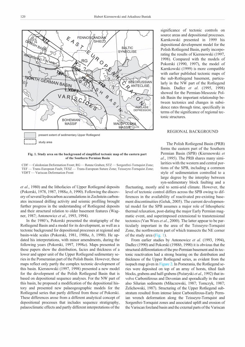
From earlier studies by Antonowicz et al. (1993, 1994),Dadlez (1990) and Pokorski (1988b, 1990) it is obvious that thestructural differentiation of the pre-Permian basement and its tec-tonic reactivation had a strong bearing on the distribution andthickness of the Upper Rotliegend series, as evident from theisopach map given in Figure 2. In Pomerania, the Rotliegend se-ries were deposited on top of an array of horsts, tilted faultblocks, grabens and half-grabens (Po¿aryski et al., 1992) that in-volve Carboniferous and Devonian and sporadically in the eastalso Silurian sediments (Mi³aczewski, 1987; Tomczyk, 1987;¯elichowski, 1987). Structuring of the Upper Rotliegend sub-stratum resulted from intense latest Carboniferous-Early Perm-ian wrench deformation along the Teisseyre-Tornquist andSorgenfrei-Tornquist zones and associated uplift and erosion ofthe Variscan foreland basin and the external parts of the Variscan
120 Hubert Kiersnowski and Arkadiusz Buniak
Fig. 1. Study area on the background of simplified tectonic map of the eastern partof the Southern Permian Basin
CDF — Caledonian Deformation Front; RG — R�nne Graben; STZ — Sorgenfrei-Tornquist Zone;TEF — Trans-European Fault; TESZ — Trans-European Suture Zone; Teisseyre-Tornquist Zone;VDFT — Variscan Deformation Front

Evolution of the Rotliegend Basin of northwestern Poland 121
Fig
.2.P
rese
nt
thic
kn
ess
dis
trib
uti
onof
Rot
lieg
end
dep
osit
sin
nor
thw
este
rnP
olan
dan
dn
eigh
bou
rin
gG
erm
anan
dB
alti
car
eas
Tec
toni
cre
gion
sI
toV
are
desc
ribe
din
the
text
;tw
ova
rian
tsof
the
cour
seof
the
Var
isca
nD
efor
mat
ion
Fro
nt(V
DF
T)
are
show
nin
red
and
gree
n;ot
her
expl
anat
ions
ason
Fig
ure
1

fold-and-thrust belt. This involved the reactivation of pre-exist-ing crustal discontinuities and the development of new ones(Figs. 1 and 2; Ziegler, 1990).
The northern parts of the Polish Rotliegend Basin arefringed by and are superimposed on major crustal boundaries,tectonic activity along which, and the significance of whichchanged in the course of time. The oldest of these crustalboundaries corresponds to the margin of the East EuropeanCraton (EEC) that coincides in Pomerania with theTeisseyre-Tornquist Zone (TTZ). In the study area, the lattercoincides with the Koszalin-Chojnice Fault Zone. Recently thismargin was understood to flank to the NE the wide Caledo-nian-deformed Trans-European Suture Zone (TESZ) that ex-tends westward to dislocations interpreted as being associatedwith the Trans-European Fault (TEF), thought to mark the mar-gin of the Gondwana-derived East Avalonia Terrane(Nawrocki and Poprawa, 2006). In Pomerania, fault systemsassociated with the TTZ closely coincide with the CaledonianDeformation Front (CDF) and the EEC margin, whereas in theBaltic Sea these fault systems extend into the Precambrian crustof the EEC and form part of the Sorgenfrei-Tornquist Zone(STZ; Fig. 1). In the southern Baltic Sea, the course of the CDFturns to the NW and strikes obliquely to faults associated withthe TTZ and STZ (Fig. 1). Whilst the NE and N parts of thePolish Rotliegend Basin extend beyond the CDF onto the EEC,its axial part is superimposed on the TESZ, whereas its SW,shallower parts overlay crustal domains attributed to the EastAvalonia Terrane and encroach on the Variscan Externides(Figs. 1 and 2).
North of the Variscan Deformation Front (VDFT) and to thewest of the Kamieñ-Stargard Fault Zone, relatively thin UpperRotliegend deposits rest on Early Permian volcanics that are un-derlain by block-faulted Carboniferous series. This regionalpalaeohigh separates the Upper Rotliegend depocentres of NWPoland and NE Germany. South of the VDFT, the PolishRotliegend Basin is fringed by palaeohighs that are upheld bythe strongly folded Lower Carboniferous sediments of theVariscan Externides that are capped by Early Permian volcanicrocks. The trace of the rather ill-defined VDFT does, however,not appear to coincide with the southernmost extension of UpperRotliegend deposits. To the north, the Rotliegend Basin is clearlylimited by a system of palaeohighs (here referred to as the West-ern Pomerania Upland) that are upheld by Carboniferous sedi-ments and Lower Permian volcanic rocks. The tectonic origin ofthese palaeohighs has, so far, not yet been documented.
MATERIALS AND METHODS
Seismostratigraphic interpretation of the studiedRotliegend deposits is seriously hampered by the poor seismicresolution at pre-Zechstein levels. Therefore, the present studyis based on the analysis of wireline logs and core material ofmost of the wells that penetrated Rotliegend deposits in NWPoland (Pomerania), NE Germany (Mecklenburg) and the Bal-tic Sea. Sedimentological and petrologic analyses of cored sec-tions permitted to establish a correlation between specific wire-line log characteristics and different lithological units, facies
types and to a degree also depositional environments, thus al-lowing to extend interpretations from cored to non-cored inter-vals. The analysis of borehole profiles yielded important infor-mation for the construction of spatial models showing the dis-tribution of successive Rotliegend depositional systems and theidentification of their bounding surfaces. Furthermore, defini-tion of these bounding surfaces permitted to establish regionalcorrelations on the base of which the effects of syn-sedimentaryfaulting on lateral facies and thickness changes could be as-sessed. Based on published and unpublished tectonic maps ofthe sub-Permian basement, as well as on seismically controlledstructural maps of the top Upper Rotliegend (= base ZechsteinPZ1), mapped fault systems were analyzed. Tectonic analysesincluded the interpretation of gravimetric and magnetic data(particularly vertical gradients maps) in terms of identifyingpotential fault zones. Faults that were recognized as havingformed during the Late Cretaceous and Paleocene inversion ofthe Mid-Polish Trough (Krzywiec, 2006) are excluded fromthe map given in Figure 2.
Based on wireline log analyses of sedimentary environ-ments, the different depositional cycles that are preserved inlarge parts of the Upper Rotliegend Basin were identified andcharacterised, and their mutual spatial relationship, composi-tion and lateral extent determined (Fig. 3). Correlations be-tween boreholes were performed and faults marked that in ourview reflect syndepositional tectonic activity (Figs. 4 and 5).Earlier correlations between boreholes lacked, however, aproper identification of sedimentary environments and werelargely based on arbitrary wireline log correlations (Pokorski,1987), leading to erroneous interpretations. Results of thesestudies were subsequently used for the definition of informallithostratigraphic units, representing allostratigraphic units(Karnkowski, 1987) or diastrophic cycles (Pokorski, 1987) thatwere referred to as “formations” and “members” (Pokorski,1981, 1988a, b, 1998a; Hoffmann et al., 1997). Based onsedimentological core studies and palaeoenvironmen-tal/palaeoclimatic interpretations, Kiersnowski (1997, 1998)applied for the first time sequence stratigraphic concepts to theentire Polish Upper Rotliegend Basin, tentatively distinguish-ing the individual depositional sequences. Hitherto, interpreta-tions of the distribution and succession of different lithofaciesunits were based on a tectonic model for the development of theRotliegend Basin that implied its partitioning into segments bytransverse fault zones striking normal to the basin axis and themargin of the East European Craton (Pokorski, 1988b, 1990).
SEDIMENT THICKNESS PATTERN AND MAINPALAEOTECTONIC UNITS
During latest Carboniferous and Early Permian times, largeparts of the studied area were covered by volcanic flows and as-sociated pyroclastic and subordinate siliciclastic sediments(Pokorski, 1990). In N Germany and Poland the volcanic activ-ity spanned 302–295 Ma (Neumann et al., 2004) and was pre-ceded by the subsidence of fault-controlled troughs in westernPomerania and northern Mecklenburg in which the Stephanianclastics of the Œwiniec Formation (Pokorski, 1990) and
122 Hubert Kiersnowski and Arkadiusz Buniak

Mönchgut-Beds of Strelasund Trough were deposited. Theseare covered by extrusive and pyroclastic rocks that attain maxi-mum thickness of over 2500 m south of Rügen and 2360 inMecklenburg-Vorpommern but decrease in thickness south-east- and eastward (Katzung and Obst, 2004). For instance, inthe Stargard Szczeciñski 1 borehole, 350 m of siliciclastic andpyroclastic rocks were penetrated (Maliszewska et al., 2003)whilst on the Moracz High volcanics are over 600 m thick.These thin out eastward towards the Trzebiatów Fault Zonewhich flanks the Ko³obrzeg Block (Fig. 2; Pokorski, 1987,1990). Beyond this fault zone, numerous, generally thin andisolated occurrences of volcanic rocks have been recorded(Ryka, 1978). Therefore, it is likely that the entire area ofKo³obrzeg Block was initially covered by volcanic rocks, butthat these were partly eroded in late Early Permian times. Theintensity of this erosion and underlying wrench deformations isillustrated by the occurrence of Middle Devonian to LowerCarboniferous rocks at the base of the Rotliegend deposits. Theisopach map of the Upper Rotliegend sediments, presented inFigure 2, illustrates the complex geometry of the Polish part ofthe Southern Permian Basin. Basement faults shown in Fig-ure 2 are superimposed onto this map and highlight the faultcontrol on individual, discrete Upper Rotliegend depocentres,such as the Czaplinek and Pi³a sub-basins, as well as on inter-vening and flanking highs. The principal tectonic units identi-fied in Figure 2 are based on a number of sources (Conrad,2001; Dadlez, 1990, 1995, 2000; Dadlez and Pokorski, 1995;Rieke et al., 2001; Roch et al., 2005; Vejb�k, 1985; Vejb�k et
al., 1994), as well as on unpublished geological structural mapsof the Piaski-Resko Area.
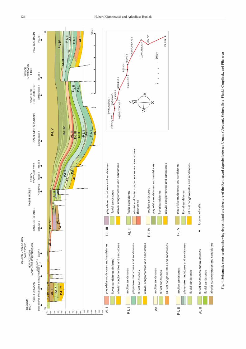
Whilst Upper Rotliegend sediments attain a maximumthickness of 1300 m in the Czaplinek Sub-Basin, marginalblocks are characterized by reduced thickness owing to strati-graphic condensation and/or erosion. For instance on the PiaskiHorst (borehole Piaski PIG 2; Figs. 2 and 4) an about 300 mthick sedimentary package equates to a 1050 m thick interval inthe Czaplinek IG 2 borehole and thus testifies to differentialsubsidence of this horst and the adjacent sub-basin.Syndepositional tectonic activity along the Laska-Golce Fault,that separates the Golce High from the Czaplinek Sub-Basin, isindicated by the Golce 1 borehole that penetrated about 560 mthick Rotliegend deposits, which equate to 960 m of sedimentsin the Czaplinek IG 1 borehole (Figs. 2 and 4). The reducedthickness of Rotliegend deposits in Golce 1 resulted both fromsediment condensation and periods of significant erosion. TheLaska-Golce Fault was already active during the Early Perm-ian, as indicated by Rotliegend sediments resting on Early Car-boniferous (Viséan) rocks in the Czaplinek IG 1 borehole,whereas in Golce 1 they lie on Early Permian volcanics.
Based on an analysis of major structural features and theireffects on Rotliegend sedimentation, five main regions can bedistinguished in Pomerania and adjacent areas that are boundedby fault zones that partly reactivated pre-existing major crustaldiscontinuities, such as the TEF and TTZ, and partly by faultzones that developed during latest Carboniferous-Early Perm-ian times. Region I is delimited to NE by the Strelasund andsouthern part of Kamieñ-Stargard Fault Zone, Region II by theStrelasund and northern Adler-Kamieñ Fault Zone, Region IIIby the Adler-Kamieñ Fault Zone (to the NW), Laska-Golce
and Koszalin-Chojnice fault zones (to the SW), Region IV bythe southern Kamieñ-Stargard Fault Zone (to the W) andLaska-Golce Fault Zone (to the NE), and Region V by theKoszalin-Chojnice Fault Zone to the SW (Fig. 2). TheStrelasund and Laska-Golce fault zones are superimposed onthe TEF whilst the Koszalin-Chojnice Fault Zone is superim-posed on the TTZ (Dadlez, 2000; Dadlez et al., 1998;Po¿aryski et al., 1992). The Adler-Kamieñ Pomorski and itsprolongation in the Kamieñ-Stargard Fault Zone obliquelytransect the CDF and the TEF and thus probably developedduring the Permo-Carboniferous.
REGION I
This region straddles the transition zone between the Polishand the North German Rotliegend Basin (Katzung and Obst,2004) and corresponds to a broad palaeohigh, referred to as theMecklenburg-Vorpommern High in Germany (Hoffman,1990) and as the Trzebie¿-Stargard Horst and Graben Complexin Poland. This high, which is upheld by Late Carboniferoussediments (Franke, 1990) that are covered by extensive EarlyPermian volcanics, was only overstepped by the upper parts ofthe Upper Rotliegend series that merely locally are thicker than300 m (Fig. 2). More complete Rotliegend series occur only inthe Strelasund Trough and Œwina Graben. The Strelasund andthe Kamieñ-Stargard fault zones bound this palaeohigh to theNE, with the ill-defined VDFT (Dadlez, 2000) forming itssouthern boundary. According to Hoffmann et al. (1998), theMecklenburg-Vorpommern High is subdivided into two partsby the Anklam Fault (AF; Fig. 2), which constitutes a tectonicboundary in the pre-Permian basement between the VariscanForeland area in the south and Caledonian Deformation Belt inthe north. Due to poor well control in the eastern part of theMecklenburg-Vorpommern High, the significance of the AFfor the Rotliegend sedimentation is not clear, although it ap-pears to control the NE flank of the North German Basin.
The sediments in the Strelasund Trough (over 900 m ofcoarse grained sediments — west of the present study area) areinterpreted as belonging to the lowermost part of the upperRotliegend (Rieke et al., 2001), and are further transected by aseries of normal faults, running approximately from the northto the south. These faults formed in response to tectonic activityalong the underlying NW–SE oriented strike-slip fault zone(Rieke et al., 2001). This zone and the Strelasund Trough are ofan older tectonic origin, as evidenced by the thickness and spa-tial extent of Late Carboniferous sediments (so-calledMönchgut-Beds; Hoffmann et al., 1997).
The Œwina tectonic trough (Pokorski, 1990), filled with over400 m of Rotliegend deposits, is separated from the StrelasundTrough by the Lütow and Usedom palaeohighs. Probably, theŒwina Graben constitutes the next segment of the chain of tec-tonic depressions that were controlled by activity along theStrelasund Fault Zone. The development of Rotliegend depositsin this trough is based on the Œwinoujœcie 1 borehole, which didnot pierce their full thickness. Nevertheless, according to thepresent authors, this profile (including probable aeolian deposits)correlates with the lower part of the Upper Rotliegend seriescontained in tectonic troughs located to the west (R�nne Graben)and south-west of Bornholm (K5 Graben).
Evolution of the Rotliegend Basin of northwestern Poland 123

124 Hubert Kiersnowski and Arkadiusz Buniak

The Kamieñ-Stargard Fault Zone is poorly defined. Alongthis zone a number of palaeohighs and tectonic depressions arethought to occur. One of these depressions may be the StargardSzczeciñski Trough that contains at least 350 metres of LowerRotliegend deposits (Maliszewska et al., 2003).
The current state of knowledge, based on boreholes, allowsassumption that Upper Rotliegend deposits (particularly, theElbe Subgroup; Schöder et al., 1995) occur throughout Region I,
with the older deposits of Havel Subgroup (Table 1) occuringonly in tectonic troughs located in the marginal zones of the areastudied (Strelasund Trough, Œwina Graben, Uckemark Trough).
REGION II
In the NW part of this region, Rotliegend deposits occur onlyas some tens of metres thick erosional remnants (cf. Pokorski,
Evolution of the Rotliegend Basin of northwestern Poland 125
Fig. 3. Maps (a–i) of inferred extent and facies of successive depositional cycles of the Upper Rotliegend in northwestern Polandand neighbouring German and Baltic areas
Other explanations as on Figure 1
126 Hubert Kiersnowski and Arkadiusz Buniak
Fig
.4.S
chem
atic
cros
s-se
ctio
nsh
owin
gd
epos
itio
nal
arch
itec
ture
ofth
eR
otli
egen
dd
epos
its
bet
wee
nU
znam
(Use
dom
),Œ
win
oujœ
cie–
Pia
ski–
Cza
pli
nek
,an
dP
i³a
area

Evolution of the Rotliegend Basin of northwestern Poland 127
Fig
.5.A
—sc
hem
atic
cros
s-se
ctio
nsh
owin
gd
epos
itio
nal
arch
itec
ture
ofth
eR
otli
egen
dd
epos
its
bet
wee
nP
asew
alk
(Ger
man
y)an
dM
orac
z-Œ
lep
cezo
ne;
B—
sch
emat
iccr
oss-
sect
ion
show
ing
dep
osit
ion
alar
chit
ectu
reof
the
Rot
lieg
end
dep
osit
sb
etw
een
Pre
nzl
au(G
erm
any)
and
Sta
rgar
d-P
iask
izon
e
Oth
erex
plan
atio
nsas
onF
igur
e4

1990) in the shallow Mittelrügen Trough and in isolated depres-sions. The substrate of volcanic and sedimentary Permian rocksconsists in the southern parts of Late Carboniferous sediments(Hoffmann, 1990) and in northern parts of Early Palaeozoic sedi-ments and Precambrian basement (Obst et al., 2004). Main struc-tural elements are the Sudrügen High that is superimposed on theTEF and parallels the Strelasund Fault Zone, the Nordrügen Highthat coincides with the CDF, and the elevated Wolin Block that isdelimited to the E by the Adler-Kamieñ Fault Zone and to the SWby the Strelasund Fault Zone.
REGION III
The structural configuration of the Region III is dominatedby NW–SE trending fault systems of which the TrzebiatówFault Zone, that separates the Gryfice Block in the west fromthe Ko³obrzeg Block in the east, is the most important(Pokorski, 1990). The Czaplinek Sub-Basin, in which UpperRotliegend sediments attain maximum thicknesses of 1300 m,occupies the SE parts of this region. By contrast, Rotliegendsediments are generally thin or missing in the NW parts of thisregion, except in the K5 Graben that forms an extension of theR�nne Graben (Figs. 1 and 2).
The Gryfice Block corresponds to an elevated area that isoffset to the N by the K5 Graben (Oderbank-Trough; Katzungand Obst, 2004) and to the S by the Samlino-Resko andS³owieñsko grabens. Along the S margin of this block the limitof the PRB is very irregular and is controlled by NW–SEtrending fault systems, tectonic activity along which persistedduring much of Upper Rotliegend times. In the southern partsof Gryfice Block, Late Carboniferous (Westphalian andStephanian) sediments directly underlie the Upper Rotliegenddeposits (Dadlez and Pokorski, 1995). The northern parts ofthis block, located in the Baltic Sea, consist of the elevatedKamieñ Block (boreholes K1/86 and K9/89) and theGryfice-K5 Graben, in which 205 m of Early Permianvolcanics rest on Westphalian C and D sediments and in turnare covered by 445 m of Rotliegend deposits (K5/88 borehole;Lindert et al., 1993). Northward, the K5 Graben grades into theR�nne Graben (Fig. 2; Vejb�k, 1985; Vejb�k et al., 1994) inwhich Rotliegend deposits have been identified in two bore-holes (Nielsen and Jaspen, 1991).
The Trzebiatów Fault Zone that separates the Gryfice andthe Ko³obrzeg blocks, was repeatedly reactivated and had aconsiderable impact on the development of Rotliegend basins,in so far as it is associated with the S³owieñsko and Œlepcegrabens in which Rotliegend attains thickness of up to 300 mand exceeds 370 m, respectively.
The northern parts of the Ko³obrzeg Block are probablydevoid of Rotliegend deposits, except for the Ko³obrzegGraben that may contain some erosional remnants. By contrast,Rotliegend sediments are widely distributed in its southernparts and increase in thickness towards the Czaplinek Sub-Ba-sin. The northern limit of Rotliegend deposits is erosional,highly irregular and appears to be fault-controlled. Whereas theoccurrence of isolated remnants of Rotliegend deposits on theeastern parts of the Ko³obrzeg Block suggests they were up-lifted and subjected to strong erosion, its SW parts subsidedconspicuously during the deposition of the Rotliegend. In the
southern and central parts of the block, Middle Devonian andlocally Late Devonian and Early Carboniferous sediments un-derlay the Rotliegend series (Dadlez and Pokorski, 1995). Inthe north, adjacent to the Koszalin-Chojnice Fault Zone, Mid-dle and Late Devonian and Ordovician-Silurian rocks prevail.
The Czaplinek Sub-Basin forms the main depocentre ofthe Polish Upper Rotliegend Basin and is bounded to the SWby the Laska-Golce Fault Zone and to the NE by theTrzebiatów Fault Zone and fault systems of the Ko³obrzegBlock. The lower parts of the Upper Rotliegend accumulateddirectly on Early Carboniferous sediments.
The hypothetical Resko-Œwidwin Fault Zone (Pokorski,1998b) is thought to separate the Gryfice and Ko³obrzeg blocksfrom the central Rotliegend Basin to the south. Based on analy-ses performed in this paper, the existence of such a fault zone isnot required, as it does not solve question of lithologic andthickness variations. In our view, the condensed or reducedthickness of the Rotliegend known from the tectonically ele-vated Moracz, Karsk, Piaski and Golce blocks (Figs. 2, 4 and 5)is associated with the wide Laska-Golce Fault Zone, that isaligned with the Œwinoujœcie-Drawsko Fault (Dadlez et al.,1998). The latter controlled the Permian-Mesozoic develop-ment of the northern part of the Mid-Polish Trough(Antonowicz et al., 1993).
REGION IV
This region includes the Pi³a Sub-Basin in which the UpperRotliegend attains a thickness of up to 1000 m (Fig. 4, boreholePi³a IG 1; Kiersnowski, 1998). However, owing to limited con-trol, the thickness indicated for this basin in Figure 3 must beconsidered as tentative. The Pi³a and Czaplinek sub-basins areseparated by the Golce High, which was overstepped by earlyRotliegend deposit but remained intermittently tectonically ac-tive until regional subsidence of these basins commenced dur-ing the later part of the Upper Rotliegend time (Fig. 4). In thePi³a Sub-Basin, the substrate of the Rotliegend deposits isformed by Late Carboniferous sediments in its northern partand by Early Carboniferous ones in its southern part.
REGION V
The NW parts of this region, corresponding to the Dar³owoBlock (Krzywiec et al., 2003), are occupied by the wide andshallow S³upsk Sub-Basin that contains up to 200 m ofsiliciclastics, attributed to the Upper Rotliegend and theZechstein (Fig. 2; Pokorski, 1976, 1997). The substrate of thisbasin is formed by flat-lying Silurian shales and, near theKoszalin-Chojnice Fault Zone, by Caledonian folded Silurianand Ordovician rocks (Podhalañska and Modliñski, 2006).Owing to poor control, the architecture of the S³upsk Sub-Ba-sin is ill-defined, particularly in the area of the Baltic Sea. Thisbasin probably corresponds to a wide erosional depression thatwas carved into the soft Silurian shales during the early devel-opment stages of the Polish Rotliegend Basin. As such, the areaof the S³upsk Basin may have acted as a source area for the NEparts of the Upper Rotliegend Basin (Kiersnowski, 1997). Dur-ing later stages, uplift of blocks along the Koszalin-Chojnice
128 Hubert Kiersnowski and Arkadiusz Buniak

Fault Zone may have isolated the S³upsk Basin from the centralRotliegend Basin, resulting in infilling of the former and a de-creasing clastic supply to the latter.
STRATIGRAPHIC AND DEPOSITIONALFRAMEWORK
In the NW parts of the PRB nine successive depositionalcycles are recognized that are characterized by conspicuousheterogeneity and lateral extent, and that partly correspond tothe depositional sequences defined earlier by Kiersnowski(1997, see his fig. 2; tab. 1). These cycles involve the followingdepositional environments: a) alternating ephemeral streamsand alluvial fans, representing sedimentation under arid andmore humid climatic conditions; b) sandy and muddy alluvialplains; c) muddy playa lakes with a marginal admixture ofsulphates and ephemeral freshwater lakes; d) aeolian deposits.These cycles contain numerous conglomerate horizons thatrepresent alluvial fan/plain depositional systems. Their recur-rent appearance in individual profiles is interpreted as reflect-ing diastrophic events associated with palaeorelief rejuvena-tions and/or palaeoclimate changes. These conglomeratic hori-zons advanced periodically from source areas located in the Nand NE southward far into the basin, thus forming conspicuouscorrelative marker horizons of stratigraphic significance. Onthe other hand, the southern part of the basin (Czaplinek andPi³a sub-basins) was dominated by relatively stable subsidencerates, resulting in the accumulation of fine-grained playa-lakedeposits that attain considerable thickness. These were tempo-rarily, and sometimes cyclically, interrupted by fluvial sandsand during drier periods by aeolian sheet and dune sands.
The cycles described below form widespread sedimentaryrock units, each of which relates to a genetically coherentdepositional system that is bounded by isochronous surfaces.These surfaces testify to important changes in the sedimentaryregime that had a strong bearing on the architecture of theevolving basin. These changes can be attributed to tectonicmovements and/or conspicuous palaeoclimatic changes.
Owing to limited space depositional cycles discussed be-low will be described in a more detail in a forthcoming paper byKiersnowski and Buniak.
ALLUVIAL DEPOSITIONAL CYCLE (AL I) (FIG. 3a)
Conglomerates and sandstones of the cycle AL I accumu-lated during the initial stage of the PRB development. In alithostratigraphic sense, they form the lowermost part of theDrawa Fm. (Pokorski, 1981), also referred to as the PolwicaConglomerate Mb. (Karnkowski, 1994). They may also beequivalent to conglomerates occurring in the lowermost part ofthe Parchim Fm. in Germany (Table 1; Schöder et al., 1995).These conglomerates may possibly be attributed to the LowerRotliegend, as suggested by Kiersnowski (1997) andMaliszewska et al. (2003).
In the area of interest, basal Rotliegend clastics were depos-ited in a system of tectonically controlled troughs, the NW–SEorientation of which coincides with some of the main tectoniczones presented in Figure 2. Sediment accumulation in these
depressions reflects the earliest development stage of tectonichigh-rate subsidence zones, such as the Resko-Czaplinek,Œlepce and Œwina grabens, with the latter finding its possibleNW-ward extension in the Strelasund Trough and its SE-wardextension in the Pi³a Sub-Basin (Hoffmann et al., 1997). At thesame time, the vast system of the K5 and R�nne grabens mayhave developed to the SW and S of Bornholm (Vejb�k et al.1994). Similarly, the “initial Phase I” dry conglomerates of theStrelasund Trough (Rieke et al., 2001) may have been depos-ited at this time. Lower Rotliegend volcanic rocks covered ar-eas surrounding these troughs, except for the Czaplinek Tec-tonic Step (Czaplinek IG 1 borehole) on which Early Carbonif-erous rocks were exposed.
LOWER FLUVIAL AND PLAYA-LAKE DEPOSITIONAL CYCLE(P-L I) (FIG. 3b)
Compared to the AL I deposits, the conglomerates, sand-stones and mudstones of the P-L I cycle show a wider distribu-tion, particularly in the SE part of the study area. Deposition ofthis sedimentary complex was accompanied by further tectonicactivity in the Œlepce, Resko-Czaplinek, Œwina grabens, as wellas by increased subsidence rates of the Czaplinek and Pi³asub-basins. Conglomerates were also deposited in the K5Trough (Lindert et al., 1993) and the Strelasund system of tec-tonic troughs. In the latter, characteristic “wet conglomerates”accumulated, owing to the generation of additional accommo-dation space in response to thermal relaxation of the lithosphere(Rieke et al., 2001). The distribution of these sediments is,however, poorly constrained due to limited borehole control.
The clastic source area for the alluvial fans was located tothe N and probably to the SW of the PRB. Overall, alluvial fansadvanced SE-wards into the area of maximum subsidencerates, with conglomerates giving gradually way to sandstones(Resko 1, Resko 3, Berkanowo 1) and ultimately tofine-grained playa-lake deposits (Czaplinek IG 1, Czap-linek IG 2, Golce 1, Pi³a IG 1; Fig. 4). Furthermore, aeoliansandstones occur in this complex as intercalations in playa de-posits (e.g. Pi³a IG 1 and probably Golce 1, and upper part ofthe Czaplinek IG 2 profiles; Fig. 4). These fine-grained sedi-ments overly with a sharp contact the coarse-grained alluvialplain deposits of the AL I cycle. Such a contact is evident in ar-eas of highest subsidence rates (e.g. boreholes Czaplinek IG 1,Czaplinek IG 2, Golce 1 and Pi³a IG 1) and may point towards aconspicuous palaeoclimatic change.
AEOLIAN DEPOSITIONAL CYCLE (Ae) (FIG. 3c)
Aeolian sandstones were identified in cores or were in-ferred from log characteristics (*) in a number of boreholes(Miêdzyzdroje 5, Œwinoujœcie 1*, Karsk 1, Samlino 1*, PiaskiPIG 2, Resko 1, Resko 3*, Czaplinek IG 2, Stargard 1*)(Figs. 4 and 5). All these profiles are situated far to the north ofthe area of main occurrence of aeolian deposits, i.e. the EasternErg in the Poznañ region (Kiersnowski, 1997). Based onsedimentological studies of cored intervals, thesestratigraphically condensed aeolian sediments represent duneand interdune deposits (sand sheets).
Evolution of the Rotliegend Basin of northwestern Poland 129

In terms of lithostratigraphy, the Ae cycle forms part of theDrawa Fm. (Pokorski, 1981) or Siekierki Sandstone Fm.(Karnkowski, 1994) that may equate to the aeolian sandstones ofParchim Fm. (Table 1; Schöder et al., 1995; Drong et al., 1982).In this paper, these sandstones are informally referred to as thePiaski Aeolian Sandstone Unit, after the Piaski PIG 2 borehole,where 12 m thick aeolian sandstones were found for the firsttime. They range in thickness between a few to maximum 50metres in the Resko 1 profile and form a conspicuous horizon,except in the boreholes Miêdzyzdroje 5 and Œwinoujœcie 1where numerous aeolian layers occur that are separated by flu-vial deposits, as seen in the K5 profile (Lindert et al., 1993)where the thickest aeolian layer is about 100 m thick.
The development of these extensive aeolian sandstone de-posits is here interpreted as reflecting a unique and rapidpalaeoclimatic shift to extremely arid conditions, allowing forlong-range dune migration. During the deposition of the Ae cy-cle, aeolian sands migrated northward across the central playaof the PRB and covered a vast area along its margin, here re-ferred to as the “Northern Erg” (Fig. 3c). The source area foraeolian sandstones occurring in the boreholes Resko and Piaskiis located to the S of the Pi³a IG 1 and Wrzeœnia IG 1 boreholes,whilst those occurring in the Stargard Szczeciñski area mayhave been derived from the Banie-Myœlibórz High (immedi-ately south of the study area), and those of the Miêdzyzdroje 5and possibly Œwinoujœcie 1 profiles from the eastern part of theMecklenburg-Vorpommern High and the Usedom High. Ae-olian sandstones occurring in the K5 borehole were probablyderived from the Gryfice Block area. Further to the north, theaeolian and fluvial deposits interfinger in the R�nne Graben(borehole Pernille 1; Vejb�k et al., 1994).
LOWER FLUVIAL AND PLAYA-LAKE DEPOSITIONAL CYCLE(P-L II) (FIG. 3d)
The sediments of the Ae cycle are overlain by claystones,mudstones and sandstones that were deposited under lacus-trine, playa-lake and fluvial environments, thus reflecting at theonset of the P-L II cycle a rapid return to more humid condi-tions. During the P-L II cycle, a freshwater lake occupied thenorthern part of the PRB in which mainly clays were deposited.As in the lower part of these lacustrine deposits (Resko 1 andResko 3 boreholes) more clays occur than in its upper parts, themore clayey lower sequence presumably represents a period ofmaximum flooding and bathymetric stability of this lake. Inprofiles of the P-L II cycle, regular coarsening-upward succes-sions are observed, reflecting the gradual progradation of flu-vial plains and sparse fluvial channels into the basin fromnorthern and possibly also western source areas. The occur-rence of alternating aeolian and fluvial deposits in the Œwinaand K5 grabens can be compared to the alternation playa-lakeand aeolian sediments in the Pi³a Sub-Basin (boreholesŒwinoujœcie 1 and Pi³a IG 1; Fig. 4).
ALLUVIAL AND FLUVIAL DEPOSITIONAL CYCLE(AL II) (FIG. 3e)
Deposits of the AL II cycle consist of conglomeratic allu-vial and sandy fluvial fans that advanced from the north into the
PRB, filling the Œwina, Samlino-Resko, S³owieñsko andŒlepce grabens. This is here interpreted as reflecting a tectonicrejuvenation of the palaeorelief and related erosional processesin source areas, as well as a reactivation of fault systems outlin-ing individual grabens. Systems of partly isolated conglomer-atic alluvial fans prograded into these grabens, giving ba-sin-ward way to sand-dominated fluvial fans and possibly alsoplaya deposits. Conglomeratic fans probably developed also onthe western slopes of the Mecklenburg-Vorpommern and east-ern slopes of Trzebie¿-Stargard Horst and Graben Complex(Fig. 3e) (Stargard and Prenzlau boreholes; Fig. 5). In the Pol-ish Basin, sediments of the AL II cycle are assigned to theDrawa Fm. (Table 1; Pokorski, 1981) and are likely to equate tothe basal parts of the Mirow Fm. in the North German Basin(Schöder et al., 1995).
LOWER FLUVIAL AND PLAYA-LAKE DEPOSITIONAL CYCLE(P-L III) (FIG. 3f)
The sediments of this cycle were laid down in depositionalcontinuity with those of the preceding cycle and represent thetopmost member of the Polish Drawa Fm. that equates to the up-per part of the Mirow Fm. of the North German Basin. Depositsof the P-L III cycle are only preserved in areas of highest subsi-dence rates, such as the Samlino-Resko Graben and the axialzone of the Czaplinek Sub-Basin. Originally, they extended overa somewhat larger area but were eroded at the onset of the subse-quent AL III cycle (e.g. on Czaplinek Tectonic Step, Fig. 4).Sediments of the P-L III cycle consist of fluvial sandstones andfine-grained conglomerates with mudstone intercalations, and oflacustrine mudstones in local depocentres. The source of theseclastics was probably located to the N and NE, as indicated bythe prevalence of lithic clasts (Maliszewska and Pokorski, 1986).This increase in clastic supply to the PRB is interpreted as her-alding the progradational cycle that culminated in conglomeraticsedimentation during the subsequent AL III depositional cycle.This contradicts the view that the Noteæ cycle (sensu Pokorski,1981) commenced with conglomerates in the central part of thebasin (Czaplinek IG 2 borehole).
ALLUVIAL AND FLUVIAL DEPOSITIONAL CYCLE(AL III) (FIG. 3g)
Deposits of this cycle are very widespread in the Polish Ba-sin where they form the basal part of the Noteæ Fm. that isequivalent to the lower part of the Dethlingen Fm. of the NorthGerman Basin (Table 1). During this cycle progradation of flu-vial systems reached a peak and spread over almost the entirePRB. Following erosion of older deposits across such activelyrising fault blocks as the Moracz High and the Czaplinek Tec-tonic Step, these were progressively onlapped and oversteppedby the AL III conglomerates (Figs. 4 and 5). Whereas in thenorthern part of the basin the cycle consists predominantly ofalluvial fan deposits, alluvial plain facies, periodically domi-nated by fluvial facies, prevail in its southern parts. Only in thesouthernmost parts of the basin, in the area to the south of theGolce 1 borehole, may the conglomeratic/sandy AL III depos-its give way to sandstones. In the Czaplinek IG 1 profile, agradual upward transition from coarse-grained (conglomeratic)
130 Hubert Kiersnowski and Arkadiusz Buniak

alluvial fan deposits to finer fluvial deposits is observed(Fig. 4). Here, the conglomerate components consist of Devo-nian and Carboniferous carbonates and siliciclastic rocks. Asthis applies also to the boreholes Czaplinek IG 2 and Golce 1,the bulk of these conglomerates were derived from source ar-eas located to the E and NE.
The widespread extent of the AL III deposits points to thedevelopment of an ever-expanding alluvial plain with a fairlysmooth palaeorelief, and to the coalescence of the Czaplinekand Pi³a sub-basins. The vast area covered by sediments of thiscycle reflects long-lasting erosion of source areas located to theN (West Pomerania Upland) NE and SW. At the end of the cy-cle, the Polish and North German parts of the Upper RotliegendBasin were still partly separated by the vast area of palaeohigh(Fig. 3g). Deposits associated with this depositional event arerepresented in the eastern part of the North German Basin bythe conglomerates and sandstones of the lowermost part of theDethlingen Fm. (Schöder et al., 1995; Table 1).
UPPER FLUVIAL AND PLAYA-LAKE DEPOSITIONAL CYCLE(P-L IV) (FIG. 3h)
Deposits of this cycle form the middle part of the Noteæ Fm.of the PRB and are essentially equivalent to the upper parts ofthe Dethlingen and the basal parts of the Hannover formationsof the North German Basin. Although clastic influx into thePRB, mainly from northern sources, gradually abated duringthis depositional cycle, basin margins and intra-basinal highs(e.g. Moracz High) were slowly overstepped whilst subsidenceof the Czaplinek Sub-Basin increased. At the same time activ-ity along basin and block bounding faults decreased (Figs. 4and 5). In the northern parts of the basin, thin alluvial conglom-erates were deposited that pass southward into fluvial sand-stones and mudstones which attain in the Piaski region a maxi-mum thickness of 30 m. These small thicknesses reflect insig-nificant subsidence rates for this area, preventing fluvialaggradation. Correspondingly, sediments preserved in thenorthern, marginal parts of the basin represent multiple stagesof fluvial transfer from the N to the S. To the S of the PiaskiHorst, increasing subsidence rates accounted for a conspicuousthickness increase of P-L IV deposits, as well as their upwardand lateral transition to playa-lake facies. In the center of theCzaplinek Sub-Basin, these deposits attain thicknesses of morethan 280 m and consist of cyclically alternating fluvial sandsand playa-lake clays, as evident in the Resko-Czaplinek region(Fig. 4). In the Pi³a IG 1 and Czaplinek IG 2 boreholes, fluvialP-L IV deposits contain thin aeolian sandstone intercalations,suggesting that by this time the Czaplinek and Pi³a sub-basinshad amalgamated. By the end of the P-L IV cycle, theTrzebie¿-Stargard area had been largely overstepped, thus pro-viding for a broad connection between the Polish and NorthGerman basins (Fig. 3h).
UPPER PLAYA-LAKE AND FLUVIAL DEPOSITIONAL CYCLE(P-L V) (FIG. 3i)
This cycle represents the terminal Upper Rotliegend depo-sition and is capped by the marine basal Zechstein CopperShale. It corresponds to the top part of the Polish Noteæ and the
North German Hannover formations (Table 1). Sediments ofthe cycle occur throughout the PRB and are mostly representedby playa-lake and fluvial deposits, with the latter occurringalong its northern margin and having a wider distribution in itsNE marginal parts. During the cycle, the PRB subsided region-ally in response to lithospheric cooling and contraction with noevidence for further reactivation of its fault systems (Figs. 4 and5). At the same time, clastic supply to the basin, mainly from Nand NE sources diminished. This accounted for the develop-ment and wide lateral extent of a playa-lake that was connectedto the North German Basin. In the Polish Basin, the P-L V de-posits consist of muddy sediments containing sandy intercala-tions and of cyclically alternating fine-grained sandstones andmudstones. Sedimentary cycles, observed in the most completeprofiles (boreholes Resko 1, Resko 3, Czaplinek IG 1,Czaplinek IG 2, Golce 1, Pi³a IG 1) show recurrent stages ofhigh/low rates of accommodation space development, causingfluctuations in the development of fluvial depositional system,as evidenced by fining-upward, coarsening-upward and sym-metrical cycles. Analysis of these cycles in terms of their occur-rence, succession and variability documents the migration ofdepocenters in space and time during the deposition of theplaya-lake complex. In the uppermost part of Czaplinek IG 1and Czaplinek IG 2 boreholes, brecciated levels are attributedto the growth and dissolution of salt crystals. The lack of desic-cation cracks speaks, however, for the persistence of the P-L Vcycle playa-lake.
Towards the end of the Rotliegend sedimentation and priorto the transgression of the Zechstein Sea, playa depositsreached far to the north, almost to the depositional limit ofRotliegend sediments. This can be attributed to the regionalthermal subsidence of the basin, a related relative rise in ero-sional base level and a reduction of clastic influx (Plumhoff,1966; Rieke et al., 2001). Rieke et al. (2001) claimed that thedominance of more fine-grained deposits (the so-called “phaseIII” in the southern Rügen), observed in the northeastern part ofthe Mecklenburg-Vorpommern palaeohigh, resulted from thefact that this formerly isolated region was tilted towards theSW. This tilting was caused by the thermal subsidence of thecentral part of the North German Basin. Thus, during upper-most Havel and Elbe Subgroup times, the northern margin ofthe northeastern German basin formed. If this were so, then de-velopment of the uppermost playa-lake deposits would proba-bly reflect one of the longest depositional periods in the devel-opment of the entire Southern Permian Basin.
ROTLIEGEND IN WESTERN POMERANIA ANDEASTERN MECKLENBURG-VORPOMMERN —
INTERPRETATION AND DISCUSSION
Rotliegend depositional cycles recognized in the Polish Ba-sin appear to correlate with similar cycles in the North GermanBasin, as summarized in Table 1 (Gebhardt et al., 1991;Helmuth and Süssmuth, 1993; Rieke et al., 2001; 2003;Katzung and Obst, 2004). In the studied NW part of the PRB,the lower part of the Drawa Fm. (cycles AL I to P-L II) was de-posited in a system of tectonically active grabens, comparableto the time-equivalent Parchim Fm. in Northern Germany
Evolution of the Rotliegend Basin of northwestern Poland 131

(Gebhardt et al., 1991; Rieke et al., 2003). During the deposi-tion of the upper part of the Drawa Fm. (cycles AL II, P-L III),the area of sedimentation expanded while fault activity per-sisted intermittently, as also seen during the deposition of theMirow Fm. in Northern Germany (Gebhardt et al., 1991;Schöder et al., 1995). Deposits of the Noteæ Fm. (cycles AL IIIto P-L V) reflect rapid broadening of the basin in response tocooling and contraction of the lithosphere with fault activityending during cycle P-L IV. The cycles AL III and P-L IV cor-respond in the North German Basin to the Rambow and Eldenaseries that also reflect rapid basin subsidence (Schöder et al.,1995). The cycle P-L V equates in the North German Basin tothe Peckensen and Mellin Beds during the deposition of whichthis basin expanded significantly (Gebhardt et al., 1991).
The Rotliegend sediments of the R�nne and K5-Gryficegrabens (Vejb�k et al., 1994) are here thought to be equiva-lents of the Drawa Fm. rather than the Noteæ Fm., as postulatedby Hoffmann et al. (1997) and Pokorski (1998b). As such,these basins form an integral part of the graben system that be-gan to subside at the transition from the Early to the Late Perm-ian in the area of the TESZ in response to last pulses ofwrench-deformation along the sinistral TTZ and SFTZ(Dadlez, 1990, 2000). Pokorski (1998b) claimed that infillingof the K5 Trough with aeolian deposits was time equivalent
with the deposition of the Noteæ Fm. We argue, however, thatthese troughs were formed during the early tectonic reorganiza-tion stages of the large TESZ area. Sediments infilling thesetroughs (alluvial/fluvial in the northern part and fluvial/aeolianin the southern part) were deposited during recurrent stages oftectonic subsidence. Aeolian deposits were formed during sev-eral stages and their occurrence is associated with period ofmaximum aeolian development during the deposition of thelower part of the Upper Rotliegend.
Inferred ranges of sediments representing successive for-mations of the Upper Rotliegend (Upper Rotliegend II) innortheastern Mecklenburg (Germany) depend on the assumedscheme of main tectonic fault zones controlling sedimentation,as well as on the assumed lithostratigraphic correlation concept(Hoffmann, 1990; Rieke et al., 2001, 2003; Katzung and Obst,2004). Moreover, the concept of stratigraphic correlation be-tween the Polish Basin and the NE North German Basin de-pends on criteria on which the lithostratigraphic subdivisionsare based (Pokorski 1988a; Schneider and Gebhardt, 1993;Hoffmann et al., 1997). According to Pokorski (1981, and hisco-workers), one can distinguish in the PRB two conspicuousdiastrophic-sedimentary cycles corresponding to the Drawaand Noteæ formations. Additionally, Pokorski (1981, 1988a)distinguished lithostratigraphic members, including the Resko
132 Hubert Kiersnowski and Arkadiusz Buniak
T a b l e 1
Upper Permian (Rotliegend) stratigraphy of the NW Polish Basin (Western Pomerania), NE North German Basin and the Baltic Sea area

Mb., representing a characteristic claystone complex in theResko 1 borehole (Table 1). However, this author abandoneddistinguishing these members in his late papers (Pokorski,1990). Later, Pokorski (1998a), modified his stratigraphic sub-division, introducing new, informal lithostratigraphic unitsbased on depositional sequences, distinguished earlier byKiersnowski (1997, 1998). Furthermore, Pokorski advancedboth Drawa and Noteæ formations to the rank of subgroups.These changes were aimed at unification with the changes in-troduced to the Rotliegend stratigraphy of the North GermanBasin (Hoffmann et al., 1997; Schöder et al., 1995). Anotherlithostratigraphic subdivision, introduced for the PRB byKarnkowski (1981, 1987), is not discussed here, as it cannot becompared to the NE North German Basin stratigraphy. The lat-ter is based on depositional cyclicity, in which the beginning ofevery individual sedimentary cycle (irrespectively of its origin)is well defined (Helmuth and Süssmuth, 1993).
On the flanks of the large NW–SE oriented Mecklen-burg-Vorpommern High the occurrence of Parchim Forma-tion deposits is spotty according to German authors(Hoffmann, 1990; Rieke et al., 2003; Katzung and Obst, 2004).On the Mecklenburg-Vorpommern High, isolated remnants ofParchim deposits have been encountered that are interpreted asthe fill of palaeovalleys (Lindert et al., 1990; Hoffmann, 1990;Rieke et al., 2003) through which clastics were transportedsouthward into the depocentre of the North German Basin. Inthe latter, Parchim deposits attain thicknesses of over 600 m(Schwerin 1 borehole; Schöder et al., 1995). By contrast, to theNE of the Mecklenburg-Vorpommern High, Parchim and olderdeposits (Müritz Subgroup) are 500–600 m thick in the elon-gated Strelasund Trough (Hoffman et al., 1997). This trough,which parallels the Mecklenburg-Vorpommern High, isbounded to the NE by the Sudrügen High and finds its on-trendprolongation in the Œwina Graben of Poland. Parchim equiva-lent deposits attain thicknesses of over 370 m in the CzaplinekSub-Basin of Poland and over 400 m in the K5 Graben.
During the deposition of the Mirow Formation, theMecklenburg-Vorpommern High and its extension into Polandwere devoid of a stable sedimentary cover and acted as a clasticsource area (Katzung and Obst, 2004). However, the SW mar-gin of this palaeohigh was progressively overstepped duringthe deposition of the Mirow Fm. (see Fig. 5, boreholesPrenzlau and Penkun; Gast et al., 1998; Schöder et al., 1995).Deposits of this formation attain maximum thicknesses of450 m in the North German Basin (borehole Schwerin 1;Schöder et al., 1995), and 200 m in the Czaplinek Sub-Basin ofPoland (borehole Czaplinek IG 2; Fig. 5) but appear to be miss-ing in the Strelasund Trough (Rieke et al., 2003). Whether thetopmost 43 m thick conglomerates occurring in the K5 Grabenequate to the Mirow Fm. is uncertain.
Correlations between the Rotliegend deposits of the NorthGerman and Polish basins are based on the results of the bore-holes Mirow 1, Wesenberg 1, Feldberg 1, Prenzlau 1 andPenkun 1 in Germany (Schöder et al., 1995; Gast et al., 1998)and Stargard 1 in Poland (see Figs. 2 and 5B). However, as theStargard 1 borehole cannot be unequivocally correlated withthe most important Rotliegend profiles of the PRB, major un-certainties remain, with the correlation presented here beingonly one of several options. Therefore, comparative analyses of
the depositional development of both basins in terms of tec-tonic and palaeoclimatic controls are of crucial importance(Kiersnowski, 1998; Karnkowski, 1999). Deposits attributed tothe Mirow Fm. are in the Prenzlau 1 borehole 80 m thick, whilstin the Stargard 1 borehole deposits regarded as Mirow Fm.equivalents, are only 20 m thick (Fig. 5). The question, whetherthese deposits formed a continuous sedimentary cover, has notbeen answered as yet. During the deposition of the Mirow Fm.,the North German and Polish Basins were in all likelihood stillseparated by the Mecklenburg-Vorpommern-Trze-bie¿-Stargard palaeohighs, as shown in Figures 3e and f. Ac-cording to published stratigraphic correlations, the Mirow Fm.deposits reach as far as east of the Prenzlau borehole location(Gast et al., 1998; Schöder et al., 1995) and probably to thePenkun borehole location. In the light of analyses presentedherein, and a comparison with the Friedland 1 borehole profile,the occurrence of these deposits in the lowermost part of theRotliegend in the Pasewalk 2 borehole is unlikely. These de-posits may represent an equivalent of lower or middle part ofthe Rambow Beds (Table 1). In the North German Basin, theDethlingen Fm. broadly overstepped the depositional limits ofthe Mirow Fm. Its distribution is limited to the NE by theStrelasund Tectonic Zone (Hoffmann et al., 1997) that is con-sidered to form the axis of the Strelasund Trough (Rieke et al.,2001). Whereas Gebhardt et al. (1991) proposed that theDethlingen Fm. extends eastward into the Polish Basin, Riekeet al. (2003) claimed that it does not reach beyond the Ger-man-Polish border zone. In our palaeogeographic reconstruc-tion (Fig. 3g), we show a zone of palaeohighs, associated withthe Kamieñ-Stargard Fault Zone that may have formed an ef-fective barrier separating the North German and Polish basins,particularly in palaeohydrological terms.
The Dethlingen Formation attains a thickness of 675 m inthe northern part of the North German Basin (boreholeSchleswig Z1; Schöder et al., 1995), and its counterpart in thePRB almost 400 m (Czaplinek IG 2). However, as the bound-ary between the Dethlingen and Hannover formations has notyet been established in the PRB, the thickness quoted for theborehole Czaplinek IG 2 must be considered as tentative.
During the deposition of the Hannover Formation, theRotliegend basins of Northern Germany and Poland attainedtheir maximum extent and became widely connected (Fig. 3hand i). Nevertheless, the northern depositional limit of theHannover Fm. overstepped only marginally that of theDethlingen Fm. in the area of the Strelasund Fault Zone. TheHannover Fm. attains in the northern part of the North GermanBasin a thickness of almost 700 metres (borehole Schleswig Z1;Schöder et al., 1995), and some 300 m in the Polish Basin(Czaplinek IG 2). Deposits of the Hannover Fm. show geneticsimilarities in both basins, with the only difference being the ab-sence of a typical saline facies in the Polish Basin, though nu-merous sediment deformation levels were observed in the upperparts of the boreholes Czaplinek IG 1 and IG 2 that can be attrib-uted to the growth and dissolution of halite crystals.
It is still an open question whether Rotliegend formationboundaries and palaeoenvironments (including theirpalaeoclimatic interpretation) distinguished in the North Ger-man Basin find indeed their counterparts in the Polish Basin(Table 1). This pertains particularly to the Parchim-Mirow and
Evolution of the Rotliegend Basin of northwestern Poland 133

Drawa successions. For instance, the maximum northward ex-pansion of aeolian sandstones in the North German Basin(Rieke et al., 2003) appears to correlate with the period of max-imum sandy desert development in the PRB. The aeolianSchneverdingen Sandstone (Drong et al., 1982) of the ParchimFm. that was generally deposited in grabens (Gast, 1988) istime-equivalent with the Ae cycle of maximum aeolian sedi-ment expansion of in the SE part of the PRB where they attainthicknesses of 500–600 m in the Poznañ Trough (Kiersnowski,1997, 1998). However, so far no aeolian sandstones have beenreported from the Parchim or Mirow formations in the NE partof the North German Basin (McCann, 1998; McCann et al.2000). Similarly, the increase in fluvial and aeolian sandstonesin the Wustrow Member (lower Hannover Fm.) of the NorthGerman Basin (Gast et al., 1998) appears to correlate with arapid increase in fluvial and possibly also aeolian sandstones atthe transition from cycle P-L IV to P-L V in the central parts ofthe Polish Basin.
Furthermore, there are differences in the structural configu-ration and possibly also the tectonic evolution of the NorthGerman and Polish Basins. Although is was recently acceptedthat the tectonic evolution of both basins was rather similar interms of main tectonic events (Gebhardt et al., 1991; Plein,1993; Hoffmann et al., 1997; Schneider and Gebhardt, 1993;Pokorski 1988a, b), faulting may have played a more importantrole in the evolution of the Polish Basin that is superimposed onthe TESZ and the TTZ–STZ, at the NW termination of whichthe Oslo Rift opened during latest Carboniferous and EarlyPermian times (Neumann et al., 2004).
DISCUSSION AND CONCLUSIONS
Our review of the evolution of the Polish Upper RotliegendBasin attempts to document that syn-depositional faulting ex-erted a conspicuous control on the facies development of theRotliegend deposits and their characteristic multi-stage develop-ment, particularly during the accumulation of the Drawa andlower parts of the Noteæ formations. Moreover, our studies showthat the northern margin of the PRB is very irregular and reflectsthe complex tectonic structure of its pre-Permian basement, con-trary to the interpretation by Pokorski (1990). In previous stud-ies, little heed was given to the fact that the PRB was repeatedlysupplied with a large amount of sediments derived from an arealocated to its N, here referred to as the Western Pomeranian Up-land (Fig. 3). In this area deep erosion affected not only thepre-Permian basement but also earlier deposited Rotliegend sed-iments. Thus, the present northern limit of the Rotliegend depos-its does not represent their primary depositional limit that period-ically extended further. A similar view was expressed by Dadlez(1990) in his tectonic analysis of the of the SW Baltic area. Inthis area, coarse-grained sediments contained in numerous,poorly defined tectonic troughs may represent the youngestRotliegend successions, though it cannot be excluded that theymay be considerably older, as in the case of the K5 Graben (Ta-ble 1). It is uncertain how far south the Rotliegend deposits of theK5 Graben extend and whether they were connected with thoseof the the S³owieñsko Graben (Fig. 2).
The revised Upper Rotliegend isopach map presented inFigure 2 clearly reflects the structure of the pre-Permian base-ment and the relationship between basement fault zones andrapid lateral Rotliegend thickness changes. Previously pub-lished palaeogeographic and isopach maps were based onpartly different reconstructions of the structural configurationof the basement (see maps by Pokorski 1988b, 1990, 1998b).For example, the orientation of the much quoted S³owieñsko-Œlepce-Daszewo grabens, erroneously interpreted as a fluvialpalaeo-channel (Pokorski, 1990), could not be confirmed. Al-though the isopach map presented in Figure 2 is based on all ac-cessible boreholes, thickness values given for large parts of thestudied area must be considered as tentative owing to limitedborehole control. Nevertheless, the general division of the ba-sin into a northern shallower and the southern deeper part iswell founded and conspicuous. Generally, the northern part ofthe PRB is characterized by an array of horst and grabens andsharp lateral thickness changes of Rotliegend deposits, reflect-ing the tectonic mobility of the different basement blocks.Moreover, there is evidence for repeated erosion, sedimentby-pass and deposition of generally thin Rotliegend series onhorsts (Fig. 5). Although the structural configuration of thepre-Permian basement beneath the Rotliegend depocentres ofthe southern parts of the basin is poorly controlled, it may be ascomplex as in its northern, shallower parts.
Considering the entire PRB, it is evident that during the de-position of the Drawa Fm. fluvial and lacustrine environmentsdominated its northern parts whilst aeolian and playa lake envi-ronments dominated in the south. This points towards the pres-ence of an extensive drainage system in areas to the N and NEof the basin that is consistent with their multi-stage erosion. Ap-parently, considerable wetter climatic conditions dominatedsedimentary processes in the northern parts of the basin than inits southern parts. In the southern parts of the basin, aeolianconditions were episodically interrupted by fluvial regime(Kiersnowski, 1997), whereas in its northern parts predominantfluvial and lacustrine conditions were interrupted by conspicu-ous aeolian episodes, such as the Piaski episode (Ae cycle;Fig. 3c). Earlier analyses (Kiersnowski, 1997, 1998) show thataeolian sequences are interrupted by a number of ero-sional/non-depositional hiatuses. These can be related to wetterperiods, corresponding to fluvial/lacustrine sedimentation inthe north and cyclic changes of the spatial extension of the cen-tral playa lake. In this paper, we emphasize the occurrence ofaeolian deposits in the northern part of the PRB, an aspect thatwas generally neglected by previous authors. During periodicallow humidity stages, aeolian sheet sandstones extended fromthe southern parts of the basin as far N as the Miêdzyzdrojearea, where they may form potential gas reservoirs.
In the PRB, the distribution of lithofacies in time and spacemanifests the recurrent appearance of fluvial and aeolian envi-ronments and, as such, resembles the sedimentary evolution ofPermian and Jurassic basins in USA (Mountney and Jagger,2004; Clemmensen et al., 1989), as well as of the UpperRotliegend Group in the UK sector of the southern North Sea,from which similar alternations of playa and aeoliandepositional systems have been reported (Sweet, 1999). An un-derstanding of the mutual interaction between these two
134 Hubert Kiersnowski and Arkadiusz Buniak

depositional systems is of key importance for explaining thesignificance and interplay between syn-sedimentary tectonicsubsidence and palaeoclimatic conditions.
In the area of the PRB differential motions of basementblocks controlled the subsidence pattern of individual troughs,the relative stability and even uplift of horsts, until regionalthermal subsidence of the entire basin became dominant duringthe later parts of the Noteæ Fm. time. The tectonicAdler-Kamieñ-Stargard Zone (probably a transpressionalstrike-slip zone) apparently played a crucial role in terms of dif-ferences in the development of the Polish and North GermanRotliegend basins. The Trzebiatów Fault Zone, similar to theAdler-Kamieñ-Stargard Fault Zone, was activated during theEarly Permian by strike-slip movements, giving rise totranstensional and transpressional deformations, and remainedintermittently active during the earlier parts of the UpperRotliegend deposition. Its activity, coupled with strike-slipmovements along the Laska-Piaski Fault (Fig. 2), may be re-sponsible for the development of Œlepce and Samlino-Reskograbens. These are probably transtensional features separatedby a system of horsts along Trzebiatów Fault Zone(Trzebusz-Gorzys³aw-Petrykozy horsts passing to SE intoS³awoborze-Ciechnowo Horst — region of S³awoborze andCiechnowo boreholes; Figs. 2 and 5). During deposition of theof Rotliegend series, tectonically-controlled depressions paral-leling the Trzebiatów Fault Zone played and important role inthe development a N–S directed fluvial drainage systemthrough which clastics were supplied to the Czaplinekdepocentre from northern sources.
Wrench tectonics is most probably responsible also for thedevelopment of the Czaplinek Sub-Basin forming the maindepocentre in the study area. During the accumulation of thelower Upper Rotliegend, syn-depositional faulting controlledits subsidence, as evidenced for instance along the margins ofthe Piaski Horst and Golce High (Fig. 4). Correspondingly, thissub-basin may be interpreted as a large pull-apart structure thatremained active during the earlier stages of Rotliegend deposi-tion before it began to subside regionally during the accumula-tion of the upper parts of the Rotliegend series (Fig. 2 and 4).On the regional structural cross-section, given in Figure 4, theResko and Czaplinek tectonic steps are shown in the area of theCzaplinek Sub-Basin. In our view, these steps influencedRotliegend sedimentation particularly during the earliest stagesof basin development. Moreover, they may represent marginalelements of the pull-apart system that embraced the entireCzaplinek Sub-Basin that is bounded to the NE by an extensionof the Trzebiatów Fault Zone and to the SW by the fault delim-iting the Golce High to the north. Similar to the CzaplinekSub-Basin, also the Pi³a Sub-Basin is interpreted as havingevolved as a pull-apart structure during the deposition of theearlier part of the Upper Rotliegend.
During early evolutionary stages of the PRB, tectonic reacti-vation of the NE segment of the TEF played more important rolethan was hitherto believed. Tectonic movements of individualblocks located along the TEF allowed for the deposition of re-duced or stratigraphically condensed Rotliegend sequences only.
The mid-basinal Golce High and the Czaplinek TectonicStep were periodically uplifted and eroded and were delivering
sediments to the adjacent depocentres (Fig. 4). This contradictsthe model of Pokorski (1998b), according to which theCzaplinek-Pi³a part of the basin underwent continuous subsi-dence during the deposition of the Upper Rotliegend series.
It is proposed here that the R�nne and K5-Gryfice grabens,located to the SW and S of Borholm (Figs. 1 and 2), were acti-vated at the same time as the grabens of the northern part ofPRB during the deposition of the lower parts of the Drawa Fm.Sediments contained in these grabens span, according to our in-terpretation, much of this formation (Table 1) and do not equateto the Noteæ Fm., as proposed by Pokorski (1998a). The ae-olian sandstones in the K5 Graben reflect episodes of maxi-mum northward aeolian facies expansion during the depositionof the Parchim-lower Drawa formations.
Conspicuous temporal correlations between the Rotliegenddeposits of the NW parts of the Polish Basin and the NE parts ofthe North German Basin suggest synchronous reactivation offault systems controlling the main stages of their evolution, aswell as the onset of their regional thermal subsidence. The cli-mate-controlled cyclicity of Rotliegend deposits requires fur-ther research on a basin-wide scale.
In summary, our analysis supports the view that in the PolishBasin, deposition of the Upper Rotliegend series was initiallyconfined to tectonic troughs that developed under atranstensional stress field. Only during the later stages of theRotliegend, when fault activity had decreased and ultimatelyceased, were the margins of these troughs permanentlyover-stepped and the basin widened out in response to its thermalsubsidence. In this respect, the evolution of the Polish Basinshows great similarities to that of the North German RotliegendBasin (Gast, 1988; Gebhardt et al., 1991; Hoffmann et al., 1997).
The tectonic framework of the NW parts of the PolishRotliegend Basin, as well as major thickness changes acrossfaults, as outlined in Figure 2, show that syn-depositional reacti-vation of pre-existing fault systems played an important role,particularly during the early development stages of this basin.Underlying diastrophic events, involving the development of acomposite system of faults and tectonic reactivation zones, arenot yet fully understood. Nevertheless, they appear to reflect lastpulses of the post-Variscan tectonic reorganization that, in time,gave way to thermal relaxation of the lithosphere as the dominantsubsidence mechanism of the Late Permian and Mesozoic PolishBasin (Dadlez et al., 1995; Van Wees et al, 2000).
Acknowledgments. The authors thank the Polish Gas and OilCompany (PGNiG S.A., Pi³a Branch) for granting access to corematerial and wire-line logs of selected boreholes. We thank Dr. A.Protas for granting us access to the results of joint Polish-East Ger-many research on the Permian System and Dr. S. Lech for sharingwith us information on the geological structure of the pre-Permianbasement of West Pomerania. We appreciated discussions withand comments by E. Iwanowska (PGNiG S.A., Warsaw) con-cerning the tectonic evolution of the northern Polish RotliegendBasin. We thank Dr. B. Kluge of EEG Berlin and Drs. P. Hoth andH. Rempel of the BGR Berlin for granting us access to boreholeprofiles from eastern Mecklenburg and wire-line logs of the K5borehole. We also thank Dr. N. Hoffmann of the BGR Berlin forhis inspiring discussion on the Rotliegend profiles of eastern
Evolution of the Rotliegend Basin of northwestern Poland 135

Mecklenburg and the tectonics of the Rügen and Baltic area. Ourspecial gratitude goes to M. Geisler and Prof. dr. Ch. Breitkreuz ofthe TU Freiberg and Dr. J. Kopp of the Geological Survey of
Brandenburg for discussions and granting us access to Rotliegendcores of a number of boreholes from the eastern part of Germany.
Finally we acknowledge the detailed review and editorial ef-forts of Prof. P. A. Ziegler that substantially improved the paper.
REFERENCES
ANTONOWICZ L., IWANOWSKA E., JAMROZIK J. and NOWICKA A.(1993) — Tilted block (half grabens) of the Permian basement in NWPoland — implications for hydrocarbon exploration (in Polish withEnglish summary). Prz. Geol., 41 (2): 71–74.
ANTONOWICZ L., IWANOWSKA E. and RENDAK A. (1994) — Ten-sional tectonics in the Pomeranian section of the T-T Zone and theimplictions for hydrocarbon exploration. Geol. Quart., 38 (2): 289–306.
CLEMMENSEN L. B., OLSEN H. and BLAKEY R. C. (1989) — Erg-mar-gin deposits in the Lower Jurassic Moenave Formation and WingateSandstone, southern Utah. Geol. Soc. Am. Bull., 101: 759–773.
CONRAD W. (2001) — Eine gravimetrisch-magnetische Diskussion desregionalen Tiefenbaus zwischen Ostsee und Lausitz. Diedeutsch-polonische Kooperation zwischen 1975 und 1990 auf denGebieten Gravimetric und Magnetik ergänzt durch einegravimetrisch-tomografische Neubewertung ihrer Aussagen zumregionalen geologischen Bau. Z. geol. Wiss., Berlin 29 (2): 169–192.
DADLEZ R. (1974a) — Tectonic position of Western Pomerania (North-western Poland) prior to the Upper Permian (in Polish with Englishsummary). Biul. Inst. Geol., 274: 49–87.
DADLEZ R. (1974b) — Some geological problems of the Southern BalticBasin. Acta Geol. Pol., 24 (1): 261–276.
DADLEZ R. (1978) — Sub-Permian rock complexes in theKoszalin-Chojnice zone (in Polish with English summary). Geol.Quart., 22 (2): 269–301.
DADLEZ R. (1990) — Tectonics of the Southern Baltic (in Polish withEnglish summary). Geol. Quart., 34 (1): 1–20.
DADLEZ R. (1995) — Tectonic sketch map. Plate III. In: Geological Atlasof the Southern Baltic. (eds. R. Dadlez, J. E. Mojski, B. S³owañska, S.Uœcinowicz and J. Zachowicz). Pañstw. Inst. Geol. Sopot-Warszawa.
DADLEZ R. (2000) — Pomeranian Caledonides (NW Poland), fifty year ofcontroversies: a review and a new concept. Geol. Quart., 44 (3): 221–236.
DADLEZ R., NARKIEWICZ M., POKORSKI J. and WAGNER R. (1998)— Subsidence history and tectonic controls on the Late Permian andMesozoic development of the Mid-Polish Trough (in Polish with Eng-lish summary). In: Sedimentary Basins Analysis of the Polish Low-lands (ed. M. Narkiewicz). Pr. Pañstw. Inst. Geol., 165: 47–56.
DADLEZ R., NARKIEWICZ M., STEPHENSON R. A., VISSER M. T.M., and VAN VEES J.-D. (1995) — Tectonic evolution of theMid-Polish Trough, modelling implications and significance for cen-tral European geology. Tectonophysics, 252 (1–4): 179–195.
DADLEZ R. and POKORSKI J. (1995) — Devonian and Carboniferous.Plate VI. In: Geological Atlas of the Southern Baltic. (eds. R. Dadlez,J. E. Mojski, B. S³owañska, S. Uœcinowicz and J. Zachowicz). Pañstw.Inst. Geol. Sopot-Warszawa.
DRONG H-J., PLEIN E., SANNEMANN D., SCHUEPBACH M. A. andZIMDARS J. (1982) — Der Schneverdingen-Sandstein desRotliegenden – eine äolische Sedimentfüllung alter Grabenstrukturen.Z. Dt. Geol. Ges. 133: 699–725.
FRANKE D. (1990) — Der präpermische Untergrund derMitteleuropälschen Trough – Fakten und Hypothesen. In. Geologieund Kohlenwasserstoff-Erkundung im Präzechstein der DDR,Nordostdeutsche Trough. Niedersächsische Akad. Geowissensch.Veröffentlichungen, 4: 19–71. Hannover.
GAST R. (1988) — Rifting im Rotliegenden Niedersachsens. Die Geo-wissensch., 4: 115–122.
GAST R., PASTERNAK M., PISKE J. and RASCH H.-J. (1998) — DasRotliegend im nordostdeutschen Raum: Regionale Übersicht,Stratigraphie, Fazies und Diagenese. In: GeowissenschaftlicheErgebnisse der Kohlenwasserstoff-Exploration im Land Brandenburgund im Thüringer Becken in den Jahren 1991–1996 (Zechstein undRotliegend). (eds. W.-D. Karnin, D. Merkel, J. Piske and S.Schretzenmayer). Geol. Jb., A 149: 59–79.
GEBHARDT U., SCHNEIDER J. and HOFFMANN N. (1991) — Modellezur Stratigraphie und Beckenentwicklung im Rotliegenden derNorddeutschen Trough. Geol. Jb., A 127: 405–427.
GELUK M. (2005) — Regional synthesis of the Permian and Triassic. In:Stratigraphy and tectonics of Permo-Triassic basins in the Netherlandsand surrounding areas: 101–136.
HELMUTH H.-J. and SÜSSMUTH S. (1993) — Die lithostratigraphischeGliederung des jüngeren Oberrotliegenden (Oberrotliegendes II) inNordostdeutschland. In: Perm im Ostteil der Norddeutschen Trough.(eds. E. P. Müller and H. Porth). Geol. Jb., Reihe A 131: 31–55.
HOFFMANN N. (1990) — Zur paläodynamischen Entwicklung desPräzechsteins in der Nordostdeutschen Trough. In. Geologie undKohlenwasserstoff-Erkundung im Präzechstein der DDR,Nordostdeutsche Trough. Niedersächsische Akad. Geowissensch.Veröffentlichungen, 4: 5–17. Hannover.
HOFFMANN N., POKORSKI J., LINDERT W. and BACHMANN H.(1997) — Rotligend stratigraphy, paleogeography and facies in east-ern part of the central European Basin. Proc. XIII Int. Congr. On Car-boniferous-Permian, Kraków. Pr. Pañstw. Inst. Geol., 157: 75–86.
HOFFMANN N., JÖDICKE H., FLUCHE B., JORDING A. and MÜLLERW. (1998) — Modellvorstellungen zur Verbreitung potentiellerpräwestfalischer Erdgas-Muttergesteine in Norddeutschland —Ergebnisse neuer magnetotellurischer Messungen. Z. Angew. Geol. 44(3): 140–158.
KARNKOWSKI P. H. (1981) — The current lithostratigraphy subdivisionof the Rotliegendes in Poland and proposition of its formalization (inPolish with English summary). Kwart. Geol. 25 (1): 59–66.
KARNKOWSKI P. H. (1987) — Allostratigraphy and lithostratigraphy ofthe Rotliegend in Poland (in Polish with English summary). Kwart.Geol., 31 (1): 43–56.
KARNKOWSKI P. H. (1994) — Rotliegend lithostratigraphy in the centralpart of the Polish Permian Basin. Kwart. Geol., 38 (1): 27–42.
KARNKOWSKI P. H. (1999) — Origin and evolution of the PolishRotliegend Basin. Pol. Geol. Inst. Spec. Pap., 3.
KATZUNG G. and OBST K. (2004) — Perm. Rotliegendes. In: Geologievon Mecklenburg-Vorpommern. (ed. G. Katzung): 98–132. E.Schweizerbart‘sche Verlagsbuchhandlung. Stuttgart.
KIERSNOWSKI H. (1997) — Depositional development of the Polish Up-per Rotliegend Basin and evolution of its sediment source areas. Geol.Quart., 41 (4): 433–456.
KIERSNOWSKI H. (1998) — Depositional architecture of the RotliegendBasin in Poland (in Polish with English summary). In: SedimentaryBasins Analysis of the Polish Lowlands. (ed. M. Narkiewicz). Pr.Pañstw. Inst. Geol., 165: 113–128.
KIERSNOWSKI H., PAUL J., PERYT T. M. and SMITH, D. B. (1995) —Facies, Paleogeography, and sedimentary History of the SouthernPermian Basin in Europe. In: The Permian of the Northern Pangea, 2:Sedimentary Basins and Economic Resources, (eds. P. A. Scholle, T.M. Peryt and D. S. Ulmer-Scholle): 119–136.
136 Hubert Kiersnowski and Arkadiusz Buniak

KRZYWIEC P. (2006) — Structural inversion of the Pomeranian andKuiavian segments of the Mid-Polish Trough — lateral variations intiming and structural style. Geol. Quart., 50 (1): 151–167.
KRZYWIEC P., KRAMARSKA R. and ZIENTARA P. (2003) —Strike-slip tectonics within the SW Baltic Sea and its relationship tothe inversion Mid-Polish Trough — evidence from high-resolutionseismic data. Tectonophysics, 373 (1–4): 93–105.
LINDERT W., WARNCKE D. and STUMM N. (1990) — Probleme derlithostratigraphischen Gliederung des Oberrotliegenden (Saxon) imNorden der DDR. Z. Angew. Geol., 36: 368–375. Berlin.
LINDERT W., WEGNER H.-U., ZAGORA I. and ZAGORA K. (1993) –Ein neuer Perm-Aufschluß im Seegebiet östlich von Rügen. Geol. Jb.,A 131: 351–360.
MALISZEWSKA A., KIERSNOWSKI H. and JACKOWICZ E. (2003) —Lower Rotliegend volcaniclastic rocks at Wielkopolska (Western Poland)(in Polish with English summary). Pr. Pañstw. Inst. Geol., 179: 1–59.
MALISZEWSKA A. and POKORSKI J. (1986) — Mapping of results ofpetrographic studies on the Rotliegend in western Pomerania (in Pol-ish with English summary). Prz. Geol., 34 (8): 427–436.
McCANN T. (1998) — The Rotliegend of the NE German Basin: back-ground and perspectivity. Petrol. Geosc., 4: 17–27.
McCANN T., KRAWCZYK C. M. and RIEKE H. (2000) — Integrated Ba-sin Analysis — an Example from the Upper Rotliegend of the NE Ger-man Basin. Erdöl Erdgas Kohle, 116 (5): 261–266.
MI£ACZEWSKI L. (1987) — Devonian. In: Geological structure of thePomerania Swell and its basement (in Polish with English summary).(ed. A. Raczyñska). Pr. Inst. Geol., 119: 16–21.
MOUNTNEY N. P. and JAGGER A. (2004) — Stratigraphic evolution ofan aeolian erg margin system: the Permian Cedar Mesa Sandstone, SEUtah, USA. Sedimentology, 51: 713–743.
NAWROCKI J. and POPRAWA P. (2006) — . Geol. Quart., 50 (1):000–000.
NEUMANN E.-R., WILSON M., HEEREMANS M., SPENCER E. A.,OBST K., TIMMERMAN M. J. and KIRSTEIN L. (2004) — Carbon-iferous-Permian rifting and magmatism in southern Scandinavia, theNorth Sea and northern Germany: a review. In: Permo-CarboniferousMagmatism and Rifting in Europe (eds. M. Wilson, E.-R. Neumann,G. R. Davies, M. J. Timmerman, M. Heeremans and B. T. Larsen).Geol. Soc., London, Spec. Publ., 223: 11–40.
NIELSEN L. H. and JAPSEN P. (1991) — Deep wells in Denmark1935–1990. Lithostratigraphic subdivision. Danmarks Geol. Unders.DGU Serie A, 31.
OBST K., HAMMER J., KATZUNG G. and KORICH D. (2004) — TheMesoproterozoic basement in the southern Baltic Sea: insights from theG 14-1 off-shore borehole. Int. J. Earth Sc. (Geol. Rundsch.) 93: 1–12.
PLUMHOFF F. (1966) — Marines Ober-Rotliegendes (Perm) im Zentrumdes nordwestdeutschen Rotliegend-Beckens. Neue Beweise undFolgerungen. Erdöl und Kohle Erdgas Petrochemie, 10: 713–720.
PLEIN E. (1993) — Bemerkungen zum Ablauf der paläogeographischenEntwicklung im Stefan und Rotliegend des Norddeutschen Beckens.Geol. Jb., A 131: 99–116.
PODHALAÑSKA T. and MODLIÑSKI Z. (2006) — Facial developmentand stratigraphy of the Ordovician and Silurian of theKoszalin-Chojnice Zone and the south-western margin of the East Eu-ropean Craton — similarities and differences. Pr. Pañstw. Inst. Geol.184 (in press).
POKORSKI J. (1976) — Rotliegend. Dar³owo Beds and Miastko Beds (inPolish with English summary). In: Permian and Mesozoic of thePomerania Trough. (ed. R. Dadlez). Pr. Inst. Geol., 79: 10–18.
POKORSKI J. (1978) — Rotliegend. In: Lithofacies — paleogeographicalatlas of the Permian of platform areas of Poland (in Polish with Eng-lish summary) (ed. S. Depowski). Inst. Geol. Warszawa.
POKORSKI J. (1981) — Formal lithostratigraphic subdivision proposedfor the Rotliegendes of the Polish Lowlands (in Polish with Englishsummary). Kwart. Geol., 25 (1): 41–58.
POKORSKI J. (1987) — Rotliegend. In: Geological structure of thePomerania Swell and its basement (in Polish with English summary).(ed. A. Raczyñska). Pr. Inst. Geol., 119: 51–64.
POKORSKI J. (1988a) — Rotliegendes lithostratigraphy in north-westernPoland. Bull. Pol. Acad. Sc., 36: 99–108.
POKORSKI J. (1988b) — Paleotectonic maps of the Rotliegendes in Po-land (in Polish with English summary). Kwart. Geol., 32 (1): 15–31.
POKORSKI J. (1990) — Rotliegendes in the nortwesternmost Pomeraniaand the adjacent Baltic Basin (in Polish with English summary).Kwart. Geol., 34 (1): 79–92.
POKORSKI J. (1997) — The Lower Permian (Rotliegend) (in Polish withEnglish summary). In: The epicontinental Permian and Mesozoic inPoland (eds. S. Marek and M. Pajchlowa). Pr. Pañstw. Inst. Geol.,153: 35–62.
POKORSKI J. (1998a) — Prospects of the occurrence of gaseous hydro-carbons in the Rotliegend deposits (in Polish with English summary).In: Sedimentary Basins Analysis of the Polish Lowlands (ed. M.Narkiewicz). Pr. Pañstw. Inst. Geol., 165: 293–298.
POKORSKI J. (1998b) — Rotliegend. In: Paleogeographical Atlas of theEpicontinental Permian and Mesozoic in Poland. (eds. J. Dadlez. S.Marek and J. Pokorski). Pañstw. Inst. Geol. Warszawa.
PO¯ARYSKI W., GROCHOLSKI A., TOMCZYK H., KARNKOWSKI P.and MORYC W. (1992) — The tectonic map of Poland in the Variscanepoch (in Polish with English summary). Prz. Geol., 40 (11): 643–651
RIEKE H., McCANN T., KRAWCZYK C. M. and NEGENDANK J. F. W.(2003) — Evaulation of controlling factors on facies distribution andevolution in an arid continental environment: an example from the NEGerman Basin. In: Tracing Tectonic Deformations Using the Sedimen-tary Record. (eds. T. McCann and A. Saintot). Geol. Soc., London,Spec. Publ., 208: 71–94.
RIEKE H., KOSSOW D., McCANN T. and KRAWCZYK C. (2001) —Tectono-sedimentary evolution of the Northernmost margin of the NEGerman Basin between Uppermost Carboniferous and Late Permian.Geol. J., 36 (1): 19–37.
ROCH D., GEISLER M., BREITKREUTZ C., HOFFMANN R. andKIERSNOWSKI H. (2005) — Detailed geometric model of theRotliegend succession in the Southern Permian Basin in NE Germanyand NW Poland. Poster and abstract “System Earth and BiosphereCoupling”, Conf. Erlangen.
RYKA W. (1978) — Permian volcanic rocks in the Baltic part of the west-ern Pomerania (in Polish with English summary). Kwart. Geol. 22(4): 753–772.
SCHNEIDER J. and GEBHARDT U. (1993) — Litho- undBiofaziesmuster in intra- und extramontanen Troughn des Rotliegend(Perm, Nord- und Ostdeutschland). Geol. Jb., A 131: 57–98.
SCHÖDER L., PLEIN E., BACHMANN G. H., GAST R. E., GEBHARDTU., GRAF R., HELMUTH H.-J., PASTERNAK M., PROTH H. andSÜSSMUTH S. (1995) — Stratigraphische Neugliederung desRotliegend im Norddeutschen Becken. Geol. Jb., Reihe A, 148: 3–21.
SWEET M. L. (1999) — Interaction between aeolian, fluvial and playa en-vironments in the Permian Upper Rotliegend Group, UK southernNorth Sea. Sedimentology, 46: 171–187.
TOMCZYK H. (1987) — Sylurian. In: Geological structure of thePomerania Swell and its basement (in Polish with English summary).(ed. A. Raczyñska). Pr. Inst. Geol., 119: 12–16.
WAGNER R. (1987) — Zechstein. In: Geological structure of thePomerania Swell and its basement (in Polish with English summary).(ed. A. Raczyñska). Pr. Inst. Geol., 119: 64–81.
WAGNER R., POKORSKI J. and DADLEZ R. (1980) — Paleotectonics ofthe Permian basin in the Polish Lowlands (in Polish with English sum-mary). Kwart. Geol., 24 (3): 553–569.
VAN WEES J.-D., STEPHENSON R. A., ZIEGLER P. A., BAYER U.,McCANN T., DADLEZ R., GAUPP R., NARKIEWICZ M., BITZERF. and SCHECK M. (2000) — On the origin of the Southern Permianbasin, Central Europe. Mar. Petrol. Geol., 17: 43–59.
VEJBK�K O.V. (1985) — Seismic Stratigraphy and Tectonics of Sedi-mentary Basins around Bornholm Southern Baltic. Danmarks Geol.Unders. DGU Serie A, 8.
VEJB�K O. V., STOUGE S. and POULSEN K. D. (1994) — Paleozoictectonic and sedimentary evolution and hydrocarbon prospectivity inthe Bornholm area. Danmarks Geol. Unders. DGU Serie A, 34.
ZIEGLER P. A. (1990) — Geological Atlas of Western and Central Europe.2nd Ed. Shell Internationale Petroleum Maatschappij B.V., Geol. Soc.Publ. House Bath.
¯ELICHOWSKI A. M. (1987) — Carboniferous. In: Geological structureof the Pomerania Swell and its basement (in Polish with English sum-mary). (ed. A. Raczyñska). Pr. Inst. Geol., 119: 26–51.
Evolution of the Rotliegend Basin of northwestern Poland 137