evénements liés au couplage lithosphère...
TRANSCRIPT
RADIO SCIENCE FOR HUMANITY
Events linked to the lithosphere-atmosphere-ionosphere coupling observed by DEMETER
Evénements liés au couplage lithosphère-atmosphère-ionosphère observés par DEMETER
Parrot Michel1 1Université d’Orléans, LPC2E/CNRS, [email protected] Keywords: Earthquake, ionosphere, tremblement de Terre, ionosphère. Abstract/Résumé It has been statistically shown that before their occurrence the earthquakes induce perturbations in the ionosphere. Models taking into account the global electric circuit between the ground and the bottom of the ionosphere can explain these perturbations. To validate these models the aim of this paper is to show in the ionosphere the signature of various events occurring at the Earth’s surface or in the atmosphere. It includes: the old natural nuclear reactor located at Oklo (Gabon), the sand storms in Sahara, the volcanic activity, the thunderstorm activity, and the hurricanes. Il a été statistiquement démontré que les tremblements de Terre induisent des perturbations dans l’ionosphère avant leur apparition. Des modèles tenant compte du circuit électrique global entre la surface de la Terre et le bas de l’ionosphère peuvent expliquer ces perturbations. Pour valider ces modèles, le but de ce papier est de montrer dans l’ionosphère les signatures de divers événements ayant lieu à la surface de la Terre ou dans l’atmosphère. Cela concerne: l’ancien réacteur nucléaire naturel situé à Oklo (Gabon), les tempêtes de sable au Sahara, l’activité volcanique, l’activité orageuse, et les typhons.
1 Introduction In the past many ionospheric changes have been statistically observed prior to earthquakes [1, 2, 3, 4, 5, 6]. These perturbations can be considered as short-term precursors (between a few hours and some days before the shock). Mechanisms which can trigger these ionospheric events are much debated. But there are several models of Lithosphere-Atmosphere-Ionosphere-Magnetosphere (LAIM) coupling to explain ionospheric perturbations which can be observed prior to earthquakes [7, 8, 9]. They mostly involve the appearance of aerosols and gas including radon which can lead to ionization of air molecules and many different effects as temperature and pressure anomalies, and redistribution of electric charges in the global electric circuit which exists between the Earth’s surface and the bottom of the ionosphere [10]. In the frame of this model validation several events have been studied with the DEMETER satellite data.
DEMETER was an ionospheric micro-satellite in operation between June 2004 and December 2010. Its orbit was circular (660 km), polar, and nearly sun-synchronous (10.30 LT and 22.30 LT). Its payload measured electromagnetic waves in different frequency ranges from ULF to MF, and also plasma parameters (for example the electron and ion density). The description of the experiments can be found in [11]. The electric and magnetic spectrograms were always onboard calculated with a low time (2 s) and frequency (19 Hz) resolution all around the Earth except in the auroral zone.
The events studied in this paper occur in the atmosphere and concern the effects of (i) the ancient natural nuclear reactor located at Oklo (Gabon), (ii) the sand storms in Sahara, (iii) the volcanic activity, (iv) the lightning activity, and (v) the hurricanes. The main signature of these events in the ionosphere will be shown.
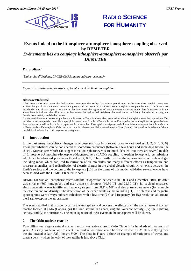
2 The Oklo nuclear reactor Two billion years ago a natural nuclear reactor was active close to Oklo (Gabon) for hundreds of thousands of years. A survey has been done to check if a residual ionization could be detected when DEMETER is flying over the site located at lat=1°23’, long=13°09’. The plots in Figure 1 show an example of variations of waves and plasma density when the orbit of the satellite is just above Oklo.
Journées scientifiques 1/3 février 2017 URSI-France
177
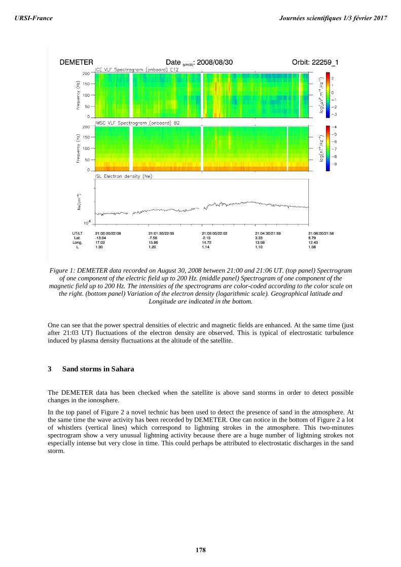
Figure 1: DEMETER data recorded on August 30, 2008 between 21:00 and 21:06 UT. (top panel) Spectrogram
of one component of the electric field up to 200 Hz. (middle panel) Spectrogram of one component of the magnetic field up to 200 Hz. The intensities of the spectrograms are color-coded according to the color scale on
the right. (bottom panel) Variation of the electron density (logarithmic scale). Geographical latitude and Longitude are indicated in the bottom.
One can see that the power spectral densities of electric and magnetic fields are enhanced. At the same time (just after 21:03 UT) fluctuations of the electron density are observed. This is typical of electrostatic turbulence induced by plasma density fluctuations at the altitude of the satellite.
3 Sand storms in Sahara
The DEMETER data has been checked when the satellite is above sand storms in order to detect possible changes in the ionosphere.
In the top panel of Figure 2 a novel technic has been used to detect the presence of sand in the atmosphere. At the same time the wave activity has been recorded by DEMETER. One can notice in the bottom of Figure 2 a lot of whistlers (vertical lines) which correspond to lightning strokes in the atmosphere. This two-minutes spectrogram show a very unusual lightning activity because there are a huge number of lightning strokes not especially intense but very close in time. This could perhaps be attributed to electrostatic discharges in the sand storm.
Journées scientifiques 1/3 février 2017URSI-France
178
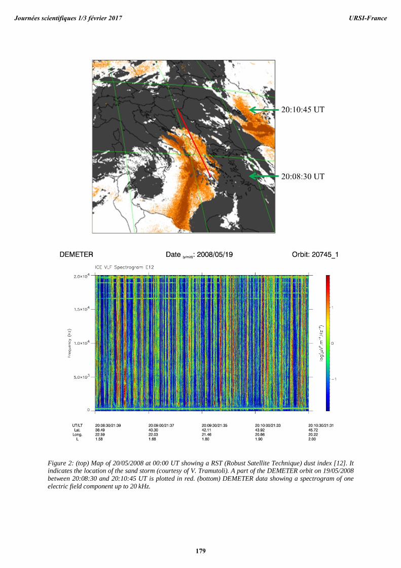
Figure 2: (top) Map of 20/05/2008 at 00:00 UT showing a RST (Robust Satellite Technique) dust index [12]. It indicates the location of the sand storm (courtesy of V. Tramutoli). A part of the DEMETER orbit on 19/05/2008 between 20:08:30 and 20:10:45 UT is plotted in red. (bottom) DEMETER data showing a spectrogram of one electric field component up to 20 kHz.
Journées scientifiques 1/3 février 2017 URSI-France
179

4 Volcanic activity Ashes in volcanic plumes are likely to produce electrostatic discharges in the atmosphere and then induce disturbances in the ionosphere. This is discussed in [13] where some examples are given. Here we intend to simultaneously show the atmospheric perturbation and the induced ionospheric change. During an eruption of Etna, Figure 3 displays hotspot detection of ashes, with a RST (Robust Satellite Techniques) approach optimized by a long-term time domain analysis performed on several satellite records, covering Mt Etna area and applied both on NOAA-AVHRR and EOS-MODIS data [14].
Figure 3: Hotspot detection of ashes during an eruption of Etna (courtesy of V. Tramutoli). The red line
indicates the orbit of DEMETER. In Figure 4 one can see some lightning activities (vertical lines in the spectrogram) but above all, an increase of the ion density when the satellite is at the latitude of the Mt Etna (around 20:45 UT).
Figure 4: It corresponds to DEMETER data recorded along the part of the orbit shown in Figure 3. The top panel represents a spectrogram of an electric component up to 2 kHz and the bottom panel is related to the
variation of the density of the ion O+.
Journées scientifiques 1/3 février 2017URSI-France
180

5 Lightning activity
The thunderstorm activity in the atmosphere triggers waves called whistlers in a large frequency range. These waves which propagate in the Earth–ionosphere waveguide can escape in the ionosphere and the magnetosphere. They induce precipitation of the particles which are in the radiation belts. This particle precipitation produces an additional ionization at the altitude of the satellite.
Figure 5: (top panel) spectrogram of an electric field component up to 20 kHz recorded on January 7, 2006. The intensity is color-coded on the right color scale. (bottom panel) Variation of the O+ ion density (adapted from
[15])..
Figure 5 displays data registered when DEMETER is above a thunderstorm. The top panel shows the spectrogram of an electric field component up to 20 kHz where intense whistlers are observed (vertical lines) just after 12:03 UT. At the time when the number of whistlers increases together with their intensities, one can see in the bottom panel an increase of the O+ ion density.
6 The hurricanes
Investigations have been done when the satellite is above atmospheric events with large pressure modifications such as hurricanes. Figure 6 displays the location of the hurricane DEAN on 17 August 2007. At this time the wind speed is 145 mph. The red line corresponds to a part of the DEMETER half-orbit during this day. Hours are indicated. Figure 7 is related to the DEMETER data recorded along this half-orbit. One notices the large number of whistlers (vertical lines) in the top panel which are mainly located at the edges of the hurricane. A large increase of the density is observed in the bottom panel at the closest approach of the hurricane.
Journées scientifiques 1/3 février 2017 URSI-France
181

Figure 6: Passive microwave imagery from the NASA TRMM satellite depicting the eyewall replacement cycle in Hurricane Dean on 17 August 2007, at 2254 UTC. All images are from the 85GHz channel in which ice
scattering reveals areas of deep convection displayed in the red shades. Image courtesy of the Naval Research Laboratory (NRL).
Figure 7: DEMETER data recorded along the half-orbit shown in the Figure 6. The top panel displays the spectrogram of an electric field component up to 20 kHz and the bottom panel is related to the O+ ion density.
Journées scientifiques 1/3 février 2017URSI-France
182
7 Discussion and Conclusion A various set of events occurring at the Earth’s surface or in the atmosphere has been studied with the DEMETER data. These events are related to radioactivity, electrostatic discharges of different intensities, temperature and pressure changes. It has been shown that they all induce variations in the ionosphere at the altitude of the satellite. These phenomena involve mechanisms which are put forward to explain the ionospheric perturbations induced by the earthquakes prior to their occurrence. Then the DEMETER observations point out that the different steps described in the LAIM coupling models [7, 9] are possible.
8 Acknowledgements This study is issued from an ISSI team led by S. Pulinets (RU) and D. Ouzounov (US) started in 2013 to work with the following aim: Multi-instrument Space-Borne Observations and Validation of the Physical Model of the LAIM coupling (see http://www.issibern.ch/teams/spaceborneobserve/). They are deeply acknowledged together with the contribution of K. Hattori, Tiger J.Y. Liu, A. Namgaladze, and V. Tramutoli.
References [1] Němec, F., O. Santolík, and M. Parrot (2009), Decrease of intensity of ELF/VLF waves observed in the upper ionosphere close to earthquakes: A statistical study, J. Geophys. Res., 114, A04303, doi:10.1029/2008JA013972.
[2] He, Y., Yang, D., Qian, J., and Parrot, M.: Response of the ionospheric electron density to different types of seismic events, Nat. Hazards Earth Syst. Sci., 11, 2173-2180, doi:10.5194/nhess-11-2173-2011, 2011.
[3] Li, M. and Parrot, M.: "Real time analysis" of the ion density measured by the satellite DEMETER in relation with the seismic activity, Nat. Hazards Earth Syst. Sci., 12, 2957-2963, doi:10.5194/nhess-12-2957-2012, 2012. [4] Li, M., and M. Parrot (2013), Statistical analysis of an ionospheric parameter as a base for earthquake prediction, J. Geophys. Res. Space Physics, 118, 3731–3739, doi:10.1002/jgra.50313.
[5] Piša, D., F. Nĕmec, O. Santolik, M. Parrot, and M.Rycroft (2013), Additional attenuation of natural VLF electromagnetic waves observed by the DEMETER spacecraft resulting from preseismic activity, J. Geophys. Res. Space Physics, 118, doi:10.1002/jgra.50469.
[6] Ryu, K., E. Lee, J. S. Chae, M. Parrot, and S. Pulinets (2014), Seismo-ionospheric coupling appearing as equatorial electron density enhancements observed via DEMETER electron density measurements, J. Geophys. Res. Space Physics, 119, pages 8524–8542, doi:10.1002/2014JA020284. [7] S. Pulinets and D. Ouzounov (2011), “Lithosphere–Atmosphere–Ionosphere Coupling (LAIC) Model—An Unified Concept for Earthquake Precursors Validation”, Journal of Asian Earth Sciences, 41, June 2011, pp. 371–382. [8] S. Pulinets (2012), “Low-Latitude Atmosphere-Ionosphere Effects Initiated by Strong Earthquakes Preparation Process”, International Journal of Geophysics, 2012, Article ID 131842, 14 pages. [9] S. Pulinets and D. Davidenko, “Ionospheric Precursors of Earthquakes and Global Electric Circuit”, Advances in Space Research, 53, 5, March 2014, pp. 709-723.
[10] R.G. Harrison, K.L. Aplin, and M.J. Rycroft, “Atmospheric Electricity Coupling between Earthquake Regions and the Ionosphere“, Journal of Atmospheric and Solar Terrestrial Physics, 72, April 2010, pp. 376-381. [11] Parrot, M. (2006), First results of the DEMETER micro-satellite, Special Issue of, Planet. Space Sci., 54(5), 411–558. [12] Sannazzaro, F., Filizzola, C., Marchese, F., Corrado, R., Paciello, R., Mazzeo, G., Pergola, N. and Tramutoli, V. (2014). Identification of dust outbreaks on infrared MSG-SEVIRI data by using a Robust Satellite Technique (RST). Acta Astronautica, 93, 64-70.
Journées scientifiques 1/3 février 2017 URSI-France
183
[13] Zlotnicki, Jacques, Feng Li and Michel Parrot (2010), Signals recorded by DEMETER satellite over active volcanoes during the period 2004 August–2007 December, Geophysical Journal International, 183 (3), 1332-1347.
[14] Pergola, N., Tramutoli, V., Marchese, F., Scaffidi, I., & Lacava, T. (2004). Improving volcanic ash cloud detection by a robust satellite technique. Remote Sensing of Environment, 90(1), 1-22. [15] Parrot, M., J. A. Sauvaud, S. Soula, J. L. Pinçon, and O. van der Velde (2013), Ionospheric density perturbations recorded by DEMETER above intense thunderstorms, J. Geophys. Res. Space Physics, 118, doi:10.1002/jgra.50460.
Journées scientifiques 1/3 février 2017URSI-France
184