evaluation workshop on the international space...
TRANSCRIPT

EUROPEAN SELF-TRAINING WORKSHOP ON THE INTERNATIONAL
« SPACE AND ENVIRONMENTAL DISASTERS » CHARTER PARIS 18th AND 19th MARCH 2002
1
EVALUATION WORKSHOP
ON THE INTERNATIONAL SPACE AND
MAJOR DISASTERS CHARTER
18TH AND 19TH MARCH 2002
PARIS
FINAL REPORT COMMISSION EUROPEENNE- DG ENV
Convention signée le 1/12/2001 Référence: SUB/01/330104

EUROPEAN SELF-TRAINING WORKSHOP ON THE INTERNATIONAL
« SPACE AND ENVIRONMENTAL DISASTERS » CHARTER PARIS 18th AND 19th MARCH 2002
2
Contents
INTRODUCTION............................................................................................................................. 3
WORKSHOP PROGRAMME....................................................................................................... 4
REPORT .......................................................................................................................................... 5
1ST GROUP: GEOGRAPHICAL INFORMATION SYSTEMS............................................................................. 8
2ND GROUP: IMAGE USAGE AND DELIVERY ........................................................................................... 8
3RD GROUP: EARTH OBSERVATION ...................................................................................................... 9
PRINCIPLE..................................................................................................................................... 10
THEME ......................................................................................................................................... 10
OBJECTIVES .................................................................................................................................. 10
ENTITIES ...................................................................................................................................... 11
TELECOMMUNICATION RESOURCES .................................................................................................. 11
WORKSHOPS ................................................................................................................................. 11
PARTICIPANT LIST AND CONTACT DETAILS........................................................................... 16
SYNTHESIS ON THE EXPECTATIONS AND IMPROVEMENTS RELATING TO THE
OPERATION OF THE SPACE CHARTER..................................................................................... 24
EUROPEAN SELF-TRAINING WORKSHOP ON THE INTERNATIONAL
« SPACE AND ENVIRONMENTAL DISASTERS » CHARTER PARIS 18th AND 19th MARCH 2002
3
Introduction
This report groups together all of the contributions presented in Paris on the 18th and 19th of March 2002, during the evaluation workshop on the International Space and Major Disasters. This workshop is a European project, co-financed by the Environmental Branch and organised by the French Ministry of the Interior’s Defence and Emergency Preparedness Branch. The sought objective was to increase awareness raising and instigate the apprenticeship of users in member States and the States within the European Economic Community in the consultation of space data during natural disasters. This workshop was geared around the following three phases:
The first phase consisted of presenting the feedback from the various managers and civil defence experts, by means of several concrete cases of natural disasters (Earthquake in San Salvador, Floods in Russia, volcano eruption in the Congo, landslides and forest fires in Italy, tempest in France, etc.).
The first day’s interventions were rounded off with a field exercise that took place in the ‘bois de Chaville’ – Chaville Woods (Yvelines), where archive pictures (optical and radar), before and after the tempest of December 1999, were shown. A simulation was run of image transmission in real time.
The last afternoon was dedicated to the drawing up of recommendations. Grouped into three work groups, (Geographical information system, Use and delivery of images and Earth Observation), the participants listed a series of observations and recommendations in these three areas.
EUROPEAN SELF-TRAINING WORKSHOP ON THE INTERNATIONAL
« SPACE AND ENVIRONMENTAL DISASTERS » CHARTER PARIS 18th AND 19th MARCH 2002
4
Workshop programme
SUNDAY 17 MARCH 2002 from 14:00 Welcoming the delegations 20:00 welcome dinner at the Hotel IBIS Courbevoie
MONDAY 18 MARCH 2002 9:00 Welcoming the Delegations, Defence and Emergency Preparedness Branch, Asnières-sur-Seine 9:30 Opening Mr. Michel SAPPIN, Prefect, Director of Defence and Emergency Preparedness, High Ranking Defence Official Mr. José ACHACHE, Director of the European Space Agency Earth Observation Programmes. Mr. BRACHET, Managing Director of the CNES 10:00 – 11:00 The International “Space and Major Disaster” Charter – Organisation, Operation, Activation Procedures J. Béquignon (ASE) and J.L. Bessis (CNES) 11:00 –12:45: Theoretical aspects. Earth Observation, imagery on the ground segment, data processing, the use of Information Systems, visualisations and cartography with a few concrete examples. 12:45 – 14:00: Lunch – Buffet offered by the Director of Defence and Emergency Preparedness 14:00 – 18:30: (coffee break around 16:00) Concrete examples Earthquakes in San Salvador and Inde, J. Inglada (CNES), R. Capes (Nigel Press Associates) Floods in the Saône, Meuse (France) and Lena (Russia), P. de Fraipont (SERTIT), S. Saradeth (GAF), Lt-Cl Stock(France) Volcanism NYIRACONGO (Congo) J. Inglada (CNES) Protezione Civile (Italy) Marine pollution: Galapagos and the Baltic Sea, J.Béquignon (ESA), P. Vanckeckhoven (Emergency Preparedness Unit) Landslide in Soverato (Italy) G. Sylos Labini (Planetek) Forest fires: Fires in the Pouilles, G. Sylos Labini (Planetek) Presentation of the next day’s exercise 18:OO departure for hotel 19:30 departure from hotel for official dinner
Tuesday 19 March 2002 8:00 – 9:00: departure from hotel and journey to exercise location. 9:00 – 12:00: field exercise in the Marly forest Responsibility: SERTIT and TD COM 12:00 – 14:00 Lunch at the University Léonard de Vinci 14:00-14:30 Return to the committee on civil defence 14:00 – 15:30 Report, recommendations Three work groups with a report compiler and proposed recommendations:
1. Geographical information systems 2. Image usage and delivery 3. definition of the end products, application of data to environmental risks (technology) , Earth Observation
15:30 – 16:00 Workshop recommendations and conclusions Return to the hotel or departure and shuttle to airport.

EUROPEAN SELF-TRAINING WORKSHOP ON THE INTERNATIONAL
« SPACE AND ENVIRONMENTAL DISASTERS » CHARTER PARIS 18th AND 19th MARCH 2002
5
Report The Prefect, Michel Sappin, Director of Defence and emergency preparedness, high ranking defence official The session was opened by the Prefect, who bid the participants welcome. The defence and emergency preparedness office has started up think tanks on the contribution of new technologies with a view towards improving its ability to anticipate crises. In particular, it has initiated collaboration with the space agencies. The Charter is an essential part of the answer to its concerns, shared by its European partners. To make progress towards a better response to emergency preparedness users’ requirements, it is essential that discussions and the analysis of current experience be continued. The Office is therefore very happy to welcome the participants in this workshop organised in co-operation with the European Commission. Mr. Brachet, General Director of the National Space Studies Centre Was the inspiration for the drawing up of this Charter, and since its operational implementation on the 1st November 2000, the Charter has been called upon 13 times, and a certain number of these events will be discussed during this workshop. Despite the limited number of space systems available, the results are encouraging, but could be improved. A workshop to assess the Charter’s performance was organised within the National Space Studies Centre on the 15th and 16th January 2002. It gathered together fifty participants, representing the signatories of the Charter, the users and the added value companies, involved in the events that have triggered the Charter. A certain number of recommendations arose from this workshop, among which figured:
1. The simplification of dialogue between the authorised user and the Charter, 2. The acceleration of the entire process, from triggering the Charter, up to supplying information, 3. Improving the quality of the products provided to users: simple and appropriate to needs, 4. Developing communication about the Charter and training users in its usage: this workshop is a first
step in answering this recommendation. The members of the Charter will do all they can in order to meet these recommendations as best they can, in close relation with the participants. The participation of new members and the launching into orbit of new satellites will contribute to these improvements. In this way the SPOT 5 satellite, scheduled for launch in April this year, will complete the SPOT constellation and enable an acceleration of image acquisition and the faster provision of products that are more appropriate to the description of the framework and roads network, taking into account improved space resolution (5m or even 2.5m). At the approach to 2006, a Franco-Italian project for a constellation of optical and radar satellites (Cosmo/Pleiades) will enable access to sub-metric resolutions that will further refine the information provided. Mr. Brachet notes that, up to now, only the Earth Observation satellites have been taken into account in the Charter. However, there are other space system that could offer precious help in times of crisis: the telecommunications systems, with portable terminals, when the land infrastructures are destroyed, the emergency resources positioning systems, the data collection and localisation systems enabling the monitoring of hydrocarbon slicks, etc. The members of the Charter, in co-operation with the community of users, and aware that the contribution of such systems could be vital, are studying the possibility of extending the Charter to these resources. Lastly, risk management is not restricted to crisis management and space systems may offer a key contribution in the prevention, forecasting and rehabilitation phases. Work is underway to develop these contributions. Mr. Achache, Director of the Earth Observation Programmes at the European Space Agency, is proud of the development of the Charter, in which he sees a forerunner of the GMES service programme (Global Monitoring of Environment and Security). This extensive programme, which will be run in partnership with the European Commission, aims to provide the communities concerned, and foremost among them the emergency preparedness and all the participants in natural or technological risk management, with the information they need in order to improve and support their decision making. This information will be provided from the data gathered by all of the existing space systems after integration (with data gathered elsewhere) and assimilation using the appropriate models. In this way the PACTES
EUROPEAN SELF-TRAINING WORKSHOP ON THE INTERNATIONAL
« SPACE AND ENVIRONMENTAL DISASTERS » CHARTER PARIS 18th AND 19th MARCH 2002
6
project, initiated by the French Ministry of Research and the National Space Studies Centre, aims to develop a pre-operational system for the management of the various phases of flood risk, using the different types of space resources. M. Patrick Vankerckhoven, representing the Commission, bid the participants welcome in his turn, and underlined the interest in spatial techniques and his desire to obtain feedback from the Member States. Colonel Nardin chaired the session and handed over the right of speech to the first lecturers,
• Messrs. Bessis (National Space Studies Centre) and Béquignon (European Space Agency) of the Charter Executive secretariat, on the principle, organisation and operation of the Charter. (diagrams in Appendix A).
• A theoretical preview of the Earth observation techniques was presented by Mr. François Delpont (GDTA).
In the afternoon, a certain number of real cases of Charter application were examined.
• Mr. Ren Capes presented examples of how the Charter was applied during the earthquakes in San Salvador and India.
• The case of flatlands flooding was tackled.
1. flooding of the river Lena in Siberia Mr. Stefan (GAF) 2. case of the Saône and the Meuse in France Mr. de Fraipont (SERTIT.
• Experience of Charter application Lieutenant-colonel STOCK re-capped on the role, organisation and links between the defence and emergency preparedness authorities, the general staff of the Eastern zone and the Moselle, Meuse and Ardennes County authorities, as well as the relationship with the inter-county industry and environment offices. He emphasised the high level of interest aroused by earth observation techniques (EO), underlining that major efforts had been made in reducing the time taken to provide information. Nevertheless, he did recall that for crisis management, the delay of 10 – 12 h is still too long. He specified his expectations and provided a few possible paths to follow. The Earth Observation data should allow:
• Updating on a critical situation and comparison with previous situations (idea of archiving interventions)
• Pinpointing of the geographical areas affected • Preparation of indemnity files in the event of natural disasters (CATNAT) • Comparison of an observed situation at a given time with the forecasts in order to refine them • Completion of ground occupation maps.
According to him, the Earth observation data should, for the moment, be mainly useful in the post-crisis period. He would like to see improvements in the investigation scales, heading from 1:25 000 to 1:10 000 or even 1:2000. This would enable improved identification of the sectors affected and the potential risks and rewards. We also need to improve the speed of delivery to users. Lieutenant-colonel Stock further provided the specific reflections enclosed. Mr. Paul DEWIL (Belgium) Underlined the restrictions of space data and that it is necessary to increase the complementarity of the standard and space techniques, as one cannot replace the other. There followed a presentation on cases of volcanic eruption presented by Mr. Jordi Inglada from the National Space Studies Centre.

EUROPEAN SELF-TRAINING WORKSHOP ON THE INTERNATIONAL
« SPACE AND ENVIRONMENTAL DISASTERS » CHARTER PARIS 18th AND 19th MARCH 2002
7
PARTICIPANT REACTIONS Mr. Paul DEWILL (Belgium) stated that the Belgian Civil Defence found the documents highly interesting and gave them food for thought concerning the situation and enabled them to make an initial assessment of requirements in terms of manpower and equipment. However, extremely high resolution data is necessary in order to manage the situation in the field. In addition, a confrontation between the derivative products of space originated data and ground measures showed that a second minor landslide had not been detected. Various participants have expressed their concerns regarding this subject. Mr. Dewil reiterated that an emergency/crisis service is used to dealing with non watertight and confused data and that any data /information is useful. . The case of oceanic pollution by hydrocarbons This is illustrated by what occurred in the Galapagos, when the request came from the Civil Protection Unit. Mr. Vanckerckhoven summed up the points required: cutting down data delivery times, the presentation of information in a format that can be read and understood by non specialist personnel, and avoiding a multiplicity of contacts The problem of landslides is illustrated by the Soverato disaster. To this date, the Charter has not been employed in relation to forest fires. This case is illustrated by a presentation of the VAMPYR project, being the cartography of fire devastated areas in Southern Italy using satellite imaging and GPS positioning. Finally, a presentation concerning the tempest which struck France in 1999 was given by Mr. de Fraipont. This presentation introduced the next days field exercises, which simulates forestry devastation, such as that which occurred Forest of Marly close to Versailles in during the 1999 tempest,– cartography in a context similar to that of the Charter, with the sending out of cartography field teams by a crisis centre and the feedback of GPS readings and on the spot photos/video films taken by the field teams.
EUROPEAN SELF-TRAINING WORKSHOP ON THE INTERNATIONAL
« SPACE AND ENVIRONMENTAL DISASTERS » CHARTER PARIS 18th AND 19th MARCH 2002
8
The morning of the second day was allocated to the field exercise, a description of which is provided in the next chapter. In the afternoon, the participants were divided up into three working groups: Geographical information systems, made up of Konrad ZIRM, H. M. Abd Allah HASSAN, Juan José ROMAN, Eduardo GONZALEZ, Juha KILPINEN, Paul DE FRAIPONT, Hamid L MOHAZ, Françoise AXES, Jérôme BEQUIGNON and Ulf BJURMAN (report compiler) Use and delivery of images, made up of Paul DEWIL, Isaak PARCHARIDIS, Luigi D’ANGELO, Kader FELLAH, Jean-Claude FAVARD, Jordi INGLADA, Patrick VANKERCKHOVEN, Noël STOCK, Patrick SAUVAGE, Oyvind JUELL, Adnene TEBOURBI and Ren CAPES (report compiler) Earth observation, made up of Andreas Busch, Evangelos LAGIOS, Andrea CARUSI, Hervé YESOU, Jean-Luc BESSIS and Einar ELLINGSEN (report compiler). Each group's report compiler presented the results of the work in plenary session. 1st group: Geographical information systems General observation concerning the morning's exercise:
- Certain geographical information systems are used by the Emergency Preparedness Services on a daily basis (prevention, risk analysis, operational preparation). It is important that ground data received, for example from satellite through GIS, is relayed.
- However, the systems used vary from State to State, and it therefore appears necessary to draw up compatible Community Standards, or even reference geographical information for use in protecting the environment or tackling environmental disasters (European data template, or even an easy-to-use GIS for the Emergency Preparedness Services).
- The deployment of a training strategy appears indispensable for promoting GIS development, operation and the use of satellite data. An "easy to use" operational procedures guide would be highly invaluable.
- Emergency preparedness programmes within EUROMED could be organised in order to facilitate GIS development and implementation.
2nd group: Image usage and delivery Some disagreements developed in this group: certain participants claimed that in developed countries, maps that become available one hour after the event has occurred only have a limited use (they are no longer appropriate to field requirements at H + 1). As they were not experts in image processing, they expressed a desire to take part in training courses on interpreting these type of maps and on the processing of data that contributed to making an operational decision. The CPA (local emergency preparedness authorities) experts are the most suitable locations for the correct data interpretation due to their knowledge in this sector. In terms of crisis situation response, the comparison of before and after images of a disaster is highly beneficial. Some participants are against consulting media sources while the Charter is in the process of being activated, as these sources remain unreliable. A Standard for maps and documents must be perfected (common colours, titles and page set up between countries). A number of participants debated the limited scope of the Charter. It is only effectively used in crisis situations and they underlined the relevance of providing the products in less urgent or exercise situations, in order that the appropriate teams can familiarise themselves with both the products and procedures.
EUROPEAN SELF-TRAINING WORKSHOP ON THE INTERNATIONAL
« SPACE AND ENVIRONMENTAL DISASTERS » CHARTER PARIS 18th AND 19th MARCH 2002
9
3rd group: Earth observation This group's participants highlighted the advantages of high resolution data and precise positioning, emphasising the importance of GPS. The previous day’s presentations highlighted:
- that satellite data provides only a part of the available information and can be used as a compliment to other forms of information.
- That this data is transmitted in "raw" format to the users, and requires interpretation by experts who have the necessary skills, and an understanding of the type of phenomena and the location where it occurs. This level of expertise should therefore be available in every country, thus emphasising the importance of training. The members of this group suggested the creation of regional know-how centres (in accordance with the type of danger), thus guaranteeing a centralisation of expertise and know-how.
- The necessity of developing added value relationships with each country's industrial sector in order to impart this expensively acquired know-how to them, and so result in the creation of appropriately adapted products.
In conclusion, the members of this group consider that the Charter's success lies is the establishing of regional centres, otherwise it would simply be a source of badly understood information and of limited use. There followed general discussion. On the subject of data processing and extraction of information, Mr. Bessis (National Space Studies Centre) stated that his Centre could not continue to finance this effort unilaterally. The majority of the participants estimated that this effort would have to be maintained over a relatively long period. If this support was stopped too abruptly, the EO (Earth Observation) data assimilation process in the Emergency Preparedness units would grind to a halt.

EUROPEAN SELF-TRAINING WORKSHOP ON THE INTERNATIONAL
« SPACE AND ENVIRONMENTAL DISASTERS » CHARTER PARIS 18th AND 19th MARCH 2002
10
Description of the field exercise Principle
1. The use of satellite earth observation data for the management of natural disaster situations in real time is on its way to becoming a reality.
This state of affairs is mainly the result of the following points.
• There are more and more non-military earth observation satellites. • The wide variety of sensors enable all-weather data acquisition. • The majority of satellites have acquisition programming facility. All of these elements contribute towards a potential augmentation in the frequency of image
acquisition covering all points of the globe.
2. The Charter, by instituting a programming priority, also improves the possibilities of overlapping cover.
3. The recent example of Charter implementation (flooding of the Saône and Meuse, etc.) demonstrated the feasibility of making geometrically correct interpreted crisis documents available to the authorities responsible for managing natural disasters, within twelve hours following satellite image acquisition.
4. The satellite communication resource offer currently accessible on the market opens up the possibility of real time distribution of crisis documents derived from satellite image acquisitions to the teams operating in the field.
5. The recent lifting of selective access (scrambling) to the World-wide satellite radio positioning system has provided an ubiquitous, inexpensive and generalised "localisation" function to crisis response management systems.
The objective of the exercise is to give a field demonstration of the feasibility of a system, that in a crisis situation (for example, a natural disaster), simultaneously directs observation satellite data to the crisis management centre and the field teams.
This system is based on coupling data from various types of "satellite" resources (earth observation, telecommunication and radio positioning satellites) by putting into play a conjunction of agents, that are not dedicated to crisis management and are available within a standard commercial framework.
In this set-up, the Charter intervenes as a catalyst which "multiplies" the normal opportunities for accessing satellite images.
Theme
The 1999 tempest caused serious forestry devastation, the wooded areas in the Paris region being particularly affected with, in some cases, a higher than 80% destruction level.
A database was built up in order to illustrate this phenomena and serves as a support for the field exercise which consists of simulating a natural disaster situation during the hours and days which "stricto sensu" follow the its actual occurrence . Objectives
1. Test transmission of a cartography of the crisis to the field using a telecommunications satellite.
2. Comparing the digitally processed satellite data mapping of the devastation with the reality in the field.
3. Using a cartography of the devastation in the field by means of a GPS system coupled with a GIS tool.
4. Feeding of localised information from the field back to a crisis centre.
EUROPEAN SELF-TRAINING WORKSHOP ON THE INTERNATIONAL
« SPACE AND ENVIRONMENTAL DISASTERS » CHARTER PARIS 18th AND 19th MARCH 2002
11
5. Measuring the possibilities opened up by the integration in real time of GPS positioning with the Earth observation data during the crisis period and after as a "substitute" compliment to the other cartographic information .
Entities Fixed units
• Field Command Centre: (CCT). • COGIC (Inter-Ministry Operational Crisis Management Centre). • Spot Image satellite data provider: (DP) • Sertit, cartographic crisis data provider: (VAC).
Mobile units
• Motorised field team: (ETM). • Pedestrian field team: (ETP).
Telecommunication resources
• CCT: a high throughput Inmarsat connection (Thrane & Thrane M4 Internet terminal). • ETM: a high throughput Inmarsat connection (Thrane & Thrane M4 Internet terminal).). • ETP the high throughput Inmarsat connection is optional in the event of a low degree of priority (with
a possible alternative of data transfer and GPS positioning using a portable). COGIC, VAC and DP are digitally (ISDN) connected to the Internet.
The minimum high throughput performance required for the exercise is 64 K bauds, the higher passband capacity will constitute a major advantage. Workshops
Due to the number of people (30 to 50 ) likely to attend the exercise, this will be divided up into workshops that will take place in, or in the vicinity of, the tent representing the CCT. "GPS trajectory" workshop
The bus journey taken by the participants of the Charter Workshop from the assembly point to the location of the exercise is recorded using an onboard GPS system connected to a portable computer.
A playback of this recording is replayed on a workstation, the trajectory is displayed on a National Geographic Institute cartographic background and on the background of a satellite optic image.
Workshop objectives :
• Present the GPS tool to those participants without experience in its use. • Compare the tracking possibilities on the two types of documents: normal cartographic backgrounds
and satellite optic images.
Possible improvement: produce feedback in real time on the bus's television during the journey.

EUROPEAN SELF-TRAINING WORKSHOP ON THE INTERNATIONAL
« SPACE AND ENVIRONMENTAL DISASTERS » CHARTER PARIS 18th AND 19th MARCH 2002
12
"Data transmission to field teams" workshop Within the framework of crisis management, transmission of information to the field teams represents a potential major risk or reward. There is not necessarily any synchronisation between the departure of the teams and the availability (or not) of the crisis cartography. In addition, the travelling time constituents a useful time frame with which "format" the crisis data. Downloading from satellite therefore constitutes the means of catching up with the field teams.
Two transfer methods are available using a file transfer protocol (ftp) application. The restitution in the field of a crisis cartography via the VAC ftp server. The restitution in the field of a satellite optical image, ortho-rectified from the DP ftp server which either adds to, or is a substitute for a standard cartography. Depending on the number of Inmarsat workstations that are available in the field, these transfers can be directed towards the 3 field units, CCT, ETM and ETP. It is possible to foresee the transfer of the complete cartographic database from the data provider's data servers (see below). Comment: with a 128 Kb/s throughput, a 10 minute test held in optimum conditions should in theory enable the transfer of approximately 70 Mb of data; if the data is zipped, this figure is likely to increase dramatically.
In all cases, the tests should enable the system to be calibrated and to set the limits that are possible in the time allocated to this demo.
COGIC
Data ProviderVAC
Inmarsat
CCT ETM ETP
EUROPEAN SELF-TRAINING WORKSHOP ON THE INTERNATIONAL
« SPACE AND ENVIRONMENTAL DISASTERS » CHARTER PARIS 18th AND 19th MARCH 2002
13
Workshop objectives :
• Demonstrate the feasibility of downloading cartographic data from telecommunications satellites. • Assess the advantages of such a system in terms of crisis cartographic data distribution.
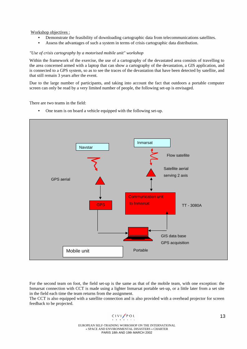
"Use of crisis cartography by a motorised mobile unit" workshop
Within the framework of the exercise, the use of a cartography of the devastated area consists of travelling to the area concerned armed with a laptop that can show a cartography of the devastation, a GIS application, and is connected to a GPS system, so as to see the traces of the devastation that have been detected by satellite, and that still remain 3 years after the event.
Due to the large number of participants, and taking into account the fact that outdoors a portable computer screen can only be read by a very limited number of people, the following set-up is envisaged.
There are two teams in the field:
• One team is on board a vehicle equipped with the following set-up.
For the second team on foot, the field set-up is the same as that of the mobile team, with one exception: the Inmarsat connection with CCT is made using a lighter Inmarsat portable set-up, or a little later from a set site in the field each time the team returns from the assignment. The CCT is also equipped with a satellite connection and is also provided with a overhead projector for screen feedback to be projected.
GPS
Communication unit
to Inmarsat
Navstar Inmarsat
Flow satellite
Portable
Satellite aerial
serving 2 axis
Mobile unit
GPS aerial
TT - 3080A
GIS data base
GPS acquisition

EUROPEAN SELF-TRAINING WORKSHOP ON THE INTERNATIONAL
« SPACE AND ENVIRONMENTAL DISASTERS » CHARTER PARIS 18th AND 19th MARCH 2002
14
In this workshop, the Inmarsat connection is used for sharing the mobile team's screen with the occupants of the CCT. The field team's advance, measured by its GPS, is thus mapped in real time at CCT. The application is used for this data sharing is Microsoft’s Netmeeting software, which enables to share the information contained on the laptop’s desktop Workshop objectives :
To evaluate the advantages provided to the work of the field teams by coupling satellite imaging with GPS. To assess the possibilities offered by a cartographic feedback in real time tracing the team’s movements in the field on various backgrounds, and especially the crisis cartography.
"Use of crisis cartography by a mobile unit" workshop This workshop is similar to the previous one (known as motorised mobile), although it is especially dedicated to those auditors that do not, or have very little experience in using GPS – cartography – satellite image coupling in real time. Two types of connections are foreseen for this workshops: this is either a permanent connection that is identical to that of the motorised mobile unit, if a portable version is available, or a return at regular intervals to a telecommunications terminal which enables observations to be fed back to the CCT (journey). Workshop objectives :
To carry out practical field measurements of a GPS and satellite cartography coupling in real time. To implement telecommunication resources with the CCT. "Image data feed back from the field" workshop
This exercise is supplementary to the two previous workshops. It involves one or the other of the two field teams combining "position" data coming from the GPS with "image" data , whether static or animated.
Workshop objectives :
• To demonstrate the feasibility of feeding back information from the field by satellite channel. • To confirm the coupling of "localised field data" with "telecommunications".
Communication
unit
Inmarsat
Flow satellite
Video projectorPortable
Projection
screen
Aieral
Command centre
EUROPEAN SELF-TRAINING WORKSHOP ON THE INTERNATIONAL
« SPACE AND ENVIRONMENTAL DISASTERS » CHARTER PARIS 18th AND 19th MARCH 2002
15
Supplementary workshops
The scheduled duration of this exercise, if three workstations are available, being two mobile workstations and a "command" workstation for field feedback, is approximately 2 hours. If we also accept that the auditorium will contain 30 to 50 people, we envisage having 1, 2 or 3 additional workstations at the Centre in order to distribute information in the form of interactive exercises or using slide shows illustrating the use of satellite imaging in managing natural disasters.
The purpose of these workstations is to act as the catalysts for informal discussions using concrete examples.
1 Crisis cartography by Internet : the procedures for distributing cartographic data on an "IP network are numerous. Internet servers provide a solution which could constitute a link in a crisis management system.
2 Slideshow on the Saône flooding: highlighted by radar images of the flooded areas.
3 Slideshow on the Meuse flooding: monitoring a flood's flood wave by satellite optical and radar images.
4. Known flood areas and zones not liable to flooding: impact on inhabited areas. Provisional schedule for the exercise • Journey to the location of the exercise 30 minutes. • Presentation of the exercise and technical resources. 10 minutes. • "GPS trajectory" workshop 10 minutes • "transmission of data to field teams" workshop 10 minutes • "Use of crisis cartography by a motorised mobile unit " workshop 20 minutes • "Use of crisis cartography by a mobile unit" workshop 20 minutes • "Image data feedback from the field" workshop 10 minutes • Supplementary workshops 20 minutes • Return journey 30 minutes Total 2 h 40 min
16
EUROPEAN SELF-TRAINING WORKSHOP ON THE INTERNATIONAL
« SPACE AND ENVIRONMENTAL DISASTERS » CHARTER PARIS 18th AND 19th MARCH 2002
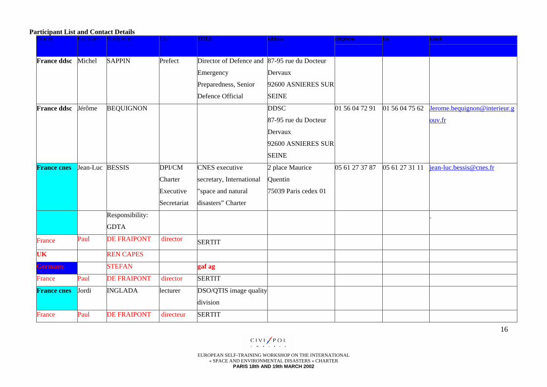
Participant List and Contact Details Country First Name Family Name Title TITLE address telephone fax e.mail
France ddsc Michel SAPPIN Prefect Director of Defence and
Emergency
Preparedness, Senior
Defence Official
87-95 rue du Docteur
Dervaux
92600 ASNIERES SUR
SEINE
France ddsc Jérôme BEQUIGNON DDSC
87-95 rue du Docteur
Dervaux
92600 ASNIERES SUR
SEINE
01 56 04 72 91 01 56 04 75 62 [email protected]
ouv.fr
France cnes Jean-Luc BESSIS DPI/CM
Charter
Executive
Secretariat
CNES executive
secretary, International
"space and natural
disasters” Charter
2 place Maurice
Quentin
75039 Paris cedex 01
05 61 27 37 87 05 61 27 31 11 [email protected]
Responsibility:
GDTA
France Paul DE FRAIPONT director SERTIT
UK REN CAPES
Germany STEFAN gaf ag
France Paul DE FRAIPONT director SERTIT
France cnes Jordi INGLADA lecturer DSO/QTIS image quality
division
France Paul DE FRAIPONT directeur SERTIT
17
EUROPEAN SELF-TRAINING WORKSHOP ON THE INTERNATIONAL
« SPACE AND ENVIRONMENTAL DISASTERS » CHARTER PARIS 18th AND 19th MARCH 2002
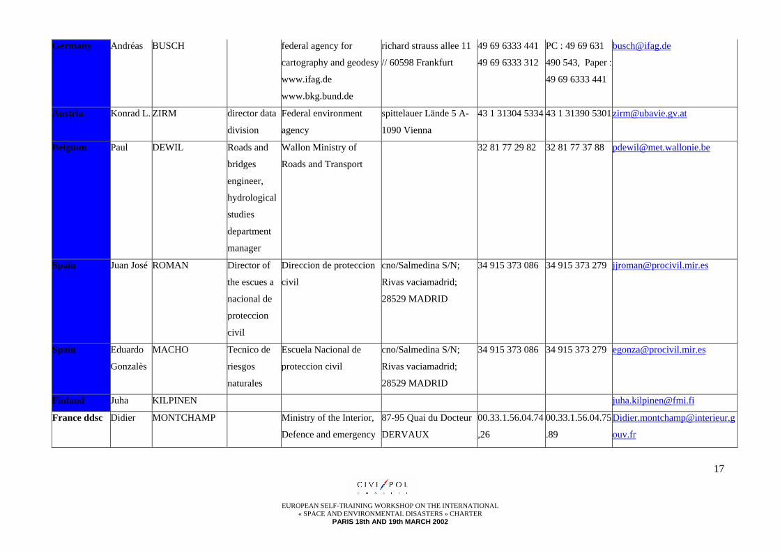
Germany Andréas BUSCH federal agency for
cartography and geodesy
www.ifag.de
www.bkg.bund.de
richard strauss allee 11
// 60598 Frankfurt
49 69 6333 441
49 69 6333 312
PC : 49 69 631
490 543, Paper :
49 69 6333 441
Austria Konrad L. ZIRM director data
division
Federal environment
agency
spittelauer Lände 5 A-
1090 Vienna
43 1 31304 5334 43 1 31390 [email protected]
Belgium Paul DEWIL Roads and
bridges
engineer,
hydrological
studies
department
manager
Wallon Ministry of
Roads and Transport
32 81 77 29 82 32 81 77 37 88 [email protected]
Spain Juan José ROMAN Director of
the escues a
nacional de
proteccion
civil
Direccion de proteccion
civil
cno/Salmedina S/N;
Rivas vaciamadrid;
28529 MADRID
34 915 373 086 34 915 373 279 [email protected]
Spain Eduardo
Gonzalès
MACHO Tecnico de
riesgos
naturales
Escuela Nacional de
proteccion civil
cno/Salmedina S/N;
Rivas vaciamadrid;
28529 MADRID
34 915 373 086 34 915 373 279 [email protected]
Finland Juha KILPINEN [email protected]
France ddsc Didier MONTCHAMP Ministry of the Interior,
Defence and emergency
87-95 Quai du Docteur
DERVAUX
00.33.1.56.04.74
,26
00.33.1.56.04.75
.89
ouv.fr
18
EUROPEAN SELF-TRAINING WORKSHOP ON THE INTERNATIONAL
« SPACE AND ENVIRONMENTAL DISASTERS » CHARTER PARIS 18th AND 19th MARCH 2002
preparedness office 92600 Asnières
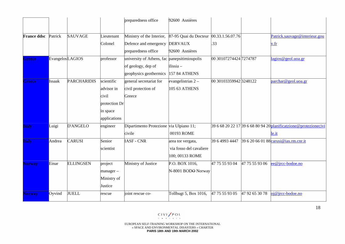
France ddsc Patrick SAUVAGE Lieutenant
Colonel
Ministry of the Interior,
Defence and emergency
preparedness office
87-95 Quai du Docteur
DERVAUX
92600 Asnières
00.33.1.56.07.76
.33
v.fr
Greece EvangelosLAGIOS professor university of Athens, fac
of geology, dep of
geophysics geothermics
panepsitimioupolis
ilissia –
157 84 ATHENS
00 30107274424 7274787 [email protected]
Greece Issaak PARCHARIDIS scientific
advisor in
civil
protection Dr
in space
applications
general secretariat for
civil protection of
Greece
evangelistrias 2 –
105 63 ATHENS
00 30103359942 3248122 [email protected]
Italy Luigi D'ANGELO engineer Dipartimento Protezione
civile
via Ulpiano 11;
00193 ROME
39 6 68 20 22 17 39 6 68 80 94 20planificatzione@protezionecivi
le.it
Italy Andrea CARUSI Senior
scientist
IASF - CNR area tor vergata,
via fosso del cavaliere
100; 00133 ROME
39 6 4993 4447 39 6 20 66 01 [email protected]
Norway Einar ELLINGSEN project
manager –
Ministry of
Justice
Ministry of Justice P.O. BOX 1016,
N-8001 BODO Norway
47 75 55 93 04 47 75 55 93 06 [email protected]
Norway Oyvind JUELL rescue joint rescue co- Tollbugt 5, Box 1016, 47 75 55 93 05 47 92 65 30 78 [email protected]
19
EUROPEAN SELF-TRAINING WORKSHOP ON THE INTERNATIONAL
« SPACE AND ENVIRONMENTAL DISASTERS » CHARTER PARIS 18th AND 19th MARCH 2002
inspector -
centre
opérationnel
nord
ordination centre north
Norway
N-8001 BODO Norway
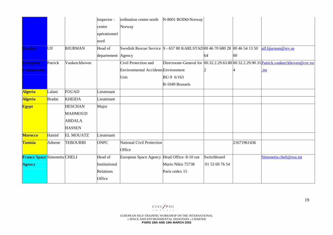
Sweden Ulf BJURMAN Head of
departement
Swedish Rescue Service
Agency
S - 657 80 KARLSTAD 00 46 70 680 28
64
00 46 54 13 50
00
European
Commission
Patrick Vankerckhoven Civil Protection and
Environmental Accidents
Unit
Directorate-General for
Environment
BU-9 6/163
B-1049 Brussels
00.32.2.29.63.88
2
00.32.2.29.90.31
4
.int
Algeria Lalani FOUAD Lieutenant
Algeria Bradai KHEIDA Lieutenant
Egypt HESCHAN
MAHMOUD
ABDALA
HASSEN
Major
Morocco Hamid EL MOUATZ Lieutenant
Tunisia Adnene TEBOURBI ONPC National Civil Protection
Office
21671961436
France Space
Agency
Simonetta CHELI Head of
Institutional
Relations
Office
European Space Agency Head Office: 8-10 rue
Mario Nikis 75738
Paris cedex 15
Switchboard
01 53 69 76 54
20
EUROPEAN SELF-TRAINING WORKSHOP ON THE INTERNATIONAL
« SPACE AND ENVIRONMENTAL DISASTERS » CHARTER PARIS 18th AND 19th MARCH 2002
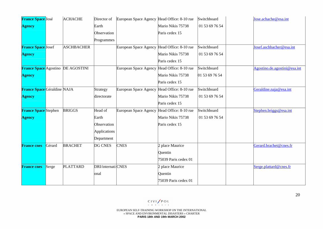
France Space
Agency
José ACHACHE Director of
Earth
Observation
Programmes
European Space Agency Head Office: 8-10 rue
Mario Nikis 75738
Paris cedex 15
Switchboard
01 53 69 76 54
France Space
Agency
Josef ASCHBACHER European Space Agency Head Office: 8-10 rue
Mario Nikis 75738
Paris cedex 15
Switchboard
01 53 69 76 54
France Space
Agency
Agostino DE AGOSTINI European Space Agency Head Office: 8-10 rue
Mario Nikis 75738
Paris cedex 15
Switchboard
01 53 69 76 54
France Space
Agency
Géraldine NAJA Strategy
directorate
European Space Agency Head Office: 8-10 rue
Mario Nikis 75738
Paris cedex 15
Switchboard
01 53 69 76 54
France Space
Agency
Stephen BRIGGS Head of
Earth
Observation
Applications
Department
European Space Agency Head Office: 8-10 rue
Mario Nikis 75738
Paris cedex 15
Switchboard
01 53 69 76 54
France cnes Gérard BRACHET DG CNES CNES 2 place Maurice
Quentin
75039 Paris cedex 01
France cnes Serge PLATTARD DRI/internati
onal
CNES 2 place Maurice
Quentin
75039 Paris cedex 01

21
EUROPEAN SELF-TRAINING WORKSHOP ON THE INTERNATIONAL
« SPACE AND ENVIRONMENTAL DISASTERS » CHARTER PARIS 18th AND 19th MARCH 2002
France cnes Michèle CHEVREL DRI/CM,
Member of
Charter
Board
CNES 2 place Maurice
Quentin
75039 Paris cedex 01
France cnes Jean-
Claude
FAVARD lecturer CNES - DSO/QTIS
image quality division
2 place Maurice
Quentin
75039 Paris cedex 01
France cnes VéroniqueMARIETTE DPI/EOT
Earth
observation
CNES 2 place Maurice
Quentin
75039 Paris cedex 01
France cnes Hervé BUTHAUD DPI/EOT
Earth
observation
CNES 2 place Maurice
Quentin
75039 Paris cedex 01
France SPOT Françoise AXES SPOT IMAGE 5 rue Satellite 31400
TOULOUSE
05 62 19 40 40
Italy Patrick DESENNE EUROPE IMAGE (Film
Company)
92 ISSY LES
MOULINEAUX
France ddsc Michel CHAMPON Deputy Director of Civil
Defence and Emergency
Preparedness
87-95 rue du Docteur
Dervaux
92600 ASNIERES SUR
SEINE
France ddsc Gilles BARSACQ Director of the Director
of Civil Defence and
Emergency
87-95 rue du Docteur
Dervaux
92600 ASNIERES SUR

22
EUROPEAN SELF-TRAINING WORKSHOP ON THE INTERNATIONAL
« SPACE AND ENVIRONMENTAL DISASTERS » CHARTER PARIS 18th AND 19th MARCH 2002
Preparedness’ Office SEINE
France ddsc Philippe NARDIN Colonel Head of the International
Relations Assignment at
the Defence and
Emergency
Preparedness’ directorate
87-95 rue du Docteur
Dervaux
92600 ASNIERES SUR
SEINE
33 1 56 04 75 58 [email protected]
.fr
France ddsc Christine Mme
BILLAUDEL
Senior Civil Servant at
the International
Relations Assignment
87-95 rue du Docteur
Dervaux
92600 ASNIERES SUR
SEINE
33 1 56 04 75 58
France ddsc Serge POPOFF Senior Civil Servant at
the International
Relations Assignment
87-95 rue du Docteur
Dervaux
92600 ASNIERES SUR
SEINE
33 1 56 04 75 58
France ddsc Michèle Mme VIE Senior Civil Servant at
the International
Relations Assignment
87-95 rue du Docteur
Dervaux
92600 ASNIERES SUR
SEINE
33 1 56 04 75 58
France ddsc Lionel LE CLEÏ Colonel Head of the "Industrial
Relations" office at the
Defence and Emergency
Preparedness’ directorate
87-95 rue du Docteur
Dervaux
92600 ASNIERES SUR
SEINE
France ddsc Noël STOCK Lieutenant
Colonel
Emergency Preparedness
General Staff -
Préfecture de la zone de
défense Est 57000
23
EUROPEAN SELF-TRAINING WORKSHOP ON THE INTERNATIONAL
« SPACE AND ENVIRONMENTAL DISASTERS » CHARTER PARIS 18th AND 19th MARCH 2002
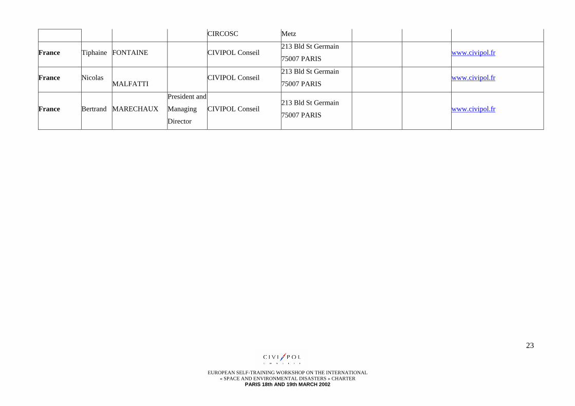
CIRCOSC Metz
France Tiphaine FONTAINE CIVIPOL Conseil 213 Bld St Germain
75007 PARIS www.civipol.fr
France Nicolas MALFATTI
CIVIPOL Conseil 213 Bld St Germain
75007 PARIS www.civipol.fr
France Bertrand MARECHAUX
President and
Managing
Director
CIVIPOL Conseil 213 Bld St Germain
75007 PARIS www.civipol.fr

24
EUROPEAN SELF-TRAINING WORKSHOP ON THE INTERNATIONAL
« SPACE AND ENVIRONMENTAL DISASTERS » CHARTER PARIS 18th AND 19th MARCH 2002
SYNTHESIS ON THE EXPECTATIONS AND IMPROVEMENTS RELATING TO THE OPERATION OF
THE SPACE CHARTER Global Approach: User requirements in terms of the use of Earth observation images should be determined from a risk analysis drawn up from the following reflection logic: 1- What is the source of risk (initial source)? 2- Which mode or flow it is expressed in (actions caused by the source on one (or more) potential risks or rewards (or targets)? 3- What targets are likely to undergo attack in the event that a risk should occur (human lives, goods, environment, economic infrastructures, etc.)? 4- What are the most plausible scenarios for risk manifestation? 5- What situations can be envisaged in terms of consequences and foreseeable damage? 6- What decision making help tools exist and are necessary in order to estimate these foreseeable situations? 7- What is the decision making “time required” scale in order to offer an appropriate response to a situation? 8- Are the possibilities offered by the decision making help tools (EO images) compatible with the time required and available for decision making. Example of slow floods (for the last 3 questions): The flood forecasts are made at 12:00, and are renewed (updated) every 6 hours in the case of a severe flood (on the side of the first effect). What could EO images offer to improve the quality of these forecasts (situations that could be envisaged) during the crisis phase? Is the “restitution time” dimension of these images compatible with the frequency of forecast updates? H - 24 H – 6 H + 6
H -12 H H + 12
Forecast for time H verification of real situation with forecast
Forecast for the time H+ 6…
Satellite programming EO acquisition EO restitution (time H) to user The interest would lie in making a comparison between the situation forecast at the time H and the situation observed at the same time, in order to refine and define the forecasts with greater precision. However, the observed situation is only available at H + 12. There is thus a period of 24 hours between the initial forecast (H -12) and the opportunity of checking this forecast against images of the real situation available at H + 12. In reality, in actions carried out by the flood warning services, the forecasts are updated every 6 hours.
25
EUROPEAN SELF-TRAINING WORKSHOP ON THE INTERNATIONAL
« SPACE AND ENVIRONMENTAL DISASTERS » CHARTER PARIS 18th AND 19th MARCH 2002
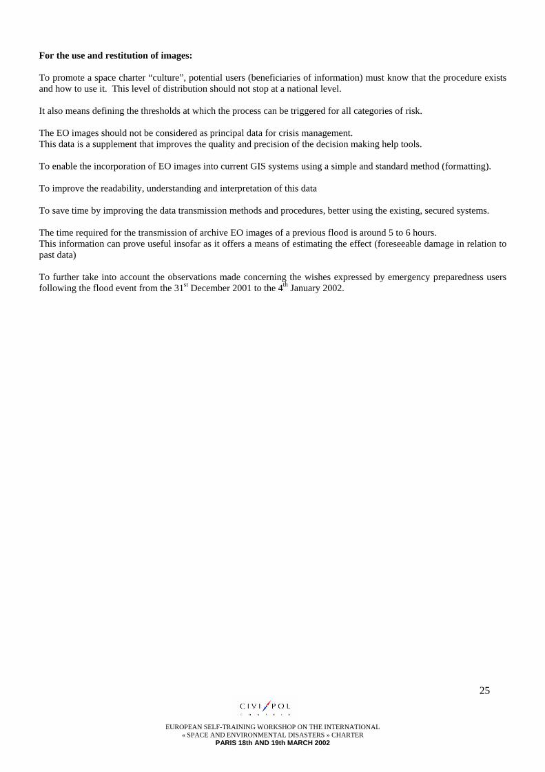
For the use and restitution of images: To promote a space charter “culture”, potential users (beneficiaries of information) must know that the procedure exists and how to use it. This level of distribution should not stop at a national level. It also means defining the thresholds at which the process can be triggered for all categories of risk. The EO images should not be considered as principal data for crisis management. This data is a supplement that improves the quality and precision of the decision making help tools. To enable the incorporation of EO images into current GIS systems using a simple and standard method (formatting). To improve the readability, understanding and interpretation of this data To save time by improving the data transmission methods and procedures, better using the existing, secured systems. The time required for the transmission of archive EO images of a previous flood is around 5 to 6 hours. This information can prove useful insofar as it offers a means of estimating the effect (foreseeable damage in relation to past data) To further take into account the observations made concerning the wishes expressed by emergency preparedness users following the flood event from the 31st December 2001 to the 4th January 2002.