evaluation of wetland assessment methods and...
TRANSCRIPT
Evaluation of Wetland Assessment Methods and Credit-Debit Systems for
In-Lieu Fee Mitigation of Coastal Aquatic Resources in
Southeast Alaska
October 27, 2010
Prepared for
Southeast Alaska Land Trust Juneau, Alaska
Funded by
U.S. Fish and Wildlife Service Juneau Field Office
Prepared by
949 E. 36th Avenue, Suite 500 1100 112th Avenue NE, Suite 400 Anchorage, AK 99508 Bellevue, WA 98004 425/453-5000

CH2MHILL_SEALTRUST_WETLANDREPORT_FINAL_10-27-2010.DOC i
Contents Acronyms and Abbreviations ........................................................................................................ iii 1.0 Summary ..................................................................................................................................... 1-1
1.1 Wetland Assessment Methods Evaluation ....................................................................... 1-1 1.2 Credit-Debit Systems ........................................................................................................... 1-2 1.3 Organization of the Report ................................................................................................. 1-3
2.0 Introduction ................................................................................................................................ 2-1 2.1 Study Purpose, Goals, and Objectives .............................................................................. 2-1 2.2 Background ........................................................................................................................... 2-1 2.3 Evaluation Methods and IRT Input ................................................................................... 2-2 2.4 Characteristics for a Southeast Alaska Assessment Method ......................................... 2-3
3.0 Evaluation of Wetland Assessment Methods ...................................................................... 3-1 3.1 Overview of Wetland Assessment Methods Evaluated ................................................. 3-1 3.2 Assessment Methods Not Available for Evaluation ....................................................... 3-3 3.3 Recommended Wetland Assessment Method for Southeast Alaska ............................ 3-3
4.0 Evaluation of Credit-Debit Systems ...................................................................................... 4-1 4.1 Overview of Credit-Debit Systems .................................................................................... 4-1 4.2 Recommendations and Example Credit-Debit Framework for SEAL Trust ............... 4-4 4.3 Considerations for Addressing In-Kind Mitigation ........................................................ 4-6
5.0 Recommended Next Steps ....................................................................................................... 5-1 5.1 Develop a Project Workplan ............................................................................................... 5-1 5.2 Adopt and Revise Wetland Assessment Method for Southeast Alaska ...................... 5-1 5.3 Develop and Implement a Credit-Debit Framework for SEAL Trust .......................... 5-2
6.0 Authors and Contributors ........................................................................................................ 6-1 7.0 References ................................................................................................................................... 7-1 Tables
1-1 Sample Ratios for Compensatory Mitigation in Alaska—USACE Alaska District ....... 1-3 2-1 Summary of Attendees at the Interagency Review Team Meetings for the
SEAL Trust Project .................................................................................................................. 2-3 3-1 Grouped Service Functions and Aggregated Functions Assessed by
ORWAP/WESPUS ................................................................................................................. 3-4 3-2 Hypothetical Example of Wetland Functional Assessment using
ORWAP/WESPUS ................................................................................................................. 3-6 3-3 Hypothetical Example of Using Average Overall WESPUS Scores to
Incrementally Correspond to a Continuum of Mitigation Ratios .................................... 3-7 4-1 Sample Ratios for Compensatory Mitigation in Alaska—USACE Alaska District ....... 4-1 4-2A Project A – Proposed Project Impact (“Debit”) and Mitigation Calculation .................. 4-4 4-2B Project B – Proposed Project Impact (“Debit”) and Mitigation Calculation ................... 4-5 4-3 Proposed Preservation Site X from In-Lieu Fee Sponsor (“Credits”) .............................. 4-5 4-4 Sample Proposed Credit-Debit Framework Ledger .......................................................... 4-5 4-5 Example Conversion Factors to Adjust for Functional Equivalency .............................. 4-6 4-6 Project A – Proposed Project Impacts Adjusted to “High-Function Unit
Acres” ....................................................................................................................................... 4-7
EVALUATION OF WETLAND ASSESSMENT METHODS AND CREDIT-DEBIT SYSTEMS FOR IN-LIEU FEE MITIGATION OF COASTAL AQUATIC RESOURCES IN SOUTHEAST ALASKA
CH2MHILL_SEALTRUST_WETLANDREPORT_FINAL_10-27-2010.DOC ii
4-7 Project B – Proposed Project Impacts Adjusted to “High-Function Unit Acres” ....................................................................................................................................... 4-7
4-8 ILF Receiving Site X – Proposed Preservation Credit Adjusted to “High-Function Unit Acres” ................................................................................................. 4-7
4-9 Sample Proposed Credit-Debit Framework Ledger using “High-Function Unit Acres” ....................................................................................................................................... 4-8
Figure 3-1 Distribution of average overall scores for sites sampled for ORWAP
(sample size n=221) ................................................................................................................ 3-6 Photo 3-1 Visit to Juneau area wetlands with SEAL Trust and USFWS on
March 31, 2010 ......................................................................................................................... 3-5 Attachments A Summary of Characteristics for Wetland Assessment Methods B Wetland Assessment Methods Evaluation C U.S. Army Corps of Engineers Alaska District Regulatory Guidance Letter #09-01
CH2M HILL Project No. 403452.01.02

CH2MHILL_SEALTRUST_WETLANDREPORT_FINAL_10-27-2010.DOC iii
Acronyms and Abbreviations
ADEC Alaska Department of Environmental Conservation
ADF&G Alaska Department of Fish and Game
ADNR Alaska Department of Natural Resources
ADOT&PF Alaska Department of Transportation & Public Facilities
AKWAM Alaska Wetland Assessment Method
BPJ Best Professional Judgment
CBJ City and Borough of Juneau
CIAP Coastal Impact Assistance Program
ESA Endangered Species Act
HGM Hydrogeomorphic Method
HUC hydrologic unit code
ILF In-Lieu Fee
IRT Interagency Review Team
NMFS National Marine Fisheries Service
NOAA National Oceanic and Atmospheric Administration
ORWAP Oregon Rapid Wetland Assessment Protocol
PNW Pacific Northwest
RGL Regulatory Guidance Letter
SEAL Trust Southeast Alaska Land Trust
USACE U.S. Army Corps of Engineers
USEPA U.S. Environmental Protection Agency
USFWS U.S. Fish and Wildlife Service
WESPUS Wetland Ecosystem Services Protocol United States
WSDOT Washington State Department of Transportation

CH2MHILL_SEALTRUST_WETLANDREPORT_FINAL_10-27-2010.DOC 1-1
1.0 Summary
CH2M HILL conducted a study in 2010 to evaluate wetland assessment methods and credit-debit systems for in-lieu fee mitigation1 of coastal aquatic resources in Southeast Alaska. This study was conducted for the Southeast Alaska Land Trust (SEAL Trust) in support of their In-Lieu Fee (ILF) Program that is being revised to comply with the Final Rule for Compensatory Mitigation for Losses of Aquatic Resources, which was published in the Federal Register on April 10, 2008 (hereafter referred to at the 2008 Federal Mitigation Rule). The Juneau Field Office of the U.S. Fish and Wildlife Service (USFWS) funded this study under a Coastal grant to SEAL Trust.
1.1 Wetland Assessment Methods Evaluation Seventeen existing available wetland assessment methods were evaluated as part of this study and are described in Chapter 3 and in Attachments A and B of this report. The methods evaluated were developed for Southeast Alaska, for other parts of Alaska, and for the Pacific Northwest (PNW) and other regions. An Interagency Review Team (IRT) based mostly in Juneau suggested several methods to be evaluated. The IRT also provided input to develop a list of essential characteristics that were used to evaluate the methods. The characteristics identified as being essential for a wetland assessment method for Southeast Alaska include:
Be applicable to tidal and non-tidal wetlands.
Assess wetland functions (such as, hydrologic, water quality, and fish/wildlife habitat).
Result in an overall functional rating or categorization (such as, High, Moderate, Low).
Require one-half day or less for assessment of each wetland (i.e., “rapid”).
Be repeatable and objective (results in consistent ratings) and minimizes reliance on Best Professional Judgment (BPJ).
Be supported by recent available documented science. (Recent was defined as occurring after the year 2000).
Be watershed-based by considering a wetland’s watershed and surrounding land uses.
Identify “Red Flag” Habitats – Elevate high quality/value ecological conditions (such as, habitat for Endangered Species Act (ESA) Listed species, rare/sensitive species, rare wetland types, areas including or adjacent to essential fish habitat).
Include a data form to record field observations and notes.
1 In-lieu fee mitigation is a type of compensatory mitigation that is required after an applicant has avoided and minimized impacts to a wetland.
EVALUATION OF WETLAND ASSESSMENT METHODS AND CREDIT-DEBIT SYSTEMS FOR IN-LIEU FEE MITIGATION OF COASTAL AQUATIC RESOURCES IN SOUTHEAST ALASKA
CH2MHILL_SEALTRUST_WETLANDREPORT_FINAL_10-27-2010.DOC 1-2
The wetland assessment methods evaluated generally fell into several general groups related to their original authors:
New England Highway Methodology Workbook-based methods
Hydrogeomorphic (HGM)-based methods
Washington-based methods
ADOT&PF method (adapted from Montana Department of Transportation).
Adamus-based methods
Of the seventeen methods evaluated, the one method that may have the greatest potential for being applied to Southeast Alaska is based on a method developed by Paul Adamus for Oregon. Based on the Oregon method, Adamus has created a generic beta version called Wetland Ecosystem Services Protocol United States (WESPUS). The WESPUS method satisfies most of the essential characteristics and has many of the desirable characteristics compared to all the other methods evaluated. Also, Adamus began a preliminary experimental test of WESPUS in Juneau in June 2010 (See Appendix C in Bosworth and Adamus, 2010). As a result of this evaluation of wetland assessment methods, WESPUS is being recommended to SEAL Trust and the IRT for preliminary testing and calibration for Southeast Alaska.
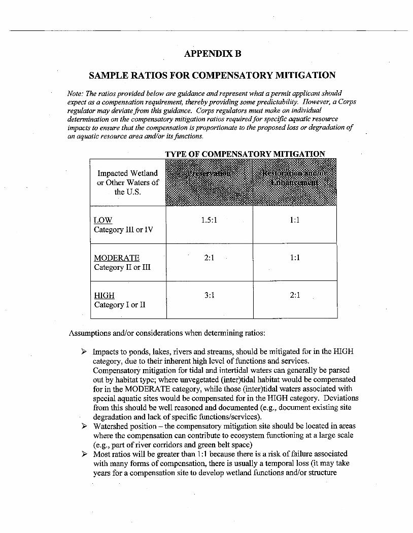
1.2 Credit-Debit Systems A limited number of credit-debit systems are currently in use, particularly in Alaska. The one credit-debit system from Alaska that was available for review included the Sample Ratios for Compensatory Mitigation that were provided as Appendix B in the 2009 U.S. Army Corps of Engineers (USACE) Alaska District Regulatory Guidance Letter (RGL) (USACE 2009), which incidentally was adapted from guidance developed in Washington State. The table from Appendix B of the 2009 Alaska District RGL (USACE 2009) is presented in Table 1-1 below. For convenience, the 2009 Alaska District RGL is included as Attachment C of this report. This table provides sample ratios for three categories (Low, Moderate, and High) of impacted wetlands or other waters of the United States, and two types of compensatory mitigation (preservation and restoration/enhancement). For SEAL Trust (and Alaska in general), the primary form of compensatory mitigation provided is wetland preservation.
A number of other credit-debit systems were evaluated and are described in Chapter 4. A credit-debit framework being recommended for SEAL Trust and the IRT to consider combines the 2009 Alaska District RGL with approaches that are being implemented in Washington and Oregon. Considerations for addressing in-kind mitigation are discussed. Also, an example approach is proposed to adjust for different levels of function and provide better equivalency between impact acreage (debits) and preservation acreage (credits).
EVALUATION OF WETLAND ASSESSMENT METHODS AND CREDIT-DEBIT SYSTEMS FOR IN-LIEU FEE MITIGATION OF COASTAL AQUATIC RESOURCES IN SOUTHEAST ALASKA
CH2MHILL_SEALTRUST_WETLANDREPORT_FINAL_10-27-2010.DOC 1-3
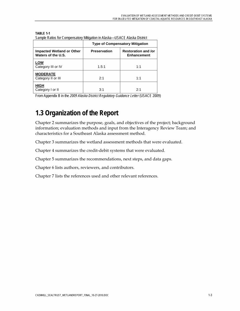
TABLE 1-1 Sample Ratios for Compensatory Mitigation in Alaska—USACE Alaska District
Type of Compensatory Mitigation
Impacted Wetland or Other Waters of the U.S.
Preservation Restoration and /or Enhancement
LOW Category III or IV
1.5:1
1:1
MODERATE Category II or III
2:1
1:1
HIGH Category I or II
3:1
2:1
From Appendix B in the 2009 Alaska District Regulatory Guidance Letter (USACE 2009)
1.3 Organization of the Report Chapter 2 summarizes the purpose, goals, and objectives of the project; background information; evaluation methods and input from the Interagency Review Team; and characteristics for a Southeast Alaska assessment method.
Chapter 3 summarizes the wetland assessment methods that were evaluated.
Chapter 4 summarizes the credit-debit systems that were evaluated.
Chapter 5 summarizes the recommendations, next steps, and data gaps.
Chapter 6 lists authors, reviewers, and contributors.
Chapter 7 lists the references used and other relevant references.


CH2MHILL_SEALTRUST_WETLANDREPORT_FINAL_10-27-2010.DOC 2-1
2.0 Introduction
This chapter summarizes the purpose, goals, and objectives of the project; background information; evaluation methods and input from the Interagency Review Team (IRT); and characteristics for a Southeast Alaska assessment method.
2.1 Study Purpose, Goals, and Objectives In collaboration with the IRT consisting of the USACE, USFWS, National Oceanic and Atmospheric Administration (NOAA), U.S. Environmental Protection Agency (USEPA), Alaska Department of Fish and Game (ADF&G), Alaska Department of Natural Resources (ADNR), and CBJ, CH2M HILL evaluated existing coastal and Pacific Northwest wetland assessment methods and credit-debit systems to identify and describe critical elements that would be useful to develop or customize a method for Southeast Alaska.
The goals of the study were to: 1) Identify an existing assessment method that meets the essential characteristics, could
readily be adapted to Southeast Alaska, and results in a general rating or categorization of overall wetland function.
2) Evaluate credit-debit systems and recommend a credit-debit framework that could be used by SEAL Trust as part of their ILF instrument.
The objectives of the study were to provide: 1) Comparative information on assessment methods from which SEAL Trust and the IRT
could extract components that they agree are workable and sufficient to reasonably translate to Southeast Alaska coastal aquatic resources, including estuarine wetlands.
2) Recommendations on elements critical to a region-specific aquatic resources assessment tool and credit-debit system (SEAL Trust would seek to develop this assessment tool and credit-debit system as a subsequent future task not included in this scope of work).
3) Enhanced knowledge gained by the USACE, SEAL Trust, IRT, and other regional resource and lands professionals that will result in more informed and consistent implementation of the 2008 Federal Mitigation Rule to Southeast Alaska coastal aquatic resources.
2.2 Background
Southeast Alaska Land Trust Under a legal partnership with USACE, SEAL Trust accepts fees from permitees in lieu of mitigation for project impacts to waters of the United States. SEAL Trust is then obligated to acquire or otherwise protect wetlands for conservation purposes that offset the losses from the permitted developments. Proposed mitigation projects are reviewed by the IRT.
EVALUATION OF WETLAND ASSESSMENT METHODS AND CREDIT-DEBIT SYSTEMS FOR IN-LIEU FEE MITIGATION OF COASTAL AQUATIC RESOURCES IN SOUTHEAST ALASKA
CH2MHILL_SEALTRUST_WETLANDREPORT_FINAL_10-27-2010.DOC 2-2
Currently, SEAL Trust uses real estate value, transaction costs, survey, appraisal, and other professional fees and stewardship costs to determine the amount of in-lieu fees for impacted sites. The funds are used to protect sensitive areas through conservation easements, fee-simple title acquisition, or other legal instruments to mitigate for permitted impacts. The current system, however, lacks rigorous parity between impacted and mitigation sites now required by regulation. Recent Federal regulations require in-lieu fee programs to use wetland assessment methods and credit-debit legers to ensure that mitigation efforts offset functions lost at impacted sites.
The IRT agencies and developers struggle with variable and often subjective approaches to evaluating wetland impacts and determining the appropriate permit mitigation requirements. Southeast Alaska lacks a region-specific methodology for assessing wetlands, for assigning debits to the permitted impacts, and assigning credits for wetland preservation.
ADOT&PF Synthesis Report In 2005, the Alaska Department of Transportation and Public Facilities (ADOT&PF) completed a Synthesis of Practice for Rapid Wetland Assessment in Alaska (ADOT&PF 2005). The ADOT&PF report recommended that “The Montana Wetland Assessment Method, prepared for the Montana Department of Transportation, is one that could incrementally and relatively easily be adapted for use in Alaska. With few modifications, it could be tested in Alaska immediately. ADOT&PF should adopt certain concepts from other methods as well.” Since 2005, ADOT&PF has been working to develop a method for Alaska based on the Montana Wetland Assessment Method (Berglund 1999; Berglund and McEldowney 2008). In July 2010, ADOT&PF issued version 1.0 of their Alaska Wetland Assessment Method (AKWAM). The evaluation currently being conducted for SEAL Trust builds on the previous synthesis prepared by ADOT&PF (2005), and identifies recent advances in wetland assessment science.
2.3 Evaluation Methods and IRT Input SEAL Trust invited members of the IRT to a kickoff meeting that was held in Juneau on March 31, 2010. Representatives that attended the kickoff meeting from participating organizations are summarized in Table 2-1.
At the kickoff meeting, SEAL Trust and the IRT drafted a list of characteristics that were identified as being essential for any assessment method developed for Southeast Alaska. In early April, immediately following the kickoff meeting, the list of essential characteristics was refined and sent to the IRT and SEAL Trust for review and comment. Comments received were incorporated into a refined list of essential characteristics that was used to evaluate the wetland assessment methods.
SEAL Trust invited members of the IRT to a second meeting that was held in Juneau on August 31, 2010. The purpose of this meeting was to discuss and provide comments on a draft version of this report.
In April and May 2010, the various methods were obtained and evaluated. By late May, SEAL Trust distributed to the IRT a summary of the evaluation of wetland assessment
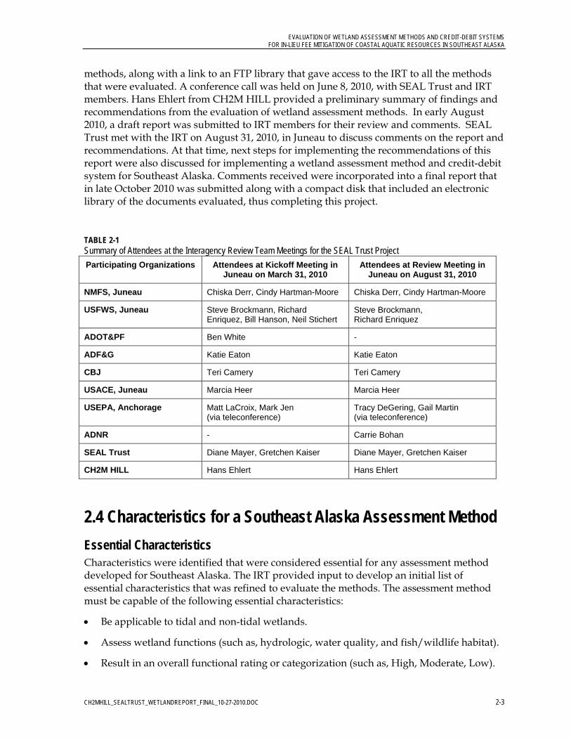
EVALUATION OF WETLAND ASSESSMENT METHODS AND CREDIT-DEBIT SYSTEMS FOR IN-LIEU FEE MITIGATION OF COASTAL AQUATIC RESOURCES IN SOUTHEAST ALASKA
CH2MHILL_SEALTRUST_WETLANDREPORT_FINAL_10-27-2010.DOC 2-3
methods, along with a link to an FTP library that gave access to the IRT to all the methods that were evaluated. A conference call was held on June 8, 2010, with SEAL Trust and IRT members. Hans Ehlert from CH2M HILL provided a preliminary summary of findings and recommendations from the evaluation of wetland assessment methods. In early August 2010, a draft report was submitted to IRT members for their review and comments. SEAL Trust met with the IRT on August 31, 2010, in Juneau to discuss comments on the report and recommendations. At that time, next steps for implementing the recommendations of this report were also discussed for implementing a wetland assessment method and credit-debit system for Southeast Alaska. Comments received were incorporated into a final report that in late October 2010 was submitted along with a compact disk that included an electronic library of the documents evaluated, thus completing this project.
TABLE 2-1 Summary of Attendees at the Interagency Review Team Meetings for the SEAL Trust Project
Participating Organizations Attendees at Kickoff Meeting in Juneau on March 31, 2010
Attendees at Review Meeting in Juneau on August 31, 2010
NMFS, Juneau Chiska Derr, Cindy Hartman-Moore Chiska Derr, Cindy Hartman-Moore
USFWS, Juneau Steve Brockmann, Richard Enriquez, Bill Hanson, Neil Stichert
Steve Brockmann, Richard Enriquez
ADOT&PF Ben White -
ADF&G Katie Eaton Katie Eaton
CBJ Teri Camery Teri Camery
USACE, Juneau Marcia Heer Marcia Heer
USEPA, Anchorage Matt LaCroix, Mark Jen (via teleconference)
Tracy DeGering, Gail Martin (via teleconference)
ADNR - Carrie Bohan
SEAL Trust Diane Mayer, Gretchen Kaiser Diane Mayer, Gretchen Kaiser
CH2M HILL Hans Ehlert Hans Ehlert
2.4 Characteristics for a Southeast Alaska Assessment Method
Essential Characteristics Characteristics were identified that were considered essential for any assessment method developed for Southeast Alaska. The IRT provided input to develop an initial list of essential characteristics that was refined to evaluate the methods. The assessment method must be capable of the following essential characteristics:
Be applicable to tidal and non-tidal wetlands.
Assess wetland functions (such as, hydrologic, water quality, and fish/wildlife habitat).
Result in an overall functional rating or categorization (such as, High, Moderate, Low).
EVALUATION OF WETLAND ASSESSMENT METHODS AND CREDIT-DEBIT SYSTEMS FOR IN-LIEU FEE MITIGATION OF COASTAL AQUATIC RESOURCES IN SOUTHEAST ALASKA
CH2MHILL_SEALTRUST_WETLANDREPORT_FINAL_10-27-2010.DOC 2-4
Require one-half day or less for assessment of each wetland (i.e., “rapid”).
Be repeatable and objective (results in consistent ratings) and minimizes reliance on Best Professional Judgment.
Be supported by recent available documented science. (Recent was defined as occurring after the year 2000).
Be watershed-based by considering a wetland’s watershed and surrounding land uses.
Identify “Red Flag Habitats” – Elevate high quality/value ecological conditions (such as, habitat for ESA-listed species, rare/sensitive species, rare wetland types, areas including or adjacent to essential fish habitat).
Include a data form to record field observations and notes.
Other Desirable Characteristics Other characteristics were also identified that would be desirable, but that are not essential. It would be desirable if the assessment method were capable of the following additional characteristics:
Uses models to estimate wetland functions (not rely solely on BPJ).
Is relatively easy to learn and apply (requires minimal training for a qualified natural resources professional).
Emphasize use of available spatial information (such as, National Wetlands Inventory, online aerial photos, and Shorezone mapping).
Incorporate concepts of HGM.
Designed or modified for use in Southeast Alaska, or for similar habitat elsewhere in Alaska or in the Pacific Northwestern United States (such as, Washington or Oregon).

CH2MHILL_SEALTRUST_WETLANDREPORT_FINAL_10-27-2010.DOC 3-1
3.0 Evaluation of Wetland Assessment Methods
This chapter includes a summary of the wetland assessment methods that were evaluated and a recommended assessment method.
3.1 Overview of Wetland Assessment Methods Evaluated Seventeen wetland assessment methods were evaluated. These methods represented three broad geographic categories: existing methods developed for and/or used in Southeast Alaska, methods used elsewhere in Alaska, and methods being used in the Pacific Northwestern United States (including other potentially interesting methods from other regions).
Details for each method evaluated are summarized in Attachments A and B of this report. Attachment A identifies the characteristics that correspond to each assessment method. Attachment B summarizes for each assessment method a description, advantages, disadvantages, and suggested improvements.
The wetland assessment methods evaluated generally fell into several general groups related to their original authors, as summarized in the text that follows.
New England Highway Methodology Workbook – A series of subjective assessment methods were developed approximately 10 years ago that were based on the original Highway Methodology Workbook prepared by the New England District of the U.S. Army Corps of Engineers (USACE 1999). These methods include the Southeast Alaska Freshwater Wetland Assessment Method (USACE 2000), Wetland Functions Characterization Tool for Linear Projects prepared by the Washington State Department of Transportation (WSDOT 2000), and more recently the functional assessment information and tools that were provided as Appendix A in the 2009 Alaska District RGL (USACE 2009), which incidentally was adapted directly from the WSDOT (2000) tool. The major drawback of these tools is that they rely on subjective rating and professional judgment, which may have variable results and low repeatability. It is important to note that though a version of this method was developed for Southeast Alaska (USACE 2000), it is not currently being implemented.
Hydrogeomorphic Methods (HGM) – The Alaska Department of Environmental Conservation (ADEC) (with other cooperating state and federal agencies and organizations) conducted a broad-based, statewide effort to develop a Hydrogeomorphic (HGM) functional assessment for Alaska’s wetlands. This was in response to there being no widely accepted evaluation methods for Alaska’s wetlands that were available to accurately and consistently evaluate changes in gains and losses of ecosystem functions. HGM was selected by ADEC and several other cooperating agencies and organizations because it offered a relatively rapid, efficient, and reference-based method of assessment that allowed users to recognize human-induced changes in the functions of wetlands ecosystems. This resulted in the development of wetland functional assessment guidebooks for riverine and slope river proximal wetlands by Powell et al. (2003) and for slope/flat wetland complexes by Hall et

EVALUATION OF WETLAND ASSESSMENT METHODS AND CREDIT-DEBIT SYSTEMS FOR IN-LIEU FEE MITIGATION OF COASTAL AQUATIC RESOURCES IN SOUTHEAST ALASKA
CH2MHILL_SEALTRUST_WETLANDREPORT_FINAL_10-27-2010.DOC 3-2
al. (2003), for Southeast Alaska and Cook Inlet Basin Ecoregion, respectively. It is important to note that though the former method was developed specifically for Southeast Alaska (Powell et al. 2003), it is not routinely being implemented.
Washington-based methods – In Washington State, Tom Hruby has led the development of three different functional assessment tools over the last decade. In particular the Washington State Wetland Rating System for Western Washington (Hruby 2004) could be directly applicable to Southeast Alaska and would result in grouping the wetlands into four categories (I, II, III, and IV). However, it does not address tidal wetlands in any detail. More recently, in support of an in-lieu fee program that is being developed for King County, Washington (Seattle area), Hruby et al. (2010) have developed a draft method for “Rating Wetland Functions and Values for Compensatory Mitigation.” This method is still currently draft, is undergoing field testing, and so far has unproven effectiveness.
ADOT&PF Method – In July 2010, ADOT&PF issued version 1.0 of their Alaska Wetland Assessment Method (AKWAM). This method is based on the Montana Department of Transportation’s Montana Wetland Assessment Method (Berglund and McEldowney 2008). AKWAM assessments result in a relative rating for up to ten wetland functions and services. The method also results in assigning an overall rating of the assessment area into one of four categories, which are consistent with and defined in Appendix A of the 2009 Alaska District RGL. The overall rating may be used to help determine appropriate compensation ratios specific to each category. According to Ben White with ADOT&PF, AKWAM may initially be applied to smaller routine projects being conducted by ADOT&PF with an emphasis on interior Alaska (Personal Communication on 8/31/10). However, AKWAM has not been developed for application in coastal areas, such as Southeast Alaska. This first version of AKWAM is a first approximation and does not represent a comprehensive, fully Alaska-adapted, and final assessment method.
Adamus-based methods – In 1987, Paul Adamus prepared the original Juneau Wetlands: Functions and Values for the CBJ, which was adopted and continues to date to be the basis of the Juneau Wetland Management Plan (CBJ 2005). Since Adamus developed his original Wetland Evaluation Technique in 1983, he has continued to refine his methods for wetland function assessment. In 2009, he co-authored the Oregon Rapid Wetland Assessment Protocol (ORWAP), which applies to wetlands of any type anywhere in Oregon (Adamus et al. 2009). ORWAP is one of few assessment methods that also addresses tidal wetlands and is based on the Hydrogeomorphic (HGM) Assessment Guidebook for Tidal Wetlands of the Oregon Coast previously developed by Adamus (2006). Also, ORWAP is being used as the basis for an ecosystem accounting system that is being developed in Oregon.
Of all the methods evaluated, ORWAP may have the greatest potential for being applied to Southeast Alaska, particularly because Adamus (2010) has created a generic beta version of his method called Wetland Ecosystem Services Protocol United States (WESPUS). Also, Adamus began several preliminary experimental tests of WESPUS in Juneau in June 2010 (See Appendix C in Bosworth and Adamus, 2010). See Attachment B of this report for an evaluation of each method.
The other methods evaluated met fewer of the essential characteristics. The other methods generally fell short because most of them:

EVALUATION OF WETLAND ASSESSMENT METHODS AND CREDIT-DEBIT SYSTEMS FOR IN-LIEU FEE MITIGATION OF COASTAL AQUATIC RESOURCES IN SOUTHEAST ALASKA
CH2MHILL_SEALTRUST_WETLANDREPORT_FINAL_10-27-2010.DOC 3-3
Do not assess tidal wetlands.
Do not assign an overall rating category.
Have low repeatability because they are based on BPJ.
Do not identify “red flag” habitats.
3.2 Assessment Method Not Available for Evaluation In summer 2010, NatureServe was developing and testing a method in Juneau for USEPA, but their method was not available for review at the time that this evaluation for SEAL Trust was prepared. A report from NatureServe is expected in late 2010 or early 2011.
3.3 Recommended Wetland Assessment Method for Southeast Alaska Based on the methods evaluated for SEAL Trust, the wetland assessment method being recommended to SEAL Trust and the IRT for preliminary use for testing and calibration for Southeast Alaska is the Wetland Ecological Services Protocol United States or WESPUS, which is a beta version adapted by Paul Adamus directly from the recent method developed for Oregon called ORWAP (Adamus et al. 2009). Table 3-1 summarizes the grouped service functions and aggregated functions assessed by ORWAP/WESPUS.
The ORWAP/WESPUS method satisfies most of the essential characteristics and has many of the desirable characteristics compared to all the other methods evaluated. Key advantages of the ORWAP/WESPUS method are:
Applicable to wetlands of any type anywhere in Oregon. Can be used to compare wetlands of very different types. Does not require the user to fill out different data forms for different wetland types or regions of the state. A single three-part data form can be used for all Oregon wetlands.
Relatively rapid. Extensive testing showed that a typical application of ORWAP requires 3 to 6 hours to complete (once the method is learned).
Among independent users, repeatability of the scores for most functions and values was found to be within ± 0.7 point or less on a 0-to-10 scoring scale.
Uses an electronic spreadsheet that automatically calculates scores.
User training is available for applying this method.
ORWAP is one of few assessment methods that also addresses tidal wetlands. It is based on the Hydrogeomorphic (HGM) Assessment Guidebook for Tidal Wetlands of the Oregon Coast previously developed by Adamus (2006).
While in Juneau in June 2010, Adamus conducted limited testing of this method on several wetlands. A meeting was arranged for Adamus to introduce his method to the IRT.

EVALUATION OF WETLAND ASSESSMENT METHODS AND CREDIT-DEBIT SYSTEMS FOR IN-LIEU FEE MITIGATION OF COASTAL AQUATIC RESOURCES IN SOUTHEAST ALASKA
CH2MHILL_SEALTRUST_WETLANDREPORT_FINAL_10-27-2010.DOC 3-4
TABLE 3-1 Grouped Service Functions and Aggregated Functions Assessed by ORWAP/WESPUS
Grouped Service Functions Aggregated Functions Within Each Grouped Service
Hydrologic Function (WS) Water storage & delay (WS)
Water Quality Functions (WQ) Sediment retention & stabilization (SR) Phosphorus retention (PR) Nitrate removal & retention (NR) Thermoregulation (TR)
Fish Support (FISH) Anadromous fish habitat (FA) Non-anadromous fish habitat (FR)
Aquatic Support (AQ) Aquatic invertebrate habitat (INV) Amphibian & reptile habitat (AM) Waterbird feeding habitat (WBF) Waterbird nesting habitat (WBN) Organic matter export (OE)
Terrestrial Support (TERR) Songbird, raptor & mammal habitat (SBM) Native plant diversity (PD) Pollinator habitat (POL)
Carbon Sequestration (CS) Carbon Sequestration (CS)
Key improvements that could be performed to customize ORWAP/WESPUS for Southeast Alaska are:
The beta version of this method (WESPUS) is available for immediate use in Southeast Alaska (http://people.oregonstate.edu/~adamusp/WESPUS/). The following next steps are recommended:
‐ Conduct a review literature on Southeast Alaska wetlands and adjust WESPUS using scientific research for Southeast Alaska wetlands (i.e., regional adjustment).
‐ Calibrate the method to local conditions and the range of scores in Southeast Alaska region (i.e., regional calibration).
‐ Test repeatability among individual users in Southeast Alaska. ‐ Develop a user’s manual (similar to ORWAP) with instructions and documentation
that is customized for the data sources and wetland types of Southeast Alaska. ‐ Conduct training for users of the method.
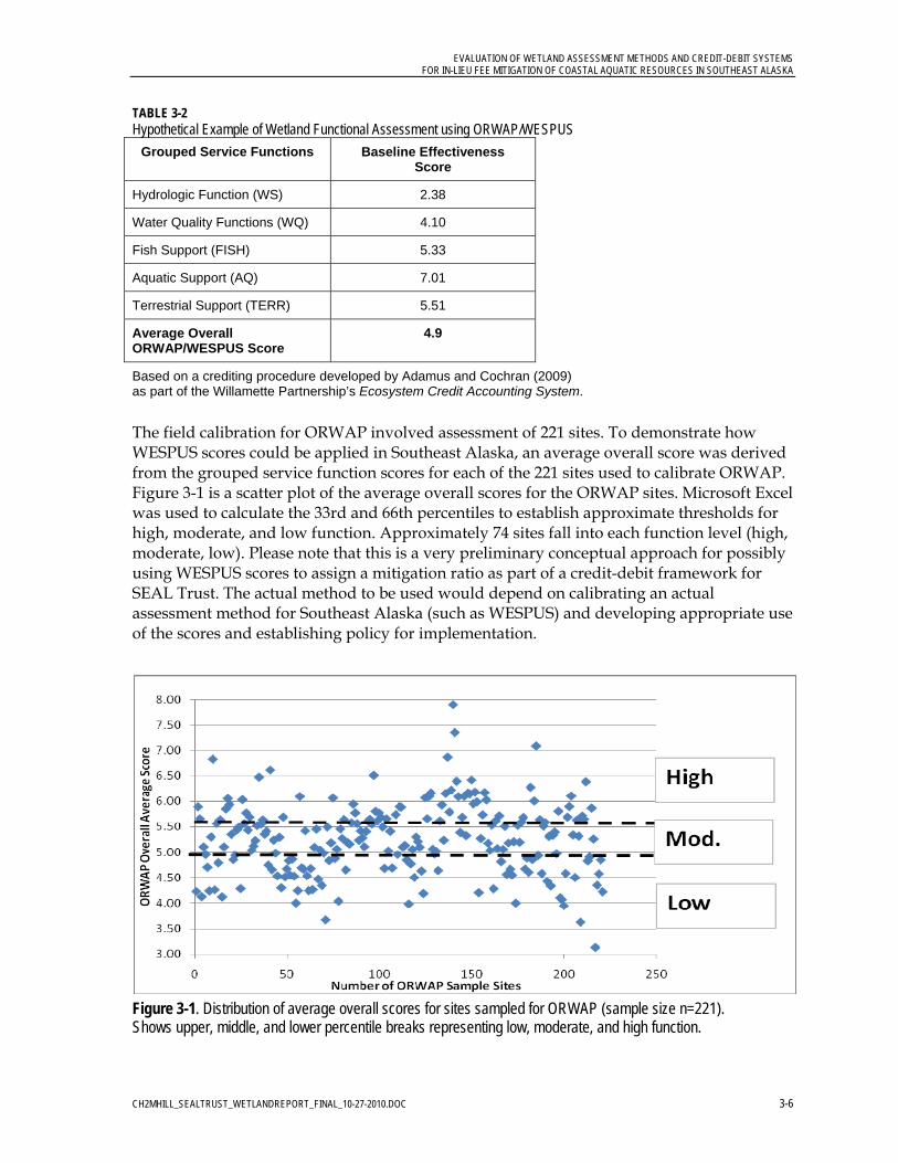
For specific use by SEAL Trust, the average overall score resulting from WESPUS could be calculated (which is an overall average of the five grouped service functions), see Table 3-2.
Data gathered from calibration and testing of WESPUS in Southeast Alaska could be grouped into thirds to achieve High, Moderate, and Low groups (see example Figure 3-1). Therefore, once a wetland is scored, the overall average could directly translate to a High, Moderate, or Low category/rating. Then the mitigation ratios which are based on High, Moderate, and Low could be applied to determine the debit. The
EVALUATION OF WETLAND ASSESSMENT METHODS AND CREDIT-DEBIT SYSTEMS FOR IN-LIEU FEE MITIGATION OF COASTAL AQUATIC RESOURCES IN SOUTHEAST ALASKA
CH2MHILL_SEALTRUST_WETLANDREPORT_FINAL_10-27-2010.DOC 3-5
data form would need to be adjusted data form to automatically calculate this overall average.
Similarly, WESPUS could also be used to assess SEAL Trust’s ILF preservation sites to determine the category/rating to ensure that mitigation credits offset wetland functions lost at impacted sites.
Unique opportunities for implementing ORWAP/WESPUS in Southeast Alaska include:
The CBJ expects to receive approximately $1.2 million from Coastal Impact Assistance Program (CIAP) that the CBJ intends to use to update the method and approach used to manage wetlands in Juneau.
ADOT&PF is in the process of developing wetland assessment methods for Alaska.
SEAL Trust could work collaboratively with CBJ, ADOT&PF, and the IRT to customize WESPUS and develop a wetland assessment method and corresponding credit-debit framework that could work for Southeast Alaska.
Depending on how WESPUS performs in Southeast Alaska, organizations such as USACE, USEPA, and ADOT&PF could consider applying WESPUS in other regions of Alaska beyond Southeast.
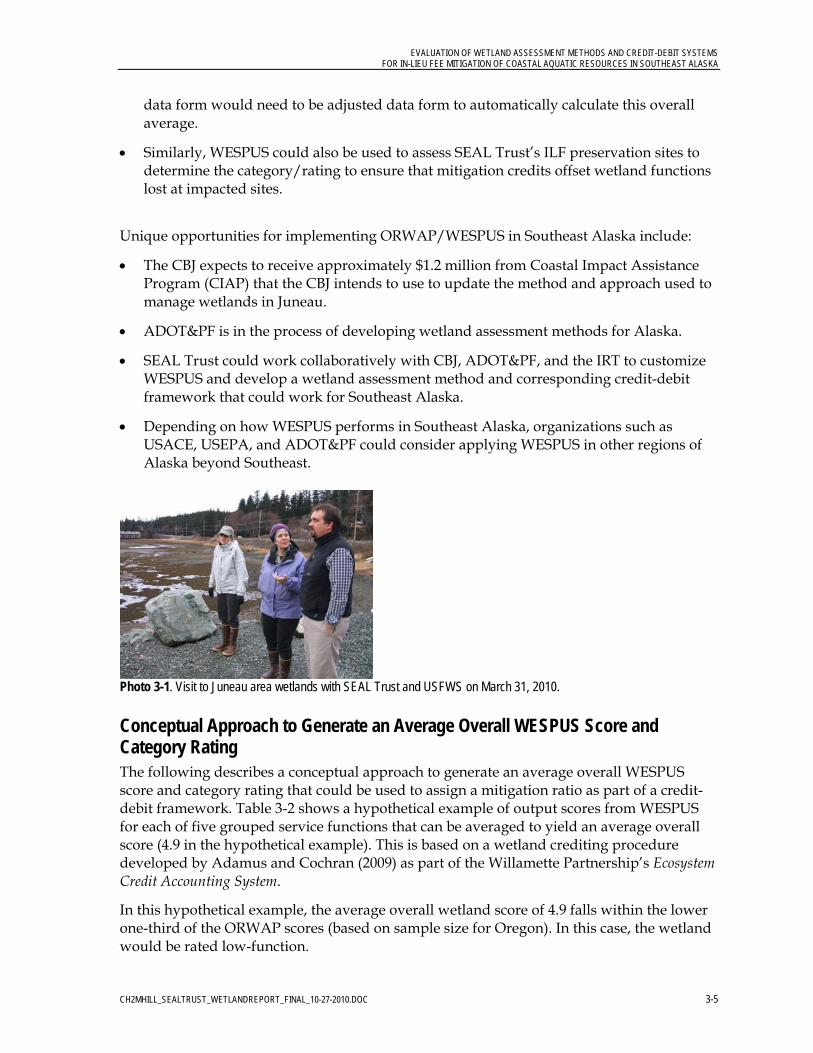
Photo 3-1. Visit to Juneau area wetlands with SEAL Trust and USFWS on March 31, 2010.
Conceptual Approach to Generate an Average Overall WESPUS Score and Category Rating The following describes a conceptual approach to generate an average overall WESPUS score and category rating that could be used to assign a mitigation ratio as part of a credit-debit framework. Table 3-2 shows a hypothetical example of output scores from WESPUS for each of five grouped service functions that can be averaged to yield an average overall score (4.9 in the hypothetical example). This is based on a wetland crediting procedure developed by Adamus and Cochran (2009) as part of the Willamette Partnership’s Ecosystem Credit Accounting System.
In this hypothetical example, the average overall wetland score of 4.9 falls within the lower one-third of the ORWAP scores (based on sample size for Oregon). In this case, the wetland would be rated low-function.
EVALUATION OF WETLAND ASSESSMENT METHODS AND CREDIT-DEBIT SYSTEMS FOR IN-LIEU FEE MITIGATION OF COASTAL AQUATIC RESOURCES IN SOUTHEAST ALASKA
CH2MHILL_SEALTRUST_WETLANDREPORT_FINAL_10-27-2010.DOC 3-6
TABLE 3-2 Hypothetical Example of Wetland Functional Assessment using ORWAP/WESPUS
Grouped Service Functions Baseline Effectiveness Score
Hydrologic Function (WS) 2.38
Water Quality Functions (WQ) 4.10
Fish Support (FISH) 5.33
Aquatic Support (AQ) 7.01
Terrestrial Support (TERR) 5.51
Average Overall ORWAP/WESPUS Score
4.9
Based on a crediting procedure developed by Adamus and Cochran (2009) as part of the Willamette Partnership’s Ecosystem Credit Accounting System.
The field calibration for ORWAP involved assessment of 221 sites. To demonstrate how WESPUS scores could be applied in Southeast Alaska, an average overall score was derived from the grouped service function scores for each of the 221 sites used to calibrate ORWAP. Figure 3-1 is a scatter plot of the average overall scores for the ORWAP sites. Microsoft Excel was used to calculate the 33rd and 66th percentiles to establish approximate thresholds for high, moderate, and low function. Approximately 74 sites fall into each function level (high, moderate, low). Please note that this is a very preliminary conceptual approach for possibly using WESPUS scores to assign a mitigation ratio as part of a credit-debit framework for SEAL Trust. The actual method to be used would depend on calibrating an actual assessment method for Southeast Alaska (such as WESPUS) and developing appropriate use of the scores and establishing policy for implementation.
Figure 3-1. Distribution of average overall scores for sites sampled for ORWAP (sample size n=221). Shows upper, middle, and lower percentile breaks representing low, moderate, and high function.
EVALUATION OF WETLAND ASSESSMENT METHODS AND CREDIT-DEBIT SYSTEMS FOR IN-LIEU FEE MITIGATION OF COASTAL AQUATIC RESOURCES IN SOUTHEAST ALASKA
CH2MHILL_SEALTRUST_WETLANDREPORT_FINAL_10-27-2010.DOC 3-7
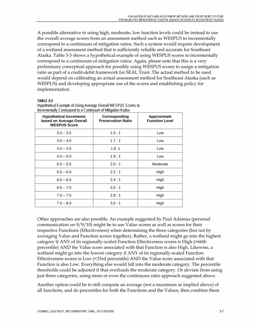
A possible alternative to using high, moderate, low function levels could be instead to use the overall average scores from an assessment method such as WESPUS to incrementally correspond to a continuum of mitigation ratios. Such a system would require development of a wetland assessment method that is sufficiently reliable and accurate for Southeast Alaska. Table 3-3 shows a hypothetical example of using WESPUS scores to incrementally correspond to a continuum of mitigation ratios. Again, please note that this is a very preliminary conceptual approach for possibly using WESPUS scores to assign a mitigation ratio as part of a credit-debit framework for SEAL Trust. The actual method to be used would depend on calibrating an actual assessment method for Southeast Alaska (such as WESPUS) and developing appropriate use of the scores and establishing policy for implementation.
TABLE 3-3 Hypothetical Example of Using Average Overall WESPUS Scores to Incrementally Correspond to a Continuum of Mitigation Ratios
Hypothetical Increments based on Average Overall
WESPUS Score
Corresponding Preservation Ratio
Approximate Function Level
3.0 – 3.5 1.5 : 1 Low
3.5 – 4.0 1.7 : 1 Low
4.0 – 4.5 1.8 :1 Low
4.5 – 5.0 1.9 : 1 Low
5.0 – 5.5 2.0 : 1 Moderate
5.5 – 6.0 2.2 : 1 High
6.0 – 6.5 2.4 : 1 High
6.5 – 7.0 2.6 : 1 High
7.0 – 7.5 2.8 : 1 High
7.5 – 8.0 3.0 : 1 High
Other approaches are also possible. An example suggested by Paul Adamus (personal communication on 9/9/10) might be to use Value scores as well as scores for their respective Functions (Effectiveness) when determining the three categories (but not by averaging Value and Function scores together). Rather, a wetland might go into the highest category if ANY of its regionally-scaled Function Effectiveness scores is High (>66th percentile) AND the Value score associated with that Function is also High. Likewise, a wetland might go into the lowest category if ANY of its regionally-scaled Function Effectiveness scores is Low (<33rd percentile) AND the Value score associated with that Function is also Low. Everything else would fall into the moderate category. The percentile thresholds could be adjusted if that overloads the moderate category. Or deviate from using just three categories, using more or even the continuous ratio approach suggested above.
Another option could be to still compute an average (not a maximum as implied above) of all functions, and do percentiles for both the Functions and the Values, then combine them

EVALUATION OF WETLAND ASSESSMENT METHODS AND CREDIT-DEBIT SYSTEMS FOR IN-LIEU FEE MITIGATION OF COASTAL AQUATIC RESOURCES IN SOUTHEAST ALASKA
CH2MHILL_SEALTRUST_WETLANDREPORT_FINAL_10-27-2010.DOC 3-8
logically (as above) rather than mathematically. The approaches are best decided by participating agencies after reviewing some initial results of various options.

CH2MHILL_SEALTRUST_WETLANDREPORT_FINAL_10-27-2010.DOC 4-1
4.0 Evaluation of Credit-Debit Systems
This chapter includes a summary of the credit-debit systems that were evaluated and a recommended credit-debit framework and sample ledger.
4.1 Overview of Credit-Debit Systems A limited number of credit-debit systems are currently in use, particularly in Alaska.
2009 USACE Alaska District Regulatory Guidance Letter The main credit-debit system from Alaska that was available for review included the Sample Ratios for Compensatory Mitigation that were provided as Appendix B in the 2009 Alaska District RGL (USACE 2009), which incidentally was adapted from guidance developed in Washington State. The table from Appendix B of 2009 Alaska District RGL (USACE 2009) is presented in Table 4-1 below. This table provides sample ratios for three categories (Low, Moderate, and High) of impacted wetlands or other waters of the United States, and two types of compensatory mitigation (preservation and restoration/ enhancement). For SEAL Trust (and Alaska in general), the primary method for mitigation is to provide wetland preservation. Table 4-1 provides a credit-debit framework that is simple and predictable to use, particularly when preservation is the primary mitigation type. This framework is currently being implemented in Alaska. For convenience, the 2009 Alaska District RGL is included in Attachment C of this report.
TABLE 4-1 Sample Ratios for Compensatory Mitigation in Alaska – USACE Alaska District
Type of Compensatory Mitigation
Impacted Wetland or Other Waters of the U.S.
Preservation Restoration and /or Enhancement
LOW Category III or IV
1.5:1
1:1
MODERATE Category II or III
2:1
1:1
HIGH Category I or II
3:1
2:1
From Appendix B in the 2009 Alaska District Regulatory Guidance Letter (USACE 2009)
Assumptions and/or considerations when determining ratios:
Impacts to ponds, lakes, rivers and streams should be mitigated for in the HIGH category due to their inherent high level of functions and services.
Compensatory mitigation for tidal and (inter)tidal waters associated with special aquatic sites would be compensated for in the HIGH category. Deviations from this should be well reasoned and documented (e.g., document existing site degradation and lack of specific functions/services). [Special aquatic sites include: sanctuaries and refuges, wetlands, mud flats, vegetated shallows, coral reefs, and riffle and pool complexes.]
EVALUATION OF WETLAND ASSESSMENT METHODS AND CREDIT-DEBIT SYSTEMS FOR IN-LIEU FEE MITIGATION OF COASTAL AQUATIC RESOURCES IN SOUTHEAST ALASKA
CH2MHILL_SEALTRUST_WETLANDREPORT_FINAL_10-27-2010.DOC 4-2
Watershed position—the compensatory mitigation site should be located in areas where the compensation can contribute to ecosystem functioning at a large scale (e.g., part of river corridors and green belt space).
Most ratios will be greater than 1:1 because there is a risk of failure associated with many forms of compensation, there is usually a temporal loss (it may take years for a compensation to develop wetland functions and/or structure equivalent to the impacted wetland), and preservation and enhancement activities result in net loss of wetland acreage and/or function.
Ratios shown represent a compensatory project that is constructed or protected in perpetuity concurrent with aquatic resource impacts. If there is a time delay in constructing or securing a preservation site, the ratios will increase due to temporal loss.
Preservation sites selected for compensatory mitigation will be moderate to high functioning systems that meet the criteria of 33 CFR 332.3(h).
If using a mitigation bank, rules and ratios applicable to the individual bank should be used.
Consider indirect and/or secondary impacts. For example, impacting a small portion of the wetland (<25% on the edge) is less impact than bisecting a wetland in the middle or impacting >70% of a wetland.
Anchorage Credit-Debit Method The Anchorage Credit-Debit Method (ACDM) has been developed specifically for Anchorage. It is a complicated method and is not recommended for broad application in Southeast Alaska. The recent development of a glossary and other guidance by USEPA are an important improvement to this method. Documentation of any credit-debit method developed for Southeast Alaska will be critical for consistency of use and implementation.
Su-Knik Mitigation Bank, South-Central Alaska A credit determination methodology was developed for the Su-Knik Mitigation Bank in MatSu Borough in South Central Alaska. Credits are the currency used for this bank and are a measure of the wetland functional capacity. Credits will be calculated and tracked on an individual function basis for each wetland type. The function index scores for individual wetland functions may also be combined and averaged for each of three major functional groups: Hydrologic, Biogeochemical, and Habitat. This will allow the bank to trade mitigation credits under all possible mitigation scenarios: by individual wetland function (i.e., stormwater retention), by functional group (i.e., Hydrologic), or even by acreage of wetland type if a functional assessment has not been conducted for a project site.
Mitigation Reserves ILF Program, King County Washington King County (Seattle Area) in Washington State has been developing an ILF program called Mitigation Reserves Program or MRP. They are working to get their ILF instrument certified in 2010. This ILF program is one of the most advanced and sophisticated in the country. SEAL Trust has already been provided a copy of their draft instrument. Aspects of their credit-debit method are applicable to Southeast Alaska. However, their method focuses on wetland restoration and enhancement as the primary forms of compensatory mitigation, rather than preservation.
EVALUATION OF WETLAND ASSESSMENT METHODS AND CREDIT-DEBIT SYSTEMS FOR IN-LIEU FEE MITIGATION OF COASTAL AQUATIC RESOURCES IN SOUTHEAST ALASKA
CH2MHILL_SEALTRUST_WETLANDREPORT_FINAL_10-27-2010.DOC 4-3
The April 2010 draft instrument for the MRP included a determination of debits and credits that was described as:
After in-lieu fee offsite mitigation through the MRP is determined to be a suitable mitigation option by agencies with regulatory authority over a permitted impact, a King County permit reviewer will assess the development project’s impacts to the aquatic resource and/or regulatory buffer using an IRT-approved mitigation assessment method (“the tool”), that considers the existing condition of the aquatic resource and/or buffer relative to potential project effects. Application of this method will result in the quantification of units of functional loss, or “debits,” associated with the project. Once the number of debits has been determined, then the permittee can purchase a commensurate number of “credits” from the MRP to offset the debits.
The version of the tool currently under development is intended to quantify functional losses or lift (i.e., debits or credits) related to wetlands and wetland buffers. At this point, the assessment method is not designed for use in quantifying impacts or lift related to functions and values of streams or rivers, or other aquatic bed environments.
The tool also accounts for temporal losses by using a temporal loss factor to increase the number of credits required to offset an impact.
Ecosystem Credit Accounting System, Willamette Partnership, Oregon The Willamette Partnership in Oregon has developed a procedure to translate outputs from functional assessments into functional acres to be used as tradable wetland credits and debits. The procedure relies on the ORWAP Manual (Adamus et al. 2009) and other guidance for producing functional assessment scores. ORWAP was not developed explicitly as a crediting metric. The Oregon Department of State Lands and the Army Corps of Engineers approved ORWAP for use as a functional assessment. The project involved convening a wetlands focus group to assign rules for converting ORWAP scores into quantities of functional acres as tradable credits.
ORWAP computes a score for each of 16 wetland functions and their societal value. Ecosystem services are considered to be the combination of a site’s functional capacity and its value. However, ORWAP currently does not specify a process for combining the function and value score into an “ecosystem service” score based on each pairing. These 16 functions are aggregated into five grouped service functions with scores between 0 and 10.
Washington State Department of Transportation, Alternative Mitigation Program The Washington State Department of Transportation (WSDOT) has been managing an Alternative Mitigation Program for many years and has established three certified mitigation banks and has permitted multiple advance mitigation sites. WSDOT has worked with the IRT in Washington to develop and refine the concepts for mitigation accounting and tracking that can translate directly to a credit-debit framework for SEAL Trust in Southeast Alaska. CH2M HILL has worked extensively with WSDOT to develop mitigation strategies and credit-debit systems that have been successfully implemented in Washington.
EVALUATION OF WETLAND ASSESSMENT METHODS AND CREDIT-DEBIT SYSTEMS FOR IN-LIEU FEE MITIGATION OF COASTAL AQUATIC RESOURCES IN SOUTHEAST ALASKA
CH2MHILL_SEALTRUST_WETLANDREPORT_FINAL_10-27-2010.DOC 4-4
4.2 Recommendations and Example Credit-Debit Framework for SEAL Trust Until SEAL Trust and the IRT can recommend that applicants for USACE permits use a specific wetland assessment method for Southeast Alaska, any credit-debit framework for now will likely depend on an existing wetland assessment methods based on best professional judgment.
Eventually, if a system such as ORWAP/WESPUS were adopted and implemented, SEAL Trust and the IRT could begin to establish consistency in the assessment and accounting of wetland impacts (or debits) that could translate to standardized crediting of preservation.
A credit-debit framework being recommended for SEAL Trust and the IRT to consider combines the 2009 Alaska District RGL with approaches that are being implemented in Washington and Oregon. Examples of a conceptual framework are described in the text that follows.
The following examples use ratios for wetland preservation because that is the form of mitigation available through SEAL Trust’s In-Lieu Fee Program.
Example 1—Credit-Debit Framework for ILF Sponsor This section proposes an example for a conceptual credit-debit framework.
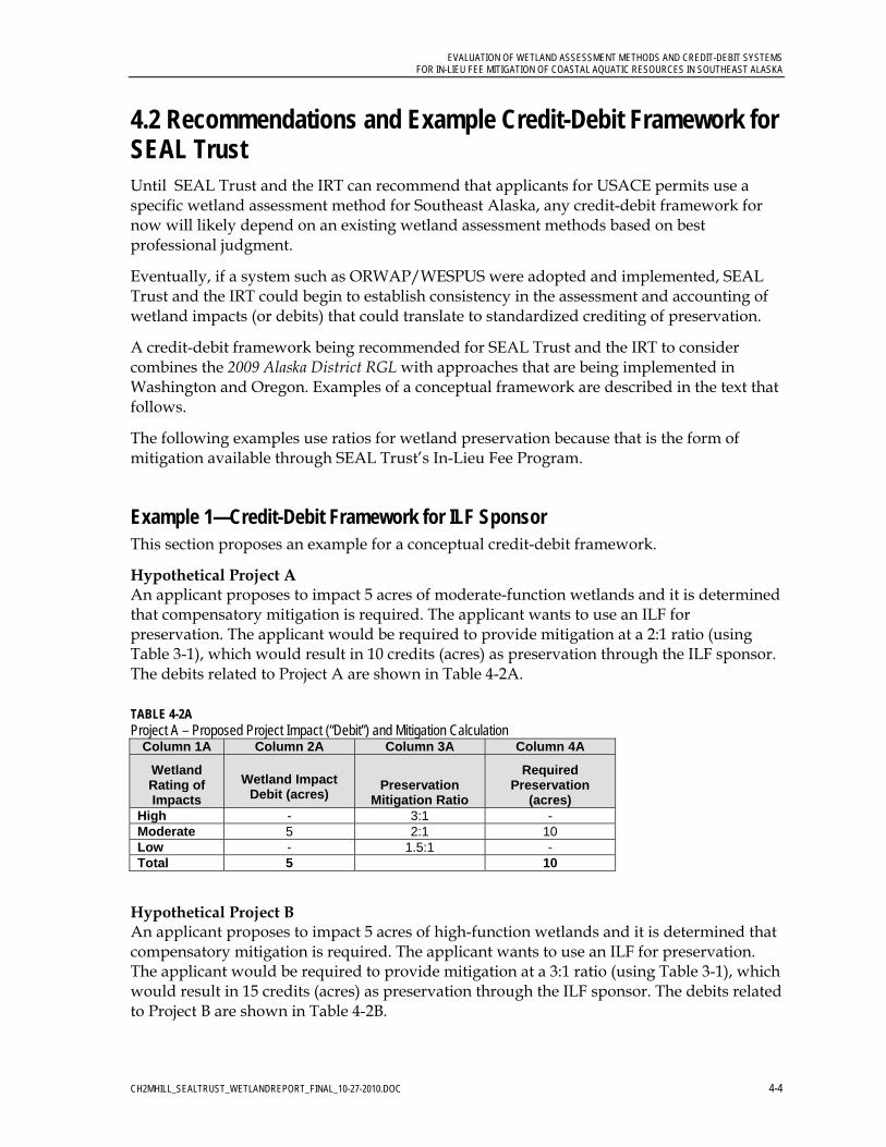
Hypothetical Project A An applicant proposes to impact 5 acres of moderate-function wetlands and it is determined that compensatory mitigation is required. The applicant wants to use an ILF for preservation. The applicant would be required to provide mitigation at a 2:1 ratio (using Table 3-1), which would result in 10 credits (acres) as preservation through the ILF sponsor. The debits related to Project A are shown in Table 4-2A.
TABLE 4-2A Project A – Proposed Project Impact (“Debit”) and Mitigation Calculation
Column 1A Column 2A Column 3A Column 4A
Wetland Rating of Impacts
Wetland Impact Debit (acres)
Preservation Mitigation Ratio
Required Preservation
(acres) High - 3:1 - Moderate 5 2:1 10 Low - 1.5:1 - Total 5 10
Hypothetical Project B An applicant proposes to impact 5 acres of high-function wetlands and it is determined that compensatory mitigation is required. The applicant wants to use an ILF for preservation. The applicant would be required to provide mitigation at a 3:1 ratio (using Table 3-1), which would result in 15 credits (acres) as preservation through the ILF sponsor. The debits related to Project B are shown in Table 4-2B.

EVALUATION OF WETLAND ASSESSMENT METHODS AND CREDIT-DEBIT SYSTEMS FOR IN-LIEU FEE MITIGATION OF COASTAL AQUATIC RESOURCES IN SOUTHEAST ALASKA
CH2MHILL_SEALTRUST_WETLANDREPORT_FINAL_10-27-2010.DOC 4-5
TABLE 4-2B Project B – Proposed Project Impact (“Debit”) and Mitigation Calculation
Column 1A Column 2A Column 3A Column 4A
Wetland Rating of Impacts
Wetland Impact Debit (acres)
Preservation Mitigation Ratio
Required Preservation
(acres) High 5 3:1 15 Moderate - 2:1 - Low - 1.5:1 - Total 5 15
The ILF sponsor has acquired the 30-acre Preservation Site X and has established (by using an IRT-approved wetland assessment method, such as WESPUS) that the site includes 15 acres of high-function wetlands and 15 acres of moderate-function wetlands, as shown in Table 4-3. A map of Preservation Site X would be provided as part of the documented wetland assessment of the Preservation Site X.
TABLE 4-3 Proposed Preservation Site X from In-Lieu Fee Sponsor (“Credits”)
Column 1B Column 2B
Wetland Rating of Mitigation Wetlands
Wetland Preservation Site
Area (acres) High 15 Moderate 15 Low - Total 30
Impacts related to Projects A and B would be mitigated at the 30-acre Preservation Site X, as shown in the sample proposed credit-debit ledger in Table 4-4. Impacts from Project A are first debited, yielding 20 remaining credits. Then impacts from Project B are debited, yielding 5 remaining credits, which would be available for another future project. Each preservation site would have a consistent set of site summary information such as basin or watershed name, hydrologic unit code (HUC).
TABLE 4-4 Sample Proposed Credit-Debit Framework Ledger
Column A Column B Column C Column D Column E Column F Column G
Preservation “Credit”
Available at ILF Receiving
Site X
Name/Date of Impact Project
USACE Permit #
Impact Acreage
Wetland Function
/Ratio H = x3 M = x2
L = x1.5
Wetland Impact “Debit” (HFUAs)[=CxD]
Remaining Mitigation Credit at
ILF Preservation Site X
(Credit minus Debit)[=A-E]
30 Project A, 1/7/2010
xxxx 5 2 10 20
20 Project B 5/8/2010
xxxx 5 3 15 5
5
ILF Receiving Site X Summary Information: Basin Name: ____ 8-digit Hydrologic Unit Code (Southeast Alaska HUC): ____ Biogeographical Province: ____

EVALUATION OF WETLAND ASSESSMENT METHODS AND CREDIT-DEBIT SYSTEMS FOR IN-LIEU FEE MITIGATION OF COASTAL AQUATIC RESOURCES IN SOUTHEAST ALASKA
CH2MHILL_SEALTRUST_WETLANDREPORT_FINAL_10-27-2010.DOC 4-6
4.3 Considerations for Addressing In-Kind Mitigation In-kind mitigation can mean many things. As in Example 1, it could simply mean that the wetland impacts are replaced by an appropriate amount of wetland preservation.
However, the quality of the preservation may be an important consideration for mitigating certain wetlands. A basic assumption could be that impacts to moderate-function wetlands should be mitigated with moderate-function preservation wetlands (assuming there is a reliable and accepted method available to assess functions). Or likewise, impacts to high-function wetlands should be mitigated with high-function preservation wetlands.
For impacts to wetlands with unique functions, it may be desirable to consider having some amount of the preservation wetlands be mitigated with the same kind of HGM class impacted. In Example 1, if the 5 acres of impact were to moderate-function tidal wetlands, and 10 acres will be preserved, it might be desirable to require that some amount of preservation also be tidal (such as, 1 acre of equivalent moderate–function tidal preservation for each acre of moderate-function estuarine impact, which is 1:1 in-kind preservation for the HGM class), and the remaining 5 acres of preservation being any other kind of HGM class wetland with moderate-function wetland.
Using a wetland assessment method such as ORWAP/WESPUS would provide detailed information for a variety of functions/values or function groups. In some cases, it may be beneficial to ensure that wetlands providing high performance in certain function groups be replaced in-kind with similarly performing function groups.
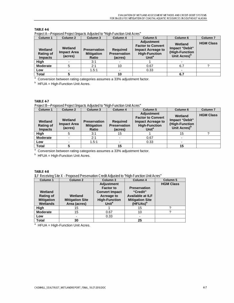
Example 2—Debit-Credit Framework Adjusted to High-Function Unit Acres (HFUAs) It may be desirable to consider converting all the wetlands to a standard unit, such as high- or moderate-function. In a system that uses three function levels (i.e., High, Moderate, Low), a 33 percent conversion factor could be applied to adjust from one function-level to the next. For example, 1 acre of moderate-function wetland could be converted to high-function wetland by multiplying by 0.66 to yield 0.66 acre of high-function wetland. Table 4-5 shows examples of basic conversions. Allowing adjustments from different levels of function provides better equivalency between impact acreage and preservation acreage. Adjusting between function levels is an accepted approach in Washington State.
TABLE 4-5 Example Conversion Factors to Adjust for Functional Equivalency
Beginning with Conversion Factor Ending with
1 acre of moderate-function wetland multiply by 0.66 0.66 acre of high-function wetland
1 acre of low-function wetland multiply by 0.66 0.66 acre of moderate-function wetland
1 acre of low-function wetland multiply by 0.33 0.33 acre of high-function wetland
0.66 acre of high-function wetland divide by 0.66 1 acre of moderate-function wetland
0.66 acre of moderate-function wetland divide by 0.66 1 acre of low-function wetland
0.33 acre of high-function wetland divide by 0.33 1 acre of low-function wetland
EVALUATION OF WETLAND ASSESSMENT METHODS AND CREDIT-DEBIT SYSTEMS FOR IN-LIEU FEE MITIGATION OF COASTAL AQUATIC RESOURCES IN SOUTHEAST ALASKA
CH2MHILL_SEALTRUST_WETLANDREPORT_FINAL_10-27-2010.DOC 4-7
TABLE 4-6 Project A—Proposed Project Impacts Adjusted to “High-Function Unit Acres”
Column 1 Column 2 Column 3 Column 4 Column 5 Column 6 Column 7
Wetland Rating of Impacts
Wetland Impact Area
(acres)
Preservation Mitigation
Ratio
Required Preservation
(acres)
Adjustment Factor to Convert Impact Acreage to
High-Function Unita
Wetland Impact “Debit” (High-Function
Unit Acres)b
HGM Class
High - 3:1 - 1 - Moderate 5 2:1 10 0.67 6.7 ? Low - 1.5:1 - 0.33 - Total 5 10 6.7
a Conversion between rating categories assumes a 33% adjustment factor. b HFUA = High-Function Unit Acres.
TABLE 4-7 Project B—Proposed Project Impacts Adjusted to “High-Function Unit Acres”
Column 1 Column 2 Column 3 Column 4 Column 5 Column 6 Column 7
Wetland Rating of Impacts
Wetland Impact Area
(acres)
Preservation Mitigation
Ratio
Required Preservation
(acres)
Adjustment Factor to Convert Impact Acreage to
High-Function Unita
Wetland Impact “Debit” (High-Function
Unit Acres)b
HGM Class
High 5 3:1 15 1 15 ? Moderate - 2:1 - 0.67 - Low - 1.5:1 - 0.33 - Total 5 15 15
a Conversion between rating categories assumes a 33% adjustment factor. b HFUA = High-Function Unit Acres.
TABLE 4-8 ILF Receiving Site X - Proposed Preservation Credit Adjusted to “High-Function Unit Acres”
Column 1 Column 2 Column 3 Column 4 Column 5
Wetland Rating of Mitigation Wetlands
Wetland Mitigation Site Area (acres)
Adjustment Factor to
Convert Impact Acreage to
High-Function Unita
Preservation “Credit”
Available at ILF Mitigation Site
(HFUAs)a
HGM Class
High 15 1 15 ? Moderate 15 0.67 10 ? Low - 0.33 - Total 30 25
a HFUA = High-Function Unit Acres.

EVALUATION OF WETLAND ASSESSMENT METHODS AND CREDIT-DEBIT SYSTEMS FOR IN-LIEU FEE MITIGATION OF COASTAL AQUATIC RESOURCES IN SOUTHEAST ALASKA
CH2MHILL_SEALTRUST_WETLANDREPORT_FINAL_10-27-2010.DOC 4-8
TABLE 4-9 Sample Proposed Credit-Debit Framework Ledger Using “High-Function Unit Acres”
Column A Column B Column C Column D Column E Column F Column G
Preservation “Credit”
Available at ILF Receiving
Site X (HFUAs)
Name/Date of Impact Project
Impact Acreage
Wetland Function
/Ratio H = x3 M = x2
L = x1.5
Adjustment Multiplier
H = x1 M = x0.67 L = x0.33
Wetland Impact “Debit” (HFUAs)[=CxDxE]
Remaining Mitigation Credit at ILF
Mitigation Site (Credit minus Debit)
(HFUAs)a [=A-F]
25 Project A, 1/7/2010
5 2 0.67 6.7 18.3
18.3 Project B 5/8/2010
5 3 1 15 3.3
3.3 a HFUA = High-Function Unit Acres.
CH2MHILL_SEALTRUST_WETLANDREPORT_FINAL_10-27-2010.DOC 5-1
5.0 Recommended Next Steps
The potential next steps recommended for SEAL Trust and the IRT to develop a wetland assessment method and credit-debit system for Southeast Alaska are briefly summarized in this chapter.
5.1 Develop a Project Workplan An initial project workplan should be developed to address management and coordination of an integrated effort to adopt and revise a wetland assessment method and develop a debit-credit system for Southeast Alaska. Key elements would include:
Team— project leader, members, commitment
Goals and objectives
Scope
Schedule
Budget
Data needs and gaps
Priorities
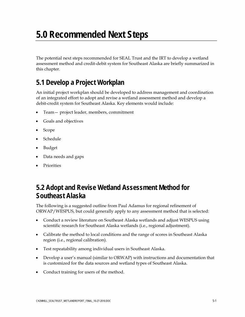
5.2 Adopt and Revise Wetland Assessment Method for Southeast Alaska The following is a suggested outline from Paul Adamus for regional refinement of ORWAP/WESPUS, but could generally apply to any assessment method that is selected:
Conduct a review literature on Southeast Alaska wetlands and adjust WESPUS using scientific research for Southeast Alaska wetlands (i.e., regional adjustment).
Calibrate the method to local conditions and the range of scores in Southeast Alaska region (i.e., regional calibration).
Test repeatability among individual users in Southeast Alaska.
Develop a user’s manual (similar to ORWAP) with instructions and documentation that is customized for the data sources and wetland types of Southeast Alaska.
Conduct training for users of the method.
EVALUATION OF WETLAND ASSESSMENT METHODS AND CREDIT-DEBIT SYSTEMS FOR IN-LIEU FEE MITIGATION OF COASTAL AQUATIC RESOURCES IN SOUTHEAST ALASKA
CH2MHILL_SEALTRUST_WETLANDREPORT_FINAL_10-27-2010.DOC 5-2
5.3 Develop and Implement a Credit-Debit Framework for SEAL Trust The following are several suggested steps to develop a credit-debit framework for the ILF instrument for SEAL Trust:
Work with the IRT to develop and refine a credit-debit framework.
Initially test the conceptual credit-debit framework using actual ILF preservation sites as applied to existing and proposed projects. Develop several examples for critical review and input by the IRT.
Coordinate regularly with the development of the wetland assessment method (WESPUS) to ensure seamless integration into the credit-debit framework.
Incorporate the credit-debit framework into Seal Trust’s ILF instrument.
Identify data gaps and information needed to support and sustain the credit-debit system.
SEAL Trust and IRT implement a consistent and reliable credit-debit system.

CH2MHILL_SEALTRUST_WETLANDREPORT_FINAL_10-27-2010.DOC 6-1
6.0 Authors and Contributors
Principal Evaluator, Author, and Project Manager
Hans Ehlert/CH2M HILL, Seattle—Professional Wetland Scientist (PWS#1165) office: 425-233-3167 mobile: 425-922-8238 [email protected]
Southeast Alaska Land Trust, Juneau
Diane Mayer, Executive Director
Gretchen Keiser, Conservation Specialist
Juneau Interagency Review Team (IRT)
Chiska Derr/NMFS, Juneau
Cindy Hartman-Moore/NMFS, Juneau
Neil Stichert/USFWS, Juneau
Steve Brockmann/USFWS, Juneau
Richard Enriquez/USFWS, Juneau
Bill Hanson/USFWS, Juneau
Ben White/ADOT&PF, Juneau
Katie Eaton/ADF&G, Juneau
Carrie Bohan/ADNR, Juneau
Teri Camery/CBJ, Juneau
Marcia Heer/USACE, Juneau
Matt LaCroix/USEPA, Anchorage
Mark Jen/USEPA, Anchorage
Tracy DeGering/USEPA, Anchorage
Gail Martin/USEPA, Anchorage
EVALUATION OF WETLAND ASSESSMENT METHODS AND CREDIT-DEBIT SYSTEMS FOR IN-LIEU FEE MITIGATION OF COASTAL AQUATIC RESOURCES IN SOUTHEAST ALASKA
CH2MHILL_SEALTRUST_WETLANDREPORT_FINAL_10-27-2010.DOC 6-2
Other Contributors and Reviewers
Heidi Firstencel/USACE
Randy Vigil/USACE
Susan Walker/NOAA
Jackie Timothy/ADF&G
Personal Communications
Dr. Paul Adamus, Adamus Resource Assessments
Dr. Tom Hruby/Washington State Department of Ecology
Michael Murphy/King County Mitigation Reserves Project Manager
Gail Terzi/USACE, Seattle District
Ben White/ADOT&PF, Statewide Environmental Office

CH2MHILL_SEALTRUST_WETLANDREPORT_FINAL_10-27-2010.DOC 7-1
7.0 References
WETLAND ASSESSMENT METHODS EVALUATED FROM SOUTHEAST ALASKA Adamus, P. 1987. Juneau Wetlands: Functions and Values.
http://people.oregonstate.edu/~adamusp/Juneau/Juneau_Wetlands.pdf
Bosworth, K., and P. Adamus. 2007. Delineation and Function Rating of Jurisdictional Wetlands on Potentially Developable City-owned Parcels in Juneau, Alaska. Prepared for Community Development Department, Juneau, Alaska. January 2010. http://www.juneau.org/cddftp/documents/DelineationandFunctionRatingofJurisdictionalWetlandsonPotentiallyDevelopableCity-ownedParcel.pdf
Bosworth, K., and P. Adamus. 2010. Delineation and Function Rating of Jurisdictional Wetlands on CBJ Parcels in the Industrial Blvd and Hill 560 Areas Juneau, Alaska. Prepared for Community Development Department, City and Borough of Juneau, Alaska. September 2010.
Powell et al. 2003. Wetland Functional Assessment Guidebook—Riverine and Slope River Proximal Wetlands in Coastal SE and Southcentral Alaska using HGM. http://www.dec.state.ak.us/water/wnpspc/wetlands/southeastcentralhgm.htm
SWCA Environmental Consultants. 2006. Sitka Rocky Gutierrez Airport, 2005 Summer Biological Resources Surveys, Vegetation and Wetlands. Prepared for Federal Aviation Administration and Alaska Department of Transportation. February 15, 2006.
SWCA Environmental Consultants. 2007. Juneau International Airport, Final Environmental Impact Statement, Appendix E, Wetland Functional Assessment Technical Report. http://www.juneau.org/airport/documents.php
U.S. Army Corps of Engineers (USACE). 2000. Southeast Alaska Freshwater Wetland Assessment Method.
OTHER WETLAND REFERENCES FOR SOUTHEAST ALASKA City and Borough of Juneau (CBJ). 2008. Juneau Wetlands Management Plan.
NatureServe. 2010. Juneau Pilot Study. [in progress]
Southeast Alaska Land Trust (SEAL Trust). http://www.southeastalaskalandtrust.org/
Siegel, D.I. 1988. The Recharge-Discharge Function of Wetlands Near Juneau, Alaska: Part I. Hydrological Investigations. Ground Water, Vol. 26, No.:4, p.427-434 [July-August]
Siegel, D.I. 1988. The Recharge-Discharge Function of Wetlands Near Juneau, Alaska: Part II. Geochemical Studies. Ground Water. Ground Water, Vol. 26, No.:5, p.580-586 [Sept.-Oct.]

EVALUATION OF WETLAND ASSESSMENT METHODS AND CREDIT-DEBIT SYSTEMS FOR IN-LIEU FEE MITIGATION OF COASTAL AQUATIC RESOURCES IN SOUTHEAST ALASKA
CH2MHILL_SEALTRUST_WETLANDREPORT_FINAL_10-27-2010.DOC 7-2
WETLAND ASSESSMENT METHODS EVALUATED FROM ALASKA City of Homer, Alaska. 2006. 2006 Functional Assessment of Wetlands within the City of
Homer and the Bridge Creek Watershed Protection District.
Hall et al. 2003. Wetland Functional Assessment Guidebook: Operational Draft Guidebook for Assessing the Functions of Slope/Flat Wetland Complexes in the Cook Inlet Basin Ecoregion, Alaska, using the HGM Approach. http://www.dec.state.ak.us/water/wnpspc/wetlands/cookinlethgm.htm
U.S. Army Corps of Engineers (USACE). 2009. Regulatory Guidance Letter (RGL) #09-01. Alaska District, Anchorage, AK. February 25, 2009.
Alaska Department of Transportation & Public Facilities (ADOT&PF). 2010. ADOT&PF Alaska Wetland Assessment Method. Research and Technology Transfer Division and Statewide Environmental Office, Fairbanks and Juneau, Alaska. July 2010. http://www.dot.state.ak.us/stwddes/research/assets/documents/research_projects/akwam1.exe
OTHER WETLAND REFERENCES FOR ALASKA Alaska Department of Transportation & Public Facilities (ADOT&PF). 2005. Synthesis of
Practice for Rapid Wetland Assessment in Alaska. Prepared by HDR Alaska, Inc. for Alaska Department of Transportation Statewide Research Office. FHWA-AK-RD-05-09.
Alaska ShoreZone Viewer. http://mapping.fakr.noaa.gov/Website/ShoreZone/viewer.htm
Cook Inlet Wetlands. http://cookinletwetlands.info/
Municipality of Anchorage. 1996. Anchorage Wetlands Plan.
WETLAND ASSESSMENT METHODS EVALUATED FROM PACIFIC NORTHWEST AND OTHER REGIONS Hruby et al. 2010. Rating Wetland Functions and Values for Compensatory Mitigation.
Prepared for King County Mitigation Reserves Program. [Draft]
Adamus, P. 2006. Hydrogeomorphic (HGM) Assessment Guidebook for Tidal Wetlands of the Oregon Coast, Part 1. Rapid Assessment Method. Produced for the Coos Watershed Association, Oregon Department of State Lands, and USEPA-Region 10. Charleston, OR: Coos Watershed Association. http://www.oregonstatelands.us/DSL/WETLAND/docs/tidal_HGM_pt1.pdf
Part 2. http://www.oregonstatelands.us/DSL/WETLAND/docs/tidal_HGM_pt2.pdf
Part 3. http://www.oregonstatelands.us/DSL/WETLAND/docs/tidal_HGM_pt3.pdf
Excel Spreadsheet. http://www.oregon.gov/DSL/WETLAND/docs/tidalwet_cal_hgm_oregon_fixed_jan09.xls
EVALUATION OF WETLAND ASSESSMENT METHODS AND CREDIT-DEBIT SYSTEMS FOR IN-LIEU FEE MITIGATION OF COASTAL AQUATIC RESOURCES IN SOUTHEAST ALASKA
CH2MHILL_SEALTRUST_WETLANDREPORT_FINAL_10-27-2010.DOC 7-3
Adamus, P., J. Morlan, and K. Verble. 2009. Manual for the Oregon Rapid Wetland Assessment Protocol (ORWAP). Version 2.0. Oregon Dept. of State Lands, Salem, OR. http://www.oregon.gov/DSL/WETLAND/docs/orwap_manual_v2.pdf
Adamus, P., J. Morlan, and K. Verble. 2009. Oregon Rapid Wetland Assessment Protocol (ORWAP): calculator spreadsheet, databases, and data forms. Oregon Department of State Lands, Salem, OR. http://www.oregonstatelands.us/DSL/WETLAND/technical_resources.shtml
Supplemental Information: http://www.oregonstatelands.us/DSL/WETLAND/docs/orwap_suppinfo_v2.0.2_042010.xls
Data Forms: http://www.oregon.gov/DSL/WETLAND/docs/orwap_dataforms.pdf
Spreadsheet Calculator: http://www.oregon.gov/DSL/WETLAND/docs/orwap_calculator_v2.0.2_apr26_2010.xls
Adamus, P. 2010. Wetland Ecosystem Services Protocol United States (WESPUS beta v1). Adamus Resource Assessment, Inc. Corvallis, OR. Version Accessed on 7/26/10. http://people.oregonstate.edu/~adamusp/WESPUS/
Berglund, J. 1999. MDT Montana Wetland Assessment Method. Prepared for Montana Department of Transportation and Morrison-Maierle, Inc. May 25th. Western EcoTech, Helena, Montana.
Berglund, J. and R. McEldowney. 2008. MDT Montana wetland assessment method. Prepared for: Montana Department of Transportation. Post, Buckley, Schuh & Jernigan. Helena, Montana.
Hruby, T. 2004. Washington State Wetland Rating System for Western Washington – Revised. Washington State Department of Ecology Publication # 04-06-025. Olympia, WA. Accessed at: http://www.ecy.wa.gov/pubs/0406025.pdf.
Magee and Hollands. 1998. A Rapid Procedure for Assessing Wetland Functional Capacity.
Washington State Department of Transportation (WSDOT). 2000. Wetland Functions Characterization Tool for Linear Projects. Washington State Department of Transportation, Environmental Affairs Office, Olympia, WA. Accessed at: http://www.wsdot.wa.gov/NR/rdonlyres/B92BE0D4-9078-4EFC-99DA-3C0EA4805E2F/0/bpjtool.pdf.
U.S. Army Corps of Engineers. 1999. The Highway Methodology Workbook Supplement. U.S. Army Corps of Engineers, New England District. NAEEP-360-1-30a. September 1999.

EVALUATION OF WETLAND ASSESSMENT METHODS AND CREDIT-DEBIT SYSTEMS FOR IN-LIEU FEE MITIGATION OF COASTAL AQUATIC RESOURCES IN SOUTHEAST ALASKA
CH2MHILL_SEALTRUST_WETLANDREPORT_FINAL_10-27-2010.DOC 7-4
CREDIT-DEBIT SYSTEMS EVALUATED FROM ALASKA Su-Knik Mitigation Bank South-Central Alaska
http://www.su-knikmitigationbank.com/#
U.S. Army Corps of Engineers (USACE). 2009. Regulatory Guidance Letter (RGL) #09-01. Alaska District, Anchorage, AK.
U.S. Environmental Protection Agency (USEPA). 2010. Revised Anchorage Credit-Debit Method.
CREDIT-DEBIT SYSTEMS EVALUATED FROM PACIFIC NORTHWEST AND OTHER REGIONS Adamus, P. and B. Cochrane. 2009. Wetland Crediting Procedure: Translating Functional
Scores to Credits Accounting. http://willamettepartnership.org/ecosystem-credit-accounting/wetlands
King County. 2010. Mitigation Reserves Program. http://www.kingcounty.gov/environment/waterandland/wetlands/mitigation-reserves-program.aspx
Willamette Partnership. 2009. Ecosystem Credit Accounting System. http://willamettepartnership.org/ecosystem-credit-accounting
OTHERS WETLAND REFERENCES FROM PACIFIC NORTHWEST AND OTHER REGIONS Adamus, P.R., E.J. Clairain, R.D. Smith, and R.E. Young. 1987. Wetland Evaluation
Technique (WET). Volume II. Methodology. US Army Corps of Engineers Waterways Experiment Station, Vicksburg, Mississippi.
Brennan, J.S., and H. Culverwell. 2004. Marine Riparian: An Assessment of Riparian Functions in Marine Ecosystems. Published by Washington Sea Grant Program Copyright 2005, UW Board of Regents. Seattle, WA. 34 p. www.wsg.washington.edu/research/pdfs/brennan.pdf
Hruby, T., K. Harper, and S. Stanley. 2009. Selecting Wetland Mitigation Sites Using a Watershed Approach. Washington State Department of Ecology Publication #09-06-032. December 2009. http://www.ecy.wa.gov/pubs/0906032.pdf
Kusler, J. 2006. Recommendations for Reconciling Wetland Assessment Techniques. Final Report. Association of State Wetland Managers, Inc. April 2006. http://www.aswm.org/propub/reconciling.pdf
North Carolina Ecosystem Enhancement Program. http://www.nceep.net/
Rempel, M., P. Adamus, and J. Kagan. 2009. Oregon Wetlands Explorer: an internet tool for ORWAP wetland assessment support and data archiving. Oregon State University
EVALUATION OF WETLAND ASSESSMENT METHODS AND CREDIT-DEBIT SYSTEMS FOR IN-LIEU FEE MITIGATION OF COASTAL AQUATIC RESOURCES IN SOUTHEAST ALASKA
CH2MHILL_SEALTRUST_WETLANDREPORT_FINAL_10-27-2010.DOC 7-5
Library and Institute for Natural Resources, Oregon State University, Corvallis, OR. Internet: http://oregonexplorer.info/wetlands/orwap/
U.S. Army Corps of Engineers (USACE). 2008. Final Rule for Compensatory Mitigation for Losses of Aquatic Resources, which was published in the Federal Register on April 10, 2008. http://www.epa.gov/owow/wetlands/pdf/wetlands_mitigation_final_rule_4_10_08.pdf
Washington State Department of Ecology. 1999. Washington State Wetland Function Assessment Methods (WFAM). http://www.ecy.wa.gov/programs/sea/wetlands/wfap/index.html

Attachments
Attachment A. Summary of Characteristics for Wetland Assessment Methods
Attachment B. Wetland Assessment Methods Evaluation Attachment C. U.S. Army Corps of Engineers Alaska District Regulatory Guidance Letter
#09-01

Attachment A. Summary of Characteristics for Wetland Assessment Methods

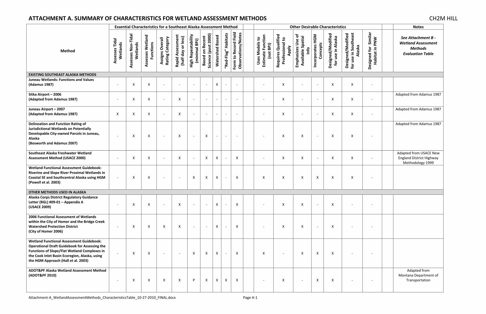
ATTACHMENT A. SUMMARY OF CHARACTERISTICS FOR WETLAND ASSESSMENT METHODS CH2M HILL
Attachment‐A_WetlandAssessmentMethods_CharacteristicsTable_10‐27‐2010_FINAL.docx Page A‐1
Essential Characteristics for a Southeast Alaska Assessment Method Other Desirable Characteristics Notes
Method
Assesses Tida
l Wetland
s
Assesses Non
‐Tidal
Wetland
s
Assesses Wetland
Function
s
Assigns Overall
Rating
Category
Rapid Assessm
ent
(half d
ay or less)
High Re
peatab
ility
(minim
al BPJ)
Based on
Recen
t Science (post 2
000)
Watershed
Based
“Red
‐Flag” Hab
itats
Form
to Re
cord Field
Observation
s/Notes
Uses Mod
els to
Estimate Function
(not BPJ)
Requ
ires Qua
lified
Profession
al to
App
ly
Emph
asizes Use of
Available Sp
atial
Info
Incorporates HGM
Concep
ts
Designe
d/Mod
ified
for use in Alaska
Designe
d/Mod
ified
for use in Sou
theast
Alaska
Designe
d for Sim
ilar
Hab
itat in
PNW
See Attachment B ‐ Wetland Assessment
Methods Evaluation Table
EXISTING SOUTHEAST ALASKA METHODS
Juneau Wetlands: Functions and Values (Adamus 1987)
‐ X X ‐ ‐ ‐ ‐ X ‐ ‐ ‐ X ‐ ‐ X X ‐
Sitka Airport – 2006 (Adapted from Adamus 1987)
‐ X X ‐ X ‐ ‐ ‐ ‐ ‐ ‐ X ‐ ‐ X X ‐ Adapted from Adamus 1987
Juneau Airport – 2007 (Adapted from Adamus 1987)
X X X ‐ X ‐ ‐ ‐ ‐ ‐ ‐ X ‐ ‐ X X ‐ Adapted from Adamus 1987
Delineation and Function Rating of Jurisdictional Wetlands on Potentially Developable City‐owned Parcels in Juneau, Alaska (Bosworth and Adamus 2007)
‐ X X ‐ X ‐ X ‐ ‐ ‐ ‐ X X ‐ X X ‐
Adapted from Adamus 1987
Southeast Alaska Freshwater Wetland Assessment Method (USACE 2000)
‐ X X ‐ X ‐ X X ‐ X ‐ X X ‐ X X ‐ Adapted from USACE New England District Highway
Methodology 1999 Wetland Functional Assessment Guidebook: Riverine and Slope River Proximal Wetlands in Coastal SE and Southcentral Alaska using HGM (Powell et al. 2003)
‐ X X ‐ ‐ X X X ‐ X X X X X X X ‐
OTHER METHODS USED IN ALASKA
Alaska Corps District Regulatory Guidance Letter (RGL) #09‐01 – Appendix A (USACE 2009)
‐ X X ‐ X ‐ ‐ X ‐ X ‐ X X ‐ X ‐ ‐
2006 Functional Assessment of Wetlands within the City of Homer and the Bridge Creek Watershed Protection District (City of Homer 2006)
‐ X X X X ‐ ‐ X ‐ X ‐ X X ‐ X ‐ ‐
Wetland Functional Assessment Guidebook: Operational Draft Guidebook for Assessing the Functions of Slope/Flat Wetland Complexes in the Cook Inlet Basin Ecoregion, Alaska, using the HGM Approach (Hall et al. 2003)
‐ X X ‐ ‐ X X X ‐ X X ‐ X X X ‐ ‐
ADOT&PF Alaska Wetland Assessment Method (ADOT&PF 2010)
‐ X X X X P X X X X ‐ X ‐ X X ‐ ‐
Adapted from Montana Department of
Transportation
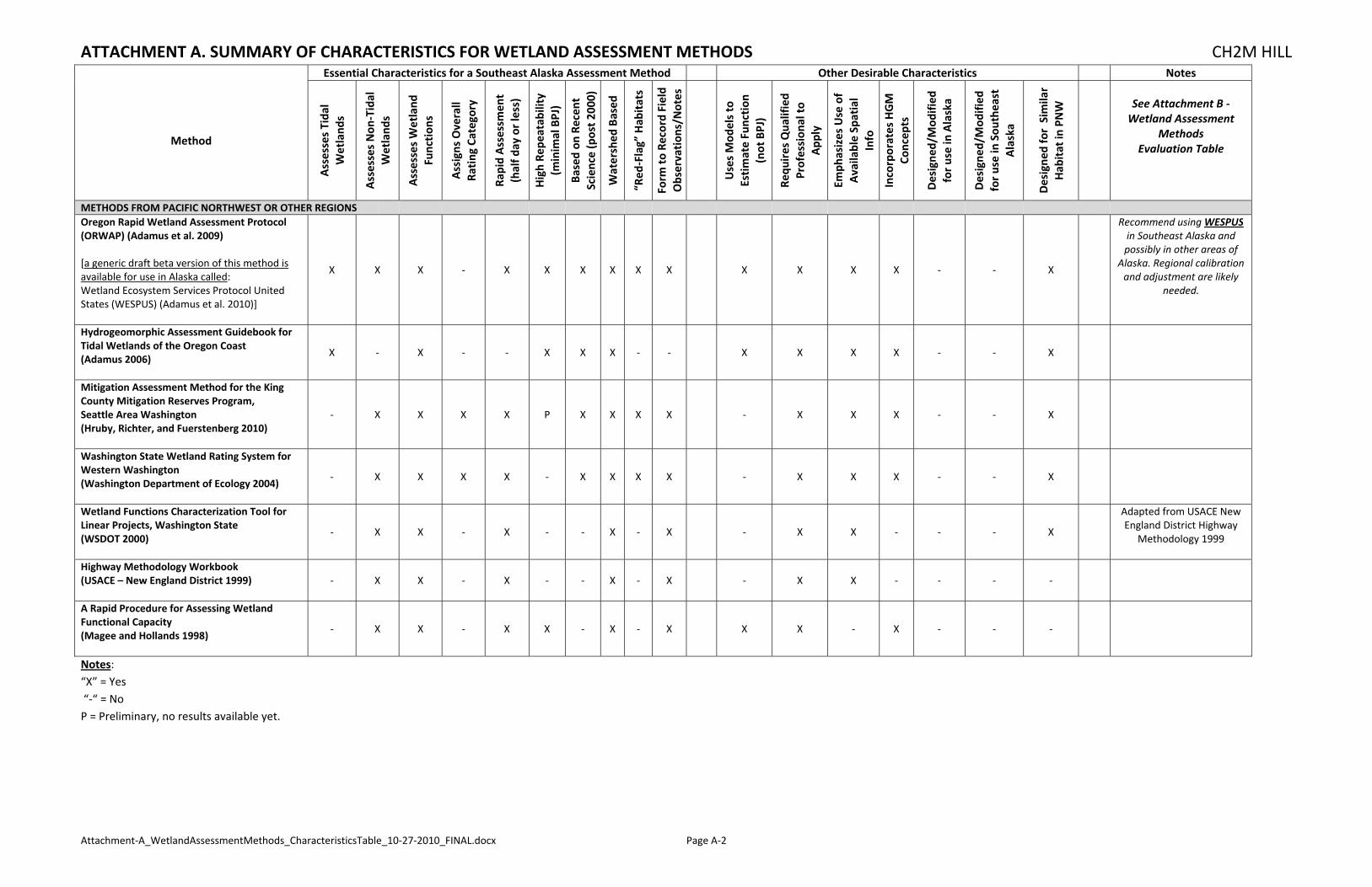
ATTACHMENT A. SUMMARY OF CHARACTERISTICS FOR WETLAND ASSESSMENT METHODS CH2M HILL
Attachment‐A_WetlandAssessmentMethods_CharacteristicsTable_10‐27‐2010_FINAL.docx Page A‐2
Essential Characteristics for a Southeast Alaska Assessment Method Other Desirable Characteristics Notes
Method
Assesses Tida
l Wetland
s
Assesses Non
‐Tidal
Wetland
s
Assesses Wetland
Function
s
Assigns Overall
Rating
Category
Rapid Assessm
ent
(half d
ay or less)
High Re
peatab
ility
(minim
al BPJ)
Based on
Recen
t Science (post 2
000)
Watershed
Based
“Red
‐Flag” Hab
itats
Form
to Re
cord Field
Observation
s/Notes
Uses Mod
els to
Estimate Function
(not BPJ)
Requ
ires Qua
lified
Profession
al to
App
ly
Emph
asizes Use of
Available Sp
atial
Info
Incorporates HGM
Concep
ts
Designe
d/Mod
ified
for use in Alaska
Designe
d/Mod
ified
for use in Sou
theast
Alaska
Designe
d for Sim
ilar
Hab
itat in
PNW
See Attachment B ‐ Wetland Assessment
Methods Evaluation Table
METHODS FROM PACIFIC NORTHWEST OR OTHER REGIONS
Oregon Rapid Wetland Assessment Protocol (ORWAP) (Adamus et al. 2009) [a generic draft beta version of this method is available for use in Alaska called: Wetland Ecosystem Services Protocol United States (WESPUS) (Adamus et al. 2010)]
X X X ‐ X X X X X X X X X X ‐ ‐ X
Recommend using WESPUSin Southeast Alaska and possibly in other areas of
Alaska. Regional calibration and adjustment are likely
needed.
Hydrogeomorphic Assessment Guidebook for Tidal Wetlands of the Oregon Coast (Adamus 2006)
X ‐ X ‐ ‐ X X X ‐ ‐ X X X X ‐ ‐ X
Mitigation Assessment Method for the King County Mitigation Reserves Program, Seattle Area Washington (Hruby, Richter, and Fuerstenberg 2010)
‐ X X X X P X X X X ‐ X X X ‐ ‐ X
Washington State Wetland Rating System for Western Washington (Washington Department of Ecology 2004)
‐ X X X X ‐ X X X X ‐ X X X ‐ ‐ X
Wetland Functions Characterization Tool for Linear Projects, Washington State (WSDOT 2000)
‐ X X ‐ X ‐ ‐ X ‐ X ‐ X X ‐ ‐ ‐ X
Adapted from USACE New England District Highway
Methodology 1999
Highway Methodology Workbook (USACE – New England District 1999)
‐ X X ‐ X ‐ ‐ X ‐ X ‐ X X ‐ ‐ ‐ ‐
A Rapid Procedure for Assessing Wetland Functional Capacity (Magee and Hollands 1998)
‐ X X ‐ X X ‐ X ‐ X X X ‐ X ‐ ‐ ‐
Notes: “X” = Yes “‐“ = No P = Preliminary, no results available yet.

Attachment B. Wetland Assessment Methods Evaluation

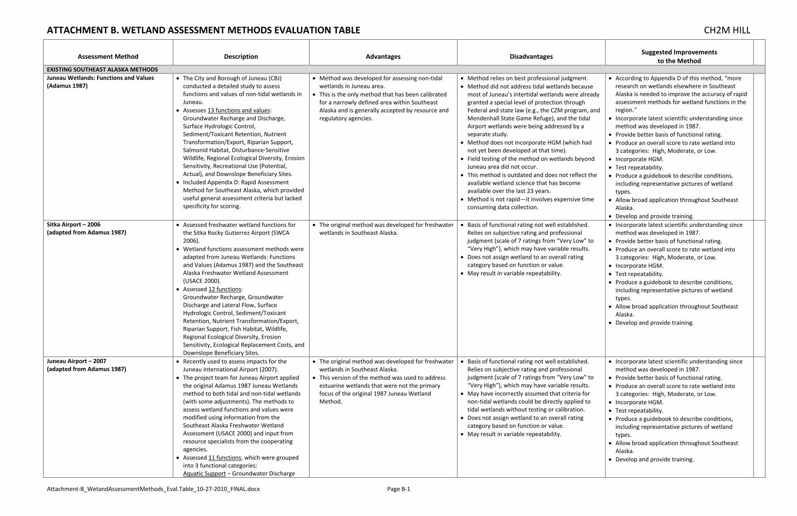
ATTACHMENT B. WETLAND ASSESSMENT METHODS EVALUATION TABLE CH2M HILL
Attachment‐B_WetandAssessmentMethods_Eval.Table_10‐27‐2010_FINAL.docx Page B‐1
Assessment Method Description Advantages Disadvantages Suggested Improvements
to the Method
EXISTING SOUTHEAST ALASKA METHODS
Juneau Wetlands: Functions and Values (Adamus 1987)
The City and Borough of Juneau (CBJ) conducted a detailed study to assess functions and values of non‐tidal wetlands in Juneau.
Assesses 13 functions and values: Groundwater Recharge and Discharge, Surface Hydrologic Control, Sediment/Toxicant Retention, Nutrient Transformation/Export, Riparian Support, Salmonid Habitat, Disturbance‐Sensitive Wildlife, Regional Ecological Diversity, Erosion Sensitivity, Recreational Use (Potential, Actual), and Downslope Beneficiary Sites.
Included Appendix D: Rapid Assessment Method for Southeast Alaska, which provided useful general assessment criteria but lacked specificity for scoring.
Method was developed for assessing non‐tidal wetlands in Juneau area.
This is the only method that has been calibrated for a narrowly defined area within Southeast Alaska and is generally accepted by resource and regulatory agencies.
Method relies on best professional judgment. Method did not address tidal wetlands because most of Juneau’s intertidal wetlands were already granted a special level of protection through Federal and state law (e.g., the CZM program, and Mendenhall State Game Refuge), and the tidal Airport wetlands were being addressed by a separate study.
Method does not incorporate HGM (which had not yet been developed at that time).
Field testing of the method on wetlands beyond Juneau area did not occur.
This method is outdated and does not reflect the available wetland science that has become available over the last 23 years.
Method is not rapid—it involves expensive time consuming data collection.
According to Appendix D of this method, “more research on wetlands elsewhere in Southeast Alaska is needed to improve the accuracy of rapid assessment methods for wetland functions in the region.”
Incorporate latest scientific understanding since method was developed in 1987.
Provide better basis of functional rating. Produce an overall score to rate wetland into 3 categories: High, Moderate, or Low.
Incorporate HGM. Test repeatability. Produce a guidebook to describe conditions, including representative pictures of wetland types.
Allow broad application throughout Southeast Alaska.
Develop and provide training. Sitka Airport – 2006 (adapted from Adamus 1987)
Assessed freshwater wetland functions for the Sitka Rocky Gutierrez Airport (SWCA 2006).
Wetland functions assessment methods were adapted from Juneau Wetlands: Functions and Values (Adamus 1987) and the Southeast Alaska Freshwater Wetland Assessment (USACE 2000).
Assessed 12 functions: Groundwater Recharge, Groundwater Discharge and Lateral Flow, Surface Hydrologic Control, Sediment/Toxicant Retention, Nutrient Transformation/Export, Riparian Support, Fish Habitat, Wildlife, Regional Ecological Diversity, Erosion Sensitivity, Ecological Replacement Costs, and Downslope Beneficiary Sites.
The original method was developed for freshwater wetlands in Southeast Alaska.
Basis of functional rating not well established. Relies on subjective rating and professional judgment (scale of 7 ratings from “Very Low” to “Very High”), which may have variable results.
Does not assign wetland to an overall rating category based on function or value.
May result in variable repeatability.
Incorporate latest scientific understanding since method was developed in 1987.
Provide better basis of functional rating. Produce an overall score to rate wetland into 3 categories: High, Moderate, or Low.
Incorporate HGM. Test repeatability. Produce a guidebook to describe conditions, including representative pictures of wetland types.
Allow broad application throughout Southeast Alaska.
Develop and provide training.
Juneau Airport – 2007 (adapted from Adamus 1987)
Recently used to assess impacts for the Juneau International Airport (2007).
The project team for Juneau Airport applied the original Adamus 1987 Juneau Wetlands method to both tidal and non‐tidal wetlands (with some adjustments). The methods to assess wetland functions and values were modified using information from the Southeast Alaska Freshwater Wetland Assessment (USACE 2000) and input from resource specialists from the cooperating agencies.
Assessed 11 functions, which were grouped into 3 functional categories: Aquatic Support – Groundwater Discharge
The original method was developed for freshwater wetlands in Southeast Alaska.
This version of the method was used to address estuarine wetlands that were not the primary focus of the original 1987 Juneau Wetland Method.
Basis of functional rating not well established. Relies on subjective rating and professional judgment (scale of 7 ratings from “Very Low” to “Very High”), which may have variable results.
May have incorrectly assumed that criteria for non‐tidal wetlands could be directly applied to tidal wetlands without testing or calibration.
Does not assign wetland to an overall rating category based on function or value.
May result in variable repeatability.
Incorporate latest scientific understanding since method was developed in 1987.
Provide better basis of functional rating. Produce an overall score to rate wetland into 3 categories: High, Moderate, or Low.
Incorporate HGM. Test repeatability. Produce a guidebook to describe conditions, including representative pictures of wetland types.
Allow broad application throughout Southeast Alaska.
Develop and provide training.
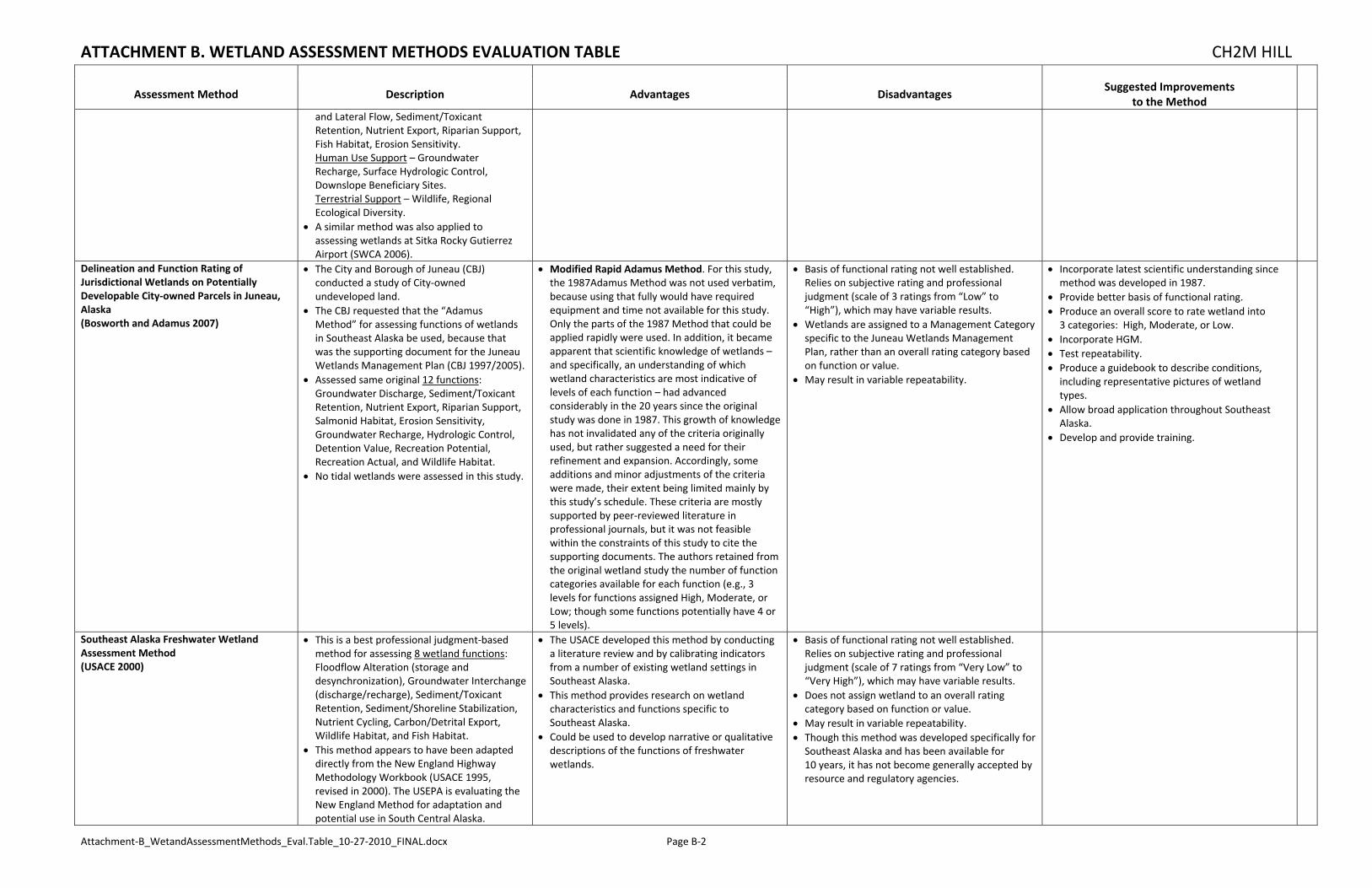
ATTACHMENT B. WETLAND ASSESSMENT METHODS EVALUATION TABLE CH2M HILL
Attachment‐B_WetandAssessmentMethods_Eval.Table_10‐27‐2010_FINAL.docx Page B‐2
Assessment Method Description Advantages Disadvantages Suggested Improvements
to the Method
and Lateral Flow, Sediment/Toxicant Retention, Nutrient Export, Riparian Support, Fish Habitat, Erosion Sensitivity. Human Use Support – Groundwater Recharge, Surface Hydrologic Control, Downslope Beneficiary Sites. Terrestrial Support – Wildlife, Regional Ecological Diversity.
A similar method was also applied to assessing wetlands at Sitka Rocky Gutierrez Airport (SWCA 2006).
Delineation and Function Rating of Jurisdictional Wetlands on Potentially Developable City‐owned Parcels in Juneau, Alaska (Bosworth and Adamus 2007)
The City and Borough of Juneau (CBJ) conducted a study of City‐owned undeveloped land.
The CBJ requested that the “Adamus Method” for assessing functions of wetlands in Southeast Alaska be used, because that was the supporting document for the Juneau Wetlands Management Plan (CBJ 1997/2005).
Assessed same original 12 functions: Groundwater Discharge, Sediment/Toxicant Retention, Nutrient Export, Riparian Support, Salmonid Habitat, Erosion Sensitivity, Groundwater Recharge, Hydrologic Control, Detention Value, Recreation Potential, Recreation Actual, and Wildlife Habitat.
No tidal wetlands were assessed in this study.
Modified Rapid Adamus Method. For this study, the 1987Adamus Method was not used verbatim, because using that fully would have required equipment and time not available for this study. Only the parts of the 1987 Method that could be applied rapidly were used. In addition, it became apparent that scientific knowledge of wetlands – and specifically, an understanding of which wetland characteristics are most indicative of levels of each function – had advanced considerably in the 20 years since the original study was done in 1987. This growth of knowledge has not invalidated any of the criteria originally used, but rather suggested a need for their refinement and expansion. Accordingly, some additions and minor adjustments of the criteria were made, their extent being limited mainly by this study’s schedule. These criteria are mostly supported by peer‐reviewed literature in professional journals, but it was not feasible within the constraints of this study to cite the supporting documents. The authors retained from the original wetland study the number of function categories available for each function (e.g., 3 levels for functions assigned High, Moderate, or Low; though some functions potentially have 4 or 5 levels).
Basis of functional rating not well established. Relies on subjective rating and professional judgment (scale of 3 ratings from “Low” to “High”), which may have variable results.
Wetlands are assigned to a Management Category specific to the Juneau Wetlands Management Plan, rather than an overall rating category based on function or value.
May result in variable repeatability.
Incorporate latest scientific understanding since method was developed in 1987.
Provide better basis of functional rating. Produce an overall score to rate wetland into 3 categories: High, Moderate, or Low.
Incorporate HGM. Test repeatability. Produce a guidebook to describe conditions, including representative pictures of wetland types.
Allow broad application throughout Southeast Alaska.
Develop and provide training.
Southeast Alaska Freshwater Wetland Assessment Method (USACE 2000)
This is a best professional judgment‐based method for assessing 8 wetland functions: Floodflow Alteration (storage and desynchronization), Groundwater Interchange (discharge/recharge), Sediment/Toxicant Retention, Sediment/Shoreline Stabilization, Nutrient Cycling, Carbon/Detrital Export, Wildlife Habitat, and Fish Habitat.
This method appears to have been adapted directly from the New England Highway Methodology Workbook (USACE 1995, revised in 2000). The USEPA is evaluating the New England Method for adaptation and potential use in South Central Alaska.
The USACE developed this method by conducting a literature review and by calibrating indicators from a number of existing wetland settings in Southeast Alaska.
This method provides research on wetland characteristics and functions specific to Southeast Alaska.
Could be used to develop narrative or qualitative descriptions of the functions of freshwater wetlands.
Basis of functional rating not well established. Relies on subjective rating and professional judgment (scale of 7 ratings from “Very Low” to “Very High”), which may have variable results.
Does not assign wetland to an overall rating category based on function or value.
May result in variable repeatability. Though this method was developed specifically for Southeast Alaska and has been available for 10 years, it has not become generally accepted by resource and regulatory agencies.

ATTACHMENT B. WETLAND ASSESSMENT METHODS EVALUATION TABLE CH2M HILL
Attachment‐B_WetandAssessmentMethods_Eval.Table_10‐27‐2010_FINAL.docx Page B‐3
Assessment Method Description Advantages Disadvantages Suggested Improvements
to the Method
Wetland Functional Assessment Guidebook: Riverine and Slope River Proximal Wetlands in Coastal Southeast and Southcentral Alaska using HGM (Powell et al. 2003)
Provides information about applying the HGM approach to the functional assessment of riverine wetlands and slope river proximal wetlands, on low permeability deposits and bedrock in Coastal Southeastern and Southcentral Alaska.
No widely accepted evaluation methods for Alaska’s wetlands accurately and consistently are available to evaluate changes in gains and losses of ecosystem functions. In response, the Alaska Department of Environmental Conservation (ADEC) (with other cooperating state and federal agencies and organizations) conducted a broad‐based, statewide effort to develop a Hydrogeomorphic (HGM) functional assessment for Alaska's wetlands. HGM was selected by ADEC and several other cooperating agencies and organizations because it offers a relatively rapid, efficient, and reference‐based method of assessment that allows users to recognize human‐induced changes in the functions of wetlands ecosystems.
The HGM method departs from other functional assessment approaches because it is based on: (1) recognition of differences among wetlands (i.e. classification), (2) identification of functions performed by classes and subclasses of wetlands, and (3) regionally developed reference systems.
This method provides research on wetland characteristics and functions specific to Southeast Alaska.
This method is limited to riverine wetlands and slope river proximal wetlands. Its utility can be expanded by combining it with the companion HGM method for slope/flat wetland complexes in the Cook Inlet Basin Ecoregion (Hall et al. 2003).
This method (like most HGM‐methods) is not rapid—it involves expensive time consuming data collection that would not be appropriate for routine functional assessments used for regulatory permit decisions.
Provides excellent source of scientific information on riverine wetlands that can be used to develop or calibrate other rapid assessment methods for Southeast Alaska.
OTHER RECENT ALASKA METHODS
Alaska Corps District Regulatory Guidance Letter (RGL) #09‐01 – Appendix A (USACE 2009)
Appendix A of the Corps RGL provides example functional assessment information and tools, which have been directly adapted from the Washington State Wetland Functions Characterization Tool for Linear Projects (WSDOT 2000).
This is a best professional judgment‐based method for assessing 10 wetland functions and values: Flood Flow Alteration, Sediment Removal, Nutrient/Toxicant Removal, Erosion Control /Shoreline Stabilization, Production of Organic Matter and its Export, General Habitat Suitability, General Fish Habitat, Native Plant Richness, Education or Scientific Value, and Uniqueness and Heritage.
May be best used to develop narrative or qualitative description of wetland functions and values.
Relies on subjective professional judgment, which may have variable results.
Does not assign wetland to an overall rating category based on function or value, making it difficult to make consistent management decisions (such as, assigning mitigation ratios).
May result in variable repeatability.
Instead of indicating whether functions are likely or not likely being provided, some users have proposed to add a subjective rating of functions (H,M,L) to identify the relative magnitude of each function/value being provided.
2006 Functional Assessment of Wetlands within the City of Homer and the Bridge Creek Watershed Protection District (City of Homer 2006)
Relatively rapid using best professional judgment.
Adapted the functional assessment method developed for Anchorage, but with some changes to reflect local geography, topography, and natural resources in Homer.
Functions for 3 categories (Hydrology, Habitat, and Species Occurrence) were scored qualitatively (H,M,L), then grouped by value (H,M,L).
Satisfies the needs of the City of Homer. Does not accurately assess functions (rather, assesses functions identified as valuable to the community).
Results in static assessment of functions (rather than assess current functions) that is incorporated into the City’s wetland management plan (i.e., pre‐determined value).
Does not incorporate HGM. Does not assess estuarine wetlands.

ATTACHMENT B. WETLAND ASSESSMENT METHODS EVALUATION TABLE CH2M HILL
Attachment‐B_WetandAssessmentMethods_Eval.Table_10‐27‐2010_FINAL.docx Page B‐4
Assessment Method Description Advantages Disadvantages Suggested Improvements
to the Method
Wetland Functional Assessment Guidebook: Operational Draft Guidebook for Assessing the Functions of Slope/Flat Wetland Complexes in the Cook Inlet Basin Ecoregion, Alaska, using the HGM Approach (Hall et al. 2003)
Provides information about applying the HGM approach to the functional assessment of slope/flat wetland complexes in the Cook Inlet Basin Ecoregion.
Similar to the HGM method developed by Powell et al. (2003) for riverine wetlands, this HGM method departs from other functional assessment approaches because it is based on: (1) recognition of differences among wetlands (i.e. classification), (2) identification of functions performed by classes and subclasses of wetlands, and (3) regionally developed reference systems.
This method provides research on wetland characteristics and functions specific to Cook Inlet Basin that could be extrapolated to Southeast Alaska.
This method is limited to slope/flat wetland complexes in the Cook Inlet Basin Ecoregion. Its utility can be expanded by combining it with the companion HGM method for riverine wetlands and slope river proximal wetlands (Powell et al. (2003).
This method (like most HGM‐methods) is not rapid—it involves expensive time consuming data collection that would not be appropriate for routine functional assessments used for regulatory permit decisions.
Provides excellent source of scientific information on slope/flat wetland complexes that could be used to develop or calibrate other rapid assessment methods for Southeast Alaska.
ADOT&PF Alaska Wetland Assessment Method (AKWAM) (ADOT&PF 2010)
Results in the relative rating of up to 10 wetland functions or services: Habitat for species of concern; General wildlife support; General fish support; Water storage; Sediment/nutrient/toxicant retention and removal; Sediment/shoreline stabilization; Production export/terrestrial and aquatic food chain support; Groundwater discharge/recharge; Uniqueness; Recreation/educational potential.
This first version of AKWAM is a first approximation and does not represent a comprehensive, fully Alaska‐adapted, and final assessment method.
Incorporates current and relevant information on wetland functions;
Meets the needs of ADOT&PF, the Corps of Engineers, and other concerned agencies for rating the functions and services of wetlands and categorizing wetlands and waterbodies potentially affected by ADOT&PF’s routine projects;
Minimizes subjectivity and variability among evaluators;
Allows for the comparison of different wetland types and different waterbody types;
Rates wetlands and waterbodies in a way that helps prioritize impact avoidance and minimization measures;
Categorizes wetlands and waterbodies in a way that promotes consistent and predictable application of compensatory mitigation requirements.
Results in an overall rating for the assessment area.
Offers a standard method that could be used consistently on projects for Interior Alaska.
This method is newly developed and does not appear to have been field tested for use in Alaska.
This method does not characterize the functions of tidal wetlands found in Southeast and other coastal regions in Alaska.
This method results in an overall rating of Category 1, 2, 3 or 4, which leads to ambiguity regarding assignment of regulatory mitigation ratios that are based on High, Moderate, and Low.
May result in variable repeatability. Does not emphasize use of available spatial data.
Conduct field testing: ‐ Pilot testing to calibrate method to the range
of scores in Alaska (i.e., regional calibration for Interior Alaska).
‐ Adjust method using scientific research for Alaska wetlands (i.e., regional adjustment for Interior Alaska).
‐ Develop a user’s manual (similar to ORWAP) that is customized to the data sources and wetland types of Alaska.
‐ Repeatability testing with individual users in Alaska.
Train users on the method. Emphasize use of available spatial data in Alaska. Adjust method based on results of field testing and user input.
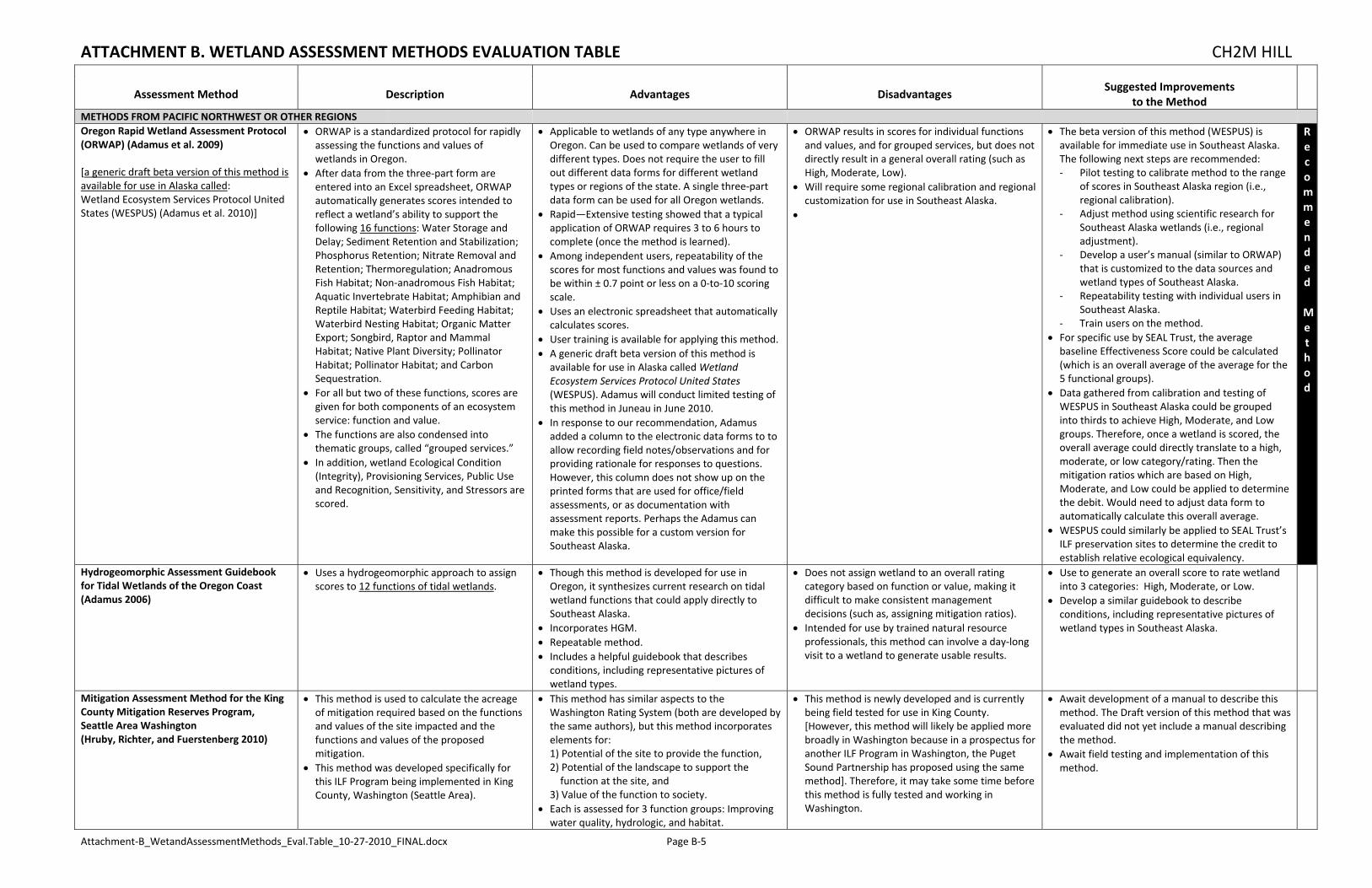
ATTACHMENT B. WETLAND ASSESSMENT METHODS EVALUATION TABLE CH2M HILL
Attachment‐B_WetandAssessmentMethods_Eval.Table_10‐27‐2010_FINAL.docx Page B‐5
Assessment Method Description Advantages Disadvantages Suggested Improvements
to the Method
METHODS FROM PACIFIC NORTHWEST OR OTHER REGIONS
Oregon Rapid Wetland Assessment Protocol (ORWAP) (Adamus et al. 2009) [a generic draft beta version of this method is available for use in Alaska called: Wetland Ecosystem Services Protocol United States (WESPUS) (Adamus et al. 2010)]
ORWAP is a standardized protocol for rapidly assessing the functions and values of wetlands in Oregon.
After data from the three‐part form are entered into an Excel spreadsheet, ORWAP automatically generates scores intended to reflect a wetland’s ability to support the following 16 functions: Water Storage and Delay; Sediment Retention and Stabilization; Phosphorus Retention; Nitrate Removal and Retention; Thermoregulation; Anadromous Fish Habitat; Non‐anadromous Fish Habitat; Aquatic Invertebrate Habitat; Amphibian and Reptile Habitat; Waterbird Feeding Habitat; Waterbird Nesting Habitat; Organic Matter Export; Songbird, Raptor and Mammal Habitat; Native Plant Diversity; Pollinator Habitat; Pollinator Habitat; and Carbon Sequestration.
For all but two of these functions, scores are given for both components of an ecosystem service: function and value.
The functions are also condensed into thematic groups, called “grouped services.”
In addition, wetland Ecological Condition (Integrity), Provisioning Services, Public Use and Recognition, Sensitivity, and Stressors are scored.
Applicable to wetlands of any type anywhere in Oregon. Can be used to compare wetlands of very different types. Does not require the user to fill out different data forms for different wetland types or regions of the state. A single three‐part data form can be used for all Oregon wetlands.
Rapid—Extensive testing showed that a typical application of ORWAP requires 3 to 6 hours to complete (once the method is learned).
Among independent users, repeatability of the scores for most functions and values was found to be within ± 0.7 point or less on a 0‐to‐10 scoring scale.
Uses an electronic spreadsheet that automatically calculates scores.
User training is available for applying this method. A generic draft beta version of this method is available for use in Alaska called Wetland Ecosystem Services Protocol United States (WESPUS). Adamus will conduct limited testing of this method in Juneau in June 2010.
In response to our recommendation, Adamus added a column to the electronic data forms to to allow recording field notes/observations and for providing rationale for responses to questions. However, this column does not show up on the printed forms that are used for office/field assessments, or as documentation with assessment reports. Perhaps the Adamus can make this possible for a custom version for Southeast Alaska.
ORWAP results in scores for individual functions and values, and for grouped services, but does not directly result in a general overall rating (such as High, Moderate, Low).
Will require some regional calibration and regional customization for use in Southeast Alaska.
The beta version of this method (WESPUS) is available for immediate use in Southeast Alaska. The following next steps are recommended: ‐ Pilot testing to calibrate method to the range
of scores in Southeast Alaska region (i.e., regional calibration).
‐ Adjust method using scientific research for Southeast Alaska wetlands (i.e., regional adjustment).
‐ Develop a user’s manual (similar to ORWAP) that is customized to the data sources and wetland types of Southeast Alaska.
‐ Repeatability testing with individual users in Southeast Alaska.
‐ Train users on the method. For specific use by SEAL Trust, the average baseline Effectiveness Score could be calculated (which is an overall average of the average for the 5 functional groups).
Data gathered from calibration and testing of WESPUS in Southeast Alaska could be grouped into thirds to achieve High, Moderate, and Low groups. Therefore, once a wetland is scored, the overall average could directly translate to a high, moderate, or low category/rating. Then the mitigation ratios which are based on High, Moderate, and Low could be applied to determine the debit. Would need to adjust data form to automatically calculate this overall average.
WESPUS could similarly be applied to SEAL Trust’s ILF preservation sites to determine the credit to establish relative ecological equivalency.
Recommended Method
Hydrogeomorphic Assessment Guidebook for Tidal Wetlands of the Oregon Coast (Adamus 2006)
Uses a hydrogeomorphic approach to assign scores to 12 functions of tidal wetlands.
Though this method is developed for use in Oregon, it synthesizes current research on tidal wetland functions that could apply directly to Southeast Alaska.
Incorporates HGM. Repeatable method. Includes a helpful guidebook that describes conditions, including representative pictures of wetland types.
Does not assign wetland to an overall rating category based on function or value, making it difficult to make consistent management decisions (such as, assigning mitigation ratios).
Intended for use by trained natural resource professionals, this method can involve a day‐long visit to a wetland to generate usable results.
Use to generate an overall score to rate wetland into 3 categories: High, Moderate, or Low.
Develop a similar guidebook to describe conditions, including representative pictures of wetland types in Southeast Alaska.
Mitigation Assessment Method for the King County Mitigation Reserves Program, Seattle Area Washington (Hruby, Richter, and Fuerstenberg 2010)
This method is used to calculate the acreage of mitigation required based on the functions and values of the site impacted and the functions and values of the proposed mitigation.
This method was developed specifically for this ILF Program being implemented in King County, Washington (Seattle Area).
This method has similar aspects to the Washington Rating System (both are developed by the same authors), but this method incorporates elements for: 1) Potential of the site to provide the function, 2) Potential of the landscape to support the function at the site, and
3) Value of the function to society. Each is assessed for 3 function groups: Improving water quality, hydrologic, and habitat.
This method is newly developed and is currently being field tested for use in King County. [However, this method will likely be applied more broadly in Washington because in a prospectus for another ILF Program in Washington, the Puget Sound Partnership has proposed using the same method]. Therefore, it may take some time before this method is fully tested and working in Washington.
Await development of a manual to describe this method. The Draft version of this method that was evaluated did not yet include a manual describing the method.
Await field testing and implementation of this method.
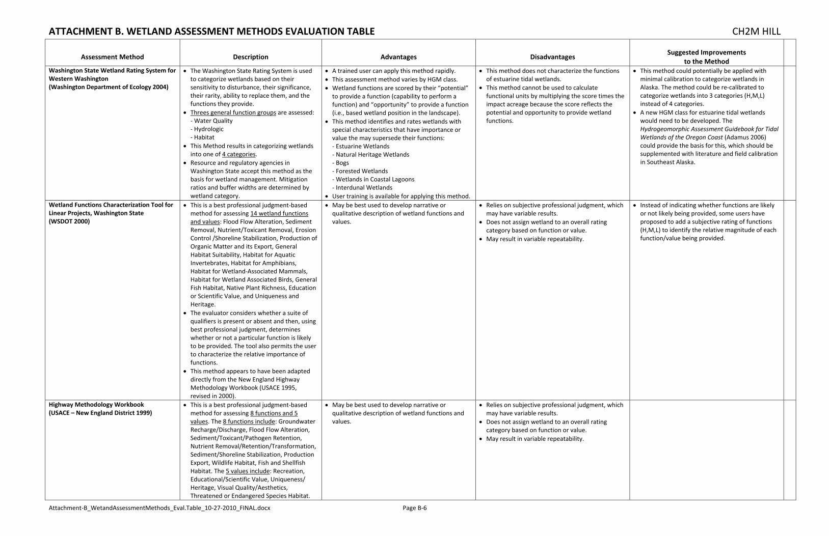
ATTACHMENT B. WETLAND ASSESSMENT METHODS EVALUATION TABLE CH2M HILL
Attachment‐B_WetandAssessmentMethods_Eval.Table_10‐27‐2010_FINAL.docx Page B‐6
Assessment Method Description Advantages Disadvantages Suggested Improvements
to the Method
Washington State Wetland Rating System for Western Washington (Washington Department of Ecology 2004)
The Washington State Rating System is used to categorize wetlands based on their sensitivity to disturbance, their significance, their rarity, ability to replace them, and the functions they provide.
Threes general function groups are assessed: ‐ Water Quality ‐ Hydrologic ‐ Habitat
This Method results in categorizing wetlands into one of 4 categories.
Resource and regulatory agencies in Washington State accept this method as the basis for wetland management. Mitigation ratios and buffer widths are determined by wetland category.
A trained user can apply this method rapidly. This assessment method varies by HGM class. Wetland functions are scored by their “potential” to provide a function (capability to perform a function) and “opportunity” to provide a function (i.e., based wetland position in the landscape).
This method identifies and rates wetlands with special characteristics that have importance or value the may supersede their functions: ‐ Estuarine Wetlands ‐ Natural Heritage Wetlands ‐ Bogs ‐ Forested Wetlands ‐ Wetlands in Coastal Lagoons ‐ Interdunal Wetlands
User training is available for applying this method.
This method does not characterize the functions of estuarine tidal wetlands.
This method cannot be used to calculate functional units by multiplying the score times the impact acreage because the score reflects the potential and opportunity to provide wetland functions.
This method could potentially be applied with minimal calibration to categorize wetlands in Alaska. The method could be re‐calibrated to categorize wetlands into 3 categories (H,M,L) instead of 4 categories.
A new HGM class for estuarine tidal wetlands would need to be developed. The Hydrogeomorphic Assessment Guidebook for Tidal Wetlands of the Oregon Coast (Adamus 2006) could provide the basis for this, which should be supplemented with literature and field calibration in Southeast Alaska.
Wetland Functions Characterization Tool for Linear Projects, Washington State (WSDOT 2000)
This is a best professional judgment‐based method for assessing 14 wetland functions and values: Flood Flow Alteration, Sediment Removal, Nutrient/Toxicant Removal, Erosion Control /Shoreline Stabilization, Production of Organic Matter and its Export, General Habitat Suitability, Habitat for Aquatic Invertebrates, Habitat for Amphibians, Habitat for Wetland‐Associated Mammals, Habitat for Wetland Associated Birds, General Fish Habitat, Native Plant Richness, Education or Scientific Value, and Uniqueness and Heritage.
The evaluator considers whether a suite of qualifiers is present or absent and then, using best professional judgment, determines whether or not a particular function is likely to be provided. The tool also permits the user to characterize the relative importance of functions.
This method appears to have been adapted directly from the New England Highway Methodology Workbook (USACE 1995, revised in 2000).
May be best used to develop narrative or qualitative description of wetland functions and values.
Relies on subjective professional judgment, which may have variable results.
Does not assign wetland to an overall rating category based on function or value.
May result in variable repeatability.
Instead of indicating whether functions are likely or not likely being provided, some users have proposed to add a subjective rating of functions (H,M,L) to identify the relative magnitude of each function/value being provided.
Highway Methodology Workbook (USACE – New England District 1999)
This is a best professional judgment‐based method for assessing 8 functions and 5 values. The 8 functions include: Groundwater Recharge/Discharge, Flood Flow Alteration, Sediment/Toxicant/Pathogen Retention, Nutrient Removal/Retention/Transformation, Sediment/Shoreline Stabilization, Production Export, Wildlife Habitat, Fish and Shellfish Habitat. The 5 values include: Recreation, Educational/Scientific Value, Uniqueness/ Heritage, Visual Quality/Aesthetics, Threatened or Endangered Species Habitat.
May be best used to develop narrative or qualitative description of wetland functions and values.
Relies on subjective professional judgment, which may have variable results.
Does not assign wetland to an overall rating category based on function or value.
May result in variable repeatability.

ATTACHMENT B. WETLAND ASSESSMENT METHODS EVALUATION TABLE CH2M HILL
Attachment‐B_WetandAssessmentMethods_Eval.Table_10‐27‐2010_FINAL.docx Page B‐7
Assessment Method Description Advantages Disadvantages Suggested Improvements
to the Method
The evaluator considers whether a suite of qualifiers is present or absent and then, using best professional judgment, determines whether or not a particular function is likely to be provided. The tool also permits the user to characterize the relative importance of functions.
This method is the basis for variety of similar methods also evaluated herein (WSDOT 2000; USACE 2000, USACE 2010).
A Rapid Procedure for Assessing Wetland Functional Capacity (Magee and Hollands 1998)
This procedure is not HGM (though some informally refer to it as “HGM light”).
This procedure was developed to provide a rapid functional assessment tool based on HGM classification for use in situations where time and cost prohibit the establishment of reference wetlands but where a rapid functional assessment is needed.
It can be modified to make it applicable to other regions in the continental U.S. or refined for specific subregions by adding, deleting, or modifying the functions, variables and variable conditions, or by making other changes appropriate for the location.
It can provide a template for building regional HGM models.
It can be used for conducting rapid wetland functional assessments in the glaciated Northeastern and Midwestern U.S.
Allows user to build a reference data set as the assessment is conducted.
Useful to develop comparative values. According to EPA, this method is apparently being used on several projects in Alaska (such as on North Slope).
This procedure was developed for the glaciated Northeastern and Midwestern U.S. Assumed use would be for continental U.S. only.
This method does not address tidal wetland HGM class.
Substantial upfront effort needed to develop functional model and calibrate for new regions, particularly Southeast Alaska.
Weak for peatland assessments (such as in Southcentral Alaska).
Requires considerable scientific input.
Obtain and review examples where this method has previously been used in Alaska.
Would require substantial regional calibration and regional customization for use in Southeast Alaska.
Would require development of a new model for the tidal wetland HGM class (which potentially could be adapted from Adamus 2006).

Attachment C. U.S. Army Corps of Engineers Alaska District Regulatory Guidance Letter #09-01