evaluation of well records and geophysical logs for ... · pdf filepenetration of water and...
TRANSCRIPT
Evaluation of Well Records and Geophysical Logs
for Determining the Presence of Freshwater,
Saltwater, and Gas above the Marcellus Shale,
South-Central New York
John H. WilliamsNew York Water Science Center
Troy, New York

Glacial-drift aquifers
7-county study area
Marcellus Shale outcrop
Study Area in South-Central New York
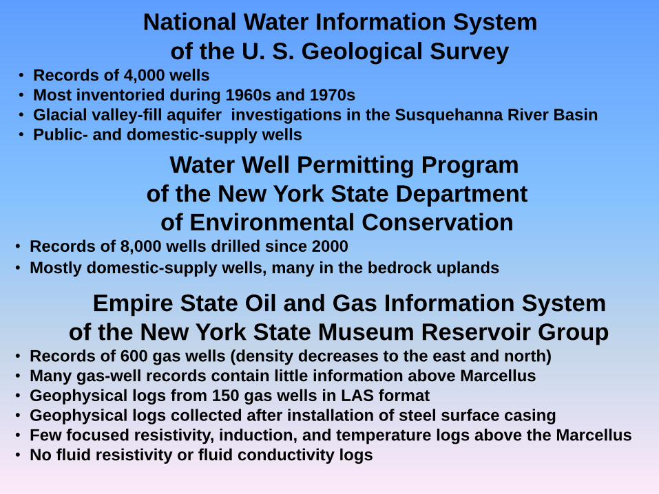
National Water Information System
of the U. S. Geological Survey• Records of 4,000 wells
• Most inventoried during 1960s and 1970s
• Glacial valley-fill aquifer investigations in the Susquehanna River Basin
• Public- and domestic-supply wells
Water Well Permitting Program
of the New York State Department
of Environmental Conservation• Records of 8,000 wells drilled since 2000
• Mostly domestic-supply wells, many in the bedrock uplands
Empire State Oil and Gas Information System
of the New York State Museum Reservoir Group• Records of 600 gas wells (density decreases to the east and north)
• Many gas-well records contain little information above Marcellus
• Geophysical logs from 150 gas wells in LAS format
• Geophysical logs collected after installation of steel surface casing
• Few focused resistivity, induction, and temperature logs above the Marcellus
• No fluid resistivity or fluid conductivity logs
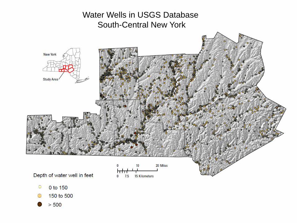
Water Wells in USGS Database
South-Central New York

Depth of Water Wells in USGS Database
South-Central New York

Water Wells that Penetrated Saltwater in South-Central New York
Modified from Williams (2011)

Water Wells that Penetrated Saltwater in North-Central Pennsylvania
Williams and others (1998)

344 588
7,800
2.10.2
36
40
1013
NS
30
3.1
Water Quality of Typical Freshwater and Salty
Water Wells in Upper Devonian Bedrock
Salty water wells
(Williams and others, 1998)
3
4,600
304 Tioga
County, PA
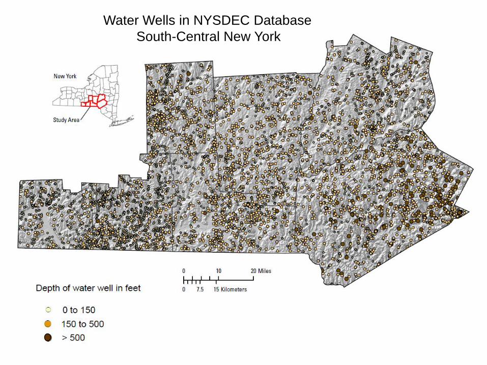
Water Wells in NYSDEC Database
South-Central New York
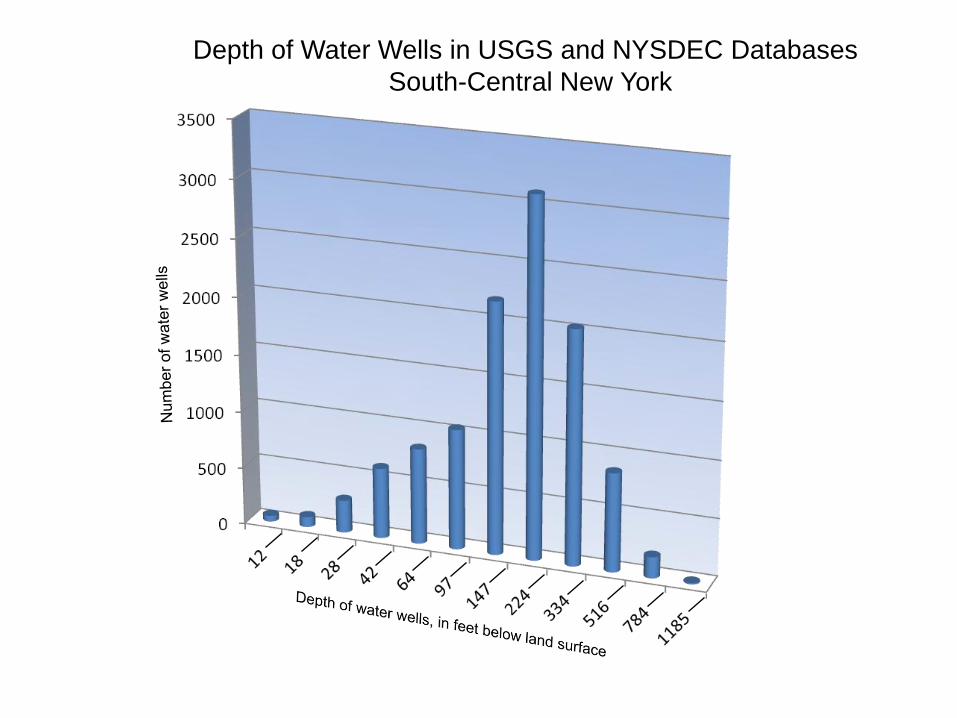
Depth of Water Wells in USGS and NYSDEC Databases
South-Central New York
Modified from Williams (2011)
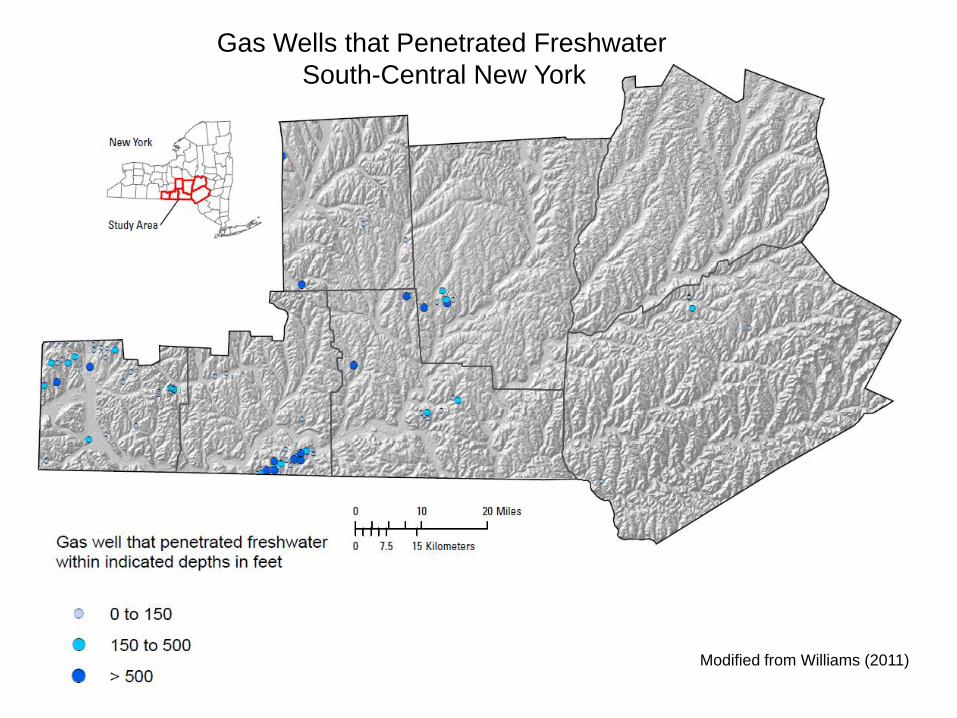
Gas Wells that Penetrated Freshwater
South-Central New York

Depth of Freshwater Zones Penetrated by Gas Wells
South-Central New York

Modified from Williams (2011)
Wells that Penetrated Gas above the Marcellus Shale
South Central New York

Freshwater and Gas in Close Vertical Proximity

Gas Show and Temperature Log
Surface
casing
Gas
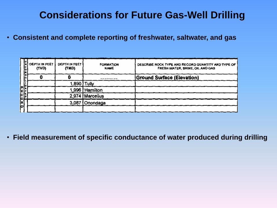
Considerations for Future Gas-Well Drilling
• Consistent and complete reporting of freshwater, saltwater, and gas
• Field measurement of specific conductance of water produced during drilling
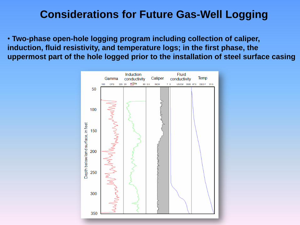
Considerations for Future Gas-Well Logging
• Two-phase open-hole logging program including collection of caliper,
induction, fluid resistivity, and temperature logs; in the first phase, the
uppermost part of the hole logged prior to the installation of steel surface casing

Considerations for Future Database Development
• Compilation and integration of information from gas wells and from water wells
that are inventoried and water-quality sampled during gas development and
ongoing county- and basin-wide programs
Evaluation of Well Records and Geophysical Logs for Determining the Presence of Freshwater, Saltwater, and Gas
above the Marcellus Shale, South-Central New York John H. Williams
U. S. Geological Survey
The statements made during the workshop do not represent the views or opinions of EPA. The claims made by participants have not been verified or endorsed by EPA.
Records of water wells in the National Water Information System (NWIS) and records and geophysical logs of gas wells in the Empire State Oil and Gas Information System (ESOGIS) were evaluated to provide a preliminary determination of the presence of freshwater, saltwater, and gas above the Marcellus Shale in south-central New York. This work expands the geographic extent of the well-record evaluation of Williams (2011) that included Chemung, Tioga, and Broome Counties to include Cortland, Chenango, Otsego, and Delaware Counties (fig. 1). In total, these counties form the core of the Marcellus and Utica shale-gas fairway in New York. Water-well records stored in the NWIS, which is maintained by the New York Water Science Center of the U. S. Geological Survey (USGS), were retrieved for the 7-county study area online from http://waterdata.usgs.gov/nwis/inventory. The NWIS contains records for nearly 4,000 water wells in the study area. Many of the water wells recorded in the NWIS and almost all of the 65 sites at which saltwater and (or) gas zones were penetrated were inventoried as part of glacial-drift aquifer investigations in the 1960s and 1970s (Randall, 1972; MacNish and Randall, 1982; Randall and others, 1988). These investigations were focused on the glaciated valleys of the Susquehanna and Chemung Rivers in New York. The presence of saltwater in water wells was reported by drillers or well owners based on taste tests, or was determined by water-quality analyses that indicated a chloride concentration of greater than 250 mg/L. The presence of gas was reported by drillers or well owners or was observed during field inventory.
Gas-well records and geophysical logs stored in the ESOGIS, which is maintained by the Reservoir Characterization Group at the New York State Museum (NYSM), were retrieved for the 7-county study area online from http://esogis.nysm.nysed.gov/. The ESOGIS contains records for about 600 gas wells in the study area. The gas-well records in the ESOGIS are for single- and multiple-well sites, wells whose confidential status had not expired (typically 2 years), and permitted but uncompleted wells. The density of the gas-well distribution generally decreases in a northeast direction across the study area from more than 200 wells in Chemung County to less than 20 wells in Otsego County. Because the formations above the Marcellus Shale generally have not been the focus of gas exploration, many of the gas-well records contain little or no information on the stratigraphic interval of interest. Penetration of water and (or) gas zones above the Marcellus Shale was reported for 112 gas-well sites. Water flows were reported by gas-well drillers as freshwater or saltwater presumably based on taste tests. Water flows commonly were rated by the gas-well drillers in inches of the stream
discharging from an open pipe into a mud pit while drilling with air. Reportedly, a 1-inch stream roughly equates to a flow of 10 to 20 gal/min, and a 2-inch stream roughly equates to a flow of 40 to 50 gal/min. Gas-flow rates generally were not quantified; those that were rated were reported in MCF (1,000 cubic feet), which presumably equates to the flow rate per day. Geophysical logs for 150 gas wells in the study area are stored in the ESOGIS in Log Ascii Standard (LAS) format. No geophysical logs were collected prior to the installation of steel surface casing, which typically is set to a depth of 500 to 1000 feet below land surface. Most of the log suites did include gamma measurements from the bottom of the well to near land surface. Neutron porosity and density logs were commonly collected along with the gamma logs. Only a few temperature, focused resistivity, or induction logs and no fluid resistivity logs were available for the interval above the Marcellus Shale. Again, because the formations above the Marcellus Shale generally have not been the focus of gas exploration, limited geophysical logging has been completed on this stratigraphic interval.
The well records and geophysical logs were reviewed to obtain information on well completions, geologic formations penetrated by the wells, and the presence of freshwater, saltwater, and gas above the Marcellus Shale in the study area. The spatial and stratigraphic distributions of freshwater, saltwater, and gas above the Marcellus Shale were investigated. To aid in the evaluation, Geographic Information System (GIS) coverages and histograms of the well data were created with ESRI ArcGIS software; and geophysical log composites were created with WellCad software. The evaluation of the well records and geophysical logs provide a preliminary but incomplete determination of freshwater, saltwater, and gas above the Marcellus Shale in the study area (Figure 1). The evaluation indicates that freshwater aquifer zones are log-normally distributed with depth and that freshwater circulates to a greater depth in the uplands than in the valleys. The base of the freshwater aquifer appears to be about 850 ft below land surface in upland settings but only about 300 ft below land surface in valley settings. At depths greater than 300 ft in valley settings, groundwater in the Upper Devonian bedrock, and in a few areas in the glacial drift, is salty. Williams and others (1998) found saltwater at similar depths in the glacial drift and Upper Devonian bedrock during an inventory of water wells in the glaciated valleys of Bradford, Tioga, and Potter Counties across the border in Pennsylvania. Water-quality analyses from these wells indicated that the shallow saltwater is characterized by elevated concentrations of chloride, barium, strontium, and radium and low concentrations of sulfate. Gas is present locally in the glacial drift, Upper Devonian bedrock, Tully Limestone, and Hamilton Group above the Marcellus Shale. The frequency of gas zones in the Upper Devonian bedrock generally increases with depth. The highest rates of gas flow above the Marcellus Shale appear to be associated with the Tully Limestone. Pockets of gas are locally present above the base of the freshwater aquifer with gas and freshwater occurring in close vertical proximity (Figure 2). Reported gas shows from targeted zones below the Marcellus Shale were correlated with distinct cooling anomalies on temperature logs suggesting that such logs could be an effective tool for delineating gas above the Marcellus if available.
Consistent and complete reporting of freshwater, saltwater, and gas during the drilling of future Marcellus and Utica shale-gas wells would greatly expand existing information. Field measurement of specific conductance of water produced during drilling would enhance the quantitative value of the gas-well records. Consideration should be given for a two-phase open-hole logging program that includes collection of caliper, induction, fluid resistivity, and temperature logs in addition to nuclear logs for the depth interval above the Marcellus. In such a program, the uppermost part of the well would need to be logged prior to the installation of surface casing. Compilation and integration of information from gas wells and from water wells that are inventoried and water-quality sampled during gas development and ongoing county- and basin-wide programs (Hetcher-Aguila, 2005; Hetcher-Aguila and Eckhardt, 2006; Nystrom, 2007; and Nystrom, 2008) would provide an important database for understanding and protecting the freshwater aquifers in the Marcellus and Utica shale-gas fairway.
References Cited
Hetcher-Aguila, K.K., 2005, Ground-water quality in the Chemung River Basin, New York, 2003: U.S. Geological Survey Open-File Report 2004–1329, 19 p.
Hetcher-Aguila, K.K., and Eckhardt, D.A.V., 2006, Ground-water quality in the upper Susquehanna River Basin, New York, 2004–05: U.S. Geological Survey Open-File Report 2006–1161, 21 p.
MacNish, R.D., and Randall, A. D., 1982, Stratified-drift aquifers in the Susquehanna River basin, New York: New York State Department of Environmental Conservation Bulletin 75, 68 p.
Nystrom, E.A., 2007, Ground-water quality in the Delaware River Basin, New York, 2001 and 2005-06: U.S. Geological Survey Open–File Report 2007-1098, 37 p.
Nystrom, E.A., 2008, Ground-water quality in the Mohawk River Basin, New York, 2006: U.S. Geological Survey Open-File Report 2008–1086, 33 p.
Randall, A.D., 1972, Records of wells and test borings in the Susquehanna River basin, New York: New York State Department of Environmental Conservation Bulletin 69, 92 p.
Randall, A.D., Snavely, D.S., Holecek, T.P., and Waller, R.M., 1988, Alternate sources of large seasonal ground-water supplies in the headwaters of the Susquehanna River basin, New York: U. S. Geological Survey Water-Resources Investigations Report 85–4127, 121 p.
Williams, J. H., Taylor, L. E., and Low, D. J., 1998, Hydrogeology and groundwater quality of the glaciated valleys of Bradford, Tioga, and Potter Counties, Pennsylvania: Pennsylvania Topographic and Geologic Survey Water Resources Report 68, 89 p.
Williams, J.H., 2011, Evaluation of well logs for determining the presence of freshwater, saltwater, and gas above the Marcellus Shale in Chemung, Tioga, and Broome Counties, New York: U.S. Geological Survey Scientific Investigations Report 2010–5224, 27 p.
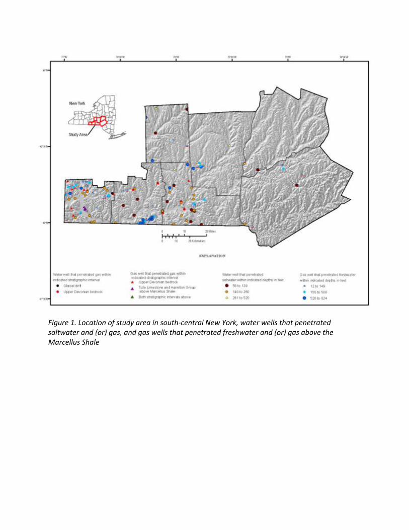
Figure 1. Location of study area in south-central New York, water wells that penetrated saltwater and (or) gas, and gas wells that penetrated freshwater and (or) gas above the Marcellus Shale
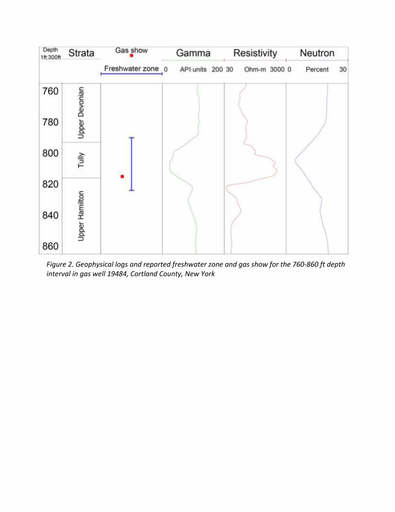
Figure 2. Geophysical logs and reported freshwater zone and gas show for the 760-860 ft depth interval in gas well 19484, Cortland County, New York