evaluating impacts of chashma right bank irrigation project...
TRANSCRIPT

Evaluating Impacts of Chashma Right Bank Irrigation
Project on the Cropping Intensity of District D.I.Khan Atta-ur-Rahman
∗
, Amir Nawaz Khan∗∗
& Zulfiqar Ali∗∗∗
Abstract This paper assesses the impacts of Chashma Right Bank
Irrigation Project (CRBIP) on the cropping intensity in
D.I.Khan district, Pakistan. To enhance agricultural
productivity, the Chashma Right Bank Canal (CRBC) project
was launched in 1984, which brought vast Gomal plains under
the irrigation network. With the command area of 250,000
hectares, the project spreads over two provinces of Khyber
Pakhtunkhwa and Punjab. Besides, drastic changes in the arid
environment of D.I.Khan district, the project has brought
large scale cultivable waste under cultivation. This study is
based on evaluating cropping intensity to measure the land
use efficiency of agriculture in the study area. The results
show that due to canal irrigation, the cropping intensity has
overall increased; while in some areas exceeded the proposed
targets of the project. However, outside the CRBC command
area, no significant change in the cropping intensity has
occurred. The study suggests that cropping intensity could
further be enhanced with the extension of canal irrigation to
the remaining un-served parts of the district and multiple
cropping patterns.
Keywords: Chashma Right Bank, Irrigation, Cropping intensity,
D.I.Khan
Introduction D.I.Khan is the southernmost district of Khyber Pakhtunkhwa (KPK),
Pakistan. Geographically, D.I.Khan district stretches between 310 15’ to
320 32’ North latitude and 70
0 11’ to 71
0 20’ East longitude (Map 1).
Here, water is one of the most valuable natural resources. There is a great
∗
Dr. Atta-ur-Rahman, Assistant Professor, Institute of Geography and Urban &
Regional Planning, University of Peshawar. Email: [email protected] ∗∗
Prof. Dr. Amir Nawaz Khan, Dean, Faculty of Life and Environmental
Sciences, University of Peshawar ∗∗∗
Dr. Zulfiqar Ali, Assistant Professor, Institute of Geography and Urban &
Regional Planning, University of Peshawar

Evaluating Impacts of Chashma Right Bank Irrigation Project
on the Cropping Intensity of District D.I.Khan Atta-ur-Rahman, Amir Nawaz & Zulfiqar Ali
Journal of Managerial Sciences Volume VI Number 1 94
potential for water resource development in general and irrigation
development in particular. Nevertheless, so far very little progress has
been made in this respect. Likewise, in D.I.Khan uncertain climatic
factors also become barriers in the development process, including arid
to semi-arid climatic condition. In the study area Rod Kohi (hill torrent
irrigation), lift irrigation, flood irrigation and canal irrigation are the
major form of irrigation. However, Rainfed (Barani) farming dominates
the land use. However, erratic rainfall largely results in crop failure
before ripening. Therefore the yields are comparatively low. Contrary to
this, irrigation has the potential to bring large scale transformation in the
land use, cropping pattern and cropping intensity (Ali, et al., 2004).
Historically, it had been a human effort to bring water through canal
irrigation systems in the arid and semi-arid area.
Map

Evaluating Impacts of Chashma Right Bank Irrigation Project
on the Cropping Intensity of District D.I.Khan Atta-ur-Rahman, Amir Nawaz & Zulfiqar Ali
Journal of Managerial Sciences Volume VI Number 1 95
In district D.I.Khan, dry conditions remained the major limiting factor in
changing land use and cropping system. Therefore, an intervention was
made in the form of Chashma Right Bank Canal (CRBC) during 1987.
The Chashma Right Bank Irrigation Scheme is a large irrigation network
spread over the two provinces i.e. KPK and Punjab. The total canal
command area is 250,000 ha, out of which 152,500 ha is in D.I.Khan
district (Ahmad, 1993; WAPDA, 1995). The ultimate goal of the
Chashma Right Bank Irrigation Project (CRBIP) was to increase
agricultural productivity and strengthening institutional support in the
agriculture sector (WAPDA, 2002). All these goals were aimed to
alleviate poverty in the area (ADB, 1987). Availability of water through
large-scale surface irrigation in this arid tract has brought revolutionary
changes in both physical and cultural environment.
Prior to the construction of CRBIP, the cropping intensity of
D.I.Khan district was 28%. One of the objectives of CRBIP was to raise
cropping intensity from mere 28% to 143% in the CRBC command area.
This paper is aimed to investigate the ex post impacts evaluation of
CRBIP on the cropping intensity of D.I.Khan district. This is a sort of
pioneering study of its nature in evaluating irrigation projects in
Pakistan. In this paper analysis has been made at two levels i.e. micro
and macro. This study may be used as a guideline for decision makers,
planners to assess land use efficiency of irrigation projects in future.
This paper is divided into four sections. Section one of the paper
deals with the detailed introduction of the study, while section two
describes the methods and material used for this research. The following
section gives analysis, results and discussion. The paper is concluded in
the final section.
Materials and Methods
Conceptual framework
The world's population continues to grow progressively. Therefore, dams
and irrigation projects are required to be built, particularly in the
developing countries to cater the food requirements of the growing
population (Stockle, 2001). However, it is important to ensure that such
projects must be built to higher standards and with due accountability to
local people and their environment than in the past (Singh, 1991;
Stockle, 2001; Government of India, 2002).
Increasing expansion in the irrigated area is possible mainly due
to large-scale irrigation projects involving enormous capital expenditure
(Cantor, 1967; Garg, 1987). Irrigation projects are usually associated
with its positive impacts on human life. However, ill planned projects

Evaluating Impacts of Chashma Right Bank Irrigation Project
on the Cropping Intensity of District D.I.Khan Atta-ur-Rahman, Amir Nawaz & Zulfiqar Ali
Journal of Managerial Sciences Volume VI Number 1 96
and unwise irrigation practices are always associated with adverse
impacts on environment. These impacts may eventually curtail the
sustainability of irrigation projects (Dalua, 1993). Hence, all the
irrigation projects cause both positive and adverse impacts on the
environment. However, the positive impacts of irrigation projects do not
need any emphasis particularly during the times of acute food shortages
and growing population. The spread of irrigation has been a key factor
behind the near tripling of global grain production, since 1950. However,
it is very unfortunate that about one-third of the world’s irrigated lands
have reduced productivity because of poorly managed irrigation system
(Sadhukhan, 1990; Khan and Ali, 1998; Hussain, 2004; Khan, et al.,
2006). Literatures on irrigation sector have already focused attention on
socio-economic aspects, but impacts on the physical environment have
not been properly considered (Amarasekara, 1993).
The concept of impact evaluation has been variously defined,
because it conveys different meaning to different people (Havens, 1981;
Hussain, 1991; Baker, 2000; Maredia, et al., 2000). The evaluation may
be described as a systematic process of collecting and analysing data to
measure pre-determined objectives and targets of a project within a
specified time period (Hussain, 1991). A more specific definition is put
forward by Rutman (1982) that evaluation deals with the use of scientific
method to measure the implementation and out-come of the project for
decision-making. The project evaluation is a process to analyse the
achievements and results of the completed projects (Hussain, 1991).
Evaluation actually measures the effects of the outcome against the
specified goal of a project (Havens, 1981). Ex post evaluation is an
applied and interdisciplinary science activity (Hussain, 1991; ADB,
1993; Baker, 2000; Maredia, et al., 2000). It is a type of evaluation that is
intended to determine the consequences of an intervention. This analysis
can be either ex ante or ex post, which measures the outcomes that have
actually resulted from the intervention to date (Baker, 2000; Maredia, et
al., 2000). Ex post evaluation provides feedback for future irrigation
projects (Hussain, 1991).
Cropping intensity refers to the number of crops grown on the
same area in any one year (Gajja, 1991). Cropping intensity indicates the
extent to which cultivated area was used for cropping. It is also
expressed statistically e.g. total cropped area as a percentage of the total
cultivated land (GoP, 2004). Thus, higher would be the intensity of
cropping higher is the agricultural land use efficiency and vice versa
(Hirashima and Gooneratne, 1990; Gajja, 1991; GoP, 2004). Various
studies on the irrigation projects indicate that with the availability of
assured canal irrigation the cropping intensity has improved (Hirashima

Evaluating Impacts of Chashma Right Bank Irrigation Project
on the Cropping Intensity of District D.I.Khan Atta-ur-Rahman, Amir Nawaz & Zulfiqar Ali
Journal of Managerial Sciences Volume VI Number 1 97
and Gooneratne, 1990; Khan and Ali, 1998; Ahmed, 2000; Osman,
2003). The study on Fertility Impact of the Rahad Irrigation Project,
Sudan found that irrigation project has influenced the income level,
labour force participation and economic productivity due to higher
cropping intensity (Osman, 2003). The study on role of Aswan high dam,
Egypt indicates that cropping intensity was greatly enhanced after
commissioning of canal irrigation (Ahmed, 2000). After the inception of
Warsak Right Bank Canal, the cropping intensity has increased from
average 20% to 110%. The cropping intensity is comparatively high at
head reaches than the tail one (Khan and Ali, 1998). The irrigation and
water management in Asia indicates that application of irrigation has
increased the cropping intensity and is one of the positive impacts of
irrigation projects (Hirashima and Gooneratne, 1990).
Data collection and analysis
To evaluate the ex post impacts of CRBIP and achieve the study
objectives, both primary and secondary sources were used. Such data
and information were obtained both from inside and outside the CRBC
command area. In D.I.Khan district, there are a total of 384 villages
(GoP, 1999). Data about cropping intensity before and after CRBC of
entire district were collected, in order to get clear picture of CRBC
impacts on the cropping intensity of D.I.Khan district. Ideally, the entire
villages should have been surveyed for in-depth study. However, due to
time and resource constraint, sampling technique was applied. Hence, for
micro level analysis four villages were randomly selected from the
CRBC command area namely: Jarra, Gomal, Buchari and Chera.
Likewise, one village i.e. Khudaka was also randomly selected from
outside the CRBC command area. The sample sites were selected from
all the three stages of CRBC.
Initially, a series of reconnaissance visits were made to grasp an
idea of positive and adverse impacts of CRBC on the cropping intensity.
After the observations several field visits were made. For collection of
primary data, four different types of questionnaires were designed i.e. for
individual household, Focused Group Discussions (FGD’s), the line
agencies and Patwari (in-charge revenue record) of the study area.
Questionnaire for the individual households were administered to the
general public. Similarly, for every sample village two to three
questionnaires for the whole village were filled during FGD’s with the
community leaders and elderly people. Group discussion with the
community leaders, local organizations and farmers were the landmark
feature for cross checking the individual data. Questionnaire for the line
Evaluating Impacts of Chashma Right Bank Irrigation Project
on the Cropping Intensity of District D.I.Khan Atta-ur-Rahman, Amir Nawaz & Zulfiqar Ali
Journal of Managerial Sciences Volume VI Number 1 98
agencies were filled-up by interviewing officials of the concerned line
agencies.
Secondary data was obtained from the offices of related line
agencies, NGO’s, reports, journals, maps and electronic database
searches etc. Data regarding each and every plot of sample villages,
before and after the CRBC were obtained from the revenue records of
D.I.Khan district. The collected data was then analysed, using GIS and
statistical techniques. Finally, the data was presented in the form of
maps, tables and statistical diagrams.
Results and Discussion This section presents an analysis of the data at two levels i.e. macro and
micro. At macro level, focus has been on the entire district, whereas at
micro level five sample villages selected randomly from different
environmental settings have been assessed.
Impacts on cropping intensity (Macro-level analysis)
Cropping intensity is directly influenced by certain factors such as land
use, availability of water and cropping pattern etc. Before discussing
macro level cropping intensity, it is essential to provide background
information about the ex post conditions of land use, irrigation and
cropping pattern. These indicators will however provide firm foundation
to ex post impact evaluation of CRBC on the cropping intensity.
In D.I.Khan district, land use has been classified into cultivated,
uncultivated and cultivable waste land (Map 2 and 3). In D.I.Khan
district, cultivated area is the second largest land use category after
cultivable waste (GoNWFP, 1975; 1980; 1991; 2000 and 2004). The
total reported area of D.I.Khan district is 730,575 ha, out of which
232,036 ha was cultivated pre construction of CRBC in 1969-70. The
Table 1 reveals that after inception of CRBC, area under cultivation has
increased to 238,678 ha in 1989-90, which in 1999-2000 reduced to
233,100 ha. The increase in the cultivated area during 1989-90 was due
to the inception of canal irrigation in the form of CRBC, whereas
reduction in the cultivated area during 1999-2000 is attributed to the
drought spell (1997 to 2003) in Pakistan (Sheikh, 2004). Subsequently,
in 2003-04, the cultivated area once again increased and marked the
figure of 236,371 ha, which is approximately 32% of the total reported
area. Thus increase in the cultivated area has been recorded after the
lapse of drought condition. It causes a positive change of about 0.58% of
the total reported area. Hence, there has been gradual increase in the
cultivated area particularly after the inception of canal irrigation in the
form of CRBC.

Evaluating Impacts of Chashma Right Bank Irrigation Project
on the Cropping Intensity of District D.I.Khan Atta-ur-Rahman, Amir Nawaz & Zulfiqar Ali
Journal of Managerial Sciences Volume VI Number 1 99
In D.I.Khan district, large tract is uncultivated and hence agriculturally
unproductive. The analysis reveals that before the construction of CRBC
(1969-70), the uncultivated land was 132,408 ha, which after advent of
CRBC gradually increased to 132,428 ha (1989-1990). This figure has
further increased to 132,487 ha in 2003-04. Field survey together with
the secondary data also reveals that both cultivated and cultivable waste
has been gradually consumed by the built-up area (uncultivated area).
This alarming change has been attributed to the increase in the district
population and socio-economic development in the area in the post
CRBC scenario.
Map

Evaluating Impacts of Chashma Right Bank Irrigation Project
on the Cropping Intensity of District D.I.Khan Atta-ur-Rahman, Amir Nawaz & Zulfiqar Ali
Journal of Managerial Sciences Volume VI Number 1 100
Map 3

Evaluating Impacts of Chashma Right Bank Irrigation Project
on the Cropping Intensity of District D.I.Khan Atta-ur-Rahman, Amir Nawaz & Zulfiqar Ali
Journal of Managerial Sciences Volume VI Number 1 101
Table 1
D.I.Khan district, pre and post CRBC land utilization, 1969-70 to 2003-
2004 (Area in ha)
Source: Go NWFP, 1975; 1980; 1991; 2000 and 2004
DNA- Data Not Available
In D.I.Khan district, cultivable waste has been the largest land use
category. This large tract of land under cultivable waste is mainly due to
shortage of irrigation water. Nevertheless, cultivable waste has been
gradually reduced after the advent of CRBC, but this category is still at
number one in the land use classes. During the study period a negative
change in the cultivable waste has been recorded, after inception of
CRBC. The analysis found that cultivable waste has inverse relation with
the cultivated area. As the cultivated land increases, the cultivable waste
decreases and vice versa.
In D.I.Khan district, there has been constant increase in the total
irrigated area, since 1969-70. In the pre CBRC (1969-70) scenario, the
total irrigated land was 52,023 ha, which increased to 145,798 ha (2002-
03) due to introduction of CRBC. After CRBC, a net positive change of
10.77% has been recorded in the irrigated area. This increase in the
irrigated area is attributed to the CRBC. Therefore, after the inception of
CRBC, canal irrigated area has been considerably increased. Presently,
the share of canal irrigated area is more than all the other categories.
Prior to the construction of CRBC (1969-70), the canal-irrigated area
was only 16,517 ha, which is 6.5% of the cultivated area. During the
stated period, Paharpur canal was the major source of canal irrigation.
After CRBC, the share of canal irrigated area was constantly improved
and marked the figure of 127,498 ha in 2002-03.
The cropping pattern is a dynamic phenomenon. It is because of
the fact that all the impact factors vital for cropping pattern is
consistently changing. Availability of water in the form of irrigation is an
important factor, which influence the cropping pattern of any region.

Evaluating Impacts of Chashma Right Bank Irrigation Project
on the Cropping Intensity of District D.I.Khan Atta-ur-Rahman, Amir Nawaz & Zulfiqar Ali
Journal of Managerial Sciences Volume VI Number 1 102
Therefore, irrigation in the form of CRBC has resulted enormous
changes in the cropping pattern of D.I.Khan district. In D.I.Khan district,
wide variety of crops ranging from arid to humid is cultivated. In
D.I.Khan district both Kharif (summer crops) and Rabi (winter crops) are
cultivated. Variety of Kharif crops are grown, but the most important are
rice, sugarcane, cotton, maize, millet, sorghum, pulses, oilseed,
vegetables and fruits. Prior to the inception of CRBC, sorghum and
millet were the major crops grown in the district. These crops respond
better even if little water is applied. However, after CRBC sugarcane,
rice and orchards took the lead and were largely introduced in the Kharif
(summer) season. Similarly, important Rabi (winter) crops are wheat,
barley, pulse, oilseed, and fruits. The analysis reveals that there has been
constant increase in Kharif (summer) and Rabi (winter) acreage
particularly after the inception of CRBC. With the advent of CRBC, new
water loving crops have been introduced. As a result, water-table is
inclining at a rapid pace leading into the problem of waterlogging and
salinity in the CRBC command area.
The analysis reveals that since the inception of CRBC, there has
been constant increase in the cropping intensity particularly in the CRBC
command area. Before the introduction of canal irrigation, the cropping
intensity in D.I.Khan district was very low. This was mainly due to
limited supply of water for agricultural land. Rod Kohi (hill torrent
irrigation) and rainfed cultivation was largely practiced, but with
uncertainty in maturity of crops. Pre CRBC, small area was under
irrigation, but after CRBC, rapid increase in the canal irrigated area
occurred mainly due to the inception of CRBC. However, CRBC has
brought an immense change in the cropping intensity.
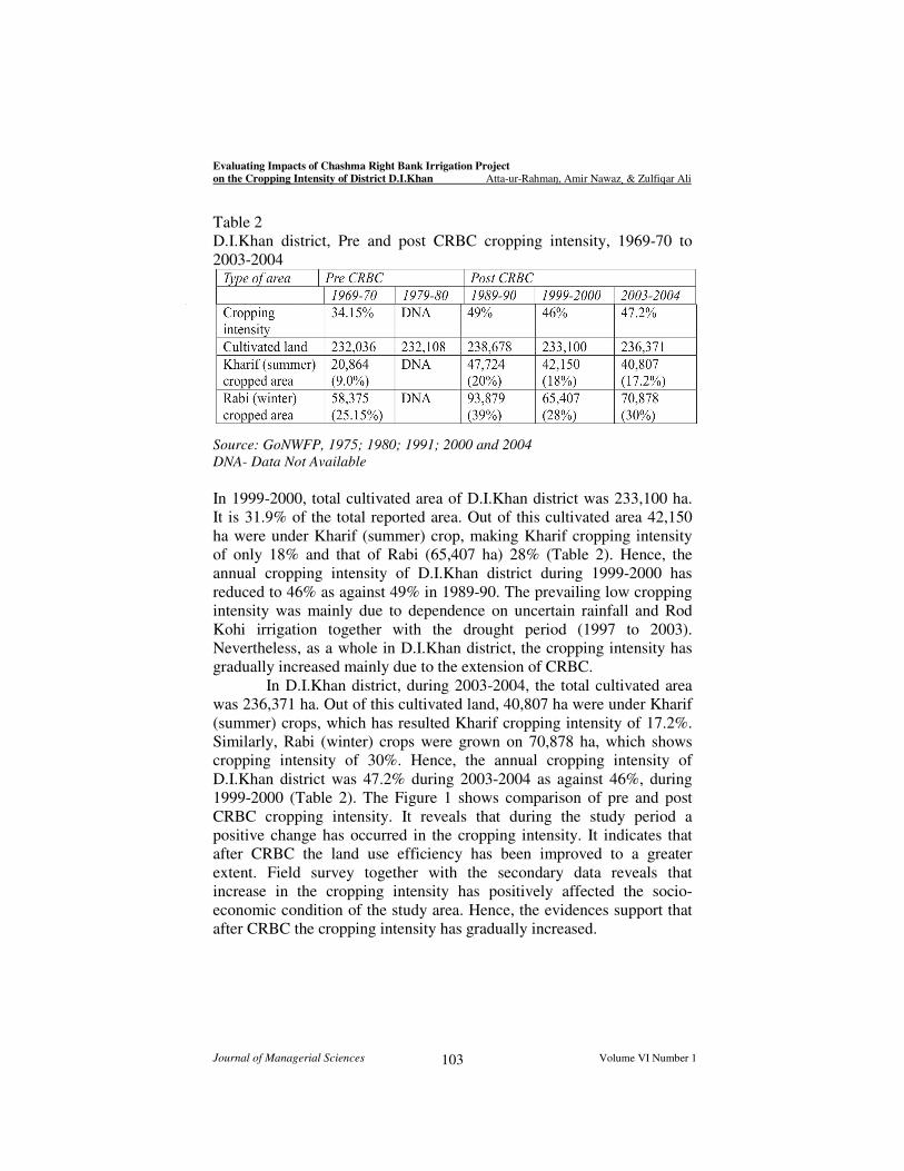
The Table 2 indicates that before CRBC (1969-70), total
cultivated land in D.I.Khan district was 232,036 ha. Out of this cultivated
land, area under Kharif (summer) crops was 20,864 ha, making Kharif
(summer) cropping intensity of only 9.0%. Similarly, area under Rabi
(winter) crops in 1969-70 was 58,375 ha, which has resulted Rabi
(winter) cropping intensity of 25.15% (Table 2). The overall picture
suggests that the annual cropping intensity was 34.15% during 1969-70.
The analysis further indicates that after the construction of
CRBC in 1989-90, total cultivated area has increased to 238,678 ha. Out
of this cultivated land, 47,724 ha were under Kharif (summer) crop,
making cropping intensity of only 20%. However, during the same year,
Rabi (winter) crops were grown over 93,879 ha, giving Rabi cropping
intensity of 39%. It means that after the inception of CRBC in 1989-
1990, the annual cropping intensity of D.I.Khan district has increased to
49% (Table 2).
Evaluating Impacts of Chashma Right Bank Irrigation Project
on the Cropping Intensity of District D.I.Khan Atta-ur-Rahman, Amir Nawaz & Zulfiqar Ali
Journal of Managerial Sciences Volume VI Number 1 103
Table 2
D.I.Khan district, Pre and post CRBC cropping intensity, 1969-70 to
2003-2004
Source: GoNWFP, 1975; 1980; 1991; 2000 and 2004
DNA- Data Not Available
In 1999-2000, total cultivated area of D.I.Khan district was 233,100 ha.
It is 31.9% of the total reported area. Out of this cultivated area 42,150
ha were under Kharif (summer) crop, making Kharif cropping intensity
of only 18% and that of Rabi (65,407 ha) 28% (Table 2). Hence, the
annual cropping intensity of D.I.Khan district during 1999-2000 has
reduced to 46% as against 49% in 1989-90. The prevailing low cropping
intensity was mainly due to dependence on uncertain rainfall and Rod
Kohi irrigation together with the drought period (1997 to 2003).
Nevertheless, as a whole in D.I.Khan district, the cropping intensity has
gradually increased mainly due to the extension of CRBC.
In D.I.Khan district, during 2003-2004, the total cultivated area
was 236,371 ha. Out of this cultivated land, 40,807 ha were under Kharif
(summer) crops, which has resulted Kharif cropping intensity of 17.2%.
Similarly, Rabi (winter) crops were grown on 70,878 ha, which shows
cropping intensity of 30%. Hence, the annual cropping intensity of
D.I.Khan district was 47.2% during 2003-2004 as against 46%, during
1999-2000 (Table 2). The Figure 1 shows comparison of pre and post
CRBC cropping intensity. It reveals that during the study period a
positive change has occurred in the cropping intensity. It indicates that
after CRBC the land use efficiency has been improved to a greater
extent. Field survey together with the secondary data reveals that
increase in the cropping intensity has positively affected the socio-
economic condition of the study area. Hence, the evidences support that
after CRBC the cropping intensity has gradually increased.

Evaluating Impacts of Chashma Right Bank Irrigation Project
on the Cropping Intensity of District D.I.Khan Atta-ur-Rahman, Amir Nawaz & Zulfiqar Ali
Journal of Managerial Sciences Volume VI Number 1 104
Impacts on cropping intensity (Micro-level analysis)
The study also presents the cropping intensity at the micro level. It was
found that the cropping intensity of the sample villages varies from one
another. The analysis reveals that after CRBC the cropping intensity of
CRBC command sample villages have increased, whereas off the
commands area no impacts of CRBC on the cropping intensity was
detected. The following discussion covers the micro level study of
sample villages as discussed below:
Jarra
Jarra, one of the sample villages falls in CRBC stage I and received
water from CRBC in 1988-89. Before the construction of CRBC, Jarra
was under the command of old Paharpur canal. It has a total area of
about 518 ha. In Jarra, two major sources of water were found including
canal and rainfall. In Jarra, canal irrigation remained a predominant
source of irrigation throughout the study period. In the sample village,
canal irrigation is reported, since 1902, when old Paharpur canal was
constructed. The analysis reveals that in Jarra, land utilization has been
greatly changed after the construction of CRBC. During Kharif
(summer), sugarcane, rice, maize, sorghum, fodder, pulses, vegetables
and fruits are grown. However, during the study period, the dominant
Kharif crops were sugarcane and rice, which hold maximum land cover.
Maize, sorghum and fodder were also grown, but due to competition
with more productive crops, these were found on relatively limited area.
Similarly, wheat, barley, pulses, oilseed, fodder and fruits were grown
during Rabi (winter) cropping season. Jarra is also famous for orchard
Comparison of Pre and Post CRBC cropping intensity
0
20
40
60
80
100
120
140
160
180
D.I.Khan Jarra Gomal Buchari Chera Khudaka
Cro
ppin
g inte
nsity in %
age
Pre CRBC Post CRBCFigur

Evaluating Impacts of Chashma Right Bank Irrigation Project
on the Cropping Intensity of District D.I.Khan Atta-ur-Rahman, Amir Nawaz & Zulfiqar Ali
Journal of Managerial Sciences Volume VI Number 1 105
farming. As a result of these developments, the population of Jarra has
comparatively better socio-economic condition.
In Jarra, prior to CRBC (1987-88), the total cultivated land was
389 ha. Out of total cultivated area, 147 ha were under Kharif crop
making cropping intensity of 38%. During the same year, area under
Rabi crops was 300 ha, which gives cropping intensity of 77% in Rabi.
The Figure 1 reveals that in the pre CRBC, the annual cropping intensity
was 115%. However, after the inception of CRBC this intensity has been
reduced to 109%. This high intensity during pre CRBC is mainly because
of the fact that Jarra was under the command of old Paharpur canal.
However, after CRBC, the annual cropping intensity was reduced to 55%
during 1999-2000. After the advent of CRBC, water loving crops such as
rice and sugarcane were largely introduced. Field survey together with
the revenue records reveal that after CRBC unwise irrigation practices
had severely affected the productive agricultural land by the twin
problem of waterlogging and salinity. The analysis further reveals that in
2003-04 once again, the annual cropping intensity was improved to a
level of 109%. This increase in the cropping intensity is attributed to the
reclamation of waterlogged and saline area.
Gomal
With a total area of about 3,661 ha, Gomal is one of the biggest villages
in terms of area in district D.I.Khan. Gomal falls in CRBC stage II and
canal irrigation through CRBC started in 1988-89. Prior to CRBC, wells
and Rod Kohi were the dominant sources of irrigation, while small area
was also found under rainfed cultivation. Therefore, numerous crops are
grown since long. The revenue record reveals that in Gomal, prior to
CRBC, there were 13 tube wells, out of which, 7 were in government
control, while 6 were privately managed. In this village, CRBC passes
through the western part of the village. About two third land of the
village is under the direct command of CRBC.
Important Kharif (summer) crops are sugarcane, cotton, rice,
maize, sorghum, millet, fodder, oilseed, vegetables and pulses. Before
CRBC, sugarcane, sorghum and millet dominated the Kharif (summer)
cropping season but after CRBC the two water loving crops i.e. rice and
sugarcane remained the principal contributors in Kharif (summer)
season. Similarly wheat, barley, pulse, oilseed, fodder and fruits are
important Rabi crops.
In Gomal, prior to CRBC, the cropping intensity was 42%
(1969-70), which after CRBC increased to 88%. The data reveals that
before CRBC in 1969-70, Kharif cropping intensity was 6% and that of
Rabi 36%. Hence, the annual cropping intensity has marked 42%, which
Evaluating Impacts of Chashma Right Bank Irrigation Project
on the Cropping Intensity of District D.I.Khan Atta-ur-Rahman, Amir Nawaz & Zulfiqar Ali
Journal of Managerial Sciences Volume VI Number 1 106
further increased to 95% during 1979-80. This increase was due to large-
scale availability of water from Rod Kohi that has accelerated the Rabi
cropping intensity. Before CRBC, the cropping intensity was varied
mainly due to its dependence on uncertain Rod Kohi system. However,
after CRBC, the annual cropping intensity has shown a consistent
increase i.e. 51% in 1989-90, 66% in 1999-2000 and 88% during 2003-
04. The analysis further indicates that after CRBC, both cultivated land
and cropped area is gradually increasing due to availability of assured
canal irrigation. It is expected that if this trend continues, the cropping
intensity will further enhance in the future.
Buchari
Buchari falls in CRBC stage III and received water through CRBC in
1994-95. In Buchari, before the inception of CRBC, the cultivated land
was entirely dependent on rainfall and Rod Kohi. Field survey together
with the FGD’s reveals that in Buchari prior to CRBC farmers prefer to
cultivate their land after rainfall. Before CRBC, during Kharif cropping
season only sorghum and millet were grown but after CRBC area under
new water loving crops, cereal crops and pulses has been largely
increased. Similarly, major Rabi crops include wheat, barley, gram,
oilseed, fodder and fruits.
Buchari has a total area of 550 ha. In Buchari, before CRBC
(during 1969-1970), the total cultivated land was only 3 ha due to
maximum dependence on uncertain rain and large area was under
wasteland. Almost all this area was under Kharif crop, which makes
cropping intensity of 100% as against zero in Rabi. Hence, before CRBC
in 1969-70, the annual cropping intensity was 100%. Nevertheless,
during 1979-80, the annual cropping intensity was reduced to 75% as
against 15% during 1989-90. The analysis reveals that prior to CRBC
several times even a single plot was not cultivated mainly due to non
availability of water. The Figure 1 reveals that prior to CRBC cropping
intensity was 44% in 1993-94, which after inception of CRBC has
increased to 169%. It is the highest recorded cropping intensity amongst
the sample villages. It is even higher than the proposed project cropping
intensity of 143%. It is also expected that it will further increase in the
preceding years. All this increase in the cropping intensity has been
attributed to irrigation facility through CRBC.
Chera
Chera falls in CRBC stage III. This village received water from CRBC in
2000-2001. Before the inception of CRBC, rainfall and Rod Kohi were
the two dominant sources of water. Prior to CRBC, important Kharif

Evaluating Impacts of Chashma Right Bank Irrigation Project
on the Cropping Intensity of District D.I.Khan Atta-ur-Rahman, Amir Nawaz & Zulfiqar Ali
Journal of Managerial Sciences Volume VI Number 1 107
crops were sorghum, millet, oilseed, fodder and fruit but after CRBC,
sugarcane and pulses were also grown. In Chera, important Rabi crops
include wheat, barley, pulse and oilseed.
Chera has a total area of 725 ha. The analysis reveals that in
Chera, prior to CRBC in 1969-70, the cultivated area was 356 ha. Out of
this cultivated area, 52 ha were under Kharif crops and only 2 ha under
Rabi. It means that before CRBC the annual cropping intensity was 16%
in 1969-70, 24% in 1979-80, 91% during 1989-90 and 50% in 1999-
2000. The data indicates that after CRBC in 2003-2004, the annual
cropping intensity increased to 120% with almost equal share from both
Rabi and Kharif. This is the highest recorded cropping intensity during
the study period and is expected to increase further in future. The
analysis reveals that there has been constant increase in the cropping
intensity as a result of CRBC. Subsequently, after CRBC both the
cultivated area and cropped area were enhanced, which positively
affected the cropping intensity.
Khudaka
Khudaka is one of the sample villages located outside the CRBC
command area and falls in the command area of proposed Chashma
Right Bank 1st Irrigation Project. This village lies right on the left bank
of Luni hill torrent. In Khudaka, Rod Kohi is the only means of
irrigation. Here groundwater is saline and is not fit both for drinking as
well as irrigation purpose. Khudaka has a total area of about 320 ha. It
lies off the CRBC command area and therefore presents quite a different
picture as far as cropping intensity is concerned. The analysis reveals that
during 1969-70, the annual cropping intensity was 45%, whereas 114%
recorded in 1979-80. However, after 1979-80, even a single plot of land
was not cultivated due to non-availability of water from Rod Kohi.
Therefore, during the study period, no positive impact of CRBC was
seen on the cropping intensity. As a result Khudaka demonstrates very
low land use efficiency for agriculture.
Conclusion
The analysis revealed that in D.I.Khan district cropping intensity varies
from area to area. Prior to CRBC, uncertain climatic conditions were the
major limiting factors for prevailing low cropping intensity. It was found
from the analysis that in the CRBC command area the cropping intensity
has been increased due to introduction of canal irrigation, whereas low
cropping intensity prevailed in the rainfed and Rod Kohi areas.
The district level analysis revealed that after CRBC, the cropping
intensity was enhanced considerably. It was found that a positive change

Evaluating Impacts of Chashma Right Bank Irrigation Project
on the Cropping Intensity of District D.I.Khan Atta-ur-Rahman, Amir Nawaz & Zulfiqar Ali
Journal of Managerial Sciences Volume VI Number 1 108
of 13.05% of the total area has been recorded. The analysis of sample
villages revealed that in Jarra, a negative change of 6% has occurred,
which is mainly due to the problem of waterlogging and salinity.
However, in rest of the CRBC command sample villages, the cropping
intensity has been improved considerably. In Gomal, 10%, Buchari
125% and Chera 29% positive changes in the cropping intensity have
been registered. This is clear indication that after the inception of CRBC,
the cropping intensity was enhanced both at micro and macro level. It
has registered a significant positive impact on the economic sector of
D.I.Khan district. On the other hand, outside the CRBC command area
(i.e. Khudaka), no impact of CRBC on the cropping intensity was
detected.
The study found that in the CRBC command area, the cropping
intensity has gradually increased, but still some land was found fallow.
In order to further accelerate the cropping intensity, it is recommended
that additional areas should be brought under canal irrigation. Similarly,
better use of agricultural inputs and scientific farming technology need to
be made available for the farmers. This will ultimately raise the cropping
intensity and agricultural production several fold.

Evaluating Impacts of Chashma Right Bank Irrigation Project
on the Cropping Intensity of District D.I.Khan Atta-ur-Rahman, Amir Nawaz & Zulfiqar Ali
Journal of Managerial Sciences Volume VI Number 1 109
References
Ahmed T. A. 2000. Role of the Aswan High Dam in Promoting the Nile
River System Management. Case study published in Dams and
development: A new framework for decision making. A report of the
World Commission on dams.
Ahmad N. 1993. Water resources of Pakistan. Shahzad Nazir publisher,
Lahore, Pakistan.
Ali A, Singhvi S.L. and Swami S.K. (Ali, et al.). 2004 Canal irrigation in
the desert ecosystem: An environmental impact analysis of the selected
areas of I.G.N.P. command (stage-I). In Khan, M. Z. A. and Agarwal, S.
K. (eds) Environmental Geography, APH publishing corporation, New
Delhi, pp.17-57.
Amarasekara N. 1993. Environmental impact assessment for the
sustainability of irrigation system: A case study from Sri Lanka”. In
Awn, N. M. and Latif, M. (eds). Proceedings of the international
symposium on environmental assessment and management of irrigation
and drainage projects for sustained agricultural growth. Pak book corp.,
Lahore. pp. 66-76.
Asian Development Bank. 1987. Chashma Right Bank Irrigation Project
Stage II, Pakistan. Technical and economic feasibility report, prepared by
Brown, Copeland, Heiler and Co. consultant, under the technical
assistance by the Asian Development Bank.
Asian Development Bank. 1993. Environmental guidelines for selected
infrastructure projects. Office of the Asian Development Bank.
Baker J. 2000. Evaluating the Impact of development projects on
poverty: A handbook for practitioner. Washington, D.C. World Bank.
Cantor L. M. 1967. World geography of irrigation. Oliver and Boyd,
London, p. 252.
Dalua A. K. 1993. Environmental impact of large reservoir projects on
human settlements: A case study of Upper Kolab Project in Orissa.
Shish publishing house, New Delhi, p. 312.

Evaluating Impacts of Chashma Right Bank Irrigation Project
on the Cropping Intensity of District D.I.Khan Atta-ur-Rahman, Amir Nawaz & Zulfiqar Ali
Journal of Managerial Sciences Volume VI Number 1 110
Gajja L.C. 1991. Land use efficiency in Rajistan in the spatio-temporal
perspective. In Lakshmi Shukla, (ed.) Readings in agricultural
geography. Scientific publishers, Jodhpur, India. Pp. 29-34.
Garg S. K. 1987. Irrigation engineering and hydraulic structures.
Khanna publishers, Delhi-6, p.1184.
Government of India. 2002. National water policy. Ministry of Water
Resources, New Delhi
Government of NWFP. 1975. Crops statistics of D.I.Khan Division,
1969-70 to 1974-75. Bureau of statistics, planning and development
department, Government of NWFP, Peshawar.
Government of NWFP. 1980. Development statistics of NWFP. Bureau
of statistics, planning and development department, Government of
NWFP, Peshawar.
Government of NWFP. 1991. NWFP Development statistics. Bureau of
statistics, planning and development department, Government of NWFP,
Peshawar.
Government of NWFP. 2000. Half decade review 2000, district-wise
statistical analysis of NWFP. Bureau of statistics, Planning, Environment
and Development Department, Peshawar, p.125.
Government of NWFP. 2004. Agriculture statistics, D.I.Khan district.
Agriculture statistics wing, EDAO office, D.I.Khan.
Government of Pakistan. 1999. District Census Report of D.I.Khan,
1998. Population Census Organization of Pakistan, Islamabad.
Government of Pakistan. 2004. Agricultural statistics of Pakistan 2003-
2004. Ministry of food, agriculture and livestock, Islamabad.
Havens H. S. 1981. Programme evaluation and programme management.
Public administration Review, vol. 41. Pp.480-485.
Hirashima S. and Gooneratne, W., 1990. Irrigation and water
management in Asia, an introductory discussion. In Gooneratne, W and
Hirashima S. (eds) Irrigation and water management in Asia, Sterling
publishers private limited. pp.1-22.

Evaluating Impacts of Chashma Right Bank Irrigation Project
on the Cropping Intensity of District D.I.Khan Atta-ur-Rahman, Amir Nawaz & Zulfiqar Ali
Journal of Managerial Sciences Volume VI Number 1 111
Hussain I. (Ed.) 2004. Pro-poor Intervention Strategies in Irrigated
Agriculture in Asia. Poverty in Irrigated Agriculture: Issues and Options,
Pakistan. Colombo, Sri Lanka: IWMI (Country report, Pakistan).
Hussain M. 1991. Project appraisal monitoring and evaluation processes
with special reference to Pakistan. Royal book company, Saddar,
Karachi, p. 491.
Khan J. and Ali I. 1998. Socio-economic impact of canal irrigation: A
case study of Warsak Right Bank Canal. Sarhad Journal of Agriculture,
vol. 14(6), pp.659-663.
Khan S, Tariq R, Yuanlai C, Blackwell J. (Khan, et al.), 2006. Can
irrigation be sustainable?. Agricultural Water Management, volume 80,
Issues 1-3, no.24, pp.87-99.
Maredia M., D. Byerlee and Anderson J. R. (Maredia, et al.), 2000. Ex
Post Evaluation of Economic Impacts of Agricultural Research
Programs: A Tour of Good Practice. In The Future of Impact Assessment
in the CGIAR: Needs, Constraints and Options. Rome, Italy: CGIAR
Technical Advisory Committee Secretariat, FAO. URL
http://impact.cgiar.org/methods/docs/maredia.pdf Accessed on August
11, 2007
Osman E. R. A. 2003. The Fertility Impact of the Rahad Irrigation
Project, Sudan. Journal of contributions in Afro-American and African
studies, volume 206, Pp. 65-88.
Rutman L. 1982. Evaluation research methods: A basic guide. Sage
publication, Inc. p. 239.
Sadhukhan S.K. 1990. Economic Geography: An evaluation of
resources. S. Chand & company ltd, New Delhi.
Sheikh M. M. 2004. Drought management and prevention in Pakistan.
Pakistan Meteorology Journal. pp.117-131.
Singh A. 1991. Problems of agricultural land use in flood prone areas. In
Lakshmi Shukla, (ed.) Readings in Agricultural Geography. Scientific
publishers, Jodhpur, India. Pp. 135-163.

Evaluating Impacts of Chashma Right Bank Irrigation Project
on the Cropping Intensity of District D.I.Khan Atta-ur-Rahman, Amir Nawaz & Zulfiqar Ali
Journal of Managerial Sciences Volume VI Number 1 112
Stockle C.O., 2001. Environmental impact of irrigation: A review. Paper
presented in the IV International Congress of Agricultural Engineering,
May 9-11 2001, Chillan, Chile.
WAPDA.1995. Environmental management plan of Chashma Right
Bank Irrigation Project. Strengthening Environmental Management for
Water Resource Development, WAPDA project: supporting report-I,
WAPDA house, Lahore.
WAPDA. 2002. Final report PIME studies, Phase II, Benchmark stage III
of Chashma Right Bank Irrigation Project. Main report Vol. I. p. 337.