european contributions to capacity building activities in geo
TRANSCRIPT
Research and innovation
BUILDING FOR GEOSS
CAPACITY
European contributions to capacity building activities in GEO

EUROPE DIRECT is a service to help you find answers to your questions about the European Union
Freephone number (*):
00 800 6 7 8 9 10 11
(*) Certain mobile telephone operators do not allow access to 00 800 numbers or these calls may be billed
LEGAL NOTICE
Neither the European Commission nor any person acting on behalf of the Commission is responsible for the use which might be made of the following information.
More information on the European Union is available on the Internet (http://europa.eu).
Cataloguing data can be found at the end of this publication.
Luxembourg: Publications Office of the European Union, 2014
ISBN 978-92-79-34579-1doi:10.2777/50075
© Cover image 1xpert, #44151633, 2013. Source: Fotolia.com
© European Union, 2014
Reproduction is authorised provided the source is acknowledged.
PRINTED ON ELEMENTAL CHLORINE-FREE BLEACHED PAPER (ECF)
EUROPEAN COMMISSION
EUROPEAN COMMISSIONDirectorate-General for Research and InnovationDirectorate I – Climate Action and Resource Efficiency
Contact: Jane ShielEuropean CommissionOffice CDMA 3/07B-1049 BrusselsTel. +32 2 29 62984E-mail: [email protected]
ENDirectorate-General for Research and Innovation
Climate Action and Resource Efficiency
European contributions to capacity building activities in GEO
2014
CAPACITY BUILDING FOR GEOSS

How to obtain EU publications
Free publications:• one copy:
via EU Bookshop (http://bookshop.europa.eu);
• more than one copy or posters/maps: from the European Union’s representations (http://ec.europa.eu/represent_en.htm); from the delegations in non-EU countries (http://eeas.europa.eu/delegations/index_en.htm); by contacting the Europe Direct service (http://europa.eu/europedirect/index_en.htm) or calling 00 800 6 7 8 9 10 11 (freephone number from anywhere in the EU) (*). (*) The information given is free, as are most calls (though some operators, phone boxes or hotels may charge you).
Priced publications:• via EU Bookshop (http://bookshop.europa.eu);
Priced publications:• via one of the sales agents of the Publications Office of the European Union
(http://publications.europa.eu/others/agents/index_en.htm).
5C A P A C I T Y B U I L D I N G F O R G E O S S - E U R O P E A N C O N T R I B U T I O N S T O C A P A C I T Y B U I L D I N G A C T I V I T I E S I N G E O
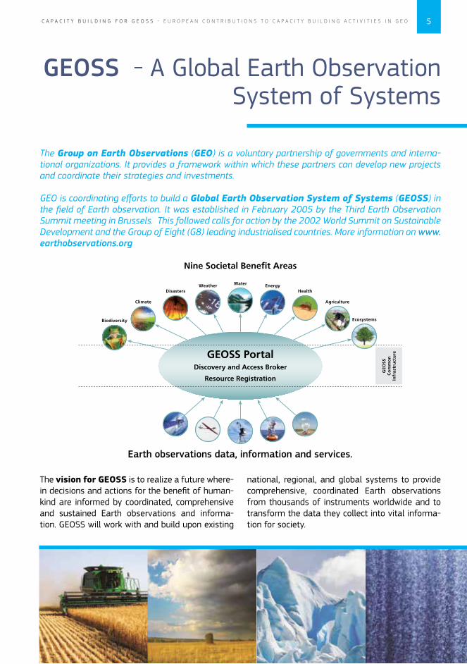
GEOSS - A Global Earth Observation System of Systems
The Group on Earth Observations (GEO) is a voluntary partnership of governments and interna-tional organizations. It provides a framework within which these partners can develop new projects and coordinate their strategies and investments.
GEO is coordinating efforts to build a Global Earth Observation System of Systems (GEOSS) in the field of Earth observation. It was established in February 2005 by the Third Earth Observation Summit meeting in Brussels. This followed calls for action by the 2002 World Summit on Sustainable Development and the Group of Eight (G8) leading industrialised countries. More information on www.earthobservations.org
The vision for GEOSS is to realize a future where-in decisions and actions for the benefit of human-kind are informed by coordinated, comprehensive and sustained Earth observations and informa-tion. GEOSS will work with and build upon existing
national, regional, and global systems to provide comprehensive, coordinated Earth observations from thousands of instruments worldwide and to transform the data they collect into vital informa-tion for society.
Earth observations data, information and services.
6 C A P A C I T Y B U I L D I N G F O R G E O S S - E U R O P E A N C O N T R I B U T I O N S T O C A P A C I T Y B U I L D I N G A C T I V I T I E S I N G E O
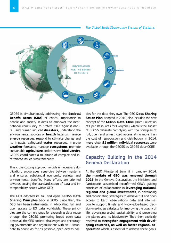
GEOSS is simultaneously addressing nine Societal Benefit Areas (SBA) of critical importance to people and society. It aims to empower the inter-national community to protect itself against natu-ral and human-induced disasters, understand the environmental sources of health hazards, manage energy resources, respond to climate change and its impacts, safeguard water resources, improve weather forecasts, manage ecosystems, promote sustainable agriculture and conserve biodiversity. GEOSS coordinates a multitude of complex and in-terrelated issues simultaneously.
This cross-cutting approach avoids unnecessary du-plication, encourages synergies between systems and ensures substantial economic, societal and environmental benefits. Many efforts are oriented towards solving the standardization of data and in-teroperability issues within GEO.
The GEO adopted its full and open GEOSS Data Sharing Principles back in 2005. Since then, the GEO has been instrumental in advocating full and open access to EO data worldwide. These princi-ples are the cornerstones for expanding data reuse through the GEOSS, promoting broad open data across all the GEO societal challenges and encourag-ing governments and organisations with an EO man-date to adopt, as far as possible, open access poli-
Capacity Building in the 2014 Geneva Declaration
At the GEO Ministerial Summit in January 2014, the mandate of GEO was renewed through 2025. In the Geneva Declaration, the Ministers and Participants assembled reconfirmed GEO’s guiding principles of collaboration in leveraging national, regional and global investments, in developing and coordinating strategies to achieve full and open access to Earth observations data and informa-tion to support timely and knowledge-based deci-sion-making as catalysts for improving the quality of life, advancing global sustainability and preserving the planet and its biodiversity. They then explicitly resolved to strengthen engagement with devel-oping countries, as well as foster regional co-operation which is essential to achieve these goals.
The Global Earth Observation System of Systems
cies for the data they own. The GEO Data Sharing Action Plan, adopted in 2010, also included the new concept of the GEOSS Data-CORE (Data Collection of Open Resources for Everyone), which is the subset of GEOSS datasets complying with the principles of full, open and unrestricted access at no more than the cost of reproduction and distribution. In 2014, more than 51 million individual resources were available through the GEOSS as GEOSS data-CORE.
7C A P A C I T Y B U I L D I N G F O R G E O S S - E U R O P E A N C O N T R I B U T I O N S T O C A P A C I T Y B U I L D I N G A C T I V I T I E S I N G E O
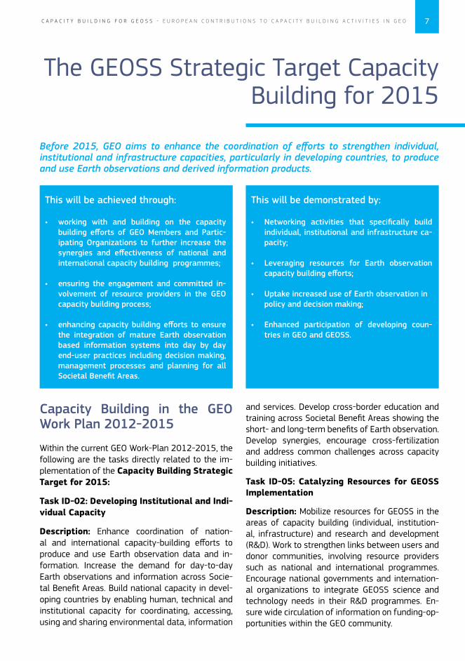
Capacity Building in the GEO Work Plan 2012-2015
Within the current GEO Work-Plan 2012-2015, the following are the tasks directly related to the im-plementation of the Capacity Building Strategic Target for 2015:
Task ID-02: Developing Institutional and Indi-vidual Capacity
Description: Enhance coordination of nation-al and international capacity-building efforts to produce and use Earth observation data and in-formation. Increase the demand for day-to-day Earth observations and information across Socie-tal Benefit Areas. Build national capacity in devel-oping countries by enabling human, technical and institutional capacity for coordinating, accessing, using and sharing environmental data, information
The GEOSS Strategic Target Capacity Building for 2015
Before 2015, GEO aims to enhance the coordination of efforts to strengthen individual, institutional and infrastructure capacities, particularly in developing countries, to produce and use Earth observations and derived information products.
This will be achieved through:
• working with and building on the capacity building efforts of GEO Members and Partic-ipating Organizations to further increase the synergies and effectiveness of national and international capacity building programmes;
• ensuring the engagement and committed in-volvement of resource providers in the GEO capacity building process;
• enhancing capacity building efforts to ensure the integration of mature Earth observation based information systems into day by day end-user practices including decision making, management processes and planning for all Societal Benefit Areas.
This will be demonstrated by:
• Networking activities that specifically build individual, institutional and infrastructure ca-pacity;
• Leveraging resources for Earth observation capacity building efforts;
• Uptake increased use of Earth observation in policy and decision making;
• Enhanced participation of developing coun-tries in GEO and GEOSS.
and services. Develop cross-border education and training across Societal Benefit Areas showing the short- and long-term benefits of Earth observation. Develop synergies, encourage cross-fertilization and address common challenges across capacity building initiatives.
Task ID-05: Catalyzing Resources for GEOSS Implementation
Description: Mobilize resources for GEOSS in the areas of capacity building (individual, institution-al, infrastructure) and research and development (R&D). Work to strengthen links between users and donor communities, involving resource providers such as national and international programmes. Encourage national governments and internation-al organizations to integrate GEOSS science and technology needs in their R&D programmes. En-sure wide circulation of information on funding-op-portunities within the GEO community.
8 C A P A C I T Y B U I L D I N G F O R G E O S S - E U R O P E A N C O N T R I B U T I O N S T O C A P A C I T Y B U I L D I N G A C T I V I T I E S I N G E O
Europe’s capability to respond
GMES and Africa Initiative and Capacity Building
The “GMES and Africa” initiative establishes a long-term partnership between Europe and Africa, working together on the development and imple-mentation of Earth observation (EO) applications tailored to African requirements. This process is im-plemented in the wider context of the Africa-EU partnership aiming at sustainable development and scientific cooperation. “GMES and Africa” strengthens Africa’s capacity and ownership of EO activities and acknowledges the importance of past and present African programmes, recognising the need to coordi-nate actions to avoid duplication, increase synergies and enhance complementarities.
“GMES and Africa” derives from the consensus reached as a result of the Lisbon Summit, in De-cember 2007, on the need to define a common pro-grammatic view for EO activities in Africa, and call-ing on the EU to extend its GMES initiative in Europe to Africa and other ACP countries. The Lisbon Dec-laration and the Lisbon Process on “GMES and Afri-ca” put forward guidelines to launch the partnership and described the necessary actions that need to be undertaken to formulate a “GMES and Africa” Ac-tion Plan (GAAP). The initiative forms part of the Joint Africa-EU Strategy Partnership.
The Space application dialogue between Africa and Europe is supported on a political level by the Joint Expert Group with representation of the African Union Commission (AUC) and the European Com-
mission. The Coordination Team for GMES Africa involves the participation of experts from African and European Member and stakeholder organisa-tions in addition to the European Commission.
The FP7 funded Support Action BRAGMA (Bridg-ing Actions for GMES and Africa, 2012-2014) was consolidating this dialogue and three thematic workshops on Marine and Coastal Environment, Water Resources, and Sustainable use of Natural Resources have been organised in 2012 and 2013. Furthermore, a Validation Workshop agreed on a “Call for the implementation of GMES & Afri-ca” was to be endorsed by the 4th EU-Africa Sum-mit, of April 2014.
In the Declaration of the Summit, the Heads of State and Government of the European Union and Africa, the President of the European Council, the President of the European Commission, the Presi-dent of the African Union (AU) and the Chairperson of the AUC took “note of the signature of a co-operative arrangement between our two EU and AU Commissions to use European space sci-ence and technology to monitor ecosystems through the “Global Monitoring for Environ-ment and Security (GMES) and Africa” initia-tive”. The Cooperative arrangement was signed on the 1st of April 2014 in Brussels and the imple-mentation is presently designed through a conti-nent-wide consultation process.
9C A P A C I T Y B U I L D I N G F O R G E O S S - E U R O P E A N C O N T R I B U T I O N S T O C A P A C I T Y B U I L D I N G A C T I V I T I E S I N G E O
Capacity building component of GMES and Africa
Building on existing capacity, the programme will facilitate partnerships between universities, research and training centres. A limited num-ber of researchers/trainees can be supported if their topics are directly relevant to the implementation of the programme. GMES & Africa will develop syn-ergies with the AUC “Pan African Universities” proj-ect, particularly the planned Space Science Institute, and will strengthen on-the-job training capacities to facilitate user uptake (including policy and decision
makers). Research cooperation under the European Union research funding programme (Horizon 2020) already initiated the exchange of scientists and the formation of inter-continental networks. The development of operational services under ‘GMES and Africa’ will additionally require the expertise to establish and maintain an African Satellite Data Ground Segment (e.g. access to Sentinel data), the sharing of experience between SMEs and an in-formed science-policy dialogue such as the African Leadership Conferences
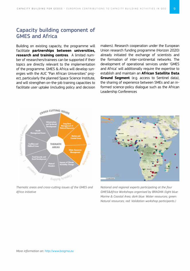
National and regional experts participating at the four GMES&Africa Workshops organised by BRAGMA (light blue: Marine & Coastal Area; dark blue: Water resources; green: Natural resources; red: Validation workshop participants.)
Thematic areas and cross-cutting issues of the GMES and Africa initiative
More information on: http://www.bragma.eu
10 C A P A C I T Y B U I L D I N G F O R G E O S S - E U R O P E A N C O N T R I B U T I O N S T O C A P A C I T Y B U I L D I N G A C T I V I T I E S I N G E O
The Monitoring for Environment and Security in Africa (MESA) Programme
MESA uses space-based and in-situ Earth obser-vation data and Geographical Information Sys-tem (GIS) applications to enable an improved management of the environment and security at continental, regional, and national levels in Africa. It builds on the Meteorological Transition in Africa (MTAP/PUMA) project and the African Monitoring for Environment and Sustainable Development (AMESD) programme.
The purpose of the MESA programme is to in-crease the information management, deci-sion-making and planning capacity of African continental, regional and national institu-tions which are mandated for environmental, cli-mate, food security and related responsibilities, by enhancing access to, and exploitation of, relevant Earth Observation applications in Africa.
This includes a range of information responding to citizens’ needs such as monitoring the water level and flow rate of key rivers used for commer-cial transport; water cycle information to help ag-riculture (e.g. best planting time or improved crop yields) and warn of flood and drought risks; moni-toring of the changing condition of rangelands for livestock management; tracking the depletion and/
or degradation of forest resources and biodiversity; monitoring of marine pollution, fisheries resources and coastal erosion, and others.
The programme started in April 2013 and will be implemented under the coordination of the African Union Commission with the EU Delegation to the African Union as the lead Delegation for the man-agement of the Programme.
MESA will reinforce and expand the long-term cooperation and exchange between Eu-ropean and African stakeholders for the devel-opment of operational information services based on satellite EO and in situ data. The services will support environmental management and security in Africa at the continental, regional and national levels, building upon the achievements of the AMESD project, and consistent with the European ‘GMES and Africa’ initiative.
The European Organisation for the Exploitation of Meteorological Satellites (EUMETSAT) and the Joint Research Centre of the European Commis-sion (JRC) are partners in the programme which will be implemented by Regional Economic Com-munities (RECs).
More information on: http://www.hd-mesa.org

11C A P A C I T Y B U I L D I N G F O R G E O S S - E U R O P E A N C O N T R I B U T I O N S T O C A P A C I T Y B U I L D I N G A C T I V I T I E S I N G E O
While contributing to the GEOSS, AGRICAB framework has the fol-lowing objectives:
1. To assure sustained provision & availability of EO satellite data and further facilitate their exploitation through free software.
2. To develop integrated applications with monitoring and predictive models on crop produc-tion, livestock and forest (including fire) systems.
3. To stimulate the wider uptake of these EO techniques.
The AGRICAB project aims to bring together satellite data providers, researchers, capacity builders, operational practitioners and decision makers, with the target of building a sustainable and compre-hensive framework for strengthening the existing African capacities in using Earth Observation (EO) for better monitoring, understanding and managing natural resources.
AGRICAB
A framework for enhancing EO capacity for Agriculture and Forest Management in Africa as a contribution to GEOSS
Examples of European Projects contributing to Capacity Building
in GEO

12 C A P A C I T Y B U I L D I N G F O R G E O S S - E U R O P E A N C O N T R I B U T I O N S T O C A P A C I T Y B U I L D I N G A C T I V I T I E S I N G E O
While the data provision and software tools benefit users across the African continent, the majority of AGRICAB’s efforts are devoted to the research and implementation of use cases adapted to the con-ditions in the focus countries: on rain fed crops in Kenya, Mozambique & Senegal, irrigated crops in Tunisia and its neighbours, livestock in Niger, Senegal and Kenya and forest and fire management in Southern Africa. These objec-tives are underpinned by the organization of a large number of workshops for training (including in depth training in Europe, technical trainings at the national level and thematic trainings at the regional level), meetings with stakeholders and stimulating uptake on various scales, leading up to the establishment of a pan-African “Community of Practice”
Project website: www.agricab.info
Field visit during national workshop in Nairobi
AGRICAB Regional workshop

13C A P A C I T Y B U I L D I N G F O R G E O S S - E U R O P E A N C O N T R I B U T I O N S T O C A P A C I T Y B U I L D I N G A C T I V I T I E S I N G E O
The purpose of the EOPOWER project is to create conditions for sustainable economic development through the increased use of Earth observation products and services for environmental applications. This purpose serves the higher goal of effective use of Earth observation for decision-making and management of economic and sustainable development processes.
The EOPOWER project builds on the results of the FP7 GEONetCab, BalkanGEONet, OBSERVE, enviro-GRIDS, SEOCA and EGIDA projects. The promotion activities of the various projects have been very successful, but there are still gaps to be ad-dressed. On the demand side, there are new target
groups of potential end-users that are not familiar yet with the possibilities of Earth observation and that have not yet been reached. On the supply side, access to data, notably through the GEOSS Com-mon Infrastructure (GCI), is a necessary condition.
The EOPOWER project will provide an extra push to stimulate the demand side, with the following results:
• Opportunities created for economic develop-ment, in particular in developing countries;
• Key international economic develop-ment processes identified that require en-vironmental information and mechanisms to develop them in a sustainable fashion;
• Local communities and authorities have received capacity building and are able to collaborate with international development programs, use environmental EO information and products, and engage resource providers;
• Mechanism established to market and ex-ploit EO applications for the creation of new innovative products and support services.
EOPOWER brings together 13 partners from three continents, coordinated by the enviroSPACE Lab at University of Geneva (UNIGE), Switzerland. The 2-year project runs from June 2013 to May 2015.
EOPOWER
Earth Observation for Economic Empowerment
Project website: http://www.eopower.eu
EOPOWER meeting
Bringing GEOSS into practice seminar
14 C A P A C I T Y B U I L D I N G F O R G E O S S - E U R O P E A N C O N T R I B U T I O N S T O C A P A C I T Y B U I L D I N G A C T I V I T I E S I N G E O
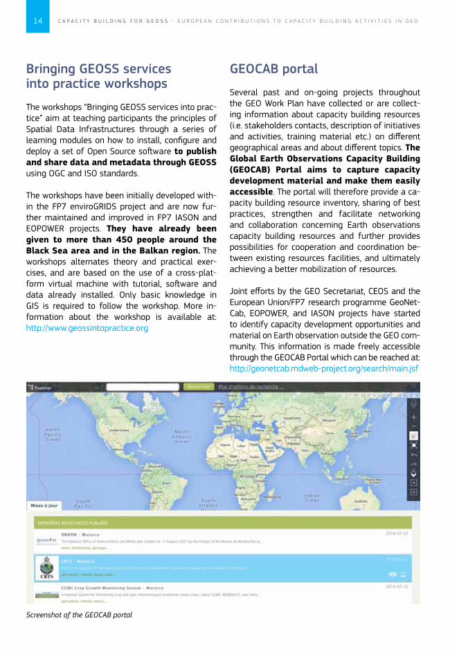
Screenshot of the GEOCAB portal
Bringing GEOSS services into practice workshops
The workshops “Bringing GEOSS services into prac-tice” aim at teaching participants the principles of Spatial Data Infrastructures through a series of learning modules on how to install, configure and deploy a set of Open Source software to publish and share data and metadata through GEOSS using OGC and ISO standards.
The workshops have been initially developed with-in the FP7 enviroGRIDS project and are now fur-ther maintained and improved in FP7 IASON and EOPOWER projects. They have already been given to more than 450 people around the Black Sea area and in the Balkan region. The workshops alternates theory and practical exer-cises, and are based on the use of a cross-plat-form virtual machine with tutorial, software and data already installed. Only basic knowledge in GIS is required to follow the workshop. More in-formation about the workshop is available at: http://www.geossintopractice.org
GEOCAB portal
Several past and on-going projects throughout the GEO Work Plan have collected or are collect-ing information about capacity building resources (i.e. stakeholders contacts, description of initiatives and activities, training material etc.) on different geographical areas and about different topics. The Global Earth Observations Capacity Building (GEOCAB) Portal aims to capture capacity development material and make them easily accessible. The portal will therefore provide a ca-pacity building resource inventory, sharing of best practices, strengthen and facilitate networking and collaboration concerning Earth observations capacity building resources and further provides possibilities for cooperation and coordination be-tween existing resources facilities, and ultimately achieving a better mobilization of resources.
Joint efforts by the GEO Secretariat, CEOS and the European Union/FP7 research programme GeoNet-Cab, EOPOWER, and IASON projects have started to identify capacity development opportunities and material on Earth observation outside the GEO com-munity. This information is made freely accessible through the GEOCAB Portal which can be reached at: http://geonetcab.mdweb-project.org/search/main.jsf
15C A P A C I T Y B U I L D I N G F O R G E O S S - E U R O P E A N C O N T R I B U T I O N S T O C A P A C I T Y B U I L D I N G A C T I V I T I E S I N G E O
• Visible and effective capacity building and knowledge transfer activities with third countries’ research institutes and organiza-tions, stakeholders and policy makers through the organization of two training workshops (one in each region).
• Demonstration of market opportunities through uptake of results from three projects (PEGASO, enviroGRIDS, and IMPACTMIN), best case scenarios and success stories.
• Identification of projects and networks, using the regional partners’ contacts in the third countries, along with inputs from training
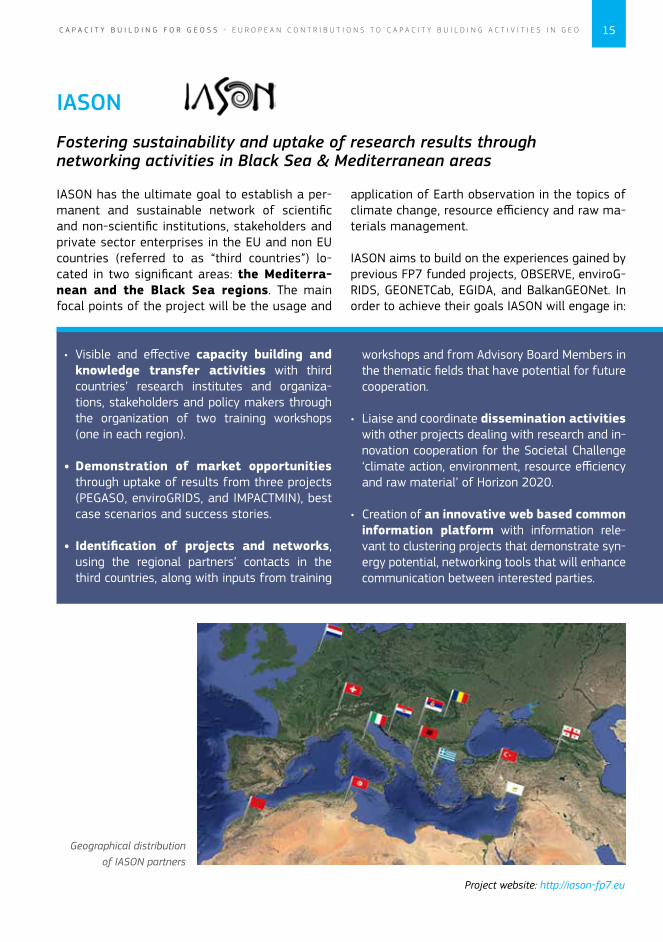
IASON has the ultimate goal to establish a per-manent and sustainable network of scientific and non-scientific institutions, stakeholders and private sector enterprises in the EU and non EU countries (referred to as “third countries”) lo-cated in two significant areas: the Mediterra-nean and the Black Sea regions. The main focal points of the project will be the usage and
IASON
Fostering sustainability and uptake of research results through networking activities in Black Sea & Mediterranean areas
workshops and from Advisory Board Members in the thematic fields that have potential for future cooperation.
• Liaise and coordinate dissemination activities with other projects dealing with research and in-novation cooperation for the Societal Challenge ‘climate action, environment, resource efficiency and raw material’ of Horizon 2020.
• Creation of an innovative web based common information platform with information rele-vant to clustering projects that demonstrate syn-ergy potential, networking tools that will enhance communication between interested parties.
application of Earth observation in the topics of climate change, resource efficiency and raw ma-terials management.
IASON aims to build on the experiences gained by previous FP7 funded projects, OBSERVE, enviroG-RIDS, GEONETCab, EGIDA, and BalkanGEONet. In order to achieve their goals IASON will engage in:
Geographical distribution of IASON partners
Project website: http://iason-fp7.eu
16 C A P A C I T Y B U I L D I N G F O R G E O S S - E U R O P E A N C O N T R I B U T I O N S T O C A P A C I T Y B U I L D I N G A C T I V I T I E S I N G E O
MEDINA aims at ensuring the optimal exploitation of the GEOSS Common Infrastructure (GCI) capabil-ities for the development of models and indicators for monitoring optimization and marine ecosystem assessment. The project has already enriched the GCI with ad-hoc components and datasets, focus-ing on a particular geographic area for which the GEO entry level barrier is still high. Through serious consideration of Integrated Coastal Zone Manage-ment objectives and achievements, MEDINA has fostered closer international cooperation on this topic between EU Member States and North African Countries.
MEDINA is taking up front the challenge of providing useful suggestions for the implementation of the Ecological Approach by all Contracting Par-ties of Barcelona Convention, which include all Northern African countries. Continuous monitoring & assessment is at the core of the “Ecosystem Ap-proach” initiative, which presents several similarities with the EU Marine Strategy Framework Directive. In this regard, MEDINA has developed several capac-ity building activities in the area, including:
MEDINA is designed to enhance Northern African Countries capacity to implement cost-effective monitoring programmes for assessing the environmental status of their Mediterranean coastal and marine ecosystems. This is a fundamental step towards the implementation of en-vironmental policies, conventions and protocols aimed at maintaining and improving the quality of such ecosystems in this region.
MEDINA
Marine Ecosystem Dynamics and Indicators for North Africa
• Three training workshops, including project partners and invited speakers, focused on Indi-cators, GEOSS and the implementation of EcAP and the Marine Strategy Framework Directive for the mediterranean Sea, Modelling tools.
• Four national workshops, in Algeria, Mo-rocco, Tunisia and Egypt, where the main re-sults were presented to local stakeholders and end-users.
• Two participatory workshops, in Morocco and Egypt, where future management scenari-os concerning the Lagoon of Nador and the Nile Delta Lakes were presented and discussed with local stakeholders.
MEDINA has produced a wealth of information, which has been made accessible to end-us-ers through the MEDINA e-Infrastructure at www.medinageoportal.eu, which includes a cata-logue and a viewer. The latter allows the visualiza-tion of maps of ecosystem status indicators and important ecological variables, as well as drivers and proxies of pressures, based on the analysis of remote sensing data and model outputs.
Project website: www.medinaproject.eu
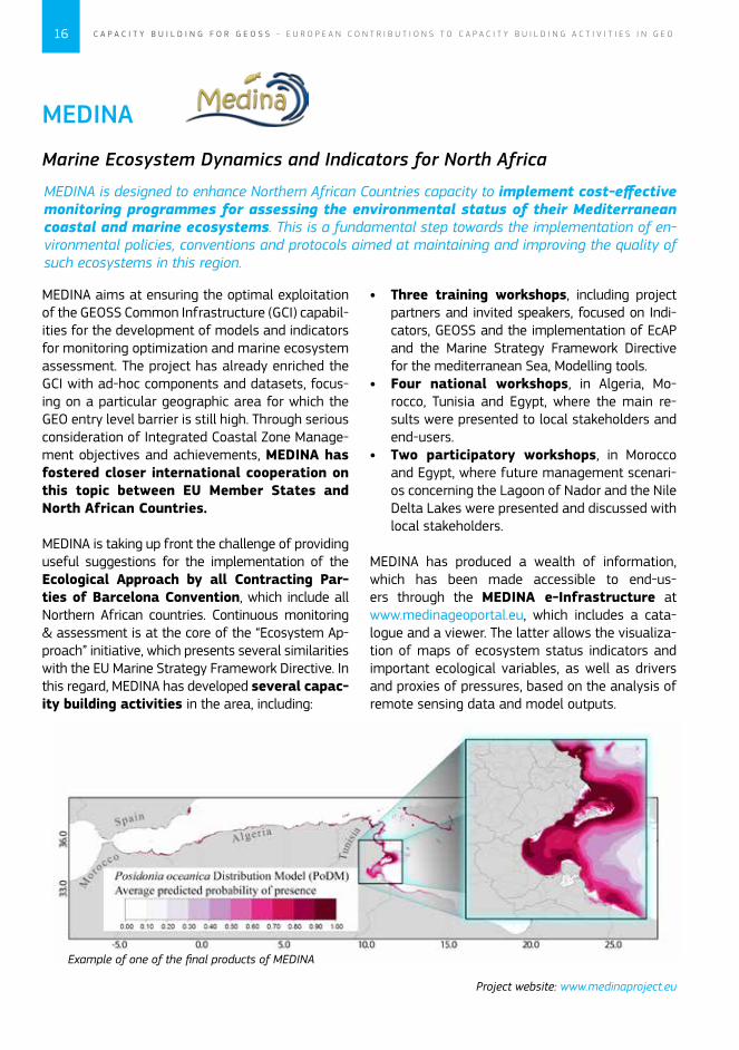
Example of one of the final products of MEDINA

17C A P A C I T Y B U I L D I N G F O R G E O S S - E U R O P E A N C O N T R I B U T I O N S T O C A P A C I T Y B U I L D I N G A C T I V I T I E S I N G E O
Dr. Byfield helping a student on an EAMNET training course
The EAMNet project has resulted in improved in-teraction between African and European infor-mation providers, user networks and centres of excellence, addressing the priority lines identified under the ‘GMES and Africa’ initiative on Marine and Coastal Areas and Capacity Building. In achiev-ing this, EAMNet has left a legacy of improved infrastructure and capability in training and experience.
Specifically:
• Providing the best quality EO data products to Africa complementing GMES initiatives (My-Ocean) and the OSI-SAF (Ocean and Sea Ice Satellite Application Facility).
• Providing 5 operational GEONETCast systems.
• Disseminating best practices through ex-changes of personnel between partners.
• Creating and presenting an EO Masters-level module at a number of universities.
EAMNet is a collaborative network linking Earth observation information providers, user networks and centres of excellence in Europe and Africa in the area of coastal and marine observations to help support sustainable development in Africa. A three year project part-funded by the European Commission and already completed. EAMNet established the fundamental structure of the network and facilitated the implementation of training and infrastructure development.
EAMNET
Europe-Africa Marine EO Network
• Establishing a regular marine science pres-ence at AARSE (African Association of Remote Sensing of the Environment) conferences in-volving African marine scientists and stake-holders and key European partners in FP7 or ESA GMES projects.
• Enabling newly trained personnel from a wide range of African Universities to use GMES data.
Although the EAMNet project was completed in June 2013, it has enjoyed continued success by winning the Environment and Conserva-tion category at the 15th UK Annual Charity Awards. The award recognises the Plymouth Ma-rine Laboratory (PML, coordinator) and EAMNet’s commitment to international research that helps society understand and manage the resources of our global ocean, with the judges highlighting the global strategic impact of this initiative.
Project website: www.eamnet.eu
18 C A P A C I T Y B U I L D I N G F O R G E O S S - E U R O P E A N C O N T R I B U T I O N S T O C A P A C I T Y B U I L D I N G A C T I V I T I E S I N G E O
The common goal of the partnership is to use inno-vative methods to enhance global agricultural risk management capacity. Satellite imagery, in combination with models and in situ observations, are used to monitor agricultural production and the impact of cultivation on the environment. The use of standardized, but locally adapted methods is thereby imperative to compare and assess findings. Capacity building is one of the key activities of SIGMA in order to improve global knowledge and expertise on the monitoring of agriculture and environment. Expert review meetings and stake-
holder workshops as well as specific training activ-ities are carried out to share experience, increase transparency and improve our knowledge on agri-cultural dynamics. In support of the GEO JECAM (Joint Experiment for Crop Assessment and Monitoring) initiative, case studies in Ukraine, Russia, Europe, Africa, Latin America and China are carried out in order to ex-plore possible methodological synergies and par-ticularities according to different cropping systems.
Firstly, multi-scale remote sensing data sets, in combination with field and other ancillary data, are used to generate an improved (global) agro-eco-logical zoning map and crop mask. Secondly, a combination of agro-meteorological models, sat-ellite-based information and long-term time series are be explored to better assess crop yield gaps and shifts in cultivation. The third research topic entails the development of best practices for as-sessing the impact of crop land and cropping sys-tem change on the environment.
SIGMA
Stimulating Innovation for Global Monitoring of Agriculture
SIGMA is a partnership of globally distributed expert organizations, focusing on the development of remote sensing based techniques and datasets to support monitoring of agriculture and its impact on the environment. SIGMA is a significant contribution to GEOGLAM (GEO Global Agricultur-al Monitoring) initiative and its research agenda.
SIGMA has 3 generic objectives which are:
• Develop and test methods to character-ize cropland and assess its changes at various scales;
• Develop and test methods to assess chang-es in agricultural production levels; and;
• Study environmental impacts of agri-culture.
Project website: www.geoglam-sigma.info
19C A P A C I T Y B U I L D I N G F O R G E O S S - E U R O P E A N C O N T R I B U T I O N S T O C A P A C I T Y B U I L D I N G A C T I V I T I E S I N G E O
The AfroMaison project was set out to contribute to the challenge of putting Integrated Natural Resources Management (INRM) in practice at meso-scale in Africa by providing a practical ap-proach and tools that can be applied in a variety of environmental and socio-economic conditions.
The outcomes of AfroMaison are insights and guidance on putting INRM in practice and tools supporting the development of operational INRM strategies which are both embedded in local tra-ditions and culture, and scientifically sound. These are presented in two key outputs:
1) Guideline for Natural Resources Managers: based on the case studies, the Guidance Document outlines: i) challenges encountered for implement-ing INRM in Africa, and proposes strategies and approaches to address them, ii) tools and meth-odologies for a practical approach to INRM, and iii) insights, conclusions and recommendations when implementing INRM approaches.
AFROMAISON
Africa at a meso-scale: Adaptive and integrated tools and strategies for natural resource management
2) Toolbox for Natural Resources Managers: This is meant to be an open-ended toolbox. Be-sides a number of AfroMaison developed and tested tools, it leads users to existing resources available on the web and encourages the commu-nity of practitioners to keep adding resources. To increase user-friendliness, different search possi-bilities have been added to the toolbox, allowing for a better match of tools, user needs and context.
Case studies in context
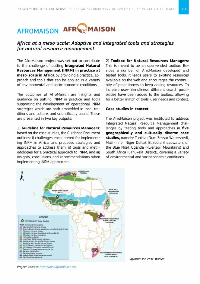
The AfroMaison project was instituted to address Integrated Natural Resource Management chal-lenges by testing tools and approaches in five geographically and culturally diverse case studies, namely: Tunisia (Oum Zessar Watershed), Mali (Inner Niger Delta), Ethiopia (headwaters of the Blue Nile), Uganda (Rwenzori Mountains) and South Africa (uThukela District), covering a variety of environmental and socioeconomic conditions.
Project website: http://www.afromaison.net
Afromaison case studies
20 C A P A C I T Y B U I L D I N G F O R G E O S S - E U R O P E A N C O N T R I B U T I O N S T O C A P A C I T Y B U I L D I N G A C T I V I T I E S I N G E O
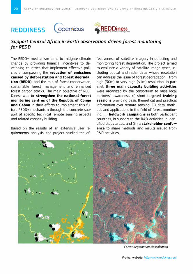
The REDD+ mechanism aims to mitigate climate change by providing financial incentives to de-veloping countries that implement effective poli-cies encompassing the reduction of emissions caused by deforestation and forest degrada-tion (REDD), and the role of forest conservation, sustainable forest management and enhanced forest carbon stocks. The main objective of RED-Diness was to strengthen the national forest monitoring centres of the Republic of Congo and Gabon in their efforts to implement this fu-ture REDD+ mechanism through the concrete sup-port of specific technical remote sensing aspects and related capacity building.
Based on the results of an extensive user re-quirements analysis, the project studied the ef-
REDDINESS
Support Central Africa in Earth observation driven forest monitoring for REDD
fectiveness of satellite imagery in detecting and monitoring forest degradation. The project aimed to evaluate a variety of satellite image types, in-cluding optical and radar data, whose resolution can address the issue of forest degradation - from high (30m) to very high (<1m) resolution. In par-allel, three main capacity building activities were organized by the consortium to raise local partners’ awareness: (i) short targeted training sessions providing basic theoretical and practical information over remote sensing, EO data, meth-ods and applications in the field of forest monitor-ing, (ii) fieldwork campaigns in both participant countries, in support to the R&D activities in iden-tified study areas, and (iii) a stakeholder confer-ence to share methods and results issued from R&D activities.
Project website: http://www.reddiness.eu/
Forest degradation classification
21C A P A C I T Y B U I L D I N G F O R G E O S S - E U R O P E A N C O N T R I B U T I O N S T O C A P A C I T Y B U I L D I N G A C T I V I T I E S I N G E O
REDDINESS
Support Central Africa in Earth observation driven forest monitoring for REDD
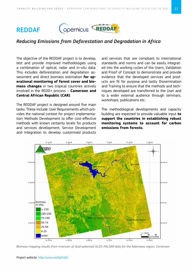
The objective of the REDDAF project is to develop, test and provide improved methodologies using a combination of optical, radar and in-situ data. This includes deforestation and degradation as-sessment and direct biomass estimation for op-erational monitoring of forest cover and bio-mass changes in two tropical countries actively involved in the REDD+ process – Cameroon and Central African Republic (CAR).
The REDDAF project is designed around five main tasks. These include: User Requirements which pro-vides the national context for project implementa-tion; Methods Development to offer cost-effective methods with known certainty levels for products and services development; Service Development and Integration to develop customised products
REDDAF
Reducing Emissions from Deforestation and Degradation in Africa
and services that are compliant to international standards and norms and can be easily integrat-ed into the working cycles of the Users; Validation and Proof of Concept to demonstrate and provide evidence that the developed services and prod-ucts are fit for purpose and lastly Dissemination and Training to ensure that the methods and tech-niques developed are transferred to the User and to a wider external audience through seminars, workshops, publications etc.
The methodological developments and capacity building are expected to provide valuable input to support the countries in establishing robust monitoring systems to account for carbon emissions from forests.
Biomass mapping results from inversion of dual-polarized ALOS–PALSAR data for the Adamawa region, Cameroon
Project website: http://www.reddaf.info/
22 C A P A C I T Y B U I L D I N G F O R G E O S S - E U R O P E A N C O N T R I B U T I O N S T O C A P A C I T Y B U I L D I N G A C T I V I T I E S I N G E O
BEYOND project is an initiative which aims to build a Centre of Excellence for Earth Observa-tion based monitoring of natural disasters in southeastern Europe, established at the Na-tional Observatory of Athens (NOA). The project aims at unlocking the institute’s potential through the consolidation of state-of-the-art equipment and technological know-how that will allow sus-tainable cutting-edge interdisciplinary research to take place with an impact on the regional and European socioeconomic welfare. The vision is to set up innovative integrated observational solutions to allow a multitude of space - and ground-based monitoring networks to op-erate in a complementary and cooperative manner, create archives and databases of long series of observations and higher level products, and make these available for exploitation with the involvement of stakeholders.
BEYOND
Building a Centre of Excellence for Earth Observation based monitoring of Natural Disasters
In BEYOND critical infrastructural components are being procured for fostering access, use, retrieval and analysis of long EO data series and products. In this framework, NOA has initiated activities for the installation and operation of important acquisi-tion facilities, including space based observational infrastructures as an X-/L-band acquisition station or the setting up of an ESA’s Mirror Site of Sentinel missions to be operable from 2014 onwards.
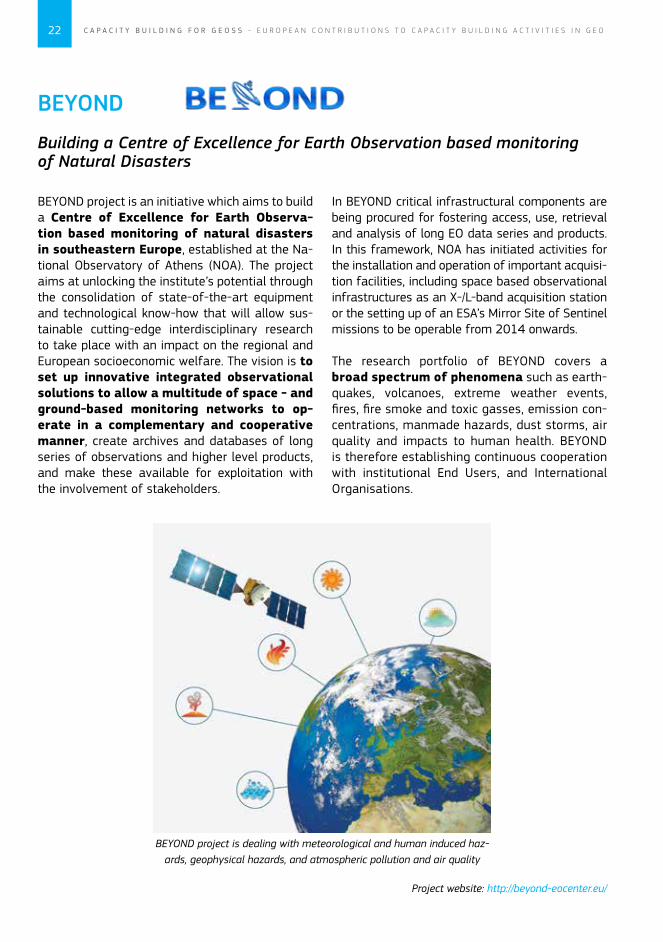
The research portfolio of BEYOND covers a broad spectrum of phenomena such as earth-quakes, volcanoes, extreme weather events, fires, fire smoke and toxic gasses, emission con-centrations, manmade hazards, dust storms, air quality and impacts to human health. BEYOND is therefore establishing continuous cooperation with institutional End Users, and International Organisations.
Project website: http://beyond-eocenter.eu/
BEYOND project is dealing with meteorological and human induced haz-ards, geophysical hazards, and atmospheric pollution and air quality

BEYOND
Building a Centre of Excellence for Earth Observation based monitoring of Natural Disasters
doi: 10.2777/50075
ISBN 978-92-79-34579-1
Recognising the need to improve our understanding of the Earth system and enhance our ability for informed decision-making for the benefit of our planet and the sustainability of our societies, over 150 governments and leading international organisations are participating in the Group on Earth Observations, or GEO, to coordinate the construction of a Global Earth Observation System of Systems (GEOSS) by the year 2015.
This series of brochures provides a snapshot of the process developed by the GEO to build the GEOSS taking advantage of the international framework of cooperation and of the common vision to share and integrate information with a view to serving nine Societal Benefit Areas.
Examples of contributions from European and the European Commission-funded projects contributing to specific Societal Benefit Areas or to the GEOSS Building Blocks are presented in each thematic brochure.
GEOSS for DisastersGEOSS for HealthGEOSS for EnergyGEOSS for ClimateGEOSS for WaterGEOSS for WeatherGEOSS for EcosystemsGEOSS for AgricultureGEOSS for BiodiversityArchitecture and Data Management within GEOCapacity Building for GEOSSScience and Technology within GEOUser Engagement within GEO
http://ec.europa.eu/research/environment/index_en.cfm?pg=earth
KI-01-13-793-EN-C