eth/88/013 government of ethiopia - food and … of ethiopia water resources development authority...
TRANSCRIPT

Government of EthiopiaWater Resources Development Authority
BALE GADULA IRRIGATION PROJECT
Annex C:
Soil Suitability and Land Evaluation Report
By
L. Van Sleen, FAO Soils' Consultant
ETH/88/013Field Doc. 18
United Nations Development ProgrammeFood and Agriculture Organization of the United nations
Addis AbabaJune 1992

The designations employed and the presentation of material inthis publication do not imply the e:cpression of any opinionwhatsoever on the part of the Food and Agriculture Organizationof the United Nations concerning the legal status of any country,tezritory, city or area or of its authorities, or concerning thedelimitation of its frontiers or boundaries.

Page
SUMMARY AND RECOMMENDATIONS................ ..... ........
1 - INTRODUCTION..... ............ ....,....... ..............THE ENVIRONMENT.... ...... ....... ........... ...........2.1 - Location, access and extent of project area..,...
Location.................... ..... , .......Access......................... .......Extent
2.2 - ..... . ......
General Characteristics.......... ..... . ..... 5
Soil Moisture Regime__ .....Soil Temperature Regime........ ............. 5
2.3 - Natural Vegetation and Present Land Use 5
2.4 - Physiography, Geology and Drainage............... 8
SOIL SURVEY METHODS................ ....... .........,... 11
3.1 - Pre-survey activities 113.2 - Field Operations............... ..... .., 11
3.3 - Post-Fieldwork Activities 12
4 - SOILS AND DESCRIPTION OF SOIL ING UNITS... ...... 13
4.1 - The Soils and their Taxonomic Classification 13
4.2 - Detailed Soil Map Legend............. ..... . ..... 154.3 - Description of Soil Mapping Units....... 20
IRRIGATION WATER QUALITY ..... .............. ............ 29
6 - LAND SUITABILITY FOR IRRIGATED AND RAINFED AGRICULTURE. 30
6.1 - Land Development Requirements and Limitationsfor surface Irrigation......... ..... ............
Vegetation clearance........... ............ 31
Removal of Surface Stones............ ...... 3")
Land Levelling........... ..... . ............ 3?
Land Development Classes 34

TABLE OF CONTTTFTS
Page
6.2 - Evaluation of the Soils (Soil Fertility) 34
6.3 - Crop Requirements and Crop Suitabilityof the Soils and the soil mapping unit 37
6.3.1 General description of suitabilityclasses and subclasses.. ..... . ....... 37
6.3.2 Major requirements of the crops shownin the crop suitability table 39
6.3,3 Major differences in land evaluationfor irrigated and rainfee agriculture..... 45
47
p ICES: 49
Detailed Soil Profile Descriptions andAnalytical 49
II Hydraulic Conductivity andinfiltration Rate.................... ...... 69
III laboratory procedures 74
LIST OF FIGURES
Figure A: Irrigated Crop Suitability Map ofthe Bale Gadulla Site.......... ........ .......iii
Figure 1 - Location Map.............. ...... . ..... 4
? Mean monthly rainfall, Goro 7
3 - Mean monthly air temperature, Goro 7
4 - Areal photo-Interpretation map ofthe Bale-Gadulla (phase I) area.Approx scale 1:50,000............ ........ 9
5 - Schematic Cross-Section of theBale-Gadulla (phase I) area 10
6 - Soil Map of Bale Gadulla feasibilityStudy area 19
7 - Optimum Altitudes for Major Cropsin Ethiopia.... ......... ....... 38
LIST U7
Page
TABLE 1 - Rainfall, Goro ...... .................. ...... 6
2 - Air temperature, Goro 6
Hectarages (and % of total area) of allmapping units 28a
TABLE 4 - Chemical Analysis of the Weib riverirrigation water............ ....... ........ 29
Preliminary land levelling classes andrelated mapping units and their extent
6 - Land development limitations, requirementsand classes of all soil mapping units.... .....
7 - Irrigated crop suitability of theBale Gadulla (phase soil mapping units 43
8 - Rainfed crop suitability of theBale-Gadulla (phase I) soil mapping units 44
9 - General land evaluation for irrigated andrainfed crop cultivation of the Bale-Gadulla(phase I) soil mapping units.......... ......... 46

ar d RecomnIFjons
The area surveyed for the Bale Gadulla, phase I feasibility study,covers about 968 hectare.
Of this approximately 46 ha (or 4 ad_41 of the total area) iscovered by Talbsa village.
In total about 583 ha (of 60 1221 of the total area) is moderatelywell suited for irrigated crop cultivation. It consists of nearlylevel to gently sloping (11/2-3% slopes), very deep (3-8m depth uptothe bedrock), somewhat imperfectly drained, slowly permeable, blackcracking clay (or silty clay) soils.
These lands have been somewhat downgraded because of difficult workability for seedbed preparation and problems related to restrictedsubsoil drainage (suitability subclass SA)
Approximately 218 ,ILL ha (or 22 i,,% of the total area) has beendowngraded as only márg¡nally suitable for irrigated cropcultivation. It consists mainly of the same black (sometimesbrownish black) cracking clay soils, but either < 3m deep to theunderlying bedrock and/or very sodic or with 3 1/2-4% slopes andthus more subjected to erosion hazard (see suitability subclasses:
fbad, fbed, S,d'3 and S,d'w)
The remaining 120 (approximately) or 12 1/4 of the total area,consists of steep rocky hills, footslopes and steep sideslopes(slopes > 4%) and is therefore not suj_ted for irrigationdevelopment (suitability subclasses: N,sr, Na),e
It may further be noted that, although a very large part of theproject area (about 4014_12 ha, or 41% of the total) is covered bycommon to many surface stones (of vesicular basalt), their removal(by hand picking) would only take: (or cost) about 13 mandays perhectare (or 40 Birr per ha) and this will amount to a stone heapof about 112m3 stones per ha, which may be used for other purposes,sucb as the construction of roads or walls.
To enable the construction of the irrigation scheme, only the riverterraces (T-mapping units), covering about 393 ha (or 41% of thetotal area) are in need of some low vegetation clearancerequirements, while all the other suitable mapping units arealready cultivated (rainfed).
Moreover, about 132 ha (or 131/2% of total area) of more or lesssuitable lands are in need of medium levelling/grading (with21/2-3% slopes) and about 1123/4 ha (or 111/2% of total area) of highlevelling/grading operations.

It should finally be noted that, due to the low annual rainfall,about 583 ha (or 601/2% of the survey area) will be upgraded fromonly marginally suited under the present rainfed conditions (classS,)to moderably well suited (class S2) under irrigated conditions.This may roughly indicate an expected productivity increase frombelow 40% to about 60% of that achieved Erom ideally suitable landunder the same level of inputs.
ii

The report outlines the results of a feasibility soilsurvey of only a small part (called ph::..se I) of the BaleGadulla area, which had already been studied in ratherdetail by a Koi-ean soil survey team together with a nationalcounterpart staff of WRDA, in 1990, at an overallobservation density of about 1 per 6 hectare.
Afterwards, however, update and improvement of the soiland landform characterizations, the soil mapping accuracyand reporting was felt to be needed.
The present study is based primarily on a detailedaerial photo-interpretation (scale 1:50,000) in combinationwith about 78 additional field observations and study of theprevious soil survey data (about 75 observations) and maps.
The new observations included 71 auger holeobservations made at regular intervals of about 200m alongtransects located more or less perpendicularly to thephysiographic mapping units oriencation, and includingnumerous (about 85) soil surface observations as well.
Furtheron 7 soil profile pits were dug upto 2m depthand 4 deep borehole were drilled upto the bedrock. All thisamounted to an overall Et,. «'ty of about 1 per 4
The soil profile pits were located on representativesites, described in detail and sampled for laboratoryanalysis, while inEiltration and permeability tests wereexecuted in triplicate near those pits.
Final soil boundaries were traced on 1:5,000 scaletopographic field sheets, which were later reduced to1:10,000 scale final maps.
The complete soil survey and mapping methodology is
described in chapter 3.
The study was conducted in consultation with AtoMekuria Tafesse, General Manager WRDA and National ProjectCoordinator ETH/88/013, Mr. S.Thirugnanasambanthar, FAO teamleader, and the members of the Steering Committee for the
UNDP assisted projects in the irrication subsector.
The work was executed in the field with the assistanceof WRDA technical staff, including Ato Girum Asfaw (the
national soil survey counterpart) and Ato Melesse Kumsa(national soil survey assistant) and Ato Mesfin Kidane and
Ato Birhane Gashu (topographic surveyors). The deep
boreholes and their descriptions were made by Ato TeodrosG/Egziabher (geologist) and Ato Bulcha Nigatu (driller).
1- .INTRODU T
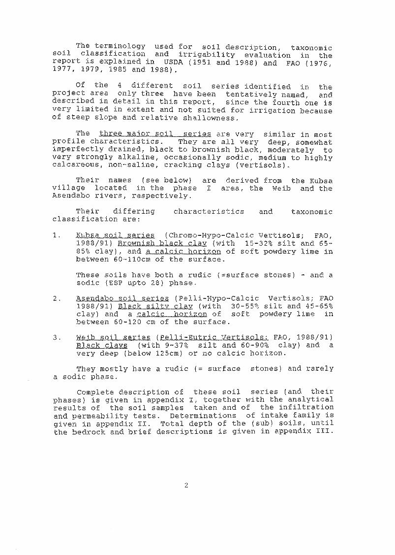
The terminology used for soil description, taxonomicsoil classification and irrigability evaluation in thereport is explained in USDA (1951 and 1988) and FAO (1976,1977, 1979, 1985 and 1988).
Of the 4 different soil series identified in theproject area only three have been tentatively named, anddescribed in detail in this report, since the fourth one isvery limited in extent and not suited for irrigation becauseof steep slope and relative shallowness.
The tbTee ior soil series are very similar in mostprofile characteristics. They are all very deep, somewhatimperfectly drained, black to brownish black, moderately tovery strongly alkaline, occasionally sodic, medium to highlycalcareous, non-saline, cracking clays (vertisols).
Their names (see below) are derived from the Kubsavillage located in the phase I area, the Weib and theAsendabo rivers, respectively.
Their differing characteristics and taxonomicclassification are:
(Chromo-Hypo-Calcic Vertisols; FAO,1988/91) R2:010:t.$11 tLa_c_li clay (with 15-32% silt and 65-85% clay), and _.g_a_11:_La bQxAzon of soft powdery lime inbetween 60-110cm of the surface.
These soils have both a rudic (=surface stones) - and asodic (F,SP upto 28) phase.
a3end: (Pelli-Hypo-Calcic Vertisols; FAO1983/91) -v_c)ax (with 30-55% silt and 45-65%clay) and a acJs_ )1,2x_rtal,n of soft powdery lime inbetween 60-120 cm of the surface.Jijji (Ea111-Eutrjo7 vertjsola,L FAO, 1988/91)Blaqk clays (with 9-37% silt and 60-90% clay) and a
very deep (below 125cm) or no calcic horizon.
They mostly have a rudic (= surface stones) and rarelya sodic phase.
Complete description of these soil series (and theirphases) is given in appendix I, together with the analyticalresults of the soil samples taken and of the infiltrationand permeability tests. Determinations of intake family isgiven in appendix II. Total depth of the (sub) soils, untilthe bedrock and brief descriptions is given in appendix III.
2

2. THE EN7T-
2.1 "" d extent of the Proiegt are
a. Location
The project area lies in a valley on the left bank ofthe Weib river in Gadulla awraja, about 30km from Goro, at analtitude of around 1900m. (see figures 1 and 2).
- Its location is roughly in between 07° 06' and 07° 09'Northern Latitudes and 40° 22' and 40° 24' Eastern longitudes,or according to the Universal Transverse Mercator GridDesignation (Zone 37, clarke 1880 spheroid) in between 16,000and 19,500m North and 652,500 and 657,500, East.
The area can be found on 1991 aerial photograph no 0034,run B2 (contract ET 1:10, scale 1;50:000). and on 250,000scale toposheet.
Access
The project area is about 30 km from Goro, and about 80km from Robe. Between Robe and Goro there is a good all-weather dirt road. From Goro the road deteriorates and forthe last 18km it is no more than a track to Kubsa villagelocated in the project area.
Extent
The area surveyed for the phase I project covers about968 ha, of which about 601/2% (583 hectare) are moderatelysuitable for irrigation development.
2.2 Climate
a.
Meteorological data for the project area are notavailable. The nearest meteorological station is at Goro;monthly rainfall and temperature data for this station aregiven in Tables 1 and 2 and in Figs. 2 and
Rainfall is eratic at Goro. In the 11-year period forwhich records are available, the maximum annual rainfall was1,383 mm and the minimum 351 mm.
The mean annual rainfall is about 723.9 mm; about 50% ofit is received during March, April and May (Belg) and morethan 25% in September and October (Mehr), while the other 7months are relatively dry, having only 20% of the total
annual rainfall.

rzr"c:3
,Z:nzraN.
'C:7f1
e
JtY
,r N.,
l SOMALIA
ETHIOPIA
Rood
Roi'rood
RiverPro}ect Site
o loo
4

The survey area has an elev1915m.
anging from 1790 to
Air temperatures at Goro (which is located at anelevation of about 2,000m.) are very uniform throughout theyear. On the basis of the three years of available data,mean monthly temperatures vary between 17.3°c (June) and19.6°c (January). Hean monthly minima vary between 7.4°C(October) and 11.6°C (January), while maximum vary between24.4°C (June) and 28.2°C (February).
The mean monthly pan evaporation varies from 128 mm(September) to 180 mm (March) with a mean annual of 1732 mm.
The mean daily wind velocity varies between 1.5 m/sec.to 4.0m/sec. withthe high wind speeds occurring from Junetill August.
b. Soil moisture regime
No exact data on soil moisture are available in theBale-Gadulla area. It has thus to be estimated from therainfall data.
The somewhat imperfectly clrained and nearly local togently undulating upland Vertisols are considered to have anUstic soil moisture regime, which means a dry upper subsoilfor at least 90 days (cumulative) and at least moist in someparts for at least 90 consecutive days.
C. Sol ITI e tu
This has also to be estimated from the climatic (airtemperature) data.
The mean annual soil temperature at a depth of 50cm ismost probably higher than 15°C and lower than 22°C, and thedifference between mean summer and mean winter soiltemperature is less than 5°C, and thus it is classified asIsothermic.
2.3 Natural vegetation and present Land Use
The nearly level terrace landforms (see T - Mappingunits) along the Asendabo river are not cultivated andcovered by a medium dense bush forest of Acacia and oftenshort and tall trees. These areas are presently used forgrazing. The more undulating landforms (see V-mapping units)are almost entirely cultivated.

Table 1. Rainfall, Gurc
Mean monthly rainfall (mm) based on 11 years' data, 1976-86
Jan Feb Mar Apr May Jun Jul Aug Sep Oct Nov Dec Total
14.5 21.2 110.6 136.6 135.3 46.2 12.1 22.0 :11.9 77,1 21,3 5.1 723,9
Table 2, Air temperature, Gorro
Mean monthly air temperatures Ideg.0 based on 3 years data, 1982, 1934, 1915
6
Jan Feb Mar Apr May Jun Jul Aug Sep Oct Nu Dec Mean
Min 11.5 15.5 10.1 n.2 9.7 16,1 10.0 10.3 9,3 7.4 10,4 10.0 12.0
Mean 19.6 19.4 18,6 13,0 17.7 17,3 17,5 18.4 17.9 17.1 18.9 13.8 12.3
May. 27.6 23.2 27,2 25.7 24.4 24.4 25.2 26.6 26.6 26.7 27.4 27.5 26.6

E
E
-80 -
70 -
50 -
50
40
30
20 -
10 -
17 -L16 -15 -1 4
13
-
7
-
Jon Feb Mar Apr
D min.
E 11,11
Mean monthly rainfall, Gorro
Mean monthly air
mean
7
MR* f7.3 t u Fes, Gorro
IDI i 1
i I i
Mcrf Jun Jul Aug Sep Oct Nov Dec
, ,,
/,
77
.
./,
/
/
,
'
/
.
.7
,
- -/,
,
-
,,-
,
7
,
.
,.
.
,
..
,,-
,
.. '
e
,
,
.''' .7
.
, ,,./ ,
., 7/ ../,...
,
, ,
,
.7
, ' //
.
,
7.
.
/
,
ie ,
.,/
,
../
,
7,
,,-
,
7 ,..--, ,.7 /
,-
/t :
- /7,-
., //i . .
Feb Mar Apr May Jun Jul Aug Sep Oct Nov Dec

Farming practices are traditional ploughing by ox. Themain rainfed crops are maize, barley, wheat, oats, sorghumand different spices. (cumin, fenugreek and coriander). Interms of land area, barley is the most important crop.Barley, Wheat and Oats are all grown in both seasons and soare the spices, but maize seems to be usually grown in theBelg only.
2.4 Physiocraph , Geology and Drainage
As can be seen on the 1:50,000 scale Aerial Photo-Interpretation map (Fig. 4) and the schematic cross-section(Fig.5) of the Bale Gadulla (phase I) area three (or four)major landforms have been distinguished. They are:
P= The Plateau with undulating summit (PJ above 2300melevation (often with large State Farms) very, steepescarpments (PJ and steep lower foothills(=H on the finalsoil map).
All these units, except H, are located outside the areasurveyed.
V= The undulating Older Valley E.7)ttom, which ispredominantly cultivated and mostly covered by common to manybasaltic surface stones. Within the ;.:ase I area, itselevation ranges from 1825-1900m.
This unit has been subdivided mainly on the basis ofslope (degree and form) into:
V1 - undulating or convex upper partV2 - gently undulating lower partV3 - level to gentle concave drainage ways and depressions
T= Nearly level a¡ver Terraces along the Asendaboriver. They are covered by medium dense Acacia bushes andwith few or no surface stones. Their elevation ranges from1785-1340m. Three different Terraces have been distinguishedTi, T, and T, (upper-, middle-, and lower terracerespectively).
A= Alluvial valleys of the Asendabo dry river bed (A,)and the Weib river (partly a deep canyon)
The plateau and foothills, as well as the valley bottomand terraces are underlain by vesicular basalts (similar tothe surface stones) of the lower Tertiary (Paleocene -
Oligocene- Miocene) Trap series (Ashangi group), according tothe Geological Map of Ethiopia (Scale 1:2 million), compiledby v.Kazmin (United Nation, 1972).
Both rivers, the Asendabo and Weyib, are draining thearea to the Southeast into the Wabi Shebelle river system.
8

9
Aerial Photo- interpretation Map of the Bale - Gadula a hose 1) and Surroundings
Approximate Scale -1:50.000
L.A.Van Sleen FAO- Expert
22 February 1992

Fig.5: Schematic cross- section ot the Bale - Gadula ( Phase Dared
Dense forest
c7i) Mediun dense acacia shrub forest
- Common to many surface stones
Knick
PI
PI
Asendaboriver
Hl V
T3 T2 H VI V2 V5
10
Asendabo
Licyiband
r I ver
Junction
P2
IWNW ESE
22300 -
2200 -
2100 -
2000-
1900 -
1800 -

3. BOIL vv7 METHODS
3.1
Maps and reports of the 1990 Korean soil survey werecollected and studied as well as the 1991 (scale 1:50,000)aerial photographs, which were interpreted in detail.
A preliminary physiographic legend for soil surveypurposes was established and on the basis of photo-interpretation mapping units, transects for highly intensivesoil survey observations and representative sites for soilprofile pits and deep borehole drillings (upto the bedrock)were located.
All this was then transferred to 1:5,000 scale topo-sheets, with lm. contour intervals to be used in the field.
3.2 CrDer
Systematic soil survey work for the feasibility studyof the Bale Gaulla (phase I) area started on 23 January andwas completed by the end of February 1992.
The soil survey fieldwork involved.
Systematic auger hole observations upto 200cm depthwere made along the transects at intervals of 200m,over a total length of about 14km. In total 71 auger
ere made.
In between these au er ho e observations, continuousso-called, Qbservations weremade with special attention for changes in soil surfacecolour, stoniness, slope and vegetation cover etc. Intotal at least $5 of such observations were recorded bya brief code and/or boundary line plotted on the map.
Detailed soil profile descriptions were made onrepresentative sites, including soil sampling forlaboratory analysis. In total 7 soil Profile Pits weremade upto 2m. depth.
Near of the above mentioned soil profile pits a deepjoore je was drilled upto the bedrock.
Thus in total 71+85+7=163 new observations were made.This together with the approx 75 old observations overan area of about 968 ha, resulted in an averageobservation density of
11
tests werees sites.
Besides Infi t 1 a : itexecuted in trip ica e on all 7 soll -oro

3.3 Post Fieldwork activities
After completion of fieldworh., all data had to beinterpreted, including the laboratory results, which werereceived from WRDA's laboratory on 24 and 26 March 1992.
PF values and bulk densities to be determined by thenational Soils Laboratory, however, where only received on 17April 1992, and the calculated results of the infiltrationand permeability tests were also handed over by the nationalcounterpart on 17 April 1992.
Correction and update of the final (1:10,000 scale) draftsoil map and legend, was completed on 10 April 1992, while thefinal (draft) Irrigability Map was completed on 21 April 1992,after receipt of all the data.
The feasibility draft report (including the drawing ofschematic cross-sections and graphs and small maps) startedin early april and was completed on 4 May 1992, when it washanded over to the project staff of WRDA for final checking,typing and drawing.

4.
13
TT,p' 7T SOIL MAPPING
4.1 The and their TaXWIQMiC _classifigatiOrk
Inspite of the 18 physiographic soil mapping unitsdelineated, soils within the phase I project area are veryuniform and similar in profile characteristics.
Apart from one unnamed soil series occurring on thealluvial-colluvial footslope (H2) below the steep rocky hill(H,)and which is very limited in extent (151/4 Ha only) and notsuitable for irrigation development because of steep slopes(8-9%) and not very deep soils (< 1112m to the bedrock) allother (three) soil series differ only from each other in soilcolour (very slightly: Pellic or just chromic), depth (orpresence)of a calcic horizon (within or below 125 cm of thesurface) and soil texture: being either silty clay (with 31-53% silt) or clay (with < 32% silt) and slightly in soilreaction (pH) being either strongly to extremely ormoderately alkaline.
Otherwise these three soil series (collectively coveringabout 938 ha(or 97% of the project area), are all very deep,somewhat imperfectly drained, black to brownish black,moderately to very strongly alkaline (occasionally sodic),medium to highly calcareous, non-saline, cracking clays (=
Vertisols).
Their tentative names (see below) are derived from theKubsa Village located in the phase I area, the Weyib river,forming the southern boundary of the phase I area and theAsendabo river, forming the north and eastern boundary,respectively.
These three soil series are described in detail underappendix I, together with their laboratory analytical data.Their main characteristics and diagnostic criteria are asfollows:
Kubsa Soil Srie$: They are the dominant soils of theundulating or convex upper part of the Older ValleyBottom (VJ, partly dissected and with 21/2-7% slopes andpredominantly cultivated and/or covered by Kubsavillage, and with common to many surface stones ofvesicular basalt.
They are very deep (3-4m deep to bedrock), somewhatimperfectly drained, very slowly permeable, slightly tohighly calcareous (9-25% Ca Co,) with a calcic horizon within125 cm depth, moderately alkaline in the topsoil and verystrongly alkaline below (PH(H20) 8.0-9.4), sodic below 20cmdepth (ES? 9-30% of CEC), brownish black, cracking clays (65-84% clay in the fine earth fraction).

FePresentFA- , : BAG001
These soils generally occur on the undulating or convexupper part of the Older Valley Bottom in association with theWeyib soil series having a deeper calcic Horizon (=below115cm depth or more).
According to the revised (1988) legend and the (June1991) annex 1 of the N S'0 RIC oil MaP of tbe World,these soils with fine, cracking c avs and intersectingslickensides within 100cm of the surEace, have beenclassified in the soil group of Vertisola and in the soilunit calcic Vertisols (VRK), (=having a calcic horizon within125cm of the surface) and soil subunits Nypc-Calcic Vertisols(= the calcic horizon consists of concentration of softpowdery lime). And because they have chromas, moist of 1.5or more, they may receive the prefix chromi, thus çhromo-HYPo-Qalc¡c Vertisola.
Similarly to the above, these soils have been classifiedin the order of Vertisols in the U.S.Soil Taxonomy SV5t?In(Key, 1988), and suborder Usterts (==ustic soil moistureregime) and great group Chromusterts (= having chromas moist,of 1.5 or more) and subgroup h=musterts (=havingcracks that remain open from 90 to 150 cumulative days inmost years).
2- Wev¡b soil series: They are the dominant soils of thephase I project area, covering the gently undulating lowerpart with many surface stones) and/nearly level to gentlyconcave depressions and drainage ways (with few surfacestones) of the predominantlj cultivated older Valley Bottom,as well as the Upper and Lower River Terraces without(or few)surface stones.
They are also very deep (mostly 3-8112m deep to bedrock),somewhat imperfectly drained, very slowly permeable, slightlyto moderately calcareous (8-15%Ca Co,), with no calcichorizon within 125cm of the surface, strongly alkaline (PH
(H30) 8.2 - 8.6), only occasionally sodic (ES? of 36-39%below 40cm depth), black, cracking clays (60-90% clay in thefine earth fraction).
Reoresentative BAG004, BAG005, BAG006, BAG007.
Similar to the Kubsa soil series, these soils have beenclassified in the subgroup of Vertisols, according to theFAO/UNESCO/ ISRTO(1988) revised legend and in the soil unitEutric Vertisols (=not having a gypic or calcic horizonwithin 125 cm of the surface but with a base saturation of
more than 50% throughout the profile). Because of theirchromas, moist of 1, they have given the prefix Pelli. Thus
Pelli-Eutric Vertisols.
14

In the US 11 ,..st.0 v System (KeY, 1988) they are alsoVert:Isols ( r) and Vsterts (suborder) because of usticsoil moistur 1.-egime and great group PelAuterts (because ofchromas 1), and subgroup 5Iffig__EQ3-111.Sterts (=having cracksthat remain open from 90 to 150 cumulatJ_ve days in mostyears.
3- bo SQIJ. sevies; They the dominant soils ofthe non cul ivated Middle River Tel:race, predominantly withno (or few) surface stones and medium dense Acacia shrubland.
They are similar in all aspects to the Kubsa soil series,but always black in colour and with a higher percentage ofsilt (31-53% silt in the fine earth fraction) and thus silty_c.laya. They have a calcic horizon usually between 63-117cmof the surface and they are moderately alaline.
Similarly to the Kubsa soil series they have been classifiedin the soil subunit of ILTYPD=r(FAO/UNESCO/ISRIC legend, 1988/91), but with a prbecause of their chromas, moist of 1, thusCalcic V
Likewise, fl US Soil TAIonomV ,9yistem (hey 1988) they areclassified in the subgroup of ildtc_rg4.2
On the basis of physiographic landform, slopes, surfacestoniness and land use and vegetation cover types and soiltaxonomic characteristics, the following physiographic soilmap-oing units were delineated within the phase I Bale-Gadulla project site.
Repre 'lee: BAG002 and BAG003

Phlslographic Soil Map Legend of the Bale-Gadulla Area
Mapping Physiographic Description,
Unit including vegetation cover
Syabols type, slope classes and
depth to bedrock
P Plateat, outside project area
H steep Hills and tootslopes; pred.
H1 Very Steep and Rocky Summits
and upper slopes
H2 Steep foctslopes (8-9% slopes:
< 1 n deep tc, bedrock
Not named (Ncilic Fluvisols,
rudic phases).
Moderately deep, well
drained, brownish black,
silty loam over gravels
.....................................................................
V ?red, Cultivated, Undulating Older Valley Bottom
Vi Undulating DI Convex Upper Part: pred: 3-4m deep to bedrock:
Common to aany surface stones (vesicular basalt(
711 Strongly sloping 4-7%) slopes Rubsa soil SEI'Le5 Chrosi-Hypo- Nled
upper slopes; more dissected Calcic Vertisols; sodio,
ludic phases Lsee V12 unit)
712 Gently Convex lower S opes Knbsa S2d'a
(2-2% slopes) Hypo Calco: Vertisols, sodic,
rudic phase), Very deep
somewhat Imperfectly drained,
brownish black, cracking clays
with a calcio honren within
125cm depth (Repr, profile B-1)
V2 Gently Undulating Lower Part; pred, 5-8111. deep to bedrock;
Col on to aany surface stones (vesicular basalt)
V21 Nearly level to very gently
undulating summits (112-2% slopes
V22 Gentle COM7EX (211-4% 51DpES
V23 Convex (3I-4%) slopes
V24 Deep (4-7%) Sideslopes to Weyib
Soil series DElle (Soil Irrigation
Taxoncay, FAO 1988 Suitability
variants, phases) and subclasses
majo: soil profile characteristics
------------------------------------------------
not surveyed not relevant
under grassland and zany surface stones
Rockland (vesicular basalt) N2sr
N2s
Weyib soil series (Pelli-Eutric 525w
Vertisols, rudi: phase).
Very deep, soEwhat isperfectly
drained, black, cracking clays
(Repr. profile: 3-5)
Weyib soil series: rudic phase S2dw
as above
Weyib soil series: Rudic phase S3ed
as above
Weyib soil series Rudic Phase flied
16

Physiographic Soil Map Legend of the Bale-Gadulla Area
Napping Physiographic Description, Soil serles flue (Soil
Unit including vegetation cover Taxonomy, FAO 1988
Syabols type, slope classes and variants, phases) and
depth to bedrock major soil profile characteristics
River valley, as above
V3 Nearly Level to Gentle Concave Drainage Ways and Depressions;
Fred, 3-5a. deep to bedrock; aostly none or few surface stones
V31 Narrow, Concave drainage ways: Weyib soil series: as above, S3ed
(31-4% slopes) but non rudic
V32 Broad depression without surface Weyib soil series, non r dic S2dw
stones
V33 Broad depression with many Weyib 00:1 series (Felli-Butric S3ad
surface. stones. Vertisols, sodic, rudic phase;
Very deep, somewhat imperfectly
drained, sodio cracking clays
'(Repr. profile: B-6)
......
Nearly level River Terraces With Scattered Bush Vegetation
TI Upper Terrace
TI1 Slightly convex Summits: uptc 21%
slopes; few rock outcrops, pred,
(32 deep to bedrock
712 Nearly level summits; 1-1i% Slopes;
pred. 3-4m. deep to bedrock
72 middle Terrace
T21 'Transitional footslopes below H:
6-7% slopes; many surface stones:
pred>-2m, deep to bedrock
17
Irrigation
Suitability
subclasses
T22 Very gently sloping (2% slopes); Asendabo soil series ;Pelli-Hypo
COUGE tc many surface stones: pred Calcic Vertisols, rudic phase); S2dw
>5m. deep to bedrock
723 Nearly level sum:its: 1-11% Slopes AsEndabo soil series (Felli-Hypo S2dw
prEd. >551. Deep to bedrock Calcio Vertisols, non-NM
but sodic phase)
Very deep, somewhat imperfectly
Weyib soil series ;Pelli-Eutric S3d'w
Vertisols)
(See T12 unit)
Weyib soil series (Pelli-Eutric S2dw
Vertisols, non-rudic phase)
;Rep:. profile: B-7)
Asendabo soil series (Pelli- Nled
Hypo-Calcic Vertisols, rudic
phase). Very deep, somewhat
imperfectly drained, black to
brownish black cracking, silty
clays, with a calcic horizon
within 125cm depth
(Rep:, profile: B-2)

Phys °graphic Soil Map Legend of the Bale-Gadulla Area
Mapping Physiographic Description,
Unit including vegetation cover
Symbols type, slope classes and
depth to bedrock
T24 Sideslopes (31-4% slopes) with
few rock outcrops; pral, (3m
deep to bedrock
- --------------
A Alluvial valleys, outside project Not surveyed
aria
Al AsEndabo d:y valley, with
basaltic
A2 Weyib valley
18
Soil series name (Soil Irrigation
Taxonomy, FAO 1988 Suitability
variants, phases) and subclasses
major soil profile characteristics
--------------------------------------------
drained, black, cracking, sodic
silty clays, with a calcio
horizon within 125 depth
(Repr. profile: E-3)
Asendabo Soil series as 83d'e
above: slightly rocky phase
Ueyib soil series (Pelli-Eutric S2dw
Vertisols),
Very deep, somewhat imperfectly
drained, black, cracking clays
(Repr, profile: B-4).
Not
relevant
n, LOW.' Terrace
Nearly level (< 1% slopes): pred,
3-5m deep to bedrock

In this section the 18 mapping units shown on thephysiographic soil map (scale 1:10,000), are described in moredetail and their hectarages (and percentage of total area) aregiven.
This unit is too elevated (above command elevation), toosteep and too rocky for any irrigation development. It iscovered by grassland and many rock outcrops and surface stonesof vesicular basalt. Irrigation suitability subclass: N2sr.
Li_q-anj-ng unit it:total area).
Moderately deep, well drained, good permeable, yellowishbrown to brownish black, silt loam over gravels. It occurs onthe steep alluvial-colluvial footslopes below the steep rockyhills.
Brief Profile DescriPtion
0- 35cm Brownish black, strongly calcareous, s¡lt loam35- 75cm. Dark yellowish brown, strongly calcareous silt loam75-140cm. Dark yellowish brown, strongly calcareous gravelly silt
140cm. pock (vesicular basalt).
The natural vegetation consists of grasslandsoil reaction (pH) is strongly alkaline.This unit is too steep for irrigation development.Irrigation suitability subclass: N,
U V: t, JELL2P (4-7%) slaaLaq,cic phase.
Approx. 39A ha (or 4% of total area)
Very deep, somewhat imperfectly drained, veryslowly permeable, slightly to highlycalcareous, moderate (topsoil) to extremely(subsoil)alkaline, sodic(subsoil), brownishblack, cracking clays.
It occurs on the moderately dissected,undulating upper part of the older valleybottom. This unit is partly covered by Kubsavillage, some grassland and some cultivatedlands and all of it has common to many surfacestones of vesicular basalt.
"II 00 1111110"7,,,,
20
(or J196 of
4.3 Description g units
MapPing Unit I-11: 1. 96 ol total area)

Bri rotj,le BscriPtiorl
A, 0-20cm. Brownish black; well developed, very fine and finesubangular blocky, strongly calcareous, olav. pH8.0
AE 20-63cm. Brownish black; moderately development, medium tocoarse, angular blocky including wedgeshaped;strongly calcareous, cracking clay. pH 8.4 (9%exchangeable sodium percentage).
63-110cm. Brownish black; moderately developed, medium tocoarse, angular blocky including wedgeshaped;extremely calcareous, with concentrations of softlime concretions or pseudomycelium; cracking clay.pH 9.4 (27% ESP).
Bu 110-170'cmBrownish black; moderately developed, medium tocoarse, angular blocky including wedgeshaped;extremely calcareous, c..ckl . pH 9.2 (29%E.S.P.)
This soil is in general only marginally suited tomost (climatically adapted) crops. Its suitabilityis mainly downgraded because of its extreme sodicityin combination with restricted subsoil drainage,andalso to some extent because of its difficultworkablity for seedbed preparation. Thisparticular mapping unit, however, is considered asnot suitable at all, because of its steep slopes(and erosion hazard).
Irrigation suitability subclass: NlseLand development requirements of this unit havebeen rated as high because of its severetopographic limitations.
Mapping Unit V,: K bsa soil series uentlidic Rudic phase.approx. 68 ha (or 7% of total area).
Similar to V, above, but only gently sloping and
thus less subjected to erosion hazard.
This unit occurs on the gentle convex lower slopesof the upper part of the older valley bottom
Its suitability for irrigation development has beendowngraded because of restricted subsoil drainage
in combination with high sodicity and limited
subsoil depth (3-4m) upto the bedrock, as only
marginally suitable. A further limitation is its
difficult workability, as mentioned above.
Irrigation suitability subclass: S, Land
development requirements of this unit are mediumbecause of moderate topographic limitations.
21
o

MaPPing Unit 1731: Wevil, soil series, neslay leve], to verY gently(1.1_La-296) sloPes, Rudic Approx. 1663/4 ha (or
171% of total area).
Very deep, somewhat imperfectly drained, very slowlypermeable, slightly to moderately calcareous,strongly kl. -, black, cracking clays.
It occurs on the nearly level to very gentlyundulating summits of the lower part of the oldervalley bottom. This whole unit is cultivated andwith common to many surface stones (of vesicularbasalt).
Brief Frofile Description
0-20cm Black; well developed, fine and medium, subangularblocky; strongly calcareous lAltv clay. PH 8.6.
20-57cm Black; well developed, coarse, angular blockyincluding wedgeshaped; strongly calcareous, crackingclay, PH E 0.
B. 57-122cm Brownish black; well developed, coarse, angularblocky including wedgeshaped; strongly calcareouscracking clay. PH 8.4.
122-160cm Black with grayish brown concentrations of soft limeconcretions; extremely calcareous, cracking clay,PH 8.4
This soil is in general moderately well suited tomost (climatically adapted) crops. Its suitabilityis somewhat downgraded because of its difficultworkability for seedbed preparation and problemsrelated to restricted subsoil drainage. Irrigationsuitability subclass:
Land development requirements are low, except forthe possible need to construct a drainage system ofabout 1meter deep ditches at regular intervals.Depth to bedrock of this unit is about 5 to
meter.
Mapping unit 17,2: Weyib soil series, gently (21, 3%) sloping, RudicphaseApprox. 47 ha (or 43/4% of total area).
Similar to V21 above, but it occurs on the gentleconvex slopes of the lower part of the lower valleybottom and is slightly more subjected to sheet
erosion.
Irrigation suitability subclass: S3,Land development requirements are low because oflight topographic limitations only.
22

Mapping Unit Vn: Wevib soiApprox. 361ha
Mapping Unit V2,: Wev.phase
Similar to V, (and Vn) above, but it occurs on thesomewhat steeper convex slopes of the lower part ofthe older valley bottom, and is thus more subjectedto erosion hazard, for which reason it has been downgraded as only marginally suitable for irrigationdevelopment.
Irrigation suitability subclass:S Landdevelopment requirements of this unit are mediumdue to moderate topographic limitations.
I. 4 9-
Approx 44 ha (or 41% of total area).
Similar to V, (and Vn and Vn) above, but occurringon the steep sideslopes of the lower part of theolder valley bottom and severely subjected toerosion hazard. This unit is too steep for gravityirrigation development. Irrigation suitabilitysubclass: N,e. Land development requirements oftheir unit would be very high, due to very severetopographic limitations.
Mapping Unit V,: b s
Approx. 19 ha (or 2% of total area.)
Similar to Vn, but it occurs on the narrow slightlyconcave, narrow drainage ways, traversing mainly theupper part of the older valley bottom. Mostly thereare only few or no surface stones on this unit.
Irrigation suitability subclass:S,
Approx. 57 ha (or 6% of total area).
Similar to Vfl, but occurring in the nearly levelbroad depression and mostly without (or few) surfacestones.
Irrigation suitability ubclass:S
23
Mapping Unit v, 'b (<1%) slopes.

A, 0-15cm
A, 15-40cm
Elack; well developed, very fine, subangular blocky;strongly calcareous, clay PH 8.2
Black; moderately developed, coarse, angular blockyincluding wedgeshaped; strongly calcareous, crackingclay. PH 8.0. (9% exchangeable sodium percentage,ESP
Bu 40-115cm Black; strongly developed, coarse, angular blockyincludiagwedgeshaped; strongly calcareous, crackingclay. P1 8.6 (36%ESP).
115-160cm Black, with grayish brown concentrations of softlime concretions, extremely calcareous, crackingclay. PH 8.4 (39% ESP).
This unit is marginally suited to most (climaticallyadapted) crops. Its suitability is mainlydowngraded because of its extreme sodicity incombination with restricted subsoil drainage, andalso to some extent because of its difficultworkability for seedbed preparation.
Irrigation suitatility subclass:S,
Mapping Unit T11: We ib soi e es, .hti.- conveslo
Approx. 17 ha(or 13/4% of total area)
Similar to V,, etc, but it occurs on the slightlyconvex part, with few rock outcrops, of the upperriver terrace. This unit is uncultivated andcovered by medium dense Acacia shrubland and withfew or no surface stones. Subsoil depth to thebedrock is generally in between 2-3m only. This
unit has been downgraded as only marginally suitablefor irrigation development because of restrictedsubsoil drainage in combination with limited subsoil
depth.
Irrigation suitability subclass:
24
MaPPing Unit V,: o
rudic, sodic Phase
Approx. 21 ha (or 21% of the total area).
Similar to V, above and also occurring in the nearlylevel, broad depression, but with common to manysurface stones and with sodic phase.
Profile Description

MaPPing Unit T13: Wevib soil series, nearly level (l-li sloPQ1/Approx. 89 ha (or 91% of total area
Similar to T, above, but occurring on the nearlylevel upper /liver terrace summit and with 3-4m deep(sub)soil upto the bedrock.
Brief Profile DescriPtion
A. 0-23cm Black; moderately developed, very fine and fine,subangular blocky; strongly calcareous, cTav. PH8.4.
AB 70cm Black; moderately developed, coarse, angular blockyincluding wedgeshaped; strongly calcareous, crackingclay. PH 8.6.
B, 70-150cm Black; moderately developed, coarse, angular blockyincluding wedgeshaped; strongly calcareous, crackingclav.PH 8.2
150-160cm Black, with bright brown concentration of soft limeconcretions; extremely calcareous, cracking clay,pH 8.4
This unit is moderately well suited for most(climatically adopted) crops. It is only somewhatdowngraded because of difficult workability andrestricted subsoil drainage. Irrigation suitabilitysubclass: s.
Asendabo soil series, tron 6 7%
Ludic phaseApprox. 63,4 ha(or 3/4% of table area).
Very dep, somewhat imperfectly drained, slowlypermeable, slightly to highly calcareous, moderately
alkal'ne bla k, cracking siltv clay.
It occurs on the transitional footslopes below H, sloping
to the middle river terrace summit. It is covered bydense Acacia shrub vegetation and many surface stones o-f
vesicular basalt.
Brief Profile Description
A, 0 - 20cm Black; moderately developed, fine and medium,
subangular blocky; slightly calcareous, silty clay.
PH 8.0.
AB 20 -63cm Black; moderately developed, coarse,
blocky; moderately calcareous, rackin. sil
PH 8.2.
mapping Unit T,:
subangular
25

63-108cm Black; moderately developed coarse, (sub) angularblocky including wedgeshaped; strongly calcareous(many lime pseudomycelia, cracking (silty) clay, PH8.0.
B, 108-165cm Black; moderately developed, medium and coarse,angular blocky, including wedgeshaped, stronglycalcareous, cracking(silty) clay. PH 8.2
B Black; as above, ( ,a PH 8.4
These soils are generally moderately well suitedfor irrigation development; only downgraded becauseof difficult workability and restricted subsoildrainage. This mapping unit however, is notsuitable because of steep slopes and erosion hazard.
Irrigation suitability subclass N,.
Mapping Unit T: Asendabo soil series very gently (2%) sl4Ping,rudic Phase
Approx. 10 ha (or 1¡% of total area).
Similar to T21 above, but occurring at its foot andvery gently sloping.
This unit is therefore mode at _y well suited forirrigation development as discussed under T,.Irrigation suitability subclass: S,.
Mapping Unit T,: Asendabo o'l s e
Approx. l42ha (or of total area
Similar to T above, occurring on the nearly levelmiddle terrace summit, but with no (or very few)surface stones.
Brief Profile description
A, 0-15cm Black; well developed, fine, subangular blocky;moderately calcareous; silty clay. PH 8.0.
AB 15-73cm Black; moderately developed, coarse, angular blockyincluding wedgeshaped; strongly calcareous cracking
silt cla . PH 8.2
73-117cm Brownish black; moderately developed, coarse angular
blacky including wedgeshaped; strongly calcareous;crachirog (silty) clay, PH 8.4.
26

13, 117-210cm Black; strongly developed, coarse, angular blockyincluding wedgeshaped; strongly calcareous , ?racking
. PH 9.2.
Likewise to the T unit, this unit is moderatelYwell suited for irrigation development.
Irrigation suitability subangular:S2d.
Mapping Unit Asendabo soil series, (3-4%) sloPing, somewhatrocky phaseApprox. 57A ha (or 6% of total area).
Similar to T3,, above, but occurring on rather steepsideslopes of the middle terrace with a few rockoutcrops. Depth to bedrock varies generally between2-3m only.
This unit is only marginally suitable for irrigationdevelopment because of restricted subsoil drainagein combination with limited (sub) soil depth. Anderosion hazard.Irrigation suitability subclass S.
Mapping Unit T,: Weyib s e
Approx. 70 ha or 7% of total area)
Similar to T,, but occurring on the lower terracesummit and with 3 to 5m. (sub)soil depth to thebedrock.
Brief Profile Description
0-17cm Black; well developed, very fine, and fine
subangular blocky; strongly calcareous, clay. PH
8.2.
AB 17-65cm Black; moderately developed, coarse, angular blockyincluding wedgeshaped; strongly calcareous, crackingclay, PH S.4.
65-117cm Black; strongly developed, coarse, angular blockyincluding wedgeshaped; strongly calcareous, crackingclay, PH 8.2.
B, 117-182cm Brownish black; strongly developed, medium, angularblocky including wedgeshaped; strongly calcareous,with many soft lime concretions, cracking clay, PH
8.2.
Bu 182-195cm Brownish black; moderately developed, medium,subangular blocky, clay, PH 8.2.

This unit has been somewhat downgraded because ofdifficult workability and problems related torestricted subsoil drainage as moderately suitablefor most (climatically adapted) crops.
Irrigation suitability subclass: S2dw
This remaining 46 hectare (or 4.75% of total area) arecovered by Kubsa village, which is located on 15.5ha ofV11 and 28ha of V12 and 2.5ha of V13 soil mapping units.
28

Table 3: Showing hectarages (and % total area of all mappingUnits occuring in the phase I, Bale Gadulla Area
+1 Kubsa Village: 1 Hectares 1 % of total areal
+1
+-------------+-including V11
I 15.50 1
1V12
I 28.00 1
I V13I 2.50 1
-+-------------+1 Subtotal Kubsa Village 1 46.00 1
+ +1 H1
I 14.75 I
1 H2 I 15.25 1
+-------------+1 Subtotal H land type I 30ha 1
+ +-I V11 I 39.50 1
I V12 I 68.00 1
+ +--
ISubtotal V1 subland type 1 107,50 1
+ +
1 V21 I
166.75 1
1 V22 I47.00 1
1 V23 I36.25 1
1 V24 I44.00 1
+
1 Subtotal V2 subland type 1 294.00 1
+ +1 V31 I 19.00 1
1 V32I
57.00 1
1 V33 I 21.00 1
+ +
I Subsoil V3 subland typeI
97.00 1 10.25+ -+
1 total V-land typeI
948.50 1 51.25
1 Ill I 17.00 I 1.75
1 T12 I 89.50 1 9.25
+ +1 Subtotal Ti-sub land type 1 106.50 1
+ +
1 T21 I 6.75 1 0.75 1
1 T22 I10.00 1 1.50 1
1 T23 I 142.50 1 14.50 1
1 T24 I 57.50 1 6.00 1
+-------------+ +
1 Subtotal T2-subland type 1 216.75 1 22.50 1
I T3-subland type 1 70.50 1 7.50 1
+ - + +
1 Total T-land type I393.50 1 41.50 1
+ + +
1 Total area 1 968ha 1 100.00%1
+ + +
28a
1
1
4.75 1
1.50 1
1.50 1
3.00%1
4.007.00
11.00
17.2543.75
3.504.50
30.00 1
2.00
6.002.50

Chemical Conductivity (ZC)PH
Cations (in meg/1)Sodium (Na')Potassium (K+)Calcium (Ca")Magnesium (Mg")
Anions (in meq/1)Chloride (Cl-)Floride (F-)Bicarbonate (HC-,Carbonate (CO3--)Sulfate (804--)Phosphate (PO4--)Nitrate(N0,-)Boron (mg/1)
29
0.08 dSm-I7,11
0.240.040.360.16
0.08
0.56
nill
Water analysis were carried out at WRDA's waterlaboratory services.
5. -"YV.a OUAT,7T7
The study area is to be developed by using the water ofthe Weyib river.
The quality of this water seems to be highly suitablefor irrigation and no hazardous effects on soils are expectedover its long-term use. As can be seen in Table 2, the Weyibriver has low soluble salts and therefore no salinity problemand pH reading falls in the normal range.
Toxic elements like sodium, chloride and boron are toosmall and will cause no problem for irrigated crops.
Table 2, shows the chemical analysis of the Weyib riverwater. It was copied from the Korean report.
Table 4: Chemica sis o on

30
6. LAND EVaLUAZION EXCATEILAND_RAIr AGRIcuLTJ-H
Some factorf7, Chat effect land suitability for surfaceirrigation are permanent and others are changeable at acost.
Typical examples of Rgialo_nL factors are climate,macrotopography, soil depth to bedrock and soil texture.
(:F. characteristics which may be altered, maytypically inolude micro-relief, vegetation, stoniness,salinity, depth of groundwater and some social and economicconditions(e.g. land tenure, accessibility).
The costs of necessary land improvements have to beestimated so that economic and environmental consequences ofdevelopment can be predicted.
In section 6.1 Land development requirements andlimitations for surface irrigation are discussed andcategories or degree classes defined such as for bushclearance, land levelling and removal of surface stones onthe basis of an estimation of the costs for improvement.Table 6 summarizes the land development limitations,requirements and classes of all the soil mapping units shownon the soil map.
In section 6.2 the physical and chemical properties ofthe three identified soil series (Kubsa-, Weyib andAsendabo) are discussed and evaluated.
In section 6.3 the potential (post development)suitability of the soil units delineated, has been workedout for a wide range of climatically suitable crops, bothfor irrigated and rainfed cultivation (see table 7 and 8respectively).
Then on the basis of these two aspects (landdevelopment classes and potential crop suitability) a
general land evaluation for both irrigated and rainfed cropcultivation was made for all the soil mapping units (seetable 9).
fac; ylq for irrigation developmentin the Ba e-Gadu a phase I), scheme, consists of steep,rocky hills and steep footslopes only, while the surroundinghigh plateaus with steep escarpments confine the project tothe old river valley bottom with river terraces, only.
Changeable Limiting f ctors for irrigation developmentin the Bale-Gadulla scheme iziclude:

a\ medium dense vegetation cover, comprising mainly Acaciabushes and thornscrubs, on the river terraces only (=T-landtypes).
Common to many surface stones of vesicular basalt,covering most of the older valley bottom (landtype V).
Slopes and other topographic limitations
Vegetatji clearance
In order to be able to construct the irrigation scheme,the area will have to be cleared of existing trees, bushesand shrubs. In the phase I area, only the river terraces ofthe T-landtype are covered by medium dense low Acacia shrubvegetation with scattered trees. This area comprises about393 ha (or 41% of the total phase I area) and the clearingLg. ie. t of these T-mapping units are considered as low.
Mapping units of the older valley bottom (V-landtype)are all cultivated and do not need any bush clearance.
Removal of surface st2nes
All the mapping units of the (gently) undulating orconvex upper and lower part of the older valley bottom (V,
and V, mapping units) are covered by common to many surfacestones (mostly 10-30cm in diameter). These stones, however,do not occur within the soil profile, but they make the useof mechanized agricultural equipment impracticable and willthus have to be removed.
Manual picking of these surface stones, to clear an areaof 10X1Ometers, resulted in a stone heap of about 1.125m3 andwas completed by 2 man in 30 minutes. Thus about 1._113 Ttonesper ha, may be cleared in 20x30x100 minutes = 100 Danhours,or 13 mandays. At a labour cost of 3 Birr per day, this willbe about LO Bir per ha, which is a negligeable amount.
It may further be noted, that clearing the topsoil uptoabout 20 cm depth, resulted in an additional stone heap ofonly 0.15 m3 per 100m2 (= 15m3 per hectare).
Moreover, these topsoil stones, are generally smaller in
size, with diameters ranging from 5-10cm. Therefore, thesefew, and small topsoil stones may be left in the soil withoutcausing any problem.
To conclude, stone removal requirements are nil to verylow. (even in the most dense stone cover units) and do nothave any influence in the irrigability evaluation of the phase
I project lands.
31

,
After construction of the irrigation and drainage system,land levelling will be necessary for the furrow irrigation toensure a proper water flow in the furrows and homogeneousmoistening of the soil profile.
To enable the irrigation engineer to calculate anaccurate estimate of levelling reuuirements and costs,representative sample fields should be selected and measuredin detail. In this report however, only very generalqualitative classes of levelling requirements have beendistinguished mainly on the basis of slopes (classes).
32

Table 5: Preliminart land levelling classes, and relatedmapping units and their extent
Land levellingcatagories
Low grading/levellingrequirements
Mediumgrading
-----Highgrading
Excluded:too steepor rocky, or otherwisenot suitable
+----------+1 Slope f f Area
f % ofClasses f Soil Mapping Units
f Total Totalha
__________
< 2% V21 166.75 17.25V32 57.00 6.00V33 21.00 2.25112 89.50 9.25T22 10.00 1.25T23 142.50 14.50T3 70.25 7.50
_ - 4%IV31V23
+-
Subtotal
H1H2Vil
V24T21
Kubsa Village
Subtotal
Grand Total+ -
33
Subtotal
2.5 - 3%IT11
T12V22
+-----------+Subtotal
112.75
14.7515.2539.5044.00
6.7546.00
166,25
968.00 1
11.50%
+
1.50
1.504.004.500.754,75
557.00 58.00%
17.00 1.7568.00 7.0047.00 4.75
132.00 13.50%1
-+
36.50 3.5019.00
f2.00
57,50f
6.00

d. T PeVe'YonIn summary of the above, it may be noted, that the medium
dense vegetation cover of Acacia shrubs (on the riverterraces) as well as the common to many surfaces stones onmost of the cultivated older valley bottom surfaces, bothrequire only low development efforts (and costs) and aretherefore allowed in land development classes Dl.
Thus the only remaining factor of importance for the landdevelopment classes in this phase I project area, is formedby the different slope classes.
Of this latter, the low grading category has been allowedfor in land development class 1, and medium grading in landdevelopment class 2, while high grading will come into landdevelopment class 3 and the remaining units will be excludedof any irrigation development.
In 6 table below, the type of limitation and theirdevelopment requirements as well as the land developmentclasses have been summarized for all the soil mapping units.
6 2 Evalvation of the soils (soil fertility)
About 938 hectare (or 97% of the total phase I area)is covered by very deep, somewhat imperfectly drained,black to brownish black, moderately to (very) stronglyalkaline, medium to highly calcareous, non-saline,(occasionally sodic), cracking ciar soils.
On the basis of only minor variations in soil colour(either black or brownish black), presence or absence of
a calcic horizon within 125 cm of the surface, soiltexture (being either silty clay with 31-53% silt or claywith less than 32% silt), or soil reaction (PH of theupper and lower subsoil varyina eithec in between 8.0-8.6 which is moderately alkaline, or in between 8.4 - 9.4
which is strongly to very strongly alkaline), three
different soil seriesbeenhave tentatively
distinguished. They are named Kubsa, Asendabo and Weyibsoil series and respectively classified as Chromi-HyPo-calcic-, *-1 i-HyPo-Calcic, and pelli-Eutric Vertisols.
The Physical ProPerties of these dark-coloured,cracking clay soils are moderately good.
They are difficult to work for seedbed preparationand somewhat imperfectly drained with (most probably)slow to very slow permeablities although the valuesobtained from the field tests are somewhat higher than
expected. These values vary in between 0.2_4-Q.73 metr
per day, which is moderately slow to moderately rapid.
These relatively, high values may be the result of
insufficient pre-wetting and thus not closing all the
shrinkage cracks.
34

Table 6: Land Development Limitations, requirements and Classes,
of all soil Mapping units in the Phase I, Bale-Gadulla area
35
Mapping
Units
Type of Degree of Limitations1 Development Requirements
1 Land 1 Area
Topography; Vegetation Su:face ' Levelling; Bush 1 Stone 1 Classes 1 Ha 1
Slopes 1 Stones Removal 1 Clearance, Clearance!I I
%
1V12 2,5-3 Cultivated Many I Medium None ' Low D2L 1 68.00 7.901721 1,5-2 Cultivated Many Low None Low D1
1 166.75 17.25
1722 2.5-3 Cultivated Many Medium NODE Low D2L 1 47.00I
4.75
1723 3.5-4 I Cultivated Many High NODE' LowI D3L
1 36,25 3.50
1731
1732
3.5-4 Cultivated few-noneI High None
<2 Cultivated few-none Low None
None I D3L
None D1
1 1980,
1 5730 I
2.00
6.00
1733 <2 I Cultivated Many LowiNone Low D1 1 21,00 2,25
1111 12.5 Acacia Shrubl Fewi
Xediu j Low LowI D2L 1 17,00 1.75
1Tu I1-1.5 Acacia Shrubl None
I Low LOWI
None IDI 1 89,50 I 9.251122 2
IAcacia Shrubl Many Low
ILow Low IDI 1 10.0CI 1.25
11231
1-1,5 Acacia Shrubl Nonej
Low I LowI
None DI 1 142.59I
14.501724 I 3,5-4 Acacia Shrubl V.few rol High
ILow I Low
I OIL 1 57,50I
6,00
113 , <1 , Acacia Shrub' None I Low I Low 1None
i
D1 1 70.25 I 7.50
Total area to be developed 1 301.75i
32%1
Deluded, because not suitable for irrigation
development: H1, H2, 711, V24 721 and Rubsa Village 1 166.25 j 17%1
Grand Total1
968I
100 1

The same can be said of the relatively high basicinfiltration rates measured in the field, varying mostlyin between 5.8-7.3cm Per hour. These values indicatemoderate to marginal suitability for gravity irrigation.
Tc)-tal availal)le moisture measured on undisturbedcore samples of 4 different soil profiles vary in betweenJ83-350mm over 1 meter which is rather hlgh. (silty clayto clay textures usually show values of availablemoisture in between 180-250mm only).
T410 Soil t 1 of these soils, however, aregenerally very good, fine to medium size, subangularblocky and friable when moist.
The chemical properties of these soils are generallygood except for their soil reaction (pH) which ismoderate to (very) strongly alkaline (pi-1 8.0-9.4) causinglimited availability of micro-nutrients and occasionallysodicity problems, which will require addition of gypsum.At higher pH (>6.5) values, availability of phosphorusalso decreases in the presence of calcium and borontoxicity is common in sodic soils (pH>9.0).
Cation Exchange capacity (CEC) is high to extremelyhigh (62-81 meq/100gr soil) and exchangeable bases of Caand Mg are very high and of K high to very high and basesaturation % is very high.
Exchangeable sodium percentage (ESP) is mostlybelow15% but occasionally 27-39%, which may cause futurephysical problems through clay deflocculation. Thesehigh ESP levels may have deterious efects on thestructural stability of these soils and their physicalresponse when water is applied, especially since theycontain expending type of clay minerals. The presenceof excessive amounts of exchangeable sodium promotes thedispersion and swelling of clay minerals. The soilbecomes impermeable to both air and water. these soilswill thus require gypsum application without which 50%yield reduction may occur.
Organic carbon content is high in the topsoil (2.4-3.3%) and medium in the subsoil (0.7-2.0%). Nitrogen ishigh to very high in the topsoil (0.15-0.86%) and mediumto very high in the subsoil (0.10-0.98%). Availablephosphorus varies between 76-925 ppm (or 11.4 to 138.7kg per ha) which is slight to high.
36

6.3 §rop Requiremethe soil ma
6.3.11as
d Crop 1
Descrtption of
Nost crops are tolerant of a wide range of soilconditions. Varieties of some crops can be bred, to suit(or tolerate) particular soil environmental conditions.Crop yields also depend greatly on management: by goodmanagement or use of special techniques, a skilled farmermay be able to produce satisfactory yields from a soilrelatively unsuited to the crop. Good crops cansometimes be obtained from 'poor' soils too, in yearswith favourable weather. Besides, the suitability ofsoils for irrigated crops intends to be independent ofrainfall characteristics.
The crops for which the suitability of the soilshas been rated here, are those adapted to the climaticenvironmental (altitude) conditions (see figure j).
The land suitability classes quoted in able 7 (forirrigated) and table 8 (for rainfed) are defined asfollows:
Si Hiahly suitable82 Moderately suitableS3 Marginally suitableN1 Presently not suitableN2 Permanently not suitable
The subclasses are indicated by using lower caselatter suffixes for the major limitations: the firstsuffix being the most important limitation.
They are:
c = climatic conditions not well suited to the crop(temperatures too low)
r = restricted rootability - limited depth to bedrock rockoutcrops.
s = Very steep slopese = (sheet) erosion hazard (mod.GrE.ta steep slopes)
w = difficult workability for sc_eced preparation and/or tooheavy topsoil causing poor aeration or prevailing peg
penetration (groundnuts) and/or causing losse at
harvesting.
d = problems, due to restricted subsoil drainage or pooraeration, but at least 3m deep upto the bedrock. These
soils may be artificially improved for instance byditches of 1 m. or more deep at frequent intervals.
37

38
i.
_ry.,.:,00"1-...
BALE GADui_ AMEC1ELA
I0- 500m 5O1-900m 901-1300m 1301-1700m 1701-2200m 2201-2600 001-340CTn 3401-3800mo oo o oN
o oo oo oo oN
o0 8 o0i-
oo
o8rt IV a) CO Tr w co
.,., TN
- 9-.r.
st S coPIl u a I'
0.111, OP n a.....Barley ( Foo d) -
A/ Or" "a P a -,,,::,---
_
.:
0v
o Ala o___. et
IIP-0-,v
1 1 r13-0_,I.
II 17/' "O'CA "a 'a _ g0 . .1/1-00 -00/0
aV_
Buity_y___a_flaltink)-
'0 O.10,0.
o ex
o " ".,'
0 f --_.II.P.nIf _J7._ -,=---
--' .--- --.---
=......=.CI 0 aoxan . n
0 o I
m _n__rt
o 0-i00O aI a r
-i,--P-01OCDP _a_
Oats
eat ( Bread) 0"Itt I
V _ a 006 CH ,0 0
' 0/ ' - - -eat (Durum) .. o.,.. ,... 0
Te f f .--_
Moiz e ( Highland)I,
Ot_
-LACI ,,111,.
Maize (Low land)se
ae
AL AL_O- .
Sorghum (Highland) . p
Sorghum (L ow land )OPP . vIo . ., .
0_e_t
o
00.rP 0 0o AC
_ItI_O 12 n
. ,o P
0
Millet ( Finger )
a O0ne
o o0
0IV
0M'' 0' 0
`2,---,. 0Rice (Paddy bunded) 0 0 0 0
LP .P J v
Horse Bean ( Fa ba bean -V
ae
0P70V ,
o `, ola o _r-r,-..0 P V7 el a7
-,_ tttField Pea StaPPorto-a 0 0._ '......
Ppo 0 A
L anti 1.7 a P P
a 'rrr,.
-...-,_,_
. ,0 or 1
111 o 1. . .1
o a. ,or
-
Chick Pea11 a
Gr ass Pea .
"-- -'.-
"-t.
7::1'.iv I
0: 0::
`7°"":'0.... OP
'0'.
,
'
a u__ n a.Lima - Bean E 0000
Ior icot Bean ,
0pie.
Cow Pea_
Lin Seed (Flax )
w
",'P.,i',,: ,».ii`-',-1,-.'..
Safflower ,
a
li°,°°,- - '.."., o P-
Rapeseed 0 0 - _ . ,,,o_r_ P
o
it _e__rt
Niger Seed (Noug )." 2 -2,222-1/ -.-
___c.- -
- ,r_e__It
,_°
r.
6. . . - rI. VSun f lowe r 1 I WM oI Is 0 0 --=:.,; Iv e
Sesame.
.
Groud nut_ -., . ,
11 II
Soya Bean- -
. . . . 0 I II I. X. .0 .111. 511ffle no. a- 1.- or or- p10/7170 a tel,A7,3a
000ne1.0. gaga
--.-.-a lat 4
LI SW
AP si-vpotato (White)Sugar Beat 0 e P u,,P.
P
0 0., .o o
o
r o%PA.A - 7 , a A 0 P etEns et
0. .0
IW 20
0 0. 0
ES
p0 I ,.67
67 P 0P LI
Ill /2 el
Toro ' ." er' eo." et. a
0 0
°.a " a
tr
Sweet Potato a et
O
3 ova
_
at ton 'a--
m.Sisal i ._Ke n a t
P00 ae'r.`",0
s
°....1°.'.1°.-- ' ' PocPor' ; a ' r 0
0
Citr us66 6 0 .- a a
r --avaaaO oGra per
"r
0. 0/
Banana 00 IV. V.
Cof f ee (Ara bloc)' ' i P
- PP0 a0 0ragP Pr 0 r_
Tea 2,. .;la ir a 0 ' r
o 00 P
0 e/ P.
Tobacco e r. 0 0" ° ". iis,. r--- ....v.o ....1.yrethr um la
0 4.. to, a., ,,,,_. :.`,... .P P0-..
oO a
,.
Pepper Ghillie0 a r
°O.. 0 .17. r
O
oo 0 r a ,0 f n
, on oP- ..--om
Sugars C One-,,
..._--,_ . -.--..
- -,
- _
_ . ,,- .. -- -
OPTIMUM ALTIT 'ES FOR MAJOR CROPS IN ETHIOPIA FIG
L1.1EL SEL

= restricted subsoil drainage as above and in combinationwith limited soil depth (e.g 2-3m depth only) as a resultof which the groundwater table will build up rapidlyunder irrigation, to reach within the rootzone.
p = only for rainfed: rainfall restricted or too erratic;hazard of perodic drought (800-1000mm annual rainfall).
a = Soil reaction (pH) too high (=alkaline) and/or evensodic.
In table 9 the dominant suitability for most of theclimatically adapted crops is given for all the soilmapping units; both for irrigated agriculture as well asfor rainfed. Also the extent (and % of the total area)is given for all the suitability subclasses.
Maize has relatively high moisture and nitrogenrequirements and a shallow rooting system (mainly within40cm). It is killed if the rootstone is waterlogged formore than about a day. It tolerates a wide range of soilreaction. With rainfall less than 800mm, in the BaleGadulla area, the dark coloured cracking clay soils ofthis area should not be placed higher than suitabilityclass 3 because of drought hazard d:ring the growingseason. Thus suitability subclass 1%,: (P for lowrainfall), provided that no other limitations are presentwhich require them to be placed in a lower class. Forirrigated conditions these soils should not be ratedhigher than class 2, because of difficult workability andrestricted subsoil drainage: suitability subclass 54 andwhenever the subsoil (upto the bedrock) is less than 3m.deep, they should not be rated higher than class 3:
suitability subclass (d' = risque of rapid build-up of ground water table within the root zone).
Wherever these soils are sodic they should also berated as class 3: suitability subclass g6.,.
'Theit is deep-rooting, 11:5 only a moderate moisturerequirement, is tolerant of s't=t period wetness in therootzone (but not sustained \ ate: logging) and toleratesa wide range in pH.
Wheat grown in the rainy season is susceptible to
disease and difficult to reed and is not recommended, at
present. Therefore suitability subclass (for rainfed):Ni,. For commercial production, however, it requires tobe grown 7 * fA
39

The dark-coloured, cracking clay soils of this areacan be included in class 2, where they can beartificially drained, provided there are no otherlimitations, requiring them to be placed in a lowerclass. Thus suitability subclass (for irrigatedconditions): 12,
For Sorghum, any soil receiving less than 800mm,annual rainfall, should Tot be placed higher than class2, because of drovqht b SI, during the growing season,under rainfed cultivEL Thus suitability subclass:3.2p.
Under irrigated conditions, the dark-coloured.Cracking clay soils, can be placed in class 1, wherethere are no other limitations, such as wetness or depth.But because of 'their somewhat imperfect lateral drainage,they are rated in suitability subclass S.
Rainfall is too low in this area, to provideadequate moisture for rigg during the growing period andthese soils are thus rated as not suited for rice under-a f d. Suitability subclass: ?.,12,. But under irrigatedconditions they may be well suited.
For cfrIturidnuts temperature conditions are rathertoo low, and with annual rainfall below 800mm, thesesoils should not be placed higher than class 3. Besides,the heavy topsoil textures of these cracking clay soilsare preventing the pegs from penetrating while claytopsoils are also unsuitable since this increases lossesduring harvesting. Therefore the suitability subclassunder rainfed will be , provided the-re are no otherlimiting factors to put them in a lower class. Underirrigated conditions they may be placed in class 2 orsuitability subclass 5..
Yields of bar s are reduced by short-periods ofwater logging. Therefore, these somewhat inperfectlydrained, craching clay soils should not be rated higherthan class 2; or suitability subclass Sw, for both,rainfed and irrigated cultivation.
Likewise for Sovabeans, can these dark-colouredcracking clay soils be placed in suitability subclass
for irrigated conditions. And because of low
rainfall in suitability subclass a,p, under rainfed.
Safflower and funflower are also very sensitive to
water logging and impeded drainage and are thereforelikewise placed in suitability subclass S under rainfedconditions, and because of the low annual rainfall of
less than 800mm, in suitability subclass sd under
rainfed conditions.
40

Potatoe.s are best grown on an acid soil, while thesomewhat imperfectly dl7ained cracking clay soils shouldnot be placed higher than class 2, since potatoes arevery sensitive to waterlogging for more than 1-3 days inthe surface layer.
Without irrigation potatoes can only be grown inthe rainy season, but since annual rainfall is less than800mm, they should not be rated higher than class 3, orsuitabilit subclass
With irrigation available, it is possible to growthree crops in the year (although preferably not on thesame land, because of disease build up) and thesestrongly alkaline clay soils can thus be placed insuitability subclass:
1011-. do not well under alkaline conditions andthe plant is not frost tolerant.
With less than 800mm annual rainfall, these somewhatimperfectly drained clay soils should not be rated higherthan class 3, or rainfed suitability subclass:S whileunder irrigation they may be rated as suitabilitysubclass S.
Nenaf is sensitive to water logging and to ensureeven fibre quality, irrigation is necessary in this areawith less than 800mm annual rainfall. For under rainfedconditions these soils are thus rated as not suitable forKenaf or suitability subclass mp.
But for irrigated conditions these somewhatimperfectly drained clay soils may be rated not higherthan suitability subclass
Dark-coloured cracking clay soils can generally beplaced in class 2 for citrus, if artificially drained to1 meter depth and irrigated. However the high altitude(above 1800m) is another limitation downgrading thesesoils as class 3, or suitability subclass providedthere are no their limitations. Under rainfed thesesoils are not suitable because of low rainfall, orsuitability subclass
For Bananas, these clay soils can be placed in class2, if they are drained to at least 60cm, but temperaturesare rather too low, for which reason they have beendowngraded as class 3, or suitability subclass a. Andunder rainfed as suitability subclass
For Coffee and , these heavy clay soils wouldnot be placed higher than class 3, because of restrictedpermeability and aeration.
41

Also the calcareousness and higher pH (evensodicity) is another limiting factor, and rainfall istoo low (should be above 1300mm). So they are not suitedfor rainfed cultivation, or suitability subclass:
112pda.
But assuming irrigated conditions, suitability subclassmay be Sdal provide there are no other limitations.
For Tobcco temperatures are also rather too lowand so is the rainfall, therefore rainfed suitabilitysubclass N. But for irrigated conditions these somewhat imperfectly drained clay soils may be rated nothigher than suitability subclass 1,, since it is veryintolerant to water logging.
Cotton is tolerant of moderate to strong alkalinity(so long as this is not accompanied by impeded drainagewhich is the case with the dark clay soils). It requireshigher temperatures. With rainfall of less than 800mmannually, tbese cracking clay soils can not be placedhigher than suitability subclass S .
Under irrigated conditions these somewhatimperfectly drained clay soils should also not be ratedhigher than class 3, or suitability subclass 1,.
Because of sunshine and hot temperaturerequirements, and of not being tolerant to water logging,these black cracking clay soil should not be rated higherthan class 2 for Suaarcane. And because of annualrainfall being less than 800mm, these clay soils arerated for under rainfed conditions in suitabilitysubclass Spa only.
Under irrigated conditions these clay soils are
suitable for sugar cane cultivation, if they are
adequately drained, by means, of ditches 1 meter or more
deep at freauent intervals or cultivation of the crop on
cambered beds. Irrigation suitability subclass:
42

Table 7: Irrigated Crop Suitability of the
Bale-Gadulla (Phase I) area
1 Crops1 Soil Rapping Units: Soil series, variants and phases
(Maize 1N2rsIN2s
¡Wheat 1N2rsIN2s
!Barely 1H2rsIN2s
(Sorghua 1N2rsIN2s
(Rice 1N2rsIN2s
IGroundnuts1N2rsIN2s
!Beans 1N2rs(N2s
¡Soya BeansINZrs1N2s
'Safflower 1N2rsIN2s
!Sunflower 1N2rsIN2s
(Potatoes 1N2rsIN2s
IToiatoes 1H2rsIN2s
ILenaf 1N2rsIN2s
1V11 1v12 1 V21 Viii V23 (V24 1 V3I I V32 I V33 1 TII 1 T12 I T21 1 T22 I T23 1 T24 1 T3
INledIS3ad IS2dw 1S2dw 1S3ed 1Nled 1S3ed 1S2dw 153ad IS3d(wIS2dw !Hied 1S2dw IS2dw I53d1e152dw
INled153d'aIS2dw 15(2dw 1S3ed INled 153ed 1S2dw ISida IS3d1w152dw INled IS2dw IS2dw IS3dIelS2dw
INled153d(wIS2dw 1S2dw Ined INied IS3ed (S2dw 1S2dw 1S3d' 1S2dw INIed IS2dw IS2dw IS3d1e1S2dw
INled153d1w1S:dw 152dw 1S3(ed INled 1S3ed 1S2dw 1S2dw IS3d1 152dw 1Nled IS2dw 1S2dw I53d'e1.52dw
1Nle 152e 151 1S2e IS3e 1Nle 153e 151 SiI 152r (SI 'Hie 151 ISI 1S3re (Si
153ew1S2cw 1S2cw 1S2cw IS2cw 153cw 152cw IS2cw 1520w IS32w IS2cw IS3ew 152cw IS2cw 1532w 152cw
1S3ed,S2dw 1325w 1S2dw 1S3ed IS3ed Ined 1S2dw IS2dw 1525w I525w IS3ed 1S25w 1525w 1S3ed 1S2dw
153edI525w 1S2dw 1S2dw (S3ed 1S3ed 1S3ed I525w 1S2dw I325w 1S25w 1321w 1325w 1S25w 1S3ed 152dw
IS3ed1S21w 152dw 1525w 1.53ed 153ed IS3ed 1S2dw 1S2dw 152dw 1525w 1525w 1325w 1525w IS3ed 1S25w
1S3edIS2dw 1525w IS2dw IS3ed 153ed 153ed 1S2dw 1525w 1525w I325w 132dw I325w 1S2dw IS3ed'1,52dw
IS3ed1S3d'a152da 152da I52ed IS3ed IS2ed (Sida IS25a IS3d1a1S2da 1S3ed (Sala 1S2cla IS3ed(152da
IfledIS3d'aIS3da !Side. 153da 1S3ed 1Sida (Sida 1Sida 133d'aIS3da !Sled 'Sida (Sida 1S3d'a153da
153ed(52d 1525 1S2d IS3ad 1S3ed 1S3ed I32d 1525 1525 I52d 153ed 152d I525 153ed 1S25
1Citrus 1N2rsIN:s IS3cd1S3cd IS3cd 153cd (53c5 153cd 1S3cd 153cd 1S3cd 153cd 153cd 153cd 153cd 1S3cd 1S3cd 153cd
(Bananas 1N2rs1N2s IS3cd1S3cd 1S3cd 1S3cd IS3cd 153cd 13305 IS3cd I53cd (S3cd 153cd 1S3cd 133cd 1S3cd 153c5 153cd
;Coffee 1N2rsIN2s IN1daIN1d(a153da (Sida 1Sida I53de IS3da IS2da !Ede INId(a153da IS3de IS3da (Mida IN1d(a1S3da
(Tea IN:rs(N2s (NldaIN1d'a153da 153da 1,53da I535e 153da (Sida (Mida (Nld'aIS3da 1S3de (Sida IN1da INld'alS3da
'Tobacco IN:rs1N2s IN2s I53dc IS3dc 1S3dc 153dc 1N2s 153d: (Sido IS3dc 153dc 153dc IN2s (Sido I53dc 1Sido (sido
1Cctton IN2rs1N2s 1S3ed153cd 153cd SirS Vied 153ed 1S3:d 153cd 153cd 1S3cd 153cd 1S3ed IS3cd 153cd 1S3cd 1S3cd
ISugar CanelErsIN2s IS3edIN:dr 152cd 152:d (52c5 153ec 1S2cd 152:5 (53d IH251 IS2cd IS3ed 152cd 1S2cd 1N2d1 152cd
111 I I '
II
1 I
!
43

Table 8: Rainfed Crop Suitability of the Bale-Gadulla (Phase area
1
{ Crops
Oroundnuts1N2rsIN:s!Beans IN2rsIN2s
(Soya BeansIN2702s;Safflower Ilars1N2s{Sunflower {N2rsIN2s
{Potatoes IN2rsIN2s
{Tomatoes, {N2rsIN2s
IKenaf IN2rsIN2s
Soil Yapping Units: Soil series, venenos and phases
44
H1 H2 I VII 1 V12 1 V21 1 V22 1 V23 1 V24 1 V31 (v32 1 V33 ! T11 (TU T21 1 T22 1 T23 T24 ¡ T3 1
IN1sw IS3pw IS3pw 153pw 153pw IN1sw IS3pw Is2pw IS3pw I53pw 1S3pw {Nlsw 153pw IS3pw 153pw IS3pw I
153sd I52dw {52dw 1S2dw {Sled 153ed !fled 1S2dw IS2dw IS2dw 152dw IS3sd IS2dw {S3ed IS2dw {
SN2ps IS3pd 153pd IS3pd {S3ps IN2ps IS3ps IS3pd 1s3pd 153pd IS3pd 1N2ps Is3pd IS3pd IS3ps IS3pd I .
1S3sp IS3pd 153pd {S3pd (Upe 153ps S3pe IS3pd Is3pd IS3pd ISepd 1S3sp IS3pd IS3pd IS3pe IS3pd I
I53sp {53pd 153pd IS3pd IS3pe IS3sp (Upe ISepd Is3pd {S3pd IS3pd 153sp ISepd IS3pd 1s3pe IS3pd I
IS3ps jS3pd 153pd 1S3pd IS3pe I53ps 153pe Is2pd 1S3pd 1,33pd {S3pd IS3ps IS3pd IS3pd 153pe IS3pd {
IS3ps IS3pd ISZpd IS3pd IS3pe I53ps (Upe IS3pd I53pd 1S3pd I53pd IS3ps IS3pd IS3pd 153pe ISepdIN2ps N2p 1N2p IN2p IN2p IN2ps IN2p IN2p {N2p IN2p 1N2ps 1112p {N2p (Nip (Nip IN2p I
1Ci:rus IN:rsIN2s IN2cp {N2cp IN2cp IN2cp {N2cp 4/2cp IN2cp (N2cp IN2:p {N2cp IN2cp {N2cp {N2cp (N2cp (N2cp {1i2cp {
!Bananas IN2rs1N2s IS3cp {53cp jS3cp IS3cp IS3cp IS3cp 153cp IS2cp IS3cp {S3cp 153cp S3cp )53cp 153:p 153cp 1S3cp I
{Coffee {E05I1125 IN2pa ;N:pa IN2pdadaIN2pda{N2pdaIN2pdaIN2pdaIN2pdaIN2pdaIN2pda{N2p6a1N2pdaIN2pdaIN2pdaIN2pdalITea {N2rsiN25 ¡N2pa {N2pa {N2pf,a{(:,11.dal!'.2pda{N2pdaY,i2pda{N:pda{N2pda{N2pda{S2pda{N2pda¡N2pda{Ripda{112pda{112pda{
Tobao:cIN2rs;N23 IN2ps IN:pc (Hipo 1N2pc IN2ps IN2pc ;N:pc IN:pc !N2pc 1N2pc 1N2ps IN2pc N2p: IN2pc IN2pc I
{Cotton ;N:702s 153s: 153cp 1S3cp HS3cp 53:p ISiso I53cp {53:p 133:p 153cp 153cp IS3sc IS3cp 152cp IS3cp 153:p !
;Sag: 0ane{Ets{N2s, ¡S3sd {S3pd IS3pd {S3pd {53pd {53sd {53pd {S3pd {S3pd IS3pd {S3pd {S3sd 1S3pd IS3pd IS3pd 153pd I{i ( I I I{ {{!{ I I It{ I
IMaize IN2rsIN2s IN1Se {Upe IS3p IS3p {S3pe 1Upe {Upe IS3p (Upe IS3p {S3p {Upe {S3p 153p IUpe IS3p I
jirneat IN2rs{N23 INlc !,11c JN1c INlc IN1c IN1c IN1: IN1c INlc /Nic INIc INIc INIc INlc {NIc IN1c I
1Barely IN2rsIN2s 1S3pe IS:pe I52p IS:p (Upe (Upe (Upe 1S2p (Upe I53d' {52p (Upe IS2p IS2p (Upe IS2p {
IScrghuo IN2rsIN2s (Upe 1Upe 152p IS2p IS2pe IS2pe (Upe Is2p IUpe IS3d1 I52p 153pe Is2p JS2p {S2pe IS2p I
¡Rtce I112IsWis IHipe IN2p IN2p IN2p {'Upe ('Upe IN2pe IN2p (Upe IN2p IN2p IUpe IN2p IN2p IN2pe IN2p I

6.3.3 Major_aifferences in Land Evalqat¡on for irrigatedand ral.nfed aciLiculture
As can be seen in table 9 below, all class 2 land forunder irrigated conditions have been downgraded to class 2 to3, mainly because of low annual rainfall, especially for asfar as the non-cereal crops are concerned, but also for wheat(see table 8, above).
On the other hand, somewhat steeper sloping mappingunits, which were considered not suitable for gravityirrigation development have been classified as marginallysuitable for under rainfed conditions.
Thus as a whole about 92.25% of the total area is mostlyonly marginally suitable for rainfed, while introducingirrigation would classify about 60.5% of the survey area asmoderablely suitable for crop cultivation.
45

Table 9: Comparing general land evaluation for irrigated and
rainfed cultivation of the Bale-Gadulla, Phase I, areaa
46
I Irrigated Agriculture Rainfed Agriculture
lIrrigated 1 Soil Extent Rainfed I Soil Extent
!Suitability j Napping ---------4---------- Suitability 1 Mapping ---------4----------1Subclasses 1 Units I Ha 1 % of j Subclasses 1 Units Ha I % of
11
17otal areal 1Total area
1S2dw IV21 166,75 17.25 152-3pd 1V21 165,75 17.25
152dw 1V22 47,00 4.75 152-3pd 1V22 47.00 4.75
152d 1V32 57.00 6.00 152-3pd 11732 57.00 6.00
I52dw 1712 89,501
9.25 152-3pd 1712 89,50 9.25
1S2dw 1722 10.00 1.25 I52-3pd 1722 10,00 1.25
152dw 1723 142,50 14.50 152-3pd 1723 142.50 I 14.50
151dw 173 70.25 7.50 152-3pd 173 70.50 7,50
'Subtotal 52 I 583.00 63,50Subtotal 32-3 583.00 60,50%
153d'a 1V12 68.00 7,00 1S3pe 1V12 6E00 7.00
153da 1V33 I21.00 2.25 1S3pe 1V23 36,25 3,50
1S3ed 1V23 36.25 3,50 153pe 1V31 19.00 2.00
152E1 1V31 19.00 2.00 IS3pe IT:4 57.50 6,00
153dIe IT24 57,50 6.00 IS3pe 1V11 39,50 4.00
153d'w '711 17,00 1.75 153pd' 1711 17.00 1.75
1
!Subtotal 53 213.75 22.5%153pd1\733 21,00 2.25
!
IN2ST ;111 14.75 1.50 153ps 1V24 44.00 4,50
1N2s IH2 15,25 1.50 I53ps 1721 6.75 0.75
!filed 1V24 44,00
1Nled T2 I6.75
10.75 'Subtotal 53 309,00 31.75%1
INled 1%111 39.50
1
1 IN2sr 1H1 14,75 1,50 I
I jN2s 1H2 15,25 1.50 I
15ubtotal N 120.25 I 12.25 1Subtotal IN , 30.00 ! 3%1
1Kubsa Village_ 461 4,75 1Kubsa Villagel 1 46.00 1 4.75%1
IGrand Total 1 968 Ha 1 100.0041 968 Ha I 100%1

AID - USDA
REFERENCES
1988, Key to soil Taxonomy, by Soil SurveyStaff, SMSS Technical Monograph No. 6,Washington, D.C.
Australian June 1987 Assessment of Agricultural landAgricultural suitability in South-Eastern,Consulting and southern, South-Western andManagement and Western Ethiopia, Vol, II-Co. PTY, Ltd. Mena-Berbere, LUPRD, Ministry of
Agriculture, Ethiopia.
Brammer, H. 1975, Crop suitability: Technical Guide No. 7,Land Use Branch, Dep. of Agric, Mt.Makulu, Zambia,
FAO 1976, A Framework for land Evaluation, SoilsBulletin, No, 32, FAO, Rome.
FAO 1977, Guidelines for Soii Profile Description,2nd Edition, FAO, Rome.
FAO 1979, Soil Survey Investigations for Irrigation,Soils Bulletin No. 42, FAO, Rome.
FAO 1978-81, Reports, of the Agro-Ecological Zonesproject, World Soil Resources Report, No.48/1.
fA0 1985, Guidelines: Land Evaluation for IrrigatedAgriculture, Soils Bulletin No. 55. FAO,Rome.
FAO/ISRIC 1989, FAO-ISRIC Soil Data Base (SDB), World soilResources Report, FAO, Rome.
IILRI 1974, Drainage Principles and Application, IIISurvey and Investigation, Wageningen.
Michael, 1990, Irrigation: Theory and Practice.A.M. Vikas Publishing House, PVT LTP, New
Delhi.
Kazmin,V. 1972, Geological Map of Ethiopia (scale1:250,000). Geological Survey ofEthiopia, Min. of Mines, A.A.
Munsell 1954, Munsell Soil Color Charts.
Oyama, H. & 1967, Revised Standard Soil Color Charts.H.Tekera
USDA 1951, Soil Survey Manual, Agr. Handbook No. 18,USDA, Washington.
47

USDA 1978, Bureau of Reclamation, Drainage Manual,Denver.
WRDA May 1990, Soil and Land Suitability of the Bale-GEdulla area, Bale Region
WRDA/FAO March 1992 Agro-Socioeconomic Survey for proposedirrigation project at Bale-Gadulla(unpublished).
Zimmerman, 1966, Irrigation, John Wiley & Sons,J.D. New York.
48

Detailed Soil Profile DEscri:ptio.iand Analyticai Data

Sheet/Grid: /1800N 5345E
Location : Near Bench mark -13,
Survey Area : Bale Gadulla
Autbor(s) : Lucas Van Sleen Girum Asfaw Nelese Kumsa
50
Coord : N 7 -06-45 E 40 -22-10
Elevation: 1892
Date : 11/02/92
Classification FAO: Calcic Vertisol(1988) Chromic Vertisol (1974) - sodic phase
ST : Udic Chromustert, clayey, montmorrilonitic(calc.) Local Series : Kubsa Soil seriesSoil Climate: ustic isother ic
Topography : gently undulating
Element/Pos.: interfluve- upper slope
Flooding : nil
Land Use : Urban
Vegetation : short grassland Grasscover: >70%
Species
Parent Material: in situ weathered over volcanic ash - derived from basalt
Rock Outcrops : very few - Surface Stones : common stones
Erosion: nil and nil Sealing/Crusting: nil
Drainage : imperfect, internal drainage: very slow, external drainage: rapid
Watertable: not observed
Moist Cond: dry 0 - 170cm Eff. Soil Depth: > 150cm
Human Infl: fertilizer application
Remarks:
Sample:: A: 0- 20 6: 20- 63 C: 63-110 D: 110-170
Land Form: valley
Slope : 2 - 8% convex
Micro Top: even
Al 0 - 20 cm 10YR 2/2 (moist) and 7,5YR 2/2 Nixed, clay, strong very fine subangular blocky structure,
very hard (dry), sticky (wet), plastic (wet), common very fine pores, strongly calcareous,
many very fine and fine roots, field pH: 8,0, clear smooth boundary.
AB 20 - 63 cm 10YR 2/2 (moist), clay, moderate coarse wedge shaped angular blocky structure,
extremely hard (dry), very sticky (wet), very plastic (wet), many distinct
intersecting slickensides on pedfaces, co mon very fine pores, strongly calcareous, common
very fine and fine roots, field pH: 8,4, clear sooth boundary,
Bk 63 - 110 cm 10YR 2/2 (moist) and 10YR 2/3 Nixed, clay, moderate medium and coarse wedge shaped angular blocky
structure, extremely hard (dry), very sticky (wet), very plastic (wet), many distinct
intersecting slickensides on pedfaces, com on very fine pores, many fine irregular
soft calcareous white concretions, extremely calcareous, few very fine and
fine roots, field pH: 9.0, clear smooth boundary.
Bu 110 - 170 cm 10YR 2/2 (moist), clay, moderate medium and coar-se wedge shaped angular blocky structure,
very hard (dry), very sticky (wet), very plastic (wet), Nany distinct
intersecting slickensides on pedfaces, few very fine pores, few fine irregular
soft calcareous white concretions, extremely calcareous, few very fine roots, field pH: 9.0,
Print Date: 03107/9:
SOIL PROFILE DESCRIPTION Profile: EA0001 Unit: V-12 Status:

SOIL ANALYSES RESULTS
PROFILE: HAG001
DEPTH pH EC P C N CaCO3 CaSO4 CEC Ca Mg X Na PBS X fixed
Total Act.
H20 X ,S/ca ppa weight % % ------- leg/100gr soil
Particle size (weight %) CECclay METHODS
vcS cS ms fs vfS cSi fSi Clay weq/100gr123456789
51
Print date: 03/07/92
A 0 20 8.0 0,0 0.1 0 3.34 0.28 0,0 10,1 0,0 71.6 62.5 4.5 1,7 1,6 98 0.0
B 20 63 8.4 0.0 0.1 0 1.92 0.43 0.0 9.2 03 70.0 63.0 5,2 0.9 6,5 100 0.0
C 63 110 9,4 0.0 0.8 0 1.19 0.09 0,0 24,6 0.0 79.8 57.4 6.3 1,5 22,0 100 0.0
D 110 170 9.2 0.0 1.1 0 0.86 0,35 0.0 18.9 0.0 73.0 60.1 7,2 1.6 21.6 108 0.0
A 0 0 3 0 0 0 32 65 0
B 0 0 20002078 0
C 0 0 1 0 0 0 15 84
D001000 17 82 0

SOIL PHYSICAL PROPERTIES
PROFILE: BAG001
INFILTRATION (cm/hr) METHOD:
1 0.0
2 0.0
3 0.0
SURFACE STRUCTURE STABILITY INDEX: 0.00
DEPTH (cm) BULK DENSITY WATER CONTENT (weight %) METHOD
(g/cc) 0,03bar 0,05bar libar 0,3bar 1,0bar 3.0bar 5.0bar 15,0bar
Available Moistmre
0 - 20cm = (Fc-pwp) x 20 x BD20 - 63cm = (Fc-pwp) x 43 x BD63 - 100cm = (Fc-pwp) x 37 x BD
52
2.61cm15.36cm16.05cm
35.02cm over 100cm depth
Print date: 03/07/92
BAGQ01
A 0 20 1.21 57.72 49,3 43.9 42,8
B 20 63 1.55 65.35 62.2 57.0 42.3
C 63 110 1.31 77.12 60.0 47.2 44.0
D 110 170 1.32 73,62 56.3 52.4 39,5

Sheet/Grid: /18506 5400E
Location 300 eters,NE of Benchark-li
Survey Area : Bale Gadulla
Author(s) Lucas Van Sleen Giru Asfaw Melese Kumsa
Classification FAO: Calcic Vertisol(1988) Pellic Vertisol (1974) - Rudic phaseST Udic Pellustert, clayey, montmorrilonitic(calc.) Local Series : Asendabo Soil Series
Soil Climate; ustic isothermic
Topography : gently undulating Land Form: valley
Element/Pos.: Alluvial Colluvial footslope- middle slope Slope : 2 - 8% concaveFlooding ; rare Micro Top: evenLand Use ; traditional grazing
Vegetation semi-deciduous shrub Grasscover: 10-30%Species Acacia
Parent Material: colluvu over in situ weathered derived from basalt
Rock Outcrops : ni) - Su ce Stones : vany stones
Erosion: slight sheet erosion and slight deposition by water Sealing/Crusting: nil
Drainage : aoderately well, internal drainage: slow, external drainage: rapid
Watertable: not observed
Moist Cond: oist D - 20 , dry 20 - 63 , moist 63 - 190cm Eff. Soil Depth: > 150cm
Human Infl;
Remarks; Asendabo soil series,Calcareous pseudo-mycelio in between 20-83cm few and many in between 63-108cm depth,Crac
cm wide at 50cm depth.
Samples; A: D- 20 B: 20- 63 C; 63-108 D: 108-165 E; 165-190
Al 0 - 20 cm 9Y8 2/1 (moist)and 10YR 2/1 Mixed, silty clay, oderate to strong fine and medium
subangular blocky structure, friable ( oist), very sticky (wet), very plastic (wet),
many very fine pores, few mediu subrounded basalt rock fragments, slightly calcareous, many
very fine and fine roots, field pH: 7.8, cl ar sooth boundary.
AB 20 - 63 cm 9YR 2/1 (moist) and 7,5YR 2/1,5 Mixed, silty clay, moderate coarse subangular blocky structure,
extremely hard (dry), friable (moist), very sticky (wet), very plastic (wet), few
very fine pores, common edium subrounded basalt rock fragments, few fine irregular
soft calcareous white soft segregation, moderately calcareous, CORIUM very fine and
fine roots, field pH: 7.8, clear smooth boundary.
Bk 63 - 108 cm 10YR 1.7/1 (moist), clay, i'oderate coarse subangular blocky structure, extremely hard (dry),
friable (moist), very sticky (wet), very plastic (wet), common distinct
intersecting slickensides on pedfaces, common very fine pores, few mediuq subrounded
basalt rock fragments, many fine irregular soft calcareous white soft segregation,
extremely calcareous, common very fine and fine roots, field pH: 7.6,
gradual wavy boundary.
Bu1 108 - 165 cm 10YR 2/1 (0.oist), clay, voderate medium and coarse wedge shaped angular blocky structure,
many prominent intersecting slickensides on pedfaces, common very fine pores, few
fine subrounded basalt rock fragments, common fine irregular soft calcareous white
soft segregation, extremely calcareous, few very fine roots, field pH: 7.8,
clear smooth boundary.
6u2 165 - 190 cm 7.5YR 2/1 (moist), clay, moderate coarse wedge shaped angular blocky structure,
friable (moist), very sticky (wet), very plastic (wet), common distinct
partly intersecting slickensides on pedfaces, covon very fine pores, few calcareous white
soft segregation, extremely calcareous, nil roots, field pH: 7,8,
53
Coord : N 7 -07-00 E 40 -22-30
Elevation: 1841 la
Date : 12/02/92
Print Date: 03/07r,
SOIL PROFILE DESCRIPTIONProfile: BA1002 Unit: T-21 Status:

SOIL ANALYSES RESULTS
PROFILE: BA0002
Particle size (weight %) CECclay METHODS
vcS cS mS SS vfS cSi fSi Clay meq/100gr123456789
A 0 0 I 0 U 0 46 53
B 0 0 I U 0 0 44 55 0
C 0 0 3 0 0 0 38 59
0 0 0 1 U 0 0 31 68
E 0 0 2 0 U 0 33 65 0
54
DEPTH pH EC P C N CaCO3 CaSO4 CEC Ca Mg K Na PBS K fixed
Total Act,
H20 X mS/cm ppm weight t eq/100gr soil ---%
Print date; 03/07/92
A 0 20 8.0 0.0 0,4 0 2.85 0.21 0.0 0,4 0.0 65.0 57.5 7,5 1.5 0.4 100 0.0
20 63 8.2 0,0 0.1 0 1.79 0.57 0,0 7.7 0,0 69.4 60,5 7.0 2,9 0.5 100 0.0
C 63 108 8.0 0.0 0,8 0 1.09 0.10 0.0 6.1 0,0 71,2 67,0 6.0 7.0 1.0 100 0.0
D 109 165 8.2 0,0 0.3 0 0.80 0,40 0.0 11.9 0.0 65.2 60.5 4.5 2,2 1,5 100 0.0
E 165 190 8.4 0.0 0.5 0 0.80 0.03 0.0 13.2 0.0 63.6 60.5 4.5 1.0 2.0 100 0,0

SOIL PHYSICAL PROPERTIES
PROFILE; BA0002
INFILTRATION (cn/hr) METHOD;
SURFACE STRUCTURE STABILITY INDEX: 0.00
DAG 002
Avrli_abT(?_
55
Print date: 03/01/92
DEPTH (cm) BULK DENSITY
(g/cc)
WATER CONTENT (weight %)
0,03bar 0.05bar 0.1bar 0,3bar 1.0bar 3.0bar 5.0bar
METHOD
15.0bar
A 0 20 1.21 57.72 49.3 43.9 42.8
6 20 63 1,22 53,86 46.3 44.3 37.5
C 63 108 1.25 51,44 48,0 44,1 31.3
D 108 165 1.24 55.09 48,8 42.5 33,1
E 165 190 1.24 56.07 47.9 44,0 31,1
0 - 20cm = (Fc-pwp) x 20 x BD 3.20cm20 - 63cm = (Fc-pwp) x 43 x BD 8.51cm63 -100cm = (Fc-pwp) x 37 x BD 6.54cm
18.25cm over 100cm depth
1 8.9
2 21.8
3 0.0

56
SOIL PROFILE DESCRIPTION Profile: BAG003 Unit: T-23 Status:
Sheet/Grid: /1920N 5460E Coord N 7 -07-10 E 40 -22-45
Location : 550ri,SW of Asendabo river or 1.1km NE of BM-11.
Survey Area : Bale Gadulla Elevation: 1833 1
Author(s) : Lucas Van Sleen Girum Asfaw Melese Kumsa Date : 12/02/92
Classification FAO: Vertisols(1988) Pellic Vertisol (1974) - sodic phase
ST : Udic Pellustert, clayey, montmorrilonitic(calc.) Local Series : Asendabo Soil Series
Soil Climate: ustic isothertic
Topography : flat Land Form: valley
Element/Pos.: terrace- middle slope Slope : 0.7 - 2% straight
Flooding : nil Micro Top: even
Land Use : traditional grazing
Vegetation : semi-deciduous shrub Grasscover: >70%
Species : Acacia
Parent Katerial: fluvial deposits over in situ weathered - derived from basalt
Rock Outcrops : nil - Surface Stones : few stones
Erosion: slight sheet erosion Sealing/Crusting: nil
Drainage : moderately sell, internal drainage: very slow, external drainage: slow
Watertable: not observed
Roist Cond: moist 0 - 15, dry 15 - 200ca Eff. Soil Depth: > 150ca
Human Infl:
Remarks: Asendabo soil series.Cracks at 5Oc depth.
Samples: A: 0- 15 B: 15- 73 C: 73-117 D: 117-210
Al 0 - 15 c 10YR 2/1 (moist), silty clay, strong fine- subangular blocky structure, very hard (dry),
friable (moist), very sticky (wet), very plastic (wet), many very fine pores,
extremely calcareous, any very fine and fine roots, field pH: 8,2, gradual smooth boundary.
AB 15 - 73 ca 10YR 2/1 (moist), sil y :lay, moderate coarse wedge shaped angular blocky structure,
extremely hard (dry), very sticky (wet), very plastic (wet), many distinct
intersecting slickensides on pedfaces, many very fine pores, extremely calcareous, many
very fine and common fine roots, field pH: SA, gradual wavy boundary.
Bk 73 - 117 CR 10YR 2/2 (moist), silty clay, moderate coarse wedge 5haped angular blocky structure,
extremely hard (dry), very sticky (wet), very plastic (uet), many distinct
intersecting slickensides on pedfaces, common very fine pores, many medium spherical
soft calcareous white soft segregation, extre ely calcareous, co mon very fine roots,
field pH: 8,0, clear irregular boundary.
Bu 117 - 210 ca 10YR 2/1 (moist), silty clay, strong coarse wedge shaped angular blocky structure,
extremely hard (dry), very sticky (wet), very plastic (wet), many prominent
intersecting slickensides on pedfaces, few very fine pores, common medium spherical
soft calcareous white soft segregation, strongly calcareous, nil roots, field pH: 7.8,
--------------------------------------------------------------------------------------------------------------------
Print Date: 04/07/92

SOIL ANALYSES RESULTSomwrossamm.m.m..m000matemaftwaowegeommmmmmowro
PROFILE: BAG003
owswooloaromo.omaommmsomomoomommamaa.mmm...omommwm.ommwsmalwonwm.rawartamposmotamyoft...m..shoussomoomommommmamommwmoom.mma
DEPTH PH EC P C N CaCO3 CaSO4 CEC Ca Mg K Na PBS I fixedTots1 Act.
H20 X S/ca ppy weight % % ------- .eg/100gr soil ---%
Particle size (weight %) CECclay NETHODS
vcS cS IS fS vfS cSi fSi Clay leg/100gr123456789
A 0 0 2 0 0 0 53 45
80020004355
57
Print date: 03/07192
A 0 15 8.0 0.0 0.1 0 2.40 0.86 0.0 6.6 0.0 70.6 65,0 10.2 1.7 0.3 100 0.0
B 15 73 8,2 0.0 0.3 0 139 0.27 0.0 11.3 0.0 79,0 65.0 14.5 1.2 0.5 100 0,0
C 73 117 8.4 0.0 0,3 0 1.03 0.74 0.0 21.9 0.0 78.5 60.0 13,5 0.9 6,1 100 0.0
D 117 210 9.2 0,0 0,4 0 0,67 0.49 0.0 13.8 0.0 77,2 64.5 15.0 1.4 6.3 100 0.0
C U 0 2 0 0 0 35 63
D 0 0 2 0 0 0 46 52

Sheet/Grid: 11940N 5480E
Location : 145m SW of Asendabo river or 1.5km NE of BM-11.
Survey Area : Bale Gadulla
Author(s) : Lucas Van Sleen Girum Asfaw Melase Kumsa
Classification FAO: Vertisols(1988) Pellic Vertisol (1974)
ST : Odic Pellustert, clayey, ontmorrilonitic(calc.) Local Series : Weieb Soil Series
Soil Climate: ustic isothermic
Topography : flat
Element/Pos.: terrace- middle slope
Flooding : rare
Land Use : traditional grating
Vegetation : semi-deciduous shrub
Species : Acacia
Parent Material: fluvial deposits over in situ weathered derived fro basalt
Rock Outcrops : nil - Surface Stones : very few stones
Erosion: slight sheet erosion and slight deposition by water Sealing/Crusting: nil
Drainage : oderately well, internal drainage: very slow, external drainage: slow
Watertable: not observed
Hoist Cond: moist 0 - 17 , dry 17 - 117, moist 117 - 195cm Eff, Soil Depth: > 1 Oc
Human Infl:
Remarks: Weyib soil series.Cracks lcm wide at 65cm.
Samples: A; 0- 17 B: 11- 65 C: 65-117 D: 117-182 E., 182-195
58
Coord N 7 -07-15 E 40 -23-00
Elevation: 1829 m
Date : 12/02/92
Land Form: valley
Slope :0.3 - 0.7% straight
Micro Top: even
Grasscover: >70%
Al 0 - 17 cm 10YR 2/1 (moist), clay, strong very fine subangular blocky structure, friable koivery sticky (wet), very plastic (wet), many very fine pores, very few medium
subrounded basalt rock fragments, extremely calcareous, any very fine and
fine roots, field pH: 8.2, clear smooth boundary.
AB 17 - 65 cm 10YR 2/1 (moist), clay, moderate coarse wedge shaped angular blocky structure,
extremely hard (dry), very sticky (wet), very plastic (wet), many distinct
intersecting slickensides on pedfaces, many very fine pores, extremely calcareous, co 011
very fine and fine roots, field pH: 8.0, diffuse boundary.
Bu 65 - 117 cm 10YR 2/1 (moist), clay, strong coarse wedge shaped angular blocky structure,
extremely hard (dry), very sticky (wet), very plastic (wet), many prominent
intersecting slickensides on pedfaces, vany very fine pores, extremely calcareous, few
very fine and fine roots, field pH: 8.0, gradual wavy boundary.
Bk 117 - 182 cm 10YR 2/1 ( oist), clay, strong mediuv wedge shaped angular blocky structure,
extremely hard (dry), friable (oist), very sticky (wet), very plastic (wet), many prominent
intersecting slickensides on pedfaces, many fine irregular soft calcareous white
soft segregation, extremely calcareous, few very fine roots, field pH: 8.0,
clear smooth boundary.
Bu 182 - 195 cm 7.500 2/2 (moist), clay, oderate medium subangular blocky structure, friable (moist),
very sticky (wet), very p astic (wet), common distinct intersecting slickensides
on pedfaces, few very fine pores, extremely calcareous, nil roots, field pH: 8.2,
Print Date: 04/07/92
SOIL PROFILE DESCRIPTIONProfile: BAG004 Unit: T-3 Status:

SOIL ANALYSES RESULTS--------
PROFILE: 8A6004__ .......... ____ ..........
Particle size (weight %) CECclay METHODS
yeS cS S f9 vfS cSi fSi Clay oeq/100gr123456789
59
Print date: 03/01/92
DEPTH PH EC P C N CaCO3 CaSO4 CEC Ca Mg K Na PBS K fixed
Total Act,
H20 X 6/cm ppm weight % ------ % ------- ------ meq/100gr soil ---1__ .......... _________ ......... ......... ..... ... .......... ______ ........... _ ......... ____ ............. _________
. ......... ...................................................._ ......... ...............
A 0 17 8.2 0.0 0.5 0 3.16 0.19 0.0 1,0 0.0 76,6 65.0 12,0 2.2' 0.3 100 0,0
B 11 65 8.4 0.0 0,3 0 2.00 0.75 0.0 9.1 0.0 74.0 60.5 11,5 1.4 0,3 99 0.0
65 111 8,2 0.0 0.1 0 1,36 0.07 0,0 7.6 0.0 76.0 65,0 15.0 1.0 0.7 100 0.0
D 117 182 8.2 0.0 0.1 0 0,81 0.08 0,0 7,8 0.0 16.0 64.0 13.5 0,8 0.8 97 0.0
182 195 8.2 0.0 0,2 0 0,67 0,06 0,0 10,9 0,0 70.2 64.5 13.5 0.9 0,8 100 0.0
A 0 0 2 0 0 0 36 62 0
B 0 0 2 0 0 0 35 63 0
C 0 0 2 0 0 0 19 79 0
D 0 0 2 0 0 0 19 19
E 0 0 3 0 0 0 17 80 0

SOIL PHYSICAL PROPERTIES
PROFILE: BAG004
INFILTRATION (cm/hr) METHOD:
SURFACE STRUCTURE STABILITY INDEX: 0.00
-------------------------- --------- ------- ------- ----------------
DEPTH (cm) BULK DENSITY WATER CONTENT (weight %) METHOD
(g/cc) 0.03bar 0,05bar 0,1bar 0.3bar Mbar 3.0bar 5.0bar 15.0bar
A 0 0 0,00
--------
Print date: 04/07/92
1 5.9
2 5.8
3 0.0

61
Al 0 - 20 cm 9YR 2/1 (moist), clay, strong fine and medium subangular blocky structure, very hard (dry),
friable (moist), very sticky (wet), very plastic (wet), many very fine pores, very few
medium subrdunded basalt rock fragmer,ts, extremely calcareous, many very fine roots,
field pH: 8.2, olear smooth boundary,
AB 20 - 57 cm lOn 2/1 (moist), clay, strong coarse wedge snaped angular blooky structure,
extremely hard (dry), very sticky (wet), very plastic (wet), many distinct
intersecting slickensides on pedfaces, common very fine pores, extremely calcareous, cocean
very fine roots, field pH: 6,0, diffuse boundary.
Bu 57 - 122 cm 100R 2/2 (moist), clay, strong coarse wedge shaped angular blocky structure,
extremely hard (dry), friable (moist), very sticky (wet), very plastic (wet), many prominent
intersecting slickensides on pedfaces, common very fine pores, extremely calcareous, few
very fine roots, field pH; 8.2, gradual irregular boundary,
Bk 122 - 180 cm 10YR 2/2 (moist), clay, strong coarse wedge shaped angular blocky structure,
extremely hard (.'.1), friable (moist), very sticky (wet), very plastic (wet), many prominent
intersecting slineides on pedfaces, common very fine pores, common fine irregular
soft calcareo.s soft segrega ,extremely calcareous, nil roots, field pH: 8.0,
Print Date: 11/05/92
Author(s) : Lucas Van Sleen Girum Asfaw Melase Kumsa Date : 13/02/92
Classification FAS: Vertisols(1988) Pellic Vertisol (1974) - Radie phase
ST Udic Pellustert, clayey, montmorrilonitic(calc,) Local Series : Weieb Soil Series
Soil Climate: ustic isothermic
Topography ; gently undClating Land FOFM! valley
Eliment/Pos. interfluve- lower slope Slope 2 - Bt convex
Flooding nil Micro Top: low gilgai
Land Use traditional dryland farming- crops; wheat
Vegetation scover:
Species
Parent Material: in situ weathered over volcanic ash - derived from basalt
Rock Outcrops : nil - Surface Stones : many stones
Erosion: vil Sealing/Crusting: nil
Drainage ; moderately well internal drainage: very slow, external drainage; slow
Watertable: not observed
Moist Cond: moist 0 - 20 , dry 20 - 57 , moist 57 - 122cm Eff, Soil Depth: > 150cm
Hufr Infl: ploughing
E: Cracks 2om wide at 50cm depth and deeper.
Samples: A: 0- 20 8: 20- 51 5: 57-122 D; 122-160
SOIL PROFILE DESCRIPTION Profile: BAG005 Unit: V21 Status:
Sheet/Grid: /1725N 5540E Coord N 7 -06-30 E 40 -23-00Location 8M-17.
Survey Area : Bale Gadulla Elevation; 1E38 m

20 IL ANALYSES RESI;LTS
PROFILE: 545005
DUTH PH EC R C 1 Can12 Ca:S214 CE? Ca Mg N Na POS K fdTotal Act.H2O XO m11009r soil ---%
20 8.5 0.0 0.3 0 2.72 0.22 0,0 10.3 0.0 65.4 52.5 ILI 1.5 0.3 92 0.0
23 51 0,0 0,0 2.2 0 :h31 0,93 0.0 12,6 0,0 56.0 56,0 14.2 0,3 0,5 100 0.0
57 122 3,4 0,0 0.1 1,34 0,22 0.0 12.4 0,0 53.8 58.0 14,9 1.3 0.8 100 0.0
D 122 150 9,4 0,0 0.1 0 0.81 0,81 0.0 15.3 0,0 65,4 54,0 13,5 1.1 2,0 100 0.0
Particli sise (wa,,ight %) CECclay 4E2001E
icS 05 mS fO f? cSi fSi Ilay miq/100gr122458739
A3 0'0 0 0 43 52 0
S 0 0 2 0 0 0 35 03 0
,j :: U U 3 22 75 0
0 0 21
Print dati: 11105i02
---------- ----9 -----

SOL PROFILE DESCRIPTION
--------
63
Pr3fili: 5A5005 Unit: V-?3 Status:
h cm 10YR 2/1 (moist), clay, strong very fine subangular blocky structure, very hard (dry),
friab)e (moist), vEry sticky (wet), very plastic (wet), many very fine pores, very few
tedien subrounded basalt FOCK fragments, extremely calcareous, many very fine and
fine roots, field pH: 7,8, gradual smooth boundary.
AB 40 co 10YR 211 (moist), clay, moder6te CO8F5i wedge shaped angular blocky structure,
extremely hard (dry), very sticky (wet), very plastic (wet), many distinct
intersecting slickensides on pedfaces, common very fine pores, very few medium
subrounded basalt rock fragments, extremely calcareous, common very fine and
fine coots, field pH: 3.0, diffuse boundary,
Du 40 - 115 co 10YR 2/1 (MC13t), c';av, strong CCE75 WeV.,: shaped angular blocky SIFUCtUrE,
extremely hard (dry), very sticky ret, very plastic (wet), many prominent
intersecting slickensides on pedfaces, common very fine pores, extremely calcareous, common
very fine roots, field pH: 5.2, clear wavy boundary.
Ek 115 - 160 cm 10YR 2/1 (moist) and 10YR 2/2 Hixed, clay, mooerate coarse wedge shaped angular blocky structure,
friable (moist), very sticky (wet), very plastic (wet), many prominent
intersecting slickensides on pedfaces, common very fine pores, very few medium
subrounded basalt rock fragments, common medium irregular soft calcareous white
concretions, extremely calcareous, few very fine roots, field pH: 9.0,
Print Date: 11/05192
5heet/,72rid: /17100N 56,3E. Coord : N 7 -06-00 E 40 -23-'20
Locaticn 75m NW of pond or 10)5m ESE of SA-17.
Survey Ar'i Eale 7:)adulla EleYation: 1810 m
Author(s) : Lucas Van Shen GirUM Asfaw Helese Kumsa Late : 13/02/92
Classification FAO: Vertisols(1988) Pellic Vertisol 74) - sodio phase
ST :IJdio Pellustert, clayey, montmorri onitic(calc,),, Local Series : Web Soil Series
Soil Climate: ustic isothermic
Topography : almost flat Land Furia: valley
Element/Pos.: depression- lower slope Slope : 0.7 - 2% concave
Flooding : FEJ'Er Hicro Top: even
land Use : traditional drylard fapming- crops: wheatVegetation :''Irasscover:Species
Parent 7.iaterial: in situ weathered ever volcanic ash derived from basalt
Rock Dutc7p3 nil - 'Arface Stones : many stones
Erosion: n(1 and slight depcsition by water Sealing/Crusting: nil
Drainage : mcc!enatel',, well internal drainage: very slow, external drainage: slow
Watertable: not obserd
Moist Cond: moist 0 - 15 , dry 15 - 115, moist 115 - 160cm Eff, Soil Depth: 150cm
Human Infl: ploughing
Remark: Weyib soil series,sodic phase.Cracks 2cm wide at 50cm depth and deeper,
Sampl.,:,,s; A: C- 15 '3: 15- 40 C: 40-115 0: 115-160

PROFILE: BA0006
DEPTH pH EC P C N CaCO3 CaSO4 CEC Ca Mg K Na PBS K fixed
Total Act.
H20 X mS/cm ppm weight O ------ O ------- ------ megf1DOgr soil "it;
Particle size (weight CECclay METHODS
vcS cS mS fS vfS cSi fSi Clay meq1100gr123456789
Print date: 11/05/92
A 0 15 3.2 0.0 0.1 0 3,00 0.27 0,0 7,6 0,0 71.4 60,0 12.0 1.1 0,8 100 0,0
15 40 6.0 0.0 0.1 1 2,E; 0.12 0.0 12.2 0.0 60.0 57.5 10,6 0,9 6.2 100 0,0
C 40 115 8.6 0.0 0,5 0 0.90 0,12 0,0 14.6 0.0 66.8 52,5 12.5 0.7 24.2 100 0,0
D 115 160 8.4 0.0 1,2 6 0,72 0,34 0,0 15.0 0.0 73.4 57.5 12,5 1,1 28.5 100 0,0
A 0 0 2 0 0 0 37 61
B 0 0 2 0 0 0 18 30
C 0 0 2 0 0 0 18 SO
D 0 0 2 0 0 0 9 89

" SOIL PHYSICAL PROPERTIES
PROFILE: BAGC06
INFILTRATION (cm/hr METHOD:
7.3
2 7,2
3 11.2
SURFACE STRUCTURE STABILITY IN2E:f: 0,00
DEPTH Lt1) BULK DENSITY WATER CONTENT (weight %) METHOD
(g/cc) 0.03bar 0.05bar Gibar 9.3bar 1.0bar 3.0bar 5,0bar 15.0bar
A 0 0 0,00
Print date: 11/05/92

Sheet/.;lid: /1840N 5540E Coord : N 7 -06-40 E 40 -23-10Location : 120m NE of EX-18.,
Survey Area : Bale Gadulla Elevat on: 1834 a
Author(s) : Lucas Van Sleen Girum Asfaw Melase Kumsa Date : 13/02/92
Classification FAO: Vertisols(1988) Pellic Vertisol (1974)
ST : Udic Pellustert, clayey, montmorrilonitic(calc,) Local Se : weiel Scil seriesSoil Clipate: ustic isothermic
Topograpny : flat Land Form: val ley
Element/Pas:: terrace- lower SiCpe Slope : 2.7 - 21 straight
Flooding : rara Micro Top: even
Land Use : traditional grazing
Vegetation : semi-deciduous shrub Grasscover: >70%
Species : Acacia
Parent Material: fluvial deposits over in situ weatnered - derived from basalt
Rock Cutcrops : very few - Surface Stones : very few stones
Erosion: slight sheet erosion Sealing/Crusting: nil
Drainage : moderately well, internal drainage: very slow, esterad l drainage: slow
Watertable: not observad
Hoist Cud: moist 0 - 23 , dry 23 - 150, moist 150 - 160cm Eff, Soil Depth: > 150ca
HU3ifl Infl:
Reaarks: Weyib soil series,oracks 1,5cm wide at71ca.
Samples: A: 0- 23 B: 23- 70 C: 70-150 D: 250-150
Al 0 - 23 cm 1110 2/1 acist), :lay, moderate very fine subangular blocky structure, friable (moist),
very sticky 7ery plastic )4et), many very f.Y:.e 3any very fine and
fin IDC:S, 8.4, 7,1EET smooth boundary,
AB 23 - 70 ca 10YR 2/1 acistk clay, moderate coarse WEO.,_ sinced angular blocky structure,
extre:ely .:.ard :dry), very sticky ;vutL very ¡lastic (wet), many distin:t
intersecting slickensides on pedfaces, 7any very fine pores, very few medium
subr.Junde.:, 1asalt rock fragments, 7ery fine roots, field pH: 8,2,
diffuse boundary,
Bu 70 - 150 cm 9120 2/1.5 (moist), clay, moderate coarse wedge shaped angular blocky structure,
extremely hard iciry), very sticky (wet), very plastic (wet), aany prominent
intersecting slickensides on pedfaces, common very fine pores, few very fine roots, field pH: 8.2,
clear smooth boundary.
L'k. 150 - 160 cm 1010 2/1 Dicist) and 1010 2/2 Hixed, clay, moderate coarse wedge shaped angular blocky structure,
friable very sticky (wet), very plastic (wet), common prominent
intersecting slickensides, common very fine pores, many media irregular soft
calcareous white soft segregation, nil roots, field pH: 8,2,
.....
Print Date: 11/05/92
66
SOIL PROFILE DESCRIPTIONProfile: BAG007 Unit: T-12 Status:
.....

SOIL ANALYSES RESULTS
Particle size Neight %) CECola" MYTHODSy ,.
vcS cS SS SS vfS tSi 531 Clay meq,110Dgr123456785
A00200022 66 0
0 0 2 0 0 0 24 74 0
C 0 1 2 0 0 0 14 84
O C 3 C 0 8 12 35
Print date: 11,05/P,2
PROFILE: BA0007
DEPTH pH
8120 Z
EC
ES/cm
P C N
ppn weight %
CaCO3
Total Act,
% -------
CaS01 CEO Ca Ng K Na
sleq/100gr soil
PBS fixed
A 0 23 8,4 0.0 0.1 4 2,50 0,15 0.0 8.4 0.0 71,0 56,0 12.5 0.7 8.6 98 0.0
23 70 8.6 0.0 0.1 0 1.69 0.30 0.0 10.3 8,0 71.0 33.5 12.5 1.2 0.7 90 0.0
C 70 150 8.2 0.0 0.1 0 0,99 0.04 0.1 15,4 8.0 63.4 59.5 15.5 1.4 1.4 100 0.0
D 150 168 8.4 0,8 0.1 D 0.81 0,50 0.8 11.2 0,0 62.4 50,5 15.8 1.4 4.0 0 0.0

SOIL PHYSICAL PROPERTIES-................... ...... ..... ..........
PROFILE: BA0007
INFILTRATION (c
1 6.8
6.8
OA
/hr) METHOD:
SURFACE S1RUCTURE STABILITY INDEX: 5,00
LEP'a Lca) BULK DENSITY WATER CONTENT (weight %) METHOD
(/cc) 0.03bar 0,05bar 0.1bar 0.3bar 1.0bar 3,0bar 5.0bar 15.0bar
A 0 23 1.17 58.53 51.6 45.4 43.0
B 23 75 1,16 53,22 48,3 37.3 36,8
70 150 1.37 51.87 46.7 39.7 36.8
3150 168 1.34 55.69 50.8 12.7 37,4
Print date: 11105/92
BAG 007
Available moisture
0-23 cm = (Fc-pwp) x 23 x BD 4.18cm23-70cm = (Fc-Pwp) x 47 x BD = 11.27cm70 - 100cm = (Fc-Pwp) x 30 x BD = 5.86cm
21.31cm over 100 cm depth
68

,PT,13
,41
DP- TO,diX II
69
L. t

"c Condutivitv
Introduction
To determine the hydraulic Conductivity, permeability testswere performed in most of the distinguished soil units. The testwere executed according to the inversed auger hole method asdescribed in "Drainage principle and applications Volume III,:13urveys and Investigations". The principle is similar to the augerhole method with this difference that in the inversed auger holemethod the Rate of fall of the water level in the hole is measuredinstead of the rise.
.72,71res
Test locations were situated near the representative soilpits. This gave the advantage that the locations and consequentlythe soil units and the textural sequence of the soils to be testedwere known. Three augerings were made near the representativeprofile pits up to one meter depth. After augering the holes werefilled with water and the profile described. The first filling wasdone to reach a wet condition in the profile as under irrigation.The water filling was done from a jerican so carefully morder' notto disturb the wall of the hole by a flow of water. After the waterof the first fill drained away the actual width and depth of theauger hole were measured. In some profiles it was ob-served thatduring the first fill the wall of the auger hole collapsed causinga wider and less deep auger hole.
For measuring the rate of fall of the water level a float anda measuring tape installed an a standard were used. Afterinstallation of this equipment the hole was filled for the secondtime. The rate of fall was measured after 0.00 sec, 15 sec, 30 sec,60 sec, 120 sec 180 sec, 240 sec, 360 sec and 540 sec.
At the time of Survey work it was observed that the crackingclay soils and cavities in the surface and sub soils, which arevisible during augering, were impossible to examine because of thewater flowing away through the cracks and cavities. The procedureused for the execution of permeability test can be limited orinfluenced by the presence of soil cracks, holes created by roots,worms or larger animals and the presence of thin sand lenses maygive unreliable figures. The test results are presented in Mfdayfor auger holes upto one meter depth. The classification of theHydraulic conductivity is based on the following description:-
70

SoilMappingUnit
Very slowSlowModerately slowModerateModerately rapidRapidVery rapid
NearSoil
B-2-1b-2-2B-2-3B-4-1B-4-2B-4-3B-6-1B-6-2B-6-3B-7-1B-7-2B-7-3
TestsresultM/day
< 0.03 m/day0.03 - 0.12 m/day0.12 - 0.49 m/day0.49 - 1.55 m/day1.55 - 3.05 m/day3.05 - 4.58 m/day> 4.58 m/day
Classifica-tion
Moderate
-
-
-
Moderately SlowModerately SlowModerately SlowModerateModerately SlowModerately Slow
Infiltration Measurements
The infiltration capacity refers to the vertical entryof water into the soil surface, for these measurements the doubeRing in filtrometer has been used. In here the initial intake rateand the equilibrium of the basic intake rate has become constantafter several hours are the two interest figures.
The rate of infiltration is measured by observing thefall of water within two concentric cylinders driven into the soilsurface. The use of a double ring with measurement confined to theinner ring, minimizes errors due to flow divergence in directionother than the vertical. To avoid unreliable results, water of thesame quality as will be used for irrigation should preferably beused for six hours. It does not work very well on cracked claysas the water disappears too fast and results are too variable butthey indicate important aspects of soil physical properties.
Evaporation rates are usually too low to be significant,but if the infiltration rate is very low and the weather is hot and
dry it is necessary to correct for evaporation. It is afterconvenient to carry out the test close to a sampled profile so thatthe complete description on the soil is obtained.
71
Remark
Due to crackand clayclogging
Source:- Soil Consetvation vice, USDA Dec. 1948
Results of Hydraulic Conductivity tests
0.550.660.73
0.320.240.280.550.400.30

Procedure
Near the representative soil profile the pairs of cylindersshould be installed 3-10 meters apart. Drive the cylinders in tothe soil to a depth of approximately 10-15 centimeters. Placeplastic or your hand over the soil to dissipate the force of thewater inorder to reduce turbidity. Prepare every thing ready forall replicates before starting the test. Fill both cylinders toa depth of about 10 cm and record the time and the height of thewater in the innser cylinder using a ruler or a hook gauge. Do thesame for the replicates and repeat the measurement after 15 mm,30 mm, 45 mm, 60 mm, 90 mm, and 120 mm, and each hour for theremainder of the test.
The infiltration rate can be measured either by measuring thedistance of the water surface from the top of the cylinder before,and after topping up or by measuring the amount of water (using agraduate cylinder) required for topping upto a fixed hook gauge.The former method is simpler when different diameter cylinders areused. The outer cylinder should be kept at approximately the samelevel as the inner one.
It is important that it should never be filled up higher thanthe inner cylinder or the measured water level may rise instead offall. The recordings should be entered on a form and the averagehourly rates calculated. The curves of infiltrations versus time-should be plotted on graph paper and the cumulative amount of waterinfiltrated also plotted as a check. If one cylinder givesdifferent rate from the others it should be rejected and takingthe averages.
72

For interpretation of the obtained data, references can bemade to FAO soils bulletin 42. In this Publication, the followingfigures are mentioned.
If the infiltration rate after six hours remains in
excess of 12.5cm/hr, gravity irrigation may not be practicable,because of difficulties with water distribution and excessivepercolation losses.
With rate in the order of magnitude of 0.1 - 0.2cm/hrsurface waste of water may be excessive.
Optimal infiltration rates are considered to be between0.7cm/hr and 3.5cm/hr
Looking to the figures of the results they show 7 - 11.2 andsame funny results are also obtained due to Che cracks and cavitiesin the subsoils.
73
SoilMappingUnit
Infiltration Measurement results
NearSoil pit
Test resultCm/h
Remark
1-2-1 8.9
6.-2L2 27.8B-2-3 - Impossible to
insert the ringdue to burried-tones.
8-4-1 5.9B-4-2 5.66-4-3 - Due to crack
6-5-1 7.06-5-2 9.36-5-3 26.5 Due to crack
6-6-1 7.3B-6-2 7.26-6-3 11.2
'6-7-1 6.06-7-2 6.8B-7-3 - Due to crack

!ndix IIILabora.torv Proc.eldu- s
74

Description Method Procedure
,reHydrometer Weight 50 g soil, if the soil is sandy weitht 100 g.
Transfer to the dispensation cup and fill 2/3 with
water. Add 10 ca3 calgon solution stir for 30
mutes pour into the sedisentation cylinder and
make up to 1 dm3 with water. Heep the sedimentation
cylinder in a constant temperature bath at 20 C,
if this is not available keep the 'cylinder on the
work bench. Mix the suspension very well, Note
the time as soon as the cylinder is kept at rest.
Take the temperature and the hydrometer reading at
the end of 40 sec., 4 sin and 2 hours.
PH water Potentiometer Weight 10 gm of soil sample and add 25 nl of
Ratio 1:2.5 distilled water. Shake for 30 oinutes using
electrical shaker and let it for overnight.
Using pH meter measure the PH.
----------------------------------- ------- ----------------------- ----- ------- -------pH Potassium Potentiometer Weight 10 gi of soil sample and add 25 ml of
Chloride 0.01 MECI, solution shake for 15 minutes and take
Ration 1:2,5 the pH reading
--------- ----------------------------------------------------------------------------Organic Walkely and Take soil sample & pass it through 0.2 ma sieve
cabon % Black Chromic weight 1 ga or less & transfer to conical flask
acid oxidation Add 10 ml of potassium dichromate solution and
swirl gently the flask to six the reagent with the
soil. Add 20 ml of conc. H2SO4. Swirl the flask
and allow it to stand for about 30 minutes, add
200 al of distilled water to each flask, place
10 ml of phosphoric acid. Cool it using ostwald
pippet add two or three drops of diphenyl amine
indicator solution. (Titrate the excess dichromate
with Kohr'salt solution) carry out the Blank
titration the same way.
-------------- ----- --------------------------------------------------------------------Calcium Bernard's Place 0.1 gs of soil in a conical flask using
Carbonate Calcimeter small test tubes add 10% diluted HC1 in to conical
flask pour the HC1 from the meter. Do, triple
0.1 gm of calcium carbonate as standard
------------------------------------------ ----- ----------------------------------------
Electrical Conductimetry Take 50 gm of soil and using distilled water make
Conductivity saturation till the soil show falling freely from
of Saturation spatula take the EC reading
Extract
75

Exchangeable Ammonium Take 10 ga of soil and leach the soil by Neutral
cations Acetate method Ammonium Acetate till the total volume 250
Sodiu° Flame photometer Standardized the flame photometer using potassium
standards and run the extract.
---------------------------------------------------------------------------------------
Calcium & Titration Take 25 me the extract and titrate the extract
Magnesium by 0.01 N EDTA complex
---------------------------------------------------------------------------------------
CEC Calcium Take 10 gm of soil and saturated with 1 N CaC12,
Chloride 2H20 let it for over night and leach the soil till
the solution comes 150-500 ml discard the solution
and equilibrate with 0.1 N CaC12, 2H20 replace the
calcium ion with 1 N Potassium nitrate and collect
in 500 volunetric flask. Titrate the exess chloride
using KSCN or Mercuric nitrate and titrate the
calcium ion.
....... ..... ...... ...................................................................
76

s
sr
57-4'And
t ,'
,
',2\\. 1,_.-
I< Y1 -- i °
--- ,,;f5 I \ -; , -2 (6,
4,_---,,,,..\::;"'"---7,-------- --:-- : ''''''":'j\:--- i-.; - \ ,
t , '. - ..2' T.,
..,..s..--, 1
Z'.,.....N...2,,,,,, ,,,,,,,,, \\:;,,,___ ,,
\ ; 00,, .4 -,,_
-------..:_ - -.---,_, - , \ .
,,, ...., -....-- - \_...--,--,1 . ,---<- 1-7.,---2=-,-' , \ .--'.
.,
s ... :: -
)), 1
i 'f2 \ ' \'''' -72f '
i 1' t '
,' _
T.
-
-
_
G 0 Pita ' ,C EC, 1.4.,
Fig 1,
l'ggf 0";,i'CT;i7R.A.C

,S07.500 .
rr-4,4
OL
A
OcNERNMENT C ETHIOPtA
RESOURCES DEVELOPAENT .AUTHORCIA.DP/4,0- ETH/ 80/013
STR.R6THOMC£S.MN G.8.71.elLIVESoc V...
&ALE SADULA SO OiO CTOST c 00P