estimating flood impacts 3 in coastal cities and...
TRANSCRIPT

23
In this chapter, the main findings of the hydro-logical analysis—in terms of potential increase in flooding in 2050 under different scenarios—
are presented. For each city, the analysis presents the main drivers of flooding, how climate change is likely to influence flooding, and the potential physical consequences on the city and its residents in 2050. The findings from the hydrological model-ing were overlaid on GIS maps, thus relating flood depth/duration and area flooded (estimated from the hydrologic modeling) with maps of future land use; location of residential, commercial, and industrial areas; and essential infrastructure and environmental resources. Use of GIS enables a visual mapping of the area inundated and districts and sectors likely to be at risk from flooding under different scenarios in 2050.29 For the purposes of this report, only a selection of GIS maps is included; a more extensive set of maps can be obtained from the city-level studies.
eSTIMATIng FuTuRe ClIMATe-RelATed IMpACTS In bAngKoK
The Bangkok Municipal Region covers an area of about 1,569 sq kms and is located in the delta of the Chao Phraya River basin—the largest river basin in Thailand, covering an area of 159,000 sq kms, or 35 percent of the total land area of the country (Figure 3.1). The basin area is flat at an average elevation of 1–2m from mean sea level. Some areas are at sea
level due to land subsidence. Bangkok straddles the Chao Phraya River approximately 33 kilometers above the Gulf of Thailand.
Estimating Flood Impacts and Vulnerabilities in Coastal Cities3
29 For 2050, projected land use changes—where available—were incorporated into the GIS to assess the future impacts.
FIguRe 3.1 ■ location of bangkok in the Chao praya River basin
Gulf ofThai land
AndamanSea
Tha Chin
Ping
N
an
Yom
Chao P
hra
ya
Tak
Nan
Phrae
Bangkok
Phichit
Chainat
Ang Thong
Sing Buri
Uttaradit
Ratchaburi
Nonthaburi
Chiang Mai
Supham Buri
Uthai Thani
SamutSakhon
Samut Prakan
Pathum Thani
Nakhon Sawan
KamphaengPhet
Thahanbok Lop Buri
Phra Nakhon Si Ayutthaya
M YA N M A R
L A OP. D . R .
T H A I L A N D
14°14°
16°
18°18°
20°
102°100°
102°100°
0 100
KILOMETERS
THAILAND
CHAO PHRAYA RIVER
PROJECT RIVER
SELECTED CITIES
NATIONAL CAPITAL
INTERNATIONALBOUNDARY
JANUARY 2010
IBRD 37477
This map was produced by the Map Design Unit of The World Bank. The boundaries, colors, denominations and any other informationshown on this map do not imply, on the part of The World BankGroup, any judgment on the legal status of any territory, or anyendorsement or acceptance of such boundaries.
Area ofMap
BANGKOK
HANOI
NAYPYIDAW
VIENTIANE
PHNOMPENH
15°N
100°E 105°E
15°N
15°N
THAILAND
CAMBODIA
LAOP.D.R. VIETNAM
MYANMAR
MALAYSIA
Gulf ofThailand
AndamanSea
Source: Thailand map IBRD 37477.
24 | Climate Risks and Adaptation in Asian Coastal Megacities: A Synthesis Report
Importance of bMR to the regional economy
The Bangkok Metropolitan Region (BMR) is the economic center of Thailand. It is the headquarters for all of Thailand’s large commercial banks and financial institutions. The area to the east of Bangkok and Samut Prakarn is also an important industrial zone. In 2006, the gross domestic product (GDP) of the Bangkok Municipal Region was 3,352 billion baht, or 43 percent of the country’s GDP (7,830 billion baht). The annual average growth rate was 7.04 per-cent, and per capita GDP was 311,225 baht (Bangkok case study report). The current official population of Bangkok is estimated to be about 10 million people (based on 2007 estimates) with an estimated growth rate of .64 percent between 2003–07.30
nature of urban poverty
As stated in the Bangkok study, in 2007, 0.6 percent or 88,361 people in the BMR were poor (Table 3.1). The poverty line for the Bangkok municipal region was 1,638 baht ($49) per person per month in 2007.31 The number of poor is an official estimate and does not include unregistered people. Most of the poor live in condensed housing and are unregistered. Statistics from the Office of National Economic and Social Development Board (NESDB 2007) show 768,220 people living in 133,317 housing units of the condensed housing area. Therefore in the as-sessment of flood impacts on the poor, this housing
unit and population was used as a base for the as-sessment of income loss of the poor.
Climate and precipitation in the Chao phraya River basin
Bangkok has a tropical monsoon climate. The aver-age annual rainfall over the basin is 1,130 mm, and is higher in the northeastern region of the basin (Table 3.2). About 85 percent of the average annual rainfall occurs between May and October (Panya Consul-tants 2009). Tropical cyclones occur between Sep-tember and October. In this case, rainfall continues for a long period of time in a relatively wide area. The peak river discharge is registered in October at the end of the rainy season. Severe flood damage may arise with high tide in this period (ibid.). BMA’s maximum temperature is in April and its minimum temperature is in December. The mean temperature ranges from 26°C to 31°C.
Main climate-related drivers of flooding
Severe flooding in Bangkok is associated with heavier than normal rainfall occurring over several
30 This figure does not include unregistered migrants. 31 Poverty incidence is measured at the household level by comparing per capita household income against the pov-erty line, which is the income level that is sufficient for an individual to enjoy society’s minimum standards of living. If an individual’s income falls below the poverty line, he or she is classified as poor.
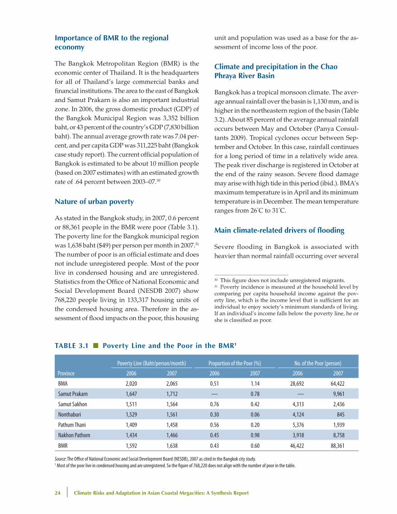
TAble 3.1 ■ poverty line and the poor in the bMR1
Province
Poverty Line (Baht/person/month) Proportion of the Poor (%) No. of the Poor (person)
2006 2007 2006 2007 2006 2007
BMA 2,020 2,065 0.51 1.14 28,692 64,422
Samut Prakarn 1,647 1,712 — 0.78 — 9,961
Samut Sakhon 1,511 1,564 0.76 0.42 4,313 2,436
Nonthaburi 1,529 1,561 0.30 0.06 4,124 845
Pathum Thani 1,409 1,458 0.56 0.20 5,376 1,939
Nakhon Pathom 1,434 1,466 0.45 0.98 3,918 8,758
BMR 1,592 1,638 0.43 0.60 46,422 88,361
Source: The Office of National Economic and Social Development Board (NESDB), 2007 as cited in the Bangkok city study.1 Most of the poor live in condensed housing and are unregistered. So the figure of 768,220 does not align with the number of poor in the table.

estimating Flood Impacts and vulnerabilities in Coastal Cities | 25
months during the monsoon period over the Chao Phraya watershed. The flooding can last several weeks to over a month. Intense short-duration rain-fall over the city can cause localized flooding that normally lasts for less than 24 hours. Bangkok is not subject to direct hits from tropical typhoons or cyclones. Large floods have occurred in 1942, 1978, 1980, 1983, 1995, 1996, 2002, and 2006. A number of dams in the upper watershed—including the Bhumibol Dam (1964) and Sirikit Dam (1971)—have helped reduce flooding in Bangkok. In 1995 a seri-ous flood occurred due to a series of tropical storms reaching the upper watershed from the end of July to September. The resultant runoff exceeded the stor-age capacity of the Sirikit Dam, which had to release 2,900 million m3 of storm runoff. Despite efforts to attenuate the flood wave by allowing flooding of agriculture lands upstream of Bangkok, the flood wave crest reached Bangkok at the same time as the high spring tide, flooding 65 percent of BMA with inundation depths up to 2 meters and left some areas flooded into December. The flood event of 1995 is estimated to have a return frequency of 1-in-30 years.
non-climate drivers of flooding
In addition to climate-related drivers, non-climate drivers such as land subsidence, deforestation,
urbanization, and removal of natural attenuation basins (like wetlands) also contribute to flooding. Land subsidence is a critical factor in flooding and is discussed later in the section.
existing flood protection in bangkok—diversion canals and flood dikes with pumped drainage
In response to the flooding, Bangkok has imple-mented a large-scale flood protection system that includes a flood embankment surrounding the city and a pumped drainage system. In 2006 there was another significant flood event in the upper Chao Phraya watershed. Flood peaks were again attenuated by allowing the agricultural lands north of Bangkok to flood, and flood flows were also di-verted to channels to the east of Bangkok. The flood embankment system and pumped drainage system protected the city. Nevertheless, areas surrounding Bangkok continue to experience inundation during peak flood flow. The city and national planners have plans to add further flood protection, which has been planned and budgeted through 2014. The long-term land use plan until 2057 for the greater Bangkok region provides for development areas and environmental zones that will be used to allow flood flows and drainage. Most of the flood control
TAble 3.2 ■ bangkok Monthly Average Temperature and precipitation
Month Temperature Average Low (oC) Temperature Average High (oC) Average precipitation (mm)
January 23° 32° 7.2
February 24° 33° 13.7
March 26° 34° 32.5
April 27° 35° 58.3
May 27° 34° 170.8
June 26° 33° 112.5
July 26° 33° 118.1
August 26° 33° 160.0
September 25° 33° 262.5
October 25° 32° 207.3
November 24° 32° 32.4
December 22° 32° 3.3
Total 1,171.4
Source: http://weather.uk.msn.com/monthly_averages.aspx?wealocations=wc:THXX0002

26 | Climate Risks and Adaptation in Asian Coastal Megacities: A Synthesis Report
activities that are being considered in the Royal Ir-rigation Department master plan are infrastructure activities (such as construction and improvement of canals, dikes, pumping stations, etc.). Flooding of agricultural lands upstream of Bangkok is utilized during major floods to help attenuate the flood peak, lowering the flood profile in Bangkok.
Current and planned land use and urban planning in bangkok—bangkok in the future
The Bangkok study projected what the city would look like in the future based on a wide range of available data about population and growth and a number of sectoral and urban development plans (Box 3.1). Modern urban land use planning in Bangkok started in the 1950s. Bangkok’s inner city contains the Grand Palace, government offices, ma-jor universities and educational establishments, and 2-to-4-story row houses that are used as commercial and residential units. The inner city is a national historic conservation area where construction of high-rise buildings is prohibited. Urban growth in Bangkok, however, has progressed in a sometimes ad hoc manner and without a unified plan linking it to the surrounding areas. To remedy this problem, the government has developed a 50-year regional spatial plan (finished in 2007) that foresees growth of the surrounding areas. This plan also provides for significant environmental protection and wet-land areas.
Climate change parameters—statistical downscaling
For the 2050 simulations, the Bangkok City case study applied the statistical downscaling factors estimated by the University of Tokyo’s Integrated Research System for Sustainability Science (IRS3) discussed in chapter 2. Given the size of the Chao Phraya watershed and the long time it takes upper watershed rainfall to reach Bangkok as stream flow, the team applied the mean increase in seasonal precipitation (3 percent and 2 percent for A1FI and B1 respectively) to the three-month rainfall events for the corresponding 1-in-10, 1-in-30 and 1-in-100-year precipitation events for the watershed. These total precipitation levels were distributed over the
watershed using spatial and temporal patterns from historic flood years. The forecasted temperature increases of 1.9°C and 1.2°C for the A1FI and B1 scenarios respectively for 2050 were used in the hy-drological modeling. The SLR estimates used were 0.29 m and 0.19 m for the A1FI and B1 scenarios respectively. This was based on IPCC AR4 (Working Group 1, Chapter 10, Table 10.7) estimates. It was decided to use half of the 2099 increase for the 2050 estimates; namely, 0.29 m and 0.19 m for the A1FI and B1 scenarios respectively.
box 3.1 ■ The bangkok Metropolitan Region (bMR): Some Assumptions about the Future
Bangkok is changing rapidly and some of these changes have been taken into account in modeling the future. Bangkok is increasingly “suburbanizing.” Between 1998 and 2003, BMR saw a 74 percent increase in urban development. The city’s housing stock has doubled in the last decade. This trend is expected to continue. The Government’s Land Use Plan for 2057 is used to project the number of commercial, residential, and industrial buildings in Bangkok in 2050. Available government plans are taken into account in establishing future road and transportation networks. Plans suggest tightened urban areas within a network of expressways bounded by large environmental protection areas to divert any floods from the centers.
Based on existing trends, the city of Bangkok is not expected to grow a lot, while neighboring suburbs will continue to grow. For instance, suburban Nonthaburi increased its population by 47 percent during 2002–07. Bangkok City is expected to have a population of 10.55 million (4.65 million households) and BMR a population of nearly 16 million by 2050. To forecast the population in 2050 for BMR, information on population projections for Thailand 2003–30 prepared by the government (NESDB) was used as a base. The NESDB report projects population to the year 2030 for the whole kingdom and to 2025 and 2020 for Bangkok and other provinces respectively. In projecting the population to 2050, a regression function was applied.
In terms of the BMR economy, regional GDP is projected for two areas (Bangkok and Samut Prakarn) of BMR most likely to be affected by flooding. GDP for Bangkok and Samut Prakarn in 2050 is expected to be six-fold higher than the current GDP. In terms of poverty in the cities, in Bangkok in 2007 only 88,361 people (0.6 percent of the total) in the BMR were officially considered poor. However, this number excludes some 768,220 people living in 133,317 condensed housing units. In the flood impact assessment, the higher, more accurate number was used.
Source: Adapted from Panya Consultants (2009).
estimating Flood Impacts and vulnerabilities in Coastal Cities | 27
estimation of storm surge in the case of bangkok
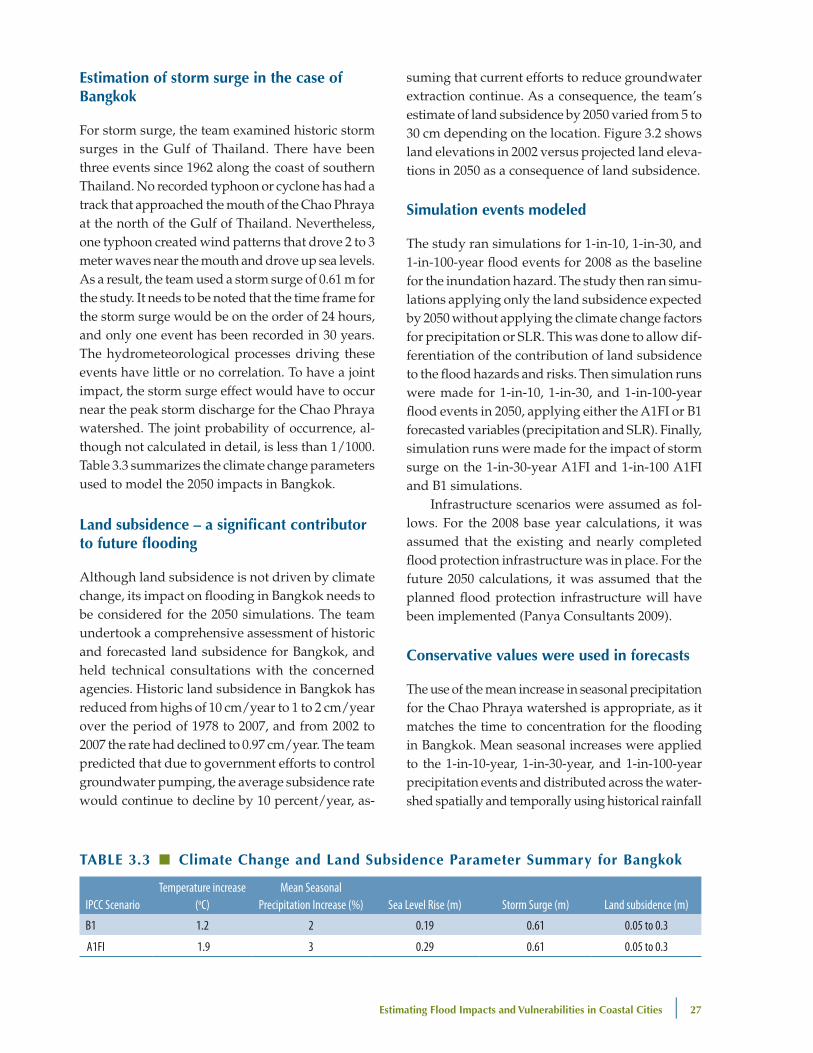
For storm surge, the team examined historic storm surges in the Gulf of Thailand. There have been three events since 1962 along the coast of southern Thailand. No recorded typhoon or cyclone has had a track that approached the mouth of the Chao Phraya at the north of the Gulf of Thailand. Nevertheless, one typhoon created wind patterns that drove 2 to 3 meter waves near the mouth and drove up sea levels. As a result, the team used a storm surge of 0.61 m for the study. It needs to be noted that the time frame for the storm surge would be on the order of 24 hours, and only one event has been recorded in 30 years. The hydrometeorological processes driving these events have little or no correlation. To have a joint impact, the storm surge effect would have to occur near the peak storm discharge for the Chao Phraya watershed. The joint probability of occurrence, al-though not calculated in detail, is less than 1/1000. Table 3.3 summarizes the climate change parameters used to model the 2050 impacts in Bangkok.
land subsidence – a significant contributor to future flooding
Although land subsidence is not driven by climate change, its impact on flooding in Bangkok needs to be considered for the 2050 simulations. The team undertook a comprehensive assessment of historic and forecasted land subsidence for Bangkok, and held technical consultations with the concerned agencies. Historic land subsidence in Bangkok has reduced from highs of 10 cm/year to 1 to 2 cm/year over the period of 1978 to 2007, and from 2002 to 2007 the rate had declined to 0.97 cm/year. The team predicted that due to government efforts to control groundwater pumping, the average subsidence rate would continue to decline by 10 percent/year, as-
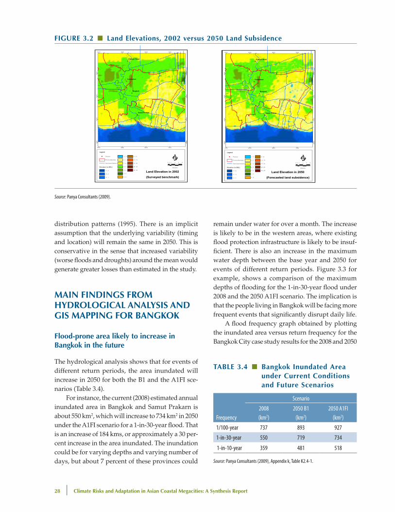
suming that current efforts to reduce groundwater extraction continue. As a consequence, the team’s estimate of land subsidence by 2050 varied from 5 to 30 cm depending on the location. Figure 3.2 shows land elevations in 2002 versus projected land eleva-tions in 2050 as a consequence of land subsidence.
Simulation events modeled
The study ran simulations for 1-in-10, 1-in-30, and 1-in-100-year flood events for 2008 as the baseline for the inundation hazard. The study then ran simu-lations applying only the land subsidence expected by 2050 without applying the climate change factors for precipitation or SLR. This was done to allow dif-ferentiation of the contribution of land subsidence to the flood hazards and risks. Then simulation runs were made for 1-in-10, 1-in-30, and 1-in-100-year flood events in 2050, applying either the A1FI or B1 forecasted variables (precipitation and SLR). Finally, simulation runs were made for the impact of storm surge on the 1-in-30-year A1FI and 1-in-100 A1FI and B1 simulations.
Infrastructure scenarios were assumed as fol-lows. For the 2008 base year calculations, it was assumed that the existing and nearly completed flood protection infrastructure was in place. For the future 2050 calculations, it was assumed that the planned flood protection infrastructure will have been implemented (Panya Consultants 2009).
Conservative values were used in forecasts
The use of the mean increase in seasonal precipitation for the Chao Phraya watershed is appropriate, as it matches the time to concentration for the flooding in Bangkok. Mean seasonal increases were applied to the 1-in-10-year, 1-in-30-year, and 1-in-100-year precipitation events and distributed across the water-shed spatially and temporally using historical rainfall
TAble 3.3 ■ Climate Change and land Subsidence parameter Summary for bangkok
IPCC ScenarioTemperature increase
(oC)Mean Seasonal
Precipitation Increase (%) Sea Level Rise (m) Storm Surge (m) Land subsidence (m)
B1 1.2 2 0.19 0.61 0.05 to 0.3
A1FI 1.9 3 0.29 0.61 0.05 to 0.3
28 | Climate Risks and Adaptation in Asian Coastal Megacities: A Synthesis Report
distribution patterns (1995). There is an implicit assumption that the underlying variability (timing and location) will remain the same in 2050. This is conservative in the sense that increased variability (worse floods and droughts) around the mean would generate greater losses than estimated in the study.
MAIn FIndIngS FRoM hydRologICAl AnAlySIS And gIS MAppIng FoR bAngKoK
Flood-prone area likely to increase in bangkok in the future
The hydrological analysis shows that for events of different return periods, the area inundated will increase in 2050 for both the B1 and the A1FI sce-narios (Table 3.4).
For instance, the current (2008) estimated annual inundated area in Bangkok and Samut Prakarn is about 550 km2, which will increase to 734 km2 in 2050 under the A1FI scenario for a 1-in-30-year flood. That is an increase of 184 kms, or approximately a 30 per-cent increase in the area inundated. The inundation could be for varying depths and varying number of days, but about 7 percent of these provinces could
remain under water for over a month. The increase is likely to be in the western areas, where existing flood protection infrastructure is likely to be insuf-ficient. There is also an increase in the maximum water depth between the base year and 2050 for events of different return periods. Figure 3.3 for example, shows a comparison of the maximum depths of flooding for the 1-in-30-year flood under 2008 and the 2050 A1FI scenario. The implication is that the people living in Bangkok will be facing more frequent events that significantly disrupt daily life.
A flood frequency graph obtained by plotting the inundated area versus return frequency for the Bangkok City case study results for the 2008 and 2050
FIguRe 3.2 ■ land elevations, 2002 versus 2050 land Subsidence
Source: Panya Consultants (2009).
TAble 3.4 ■ bangkok Inundated Area under Current Conditions and Future Scenarios
Frequency
Scenario
2008(km2)
2050 B1(km2)
2050 A1FI(km2)
1/100-year 737 893 927
1-in-30-year 550 719 734
1-in-10-year 359 481 518
Source: Panya Consultants (2009), Appendix k, Table K2.4-1.
Climate Change Impact and Adaptation Study for Bangkok Metropolitan Region Final Report Chapter 2: City Descriptions
2-2
2.1.2 Land Subsidence
From observed data, the average land subsidence rate in the Bangkok Metropolitan Region (BMR) has gradually reduced from 10 cm per year to 1-2 cm per year from 1978 to 2007. Furthermore, during the last 5 years (2002-2007), the average land subsidence rate has reduced to 0.97 cm per year. Therefore, it is expected that the land subsidence rate would reduce by 10% per year. Thus, the accumulated land subsidence during 2002-2050 (48 years) would spatially vary from 5 to 30 cm depending on location as shown in Figure 2.1-3.
!(
!(
!(
!(
Bangkok
Nonthaburi
Pathum Thani
Samut Prakan
640000
640000
660000
660000
680000
680000
700000
700000
1480
000
1480
000
1500
000
1500
000
1520
000
1520
000
1540
000
1540
000
Legend
!( Province
Province Boundary
River/Canal Network
Elevation (m.MSL)-7 - -5
-5 - -3
-3 - -1
-1 - 0
0 - 1
1 - 2
2 - 3
3 - 4
4 - 5
5 - 8
8 - 10
10 - 15
15 - 20
20 - 25
25 - 35
Ê0 3 6 9 121.5
Kilometers
!(
!(
!(
!(
Bangkok
Nonthaburi
Pathum Thani
Samut Prakan
640000
640000
660000
660000
680000
680000
700000
700000
1480
000
1480
000
1500
000
1500
000
1520
000
1520
000
1540
000
1540
000
Legend
!( Province
Province Boundary
River/Canal Network
Elevation (m.MSL)-7 - -5
-5 - -3
-3 - -1
-1 - 0
0 - 1
1 - 2
2 - 3
3 - 4
4 - 5
5 - 8
8 - 10
10 - 15
15 - 20
20 - 25
25 - 35
Ê0 3 6 9 121.5
Kilometers
Land Elevation in 2002(Surveyed benchmark)
Land Elevation in 2050(Forecasted land subsidence)
Source: Royal Thai Survey Department (RTSD) and Panya Consultants’ forecast
Figure 2.1-3 Land Elevation in 2002 and 2050 due to Land Subsidence
2.2 CLIMATE
2.2.1 General
The climate of the Chao Phraya River Basin belongs to the tropical monsoon. The average annual rainfall over the basin is 1,130 mm, varying from 1,000 to 1,600 mm and registering higher in the northeastern region of the basin. According to the rainfall pattern, about 85% of the average annual rainfall occurs between May and October. Tropical cyclones occur between September and October and may strike the basin. In this case, rainfall continues for a long period of time in a relatively wide area. The peak river discharge is registered in October, the end of the rainy season, and severe flood damage may arise with high tide in this period. The mean temperature ranges from 26oC to 31oC. Its maximum temperature is in April and its minimum is in December. The evaporation (Class-A Pan) in the basin is normally at its highest in April and lowest in October with an average annual value of about 1,700 mm.

estimating Flood Impacts and vulnerabilities in Coastal Cities | 29
A1FI further demonstrates how the flood hazard will increase dramatically in Bangkok. As the graph in Figure 3.4 below illustrates, a flood event in 2008 with an inundated area of 625 km2 has a frequency of 0.02 or return period of 1-in-50 years. By 2050 under the A1FI scenario, flood events inundating areas of 625 km2 would be expected to occur with an increased frequency of 1-in-15 years. The corollary of this is that the intensity of flooding for a 1-in-15-year event would increase from about 450 km2 to 625 km2.
population exposed to flooding will increase for 1-in-30-year flood for both A1FI and b1 scenarios
Severe floods inundate the lower Chao Phraya floodplain in which Bangkok is situated. The huge volume of water (over 31,000 million cubic meters for a 1-in-30-year event) associated with these floods can take months to drain as Bangkok acts as
a “bottleneck” to the discharge reaching the Gulf of Thailand. This can leave many areas flooded for more than 30 days. The flood protection schemes for Bangkok are generally designed to protect against
FIguRe 3.3 ■ Maximum water depth for 1-in-30-year event, 2008 and 2050, A1FI
Source: Panya Consultants (2009).
FIguRe 3.4 ■ bangkok Flood hazard Relationship
1,000900800700600500400300200100
00.00 0.02 0.04 0.06 0.08 0.10 0.12
Increasedfrequency
IncreasedIntensity
1/15–year1/50–year
~39% increase625
450
Inun
date
d are
a (km
2 )
Flood frequency
2008 2050 A1FI
Source: Panya Consultants (2009).
Climate Change Impact and Adaptation Study for Bangkok Metropolitan Region Final Report Chapter 3: Model Development and Simulation
3-7
!(
!(
!(
!(
!(
!(
Bangkok
Nonthaburi
Pathum Thani
Samut SakhonSamut Prakan
Nakhon Pathom
620000
620000
640000
640000
660000
660000
680000
680000
700000
7000001480
000
1480
000
1500
000
1500
000
1520
000
1520
000
1540
000
1540
000
1560
000
1560
000
1580
000
1580
000
Legend
!( Province
Province Boundary
River/Canal Network
Dike
Elevation (m.MSL)-7 - -5
-5 - -3
-3 - -1
-1 - 0
0 - 1
1 - 2
2 - 3
3 - 4
4 - 5
5 - 8
8 - 10
10 - 15
15 - 20
20 - 25
> 25
Max.Water Depth (cm)
0 - 10
10 - 50
50 - 100
100 - 200
200 - 300
300 - 400
> 400
Ê0 4 8 12 162
Kilometers
!(
!(
!(
!(
!(
!(
Bangkok
Nonthaburi
Pathum Thani
Samut SakhonSamut Prakan
Nakhon Pathom
620000
620000
640000
640000
660000
660000
680000
680000
700000
7000001480
000
1480
000
1500
000
1500
000
1520
000
1520
000
1540
000
1540
000
1560
000
1560
000
1580
000
1580
000
Legend
!( Province
Province Boundary
River/Canal Network
Dike
Elevation (m.MSL)-7 - -5
-5 - -3
-3 - -1
-1 - 0
0 - 1
1 - 2
2 - 3
3 - 4
4 - 5
5 - 8
8 - 10
10 - 15
15 - 20
20 - 25
> 25
Max. Water Depth (cm)
0 - 10
10 - 50
50 - 100
100 - 200
200 - 300
300 - 400
> 400
Ê0 4 8 12 162
Kilometers
Max. Water DepthC2008-T30
Max. Water DepthC2050-LS-SR
-A1FI-T30Source: Panya Consultants’ calculation
Figure 3.2-1 Maximum Water Depth of Case C2008-T30 and C2050-LS-SR-A1FI-T30
Figure 3.2-2 illustrates the maximum water surface profile along the Chao Phraya River from the river mouth to Bang Sai district, Ayutthaya at 10, 30 and 100-year flood return periods. Comparing Case C2008-T100 and C2050-LS-T100, it reveals that the maximum water level will be reduced due to land subsidence of about 0.20 m, considering the sea level at the river mouth is not increased. Comparing Case C2050-LS-T100 and C2050-LS-SR-A1FI-T100, the maximum water level will be increased due to the increasing of flood water from the upper basin and the sea level rise. Comparing Case C2050-LS-SR-A1FI-T100 and C2050-LS-SR-SS-A1FI-T100, the maximum water level will be increased at the river mouth due to storm surge, but the effect will appear up to about 50 km from the river mouth.
30 | Climate Risks and Adaptation in Asian Coastal Megacities: A Synthesis Report
1-in-30-year floods. There are steep increases in persons affected as inundation levels exceed the 2008 1-in-30-year design standards. For example, the number of persons who would be affected by 1-in-100-year flood event in 2008 is nearly double the number affected by a 1-in-30-year flood, as shown in Table 3.5. Similarly, the number of persons affected in 2050 by a 1-in-30-year event will rise sharply for both B1 and A1FI scenarios, with 47.2 percent and 74.6 percent increases, respectively.
Areas in bangkok vulnerable to flooding
Although Bangkok’s flood embankment and pumped drainage will continue to offer substantial protection for the interior area, land outside the em-bankment to the north and the southwest is likely to experience significantly worse flooding. These are areas which are undergoing housing, commercial, and industrial development. Within BMR, Bangkok and Samut Prakarn are the two provinces that are most affected by climate change. In a C2050-LS-SR-SS-A1FI-T30 scenario, almost 1 million people in Bangkok and Samut Prakarn would be impacted by floods. The impact will be profound for people living on the lower floors of residential buildings. Nevertheless, people living on higher floors in the Bang Khun Thian district of Bangkok and the Phra Samut Chedi district of Samut Prakarn might also be impacted. District-wise, Don Muang district in north Bangkok has the highest number of people affected by floods (approximately 90,000) owing to its higher population density. In the western part of the Chao Phraya River, about 200,000 people in Bang Khun Thian, Bang Bon, Bang Khae, and Nong Kham districts might be impacted. The maps in Figure 3.5a and 3.5b below show the differences in flooding for the 1-in-30-year event, currently and in 2050.
Impact of the floods on people living in condensed housing
Figures 3.5a and 3.5b show the impact of flooding under the 1-in-30-year A1FI flood in 2050 in com-parison to 2008, with an overlay of poor housing in Bangkok. It shows increased flooding in several condensed housing areas where the poor live. As the study points out, “ about 1 million inhabitants of Bangkok and Samut Prakarn will be affected by the A1FI climate change condition in 2050. One in eight of the affected inhabitants will be from the condensed housing areas where most live below the poverty level. One-third of the total affected people may be subjected to more than a half meter inundation for at least one week. This marks a two-fold increase of that vulnerable population. The impact will be critical for the people living in the Bang Khun Thian district of Bangkok and the Phra Samut Chedi district of Samut Prakarn” (Panya Consultants 2009).
Key sectors likely to be affected by flooding in 2050 but buildings and housing most affected
The most significant impacts will be felt by the residential, commercial, and industrial sectors with more than a million buildings being affected by a 1-in-30-year event in 2050. About 300,000 build-ings in areas to the west of Bangkok—like Bang Khun Thian, Bang Bon, Bang Khae, Phra Samut, and Chedi districts—will also be impacted. For the 1-in-30-year event, approximately 1,700 km of roads would be exposed to flooding. The Lat Krabang water supply distribution station and the Nongkhaem solid waste transit station would both be subject to 50–100 cm inundation, although the main water and wastewater treatment facilities are protected. In addition, 127 health care facilities would be subject to flooding, with inundation levels ranging from 10 to 200 cm.
Storm surge and sea level rise have relatively small role in contributing to flooding in bangkok
Analysis carried out in the Bangkok study found a linear relationship between future precipitation
Table 3.5 ■ exposure of bangkok population to Flooding
Frequency
Population affected for >30 days
2008 2050 B1 2050 A1FI
1-in-100 year 1,002,244 1,187,803 1,271,306
1-in-30 year 546,748 805,055 954,389
Source: Panya Consultants (2009).

estimating Flood Impacts and vulnerabilities in Coastal Cities | 31
and flood volume in the Chao Phraya River. How-ever, it found that flood peak discharge in the Chao Phraya River will increase by a larger percentage than precipitation, due to unequal travel times of floods from upstream catchments. Further, while storm surges and sea level rise are important, they will have less effect on flooding in Bangkok. While storm surges do occur in the Gulf of Thailand and contribute to flooding the BMR area, it was esti-mated that the flood-prone area in Bangkok and
Samut Prakarn will increase by about 2 percent due to a storm surge striking the western coast of the Gulf of Thailand.
eSTIMATIng ClIMATe-RelATed IMpACTS In MAnIlA
The Manila study (Muto et al. 2010) focuses on Metro Manila and includes Manila and 16 munici-
FIguRe 3.5a ■ Affected Condensed (poor) Community of Case C2008-T30
FIguRe 3.5b ■ Affected Condensed (poor) Community of Case C2050-lS-SR-SS-A1FI-T30
Source: Panya Consultants (2009).
32 | Climate Risks and Adaptation in Asian Coastal Megacities: A Synthesis Report
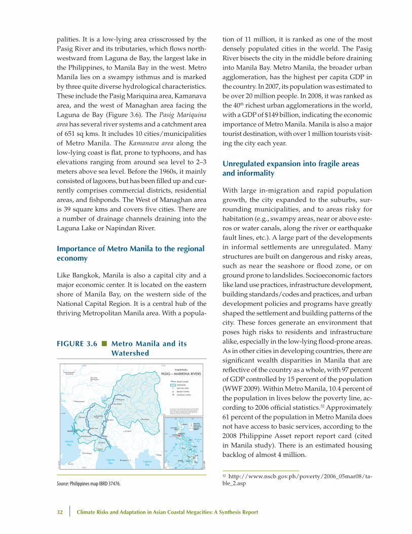
palities. It is a low-lying area crisscrossed by the Pasig River and its tributaries, which flows north-westward from Laguna de Bay, the largest lake in the Philippines, to Manila Bay in the west. Metro Manila lies on a swampy isthmus and is marked by three quite diverse hydrological characteristics. These include the Pasig Mariquina area, Kamanava area, and the west of Managhan area facing the Laguna de Bay (Figure 3.6). The Pasig Mariquina area has several river systems and a catchment area of 651 sq kms. It includes 10 cities/municipalities of Metro Manila. The Kamanava area along the low-lying coast is flat, prone to typhoons, and has elevations ranging from around sea level to 2–3 meters above sea level. Before the 1960s, it mainly consisted of lagoons, but has been filled up and cur-rently comprises commercial districts, residential areas, and fishponds. The West of Managhan area is 39 square kms and covers five cities. There are a number of drainage channels draining into the Laguna Lake or Napindan River.
Importance of Metro Manila to the regional economy
Like Bangkok, Manila is also a capital city and a major economic center. It is located on the eastern shore of Manila Bay, on the western side of the National Capital Region. It is a central hub of the thriving Metropolitan Manila area. With a popula-
tion of 11 million, it is ranked as one of the most densely populated cities in the world. The Pasig River bisects the city in the middle before draining into Manila Bay. Metro Manila, the broader urban agglomeration, has the highest per capita GDP in the country. In 2007, its population was estimated to be over 20 million people. In 2008, it was ranked as the 40th richest urban agglomerations in the world, with a GDP of $149 billion, indicating the economic importance of Metro Manila. Manila is also a major tourist destination, with over 1 million tourists visit-ing the city each year.
unregulated expansion into fragile areas and informality
With large in-migration and rapid population growth, the city expanded to the suburbs, sur-rounding municipalities, and to areas risky for habitation (e.g., swampy areas, near or above este-ros or water canals, along the river or earthquake fault lines, etc.). A large part of the developments in informal settlements are unregulated. Many structures are built on dangerous and risky areas, such as near the seashore or flood zone, or on ground prone to landslides. Socioeconomic factors like land use practices, infrastructure development, building standards/codes and practices, and urban development policies and programs have greatly shaped the settlement and building patterns of the city. These forces generate an environment that poses high risks to residents and infrastructure alike, especially in the low-lying flood-prone areas. As in other cities in developing countries, there are significant wealth disparities in Manila that are reflective of the country as a whole, with 97 percent of GDP controlled by 15 percent of the population (WWF 2009). Within Metro Manila, 10.4 percent of the population in lives below the poverty line, ac-cording to 2006 official statistics.32 Approximately 61 percent of the population in Metro Manila does not have access to basic services, according to the 2008 Philippine Asset report report card (cited in Manila study). There is an estimated housing backlog of almost 4 million.
FIguRe 3.6 ■ Metro Manila and its watershed
Bacoor
Parañaque
Mandaluyong
San Juan
Pasig
Antipolo
Pililla
Binangonan
Marikina
San Mateo
Rodriguez
QUEZONCITYCaloocan
Meycauayan
Pateros
Taguig
Bosoboso
San JoseDel Monte
MANILA
ManilaBay
LagunaBay
LagunaBay
Pasig River
Mar
ikin
a R
iver
121°20'
121°20'
121°00'
121°00'
14°40'
Area of Map
San FernandoQuezon
Tuguegarao
BaguioSan Fernando
Legaspi
Tacloban
Cebu
Butuan
DavaoCotabato
Cagayande Oro
Iligan
Iloilo
Zamboanga
MANILA
MALAYSIACelebes Sea
Sulu Sea
Phi l ippineSea
10°N
15°N
10°N
15°N
5°N 5°N125°E120°E
120°E 125°E
REGION CAPITALSNATIONAL CAPITALREGION BOUNDARIESINTERNATIONALBOUNDARIES
0 5
KILOMETERS
PHILIPPINES
PASIG – MARIKINA RIVERS
PROJECT RIVERS
WATERSHED
SELECTED CITIES
REGION CAPITAL
NATIONAL CAPITAL
JAN
UA
RY 2010
IBRD 37476
This map was produced by the Map Design Unit of The World Bank. The boundaries, colors, denominations and any other informationshown on this map do not imply, on the part of The World BankGroup, any judgment on the legal status of any territory, or anyendorsement or acceptance of such boundaries.
Source: Philippines map IBRD 37476.
32 http://www.nscb.gov.ph/poverty/2006_05mar08/ta-ble_2.asp

estimating Flood Impacts and vulnerabilities in Coastal Cities | 33
Manila’s current climate—Tropical with distinct wet and dry seasons
Figure 3.7 shows the four main climate regimes in the Philippines and the relative frequency of typhoons making landfall. Manila falls into Type 1, which is defined as having two distinct seasons, with the dry season running from November to April and the wet season occurring in the other months. About 16 percent of the typhoons crossing the Philippines pass in the general vicinity of Manila and its nearby areas. The average temperatures and precipitation in Manila are shown in Table 3.6. Manila has an average annual precipitation of about 1,433 mm, but there is significant variability.
Main climate-related drivers of flooding—driven by single-storm events, usually related to typhoons
Unlike Bangkok, where floods are generated by heavy seasonal precipitation over 1 to 3 months, extreme flood events in Manila are caused by heavy precipitation events over 1 to 3 days generally associ-ated with typhoons and storm surge. The watershed area for Manila’s Pasig-Marikina River System is 651 km2, which includes the San Juan River catch-
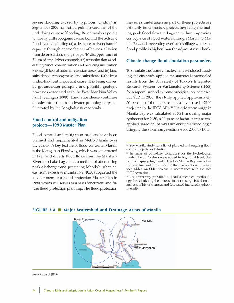
ment. This is relatively small in comparison to the watersheds of other cities in the study. The precipi-tation pattern causing flooding is often associated with strong winds and flash flooding, which can be devastating for informal housing located along drainage ways. Seeking refuge during such events is extremely difficult and hazardous to the population. Other climate-related factors contributing to flooding include a combination of high tide, excess runoff from rivers, heavy rains, and sea level rise. A schematic of the watersheds around Manila is shown in Figure 3.8.
non-climate related drivers of flooding
Even though land subsidence is an important issue in Metro Manila, it was not possible to consider it for the hydrological simulation for the Manila study because of lack of availability of reliable data.33 The
FIguRe 3.7 ■ different Climatic Regimes in the philippines
!
Source: Muto et al. (2010).
TAble 3.6 ■ Manila: Monthly Average Temperature and precipitation
Month
Temperature Average Low
(oC)
Temperature Average High
(oC)
Average precipitation
(mm)
January 24° 30° Negligible
February 24° 30° 12.1
March 25° 32° 9.1
April 27° 33° 15.9
May 27° 33° 133.0
June 26° 32° 150.8
July 26° 31° 292.9
August 26° 31° 305.8
September 26° 31° 237.5
October 26° 31° 137.2
November 25° 31° 81.3
December 24° 30° 58.0
Total 1433.6
Source: http://weather.uk.msn.com/monthly_averages.aspx?wealocations=wc:RPXX0017
33 One difficulty in Metro Manila is that the station that is supposed to measure land subsidence of Manila de Bay is located on one of the old piers of Manila Port, which itself is sinking gradually.
34 | Climate Risks and Adaptation in Asian Coastal Megacities: A Synthesis Report
severe flooding caused by Typhoon “Ondoy” in September 2009 has raised public awareness of the underlying causes of flooding. Recent analysis points to mostly anthropogenic causes behind the extreme flood event, including (a) a decrease in river channel capacity through encroachment of houses, siltation from deforestation, and garbage; (b) disappearance of 21 km of small river channels; (c) urbanization accel-erating runoff concentration and reducing infiltration losses; (d) loss of natural retention areas; and (e) land subsidence. Among these, land subsidence is the least understood but important cause. It is being driven by groundwater pumping and possibly geologic processes associated with the West Marikina Valley Fault (Siringan 2009). Land subsidence continues decades after the groundwater pumping stops, as illustrated by the Bangkok city case study.
Flood control and mitigation projects—1990 Master plan
Flood control and mitigation projects have been planned and implemented in Metro Manila over the years.34 A key feature of flood control in Manila is the Mangahan Floodway, which was constructed in 1985 and diverts flood flows from the Marikina River into Lake Laguna as a method of attenuating peak discharges and protecting Manila’s urban ar-eas from excessive inundation. JICA supported the development of a Flood Protection Master Plan in 1990, which still serves as a basis for current and fu-ture flood protection planning. The flood protection
measures undertaken as part of these projects are primarily infrastructure projects involving attenuat-ing peak flood flows in Laguna de bay, improving conveyance of flood waters through Manila to Ma-nila Bay, and preventing overbank spillage where the flood profile is higher than the adjacent river bank.
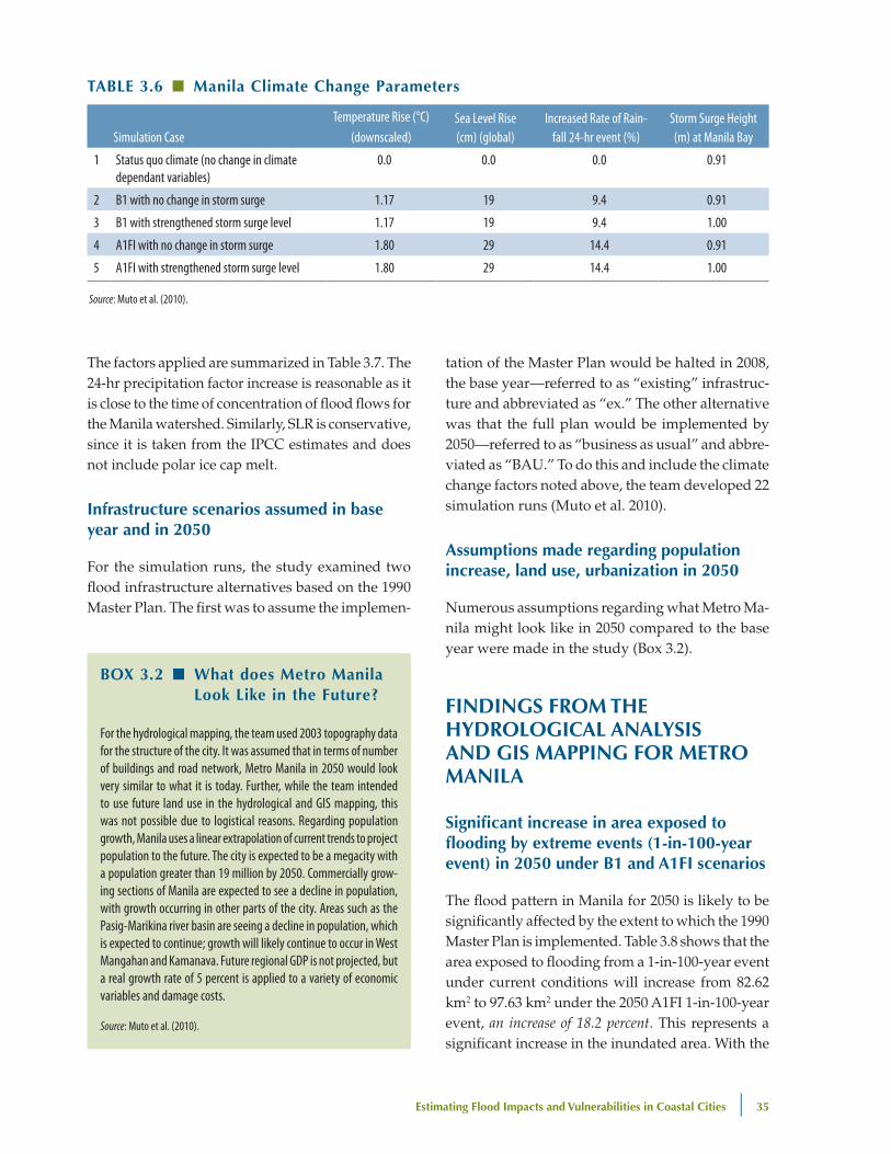
Climate change flood simulation parameters
To simulate the future climate-change-induced flood-ing, the city study applied the statistical downscaled results from the University of Tokyo’s Integrated Research System for Sustainability Science (IRS3) for temperature and extreme precipitation increases. For SLR in 2050, the study applied approximately 50 percent of the increase in sea level rise in 2100 projected in the IPCC AR4.35 Historic storm surge in Manila Bay was calculated at 0.91 m during major typhoons; for 2050, a 10 percent factor increase was applied based on Ibaraki University methodology,36 bringing the storm surge estimate for 2050 to 1.0 m.
FIguRe 3.8 ■ Major watershed and drainage Areas of Manila
Pasig-SanJuan Marikina
West Mangahan
Source: Muto et al. (2010)
34 See Manila study for a list of planned and ongoing flood control projects and studies.35 In terms of boundary conditions for the hydrological model, the SLR values were added to high tidal level; that is, mean spring high water level in Manila Bay was set as the base line water level for the flood simulation, to which was added an SLR increase in accordance with the two IPCC scenarios. 36 The university provided a detailed technical methodol-ogy for calculating the increase in storm surge based on an analysis of historic surges and forecasted increased typhoon intensity.
estimating Flood Impacts and vulnerabilities in Coastal Cities | 35
The factors applied are summarized in Table 3.7. The 24-hr precipitation factor increase is reasonable as it is close to the time of concentration of flood flows for the Manila watershed. Similarly, SLR is conservative, since it is taken from the IPCC estimates and does not include polar ice cap melt.
Infrastructure scenarios assumed in base year and in 2050
For the simulation runs, the study examined two flood infrastructure alternatives based on the 1990 Master Plan. The first was to assume the implemen-
tation of the Master Plan would be halted in 2008, the base year—referred to as “existing” infrastruc-ture and abbreviated as “ex.” The other alternative was that the full plan would be implemented by 2050—referred to as “business as usual” and abbre-viated as “BAU.” To do this and include the climate change factors noted above, the team developed 22 simulation runs (Muto et al. 2010).
Assumptions made regarding population increase, land use, urbanization in 2050
Numerous assumptions regarding what Metro Ma-nila might look like in 2050 compared to the base year were made in the study (Box 3.2).
FIndIngS FRoM The hydRologICAl AnAlySIS And gIS MAppIng FoR MeTRo MAnIlA
Significant increase in area exposed to flooding by extreme events (1-in-100-year event) in 2050 under b1 and A1FI scenarios
The flood pattern in Manila for 2050 is likely to be significantly affected by the extent to which the 1990 Master Plan is implemented. Table 3.8 shows that the area exposed to flooding from a 1-in-100-year event under current conditions will increase from 82.62 km2 to 97.63 km2 under the 2050 A1FI 1-in-100-year event, an increase of 18.2 percent. This represents a significant increase in the inundated area. With the
TAble 3.6 ■ Manila Climate Change parameters
Simulation CaseTemperature Rise (°C)
(downscaled)Sea Level Rise (cm) (global)
Increased Rate of Rain-fall 24-hr event (%)
Storm Surge Height (m) at Manila Bay
1 Status quo climate (no change in climate dependant variables)
0.0 0.0 0.0 0.91
2 B1 with no change in storm surge 1.17 19 9.4 0.91
3 B1 with strengthened storm surge level 1.17 19 9.4 1.00
4 A1FI with no change in storm surge 1.80 29 14.4 0.91
5 A1FI with strengthened storm surge level 1.80 29 14.4 1.00
Source: Muto et al. (2010).
box 3.2 ■ what does Metro Manila look like in the Future?
For the hydrological mapping, the team used 2003 topography data for the structure of the city. It was assumed that in terms of number of buildings and road network, Metro Manila in 2050 would look very similar to what it is today. Further, while the team intended to use future land use in the hydrological and GIS mapping, this was not possible due to logistical reasons. Regarding population growth, Manila uses a linear extrapolation of current trends to project population to the future. The city is expected to be a megacity with a population greater than 19 million by 2050. Commercially grow-ing sections of Manila are expected to see a decline in population, with growth occurring in other parts of the city. Areas such as the Pasig-Marikina river basin are seeing a decline in population, which is expected to continue; growth will likely continue to occur in West Mangahan and Kamanava. Future regional GDP is not projected, but a real growth rate of 5 percent is applied to a variety of economic variables and damage costs.
Source: Muto et al. (2010).

36 | Climate Risks and Adaptation in Asian Coastal Megacities: A Synthesis Report
implementation of the 1990 Master Plan, infrastruc-ture in the inundated areas will be reduced consider-ably for the current flood hazard (i.e., an inundated area of only 36.93 km2 from a 1-in-100-year event in 2008), but the infrastructure will not afford the level of protection in 2050 for the return periods on which the designs are based. Climate change impacts under the A1FI 1-in-100-year storm event would increase the inundated area by 42 percent (from 36.93 km2 to 52.44 km2) compared to the base year 2008. The main point is that that the master plan will not offer the planned level of protection.
Increase in percentage of population exposed to flooding under high and low emissions scenarios
As would be expected from the significant increase in inundated area under the B1 and A1FI climate change scenarios, the number of people affected by the floods increases significantly as well, as illustrated in Figure 3.9. Thus, for a 1-in-100-year flood in 2050, under the AIFI scenario more than 2.5 million people are likely to be affected, assum-ing that the infrastructure in 2050 is the same as in the base year. In a scenario where the flood protec-tion infrastructure under the 1990 Master Plan is implemented, the level of protection expected by its implementation will not be achieved under the A1FI 1-in-100-year storm event, where approximately 1.3 million persons would be affected.
An overlay of population density maps with GRID data on inundation shows areas of high
population density that are likely to face serious flooding risk (Figure 3.10). These include Manila City, Quezon City, Pasig City, Marikina City, San Juan, and Mandaluyong City.
Areas in Metro Manila likely to be at high risk from flooding due to extreme events in 2050
The hydrological analysis shows that some local gov-ernment units (LGUs) will be much more affected than others under different scenarios. As Figure 3.11 shows, municipalities in the Pasig Marikina River basin (namely Manila, Mandaluyong, and Marikina) and Kamanava areas (namely Malabon and Navotas) are more likely to be vulnerable to flooding com-pared to those in the West Managhan area.
TAble 3.8 ■ Manila: Comparison of Inundated Area (km2) with 1-in-100-year flood for 2008 and 2050 Climate Change Scenarios with only existing Infrastructure and with Completion of 1990 Master plan
No change to existing infrastructure All 1990 Master Plan infrastructure implemented
2008 (km2) 2050 B1 (km2) 2050 A1FI (km2) 2008 (km2) 2050 B1 (km2) 2050 A1FI (km2)
Pasig-Marikina 53.73 63.19 67.97 29.14 40.09 44.14
West Mangahan 10.65 11.09 11.42 7.79 8.16 8.30
KAMANAVA 18.24 18.24 18.24 — — —
Total 82.62 92.53 97.63 36.93 48.25 52.44
Relative increase 12.0% 18.2% 30.7% 42.0%
Source: Muto et al. (2010).
FIguRe 3.9 ■ Comparison of population Affected by Flooding under different Scenarios*
3,000,000
2,500,000
2,000,000
1,500,000
1,000,000
500,000
0EX SQ EX B1 EX A1FI BAU SQ BAU B1 BAU A1FI
Source: Muto et al. (2010).* Scenarios include 1-in-100-year event (P100) in 2008 (SQ) with the 2050 B1 and 2050 A1FI scenarios with only the existing infrastructure (EX) and with the full implementation of the 1990 Master Plan (business as usual or BAU).

estimating Flood Impacts and vulnerabilities in Coastal Cities | 37
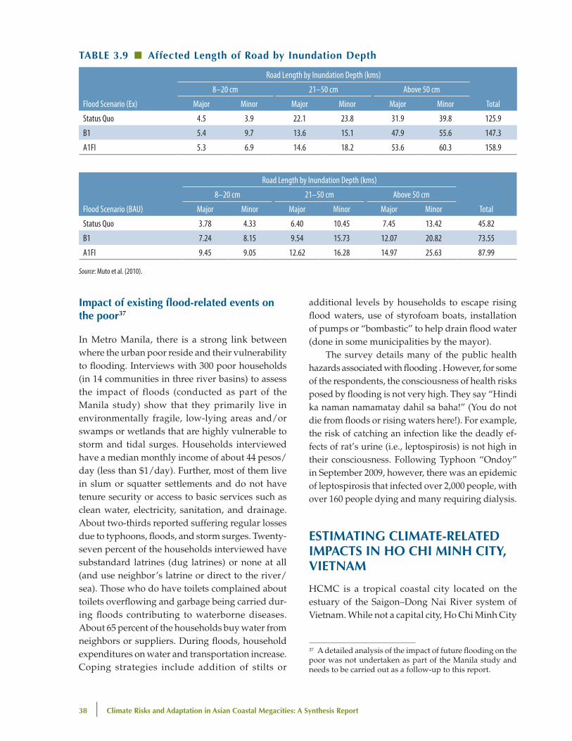
Impact on roads, rail network, power and water supply facilities and transportation
The hydrological analysis shows the length of roads that are likely to be flooded (in terms of depth and duration) under different scenarios. Thus for instance, under both emissions scenarios—A1FI and B1, more roads are flooded under “existing infrastructure scenario” where no additional infra-structural improvements are made, compared to a scenario where there is continued implementation of flood protection infrastructure in 2050 (Table 3.9). As a reference, it is useful to note that a depth of more than 26 cms is considered impassable for most vehicles in Manila.
The hydrological analysis also shows specific locations where the power distribution system in Manila is vulnerable. It notes that the elevated rail system in Manila, although above the flood levels, is vulnerable to loss of power from the power utility Merelco, and that a number of the stations would be inaccessible during extreme floods. The impact of high winds in these situations was not detailed. The consultants held discussions with the water supply providers who indicated that their facilities were not vulnerable to floods.
FIguRe 3.11 ■ Areas at high Risk from Flooding under different Scenarios8070605040302010
0
City
Man
daluy
ong
Man
ila
Mar
ikina
Quez
on
San J
uan
Passa
y
Mak
ati
Pasig
Tagu
ig
Pate
ros
Kaloo
kan
Mala
bon
Navo
tas
Ex–SQ Ex–B1 Ex–A1F1 BAU–SQ BAU–B1 BAU–A1F1
%
Region Pasig – Marikina River Basin West Mangahan Area KAMANAVA Area
Source: Muto et al. (2010).
FIguRe 3.10 ■ Areas of high population density and with high Risk of Inundation under A1FI Scenario
Source: Muto et al. (2010).
38 | Climate Risks and Adaptation in Asian Coastal Megacities: A Synthesis Report
Impact of existing flood-related events on the poor37
In Metro Manila, there is a strong link between where the urban poor reside and their vulnerability to flooding. Interviews with 300 poor households (in 14 communities in three river basins) to assess the impact of floods (conducted as part of the Manila study) show that they primarily live in environmentally fragile, low-lying areas and/or swamps or wetlands that are highly vulnerable to storm and tidal surges. Households interviewed have a median monthly income of about 44 pesos/day (less than $1/day). Further, most of them live in slum or squatter settlements and do not have tenure security or access to basic services such as clean water, electricity, sanitation, and drainage. About two-thirds reported suffering regular losses due to typhoons, floods, and storm surges. Twenty-seven percent of the households interviewed have substandard latrines (dug latrines) or none at all (and use neighbor’s latrine or direct to the river/sea). Those who do have toilets complained about toilets overflowing and garbage being carried dur-ing floods contributing to waterborne diseases. About 65 percent of the households buy water from neighbors or suppliers. During floods, household expenditures on water and transportation increase. Coping strategies include addition of stilts or
additional levels by households to escape rising flood waters, use of styrofoam boats, installation of pumps or “bombastic” to help drain flood water (done in some municipalities by the mayor).
The survey details many of the public health hazards associated with flooding . However, for some of the respondents, the consciousness of health risks posed by flooding is not very high. They say “Hindi ka naman namamatay dahil sa baha!” (You do not die from floods or rising waters here!). For example, the risk of catching an infection like the deadly ef-fects of rat’s urine (i.e., leptospirosis) is not high in their consciousness. Following Typhoon “Ondoy” in September 2009, however, there was an epidemic of leptospirosis that infected over 2,000 people, with over 160 people dying and many requiring dialysis.
eSTIMATIng ClIMATe-RelATed IMpACTS In ho ChI MInh CITy, vIeTnAM
HCMC is a tropical coastal city located on the estuary of the Saigon–Dong Nai River system of Vietnam. While not a capital city, Ho Chi Minh City
TAble 3.9 ■ Affected length of Road by Inundation depth
Flood Scenario (Ex)
Road Length by Inundation Depth (kms)
Total
8–20 cm 21–50 cm Above 50 cm
Major Minor Major Minor Major Minor
Status Quo 4.5 3.9 22.1 23.8 31.9 39.8 125.9
B1 5.4 9.7 13.6 15.1 47.9 55.6 147.3
A1FI 5.3 6.9 14.6 18.2 53.6 60.3 158.9
Flood Scenario (BAU)
Road Length by Inundation Depth (kms)
Total
8–20 cm 21–50 cm Above 50 cm
Major Minor Major Minor Major Minor
Status Quo 3.78 4.33 6.40 10.45 7.45 13.42 45.82
B1 7.24 8.15 9.54 15.73 12.07 20.82 73.55
A1FI 9.45 9.05 12.62 16.28 14.97 25.63 87.99
Source: Muto et al. (2010).
37 A detailed analysis of the impact of future flooding on the poor was not undertaken as part of the Manila study and needs to be carried out as a follow-up to this report.
estimating Flood Impacts and vulnerabilities in Coastal Cities | 39
is also a key economic and financial center and a core part of the Southern Economic Focal region in Vietnam. The city’s official population is estimated to be about 6.4 million people. The actual current population, which includes temporary and unreg-istered migrants, is estimated to be 7–8 million. The population of HCMC has been growing at a rate of 2.4 percent per year, which is a faster rate than anywhere else in the country. The city accounted for over 23 percent of the country’s GDP in 2006 (ADB 2010). Rapid economic growth—11.3 percent annu-ally between 2000 and 2007—has been the central driver behind the city’s expansion, as the increasing number and magnitude of income earning oppor-tunities attract migrants from throughout Vietnam. Key economic growth sectors include industrial and service sectors, which have grown at a rate of 11.9 percent and 11.1 percent annually respectively
between 2000 and 2007. During the same period, ag-riculture and related activities have grown relatively slowly at a rate of 4.8 percent annually (ADB 2010).
nature of poverty in hCMC
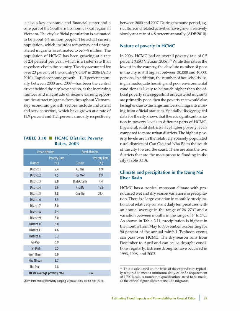
In 2006, HCMC had an overall poverty rate of 0.5 percent (GSO Vietnam 2006).38 While this rate is the lowest in the country, the absolute number of poor in the city is still high at between 30,000 and 40,000 persons. In addition, the number of households liv-ing in inadequate housing and poor environmental conditions is likely to be much higher than the of-ficial poverty rate suggests. If unregistered migrants are primarily poor, then the poverty rate would also be higher due to the large numbers of migrants miss-ing from official statistics. Spatially disaggregated data for the city shows that there is significant varia-tion in poverty levels in different parts of HCMC. In general, rural districts have higher poverty levels compared to more urban districts. The highest pov-erty levels are in the relatively sparsely populated rural districts of Can Gio and Nha Be to the south of the city toward the coast. These are also the two districts that are the most prone to flooding in the city (Table 3.10).
Climate and precipitation in the dong nai River basin
HCMC has a tropical monsoon climate with pro-nounced wet and dry season variations in precipita-tion. There is a large variation in monthly precipita-tion, but relatively constant daily temperatures with an annual average in the range of 26–27oC and a variation between months in the range of 4° to 5oC. As shown in Table 3.11, precipitation is highest in the months from May to November, accounting for 90 percent of the annual rainfall. Typhoon events can pass over HCMC. The dry season runs from December to April and can cause drought condi-tions regularly. Extreme droughts have occurred in 1993, 1998, and 2002.
TAble 3.10 ■ hCMC district poverty Rates, 2003
Urban districts Rural districts
DistrictPoverty Rate
(%) DistrictPoverty Rate
(%)
District 1 2.4 Cu Chi 6.9
District 2 4.5 Hoc Mon 6.9
District 3 2.8 Binh Chanh 4.4
District 4 5.6 Nha Be 12.9
District 5 3.8 Can Gio 23.4
District 6 5.5
District 7 3.0
District 8 7.4
District 9 5.0
District 10 3.0
District 11 4.6
District 12 6.3
Go Vap 6.9
Tan Binh 5.5
Binh Thanh 5.0
Phu Nhuan 3.7
Thu Duc 7.8
HCMC average poverty rate 5.4
Source: Inter-ministerial Poverty Mapping Task Force, 2003, cited in ADB (2010).
38 This is calculated on the basis of the expenditure typical-ly required to meet a minimum daily calorific requirement of 1,700 Kcals. A number of qualifications need to be made, as the official figure does not include migrants.
40 | Climate Risks and Adaptation in Asian Coastal Megacities: A Synthesis Report
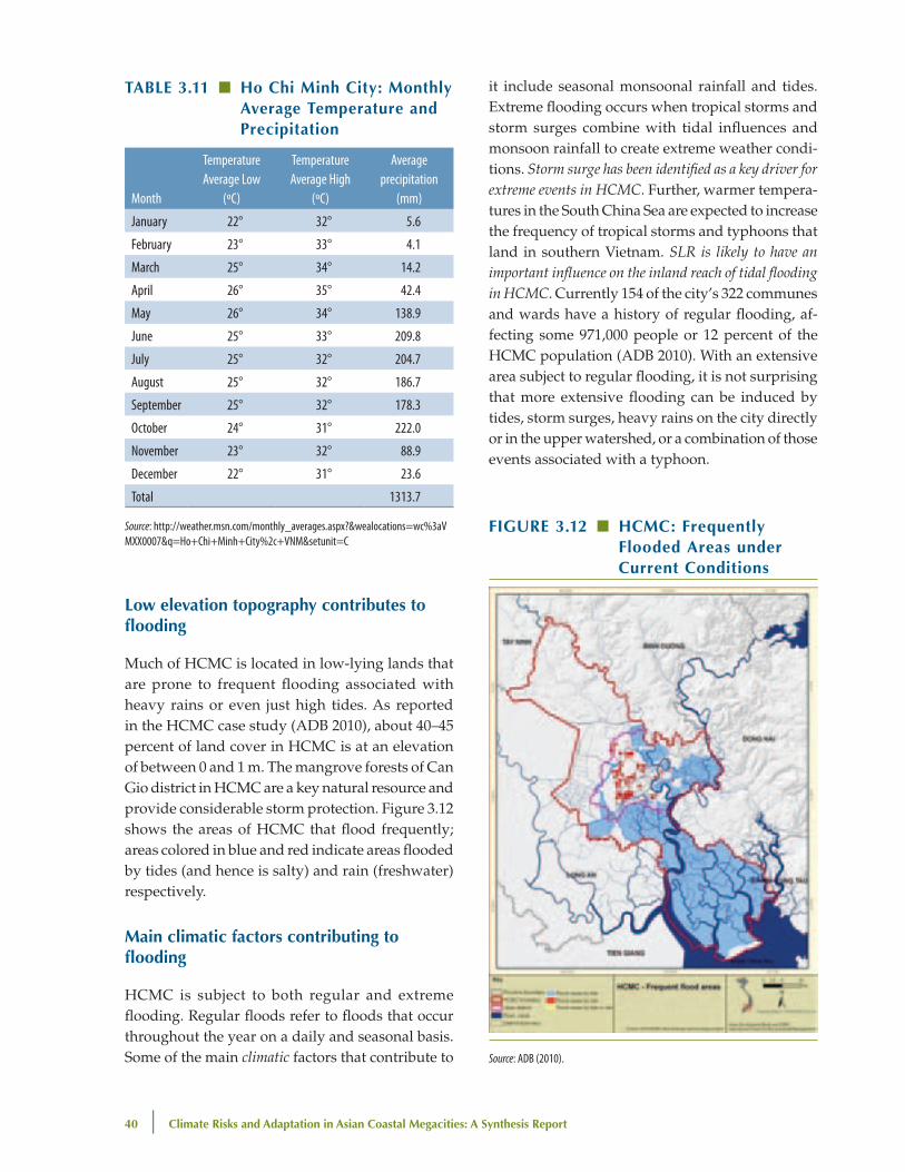
low elevation topography contributes to flooding
Much of HCMC is located in low-lying lands that are prone to frequent flooding associated with heavy rains or even just high tides. As reported in the HCMC case study (ADB 2010), about 40–45 percent of land cover in HCMC is at an elevation of between 0 and 1 m. The mangrove forests of Can Gio district in HCMC are a key natural resource and provide considerable storm protection. Figure 3.12 shows the areas of HCMC that flood frequently; areas colored in blue and red indicate areas flooded by tides (and hence is salty) and rain (freshwater) respectively.
Main climatic factors contributing to flooding
HCMC is subject to both regular and extreme flooding. Regular floods refer to floods that occur throughout the year on a daily and seasonal basis. Some of the main climatic factors that contribute to
it include seasonal monsoonal rainfall and tides. Extreme flooding occurs when tropical storms and storm surges combine with tidal influences and monsoon rainfall to create extreme weather condi-tions. Storm surge has been identified as a key driver for extreme events in HCMC. Further, warmer tempera-tures in the South China Sea are expected to increase the frequency of tropical storms and typhoons that land in southern Vietnam. SLR is likely to have an important influence on the inland reach of tidal flooding in HCMC. Currently 154 of the city’s 322 communes and wards have a history of regular flooding, af-fecting some 971,000 people or 12 percent of the HCMC population (ADB 2010). With an extensive area subject to regular flooding, it is not surprising that more extensive flooding can be induced by tides, storm surges, heavy rains on the city directly or in the upper watershed, or a combination of those events associated with a typhoon.
TAble 3.11 ■ ho Chi Minh City: Monthly Average Temperature and precipitation
Month
Temperature Average Low
(oC)
Temperature Average High
(oC)
Average precipitation
(mm)
January 22° 32° 5.6
February 23° 33° 4.1
March 25° 34° 14.2
April 26° 35° 42.4
May 26° 34° 138.9
June 25° 33° 209.8
July 25° 32° 204.7
August 25° 32° 186.7
September 25° 32° 178.3
October 24° 31° 222.0
November 23° 32° 88.9
December 22° 31° 23.6
Total 1313.7
Source: http://weather.msn.com/monthly_averages.aspx?&wealocations=wc%3aVMXX0007&q=Ho+Chi+Minh+City%2c+VNM&setunit=C
FIguRe 3.12 ■ hCMC: Frequently Flooded Areas under Current Conditions
Source: ADB (2010).
estimating Flood Impacts and vulnerabilities in Coastal Cities | 41
Importance of non-climate-related factors in contributing to flooding
The HCMC study shows that a number of non-climate-related factors also contribute to and exacer-bate the impacts of flooding. This includes domestic solid waste that is often dumped in canals and wa-terways, as well as poor dredging of canals. Canals are often choked with water weeds and garbage, so that in addition to accumulating sediment, their capacity to drain storm waters is severely limited (ADB 2010). Further, land subsidence is also an important problem in HCMC, but was not included in the flood modeling simulations because like Ma-nila, land subsidence data were not reliable. This is an important limitation of this study. The upper watershed of the Saigon River and Dong Nai River, both of which drain HCMC, are well-regulated with dams and reservoirs, including the man-made Dau Tieng Lake and Tri An Lake, which are able to reduce peak flood flows associated with extreme precipita-tion events. Given the intense management of the HCMC upper watershed, upstream rainfall is not
considered to be a major factor affecting flooding in HCMC.39 However, the watershed of the Dong Nai River basin has been subject to considerable deforestation. Deforestation leads to increased run-off, erosion, and sediment release and exacerbates flooding in HCMC; this needs to be addressed.
urban planning and assumptions about the city in the future
As with the other studies, analysis carried out for HCMC built its understanding of the future city on the basis of a vast amount of data relating to current conditions and a number of sectoral and urban development plans and strategies devel-oped by the government about the future (Box 3.3). Briefly, the planning system in HCMC is shaped by several strategic plans, including the urban
box 3.3 ■ hCMC in 2050
Future land use and development projections for HCMC were guided by a number of sectoral and urban development plans and strategies. As per the adjustment plan, the population of HCMC in 2025 is expected to be about 10 million; economic growth in HCMC is expected to increase 8 percent annually in the period from 2026 to 2050 (ADB 2010). Land use for residential purposes is expected to grow by 28 percent and for interior traffic by 215 percent. The vision underlying the adjustment plan includes distributing a population of about 10 million in several satellite cities. It assumes growth in both the industrial and service sectors until 2020. In accordance with this vision, a substantial amount of land in HCMC is being reallocated for industrial purposes. An industrial master plan prepared by the Ministry of Industry estimates this to be around 11,000 ha by 2025. While the adjustment plan recognizes the importance of green space, it also estimates that open areas will decline by about 25 percent. The adjustment plan refers to climate change but does not address measures needed for adaptation.
Population projections for 2050 were developed by the study team based on government data and Master Plan. This resulted in two population estimates, one low estimate of 12 million people, and a high estimate of 20.8 million people by 2050. The high population estimate is likely to be more realistic. Future population distributions were also estimated based on current patterns and trends and are expected to be influenced by the hollowing out of the city center, higher growth and increased population densities in peripheral areas, and the development of satellite cities. In 2006, HCMC had an overall poverty rate of 0.5 percent. While this rate is the lowest in the country, the absolute number of poor in the city is still high, at between 30,000 and 40,000 people. The HCMC poverty rate was projected to remain significant as climate change impacts take hold.
Rapid economic growth (11.3 percent between 2000 and 2007) has been the central driver behind the city’s expansion, as the increasing number and magnitude of income earning opportunities attract migrants from throughout Vietnam. The HCMC study bases its GRDP numbers on an “Adjustment Plan” developed by the government. The master plan, which was developed for 2025, contained projections to 2050 for GDP. Accordingly, economic growth in HCMC is expected to be 8.7 percent between 2011 and 2025, and 8 percent between 2026 and 2050. Industrial zones and export promotion zones are expected to increase and the service sector, including financial and tourism services, is expected to grow rapidly.
Source: ADB (2010).
39 The Dong Nai and Saigon rivers are heavily regulated by hydropower and irrigation dams. They are the main source of energy and water supply for HCMC. However, climate change has not been factored into their construction or op-eration.

42 | Climate Risks and Adaptation in Asian Coastal Megacities: A Synthesis Report
master plan prepared by the Department of Plan-ning and Architecture, the land use plan prepared by DoNRE, and the socioeconomic development plan prepared by the Department of Planning and Investment. These are prepared by different agencies under different time scales with little coordination between them, thus posing a difficult problem in estimating future infrastructure and urbanization scenarios. In terms of a development scenario for 2050, HCMC has an urban master plan that was approved in 1998. In 2007, a study was completed to adjust the HCMC master plan up to 2025 (commonly referred to as the Adjustment Plan).40 The city case study used the Adjustment Plan as the basis of the most likely development scenario for 2050 (ADB 2010).
In terms of land use, key trends include a declin-ing population in central HCMC; doughnut-shaped urbanization, with higher population growth within 10 kms from the center of the city; and industries be-ing relocated and established in industrial zones. Ag-riculture and forest land (primarily made up by the Can Gio biosphere reserve) situated in the rural and suburban areas, has declined from 64 percent in 1997 to 59 percent in 2006. According to DONRE’s land use plans, open space is expected to decline by 25 percent by 2020 (ADB 2010). Rivers and canals cover close to 15 percent of the total land use, reflecting the
box 3.4 ■ overview of downscaling and hydrological Analysis Carried out for hCMC Study
Low-resolution outputs (~2o) from ECHAM’s (European Centre for Medium Range Weather Forecast-University of Hamburg) atmosphere-ocean-coupled global circulation model (GCM) Version 4 were downscaled by PRECIS (Providing Regional Climates for Impacts Studies, and a dynamic modeling tool developed by the UK Met Office Hadley Centre for Climate Prediction and Research, precis.metoffice.com). Two IPCC SRES greenhouse gas emission scenarios were used as inputs to the GCM. SRES A2 is a high-emission scenario, while B2 represents the low-emission world.
ECHAM is considered a “moderate” GCM in that it does not give any extreme temperature or precipitation projections, but tends to be in the middle ranges. However, other GCM’s are also available and need to be included in subsequent studies. PRECIS was used because it is the regional modeling tool that has been most widely used globally, as well as being the tool that the UNDP National Communication Support Unit recommends for countries receiving GEF funding.
PRECIS gridded outputs at resolution 0.22o (~25km) for the Sai Gon-Dong Nai Basin were provided by SEA START RC. Daily outputs for maximum/minimum temperature and rainfall for the baseline decade (1994–2003) and a future decade (2050–59), which represent the year 2050, were taken as a key input for the hydrodynamic model—HydroGIS—to calculate the water and flood regime of Ho Chi Minh City. PRECIS gave the total and seasonal rainfall anomalies that are comparable, though with a slightly wider range than the JBIC/IR3S ensemble, which was used by the other city studies in this collaborative initiative (see table below). By using PRECIS, the daily outputs as well as spatial distribution of climate variables were also obtained to get more in-depth information on temporal and geographic variables for the study area.
The table below provides a comparison of 10 years averaged June-July-August rainfall from PRECIS and the IR3S rainfall ensemble for Ho Chi Minh City for the year 2050 (%change relative to baseline)
Monsoon-driven seasonal rainfall years with maximum and mini-mum annual rainfall for each decade were selected to represent “wet” and “dry” years of the baseline and future A2 and B2 decades.
Event-based rainfall extremes for the baseline and future time slices were derived from the 1-, 3-, 5-, and 7-day maximum rainfall from PRECIS over the HCMC urban area. Extreme rainfalls of 30- and 100-year return periods were extrapolated from the log-log (power) regression
between the frequency of occurrence (years) and amount of each rainfall extreme. The 30-year and 100-year extremes and 1-, 3-, 5-, and 7-day rainfall data were rescaled to the observed extreme rainfalls at Tan Song Nhat Airport. The scaling factors for each extreme period were used for scaling the respective future extreme rainfall.
Source: Adapted from ADB (2010).
GHG Emission Scenarios PRECIS IR3S
High +7.5 (A2) +4.4 (A1FI)
Low +1.5 (B2) +2.9 (B1)
40 Even though it is in the process of being formally ap-proved by the government, in the interim, it is the recog-nized update for the 1998 Master Plan.

estimating Flood Impacts and vulnerabilities in Coastal Cities | 43
original swamp land on which the city was settled. Roads and other transport facilities occupy around 3 percent; land for industry and commerce is expand-ing rapidly and now represents about 5 percent of the city’s land use. There are 90 parks in HCMC. In addition to the urban master plan and the HCMC land use plans, the department of transportation has prepared a transport master plan for HCMC until 2020, which has been used for modeling impacts of climate change on the transport sector (ADB 2010). HCMC also has a power development plan and a health sector master plan, both to 2020. Similarly, a water supply master plan until 2025 is currently under preparation (ADB 2010) and has been used to model impacts on the water sector in 2050.
Flood protection infrastructures assumed for the hydrological analysis
HCMC has a planned flood protection dyke and sluice system to protect much of the city from flood-ing with an estimated cost of $650 million. This is to be implemented in phases, which will allow lessons learned during implementation to be applied to the later stages. The 2050 modeling has developed sce-narios assuming implementation and no implemen-tation of the proposed flood protection measures.
dynamic downscaling technique applied to model 2050 climate change
The HCMC study used the SRES A2 and B2 scenarios as the enveloping case for high and low projections. Further, unlike the other cities in the study, which used statistical downscaling, the HCMC case study used both statistical downscaling and also a PRECIS dynamic downscaling technique to model future climate change parameters (Box 3.4). The dynamic downscaling approach allowed the study to address the complex hydrometeorological and oceanograph-ic changes. Specifically, PRECIS allowed simulation of mean (minimum and maximum temperatures) for the base case and A2 and B2 scenarios, simula-tion of daily rainfall data in the base year (averaged over 1994–2003) and for 2050 (based on average of 2050–59). Based on this, the percent increase in rainfall in terms of average increase and increase for extreme events (1-in-30 year, 1-in-100 year, etc.) was
calculated. Thus, it was estimated that future extreme rainfall under the high emissions scenario will increase by more than 20 percent for a 1-in-30-year flood and by 30 percent for a 1-in-100-year flood. This information was then used as input into the hydrological modeling.
Inputs and outputs for the hydrological modeling
The main drivers of the water regime in the HCMC include the following: seasonal monsoon-driven rainfall, extreme rainfall due to typhoons and tropi-cal storms in the vicinity of the city, local SLR, storm surge, upstream-downstream inflow as a function of catchment basin hydrology, and various land uses such as water management infrastructure, hydrolog-ic/hydrodynamic conductivity, and water demand by sectors and geographic locations. Some of these are related to regional climate change and are more a function of land use and development. For instance, “over 75 percent of flooding points in HCMC have occurred following rainfall of 40mm even during ebb tide,” which indicates that surcharge from storm drains is a major factor contributing to flooding. For the hydrological simulations, it was assumed that the population and land use in 2050 were the same as the base year (see HCMC annex). For the HCMC study, a hydrodynamic modeling tool—Hydro-GIS—was used to integrate information about these drivers and derive output variables (such as flood depth, duration, salinity distribution, etc) for an assessment of risks and impacts in 2050.
estimates for sea level rise and storm surge
In addition to using dynamic downscaling to esti-mate precipitation changes, the study used the DIVA (Dynamic Interactive Vulnerability Assessment) tool developed by the DINAS-COAST consortium.41 The results from that tool yielded SLR of 0.26 m and 0.24 m
41 In DINAS-COAST, the DIVA method was applied to produce a software tool that enables its users to produce quantitative information on a range of coastal vulnerabil-ity indicators, for user-selected climatic and socioeconomic scenarios and adaptation policies, on national, regional and global scales, covering all coastal nations. http://www.pik-potsdam.de/research/research-domains/transdisciplinary-concepts-and-methods/project-archive/favaia/diva
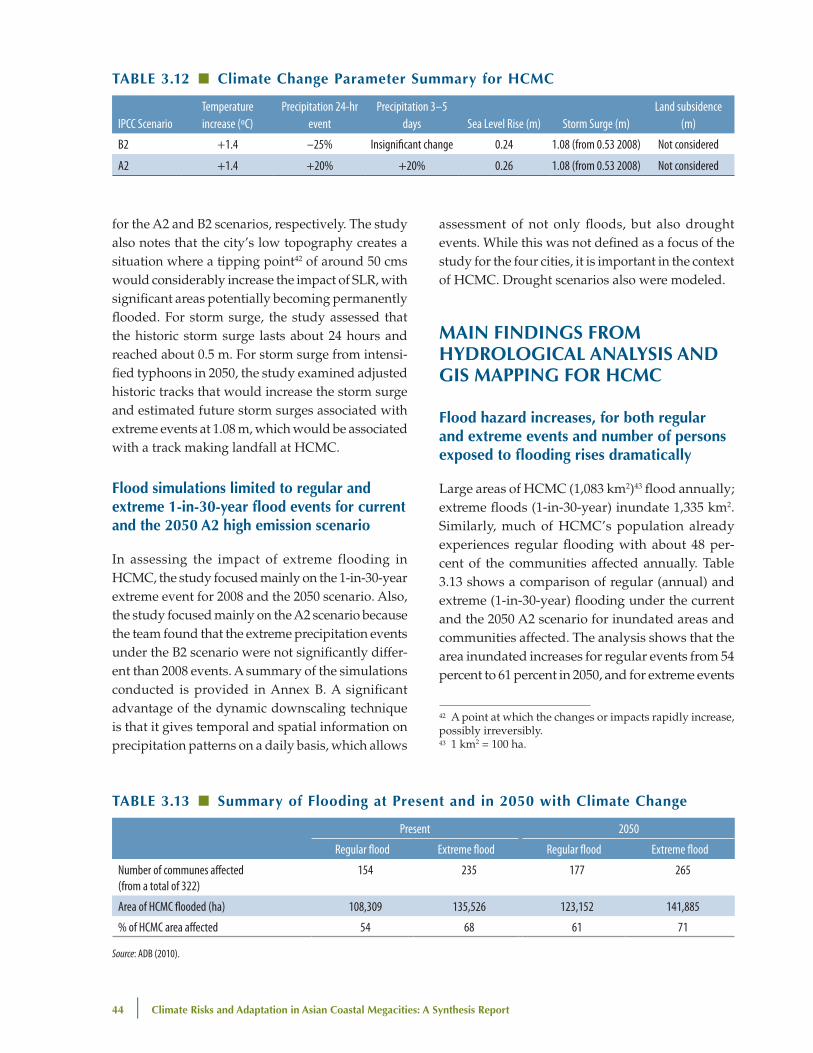
44 | Climate Risks and Adaptation in Asian Coastal Megacities: A Synthesis Report
for the A2 and B2 scenarios, respectively. The study also notes that the city’s low topography creates a situation where a tipping point42 of around 50 cms would considerably increase the impact of SLR, with significant areas potentially becoming permanently flooded. For storm surge, the study assessed that the historic storm surge lasts about 24 hours and reached about 0.5 m. For storm surge from intensi-fied typhoons in 2050, the study examined adjusted historic tracks that would increase the storm surge and estimated future storm surges associated with extreme events at 1.08 m, which would be associated with a track making landfall at HCMC.
Flood simulations limited to regular and extreme 1-in-30-year flood events for current and the 2050 A2 high emission scenario
In assessing the impact of extreme flooding in HCMC, the study focused mainly on the 1-in-30-year extreme event for 2008 and the 2050 scenario. Also, the study focused mainly on the A2 scenario because the team found that the extreme precipitation events under the B2 scenario were not significantly differ-ent than 2008 events. A summary of the simulations conducted is provided in Annex B. A significant advantage of the dynamic downscaling technique is that it gives temporal and spatial information on precipitation patterns on a daily basis, which allows
assessment of not only floods, but also drought events. While this was not defined as a focus of the study for the four cities, it is important in the context of HCMC. Drought scenarios also were modeled.
MAIn FIndIngS FRoM hydRologICAl AnAlySIS And gIS MAppIng FoR hCMC
Flood hazard increases, for both regular and extreme events and number of persons exposed to flooding rises dramatically
Large areas of HCMC (1,083 km2)43 flood annually; extreme floods (1-in-30-year) inundate 1,335 km2. Similarly, much of HCMC’s population already experiences regular flooding with about 48 per-cent of the communities affected annually. Table 3.13 shows a comparison of regular (annual) and extreme (1-in-30-year) flooding under the current and the 2050 A2 scenario for inundated areas and communities affected. The analysis shows that the area inundated increases for regular events from 54 percent to 61 percent in 2050, and for extreme events
TAble 3.12 ■ Climate Change parameter Summary for hCMC
IPCC ScenarioTemperature increase (oC)
Precipitation 24-hr event
Precipitation 3–5 days Sea Level Rise (m) Storm Surge (m)
Land subsidence (m)
B2 +1.4 –25% Insignificant change 0.24 1.08 (from 0.53 2008) Not considered
A2 +1.4 +20% +20% 0.26 1.08 (from 0.53 2008) Not considered
TAble 3.13 ■ Summary of Flooding at present and in 2050 with Climate Change
Present 2050
Regular flood Extreme flood Regular flood Extreme flood
Number of communes affected (from a total of 322)
154 235 177 265
Area of HCMC flooded (ha) 108,309 135,526 123,152 141,885
% of HCMC area affected 54 68 61 71
Source: ADB (2010).
42 A point at which the changes or impacts rapidly increase, possibly irreversibly.43 1 km2 = 100 ha.
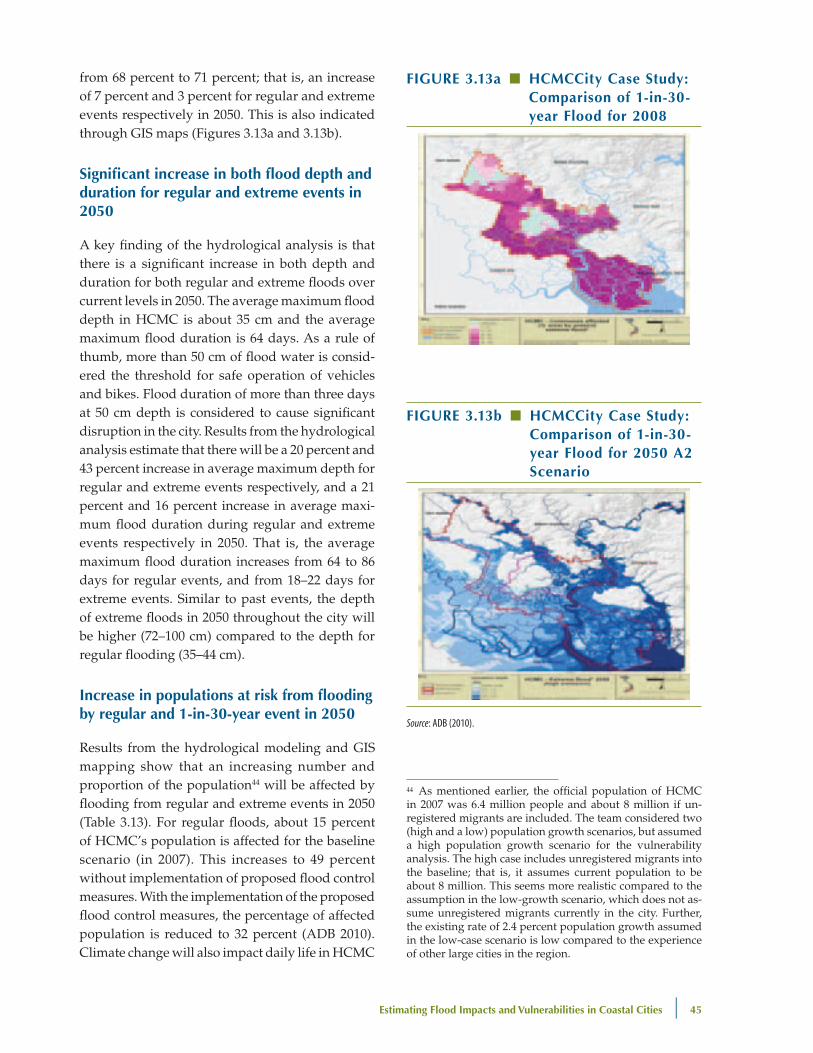
estimating Flood Impacts and vulnerabilities in Coastal Cities | 45
from 68 percent to 71 percent; that is, an increase of 7 percent and 3 percent for regular and extreme events respectively in 2050. This is also indicated through GIS maps (Figures 3.13a and 3.13b).
Significant increase in both flood depth and duration for regular and extreme events in 2050
A key finding of the hydrological analysis is that there is a significant increase in both depth and duration for both regular and extreme floods over current levels in 2050. The average maximum flood depth in HCMC is about 35 cm and the average maximum flood duration is 64 days. As a rule of thumb, more than 50 cm of flood water is consid-ered the threshold for safe operation of vehicles and bikes. Flood duration of more than three days at 50 cm depth is considered to cause significant disruption in the city. Results from the hydrological analysis estimate that there will be a 20 percent and 43 percent increase in average maximum depth for regular and extreme events respectively, and a 21 percent and 16 percent increase in average maxi-mum flood duration during regular and extreme events respectively in 2050. That is, the average maximum flood duration increases from 64 to 86 days for regular events, and from 18–22 days for extreme events. Similar to past events, the depth of extreme floods in 2050 throughout the city will be higher (72–100 cm) compared to the depth for regular flooding (35–44 cm).
Increase in populations at risk from flooding by regular and 1-in-30-year event in 2050
Results from the hydrological modeling and GIS mapping show that an increasing number and proportion of the population44 will be affected by flooding from regular and extreme events in 2050 (Table 3.13). For regular floods, about 15 percent of HCMC’s population is affected for the baseline scenario (in 2007). This increases to 49 percent without implementation of proposed flood control measures. With the implementation of the proposed flood control measures, the percentage of affected population is reduced to 32 percent (ADB 2010). Climate change will also impact daily life in HCMC
44 As mentioned earlier, the official population of HCMC in 2007 was 6.4 million people and about 8 million if un-registered migrants are included. The team considered two (high and a low) population growth scenarios, but assumed a high population growth scenario for the vulnerability analysis. The high case includes unregistered migrants into the baseline; that is, it assumes current population to be about 8 million. This seems more realistic compared to the assumption in the low-growth scenario, which does not as-sume unregistered migrants currently in the city. Further, the existing rate of 2.4 percent population growth assumed in the low-case scenario is low compared to the experience of other large cities in the region.
FIguRe 3.13a ■ hCMCCity Case Study: Comparison of 1-in-30-year Flood for 2008
FIguRe 3.13b ■ hCMCCity Case Study: Comparison of 1-in-30-year Flood for 2050 A2 Scenario
Source: ADB (2010).
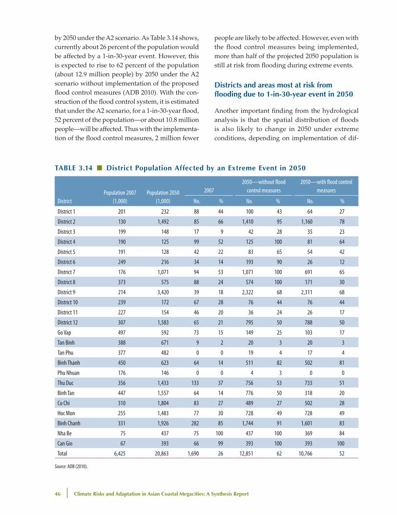
46 | Climate Risks and Adaptation in Asian Coastal Megacities: A Synthesis Report
by 2050 under the A2 scenario. As Table 3.14 shows, currently about 26 percent of the population would be affected by a 1-in-30-year event. However, this is expected to rise to 62 percent of the population (about 12.9 million people) by 2050 under the A2 scenario without implementation of the proposed flood control measures (ADB 2010). With the con-struction of the flood control system, it is estimated that under the A2 scenario, for a 1-in-30-year flood, 52 percent of the population—or about 10.8 million people—will be affected. Thus with the implementa-tion of the flood control measures, 2 million fewer
people are likely to be affected. However, even with the flood control measures being implemented, more than half of the projected 2050 population is still at risk from flooding during extreme events.
districts and areas most at risk from flooding due to 1-in-30-year event in 2050
Another important finding from the hydrological analysis is that the spatial distribution of floods is also likely to change in 2050 under extreme conditions, depending on implementation of dif-
TAble 3.14 ■ district population Affected by an extreme event in 2050
DistrictPopulation 2007
(1,000)Population 2050
(1,000)
20072050—without flood
control measures2050—with flood control
measures
No. % No. % No. %
District 1 201 232 88 44 100 43 64 27
District 2 130 1,492 85 66 1,410 95 1,160 78
District 3 199 148 17 9 42 28 35 23
District 4 190 125 99 52 125 100 81 64
District 5 191 128 42 22 83 65 54 42
District 6 249 216 34 14 193 90 26 12
District 7 176 1,071 94 53 1,071 100 691 65
District 8 373 575 88 24 574 100 171 30
District 9 214 3,420 39 18 2,322 68 2,311 68
District 10 239 172 67 28 76 44 76 44
District 11 227 154 46 20 36 24 26 17
District 12 307 1,583 65 21 795 50 788 50
Go Vap 497 592 73 15 149 25 103 17
Tan Binh 388 671 9 2 20 3 20 3
Tan Phu 377 482 0 0 19 4 17 4
Binh Thanh 450 623 64 14 511 82 502 81
Phu Nhuan 176 146 0 0 4 3 0 0
Thu Duc 356 1,433 133 37 756 53 733 51
Binh Tan 447 1,557 64 14 776 50 318 20
Cu Chi 310 1,804 83 27 489 27 502 28
Hoc Mon 255 1,483 77 30 728 49 728 49
Binh Chanh 331 1,926 282 85 1,744 91 1,601 83
Nha Be 75 437 75 100 437 100 369 84
Can Gio 67 393 66 99 393 100 393 100
Total 6,425 20,863 1,690 26 12,851 62 10,766 52
Source: ADB (2010).
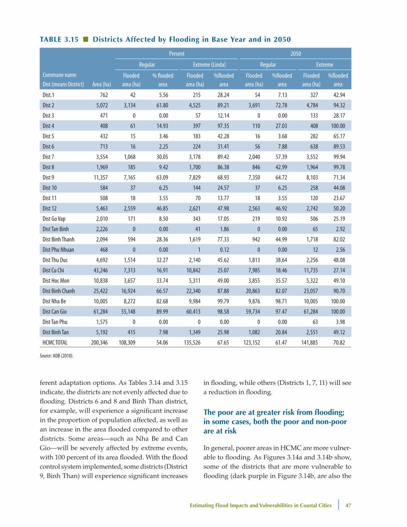
estimating Flood Impacts and vulnerabilities in Coastal Cities | 47
ferent adaptation options. As Tables 3.14 and 3.15 indicate, the districts are not evenly affected due to flooding. Districts 6 and 8 and Binh Than district, for example, will experience a significant increase in the proportion of population affected, as well as an increase in the area flooded compared to other districts. Some areas—such as Nha Be and Can Gio—will be severely affected by extreme events, with 100 percent of its area flooded. With the flood control system implemented, some districts (District 9, Binh Than) will experience significant increases
in flooding, while others (Districts 1, 7, 11) will see a reduction in flooding.
The poor are at greater risk from flooding; in some cases, both the poor and non-poor are at risk
In general, poorer areas in HCMC are more vulner-able to flooding. As Figures 3.14a and 3.14b show, some of the districts that are more vulnerable to flooding (dark purple in Figure 3.14b, are also the
TAble 3.15 ■ districts Affected by Flooding in base year and in 2050
Commune nameDist (means District) Area (ha)
Present 2050
Regular Extreme (Linda) Regular Extreme
Flooded area (ha)
% flooded area
Flooded area (ha)
%flooded area
Flooded area (ha)
%flooded area
Flooded area (ha)
%flooded area
Dist.1 762 42 5.56 215 28.24 54 7.13 327 42.94
Dist 2 5,072 3,134 61.80 4,525 89.21 3,691 72.78 4,784 94.32
Dist 3 471 0 0.00 57 12.14 0 0.00 133 28.17
Dist 4 408 61 14.93 397 97.35 110 27.03 408 100.00
Dist 5 432 15 3.46 183 42.28 16 3.68 282 65.17
Dist 6 713 16 2.25 224 31.41 56 7.88 638 89.53
Dist 7 3,554 1,068 30.05 3,178 89.42 2,040 57.39 3,552 99.94
Dist 8 1,969 185 9.42 1,700 86.38 846 42.99 1,964 99.78
Dist 9 11,357 7,165 63.09 7,829 68.93 7,350 64.72 8,103 71.34
Dist 10 584 37 6.25 144 24.57 37 6.25 258 44.08
Dist 11 508 18 3.55 70 13.77 18 3.55 120 23.67
Dist 12 5,463 2,559 46.85 2,621 47.98 2,563 46.92 2,742 50.20
Dist Go Vap 2,010 171 8.50 343 17.05 219 10.92 506 25.19
Dist Tan Binh 2,226 0 0.00 41 1.86 0 0.00 65 2.92
Dist Binh Thanh 2,094 594 28.36 1,619 77.33 942 44.99 1,718 82.02
Dist Phu Nhuan 468 0 0.00 1 0.12 0 0.00 12 2.56
Dist Thu Duc 4,692 1,514 32.27 2,140 45.62 1,813 38.64 2,256 48.08
Dist Cu Chi 43,246 7,313 16.91 10,842 25.07 7,985 18.46 11,735 27.14
Dist Hoc Mon 10,838 3,657 33.74 5,311 49.00 3,855 35.57 5,322 49.10
Dist Binh Chanh 25,422 16,924 66.57 22,340 87.88 20,863 82.07 23,057 90.70
Dist Nha Be 10,005 8,272 82.68 9,984 99.79 9,876 98.71 10,005 100.00
Dist Can Gio 61,284 55,148 89.99 60,413 98.58 59,734 97.47 61,284 100.00
Dist Tan Phu 1,575 0 0.00 0 0.00 0 0.00 63 3.98
Dist Binh Tan 5,192 415 7.98 1,349 25.98 1,082 20.84 2,551 49.12
HCMC TOTAL 200,346 108,309 54.06 135,526 67.65 123,152 61.47 141,885 70.82
Source: ADB (2010).
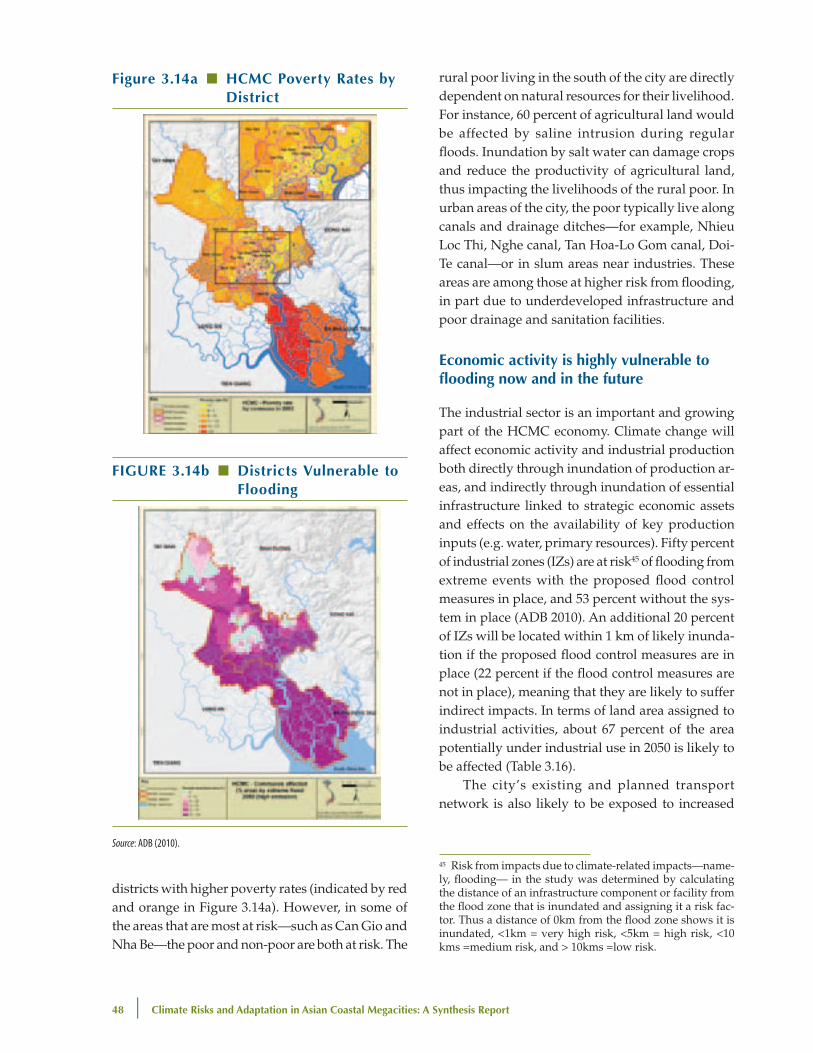
48 | Climate Risks and Adaptation in Asian Coastal Megacities: A Synthesis Report
rural poor living in the south of the city are directly dependent on natural resources for their livelihood. For instance, 60 percent of agricultural land would be affected by saline intrusion during regular floods. Inundation by salt water can damage crops and reduce the productivity of agricultural land, thus impacting the livelihoods of the rural poor. In urban areas of the city, the poor typically live along canals and drainage ditches—for example, Nhieu Loc Thi, Nghe canal, Tan Hoa-Lo Gom canal, Doi-Te canal—or in slum areas near industries. These areas are among those at higher risk from flooding, in part due to underdeveloped infrastructure and poor drainage and sanitation facilities.
economic activity is highly vulnerable to flooding now and in the future
The industrial sector is an important and growing part of the HCMC economy. Climate change will affect economic activity and industrial production both directly through inundation of production ar-eas, and indirectly through inundation of essential infrastructure linked to strategic economic assets and effects on the availability of key production inputs (e.g. water, primary resources). Fifty percent of industrial zones (IZs) are at risk45 of flooding from extreme events with the proposed flood control measures in place, and 53 percent without the sys-tem in place (ADB 2010). An additional 20 percent of IZs will be located within 1 km of likely inunda-tion if the proposed flood control measures are in place (22 percent if the flood control measures are not in place), meaning that they are likely to suffer indirect impacts. In terms of land area assigned to industrial activities, about 67 percent of the area potentially under industrial use in 2050 is likely to be affected (Table 3.16).
The city’s existing and planned transport network is also likely to be exposed to increased
45 Risk from impacts due to climate-related impacts—name-ly, flooding— in the study was determined by calculating the distance of an infrastructure component or facility from the flood zone that is inundated and assigning it a risk fac-tor. Thus a distance of 0km from the flood zone shows it is inundated, <1km = very high risk, <5km = high risk, <10 kms =medium risk, and > 10kms =low risk.
Figure 3.14a ■ hCMC poverty Rates by district
FIguRe 3.14b ■ districts vulnerable to Flooding
Source: ADB (2010).
districts with higher poverty rates (indicated by red and orange in Figure 3.14a). However, in some of the areas that are most at risk—such as Can Gio and Nha Be—the poor and non-poor are both at risk. The
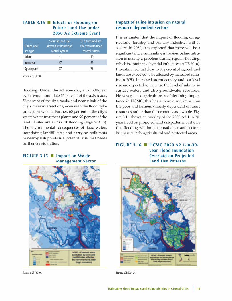
estimating Flood Impacts and vulnerabilities in Coastal Cities | 49
flooding. Under the A2 scenario, a 1-in-30-year event would inundate 76 percent of the axis roads, 58 percent of the ring roads, and nearly half of the city’s main intersections, even with the flood dyke protection system. Further, 60 percent of the city’s waste water treatment plants and 90 percent of the landfill sites are at risk of flooding (Figure 3.15). The environmental consequences of flood waters inundating landfill sites and carrying pollutants to nearby fish ponds is a potential risk that needs further consideration.
Impact of saline intrusion on natural resource dependent sectors
It is estimated that the impact of flooding on ag-riculture, forestry, and primary industries will be severe. In 2050, it is expected that there will be a significant increase in saline intrusion. Saline intru-sion is mainly a problem during regular flooding, which is dominated by tidal influences (ADB 2010). It is estimated that close to 60 percent of agricultural lands are expected to be affected by increased salin-ity in 2050. Increased storm activity and sea level rise are expected to increase the level of salinity in surface waters and also groundwater resources. However, since agriculture is of declining impor-tance in HCMC, this has a more direct impact on the poor and farmers directly dependent on these resources rather than the economy as a whole. Fig-ure 3.16 shows an overlay of the 2050 A2 1-in-30-year flood on projected land use patterns. It shows that flooding will impact broad areas and sectors, but particularly agricultural and protected areas.
FIguRe 3.15 ■ Impact on waste Management Sector
Source: ADB (2010).
FIguRe 3.16 ■ hCMC 2050 A2 1-in-30-year Flood Inundation overlaid on projected land use patterns
Source: ADB (2010).
TAble 3.16 ■ effects of Flooding on Future land use under 2050 A2 extreme event
Future land use type
% future land use affected without flood
control system
% future land use affected with flood
control system
Urban 61 49
Industrial 67 63
Open space 77 76
Source: ADB (2010).
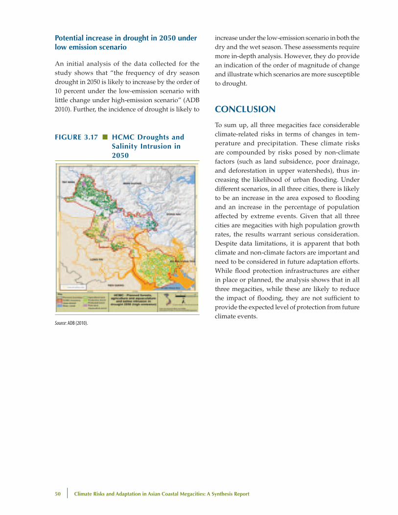
50 | Climate Risks and Adaptation in Asian Coastal Megacities: A Synthesis Report
potential increase in drought in 2050 under low emission scenario
An initial analysis of the data collected for the study shows that “the frequency of dry season drought in 2050 is likely to increase by the order of 10 percent under the low-emission scenario with little change under high-emission scenario” (ADB 2010). Further, the incidence of drought is likely to
increase under the low-emission scenario in both the dry and the wet season. These assessments require more in-depth analysis. However, they do provide an indication of the order of magnitude of change and illustrate which scenarios are more susceptible to drought.
ConCluSIon
To sum up, all three megacities face considerable climate-related risks in terms of changes in tem-perature and precipitation. These climate risks are compounded by risks posed by non-climate factors (such as land subsidence, poor drainage, and deforestation in upper watersheds), thus in-creasing the likelihood of urban flooding. Under different scenarios, in all three cities, there is likely to be an increase in the area exposed to flooding and an increase in the percentage of population affected by extreme events. Given that all three cities are megacities with high population growth rates, the results warrant serious consideration. Despite data limitations, it is apparent that both climate and non-climate factors are important and need to be considered in future adaptation efforts. While flood protection infrastructures are either in place or planned, the analysis shows that in all three megacities, while these are likely to reduce the impact of flooding, they are not sufficient to provide the expected level of protection from future climate events.
FIguRe 3.17 ■ hCMC droughts and Salinity Intrusion in 2050
Source: ADB (2010).