estimating deforestation and forest degradation in … · 2013-10-30 · estimating deforestation...

1
Estimating Estimating deforestation and deforestation and forest forest degradation in Sri Lanka degradation in Sri Lanka Eskil Mattsson 1 , Madelene Ostwald 2 , S.P Nissanka 3 1 Earth Sciences Centre, University of Gothenburg, Guldhedsgatan 5A, 413 20 Göteborg, Sweden, 2 Centre for Climate Science and Policy Research, Linköping University, 601 74 Norrköping, Sweden, 3 Department of Crop Science, Faculty of Agriculture, University of Peradeniya, Sri Lanka. Background Optical remote sensing is used in an integrated assessment of feasibility of estimating historic carbon in forest ecosystems on Sri Lanka. This project is closely linked to the ongoing mitigation option suggested as Reducing Emissions from Deforestation in Developing Countries - REDD. This is at present one of the most central issues within the international climate change negotiations within the United Nations Framework Convention on Climate Change (UNFCCC) due to the fact that tropical deforestation accounts for 18-25 % of global greenhouse gas emissions. Pilot projects as in this case, are crucial for supporting decision making procedures since many developing countries (including Sri Lanka) still lack updated information that explicitly assess carbon content in forests. Aims & Objectives • Test the feasibility of measuring changes in forest area and hence carbon content with optical sensor products (Landsat, SPOT, ASTER) and forest inventory data on a national scale in Sri Lanka. Wall-to-wall mapping will be tested as well as a sampling approach within forests to retrieve data on past land-use and changes from 1990 to 2005. By selecting areas of particular interest e.g. with dubious interpretation outcome, hot spots will be selected for field work (fig. 1) where additional information will be collected from local statistics and Participatory Rural Appraisal (PRA) techniques. • Apply findings and their feasibility by following the international climate change negotiations regarding REDD. Methods & Data Several methods will be explored for image processing and interpretation such as wall-to-wall assessment and sampling approach. Correlation analysis between RS data and forest data and empirical data from several test sites will be done. Ground truthing assessments at selected hot spots will be carried out to improve correlation and accuracy. Ground truthing will include forest inventory sampling in-situ through the quadrate method by measuring e.g. tree diameter and height in selected sample plots in different forest areas. Datasets will be used to calculate forest area change, biomass storage and also carbon accounting (fig 2). Preliminary results By analyzing nine Landsat TM/ETM+ data images initial results demonstrate that northern and southern districts of Sri Lanka show forest cover reduction from 1992 to 2001 whereas districts located in the central mountainous region show an increase in forest cover, hence a likely increase of carbon content (fig 2). The decrease in forest cover is believed to be a consequence of the ongoing conflict in the country whereas the increase in forest cover is supposed to stem from national policies supporting island-wide agriculture and power production. Validation between remote sensing data, forest data and empirical data from several test sites will be carried out in autumn 2008. Visual interpretation of the result will be carried out in collaboration with Sri Lankan colleagues, whom are familiar with the region which will increase the accuracy of the interpretation. Persistent cloud cover also necessitates to analyze supplementary images from other sensors and dates over the same area. Expected outcome Pilot projects, in this case feasibility assessments of the issue regarding reducing emissions from deforestation in developing countries (REDD) and its potential future mechanism, are crucial for supporting decision- making procedures. These types of projects will provide experience to the ongoing UNFCCC negotiation process, where the REDD input up until the party meeting in Copenhagen 2009 will be crucial for a potential future climate protocol. These assessments can contribute scientifically with analysis regarding the development of general carbon inventory methods using remote sensing, testing and tuning baseline and degradation definitions and methods and integrated assessments which are very much needed for the development of Land Use, Land-Use Change and Forestry (LULUCF) related projects for carbon trading. This study will also improve Sri Lanka’s capability to further establish a potential REDD monitoring system, an approach that may be transferred to other countries as well. Acknowledgements & Contact This project is funded by the Swedish Energy Agency. The author acknowledge Global Land Cover Facility (www.landcover.org) for providing satellite images. For further information, please contact Eskil Mattsson, PhD Student, University of Gothenburg. E-mail: [email protected] . Website: www.gvc2.gu.se/lulucf . Phone: +46 (0) 31 786 28 28 1992 2001 1992 2001 Figure 2. Flowchart describing the methodological procedure of the remote sensing and validation process. Figure 3. Forest area 1992 compared to 2001 in two selected plots in the northern respectively southern mountainous part of Sri Lanka. Figure 1. We will prove the correctness of modelling and remote sensing estimates by integrating extensive field sampling in different forest ecosystems.

Upload: tranthien

Post on 16-Sep-2018

217 views

Category:

Documents


0 download

TRANSCRIPT

EstimatingEstimating deforestation and deforestation and forestforest degradation in Sri Lanka degradation in Sri Lanka

Eskil Mattsson1, Madelene Ostwald2, S.P Nissanka3

1 Earth Sciences Centre, University of Gothenburg, Guldhedsgatan 5A, 413 20 Göteborg, Sweden, 2 Centre for Climate Science and Policy Research, Linköping University, 601 74 Norrköping, Sweden, 3 Department of Crop Science, Faculty of Agriculture, University of Peradeniya, Sri Lanka.

BackgroundOptical remote sensing is used in an integrated assessment of feasibility of estimating historic carbon in forest ecosystems on Sri Lanka. This project is closely linked to the ongoing mitigation option suggested as Reducing Emissions from Deforestation in DevelopingCountries - REDD. This is at present one of the most central issues within the international climate change negotiations within the United Nations Framework Convention on Climate Change (UNFCCC) due to the fact that tropical deforestation accounts for 18-25 % of global greenhouse gas emissions. Pilot projects as in this case, are crucial for supporting decision making procedures since many developing countries (including Sri Lanka) still lack updated information that explicitly assess carbon content in forests.

Aims & Objectives• Test the feasibility of measuring changes in forest area and hence carbon content with optical sensor products (Landsat, SPOT, ASTER) and forest inventory data on a national scale in Sri Lanka. Wall-to-wall mapping will be tested as well as a sampling approach within forests to retrieve data on past land-use and changes from 1990 to 2005.

• By selecting areas of particular interest e.g. with dubious interpretation outcome, hot spots will be selected for field work (fig. 1) where additional information will be collected from local statistics and Participatory Rural Appraisal (PRA) techniques.

• Apply findings and their feasibility by following the international climate change negotiations regarding REDD.

Methods & DataSeveral methods will be explored for image processing and interpretation such as wall-to-wall assessment and sampling approach. Correlationanalysis between RS data and forest data and empirical data from severaltest sites will be done. Ground truthing assessments at selected hot spotswill be carried out to improve correlation and accuracy. Ground truthingwill include forest inventory sampling in-situ through the quadrate methodby measuring e.g. tree diameter and height in selected sample plots in different forest areas. Datasets will be used to calculate forest area change, biomass storage and also carbon accounting (fig 2).

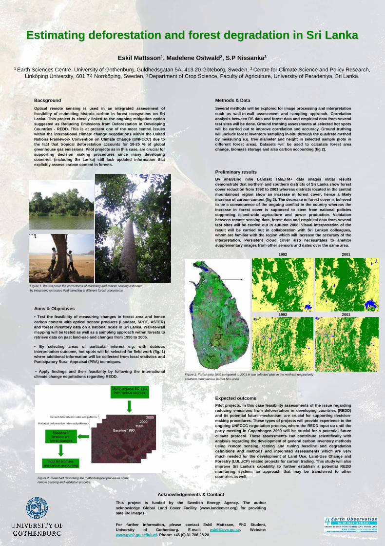
Preliminary resultsBy analyzing nine Landsat TM/ETM+ data images initial resultsdemonstrate that northern and southern districts of Sri Lanka show forest cover reduction from 1992 to 2001 whereas districts located in the central mountainous region show an increase in forest cover, hence a likely increase of carbon content (fig 2). The decrease in forest cover is believed to be a consequence of the ongoing conflict in the country whereas the increase in forest cover is supposed to stem from national policies supporting island-wide agriculture and power production. Validationbetween remote sensing data, forest data and empirical data from severaltest sites will be carried out in autumn 2008. Visual interpretation of the result will be carried out in collaboration with Sri Lankan colleagues, whom are familiar with the region which will increase the accuracy of the interpretation. Persistent cloud cover also necessitates to analyzesupplementary images from other sensors and dates over the same area.

Expected outcomePilot projects, in this case feasibility assessments of the issue regarding reducing emissions from deforestation in developing countries (REDD) and its potential future mechanism, are crucial for supporting decision-making procedures. These types of projects will provide experience to the ongoing UNFCCC negotiation process, where the REDD input up until the party meeting in Copenhagen 2009 will be crucial for a potential future climate protocol. These assessments can contribute scientifically with analysis regarding the development of general carbon inventory methods using remote sensing, testing and tuning baseline and degradation definitions and methods and integrated assessments which are very much needed for the development of Land Use, Land-Use Change and Forestry (LULUCF) related projects for carbon trading. This study will also improve Sri Lanka’s capability to further establish a potential REDD monitoring system, an approach that may be transferred to other countries as well.

Acknowledgements & ContactThis project is funded by the Swedish Energy Agency. The authoracknowledge Global Land Cover Facility (www.landcover.org) for providingsatellite images.

For further information, please contact Eskil Mattsson, PhD Student, University of Gothenburg. E-mail: [email protected]. Website: www.gvc2.gu.se/lulucf. Phone: +46 (0) 31 786 28 28

1992 2001

1992 2001

Figure 2. Flowchart describing the methodological procedure of the remote sensing and validation process.

Figure 3. Forest area 1992 compared to 2001 in two selected plots in the northern respectivelysouthern mountainous part of Sri Lanka.

Figure 1. We will prove the correctness of modelling and remote sensing estimatesby integrating extensive field sampling in different forest ecosystems.