esci 1101 fall_2011_chapter_05_guided_notes
TRANSCRIPT

Chapter 5Chapter 5
Global Temperature Patterns

Which wavelength of light has the most energy?
A. RedB. GreenC. IndigoD. VioletE. Blue
Answer: D
What happens to the atmosphere if less shortwave & longwave radiation is transmitted into space than comes in through insolation?
A. It warms upB. It cools downC. There is no change
Answer: A

Global Temperature PatternsGlobal Temperature Patterns
• Layered Structure of the Atmosphere
• Surface and Air Temperature

Layered Structure of the Layered Structure of the AtmosphereAtmosphere

The TroposphereThe Troposphere
• Lowest layer of atmosphere, to ~12 km, taller over Equator, shorter over poles
• Most organisms and weather are here
• Cools with rising altitude at Environmental Lapse Rate, -6.4 degrees Celsius/1000m avg.
• Upper limit – tropopause where cooling stops

The TroposphereThe Troposphere
• Environmental Lapse Rate, temp vs. altitude
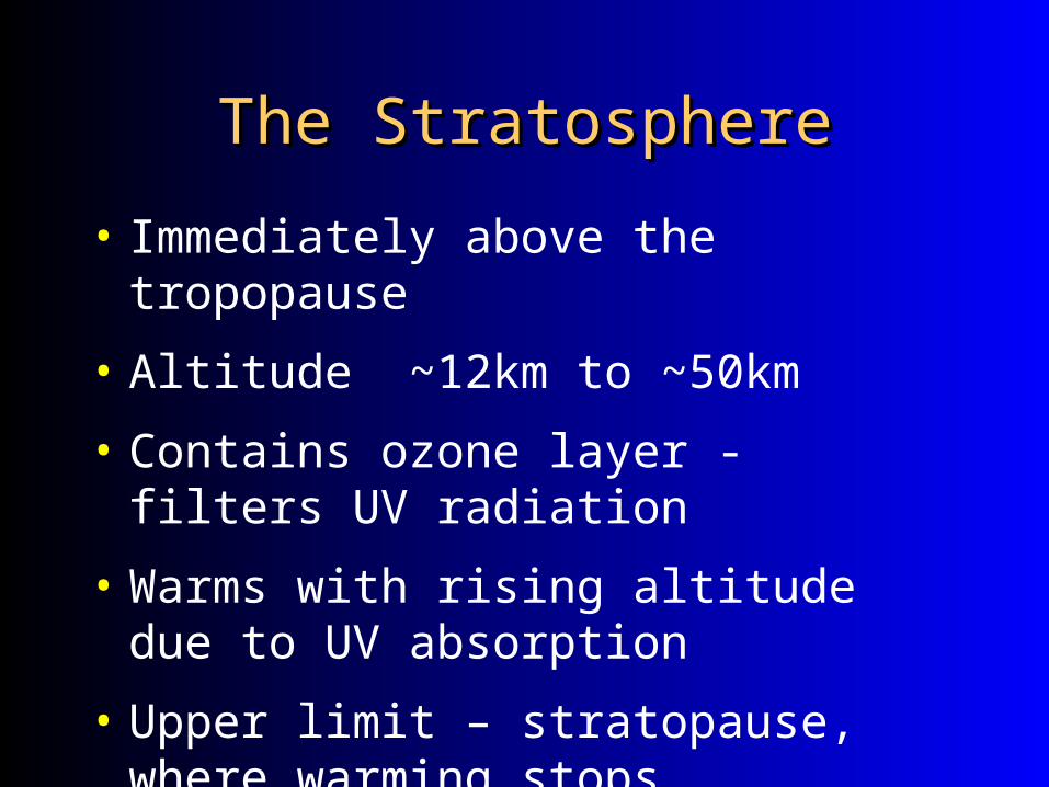
The StratosphereThe Stratosphere
• Immediately above the tropopause
• Altitude ~12km to ~50km
• Contains ozone layer - filters UV radiation
• Warms with rising altitude due to UV absorption
• Upper limit – stratopause, where warming stops

The MesosphereThe Mesosphere
• Immediately above the stratopause
• Altitude ~50 to ~80km
• Coldest layer, near -100 degrees Celsius at top
• Cools with rising altitude
• Upper Limit – mesopause, where cooling stops
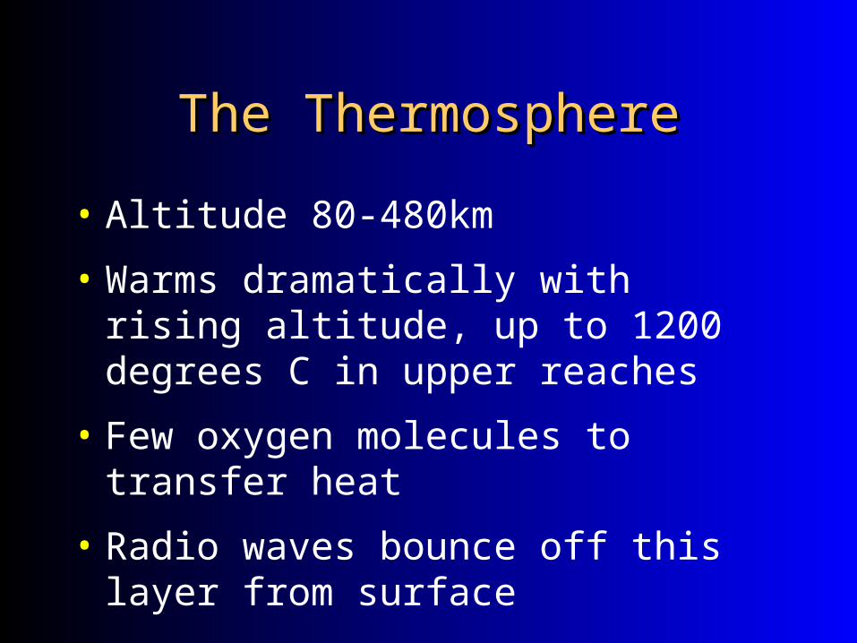
The ThermosphereThe Thermosphere
• Altitude 80-480km
• Warms dramatically with rising altitude, up to 1200 degrees C in upper reaches
• Few oxygen molecules to transfer heat
• Radio waves bounce off this layer from surface

Surface and Air TemperatureSurface and Air Temperature
• Atmospheric temperature - a measure of kinetic energy in the air in a given place or region
• Kinetic energy - the energy of motion in a substance, measured as temperature
• Atmospheric temperature depends on net radiation

Surface and Air TemperatureSurface and Air Temperature
• Three temperature scales:
• Fahrenheit - US
• Celsius - International
•ºF = 9/5C + 32
•ºC = 5/9(F – 32)
• Kelvin – Absolute 0, scientific uses

Scale ComparisonScale Comparison

****Principal Temperature ****Principal Temperature Controls****Controls****
• Latitude • Affects insolation
• Altitude • High altitude has greater daily range
• High altitude has lower annual average
• Proximity to bodies of water

Principal Temperature ControlsPrincipal Temperature Controls
• Seasons and length of day
• Time of day
• Temporal Lag between highest daily insolation and highest daily temperature
• Cloud cover• High albedo
• Moderate temperatures - cooler days, warmer nights

Which of the following formulas would you use to convert a temperature initially taken in degrees Fahrenheit to degrees Celsius?
A. C = 9/5 F + 32
B. C = 5/9 (F-32)
C. C = F – 273
D. C = 5/9F – 32
E. C = 9/5 (F-32)
Answer: A

LatitudeLatitude
• The Earth is always warmer at the equator than at the poles, regardless of season and tilt of the Earth
• The curvature of the Earth, as discussed in the last 2 lectures, allows more direct radiation to impact the equatorial regions. This is the primary reason for the large North to South temperature gradient

LatitudeLatitude
• More energy in at the equator, more energy out at the poles

Global temperatures, a reflection of latitudeGlobal temperatures, a reflection of latitude
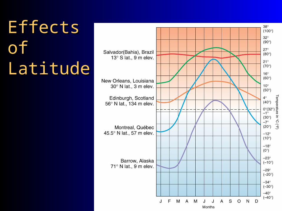
Effects of Effects of LatitudeLatitude

AltitudeAltitude
• Temperature decreases with height in the troposphere
• Environmental lapse rate- -6.4 degrees C for every 1000 meters
Note: This is the average lapse rate!


AltitudeAltitude

• It is this imbalance in temperature that drives both atmospheric and oceanic circulations
• The Earth is trying to restore balance
• We will discuss circulation in more depth later…

As you increase your altitude, the temperature of the atmosphere decreases in these layer(s) of the atmosphere.
I. Trophosphere II. Stratosphere III. Mesophere IV. Thermosphere
A. I
B. II
C. I and II
D. I and III
E. II and IV
Answer: D

Land–Water Heating Differences Land–Water Heating Differences
• Evaporation
• Transparency
• Specific heat
• Movement
• Ocean currents and sea surface temperatures
• Marine vs. continental effects

EvaporationEvaporation
• Where do you expect to find more evaporation? Land or Ocean?
• 84% of the worlds water that is evaporated comes from the oceans
• Why is this important for temperature?

TransparencyTransparency
• Transparency-The transmission of light through a substance
• Soil is not transparent, however water is. What does this mean? Soil doesn't transfer energy very well.
• How deep does light penetrate into the ocean?

Specific HeatSpecific Heat
• Specific heat- The amount of ‘heat’ an object can hold
• Think about a swimming pool vs. a glass of water at the same temperature

Bodies of WaterBodies of Water
• Water plays two roles in controlling temperature
1. ____________________________
1. ____________________________

Ocean CirculationsOcean Circulations
• The ocean water is not stagnant, in fact the ocean has a very complex circulation which is very important to meteorology
• Both warm and cold currents circulate around the world, transporting heat poleward

• Take a very famous current, the ‘Gulf Stream’ which transports warm water from the southeast US coast all the way to Europe
Note the cold water moving southward and the warm water moving northward. Again, the Earth is attempting to restore balance!
Also notice the latitude of Europe…the same as central Canada!

The GulfThe GulfStreamStream

The heat capacity of waterThe heat capacity of water
• Water heats and cools very slowly• Heat capacity- • Water has a high heat capacity, as opposed
to air and landKnowing this….why are the warmest
temperatures of our summer in July and August and not late May and June when the sunlight is the most direct??

Marine vs. ContinentalMarine vs. Continental
• Marine effect - locations that exhibit the moderating influences of the ocean
• Continental effect - areas are less affected by the sea and have a greater range in temperatures

Marine and Continental ClimatesMarine and Continental Climates
Figure 3.23

Proximity to bodies of waterProximity to bodies of water
• San Francisco has much less variation throughout the year than the other locations. Why?
Because it's close to water.
• Charleston and San Diego both sit along shorelines (same latitude), yet San Diego has much less variability, why?
Westward moving winds (wind moving from ocean to San Diego, while wind is moving from land to Charleston.

• **Bodies of water act to moderate the air in winter, and cool the air in summer.**
• The prevailing wind direction is also important….areas downwind of oceans are affected more than areas upwind
Proximity to bodies of waterProximity to bodies of water

Earths temperature patternsEarths temperature patterns
• Thermal equator - a line connecting all points of the highest average temperature
• Where do you think the greatest shifts in the thermal equator will be during the year?
Land, because land will give off heat much faster than water.

Earth’s Temperature PatternsEarth’s Temperature Patterns• January Temperature Map
• Thermal equator movement southward.• More movement over large continents.
• July Temperature Map • Thermal equator movement northward.• More movement over large continents
• Annual Range of Temperatures• Continentality
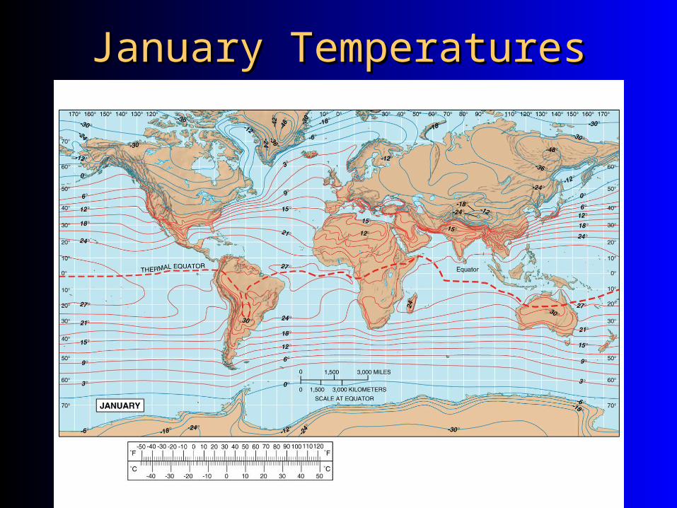
January TemperaturesJanuary Temperatures

July TemperaturesJuly Temperatures

Annual Range of Surface TempAnnual Range of Surface Temp
• Consistently warm in tropics & equatorial regions, esp. near water
• Higher altitudes cooler than surrounding lowlands
• High latitude continents of N. hemisphere have greatest annual range in temperature
• More maritime influence in S. hemisphere, smaller annual temp ranges

Annual Range of Surface TempAnnual Range of Surface Temp
Temperature and Location

Global Temperature RangesGlobal Temperature Ranges(difference between Jan and July temps)(difference between Jan and July temps)
Figure 3.28

Daily CycleDaily Cycle
Insolation
Net Radiation
Air Temp
Surface Temperature

What do cities do to What do cities do to temperature?temperature?
• Urban heat island - on average, both maximum and minimum daytime temperatures are higher in urban areas than in surrounding rural settings
• Why?
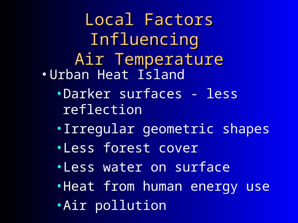
Local Factors Influencing Local Factors Influencing Air TemperatureAir Temperature
• Urban Heat Island
• Darker surfaces - less reflection
• Irregular geometric shapes
• Less forest cover
• Less water on surface
• Heat from human energy use
• Air pollution

The Urban EnvironmentThe Urban Environment

Urban Heat IslandUrban Heat Island

Human ComfortHuman Comfort
• Wind chill index - How cold air feels to human in cold, dry environment – based on air temp, windspeed, etc. – Higher windspeed = lower windchill
• Heat index - How warm air feels to human in hot, humid environment – based on air temp and relative humidity – Higher humidity = higher heat index
50 multiple choice ?sChapters 1-5, emphasis on chapters 3, 4, and 5.Seasons, sun, tools for geographers, energy pathway from sun-earth and earth-sun, water & its role in temperature control, latitude, altitude, diff ways of energy transfer,