errata to the initial study mitigated negative …
TRANSCRIPT

ERRATA TO THE INITIAL STUDY /
MITIGATED NEGATIVE DECLARATION
Emerald Ridge Condominium
City of Oceanside, California
Project No. T15-00009, D15-00021
SCH#: 2017121021
November 2018
As a result of comments received during the public review period, minor changes were required to
the text of the Draft Emerald Ridge Condominium IS/MND. This errata identifies those minor
changes, which do not represent substantial revisions that would require recirculation of the
environmental document, as described in State CEQA Guidelines 15073.5. Specifically, the revisions
do not result in new significant environmental impacts, do not constitute significant new
information, and do not alter the conclusions of the environmental analysis or effectiveness of the
mitigation measures. Changes are provided in tracked changes format (underline for new text and
strikeout for deleted text).
8. Project Description, Page 1:
Emerald Drive/Sunset Drive is located within the City of Vista with jurisdictional
boundaries running along the northern portion of the project site.
8. Project Description, Parking, Roadway and Utility Improvements, Page 3:
The project will install a storm drain in Sunset Drive/Emerald Drive that will
connect to an existing box culvert in Emerald Drive.
10. Other Required Agency Approvals, page 4:
City of Vista –Coordination and Approval for Sunset Drive Realignment,
Responsible Agency, Hydrologic/Hydraulic Approval, Public Storm Drain Plans,
Storm Drain Easements, Public Improvement Plans, Encroachment Permits,
Grading Permit, Erosion Control Plan, Subdivision Agreement, Engineered Street
and Sewer Improvement Plans for Sunset Drive.
12. Consultation, page 4:
City of Vista, Community Development Department, Planning Division
Figures 5, 6, 7 and 11 have been updated based on City of Vista consultation and jurisdictional boundaries.
Appendix E has been updated to clarify the storm drain will discharge into an existing outlet.
14.4.e, Biological Resources, page 17: The Project storm drain will be placed in the northerly side of Sunset Drive/Emerald Drive and will connect to an existing box culvert. The project will not construct a new storm drain outlet within Buena Vista Creek.
RESPONSE TO COMMENTS RECEIVED ON THE DRAFT
INITIAL STUDY /MITIGATED NEGATIVE DECLARATION
Emerald Ridge Condominium
City of Oceanside, California
Project No. T15-00009, D15-00021
SCH#: 2017121021
November 2018
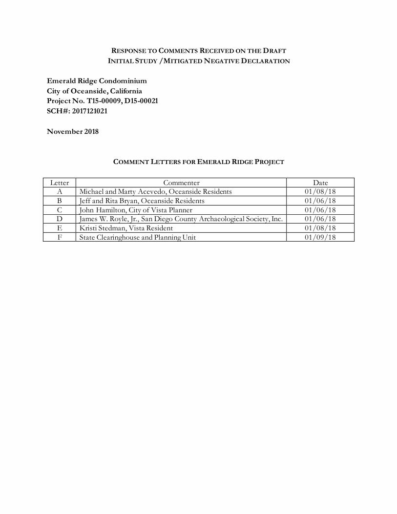
COMMENT LETTERS FOR EMERALD RIDGE PROJECT
Letter Commenter Date A Michael and Marty Acevedo, Oceanside Residents 01/08/18
B Jeff and Rita Bryan, Oceanside Residents 01/06/18
C John Hamilton, City of Vista Planner 01/06/18 D James W. Royle, Jr., San Diego County Archaeological Society, Inc. 01/06/18
E Kristi Stedman, Vista Resident 01/08/18
F State Clearinghouse and Planning Unit 01/09/18

RESPONSE TO COMMENTS RECEIVED ON THE DRAFT INITIAL STUDY
EMERALD RIDGE CONDOMINIUM
PROJECT NO. T15-00009, D15-00021 SCH#: 2017121021
LETTER A
RESPONSE TO LETTER A
A-1: The City appreciates the review and comments from Oceanside resident Marty Acevedo in his email dated January 8, 2018. The City acknowledges this resident’s opposition to approval of the Emerald Ridge Project. No changes were made to CEQA documentation as a result of this comment.
A-2: This comment expresses a concern regarding the traffic conditions related to an 800 residential development, located off-site and on the former quarry site within the City of Carlsbad. This comment does not pertain to the study area, intersections or roadway segments included in the Transportation Analysis for the Project. No changes were made to the CEQA documentation as a result of this comment.
A-3: This comment expresses a concern regarding traffic from the development of the Project’s 48 townhomes. As part of the environmental analysis for the project, a Traffic Study was prepared and included in Appendix G to the IS/MND. The Traffic Study analyzed the Emerald Drive/Hacienda Avenue intersection; Emerald Drive roadway segment, north of Sky Haven Lane/Sunset Drive to Hacienda Avenue; and the Emerald Drive roadway segment, between Hacienda Avenue and SR-78 Eastbound off ramp. Additional intersections and roadway segments, not identified in this comment, were also included in the study. Two scenarios were analyzed: 1) existing traffic intersection and roadway conditions; and 2) existing plus project traffic intersection and roadway conditions. The results of the Traffic Study determined that the addition of project traffic would cause a significant increase in the volume to capacity ratio (more than 0.02) to Sunset between the Sky Haven/Sunset-Emerald intersection and the project access and is therefore required to provide mitigation. The traffic analysis reviewed access and internal circulation within the project and was found to adequately accommodate project traffic.
The Project’s required mitigation is identified in IS/MND, Section 14.16 Transportation/Traffic. Mitigation measure MM-TRA-1 requires the Applicant to realign and widen Sunset Drive to provide a left turn lane at the Sunset Drive project access and at Emerald Drive-Sunset Drive/Shady Lane intersection. The project would also install a traffic signal at the intersection of Sunset Drive and Sky Haven Lane with left turn lanes on both streets. The project also proposes the realignment of Sunset Drive from east of the project access to west of Sky Haven Lane to provide the equivalent of a Collector Road with one lane in each direction plus a center turn lane. Further, the applicant would improve the project’s frontage of Sunset Drive and Sky Haven Lane. Project access to Sunset Drive would include the installation of a stop sign entering Sunset Drive. Therefore, the Project would result in less than significant transportation and traffic impacts, with incorporation of the required mitigation. No changes were made to the CEQA documentation as a result of this comment.
A-1
A-2
A-3

RESPONSE TO COMMENTS RECEIVED ON THE DRAFT INITIAL STUDY
EMERALD RIDGE CONDOMINIUM
PROJECT NO. T15-00009, D15-00021 SCH#: 2017121021
LETTER B
RESPONSE TO LETTER B
B-1: The City appreciates the review and comments from Oceanside resident Jeff and Rita Bryan in their email dated January 6, 2018. The City acknowledges the resident’s opposition to approval of the Emerald Ridge Project, due to traffic congestion and safety. No changes were made to the CEQA documentation as a result of this comment.
B-2: This comment expresses a concern regarding the existing traffic conditions in the Project area and the addition of project related traffic. Within the IS/MND, Section 14.16d addresses the potential for the project to substantially increase hazards. This section identifies that as part of the project, access to Sunset Drive would include the installation of a stop sign entering Sunset Drive and project. The project would also install a traffic signal at the intersection of Sunset Drive and Sky Haven Lane with left turn lanes on both streets. Internal circulation was found to adequately accommodate project traffic. Please see response to A-3 above.
B-3: This comment expresses a concern regarding traffic modeling. As part of the environmental analysis for the project, a Traffic Study was prepared and included in Appendix G to the IS/MND. The Traffic Study analysis methodology included software SYNCHRO, version 8 to analyze morning and afternoon peak hour conditions of the intersections in the project vicinity. Daily traffic volumes of the roadway segments in the vicinity of the project were compared to the Level of Service (LOS) classification thresholds identified in the City of Oceanside Levels of Service. Please see response to A-3 above. To improve traffic and safety conditions in the area, the Applicant will realign and widen Sunset Drive to provide a left turn lane at the Sunset Drive project access and at Emerald Drive-Sunset Drive/Shady Lane intersection. The project would also install a traffic signal at the intersection of Sunset Drive and Sky Haven Lane with left turn lanes on both streets. The project will also realign Sunset Drive from east of the project access to west of Sky Haven Lane to provide the equivalent of a Collector Road with one lane in each direction plus a center turn lane. The project’s frontage along Sunset Drive and Sky Haven Lane would be improved, including installation of a stop sign entering Sunset Drive. Access and internal circulation was determined to adequately accommodate project traffic. Therefore, the Project would result in less than significant transportation and traffic impacts, with incorporation of the required mitigation. No changes were made to the CEQA documentation as a result of this comment.
B-1
B-2
B-3
B-4
B-5

RESPONSE TO COMMENTS RECEIVED ON THE DRAFT INITIAL STUDY
EMERALD RIDGE CONDOMINIUM
PROJECT NO. T15-00009, D15-00021 SCH#: 2017121021
LETTER B (Cont.)
RESPONSE TO LETTER B (Cont.)
B-4: This comment expresses a concern regarding Project construction. Within the IS/MND,
Section 14.16d addresses the potential for the project to substantially increase hazards, including
construction hazards. This section identifies that construction activities associated with the
installation of water pipelines would be located within roadway right-of-ways and may result in
temporary, construction related lane and road closures or detours. Temporary closures may result
in roadway hazards, if appropriate authorities are not properly notified. However, in the event that
pipeline construction would require a lane or roadway closure, the construction contractor would
be required to submit a traffic control plan to the City of Oceanside. The traffic control plan would
ensure that adequate emergency access and egress is maintained and that traffic can move
efficiently and safely in and around the construction site. With implementation of a traffic control
plan, the project would not result in a potentially significant impact associated with substantially
increasing roadway hazards. Impacts would be less than significant. No changes were made to the
CEQA documentation as a result of this comment.
B-5: The City appreciates the review and comments from Oceanside resident Jeff and Rita Bryan
in their email dated January 6, 2018. This comment expresses a concern regarding elderly drivers
in the area and does not pertain to the environmental analysis for the project. No changes were
made to the CEQA documentation as a result of this comment.
B-6: The City appreciates the review and comments from Oceanside resident Jeff and Rita Bryan
in their email dated January 6, 2018. This City acknowledges the residents opposition to approval
of the Emerald Ridge Project. No changes were made to the CEQA documentation as a result of
this comment.
B-6

RESPONSE TO COMMENTS RECEIVED ON THE DRAFT INITIAL STUDY
EMERALD RIDGE CONDOMINIUM
PROJECT NO. T15-00009, D15-00021 SCH#: 2017121021
LETTER C
RESPONSE TO LETTER C
C-1: The City appreciates the review and comments from City of Vista Environmental Planner John Hamilton in his email dated January 6, 2018. Since receipt of this letter, extensive coordination with the City of Vista has been performed by the Applicant. As a result of this coordination, the City of Oceanside has required a number of general land development conditions be included as conditions of project approval. With the incorporation of the identified general land use conditions, the City of Vista has indicated support for the project. No changes were made to the CEQA documentation as a result of this comment.
C-2: This comment expresses concern with the Project Description, in relation to the City of Vista’s boundary. This comment required additional research to determine the jurisdictional boundaries between the City of Vista and City of Oceanside. After several iterations, it was resolved that Emerald Drive/Sunset Drive is in the City of Vista, not the City of Oceanside, and the jurisdiction’s boundaries run along the project’s northerly boundary. As a result of this comment, the delineation of the City boundary was corrected to show all of Emerald Drive/Sunset Drive and the property on the north side of the street to be in the City of Vista. All figures within the IS/MND have been updated to show the revised City boundaries, as outlined in the Errata for the Final IS/MND.
C-3: The City of Vista has been added as a responsible agency within section 10, page 4 of the IS/MND, in addition to a list of City of Vista required permits. Please refer to the Errata for the Final IS/MND.
C-4: This comment points out a typo in the IS/MND. The project does not propose to construct a new public storm drain within Buena Vista Creek. The Project storm drain will be placed in the northerly side of Sunset Drive/Emerald Drive and will connect to an existing box culvert. The project will not construct a new storm drain outlet within Buena Vista Creek. Minor text changes to the IS/MND were made based on this comment. Please refer to the Errata for the Final IS/MND.
C-5: The City appreciates the review and comments from the City of Vista. This comment letter resulted in additional consultation efforts between the jurisdictions, including clarification of jurisdictional boundaries, clarification of the public storm drain outfall location and establishment of City of Vista conditions for project approval. Per State CEQA Guidelines Section 15073.5(a) and (b)(1), the City’s comment letter did not result in any substantial revisions to the CEQA documentation, including the identification of any new, avoidable significant effects. No changes were made to the CEQA documentation as a result of this comment.
C-1
C-2
C-3
C-4
C-5

RESPONSE TO COMMENTS RECEIVED ON THE DRAFT INITIAL STUDY
EMERALD RIDGE CONDOMINIUM
PROJECT NO. T15-00009, D15-00021 SCH#: 2017121021
LETTER D
RESPONSE TO LETTER D
D-1: The City appreciates the review and comments from the San Diego County
Archaeological Society, Inc. dated January 6, 2018. This comment expresses agreement
with the conclusions within the CEQA documentation. No changes were made to the
CEQA documentation as a result of this comment.
D-1

RESPONSE TO COMMENTS RECEIVED ON THE DRAFT INITIAL STUDY
EMERALD RIDGE CONDOMINIUM
PROJECT NO. T15-00009, D15-00021 SCH#: 2017121021
LETTER E
RESPONSE TO LETTER E E-1: The City appreciates the review and comments from City of Vista resident Kristi
Stedman in her email dated January 8, 2018. This comment expresses opposition to the
project due to existing traffic issues. Please see response to A-3 above. To improve
traffic and safety conditions in the area, the Applicant will realign and widen Sunset
Drive to provide a left turn lane at the Sunset Drive project access and at Emerald
Drive-Sunset Drive/Shady Lane intersection. The project would also install a traffic
signal at the intersection of Sunset Drive and Sky Haven Lane with left turn lanes on
both streets. The project will also realign Sunset Drive from east of the project access
to west of Sky Haven Lane to provide the equivalent of a Collector Road with one lane
in each direction plus a center turn lane. The project’s frontage along Sunset Drive and
Sky Haven Lane would be improved, including installation of a stop sign entering
Sunset Drive. Access and internal circulation was determined to adequately
accommodate project traffic. No changes were made to the CEQA documentation as
a result of this comment.
E-1

RESPONSE TO COMMENTS RECEIVED ON THE DRAFT INITIAL STUDY
EMERALD RIDGE CONDOMINIUM
PROJECT NO. T15-00009, D15-00021 SCH#: 2017121021
LETTER F
RESPONSE TO LETTER F F-1: This letter from the California State Clearinghouse acknowledges the project has
complied with CEQA review requirements and states that no state agencies submitted
comments. No changes were made to the CEQA documentation as a result of this
comment.
E-1
F-1
FINDINGS OF FACTS
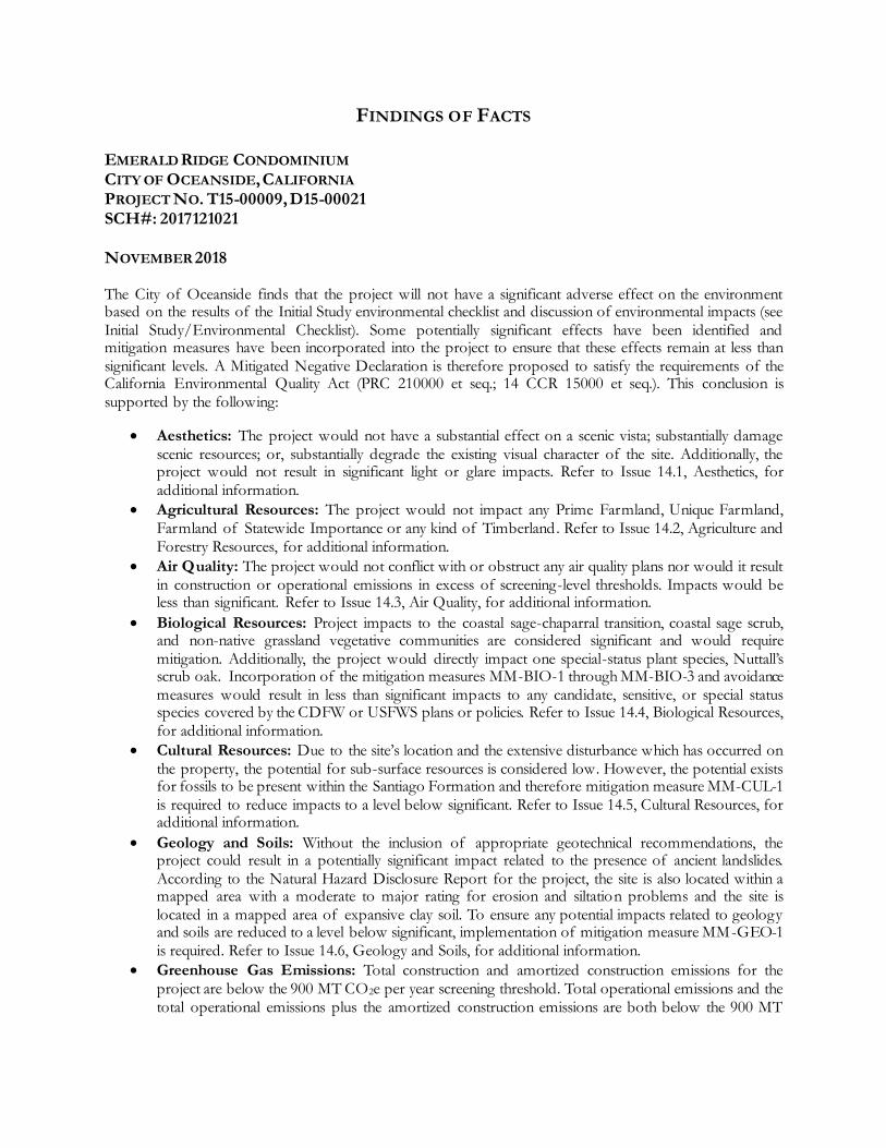
EMERALD RIDGE CONDOMINIUM CITY OF OCEANSIDE, CALIFORNIA PROJECT NO. T15-00009, D15-00021 SCH#: 2017121021 NOVEMBER 2018 The City of Oceanside finds that the project will not have a significant adverse effect on the environment based on the results of the Initial Study environmental checklist and discussion of environmental impacts (see Initial Study/Environmental Checklist). Some potentially significant effects have been identified and mitigation measures have been incorporated into the project to ensure that these effects remain at less than significant levels. A Mitigated Negative Declaration is therefore proposed to satisfy the requirements of the California Environmental Quality Act (PRC 210000 et seq.; 14 CCR 15000 et seq.). This conclusion is supported by the following:
Aesthetics: The project would not have a substantial effect on a scenic vista; substantially damage scenic resources; or, substantially degrade the existing visual character of the site. Additionally, the project would not result in significant light or glare impacts. Refer to Issue 14.1, Aesthetics, for additional information.
Agricultural Resources: The project would not impact any Prime Farmland, Unique Farmland, Farmland of Statewide Importance or any kind of Timberland. Refer to Issue 14.2, Agriculture and Forestry Resources, for additional information.
Air Quality: The project would not conflict with or obstruct any air quality plans nor would it result in construction or operational emissions in excess of screening-level thresholds. Impacts would be less than significant. Refer to Issue 14.3, Air Quality, for additional information.
Biological Resources: Project impacts to the coastal sage-chaparral transition, coastal sage scrub, and non-native grassland vegetative communities are considered significant and would require mitigation. Additionally, the project would directly impact one special-status plant species, Nuttall’s scrub oak. Incorporation of the mitigation measures MM-BIO-1 through MM-BIO-3 and avoidance measures would result in less than significant impacts to any candidate, sensitive, or special status species covered by the CDFW or USFWS plans or policies. Refer to Issue 14.4, Biological Resources, for additional information.
Cultural Resources: Due to the site’s location and the extensive disturbance which has occurred on the property, the potential for sub-surface resources is considered low. However, the potential exists for fossils to be present within the Santiago Formation and therefore mitigation measure MM-CUL-1 is required to reduce impacts to a level below significant. Refer to Issue 14.5, Cultural Resources, for additional information.
Geology and Soils: Without the inclusion of appropriate geotechnical recommendations, the project could result in a potentially significant impact related to the presence of ancient landslides. According to the Natural Hazard Disclosure Report for the project, the site is also located within a mapped area with a moderate to major rating for erosion and siltation problems and the site is located in a mapped area of expansive clay soil. To ensure any potential impacts related to geology and soils are reduced to a level below significant, implementation of mitigation measure MM-GEO-1 is required. Refer to Issue 14.6, Geology and Soils, for additional information.
Greenhouse Gas Emissions: Total construction and amortized construction emissions for the project are below the 900 MT CO2e per year screening threshold. Total operational emissions and the total operational emissions plus the amortized construction emissions are both below the 900 MT

CO2e per year screening threshold. Therefore, impacts would be less than significant. Refer to Issue 14.7, Greenhouse Gas Emissions, for additional information.
Hazards and Hazardous Materials: The project would not result in a significant impact relative to hazards or hazardous materials. Impacts would be less than significant. Refer to Issue 14.8, Hazards and Hazardous Materials, for additional information.
Hydrology and Water Quality: Implementation of the project has the potential to violate a water quality standard or waste discharge requirement during construction and operation. With implementation of mitigation measures MM-HYD-1 through MM-HYD-3 the project would result in less than significant impacts. Refer to Issue 14.9, Hydrology and Water Quality, for additional information.
Land Use and Planning: The project would impact approximately 0.96 acre of coastal sage-chaparral transition habitat, 0.05 acre of coastal sage scrub and 0.12 acre of non-native grassland habitat, requiring a total of 2.08 acres of habitat to be mitigated off-site. With the incorporation of mitigation measures MM-BIO-1 through MM-BIO-3, the project would comply with the Oceanside Subarea Habitat Conservation Plan/Natural Community Conservation Plan. Impacts would be potentially significant unless mitigated. Refer to Issue 14.10, Land Use and Planning, for additional information.
Mineral Resources: The project site would not result in the loss of availability of a known mineral resource that would be of value to the region and the residents of the state, or result in the loss of availability of a locally-important mineral resource recovery site delineated on a local general plan, specific plan, or other land use plan. Refer to Issue 14.11, Mineral Resources, for more information.
Noise: Based upon the results of the Acoustical Site Assessment for the project, no exterior noise levels were identified which would exceed the City’s General Plan noise abatement standards. However, future first- and second floor building façade noise levels for Buildings 1 through 3 were found to be above the State of California noise insulation standard of 60 dBA CNEL. Implementation of mitigation measure MM-NOI-1 would reduce this impact to a level below significant. Refer to Issue 14.12, Noise, for more information.
Population and Housing: The project would not displace existing housing or generate a substantial increase in population or employment. Impacts would be less than significant. Refer to Issue 14.13, Population and Housing, for more information.
Public Services: The project would not result in substantial adverse impacts on public protection services (fire, police) and would not substantially increase demands on schools, parks or other public facilities. Impacts would be less than significant. Refer to Issue 14.14, Public Services, for more information.
Recreation: The environmental impacts associated with the construction of the facilities contained in the two open space recreation areas would result in potentially significant environmental impacts to biological resources, cultural resources, geology and soils, hydrology and water quality, noise and traffic. These impacts would be mitigated through the implementation of mitigation measures MM-BIO-1 through MM-BIO-3, MM-CUL-1, MM-GEO-1, MM-HYDRO-1 through MM-HYDRO-3, MM-NOI-1, and MM-TRA-1 through MM-TRA-2. Impacts would be potentially significant unless mitigated. Refer to Issue 14.15, Recreation, for more information.
Transportation and Traffic: The addition of project traffic would cause the project to report a significant increase in the volume to capacity ratio (more than 0.02) to Sunset between the Sky Haven/Sunset-Emerald intersection and the project access. Traffic related impacts associated with the project would be mitigated with implementation of mitigation measures MM-TRA-1 and MM-TRA-2. Impacts would be potentially significant, unless mitigated. Refer to Issue 14.16, Transportation and Traffic, for more information.
Tribal Cultural Resources: Based on the required AB 52 consultation, mitigation measures MM-TCR-1 through MM-TCR-8 shall be implemented to reduce any potentially significant impacts related to tribal cultural resources to a level below significant. Refer to Issue 14.17, Tribal Cultural Resources, for more information.

Utilities and Service Systems: As part of the project, approximately 3,000 linear feet of water pipeline would be installed on- and off-site. Additionally, a new sewer lift station would be constructed on-site. The environmental effects of constructing the pipelines and lift station have been evaluated within this Initial Study checklist. As discussed in the other sections of this checklist, potentially significant environmental impacts could occur to biological resources, cultural resources, geology and soils, hydrology and water quality, noise, traffic and tribal cultural resources. These impacts would be mitigated through the implementation of mitigation measures MM-BIO-1 through MM-BIO-3, MM-CUL-1, MM-GEO-1, MM-HYDRO-1 through MM-HYDRO-3, MM-NOI-1, MM-TRA-1 and MM-TCR-1 through MM-TCR-8. Impacts would be potentially significant unless mitigated. Refer to Issue 14.18, Utilities and Service Systems, for more information.
Mandatory Findings of Significance: Potentially significant environmental impacts could occur to biological resources, cultural resources, geology and soils, hydrology and water quality, noise and traffic. These impacts would be mitigated through the implementation of mitigation measures MM-BIO-1 through MM-BIO-3, MM-CUL-1, MM-GEO-1, MM-HYDRO-1 through MM-HYDRO-3, MM-NOI-1 and MM-TRA-1 through MM-TRA-2. Impacts to human beings would be potentially significant unless mitigated.

MITIGATION MONITORING AND REPORTING PROGRAM
Emerald Ridge Condominium
City of Oceanside, California
Project No. T15-00009, D15-00021
SCH#: 2017121021
November 2018
The California Environmental Quality Act (CEQA) requires that when a lead agency adopts a
Mitigated Negative Declaration (MND), it shall prepare a monitoring or reporting program (MMRP)
for all required mitigation measures (CEQA Guidelines Section 15097). The MMRP, below,
describes the monitoring and reporting program for mitigation measures adopted by the City of
Oceanside to avoid or substantially reduce potentially significant impacts related to the Emerald
Ridge Condominium Project (Project). The MMRP shall be maintained by the designated Project
Manager and be available for inspection upon request at the City.
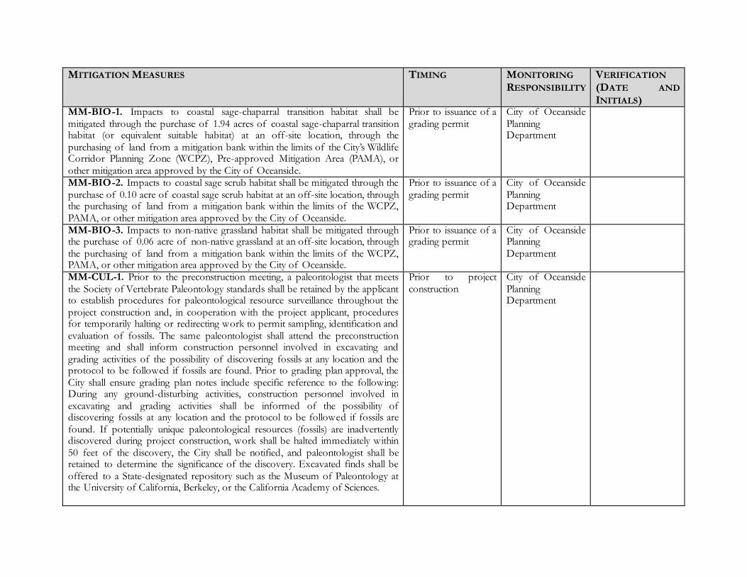
MITIGATION MEASURES TIMING MONITORING
RESPONSIBILITY VERIFICATION
(DATE AND
INITIALS) MM-BIO-1. Impacts to coastal sage-chaparral transition habitat shall be mitigated through the purchase of 1.94 acres of coastal sage-chaparral transition habitat (or equivalent suitable habitat) at an off-site location, through the purchasing of land from a mitigation bank within the limits of the City’s Wildlife Corridor Planning Zone (WCPZ), Pre-approved Mitigation Area (PAMA), or other mitigation area approved by the City of Oceanside.
Prior to issuance of a grading permit
City of Oceanside Planning Department
MM-BIO-2. Impacts to coastal sage scrub habitat shall be mitigated through the purchase of 0.10 acre of coastal sage scrub habitat at an off-site location, through the purchasing of land from a mitigation bank within the limits of the WCPZ, PAMA, or other mitigation area approved by the City of Oceanside.
Prior to issuance of a grading permit
City of Oceanside Planning Department
MM-BIO-3. Impacts to non-native grassland habitat shall be mitigated through the purchase of 0.06 acre of non-native grassland at an off-site location, through the purchasing of land from a mitigation bank within the limits of the WCPZ, PAMA, or other mitigation area approved by the City of Oceanside.
Prior to issuance of a grading permit
City of Oceanside Planning Department
MM-CUL-1. Prior to the preconstruction meeting, a paleontologist that meets the Society of Vertebrate Paleontology standards shall be retained by the applicant to establish procedures for paleontological resource surveillance throughout the project construction and, in cooperation with the project applicant, procedures for temporarily halting or redirecting work to permit sampling, identification and evaluation of fossils. The same paleontologist shall attend the preconstruction meeting and shall inform construction personnel involved in excavating and grading activities of the possibility of discovering fossils at any location and the protocol to be followed if fossils are found. Prior to grading plan approval, the City shall ensure grading plan notes include specific reference to the following: During any ground-disturbing activities, construction personnel involved in excavating and grading activities shall be informed of the possibility of discovering fossils at any location and the protocol to be followed if fossils are found. If potentially unique paleontological resources (fossils) are inadvertently discovered during project construction, work shall be halted immediately within 50 feet of the discovery, the City shall be notified, and paleontologist shall be retained to determine the significance of the discovery. Excavated finds shall be offered to a State-designated repository such as the Museum of Paleontology at the University of California, Berkeley, or the California Academy of Sciences.
Prior to project construction
City of Oceanside Planning Department

MM-GEO-1. The Construction Contractor shall ensure that construction of the project complies with the recommendations identified in the Preliminary Geotechnical Evaluation for Emerald Ridge Project, prepared by GeoTeck, Inc (2015).
During project construction
City Engineer / City Inspector
MM-HYDRO-1. The project shall incorporate permanent source control Best Management Practice (BMPs) as identified in the project SWMP, such as storm drain inlet labeling, common trash enclosures and recyclable material storage areas, integrated pest management (IMP) practices, the use of drought tolerant landscape design and efficient irrigation systems and designated pet use areas. The implementation of site design Low Impact Development (LID) practices may include the conservation of natural areas, protecting slopes and channels, disconnecting impervious surfaces and minimizing impervious surfaces. Impervious surfaces would be minimized by constructing drive aisles to minimum widths, minimizing soil compaction in landscape areas, incorporating interior landscape areas and landscape buffers along the proposed parking perimeter. BMPs would be located as close to the source as possible and designed to mitigate pollutants from runoff prior to discharge to the MS4. The project shall provide an Operation and Management Plan to ensure long-term maintenance.
During project construction
City Engineer / City Inspector
MM-HYDRO-2. On-site private improvements shall include construction of Water Quality Treatment Control BMPs and HMP facilities and underground private storm drainage improvements to support the water quality and HMP facilities. Runoff would be carried to a Bio-filtration Basin (BFB) which would provide both HMP flow control and storm water quality treatment. All BFBs shall be constructed as identified in the SWMP.
During project construction
City Engineer / City Inspector
MM-HYDRO-3. Low Impact Development (LID) and Green Street design concepts shall be implemented in order to further reduce impacts to water quality. Sky Haven Lane and Sunset Drive would be improved with Green Street design concepts in compliance with the United States Environmental Protection Agency Green Streets Guidance Manual, “Managing Wet Weather with Green Infrastructure – Municipal Handbook: Green Streets.” The project shall create a green street corridor that ties together the existing community with the project. This would include noncontiguous sidewalks to enhance pedestrian safety, enhanced parkway soil profiles to promote infiltration of low flow runoff, and heavy landscaping between the sidewalk and curb.
During project construction
City Engineer / City Inspector

MM-NOI-1. An interior acoustical site assessment of affected structures, consistent with CCR Title 24, Part 2 shall be completed prior to final submittal of architectural plans for the project site.
Prior to issuance of final architectural plans
City of Oceanside Planning Department
MM-TRA-1. The applicant shall realign and widen Sunset Drive to provide a left turn lane at the Sunset Drive project access and at Emerald Drive-Sunset Drive/Shady Lane intersection.
During project construction
City of Oceanside Planning and Public Works Departments
MM-TCR-1. Prior to the issuance of a Grading Permit, the Applicant/Owner shall enter into a pre-excavation agreement with a representative of the San Luis Rey Band of Mission Indians, otherwise known as a Tribal Cultural Resources Treatment and Tribal Monitoring Agreement. The Applicant/Owner shall submit a copy of the executed agreement with the Grading Permit application. The purpose of this agreement shall be to formalize protocols and procedures between the Applicant/Owner and the San Luis Rey Band for the protection and treatment of, including but not limited to, Native American human remains, funerary objects, cultural and religious landscapes, ceremonial items, traditional gathering areas and cultural items, located and/or discovered through a monitoring program in conjunction with the construction of the proposed project, including additional archaeological surveys and/or studies, excavations, geotechnical investigations, grading, and all other ground disturbing activities.
Prior to issuance of a grading permit
City of Oceanside Planning Department
MM-TCR-2. Prior to the issuance of a Grading Permit, the Applicant/Owner shall provide a copy of an executed contract to the City of Oceanside Planning Division providing that a Qualified Archaeologist and Luiseño Native American Monitor have been retained at the Applicant/Owner expense to implement the monitoring program, as described in the pre-excavation agreement.
Prior to issuance of a grading permit
City of Oceanside Planning Department
MM-TCR-3. Prior to the release of the grading bond, the Qualified Archaeologist will have submitted a monitoring report and/or evaluation report, if appropriate, which describes the results, analysis and conclusions of the archaeological monitoring program (e.g., data recovery plan), along with the Luiseño Native American Monitor’s notes and comments, to the City of Oceanside Planning Division for review and acceptance.
Prior to release of grading bond
City of Oceanside Planning Department
MM-TCR-4. The Qualified Archaeologist shall maintain ongoing collaborative consultation with the Luiseño Native American monitor during all ground disturbing activities (i.e. grubbing, clearing, grading, cutting, filling, trenching and/or boring). The requirement for the monitoring program shall be noted on all applicable construction documents, including demolition plans, grading plans, etc. The Applicant/Owner shall not begin any ground disturbing activities until
Prior to, during and after grading
City of Oceanside Planning Department

they have provided the City of Oceanside Planning Division with a schedule of ground disturbing activities and until the Qualified Archaeologist and Luiseño Native American Monitor are on-site to conduct monitoring of all ground disturbing activities. MM-TCR-5. The City will invite the Qualified Archaeologist and Luiseño Native American Monitor to attend all applicable pre-construction meetings with the General Contractor and/or associated Subcontractors to present the archaeological monitoring program. The Qualified Archaeologist and Luiseño Native American Monitor shall be present on-site full-time during any ground disturbing activities, to identify any evidence of potential archaeological or tribal cultural resources. All fill materials shall be subject to appropriate and reasonable testing or sampling by the Qualified Archaeologist and Luiseño Native American Monitor to assure the recovery of any and all tribal cultural resources.
Prior to, during and after grading
City of Oceanside Planning Department
MM-TCR-6. The Qualified Archaeologist or the Luiseño Native American monitor may halt ground disturbing activities if unknown archaeological artifact deposits or cultural features are discovered. Ground disturbing activities shall be directed away from these deposits to allow a determination of potential importance. Isolates and clearly non-significant deposits will be minimally documented in the field, and before grading proceeds these items shall be given to the San Luis Rey Band so that they may be repatriated at the site on a later date. If the Qualified Archaeologist or Luiseño Native American Monitor determine that the unearthed artifact deposits or cultural features are considered potentially significant, they shall notify and consult with the San Luis Rey Band of Mission Indians to determine the respectful and dignified treatment of those resources. The avoidance and protection of the significant cultural resource and/or unique archaeological resource is the preferable mitigation. If the Qualified Archaeologist recommends and the City requires a data recovery plan, the San Luis Rey Band shall be notified and consulted regarding the preparation and scope of any such recovery plan. If the Qualified Archaeologist collects any artifact deposit samples as part of the data recovery plan, the Luiseño Native American monitor shall be present during any testing or cataloging of those resources. Moreover, if the Qualified Archaeologist does not collect any artifact deposit samples that are unearthed during the ground disturbing activities, the Luiseño Native American monitor, may at their discretion, collect said resources and provide them to the San Luis Rey Band for respectful and dignified treatment in accordance with the Tribe’s cultural and spiritual traditions.
Prior to, during and after grading
City of Oceanside Planning Department

MM-TCR-7. Any and all uncovered tribal cultural resources of Native American importance shall be returned to the San Luis Rey Band of Mission Indians, and/or the Most Likely Descendant.
Prior to, during and after grading
City of Oceanside Planning Department
MM-TCR-8. As mandated by California Health and Safety Code Section 7050.5, if human remains are found on the project site during construction or during archaeological work, the person responsible for the excavation, or his or her authorized representative, or the Qualified Archaeologist shall immediately notify the San Diego County Coroner’s office by telephone. No further excavation or disturbance of the site or any nearby area reasonably suspected to overlie adjacent remains shall occur until the Coroner has made the necessary findings as to origin and disposition pursuant to Public Resources Code 5097.98. If such a discovery occurs, a temporary construction exclusion zone shall be established surrounding the area of the discovery so that the area would be protected, and consultation and treatment could occur as prescribed by law. By law, the Coroner will determine within two working days of being notified if the remains are subject to his or her authority. If the Coroner determines that the remains are Native American, he or she shall contact the Native American Heritage Commission (NAHC) within 24 hours. The NAHC will then make a determination as to the Most Likely Descendent. Any Native American remains discovered on the project site shall be kept in-situ, or in a secure location in close proximity to where they were found, and any analysis of the remains shall only occur on-site in the presence of a Luiseño Native American monitor. At the conclusion of any analysis, any Native American remains shall be repatriated to the Most Likely Descendent for re-burial, in accordance with PRC 5097.98.
Prior to, during and after grading
City of Oceanside Planning Department