erosion control on forest land in georgiacoweeta.uga.edu/publications/2166.pdf · erosion control...
TRANSCRIPT
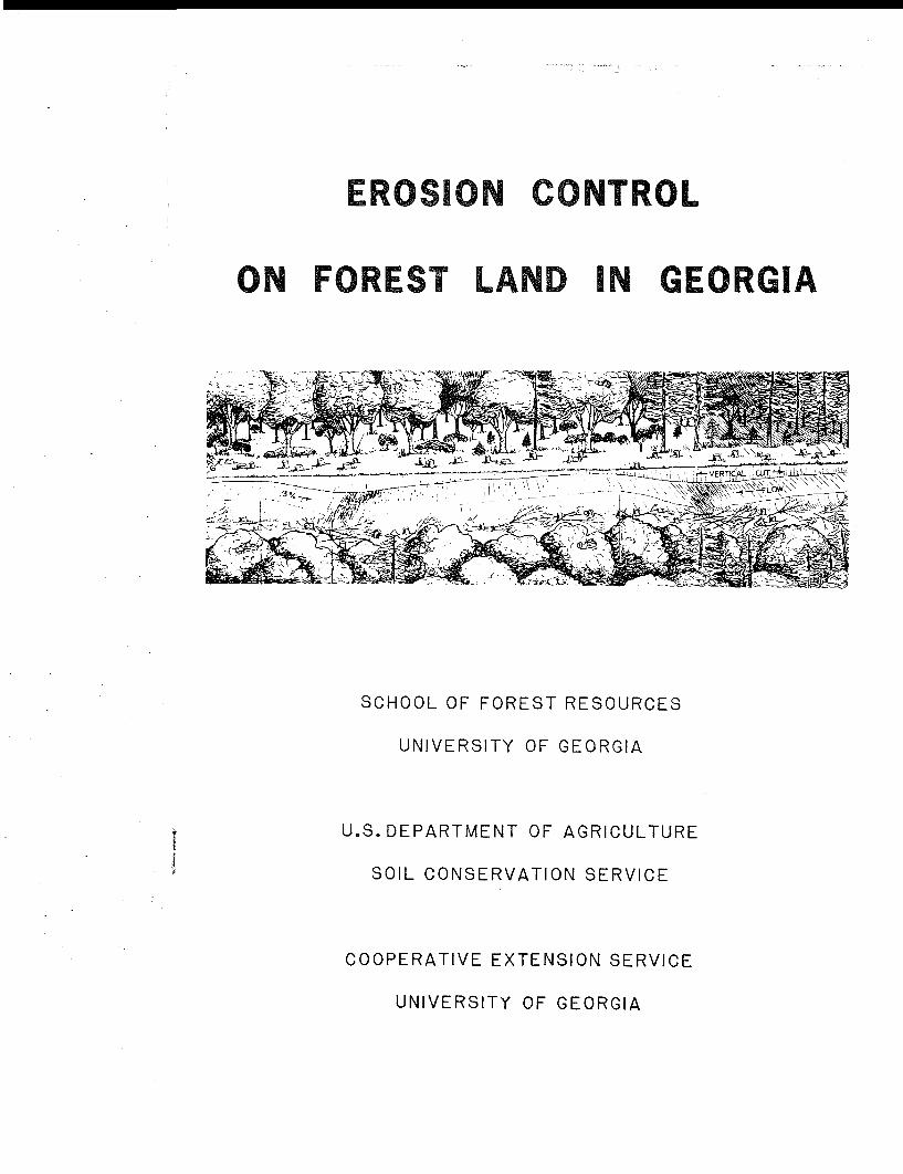
EROSION CONTROL
ON FOREST LAND IN GEORGIA
SCHOOL OF FOREST RESOURCES
UNIVERSITY OF GEORGIA
U.S. DEPARTMENT OF AGRICULTURE
SOIL CONSERVATION SERVICE
COOPERATIVE EXTENSION SERVICE
UNIVERSITY OF GEORGIA
INTRODUCTION
This booklet is intended to help foresters and timbercontractors to apply simpl e erosion control methods w h i l eharvesting and regenerating forests in the Flatwoods,Coastal P l a i n , Piedmont, Valley and Ridge, and MountainProvinces of Georgia. Some new suggestions for betteraccess roads and harvesting methods are i n c l u d e d , butmost of the recommendations come from the commonplaceexperience of loggers and foresters. The booklet ispart of the regional effort to implement Section 208 ofthe Federal Water P o l l u t i o n Control Act Amendments of1972 (PL 92-500), as delegated by the EnvironmentalProtection Agency (EPA) to the states. The recommen-dation may be a p p l i e d in adjoining states with similarphysiographic provinces.
Prepared by
Dr. John D. Hewlett, Forest Hydrologist, School ofForest Resources
W. P. Thompson, Forester, Soil Conservation Service
Nelson B r i g h t w e l l , Forester, Cooperative ExtensionService
Athens, Georgia - 1979
FACTS ABOUT FOREST EROSION
Early American foresters pioneered modern concerns forthe environment. Among other subjects, foresters studiedthe effects of forest removal on erosion and sedimenta-tion of streams.
When rain f a l l s on forest l a n d s , the energy it brings isused up on its way to the sea. Down on the big streamswe tap the energy to generate electricity. But in theforested headwaters we want to control the energy of waterso that it does not detach, move, and deposit soil mate-rials in streams. An unbroken layer of litter and forestdebris over the soil is the surest way to prevent accele-rated erosion (that is, erosion caused by man). Litter,branches, and fibrous roots of the forest floor absorbthe energy of raindrops and prevent soil p a r t i c l e s frommoving d o w n h i l l . Unbroken forest cover serves best todisperse r a i n f a l l energy that otherwise erodes the l a n d .However, forest debris not removed d u r i n g harvest can,if well used, serve the same role.
Problems arise chiefly with road systems, and with theb u n c h i n g or b u r n i n g of too much of th i s r e s i d u a l forestmaterial. Under these c o n d i t i o n s , r a i n f a l l energy f a l l sdirectly on bare s o i l . Watershed experiments have shownthat rain f a l l i n g in scattered Hatches of bare soil w i l lnot d e l i v e r sediments to stream channels u n l e s s the patchesform unbroken pathways for long distances d o w n h i l l . Undercareful s i l v i c u l t u r e this does not have to h a p p e n ; up to25 percent of the total forested watershed may be exposedto the raindrop's power without serious erosion if thereare frequent patches of organic m a t e r i a l s to stop the soilp a r t i c l e s . Frequent patches of litter and s l a s h w i l l trapboth the moving soil and the water that carries it, thuskeeping rainfall from becoming surface runoff.
A raindrop kicks a soil p a r t i c l e into the air--what hap-pens to that particle depends on size of the exposedpatch and its distance from a stream. In brief, the prob-a b i l i t y that a detached soil p a r t i c l e w i l l reach a l i v estream is directly proportional to the size of an exposed
patch of soil and inversely proportional to the distancefrom that patch to the stream.
A small amount of suspended sediment is bound to reachthe stream under heavy rainfalls, but sediment deliveryfrom forest operations need not be seriously acceleratedif roads are kept away from streams and equipment is usedproperly. Without great cost, the equipment and methodsused to harvest trees, prepare the site, and plant the newcrop can reduce accelerated erosion to acceptable levels.
Simply cutting trees has l i t t l e to do with erosion. Everystudy of sediment export caused by forest operations hasshown that the access system (haul roads, skid trails anddecking areas) is the prime source of sediment. In typi-cal jobs, 80 percent or more of a l l sediment export due toforest operations can be traced to poorly located and poorlyused roads and skid trails. Roads and heavy equipment run-ning through streamside buffer zones as well as skid trai l srunning down slopes to streams are signs of a poor l o g g i n gjob.
Watershed research shows that rates of sediment export frombadly roaded forest watersheds can reach 10 tons per acrein the year following harvest, and that the average rateover a 30-year cutting cycle can be as h i g h as one ton peracre per year. The same timber harvest can be made usinga good access system with a delivery rate as low as 100pounds per acre per year. With advanced pla n n i n g and goodfield supervision, sediment from the poorly managed forestoperation could be cut by 90 percent, and at no great cost.
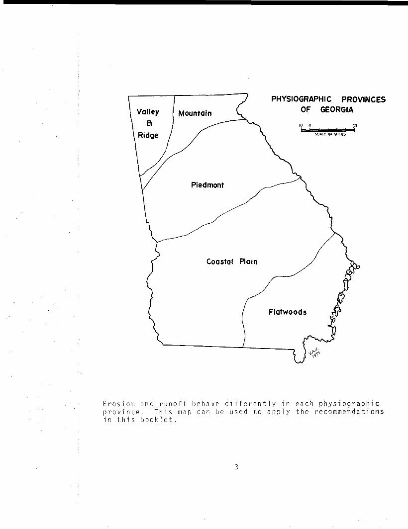
PHYSIOGRAPHIC PROVINCES
OF GEORGIA
10 0 50SCALE IN MILES
Erosion and runoff b e h a v e differently in each physiographicp r o v i n c e . T h i s map can be used to a p p l y the recommendationsin t h i s b o o k l e t .
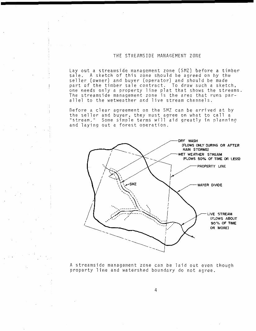
THE STREAMSIDE MANAGEMENT ZONE
Lay out a streamside management zone (SMZ) before a timbersale. A sketch of this zone s h o u l d be agreed on by theseller (owner) and buyer (operator) and should be madepart of the timber sale contract. To draw such a sketch,one needs only a property l i n e plat that shows the streamsThe streamside management zone is the area that runs par-a l l e l to the wetweather and l i v e stream channels.
Before a clear agreement on the SMZ can be arrived at bythe seller and buyer, they must agree on what to call a"stream." Some s i m p l e terms w i l l aid greatly in p l a n n i n gand laying out a forest operation.
DRY WASH(FLOWS ONLY DURING OR AFTERRAIN STORMS)
WET WEATHER STREAM(FLOWS 50% OF TIME OR LESS)
PROPERTY LINE
WATER DIVIDE
LIVE STREAM(FLOWS ABOUT90% OF TIMEOR MORE)
A streamside management zone can be l a i d out even thoughproperty l i n e and watershed boundary do not agree.
It is not always clear exactly where a live stream becomesa wetweather one,or where the latter becomes a dry wash,but most reasonable parties would be able to agree after avis i t to the site. The SMZ should i n c l u d e the wetweatherstream as well as the l i v e stream, but dry washes canusually be treated as part of the upslope zones for regularsi 1 v i c u l t u r a l management.
If the following width recommendations are used, the por-tion of large properties or watersheds that w i l l remainin the SMZ w i l l vary from 15 to 25 percent. Trees in theSMZ can be cabled from the edge without entering the SMZwith wheeled or tracked vehicles.
RECOMMENDED WIDTHS FOR SMZ
Province One side Both sides
-fop t _ _ _I C C U — — — —
Piedmont, Valley and R i d g e , and 80 160Mountai n
Coastal P l a i n AQ 80
Flatwood (Usually does not apply.)
ACCESS ROAD LAYOUT
Having delineated the streamside management zone, layout the truck or haul roads that must be b u i l t or relo-cated. Keep roads as far from the SMZ as the terrainw i l l allow. Do not let property lines dictate bad roadlocations without exploring alternatives.
Road Location
The first step is to plan the extent of the road systemneeded. The extent and type of access roads are affectedby:
1. Volume and type of forest products to beremoved, or activity to be served.
2. Type of equipment to be used, and frequencyand season of use.
3. Topography of the area--si opes, streams andwaterways.
4. Property line constraints.
The forest manager, landowner, operator, or responsibleagent should carefully plan the layout, construct!' on, andmaintenance or retirement of any road system to be usedin a timber removal operation.
Some general guides to be considered on a l l l o g g i n g op-erations are:
1. Do not haul or skid in l i v e or wetweatherstreams.
2. Cross li v e or wetweather streams only overbridges or culverts.
3. Do not leave l o g g i n g slash in a stream orlake.
4. Leave logging slash on exposed soil, drywashes and at points of drainage fromroads--otherwise , scatter.
Roads should be located along either side of ridges orwater divides, not on top of the ridge as is often thecase with older dirt roads. The ridges should be crossedat saddles with a s l i g h t upward vertical curve to ensurebetter drainage, thus e l i m i n a t i n g the mud pudd l e s thatfrequently develop in saddles. The side-hill locationensures easy drainage of rutted roads, whereas the h i l l t o plocation causes gradual entrenchment of the roadbed undertraffic. On the lower side, keep at least 80 feet abovewetweather streams and spring heads; that is, stay wellabove the SMZ. The toe of the road slope should neverextend into the SMZ, except at properly engineered bridgesor culverts. Stream crossings should go straight in andstraight out. Operations off these access roads should bedone with as little use of dozer blades as possible.
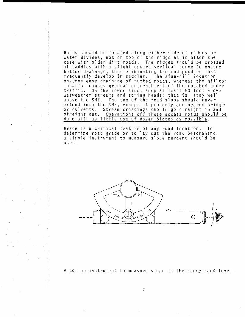
Grade is a critical feature of any road location. Todetermine road grade or to lay out the road beforehand,a simple instrument to measure slope percent s h o u l d beused.
A common instrument to measure slope is the abney hand level
Ideally, access road grades should be kept as near levelas possible, preferably below 5 percent. Where absolutelynecessary, as in the case of severe property l i n e con-straints, grades of 15 to 20 percent may occur for shortdistances (200 to 300 feet), but these are apt to poses p e c i a l maintenance problems. The a p p r o a c h i n g gradesabove and below such steep pitches s h o u l d be as level asp o s s i b l e . Steady c l i m b i n g grades, with properly spacedwater d i v e r s i o n s , u s u a l l y e l i m i n a t e the. need for steeppitches. If these rules are followed, it w i l l seldom benecessary to locate roads w i t h i n streamside managementzones or through wet areas.
In summary, the major considerations for road locationare :
1. Stay as far away as p o s s i b l e from SMZs.
2. Stay at least a few dozen yards below the ridgetops; a v o i d completely flat areas if pos s i b l e .
3. Where property l i n e s permit, keep grades below5 percent and follow the contour as much aspossible.
4. Under these constraints, locate roads to servefuture as well as present uses with m i n i m u mmileage and maintenance.
Road Construction
The road surface s h o u l d be constructed wide enough toh a n d l e the e q u i p m e n t that w i l l use the road. U s u a l l y awidth of 12 to 14 feet is adequate for a single-trackhaul road. W h i l e it is important to use a machine b i genough to do the job, e q u i p m e n t larger than requiredshould be a v o i d e d . Next to l o c a t i o n , control of wateroni n
Doins
the road iscontrol 1 ing
noti de
i n s 1 o p editches .
the mosterosion
or outWhen
sii
imooand s
ope dn s i d e
rtan t construction factoredi men tat ion .
irtdit
haulches
roaare
ds andused ,
avoidpro vi si ons
must be made to divert the water across the road atfrequent intervals with expensive culverts. Avoid"laying back" the cut slopes, unless the cuts are over6 feet deep.
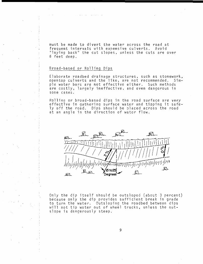
Broad-based or R o l l i n g Dips
Elaborate roadbed drainage structures, such as stonework,opentop culverts and the l i k e , are not recommended. Sim-ple water bars are not effective either. Such methodsare costly, largely ineffective, and even dangerous insome cases.
R o l l i n g or broad-based dips in the road surface are veryeffective in gathering surface water and t i p p i n g it safe-ly off the road. Dips sho u l d be placed across the roadat an angle in the direction of water flow.
yyvj/«
yi5to25JDegrees'
Only the dip itself s h o u l d be outsloped (about 3 percent)because only the dip provides sufficient break in gradeto turn the water. Outsloping the roadbed between dipsw i l l not tip water out of wheel tracks, unless the out-slope is dangerously steep.
•"St
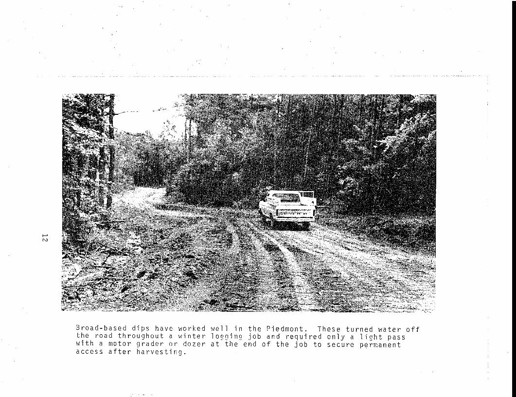
Broad-based dips have worked well in the Piedmont. These turned water offthe road throughout a winter l o g g i n g job and required only a l i g h t passwith a motor grader or dozer at the end of the job to secure permanentaccess after harvesting.
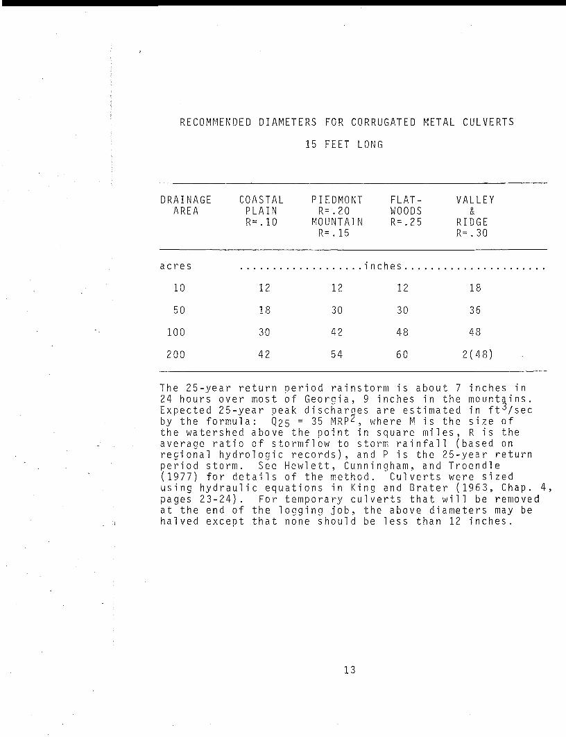
RECOMMENDED DIAMETERS FOR CORRUGATED METAL CULVERTS
15 FEET LONG
DRAINAGEAREA
COASTALPLAINR=.10
PIEDMONTR=.20
MOUNTAINR=.15
FLAT-WOODSR=.25
VALLEY&
RIDGER=.30
acres
10
50
100
200
12
18
30
42
12
30
42
54
inches.
12
30
48
60
18
36
48
2(48)
The 25-year return period rainstorm is abou24 hours over most of Georgia, 9 inches inExpected 25-year peak discharoes are estimaby the formula: 0,25 ~ 35 MRP^, where M isthe watershed above the point in square m i laverage ratio of stormflow to storm rainfalregional hydrologic records), and P is theperiod storm. See Hewlett, C u n n i n g h a m , and(1977) for details of the method. Culvertsusin g h y d r a u l i c equations in King and Bratepages 23-24). For temporary culverts thatat the end of the l o g g i n g job, the above dih a l v e d except that none s h o u l d be less than
t 7 inches inthe mountains,ted in ft^/secthe size ofes , R is the1 (based on25-year returnTroendlewere sized
r (1963, Chap. <w i 1 1 be removedameters may be12 inches.
13
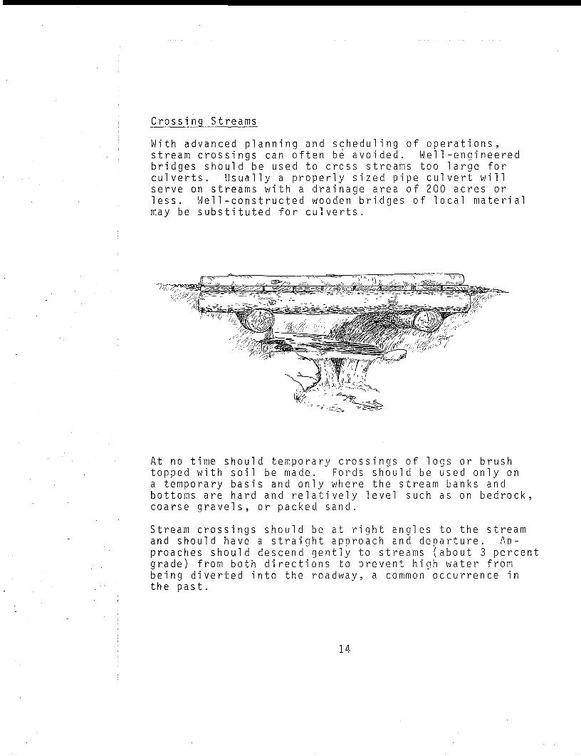
Crossing Streams
With advanced p l a n n i n g and s c h e d u l i n g of operations,stream crossings can often be avoided. Wei 1-engineeredbridges should be used to cross streams too large forculverts. Usually a properly sized pip e culvert w i l lserve on streams with a drainage area of 200 acres orless. Wei 1-constructed wooden bridges of local materialmay be substituted for culverts.
At no time s h o u l d temporary crossings of logs or brushtopped with soil be made. Fords s h o u l d be used only ona temporary basis and only where the stream banks andbottoms are hard and relatively l e v e l such as on bedrock,coarse gravels, or packed sand.
Stream crossings should be at right angles to the streamand s h o u l d have a straight approach and departure. Ap-proaches should descend gently to streams (about 3 percentgrade) from both directions to prevent h i g h water frombeing diverted into the roadway, a common occurrence inthe past.
14
All common engineering standards require that culverts,bridges and their approaches be placed in a way that doesnot impede h i g h water flows. On large bridge jobs, thesestandards are complex, but for culverts common sense wil lserve. Crossings should be made on straight reaches ofthe stream, not at a bend. Culverts should be covered toa depth at least e q u i v a l e n t to their diameter.
Every stream crossing, even if properly engineered, isan immediate source of sediment export. Therefore, seed-ing and m u l c h i n g of exposed f i l l slopes s h o u l d be doneas part of the construction work itself, not after severalrains have washed tons of soil into the stream. Else-where on the access roads, seeding and fertilizing canwait until the end of l o g g i n g (assuming r o l l i n g d i p s areproperly installed). But cut slopes, fills and road sur-faces wi t h i n the SMZ (or wi t h i n 80 feet of the stream)should be st a b i l i z e d immedi ately after construction. Ifdry weather or frost heave prevents a good stand of vege-tation, seed again after rain or thawing. Since the SMZis the most sensitive section of the watershed, this extracare with stream crossings w i l l pay off more than anyother specific erosion control measure on the basin.
15
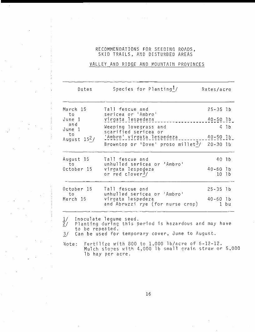
RECOMMENDATIONS FOR SEEDING ROADS,SKID TRAILS, AND DISTURBED AREAS
VALLEY AND RIDGE AND MOUNTAIN PROVINCES
Dates Species for PlantingV Rates/acre
March 15to
June 1and
June 1to
August 15^/
August 15to
October 15
October 15to
March 15
Tall fescue andsericea or ' Ambro 'virgata lespedeza
Weeping lovegrass andscarified sericea or'Ambro 1 virgata lespedeza
Browntop or 'Dove' proso millet^/
Tal 1 fescue andu n h u l l e d sericea or 'Ambro 1
virqata lespedezaor red cloverV
Tal 1 fescue andu n h u l l e d sericea or 'Ambro'virgata lespedezaand Abruzzi rye (for nurse crop)
25
40
40
20
40
25
40
-35
-50
4
-50
-30
40
-6010
-35
-601
Ib
Ib
Ib
Ib
Ib
Ib
IbIb
Ib
Ibbu
\_l Inoculate legume seed.27 P l a n t i n g during this period is hazardous and may have~ to be repeated.37 Can be used for temporary cover, June to August.
Note: Fertilize with 800 to 1,000 Ib/acre of 6-12-12.Mulch slopes with 4,000 Ib small grain straw or 5,000Ib hay per acre.
16
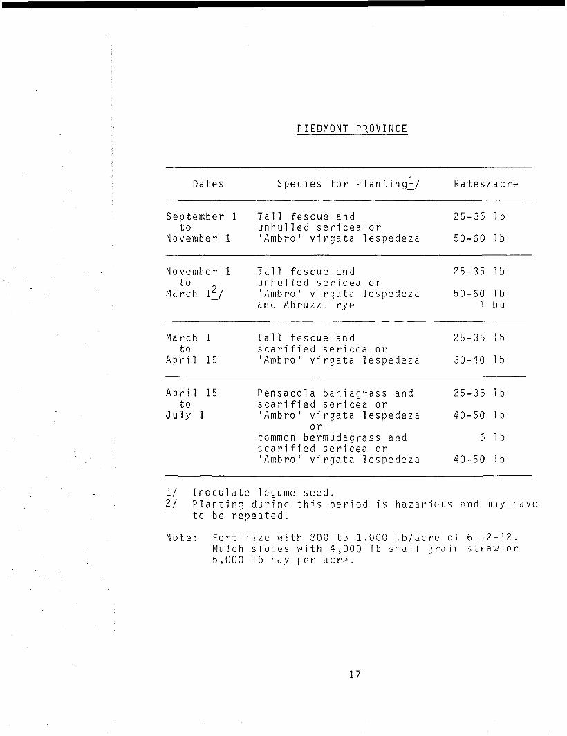
PIEDMONT PROVINCE
Dates Species for Planting^/ Rates/acre
September 1to
November 1
Tal1 fescue andu n h u l l e d sericea or'Ambro' virgata lespedeza
25-35 Ib
50-60 Ib
November 1to
March IV
Tall fescue and 25-35 Ibu n h u l l e d sericea or'Ambro' virgata lespedeza 50-60 Iband Abruzzi rye 1 bu
March 1to
April 15
Tall fescue and 25-35 Ibscarified sericea or'Ambro' virgata lespedeza 30-40 Ib
A p r i l 15to
July 1
Pensacola bahiagrass and 25-35 Ibscarified sericea or'Ambro' virgata lespedeza 40-50 Ib
orcommon bermudagrass and 6 Ibscarified sericea or'Ambro' virgata lespedeza 40-50 Ib
_!/ Inoculate legume seed.2/ P l a n t i n g during this period is hazardous and may have
to be repeated.
Note: Fertilize with 800 to 1,000 Ib/acre of 6-12-12.Mu l c h slopes with 4,000 Ib small grain straw or5,000 Ib hay per acre.
17

COASTAL PLAIN AMD FLATWOODS PROVINCES
Dates Species for Planting^/ Rates/acre
September 1to
November 15
Tall fescue 25-35 Ibor 'Pensacola 1 bahiagrass 25-35 Iband rye grass 15 Ib
November 15to
February 15
Tall fescue 25-35 Ibor 'Pensacola 1 bahiagrass 20-25 Iband Abruzzi rye 1 bu
February 15to
June 15
Pensacola bahiagrass 20-25 Ibor bermudagrass and 6 Ibscarified sericea or 30-40 Ib'Ambro' virgata lespedeza
JY Inoculate legume seed.
Note: Fertilize with 900 to 1,200 Ib/acre of 5-10-15.M u l c h slopes with 4,000 Ib sm a l l grain straw or5,000 1b hay per acre.
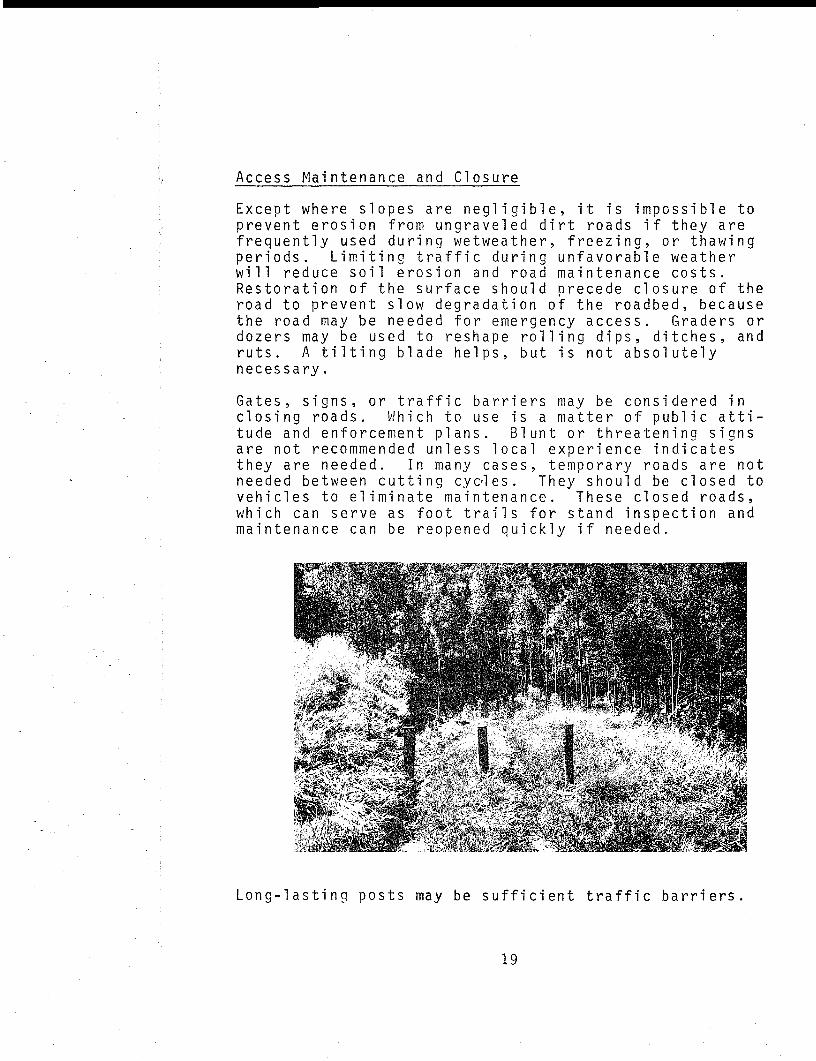
Access Maintenance and Closure
Except where slopes are n e g l i g i b l eprevent erosion from ungraveled difrequently used during wetweather,periods. L i m i t i n g traffic duringw i l l reduce soil erosion and roadRestoration of the surface shouldroad to prevent slow degradation othe road may be needed for emergendozers may be used to reshape rollruts. A t i l t i n g blade h e l p s , butnecessary.
it is impossible tort roads if they arefreezing, or thawing
unfavorable weathermaintenance costs.precede closure of thef the roadbed, becausecy access. Graders oring dips, ditches, andis not absolutely
Gates, signs, or traffic barrieclosing roads. Which to use istude and enforcement plans. Blare not recommended unless locathey are needed. In many casesneeded between cutting cycles,vehicles to eliminate maintenanwhich can serve as foot trailsmaintenance can be reopened qui
rs may be considered ina matter of p u b l i c atti-
unt or threatening signs1 experience indicates, temporary roads are notThey should be closed to
ce. These closed roads,for stand inspection andckly if needed.
Long-lasting posts may be sufficient traffic barriers.
19
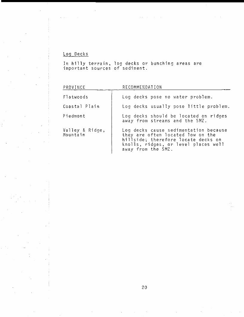
Log Decks
In h i l l y terrain, log decks or bunching areas areimportant sources of sediment.
P R O V I N C E RECOMMENDATION
Flatwoods
Coastal Plain
Piedmont
Valley & Ridge,Mountain
Log decks pose no water problem.
Log decks usually pose l i t t l e problem
Log decks should be located on ridgesaway from streams and the SMZ.
Log decks cause sedimentation becausethey are often located low on theh i l l s i d e ; therefore locate decks onknolls, ridges, or level places wellaway from the SMZ.
20
.SITE PREPARATION
The previous recommendation regarding the streamsidemanagement zone and access design address the most fre-quent sources of n o n p o i n t water p o l l u t i o n caused by tim-ber management in Georgia. However, some types of sitepreparation are also troublesome, p a r t i c u l a r l y when ap-p l i e d without consideration of the lay of the l a n d . Whenhalf or more of Piedmont and M o u n t a i n s o i l is l a i d bareby site preparation, spring and summer rains can d e l i v e rup to 1 ton of soil per acre per month to the stream.W h i l e these rates don't last l o n g , the r i l l s and g u l l i e sformed are not as easily s t a b i l i z e d by annual regrowthas the rest of the soil surface. This problem can besevere when machinery and methods s u i t a b l e for l e v e ll a n d s of the Coastal P l a i n or Flatwoods are employedw i t h o u t m o d i f i c a t i o n in the P i e d m o n t , M o u n t a i n , andV a l l e y and R i d g e Provinces.
R o o t - r a k i n g , c l e a n - d i s c i n g , and windrow ing with dozerb l a d e s , p a r t i c u l a r l y when accompanied by broadcast burn-i n g , s h o u l d be a v o i d e d on s l o p i n g l a n d in the P i e d m o n t ,V a l l e y and R i d g e , and M o u n t a i n Provinces. Fire usedalone to clear the ground for hand or m a c h i n e p l a n t i n gdoes not completely bare the m i n e r a l soil u n l e s s the fuelis very dry--for e x a m p l e , d u r i n g a dry f a l l . A hot,c l e a n - b u r n i n g fire in the fall leaves the s o i l bare throughout the winter and s p r i n g , whereas spring b u r n i n g w i l loften s t i m u l a t e low a n n u a l ground cover before summer.
C h o p p i n g r e s i d u a l forest debris with drum r o l l e r - c h o p p e r s ,once in the spring and a g a i n in the f a l l , is recommendedas the safest practice on slopes of 5 to 20 percent. Onslopes less than 5 percent, few site preparation or p l a n t -ing methods w i l l cause sediment p r o b l e m s ; w h i l e on slopesover 20 percent, m e c h a n i c a l site preparation s h o u l d not beused a t a l l .
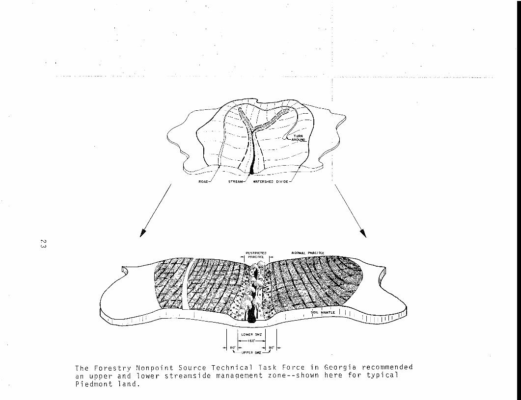
Where m e c n a n i c a l site preparation threatens to bare morethan 50 percent of the s o i l surface, two streamside man-agement zones are required. There s h o u l d be a lower SMZand an upper SMZ of e q u a l w i d t h . No wheeled or trackedv e h i c l e s s h o u l d enter the lower SMZ; trees may be winched
21
from the edge. In the upper SMZ, wheeled and trackedvehicles can harvest trees and crush the remaining stand,but the forest soil should not be turned, scraped, orclean burned.
TREE PLANTING
The upper and the lower SMZ should be hand planted inaccordance with the restriction on soil turning or scrap-ing. Normally, about 25 percent of the average propertywill lie in the upper and the lower SMZ.
Hand p l a n t i n g of trees is feasible in most u p l a n d partsof the state and, according to some i n d u s t r i a l foresters,is competitive with machine p l a n t i n g except on clear andnearly level sites — for example, old fields or pure pineclearcuts with l i t t l e hardwood competition. Machineplanters do not work well on rough slopes and survivalof seedlings is poor. Exclusion of machine planters fromthe upper and the lower SMZ w i l l not work a hardship onmost property owners and timber buyers.
22
rviCO
RESTRICTED NORMAL PRACTICE
The Forestry Nonpoint Source Technical Task Force in Georgia recommendedan upper and lower streamside management zone—shown here for typical
Piedmont land.
FIRE BREAKS
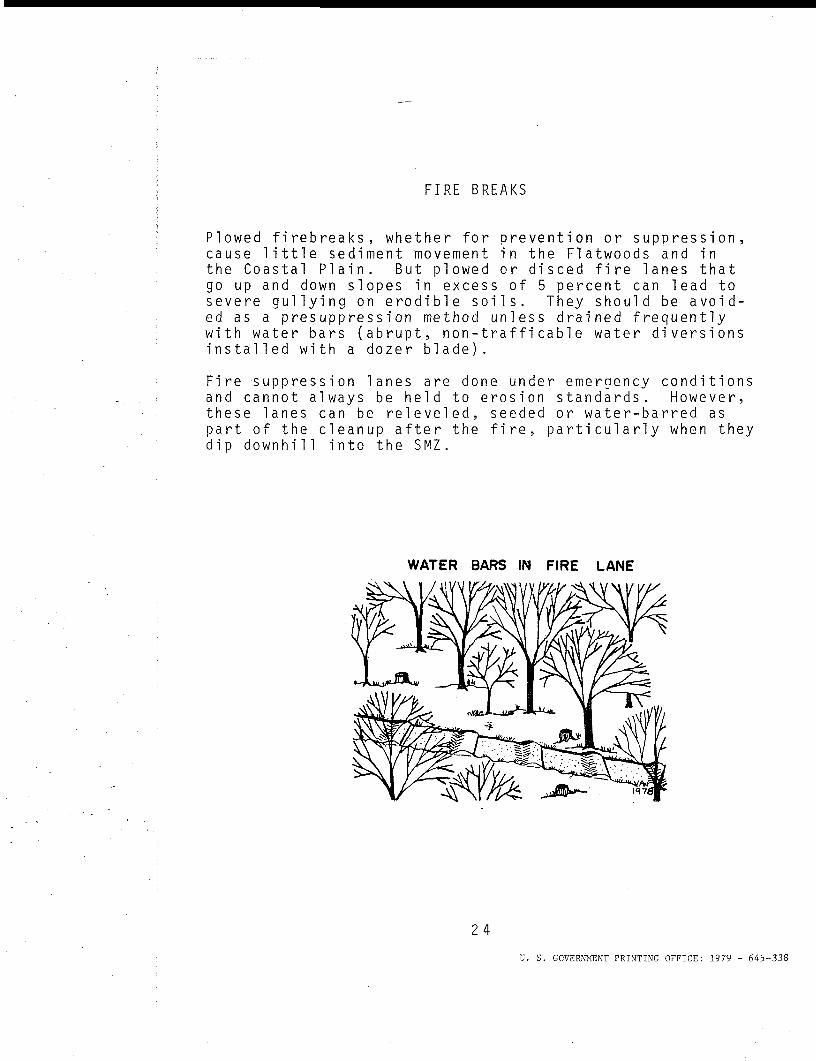
Plowed firebreaks, whether for prevention or suppression,cause l i t t l e sediment movement in the Flatwoods and inthe Coastal P l a i n . But plowed or disced fire lanes thatgo up and down slopes in excess of 5 percent can lead tosevere g u l l y i n g on erodible soils. They s h o u l d be avoid-ed as a presuppression method unless drained frequentlywith water bars (abrupt, non-trafficable water diversionsi n s t a l l e d with a dozer blade).
Fire suppression lanes are done under emergency conditionsand cannot always be he l d to erosion standards. However,these lanes can be releveled, seeded or water-barred aspart of the cleanup after the fire, particularly when theydip d o w n h i l l into the SMZ.
WATER BARS IN FIRE LANE
24
U. S. GOVERNMENT PRINTING OFFICE: 1979 - 645-338
SELECTED REFERENCES
Forestry Nonpoint Source Technical Task Force (Georgia208 Planning), "Report and Recommendations",October 1978, 58 p., and Appendix. (Unpubl.)
Hartung, R. E. and J. M. Kress, "Woodlands of the North-east: Erosion and sediment control guides", 1977,USDA Soil Conservation Service and Forest Service,Upper Darby, Pa., 25 p.
Hershfield, D. M. , "Rainfall frequency atlas of theUnited States", 1961, US Weather Bureau TechnicalReport, 40 p.
Hewlett, J. D. and J. E. Douglass, "Blending ForestUses", 1968, USDA Forest Service, SEFLS, Asheville,
1 N.C. , 15 p.
Hewlett, J. D., "An analysis of forest water problems inGeorgia", 1972, Georgia Forest Research Council,Report 30, 27 p.
Hewlett, J. D., G. B. Cunningham and C. A. Troendle,"Predicting stormflow and peakflow from small basinsin humid areas by the R-index method", 1977, WaterResources Bullentin, Volume 13(2), 231-253 pp.
Hewlett, J.D., "Forest Water Quality: An experiment inharvesting and regenerating Piedmont Forest La.nd",1979, University of Georgia Printing Office,School of Forest Resources, Athens, Georgia, 28 p.
King, H. W. and E. F. Brater, "Handbook of Hydraulics",1963, McGraw-Hill, N. Y., 5th Edition, Chapter 4,23-24 pp.
Soil Conservation Service, USDA, Technical GuideSection IV, "Critical Area Planting", (Code 342),March 1974
SOL CONSERNATON SERVICE