epicenter modified mercalli intensity (mmi) scaleon ... · modified mercalli intensity ... doors...
TRANSCRIPT

EpicenterThe point on the Earth’s surface above the point at depth in the Earth’s crust where an earthquake occurs.
FaultA fracture or crack along which two blocks of rock slide past one another. This movement may occur rapidly, in the form of an earth-quake, or slowly, in the form of creep.
MagnitudeRefers to the amount of energy released at the epicenter by the earthquake. Various scales are used, sometimes referred in news sources as the “Richter Scale”.
SeismologistsScientists who study earthquakes and their causes and effects.
Seismogram The record made by a seismograph
Seismographs Instruments that make an automatic record of the time, duration, direction, and intensity of earthquakes.
Theory of Plate TectonicsStates that the earth’s crust is divided into a number of relatively rigid plates that collide with, separate from, and translate past one another at their boundaries, this disruption commonly results in earthquakes.
Modified Mercalli Intensity (MMI) Scale The Modified Mercalli Intensity Scale is commonly used in the United States by seismologists seeking information on the severity of earthquake effects.
Many portions of this brochure have been adapted from the 2008 South Carolina Earthquake Guide originally developed by theSouth Carolina Emergency Management Division. We appreciate the inspiration and support they provided for this project. Images in this document
are provide courtesy South Carolina Emergency Management Division, Federal Emergency Management Agency, U.S. Geological Survey, Missouri Historical Society, and the Library of Congress, Geography and Map Division.
The Central United States Earthquake Consortium (CUSEC) is an incorporated non-profit organization in partnership with the Federal Government and the eight states most affected by earthquakes in the central U.S. Those states are Alabama, Arkansas, Illinois,
Indiana, Kentucky, Mississippi, Missouri, and Tennessee.
This publication is funded through a cooperative agreement with the Dept. of Homeland Security / Federal EmergencyManagement Agency - Grant Number 2009-RC-51-K046. For more information on earthquakes, disaster preparedness, and earthquake
mitigation, please visit the CUSEC website at www.cusec.org or call (800) 824-5817.
Central U.S. Earthquake Consortium | 2630 E. Holmes Road | Memphis, TN 38118Online: www.cusec.org | Toll Free: (800) 824-5817
����
����
� ����
����� � ������� � ��������
�
���
����
�� �
���������� � �������
� �������
��
��
�����
������������
���������� �����
����
�
The Modi�ed Mercalli Intensity Scale (MMI) The Magnitude Scale
I
II - III
IV - V
VI - VII
VIII - IX
Xor
Higher
MICRO
MINOR
LIGHT
MODERATE
STRONG
MAJORto
GREAT
(I) Not felt except by a very few people under especially favorable conditions.
(II) Felt only by a few people at rest, especially on upper floors of buildings.
(III) Felt quite noticeably by people indoors, especially on upper floors of buildings. Many people do not recognize it as an earthquake. Standing motorcars may rock slightly. Vibrations similar to the passing of a truck may be felt. Duration estimated.
(IV) Felt indoors by many, outdoors by few during the day. At night, some awakened. Dishes, windows, doors disturbed; walls make cracking sounds. Vibrations felt are similar to a heavy truck striking a building. (V) Felt by nearly everyone; many awakened; some dishes, windows broken and unstable objects overturned; pendulum clocks may stop.
(VI) Felt by all, many frightened; some heavy furniture movement; a few instances of fallen plaster; damage slight. (VII) Damage negligible in buildings of good design and construction; slight to moderate in well-built ordinary structures; considerable damage in poorly built or badly designed structures; some chimneys broken.
(VIII) Damage slight in specially designed structures; considerable damage in ordinary substantial buildings with partial collapse; damage great in poorly built structures. Chimneys, factory stacks, columns, monuments, walls may fall, heavy furniture overturned.(IX) Damage considerable in specially designed structures; well-designed frame structures thrown out of plumb; damage great in substantial buildings, with partial collapse; buildings shifted off foundations.
(X) Some well-built wooden structures destroyed; most masonry and frame structures destroyed with foundations; rails bent.(XI) Few, if any, (masonry) structures remain standing; bridges destroyed; rails bent greatly.(XII) Damage total; lines of sight and level are distorted; objects thrown into the air.
0.0 - 3.0
3.0 - 3.9
4.0 - 4.9
5.0 - 5.9
6.0 - 6.9
7.0 andHigher
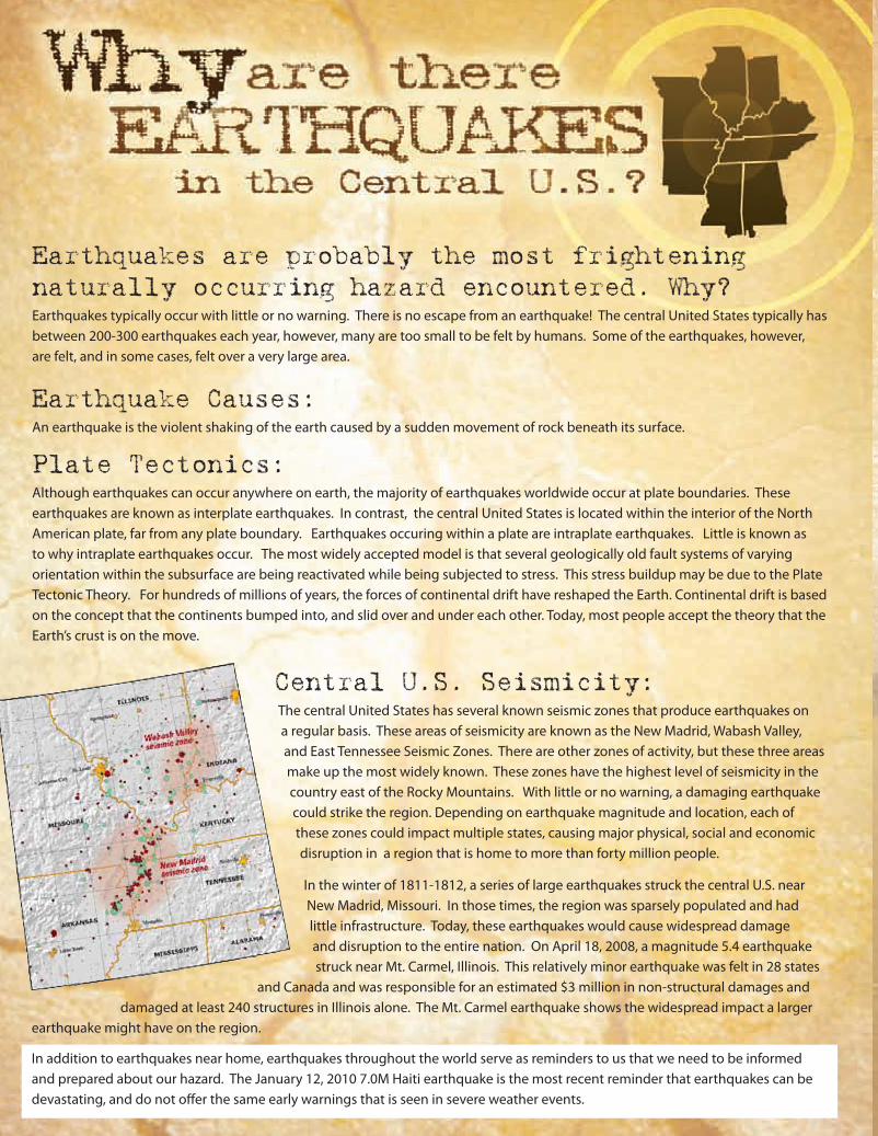
Earthquakes are probably the most frightening naturally occurring hazard encountered. Why?
Earthquakes typically occur with little or no warning. There is no escape from an earthquake! The central United States typically has between 200-300 earthquakes each year, however, many are too small to be felt by humans. Some of the earthquakes, however, are felt, and in some cases, felt over a very large area.
Earthquake Causes:An earthquake is the violent shaking of the earth caused by a sudden movement of rock beneath its surface.
Plate Tectonics:Although earthquakes can occur anywhere on earth, the majority of earthquakes worldwide occur at plate boundaries. These earthquakes are known as interplate earthquakes. In contrast, the central United States is located within the interior of the North American plate, far from any plate boundary. Earthquakes occuring within a plate are intraplate earthquakes. Little is known as to why intraplate earthquakes occur. The most widely accepted model is that several geologically old fault systems of varying orientation within the subsurface are being reactivated while being subjected to stress. This stress buildup may be due to the Plate Tectonic Theory. For hundreds of millions of years, the forces of continental drift have reshaped the Earth. Continental drift is based on the concept that the continents bumped into, and slid over and under each other. Today, most people accept the theory that the Earth’s crust is on the move.
Central U.S. Seismicity:The central United States has several known seismic zones that produce earthquakes on a regular basis. These areas of seismicity are known as the New Madrid, Wabash Valley, and East Tennessee Seismic Zones. There are other zones of activity, but these three areas make up the most widely known. These zones have the highest level of seismicity in the country east of the Rocky Mountains. With little or no warning, a damaging earthquake could strike the region. Depending on earthquake magnitude and location, each of these zones could impact multiple states, causing major physical, social and economic disruption in a region that is home to more than forty million people.
In the winter of 1811-1812, a series of large earthquakes struck the central U.S. near New Madrid, Missouri. In those times, the region was sparsely populated and had little infrastructure. Today, these earthquakes would cause widespread damage and disruption to the entire nation. On April 18, 2008, a magnitude 5.4 earthquake struck near Mt. Carmel, Illinois. This relatively minor earthquake was felt in 28 states
and Canada and was responsible for an estimated $3 million in non-structural damages and damaged at least 240 structures in Illinois alone. The Mt. Carmel earthquake shows the widespread impact a larger
earthquake might have on the region.
In addition to earthquakes near home, earthquakes throughout the world serve as reminders to us that we need to be informed and prepared about our hazard. The January 12, 2010 7.0M Haiti earthquake is the most recent reminder that earthquakes can be devastating, and do not offer the same early warnings that is seen in severe weather events.
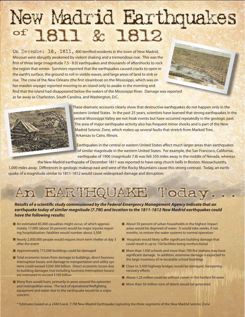
On December 16, 1811, 400 terrified residents in the town of New Madrid, Missouri were abruptly awakened by violent shaking and a tremendous roar. This was the first of three large (magnitude 7.5 - 8.0) earthquakes and thousands of aftershocks to rock the region that winter. Survivors reported that the earthquakes caused cracks to open in the earth’s surface, the ground to roll in visible waves, and large areas of land to sink or rise. The crew of the New Orleans (the first steamboat on the Mississippi, which was on her maiden voyage) reported mooring to an island only to awake in the morning and find that the island had disappeared below the waters of the Mississippi River. Damage was reported as far away as Charleston, South Carolina, and Washington, D.C.
These dramatic accounts clearly show that destructive earthquakes do not happen only in the western United States. In the past 25 years, scientists have learned that strong earthquakes in the central Mississippi Valley are not freak events but have occurred repeatedly in the geologic past. The area of major earthquake activity also has frequent minor shocks and is part of the New Madrid Seismic Zone, which makes up several faults that stretch from Marked Tree, Arkansas to Cairo, Illinois.
Earthquakes in the central or eastern United States affect much larger areas than earthquakes of similar magnitude in the western United States. For example, the San Francisco, California, earthquake of 1906 (magnitude 7.8) was felt 350 miles away in the middle of Nevada, whereas
the New Madrid earthquake of December 1811 was reported to have rang church bells in Boston, Massachusetts, 1,000 miles away. Differences in geologic makeup east and west of the Rocky Mountains cause this strong contrast. Today, an earth-quake of a magnitude similar to 1811-1812 would cause widespread damage and disruption.
Results of a scientific study commissioned by the Federal Emergency Management Agency indicate that an earthquake today of similar magnitude (7.7M) and location to the 1811-1812 New Madrid earthquakes could have the following results:
* Estimates based on a 2AM Event, 7.7M New Madrid Earthquake rupturing the three segments of the New Madrid Seismic Zone
An estimated 85,000 casualties might occur, of which approxi-mately 17,000 (about 20 percent) would be major injuries requir-ing hospitalization; fatalities would number about 3,500
Nearly 2,000,000 people would require short-term shelter at day 3 after the event
Approximately 715,000 buildings could be damaged
Total economic losses from damage to buildings, direct business interruption losses, and damage to transportation and utility sys-tems could exceed $200-300 billion. Direct economic losses due to building damages (not including business interruption losses) are estimated to exceed $100 billion
Many fires would burn, primarily in areas around the epicenter and metropolitan areas. The lack of operational firefighting equipment and water due to the earthquake would be a major concern
About 50 percent of urban households in the highest impact areas would be deprived of water. It would take weeks, if not months, to restore the water systems to normal operation
Hospitals would likely suffer significant building damage that could result in up to 150 facilities being nonfunctional
More than 1300 schools and more than 700 fire stations may have significant damage. In addition, extensive damage is expected to the large inventory of re-locatable school buildings
Close to 3,500 highway bridges would be damaged, hampering recovery efforts
About 1.25 million could be without power in the hardest hit areas
More than 50 million tons of debris would be generated
EpicenterThe point on the Earth’s surface above the point at depth in the Earth’s crust where an earthquake occurs.
FaultA fracture or crack along which two blocks of rock slide past one another. This movement may occur rapidly, in the form of an earth-quake, or slowly, in the form of creep.
MagnitudeRefers to the amount of energy released at the epicenter by the earthquake. Various scales are used, sometimes referred in news sources as the “Richter Scale”.
SeismologistsScientists who study earthquakes and their causes and effects.
Seismogram The record made by a seismograph
Seismographs Instruments that make an automatic record of the time, duration, direction, and intensity of earthquakes.
Theory of Plate TectonicsStates that the earth’s crust is divided into a number of relatively rigid plates that collide with, separate from, and translate past one another at their boundaries, this disruption commonly results in earthquakes.
Modified Mercalli Intensity (MMI) Scale The Modified Mercalli Intensity Scale is commonly used in the United States by seismologists seeking information on the severity of earthquake effects.
Many portions of this brochure have been adapted from the 2008 South Carolina Earthquake Guide originally developed by theSouth Carolina Emergency Management Division. We appreciate the inspiration and support they provided for this project. Images in this document
are provide courtesy South Carolina Emergency Management Division, Federal Emergency Management Agency, U.S. Geological Survey, Missouri Historical Society, and the Library of Congress, Geography and Map Division.
The Central United States Earthquake Consortium (CUSEC) is an incorporated non-profit organization in partnership with the Federal Government and the eight states most affected by earthquakes in the central U.S. Those states are Alabama, Arkansas, Illinois,
Indiana, Kentucky, Mississippi, Missouri, and Tennessee.
This publication is funded through a cooperative agreement with the Dept. of Homeland Security / Federal EmergencyManagement Agency - Grant Number 2009-RC-51-K046. For more information on earthquakes, disaster preparedness, and earthquake
mitigation, please visit the CUSEC website at www.cusec.org or call (800) 824-5817.
Central U.S. Earthquake Consortium | 2630 E. Holmes Road | Memphis, TN 38118Online: www.cusec.org | Toll Free: (800) 824-5817
������
������������������������
����
��
���
����
���
�����
�������������
��������
��
����������������
���
����
���������������
�
The Modi�ed Mercalli Intensity Scale (MMI) The Magnitude Scale
I
II - III
IV - V
VI - VII
VIII - IX
Xor
Higher
MICRO
MINOR
LIGHT
MODERATE
STRONG
MAJORto
GREAT
(I) Not felt except by a very few people under especially favorable conditions.
(II) Felt only by a few people at rest, especially on upper floors of buildings.
(III) Felt quite noticeably by people indoors, especially on upper floors of buildings. Many people do not recognize it as an earthquake. Standing motorcars may rock slightly. Vibrations similar to the passing of a truck may be felt. Duration estimated.
(IV) Felt indoors by many, outdoors by few during the day. At night, some awakened. Dishes, windows, doors disturbed; walls make cracking sounds. Vibrations felt are similar to a heavy truck striking a building. (V) Felt by nearly everyone; many awakened; some dishes, windows broken and unstable objects overturned; pendulum clocks may stop.
(VI) Felt by all, many frightened; some heavy furniture movement; a few instances of fallen plaster; damage slight. (VII) Damage negligible in buildings of good design and construction; slight to moderate in well-built ordinary structures; considerable damage in poorly built or badly designed structures; some chimneys broken.
(VIII) Damage slight in specially designed structures; considerable damage in ordinary substantial buildings with partial collapse; damage great in poorly built structures. Chimneys, factory stacks, columns, monuments, walls may fall, heavy furniture overturned.(IX) Damage considerable in specially designed structures; well-designed frame structures thrown out of plumb; damage great in substantial buildings, with partial collapse; buildings shifted off foundations.
(X) Some well-built wooden structures destroyed; most masonry and frame structures destroyed with foundations; rails bent.(XI) Few, if any, (masonry) structures remain standing; bridges destroyed; rails bent greatly.(XII) Damage total; lines of sight and level are distorted; objects thrown into the air.
0.0 - 3.0
3.0 - 3.9
4.0 - 4.9
5.0 - 5.9
6.0 - 6.9
7.0 andHigher
Earthquakes are probably the most frightening naturally occurring hazard encountered. Why?
Earthquakes typically occur with little or no warning. There is no escape from an earthquake! The central United States typically has between 200-300 earthquakes each year, however, many are too small to be felt by humans. Some of the earthquakes, however, are felt, and in some cases, felt over a very large area.
Earthquake Causes:An earthquake is the violent shaking of the earth caused by a sudden movement of rock beneath its surface.
Plate Tectonics:Although earthquakes can occur anywhere on earth, the majority of earthquakes worldwide occur at plate boundaries. These earthquakes are known as interplate earthquakes. In contrast, the central United States is located within the interior of the North American plate, far from any plate boundary. Earthquakes occuring within a plate are intraplate earthquakes. Little is known as to why intraplate earthquakes occur. The most widely accepted model is that several geologically old fault systems of varying orientation within the subsurface are being reactivated while being subjected to stress. This stress buildup may be due to the Plate Tectonic Theory. For hundreds of millions of years, the forces of continental drift have reshaped the Earth. Continental drift is based on the concept that the continents bumped into, and slid over and under each other. Today, most people accept the theory that the Earth’s crust is on the move.
Central U.S. Seismicity:The central United States has several known seismic zones that produce earthquakes on a regular basis. These areas of seismicity are known as the New Madrid, Wabash Valley, and East Tennessee Seismic Zones. There are other zones of activity, but these three areas make up the most widely known. These zones have the highest level of seismicity in the country east of the Rocky Mountains. With little or no warning, a damaging earthquake could strike the region. Depending on earthquake magnitude and location, each of these zones could impact multiple states, causing major physical, social and economic disruption in a region that is home to more than forty million people.
In the winter of 1811-1812, a series of large earthquakes struck the central U.S. near New Madrid, Missouri. In those times, the region was sparsely populated and had little infrastructure. Today, these earthquakes would cause widespread damage and disruption to the entire nation. On April 18, 2008, a magnitude 5.4 earthquake struck near Mt. Carmel, Illinois. This relatively minor earthquake was felt in 28 states
and Canada and was responsible for an estimated $3 million in non-structural damages and damaged at least 240 structures in Illinois alone. The Mt. Carmel earthquake shows the widespread impact a larger
earthquake might have on the region.
In addition to earthquakes near home, earthquakes throughout the world serve as reminders to us that we need to be informed and prepared about our hazard. The January 12, 2010 7.0M Haiti earthquake is the most recent reminder that earthquakes can be devastating, and do not offer the same early warnings that is seen in severe weather events.
On December 16, 1811, 400 terrified residents in the town of New Madrid, Missouri were abruptly awakened by violent shaking and a tremendous roar. This was the first of three large (magnitude 7.5 - 8.0) earthquakes and thousands of aftershocks to rock the region that winter. Survivors reported that the earthquakes caused cracks to open in the earth’s surface, the ground to roll in visible waves, and large areas of land to sink or rise. The crew of the New Orleans (the first steamboat on the Mississippi, which was on her maiden voyage) reported mooring to an island only to awake in the morning and find that the island had disappeared below the waters of the Mississippi River. Damage was reported as far away as Charleston, South Carolina, and Washington, D.C.
These dramatic accounts clearly show that destructive earthquakes do not happen only in the western United States. In the past 25 years, scientists have learned that strong earthquakes in the central Mississippi Valley are not freak events but have occurred repeatedly in the geologic past. The area of major earthquake activity also has frequent minor shocks and is part of the New Madrid Seismic Zone, which makes up several faults that stretch from Marked Tree, Arkansas to Cairo, Illinois.
Earthquakes in the central or eastern United States affect much larger areas than earthquakes of similar magnitude in the western United States. For example, the San Francisco, California, earthquake of 1906 (magnitude 7.8) was felt 350 miles away in the middle of Nevada, whereas
the New Madrid earthquake of December 1811 was reported to have rang church bells in Boston, Massachusetts, 1,000 miles away. Differences in geologic makeup east and west of the Rocky Mountains cause this strong contrast. Today, an earth-quake of a magnitude similar to 1811-1812 would cause widespread damage and disruption.
Results of a scientific study commissioned by the Federal Emergency Management Agency indicate that an earthquake today of similar magnitude (7.7M) and location to the 1811-1812 New Madrid earthquakes could have the following results:
* Estimates based on a 2AM Event, 7.7M New Madrid Earthquake rupturing the three segments of the New Madrid Seismic Zone
An estimated 85,000 casualties might occur, of which approxi-mately 17,000 (about 20 percent) would be major injuries requir-ing hospitalization; fatalities would number about 3,500
Nearly 2,000,000 people would require short-term shelter at day 3 after the event
Approximately 715,000 buildings could be damaged
Total economic losses from damage to buildings, direct business interruption losses, and damage to transportation and utility sys-tems could exceed $200-300 billion. Direct economic losses due to building damages (not including business interruption losses) are estimated to exceed $100 billion
Many fires would burn, primarily in areas around the epicenter and metropolitan areas. The lack of operational firefighting equipment and water due to the earthquake would be a major concern
About 50 percent of urban households in the highest impact areas would be deprived of water. It would take weeks, if not months, to restore the water systems to normal operation
Hospitals would likely suffer significant building damage that could result in up to 150 facilities being nonfunctional
More than 1300 schools and more than 700 fire stations may have significant damage. In addition, extensive damage is expected to the large inventory of re-locatable school buildings
Close to 3,500 highway bridges would be damaged, hampering recovery efforts
About 1.25 million could be without power in the hardest hit areas
More than 50 million tons of debris would be generated
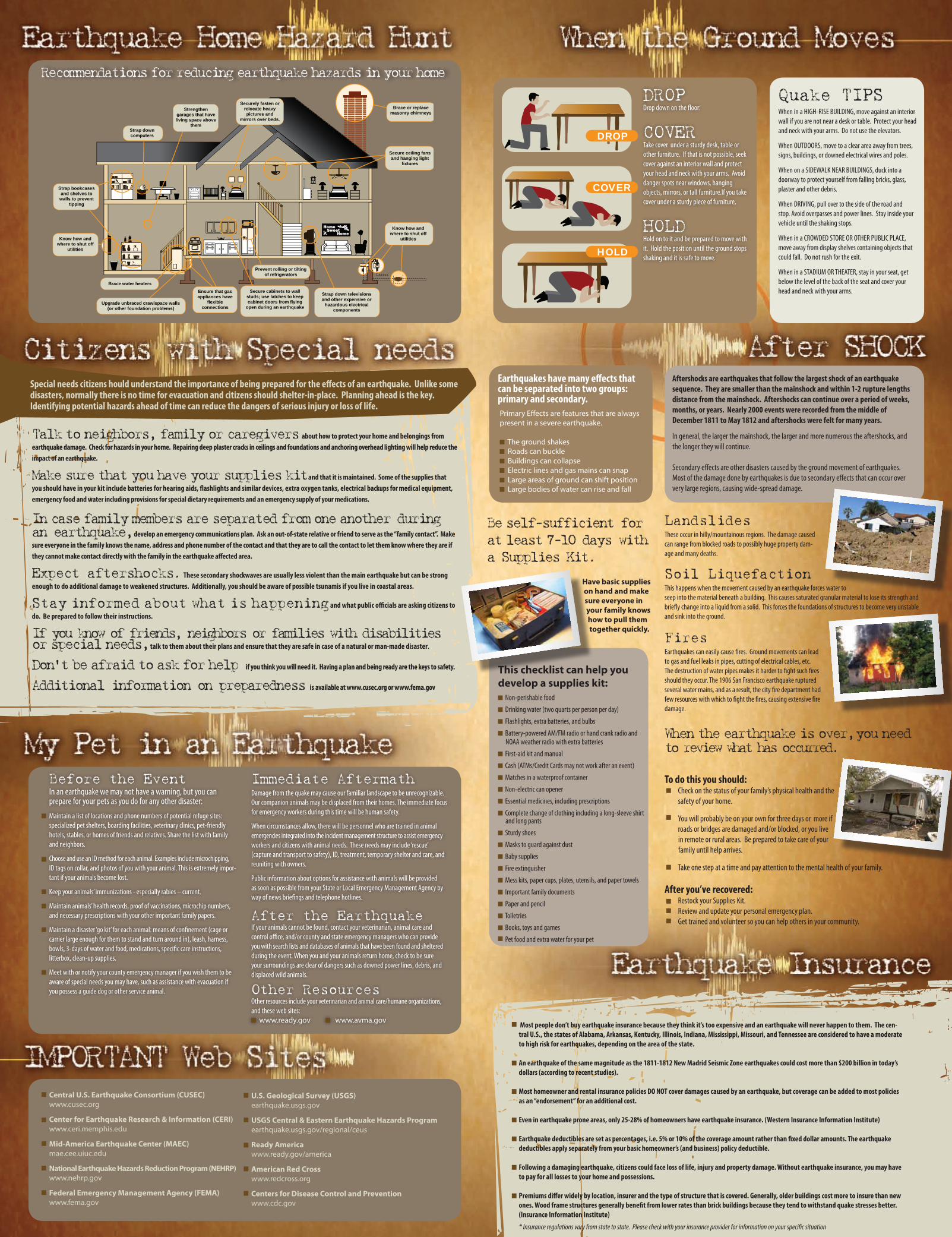
Strap down computers
Strengthen garages that have living space above
them
Securely fasten or relocate heavy pictures and
mirrors over beds.
Secure ceiling fans and hanging light
fixtures
Brace or replace masonry chimneys
Strap bookcases and shelves to
walls to prevent tipping
Know how and where to shut off
utilities
Brace water heaters
Upgrade unbraced crawlspace walls (or other foundation problems)
Ensure that gas appliances have
flexible connections
Secure cabinets to wall studs; use latches to keep cabinet doors from flying
open during an earthquake
Strap down televisions and other expensive or
hazardous electrical components
Prevent rolling or tilting of refrigerators
Know how and where to shut off
utilities
Talk to neighbors, family or caregivers about how to protect your home and belongings from earthquake damage. Check for hazards in your home. Repairing deep plaster cracks in ceilings and foundations and anchoring overhead lighting will help reduce the impact of an earthquake.
Make sure that you have your supplies kit and that it is maintained. Some of the supplies that you should have in your kit include batteries for hearing aids, flashlights and similar devices, extra oxygen tanks, electrical backups for medical equipment, emergency food and water including provisions for special dietary requirements and an emergency supply of your medications.
In case family members are separated from one another during an earthquake, develop an emergency communications plan. Ask an out-of-state relative or friend to serve as the “family contact”. Make sure everyone in the family knows the name, address and phone number of the contact and that they are to call the contact to let them know where they are if they cannot make contact directly with the family in the earthquake affected area.
Expect aftershocks. These secondary shockwaves are usually less violent than the main earthquake but can be strong enough to do additional damage to weakened structures. Additionally, you should be aware of possible tsunamis if you live in coastal areas.
Stay informed about what is happening and what public officials are asking citizens to do. Be prepared to follow their instructions.
If you know of friends, neighbors or families with disabilities or special needs, talk to them about their plans and ensure that they are safe in case of a natural or man-made disaster.
Don’t be afraid to ask for help if you think you will need it. Having a plan and being ready are the keys to safety.
Additional information on preparedness is available at www.cusec.org or www.fema.gov
Before the EventIn an earthquake we may not have a warning, but you can prepare for your pets as you do for any other disaster:
Maintain a list of locations and phone numbers of potential refuge sites: specialized pet shelters, boarding facilities, veterinary clinics, pet-friendly hotels, stables, or homes of friends and relatives. Share the list with family and neighbors.
Choose and use an ID method for each animal. Examples include microchipping, ID tags on collar, and photos of you with your animal. This is extremely impor-tant if your animals become lost.
Keep your animals’ immunizations - especially rabies – current.
Maintain animals’ health records, proof of vaccinations, microchip numbers, and necessary prescriptions with your other important family papers.
Maintain a disaster ‘go kit’ for each animal: means of confinement (cage or carrier large enough for them to stand and turn around in), leash, harness, bowls, 3-days of water and food, medications, specific care instructions, litterbox, clean-up supplies.
Meet with or notify your county emergency manager if you wish them to be aware of special needs you may have, such as assistance with evacuation if you possess a guide dog or other service animal.
Immediate AftermathDamage from the quake may cause our familiar landscape to be unrecognizable. Our companion animals may be displaced from their homes. The immediate focus for emergency workers during this time will be human safety.
When circumstances allow, there will be personnel who are trained in animal emergencies integrated into the incident management structure to assist emergency workers and citizens with animal needs. These needs may include ‘rescue’ (capture and transport to safety), ID, treatment, temporary shelter and care, and reuniting with owners.
Public information about options for assistance with animals will be provided as soon as possible from your State or Local Emergency Management Agency by way of news briefings and telephone hotlines.
After the EarthquakeIf your animals cannot be found, contact your veterinarian, animal care and control office, and/or county and state emergency managers who can provide you with search lists and databases of animals that have been found and sheltered during the event. When you and your animals return home, check to be sure your surroundings are clear of dangers such as downed power lines, debris, and displaced wild animals.
Other ResourcesOther resources include your veterinarian and animal care/humane organizations, and these web sites:
www.ready.gov www.avma.gov
Central U.S. Earthquake Consortium (CUSEC)www.cusec.org
Center for Earthquake Research & Information (CERI)www.ceri.memphis.edu
Mid-America Earthquake Center (MAEC)mae.cee.uiuc.edu
National Earthquake Hazards Reduction Program (NEHRP)www.nehrp.gov
Federal Emergency Management Agency (FEMA)www.fema.gov
U.S. Geological Survey (USGS)earthquake.usgs.gov
USGS Central & Eastern Earthquake Hazards Programearthquake.usgs.gov/regional/ceus
Ready Americawww.ready.gov/america
American Red Crosswww.redcross.org
Centers for Disease Control and Preventionwww.cdc.gov
DROP
COVER
HOLD
DROP Drop down on the floor:
COVER Take cover under a sturdy desk, table or other furniture. If that is not possible, seek cover against an interior wall and protect your head and neck with your arms. Avoid danger spots near windows, hanging objects, mirrors, or tall furniture.If you take cover under a sturdy piece of furniture,
HOLD Hold on to it and be prepared to move with it. Hold the position until the ground stops shaking and it is safe to move.
Quake TIPSWhen in a HIGH-RISE BUILDING, move against an interior wall if you are not near a desk or table. Protect your head and neck with your arms. Do not use the elevators.
When OUTDOORS, move to a clear area away from trees, signs, buildings, or downed electrical wires and poles.
When on a SIDEWALK NEAR BUILDINGS, duck into a doorway to protect yourself from falling bricks, glass, plaster and other debris.
When DRIVING, pull over to the side of the road and stop. Avoid overpasses and power lines. Stay inside your vehicle until the shaking stops.
When in a CROWDED STORE OR OTHER PUBLIC PLACE, move away from display shelves containing objects that could fall. Do not rush for the exit.
When in a STADIUM OR THEATER, stay in your seat, get below the level of the back of the seat and cover your head and neck with your arms.
Earthquakes have many effects that can be separated into two groups: primary and secondary.
Aftershocks are earthquakes that follow the largest shock of an earthquake sequence. They are smaller than the mainshock and within 1-2 rupture lengths distance from the mainshock. Aftershocks can continue over a period of weeks, months, or years. Nearly 2000 events were recorded from the middle of December 1811 to May 1812 and aftershocks were felt for many years. In general, the larger the mainshock, the larger and more numerous the aftershocks, and the longer they will continue.
Secondary effects are other disasters caused by the ground movement of earthquakes. Most of the damage done by earthquakes is due to secondary effects that can occur over very large regions, causing wide-spread damage.
LandslidesThese occur in hilly/mountainous regions. The damage caused can range from blocked roads to possibly huge property dam-age and many deaths.
Soil LiquefactionThis happens when the movement caused by an earthquake forces water to seep into the material beneath a building. This causes saturated granular material to lose its strength and briefly change into a liquid from a solid. This forces the foundations of structures to become very unstable and sink into the ground.
FiresEarthquakes can easily cause fires. Ground movements can lead to gas and fuel leaks in pipes, cutting of electrical cables, etc. The destruction of water pipes makes it harder to fight such fires should they occur. The 1906 San Francisco earthquake ruptured several water mains, and as a result, the city fire department had few resources with which to fight the fires, causing extensive fire damage.
Have basic supplies on hand and make sure everyone in your family knows how to pull them together quickly.
When the earthquake is over, you need to review what has occurred.
Most people don’t buy earthquake insurance because they think it’s too expensive and an earthquake will never happen to them. The cen-tral U.S., the states of Alabama, Arkansas, Kentucky, Illinois, Indiana, Mississippi, Missouri, and Tennessee are considered to have a moderate to high risk for earthquakes, depending on the area of the state.
An earthquake of the same magnitude as the 1811-1812 New Madrid Seismic Zone earthquakes could cost more than $200 billion in today’s dollars (according to recent studies).
Most homeowner and rental insurance policies DO NOT cover damages caused by an earthquake, but coverage can be added to most policies as an “endorsement” for an additional cost.
Even in earthquake prone areas, only 25-28% of homeowners have earthquake insurance. (Western Insurance Information Institute)
Earthquake deductibles are set as percentages, i.e. 5% or 10% of the coverage amount rather than fixed dollar amounts. The earthquake deductibles apply separately from your basic homeowner’s (and business) policy deductible.
Following a damaging earthquake, citizens could face loss of life, injury and property damage. Without earthquake insurance, you may have to pay for all losses to your home and possessions.
Premiums differ widely by location, insurer and the type of structure that is covered. Generally, older buildings cost more to insure than new ones. Wood frame structures generally benefit from lower rates than brick buildings because they tend to withstand quake stresses better. (Insurance Information Institute)
To do this you should: Check on the status of your family’s physical health and the safety of your home.
You will probably be on your own for three days or more if roads or bridges are damaged and/or blocked, or you live in remote or rural areas. Be prepared to take care of your family until help arrives.
Take one step at a time and pay attention to the mental health of your family.
After you’ve recovered: Restock your Supplies Kit. Review and update your personal emergency plan. Get trained and volunteer so you can help others in your community.
Special needs citizens hould understand the importance of being prepared for the effects of an earthquake. Unlike some disasters, normally there is no time for evacuation and citizens should shelter-in-place. Planning ahead is the key. Identifying potential hazards ahead of time can reduce the dangers of serious injury or loss of life.
Recommendations for reducing earthquake hazards in your home
Primary Effects are features that are always present in a severe earthquake.
The ground shakes Roads can buckle Buildings can collapse Electric lines and gas mains can snap Large areas of ground can shift position Large bodies of water can rise and fall
Be self-sufficient for at least 7-10 days with a Supplies Kit.
This checklist can help you develop a supplies kit:
Non-perishable food
Drinking water (two quarts per person per day)
Flashlights, extra batteries, and bulbs
Battery-powered AM/FM radio or hand crank radio and NOAA weather radio with extra batteries
First-aid kit and manual
Cash (ATMs/Credit Cards may not work after an event)
Matches in a waterproof container
Non-electric can opener
Essential medicines, including prescriptions
Complete change of clothing including a long-sleeve shirt and long pants
Sturdy shoes
Masks to guard against dust
Baby supplies
Fire extinguisher
Mess kits, paper cups, plates, utensils, and paper towels
Important family documents
Paper and pencil
Toiletries
Books, toys and games
Pet food and extra water for your pet
* Insurance regulations vary from state to state. Please check with your insurance provider for information on your specific situation

EpicenterThe point on the Earth’s surface above the point at depth in the Earth’s crust where an earthquake occurs.
FaultA fracture or crack along which two blocks of rock slide past one another. This movement may occur rapidly, in the form of an earth-quake, or slowly, in the form of creep.
MagnitudeRefers to the amount of energy released at the epicenter by the earthquake. Various scales are used, sometimes referred in news sources as the “Richter Scale”.
SeismologistsScientists who study earthquakes and their causes and effects.
Seismogram The record made by a seismograph
Seismographs Instruments that make an automatic record of the time, duration, direction, and intensity of earthquakes.
Theory of Plate TectonicsStates that the earth’s crust is divided into a number of relatively rigid plates that collide with, separate from, and translate past one another at their boundaries, this disruption commonly results in earthquakes.
Modified Mercalli Intensity (MMI) Scale The Modified Mercalli Intensity Scale is commonly used in the United States by seismologists seeking information on the severity of earthquake effects.
Many portions of this brochure have been adapted from the 2008 South Carolina Earthquake Guide originally developed by theSouth Carolina Emergency Management Division. We appreciate the inspiration and support they provided for this project. Images in this document
are provide courtesy South Carolina Emergency Management Division, Federal Emergency Management Agency, U.S. Geological Survey, Missouri Historical Society, and the Library of Congress, Geography and Map Division.
The Central United States Earthquake Consortium (CUSEC) is an incorporated non-profit organization in partnership with the Federal Government and the eight states most affected by earthquakes in the central U.S. Those states are Alabama, Arkansas, Illinois,
Indiana, Kentucky, Mississippi, Missouri, and Tennessee.
This publication is funded through a cooperative agreement with the Dept. of Homeland Security / Federal EmergencyManagement Agency - Grant Number 2009-RC-51-K046. For more information on earthquakes, disaster preparedness, and earthquake
mitigation, please visit the CUSEC website at www.cusec.org or call (800) 824-5817.
Central U.S. Earthquake Consortium | 2630 E. Holmes Road | Memphis, TN 38118Online: www.cusec.org | Toll Free: (800) 824-5817
����
����
� ����
����� � ������� � ��������
�
���
����
�� �
���������� � �������
� �������
��
��
�����
������������
���������� �����
����
�
The Modi�ed Mercalli Intensity Scale (MMI) The Magnitude Scale
I
II - III
IV - V
VI - VII
VIII - IX
Xor
Higher
MICRO
MINOR
LIGHT
MODERATE
STRONG
MAJORto
GREAT
(I) Not felt except by a very few people under especially favorable conditions.
(II) Felt only by a few people at rest, especially on upper floors of buildings.
(III) Felt quite noticeably by people indoors, especially on upper floors of buildings. Many people do not recognize it as an earthquake. Standing motorcars may rock slightly. Vibrations similar to the passing of a truck may be felt. Duration estimated.
(IV) Felt indoors by many, outdoors by few during the day. At night, some awakened. Dishes, windows, doors disturbed; walls make cracking sounds. Vibrations felt are similar to a heavy truck striking a building. (V) Felt by nearly everyone; many awakened; some dishes, windows broken and unstable objects overturned; pendulum clocks may stop.
(VI) Felt by all, many frightened; some heavy furniture movement; a few instances of fallen plaster; damage slight. (VII) Damage negligible in buildings of good design and construction; slight to moderate in well-built ordinary structures; considerable damage in poorly built or badly designed structures; some chimneys broken.
(VIII) Damage slight in specially designed structures; considerable damage in ordinary substantial buildings with partial collapse; damage great in poorly built structures. Chimneys, factory stacks, columns, monuments, walls may fall, heavy furniture overturned.(IX) Damage considerable in specially designed structures; well-designed frame structures thrown out of plumb; damage great in substantial buildings, with partial collapse; buildings shifted off foundations.
(X) Some well-built wooden structures destroyed; most masonry and frame structures destroyed with foundations; rails bent.(XI) Few, if any, (masonry) structures remain standing; bridges destroyed; rails bent greatly.(XII) Damage total; lines of sight and level are distorted; objects thrown into the air.
0.0 - 3.0
3.0 - 3.9
4.0 - 4.9
5.0 - 5.9
6.0 - 6.9
7.0 andHigher
Earthquakes are probably the most frightening naturally occurring hazard encountered. Why?
Earthquakes typically occur with little or no warning. There is no escape from an earthquake! The central United States typically has between 200-300 earthquakes each year, however, many are too small to be felt by humans. Some of the earthquakes, however, are felt, and in some cases, felt over a very large area.
Earthquake Causes:An earthquake is the violent shaking of the earth caused by a sudden movement of rock beneath its surface.
Plate Tectonics:Although earthquakes can occur anywhere on earth, the majority of earthquakes worldwide occur at plate boundaries. These earthquakes are known as interplate earthquakes. In contrast, the central United States is located within the interior of the North American plate, far from any plate boundary. Earthquakes occuring within a plate are intraplate earthquakes. Little is known as to why intraplate earthquakes occur. The most widely accepted model is that several geologically old fault systems of varying orientation within the subsurface are being reactivated while being subjected to stress. This stress buildup may be due to the Plate Tectonic Theory. For hundreds of millions of years, the forces of continental drift have reshaped the Earth. Continental drift is based on the concept that the continents bumped into, and slid over and under each other. Today, most people accept the theory that the Earth’s crust is on the move.
Central U.S. Seismicity:The central United States has several known seismic zones that produce earthquakes on a regular basis. These areas of seismicity are known as the New Madrid, Wabash Valley, and East Tennessee Seismic Zones. There are other zones of activity, but these three areas make up the most widely known. These zones have the highest level of seismicity in the country east of the Rocky Mountains. With little or no warning, a damaging earthquake could strike the region. Depending on earthquake magnitude and location, each of these zones could impact multiple states, causing major physical, social and economic disruption in a region that is home to more than forty million people.
In the winter of 1811-1812, a series of large earthquakes struck the central U.S. near New Madrid, Missouri. In those times, the region was sparsely populated and had little infrastructure. Today, these earthquakes would cause widespread damage and disruption to the entire nation. On April 18, 2008, a magnitude 5.4 earthquake struck near Mt. Carmel, Illinois. This relatively minor earthquake was felt in 28 states
and Canada and was responsible for an estimated $3 million in non-structural damages and damaged at least 240 structures in Illinois alone. The Mt. Carmel earthquake shows the widespread impact a larger
earthquake might have on the region.
In addition to earthquakes near home, earthquakes throughout the world serve as reminders to us that we need to be informed and prepared about our hazard. The January 12, 2010 7.0M Haiti earthquake is the most recent reminder that earthquakes can be devastating, and do not offer the same early warnings that is seen in severe weather events.
On December 16, 1811, 400 terrified residents in the town of New Madrid, Missouri were abruptly awakened by violent shaking and a tremendous roar. This was the first of three large (magnitude 7.5 - 8.0) earthquakes and thousands of aftershocks to rock the region that winter. Survivors reported that the earthquakes caused cracks to open in the earth’s surface, the ground to roll in visible waves, and large areas of land to sink or rise. The crew of the New Orleans (the first steamboat on the Mississippi, which was on her maiden voyage) reported mooring to an island only to awake in the morning and find that the island had disappeared below the waters of the Mississippi River. Damage was reported as far away as Charleston, South Carolina, and Washington, D.C.
These dramatic accounts clearly show that destructive earthquakes do not happen only in the western United States. In the past 25 years, scientists have learned that strong earthquakes in the central Mississippi Valley are not freak events but have occurred repeatedly in the geologic past. The area of major earthquake activity also has frequent minor shocks and is part of the New Madrid Seismic Zone, which makes up several faults that stretch from Marked Tree, Arkansas to Cairo, Illinois.
Earthquakes in the central or eastern United States affect much larger areas than earthquakes of similar magnitude in the western United States. For example, the San Francisco, California, earthquake of 1906 (magnitude 7.8) was felt 350 miles away in the middle of Nevada, whereas
the New Madrid earthquake of December 1811 was reported to have rang church bells in Boston, Massachusetts, 1,000 miles away. Differences in geologic makeup east and west of the Rocky Mountains cause this strong contrast. Today, an earth-quake of a magnitude similar to 1811-1812 would cause widespread damage and disruption.
Results of a scientific study commissioned by the Federal Emergency Management Agency indicate that an earthquake today of similar magnitude (7.7M) and location to the 1811-1812 New Madrid earthquakes could have the following results:
* Estimates based on a 2AM Event, 7.7M New Madrid Earthquake rupturing the three segments of the New Madrid Seismic Zone
An estimated 85,000 casualties might occur, of which approxi-mately 17,000 (about 20 percent) would be major injuries requir-ing hospitalization; fatalities would number about 3,500
Nearly 2,000,000 people would require short-term shelter at day 3 after the event
Approximately 715,000 buildings could be damaged
Total economic losses from damage to buildings, direct business interruption losses, and damage to transportation and utility sys-tems could exceed $200-300 billion. Direct economic losses due to building damages (not including business interruption losses) are estimated to exceed $100 billion
Many fires would burn, primarily in areas around the epicenter and metropolitan areas. The lack of operational firefighting equipment and water due to the earthquake would be a major concern
About 50 percent of urban households in the highest impact areas would be deprived of water. It would take weeks, if not months, to restore the water systems to normal operation
Hospitals would likely suffer significant building damage that could result in up to 150 facilities being nonfunctional
More than 1300 schools and more than 700 fire stations may have significant damage. In addition, extensive damage is expected to the large inventory of re-locatable school buildings
Close to 3,500 highway bridges would be damaged, hampering recovery efforts
About 1.25 million could be without power in the hardest hit areas
More than 50 million tons of debris would be generated