environmental risk management and mitigation strategies...
TRANSCRIPT
Journal of Civil, Construction and Environmental Engineering 2017; 2(2): 66-77
http://www.sciencepublishinggroup.com/j/jccee
doi: 10.11648/j.jccee.20170202.14
Environmental Risk Management and Mitigation Strategies for Offshore Gas Well Drilling Projects (Case Study: Abu Qir Bay, Egypt)
Moussa Sobh Elbisy, Ehab Abduraheem Mlybari
Civil Engineering Department, College of Engineering and Islamic Architecture, Umm Al Qura University, Makkah, Saudi Arabia
Email address: [email protected] (M. S. Elbisy), [email protected] (E. A. Mlybari)
To cite this article: Moussa Sobh Elbisy, Ehab Abduraheem Mlybari. Environmental Risk Management and Mitigation Strategies for Offshore Gas Well Drilling
Projects (Case Study: Abu Qir Bay, Egypt). Journal of Civil, Construction and Environmental Engineering. Vol. 2, No. 2, 2017, pp. 66-77.
doi: 10.11648/j.jccee.20170202.14
Received: March 15, 2017; Accepted: March 25, 2017; Published: April 12, 2017
Abstract: Risk evaluation for offshore gas exploration and production is a challenging task because much of the available
data are highly uncertain and vague, and many of the drilling techniques are complex. The paper describes the implementation
and use of environmental risk management and mitigation strategies for an offshore gas well drilling project. It includes an
offshore case study from Abu-Qir Bay in the Egyptian sector of the Mediterranean. The environmental risk management study
evaluated the potential impact of the operations and identified the mitigation procedures to be followed to eliminate any risk of
contamination. It provides a framework for the future environmental management of the area in order to minimize the negative
impacts of operations.
Keywords: Risk Assessment, Environmental Management Plan, Offshore Gas Well Project, Drilling,
Safety Mitigation Measures, Maintenance
1. Introduction
Oil and gas drilling engineering cooperation is
fundamental to oil and gas exploration and development.
This requires systematic engineering that involves numerous
investors and administrators, complicated techniques, and
large investments and risks. It also encompasses several work
categories and work procedures, grade separation, and
continuous operations. Moreover, it is a type of concealed
underground engineering. These characteristics produce
many uncertainties in oil and gas drilling projects, which lead
to great risks in every aspect of such projects. If effective
measures are not taken, these risks can easily lead to various
kinds of accidents, which will threaten the safety of operating
personnel and produce environmental pollution or even a
huge loss of government property [1].
The purpose of risk management is to ensure that adequate
measures (responses) are taken to protect people, the
environment, and assets from the harmful consequences of
the activities being undertaken, as well as to balance different
concerns, particularly health, environment, and safety (HES)
concerns, and costs. Risk management includes measures to
both avoid the occurrence of hazards and reduce their
potential harm. Risk assessment is followed by risk treatment,
which is a process involving the development and
implementation of measures to modify risk, including
measures designed to avoid, reduce (“optimize”), transfer, or
retain risk. Risk management covers all coordinated activities
designed to direct and control an organization with regard to
risk, whereas the risk management process is the systematic
application of management policies, procedures, and
practices to the tasks of establishing the context for, assessing,
treating, monitoring, reviewing, and communicating risks [2-
3].
Oil and gas exploration and production operations have
the potential for a variety of impacts on the environment,
depending upon the stage of the process, the nature and
sensitivity of the surrounding environment, and pollution
prevention, mitigation, and control techniques. In an aquatic
environment, the principal problems are linked to the
presence of offshore structures and to the waste streams of
the drilling fluids, cuttings, well treatment chemicals, and

67 Moussa S. Elbisy and Ehab A. Mlybari: Environmental Risk Management and Mitigation Strategies for
Offshore Gas Well Drilling Projects (Case Study: Abu Qir Bay, Egypt)
produced water [4-7]. The economic benefits of offshore oil
and gas exploration and exploitation must be weighed
against the potential for marine pollution. The greatest
perceived threats of pollution associated with offshore
development are spills and blowouts, but a more insidious
source is the discharged effluents generated by daily
drilling operations.
The potential environmental effects of offshore oil and
gas development have long been recognized [8-10],
including an awareness of the potential and documented
hazards from oil spills associated with offshore production
[11-13].
OSPAR [14] evaluated the impacts of offshore oil and gas
activities on the marine environment of the OSPAR maritime
area in the Northeast Atlantic to address environmental
concerns through international regulatory frameworks. Their
assessment was based on information from the annual
OSPAR data reports on discharges, spills, emissions, and
assessments. Gomiero et al. [15] developed a
multidisciplinary, chemical–biological approach focused on
changes in benthic communities and sediment chemical
accumulation to assess the environmental impact of offshore
gas exploitation and production activity in the Adriatic Sea.
The results of this survey regarding an offshore production
platform showed the importance of a multidisciplinary
approach that includes both chemical and biological analyses.
Elvin and Fraser [16] inadequately addressed the cumulative
environmental effects from the offshore oil and gas industry
in Canada in their environmental assessment process because
of the complexity of the analysis required to overcome the
unknowns with respect to the offshore environments.
Hernández et al. [17] developed a regional framework for the
sustainable management of marine water natural resources.
The results showed a failure rate of 51–92% in controlling
the marine impact of marine oil drilling and exploitation
southwest of the Gulf of Mexico.
The paper describes the implementation and use of
environmental risk management and mitigation strategies for
an offshore gas well drilling project. The study area is
located in Abu-Qir Bay (30°10′27.08''E and 31°34′27.42''N)
in the Egyptian sector of the Mediterranean. It has a depth of
approximately 28 m and is approximately 23.6 km from the
shore. The study included a baseline environmental
assessment of the site, a determination of the project’s impact
on the environment, an environmental impact assessment,
and the development of mitigation measures, with an
integrated plan for managing the identified environmental
hazards and effects, and a monitoring plan.
2. Existing Environment
2.1. Abu Qir Bay
Abu Qir Bay is a semi-circular basin that lies
approximately 35 km northeast of Alexandria on the
northeastern Egyptian Nile delta coast, between latitudes of
31°16' and 31°28'N and longitudes of 30°4' and 30°20'E. The
bay has a shoreline length of approximately 50 km. It is
relatively shallow, with a depth of less than 1 m along the
coast, which gradually increases away from the shore to a
maximum depth of approximately 15 m. The bay is
connected to Lake Edku, which is one of the coastal lagoons
of the Nile Delta that lies west of the Rosetta branch. This
lake is connected to the Mediterranean Sea through the
Boughaz EI-Meadia. Abu Qir Bay receives a substantial load
of industrial polluted water from the Tabia pumping station,
the brackish water of Lake Edku, and the Nile water reaching
the bay through the Rosetta mouth.
2.1.1. Sediment
A preliminary estimation of the nitrates in Abu Qir Bay
showed high values of 0.20–1.85 µg-at/L. The subsurface
layer along the coast and the surface water offshore had
higher concentrations. The sediment type distribution in the
bay depends principally on the distance from the mouth of
the Nile River. The hydrodynamic force and bottom
topography are additional factors that tend to redistribute
the surface layer of the thick sedimentary column formed
by the Nile River over thousands of years. A logical
analysis of the sediment of the Nile alluvium revealed that
this sediment consists of 25% sand, 43% silt, and 32% clay.
The dominant sediment forming minerals are feldspars,
quartz, pyroxenes amphiboles, iron oxides (opaque
minerals), and clay minerals. Other heavy minerals are
found in minor amounts, including zircon, tourmaline,
monazite, and garnet [18].
2.1.2. Major Constituents of Water
a) Salinity
The distribution of the salinity in the bay is generally
affected by the three main sources of inland discharge,
namely, the drainage water of Lake Edku, fresh Nile water
flowing from the Rashid branch, and contaminated drainage
water discarded from the El-Tabia pumping station. As a
result, the salinity of the bay water was found to be subjected
to wide fluctuations between 31‰ and 38‰. The lower
salinity appeared around the outlets of the inland discharges
previously mentioned, and it gradually increased away from
the shore. The variations in the salinity of the water in the
bay do not have a significant effect on the flora and fauna of
Abu Qir Bay because most of these are euryhaline forms that
can tolerate a wide range of salinity.
b) Total Alkalinity
The water in the western sector of the bay showed some
variation in its total alkalinity, with higher values equivalent
to 198 mg CaCO3 recorded at the surface water east to
Boughaz El-Maadiya. It gradually decreased westward to
minimal values near the El-Tabia outfall. Another increase
was observed in front of Abu Qir City. The subsurface water
had a lower concentration and appeared to be more
homogeneous in its horizontal distribution of the total
alkalinity. The total alkalinity in the bay was still within the
favorable limits needed for the growth of phytoplankton and

Journal of Civil, Construction and Environmental Engineering 2017; 2(2): 66-77 68
benthic flora.
c) Sulphite Content
The El-labia drainage water with its load of industrial
wastes represents the main source of dissolved sulphites in
the adjacent coastal waters. Thus, the highest sulphite
content was found near the El-Tabea pumping station,
where it reached approximately 1.8 mg Na2SO3/L. It
tended to gradually decrease away from the shore in a
northeastern direction. The surface and bottom layers had
mostly similar concentrations, with the same horizontal
distribution pattern.
d) 2.1.2.4 Calcium (Ca ++)
Estimates of the calcium in the western sector of Abu
Qir Bay indicated a lower concentration beside the El-
Tabia pumping station, with an obvious gradual increase
toward the northeast. This was explained by the effect of
wastewater with a lower calcium content. The
concentration of calcium in the surface water ranged from
0.39 to 0.68 gm/L in November and from 0.38 to 0.55
gm/L in February. Its concentration in the subsurface
water did not vary in its distribution pattern from that of
the surface water. However, slight increases to
approximately 0.76 and 0.45 gm/L dominated the
subsurface water in the vicinity of the El-Tabia outfalls
during the autumn and winter, respectively.
e) Magnesium (Mg ++)
Homogenous magnesium concentrations were generally
observed in Abu Qir Bay in the central regions.
Concentrations ranging from 1.4 to 1.6 gm/1 were found in
approximately 60% of the total area of the western section. A
significant rise to 2.3 gm/L appeared in the subsurface water
adjacent to the El-Tabia station in November 1982. The
influence of the water flowing from Lake Edku was
manifested by a sharp drop in its concentration to
approximately 0.5 gm/L in front of Boughaz E1-Maadiya,
and slight variations in the magnesium concentration
appeared with the depth. The magnesium concentrations
were nearly the same during autumn and winter.
f) Dissolved Oxygen (DO)
All of the measured values revealed that the bay, in
general, is a well-oxygenated water body and tends to be
saturated and sometimes over-saturated with DO (6–10
mL/L). However, in the vicinity of the El-Tabia pumping
station, the DO values decreased to 0.7 mL/L in the surface
water and 0.4 mg/L in the bottom water of the bay. Previous
studies found higher DO values in the range of 7–11.5 mL/L
in the offshore water and central part of the bay, which
drastically dropped to values of 0.5–1 mL/L in the western
coastal area between the Abu Qir suburb and El Tabia outfall.
The great fluctuations in the dissolved organic content are
probably due to the effect of several physical and biological
process activities with different rates, e. g., the consumption
of oxygen by the high organic load of the discharged
wastewater and oxygen production through the
photosynthetic activities of phytoplankton.
g) Organic Matter Represented by Biochemical Oxygen
Demand and Chemical Oxygen Demand
Abu Qir Bay has much higher levels of organic matter,
especially near the discharge of industrial effluents from the
El Tabia outfall. The levels of chemical oxygen demand
(COD) and biochemical oxygen demand (BOD) 300 m
from the El Tabia drain were 53 mg/l and 20 mg/l,
respectively.
h) Wind
The mean monthly wind speed is lower in summer and
higher in winter because of frequent storms during the winter
season. These speeds average 2 kn in summer and spring and
4 kn in winter. The maximum mean wind speed (8.5 kn)
occurred in December, while the minimum (1.5 kn) was in
August. Wind data revealed that the winter season is
characterized by wind coming from all directions; however,
northerly and northwesterly winds are still more predominant
than those from the other directions. The weather is highly
seasonal in nature and is strongly related to the high-pressure
systems whose limits overstep the boundaries of the
Mediterranean area [19]. The Nile Delta coast is subjected to
an average of seventeen major storms, called Nawat, each
year. In general, the storm season extends from September to
July, and storms with high intensity occur from November to
March. Figure 1 shows the wind rose over the study area
during the period of 2005–2006 [19].
i) Waves
The Nile Delta coast is affected by a wave regime that
varies with the season [20]. The average annual wave height
is approximately 0.94 m, and the predominant direction of all
waves is from the NW (42%), with a portion (25%)
approaching from the WNW. Approximately 87% of all the
wave heights are less than or equal to 1.5 m, and 13% are
greater than this value. The majority of the wave period
values (59%) are in the range of 5–8 s, with an annual mean
period of 6.5 s. Additionally, approximately 80% of the wave
periods are less than or equal to 8 s. The maximum
significant wave height (4.19 m) was observed during the
winter season, with a wave period of 10.7 s, and came from
the NW. The predominant wave directions generate a
westward-flowing longshore current. Waves approaching
from the N, NNE, and NE generate reversed longshore
currents toward the SW [20].

69 Moussa S. Elbisy and Ehab A. Mlybari: Environmental Risk Management and Mitigation Strategies for
Offshore Gas Well Drilling Projects (Case Study: Abu Qir Bay, Egypt)
Figure 1. Wind rose over study area during period of 2005–2006 [19].
2.2. Study Area
The study area was located in Abu-Qir Bay
(30°10′27.08''E and 31°34′27.42''N). It had a depth of
approximately 28 m and was approximately 23.6 km from
the shore (Figure 2).
The offshore development well (N. A/Q P-II#2) will be
drilled to 11000 ft TVDSS (Abu-Qir Bay in Mediterranean
Sea) using the Ocean Spur rig offshore development well,
which is proposed to be a vertical well, because the surface
and target geographical locations are the same
(31°36’46.83’’N, 30°05’52.39’’E).
The water depth at the proposed well location is ±93 ft.
The drilling operations are proposed to be finalized within 70
days of the starting date. In the drilling process, a
considerable amount of drilling mud will be used to lubricate
the drill string, cool the rotary drill bit, carry the rock
cuttings/fines from the well bore to the surface, inhibit the
entrance of undesirable formation fluids into the well bore,
and control excessive pressure in the well bore to prevent
blowouts.
Figure 2. Location of study area and bathymetric map of Abu-Qir Bay.

Journal of Civil, Construction and Environmental Engineering 2017; 2(2): 66-77 70
2.2.1. Measured Water Quality Parameters
The total dissolved solids (TDS) were measured after
filtering a known volume of a well-mixed sample using glass
fiber filter paper (0.045 mm), which was transferred to a
weighed evaporating dish, evaporated to dryness in a drying
oven at 180°C, and cooled in a desiccator to the balance
temperature before calculating the TDS. The BOD was
determined using the 5 day method, and the COD was
determined using the potassium dichromate method. The
water alkalinity was determined using phenolphthalein and
methyl orange indicators. The chlorisity was measured using
Mohr’s method. The sulphide was determined using the
iodometeric method. The total hardness was determined
through a complexometric method by direct titration using
EDTA solution. The ammonia was determined using the
phenate method. The nitrate as determined using the
reduction method, as described by Mullin and Riley [21].
The orthophosphate was determined using the stannous
chloride and acid molybdate method. The measured water
quality parameters are represented in Table 1.
2.2.2. Heavy Metals in Water
Five milliliters of concentrated HNO3 was added to each 1 L
sample to preserve it, after which it was stored in a refrigerator
at approximately 4°C for later analyses. To determine the
concentrations of various elements (Fe, Mn, Cu, Zn, Cd, and
Pb) 20 mL of nitric acid was added to 500 mL of a well-mixed
sample in a beaker. Slow boiling and evaporation on a hot
plate were carried out until a reduced volume was reached
(before dryness occurred) and the digestion was complete. The
beaker walls were washed down with distilled water, and the
sample was transferred to a 100 mL volumetric flask, cooled,
diluted to mark, and mixed thoroughly. The samples were
analyzed using a Perkin Elmer atomic adsorption spectroscope
with a graphite furnace. The concentrations of these elements
were determined using standard calibration curves from a
series of different standard concentrations for each element. A
blank sample was prepared using de-ionized distilled water
acidified by concentrated nitric acid and treated like the
previous samples. The concentrations of the heavy metals in
the water samples are listed in Table 2.
Table 1. Measured water quality parameters.
Parameters TDS
(g/L)
Salinity
(‰)
EC
(mS/cm)
TSS
(mg/L)
COD
(mg/L)
Calcium
(mg/L)
Magnesium
(mg/L)
Chloride
(g/L)
Concentration 40.9 39.1 57 526 12.5 725 1210 21.3
Parameters Nitrate
(µg/L)
Ammonia
(µg/L)
Silica
(mg/L)
Nitrite
(µg/L)
Sulfate
(g/L) pH
Orthophosphate
(µg/L)
Concentration 45 325 1.25 5.5 3.5 8.15 57.5
Table 2. Concentrations of heavy metals in water samples.
Parameters Cadmium µg/L Copper µg/L Manganese µg/L Lead µg/L Iron µg/L Zincc µg/L
Concentration 1.91 7.5 51.6 12.6 255 95.6
2.2.3. Organic Pollutants
The total polyaromatic hydrocarbons were measured using
the UNEP analysis method (1984). The pollution analysis of
the total petroleum hydrocarbons (TPH) showed a value of
55 mg/L.
2.2.4. Meio Fauna
It was found that the benthic community at this site
consisted of three phyla: Annelida, Arthropoda, and
Mollusca. Numerically, Annelida and Arthropoda had the
same percentages (36.36%) of the total benthic community at
this site, followed by Mollusca (27.27%).
Regarding the biomass, the collected species contributed a
total of 15.084 GFW/m², with Mollusca having the largest
weight, constituting 95.03% of the total weight, followed by
Annelida (4.47%) and Arthropoda (0.51%).
2.2.5 Fisheries
Fisheries are important sources of income in the study area.
In the Idku district, approximately 10% of the population
depends on marine and freshwater fisheries. In the town of
Meadia and its surrounding villages, the proportion is 50%.
Marine fishing is very important in Meadia. There are more
than 270 boats registered in the Meadia fishing port. Fish
catches rose from 1,500 tons in 1984 to approximately
11,500 tons in 1996. Fishing in various forms occurs
extensively in the area of the proposed export pipeline route.
The fishing activity appears to involve a variety of methods,
including trawling, purse seiners, gill nets, and surface long
liners. The type that poses the greatest hazard to the pipeline
is trawling, because this is carried out using a sac-like net
with two clump weights attached close to the ends of the net,
which is dragged along the seabed. The other types are
associated with mid-depth and surface fishing and will not
influence the pipeline.
2.3. Process Description
The proposed offshore development well will be drilled to
11000 ft TVDSS. In the drilling process, a considerable
amount of drilling mud (water-based mud) will be used to
lubricate the drill string, cool the rotary drill bit, carry the
rock cuttings/fines from the well bore to the surface, inhibit
the entrance of undesirable formation fluids into the well
bore, and control excessive pressure in the well bore to
prevent blowouts. The cuttings will be transferred by boat in
isolated boxes from the rig to an onshore base and then by a
truck to a contractor’s base, where they will be processed by
the contractor's treatment facilities to make them
environmentally safe. Water for preparing the mud and fresh
water for drinking and accommodations will be supplied

71 Moussa S. Elbisy and Ehab A. Mlybari: Environmental Risk Management and Mitigation Strategies for
Offshore Gas Well Drilling Projects (Case Study: Abu Qir Bay, Egypt)
from a well base by workboats.
3. Environmental Impacts
The significance of the impacts will be determined to
ascertain whether they are acceptable, require mitigation, or
are unacceptable to the community. The significance of an
impact is determined by considering its characteristics and
the values attached to them. The significance can be
determined based on ecological importance, social
importance, and environmental standards. The significance of
the impact from any of the activities is based on the
following factors:
i. The possibility of environmental damage (certain,
probable, uncertain), and
ii. The scope of the impact (minor or no impact), the
possibility of rehabilitating the environment after the
occurrence of the damage, and the continuity of an
impact (temporary, permanent).
These factors can be used to assess the impact in a
scientific manner, with the result showing one of two
possibilities: no impact or minor impact.
3.1. Air Quality
There are numerous emission sources affecting the
offshore atmosphere as a result of the project activities,
including marine vessels, the machinery and equipment of
the rig (e. g., generators, cranes, and compressors), and well
testing. Atmospheric emissions from these sources comprise
carbon dioxide (CO2), methane (CH4), nitrogen oxides (NOX),
sulphur dioxide (SO2), carbon monoxide (CO), and volatile
organic compounds (VOCs). Table 3 lists the environmental
impacts of these emissions.
The emissions from marine vessels are expected to be
relatively low, notably because the emission sources are
mobile, and the durations of these emissions are relatively
short. It is believed that these emissions would be readily
dispersed over a wide area. Hence, the significance of the
impact associated with emissions from marine vessels is
considered to be low.
The emissions from the machinery and equipment of the
rig (e. g., generators, cranes, and compressors) are also
expected to be relatively low considering the periodic
maintenance of this equipment and machinery, and these
emissions would be readily dispersed over a wide area.
Hence, the significance of the impact associated with
emissions from machinery and equipment is considered to be
low.
The flow testing technique for well testing is associated
with the generation of significant volumes of well fluid. The
fluids produced will be flared using a low-emission burner
boom with auxiliary air injection. These flares are installed
on cantilevers, and seawater spray systems are used to reduce
the heat radiation effects on the rig. The key advantages of
using these burners are their smoke free and fallout free
operation, which has minimal environmental impact, and
their ability to efficiently burn all types of oils, including
heavy crude oils. The main sensitive receptors that could be
potentially affected by the atmospheric emissions associated
with the proposed drilling activities include: sensitive human
resources, air quailaty in and around the proposed drilling sitr,
and air quality in the coastal zone.
The highest concentrations of emissions at and near the rig
would be expected during hydrocarbon flaring events after
well testing, and minor localized reductions in air quality
could be expected. It is expected that wind and natural
atmospheric circulation would rapidly disperse these
emissions. Because of the short-lived nature (24–36 h) of
these flaring activities and the rapid/comprehensive
dispersion of the emissions, adverse effects on the health of
the rig and vessel personnel in the area are not anticipated.
Marine fauna are not expected to be at risk from the
atmospheric emissions generated, and it is expected that the
sea level concentrations at the drilling site would be below
harmful levels. The considerable distance of the offshore
drilling operations from the sensitive receptors on the
shore/coastline means that no deterioration in onshore/coastal
air quality is expected. Overall, because the atmospheric
emissions would be readily dispersed, the significance of the
impacts on the offshore atmosphere resulting from the release
of emissions during these activities is considered to be “low.”
Table 3. Environmental impact assessment of emissions.
Emission Environmental Impact
Carbon dioxide
(CO2)
A green house gas that contributes to climate
change.
Methane (CH4)
Contributes directly to climate change by
enhancing low level ozone production. Poisonous
at high concentrations and can potentially enhance
photochemical smog formation.
Carbon Monoxide
(CO)
Contributes indirectly to climate change by
enhancing low level ozone production. Highly
toxic to human health at concentrations of several
percent and can augment
photochemical smog formation.
Nitrogen Oxides
(NOX)
NO2 is a toxic gas, even at relatively low
concentrations. NOx also contributes to the
formation of acidic species, which can be deposited
by wet and dry processes.
Acidic species may impact both freshwater and
terrestrial ecosystems. NOx augments the
formation of ozone at ground level when mixed
with VOCs in the sunlight atmosphere. NO is a
relatively innocuous species, but is of interest as a
precursor of NO2.
Sulphur Dioxide
(SO2)
SO2 is a toxic gas, and is known to contribute to
acid deposition (wet and dry), which may impact
both freshwater and terrestrial ecosystems. It has
direct health effects that potentially cause
respiratory illness.
Volatile Organic
Compounds
(VOCs)
The non-methane VOCs associated with the
proposed development are anticipated to be
predominately hydrocarbons, which play an
important role in the formation of photochemical
oxidants such as tropospheric ozone. Many are also
known or suspected carcinogens.
3.2. Water Quality
Numerous drilling activities have been assessed as having
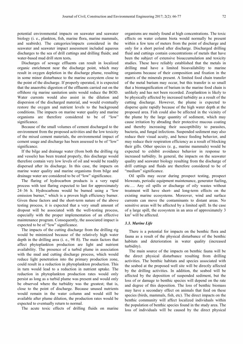
Journal of Civil, Construction and Environmental Engineering 2017; 2(2): 66-77 72
potential environmental impacts on seawater and seawater
biology (i. e., plankton, fish, marine flora, marine mammals,
and seabirds). The categories/impacts considered in the
seawater and seawater impact assessment included aqueous
discharges to the sea of drill cuttings and drilling fluids; and
water-based mud drill stem tests.
Discharges of sewage effluents can result in localized
organic enrichment near the discharge point, which may
result in oxygen depletion in the discharge plume, resulting
in some minor disturbance to the marine ecosystem close to
the point of the discharge. If properly operated, it is expected
that the anaerobic digestion of the effluents carried out on the
offshore rig marine sanitation units would reduce the BOD.
Water currents would also assist in the dilution and
dispersion of the discharged material, and would eventually
restore the oxygen and nutrient levels to the background
conditions. The impacts on marine water quality and marine
organisms are therefore considered to be of “low”
significance.
Because of the small volumes of cement discharged to the
environment from the proposed activities and the low toxicity
of the mixed cement materials, the environmental impact of
cement usage and discharge has been assessed to be of “low”
significance.
If the bilge and drainage water (from both the drilling rig
and vessels) has been treated properly, this discharge would
therefore contain very low levels of oil and would be readily
dispersed after its discharge. In this case, the impacts on
marine water quality and marine organisms from bilge and
drainage water are considered to be of “low” significance.
The flaring of hydrocarbon products is a very rapid
process with test flaring expected to last for approximately
24–36 h. Hydrocarbons would be burned using a “low
emission burner,” which is a proven high efficiency burner.
Given these factors and the short-term nature of the above
testing process, it is expected that a very small amount of
dropout will be associated with the well-testing process,
especially with the proper implementation of an effective
maintenance program. Consequently, the associated impact is
expected to be of “low” significance.
The impacts of the cutting discharge from the drilling rig
would be minimized because of the relatively high water
depth in the drilling area (i. e., 98 ft). The main factors that
affect phytoplankton production are light and nutrient
availability. The presence of a turbid plume in association
with the mud and cutting discharge process, which would
reduce light penetration into the primary production zone,
could result in a reduction in phytoplankton production. This
in turn would lead to a reduction in nutrient uptake. The
reduction in phytoplankton production rates would only
persist as long as a turbid plume was present and would only
be observed where the turbidity was the greatest; that is,
close to the point of discharge. Because unused nutrients
would remain in the water column and would still be
available after plume dilution, the production rates would be
expected to eventually return to normal.
The acute toxic effects of drilling fluids on marine
organisms are mainly found at high concentrations. The toxic
effects on water column biota would normally be present
within a few tens of meters from the point of discharge and
only for a short period after discharge. Discharged drilling
fluid and cuttings contain concentrations of metals that have
been the subject of extensive bioaccumulation and toxicity
studies. These have reliably established that the metals in
drilling mud have a limited bioavailability to marine
organisms because of their composition and fixation in the
matrix of the minerals present. A limited food chain transfer
of the metal barium may occur, but this transfer is so small
that a biomagnification of barium in the marine food chain is
unlikely and has not been recorded. Zooplankton is likely to
be physically affected by increased turbidity as a result of the
cutting discharge. However, the plume is expected to
disperse quite rapidly because of the high water depth at the
proposed area. Fish could also be affected in the vicinity of
the plume by the large quantity of sediment, which may
cause irritation by abrading their protective mucous coating
and thereby increasing their susceptibility to parasites,
bacteria, and fungal infections. Suspended sediment may also
reduce their visual acuity, and hence feeding behavior, and
may reduce their respiration efficiency as a result of blocking
their gills. Other species (e. g., marine mammals) would be
expected to exhibit avoidance behavior in response to
increased turbidity. In general, the impacts on the seawater
quality and seawater biology resulting from the discharge of
drill cuttings and fluids are therefore considered to be of
“medium” significance.
Oil spills may occur during prospect testing, prospect
blowouts, periodic equipment maintenance, generator fueling,
etc…. Any oil spills or discharge of oily wastes without
treatment will have short- and long-term effects on the
existing marine ecosystems. Moreover, wind and surface
currents can move the contaminants to distant areas. No
sensitive areas will be affected by a limited spill. In the case
of a large spill, the ecosystem in an area of approximately 3
km2 will be affected.
3.3. Marine Life
There is a potential for impacts on the benthic flora and
fauna as a result of the physical disturbance of the benthic
habitats and deterioration in water quality (increased
turbidity).
The main source of the impacts on benthic fauna will be
the direct physical disturbance resulting from drilling
activities. The benthic habitats and species associated with
the seabed at the proposed well site will be directly affected
by the drilling activities. In addition, the seabed will be
affected by the deposition of suspended sediment, but the
loss of or damage to benthic species will depend on the rate
and degree of this deposition. The loss of benthic biomass
may have a secondary effect on animals that feed on these
species (birds, mammals, fish, etc). The direct impacts on the
benthic community will affect localized individuals within
the population of benthic species found in the study area. The
loss of individuals will be caused by the direct physical

73 Moussa S. Elbisy and Ehab A. Mlybari: Environmental Risk Management and Mitigation Strategies for
Offshore Gas Well Drilling Projects (Case Study: Abu Qir Bay, Egypt)
disturbance. Therefore, the impacts are not likely to affect
more than one generation (i. e., the disturbed areas will be
recognized by other individuals). Therefore, the impacts are
considered to be minor.
3.4. Noise
Noise will be generated during the equipment mobilization
and primary installation activities. Higher levels of noise may
continue during the initial phases of the drilling activities and
abandonment of the well. The sound and vibration generated
during drilling may lead to the repulsion of some fish species
and other aquatic forms from the immediate vicinity of the
drilling area, as well as affecting the workers.
Noise has an unavoidable impact because of the nature of
the drilling. However, the impact on the environment would
be limited because of the short period of the drilling activities.
If the drilling proves to be successful, much lower sound
levels will be encountered. Consequently, the fish and
aquatic fauna will restock the area again, and workers will
usually wear hearing protection.
3.5. Drilling Fluids
Water-based mud will be used as a drilling fluid, which will
be dumped with its cuttings into the sea. Water-based mud is
considered to be environmental friendly for offshore drilling,
because it has a minor impact on the surrounding environment.
3.6. Collision Risk
The drilling rig is equipped with warning lights, foghorns,
and other identification equipment, as approved by the
Egyptian ports and lights authority. An up-to-date radio room
is located on the drilling unit, with various marine radios,
which monitor the international distress frequency 24 h per
day for possible collisions. A radar unit is also provided. This
unit is manned 24 h per day and tracks ships approaching
within 12 nautical miles (nm) of the rig. Ships entering an
area with a 5 nautical mile radius and appearing to be on a
collision course are contacted by marine radio and asked to
maintain a safe distance from the rig. If radio contact cannot
be established, one of the two supply vessels will be
dispatched to the scene to attract the attention of the vessel
using a fire hose, ship horn, etc. This supply boat will try to
establish radio contact with the approaching ship to divert it
from its course and/or determine if the ship has mechanical
difficulty. If no contact can be established and/or it has
mechanical difficulty (engine/steering failure), the rig
personnel will be ready to abandon operations and evacuate.
3.7. Socioeconomic Impacts
The main socioeconomic impacts considered in this study
include the potential interference with fishing activities,
potential interference with marine traffic, and employment.
The proposed drilling activities may result in a short-term
site-to-local-area and low-magnitude impact on offshore
fishing operations. The location of the proposed well is
within the oil and gas concession area, which has limited
importance for fishing activities. The impact on fishing
activities associated with the proposed drilling activities is
expected to be of “low” significance.
The offshore drilling activities will result in short-term,
local, and low impacts on marine traffic activities associated
with the presence and movement of the drilling rig, supply
boats, etc. The impact on marine traffic activities associated
with the proposed drilling activities is expected to be of “low”
significance.
Usually, drilling activities employ a group of workers from
the nearest areas. The presence of these work groups mandate
extra manpower to satisfy their human needs such as food
supplies, medical care and supplies, fuel, linen service, dry
cleaning, sewage removal, and garbage hauling. There will
be added job opportunities for such service contractors.
These types of activities will create extra jobs, leading to an
improvement in the socioeconomic status of the area.
4. Mitigation Measures
Mitigation measures will be adopted to minimize the
potential negative environmental impacts from the different
project stages. The detailed mitigation measures are
presented in Table 4.
Table 4. Mitigation measures.
Mitigation measures
During construction During operation
Air quality
Employ dust suppression measures.
Prohibit waste burning on the site.
All machines must be maintained and operated under the
manufacturer's standards to ensure operational efficiency.
No routine venting will take place during the operations.
Water quality
The contaminated drainage must be treated with an oil/water separator.
Waste from sewage/grey water must be treated to reduce the
concentration of organic material prior to discharge.
All solid wastes will be transported to shore for waste disposal.
All vessels must comply with all of the requirements of MARPOL (the
International Convention for the Prevention of Pollution from Ships).
Prompt containment using floating booms and other means of recovery
will be performed as a quick response to oil spills.
Predictive mathematical models will be used to predict the direction of
an oil slick based on the wind strength and direction, along with the
surface water currents.
Produced water must be treated prior to discharge.
Cuttings must be transported to shore.
Solid wastes must be transported to shore for proper
treatment and disposal.
Flaring during testing will cease if an oil sheen appears on
the sea surface.
Small oil spills and leaks must be cleaned up using routine
cleanup equipment.
Prompt containment using floating booms and other means
of recovery will be performed as a quick response to an oil
spill.
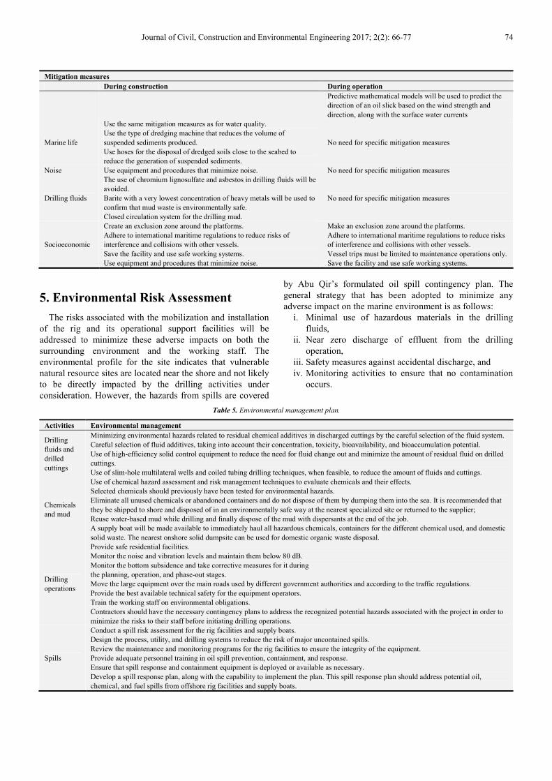
Journal of Civil, Construction and Environmental Engineering 2017; 2(2): 66-77 74
Mitigation measures
During construction During operation
Predictive mathematical models will be used to predict the
direction of an oil slick based on the wind strength and
direction, along with the surface water currents
Marine life
Use the same mitigation measures as for water quality.
Use the type of dredging machine that reduces the volume of
suspended sediments produced.
Use hoses for the disposal of dredged soils close to the seabed to
reduce the generation of suspended sediments.
No need for specific mitigation measures
Noise Use equipment and procedures that minimize noise. No need for specific mitigation measures
Drilling fluids
The use of chromium lignosulfate and asbestos in drilling fluids will be
avoided.
Barite with a very lowest concentration of heavy metals will be used to
confirm that mud waste is environmentally safe.
Closed circulation system for the drilling mud.
No need for specific mitigation measures
Socioeconomic
Create an exclusion zone around the platforms.
Adhere to international maritime regulations to reduce risks of
interference and collisions with other vessels.
Save the facility and use safe working systems.
Use equipment and procedures that minimize noise.
Make an exclusion zone around the platforms.
Adhere to international maritime regulations to reduce risks
of interference and collisions with other vessels.
Vessel trips must be limited to maintenance operations only.
Save the facility and use safe working systems.
5. Environmental Risk Assessment
The risks associated with the mobilization and installation
of the rig and its operational support facilities will be
addressed to minimize these adverse impacts on both the
surrounding environment and the working staff. The
environmental profile for the site indicates that vulnerable
natural resource sites are located near the shore and not likely
to be directly impacted by the drilling activities under
consideration. However, the hazards from spills are covered
by Abu Qir’s formulated oil spill contingency plan. The
general strategy that has been adopted to minimize any
adverse impact on the marine environment is as follows:
i. Minimal use of hazardous materials in the drilling
fluids,
ii. Near zero discharge of effluent from the drilling
operation,
iii. Safety measures against accidental discharge, and
iv. Monitoring activities to ensure that no contamination
occurs.
Table 5. Environmental management plan.
Activities Environmental management
Drilling
fluids and
drilled
cuttings
Minimizing environmental hazards related to residual chemical additives in discharged cuttings by the careful selection of the fluid system.
Careful selection of fluid additives, taking into account their concentration, toxicity, bioavailability, and bioaccumulation potential.
Use of high-efficiency solid control equipment to reduce the need for fluid change out and minimize the amount of residual fluid on drilled
cuttings.
Use of slim-hole multilateral wells and coiled tubing drilling techniques, when feasible, to reduce the amount of fluids and cuttings.
Chemicals
and mud
Use of chemical hazard assessment and risk management techniques to evaluate chemicals and their effects.
Selected chemicals should previously have been tested for environmental hazards.
Eliminate all unused chemicals or abandoned containers and do not dispose of them by dumping them into the sea. It is recommended that
they be shipped to shore and disposed of in an environmentally safe way at the nearest specialized site or returned to the supplier;
Reuse water-based mud while drilling and finally dispose of the mud with dispersants at the end of the job.
A supply boat will be made available to immediately haul all hazardous chemicals, containers for the different chemical used, and domestic
solid waste. The nearest onshore solid dumpsite can be used for domestic organic waste disposal.
Drilling
operations
Provide safe residential facilities.
Monitor the noise and vibration levels and maintain them below 80 dB.
Monitor the bottom subsidence and take corrective measures for it during
the planning, operation, and phase-out stages.
Move the large equipment over the main roads used by different government authorities and according to the traffic regulations.
Provide the best available technical safety for the equipment operators.
Train the working staff on environmental obligations.
Contractors should have the necessary contingency plans to address the recognized potential hazards associated with the project in order to
minimize the risks to their staff before initiating drilling operations.
Spills
Conduct a spill risk assessment for the rig facilities and supply boats.
Design the process, utility, and drilling systems to reduce the risk of major uncontained spills.
Review the maintenance and monitoring programs for the rig facilities to ensure the integrity of the equipment.
Provide adequate personnel training in oil spill prevention, containment, and response.
Ensure that spill response and containment equipment is deployed or available as necessary.
Develop a spill response plan, along with the capability to implement the plan. This spill response plan should address potential oil,
chemical, and fuel spills from offshore rig facilities and supply boats.
75 Moussa S. Elbisy and Ehab A. Mlybari: Environmental Risk Management and Mitigation Strategies for
Offshore Gas Well Drilling Projects (Case Study: Abu Qir Bay, Egypt)
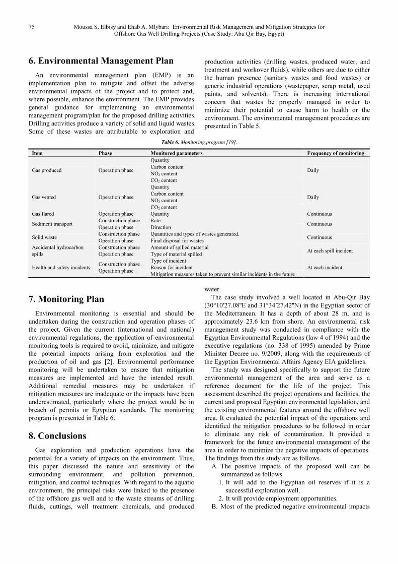
6. Environmental Management Plan
An environmental management plan (EMP) is an
implementation plan to mitigate and offset the adverse
environmental impacts of the project and to protect and,
where possible, enhance the environment. The EMP provides
general guidance for implementing an environmental
management program/plan for the proposed drilling activities.
Drilling activities produce a variety of solid and liquid wastes.
Some of these wastes are attributable to exploration and
production activities (drilling wastes, produced water, and
treatment and workover fluids), while others are due to either
the human presence (sanitary wastes and food wastes) or
generic industrial operations (wastepaper, scrap metal, used
paints, and solvents). There is increasing international
concern that wastes be properly managed in order to
minimize their potential to cause harm to health or the
environment. The environmental management procedures are
presented in Table 5.
Table 6. Monitoring program [19].
Item Phase Monitored parameters Frequency of monitoring
Gas produced Operation phase
Quantity
Daily Carbon content
NO2 content
CO2 content
Gas vented Operation phase
Quantity
Daily Carbon content
NO2 content
CO2 content
Gas flared Operation phase Quantity Continuous
Sediment transport Construction phase Rate
Continuous Operation phase Direction
Solid waste Construction phase Quantities and types of wastes generated.
Continuous Operation phase Final disposal for wastes
Accidental hydrocarbon
spills
Construction phase Amount of spilled material At each spill incident
Operation phase Type of material spilled
Health and safety incidents Construction phase
Operation phase
Type of incident
At each incident Reason for incident
Mitigation measures taken to prevent similar incidents in the future
7. Monitoring Plan
Environmental monitoring is essential and should be
undertaken during the construction and operation phases of
the project. Given the current (international and national)
environmental regulations, the application of environmental
monitoring tools is required to avoid, minimize, and mitigate
the potential impacts arising from exploration and the
production of oil and gas [2]. Environmental performance
monitoring will be undertaken to ensure that mitigation
measures are implemented and have the intended result.
Additional remedial measures may be undertaken if
mitigation measures are inadequate or the impacts have been
underestimated, particularly where the project would be in
breach of permits or Egyptian standards. The monitoring
program is presented in Table 6.
8. Conclusions
Gas exploration and production operations have the
potential for a variety of impacts on the environment. Thus,
this paper discussed the nature and sensitivity of the
surrounding environment, and pollution prevention,
mitigation, and control techniques. With regard to the aquatic
environment, the principal risks were linked to the presence
of the offshore gas well and to the waste streams of drilling
fluids, cuttings, well treatment chemicals, and produced
water.
The case study involved a well located in Abu-Qir Bay
(30°10′27.08''E and 31°34′27.42''N) in the Egyptian sector of
the Mediterranean. It has a depth of about 28 m, and is
approximately 23.6 km from shore. An environmental risk
management study was conducted in compliance with the
Egyptian Environmental Regulations (law 4 of 1994) and the
executive regulations (no. 338 of 1995) amended by Prime
Minister Decree no. 9/2009, along with the requirements of
the Egyptian Environmental Affairs Agency EIA guidelines.
The study was designed specifically to support the future
environmental management of the area and serve as a
reference document for the life of the project. This
assessment described the project operations and facilities, the
current and proposed Egyptian environmental legislation, and
the existing environmental features around the offshore well
area. It evaluated the potential impact of the operations and
identified the mitigation procedures to be followed in order
to eliminate any risk of contamination. It provided a
framework for the future environmental management of the
area in order to minimize the negative impacts of operations.
The findings from this study are as follows.
A. The positive impacts of the proposed well can be
summarized as follows.
1. It will add to the Egyptian oil reserves if it is a
successful exploration well.
2. It will provide employment opportunities.
B. Most of the predicted negative environmental impacts
Journal of Civil, Construction and Environmental Engineering 2017; 2(2): 66-77 76
have low to negligible significance. The main adverse
impacts are as follows.
1. The expected impacts of emissions from marine
vessels, machinery, and equipment are considered to
be relatively low.
2. Offshore airborne noise may disturb birds and marine
mammals. However, upon the completion of the
drilling activities, it is likely that birds and marine
mammals would re-colonize back to their normal
habitats.
3. The expected impacts of discharges of sewage
effluents, cement usage, and bilge on the marine
water quality and marine organisms are considered to
be of “low” significance.
4. The main impacts on marine fauna and flora are the
deteriorating seawater quality due to seabed sediment
during the construction and the discharge of
produced water during the operation. These impacts
will be mitigated through a set of measures.
5. It was predicted that the impacts on the marine
biology resulting from the discharge of drill cuttings
and fluids would be of “low” significance if only
water-based mud were used.
6. All of the garbage (paper, other burnable trash, food
remains, and wet garbage) will be collected and
transported to shore for disposal.
7. The main adverse socioeconomic impact is the
interference with fishing activities during the
construction phase.
C. The mitigation measures used to prevent and minimize
the negative impacts of the project were presented.
D. Environmental performance monitoring will be
undertaken to ensure that the mitigation measures are
implemented and have the intended result.
References
[1] Zhenhai, X., and Longwei, W., (2002). “Index system study of risk investment project evaluation” Journal of Zhongyuan University of Technology, Vol. 1, pp. 44-47.
[2] Maggi, C., Trabucco, B., Mannozzi, M., Manfra, L., Gabellini, M., Di Mento, R., Nonnis, O., Virno Lamberti, C., and Cicero, A. M. (2007). “A methodology approach to study the environmental impact of oil and gas offshore platforms.” Rapport de la Commission Internationale pour l’Exploration Scientifique de la Mer Méditerranée 38, 688.
[3] Badiru, A. B., and Osisanya, S. O., (2016) Project Management for the Oil and Gas Industry., CRC Press.
[4] Cicero, A. M., Di Mento, R., Gabellini, M., Maggi, C., Trabucco, B., Astori, M., and Ferraro, M. (2003). “Monitoring of environmental impact resulting from offshore oil and gas installations in the Adriatic Sea: preliminary evaluation.” Annali di Chimica, Journal of Analytical Environmental and Cultural Heritage Chemistry, Vol. 93, No. 7-8, pp. 701- 705.
[5] Trabucco, B., Maggi, C., Virno Lamberti, C., Bacci, T., Marusso, V., Vani, D., Gabellini M., and Cicero, A. M. (2006). “Marine benthic assemblages around a gas platform (Central
Adriatic sea).” Coastal Innovations and Initiatives - Proceedings Littoral, pp. 39-46.
[6] Terlizzi, A., Bevilacqua, S., Scuderi, D., Fiorentino, D., Guranieri, G., Giangrande, A., Licciano, M., Felline, S., and Fraschetti, S. (2008). “Effects of offshore platforms on softbottom macro-benthic assemblages: a case study in a Mediterranean gas field.” Marine Pollution Bulletin, Vol. 56, pp. 1303-1309.
[7] Manoukian, S., Spagnolo, A., Scarcella, G., Punzo, E., Angelini, R., and Fabi, G. (2010). “Effects of two offshore gas platforms on soft-bottom benthic communities (northwestern Adriatic Sea, Italy).” Marine Environmental Research, Vol. 70, No. 5, pp. 402-410.
[8] Boesch, D. F. and Rabalais, N. N. (1987). Long-Term Environmental Effects of Offshore oil and Gas Development, Elsevier Applied Science, London, UK.
[9] Middleditch, B. S. (1981). Environmental Effects of Offshore Oil Production: The Buccaneer Gas and Oil Field Study, Marine Science, Plenum Press, New York, USA.
[10] Patin, S. (1999). Environmental Impact of The Offshore Oil and Gas Industry, Elena Cascio (Translator). East North Port, NY: EcoMonitor Publishing.
[11] McCrary, M. D., Panzer, D. E., and Pierson, M. O. (2003). “Oil and gas operations offshore California: status, risks, and safety.” Marine. Ornithology, Vol. 31, pp. 43-49.
[12] Milne, A. R., and Smiley, B. D. (1978). Offshore Drilling in Lancaster Sound: Possible Environmental Hazards, Department of Fisheries and Oceans, Sidney, BC.
[13] Hansen, A. M., Olesen, P., Mortensen, L., Hristova, K., and Welsch, K. (2017). Why cumulative impacts assessments of hydrocarbon activities in the Arctic fail to meet their purpose. Regional Environmental Change, Vol. 17, No. 3, pp 725–737.
[14] OSPAR (2009). “Assessment of Impacts of Offshore Oil and Gas Activities in the North-East Atlantic.” OSPAR Commission, London. Publication number 453/2009.
[15] Gomiero, A., Spagnolo, A., Biasi, A. De, Kozinkova, L., Polidori, P., Punzo, E., Santelli, A., Strafella, P., Girasole, M., Dinarelli, S., Viarengo, A., Negri, A., Nasci, C., and Fabi, G. (2013). “Development of an integrated chemical, biological and ecological approach for impact assessment of Mediterranean offshore gas platforms.” Chemistry and Ecology, Vol. 29, No. 7, pp. 620-634.
[16] Elvin, S. E., and Fraser, G. S. (2012). “Advancing a national strategic environmental assessment for the Canadian offshore oil and gas industry with special emphasis on cumulative effects.” Journal of Environmental Assessment Policy and Management, Vol. 14, No. 3, pp. 1-37.
[17] Hernández, L. E. V., Romero, I. P., Soto, L. A., and Arriaga, E. R. (2012). “Legal framework for the offshore operations of the Mexican Oil Industry from a systemic environmental perspective.” Ocean & Coastal Management, Vol. 58, pp. 9-16.
[18] Emelyanov, E. M., Lisitzin, A. P., Shimkus, K. M., Trimonis, E. S., Lukashev, E. S., Lukashin, V. N., Mitropolskiy, A. Yu., and Philipchuk, M. F. (1978). “Geochemistry of Late Cenozoic sediments of the Black Sea”, Leg 428. in: Initial Reports of the Deep Sea Drilling Pro-ject, 42, Part 2, 543-605.

77 Moussa S. Elbisy and Ehab A. Mlybari: Environmental Risk Management and Mitigation Strategies for
Offshore Gas Well Drilling Projects (Case Study: Abu Qir Bay, Egypt)
[19] Elbisy, M. S. (2016). “Environmental Management of Offshore Gas Platforms in Abu Qir Bay, Egypt.” KSCE Journal of Civil Engineering, Vol. 20, No. 4, pp. 1228-1241.
[20] Fanos, A. M. (1996). “Wave Climate along the Mediterranean Egyptian coast.” Technical Progress Report No W1. Coastal Research Institute, Egypt.
[21] Mullin, J. B., and Riley, J. B. (1955). “The spectrophotomctric determination of nitrate in natural waters with particular refrence to seawater.” Anal. Chim. Acta., Vol. 12, pp. 464-480.