environmental noise assessment - city of stockton
TRANSCRIPT

APPENDIX T Environmental Noise Assessment,
Mariposa Lakes EIR Technical Noise Analysis

Environmental Noise Assessment
Mariposa Lakes EIR
Stockton, California
Project # 2005-075
Prepared For:
insite Environmental
6653 Embarcadero Drive, Suite Q Stockton, California 9521 9
Prepared By:
j.c. brennan & associates, lnc.
Luke Saxelby Senior Consultant
December 8,2006
NOISE
INTRODUCTION
This report has been prepared to address the noise impacts due to and upon the proposed Mariposa Lakes development located southeast of the City of Stockton in San Joaquin County. The proposed project is located generally within the area north of East Mariposa Road, south of Farmington Road and west of Kaiser Road. The proposed project covers an area of approximately 3,8 10 acres.
Mariposa Lakes will be a new residential and mixed-use village community for approximately 32,000 people. The hture planned community will provide a broad range of housing types and business developments that will enhance the immediate area as well as the city of Stockton as a whole. The proposed project consists of approximately 4,520 Low Density Residential dwelling units, 3,805 Medium Density Residential dwelling units and 1,876 High Density Residential dwelling units for a total of approximately 10,201 dwelling units. In addition, the non-residential developments will include approximately 1.2 million square feet of commercial development, 19.2 million square feet of industrial development, six elementary schools, a high school and a campus of Sam Joaquin Delta College. The estimated total employment is approximately 36,000 jobs.
This section discusses the existing noise environment in the immediate project vicinity, and identifies potential impacts and mitigation measures related to the project.
ENVIRONMENTAL SETTING
Acoustical Terminology
Noise is often described as unwanted sound. Sound is defined as any pressure variation in air that the human ear can detect. If the pressure variations occur frequently enough (at least 20 times per second), they can be heard and are called sound. The number of pressure variations per second is called the frequency of sound, and is expressed as cycles per second, called Hertz (Hz).
Measuring sound directly in terms of pressure would require a very large and awkward range of numbers. To avoid this, the decibel scale was devised. The decibel scale uses the hearing threshold (20 micropascals) as a point of reference, defined as 0 dB. Other sound pressures are then compared to the reference pressure, and the logarithm is taken to keep the numbers in a practical range. The decibel scale allows a million-fold increase in pressure to be expressed as 120 dB, and changes in levels (dB) correspond closely to human perception of relative loudness.

The perceived loudness of sounds is dependent upon many factors, including sound pressure level and frequency content. However, within the usual range of environmental noise levels, perception of loudness is relatively predictable, and can be approximated by the A-weighting network. There is a strong correlation between A-weighted sound levels (expressed as dBA) and the way the human ear perceives noise. For this reason, the A-weighted sound level has become the standard tool of environmental noise assessment. All noise levels reported in this section are in terms of A-weighted levels. Table 1 provides the descriptions of the various acoustical terminologies.
Table 1 Acoustical Terminology
Acoustics The science of sound.
Ambient Noise The distinctive acoustical characteristics of a given space consisting of all noise sources audible at that location. In many cases, the term ambient is used to describe an existing or pre-project condition such as the setting in an environmental noise study.
Attenuation The reduction of noise.
A-Weighting A frequency-response adjustment of a sound level meter that conditions the output signal to approximate human response.
Decibel or dB Fundamental unit of sound, A Bell is defined as the logarithm of the ratio of the sound pressure squared over the reference pressure squared. A Decibel is one-tenth of a Bell.
CNEL Community Noise Equivalent Level. Defined as the 24-hour average noise level with noise occurring during evening hours (7 - 10 p.m.) weighted by a factor of three and nighttime hours weighted by a factor of 10 prior to averaging.
Frequency The measure of the rapidity of alterations of a periodic signal, expressed in cycles per second or hertz.
Ldn Daymight Average Sound Level. Similar to CNEL but with no evening weighting.
Leq Equivalent or energy-averaged sound level.
Lmax The highest root-mean-square (RMS) sound level measured over a given period of time.
Loudness A subjective term for the sensation of the magnitude of sound.
Noise Unwanted sound.
Threshold of Hearing The lowest sound that can be perceived by the human auditory system, generally considered to be 0
dB for persons with perfect hearing. Threshold of Pain Approximately 120 dB above the threshold of hearing.

Community noise is commonly described in terms of the "ambient" noise level, which is defined as the all-encompassing noise level associated with a given noise environment. A cornrnon statistical tool to measure the ambient noise level is the average, or equivalent, sound level (Leq), which corresponds to a steady-state A-weighted sound level containing the same total energy as a time-varying signal over a given time period (usually one hour). The Leq is the foundation of the composite noise descriptors such as Ldn and CNEL, and shows very good correlation with community response to noise.
The Day-Night Average Level (Ldn) is based upon the average noise level over a 24-hour day, with a +lo decibel weighting applied to noise occurring during nighttime (10:OO p.m. to 7:00 a.m.) hours. The nighttime penalty is based upon the assumption that people react to nighttime noise exposures as though they were twice as loud as daytime exposures. Because Ldn represents a 24-hour average, it tends to disguise short-term variations in the noise environment.
Vibration Terminology
Vibration is like noise in that it involves a source, a transmission path, and a receiver. While vibration is related to noise, it differs in that in that noise is generally considered to be pressure waves transmitted through air, whereas vibration usually consists of the excitation of a structure or surface. As with noise, vibration consists of an amplitude and frequency. A person's perception to the vibration will depend on their individual sensitivity to vibration, as well as the amplitude and frequency of the source and the response of the system which is vibrating.
Vibration can be measured in terms of acceleration, velocity, or displacement. A common practice is to monitor vibration measures in terms of peak particle velocities in inches per second. Standards pertaining to perception as well as damage to structures have been developed for vibration levels defined in terms of peak particle velocities.
Major Noise Sources in the Project Vicinity
Transportation.
Motor vehicle traffic and railroad operations are the major contributors to the existing noise environment in the project vicinity. Vehicular noise within the project vicinity occurs primarily along SR 99, Farmington Road, and East Mariposa Road. Railroad noise from the Burlington Northern Santa Fe Railroad (BNSF) operations occur along the western boundary of the proposed project. The project site is located approximately % to 2 rniles east of the SR 99 fi-eeway and is not a substantial source of noise on the project site. The project site is located more than two rniles northeast of the Stockton Metropolitan Airport and is not a substantial source of noise on the project site.

Non-Transportation:
There are a number of existing industrial uses located adjacent to the project site along Mariposa Road. However, during site observations, the industrial uses were not observed to be significant noise sources at the proposed noise-sensitive areas on the project site. Transient noise generation fiom agricultural equipment also occurs on the project site on a seasonal basis.
Major Vibration Sources in the Project Vicinity
The BNSF railroad is considered to be a source of ground borne vibrations in the immediate vicinity of the railroad tracks.
Noise-Sensitive Land Uses in the Project Vicinity
Noise sensitive land uses in the immediate project vicinity consist of single-family residential uses at the locations shown on the project site plan. Noise sensitive land uses in the project vicinity consist of residential uses fronting many of the project-area roadways, a school, and a church. Future noise sensitive uses associated with the project include residential uses, schools, and a church.
Existing Noise Environment in the Project Vicinity
Existing TrafJic Noise Levels
To determine the existing traffic noise levels at the identified sensitive receivers within the project vicinity, the Federal Highway Administration Highway Traffic Noise Prediction Model (FHWA- RD-77-108) was used with the California Vehicle Noise Emission Levels. The FHWA Model is based upon the Calveno reference noise factors for automobiles, medium trucks and heavy trucks, with consideration given to vehicle volume, speed, roadway configuration, distance to the receiver, and the acoustical characteristics of the site. Traffic volumes were obtained from TJKM Transportation Consultants (December 8,2006). Truck usage and vehicle speeds on the project roadways were estimated from field observations and Caltrans data where available.
Table 2 shows the predicted existing traffic noise levels in terms of the Daymight Average Level descriptor (Ldn) at a standard distance of 100 feet from the centerlines of the existing immediate project-area roadways for existing conditions, as well as distances to existing traffic noise contours. The extent of which existing land uses in the project vicinity are affected by existing traffic noise depends on their respective proximity to the roadways and their individual sensitivity to noise. Appendix A provides the complete inputs and results to the FHWA model.

Table 2 Existing Traffic Noise Levels and Distances to Contours
S Walker Ln
Gillis Rd
Austin Rd
Kaiser Rd
Jack Tone Rd
Jack Tone Rd Source: FHWA-RD-77-108 with inputs from TJKM Transportation Consultants, Caltrans and j.c. brennan & associates, Inc. *Distances to traffic noise contours are measured in feet from the centerlines of the roadways.
Farmington Rd to E Charter Way
Farmington Rd to E Charter Way
S. of Arch Rd.
Farmington Rd to E. Mariposa Rd
N. of Farmington Rd
S. of E Mariposa Rd
52.4 dB
48.2 dB
54.6 dB
47.3 dB
57.0 dB
56.9 dB
7
4
9
3
14
13
14
8
20
7
29
29
31
16
43
14
63
62

Existing Railroad Noise Levels
Railroad activity within the project vicinity occurs along the Burlington Northern Santa Fe Railroad (BNSF) line located along the western boundary of the project area. j.c. brennan & associates, Inc. staff conducted continuous hourly noise measurements adjacent to the railroad tracks from February gth to 13&, 2006. The sound level meter was programmed to collect single event noise level data due to train pass bys on the project site, as well as overall hourly noise level data. The noise level measurements were conducted at a distance 100 feet east of the centerline of the BNSF railroad tracks. Figure 1 shows the location of the noise measurement site (Site #5).
Instrumentation consisted of a LDL Model 820 precision integrating sound level meter. The system was calibrated before use with a LDL CAL200 acoustical calibrator to ensure accuracy of the measurements.
The purpose of the noise level measurements was to determine typical sound exposure levels (SEL) for railroad line operations on this main line, accounting for the effects of travel speed and other factors that affect noise generation. In addition, the noise measurement equipment was programmed to identify individual train operations, so that the typical number of train operations could be determined. Based upon noise measurement results, the mean sound exposure level associated with a freight train operation was 105 dB SEL at a distance of 100 feet from the railroad centerline. The results of the data collected indicate that an average of 30 freight train events occurred during each day of noise monitoring. Approximately 15 Amtrak trains were noted to operate each day; however, the SEL for an Amtrak was measured to be 10 dB less than the SEL for a freight train. Therefore, Arntrak trains do not have an affect on the overall daylnight (Ldn) sound level.
To determine the distances to the railroad noise contours, it is first necessary to calculate the daylnight average (Ldn) at the noise measurement site. This was done using the collected SEL values, daily number of trains, and the distribution of daily height train operations. The Ldn may be calculated as follows:
Ldn = SEL 3- 10 log N,, - 49.4 dB, where:
SEL is the mean SEL of the event, N,, is the sum of the number of daytime events (7 a.m. to 10 p.m.) per day plus ten times the number of nighttime events (10 p.m. to 7 a.m.) per day, and 49.4 is ten times the logarithm of the number of seconds per day. The predicted railroad noise levels and distances to noise contours are shown in Table 3.
Existing Railroad Vibration Levels
Based upon vibration measurements recently conducted by j.c. brennan & associates, Inc., a freight train passage is expected to result in vibration levels of approximately 0.06 to 0.1 in/sec peak particle velocity (p.p.v.) at a distance of 50 feet from the railroad centerline. This distance corresponds to the approximate location of the railroad right-of-way line. Actual vibration levels at the project site would be less due to the increased distance from the railroad right of way. A separate discussion of the impact of railroad vibrations is included later in this analysis.

Figure 1 Mariposa Lakes EIR - City of Stockton, California
Site Plan and Noise Measurement Locations
Mariposa Lakes Stockton, California
Land Use Plan
Land Use Legend --"" " -- 9--.-!i%-u?! I Acrsl
Vlllqe W m n d Bate 33 ac V l l l * L w ~ r i n R c r ~ 1021 z
@#@# Vbllw rtwlcum D m W R e s k l d 533 x 1)1 V l l l p HI, DMw R a B D s l l 66 x 11111 Vbllys C r n t M C a ~ ~ ~ m d 93 a'
I%4wW 614.c 1)1 BytWs Ra(~a(~a(knd 57 nc
1"rtianiwl I Mrc"m"ma 43 u: rn Uo-orylHdM& IS4 u 1)1 c@Jw 11 u: m P u * l X O p s o ~ 506 ac lTllll Pr(nraRsnuu~nC~nw 51 as
w n = t b a d 151 rc 1)1 hb(r Ud- 22 ae 1)1 l a k w 1 2 & 3 66 u
nap cwcul8uo~ (Rod* h RR) 358 r
To* 3SlO;lcm'
July 5 , 2006
SCALE: I " = 180W
: Noise Measurement Site j.c. bmnnan & assodazes m n n s u / t d ~ i i s in rdmi~rrics
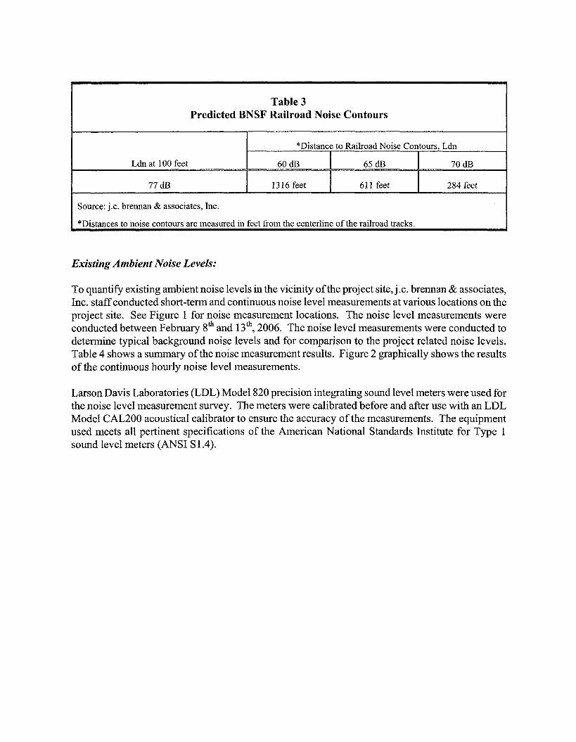
Table 3 Predicted BNSF Railroad Noise Contours
Source: j.c. brennan & associates, Inc.
*Distances to noise contours are measured in feet from the centerline of the railroad tracks.
Existing Ambient Noise Levels:
To quantify existing ambient noise levels in the vicinity of the project site, j.c. brennan & associates, Inc. staff conducted short-term and continuous noise level measurements at various locations on the project site. See Figure 1 for noise measurement locations. The noise level measurements were conducted between February gth and 13'~, 2006. The noise level measurements were conducted to determine typical background noise levels and for comparison to the project related noise levels. Table 4 shows a summary of the noise measurement results. Figure 2 graphically shows the results of the continuous hourly noise level measurements.
Larson Davis Laboratories (LDL) Model 820 precision integrating sound level meters were used for the noise level measurement survey. The meters were calibrated before and afier use with an LDL Model CAL200 acoustical calibrator to ensure the accuracy of the measurements. The equipment used meets all pertinent specifications of the American National Standards Institute for Type 1 sound level meters (ANSI S 1.4).


110
100
90
9 80 - -
Q)
3 70 -0 r 3 0 a 60
50
40
30 12 AM
Ldn =
Figure 2B Continous Measured Hourly Noise Levels - Site #5
Mariposal Lakes EIR February 10,2006
8 AM 12 PM 4 PM 8 PM
Hour of Day
1 t Leq + Lmax +L50 +L90

Table 4 Existing Ambient Noise Monitoring Results
Site
2
3
4
5
6
7
8
Source - j.c. brennan & associates, Inc.
Date - Time
2/13/06 - 3:20 pm
218106-2/1 3106
2113106- 11:40 am
2/13/06 - 1.49 pm
218106-2/13/06
211 3106 - pm
2/13106 - 12:45 pm
2/13/06 - 12: pm
Location
South of SR 4, southeast corner of existing residential.
6645 E. SR 4, Residential front yard
100' south of SR 4 C.L.,
Area N-54
East end of Carpenter Rd -----
Backyard of 5332 Carpenter Rd.
100' N of Mariposa Road C.L., Area N-3
100' N of Mariposa Road C.L., Area N-2
75' west of Kaiser Road C.L., Area N-4 1
Average Measured Hourly Noise Levels, dBA
24- hour Ldn
NA
65 dB
NA
NA
77 dB
NA
NA
NA
Nighttime
(10:OO pm - 7 am)
Leq I L5O I Lmax
N A
57 dB 43 dB 90 dB
N A
N A
Daytime
(7:OO am - 10:OO pm)
70 dB
Lmax
50dB
92 dB
78 dB
45 dB
105 dB
65 dB
77dB
67dB
Leq
46dB
63 dB
60 dB
39 dB
70 dB
53 dB
65dB
47dB
N A
N A
N A
50 dB
L5O
46dB
53 dB
48 dB
39 dB
48 dB
49 dB
61 dB
41dB
103 dB

mGULATORY SETTING
City of Stockton General Plan Noise Element:
The City of Stockton General Plan Noise Element establishes goals, policies and criteria for determining land use compatibility with major noise sources within the community. The following provides the applicable goals, policies and criteria for evaluating the feasibility and potential noise impacts associated with the proposed Bear Creek East project.
Goal I -Protect the citizens of the Stockton Planning AreaJFom the harmful and annoying efects of exposure to excessive noise.
Goal 2 -Protect the economic base of the Stockton Planning Area by preventing incompatible land uses JFom encroaching upon areas with existing noise-producing uses.
Policy 2 -The compatibility ofproposedprojects with existing andfuture noise levels due to traffic on public roadways, railroad line operations and aircraft shall be evaluated by comparison to Figure I .
Policy 3A - For noise due to trafic on public roadways, railroad line operations and aircraft in flight: 60 dB Ldn/CNEL or less in outdoor activity areas, and 45 dB Ldn/CNEL or less in indoor areas. Where it is notpossible to reduce exterior noise to 60 dB Ldn/CNEL of less by incorporating a practical application of the best available noise-reduction technology, an exterior noise level up to 65 dB Ldn/CNEL will be allowed. Under no circumstances will interior noise levels be permitted to exceed 45 dB Ldn/CNEL with the windows and doors closed.
Policy 4 - Before approving proposed development of new residential land uses in areas exposed to existing or projected exterior noise levels exceeding 60 dB Ldn/CNEL, an acoustical analysis shall be required. The acoustical analysis shall be required in the environmental review process so that noise mitigation may be included in the project design.
Table 5 Exterior Hourly Noise Level Standards for Stationary Noise Sources
Hourly Leq, dBA Maximum Level (Lmax), dBA
* Each of the noise level standards specfied above shall be reduced by five dBA for simple tone, noise consisting primarily of speech or music, or recurring impulsive noises. Source: City of Stockton General Plan Noise Element, Table I
55
75
45
65

For transportation noise sources, such as roadway traffic or railroad line operations, the City of Stockton General Plan establishes a "Normally Acceptable" exterior noise level standard for residential uses of 60 dBA Ldn, which is applied in the outdoor activity areas. A "Conditionally Acceptable exterior noise level standard of 70 dBA Ldn is applied only after careful study and inclusion of protective measures as needed for intended use. However, based upon previous experience within the City of Stockton, 65 dB Ldn is generally considered to upper limit of allowable transportation-related noise at residential uses.
City of Stockton Municipal Code
The City of Stockton Municipal Code Chapter 16, Development Code contains noise standards for new developments. The Code has been adopted since the General Plan. Therefore, for the purposes of this report, they will be used for evaluating noise impacts. The noise standards contained within the Code generally replicate the noise criteria contained within the General Plan Noise Element. However, there is one exception, in that the Code establishes a 65 dB Ldn exterior noise level standard for residential uses.
There are also exemptions to the standards and activities which are considered to be violations that are outlined in the Code. The following provides a list of the pertinent Code exemptions and violations:
16-340.020 - Activities Exempt from Noise Remlations
16-340.020(C) - Outdoor play/school ground activities. Activities conducted on parks and playgrounds andschoolgrounds, between 7:00 a.m. and 1 O:OOp.m., except for additional hours that may be granted by the City Manager. Otherwise, outdoor activities shall meet standardrs in Table 3- 7 (of the Code).
16-340.030 - Activities Deemed Violations of this Division
16-340.030(A) - Construction Noise. Operations or causing the operation of tools or equipment on private property used in alteration, construction, demolition, drilling, or repair work between the hours of 1O:OOp.m. and 7:00 am., so that the sound creates a noise disturbance across a residential property line, except for emergency work ofpublic sewice utilities.
16-340.030(B) -Loading and unloading operations. Loading, unloading, opening, closing or other handling of boxes, crates, containers, building materials, garbage cans, or similar objects on private property between the hours of 1O:OOp.m. and 7:00 a.m. in a manner to cause a noise disturbance.
16-340.030(F) - Sweepers and associated equipment. Operating or allowing the operation of sweepers or associated sweeping equipment (e.g., blowers) on private property between the hours of 1O:OOp.m. and 7:00 a.m. the following day in, or adjacent to, a residential zoning district.

16-340.040 - Standards
16-340.040(B)(2)(c) -Adjacent to other uses. If commercial, industrial, or public facilities land uses are adjacent to any noise-sensitive land uses or vacant residential(RE,RL,,RM, or RH) or open space (0s) zoning districts, these uses shall comply with the performance standards contained in Table 3- 7, Part II.
Proposed General Plan Update
It should be noted that the City of Stockton is currently in the process of developing and adopting a new general plan. The new general plan noise policies are similar to the existing policies with one notable exception. The new noise element policies would eliminate the existing performance standards, as contained in Table 5 of this document. The new policy applicable to stationary noise sources would require compliance with an exterior noise level of 65 Ldn/CNEL for noise generating uses adjacent to residential uses. This new standard would be less restrictive than the current standards because the Ldn/CENL level is calculated based upon a 24-hour average which tends to disguise short-term variations in the noise environment. Because the new general plan has not been adopted, this analysis will address the existing City of Stockton Noise Element policies.
Iletermination of a Significant Increase in Noise Levels
Another means of determining a potential noise impact is to assess a person's reaction to changes in noise levels due to a project. Table 6 is commonly used to show expected public reaction to changes in environmental noise levels. This table was developed on the basis of test subjects' reactions to changes in the levels of steady-state pure tones or broad-band noise and to changes in levels of a given noise source. It is probably most applicable to noise levels in the range of 50 to 70 dBA, as this is the usual range of voice and interior noise levels.
Table 6 Subjective Reaction to Changes in Noise Levels of Similar Sources
Change in Level, dBA
Imperceptible (Except for Tones) Just Barely Perceptible
Clearly Noticeable
Subjective Reaction Factor Change in
Acoustical Energy

Criteria for Acceptable Vibration
The City of Stockton General Plan Noise Element does not contain specific policies pertaining to vibration levels. Because the project site is located adjacent to railroad tracks, the effects of railroad-induced vibration are considered in this analysis.
Human and structural response to different vibration levels is influenced by a number of factors, including ground type, distance between source and receptor, duration, and the number of perceived vibration events. Table 7, which was developed by Caltrans, shows the vibration levels which would normally be required to result in damage to structures. The vibration levels are presented in terms of peak particle velocity in inches per second.
Table 7 indicates that the threshold for damage to structures ranges from 2 to 6 idsec. One-half this minimum threshold or 1 idsec p.p.v. is considered a safe criterion that would protect against architectural or structural damage. The general threshold at which human annoyance could occur is noted as 0.1 in/sec p.p.v.
Table 7 Effects of Various Vibration Levels on People and Buildings
Effect on Buildings
Vibrations unlikely to cause damage of any type
Vibrations unlikely to cause damage of any type
Recommended upper level of which ruins and ancient monuments should be subjected
Peak Particle Velocity
inches/second
0-.006
.006-.02
.08
.
Peak Particle Velocity
&second
0.15
0.5
2.0
2.0
6.0
Human Reaction
Imperceptible by people
Range of Threshold of perception
Vibrations clearly perceptible
Source: Survev of Earth-borne Vibrations due to Highway Construction and Hinhwav Traff~c, Caltrans 1976.
50.4
151.0
Structural Damage to Residential Buildings
Structural Damage to Commercial Buildings

IMPACTS AND MITIGATION MEASURES
Generally, a project may have a significant effect on the environment if it will substantially increase the ambient noise levels for adjoining areas or expose people to severe noise levels. In practice, more specific professional standards have been developed. These standards state that a noise impact may be considered significant if it would generate noise that would conflict with local planning criteria or ordinances, or substantially increase noise levels at noise-sensitive land uses.
STANDARDS OF SIGNIFICANCE
CEQA guidelines state that implementation of the project would result in significant noise impacts if the project would result in either of the following:
a. Exposure of persons to or generation of noise levels in excess of standards established in the City of Stockton General Plan. Specifically, exterior and interior noise levels of 60-65 dB Ldn and 45 dB Ldn, respectively, for residential uses exposed to transportation noise sources and the Table 5 standards for residential uses exposed to non-transportation noise sources.
b. Exposure of persons to or generation of excessive groundborne vibration or groundborne noise levels. Specifically, a threshold of 1 idsec p.p.v. is considered a safe criterion that would protect against architectural or structural damage.
c. A substantial permanent increase in ambient noise levels in the project vicinity above levels existing without the project, typically defined as 3 dB or greater.
d. A substantial temporary or periodic increase in ambient noise levels in the project vicinity above levels existing without the project, typically defined as 3 dB or greater.
e. For a project located within an airport land use plan or, where such a plan has not be adopted, within two miles of a public airport or public use airport, where the project would expose people residing or working in the area to excessive noise levels.
f. For a project within the vicinity of a private airstrip, where the project would expose people residing or working in the project area to excessive noise levels.
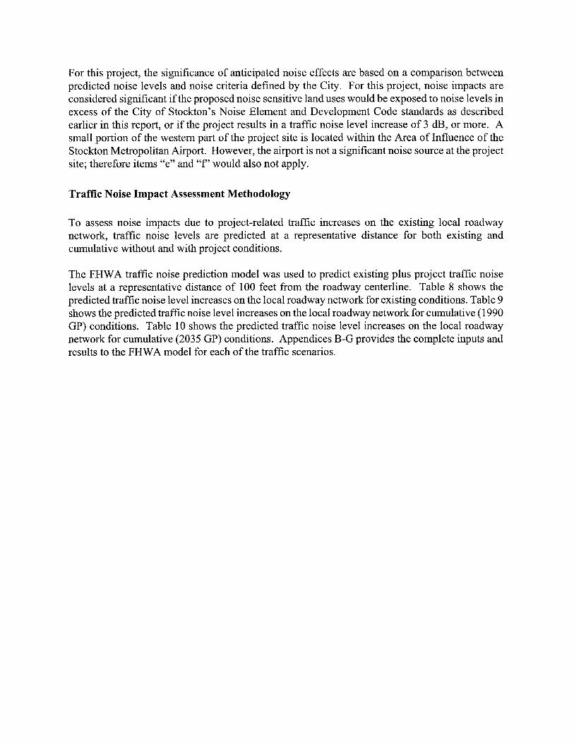
For this project, the significance of anticipated noise effects are based on a comparison between predicted noise levels and noise criteria defined by the City. For this project, noise impacts are considered significant if the proposed noise sensitive land uses would be exposed to noise levels in excess of the City of Stockton's Noise Element and Development Code standards as described earlier in this report, or if the project results in a traffic noise level increase of 3 dB, or more. A small portion of the western part of the project site is located within the Area of Influence of the Stockton Metropolitan Airport. However, the airport is not a significant noise source at the project site; therefore items "e" and "f" would also not apply.
Traffic Noise Impact Assessment Methodology
To assess noise impacts due to project-related traffic increases on the existing local roadway network, traffic noise levels are predicted at a representative distance for both existing and cumulative without and with project conditions.
The FHWA traffic noise prediction model was used to predict existing plus project traffic noise levels at a representative distance of 100 feet from the roadway centerline. Table 8 shows the predicted traffic noise level increases on the local roadway network for existing conditions. Table 9 shows the predicted traffic noise level increases on the local roadway network for cumulative (1 990 GP) conditions. Table 10 shows the predicted traffic noise level increases on the local roadway network for cumulative (2035 GP) conditions. Appendices B-G provides the complete inputs and results to the FHWA model for each of the traffic scenarios.

Table 8
Roadway
East Charter Way
East Main St.
East Main St.
East Main St.
E. 8th St.
Farmington Rd.
Farmington Rd.
Farmington Rd.
Farmington Rd.
Carpenter Rd
Carpenter Rd
Arch Rd
Arch Rd
E. Mariposa Rd
E. Mariposa Rd
E. Mariposa Rd
E. Mariposa Rd
E. Mariposa Rd
E. Mariposa Rd
Noise Levels With & Without Project
Segment
East of Mariposa Rd.
West of E. Charter
E. Charter to E. South Walker Ln
S. Walker to Gillis
W. of East Mariposa Rd.
SR 99 NB to S. Walker
S. Walker to Gillis
Gillis to Kaiser Rd.
Kaiser Rd. to Jack Tone Rd.
West of E. Mariposa
East of E. Mariposa
SR99 to Newcastle Rd.
Newcastle Rd to Austin Rd
E Charter Way to E 8th St
E. 8th St to SR 99 SB Ramps
SR 99 SB Ramps to SR 99 NB Ramps
SR 99 NB off Ramp to Stagecoach Rd
Stagecoach Rd to Carpenter Rd
Carpenter Rd to Austin Rd
Existing Traffic
Adjacent uses'
I, V, RR
C, R
C, R, A
R, A
R
R, A
A
A
A
RR
1, RR
1, RR
A, Prison
C, 1, R
R, 1, V
C, V
MH, I
I
A, I
centerline'
Existing + Approved + Project
(dB)
62.9
63.3
65.9
64.0
64.9
62.6
58.5
66.4
65.9
59.9
52.2
67.9
66.5
66.3
67.2
68.6
70.8
69.5
68.2
Change (dB)
-0.3
0.3
4.5
4.1
2.8
-5.4
-6.6
1.6
0.9
0.4
-0.7
2.2
7.8
1.6
3.0
4.8
5.7
3.4
4.3
Existing +Approved (dB)
63.1
63.0
61.3
59.8
62.0
68.0
65.0
64.9
65.0
59.5
52.8
65.8
58.7
64.7
64.2
63.8
65.1
66.1
63.9
Traffic Noise Levels Less Than 60 dB
Ldn, Yes or NO^
No
No
No
No
No
No
Yes
No
No
Yes
Yes
No
No
No
No
No
No
No
No
Noise
Existing + Approved +
Phase 1
61.9
63.2
62.2
59.6
62.8
68.6 -- --
66.2
66.1
65.0
59.5
51.0
68.0
66.6
65.5
65.8
65.2
65.8
67.7
66.8
Levels (Ldn,
Change (dB)
-1.2
0.2
0.8
-0.2
0.8
0.6
1.2
1.2
0.0
0.0
-1.8
2.2
7.9
0.8
1.6
1.4
0.7
1.6
2.9
dB) 100 Feet From
Traffic Noise Levels Less Than 60 dB
Ldn, Yes or NO^
No
No
No
Yes
No
No
No
No
No
Yes
Yes
No
No
No
No
No
No
No
No

Table 8 Existing Traffic Noise Levels With & Without Project
Roadway
E. Mariposa Rd
S Walker Ln
Gillis Rd
Austin Rd
Kaiser Rd
Jack Tone Rd
Jack Tone Rd Bold = Significant increase in noise. - ' ~=~es iden t ia l , RR=Rural Residential, MH=Mobile Home Park, A=Agriculture, I=Industrial, C=Commercial, V=Vacant
Distances to traffic noise contours are measured in feet from the centerlines of the roadways. 3~raf f ic noise levels are predicted at a standard distance of 100 feet from the roadway centerline and do not account for shielding from existing noise barriers or intervening structures. Traffic noise levels may vary depending on actual setback distances and localized shielding Source: FHWA-RD-77-108 with inputs from TJKM, Caltrans and j.c. brennan & associates, Inc.
Segment
Austin Rd to Kaiser Rd
Farmington Rd to E Charter Way
Farmington Rd to E Charter Way
S. of Arch Rd.
Farmington Rd to E. Mariposa Rd
N. of Farmington Rd
S. of E Mariposa Rd
Adjacent uses'
A, RR
A
A
A, Prison
A
A
A
Noise Levels (Ldn, dB) 100 Feet From centerline'
Change (dB)
1.1
3.5
14.4
-0.7
10.0
2.4
-0.8
Existing +Approved (dB)
64.0
58.6
50.1
55.0
47.5
57.1
57.0
Change (dB)
0.2
1 .O
-2.1
0.7
9.9
-0.2
-2.2
Traffic Noise Levels Less Than 60 dB
Ldn, Yes or No3
No
No
No
Yes
Yes
Yes
Yes
Existing + Approved +
Phase 1
64.1
59.7
48.0
55.6
57.4
57.0
54.8
Traffic Noise Levels Less Than 60 dB
Ldn, Yes or NO'
No
Yes
Yes
Yes
Yes
Yes
Yes
Existing + Approved + Project
(dB)
65.1
62.2
64.5
54.2
57.4
59.5
56.2
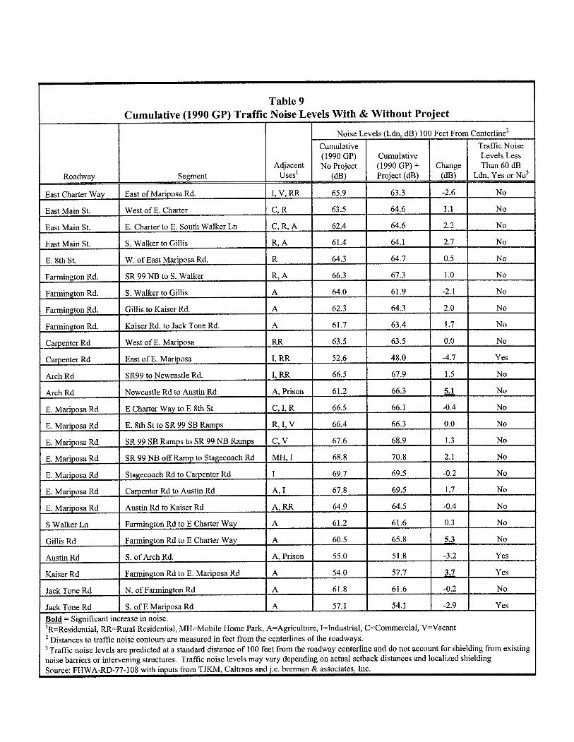
Table 9 Cumulative (1990 GP) Traffic Noise Levels With & Without Project
Adjacent uses'
1, v , RR
C, R
C, R, A
R, A
R
R, A
A
A
A
RR
Roadway
East Charter Way
East Main St.
East Main St.
East Main St.
E. 8th St.
Farmington Rd.
Farmington Rd.
Farmington Rd.
Farmington Rd.
Carpenter Rd
Noise Levels (Ldn, dB) 100 Feet From centerline2
Segment
East of Mariposa Rd.
West of E. Charter
E. Charter to E. South Walker Ln
S. Walker to Gillis
W. of East Mariposa Rd.
SR 99 NB to S. Walker
S. Walker to Gillis
Gillis to Kaiser Rd.
Kaiser Rd. to Jack Tone Rd.
West of E. Mariposa
E. Mariposa Rd
Cumulative (1 990 GP) No Project
(dB)
65.9
63.5
62.4
61.4
64.3
66.3
64.0
62.3
61.7
63.5
E. Mariposa Rd
E. Mariposa Rd
E. Mariposa Rd
S Walker Ln
Gillis Rd
Austin Rd
Kaiser Rd
Jack Tone Rd
Jack Tone Rd
Change (dB)
-2.6
1.1
2.2
2.7
0.5
1 .O
-2.1
2.0
1.7
0.0
Cumulative (1990 GP) + Project (dB)
63.3
64.6
64.6
64.1
64.7
67.3
61.9
64.3
63.4
63.5
Traffic Noise Levels Less Than 60 dB
Ldn, Yes or NO^
No
No
No
No
No
No
No
No
No
No
Bold = Significant increase in noise. - '~=~esidential , RR=Rural Residential, MH=Mobile Home Park, A=Agriculture, I=Industrial, C=Commercial, V=Vacant Distances to traffic noise contours are measured in feet from the centerlines of the roadways. Traffic noise levels are predicted at a standard distance of 100 feet from the roadway centerline and do not account for shielding from existing
noise barriers or intervening structures. Traffic noise levels may vary depending on actual setback distances and localized shielding Source: FHWA-RD-77-108 with inputs from TJKM, Caltrans and j.c. brennan & associates, Inc.
i
Stagecoach Rd to Carpenter Rd
Carpenter Rd to Austin Rd
Austin Rd to Kaiser Rd
Farmington Rd to E Charter Way
Farmington Rd to E Charter Way
S. of Arch Rd.
Farmington Rd to E. Mariposa Rd
N. of Farmington Rd
S. of E Mariposa Rd
I
A, I
A, RR
A
A
A, Prison
A
A
A
69.7
67.8
64.9
61.2
60.5
55.0
54.0
61.8
57.1
69.5
69.5
64.5
61.6
65.8
51.8
57.7
61.6
54.1
-0.2
1.7
-0.4
0.3
5.3
-3.2
3.7 -0.2
-2.9
No
No
No
No
No
Yes
Yes
No
Yes

Table 10 Cumulative (2035 GP) Traffic Noise Levels With & Without Project
Roadway
East Charter Way
Adjacent uses'
1, v, RR
C, R
C, R,A
R, A
R
R, A
A
A
A
Segment
East of Mari p osa Rd.
East Main St.
East Main St.
East Main St.
E. 8th St.
Farmington Rd.
Farmington Rd.
Carpenter Rd
Carpenter Rd
Arch Rd
Arch Rd
E. Mariposa Rd
E. Mariposa Rd
E. Mariposa Rd
E. Mariposa Rd
E. Mariposa Rd
E. Mariposa Rd
E. Mariposa Rd
S Walker Ln
Gillis Rd
Austin Rd
Kaiser Rd
Jack Tone Rd
Jack Tone Rd Bold = Significant -
Distances to traffic noise contours are measured in feet from the centerlines of the roadways. Traffic noise levels are predicted at a standard distance of 100 feet from the roadway centerline and do not account for shielding from existing
noise barriers or intervening structures. Traffic noise levels may vary depending on actual setback distances and localized shielding Source: FHWA-RD-77-108 with inputs from TJKM, Caltrans and j.c. brennan & associates, Inc.
Noise
Cumulative (2035 GP) No Project
(dB)
64.9
63.9
63.1
58.4
65.0
69.2
69.9
68.2
68.1
West of E. Charter
E. Charter to E. South Walker Ln
S. Walker to Gillis
W. of East Mariposa Rd.
SR 99 NB to S. Walker
S. Walker to Gillis
Feet From
Change (dB)
0.4
0.6
0.8
2.9
-1.1
-3.2
-12.9
-0.2
-0.3
Levels (Ldn, dB) 100
Cumulative (2035 GP) + Project (dB)
65.3
64.5
63.8
61.3
63.9
65.9
57.0
68.0
67.8 ----- 57.0
61.3
69.1
65.9
67.9
66.8
68.4
70.3
71.4
70.7
69.0
60.7
64.9
64.6
51.9
54.8
54.1
I=Industrial, '~=~esidential , RR=Rural Residential, MH=Mobile Home Park, AzAgriculture,
West of E. Mariposa
East of E. Mariposa
SR99 to Newcastle Rd.
Newcastle Rd to Austin Rd
E Charter Way to E 8th St
E. 8th St to SR 99 SB Ramps
SR 99 SB Ramps to SR 99 NB Ramps
SR 99 NB off Ramp to Stagecoach Rd
Stagecoach Rd to Carpenter Rd
Carpenter Rd to Austin Rd
Austin Rd to Kaiser Rd
Farmington Rd to E Charter Way
Farmington Rd to E Charter Way
S. of Arch Rd.
Farmington Rd to E. Mariposa Rd
N. of Farmington Rd
S. of E Mariposa Rd
increase in noise.
centerline2
Traffic Noise Levels Less Than 60 dB
Ldn, Yes or NO^
No
No
No
No
I No
No
Yes
No
No
6.4
-12.7
-0.6
1.7
-0.3
0.6
0.8
0.8
-1.9
-2.4
-2.0
-0.8
1.4
1.3
5.3
2.9
-0.3
V=Vacant
63.5
48.6
68.5
67.6
67.5
67.4
69.2
71.1
69.5
68.3
67.0
59.9
66.3
65.8
57.2
57.7
53.7
C=Commercial,
Farmington Rd.
Fm
1, RR
1, RR
A, Prison
C, 1, R
R, 1, V
C, V
MH, I
I
A, I
A, RR
A
A
A, Prison
A
A
A
No
Yes
No
No
No
No
No
No
No
No
No
Yes
No
No
Yes
Yes
Yes
Gillis to Kaiser Rd.
Farmington Rd. Kaiser Rd. to Jack Tone Rd.

The Table 8-10 data indicate that the proposed project would result in traffic noise level increases exceeding 3 dB on a number of project-area roadways, when compared to no-project conditions. Decreases in traffic noise levels are predicted due to predicted reductions in traffic volumes when compared to the no project volumes. A specific discussion of impacts and mitigation measures is provided later in this study.
Traffic Noise Levels at Proposed Residential Uses
The FHWA traffic noise prediction model was used to predict Cumulative 2035 -I- Project traffic noise levels at the proposed residential uses associated with the project. Table 11 shows the predicted traffic noise levels at the proposed residential uses adjacent to the major project-area roadways. Table 11 also indicates the property line noise barrier heights required to achieve compliance with an exterior noise level standard of 60 dB Ldn. Appendices H and I provide the complete inputs and results to the FHWA traffic noise prediction model and barrier calculations. The modeled noise barriers assume flat site conditions where roadway elevations, base of wall elevations, and building pad elevations are approximately equivalent. Figure 3 shows the recommended sound wall locations.
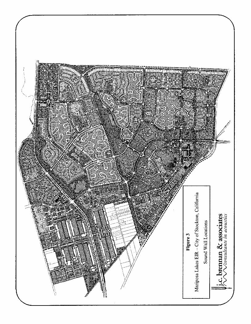

Table 11 Noise Levels
Approximate Residential
Setback, feet'
100
70
75
150
150
60
70
70
175
100
150
150
100
225
225
75
130
75
75
75
75
75
125
500
100
500
At Proposed
Approximate ADT
26360
15910
16380
14600
11960
10710
7180
5290
14570
14680
1 1340
11340
7840
17550
15160
4670
4670
4020
8070
6050
4310
4700
28150
28150
14700
14700
Cumulative
Roadway
Austin Pkwy
Austin Pkwy
Austin Pkwy
Austin Pkwy
Austin Pkwy
Blue Copper Dr - Blue Copper Dr
E. Mariposa
E. Mariposa
Farmington Rd
Farmington Rd
Farmington Rd
Farmington Rd
Farmington Rd
Mourning Cloak Ln
Mourning Cloak Ln
Orange Sulpher Rd
Proj. Enhance
Red Admiral Ave
Red Admiral Ave
Red Admiral Ave
SR4 (Proposed)
SR4 (Proposed)
SR4 (Proposed)
SR4 (Proposed)
SR4 (Proposed)
(2035 GP) + Project Traffic
Segment
South of Town Center Pkwy
North of Town Center Pkwy
NW of Swallow Tail Pkwy
North of Viceroy Ave
NW of SR4 (Proposed)
SE of SR4 (Proposed)
NW of SR4 (Proposed)
West Of Proj. Entrance
East of Proj. Enhance
West of Blue Copper Dr
East of Blue Copper Dr
North of SR4 (Proposed)
East of Mourning Cloak Ln
East of Driveway 1
North of Tortoise Shell Ln East Side
North of Tortoise Shell Ln West Side
East of Austin Pkwy
North Of E. Mariposa
East of Proj. Entrance
West Of Proj. Entrance
North of Town Center Pkwy
NE of Austin Pkwy NW Side
NE of Austin Pkwy SE Side
NE of Blue Copper Dr NW Side
NE of Blue Copper Dr SE Side
East of Farmington Rd
Residential Uses Predicted
No Wall
67
67
67
62
6 1
64
6 1
60
62
66
62
62
63
62
6 1
59
55
5 8
6 1
60
58
59
69
60
67
57
Traffic Noise ~ d n '
6' Wall
61
6 1
60
56
55
57
55
NA
56
60
56
56
57
56
56
NA
NA
NA
55
NA
NA
NA
63
NA
61
NA
Levels,
7' Wall
60
60
60
55
54
56
54
NA
56
59
55
55
56
55
55
NA
NA
NA
54
NA
NA
NA
62
NA
60
NA
dB
8' Wall
59
59
58
54
53
55
53
NA
55
58
54
54
55
55
54
NA
NA
NA
53
NA
NA
NA
61
NA
59
NA

The Table 11 data indicate that noise barriers ranging in height from 6-8 feet could be used to achieve compliance with the City of Stockton exterior noise level standards for the proposed residential uses.
Table 11 Cumulative (2035 GP) + Project Traffic Noise Levels At Proposed Residential Uses
Railroad Noise Impact Assessment Methodology
Future operations along the BNSF railroad lines were not available. Therefore, it is difficult to estimate the future train operation noise levels along the BNSF tracks given that the future level of activity is unknown at this time. For the purposes of this noise analysis, it was assumed that future railroad operations will be similar to those described earlier in this report. It should be noted that even a 25% increase in railroad operations would only result in an increase of approximately 1 dB in overall (Ldn) noise levels. Therefore, the railroad noise monitoring results discussed earlier in this report were used to calculate the predicted railroad noise exposure at the proposed residential uses associated with the project. The predicted railroad noise contours have been drawn on Figure 4. These contours do not account for shielding which may be present at various locations on the project in addition to excess ground attenuation which may occur over large distances. Therefore, these contours are considered to be conservative based upon the best available information at this time. Based upon this noise contour line, the residential uses located within the predicted 60 dB Ldn railroad noise contour would include areas N-2, N-3, N-4, N- 19, N-2 1 and N-33. The proposed college campus may also be considered noise sensitive. Therefore, a discussion of railroad noise impacts and mitigation measures is provided for the residential uses at areas N-2, N-3, N-4, N-19, N-21 and N-33 and the proposed college campus.
Roadway
Viceroy Ave
The proposed cornrnercial and industrial uses are not typically considered to be noise-sensitive.
Approximate ADT
7380
4340
Viceroy Ave West of Austin Pkwy
Segment
East of Tortoise Shell Pkwy North Side
300 4340 52 NA NA NA
Approximate Residential
Setback, feet'
75
East of Tortoise Shell Pkwy South Side
Predicted Traffic Noise Levels, dB ~ d n ~
' Setback distances are measured in feet from the centerlines of the roadways to the center of residential backyards. The modeled noise barriers assume flat site conditions where roadway elevations, base of wall elevations, and building pad elevations are
approximately equivalent. Taller wall heights may be required along Austin Road, north of E. Mariposa in order to mitigate railroad noise levels.
Source: FHWA-RD-77-108 with inputs from TJKM, Caltrans and j.c. brennan & associates, Inc.
70
No Wall
63
62
6' Wall
57
55
7' Wall
56
54
8' Wall
55
53 -

Figure 4 Mariposa Lakes EIR - City of Stockton, California Site Plan and Unmitigated RailroadNoise Contours
Mariposa Lakes Stockton, California
Land Use Plan
Land Use Legend .-
Ke). h d Ure
Village RelidenM Estate 53 ac vd!dgc h D-ny Rer&dentlll 1,021 ac
Village W i u m Denstry Reridend* 533 ;rc
Village Htgh Densty Rer~dwoal 66 ac VvBage CengsICam-I 93 1c
lmfus& 614 tc 8u.tnerrPmfa.r~M.l 17 x Imbldmsl I Mle-ce 43 * Bemenmy/Hlgh Schmlr I H a c
CdW ZI sc h*&Opm*ue $06 1c
hi- Remeadon Cenrer $2 ac Exl~drnng RwdenW IS1 ac - PuMk UuIIm 21 ac LaluerI.L&3 66 ac
Major Circulacitcon (Roar & RR) 358 x
T m l 3.810 acres
July 5,2006
LAND PLANNER / LANDSCAPE ARCHIECT:
SCALE: 1" = 1800'
U j . ~ . breman & associates I : Unmitigated Railroad Noise Contours W c o n s z ~ l t a n t s i n acoustics

Area N-21 Village High Density Residential:
This residential area is predicted to be exposed to unmitigated railroad noise levels ranging from 80 dB Ldn at the railroad right-of-way to approximately 65 dB Ldn at the eastern boundary of the parcel. Mitigation measures will be required in order to achieve compliance with the City of Stockton "Normally Acceptable" (60 dB Ldn) or "Conditionally Acceptable" (65 dB Ldn) exterior noise level standards and the City of Stockton 45 dB Ldn interior noise level standard for residential uses. Site design measures could include orienting the outdoor areas such that they received shielding from the proposed residential buildings. Sound walls could also be utilized to mitigate exterior noise levels; however, because the railroad tracks are elevated significantly relative to the project site, they may not be a reasonable mitigation measure. Based upon the existing site grade, preliminary calculations indicate that a 13 foot tall noise barrier would be required to mitigate exterior noise levels to 70 dB Ldn at a distance of 80 feet from the centerline of the BNSF tracks. Changes to the site grading, such as raising the site grade and relative base-of-wall elevation, may increase the effectiveness of noise barriers for this site area. Other site design measures are also discussed later in this document.
A typical residential building faqade provides an exterior-to-interior noise level reduction of 25-30 dB. Considering an exterior noise level approaching 80 dB Ldn, an exterior-to- interior noise level reduction of 35 dB would be required to achieve an interior noise level of 45 dB Ldn. A 35 dB exterior-to-interior noise level reduction would require window upgrades and may also require improvements to the building faqade. Therefore, a detailed analysis of interior noise levels would need to be conducted when building plans become available.
Areas N-2, N-3, N-4, N-19 and N-33 Village Medium and Low Density Residential:
These residential areas are predicted to be exposed to railroad noise levels in the range of 60- 70 dB Ldn depending on their proximity to the BNSF railroad tracks. In order to achieve compliance with the City of Stockton "Normally Acceptable" 60 dB Ldn exterior noise level standard, additional mitigation would be required. Mitigation measures would include the use of site design measures as previously discussed. Based upon the existing site grade, preliminary calculations indicate that a 10 foot tall noise barrier would be required to mitigate exterior noise levels to the "Conditionally Acceptable" level of 65 dB Ldn at the residential uses closest to the BNSF tracks at Parcel N-3. Changes to the site grading, such as raising the site grade and relative base-of-wall elevation, may increase the effectiveness of noise barriers for this site area. Residential uses with greater setbacks could comply with the City of Stockton's 60 dB Ldn exterior noise level standard with much shorter walls. This analysis does not take into account shielding affects from the existing site grading for the elevated E. Mariposa Road or noise barriers which may be built to mitigate traffic noise levels.

College Campus
The proposed college campus would be exposed to railroad noise levels of approximately 60-65 dB Ldn. An exterior noise level of 70 dB Ldn is typically considered to be the upper limit of the "Conditionally Acceptable" exterior noise environment for school uses. Modem construction practices, including mechanical ventilation, should be adequate to achieve an acceptable interior noise environment for classrooms. Therefore, no mitigation measures are considered to be necessary for the college site.
Railroad Vibration Impact Assessment Methodology
Based upon the recent railroad vibration measurements discussed earlier in this section, the project site is not predicted to be exposed to vibration levels exceeding the 1 in/sec p.p.v. threshold for structural damage. It is anticipated that railroad vibration levels may exceed the threshold of human perception at locations adjacent to the railroad right-of-way. However, these vibrations would be short in duration and would not pose a serious risk. Therefore, no vibration mitigation is considered necessary for the proposed residential uses.
Methodology for Future Noise-Producing Uses Developed Within the Project Area
There are a variety of noise sources associated with future development within the project area which have the potential to create noise levels in excess of the applicable noise standards or result in annoyance at existing and future noise-sensitive developments within the project area. Such uses include industrial, commercial, parks, schools, an Amtrak station, and a college campus.
At this time specific uses are not known and detailed site and grading plans have not yet been developed. As a result, it is not feasible to identify specific noise impacts associated with each of the proposed uses. However, a general discussion and assessment of impacts can be conducted based upon the possible types of uses associated with these land use designations. The following is a discussion of the potentially significant noise sources associated with the various types of proposed uses:
Industrial
Industrial uses can include a myriad of noise sources. At the Specific Plan level, detailed site and grading plans associated with these types of noise sources have not yet been developed. As a result, it may not be feasible to identify specific noise impacts associated with these sources. Rather, the potential for these sources to generate excessive or annoying noise levels is identified, and consideration of that potential during the design phases of the development is encouraged. A discussion of potential noise sources is provided below.

Industrial Loading Docks
Industrial loading docks can produce noise levels which exceed the noise level criteria. Noise sources associated with industrial loading docks include trucks idling, truck circulation on the sites, refrigeration units on trucks, pallets dropping and fork lifts operating on the site.
Noise monitoring conducted at industrial loading docks indicate that typical hourly average noise levels at a distance of 50 feet can range between 55 dB Leq and 60 dB Leq, and maximum noise levels range between 80 dB and 84 dB at a distance of 50 feet.
Mechanical Equipment
Heating, air conditioning and ventilation equipment can be a primary noise source associated with commercial or industrial uses. These types of equipment are often mounted on roof tops, located on the ground or located within mechanical rooms. The noise sources can take the form of fans, pumps, air compressors, chillers or cooling towers.
Noise levels from these types of equipment can vary significantly. Noise levels from these types of sources generally range between 45 dB to 70 dB at a distance of 50 feet. However, numerous noise control strategies can be utilized to mitigate noise levels to less than significant levels.
Other Noise Sources
Other fixed or industrial-type noise sources which are typically of concern include but are not limited to the following:
HVAC Systems Pump Stations Steam Valves Generators Air compressors Conveyor Systems Pile Drivers Drill Rigs Welders Outdoor Speakers Chippers Loading Docks
Cooling Towers/Evaporative Condensers Lift Stations Steam Turbines Fans Heavy Equipment Transformers Grinders Gas or Diesel Motors Cutting Equipment Blowers Cutting Equipment Amplified music and voice
The types of uses which may typically produce the noise sources described above, include, but are not limited to: wood processing facilities, pump stations, industrial manufacturing facilities, trucking operations, tire shops, auto maintenance shops, metal fabricating shops, shopping centers, drive-up windows, car washes, loading docks, public works projects, batch plants, bottling and canning plants, recycling centers, and electric generating stations.
In these cases, the facilities will be required to comply with the local criteria shown in Table 5 and will require additional analyses when they are within proximity to residential uses.

Commercial and Office Land Uses
Commercial and Office Land Use activities can also produce noise which affects adjacent sensitive land uses. These noise sources can be continuous and may contain tonal components which may be annoying to individuals who live in the nearby vicinity. In addition, noise generation from fixed noise sources may vary based upon climatic conditions, time of day and existing ambient noise levels. The Mariposa Lakes Specific Plan includes land uses which are designated Business Professional and various types of Commercial. The primary noise sources generally include truck deliveries, on-site truck circulation, trash pickup, parking lot use, HVAC equipment and loading docks.
Recommendations for Industrial and Commercial Uses
In general, where these land uses adjoin common residential property lines, mitigation measures should be included. The City of Stockton development code required that 8-foot tall sound walls be constructed where non-residential zoning districts abut residential zoning districts. Where Business Professional uses are located, the primary noise sources are parking lot noise, HVAC equipment and light truck deliveries. In this case, 8 foot tall sounds walls, as required within the City of Stockton development code would typically provide adequate isolation of parking lot and delivery truck activities. HVAC equipment should be located either at ground level or when located on roof-tops, the building facades should include parapets for shielding.
Where commercial or industrial uses adjoin common residential property lines, and loading docks or large truck circulation routes face the residential areas, the following mitigation measures should be included in the project design:
Loading docks should maintain a minimum distance of 100 feet from residential property lines; Property line barriers should be a minimum of 8-feet in height, as required within the City of Stockton development code; Circulation routes for large trucks should be located a minimum of 25-feet from the residential property lines; All large heating, cooling and ventilation equipment should be located within mechanical rooms where it is possible; All large heating, cooling and ventilation equipment shall be shielded from view with solid barriers; Emergency generators shall comply with the local noise criteria. Loading and unloading operations shall adhere the City of Stockton Municipal Code which restricts these activities to the hours of 7:00 a.m. to 10:OO p.m.
Where commercial and office land uses are separated from residential areas by local streets, all loading activities should be limited to the opposite sides of the buiIdings from residential uses.
Parks/School Playgrounds:
Children playing at neighborhood parks or elementary school playgrounds are often considered potentially significant noise sources which could adversely affect adjacent noise- sensitive land uses. Typical noise levels associated with groups of approximately 50 children playing at a distance of 50 feet generally range from 55 to 60 dB Leq, with maximum noise levels ranging from 70 to 75 dB. It is expected that the playground areas would be utilized during daytime hours. Therefore, noise levels from the playgrounds would need to comply with the City of Stockton 55 dB Leq and 75 dB Lmax exterior noise level standards at the nearest residential uses. Based upon the reference noise level data discussed above, the 55 dB Leq noise contour would be located approximately 100 feet from the center of playgrounds. The 75 dB Lmax contour would be located at approximately 50 feet from the center of playgrounds.
Given the proximity of most parks or elementary schools to residential uses, and the separation between the residential uses by streets, the potential for exceedence of the City of Stockton noise standards is not expected. Since these types of activities are deemed exempt in the City of Stockton Development Code these are not considered to be significant noise sources.
High School Athletic Fields:
Children playing on school playgrounds are often considered potentially significant noise sources which could adversely affect adjacent noise-sensitive land uses. At the high-school level, however, athletic field activities tend to be more organized, and less of a free-for-all. For example, soccer fields and baseball diamonds will likely be used for physical education and team sporting practices and games, but pick-up games during school lunch hours are uncommon. As a result of the organization, the overall noise generation of the fields tends to be lower than that experienced at grade-school playgrounds. Of course, it is likely that the playing fields will be used by the public on weekends for soccer and baseball practice.
For the assessment of playing field noise impacts, noise level data collected by j.c. brennan & associates, Inc. staff at various sporting venues in recent years was utilized. The proposed high school site would likely include baseball/softball diamonds, soccer fields, and a football stadium. Noise sources at these areas would primarily be shouting students and cheering adults during intermittent periods of the sporting events and practice sessions. j.c. brennan & associates, Inc. file data collected at various baseball/softball and soccer facilities indicate that average and maximum noise levels during games are approximately 60 dB Leq and 75 dB Lmax at a distance of 100 feet from the focal point of the playing fields can be expected.
For baseball games, the focal point tends to be in the vicinity of the pitcher's mound, with the participants and spectators all centrally located around and generally facing that position. For soccer games, the focal point is more variable, with considerable excitement generated when the ball is near either goal, but with the sound of the participants generally spread out over the entire field and the sounds of spectators spread out along the sidelines. This analysis assumed that the cumulative noise generation of the baseball diamonds is centered at the pitcher's mound and at the approximate center of the soccer fields. It is expected that the high school athletic fields would be utilized during daytime hours.

Therefore, noise levels from the athletic fields would need to comply with the City of Stockton 55 dB Leq and 75 dB Lmax exterior noise level standards at the nearest residential uses. Based upon the reference noise level data discussed above, the 55 dB Leq noise contour would be located approximately 200 feet from the focal point of the athletic field. The 75 dB Lmax contour would be located at approximately 100 feet from the focal point of the athletic field. Given the proximity of most athletic fields to residential uses, and the separation between the residential uses by streets, the potential for exceedence of the City of Stockton noise standards is not expected. Since these types of activities are deemed exempt in the City of Stockton Development Code these are not considered to be significant noise sources.
High School Football Stadium:
The proposed high school would likely include a football stadium. The noise generation of the stadium will depend mainly on crowd size; the interest level in the sporting event, whether or not marching bands will play during events, and on the design of the public address system.
Using noise level data collected at a high school football game, the noise emissions at a distance of 500 feet from the center of the stadium are estimated to be approximately 60 dB Leq and 70-75 dB Lmax, based on a typical size crowd. These levels are consistent with other j.c. brennan & associates, Inc. file data for similar venues.
It is expected that the high school football stadium could be utilized during daytime (7am to 10 pm) or nighttime (1 0pm to 7am) hours. Noise generation from daytime operation of the football stadium would be exempt under the City of Stockton Municipal Code. However, without special authorization from the City Manager, nighttime noise generation would be subject to the City of Stockton nighttime exterior noise level standards. Therefore, noise levels from the football stadium may need to comply with the City of Stockton nighttime exterior noise level standards at the nearest residential uses. Because the football stadium noise would include noise from the use of a Public Address (PA) system, the City of Stockton exterior noise level standards should be lowered by 5 dB to account for noise consisting primarily of speech or music. Therefore, it is recommended that the football stadium noise levels comply with exterior noise level standards of 40 dB Leq and 60 dB Lmax. Based upon the reference noise level data discussed above, the 40 dB Leq noise contour would be located approximately 5,000 feet from the center of the stadium. The 60 dB Lmax contour would be located at approximately 2,8 1 1 feet from the center of the stadium.
Mitigation measures would be required to achieve compliance with the City of Stockton exterior noise level standards at the nearest residential uses. Such measures may include placing the football stadium in a bowl or depression, creating an earthen berm around the bowl/depression, using bleachers with solid backs to prevent sound flanking out of the bowl, requiring football games to end by 10 pm, and by requiring that the PA system be designed to comply with the applicable City of Stockton noise standards prior to construction of the stadium.
Careful application of these mitigation measures could be used to achieve compliance with the applicable City of Stockton noise standards; however, because sounds consisting of speech have been shown to be more annoying than broad-band noise, the potential for

annoyance associated with these uses cannot practically be eliminated. Therefore, buyerlrenter notification should be required for all residential uses in the vicinity of the proposed high school football stadium.
Transit Center/Amtrak Station:
The proposed Transit CenterIAmtrak station is proposed to be located adjacent to Village Commercial parcel (C-6) and Village High Density Residential parcel (N-48). Potential noise sources associated with the station would include train movements through the station and vehicular movements on and off the site.
Based upon noise measurements conducted for this project, noise generation from Amtrak train passages were measured to be approximately 10 dB less than freight train passages. Therefore, Amtrak movements have little affect on the overall dayhight ((Ldn) noise level predicted for train movements on the BNSF line. Based upon this conclusion, the proposed Amtrak station would have little affect on railroad noise levels along the BNSF line, even if the station were to increase the number of daily Amtrak trains on the BNSF line.
Vehicular movement including busses and automobiles could generate on-site noise levels exceeding the City of Stockton exterior noise level standards at the adjacent residential uses. Therefore, an analysis of on-site noise generation from the Amtrak station should be conducted when tentative maps become available.
Proposed College Campus:
The proposed college campus is located on Parcel S-8 and would be located adjacent to Industrial uses to the north, residential uses to the east and south, and the BNSF railroad to the west. It is anticipated that the proposed college campus would consist primarily of classroom and administration buildings and parking areas. It is assumed that no athletic fields or stadiums would be included as part of the campus. Therefore, no significant noise sources are expected to be associated with the college campus. If athletic fields or stadiums are proposed, an acoustical study should be conducted to ensure that the City of Stockton exterior noise level standards are not exceeded at the nearest residential uses.
Construction Noise Impact Assessment Methodology
During the construction phases of the project, noise from construction activities would add to the noise environment in the immediate project vicinity. Activities involved in construction would generate maximum noise levels, as indicated in Table 12, ranging from 85 to 90 dB at a distance of 50 feet. Construction activities would be temporary in nature and are anticipated to occur during normal daytime working hours.
Noise would also be generated during the construction phase by increased truck traffic on area roadways and on-site grading. A significant project-generated noise source would include truck traffic associated with transport of heavy materials and equipment to and from construction sites and the movement of heavy construction equipment on the project site, especially during site grading. This noise increase would be of short duration, and would likely occur primarily during daytime hours.
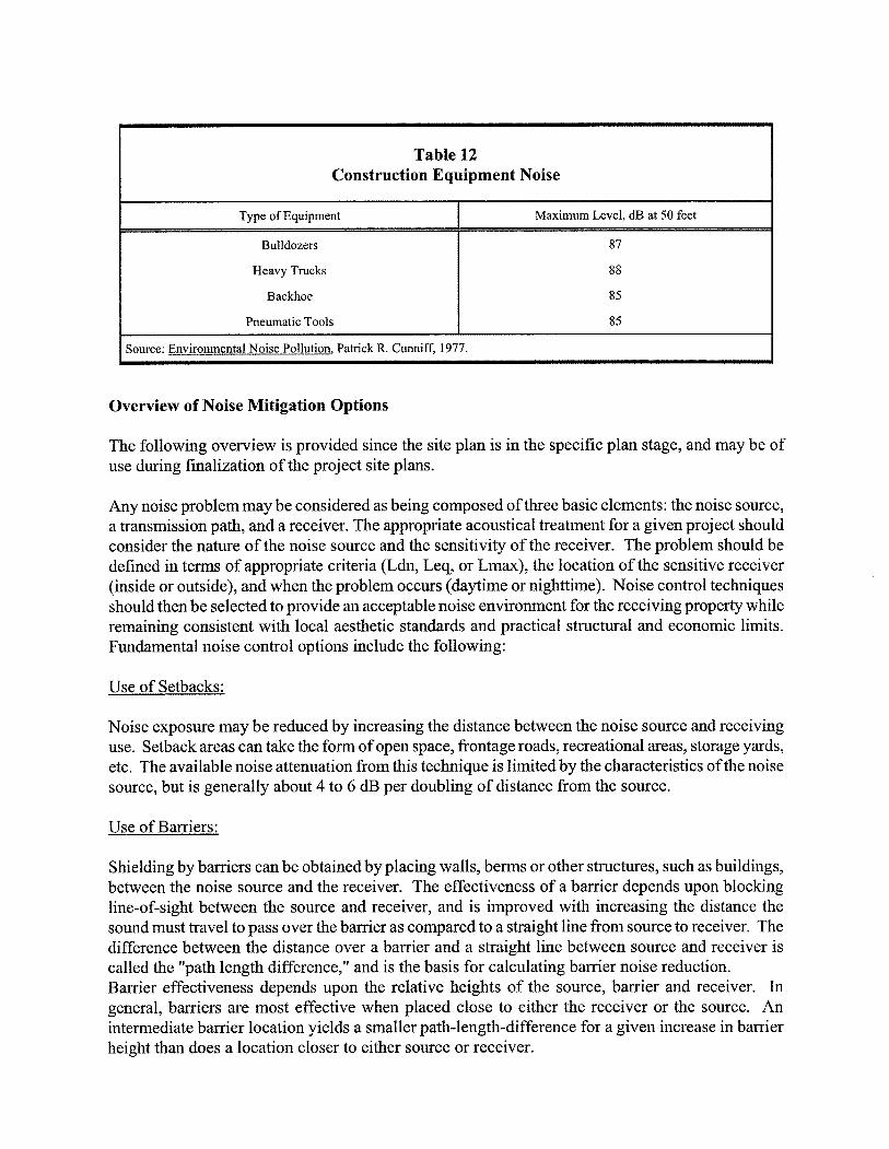
Overview of Noise Mitigation Options
Table 12 Construction Equipment Noise
The following overview is provided since the site plan is in the specific plan stage, and may be of use during finalization of the project site plans.
Type of Equipment
Bulldozers
Heavy Trucks
Backhoe
Pneumatic Tools
Any noise problem may be considered as being composed of three basic elements: the noise source, a transmission path, and a receiver. The appropriate acoustical treatment for a given project should consider the nature of the noise source and the sensitivity of the receiver. The problem should be defined in terms of appropriate criteria (Ldn, Leq, or Lmax), the location of the sensitive receiver (inside or outside), and when the problem occurs (daytime or nighttime). Noise control techniques should then be selected to provide an acceptable noise environment for the receiving property while remaining consistent with local aesthetic standards and practical structural and economic limits. Fundamental noise control options include the following:
Maximum Level, dB at 50 feet
87
88
85
85
Use of Setbacks:
Source: Environmental Noise Pollution, Patrick R. Cunniff, 1977.
Noise exposure may be reduced by increasing the distance between the noise source and receiving use. Setback areas can take the form of open space, frontage roads, recreational areas, storage yards, etc. The available noise attenuation from this technique is limited by the characteristics of the noise source, but is generally about 4 to 6 dB per doubling of distance from the source.
Use of Barriers:
Shielding by barriers can be obtained by placing walls, berms or other structures, such as buildings, between the noise source and the receiver. The effectiveness of a barrier depends upon blocking line-of-sight between the source and receiver, and is improved with increasing the distance the sound must travel to pass over the barrier as compared to a straight line from source to receiver. The difference between the distance over a barrier and a straight line between source and receiver is called the "path length difference," and is the basis for calculating barrier noise reduction. Barrier effectiveness depends upon the relative heights of the source, barrier and receiver. In general, barriers are most effective when placed close to either the receiver or the source. An intermediate barrier location yields a smaller path-length-difference for a given increase in barrier height than does a location closer to either source or receiver.

For maximum effectiveness, barriers must be continuous and relatively airtight along their length and height. To ensure that sound transmission through the barrier is insignificant, barrier mass should be about 4 lbs. /square foot, although a lesser mass may be acceptable if the barrier material provides sufficient transmission loss. Satisfaction of the above criteria requires substantial and well- fitted barrier materials, placed to intercept line of sight to all significant noise sources. Earth, in the form of berms or the face of a depressed area, is also an effective barrier material.
There are practical limits to the noise reduction provided by barriers. For vehicle traffic or railroad noise, a 5 to 10 dB noise reduction may often be reasonably attained. A 15 dB noise reduction is sometimes possible, but a 20 dB noise reduction is extremely difficult to achieve. Barriers usually are provided in the form of walls, berms, or bedwa l l combinations. The use of an earth berm in lieu of a solid wall may provide up to 3 dB additional attenuation over that attained by a solid wall alone, due to the absorption provided by the earth. Bedwa l l combinations offer slightly better acoustical performance than solid walls, and are often preferred for aesthetic reasons.
Site Design:
Buildings can be placed on a project site to shield other structures or areas, to remove them from noise-impacted areas, and to prevent an increase in noise level caused by reflections. The use of one building to shield another can significantly reduce overall project noise control costs, particularly if the shielding structure is insensitive to noise.
Site design should guard against the creation of reflecting surfaces which may increase onsite noise levels. For example, two buildings placed at an angle facing a noise source may cause noise levels within that angle to increase by up to 3 dB. The open end of "U"-shaped buildings should point away from noise sources for the same reason. Landscaping walls or noise barriers located within a development may inadvertently reflect noise back to a noise-sensitive area unless carefully located. Avoidance of these problems while attaining an aesthetic site design requires close coordination between local agencies, the project engineer and architect, and the noise consultant.
Noise Reduction bv Building Facades:
When interior noise levels are of concern in a noisy environment, noise reduction may be obtained through acoustical design of building facades. Standard construction practices provide 10-1 5 dB noise reduction for building facades with open windows, and approximately 25 dB noise reduction when windows are closed. Thus a 25 dB exterior-to-interior noise reduction can be obtained by the requirement that building design include adequate ventilation systems, allowing windows on a noise- impacted facade to remain closed under any weather condition. Where greater noise reduction is required, acoustical treatment of the building facade is necessary. Reduction of relative window area is the most effective control technique, followed by providing acoustical glazing (thicker glass or increased air space between panes) in low air infiltration rate frames, use of fixed (non-movable) acoustical glazing or the elimination of windows. Noise transmitted through walls can be reduced by increasing wall mass (using stucco or brick in lieu of wood siding), isolating wall members by the use of double or staggered stud walls, or mounting interior walls on resilient channels. Noise control for exterior doorways is provided by reducing door area, using solid-core doors, and by acoustically sealing door perimeters with suitable gaskets. Roof treatments may include the use of plywood sheathing under roofing materials.

Use of Vegetation:
Trees and other vegetation are often thought to provide significant noise attenuation. However, approximately 100 feet of dense foliage (so that no visual path extends through the foliage) is required to achieve a 5 dB attenuation of traffic noise. Thus the use of vegetation as a noise barrier should not be considered a practical method of noise control unless large tracts of dense foliage are part of the existing landscape.
Vegetation can be used to acoustically "soften" intervening ground between a noise source and receiver, increasing ground absorption of sound and thus increasing the attenuation of sound with distance. Planting of trees and shrubs is also of aesthetic and psychological value, and may reduce adverse public reaction to a noise source by removing the source from view, even though noise levels will be largely unaffected. It should be noted, however, that trees planted on the top of a noise control berm can actually slightly degrade the acoustical performance of the barrier. This effect can occur when high frequency sounds are diffracted (bent) by foliage and directed downward over a barrier.
In summary, the effects of vegetation upon noise transmission are minor, and are primarily limited to increased absorption of high frequency sounds and to reducing adverse public reaction to the noise by providing aesthetic benefits.

SPECIFIC IMPACTS AND MITIGATION MEASURES
Impact 1: Traffic Noise Level Increases at Existing Land Uses in the Project Area. Existing residences located along major roadways in the vicinity of the project area will be exposed to elevated traffic noise levels under existing and cumulative buildout conditions either with or without the project. Table 8 indicates that the existing traffic noise level increases resulting from Phase 1 of the proposed project would range from +0.2 dB to +9.9 dB Ldn, relative to no-project conditions. Traffic noise increases ranging from +0.3 dB to +14.4 dB Ldn are predicted to occur under build-out of the entire project, relative to no-project conditions. Table 9 indicates that the cumulative (1990 GP) traffic noise level increases resulting from the proposed project would range from +0.3 dB to +5.3 dB Ldn, relative to cumulative no-project noise levels. Table 10 indicates that the cumulative (2035 GP) traffic noise level increases resulting from the proposed project development would range from +0.4 dB to +6.4 dB Ldn, relative to cumulative no-project noise levels.
In some cases, overall noise levels may still be less than the City of Stockton 60 dB Ldn exterior noise level standard at the residential uses nearest to these impacted roadways. However, pursuant to the project's Significance Criteria, a significant increase in traffic noise levels is defined as 3 dB. Therefore, this impact is considered potentially significant in need of mitigation.
Mitigation for Impact 1: None Available.
Significant traffic noise impacts at existing noise-sensitive areas associated with growth of communities are generally very difficult to mitigate. This is because some areas may already have noise barriers, or new noise barriers may be infeasible from a cost standpoint or ineffective due to openings in the barriers that are commonly required for roadway ingress and egress. Because it would not likely be feasible to reduce the project-related traffic noise level increases to a less than significant level at all existing noise-sensitive land uses in the project vicinity, this impact would likely be considered unavoidable.
Significance after mitigation: Significant and unavoidable
Impact 2: Traffic Noise Impacts at Future Noise-Sensitive Land Uses Developed Within the Project Area. Proposed residential land uses located adjacent to any of the major project-area arterial roadways may be impacted by traffic noise.
The degree by which traffic noise levels will exceed the City of Stockton exterior noise level standard will depend on the proximity of the proposed noise-sensitive uses to the major roadways within the project vicinity, and the individual noise generation of those roadways. Because it is likely that residential uses will be developed within areas exposed to projected future traffic noise levels in excess of the applicable noise standards, this impact is considered significant according to the Project's Significance Criteria. Therefore, this impact is considered potentially significant in need of mitigation.
Mitigation for Impact 2:
MM 2: Sound walls should be constructed along the major project-area roadways, adjacent to proposed residential uses. The Table 11 data should be consulted to determine appropriate barrier heights. If the assumptions shown in Table 1 1 vary considerably, a detailed analysis of exterior and interior mitigation measures should be conducted when tentative maps become available.
Significance after Mitigation: Less than Significant.

Impact 3: Railroad Noise Impacts at Future Noise-Sensitive Land Uses Developed Within the Project Area. Proposed residential land uses located adjacent to the BNSF line are predicted to be impacted by railroad noise. BNSF train activity is predicted to exceed the City of Stockton 60 dB Ldn exterior noise level standard applicable to residential uses and is therefore considered significant according to the Project's Significance Criteria. Therefore, this impact is considered potentially significant in need of mitigation.
Mitigation for Impact 3:
MM 3: An analysis of projected future railroad noise levels should be conducted at the exterior and interior spaces of future noise-sensitive developments proposed within the Mariposa Lakes project area which would be located within the 60 dB Ldn railroad noise contour. This would specifically include residential areas N-2, N-3, N-4, N-19, N-21 and N-33. These analyses should be prepared at such a time as when tentative maps are available so that practical and feasible noise mitigation measures can be included in the project design to achieve compliance with the applicable noise standards.
Significance after Mitigation: Less than Significant.
Noise Impacts Associated with Development of Noise-Producing Uses within the Plan Area
Impact 4: Impacts of Industrial and Commercial Noise Sources on Existing and Planned Noise-Sensitive Uses in the Project Area. As stated in the methodology section of this report, noise impacts associated with future uses developed within the industrial areas cannot practically be evaluated due to the wide range of variables which will affect such noise generation. Because the zoning of the industrial villages would allow for certain uses which could generate significant noise levels, the potential for off-site adverse noise impacts exists, even though it cannot practically be quantified at this time. Therefore, this impact is considered potentially significant in need of mitigation.
Mitigation for Impact 4:
MM 4a: Planned retail commercial uses shall be required to comply with the requirements of chapter 16 of the City of Stockton Development Code, specifically sections 16- 340.030 (A), 16-340.030 (B), 16-340.030 (F), and 16-340.040 (B)(2)(c) .
MM 4b: During project review, the Zoning Administer shall make a determination as to whether or not the proposed use would likely generate noise levels which could adversely affect the adjacent residential areas. If it is determined from this review that proposed uses could generate excessive noise levels at noise-sensitive uses, the applicant shall be required to prepare an acoustical analysis to ensure that all appropriate noise control measures are incorporated into the project design so as to mitigate any noise impacts. Such noise control measures include, but are not limited to, use of noise barriers, site-redesign, silencers, partial or complete enclosures of critical equipment, etc.
MM 4c: Where Business Professional uses are located, the primary noise sources are parking lot noise, HVAC equipment and light truck deliveries. In this case, 8 foot tall sounds walls, as required within the City of Stockton development code would typically provide adequate isolation of parking lot and delivery truck activities. HVAC equipment should be located either at ground level or when located on roof-tops, the building facades should include parapets for shielding.

MM 4d: Where comercial or industrial uses abut residential property lines, and loading docks or large truck circulation routes face the residential areas, the following mitigation measures should be included in the project design:
Loading docks should maintain a minimum distance of 100 feet from residential property lines; Property line barriers should be a minimum of 8-feet in height, as required within the City of Stockton development code; Circulation routes for large trucks should be located a minimum of 25-feet from the residential property lines; All large heating, cooling and ventilation equipment should be located within mechanical rooms where it is possible; All large heating, cooling and ventilation equipment shall be shielded fiom view with solid barriers; Emergency generators shall comply with the local noise criteria. Loading and unloading operations shall adhere the City of Stockton Municipal Code which restricts these activities to the hours of 7:00 a.m. to 10:OO p.m.
M;M 4e: Where commercial and office land uses are separated fiom residential areas by local streets, all loading activities should be limited to the opposite sides of the buildings from residential uses.
Significance after Mitigation: Less than Significant.
Impact 5: Neighborhood Parks. The Development Code provides exemptions for park activity noise provided that it is restricted between the hours of 7:00 a.m. to 10:OO p.m. Therefore, this impact is considered potentially significant.
Mitigation for Impact 5:
MM 5 Park activities should be limited to the hours of 7:00 a.m. to 10:OO p.m.
Significance after Mitigation: Less than Significant.

Impact 6: Impact of Elementary School Playgrounds on Future Noise-Sensitive Uses in the Project Area. The Development Code provides exemptions for activities at schools provided that it is restricted between the hours of 7:00 a.m. to 10:OO p.m. Therefore, this impact is considered potentially significant in need of mitigation.
Mitigation for Impact 6:
MM 6: Outdoor school playgrounds and sporting activities should be limited to the hours of 7:00 a.m. to 10:OO p.m.
Significance after Mitigation: Less than Significant.
Impact 7: Impact of High School Athletic Field Noise on Future Noise-Sensitive Uses in the Project Area. The Development Code provides exemptions for activities at schools provided that it is restricted between the hours of 7:00 a.m. to 10:OO p.m. Therefore, this impact is considered potentially significant in need of mitigation.
Mitigation for Impact 7:
MM 7: Outdoor school playgrounds and sporting activities should be limited to the hours of 7:00 a.m. to 10:OO p.m.

Impact 8: Impact of High School Stadium Noise on Future Noise-Sensitive Uses in the Project Area. As stated in the methodology section of this report, High School stadium noise levels are likely to generate noise levels exceeding the applicable City of Stockton exterior noise level standards at the nearest noise-sensitive uses. Based upon the reference noise level data discussed previously, the 40 dB Leq stadium noise contour would be located approximately 5,000 feet from the center of the stadium. The 60 dB Lmax contour would be located at approximately 2,8 11 feet from the center of the stadium. Therefore, residential uses adjacent to the high school stadium would likely be exposed to noise levels exceeding the City of Stockton daytime and nighttime exterior noise level standards. Therefore, this impact is considered potentially significant in need of mitigation.
Mitigation for Impact 8:
MM 8a: The football stadium should be placed in a bowl or depression in order to reduce the amount of noise transmission to adjacent residential areas. An earthen berm may also be required along the rim of the bowlldepression.
MM 8b: All bleachers or seating should be constructed to have solid backs to prevent sound from flanking to the west.
MM 8c: All contests should be scheduled to end by 10:OO p.m.
MM 8d: The stadium PA system should be designed to comply with the applicable City of Stockton noise standards prior to construction of the stadium.
MM 8e: An acoustical consultant should review the proposed stadium design prior to issuance of building permits.
MM 8fi Careful application of these mitigation measures could be used to achieve compliance with the applicable City of Stockton noise standards; however, because sounds consisting of speech have been shown to be more annoying than broad-band noise, the potential for annoyance associated with these uses cannot practically be eliminated. Therefore, buyerlrenter notification should be required for all residential uses in the vicinity of the proposed high school football stadium.
Significance after Mitigation: Less than Significant.

Impact 9: Impact of Transit CenterfAmtrak Station on Future Noise-Sensitive Uses in the Project Area. Vehicular movement including busses and automobiles could generate on-site noise levels exceeding the City of Stockton exterior noise level standards at the adjacent residential uses. Therefore, this impact is considered potentially significant in need of mitigation.
MM 9: An analysis of on-site noise generation from the Amtrak station should be conducted when tentative maps become available.
Significance after Mitigation: Less than Significant.
Impact 10: Impact of College Campus on Future Noise-Sensitive Uses in the Project Area. If the proposed college campus includes athletic playing fields or stadiums, on-site noise generation could exceed the City of Stockton exterior noise level standards at the adjacent residential uses. Therefore, this impact is considered potentially significant in need of mitigation.
MM 10: An analysis of on-site noise generation from the College Campus should be conducted when tentative maps become available.
Significance after Mitigation: Less than Significant.
Impact 11: Construction Noise. Activities associated with construction will result in elevated noise levels, with maximum noise levels ranging from 85-90 dB at 100 feet, as shown in Table 12. Construction activities would be temporary in nature and would likely occur during normal daytime working hours. Nonetheless, because construction activities would result in periods of elevated noise levels, this impact is considered potentially significant in need of mitigation.
Mitigation for Impact 11:
MM 11: Construction activities should adhere to the requirements of the City of Stockton with respect to hours of operation. In addition, all equipment shall be fitted with factory equipped mufflers, and in good working order.
Significance after Mitigation: Less than Significant.

C p e n d i x A-I FHWA-RD-77-108 Highway Traffic Noise Prediction Model Data Input Sheet Project #: 2005-075 Description: Mariposa Lakes EIR - Existing LdnICNEL: Ldn HardlSoft: Soft
% Med. % Hvy. Segment Roadway Name Segment Description ADT Day % Eve % Night % Trucks rucks Speed Distance
1 East Charter Way East of Mariposa Rd. 9,070 83 17 1 1 45 100 East Main St. East Main St. East Main St.
E. 8th St. Farmington Rd. Farmington Rd. Farmington Rd. Farmington Rd. Carpenter Rd Carpenter Rd
Arch Rd Arch Rd
E. Mariposa Rd E. Mariposa Rd E. Mariposa Rd E. Mariposa Rd E. Mariposa Rd E. Mariposa Rd E. Mariposa Rd
S Walker Ln Gillis Rd
Austin Rd Kaiser Rd
Jack Tone Rd Jack Tone Rd
West of E. Charter E. Charter to E. South Walker Ln S. Walker to Gillis W.of East Mariposa Rd. SR 99 NB to S. Walker S. Walker to Gillis Gillis to Kaiser Rd. Kaiser Rd. to Jack Tone Rd. West of E. Mariposa East of E. Mariposa SR99 to Newcastle Rd. Newcastel Rd to Austin Rd E Charter Way to E 8th St E. 8th St to SR 99 SB Ramps SR 99 SB Ramps to SR 99 NB Ramps SR 99 NB off Ramp to Stagecoach Rd Stagecoach Rd to Carpenter Rd Carpenter Rd to Austin Rd Austin Rd to Kaiser Rd Farmington Rd to E Charter Way Farmington Rd to E Charter Way S. of Arch Rd. Farmington Rd to E. Mariposa Rd N. of Farmington Rd S. of E Mariposa Rd

/ FHWA-RD-77-108 Highway Traffic Noise Prediction Model Predicted Levels
Project #: 2005-075 Description: Mariposa Lakes EIR - Existing LdnICNEL: Ldn HardISoft: Soft
Medium Heavy Segment Roadway Name Segment Description Autos Trucks Trucks Total
1 East Charter Way East of Mariposa Rd. 61.4 49.8 54.3 62 East Main St. East Main St. East Main St. E. 8th St. Farmington Rd. Farmington Rd. Farmington Rd. Farmington Rd. Carpenter Rd Carpenter Rd Arch Rd Arch Rd E. Mariposa Rd E. Mariposa Rd E. Mariposa Rd E. Mariposa Rd E. Mariposa Rd E. Mariposa Rd E. Mariposa Rd S Walker Ln Gillis Rd Austin Rd Kaiser Rd Jack Tone Rd Jack Tone Rd
West of E. Charter 61.2 E. Charter to E. South Walker Ln 58.8 S. Walker to Gillis 58.6 W.of East Mariposa Rd. 58.6 SR 99 NB to S. Walker 61.3 S. Walker to Gillis 59.2 Gillis to Kaiser Rd. 59.1 Kaiser Rd. to Jack Tone Rd. 58.8 West of E. Mariposa 48.0 East of E. Mariposa 51 .O SR99 to Newcastle Rd. 55.8 Newcastel Rd to Austin Rd 53.7 E Charter Way to E 8th St 62.4 E. 8th St to SR 99 SB Ramps 60.9 SR 99 SB Ramps to SR 99 NB Ramps 61.4 SR 99 NB off Ramp to Stagecoach Rd 61.2 Stagecoach Rd to Carpenter Rd 62.5 Carpenter Rd to Austin Rd 61.5 Austin Rd to Kaiser Rd 60.8 Farmington Rd to E Charter Way 51.4 Farmington Rd to E Charter Way 47.2 S. of Arch Rd. 53.5 Farmington Rd to E. Mariposa Rd 46.3 N. of Farmington Rd 56.0 S. of E Mariposa Rd 55.9
U j.c. brennan & associates /V\/L/consultants in acoustics

FHWA-RD-77-108 Highway Traffic Noise Prediction Model Noise Contour Output
Project #: 2005-075 Description: Mariposa Lakes EIR - Existing LdnICNEL: Ldn HardISoft: Soft
-------- Distances to Traffic Noise Contours -------- Segment Roadway Name Segment Description 75 70 65 60 55
1 East Charter Way East of Mariposa Rd. 15 31 67 145 313 East Main St. East Main St. East Main St. E. 8th St. Farmington Rd. Farmington Rd. Farmington Rd. Farmington Rd. Carpenter Rd Carpenter Rd Arch Rd Arch Rd E. Mariposa Rd E. Mariposa Rd E. Mariposa Rd E. Mariposa Rd E. Mariposa Rd E. Mariposa Rd E. Mariposa Rd S Walker Ln Gillis Rd Austin Rd Kaiser Rd Jack Tone Rd Jack Tone Rd
West of E. Charter E. Charter to E. South Walker Ln S. Walker to Gillis W.of East Mariposa Rd. SR 99 NB to S. Walker S. Walker to Gillis Gillis to Kaiser Rd. Kaiser Rd. to Jack Tone Rd. West of E. Mariposa East of E. Mariposa SR99 to Newcastle Rd. Newcastel Rd to Austin Rd E Charter Way to E 8th St E. 8th St to SR 99 SB Ramps SR 99 SB Ramps to SR 99 NB Ramps SR 99 NB off Ramp to Stagecoach Rd Stagecoach Rd to Carpenter Rd Carpenter Rd to Austin Rd Austin Rd to Kaiser Rd Farmington Rd to E Charter Way Farmington Rd to E Charter Way S. of Arch Rd. Farmington Rd to E. Mariposa Rd N. of Farmington Rd S. of E Mariposa Rd
& associates i n ncoustics

Appendix B-1 f FHWA-RD-77-108 Highway Traffic Noise Prediction Model Data Input Sheet Project #: 2005-075 Description: Mariposa Lakes EIR - Existing + Approved LdnICNEL: Ldn HardlSoft: Soft
% Med. % Hvy. Segment Roadway Name Segment Description ADT Day % Eve % Night % Trucks Trucks Speed Distance
1 East Charter Wav East of Mari~osa Rd. 10.710 83 17 1 1 45 100 East Main St. East Main St. East Main St.
E. 8th St. Farmington Rd. Farmington Rd. Farmington Rd. Farmington Rd. Carpenter Rd Carpenter Rd
Arch Rd Arch Rd
E. Mariposa Rd E. Mariposa Rd E. Mariposa Rd E. Mariposa Rd E. Mariposa Rd E. Mariposa Rd E. Mariposa Rd
S Walker Ln Gillis Rd
Austin Rd Kaiser Rd
Jack Tone Rd Jack Tone Rd
West of E. charter E. Charter to E. South Walker Ln S. Walker to Gillis W.of East Mariposa Rd. SR 99 NB to S. Walker S. Walker to Gillis Gillis to Kaiser Rd. Kaiser Rd. to Jack Tone Rd. West of E. Mariposa East of E. Mariposa SR99 to Newcastle Rd. Newcastel Rd to Austin Rd E Charter Way to E 8th St E. 8th St to SR 99 SB Ramps SR 99 SB Ramps to SR 99 NB Ramps SR 99 NB off Ramp to Stagecoach Rd Stagecoach Rd to Carpenter Rd Carpenter Rd to Austin Rd Austin Rd to Kaiser Rd Farmington Rd to E Charter Way Farmington Rd to E Charter Way S. of Arch Rd. Farmington Rd to E. Mariposa Rd N. of Farmington Rd S. of E Mariposa Rd
U j .c. brennan 8r associates cons^ in dcuustics

- FHWA-RD-77108 Highway Traffic Noise Prediction Model Predicted Levels
Project #: 2005-075 Description: Mariposa Lakes EIR - Existing + Approved LdnICNEL: Ldn HardlSoft: Soft
Medium Heavy Segment Roadway Name Segment Description Autos Trucks Trucks Total
1 East Charter Way East of Mariposa Rd. 62.1 50.5 55.0 63 East Main St. East Main St. East Main St. E. 8th St. Farmington Rd. Farmington Rd. Farmington Rd. Farmington Rd. Carpenter Rd Carpenter Rd Arch Rd Arch Rd E. Mariposa Rd E. Mariposa Rd E. Mariposa Rd E. Mariposa Rd E. Mariposa Rd E. Mariposa Rd E. Mariposa Rd S Walker Ln Gillis Rd Austin Rd Kaiser Rd Jack Tone Rd Jack Tone Rd
West of E. charter E. Charter to E. South Walker Ln S. Walker to Gillis W.of East Mariposa Rd. SR 99 NB to S. Walker S. Walker to Gillis Gillis to Kaiser Rd. Kaiser Rd. to Jack Tone Rd. West of E. Mariposa East of E. Mariposa SR99 to Newcastle Rd. Newcastel Rd to Austin Rd E Charter Way to E 8th St E. 8th St to SR 99 SB Ramps SR 99 SB Ramps to SR 99 NB Ramps SR 99 NB off Ramp to Stagecoach Rd Stagecoach Rd to Carpenter Rd Carpenter Rd to Austin Rd Austin Rd to Kaiser Rd Farmington Rd to E Charter Way Farmington Rd to E Charter Way S. of Arch Rd. Farmington Rd to E. Mariposa Rd N. of Farmington Rd S. of E Mariposa Rd
U j.c. brennan & associates rVl/ l /consultdnts in dcoustics

f FHWA-RD-77-108 Highway Traffic Noise Prediction Model Noise Contour Output
Project #: 2005-075 Description: Mariposa Lakes EIR - Existing + Approved LdnICNEL: Ldn HardISoft: Soft
-------- Distances to Traffic Noise Contours -------- Segment Roadway Name Segment Description 75 70 65 60 55
1 East Charter Way East of Mariposa Rd. 16 35 75 162 349 East Main St. East Main St. East Main St. E. 8th St. Farmington Rd. Farmington Rd. Farmington Rd. Farmington Rd. Carpenter Rd Carpenter Rd Arch Rd Arch Rd E. Mariposa Rd E. Mariposa Rd E. Mariposa Rd E. Mariposa Rd E. Mariposa Rd E. Mariposa Rd E. Mariposa Rd S Walker Ln Gillis Rd Austin Rd Kaiser Rd Jack Tone Rd Jack Tone Rd
West of E. charter 16 E. Charter to E. South Walker Ln 12 S. Walker to Gillis 10 W.of East Mariposa Rd. 14 SR 99 NB to S. Walker 34 S. Walker to Gillis 22 Gillis to Kaiser Rd. 21 Kaiser Rd. to Jack Tone Rd. 22 West of E. Mariposa 9 East of E. Mariposa 3 SR99 to Newcastle Rd. 24 Newcastel Rd to Austin Rd 8 E Charter Way to E 8th St 21 E. 8th St to SR 99 SB Ramps 19 SR 99 SB Ramps to SR 99 NB Ramps 18 SR 99 NB off Ramp to Stagecoach Rd 22 Stagecoach Rd to Carpenter Rd 25 Carpenter Rd to Austin Rd 18 Austin Rd to Kaiser Rd 18 Farmington Rd to E Charter Way 8 Farmington Rd to E Charter Way 2 S. of Arch Rd. 5 Farmington Rd to E. Mariposa Rd 1 N. of Farmington Rd 6 S. of E Mariposa Rd 6
& associates in acoustics
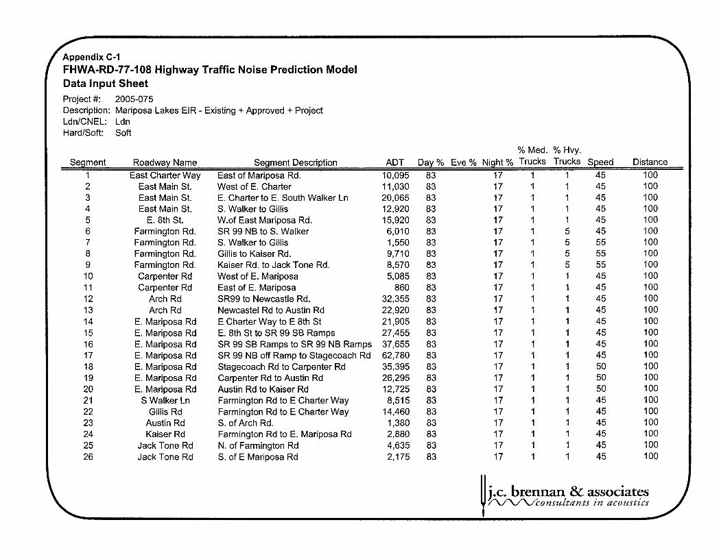
Appendix C-I T FHWA-RD-77-108 Highway Traffic Noise Prediction Model Data Input Sheet Project #: 2005-075 Description: Mariposa Lakes EIR - Existing + Approved + Project LdnICNEL: Ldn HardISoft: Soft
% Med. % Hvy. Segment Roadway Name Segment Description ADT Day % Eve % Night % Trucks Trucks Speed Distance
1 East Charter Way East of Mariposa Rd. 10,095 83 17 1 1 45 100 East Main St. East Main St. East Main St.
E. 8th St. Farmington Rd. Farmington Rd. Farmington Rd. Farmington Rd. Carpenter Rd Carpenter Rd
Arch Rd Arch Rd
E. Mariposa Rd E. Mariposa Rd E. Mariposa Rd E. Mariposa Rd E. Mariposa Rd E. Mariposa Rd E. Mariposa Rd
S Walker Ln Gillis Rd
Austin Rd Kaiser Rd
Jack Tone Rd Jack Tone Rd
West of E. charter E. Charter to E. South Walker Ln S. Walker to Gillis W.of East Mariposa Rd. SR 99 NB to S. Walker S. Walker to Gillis Gillis to Kaiser Rd. Kaiser Rd. to Jack Tone Rd. West of E. Mariposa East of E. Mariposa SR99 to Newcastle Rd. Newcastel Rd to Austin Rd E Charter Way to E 8th St E. 8th St to SR 99 SB Ramps SR 99 SB Ramps to SR 99 NB Ramps SR 99 NB off Ramp to Stagecoach Rd Stagecoach Rd to Carpenter Rd Carpenter Rd to Austin Rd Austin Rd to Kaiser Rd Farmington Rd to E Charter Way Farmington Rd to E Charter Way S. of Arch Rd. Farmington Rd to E. Mariposa Rd N. of Farmington Rd S. of E Mariposa Rd
U j .c. brennan 8r associates /Lr\/l/consultants i n acoustics

/ FHWA-RD-77-108 Highway Traffic Noise Prediction Model Predicted Levels
Project #: 2005-075 Description: Mariposa Lakes EIR - Existing + Approved + Project LdnICNEL: Ldn HardlSoft: Soft
Medium Heavy Segment Roadway Name Segment Description Autos Trucks rucks Total
1 East Charter Way East of Mariposa Rd. 61.9 50.2 54.7 62.9 East Main St. East Main St. East Main St. E. 8th St. Farmington Rd. Farmington Rd. Farmington Rd. Farmington Rd. Carpenter Rd Carpenter Rd Arch Rd Arch Rd E. Mariposa Rd E. Mariposa Rd E. Mariposa Rd E. Mariposa Rd E. Mariposa Rd E. Mariposa Rd E. Mariposa Rd S Walker Ln Gillis Rd Austin Rd Kaiser Rd Jack Tone Rd Jack Tone Rd
West of E. Charter E. Charter to E. South Walker Ln S. Walker to Gillis W.of East Mariposa Rd. SR 99 NB to S. Walker S. Walker to Gillis Gillis to Kaiser Rd. Kaiser Rd. to Jack Tone Rd. West of E. Mariposa East of E. Mariposa SR99 to Newcastle Rd. Newcastel Rd to Austin Rd E Charter Way to E 8th St E. 8th St to SR 99 SB Ramps SR 99 SB Ramps to SR 99 NB Ramps SR 99 NB off Ramp to Stagecoach Rd Stagecoach Rd to Carpenter Rd Carpenter Rd to Austin Rd Austin Rd to Kaiser Rd Farmington Rd to E Charter Way Farmington Rd to E Charter Way S. of Arch Rd. Farmington Rd to E. Mariposa Rd N. of Farmington Rd S, of E Mariposa Rd
j.c. brennan & associates /L/L/l/cconsu~tunts in dcoustics
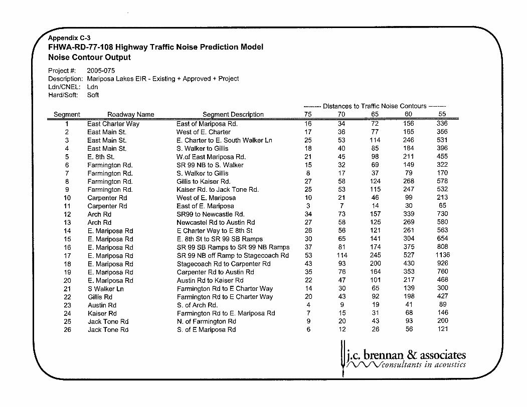
FHWA-RD-77-108 Highway Traffic Noise Prediction Model Noise Contour Output
Project #: 2005-075 Description: Mariposa Lakes EIR - Existing + Approved + Project LdnICNEL: Ldn HardISoft: Soft
-------- Distances to Traffic Noise Contours -------- Segment Roadway Name Segment Description 75 70 65 60 55
1 East Charter Way East of Mariposa Rd. 16 34 72 156 336 East Main St. East Main St. East Main St. E. 8th St. Farmington Rd. Farmington Rd. Farmington Rd. Farmington Rd. Carpenter Rd Carpenter Rd Arch Rd Arch Rd E. Mariposa Rd E. Mariposa Rd E. Mariposa Rd E. Mariposa Rd E. Mariposa Rd E. Mariposa Rd E. Mariposa Rd S Walker Ln Gillis Rd Austin Rd Kaiser Rd Jack Tone Rd Jack Tone Rd
West of E. Charter E. Charter to E. South Walker Ln S. Walker to Gillis W.of East Mariposa Rd. SR 99 NB to S. Walker S. Walker to Gillis Gillis to Kaiser Rd. Kaiser Rd. to Jack Tone Rd. West of E. Mariposa East of E. Mariposa SR99 to Newcastle Rd. Newcastel Rd to Austin Rd E Charter Way to E 8th St E. 8th St to SR 99 SB Ramps SR 99 SB Ramps to SR 99 NB Ramps SR 99 NB off Ramp to Stagecoach Rd Stagecoach Rd to Carpenter Rd Carpenter Rd to Austin Rd Austin Rd to Kaiser Rd Farmington Rd to E Charter Way Farmington Rd to E Charter Way S. of Arch Rd. Farmington Rd to E. Mariposa Rd N. of Farmington Rd S. of E Mariposa Rd
& associates in dcoustics

Appendix D-1 T FHWA-RD-77-108 Highway Traffic Noise Prediction Model Data Input Sheet Project #: 2005-075 Description: Mariposa Lakes EIR - Existing + Approved + Phase 1 LdnICNEL: Ldn HardISoft: Soft
% Med. % Hvy. Segment Roadway Name Segment Description ADT Day % Eve % Night % Trucks Trucks Speed Distanc
1 East Charter Way East of Mariposa Rd. 8,120 83 17 1 1 45 100 East Main St. East Main St. East Main St.
E. 8th St. Farmington Rd. Farmington Rd. Farmington Rd. Farmington Rd. Carpenter Rd Carpenter Rd
Arch Rd Arch Rd
E. Mariposa Rd E. Mariposa Rd E. Mariposa Rd E. Mariposa Rd E. Mariposa Rd E. Mariposa Rd E. Mariposa Rd
S Walker Ln Gillis Rd
Austin Rd Kaiser Rd
Jack Tone Rd Jack Tone Rd
West of E. charter E. Charter to E. South Walker Ln S. Walker to Gillis W.of East Mariposa Rd. SR 99 NB to S. Walker S. Walker to Gillis Gillis to Kaiser Rd. Kaiser Rd. to Jack Tone Rd. West of E. Mariposa East of E. Mariposa SR99 to Newcastle Rd. Newcastel Rd to Austin Rd E Charter Way to E 8th St E. 8th St to SR 99 SB Ramps SR 99 SB Ramps to SR 99 NB Ramps SR 99 NB off Ramp to Stagecoach Rd Stagecoach Rd to Carpenter Rd Carpenter Rd to Austin Rd Austin Rd to Kaiser Rd Farmington Rd to E Charter Way Farmington Rd to E Charter Way S. of Arch Rd. Farmington Rd to E. Mariposa Rd N. of Farmington Rd S. of E Mariposa Rd
U j .c. brennan & associates /-VLfV%onsultants in acoustics

FHWA-RD-77-108 Highway Traffic Noise Prediction Model Predicted Levels
Project #: 2005-075 Description: Mariposa Lakes EIR - Existing + Approved + Phase 1 LdnICNEL: Ldn HardISoft: Soft
Medium Heavy Segment Roadway Name Segment Description Autos Trucks rucks Total
1 East Charter Way East of Mariposa Rd. 60.9 49.3 53.8 61.9 East Main St. East Main St. East Main St. E. 8th St. Farmington Rd. Farmington Rd. Farmington Rd. Farmington Rd. Carpenter Rd Carpenter Rd Arch Rd Arch Rd E. Mariposa Rd E. Mariposa Rd E. Mariposa Rd E. Mariposa Rd E. Mariposa Rd E. Mariposa Rd E. Mariposa Rd S Walker Ln Gillis Rd Austin Rd Kaiser Rd Jack Tone Rd Jack Tone Rd
West of E. Charter E. Charter to E. South Walker Ln S. Walker to Gillis W.of East Mariposa Rd. SR 99 NB to S. Walker S. Walker to Gillis Gillis to Kaiser Rd. Kaiser Rd. to Jack Tone Rd. West of E. Mariposa East of E. Mariposa SR99 to Newcastle Rd. Newcastel Rd to Austin Rd E Charter Way to E 8th St E. 8th St to SR 99 SB Ramps SR 99 SB Ramps to SR 99 NB Ramps SR 99 NB off Ramp to Stagecoach Rd Stagecoach Rd to Carpenter Rd Carpenter Rd to Austin Rd Austin Rd to Kaiser Rd Farmington Rd to E Charter Way Farmington Rd to E Charter Way S. of Arch Rd. Farmington Rd to E. Mariposa Rd N. of Farmington Rd S. of E Mariposa Rd
U j.c. b r e w & associates AAfUconsu l tdn ts in acoustics

A p p e n d i x D-3
( FHWA-RD-77-108 Highway Traffic Noise Prediction Model
East Main St. East Main St. East Main St. E. 8th St. Farmington Rd. Farmington Rd. Farmington Rd. Farmington Rd. Carpenter Rd Carpenter Rd Arch Rd Arch Rd E. Mariposa Rd E. Mariposa Rd E. Mariposa Rd E. Mariposa Rd E. Mariposa Rd E. Mariposa Rd E. Mariposa Rd S Walker Ln Gillis Rd Austin Rd Kaiser Rd Jack Tone Rd Jack Tone Rd
West of E. charter E. Charter to E. South Walker Ln S. Walker to Gillis W.of East Mariposa Rd. SR 99 NB to S. Walker S. Walker to Gillis Gillis to Kaiser Rd. Kaiser Rd. to Jack Tone Rd. West of E. Mariposa East of E. Mariposa SR99 to Newcastle Rd. Newcastel Rd to Austin Rd E Charter Way to E 8th St E. 8th St to SR 99 SB Ramps SR 99 SB Ramps to SR 99 NB Ramps SR 99 NB off Ramp to Stagecoach Rd Stagecoach Rd to Carpenter Rd Carpenter Rd to Austin Rd Austin Rd to Kaiser Rd Farmington Rd to E Charter Way Farmington Rd to E Charter Way S. of Arch Rd. Farmington Rd to E. Mariposa Rd N. of Farmington Rd S. of E Mariposa Rd
Noise Contour Output
Project #: 2005-075 Description: Mariposa Lakes EIR - Existing + Approved + Phase 1 LdnlCNEL: Ldn HardISoft: Soft
-------- Distances to Traffic Noise Contours -------- Segment Roadway Name Segment Description 75 70 65 60 55
1 East Charter Way East of Mariposa Rd. 13 29 63 135 290
& associates in acoustics

' FHWA-RD-77-108 Highway Traffic Noise Prediction Model Data Input Sheet Project #: 2005-075 Description: Mariposa Lakes EIR - 1990GP No Project LdnICNEL: Ldn HardISoft: Soft
% Med. % Hvy. Segment Roadway Name Segment Description ADT Day % Eve % Night % Trucks Trucks Speed Distanc
1 East Charter Way East of Mariposa Rd. 20,300 83 17 1 1 45 100 East Main St. East Main St. East Main St.
E. 8th St. Farmington Rd. Farmington Rd. Farmington Rd. Farmington Rd. Carpenter Rd Carpenter Rd
Arch Rd Arch Rd
E. Mariposa Rd E. Mariposa Rd E. Mariposa Rd E. Mariposa Rd E. Mariposa Rd E. Mariposa Rd E. Mariposa Rd
S Walker Ln Gillis Rd
Austin Rd Kaiser Rd
Jack Tone Rd Jack Tone Rd
West of E. charter E. Charter to E. South Walker Ln S. Walker to Gillis W.of East Mariposa Rd. SR 99 NB to S. Walker S. Walker to Gillis Gillis to Kaiser Rd. Kaiser Rd. to Jack Tone Rd. West of E. Mariposa East of E. Mariposa SR99 to Newcastle Rd. Newcastel Rd to Austin Rd E Charter Way to E 8th St E. 8th St to SR 99 SB Ramps SR 99 SB Ramps to SR 99 NB Ramps SR 99 NB off Ramp to Stagecoach Rd Stagecoach Rd to Carpenter Rd Carpenter Rd to Austin Rd Austin Rd to Kaiser Rd Farmington Rd to E Charter Way Farmington Rd to E Charter Way S. of Arch Rd. Farmington Rd to E. Mariposa Rd N. of Farmington Rd S. of E Mariposa Rd
U j .c. brennan & associates r\/?L/l/consultants in acoustics
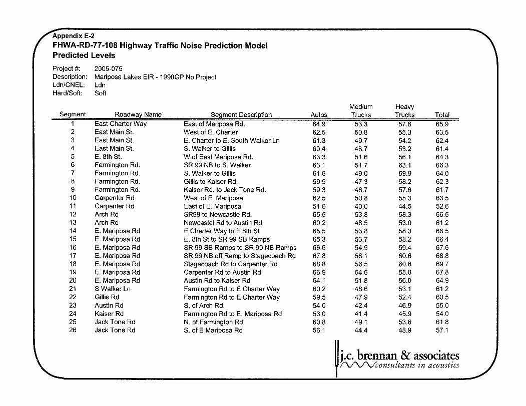
/ FHWA-RD-77-108 Highway Traffic Noise Prediction Model Predicted Levels
Project #: 2005-075 Description: Mariposa Lakes EIR - 1990GP No Project LdnICNEL: Ldn HardISoft: Soft
Medium Heavy Segment Roadway Name Segment Description Autos Trucks Trucks Total
1 East Charter Way East of Mariposa Rd. 64.9 53.3 57.8 65.9 East Main St. East Main St. East Main St. E. 8th St. Farmington Rd. Farmington Rd. Farmington Rd. Farmington Rd. Carpenter Rd Carpenter Rd Arch Rd Arch Rd E. Mariposa Rd E. Mariposa Rd E. Mariposa Rd E. Mariposa Rd E. Mariposa Rd E. Mariposa Rd E. Mariposa Rd S Walker Ln Gillis Rd Austin Rd Kaiser Rd Jack Tone Rd Jack Tone Rd
West of E. charter E. Charter to E. South Walker Ln S. Walker to Gillis W.of East Mariposa Rd. SR 99 NB to S. Walker S. Walker to Gillis Gillis to Kaiser Rd. Kaiser Rd. to Jack Tone Rd. West of E. Mariposa East of E. Mariposa SR99 to Newcastle Rd. Newcastel Rd to Austin Rd E Charter Way to E 8th St E. 8th St to SR 99 SB Ramps SR 99 SB Ramps to SR 99 NB Ramps SR 99 NB off Ramp to Stagecoach Rd Stagecoach Rd to Carpenter Rd Carpenter Rd to Austin Rd Austin Rd to Kaiser Rd Farmington Rd to E Charter Way Farmington Rd to E Charter Way S. of Arch Rd. Farmington Rd to E. Mariposa Rd N. of Farmington Rd S. of E Mariposa Rd
j.c. brennan & associates r\/l/l/consultunts in dcoustics

r FHWA-RD-77-108 Highway Traffic Noise Prediction Model Noise Contour Output
Project #: 2005-075 Description: Mariposa Lakes EIR - 1990GP No Project LdnICNEL: Ldn Hardisoft: Soft
-----em- Distances to Traffic Noise Contours -------- Segment Roadway Name Segment Description 75 70 65 60 55
1 East Charter Way East of Mariposa Rd. 25 53 115 248 535 East Main St. East Main St. East Main St. E. 8th St. Farmington Rd. Farmington Rd. Farmington Rd. Farmington Rd. Carpenter Rd Carpenter Rd Arch Rd Arch Rd E. Mariposa Rd E. Mariposa Rd E. Mariposa Rd E. Mariposa Rd E. Mariposa Rd E. Mariposa Rd E. Mariposa Rd S Walker Ln Gillis Rd Austin Rd Kaiser Rd Jack Tone Rd Jack Tone Rd
West of E. Charter E. Charter to E. South Walker Ln S. Walker to Gillis W.of East Mariposa Rd. SR 99 NB to S. Walker S. Walker to Gillis Gillis to Kaiser Rd. Kaiser Rd. to Jack Tone Rd. West of E. Mariposa East of E. Mariposa SR99 to Newcastle Rd. Newcastel Rd to Austin Rd E Charter Way to E 8th St E. 8th St to SR 99 SB Ramps SR 99 SB Ramps to SR 99 NB Ramps SR 99 NB off Ramp to Stagecoach Rd Stagecoach Rd to Carpenter Rd Carpenter Rd to Austin Rd Austin Rd to Kaiser Rd Farmington Rd to E Charter Way Farmington Rd to E Charter Way S. of Arch Rd. Farmington Rd to E. Mariposa Rd N. of Farmington Rd S. of E Mariposa Rd
j.c. b r e w & associates f iAAAconsu~ tan t s in acoustics

Appendix F-I f FHWA-RD-77-108 Highway Traffic Noise Prediction Model
Data Input Sheet Project #: 2005-075 Description: Mariposa Lakes EIR - 1990GP + Project LdnlCNEL: Ldn HardlSoft: Soft
% Med. % Hvy. Segment Roadway Name Segment Description ADT Day % Eve % Night % Trucks Trucks Speed Distance
1 East Charter Way East of Mariposa Rd. 11,190 83 17 1 1 45 100 2 East Main St. West of E. Charter 14,875 83 17 1 1 45 100 3 East Main St. E. Charter to E. South Walker Ln 14,860 83 17 1 1 45 100 4 East Main St. S. Walker to Gillis 13,305 83 17 1 1 45 100 5 E. 8th St. W.of East Mariposa Rd. 15,380 83 17 1 1 45 100 6 Farmington Rd. SR 99 NB to S. Walker 17,855 83 17 1 5 45 100 7 Farmington Rd. S. Walker to Gillis 3,460 83 17 I 5 55 100 8 Farmington Rd. Gillis to Kaiser Rd. 5,980 83 17 1 5 55 100 9 Farmington Rd. Kaiser Rd. to Jack Tone Rd. 4,880 83 17 1 5 55 100 10 Carpenter Rd West of E. Mariposa 11,660 83 17 1 1 45 100 11 Carpenter Rd East of E. Mariposa 325 83 17 1 1 45 100 12 Arch Rd SR99 to Newcastle Rd. 32,270 83 17 1 1 45 100 13 Arch Rd Newcastel Rd to Austin Rd 22,250 83 17 1 1 45 100 14 E. Mariposa Rd E Charter Way to E 8th St 20,930 83 17 1 1 45 100 15 E. Mariposa Rd E. 8th St to SR 99 SB Ramps 22,305 83 17 1 1 45 100 16 E. Mariposa Rd SR 99 SB Ramps to SR 99 NB Ramps 39,965 83 17 1 1 45 100 17 E. Mariposa Rd SR 99 NB off Ramp to Stagecoach Rd 62,865 83 17 1 1 45 100 18 E. Mariposa Rd Stagecoach Rd to Carpenter Rd 35,210 83 17 1 1 50 100 19 E. Mariposa Rd Carpenter Rd to Austin Rd 35,055 83 17 1 1 50 100 20 E. Mariposa Rd Austin Rd to Kaiser Rd 11,130 83 17 1 1 50 100 21 S Walker Ln Farmington Rd to E Charter Way 7,435 83 17 1 1 45 100 22 Gillis Rd Farmington Rd to E Charter Way 19,820 83 17 1 1 45 100 23 Austin Rd S. of Arch Rd. 785 83 17 1 1 45 100 24 Kaiser Rd Farmington Rd to E. Mariposa Rd 3,085 83 17 1 1 45 100 25 Jack Tone Rd N. of Farmington Rd 7,435 83 17 1 1 45 100 26 Jack Tone Rd S. of E Mariposa Rd 1,340 83 17 1 1 45 100
U j .c. brennan & associates f W V l A c o n s u l t a n t s in ucoustics

/ FHWA-RD-77-108 Highway Traffic Noise Prediction Model Predicted Levels
Project #: 2005-075 Description: Mariposa Lakes EIR - 1990GP + Project LdnICNEL: Ldn HardlSoft: Soft
Medium Heavy Segment Roadway Name Segment Description Autos Trucks rucks Total
1 East Charter Way East of Mariposa Rd. 62.3 50.7 55.2 63.3 East Main St. East Main St. East Main St. E. 8th St. Farmington Rd. Farmington Rd. Farmington Rd. Farmington Rd. Carpenter Rd Carpenter Rd Arch Rd Arch Rd E. Mariposa Rd E. Mariposa Rd E. Mariposa Rd E. Mariposa Rd E. Mariposa Rd E. Mariposa Rd E. Mariposa Rd S Walker Ln Gillis Rd Austin Rd Kaiser Rd Jack Tone Rd Jack Tone Rd
West of E. Charter E. Charter to E. South Walker Ln S. Walker to Gillis W.of East Mariposa Rd. SR 99 NB to S. Walker S. Walker to Gillis Gillis to Kaiser Rd. Kaiser Rd. to Jack Tone Rd. West of E. Mariposa East of E. Mariposa SR99 to Newcastle Rd. Newcastel Rd to Austin Rd E Charter Way to E 8th St E. 8th St to SR 99 SB Ramps SR 99 SB Ramps to SR 99 NB Ramps SR 99 NB off Ramp to Stagecoach Rd Stagecoach Rd to Carpenter Rd Carpenter Rd to Austin Rd Austin Rd to Kaiser Rd Farmington Rd to E Charter Way Farmington Rd to E Charter Way S. of Arch Rd. Farmington Rd to E. Mariposa Rd N. of Farmington Rd S. of E Mariposa Rd
U j.c. brennan & associates / V V U c o n s u l in acoustics

Appendix F-3 f FHVVA-RD-77-108 Highway Traffic Noise Prediction Model Noise Contour Output
Project #: 2005-075 Description: Mariposa Lakes EIR - 1990GP + Project LdnlCNEL: Ldn HardlSoft: Soft
-------- Distances to Traffic Noise Contours -------- Segment Roadway Name Segment Description 75 70 65 60 55
1 East Charter Way East of Mariposa Rd. 17 36 77 167 360 East Main St. East Main St. East Main St. E. 8th St. Farmington Rd. Farmington Rd. Farmington Rd. Farmington Rd. Carpenter Rd Carpenter Rd Arch Rd Arch Rd E. Mariposa Rd E. Mariposa Rd E. Mariposa Rd E. Mariposa Rd E. Mariposa Rd E. Mariposa Rd E. Mariposa Rd S Walker Ln Gillis Rd Austin Rd Kaiser Rd Jack Tone Rd Jack Tone Rd
West of E. Charter E. Charter to E. South Walker Ln S. Walker to Gillis W.of East Mariposa Rd. SR 99 NB to S. Walker S. Walker to Gillis Gillis to Kaiser Rd. Kaiser Rd. to Jack Tone Rd. West of E. Mariposa East of E. Mariposa SR99 to Newcastle Rd. Newcastel Rd to Austin Rd E Charter Way to E 8th St E. 8th St to SR 99 SB Ramps SR 99 SB Ramps to SR 99 NB Ramps SR 99 NB off Ramp to Stagecoach Rd Stagecoach Rd to Carpenter Rd Carpenter Rd to Austin Rd Austin Rd to Kaiser Rd Farmington Rd to E Charter Way Farmington Rd to E Charter Way S. of Arch Rd. Farmington Rd to E. Mariposa Rd N. of Farmington Rd S. of E Mariposa Rd
& associates in dcoustics

Appendix G-l f FHVVA-RD-77-108 Highway Traffic Noise Prediction Model Data Input Sheet Project #: 2005-075 Description: Mariposa Lakes EIR - 2035GP No Project LdnICNEL: Ldn HardlSoft: Soft
% Med. % Hvy. Segment Roadway Name Segment Description ADT Day % Eve % Night % Trucks rucks Speed Distance
I East Charter Way East of Mariposa Rd. 15,935 83 17 1 1 45 100 East Main St. East Main St. East Main St.
E. 8th St. Farmington Rd. Farmington Rd. Farmington Rd. Farmington Rd. Carpenter Rd Carpenter Rd
Arch Rd Arch Rd
E. Mariposa Rd E. Mariposa Rd E. Mariposa Rd E. Mariposa Rd E. Mariposa Rd E. Mariposa Rd E. Mariposa Rd
S Walker Ln Gillis Rd
Austin Rd Kaiser Rd
Jack Tone Rd Jack Tone Rd
West of E. charter E. Charter to E. South Walker Ln S. Walker to Gillis W.of East Mariposa Rd. SR 99 NB to S. Walker S. Walker to Gillis Gillis to Kaiser Rd. Kaiser Rd. to Jack Tone Rd. West of E. Mariposa East of E. Mariposa SR99 to Newcastle Rd. Newcastel Rd to Austin Rd E Charter Way to E 8th St E. 8th St to SR 99 SB Ramps SR 99 SB Ramps to SR 99 NB Ramps SR 99 NB off Ramp to Stagecoach Rd Stagecoach Rd to Carpenter Rd Carpenter Rd to Austin Rd Austin Rd to Kaiser Rd Farmington Rd to E Charter Way Farmington Rd to E Charter Way S. of Arch Rd. Farmington Rd to E. Mariposa Rd N. of Farmington Rd S. of E Mariposa Rd
U j .c. breman & assodates /L/LrLfconsultants in acoustics

II
FHWA-RD-77-108 Highway Traffic Noise Prediction Model Predicted Levels
Project #: 2005-075 Description: Mariposa Lakes EIR - 2035GP No Project LdnICNEL: Ldn HardISoft: Soft
Medium Heavy Segment Roadway Name Segment Description Autos Trucks Trucks Total
1 East Charter Way East of Mariposa Rd. 63.9 52.2 56.7 64.9 East Main St. East Main St. East Main St. E. 8th St. Farmington Rd. Farmington Rd. Farmington Rd. Farmington Rd. Carpenter Rd Carpenter Rd Arch Rd Arch Rd E. Mariposa Rd E. Mariposa Rd E. Mariposa Rd E. Mariposa Rd E. Mariposa Rd E. Mariposa Rd E. Mariposa Rd S Walker Ln Gillis Rd Austin Rd Kaiser Rd Jack Tone Rd Jack Tone Rd
West of E. Charter E. Charter to E. South Walker Ln S. Walker to Gillis W.of East Mariposa Rd. SR 99 NB to S. Walker S. Walker to Gillis Gillis to Kaiser Rd. Kaiser Rd. to Jack Tone Rd. West of E. Mariposa East of E. Mariposa SR99 to Newcastle Rd. Newcastel Rd to Austin Rd E Charter Way to E 8th St E. 8th St to SR 99 SB Ramps SR 99 SB Ramps to SR 99 NB Ramps SR 99 NB off Ramp to Stagecoach Rd Stagecoach Rd to Carpenter Rd Carpenter Rd to Austin Rd Austin Rd to Kaiser Rd Farmington Rd to E Charter Way Farmington Rd to E Charter Way S. of Arch Rd. Farmington Rd to E. Mariposa Rd N. of Farmington Rd S. of E Mariposa Rd
U j.c. brennan & associates r\/lr\/consu~tants in acoustics

f FHWA-RD-77-108 Highway Traffic Noise Prediction Model Noise Contour Output
Project #: 2005-075 Description: Mariposa Lakes EIR - 2035GP No Project LdnICNEL: Ldn HardlSoft: Soft
-------- Distances to Traffic Noise Contours -------- Segment Roadway Name Segment Description 75 70 65 60 55
1 East Charter Way East of Mariposa Rd. 21 46 98 21 1 455 East Main St. East Main St. East Main St. E. 8th St. Farmington Rd. Farmington Rd. Farmington Rd. Farmington Rd. Carpenter Rd Carpenter Rd Arch Rd Arch Rd E. Mariposa Rd E. Mariposa Rd E. Mariposa Rd E. Mariposa Rd E. Mariposa Rd E. Mariposa Rd E. Mariposa Rd S Walker Ln Gillis Rd Austin Rd Kaiser Rd Jack Tone Rd Jack Tone Rd
West of E. charter E. Charter to E. South Walker Ln S. Walker to Gillis W.of East Mariposa Rd. SR 99 NB to S. Walker S. Walker to Gillis Gillis to Kaiser Rd. Kaiser Rd. to Jack Tone Rd. West of E. Mariposa East of E. Mariposa SR99 to Newcastle Rd. Newcastel Rd to Austin Rd E Charter Way to E 8th St E. 8th St to SR 99 SB Ramps SR 99 SB Ramps to SR 99 NB Ramps SR 99 NB off Ramp to Stagecoach Rd Stagecoach Rd to Carpenter Rd Carpenter Rd to Austin Rd Austin Rd to Kaiser Rd Farmington Rd to E Charter Way Farmington Rd to E Charter Way S. of Arch Rd. Farmington Rd to E. Mariposa Rd N. of Farmington Rd S. of E Mariposa Rd
& associates i n ucozlstics

Appendix H-1 FHWA-RD-77-108 Highway Traffic Noise Prediction Model Data Input Sheet Project #: 2005-075 Description: Mariposa Lakes EIR - 2035GP + Project LdnICNEL: Ldn HardISoft: Soft
% Med. % Hvy. Segment Roadway Name Segment Description ADT Day % Eve % Night % Trucks Trucks Speed Distance
1 East Charter Way East of Mariposa Rd. 17,430 83 17 1 1 45 100 East Main St. East Main St. East Main St.
E. 8th St. Farmington Rd. Farmington Rd. Farmington Rd. Farmington Rd. Carpenter Rd Carpenter Rd
Arch Rd Arch Rd
E. Mariposa Rd E. Mariposa Rd E. Mariposa Rd E. Mariposa Rd E. Mariposa Rd E. Mariposa Rd E. Mariposa Rd
S Walker Ln Gillis Rd
Austin Rd Kaiser Rd
Jack Tone Rd Jack Tone Rd
West of E. charter E. Charter to E. South Walker Ln S. Walker to Gillis W.of East Mariposa Rd. SR 99 NB to S. Walker S. Walker to Gillis Gillis to Kaiser Rd. Kaiser Rd. to Jack Tone Rd. West of E. Mariposa East of E. Mariposa SR99 to Newcastle Rd. Newcastel Rd to Austin Rd E Charter Way to E 8th St E. 8th St to SR 99 SB Ramps SR 99 SB Ramps to SR 99 NB Ramps SR 99 NB off Ramp to Stagecoach Rd Stagecoach Rd to Carpenter Rd Carpenter Rd to Austin Rd Austin Rd to Kaiser Rd Farmington Rd to E Charter Way Farmington Rd to E Charter Way S. of Arch Rd. Farmington Rd to E. Mariposa Rd N. of Farmington Rd S. of E Mariposa Rd
U j.c. brennan & associates / V L r V c o n s u d t a n t s i n dcoustics

/ FHWA-RD-77-108 Highway Traffic Noise Prediction Model Predicted Levels
Project #: 2005-075 Description: Mariposa Lakes EIR - 2035GP + Project LdnICNEL: Ldn HardISoft: Soft
Medium Heavy Segment Roadway Name Segment Description Autos Trucks rucks Total
1 East Charter Way East of Mariposa Rd. 64.3 52.6 57.1 65.3 East Main St. East Main St. East Main St. E. 8th St. Farmington Rd. Farmington Rd. Farmington Rd. Farmington Rd. Carpenter Rd Carpenter Rd Arch Rd Arch Rd E. Mariposa Rd E. Mariposa Rd E. Mariposa Rd E. Mariposa Rd E. Mariposa Rd E. Mariposa Rd E. Mariposa Rd S Walker Ln Gillis Rd Austin Rd Kaiser Rd Jack Tone Rd Jack Tone Rd
West of E. Charter E. Charter to E. South Walker Ln S. Walker to Gillis W.of East Mariposa Rd. SR 99 NB to S. Walker S. Walker to Gillis Gillis to Kaiser Rd. Kaiser Rd. to Jack Tone Rd. West of E. Mariposa East of E. Mariposa SR99 to Newcastle Rd. Newcastel Rd to Austin Rd E Charter Way to E 8th St E. 8th St to SR 99 SB Ramps SR 99 SB Ramps to SR 99 NB Ramps SR 99 NB off Ramp to Stagecoach Rd Stagecoach Rd to Carpenter Rd Carpenter Rd to Austin Rd Austin Rd to Kaiser Rd Farmington Rd to E Charter Way Farmington Rd to E Charter Way S. of Arch Rd. Farmington Rd to E. Mariposa Rd N. of Farmington Rd S. of E Mariposa Rd
U j.c. brennan & associates A/LrVcansultunts in dcoustics

f FHWA-RD-77-108 Highway Traffic Noise Prediction Model Noise Contour Output
Project #: 2005-075 Description: Mariposa Lakes EIR - 2035GP + Project LdnlCNEL: Ldn HardISoft: Soft
-------- Distances to Traffic Noise Contours -------- Segment Roadway Name Segment Description 75 70 65 60 55
1 East Charter Way East of Mariposa Rd. 22 48 1 04 224 483 East Main St. East Main St. East Main St. E. 8th St. Farmington Rd. Farmington Rd. Farmington Rd. Farmington Rd. Carpenter Rd Carpenter Rd Arch Rd Arch Rd E. Mariposa Rd E. Mariposa Rd E. Mariposa Rd E. Mariposa Rd E. Mariposa Rd E. Mariposa Rd E. Mariposa Rd S Walker Ln Gillis Rd Austin Rd Kaiser Rd Jack Tone Rd Jack Tone Rd
West of E. charter E. Charter to E. South Walker Ln S. Walker to Gillis W.of East Mariposa Rd. SR 99 NB to S. Walker S. Walker to Gillis Gillis to Kaiser Rd. Kaiser Rd. to Jack Tone Rd. West of E. Mariposa East of E. Mariposa SR99 to Newcastle Rd. Newcastel Rd to Austin Rd E Charter Way to E 8th St E. 8th St to SR 99 SB Ramps SR 99 SB Ramps to SR 99 NB Ramps SR 99 NB off Ramp to Stagecoach Rd Stagecoach Rd to Carpenter Rd Carpenter Rd to Austin Rd Austin Rd to Kaiser Rd Farmington Rd to E Charter Way Farmington Rd to E Charter Way S. of Arch Rd. Farmington Rd to E. Mariposa Rd N. of Farmington Rd S. of E Mariposa Rd
U j.c. breman & associates A/L/l/consultants in acoustics

FHWA-RD-77-108 Highway Traffic Noise Prediction Model Data Input Sheet Project #: 2005-075 Description: 2035 + Project Traffic LdnlCNEL: Ldn HardlSoft: Soft
% Med. % Hvy. Segment Roadway Name Segment Description ADT Day % Eve % Night % Trucks Trucks Speed Distance
1 Austin Pkwy South of Town Center Pkwy 26360 83 17 1 1 45 100 Austin Pkwy Austin Pkwy Austin Pkwy Austin Pkwy Blue Copper Dr Blue Copper Dr Blue Copper Dr E. Mariposa E. Mariposa Farmington Rd Farmington Rd Farmington Rd Farmington Rd/SR 4 Farmington Rdl SR 4 Mourning Cloak Ln Mourning Cloak Ln Orange Sulpher Rd Proj. Entrance Red Admiral Ave Red Admiral Ave Red Admiral Ave SR4 (Proposed)
North of Town Center Pkwy NW of Swallow Tail Pkwy North of Viceroy Ave N of SR4 (Proposed) SE of SR4 (Proposed) NW of SR4 (Proposed) SE of Orangge Sulpher West Of Proj. Entrance East of Proj. Entrance West of Blue Copper Dr East of Blue Copper Dr North of SR4 (Proposed) East of Mourning Cloak Ln East of Driveway 1 North of Tortoise Shell Ln East Side North of Tortoise Shell Ln West Side East of Austin Pkwy North Of E. Mariposa East of Proj. Entrance West Of Proj. Entrance North of Town Center Pkwy E of Austin Pkwy N Side

/ FHWA-RD-77-108 Highway Traffic Noise Prediction Model Predicted Levels
Project #: 2005-075 Description: 2035 + Project Traffic LdnlCNEL: Ldn HardlSoft: Soft
Medium Heavy Segment Roadway Name Segment Description Autos Trucks Trucks Total
1 Austin Pkwy South of Town Center Pkwy 66.1 54.4 58.9 67 2 Austin Pkwy North of Town Center Pkwy 66.2 54.5 59.0 67 3 Austin Pkwy NW of Swallow Tail Pkwy 65.9 54.2 58.7 67 4 Austin Pkwy North of Viceroy Ave 60.8 49.2 53.7 62 5 Austin Pkwy N of SR4 (Proposed) 60.0 48.3 52.8 6 1 6 Blue Copper Dr SE of SR4 (Proposed) 62.3 52.1 57.3 64 7 Blue Copper Dr NW of SR4 (Proposed) 59.6 49.4 54.6 61 8 Blue Copper Dr SE of Orangge Sulpher 58.3 48.0 53.2 60 9 E. Mariposa West Of Proj. Entrance 61.2 48.9 53.1 62 10 E. Mariposa East of Proj. Entrance 64.8 52.6 56.8 66 11 Farmington Rd West of Blue Copper Dr 61 .I 48.8 53.0 62 12 Farmington Rd East of Blue Copper Dr 61.1 48.8 53.0 62 13 Farmington Rd North of SR4 (Proposed) 62.1 49.8 54.0 63 14 Farmington RdISR 4 East of Mourning Cloak Ln 60.3 48.1 55.3 62 15 Farmington Rdl SR 4 East of Driveway 1 59.6 47.4 54.6 61 16 Mourning Cloak Ln North of Tortoise Shell Ln East Side 57.3 47.0 52.2 59 17 Mourning Cloak Ln North of Tortoise Shell Ln West Side 53.7 43.5 48.7 55 18 Orange Sulpher Rd East of Austin Pkwy 56.6 46.4 51.6 58 19 Proj. Entrance North Of E. Mariposa 59.6 49.4 54.6 61 20 Red Admiral Ave East of Proj. Entrance 58.4 48.2 53.4 60 21 Red Admiral Ave West Of Proj. Entrance 56.9 46.7 51.9 58 22 Red Admiral Ave North of Town Center Pkwy 57.3 47.1 52.3 59 23 SR4 (Proposed) E of Austin Pkwy N Side 67.4 54.6 61.5 69
U j .c. breman 8r associates W c o n s u h a n ~ s in acoastics

f FHWA-RD-77-108 Highway Traffic Noise Prediction Model Noise Contour Output
Project #: 2005-075 Description: 2035 + Project Traffic LdnlCNEL: Ldn HardISoft: Soft
-------- Distances to Traffic Noise Contours -------- Segment Roadway Name Segment Description 75 70 65 60 55
1 Austin Pkwy South of Town Center Pkwy 30 64 137 296 637 Austin Pkwy Austin Pkwy Austin Pkwy Austin Pkwy Blue Copper Dr Blue Copper Dr Blue Copper Dr E. Mariposa E. Mariposa Farmington Rd Farmington Rd Farmington Rd Farmington RdISR 4 Farmington Rdl SR 4 Mourning Cloak Ln Mourning Cloak Ln Orange Sulpher Rd Proj. Entrance Red Admiral Ave Red Admiral Ave Red Admiral Ave SR4 (Proposed)
North of Town Center Pkwy NW of Swallow Tail Pkwy North of Viceroy Ave N of SR4 (Proposed) SE of SR4 (Proposed) NW of SR4 (Proposed) SE of Orangge Sulpher West Of Proj. Entrance East of Proj. Entrance West of Blue Copper Dr East of Blue Copper Dr North of SR4 (Proposed) East of Mourning Cloak Ln East of Driveway 1 North of Tortoise Shell Ln East Side North of Tortoise Shell Ln West Side East of Austin Pkwy North Of E. Mariposa East of Proj. Entrance West Of Proj. Entrance North of Town Center Pkwy E of Austin Pkwy N Side

Appendix 1-1 B < FHWA-RD-77-108 Highway Traffic Noise Prediction Model Data Input Sheet Project #: 2005-075 Description: 2035 + Project Traffic LdnICNEL: Ldn HardlSoft: Soft
% Med. % Hvy. Segment Roadway Name Segment Description ADT Day % Eve % Night % Trucks Trucks Speed Distance
24 SR4 (Proposed) E of Austin Pkwy S Side 28150 83 17 1 2 55 500 SR4 (Proposed) SR4 (Proposed) SR4 (Proposed) Swallow Tail Pkwy Swallow Tail Pkwy Swallow Tail Pkwy Toroise Shell Ln Town Center Pkwy Town Center Pkwy Town Center Pkwy Viceroy Ave Viceroy Ave Viceroy Ave
E of Blue Copper Dr N Side E of Blue Copper Dr S Side East of Farmington Rd NE of Town Center Pkwy NE of Austin Pkwy NE of Tortise Shell In West of Red Admiral Ave East of Austin Pkwy West of Austin Pkwy NW of Swallow Tail Pkwy East of Town Center Pkwy East of Tortoise Shell Pkwy North Side East of Tortoise Shell Pkwy South Side

/ FHWA-RD-77-108 Highway Traffic Noise Prediction Model Predicted Levels
Project #: 2005-075 Description: 2035 + Project Traffic LdnICNEL: Ldn HardISoft: Soft
Medium Heavy Segment Roadway Name Segment Description Autos Trucks Trucks Total
24 SR4 (Proposed) E of Austin Pkwy S Side 58.3 45.6 52.5 60 SR4 (proposed j SR4 (Proposed) SR4 (Proposed) Swallow Tail Pkwy Swallow Tail Pkwy Swallow Tail Pkwy Toroise Shell Ln Town Center Pkwy Town Center Pkwy Town Center Pkwy Viceroy Ave Viceroy Ave Viceroy Ave
E of Blue copper Dr N Side E of Blue Copper Dr S Side East of Farmington Rd NE of Town Center Pkwy NE of Austin Pkwy NE of Tortise Shell In West of Red Admiral Ave East of Austin Pkwy West of Austin Pkwy NW of Swallow Tail Pkwy East of Town Center Pkwy East of Tortoise Shell Pkwy North Side East of Tortoise Shell Pkwy South Side


A p p e n d i x 1-33 f FHWA-RD-77-108 Highway Traffic Noise Prediction Model
Noise Contour Output
Project #: 2005-075 Description: 2035 + Project Traffic LdnICNEL: Ldn Hardisoft: Soft
-------- Distances to Traffic Noise Contours -------- Segment Roadway Name Segment Description 75 70 65 60 55
24 SR4 (Proposed) E of Austin Pkwy S Side 46 100 215 464 999 SR4 (Proposed) SR4 (Proposed) SR4 (Proposed) Swallow Tail Pkwy Swallow Tail Pkwy Swallow Tail Pkwy Toroise Shell Ln Town Center Pkwy Town Center Pkwy Town Center Pkwy Viceroy Ave Viceroy Ave Viceroy Ave
E of Blue copper Dr N Side 30 E of Blue Copper Dr S Side 30 East of Farmington Rd 40 NE of Town Center Pkwy 6 NE of Austin Pkwy 12 NE of Tortise Shell In 8 West of Red Admiral Ave 6 East of Austin Pkwy 14 West of Austin Pkwy 19 NW of Swallow Tail Pkwy 14 East of Town Center Pkwy 13 East of Tortoise Shell Pkwy North Sit 9 East of Tortoise Shell Pkwy South Si 9
U j.c. b ~ m m & associates Weonsz;lltan;~.s in dcriustics

' FHWA Traffic Noise Prediction Model (FHWA-RD-77-108) Noise Barrier Effectiveness Prediction Worksheet
Project Information: Job Number: 2005-075 Description 2035 + Project Traffic
Roadway Name: Austin Pkwy Location(s): 1
Noise Level Data: Year: 2025 Auto Ldn, dB: 66
Medium Truck Ldn, dB: 54
Heavy Truck Ldn, dB: 59
Site Geometry: Receiver Description: South of Town Center Pkwy Centerline to Barrier Distance (C,): 75
Barrier to Receiver Distance (C2): 25 Automobile Elevation: 0
Medium Truck Elevation: 2 Heavy Truck Elevation: 8
PadIGround Elevation at Receiver: 0 Receiver levat ti on': 5
Base of Barrier Elevation: 0 Starting Barrier Height 6
Barrier Effectiveness:
Top of --------------m---m- L ~ ~ , d~ .................... Barrier Breaks Line of Sight to ... Barrier Barrier Medium Heavy Medium Heavy
Elevation (ft) ~ e i ~ h t ~ (ft) Autos Trucks Trucks Total ~ u t o s ? Trucks? Trucks? 6 6 60 49 54 61 Yes Yes Yes
Yes Yes Yes Yes Yes Yes Yes Yes
Yes Yes Yes Yes Yes Yes Yes Yes
Yes Yes Yes Yes Yes Yes Yes Yes
Notes: 1 .Standard receiver elevation is five feet above gradelpad elevations at the receiver location(s)
& associates in dcoustics

G p e n d i x J-2 FHWA Traffic Noise Prediction Model (FHWA-RD-77-108) Noise Barrier Effectiveness Prediction Worksheet
Project Information: Job Number: 2005-075 Description 2035 + Project Traffic
Roadway Name: Austin Pkwy Location(s): 2
Noise Level Data: Year: 2025 Auto Ldn, dB: 66
Medium Truck Ldn, dB: 55
Heavy Truck Ldn, dB: 59
Site Geometry: Receiver Description: North of Town Center Pkwy Centerline to Barrier Distance (C,): 45
Barrier to Receiver Distance (C2): 25 Automobile Elevation: 0
Medium Truck Elevation: 2 Heavy Truck Elevation: 8
PadlGround Elevation at Receiver: 0 Receiver leva ti on': 5
Base of Barrier Elevation: 0 Starting Barrier Height 6
Barrier Effectiveness:
Top of ------------------*- Ldn, dB .................... Barrier Breaks Line of Sight to ... Barrier Barrier Medium Heavy Medium Heavy
Elevation (ft) ~ e i ~ h t * (ft) Autos Trucks Trucks Total Autos? Trucks? Trucks? 6 6 59 48 54 61 Yes Yes No
Yes Yes Yes Yes Yes Yes Yes Yes
Notes: 1 .Standard receiver elevation is five feet above gradelpad elevations at the receiver location(s)
Yes Yes Yes Yes Yes Yes Yes Yes
Yes Yes Yes Yes Yes Yes Yes Yes
j.c. brennan & associates r\/lr\/cunsultdnt.s in acoustics

' ~ W A Traffic Noise Prediction Model (FHWA-RD-77-108) Noise Barrier Effectiveness Prediction Worksheet
Project Information: Job Number: 2005-075 Description 2035 + Project Traffic
Roadway Name: Austin Pkwy Location(s): 3
Noise Level Data: Year: 2025 Auto b,, dB: 66
Medium Truck Ldn, dB: 54
Heavy Truck Ld,, dB: 59
Site Geometry: Receiver Description: NW of Swallow Tail Pkwy Centerline to Barrier Distance (Cl): 50
Barrier to Receiver Distance (C,): 25 Automobile Elevation: 0
Medium Truck Elevation: 2 Heavy Truck Elevation: 8
PadlGround Elevation at Receiver: 0 Receiver leva ti on': 5
Base of Barrier Elevation: 0 Starting Barrier Height 6
Barrier Effectiveness:
Top of .................... Ldnr dB .................... Barrier Breaks Line of Sight to ... Barrier Barrier Medium Heavy Medium Heavy
Elevation (ft) ~ e i ~ h t * (ft) Autos Trucks Trucks Total Autos? Trucks? Trucks? 6 6 59 48 54 60 Yes Yes No
Yes Yes Yes Yes Yes Yes Yes Yes
Notes: 1 .Standard receiver elevation is five feet above gradelpad elevations at the receiver location(s)
Yes Yes Yes Yes Yes Yes Yes Yes
Yes Yes Yes Yes Yes Yes Yes Yes
j.c. brennan & associates r\/l / l /consultdnts in dcoustics

G p e n d i x 5-44 FHWA Traffic Noise Prediction Model (FHWA-RD-77-108) Noise Barrier Effectiveness Prediction Worksheet
Project Information: Job Number: 2005-075 Description 2035 + Project Traffic
Roadway Name: Austin Pkwy Location(s): 4
Noise Level Data: Year: 2025 Auto hn , dB: 61
Medium Truck Ldn, dB: 49
Heavy Truck Ldn, dB: 54
Site Geometry: Receiver Description: North of Viceroy Ave Centerline to Barrier Distance (C1): 125
Barrier to Receiver Distance (C2): 25 Automobile Elevation: 0
Medium Truck Elevation: 2 Heavy Truck Elevation: 8
PadIGround Elevation at Receiver: 0 Receiver leva ti on': 5
Base of Barrier Elevation: 0 Starting Barrier Height 6
Barrier Effectiveness:
Top of .................... L~~~ d~ .................... Barrier Breaks Line of Sight to ... Barrier Barrier Medium Heavy Medium Heavy
Elevation (ft) ~ e i ~ h t * (ft) Autos Trucks Trucks Total Autos? Trucks? Trucks? 6 6 55 44 49 56 Yes Yes Yes
Yes Yes Yes Yes Yes Yes Yes Yes
Notes: 1 .Standard receiver elevation is five feet above gradelpad elevations at the receiver location(s)
Yes Yes Yes Yes Yes Yes Yes Yes
Yes Yes Yes Yes Yes Yes Yes Yes
j.ce brennan & associates -consultants in acoustics

FHWA Traffic Noise Prediction Model (FHWA-RD-77-108) Noise Barrier Effectiveness Prediction Worksheet
Project Information: Job Number: 2005-075 Description 2035 + Project Traffic
Roadway Name: Austin Pkwy Location(s): 5
Noise Level Data: Year: 2025 Auto b,, dB: 60
Medium Truck Ldn, dB: 48
Heavy Truck b,, dB: 53
Site Geometry: Receiver Description: N of SR4 (Proposed) Centerline to Barrier Distance (C,): 125
Barrier to Receiver Distance (C2): 25 Automobile Elevation: 0
Medium Truck Elevation: 2 Heavy Truck Elevation: 8
PadIGround Elevation at Receiver: 0 Receiver leva ti on': 5
Base of Barrier Elevation: 0 Starting Barrier Height 6
Barrier Effectiveness:
Top of .................... L~,,, d~ .................... Barrier Breaks Line of Sight to ... Barrier Barrier Medium Heavy Medium Heavy
Elevation (ft) ~ e i ~ h t ' (ft) Autos Trucks Trucks Total Autos? Trucks? Trucks? 6 6 54 43 48 55 Yes Yes Yes
Yes Yes Yes Yes Yes Yes Yes Yes
Notes: 1 .Standard receiver elevation is five feet above gradelpad elevations at the receiver location(s)
Yes Yes Yes Yes Yes Yes Yes Yes
Yes Yes Yes Yes Yes Yes Yes Yes
U j.c. brennan & associates fVVlAco~zsulzunts in ucoustics

A p p e n d i x J-6 FHWA Traffic Noise Prediction Model (FHWA-RD-77-108) Noise Barrier Effectiveness Prediction Worksheet
Project Information: Job Number: 2005-075 Description 2035 + Project Traffic
Roadway Name: Blue Copper Dr Location(s): 6
Noise Level Data: Year: 2025 Auto Ldn, dB: 62
Medium Truck Ldn, dB: 52
Heavy Truck Ldn, dB: 57
Site Geometry: Receiver Description: SE of SR4 (Proposed) Centerline to Barrier Distance (C,): 35
Barrier to Receiver Distance (C2): 25 Automobile Elevation: 0
Medium Truck Elevation: 2 Heavy Truck Elevation: 8
PadlGround Elevation at Receiver: 0 Receiver leva ti on': 5
Base of Barrier Elevation: 0 Starting Barrier Height 6
Barrier Effectiveness:
Top of ----m-----m---m---- L ~ , , , d~ .................... Barrier Breaks Line of Sight to ... Barrier Barrier Medium Heavy Medium Heavy
Elevation (ft) ~ e i ~ h t ~ (ft) Autos Trucks Trucks Total Autos? Trucks? Trucks? 6 6 55 46 52 57 Yes Yes No
Yes Yes Yes Yes Yes Yes Yes Yes
Notes: 1.Standard receiver elevation is five feet above gradelpad elevations at the receiver location(s)
Yes Yes Yes Yes Yes Yes Yes Yes
Yes Yes Yes Yes Yes Yes Yes Yes
j.c. brennan & associates ~ c o n s u l t d n t s in acoustics

G p e n d i x J-7 FHWA Traffic Noise Prediction Model (FHWA-RD-77-108) Noise Barrier Effectiveness Prediction Worksheet
Project Information: Job Number: 2005-075 Description 2035 + Project Traffic
Roadway Name: Blue Copper Dr Location(s): 7
Noise Level Data: Year: 2025 Auto b,, dB: 60
Medium Truck L,,, dB: 49
Heavy Truck L,,, dB: 55
Site Geometry: Receiver Description: NW of SR4 (Proposed) Centerline to Barrier Distance (C,): 45
Barrier to Receiver Distance (C,): 25 Automobile Elevation: 0
Medium Truck Elevation: 2 Heavy Truck Elevation: 8
PadlGround Elevation at Receiver: 0 Receiver leva ti on': 5
Base of Barrier Elevation: 0 Starting Barrier Height 6
Barrier Effectiveness:
Top of .................... Ldn, dB .................... Barrier Breaks Line of Sight to ... Barrier Barrier Medium Heavy Medium Heavy
Elevation (ft) ~ e i ~ h t ~ (ft) Autos Trucks Trucks Total Autos? Trucks? Trucks? 6 6 53 43 50 55 Yes Yes No
Yes Yes Yes Yes Yes Yes Yes Yes
Notes: 1 .Standard receiver elevation is five feet above gradelpad elevations at the receiver location(s)
Yes Yes Yes Yes Yes Yes Yes Yes
Yes Yes Yes Yes Yes Yes Yes Yes
U j.c. breman & associates m c o n s u l t d n t s in acoustics

G p e n d i x J-8 FHWA Traffic Noise Prediction Model (FHWA-RD-77-108) Noise Barrier Effectiveness Prediction Worksheet
Project Information: Job Number: 2005-075 Description 2035 + Project Traffic
Roadway Name: Blue Copper Dr Location(s): 8
Noise Level Data: Year: 2025 Auto Ld,, dB: 58
Medium Truck Ldn, dB: 48
Heavy Truck L,,, dB: 53
Site Geometry: Receiver Description: SE of Orangge Sulpher Centerline to Barrier Distance (C,): 45
Barrier to Receiver Distance (C2): 25 Automobile Elevation: 0
Medium Truck Elevation: 2 Heavy Truck Elevation: 8
PadlGround Elevation at Receiver: 0 Receiver levat ti on': 5
Base of Barrier Elevation: 0 Starting Barrier Height 6
Barrier Effectiveness:
Top of .................... L ~ ~ , d~ .................... Barrier Breaks Line of Sight to ... Barrier Barrier Medium Heavy Medium Heavy
Elevation (ft) ~ e i ~ h t * (ft) Autos Trucks Trucks Total Autos? Trucks? Trucks? 6 6 51 42 48 53 Yes Yes No
Yes Yes Yes Yes Yes Yes Yes Yes
Notes: 1 .Standard receiver elevation is five feet above gradelpad elevations at the receiver location(s)
Yes Yes Yes Yes Yes Yes Yes Yes
Yes Yes Yes Yes Yes Yes Yes Yes
& associates in acoustics I

F p p e n d i x J-9 FHWA Traffic Noise Prediction Model (FHWA-RD-77-108) Noise Barrier Effectiveness Prediction Worksheet
Project Information: Job Number: 2005-075 Description 2035 + Project Traffic
Roadway Name: E. Mariposa Location(s): 9
Noise Level Data: Year: 2025 Auto Ld,, dB: 61
Medium Truck Ldn, dB: 49
Heavy Truck Ldn, dB: 53
Site Geometry: Receiver Description: West Of Proj. Entrance Centerline to Barrier Distance (C,): 150
Barrier to Receiver Distance (C2): 25 Automobile Elevation: 0
Medium Truck Elevation: 2 Heavy Truck Elevation: 8
PadIGround Elevation at Receiver: 0 Receiver leva ti on': 5
Base of Barrier Elevation: 0 Starting Barrier Height 6
Barrier Effectiveness:
Top of .................... L ~ " , d~ .................... Barrier Breaks Line of Sight to ... Barrier Barrier Medium Heavy Medium Heavy
Elevation (ft) ~ e i ~ h t * (ft) Autos Trucks Trucks Total Autos? Trucks? Trucks? 6 6 56 43 48 56 Yes Yes Yes 7 7 55 43 48 56 Yes Yes Yes 8 8 54 42 47 55 Yes Yes Yes 9 9 53 4 1 46 54 Yes Yes Yes 10 10 52 40 45 53 Yes Yes Yes 11 11 51 39 44 52 Yes Yes Yes 12 12 50 38 43 51 Yes Yes Yes 13 13 49 38 42 50 Yes Yes Yes 14 14 49 37 42 50 Yes Yes Yes
Notes: 1.Standard receiver elevation is five feet above gradelpad elevations at the receiver location(s)
& associates in dcoustics I

FHWA Traffic Noise Prediction Model (FHWA-RD-77-108) Noise Barrier Effectiveness Prediction Worksheet
Project Information: Job Number: 2005-075 Description 2035 + Project Traffic
Roadway Name: E. Mariposa Location(s): 10
Noise Level Data: Year: 2025 Auto b,, dB: 65
Medium Truck L,,, dB: 53
Heavy Truck Ldn, dB: 57
Site Geometry: Receiver Description: East of Proj. Entrance Centerline to Barrier Distance (C,): 75
Barrier to Receiver Distance (C,): 25 Automobile Elevation: 0
Medium Truck Elevation: 2 Heavy Truck Elevation: 8
PadIGround Elevation at Receiver: 0 Receiver leva ti on': 5
Base of Barrier Elevation: 0 Starting Barrier Height 6
Barrier Effectiveness:
Top of .................... L ~ " , d~ .................... Barrier Breaks Line of Sight to ... Barrier Barrier Medium Heavy Medium Heavy
Elevation (ft) ~ e i ~ h t ~ (ft) Autos Trucks Trucks Total Autos? Trucks? Trucks? 6 6 59 47 52 60 Yes Yes Yes
Yes Yes Yes Yes Yes Yes Yes Yes
Notes: 1 .Standard receiver elevation is five feet above gradelpad elevations at the receiver location(s)
Yes Yes Yes Yes Yes Yes Yes Yes
Yes Yes Yes Yes Yes Yes Yes Yes
j.c. breman & associates /LrL/lfconsultdnts in ucoustics

' FHWA Traffic Noise Prediction Model (FHWA-RD-77-108) Noise Barrier Effectiveness Prediction Worksheet
Project Information: Job Number: 2005-075 Description 2035 + Project Traffic
Roadway Name: Farmington Rd Location(s): 11
Noise Level Data: Year: 2025 Auto b,, dB: 61
Medium Truck Ldn, dB: 49
Heavy Truck Ldn, dB: 53
Site Geometry: Receiver Description: West of Blue Copper Dr Centerline to Barrier Distance (C,): 125
Barrier to Receiver Distance (C2): 25 Automobile Elevation: 0
Medium Truck Elevation: 2 Heavy Truck Elevation: 8
PadIGround Elevation at Receiver: 0 Receiver leva ti on': 5
Base of Barrier Elevation: 0 Starting Barrier Height 6
Barrier Effectiveness:
Top of ----------.--------- L~,,, d~ .................... Barrier Breaks Line of Sight to ... Barrier Barrier Medium Heavy Medium Heavy
Elevation (ft) ~ e i ~ h t ' (ft) Autos Trucks Trucks Total Autos? Trucks? Trucks? 6 6 55 43 48 56 Yes Yes Yes
Yes Yes Yes Yes Yes Yes Yes Yes
Notes; 1 .Standard receiver elevation is five feet above gradelpad elevations at the receiver location(s)
Yes Yes Yes Yes Yes Yes Yes Yes
Yes Yes Yes Yes Yes Yes Yes Yes
j.c. brennan & associates W c o n s u / t d n t s in dcousgics

Appendix 5-12 /-- FHWA Traffic Noise Prediction Model (FHWA-RD-77-108) Noise Barrier Effectiveness Prediction Worksheet
Project Information: Job Number: 2005-075 Description 2035 + Project Traffic
Roadway Name: Farmington Rd Location(s): 12
Noise Level Data: Year: 2025 Auto Ldn, dB: 61
Medium Truck Ldn, dB: 49
Heavy Truck Ldn, dB: 53
Site Geometry: Receiver Description: East of Blue Copper Dr Centerline to Barrier Distance (C,): 125
Barrier to Receiver Distance (C,): 25 Automobile Elevation: 0
Medium Truck Elevation: 2 Heavy Truck Elevation: 8
PadIGround Elevation at Receiver: 0 Receiver levat ti on': 5
Base of Barrier Elevation: 0 Starting Barrier Height 6
Barrier Effectiveness:
Top of .................... Ldn, dB .................... Barrier Breaks Line of Sight to ... Barrier Barrier Medium Heavy Medium Heavy
Elevation (ft) ~ e i ~ h t ~ (ft) Autos Trucks Trucks Total Autos? Trucks? Trucks? 6 6 55 43 48 56 Yes Yes Yes
Yes Yes Yes Yes Yes Yes Yes Yes
Yes Yes Yes Yes Yes Yes Yes Yes
Yes Yes Yes Yes Yes Yes Yes Yes
Notes: 1.Standard receiver elevation is five feet above gradelpad elevations at the receiver location(s)
U j.c. brennan & associates W c o n s u l t d n t s in dcoustics

G p e n d i x 5-1 3 FHWA Traffic Noise Prediction Model (FHWA-RD-77-108) Noise Barrier Effectiveness Prediction Worksheet
Project Information: Job Number: 2005-075 Description 2035 + Project Traffic
Roadway Name: Farmington Rd Location(s): 13
Noise Level Data: Year: 2025 Auto b,, dB: 62
Medium Truck L,,, dB: 50
Heavy Truck b,, dB: 54
Site Geometry: Receiver Description: North of SR4 (Proposed) Centerline to Barrier Distance (C,): 75
Barrier to Receiver Distance (C2): 25 Automobile Elevation: 0
Medium Truck Elevation: 2 Heavy Truck Elevation: 8
PadlGround Elevation at Receiver: 0 Receiver levat ti on': 5
Base of Barrier Elevation: 0 Starting Barrier Height 6
Barrier Effectiveness:
Top of ----------------*--- Ldn, dB .................... Barrier Breaks Line of Sight to ... Barrier Barrier Medium Heavy Medium Heavy
Elevation (ft) ~ e i ~ h t ~ (ft) Autos Trucks Trucks Total ~ u t o s ? Trucks? Trucks? 6 6 56 44 49 57 Yes Yes Yes 7 7 55 43 49 56 Yes Yes Yes 8 8 54 42 48 55 Yes Yes Yes 9 9 53 4 1 47 54 Yes Yes Yes 10 10 52 40 46 53 Yes Yes Yes 11 11 51 39 45 52 Yes Yes Yes 12 12 50 39 44 51 Yes Yes Yes 13 13 50 38 43 51 Yes Yes Yes 14 14 49 37 42 50 Yes Yes Yes
Notes: 1 .Standard receiver elevation is five feet above gradelpad elevations at the receiver location(s)
U j.c. breman & associates r n c o n s u l t a n t s in acouszics

Appendix 5-14 F FHWA Traffic Noise Prediction Model (FHWA-RD-77-108) Noise Barrier Effectiveness Prediction Worksheet
Project Information: Job Number: 2005-075 Description 2035 + Project Traffic
Roadway Name: Farmington RdISR 4 Location(s): 14
Noise Level Data: Year: 2025 Auto Ldn, dB: 60
Medium Truck Ldn, dB: 48
Heavy Truck Ldn, dB: 55
Site Geometry: Receiver Description: East of Mourning Cloak Ln Centerline to Barrier Distance (C,): 200
Barrier to Receiver Distance (C,): 25 Automobile Elevation: 0
Medium Truck Elevation: 2 Heavy Truck Elevation: 8
PadIGround Elevation at Receiver: 0 Receiver levat ti on': 5
Base of Barrier Elevation: 0 Starting Barrier Height 6
Barrier Effectiveness:
Top of -mm------mmmm------- Ldn, dB .................... Barrier Breaks Line of Sight to ... Barrier Barrier Medium Heavy Medium Heavy
Elevation (ft) ~ e i ~ h t ' (ft) Autos Trucks Trucks Total Autos? Trucks? Trucks? 6 6 55 43 50 56 Yes Yes Yes 7 7 54 42 50 55 Yes Yes Yes 8 8 53 4 1 49 55 Yes Yes Yes 9 9 52 40 48 54 Yes Yes Yes 10 10 51 39 47 53 Yes Yes Yes 11 11 50 38 46 52 Yes Yes Yes 12 12 50 38 45 51 Yes Yes Yes 13 13 49 37 45 51 Yes Yes Yes 14 14 48 36 44 50 Yes Yes Yes
Notes: 1 .Standard receiver elevation is five feet above gradelpad elevations at the receiver location(s)
j.c. breman & associates W c o n s u l t d n t s in dcoustics

Appendix 5-1 5 C W A Traffic Noise Prediction Model (FHWA-RD-77-108)
Noise Barrier Effectiveness Prediction Worksheet
Project Information: Job Number: 2005-075 Description 2035 + Project Traffic
Roadway Name: Farmington Rdl SR 4 Location(s): 15
Noise Level Data: Year: 2025 Auto b,, dB: 60
Medium Truck Ldn, dB: 47
Heavy Truck L,,, dB: 55
Site Geometry: Receiver Description: East of Driveway 1 Centerline to Barrier Distance (C,): 200
Barrier to Receiver Distance (C,): 25 Automobile Elevation: 0
Medium Truck Elevation: 2 Heavy Truck Elevation: 8
PadIGround Elevation at Receiver: 0 Receiver leva ti on': 5
Base of Barrier Elevation: 0 Starting Barrier Height 6
Barrier Effectiveness:
Top of .................... idn, d~ .................... Barrier Breaks Line of Sight to ... Barrier Barrier Medium Heavy Medium Heavy
Elevation (ft) ~ e i ~ h t * (ft) Autos Trucks Trucks Total Autos? Trucks? Trucks? 6 6 54 42 50 56 Yes Yes Yes
Yes Yes Yes Yes Yes Yes Yes Yes
Notes: I .Standard receiver elevation is five feet above gradelpad elevations at the receiver location(s)
Yes Yes Yes Yes Yes Yes Yes Yes
Yes Yes Yes Yes Yes Yes Yes Yes
& associates in deoustics

FHWA Traffic Noise Prediction Model (FHWA-RD-77-108) Noise Barrier Effectiveness Prediction Worksheet
Project Information: Job Number: 2005-075 Description 2035 + Project Traffic
Roadway Name: Mourning Cloak Ln Location(s): 16
Noise Level Data: Year: 2025 Auto Ldn, dB: 57
Medium Truck Ldn, dB: 47
Heavy Truck Ldn, dB: 52
Site Geometry: Receiver Description: North of Tortoise Shell Ln East Side Centerline to Barrier Distance (el): 50
Barrier to Receiver Distance (C2): 25 Automobile Elevation: 0
Medium Truck Elevation: 2 Heavy Truck Elevation: 8
PadIGround Elevation at Receiver: 0 Receiver levat ti on': 5
Base of Barrier Elevation: 0 Starting Barrier Height 6
Barrier Effectiveness:
Top of .................... Ldn, dB .................... Barrier Breaks Line of Sight to ... Barrier Barrier Medium Heavy Medium Heavy
Elevation (ft) ~ e i ~ h t ~ (ft) Autos Trucks Trucks Total Autos? Trucks? Trucks? 6 6 50 41 47 52 Yes Yes No
Yes Yes Yes Yes Yes Yes Yes Yes Yes Yes Yes Yes Yes Yes Yes Yes
Yes Yes Yes Yes Yes Yes Yes Yes
Notes: 1 .Standard receiver elevation is five feet above gradelpad elevations at the receiver location(s)

( FHWA Traffic Noise Prediction Model (FHWA-RD-77-108) Noise Barrier Effectiveness Prediction Worksheet
Project Information: Job Number: 2005-075 Description 2035 + Project Traffic
Roadway Name: Mourning Cloak Ln Location(s): 17
Noise Level Data: Year: 2025 Auto b,, dB: 54
Medium Truck Ldn, dB: 43
Heavy Truck Ld,, dB: 49
Site Geometry: Receiver Description: North of Tortoise Shell Ln West Side Centerline to Barrier Distance (C,): 105
Barrier to Receiver Distance (C,): 25 Automobile Elevation: 0
Medium Truck Elevation: 2 Heavy Truck Elevation: 8
PadIGround Elevation at Receiver: 0 Receiver leva ti on': 5
Base of Barrier Elevation: 0 Starting Barrier Height 6
Barrier Effectiveness:
Top of .................... L~,,, d~ .................... Barrier Breaks Line of Sight to ... Barrier Barrier Medium Heavy Medium Heavy
Elevation (ft) ~ e i ~ h t ~ (ft) Autos Trucks Trucks Total Autos? Trucks? Trucks? 6 6 48 38 44 50 Yes Yes Yes
Yes Yes Yes Yes Yes Yes Yes Yes
Yes Yes Yes Yes Yes Yes Yes Yes
Yes Yes Yes Yes Yes Yes Yes Yes
Notes: 1 .Standard receiver elevation is five feet above gradelpad elevations at the receiver location(s)
& associates in ~~cous t z ' c s
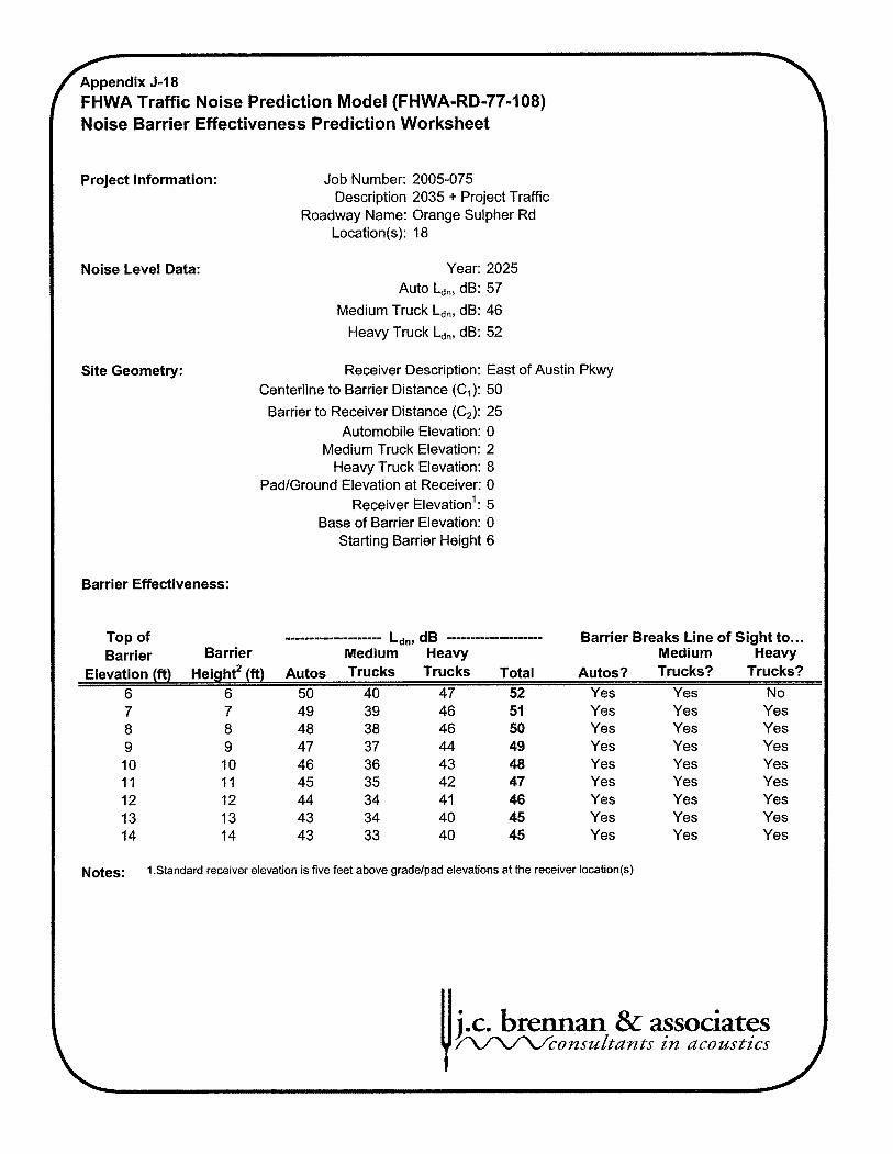
6 p e n d i x J-18 FHWA Traffic Noise Prediction Model (FHWA-RD-77-108) Noise Barrier Effectiveness Prediction Worksheet
Project Information: Job Number: 2005-075 Description 2035 + Project Traffic
Roadway Name: Orange Sulpher Rd Location(s): 18
Noise Level Data: Year: 2025 Auto Ldn, dB: 57
Medium Truck Ldn, dB: 46
Heavy Truck L,,, dB: 52
Site Geometry: Receiver Description: East of Austin Pkwy Centerline to Barrier Distance (C,): 50
Barrier to Receiver Distance (C,): 25 Automobile Elevation: 0
Medium Truck Elevation: 2 Heavy Truck Elevation: 8
PadIGround Elevation at Receiver: 0 Receiver leva ti on': 5
Base of Barrier Elevation: 0 Starting Barrier Height 6
Barrier Effectiveness:
Top of -m--m---w----------- L ~ " , d~ .................... Barrier Breaks Line of Sight to ... Barrier Barrier Medium Heavy Medium Heavy
Elevation (ft) ~ e i ~ h t ~ (ft) Autos Trucks Trucks Total Autos? Trucks? Trucks? 6 6 50 40 47 52 Yes Yes No
Yes Yes Yes Yes Yes Yes Yes Yes
Notes: 1 .Standard receiver elevation is five feet above gradelpad elevations at the receiver location(s)
Yes Yes Yes Yes Yes Yes Yes Yes
Yes Yes Yes Yes Yes Yes Yes Yes
j.c. brennan & associates /L/1/Lfconsultdnts ilz dcoustics

Appendix 5-1 9 WA Traffic Noise Prediction Model (FHWA-RD-77-108)
Noise Barrier Effectiveness Prediction Worksheet
Project Information: Job Number: 2005-075 Description 2035 + Project Traffic
Roadway Name: Proj. Entrance Location(s): 19
Noise Level Data: Year: 2025 Auto b,, dB: 60
Medium Truck L,,, dB: 49
Heavy Truck Ldn, dB: 55
Site Geometry: Receiver Description: North Of E. Mariposa Centerline to Barrier Distance (C,): 50
Barrier to Receiver Distance (C2): 25 Automobile Elevation: 0
Medium Truck Elevation: 2 Heavy Truck Elevation: 8
PadIGround Elevation at Receiver: 0 Receiver levat ti on': 5
Base of Barrier Elevation: 0 Starting Barrier Height 6
Barrier Effectiveness:
Top of .................... L ~ ~ , d~ .................... Barrier Breaks Line of Sight to ... Barrier Barrier Medium Heavy Medium Heavy
Elevation (ft) ~ e i ~ h t ~ (ft) Autos Trucks Trucks Total Autos? Trucks? Trucks? 6 6 53 43 50 55 Yes Yes No 7 7 52 42 49 54 Yes Yes Yes 8 8 5 1 4 1 49 53 Yes Yes Yes 9 9 50 40 47 52 Yes Yes Yes 10 10 49 39 46 51 Yes Yes Yes 11 11 48 38 45 50 Yes Yes Yes 12 12 47 38 44 49 Yes Yes Yes 13 13 46 37 44 49 Yes Yes Yes 14 14 46 36 43 48 Yes Yes Yes
Notes: 1.Standard receiver elevation is five feet above gradelpad elevations at the receiver location(s)
j.c. brennan & associates W c o ~ s u l t d n t s in ~~cozlstics

FHWA Traffic Noise Prediction Model (FHWA-RD-77-108) Noise Barrier Effectiveness Prediction Worksheet
Project Information: Job Number: 2005-075 Description 2035 + Project Traffic
Roadway Name: Red Admiral Ave Location(s): 20
Noise Level Data: Year: 2025 Auto b,, dB: 58
Medium Truck Ldn, dB: 48
Heavy Truck Ldn, dB: 53
Site Geometry: Receiver Description: East of Proj. Entrance Centerline to Barrier Distance (C1): 50
Barrier to Receiver Distance (C2): 25 Automobile Elevation: 0
Medium Truck Elevation: 2 Heavy Truck Elevation: 8
PadlGround Elevation at Receiver: 0 Receiver leva ti on': 5
Base of Barrier Elevation: 0 Starting Barrier Height 6
Barrier Effectiveness:
Top of --m------m--m------- L~,,, d~ ------a-m----------- Barrier Breaks Line of Sight to ... Barrier Barrier Medium Heavy Medium Heavy
Elevation (ft) ~ e i ~ h t ~ (ft) Autos Trucks Trucks Total ~ u t o s ? Trucks? Trucks? 6 6 52 42 48 54 Yes Yes No
Yes Yes Yes Yes Yes Yes Yes Yes
Notes: 1 .Standard receiver elevation is five feet above gradelpad elevations at the receiver location(s)
Yes Yes Yes Yes Yes Yes Yes Yes
Yes Yes Yes Yes Yes Yes Yes Yes
U j.c. brennan 8r associates /XAA.4consultdnts in ~~coustics

r
FHWA Traffic Noise Prediction Model (FHWA-RD-77-108) Noise Barrier Effectiveness Prediction Worksheet
Project Information: Job Number: 2005-075 Description 2035 + Project Traffic
Roadway Name: Red Admiral Ave Location(s): 21
Noise Level Data: Year: 2025 Auto b,, dB: 57
Medium Truck Ldnr dB: 47
Heavy Truck L,,, dB: 52
Site Geometry: Receiver Description: West Of Proj. Entrance Centerline to Barrier Distance (C,): 50
Barrier to Receiver Distance (C2): 25 Automobile Elevation: 0
Medium Truck Elevation: 2 Heavy Truck Elevation: 8
PadIGround Elevation at Receiver: 0 Receiver levat ti on': 5
Base of Barrier Elevation: 0 Starting Barrier Height 6
Barrier Effectiveness:
Top of .................... L~,,, d~ .................... Barrier Breaks Line of Sight to ... Barrier Barrier Medium Heavy Medium Heavy
Elevation (ft) ~ e i ~ h t ~ (ft) Autos Trucks Trucks Total Autos? Trucks? Trucks? 6 6 50 4 1 47 52 Yes Yes No
Yes Yes Yes Yes Yes Yes Yes Yes
Notes: 1 .Standard receiver elevation is five feet above gradelpad elevations at the receiver location(s)
Yes Yes Yes Yes Yes Yes Yes Yes
Yes Yes Yes Yes Yes Yes Yes Yes
j.c. brennan & associates r'l/lr\/consu/tdnts in ucoustics

fippendix 5-22 FHWA Traffic Noise Prediction Model (FHWA-RD-77-108) Noise Barrier Effectiveness Prediction Worksheet
Project Information: Job Number: 2005-075 Description 2035 + Project Traffic
Roadway Name: Red Admiral Ave Location(s): 22
Noise Level Data: Year: 2025 Auto b,, dB: 57
Medium Truck Ldn, dB: 47
Heavy Truck L,,, dB: 52
Site Geometry: Receiver Description: North of Town Center Pkwy Centerline to Barrier Distance (C,): 50
Barrier to Receiver Distance (C2): 25 Automobile Elevation: 0
Medium Truck Elevation: 2 Heavy Truck Elevation: 8
PadIGround Elevation at Receiver: 0 Receiver levat ti on': 5
Base of Barrier Elevation: 0 Starting Barrier Height 6
Barrier Effectiveness:
Top of .................... L ~ ~ , d~ .................... Barrier Breaks Line of Sight to ... Barrier Barrier Medium Heavy Medium Heavy
Elevation (ft) ~ e i ~ h t * (ft) Autos Trucks Trucks Total Autos? Trucks? Trucks?
6 6 50 4 1 47 53 Yes Yes No Yes Yes Yes Yes Yes Yes Yes Yes Yes Yes Yes Yes Yes Yes Yes Yes
Notes: I .Standard receiver elevation is five feet above gradelpad elevations at the receiver location(s)
Yes Yes Yes Yes Yes Yes Yes Yes
j.c. brennan & associates /\/lrL/conszkltdnts in dcoustics

( FHWA Traffic Noise Prediction Model (FHWA-RD-77-108) Noise Barrier Effectiveness Prediction Worksheet
Project Information: Job Number: 2005-075 Description 2035 + Project Traffic
Roadway Name: SR4 (Proposed) Location(s): 23
Noise Level Data: Year: 2025 Auto b,, dB: 67
Medium Truck L,,, dB: 55
Heavy Truck L,,, dB: 62
Site Geometry: Receiver Description: E of Austin Pkwy N Side Centerline to Barrier Distance (C,): 100
Barrier to Receiver Distance (C2): 25 Automobile Elevation: 0
Medium Truck Elevation: 2 Heavy Truck Elevation: 8
PadlGround Elevation at Receiver: 0 Receiver leva ti on': 5
Base of Barrier Elevation: 0 Starting Barrier Height 6
Barrier Effectiveness:
Top of --.----------------- L~,.,, d~ ---------------.---- Barrier Breaks Line of Sight to ... Barrier Barrier Medium Heavy Medium Heavy
Elevation (ft) ~ e i ~ h t * (ft) Autos Trucks Trucks Total Autos? Trucks? Trucks? 6 6 61 49 57 63 Yes Yes Yes
Yes Yes Yes Yes Yes Yes Yes Yes Yes Yes Yes Yes Yes Yes Yes Yes
Yes Yes Yes Yes Yes Yes Yes Yes
Notes: I .Standard receiver elevation is five feet above gradelpad elevations at the receiver location(s)
j.c. brennan & associates AfVV2consulfiants in acoustics

Appendix 5-24 F FHWA Traffic Noise Prediction Model (FHWA-RD-77-108)
Noise Barrier Effectiveness Prediction Worksheet
Project Information: Job Number: 2005-075 Description 2035 + Project Traffic
Roadway Name: SR4 (Proposed) Location(s): 24
Noise Level Data: Year: 2025 Auto Ldn, dB: 58
Medium Truck Ldn, dB: 46
Heavy Truck Ldn, dB: 53
Site Geometry: Receiver Description: E of Austin Pkwy S Side Centerline to Barrier Distance (C,): 475
Barrier to Receiver Distance (C2): 25 Automobile Elevation: 0
Medium Truck Elevation: 2 Heavy Truck Elevation: 8
Pad/Ground Elevation at Receiver: 0 Receiver leva ti on': 5
Base of Barrier Elevation: 0 Starting Barrier Height 6
Barrier Effectiveness:
Top of -*------------------ Ldn, dB .................... Barrier Breaks Line of Sight to ... Barrier Barrier Medium Heavy Medium Heavy
Elevation (ft) ~ e i ~ h t ~ (ft) Autos Trucks Trucks Total Autos? Trucks? Trucks? 6 6 53 40 47 54 Yes Yes Yes 7 7 52 40 47 54 Yes Yes Yes 8 8 52 39 46 53 Yes Yes Yes 9 9 5 1 38 45 52 Yes Yes Yes 10 10 50 37 44 51 Yes Yes Yes 11 11 49 36 43 50 Yes Yes Yes 12 12 48 35 42 49 Yes Yes Yes 13 13 47 35 42 49 Yes Yes Yes 14 14 47 34 4 1 48 Yes Yes Yes
Notes: I .Standard receiver elevation is five feet above gradelpad elevations at the receiver location(s)
j.c. bmmm & associates P/V'L4consu~$an$s in acoustics

G p e n d i x 5-25 FHWA Traffic Noise Prediction Model (FHWA-RD-77-108) Noise Barrier Effectiveness Prediction Worksheet I Project Information: Job Number: 2005-075
Description 2035 + Project Traffic Roadway Name: SR4 (Proposed)
Location(s): 25
Noise Level Data: Year: 2025 Auto b,, dB: 66
Medium Truck Ldn, dB: 53
Heavy Truck Ldn, dB: 60
Site Geometry: Receiver Description: E of Blue Copper Dr N Side Centerline to Barrier Distance (C,): 75
Barrier to Receiver Distance (C,): 25 Automobile Elevation: 0
Medium Truck Elevation: 2 Heavy Truck Elevation: 8
PadIGround Elevation at Receiver: 0 Receiver leva ti on': 5
Base of Barrier Elevation: 0 Starting Barrier Height 6
Barrier Effectiveness:
Top of .................... L~,,, d~ ------------------- Barrier Breaks Line of Sight to ... Barrier Barrier Medium Heavy Medium Heavy
Elevation (ft) ~ e i ~ h t ~ (ft) Autos Trucks Trucks Total ~ u t o s ? Trucks? Trucks? 6 6 60 48 55 61 Yes Yes Yes
Yes Yes Yes Yes Yes Yes Yes Yes
Notes: 1 .Standard receiver elevation is five feet above gradelpad elevations at the receiver location(s)
Yes Yes Yes Yes Yes Yes Yes Yes
Yes Yes Yes Yes Yes Yes Yes Yes
j.c. b & associates W c o n s u t t i x n t s in acozwtics
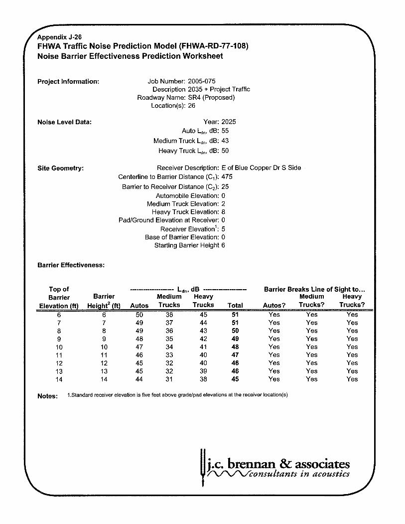
Appendix 5-26 F FHWA Traffic Noise Prediction Model (FHWA-RD-77-108) Noise Barrier Effectiveness Prediction Worksheet
Project Information: Job Number: 2005-075 Description 2035 + Project Traffic
Roadway Name: SR4 (Proposed) Location(s): 26
Noise Level Data: Year: 2025 Auto b,, dB: 55
Medium Truck Ldn, dB: 43
Heavy Truck L,,, dB: 50
Site Geometry: Receiver Description: E of Blue Copper Dr S Side Centerline to Barrier Distance (C,): 475
Barrier to Receiver Distance (C2): 25 Automobile Elevation: 0
Medium Truck Elevation: 2 Heavy Truck Elevation: 8
PadIGround Elevation at Receiver: 0 Receiver levat ti on': 5
Base of Barrier Elevation: 0 Starting Barrier Height 6
Barrier Effectiveness:
Top of .................... Ldn, dB .................... Barrier Breaks Line of Sight to ... Barrier Barrier Medium Heavy Medium Heavy
Elevation (ft) ~ e i ~ h t ' (ft) Autos Trucks Trucks Total Autos? Trucks? Trucks? 6 6 50 38 45 51 Yes Yes Yes
Yes Yes Yes Yes Yes Yes Yes Yes
Notes: 1 .Standard receiver elevation is five feet above gradelpad elevations at the receiver location(s)
Yes Yes Yes Yes Yes Yes Yes Yes
Yes Yes Yes Yes Yes Yes Yes Yes
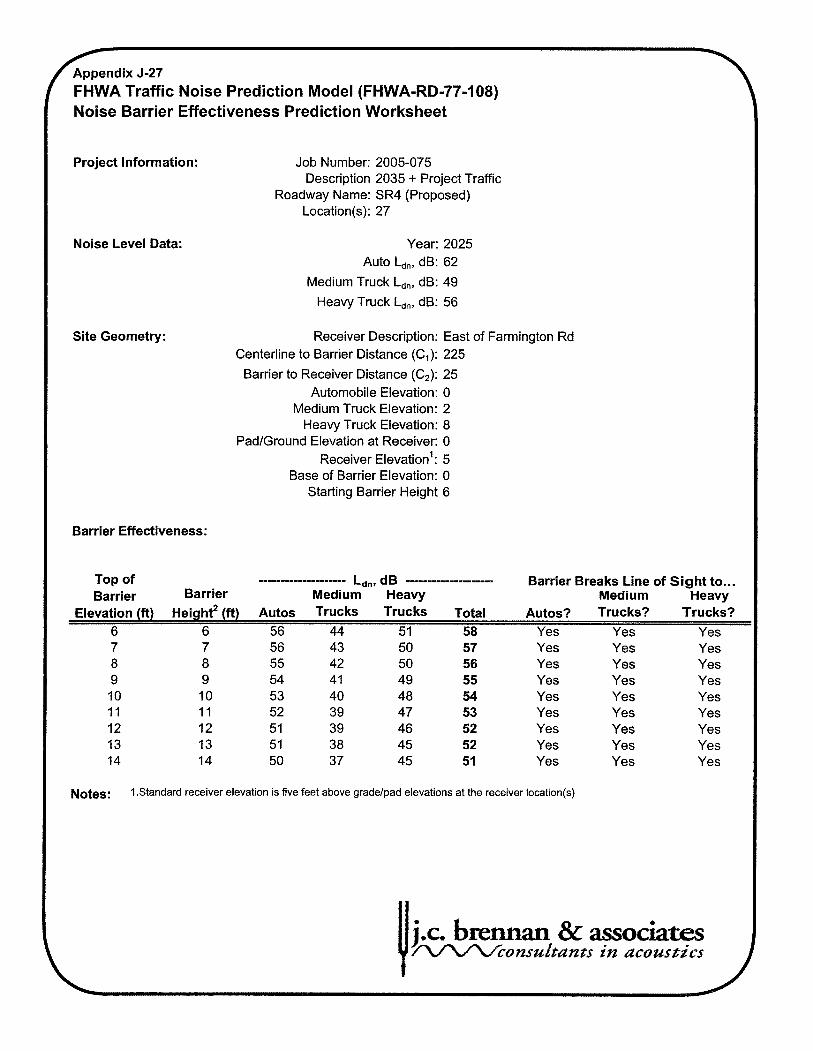
Appendix 5-27 C H W A Traffic Noise Prediction Model (FHWA-RD-77-108)
Noise Barrier Effectiveness Prediction Worksheet
Project Information: Job Number: 2005-075 Description 2035 + Project Traffic
Roadway Name: SR4 (Proposed) Location(s): 27
Noise Level Data: Year: 2025 Auto b,, dB: 62
Medium Truck Ldn, dB: 49
Heavy Truck Ldn, dB: 56
Site Geometry: Receiver Description: East of Farmington Rd Centerline to Barrier Distance (C,): 225
Barrier to Receiver Distance (C,): 25 Automobile Elevation: 0
Medium Truck Elevation: 2 Heavy Truck Elevation: 8
PadIGround Elevation at Receiver: 0 Receiver leva ti on': 5
Base of Barrier Elevation: 0 Starting Barrier Height 6
Barrier Effectiveness:
Top of .................... L‘,,.,, d~ .................... Barrier Breaks Line of Sight to ... Barrier Barrier Medium Heavy Medium Heavy
Elevation (ft) ~ e i ~ h t ~ (ft) Autos Trucks Trucks Total Autos? Trucks? Trucks? 6 6 56 44 51 58 Yes Yes Yes 7 7 56 43 50 57 Yes Yes Yes 8 8 55 42 50 56 Yes Yes Yes 9 9 54 4 1 49 55 Yes Yes Yes 10 10 53 40 48 54 Yes Yes Yes 11 11 52 39 47 53 Yes Yes Yes 12 12 51 39 46 52 Yes Yes Yes 13 13 5 1 38 45 52 Yes Yes Yes 14 14 50 37 45 51 Yes Yes Yes
Notes: 1 .Standard receiver elevation is five feet above gradelpad elevations at the receiver location(s)
j.c. braman & ass Wco n s u 6 t a n ; l . s in acoustics

Appendix 5-28 F FHWA Traffic Noise Prediction Model (FHWA-RD-77-108) Noise Barrier Effectiveness Prediction Worksheet
Project Information: Job Number: 2005-075 Description 2035 + Project Traffic
Roadway Name: Swallow Tail Pkwy Location(s): 28
Noise Level Data: Year: 2025 Auto bn, dB: 58
Medium Truck Ldn, dB: 47
Heavy Truck Ldn, dB: 53
Site Geometry: Receiver Description: NE of Town Center Pkwy Centerline to Barrier Distance (C,): 50
Barrier to Receiver Distance (C2): 25 Automobile Elevation: 0
Medium Truck Elevation: 2 Heavy Truck Elevation: 8
PadIGround Elevation at Receiver: 0 Receiver leva ti on': 5
Base of Barrier Elevation: 0 Starting Barrier Height 6
Barrier Effectiveness:
Top of --*----------------- Ldn, dB .................... Barrier Breaks Line of Sight to ... Barrier Barrier Medium Heavy Medium Heavy
Elevation (ft) ~ e i ~ h t * (ft) Autos Trucks Trucks Total Autos? Trucks? Trucks? 6 6 5 1 4 1 48 53 Yes Yes No
Yes Yes Yes Yes Yes Yes Yes Yes Yes Yes Yes Yes Yes Yes Yes Yes
Notes: 1 .Standard receiver elevation is five feet above gradelpad elevations at the receiver location(s)
Yes Yes Yes Yes Yes Yes Yes Yes

' FHWA Traffic Noise Prediction Model (FHWA-RD-77-108) Noise Barrier Effectiveness Prediction Worksheet
Project Information: Job Number: 2005-075 Description 2035 + Project Traffic
Roadway Name: Swallow Tail Pkwy Location(s): 29
Noise Level Data: Year: 2025 Auto Ld,, dB: 62
Medium Truck L,,, dB: 51
Heavy Truck L,,, dB: 57
Site Geometry: Receiver Description: NE of Austin Pkwy Centerline to Barrier Distance (C,): 50
Barrier to Receiver Distance (C,): 25 Automobile Elevation: 0
Medium Truck Elevation: 2 Heavy Truck Elevation: 8
PadIGround Elevation at Receiver: 0 Receiver leva ti on': 5
Base of Barrier Elevation: 0 Starting Barrier Height 6
Barrier Effectiveness:
Top of ----m-m---m--------- L ~ ~ , d~ .------------------- Barrier Breaks Line of Sight to ... Barrier Barrier Medium Heavy Medium Heavy
Elevation (ft) ~ e i ~ h t ~ (ft) Autos Trucks Trucks Total Autos? Trucks? Trucks? 6 6 55 45 52 57 Yes Yes No
Yes Yes Yes Yes Yes Yes Yes Yes
Notes: I .Standard receiver elevation is five feet above gradelpad elevations at the receiver location(s)
Yes Yes Yes Yes Yes Yes Yes Yes
Yes Yes Yes Yes Yes Yes Yes Yes
j.c. b~~3mxa.n & associa te W c u n s u k n a in acoustics
A

r FHWA Traffic Noise Prediction Model (FHWA-RD-77-108) Noise Barrier Effectiveness Prediction Worksheet
Project Information: Job Number: 2005-075 Description 2035 + Project Traffic
Roadway Name: Swallow Tail Pkwy Location(s): 30
Noise Level Data: Year: 2025 Auto Ldn, dB: 61
Medium Truck Ldn, dB: 51
Heavy Truck Ldn, dB: 56
Site Geometry: Receiver Description: NE of Tortise Shell In Centerline to Barrier Distance (C1): 25
Barrier to Receiver Distance (C2): 25 Automobile Elevation: 0
Medium Truck Elevation: 2 Heavy Truck Elevation: 8
PadIGround Elevation at Receiver: 0 Receiver levat ti on': 5
Base of Barrier Elevation: 0 Starting Barrier Height 6
Barrier Effectiveness:
Top of ----m--mm----------- Ldn, dB .................... Barrier Breaks Line of Sight to ... Barrier Barrier Medium Heavy Medium Heavy
Elevation (ft) ~ e i ~ h t ~ (ft) Autos Trucks Trucks Total Autos? Trucks? Trucks? 6 6 53 44 52 56 Yes Yes No
Yes Yes Yes Yes Yes Yes Yes Yes
Yes Yes Yes Yes Yes Yes Yes Yes
Yes Yes Yes Yes Yes Yes Yes Yes
Notes; I .Standard receiver elevation is five feet above gradelpad elevations at the receiver location(s)

G p e n d i x J-31 FHWA Traffic Noise Prediction Model (FHWA-RD-77-108) Noise Barrier Effectiveness Prediction Worksheet
Project Information: Job Number: 2005-075 Description 2035 + Project Traffic
Roadway Name: Toroise Shell Ln Location(s): 31
Noise Level Data: Year: 2025 Auto b,, dB: 57
Medium Truck L,,, dB: 47
Heavy Truck Ldn, dB: 52
Site Geometry: Receiver Description: West of Red Admiral Ave Centerline to Barrier Distance (el): 50
Barrier to Receiver Distance (C2): 25 Automobile Elevation: 0
Medium Truck Elevation: 2 Heavy Truck Elevation: 8
PadlGround Elevation at Receiver: 0 Receiver leva ti on': 5
Base of Barrier Elevation: 0 Starting Barrier Height 6
Barrier Effectiveness:
Top of .................... L ~ ~ , d~ .................... Barrier Breaks Line of Sight to ... Barrier Barrier Medium Heavy Medium Heavy
Elevation (ft) ~ e i ~ h t * (ft) Autos Trucks Trucks Total Autos? Trucks? Trucks? 6 6 50 4 1 47 52 Yes Yes No
Yes Yes Yes Yes Yes Yes Yes Yes
Notes: 1 .Standard receiver elevation is five feet above gradelpad elevations at the receiver location(s)
Yes Yes Yes Yes Yes Yes Yes Yes
Yes Yes Yes Yes Yes Yes Yes Yes

Appendix 5-32 C W A Traffic Noise Prediction Model (FHWA-RD-77-108)
Noise Barrier Effectiveness Prediction Worksheet
Project Information: Job Number: 2005-075 Description 2035 + Project Traffic
Roadway Name: Town Center Pkwy Location(s): 32
Noise Level Data: Year: 2025 Auto Ldn, dB: 63
Medium Truck Ldn, dB: 52
Heavy Truck L,,, dB: 56
Site Geometry: Receiver Description: East of Austin Pkwy Centerline to Barrier Distance (C,): 50
Barrier to Receiver Distance (C,): 25 Automobile Elevation: 0
Medium Truck Elevation: 2 Heavy Truck Elevation: 8
PadIGround Elevation at Receiver: 0 Receiver leva ti on': 5
Base of Barrier Elevation: 0 Starting Barrier Height 6
Barrier Effectiveness:
Top of .................... L ~ ~ , d~ .................... Barrier Breaks Line of Sight to ... Barrier Barrier Medium Heavy Medium Heavy
Elevation (ft) ~ e i ~ h t ~ (ft) Autos Trucks Trucks Total Autos? Trucks? Trucks? 6 6 56 46 51 58 Yes Yes No
Yes Yes Yes Yes Yes Yes Yes Yes
Notes: I .Standard receiver elevation is five feet above gradelpad elevations at the receiver location(s)
Yes Yes Yes Yes Yes Yes Yes Yes
Yes Yes Yes Yes Yes Yes Yes Yes

Appendix 5-33 /- FHWA Traffic Noise Prediction Model (FHWA-RD-77-108) Noise Barrier Effectiveness Prediction Worksheet
Project Information: Job Number: 2005-075 Description 2035 + Project Traffic
Roadway Name: Town Center Pkwy Location(s): 33
Noise Level Data: Year: 2025 Auto I-,,,, dB: 65
Medium Truck Ldn, dB: 53
Heavy Truck id,, dB: 57
Site Geometry: Receiver Description: West of Austin Pkwy Centerline to Barrier Distance (C,): 55
Barrier to Receiver Distance (C,): 25 Automobile Elevation: 0
Medium Truck Elevation: 2 Heavy Truck Elevation: 8
PadIGround Elevation at Receiver: 0 Receiver leva ti on': 5
Base of Barrier Elevation: 0 Starting Barrier Height 6
Barrier Effectiveness:
Top of .................... L,,, d~ .................... Barrier Breaks Line of Sight to ... Barrier Barrier Medium Heavy Medium Heavy
Elevation (ft) ~ e i ~ h t ~ (ft) Autos Trucks Trucks Total Autos? Trucks? Trucks? 6 6 58 47 52 59 Yes Yes Yes
Yes Yes Yes Yes Yes Yes Yes Yes
Notes: 1 .Standard receiver elevation is five feet above gradelpad elevations at the receiver location(s)
Yes Yes Yes Yes Yes Yes Yes Yes
Yes Yes Yes Yes Yes Yes Yes Yes
j.c. b m m & associates W c c o n s u l $ d n t s in dcozlsgics

FHWATraffic Noise Prediction Model (FHWA-RD-77-108) \
Noise Barrier Effectiveness Prediction Worksheet
Project Information: Job Number: 2005-075 Description 2035 + Project Traffic
Roadway Name: Town Center Pkwy Location(s): 34
Noise Level Data: Year: 2025 Auto Ldn, dB: 62
Medium Truck Ldn, dB: 50
Heavy Truck Ldn, dB: 55
Site Geometry: Receiver Description: NW of Swallow Tail Pkwy Centerline to Barrier Distance (C,): 65
Barrier to Receiver Distance (C,): 25 Automobile Elevation: 0
Medium Truck Elevation: 2 Heavy Truck Elevation: 8
PadIGround Elevation at Receiver: 0 Receiver leva ti on': 5
Base of Barrier Elevation: 0 Starting Barrier Height 6
Barrier Effectiveness:
Top of .................... Ldn, dB .................... Barrier Breaks Line of Sight to ... Barrier Barrier Medium Heavy Medium Heavy
Elevation (ft) ~ e i ~ h t ' (ft) Autos Trucks Trucks Total Autos? Trucks? Trucks? 6 6 55 44 50 57 Yes Yes Yes
Yes Yes Yes Yes Yes Yes Yes Yes
Yes Yes Yes Yes Yes Yes Yes Yes
Yes Yes Yes Yes Yes Yes Yes Yes
Notes; 1 .Standard receiver elevation is five feet above gradelpad elevations at the receiver location(s)
j.c. b~~ & associates W c o n s u L g d r z t s in acomtt'cs
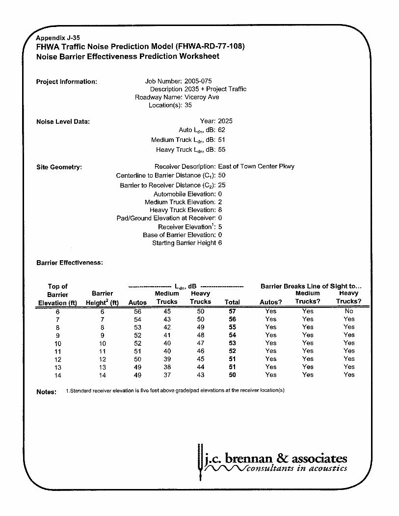
FHWA Traffic Noise Prediction Model (FHWA-RD-77-108) Noise Barrier Effectiveness Prediction Worksheet
Project Information: Job Number: 2005-075 Description 2035 + Project Traffic
Roadway Name: Viceroy Ave Location(s): 35
Noise Level Data: Year: 2025 Auto Ld,, dB: 62
Medium Truck L,,, dB: 51
Heavy Truck L,,, dB: 55
Site Geometry: Receiver Description: East of Town Center Pkwy Centerline to Barrier Distance (el): 50
Barrier to Receiver Distance (C2): 25 Automobile Elevation: 0
Medium Truck Elevation: 2 Heavy Truck Elevation: 8
PadIGround Elevation at Receiver: 0 Receiver leva ti on': 5
Base of Barrier Elevation: 0 Starting Barrier Height 6
Barrier Effectiveness:
Top of -------------------m Ldn, dB .................... Barrier Breaks Line of Sight to ... Barrier Barrier Medium Heavy Medium Heavy
Elevation (ft) ~ e i ~ h t ~ (ft) Autos Trucks Trucks Total Autos? Trucks? Trucks? 6 6 56 45 50 57 Yes Yes No
Yes Yes Yes Yes Yes Yes Yes Yes Yes Yes Yes Yes Yes Yes Yes Yes
Notes: 1 .Standard receiver elevation is five feet above gradelpad elevations at the receiver location(s)
Yes Yes Yes Yes Yes Yes Yes Yes
j.c. breman & ass W c o n s z l s d 8 d n t - s in acowties

~ W A Traffic Noise Prediction Model (FHWA-RD-77-108) Noise Barrier Effectiveness Prediction Worksheet
Project Information: Job Number: 2005-075 Description 2035 + Project Traffic
Roadway Name: Viceroy Ave Location(s): 36
Noise Level Data: Year: 2025 Auto Ldn, dB: 61
Medium Truck Ldn, dB: 49
Heavy Truck Ldn, dB: 53
Site Geometry: Receiver Description: East of Tortoise Shell Pkwy North Sid~ Centerline to Barrier Distance (C,): 45
Barrier to Receiver Distance (C2): 25 Automobile Elevation: 0
Medium Truck Elevation: 2 Heavy Truck Elevation: 8
PadIGround Elevation at Receiver: 0 Receiver leva ti on': 5
Base of Barrier Elevation: 0 Starting Barrier Height 6
Barrier Effectiveness: I Top of .................... L ~ ~ , d~ .................... Barrier Breaks Line of Sight to ... Barrier Barrier Medium Heavy Medium Heavy
Elevation (ft) eight' (ft) Autos Trucks Trucks Total ~ u t o s ? Trucks? Trucks? 6 6 54 43 48 55 Yes Yes No
Yes Yes Yes Yes Yes Yes Yes Yes
Notes: 1 .Standard receiver elevation is five feet above gradelpad elevations at the receiver location(s)
Yes Yes Yes Yes Yes Yes Yes Yes
Yes Yes Yes Yes Yes Yes Yes Yes
j.c. bmnmn & associates W c o n s u d g d n t s in acozlstics

' FHWA Traffic Noise Prediction Model (FHWA-RD-77-108) Noise Barrier Effectiveness Prediction Worksheet
Project Information: Job Number: 2005-075 Description 2035 + Project Traffic
Roadway Name: Viceroy Ave Location(s): 37
Noise Level Data: Year: 2025 Auto b,, dB: 51
Medium Truck L,,, dB: 39
Heavy Truck L,,, dB: 44
Site Geometry: Receiver Description: East of Tortoise Shell Pkwy South Sid Centerline to Barrier Distance (C,): 275
Barrier to Receiver Distance (C,): 25 Automobile Elevation: 0
Medium Truck Elevation: 2 Heavy Truck Elevation: 8
PadIGround Elevation at Receiver: 0 Receiver leva ti on': 5
Base of Barrier Elevation: 0 Starting Barrier Height 6
Barrier Effectiveness:
Top of .................... L~,,, d~ .................... Barrier Breaks Line of Sight to ... Barrier Barrier Medium Heavy Medium Heavy
Elevation (ft) ~ e i ~ h t * (ft) Autos Trucks Trucks Total Autos? Trucks? Trucks? 6 6 46 34 39 47 Yes Yes Yes 7 7 45 33 38 46 Yes Yes Yes 8 8 44 33 37 45 Yes Yes Yes 9 9 43 32 36 44 Yes Yes Yes 10 10 42 3 1 36 43 Yes Yes Yes 11 11 4 1 30 35 42 Yes Yes Yes 12 12 4 1 29 34 42 Yes Yes Yes 13 13 40 28 33 41 Yes Yes Yes 14 14 39 28 33 40 Yes Yes Yes
Notes: 1 .Standard receiver elevation is five feet above gradelpad elevations at the receiver location(s)