environmental management plan · 2019-07-25 · environmental management plan nt-2050-15-mp-0017 3...
TRANSCRIPT


Environmental Management Plan NT-2050-15-MP-0017
1
Table of contents
Executive Summary 5
1. Introduction 1
1.1 Background 1 1.2 Project Proponent 1 1.3 Project Boundary 1 1.4 Purpose 2 1.5 Structure of EMP 2
2. Project Description 3
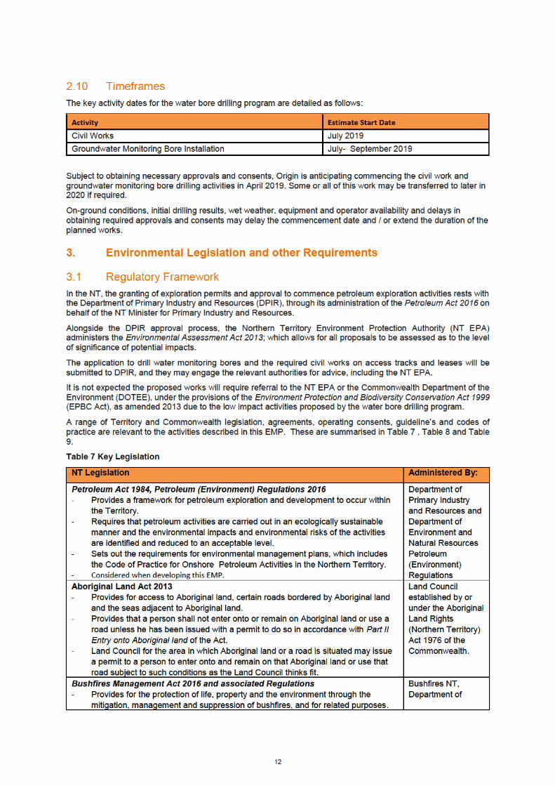
2.1 Location and Proposed Operations 3 2.2 Civil Activities 5 2.3 Groundwater Monitoring Bore Drilling Activities 6 2.4 Groundwater Monitoring Bore Sampling Activities 8 2.5 Camps 9 2.6 Waste Management 9 2.7 Water Supply and Use 10 2.8 Weed Management 10 2.9 Proposed contractors and equipment list 11 2.10 Timeframes 12
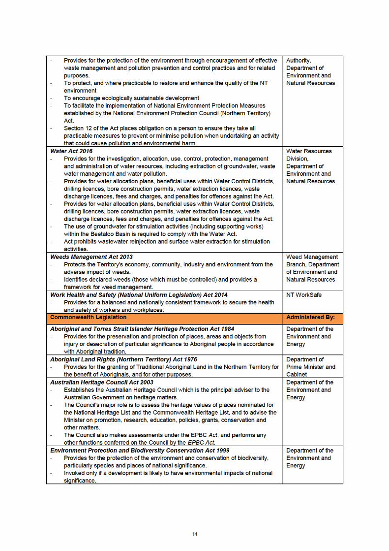
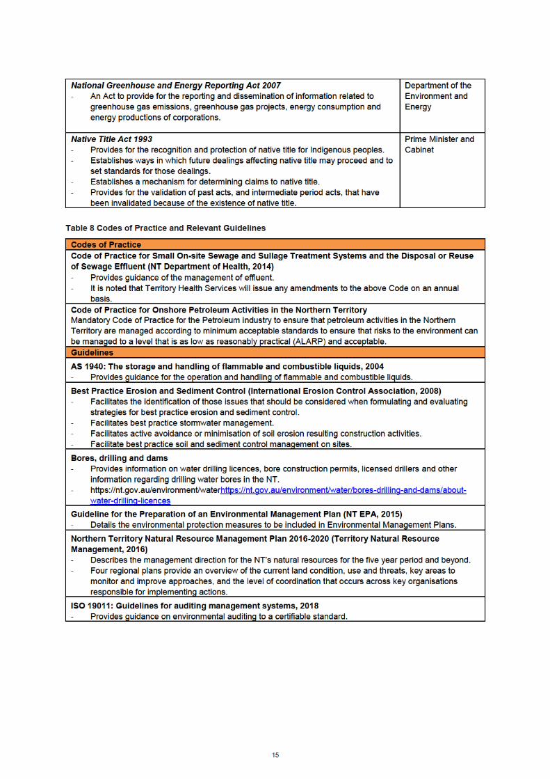
3. Environmental Legislation and other Requirements 12
3.1 Regulatory Framework 12 3.2 Referral Assessment 16
3.2.1 NT Environmental Assessment Act 17 3.2.2 Commonwealth Environmental Protection and Biodiversity Conservation Act 17
3.3 Alignment with the Principles of Ecological Sustainable Development (ESD) 19
4. Environment Description 19
4.1 Physical Environment 19 4.1.1 Climate 19 4.1.2 Geology 19 4.1.3 Soils 20 4.1.4 Hydrology 21 4.1.5 Hydrogeology 21
4.2 Biological Environment 23 4.2.1 Bioregions 23 4.2.2 Vegetation Communities 23 4.2.3 Flora 24 4.2.4 Weeds 24 4.2.5 Fauna 25 4.2.6 Significant Fauna 26 4.2.7 Feral and Pest Animals 26
4.3 Fire Regime 27 4.4 Environmental and Cultural Sensitivities 27
4.4.1 Native Title 27 4.4.2 Archaeology Assessment 27 4.4.3 Areas of Cultural Significance 28 4.4.4 Natural Resources 28 4.4.5 Non-Indigenous Heritage 28 4.4.6 Historic Heritage Assessment 29 4.4.7 Protected or Conservation Areas 29

Environmental Management Plan NT-2050-15-MP-0017
2
4.5 Social Environment 30 4.5.1 Social Context 30 4.5.2 Pastoral Activity 30 4.5.3 Other Land Uses in the Area 30
5. Stakeholder / Community Consultation 31
5.1 Pastoralist Stakeholder Engagement 32 5.2 Traditional Owner Engagement 33 5.3 Northern Territory Community Engagement 33 5.4 Ongoing Stakeholder and Community Engagement 34
6. Environmental Risks and Impacts, Description and Assessment 34
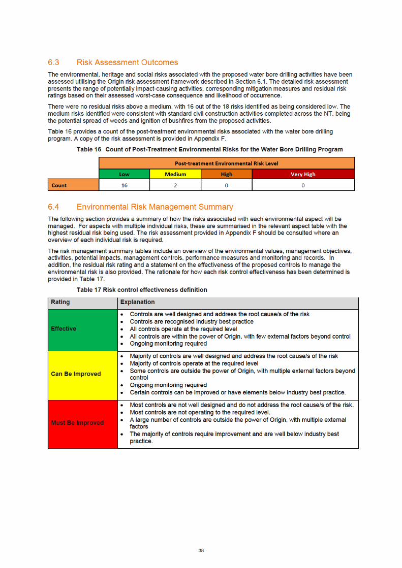
6.1 Origin’s Risk Management Approach 34 6.2 Risk Acceptance threshold- ALARP 35 6.3 Risk Assessment Outcomes 38 6.4 Environmental Risk Management Summary 38
6.4.1 Soils and erosion 39 6.4.2 Surface Water and Groundwater 40 6.4.3 Vegetation, Flora, Fauna and Habitat 41 6.4.4 Weeds 41 6.4.5 Waste Management 43 6.4.6 Air Quality – Dust and Emissions 44 6.4.7 Lighting, noise, vibration and visual amenity 44 6.4.8 Bushfires 44 6.4.9 Cultural Heritage and Sacred Sites 45 6.4.10 Community 46
7. Implementation Strategy 46
7.1 Corporate Environmental Policy 46 7.2 Environment, Health, and Safety Management Systems 47 7.3 Roles and Responsibility 48 7.4 Training and Awareness 49 7.5 Environmental Commitment Summary 50 7.6 Incident Reporting 50
7.6.1 Recordable incidents 50 7.6.2 Reportable Environmental Incident Reporting 50
7.7 Monitoring, assurance and Non-conformance management 51 7.8 Emergency Response Plan 51 7.9 Reporting 51 7.10 Record Keeping 52 7.11 Rehabilitation 52 7.12 EMP Review 53
8. References 54
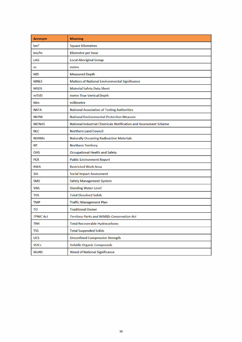
9. Acronyms & Abbreviations 58
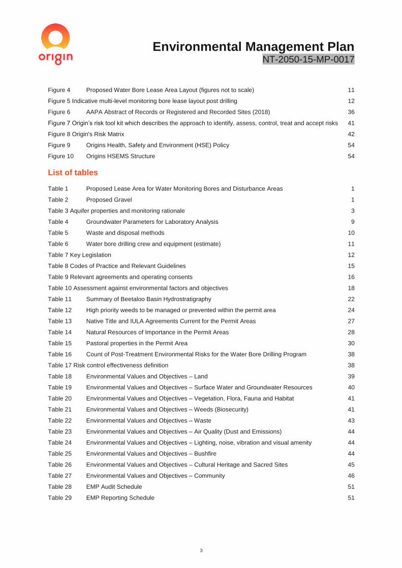
Table of figures
Figure 1 Location of Origin Permit Area 2
Figure 2 Geological schematic for the proposed multi-level groundwater monitoring bores 8
Figure 3 Photographs of the existing ~100km of access track connecting the Sturt Highway with Velkerri 76 S2 10
Environmental Management Plan NT-2050-15-MP-0017
3
Figure 4 Proposed Water Bore Lease Area Layout (figures not to scale) 11
Figure 5 Indicative multi-level monitoring bore lease layout post drilling 12
Figure 6 AAPA Abstract of Records or Registered and Recorded Sites (2018) 36
Figure 7 Origin’s risk tool kit which describes the approach to identify, assess, control, treat and accept risks 41
Figure 8 Origin's Risk Matrix 42
Figure 9 Origins Health, Safety and Environment (HSE) Policy 54
Figure 10 Origins HSEMS Structure 54
List of tables
Table 1 Proposed Lease Area for Water Monitoring Bores and Disturbance Areas 1
Table 2 Proposed Gravel 1
Table 3 Aquifer properties and monitoring rationale 3
Table 4 Groundwater Parameters for Laboratory Analysis 9
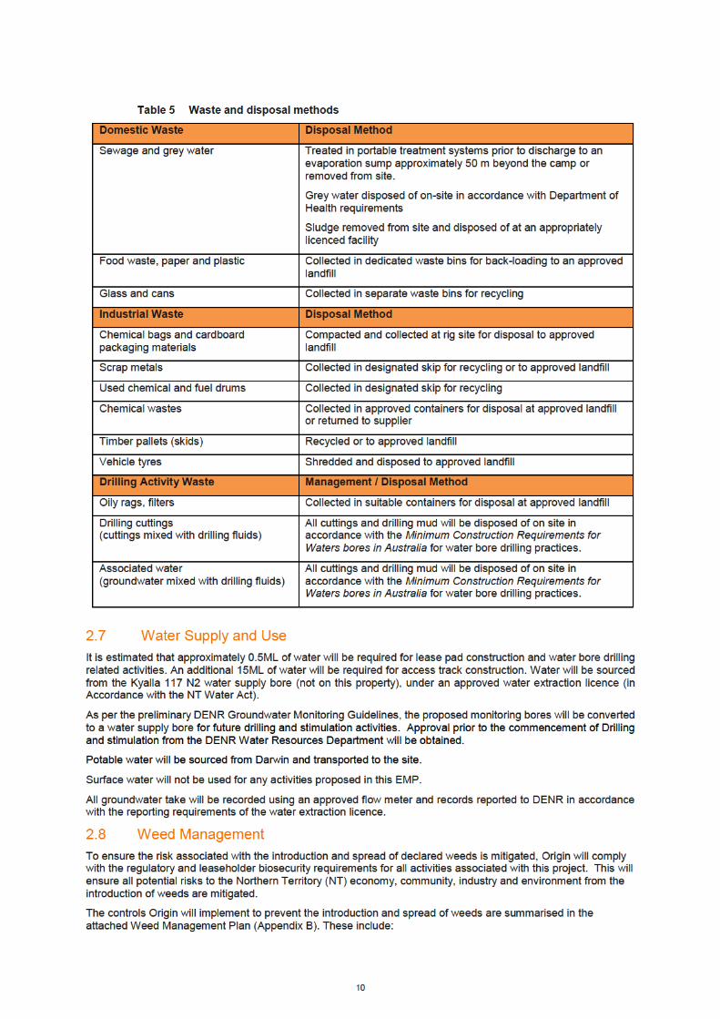
Table 5 Waste and disposal methods 10
Table 6 Water bore drilling crew and equipment (estimate) 11
Table 7 Key Legislation 12
Table 8 Codes of Practice and Relevant Guidelines 15
Table 9 Relevant agreements and operating consents 16
Table 10 Assessment against environmental factors and objectives 18
Table 11 Summary of Beetaloo Basin Hydrostratigraphy 22
Table 12 High priority weeds to be managed or prevented within the permit area 24
Table 13 Native Title and IULA Agreements Current for the Permit Areas 27
Table 14 Natural Resources of Importance in the Permit Areas 28
Table 15 Pastoral properties in the Permit Area 30
Table 16 Count of Post-Treatment Environmental Risks for the Water Bore Drilling Program 38
Table 17 Risk control effectiveness definition 38
Table 18 Environmental Values and Objectives – Land 39
Table 19 Environmental Values and Objectives – Surface Water and Groundwater Resources 40
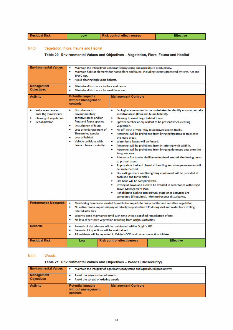
Table 20 Environmental Values and Objectives – Vegetation, Flora, Fauna and Habitat 41
Table 21 Environmental Values and Objectives – Weeds (Biosecurity) 41
Table 22 Environmental Values and Objectives – Waste 43
Table 23 Environmental Values and Objectives – Air Quality (Dust and Emissions) 44
Table 24 Environmental Values and Objectives – Lighting, noise, vibration and visual amenity 44
Table 25 Environmental Values and Objectives – Bushfire 44
Table 26 Environmental Values and Objectives – Cultural Heritage and Sacred Sites 45
Table 27 Environmental Values and Objectives – Community 46
Table 28 EMP Audit Schedule 51
Table 29 EMP Reporting Schedule 51
Environmental Management Plan NT-2050-15-MP-0017
4
List of appendices
Appendix A Typical Cross Sections For Urban and Rural Environments (NTG, Sept 2017) 60
Appendix B Weed Management Plan 62
Appendix C Land Condition Assessment 63
Appendix D Heritage Report 64
Appendix E AAPA Certificates 65
Appendix F Water Bore Drilling Program Risk Assessment and Level of Effectiveness 66
Appendix G Environmental Commitment Register 82
Appendix H Trafficwerx NT Traffic Management Plan 85
Appendix I Erosion & Sediment Control Plan 86
Appendix J Origin Beetaloo Basin Project Poster series 87
Appendix K Table of compliance with Section 7(2)(a) 88
Appendix L Amungee Mungee Stakeholder Consultation Documentation set 100

Environmental Management Plan NT-2050-15-MP-0017
5
Executive Summary
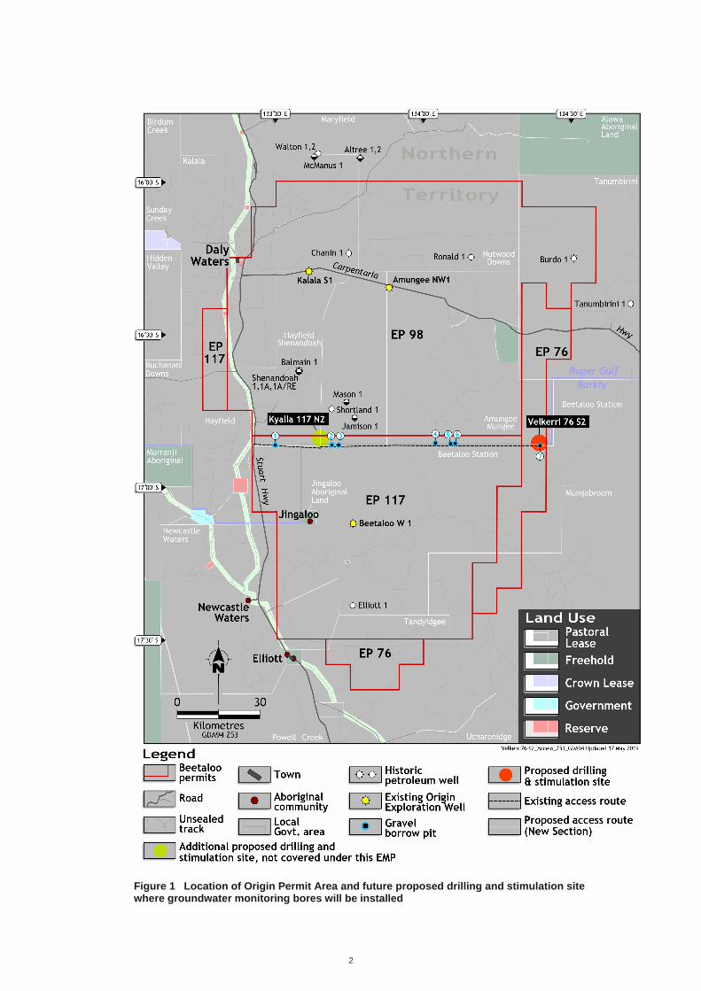
The Beetaloo Basin Groundwater Monitoring Bore Installation Environmental Management Plan (EMP) forms the basis of Origin Energy’s (Origin) application to the Northern Territory (NT) Department of Primary Industry and Resources (DPIR) for the installation of environmental monitoring bores located adjacent to the proposed future exploration sites to collect baseline groundwater level and quality data prior to further exploration.
The proposed network of groundwater monitoring bores will be used to obtain baseline groundwater quality and quantity data adjacent to the proposed future drilling and stimulation lease sites to meet Recommendation 7.11 of the Inquiry and relevant guidelines published by NT Department of Environment and Natural Resources (DENR) on Groundwater Monitoring Bores required for petroleum exploration activities.
This EMP has been prepared with reference to the NT Petroleum (Environment) Regulations 2016 and the
Exploration Agreement between Origin, local Aboriginal groups and the Northern Land Council (NLC). The
overall objective of the EMP is to ensure minimal environmental impact and minimise risk of any inadvertent
adverse outcomes from Origin’s activities. It is noted that this EMP does not seek approval for future exploration
activities or potential hydraulic fracture stimulation activities. Should Origin seek to undertake further exploration,
the company will prepare a separate submission and obtain approvals before conducting such activities.
The EMP covers a series of low impact activities proposed to expand Origin’s existing, four-year, baseline groundwater monitoring program in preparation for its’ 2019 exploration program. The groundwater monitoring program will involve the installation of monitoring bores sufficient to meet guidelines currently in development at the proposed Velkerri 76 S2 lease site within the Origin Beetaloo Exploration Area (refer Figure 1).
The activities subject to this EMP are:
- two 50 x 50 m groundwater monitoring bore lease sites, including provision for fire breaks totalling 0.5 hectares in disturbance.
- Establishment of up to four 100mx100m gravel pits to provide material for improving stability of the access
tracks
- The installation of approximately 2km of access tracks (approximately 8 m wide) to connect the groundwater monitoring leases to the existing access track.
- Installation of approximately 3km of access track (approximately 8m wide) in total, to connect Gravel pit 4,5 and 6 to the existing access track.
- Grading and forming of 80km of existing tracks which involves the clearing of an average of 1m of vegetation
along the length of the track,
- Installation of fencelines, gates, grids and firebreaks to access the groundwater monitoring bore lease sites.
- Groundwater monitoring bore drilling, completing and equipping of up to four groundwater water monitoring
bores.
For the preparation of this EMP, a land condition assessment was completed in August 2018 to review the
physical, natural and cultural heritage environment of the proposed lease areas for groundwater bore drilling and
the associated access tracks.
The proposed groundwater monitoring bore sites is located within Eucalyptus low woodland with a tussock grass understorey. The proposed site had high native grass cover and included numerous species suitable for granivorous birds (seed eaters). Dense leaf litter and numerous logs provide suitable refuge and foraging sites for fauna such as reptiles. Although most of the species found in this vegetation type are widespread in the tropical savannas of the Northern Territory, some such as the threatened Crested Shrike-tit (Falcunculus frontatus whitei) are rare and known to utilise this habitat (DoTEE, 2014, Ward, 2008). Many of the sites surrounding areas have a high density of hollow-bearing trees that provide important habitat for many fauna species. Avoiding clearing large hollow-bearing trees will reduce the impact to native wildlife within the permit area.
There was no evidence of weeds observed during the survey. This suggests the primary controls for this program will therefore be focused on preventing the introduction of weeds and managing weeds promoted through site disturbance.
The archaeology assessment did not identify culturally sensitive landforms or artefacts within the proposed disturbance area. In addition, a sacred site clearance survey coordinated and carried out by the Northern Land

Environmental Management Plan NT-2050-15-MP-0017
6
Council (NLC) in August and September 2018, was led by their anthropologist and included site visits and consultations with the Native Title holders / custodian. The Sacred Site Avoidance Survey Report / Anthropological Report has been provided to the Aboriginal Areas Protection Authority (AAPA) and informed the issuing of AAPA Certificate C2019/039.
The AAPA clearance certificates identified one restricted work areas (RWA’s) within the vicinity of Origin’s proposed activity. This RWA falls within the existing access track to the Velekrri 76 S2 lease site and outside of Origins proposed activities will not impact on any of the features of the protected area..
The environmental, heritage and social risks associated with the proposed groundwater monitoring bore drilling activities have been assessed utilising the Origin risk assessment framework. The detailed risk assessment presents the range of potentially impact-causing activities, corresponding mitigation measures and residual risk ratings based on their assessed worst-case consequence and likelihood of occurrence.
Key environmental impacts and risks identified for the program include:
- impacts on flora, fauna and habitat from clearing native vegetation
- risks to land and habitat from bushfire resulting from the activity
- risk to the land and surface water from erosion, in particular where access tracks cross small drainage channels
- risk to cultural heritage sites.
It was considered that with the appropriate controls implemented to mitigate the impacts, there were no residual risks above a medium, with 16 out of the 18 risks identified as being considered low. The medium risks identified were consistent with standard civil construction activities completed across the NT, being the potential spread of weeds and the ignition of bushfires from the proposed activities.
At completion of activities and once a determination has been made in relation to decommissioning, a site-specific
rehabilitation plan will be developed for each site. Where the site is not able to be handed over to the pastoralists
for beneficial use, the site will be rehabilitated back to a safe, stable landform consistent with surrounding land
use.
Due to the nature of the activity, community engagement for the 2018 groundwater monitoring bore installation
project has been with host Traditional Owners via the northern Land Council (NLC) and host Pastoralists directly
affected by the proposed activity. Detailed community and stakeholder engagement is underway covering future
exploration activities which are beyond the scope of this EMP.
Origin recognises the growing community interest in ensuring onshore natural gas development takes place in a safe and environmentally sound way. Origin are committed to delivering operational excellence (which encapsulates our health, safety and environmental performance). Further information on stakeholder engagement is provided in section 5.
It should be noted that the water bore monitoring installation network is a recommendation of the NT Inquiry and as such the broader NT community is expecting the work program to be executed swiftly.
2
Figure 1 Location of Origin Permit Area and future proposed drilling and stimulation site where groundwater monitoring bores will be installed

1
Figure 2 Site location map


5
2.2 Civil Activities
The civil activities subject to this EMP are:
- two 50 x 50 m groundwater monitoring bore lease sites, including provision for fire breaks totalling 0.5 hectares in disturbance.
- Establishment of up to three100mx100m gravel pits to provide material for improving stability of the access
tracks
- The installation of approximately 2km of access tracks (approximately 8 m wide) to connect the groundwater monitoring leases to the existing access track.
- Installation of approximately 1.4km of access track (approximately 8m wide) to connect Gravel pit 4, 700m of access track to connect Gravel pit 5 and 900m of access track to the existing access track.
- Grading and forming of 80km of existing tracks which involves the clearing of an average of 1m of vegetation
along the length of the track,
- Installation of fencelines, gates, grids and firebreaks to access the groundwater monitoring bore lease sites.
Land clearance will be minimised to avoid disturbance of soils, vegetation and wildlife habitats and avoid
interference or blockage of natural drainage patterns. Erosion control measures such as check banks will be used
to minimise the effect of overland flow. The material for erosion control measures would be sourced locally from the
proposed gravel pits identified. Long-term visual impact will be minimised by avoiding steep cuts and fills which
may cause erosion and slump problems.
The proposed monitoring bore lease pad and associated access road (requiring clearing and construction) are
located outside the major flow paths of the small intermediate streams and creeks. Of the existing farm access
tracks/ firebreaks, three intermediate tributaries of the Newcastle Creek cross the proposed access track to Velkerri
76 S2-1. Where a crossing on the existing access tracks is required to be upgraded to allow rig access, a bed level
crossing will be installed in accordance with the following:
- crossings will be aligned perpendicular to the water flow.
- crossing is to be constructed from clean rocks (minimal fine material) that are an equivalent or larger size
than the natural bed material at the site.
- The surface is to be left rough and not to be over compacted (e.g. track-rolled finish or rougher).
- The lowest point of the bed level crossing must be installed at the level of the lowest point of the natural
stream bed (preconstruction), within the footprint of the proposed crossing.
- There must be a height difference of at least 100 mm from the lowest point of the crossing to the edges of
the low flow section of the crossing
- Where scour protection is required:
• Scour protection must abut the surface edge of the crossing at the same level.
• If the crossing is set below bed level then the surface of the scour protection must also be below
bed level.
• The stream bed must abut the scour protection at the same level.
• The scour protection is installed at a gradient no steeper than 1 in 20 or the natural channel gradient,
whichever is steeper.
• Scour protection must incorporate a low flow channel. Clean rock to be used (with minimal fine
material), at least 100 mm diameter.
• Ensure the rock armouring is not over compacted but left proud and uneven (track-rolled finish or
rougher).
• Use clean rocks (minimal fine material), at least 100 mm diameter.
• Ensure the rock armouring is not over compacted but left proud and uneven (track-rolled finish or
rougher).
• Use clean rocks (minimal fine material), at least 100 mm diameter. Ensure the rock armouring is
not over compacted but left proud and uneven (track-rolled finish or rougher).
The groundwater monitoring bore lease pads will be constructed to accommodate the cluster of groundwater
monitoring bores at each of the two lease locations. These lease pads will be 50mx50m and located to avoid major
civil work requirements. These sites will require vegetation clearing to provide space for the water bore drilling rig
and associated equipment.

6
The access track will be designed to minimise their environmental footprint. The existing access tracks connecting the proposed lease site to the Stuart highway is in good condition and will require minimal maintenance to allow the rig to access. A 1km access track connecting the existing access tracks to the proposed lease sites will be required. An example of the existing access tracks to be utilised during the program are provided in Figure 4.
The access tracks will be typically less than 8 m wide; with provisions for a six (6) metre formed surface and eight (8) metre shoulder as per the NTG Standard Drawings (CS3003) for Typical Cross Section for Rural Environment – Pastoral Access Road 2 (refer Appendix A). A 14m disturbance area is only likely to be utilised in areas identified as requiring specific controls to manage overland flow. Where vegetation clearing is required, mature trees and trees with hollows will be avoided where possible.
Where gravel is required to allow safe access, existing gravel borrow pits will be used where possible or, alternatively, borrow pits may need to be created. This is included in the scope of discussions with landholders and NLC.
Figure 4 Photographs of the existing ~100km of access track connecting the Sturt Highway with Velkerri 76 S2
2.3 Groundwater Monitoring Bore Drilling Activities
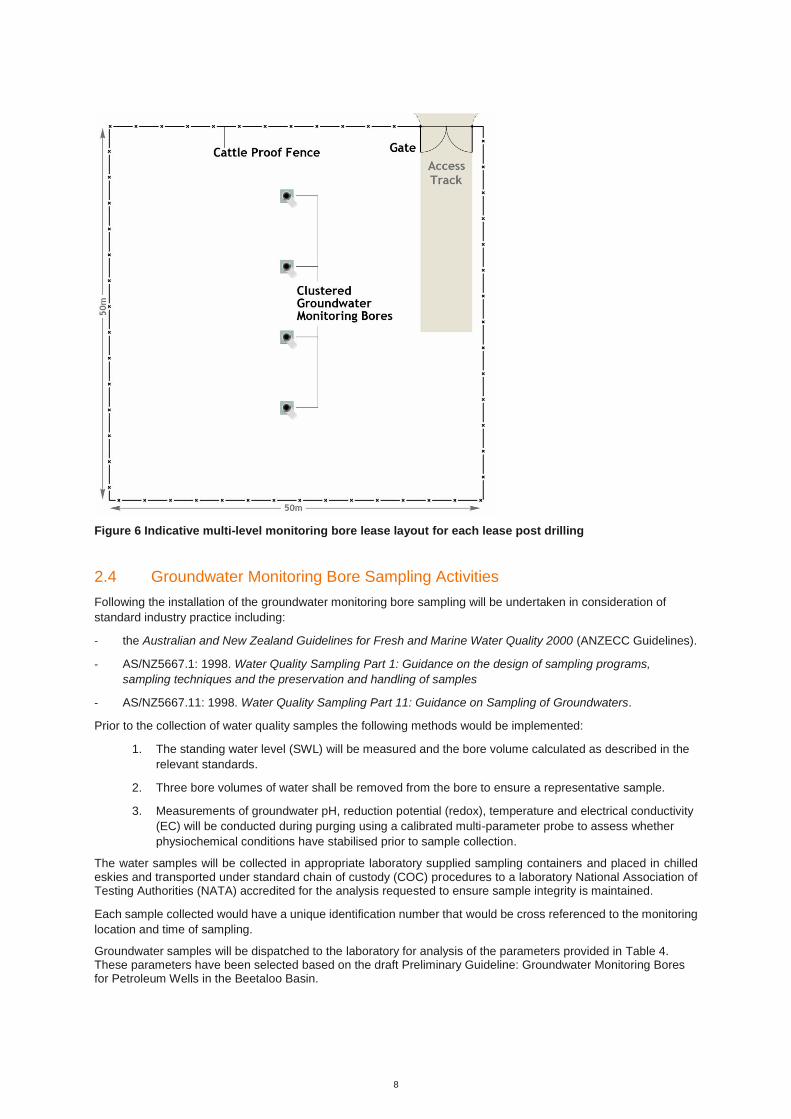
An indicative schematic of the water bore rig layout and final lease configuration is provided in Figure 5 and Figure
6.
All bores will be drilled and constructed by a licensed water bore driller and in accordance with the current version
of the Minimum Construction Requirements for Water bores in Australia.
Location of the lease areas has considered the minimum offset distance of at least 1 km between site activities and
pastoral water supply bores. Each aquifer intersected will be isolated from overlying aquifers with a cemented
casing string. Drilling will be undertaken with air or mud rotary techniques. If mud rotary techniques are employed,
the circulation fluid will be water based and will utilise standard water bore drilling polymer or bentonite-based
density and viscosity modifying additives.

7
A qualified hydrogeologist will supervise drilling activities and will determine the appropriate screening depth of
each the monitoring bores.
A survey of each monitoring bore would be established at each well pad monitoring bore in Australian Height Datum
(AHD), accurate to ±10 cm, to accurately determine depth to water table during each sampling event.
Within 28 days of bore completion, it is the driller’s responsibility to provide a statement of bore (Form 21), with
registered number, to the Water Resource branch of the Department of Environment and Natural Resources
(DENR).
All cuttings and drilling mud will be disposed of on site in accordance with the Minimum Construction Requirements
for Waters bores in Australia for water bore drilling practices.
Figure 5 Proposed Water Bore Lease Area Layout (figures not to scale)
8
Figure 6 Indicative multi-level monitoring bore lease layout for each lease post drilling
2.4 Groundwater Monitoring Bore Sampling Activities
Following the installation of the groundwater monitoring bore sampling will be undertaken in consideration of
standard industry practice including:
- the Australian and New Zealand Guidelines for Fresh and Marine Water Quality 2000 (ANZECC Guidelines).
- AS/NZ5667.1: 1998. Water Quality Sampling Part 1: Guidance on the design of sampling programs,
sampling techniques and the preservation and handling of samples
- AS/NZ5667.11: 1998. Water Quality Sampling Part 11: Guidance on Sampling of Groundwaters.
Prior to the collection of water quality samples the following methods would be implemented:
1. The standing water level (SWL) will be measured and the bore volume calculated as described in the
relevant standards.
2. Three bore volumes of water shall be removed from the bore to ensure a representative sample.
3. Measurements of groundwater pH, reduction potential (redox), temperature and electrical conductivity
(EC) will be conducted during purging using a calibrated multi-parameter probe to assess whether
physiochemical conditions have stabilised prior to sample collection.
The water samples will be collected in appropriate laboratory supplied sampling containers and placed in chilled eskies and transported under standard chain of custody (COC) procedures to a laboratory National Association of Testing Authorities (NATA) accredited for the analysis requested to ensure sample integrity is maintained.
Each sample collected would have a unique identification number that would be cross referenced to the monitoring
location and time of sampling.
Groundwater samples will be dispatched to the laboratory for analysis of the parameters provided in Table 4. These parameters have been selected based on the draft Preliminary Guideline: Groundwater Monitoring Bores for Petroleum Wells in the Beetaloo Basin.


13
- The Regulations outline infringement notices and prescribed amounts for certain
acts relating to lighting fires.
Environment and
Natural Resources
Control of Roads Act 2018
- Provides for the administration and control of roads, including the maintenance of
roads, construction and opening and closing of roads.
- The use of Road Bores will require a permit to work within a road reserve from the
Department of Transport.
Department of
Infrastructure,
Planning and
Logistics
Dangerous Goods Act 2012 and Regulations
- Provides for the safe storage, handling and transport of certain dangerous goods.
NT Worksafe,
Department of the
Attorney-General
and Justice
Environmental Assessment Act 2013 and associated Regulations
- Provides for the assessment of the environmental effects of development
proposals and for the protection of the environment.
- Ensures to the greatest extent practicable that each matter which could
reasonably have a significant effect on the environment is fully examined and
considered.
- Defines environment as being “all aspects of the surroundings of man including
the physical, biological, economic, cultural and social aspects”.
Northern Territory
Environmental
Protection
Authority,
Department of
Environment and
Natural Resources
Heritage Act 2016 and associated Regulations
- Protects the Territory’s cultural and natural heritage.
- Establishes the Heritage Council (consisting of eleven members).
- Establishes the NT Heritage Register.
- Sets the process by which places become heritage places.
- Allows for interim protection of places.
- Sets out the process for getting permission to do work to heritage places.
- Allows for fines and imprisonment for offences against the Act.
- Declares classes of places and objects of heritage significance to be protected.
- Provides for heritage agreements to encourage the conservation, use and
management of heritage places and objects.
- Regulates work on heritage places and objects.
- Establishes enforcement and offence provisions.
Heritage Branch,
Department of
Tourism and
Culture
Northern Territory Aboriginal Sacred Sites Act 2013 and associated Regulations
- Provides a practical balance between the recognized need to preserve and
enhance Aboriginal cultural tradition in relation to certain land in the Territory, and
the aspirations of the Aboriginal and all other peoples of the Territory for
economic, cultural and social advancement.
- Establishes a procedure for the protection and registration of sacred sites,
through:
• providing entry onto sacred sites and the conditions to which such entry is
subject
• procedures for avoidance of sacred sites when developing and using land
• establishing an Authority for the purposes of the Act
• procedures for the review of decisions of the Authority by the Minister, and
for related purposes.
Aboriginal Areas
Protection Authority
(AAPA); Minister for Environment and Natural Resources
Public and Environmental Health Act 2016 and Associated Regulations
- To monitor, assess and control environmental conditions, factors and agents,
facilities and equipment and activities, services and products that impact on or
may impact on public and environmental health.
- Outlines requirements for camps, specifically waste and wastewater (sewage and
greywater)management
Department of
Health
Territory Parks and Wildlife Conservation Act 2014 (TPWC Act) and associated
Regulations
- provides for the protection, conservation and sustainable utilisation of wildlife.
- Provides protection of CEEVNT listed species.
Flora and Fauna
Division of the
Department of
Environment and
Natural Resources
Waste Management and Pollution Control Act 2016 and associated Regulations Northern Territory
Environmental
Protection


17
3.2.1 NT Environmental Assessment Act
In the NT, proposed actions that have the potential to have a significant effect on the environment require environmental impact assessment (EIA) under the Environmental Assessment Act. In such cases, a Notice of Intent (NOI) is required to be submitted to the NT Environmental Protection Agency outlining the relevant information to allow a decision on whether the proposed action requires a Public Environmental Report (PER) or an Environmental Impact Statement (EIS). Where the environmental impacts of the proposed activity are not significant, a PER or EIS will not be required. An assessment of whether the proposed activity requires a NOI was undertaken in accordance with the NT Referring a Proposal to the NT EPA guideline. This is summarised in Table 10. Three project specific factors were applicable to the proposed activity covered under this EMP. These included: - Potential risks to terrestrial flora and fauna associated with vegetation clearing activities, bushfire and
introduction of weeds;
- Potential risks to Terrestrial Environmental Quality associated with access track construction and erosion and sediment control; and
- Potential risk to inland waters associated with monitoring bore drilling and sediment releases Due to the low impact nature associated with the proposed groundwater monitoring bore work program, no significant impacts on any of the NT Environmental factors and objectives are anticipated. Origin does not believe
referral to the NT EPA is required.
3.2.2 Commonwealth Environmental Protection and Biodiversity Conservation Act
Under the Commonwealth Environmental Protection and Biodiversity Conservation Act (EPBC) an action that has, will have or is likely to have a significant impact on Matters of National Environmental Significance (MNES) must be referred to the Australian Government Minister for the Environment (the Minister) for assessment. A self-assessment in accordance with the EPBC Act was undertaken under this EMP. The environment and heritage assessment confirmed significant impacts to EPBC listed threatened species or threatened ecological communities were unlikely. The proposed program will not require referral under the EPBC Act.

19
3.3 Alignment with the Principles of Ecological Sustainable Development (ESD)
This EMP aims to align with the principles of ESD through the adoption of responsible practices that are designed to maximise social benefit, whilst minimising the level of impact on the surrounding ecosystems. Ecological Sustainable Development (ESD) is defined by the NT EPA as:
“Using, conserving and enhancing the communities’ resources so that ecological processes, on which life depends, are maintained, and the total quality of life now and in the future is increased. ESD is development that aims to meet the needs of Australians today, while conserving our ecosystems for the benefit of future generations.”
The proposed water bore drilling program aim is to obtain baseline groundwater quality and quantity data within the proposed future drilling and stimulation lease sites to meet Recommendation 7.11 of the Scientific Inquiry into Hydraulic Fracturing in the Northern Territory. This is a key component of demonstrating all future petroleum exploration and development activities will not adversely impact on current and future groundwater users.
4. Environment Description
4.1 Physical Environment
4.1.1 Climate
The climate of the permit areas is arid to semi-arid, with rainfall decreasing in frequency and quantity from north to south. The climate is monsoon influenced, with a distinctive wet and dry season experienced through the year.
The average annual rainfall in the north of the permit area is listed at 680 mm at Daly Waters. The southern portion of the permit area records an average annual rainfall of 535 mm at Newcastle Waters and 608 mm listed at Elliott. Approximately 90% of the rainfall occurs during the Wet Season.
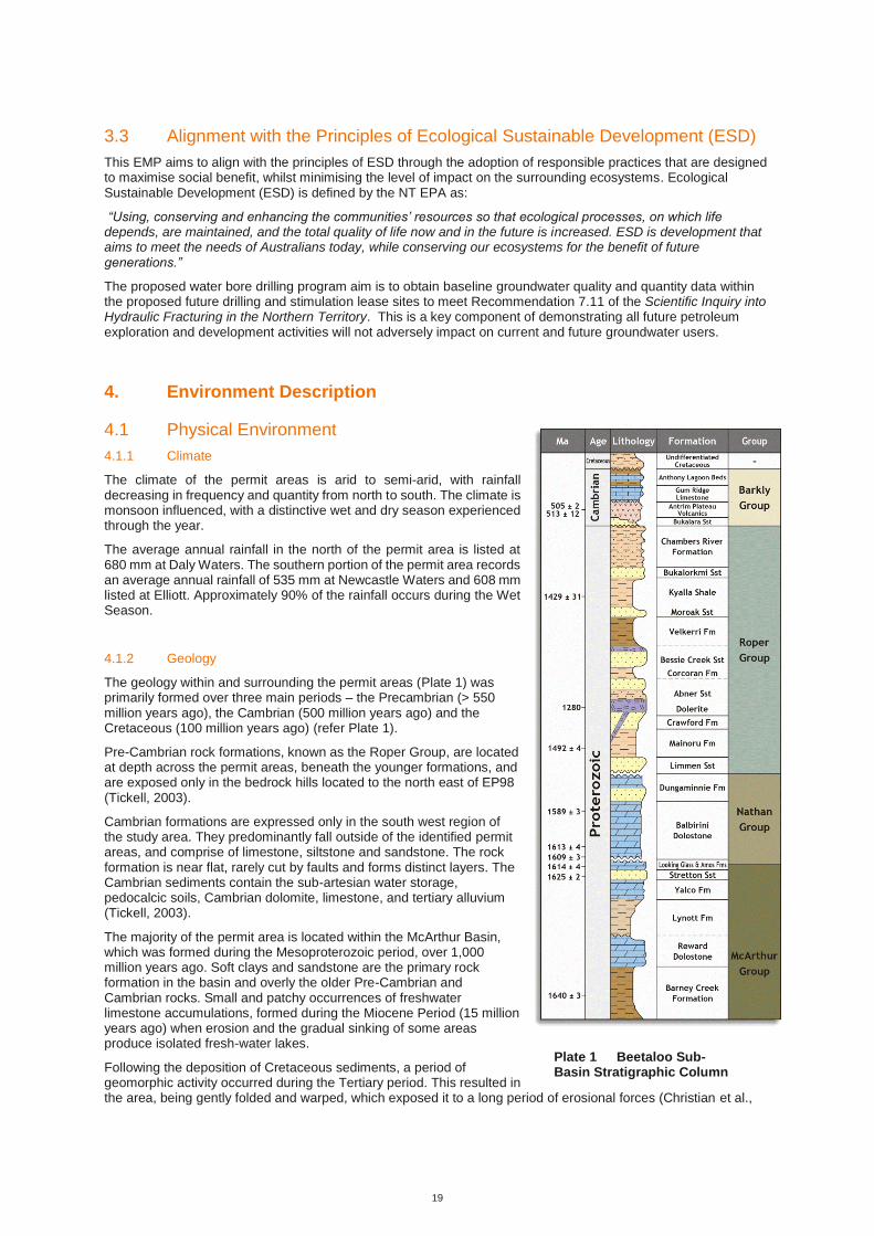
4.1.2 Geology
The geology within and surrounding the permit areas (Plate 1) was primarily formed over three main periods – the Precambrian (> 550 million years ago), the Cambrian (500 million years ago) and the Cretaceous (100 million years ago) (refer Plate 1).
Pre-Cambrian rock formations, known as the Roper Group, are located at depth across the permit areas, beneath the younger formations, and are exposed only in the bedrock hills located to the north east of EP98 (Tickell, 2003).
Cambrian formations are expressed only in the south west region of the study area. They predominantly fall outside of the identified permit areas, and comprise of limestone, siltstone and sandstone. The rock formation is near flat, rarely cut by faults and forms distinct layers. The Cambrian sediments contain the sub-artesian water storage, pedocalcic soils, Cambrian dolomite, limestone, and tertiary alluvium (Tickell, 2003).
The majority of the permit area is located within the McArthur Basin, which was formed during the Mesoproterozoic period, over 1,000 million years ago. Soft clays and sandstone are the primary rock formation in the basin and overly the older Pre-Cambrian and Cambrian rocks. Small and patchy occurrences of freshwater limestone accumulations, formed during the Miocene Period (15 million years ago) when erosion and the gradual sinking of some areas produce isolated fresh-water lakes.
Following the deposition of Cretaceous sediments, a period of geomorphic activity occurred during the Tertiary period. This resulted in the area, being gently folded and warped, which exposed it to a long period of erosional forces (Christian et al.,
Plate 1 Beetaloo Sub-Basin Stratigraphic Column

20
1951). These forces resulted in the area being dominated by undulating plains that contain extensive swampland and lakes.
Following a period of lateritization during the end of the Tertiary period, rivers were at grade and erosion was reduced to a state that allowed deep stable soil profiles to be established and be preserved (Christian et al., 1951), resulting in the ‘black’ soil clay plains and the lateritic and non-lateritic rises that are in the region today (Randal, 1967). With the onset of a more arid climate during the post–Miocene period, lakes and swamps dried up, resulting in high concentrations of lime and silica deposits that were leached from the lateritic soils into the ground and surface waters, which in turn formed a number of Tertiary limestone outcrops within the permit area. During the Quaternary period, which occurred less than 2 million years ago, the minor alluvial and lake deposits throughout the permit area were formed.
The target formations for the water bore drilling program are described below:
- Undifferentiated Cretaceous (if present) – The Cretaceous claystone located near the surface in the
Beetaloo Basin can be extremely unstable and may be very wet under the surface, retaining water from the
previous wet season. The formation poses a risk during the spudding of the well due to its propensity to
slough into the hole and wash out.
- Anthony Lagoon Beds - The Anthony Lagoon Beds are made up of dolomitic siltstones and limestones. They
pose no specific drilling risk.
- Gum Ridge Limestone - The Gum Ridge formation is described as a cavernous limestone. It is the regional aquifer for local domestic and commercial use and is therefore extremely important to isolate from any potential cross-flow contamination. Given its description as a cavernous limestone, it is highly likely that total losses would be taken during drilling.
4.1.3 Soils
The Sturt Plateau bioregion covers an area of 103,857 km and comprises undulating plains on sandstones, with mostly neutral sandy red and yellow earth soils (ANRA, 2008).
The soils within the Sturt Plateau have been derived from ancient rock formations and ancestral soils that were formed during earlier weathering cycles. The soils have been deeply weathered, leached and are relatively infertile because they have not been enriched by any recent geological events (Orr and Holmes, 1984). The distribution and diversity of soils in the plateau have been influenced by:
- the past wetter conditions of the region that formed relict Tertiary plains which comprise of highly leached
and generally lateritic soils
- extensive areas of Post-Tertiary Alluvia on which a variety of mature soils formed
- the dissected hilly country which is dominated by skeletal soils or rocky outcrops
- the range of parent materials of residual soils, ranging from basic volcanic and highly calcareous rocks to
granitoid rocks and sandstones (Christian et al, 1951).
The soil types located within the plateau range from the very strongly leached lateritic soils of the Tertiary land surface to the calcareous deserts soils and desert loams in the southern drier areas.
The lateritic plains, located within EP98 and the northern part of EP117, are classed as very strongly leached soils of the Tertiary land surface. Three main soil types are located within this area, including:
- Tertiary Lateritic Red Earths, which occur on the gently undulating topography
- Tertiary Lateritic Red Sands, which occur on gently undulating to undulating topography of the Tertiary
Lateritic Plain, formed from sandstones and complex parent materials of the deep sandy soils
- Tertiary Lateritic Podzolic Soils, formed on the gently undulating topography over a variety of rocks. These
soils are located in the northern section of the Barkly Basin and the Gulf Falls.
Other areas of Black Soil Plains are located within the Barkly Tablelands, including EP76, the southern part of EP117 and a small section of EP98. The soils usually crack widely in the upper profile upon drying and have a loose, self-mulching surface. The soils are neutral to alkaline, calcareous and commonly have depths to one metre (Fisher, 2001). The cracking clay soils occur mostly on flat or gently undulating plains (‘downs’) and are associated with the exposure and weathering of sedimentary or basic volcanic rocks. The Black soils also occur on the more recent depositional landscapes in the form of alluvial clays associated with drainage lines and major river systems.
Only a small section of the existing southern access tracks indicated the presence of Northern Heavy Grey Pedocals, also known as the black cracking clays, which are described as soils with poorer structure in the
21
surface and fine manganiferous concretions throughout the profile. They occur in high rainfall areas or poorly drained areas.
The soil erosion susceptibility is generally considered None/Slight erosion risk. This was confirmed during the field survey in August 2018 which reported no evidence of erosion within the proposed lease areas.
Soil samples collected during the field survey indicated the soils were slightly acidic (ph range of 5.0 to 6.2) across the permit area. A dispersion test was also undertaken on the samples which indicated that the soils were non-dispersive and maintained their shape when submerged in water. Results from the soil testing is provided in the Land Condition Report in Appendix C.
Certain sections of the proposed access tracks are likely to encounter more erosion susceptible soils, such as the access track to the southern sites and where streams and Newcastle Creek are crossed. Mitigation measures will need to be established to minimise the risk for erosion along the track and are stabilised leading up to the wet season. Overall, the main issues to be managed in relation to soils during exploration activities in the permit areas include:
- the generation of bull dust along the access tracks. Noting previous observations have indicated bull dust
had formed where the surface crust had been disturbed and then subjected to repeated ground disturbance
(AECOM 2015). This was primarily in grassland areas.
- The formation erosion gullies along inappropriately placed tracks and fence lines, where a slope was
present. Scolding to bedrock has previously been observed in other areas of the permit, as well as pooling
of water in areas of compaction and subsidence.
4.1.4 Hydrology
The proposed lease sites all fall within the Wiso River Basin. The Wiso River Basin covers the southern half of EP98 (south of the Carpentaria Highway) and the majority of EP76 and EP117 and is internally drained by Newcastle Creek and a number of small ephemeral creeks. Newcastle Creek ultimately flows into Lake Woods, which is located south of Newcastle Waters Station. Lake Woods covers an area of inundation of approximately 50,000 ha in normal rainfall years, extending to 80,000 ha in exceptionally wet years, after which it can retain water for several years (HLA, 2005). Lake Woods is described as a major quasi-permanent surface water body in the region, although some semi-permanent and many ephemeral waterholes are located across the permit area (HLA, 2006b).
The only major creek in the permit area that could potentially be impacted by the proposed activities is Newcastle Creek (Stream Order 4) and a number of small ephemeral streams (Stream Order 1 and 2) located along the proposed access tracks (refer Appendix C). The streams only flow for a short period during the wet season, with waterholes forming at the beginning of the dry season. If the wet season is poor, the waterholes will often remain dry, whereas, during heavy wet seasons, large areas of the internal drainage systems are flooded. The stream banks are often lined with a scatter of small trees which highlights them from the surrounding plains.
Only one intermediate stream crosses the Beetaloo Access track at one location and three intermediate and Newcastle Creek cross the proposed access track to Velkerri 76 S2-1. The retention of vegetation buffers, as outlined in the NTG Land Clearing Guidelines – Northern Territory Planning Scheme 2010, as they relate to stream order should be considered for the preparation of access tracks and pads. Gravel pits located nearby would be utilised to provide stability where creeks and streams are crossed.
During the wet season, it is likely the region would experience widespread surface flooding, to a depth of 30 cm, which has previously been identified by debris being collected on fence lines (HLA, 2005).
4.1.5 Hydrogeology
Origin commissioned CloudGMS to undertake a desktop hydrogeological study of the Beetaloo Basin (CloudGMS, 2015). The study objective was to compile an up to date summary of the hydrogeology of Beetaloo and adjacent groundwater basins, including geological setting, previous studies, aquifer characterisation, groundwater use and the regulatory framework. The conceptual hydrogeological model described below is from the Beetaloo Basin Hydrogeological Assessment.
The Beetaloo Basin comprises a thick sequence of flat-lying mudstone and sandstone formations (Roper Group) that were deposited between 1,500 and 1,430 million years ago (Ma) (Table 11). The Roper Group is estimated to reach of 5,000 m in thickness in the centre of the basin and with the exception of the north and eastern margins occurs at an average depth of about 500 m. The Roper Group is overlain by the Georgina Basin (630 – 497 Ma), which includes widespread basalts and a thick limestone sequence that forms the Cambrian Limestone Aquifer (CLA), a significant water supply aquifer. The Georgina Basin is capped by Cretaceous mudstone and sandstone (145 – 66 Ma) and recent alluvial and laterite deposits.


23
the Beetaloo Basin region). Groundwater recharge mechanisms to the CLA are poorly characterised but are likely to be dominated by infiltration through sinkholes and preferential recharge through soil cavities.
Limited information exists on the hydrogeological characteristics of the Roper Group sequence as it occurs at depth within the Beetaloo Basin. Sandstone dominated formations may behave as aquifers, however, drilling results suggest these formations have limited permeability and will only form marginal, very local scale aquifers. Groundwater in the Roper Group is highly saline and contrasts with the shallower, utilised aquifers in which groundwater is generally of drinking water quality.
The Velkerri Formation represents the primary unconventional gas target in the Beetaloo Basin, although small hydrocarbons intersections have been encountered in other formations within the Roper Group. Vertical pressure gradients between the Roper Group and the CLA are not well characterised, however, previous exploration well formation tests indicate there is an upward pressure gradient from the Roper Group to the CLA. Over much of the basin the CLA is separated from these formations by multiple aquitards including the Antrim Plateau Volcanics and Hayfield Mudstone.
4.2 Biological Environment
4.2.1 Bioregions
The Interim Biogeographic Regionalisation of Australia is a nationally recognised ecosystem classification system (Environment Australia, 2000). Bioregions are large, geographically distinct ecosystems that are distinguished by broad physical and biological characteristics, which can be further classified into Subregions. These regions and subregions are used as the basis for regional comparisons and conservation of flora and floristic communities.
Of the 85 bioregions mapped nationally, 20 occur within the Northern Territory and only two within the Origin permit areas, the Sturt Plateau bioregion and the Mitchell Grass Downs bioregion. The 2018 proposed lease sites all fall within the Sturt Plateau Bioregion which comprises undulating plains on sandstone, with predominantly neutral sandy red and yellow earth soils. Dominant vegetation associations included extensive areas of Lancewood (Acacia shirleyi) - Bullwaddy (Macropteranthes kekwickii) vegetation and associated fauna, including the Spectacled Hare-Wallaby (Lagorchestes conspicillatus). Land condition in the bioregion is moderate to good but is threatened by impacts from weeds, feral animals, pastoralism and changed fire regimes.
4.2.2 Vegetation Communities
Vegetation communities within the permit areas have been ground-truthed during baseline assessments in 2004, 2006 (HLA, 2006; 2006c), 2010, 2014, 2016 (AECOM, 2011; 2014; 2016) and more recently in August 2018, along with assessments of weeds, habitat, erosion and land condition. The August 2018 survey focused on the proposed lease areas for water bore drilling and the associated access tracks. The methodology used for the assessments is presented in Appendix C.
The existing vegetation at the proposed sites have been evaluated through detailed habitat assessments. Habitat assessments included identification of vegetation community, dominant flora species at each strata, habitat condition, disturbance factors (fire, weeds, erosion, feral fauna species), and fauna attributes (e.g. tree hollows, logs, grass cover, mistletoe abundance).
The main vegetation communities within the exploration permit areas are woodlands, typically dominated by Bloodwoods (Corymbia spp.) and tall shrublands and woodlands of Bullwaddy and Lancewood with open grassland understorey (Cofinas and Creighton, 2001; ANRA, 2008). Other less common vegetation communities within the area include Acacia shrubland over spinifex and Bullwaddy-dominated woodland.
Lancewood/Bullwaddy communities are important as they represent Gondwanan remnants of the once dominant rainforests of the Australian tertiary period and are limited in distribution (PWCNT, 2005). Lancewood forests are the most extensive acacia dominated communities across northern NT. The Lancewood/Bullwaddy communities typically have a dense shady shrub layer, a few vines and creepers and a sparse grass understorey, compared to the sparse canopy and tall grass understory of other tall dense grasslands (PWCNT, 2005).
Bullwaddy is a unique plant with a multi-stemmed habit, very small leaves crowded along the branches and a very dense and heavy wood. Whilst technically being a shrub it can grow up to six metres tall with massive individual stems (PWCNT, 2005).
The Lancewood/Bullwaddy vegetation associations are fire sensitive. Inappropriate fire regimes may result in a community succession from Bullwaddy through Lancewood to a Eucalypt dominated open woodland (PWCNT, 2005). This process may be accelerated by the invasion of exotic pasture grasses such as Buffel Grass (Cenchrus ciliaris).
Detailed condition description and photographs of each of the proposed water bore sites and access are provided in Appendix C.

24
4.2.3 Flora
A total of 805 plant species have been recorded within the wider region, during the August 2018 survey 28 dominant flora species were identified across the proposed lease areas. As the survey was conducted during the late dry season, grasses and other annual species were difficult or impossible to identify due to the lack of inflorescence or because they had already died-back.
No Commonwealth or NT threatened plant species were identified as occurring by the Protected Matters Searches or NRM Infonet search. One species, the prostrate, herbaceous vine Ipomoea argillicola, is listed as Near Threatened under Section 29 of the Territory Parks and Wildlife Conservation Act 2000 (TPWC Act) and could potentially occur in the project sites, although has not been reported in previous and current surveys. NT flora data base shows that this species has been recorded from the Bullwaddy Conservation Reserve and at locations surrounding the area in previous searches (AECOM, 2015).
The region supports fragmented stands of Bullwaddy, which is listed under the TPWC Act as ‘Least Concern’, which refers to species that are either widespread or common and cannot be categorised as Critically Endangered, Endangered, Vulnerable, Near Threatened or Data Deficient. However, Bullwaddy is significant in terms of the habitat it provides for a range of native species. The extent of Bullwaddy in the permit area is far more extensive than that indicated by the NT Herbarium records.
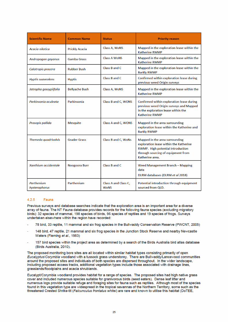
4.2.4 Weeds
Weed baseline surveys were completed by AECOM in August 2018 covering all proposed access tracks and lease pad areas. This section provides a summary of weed related information pertinent to the project, with detailed information provided as a part of the Land Condition Assessment in Appendix C.
Weed prevention and control within the NT is regulated under the Weeds Management Act. The aim of the Act is ‘to protect the Territory's economy, community, industry and environment from the adverse impact of weeds’. The act identifies several weed declaration classes, designed to eradicate, control or prevent the introduction of certain weed species in the NT. These declaration classes are:
- a Class A weed is to be eradicated
- a Class B weed is to have its growth and spread controlled
- a Class C weed is not to be introduced to the NT.
Regional Weed Management Plans (RWMP) have been developed for areas of the NT, with the Barkley and the Katherine RWMP overlapping Origin’s Beetaloo exploration tenure. The aim of these regional plans is to assist in prioritising weed management by:
- identifying the region's priority weeds and associated pathways of spread to inform management priorities
- identifying landscapes that may need prioritised protection from weed impacts like river corridors or sacred Aboriginal sites
- containing information on alert weeds that are not yet found in the region, but could become major issues if they establish
The weeds species of high risk of introduction or spread through Origins activities are listed in Table 12. These high-risk weeds have been determined through consideration of the following criteria:
• Weed species that has been confirmed in the area within the relevant RWMP or through field surveys
• Weed species listed in a RWMP that is in close proximity to Origin tenure
• Weed species is at risk of introduction through the use of machinery sourced from other regions in the NT or from other states.
A survey undertaken in August 2018 and previously in 2014,15 and 16 did not detect any priority weeds in the area surrounding the proposed activity.
The low level of weed abundance suggests good habitat condition in the areas of the proposed sites. Primary controls for this program will therefore be focused on preventing the introduction of weeds and managing weeds promoted through site disturbance. The proposed weed control measures to prevent and manage weed infestations are outlined in Section 6.4.
Additional information on the full list of weeds and control measures for the development are provided in the Weed Management Plan in Appendix B.
Table 12 High priority weeds to be managed or prevented within the permit area

26
2014, Ward, 2008). Many of the sites have a high density of hollow-bearing trees that provide important habitat for many fauna species. Avoiding clearing large hollow-bearing trees will reduce the impact to native wildlife within the permit area.
Savanna grasslands and open woodland provide suitable habitat for species such as Emu (Dromaius novaehollandiae) and Australian Bush Turkey (Ardeotis australis. Drainage lines and seasonally inundated grasslands may also provide habitat for migratory species during the wet season and are breeding areas for frogs. Limiting disturbances in these areas and avoiding these areas during the wet season would limit impacts on fauna.
4.2.6 Significant Fauna
A search of the DotEE Protected Matters database of nationally significant fauna (PMST), the NT Government fauna database (NRM Infonet), and records from the Atlas of Living Australia (ALA) was undertaken for the proposed lease areas and access tracks. The search results indicate the potential presence of 20 fauna species listed as threatened under the EPBC Act and/or the TPWC Act. These included ten birds, eight mammals and two reptiles.
The likelihood assessment of species occurrence is based on the availability of suitable habitat within the permit area, records in the vicinity and distributional data. Therefore, many of the threatened and migratory fauna species indicated in databases as ‘occurring’ or ‘likely to occur’ have been assessed as unlikely to occur within the proposed water bore lease areas. As some areas in the proposed lease area have not been subject to intensive survey and some species are very cryptic, a conservative approach has been taken to assess species presence. A full description of each species, their distribution and habitat associations are outlined in Appendix C.
No core habitat for threatened fauna was identified at the sites. However, some species may possibly occur and are known to occur in the wider landscape. Threatened species that may possibly occur include:
- Gouldian Finch Erythrura gouldiae (E-EPBC Act, VU-TPWC Act)
- Crested Shrike-tit (northern) Falcunculus frontatus whitei (VU-EPBC Act, NT-TPWC Act)
Research has shown that critical components of suitable habitat for the Gouldian Finch include suitable nesting trees during the breeding season (particularly E. tintinnans, E. brevifolia or E. leucophloia), a water source and a diverse range of favoured annual and perennial grasses (DoE, 2015). No nesting habitat was recorded during the surveys and it is unlikely this species breeds in close vicinity of the sites. During the wet season Gouldian Finches move from breeding habitat on hillsides with suitable trees down to lower lying areas where they forage on perennial grasses such as Triodia sp., Alloteropsis semialata, and Chrysopogon fallax (Palmer et al. 2012). Some of the perennial grasses were recorded during recent surveys so potential foraging habitat is present; however, there are limited records in the vicinity of the sites suggesting it is not an important area for this species.
The Crested Shrike-tit lives in dry Eucalypt forests and woodland where it feeds on insects from the canopy and also under bark (Ward, 2008). It has been recorded in wet Melaleuca open woodlands, woodlands dominated by Nutwood (Terminalia arostrata), Bloodwoods with flaky bark and ironwood (DoE, 2014, Ward, 2008). In the NT, nesting has been recorded from September through to January and nests are built in terminal branches at the top of trees (Ward et al., 2009). The stronghold of this species is north of this location and only one old record exists near Borroloola. Although it is possible this species may be present in the area, it is unlikely to represent an important area for this species and the impact of the proposed activities, given their size, would be small.
The Grey Falcon (Falco hypoleucus) is a widespread species listed as Vulnerable in the NT that is considered possibly to be present in the study area. The Painted Honeyeater (Grantiella picta) has been known to occur in the study area, however, given it does not breed in the NT it would only be present intermittently for foraging. Based on the field assessment there was no breeding habitat recorded, and depending on grass seed and water availability it is unlikely the study area comprises core habitat for this species.
4.2.7 Feral and Pest Animals
Feral animals known to occur within the region include:
- Pig (Sus scrofa)
- Wild Dog (Canis lupus familiaris)
- Feral Cat (Felis catus)
- Cane Toad (Bufo marinus)
- Horse (Equus caballus)
- Donkey (Equus asinus)
- Water Buffalo (Bubalus bubalis)


29
commercial interest from the exploration for gas in the Beetaloo Sub-basin and the growth of the ‘grey nomad’ tourism market.
4.4.6 Historic Heritage Assessment
A search of relevant historic heritage registers identified a number of historic heritage sites within a 125 km by 125 km area that encompasses the full Proposal area. No previously identified sites are located within 20 km of the proposed 2018 lease areas. No new sites of historic heritage were identified during the August 2018 survey.
4.4.7 Protected or Conservation Areas
There are no conservation areas within proximity to the proposed activities. There are no national or world heritage places, Commonwealth land or heritage places or reserves or critical habitat areas listed under the EPBC Act are located within or adjacent to the exploration areas (EP76, EP98 and EP117).


31
Elliot provide consumables (food, fuel etc.) and accommodation. A number of heritage areas of importance
to regional tourism are located in the broader region, including Elliott, Newcastle Waters and other heritage
listed homesteads.
2. Road networks – The Stuart Highway and Carpentaria Highway will be used to access the sites. In addition,
there are numerous gravel roads connecting properties, and internal property tracks. All properties also have
firebreaks on their boundaries and internally.
3. Alice Springs to Darwin Railway - The railway line runs to the west of the gas pipeline and Stuart Highway,
and does not cross into any of the permit areas.
4. Townships - The township of Daly Waters and Dunmarra lie within EP98.
5. Conservation areas – including the Bullwaddy Conservation Reserve, which lies within EP98 and Lake
Woods and the Junction Stock Reserve just outside the permit area.
6. Heritage – there are seven heritage sites within the exploration permit area. There are also number of
heritage areas of importance to regional tourism are located in the broader region, including Elliott,
Newcastle Waters and other heritage listed homesteads. These sites have been identified as part of the
environmental assessment, and the proposed water bore drilling sites will not impact on these.
7. Archaeological sites - the permit areas have a long history of Aboriginal association and 41 archaeological
sites have previously been recorded within the permit areas, as well as 25 registered Sacred Sites.
5. Stakeholder / Community Consultation
The NT Petroleum (Environment) Regulations 2016 defines stakeholder as meaning:
(a) a person or body whose rights or activities may be directly affected by the environmental impacts or
environmental risks of the regulated activity proposed to be carried out; or
(b) an agent or representative of a person or body mentioned in paragraph (a).
Origin’s local and directly impacted / affected stakeholders have, and continue to be, consulted in a respectful,
open and consistent manner. This has been the case since 2014, when Origin has assumed operatorship of
EP98, EP117 and EP76.
Origin’s consistent approach to stakeholder engagement has been to ensure that those persons and / or groups
most directly impacted / affected and / or influenced by permit commitments have received Origin’s full attention.
Origin views the social acceptance and informed consent of these primary stakeholders of critical important and
relevance during this stage of low impact and small-scale exploration activities.
For the purpose of this EMP, Origin identifies it stakeholders, in compliance with the NT Petroleum (Environment)
Regulations 2016 as:
• host Traditional Owners recognised as the Native Title holders and / or claimants and their
representative, the Northern Land Council, as described in Exploration Agreements between the parties
for EP98, EP117 and EP76; and
• host pastoralists recognised as the landholders of the nine Pastoral Lease Stations in Table 15, with
particular engagement with the landholder of Amungee Mungee as the stakeholder most impacted by
Origin’s relevant permit commitments the subject of this EMP.
Origin also recognises and engages, where appropriate and acceptable, with the following list of stakeholders:
• Northern Territory community and residents;
• Federal Government, including Departments, Members of Parliament and Opposition Spokespersons;
• Local Government Agencies, including:
o Katherine Town Council;
o Barkly Regional Council;

32
o Roper Gulf Regional Council; and
o Regional Economic Development Committees;
• Northern and Central Land Councils;
• Environmental Protection Authority;
• Aboriginal Areas Protection Authority (AAPA);
• National, State and Local Media (Print, TV and Radio);
• Australian Petroleum, Production and Exploration Association (APPEA);
• Northern Australia Development Office (NADO);
• Northern Territory Cattlemen’s Association (NTCA);
• Industry Capability Network (ICN);
• Chamber of Commerce NT;
• Business Council of Australia;
• Minerals Council of Australia;
• CSIRO / GISERA;
• NGOs;
• Darwin Major Business Group (DMBG);
• Energy Club Northern Territory (ECNT);
• Indigenous Business Network NT (NTIBN);
• Katherine Mining Services Association (KMSA).
The collection of baseline groundwater monitoring data proposed under this EMP, extending the groundwater
monitoring network Origin has had in place since 2014, is of importance and relevance to all parties including
community members, pastoralists, Traditional Owners and Origin. It provides interested stakeholders the ability to
assess impacts given a data set will exist before, during and after Hydraulic Fracturing Stimulation (HFS) activity.
For Origin, it is equally important to be able to demonstrate to the pastoralists, Traditional Owners and regulators
that our extraction processes are robust, measurable and environmentally disciplined.
Stakeholder and community engagement for the 2019 work programme has been held with host pastoralists and
Traditional Owners directly affected by the proposed activities. Origin’s proposed exploration program has been
clearly communicated to interested parties, with several written submissions and video presentations prepared by
Origin for ‘The Scientific Inquiry into Hydraulic Fracturing in the Northern Territory’. Information included in
Origin’s submission to the Inquiry is publicly available at https://frackinginquiry.nt.gov.au/submission-library.
Activities performed under EP98, EP117 and EP76 will be conducted in a manner consistent with the ‘Code of
Practice: Onshore Petroleum Activities in the Northern Territory’, which Origin considers an appropriate reference
for ensuring Origin’s activities are in line with community expectations.
5.1 Pastoralist Stakeholder Engagement
Origin has engaged with the pastoralist stakeholders identified in Table 15 above on an ongoing basis, including
engagement with the landholder of Amungee Mungee Station regarding the low impact and small-scale
exploration activities. Key engagement efforts Origin has undertaken with the landholder of Amungee Mungee
Station include:
• engaging in consultation for and agreeing on early works access to Amungee Mungee Station in
preparation of low impact and small-scale exploration activities;
33
• providing the landholder with draft copies of this EMP and the EMP for civil construction works for the
Velkerri 76 S2 well and providing opportunity for the landholder to comment;
• providing the landholder with copies of Beetaloo Basin Exploration Project – Weed Management Plan
(Appendix B) and Trafficwerx NT Traffic Management Plan (Appendix H) for works Origin proposes to
undertake as part of the broader Beetaloo Basin Exploration Project, which outline Origin’s
environmental risk management and outcome achievement policies; and
• ongoing engagement and consultation meetings regarding Origin’s proposed exploration activities,
including demonstration of the scope and activities part of Origin’s Beetaloo Basin project (Appendix J).
Appendix K summarises Origin’s compliance with Origin’s obligation to engage with the landholder of Amungee
Mungee Station as a relevant stakeholder and provide information in accordance with section 7(2)(a) of the
Petroleum (Environment) Regulations 2016.
Appendix L provides the correspondence between Origin and the landholder and representatives of Amungee
Mungee Station in fulfilment of the stakeholder engagement obligations under the Petroleum (Environment)
Regulations 2016.
5.2 Traditional Owner Engagement
Origin has undertaken detailed engagement with the relevant Traditional Owners through the Northern Land
Council to facilitate an ongoing relationship between Origin and the Traditional Owners. Engagement efforts
undertaken by Origin include:
• ongoing consultation regarding Origin work programs and proposed exploration activities, including the
locations of all areas of disturbance across the area of EP98, EP117 and EP76.
• in person consultation between Origin and the Northern Land Council regarding Origin’s proposed
exploration activities on 3 September 2018;
• ongoing communication between Origin and the Northern Land Council; and
• performance of a Sacred Site clearance survey on land with the relevant Traditional Owners between 10
September and 19 September 2018. A formal Northern Land Council Sacred Site Avoidance and
Anthropological Report was provided to AAPA to assist with the certification process for Origin’s
exploration areas and associated infrastructure.
The Northern Land Council has provided Origin with Traditional Owner consent for the activities and AAPA
provided Origin certification AAPA C2019/039 on 30 November 2018 (Appendix E).
5.3 Northern Territory Community Engagement
Broader engagement has occurred with local and regional business within the local communities of Daly Waters,
Elliot, Katherine and the broader Northern Territory region. Northern Territory businesses have been engaged on
the scope of Origin’s activities through tender opportunities covering a range of material supply and support
services, such as:
• people transport and logistics;
• accommodation and food;
• provision of temporary camps and camp services;
• civil construction work;
• freight and transport;
• water bore drilling;
• water carting and waste management;
34
• site maintenance and inspections;
• weed management and control;
• equipment and materials storage;
• oil country tubular goods;
• environmental and civil consulting;
• surveying and geotechnical assessments; and
• general provisions of goods and services (such as personal protective equipment and hire cars).
5.4 Ongoing Stakeholder and Community Engagement
Origin is committed to continuing to engage with stakeholders regarding the exploration activities under EP98,
EP117 and EP76 and any associated environmental outcomes prior to, during and after performance of the low
impact and small-scale exploration activities. For example, Origin made an express offer for further and ongoing
consultation with the landholder of Amungee Mungee Station by letter on 5 June 2019 (Appendix L).
Origin recognises the growing community interest in ensuring onshore natural gas development takes place in a
safe and environmentally sound way and are committed to delivering operational excellence (which encapsulates
our health, safety and environmental performance standards).
Origin has further committed to ongoing engagement with the relevant Traditional Owners, including annual work
plan meetings and provision of draft work programmes for future years of activity.
Detailed community and stakeholder engagement is underway covering future exploration activities which are
beyond the scope of this EMP.
6. Environmental Risks and Impacts, Description and Assessment
6.1 Origin’s Risk Management Approach
Origin utilises a robust risk management process for all its activities to achieve the following key outcomes:
- Risks are understood, eliminated or reduced and controlled to an acceptable level.
- Controls are owned, assured and continuously reviewed for effectiveness.
- All activities are compliant with regulatory standards and are guided by best practice, and
- Origin and its stakeholders are confident in the way activities are conducted to manage risks.
Risk management processes are mandated through the Origin Risk Management Policy and Directive, which includes a risk rating toolkit that is utilised from the Board through to frontline activity owners (Figure 7). The toolkit considers the requirements of ISO 31000 and addresses risk identification, assessment and management.
Assessment of risk are completed using Origin’s Risk Matrix (Figure 8) to assess and rate risks by assessing the combination of frequency of occurrence and the severity of the outcome of an event. This allows quantification of the risk and determination can then be made about whether the risk can be accepted, or whether further mitigation is required.
Origin risk management processes requires regular assessment of underlying (unmitigated) risk from an activity, the residual risk once controls are applied, the effectiveness of controls and the likelihood and consequence of a risk event. A risk is either accepted in accordance with strict delegations of authority or the activity does not proceed.

35
6.2 Risk Acceptance threshold- ALARP
A risk can be considered to have been reduced to ‘as low as reasonably practicable’ (ALARP) when all reasonably practicable control measures (both preventative and mitigative) have been identified and implemented to reduce the risk of identified events. A key element of demonstrating ALARP is that good practice is followed, where good practice is defined as the recognised risk management practices and measures that are used by competent organisations to manage well understood hazards arising from their activities. This definition incorporates good practice as defined in codes and standards, and a consensus of good practice within the industry. ALARP is not a final position over the life of an asset or project.
The practicability and the reasonability of control measures can change over time due to changes in technology (that can make measures more readily available or less expensive), industry standards (that can commoditise once-cutting-edge technology) and the socio-technical landscape (that can modify societal expectations).

36
Figure 7 Origin’s risk tool kit which describes the approach to identify, assess, control, treat and accept risks

37
Figure 8 Origin's Risk Matrix


47
7.2 Environment, Health, and Safety Management Systems
Origin has a mature Health, Safety and Environment Management System (HSEMS) which contains the systems, policies and procedures that Origin has in place to manage and minimise the impact from its activities. In addition to meeting legal requirements, Origin’s activities are also governed by several additional internal directives and risk control directives designed to ensure best practice in environmental risk management.
An overview of the Origin HSEMS and the associated directives is provided in Figure 10.
Figure 9 Origins Health, Safety and Environment (HSE) Policy

48
Figure 10 Origins HSEMS Structure
7.3 Roles and Responsibility
The following sections describe in detail the management strategies for specific components of the landscape, such as soil, ground water and vegetation, and the cultural and social environment, in relation to the different impact-causing activities that may occur.
Each management area has been assigned to specific positions within the exploration team, as follows:
- Asset Manager – responsible for the overall operations in the Origins activities in the exploration permit
area.
- Project Manager – oversees the whole planning and execution of the exploration program and is the person
ultimately responsible for ensuring all other parties are working within the HSE guidelines. The Project
Manager’s role is predominantly office-based.

49
- Civil Construction Superintendent – person based in the field responsible for ensuring all areas of
operations and construction are carried out in accordance with the EMP and Origin’ HSE Policy. All
contractors report to this position, who is responsible to the Project Manager.
This role will also cover the role of the weeds officer, who will be responsible for:
- Planning and execution of weed monitoring requirements, including baseline weed assessments and
ongoing monitoring both during periods of gas related activities as well as during the target identification
period of February to May.
- Facilitate training all workers (including contractors) in weed management requirements, with support from
the Northern Territory Government Regional Weed Officer - Onshore Shale Gas Development.
- Oversight of implementation of weed control mechanisms including but not limited to wash-downs and
proactive weed control programs.
- Ensuring all reporting requirements are met.
- Act as the designated point of contact for and rapidly responding to any weed related complaints and
incidents in accordance with the pre-determined strategies in this WMP and additional strategies as required
developed in consultation with the Regional Weed Officer - Onshore Shale Gas Development and affected
landholders.
- Review and update of WMP’s to remain effective in communication with relevant landholders and Regional
Weed Officer - Onshore Shale Gas Development in consideration of monitoring results and emerging weed
issues for both gas and pastoral operations.
- Water Bore Driller – Water Bore contractor responsible for contractor’s equipment and personnel,
adherence to the current version of the Minimum Construction Requirements for Water bores in Australia
National Uniform Drillers Licensing Committeeto minimise impact of activities on the environment and in
accordance with this EMP.
- Civil Design Consultant – An individual or organisation that provides professional or expert advice in the
field of civil engineering and design. They determine the best locations, design, materials and construction
techniques for undertaking a project to ensure it meets the needs of the end user.
- Health Safety and Environment Representative (HSE Representative) – Origin representative providing
guidance and advice to site personnel on the day-to-day management of the environment. This role is the
will also support the nominated weeds officer, specifically in the planning and reporting phases.
- Field Personnel – All staff including Origin and contractors that are working on in the exploration permit
areas.
7.4 Training and Awareness
Origin HSEMS outlines the policies and procedures governing the training and competency of all personnel (staff and contractors) to ensure they can fulfil their obligations under this EMP and the broader Origin HSEMS.
These systems include:
- General Origin HSE induction
- Contractor HSE prequalification process
- Contractor management system-
- Site specific inductions
- Task specific training and competency requirements
As most activities completed under this EMP will be implemented by contractors, contractors will be required to demonstrate they have appropriate systems, procedures and training to manage specific risks covered under this EMP prior to award. The following aspects will be considered during tender award:
- Maturity of HSE systems and process.
- Previous HSE performance
- Existing procedures and training:
• Weed identification and management
50
• Refuelling procedures
• Procedures for avoidance of potential fauna habitat and any identified heritage sites
• Hazardous material and waste management procedures
• Incident notification and management processes
- Internal training programs
- Internal auditing processes.
All staff and contractors entering the site will be required to attend a site-specific induction. The induction covers the following aspects:
- Regulatory requirements, for the area, including specific conditions on the exploration permits and
agreements with the NLC.
- Environmental considerations and special procedures to be used for environment protection, as well as,
protection of archaeological and cultural sites within the permit areas.
- Safety procedures covering the safe use of vehicles, equipment and explosives first aid and
- HSE in remote area operations.
- Landowner sensitivities, including Aboriginal communities and their specific cultural requirements.
- Procedures for handling any culturally or archaeologically sensitive materials that may be discovered.
- Provide training in safe storage and handling of flammable and combustible liquids.
7.5 Environmental Commitment Summary
The responsibility for general environmental monitoring rests with all personnel engaged on the project. More specifically the Origin Project Manager shall ensure each element of the groundwater monitoring bore drilling programs are monitored to ensure that appropriate environmental protection/procedures are in place.
The program environmental commitments are outlined in Appendix G and are sourced from the risk management controls specified in Section 6.4. The implementation and compliance against these risk controls will be assessed as part of the annual environmental report (refer Section 7.9).
Specific commitments will be to:
- recording of information to track performance, including non-conformances and corrective actions.
- inspection and monitoring of operational controls on site via regular environmental monitoring
- assessing the level of conformance with objectives and targets detailed in this EMP.
The Operating Company Representative shall undertake random site inspections and direct such action as may be considered necessary to protect, minimise or rectify any environmental concerns.
7.6 Incident Reporting
Incident reporting and investigation provides the mechanism to prevent a recurrence. Personnel are required to proactively report all incidents, near-misses and identification of potential hazards.
Origin utilises an online incident management and reporting system. Any environmental incident, near miss or observation is reported through the online incident reporting system. All personnel are encouraged to report minor events to act as an alert to environmental risks and to maintain a program of continual improvement.
7.6.1 Recordable incidents
The Regulations define a recordable incident as an incident arising from the activity that breaches an environmental objective or performance standard in the EMP that applies to the activity, and is not a reportable incident.
7.6.2 Reportable Environmental Incident Reporting
As per Part 3, Division 1 of the Petroleum (Environment) Regulations, a reportable incident means an incident arising from a regulated activity that has caused, or has the potential to cause, material environmental harm or serious environmental harm as defined under the Petroleum Act. The interest holder must notify (this may be oral or in writing) DPIR of a reportable incident as soon as practicable but no later than 2 hours after the first occurrence of the incident or after the time the interest holder becomes aware of the incident
DPIR will be notified through the DPIR Operations Term Emergency number 1300 935 250.
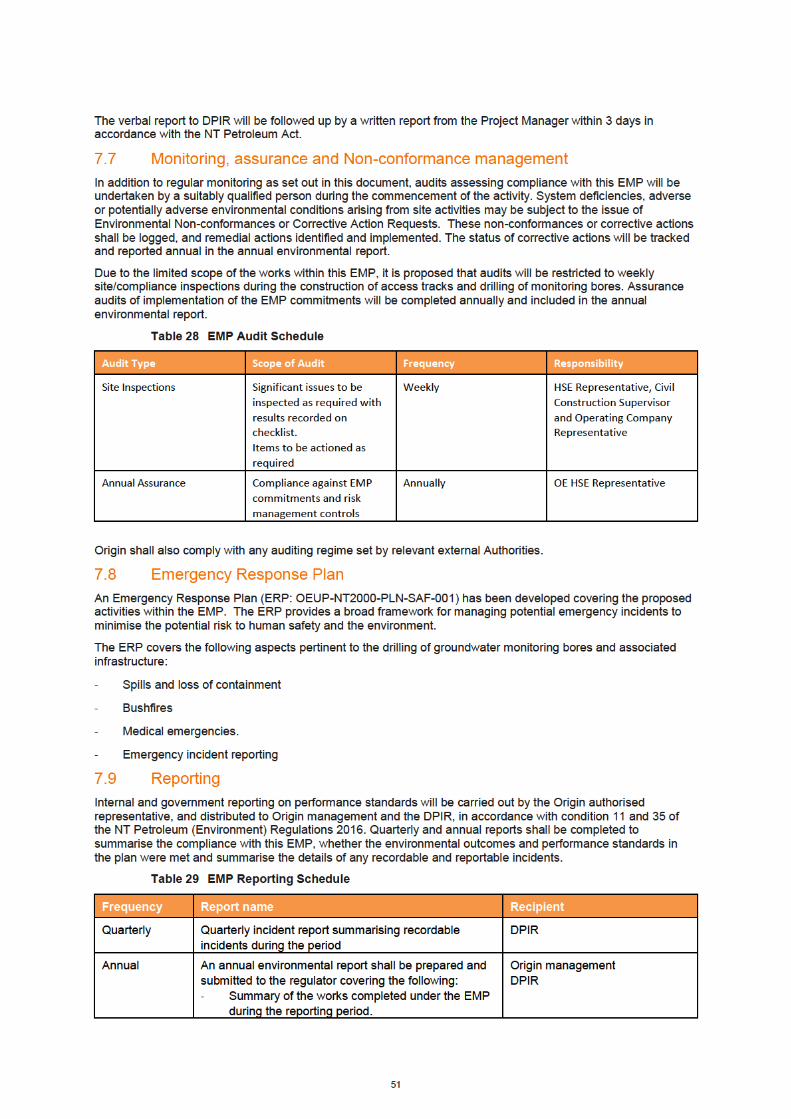


53
7.12 EMP Review
Implementation of this EMP will be continually monitored and revised as required based on monitoring and audit results, complaints, employee and stakeholder feedback, change to the proposed work program or a material increase in risk level.
A formal review, update and resubmission of this EMP will be undertaken every 5 years.
54
8. References
AECOM. 2011. Archaeological Assessment – Drill Sites and Access Roads, unpublished for Falcon Oil and Gas Australia.
AECOM. 2012a. EP99 Archaeological Survey, Beetaloo Basin, unpublished report for Falcon Oil and Gas Australia.
AECOM. 2012b. Interim Report Archaeological Surveys 2011, unpublished report for Hess Australia (Beetaloo) Pty Limited
AECOM. 2013. Environmental Closeout Survey, Sweetpea Seismic Survey 2006, Prepared by AECOM for submission to DME, Darwin, NT.
Aldrick JM and Wilson PL. 1990. Land systems of the Southern Gulf Region, Northern Territory, Technical Report No. 42, Conservation Commission of the Northern Territory, Palmerston, NT.
Aumann, T. and Baker-Gabb D. 1991. RAOU Report 75. A Management Plan for the Red Goshawk. RAOU. Royal Australasian Ornithologists Union, Melbourne.
Australian Natural Resources Atlas (ANRA), 2008. Rangelands 2008 Taking the Pulse- Sturt Plateau Bioregion.
Australian Petroleum Production and Exploration Association Limited (APPEA). 2008. Code of Environmental Practice, Canberra, ACT.
Barkly Regional Council, 2018, The Region, website accessed 18 September 2018, https://www.barkly.nt.gov.au/region/demographics
Barrett, G., Silcocks, A., Barry, S., Cunningham, R., and Poulter, R. 2003. The New Atlas of Australian Birds. Royal Australasian Ornithologists Union, Melbourne.
Barkly Regional Council, 2018, The Region, website accessed 18 September 2018, https://www.barkly.nt.gov.au/region/demographics
Commonwealth of Australia. 2001. Australian Native Vegetation Assessment 2001, Land and Water Australia, Canberra.
Christian CS, Noakes LC, Perry RA, Slatyer RO, Stewart GA and Traves DM. 1951. Survey of the Barkly Region, Northern Territory and Queensland, 1947-48, Land Research Series No. 3, CSIRO, Melbourne, SA.
Churchill, S. 2008. Australian Bats. Second edition. Jacana Books, Crow’s Nest.
CloudGMS, 2015. Beetaloo Basin Hydrogeological Assessment. Prepared by S. Fulton and A. Knapton, February 2015.
Cogger, H.G. (2000). Reptiles and Amphibians of Australia - 6th edition. Sydney, NSW: Reed New Holland.
Cole, J. and Woinarski, J. 2002. Field Guide to the Rodents and Dasyurids of the Northern Territory. Surrey Beatty and Sons, Chipping Norton, NSW.
Cooney, S.J.N. (2009). Ecological associations of the hooded parrot (Psephotus dissimilis). Ph.D. Thesis, Australian National University.
Curtis, Lee K., A. J. Dennis, K. R. McDonald, P. M. Kyne, and Debus S.J.S., Eds. (2012). Queensland’s Threatened Animals. CSIRO Publishing, Collingswood.
Debus, S. (2012). Birds of prey of Australia, 2nd edition. CSIRO Publishing, Collingwood.
Department of the Environment (2014). Tyto novaehollandiae kimberli in Species Profile and Threats Database, Department of the Environment, Canberra. Available from: http://www.environment.gov.au/sprat. Accessed Wed, 10 Sep 2014.
Department of the Environment (2014). Dasyurus hallucatus in Species Profile and Threats Database, Department of the Environment, Canberra. Available from: http://www.environment.gov.au/sprat. Accessed Wed, 10 Sep 2014.
Department of the Environment and Energy. 2018. Key threatening processes under the EPBC Act. http://www.environment.gov.au/biodiversity/threatened/key-threatening-processes, accessed14 September 2018.
Department of Environment and Natural Resource. 2018. Daly Roper Beetaloo Water Control District, Northern Territory Government, Darwin, NT.
Department of Natural Resources, Environment, The Arts and Sport (NRETAS) 2010. Land Clearing Guidelines. Northern Territory Government.

55
Department of Environment and Natural Resource (DENR). 2018a. Listing of “Threatened Animals”, “Plants” and “Weeds”, accessed August and September 2018. https://nt.gov.au/environment/animals/threatened-animals,
Department of Environment and Natural Resource (DENR). 2018b. Northern Territory Stream Order, Strahler stream orders over the Northern Territory, topographic scale data 250k, Spatial Data and Mapping Branch, Water Resources Division, Northern Territory Government, Darwin, NT.
Department of Land Resource Management. 2015. Barkly Regional Weed Management Plan 2015 - 2020.
Department of Land Resource Management and Charles Darwin University. 2018, Guidelines for the Management of the Weeds of Beetaloo 2018.
Department of Primary Industry and Resources. 2016. Partheneum found in the NT. https://dpir.nt.gov.au/news/2016/december/parthenium-found-in-the-nt accessed 14 September 2018.
Department of Natural Resources and Environment. 2018. Weed Management Planning Guide - Onshore Shale Gas Development Projects.
Dickman C.R. 2009. House cats as predators in the Australian environment: impacts and management. Human-Wildlife Conflicts 3:41-48.
Dickman, C. R. 1996. Impact of exotic generalist predators on the native fauna of Australia. Wildlife Biology 2(3):185-195.
Dostine, P.L., and Franklin, D.C. 2002. A comparison of the diet of three finch species in the Yinberrie Hills area, Northern Territory. Emu 102:159-164.
Environment Australia. 1998. Best Practice Environmental Management in Mining - Dust Control, Canberra, ACT.
Environmental Protection Agency. 1995. Best Practice Environmental Management in Mining - Environmental Impact Assessment, Canberra, ACT.
Environment Australia. 1997. Best Practice Environmental Management in Mining - Hazardous Materials Management, Storage and Disposal, Canberra, ACT.
Environment Australia. 1998. Best Practice Environmental Management in Mining - Landform Design for Rehabilitation, Canberra, ACT.
Environment Australia. 1998. Best Practice Environmental Management in Mining - Noise, Vibration and Airblast Control, Canberra, ACT.
Environmental Protection Agency. 1996. Best Practice Environmental Management in Mining - Onshore Minerals and Petroleum Exploration, Canberra, ACT.
Faulks JJ, 2001. Roper River Catchment - An Assessment of the Physical and Ecological Condition of the Roper River and its Major Tributaries, Technical Report No. 36/2001. Natural Resources Division, Department of Lands, Planning and Environment, Katherine, NT.
Fisher, A. and Woinarski, J. 1994. Golden Bandicoot. Australian Natural History 26, 20-21.
Fisher A. 2001. Biogeography and Conservation of Mitchell Grasslands in Northern Australia, PhD Thesis, Faculty of Science, Information Technology and Education, Northern Territory University, Darwin, NT.
Fisher, A., Baker, B., Woinarski, J. 2002 Biodiversity Audit – Bioregional Summaries, Compilation of individual summaries for the National Land and Water Audit, Parks and Wildlife Service, NT.
Fitzsimons, P., Bond, M., and Webber, S. 2010. Creating a participatory adaptive capacity index for climate change adaptation - Report of engagement process in the South-West of Victoria. Department of Primary Industries Victoria (in press)
Fleming MR, Johnson KA, Latz PK and McKean JR. 1983. A Biological Survey of Junction Stock Reserve and Newcastle Waters Pastoral Lease on The Barkly Tablelands, Wildlife Research Section, Conservation Commission of the NT.
Garnett, S., J. Szabo & G. Dutson. 2011. The Action Plan for Australian Birds 2010. CSIRO Publishing.
Groves RH and Williams OB. 1981. Natural grasslands. In Groves RH, (ed.) Australian Vegetation, pp. 293-316. Cambridge University Press, Melbourne.
Heritage Surveys. 1999. Additional archaeological assessments, Daly Waters to McArthur River Gas Pipeline, Northern Territory, unpublished report to Northern Territory Power and Water Authority.
Hermes, M. 1986. Amadeus Basin to Darwin Natural Gas Pipeline – Spread 2: Internal report on archaeological findings, unpublished report to Museums and Art Galleries of the Northern Territory.
56
Higgins, P.J. & S.J.J.F. Davies, eds. 1996. Handbook of Australian, New Zealand and Antarctic Birds. Volume Three - Snipe to Pigeons. Melbourne, Victoria: Oxford University Press.
Hirano, T., M. Kiyota, et al. 1995. “Physical effects of dust on leaf physiology of cucumber and kidney bean plants.” Environmental Pollution. vol. 89, no. 3, pp. 255-261.
HLA-Envirosciences Pty Ltd (HLA), 2005. Environmental Management Plan: Onshore Petroleum Exploration Beetaloo Basin, NT. Report prepared for Sweetpea Petroleum Pty Ltd.
HLA, 2006a. An Analysis of Available Water Quality Data and Gap Analysis for Beetaloo Basin, Northern Territory. Report prepared for Sweetpea Petroleum Pty Ltd.
HLA, 2006b. Surface Water Quality Investigation, Beetaloo Basin, Northern Territory. Report prepared for Sweetpea Petroleum Pty Ltd.
HLA, 2006c. Sweetpea Petroleum Environmental Program 2006: Baseline Vegetation Assessment. Report prepared for Sweetpea Petroleum Pty Ltd.
HLA, 2006d. Archaeological Assessment 2006 for the Sweetpea Petroleum Seismic Program, Beetaloo Basin, NT, 2006. Report prepared for Sweetpea Petroleum Pty Ltd.
HLA, 2006e. Beetaloo Basin: Cooee Hill and 80 Metre Tower Archaeological Assessment. Report prepared for Sweetpea Petroleum Pty Ltd.
HLA. 2006f. Beetaloo Basin: Yaroo, South Martyr’s Tree and Dunmarra Archaeological Assessment, unpublished report for Sweetpea Petroleum.
HLA, 2007a. Supplementary Environmental Management Plan, Drilling Program 2007, Beetaloo Basin, NT. Report prepared for Sweetpea Petroleum Pty Ltd.
HLA, 2007b. 2007 Environmental Works Progress Report 1 (March to May 2007). Letter to Sweetpea Petroleum dated 28 May 2007.
HLA, 2007c. Groundwater Monitoring Program, Sweetpea Petroleum Exploration Program, Beetaloo Basin, NT. Report prepared for Sweetpea Petroleum Pty Ltd.
HLA, 2007d. Archaeological Assessment Newcastle Waters Proposed Drilling Site for the Sweetpea Petroleum Seismic Program, Beetaloo Basin, NT, 2006. Report prepared for Sweetpea Petroleum Pty Ltd.
Land and Water Australia, 2004. Australian Water Resources Assessment. In: National Land and Water Resource Audit, 2004. Canberra, ACT.
Kerle, J.A., Foulkes, J.N., Kimber, R.G., and Papenfus, D. 1992. The decline of the brushtail possum, Trichosurus vulpecula (Kerr 1798), in arid Australia. Rangelands Journal 14, 107-127.
Land and Water Australia, 2004. Australian Water Resources Assessment. In: National Land and Water Resource Audit, 2004. Canberra, ACT.
Lloyd P., M. Sanders, T. Reis and A. Abbott. 2013. Targeted trapping surveys shed new light on the distribution and habitat characteristics of the Carpentarian pseudantechinus (Pseudantechinus mimulus), a threatened dasyurid marsupial. Australian Mammalogy. 35:220-223.
Mayes, P. J. 2006. The ecology and behaviour of Varanus mertensi (Reptilia: Varanidae). PhD Thesis. Edith Cowan University. Retrieved from http://ro.ecu.edu.au/theses/42.
Menkhorst, P. and Knight F. 2011. A Field Guide to the Mammals of Australia. Oxford University Press, Sydney.
Morcombe, M. 2000. Field guide to Australian birds. Steve Parish Publishing.
Noakes LC and Traves DM. 1951. Outline of the Geology of the Barkly Region. In: Survey of the Barkly Region, Northern Territory and Queensland, 1947-48. CSIRO Land Research Series No. 3.
North Australia Fire Information (NAFI), 2018. Fire Maps. http://www.firenorth.org.au Accessed 16 September 2018.
Northern Territory Government. 2015. NT Weed Management Handbook.
Northern Territory of Australia. 2017. Northern Territory Weed ID Deck.
Northern Territory Government. 2018. A – Z List of Weeds in the Northern Territory. https://nt.gov.au/environment/weeds/weeds-in-the-nt/A-Z-list-of-weeds-in-the-NT accessed 13 September 2018.
Northern Territory Government. 2005. Integrated Natural Resource Management Plan for the Northern Territory, Northern Territory Government.
Orr, DM. and Holmes, WE. 1984 'Mitchell Grasslands.' In G.N. Harrington, A.D. Wilson and M.D. Young (eds) Management of Australia's Rangelands, Australia, CSIRO: 241-254.

57
Palmer, C., Woinarski J., and Ward S. 2012. Threatened Species of the Northern Territory: Gouldian Finch Erythrura gouldiae. Department of Land Resource Management, Northern Territory Government.
Parks and Wildlife Commission of the NT. 2005. Bullwaddy Conservation Reserve Plan of Management, Parks and Wildlife Commission of the NT, Darwin.
Pavey, C. 2006. National Recovery Plan for the Greater Bilby Macrotis lagotis. Northern Territory Department of Natural Resources, Environment and the Arts.
Pizzey, G., Knight, F. and Pizzey, S. 2012. The Field Guide to Australian Birds. HarperCollins Publishers, Sydney.
Quaternary Archaeological Surveys. 1998. Archaeological survey of the Stuart Highway to Mataranka Homestead Optic Fibre Cable Corridor, Northern Territory, unpublished report for Telstra.
Randal MA. 1967. Groundwater in the Barkly Tableland, NT, Bulletin 91, Bureau of Mineral Resources, Geology and Geophysics, Canberra, ACT.
Ryder Scott Company (Ryder Scott), 2010. Evaluation of the Unconventional Oil Resource Potential Pertaining to Certain Acreage Interests in the Beetaloo Basin, Northern Territory, Australia. Report prepared for Falcon Oil and Gas Australia Pty Ltd.
Southgate, R. I. & Paltridge, R. 1998. Recovery of the Greater Bilby Macrotis lagotis. Final Report for Project Number 185, Nature Australia, Biodiversity Group, Endangered Species Program and Feral Pests Program.
Smith, J.G., and Phillips, B.L. 2006.Toxic tucker: the potential impact of cane toads on Australian reptiles. Pacific Conservation Biology 12:40-49.
Smith, M.A. 1986. An investigation of possible Pleistocene occupation at Lake Woods, Northern Territory, Australian Archaeology, 22:60-72.
Tennant Creek Regional Economic Development Committee, 2014, Tennant Creek and Barkly Region Strategic & Action Plan 2014-2016, endorsed 28 October 2014, Northern Territory Government, https://nt.gov.au/ data/assets/pdf file/0007/198340/tennant-creek-and-barkly-region-strategic-and-action-plan.pdf
Tickell S.J. 2003. Water Resource Mapping Barkly Tablelands, Unpublished draft report prepared by the Department of Infrastructure Planning and Environment, Darwin, NT.
Trainor, C.R. 2005. Distribution and Natural History of the Cryptic Dragon Chelosonia Brunnea: A Review of Records. Northern Territory Naturalist 18:24-44.
Ward, S.J. 2008. Habitat-use, foraging and breeding ecology of the northern shrike-tit Falcunculus frontatus whitei. Report to NHT (Department of Natural Resources, Environment, the Arts and Sport, Darwin).
Ward, S.J., Berghout, M. and Baker, B. 2009. Notes on the form and habitat of nests of the northern shrike-tit. Northern Territory Naturalist 21:54-60.
Wilson, S. And Swan, G. 2010. A Complete Guide to the Reptiles of Australia. 2010. New Holland,Sydney.
Woinarski, J.C.Z. 2004a. National Multi-species Recovery Plan for the Partridge Pigeon Geophaps smithii smithii, Crested Shrike-tit, Falcunculus frontatus whitei, Masked Owl Tyto novaehollandiae kimberli and Masked Owl Tiwi Islands Tyto novaehollandiae melvillensis 2004-2009. Northern Territory Department of Infrastructure Planning and Environment. Available http://www.environment.gov.au/biodiversity/threatened/publications/recovery/smithii-whitei-kimberli-melvillensis/index.html.
Woinarski, J.C.Z. 2004b. National Multi-species Recovery Plan for the Carpentarian Antechinus Pseudantechinus mimulus, Butler's Dunnart Sminthopsis butleri and Northern Hopping-mouse Notomys aquilo, 2004 - 2009. . Northern Territory Department of Infrastructure Planning and Environment.
Woinarski J.C.Z., Pavey C., Kerrigan R., Cowie I. & Ward S. 2007. Lost from our Landscape: Threatened Species of the Northern Territory. Palmerston: Department of Natural Resources, Environment and the Arts.
Woinarski, J.C.Z. and Tidemann, S.C., 1991. The bird fauna of a deciduous woodland in the wet-dry tropics of northern Australia. Wildlife Research 18: 479-500.
Woinarski, J.C.Z and Ward, S. 2012. Threatened Species of the Northern Territory: Crested Shrike-tit Falcunculus (frontatus) whitei. Department of Land Resource Management, Northern Territory Government.