environmental impact assessment ban: sasec chittagong – cox's
TRANSCRIPT

Environmental Impact Assessment May 2016
BAN: SASEC Chittagong – Cox’s Bazar Railway Project, Phase I Prepared by Ministry of Railways, Government of the People’s Republic of Bangladesh for the Asian Development Bank

CURRENCY EQUIVALENTS (as of 30 March 2016)
Currency unit – Bangladesh Taka (BDT) BDT 1.00 = $ 0.12
$1.00 = BDT 78.85
WEIGHTS AND MEASURES 1 ha – 2.47 acre 1 ha – 10,000 sq. m 1 acre – 100 decimal
ACRONYMS AND DEFINITIONS
Term Unit Definition
As mg/l Arsenic BADC Bangladesh Agricultural Development Corporation BD Bangladesh BIWTA Bangladesh Inland Water Transport Authority BNBC Bangladesh National Building Code BOQ Bill of Quantities BR Bangladesh Railway BUET Bangladesh University of Engineering and Technology BWDB Bangladesh Water Development Board CBTA Capacity Building Technical Assistance ( ADB funding mechanism) CITES Convention on Trade in Endangered Species CO mg/l Carbon Monoxide CPRs Community Property Resources CROW Construction Right of Way (nominally 50 m, i.e., 25 m per side) CWLR Continuous long welded rail CWS Chunati Wildlife Sanctuary dd/mm/yy Notation to be used at all times decimel Bangla Unit of Land Equalling 40.46 m2 DC Deputy Commissioner DG Director General DO mg/l Dissolved Oxygen DoE Department of Environment DoF Department of Forest DPHE Department of Public Health Engineering ECA Environmental Conservation Act ECR Environmental Conservation Rules EIA Environmental Impact Assessment EIB European Investment Bank EMoT Environmental Monitoring Table EMP Engineer
Environmental Management Plan The construction supervision consultant/engineer
EPAS Environmental Parameter Air Sampler EQS Environmental Quality Standards ESSU Environmental and Social Safeguards Unit FD Forest Department Fe mg/l Iron FGD Focus Group Discussion

FWS Fasiakhali Wildlife Sanctuary GHG Greenhouse Gases GM General Manager GoB Government of Bangladesh GPS Global Positioning System GRC Grievance Redress Committee GRM Grievance Redress Mechanism GW Ground Water h hour ha Hectare IC Inter-City ICTPs International Conventions, Treaties and Protocols IEE Initial Environmental Examination IESR IoL
Initial Environmental Scoping Report Inventory of Losses (a Resettlement Plan task)
IUCN International Union for Conservation and Nature Khadi rough textures of the spun cotton km Kilometre km/h kilometre per hour LGED Local Government Engineering Department Mn mg/l Manganese msl Mean sea level NE NA North East NEMAP National Environmental Management Action Plan NGO Non-Government Organisation NM Noise Measurement NO mg/l Nitric Oxide NO2 mg/l Nitrogen Dioxide O3 mg/l Ozone PAPs Project Affected Persons PC Public Consultation PCRs Physical and Cultural Resources PM10 mg/l Particulate Matter (less than or equal to 10 microns) PM2.5 mg/l Particulate Matter (less than or equal to 2.5 microns) PPTA Psgr or pax
Project Preparation Technical Assistance Passenger
PWD Public Works Department Q/A Questions and Answers QS Questionnaire Survey RCC Roller Compacted Concrete RCI Regional Cooperation and Integration RCIP Regional Cooperation and Integration Project RH Relative Humidity RHD Roads and Highway Department RHFL Recorded Highest Flood Level RLFL Recorded lowest Flood Level RoW Right of Way RTW River Training Works S mg/l Sulphur SAARC South Asia Association of Regional Cooperation

SHWL Standard High Water Level SO2 mg/l Sulphur Dioxide SPS Safeguards Policy Statement SRDI Soil Resource Development Institute SW TEUS
Surface Water Twenty-Foot –Equivalent Units (measure of ship’s cargo capacity- 39m3
TDS Total Dissolved Solids TIC Thermal Imaging Camera System TOC mg/l Total Organic Carbon ToR Terms of References TSS mg/l Total Suspended Solid UNESCAP United Nations Economic & Social Commission for Asia & Pacific UNO Upazila Nirbahi Officer UP Union Parishad Upazila An administrative unit equalling a district USD United States Dollar USEPA US Environmental Protection Agency VOC Volatile Organic Compound WQ Water Quality
NOTE
In this report, "$" refers to US dollars. The “Construction Supervision Consultant” and “Engineer” terms are used interchangeably
throughout this report, since this is the terminology used in the construction contract documents.
This Project, Subproject 4, is one of seven subprojects being investigated under the RCIP-Rail Component. It shall be referred to herein as the Project
This environmental impact assessment is a document of the borrower. The views expressed herein do not necessarily represent those of ADB's Board of Directors, Management, or staff, and may be preliminary in nature. Your attention is directed to the “terms of use” section of this website. In preparing any country program or strategy, financing any project, or by making any designation of or reference to a particular territory or geographic area in this document, the Asian Development Bank does not intend to make any judgments as to the legal or other status of any territory or area.

CONTENTS EXECUTIVE SUMMARY ............................................................................................................ I I. INTRODUCTION ............................................................................................................. 1
A. Background .......................................................................................................................... 1 B. Need for Project ................................................................................................................... 1 C. Scope of Environmental Assessment .............................................................................. 5 D. Objectives of the EIA .......................................................................................................... 5 E. Methodology ......................................................................................................................... 5 F. Environmental Classification of Project .......................................................................... 10 G. Organisation of Report...................................................................................................... 10
II. POLICY, LEGAL, AND ADMINISTRATIVE FRAMEWORK ...........................................11 A. Bangladesh ........................................................................................................... 11 B. Relevant International Conventions, Treaties and Protocols (ICTPs) .................... 16 C. GoB Environmental Clearance and Public Consultation Procedure ...................... 16 D. ADB Safeguard Policy .......................................................................................... 18
III. DESCRIPTION OF THE PROJECT ...............................................................................20 A. General ................................................................................................................. 20 B. Project Boundaries and Design ............................................................................. 20 C. Project Design ...................................................................................................... 22 D. Social and Resettlement Considerations............................................................... 28 E. Project Implementation Schedule.......................................................................... 28
IV. DESCRIPTION OF THE ENVIRONMENT ......................................................................29 A. Biophysical Environment ....................................................................................... 29 B. Social Environment ............................................................................................... 72 C. The Large Bridges >100 m ................................................................................... 73
V. ANALYSIS OF ALTERNATIVES ...................................................................................76 A. Alternatives to the Project ..................................................................................... 76 B. The Alternative Alignments ................................................................................... 76 C. Conclusions .......................................................................................................... 87
VI. IMPACTS AND MITIGATIVE MEASURES ....................................................................88 A. Pre-Construction Period ........................................................................................ 88 B. Construction Period Impacts and Proposed Mitigation ........................................ 103 C. Operating Period ................................................................................................. 127 D. Summary of Potential Impacts ............................................................................ 149 E. Environmental Benefits and Enhancements ........................................................ 150
VII. GRIEVANCE REDRESS MECHANISM ....................................................................... 152 A. Introduction ......................................................................................................... 152 B. The Grievance Redress Committee .................................................................... 152 C. Steps to a Solution .............................................................................................. 153 D. Publicising the Grievance Redress Steps and the Committee ............................. 153 E. Construction Workers Grievance ........................................................................ 154
VIII. INFORMATION DISCLOSURE, CONSULTATION, AND PUBLIC PARTICIPATION .. 156 A. General ............................................................................................................... 156 B. Stakeholder Identification Process ...................................................................... 156 C. Public Consultation Locations and Approach ...................................................... 157 D. Information Provided ........................................................................................... 158 E. Consultation Outcomes ....................................................................................... 164 F. Follow-Up Programme ........................................................................................ 165 G. Consultation with Wildlife NGOs ......................................................................... 168 H. Consultation with Forestry Department ............................................................... 168
IX. THE ENVIRONMENTAL MANAGEMENT PLAN AND COSTS ................................... 170

A. Environmental Management Plan ....................................................................... 170 B. EMP Implementation Costs................................................................................. 205
X. INSTITUTIONALINSTUTIONAL CAPACITY, NEEDS AND PROPOSED STRENGTHENING ................................................................................................................. 210
A. The Existing Conditions ...................................................................................... 210 B. BR’s Environmental and Social Safeguards Unit (ESSU) .................................... 210 C. Involvement of Local Government in Environmental Issues ................................ 213
XI. IMPLEMENTATION ARRANGEMENTS ...................................................................... 214 A. General ............................................................................................................... 214 B. Environmental Requirements and Implementation .............................................. 214 C. Roles and Responsibilities .................................................................................. 215 D. Reporting ............................................................................................................ 222
XII. CONCLUSIONS AND RECOMMENDATIONS ............................................................ 224 REFERENCES ....................................................................................................................... 227 ANNEXURES Annex 1: DoE Approved Terms of Reference for EIA .............................................................. 229 Annex 2: Land Use Strip Map Including Locations of Environmental Sampling and Public Consultations .......................................................................................................................... 231 Annex 3: Calibration Certificate of EPAS Air Quality Sampling Device .................................... 236 Annex 4: Raw Dataset of Air Quality, Noise Measurement, and SW & GW Quality ................. 238 Annex 5: Public Consultation Materials and Records .............................................................. 282 Annex 6: National Legal Instruments Related to the Project .................................................... 326 Annex 7: Indicative Construction Programme of the Project .................................................... 329 Annex 8: Draft Environmental Clauses (Specifications) Found in the Bid Documentation ...... 330 Annex 9: Tree Plantation and Replacement Programme ......................................................... 353 Annex 10: Elephant Route Identification Study for Construction of Single Line Meter Gauge Railway Track from Dohazari to Cox’s Bazar via Ramu and Ramu to Gundum by IUCN ........ 357 Annex 11: Camera-Based Detection Options for Preventing Elephant-Train Collisions on the Proposed Dohazari-Gundum Rail Line, Bangladesh ............................................................... 421 Annex 12: Possible Mitigative Measures at Five Active Elephant Crossings ........................... 457 Annex 13: Request Letter to Local Government for Arrangement of Public Consultation Meeting ............................................................................................................................................... 469 Annex 14: Compliance Monitoring Checklist Template ............................................................ 481 Annex 15: Typical Plan and Profile of Rail Embankment, Track Cross Section and Station Plan ............................................................................................................................................... 489 Annex 16: Climate Risk Assessment ....................................................................................... 500 LIST OF TABLES Table 1: Pasquill-Gifford Air Dispersion Stability Classes and Associated Dispersion Exponents7 Table 2: Meteorological Conditions Used to Define the Stability Classes ................................... 7 Table 3: International Conventions, Treaties and Protocols Signed by Bangladesh ..................16 Table 4: Seven Subprojects of RCI-Rail Component Included in the Scope of PPTA ................20 Table 5: Environmental Impact Assessment Boundaries ...........................................................21 Table 6: Description of the Alignment ........................................................................................22 Table 7: Estimated Earthwork Quantities: Dohazari-Cox’s Bazar, Via Ramu .............................23 Table 8: New Rail Stations and Access Roads: Dohazari to Cox’s Bazar ..................................25 Table 9: Freeboard Provide Based on Various Flood Return Periods .......................................27 Table 10: Navigation Clearance Requirement ...........................................................................27 Table 11: Lands, Households and People Affected ...................................................................28 Table 12: Existing Air Quality along Project Corridor (24 hour average), June 2013 ..................34

Table 13: Existing Air Quality along Project Corridor (January 2014) ........................................35 Table 14: Noise Level within 100 m of Existing RoW of the Project (June 2013) .......................35 Table 15: Noise Level within 100 m of Existing RoW of Project (January 2014) ........................36 Table 16: Summary of Results of Hydrological Analysis ............................................................40 Table 17: Surface Water Quality in Pre-Monsoon Season ........................................................41 Table 18: Surface Water Quality in Post-Monsoon Season .......................................................41 Table 19: Groundwater Quality within the RoW of the Project ...................................................42 Table 20: Active and Seasonal Elephant Crossing Points: Dohazari to Cox’s Bazar and Ramu to Line Rail Alignment ...................................................................................................................53 Table 21: Active Elephant Crossing Point 1 - Chunati, Site Conditions and Observations .........59 Table 22: Active Elephant Crossing Point 2 - Phulchari, Site Conditions and Elephant Observations .............................................................................................................................61 Table 23: Active Elephant Crossing Point 3 - Phulchari, Site Conditions and Observations ......63 Table 24: Active Elephant Crossing Point 4 - Chiringa, Site Conditions and Elephant Observations .............................................................................................................................65 Table 25: Active Elephant Crossing Point 5 - Dulahazara, Site Conditions and Observations ...67 Table 26: List of Species in Bangladesh, potentially found in the Project Corridor, from IUCN Bangladesh Redbooks (2000) ...................................................................................................71 Table 27: Number of Community Property Resources (CPRs) by Category ..............................73 Table 28: Comparison of West versus East Alignment Chunati WS Km 22-36 ..........................78 Table 29: Project Environmental Screening and Categorisation Checklist .................................81 Table 30: Comparison of Technical Solution and Capital Cost of Overpasses at Five Active Elephant Crossings ...................................................................................................................91 Table 31: Location of Underpass and Overpass In Relation to Topography, and Safe Level Crossing Locations Using the TIC System ................................................................................92 Table 32: Operating parameters of thermal imaging camera at five crossing structures ............94 Table 33: Land and Fixed Assets Impacted ..............................................................................97 Table 34: Types of Losses by Number of Affected Households and Businesses .......................98 Table 35: Noise Rating of Embankment Formation Equipment ............................................... 114 Table 36: Noise rating for station construction activities and equipment .................................. 115 Table 37: Total Number of Trees Affected on Government and Private Land .......................... 119 Table 38: Land Requirements for Elephant Overpasses and Five Active ................................ 121 Table 39: Emission Factors and Estimated Fuel Consumption of Locomotives Operating on the Dohazari-Cox’s Bazar New Line (including the Dhaka-Cox’s Bazar Tourist Trains) ................ 128 Table 40: Diverted Train Passenger Kilometres and Resulting Reduction Air Pollutant ........... 130 Table 41: Average distances from trackside at which four noise levels (no attenuation applied) were estimated for train operations during four periods ........................................................... 133 Table 42: Distribution of Receptors Exposed to Noise Level Greater than 50dB(A). ............... 134 Table 43: Computation of Shielding: Rows of Buildings and Dense Trees .............................. 135 Table 44: Transit Noise Mitigation Measures .......................................................................... 138 Table 45: Assessment of Predicted Noise Levels, Unmitigated and Mitigated Against World Bank EHS Guide Values ......................................................................................................... 139 Table 46: Extreme recorded temperature, 0C, (1967-1981) .................................................... 147 Table 47: Recorded Extreme Water Levels at Three Rivers Crossed by the Rail Line ............ 148 Table 48: Climate Adaptation Costs ........................................................................................ 149 Table 49: Stakeholders Identified ............................................................................................ 157 Table 50: Summary of Public Hearing Issues and Proponent’s Response .............................. 160 Table 51: Stakeholder Attendance (Male/Female) in Project Disclosure Consultations ........... 164 Table 52: Stakeholder Attendance in EMP Disclosure Meetings ............................................. 165 Table 53: Addressing Key Stakeholder Concerns ................................................................... 166 Table 54: Environmental Management Plan ............................................................................ 177

Table 55: Environmental Management Plan for Bridge Sites: Mitigative Measure ................... 201 Table 56: Environmental Management Plan for Bridge Sites: Monitoring Measure ................. 203 Table 57: Cost Estimate of the EMP Implementation .............................................................. 206 Table 58: Action Plan – Establishing an ESSU........................................................................ 211 Table 59: Cost of Establishment and Operation of ESSU for Seven Years (BTK) ................... 211 LIST OF FIGURES Figure 1: RCI Rail Project – Location of Seven Subprojects (Note, this EIA addresses only the Dohazari-Cox’s Bazar Section) .................................................................................................. 3 Figure 2: Proposed Location, Alignment and Rail Stations of the Project ................................... 4 Figure 3: Government of Bangladesh Environmental Assessment Process ..............................17 Figure 4: Example of 2-Celled Box Culvert ................................................................................26 Figure 5: Typical Cross-Section for a Large Bridge ...................................................................26 Figure 6: Monthly Average Maximum, Minimum and Mean Temperatures at Cox’s Bazar Project Site from 2008 to 2012 ..............................................................................................................29 Figure 7: Average Monthly Rainfall along Project Corridor ........................................................30 Figure 8: Monthly Average Wind Speed Along the Alignment ...................................................30 Figure 9: Cyclones Tracking over Bangladesh, 1902–1990 Source: Bangla .............................37 Figure 10: Graphic of Potential Impact of Sea level Rise for Bangladesh ..................................38 Figure 11: Potential Impact of Sea Level Rise on Bangladesh (Ainun Nishat, 2008, .................39 Figure 12: Current Distribution of Elephant in Bangladesh (from Islam, 2011)...........................47 Figure 13: Chunati Wildlife Sanctuary and Existing National Highway and Proposed Rail Alignment ..................................................................................................................................50 Figure 14: Fasiakhali Wildlife Sanctuary Boundary, the National Highway and Proposed Alignment ..................................................................................................................................51 Figure 15: Active Elephant Crossings, March–April 2014 (the last two southern sites are not included in this EIA) ..................................................................................................................56 Figure 16: Active Elephant Crossing Point 1 - Chunati ..............................................................58 Figure 17: Active Elephant Crossing Point 2 – Pulchari .............................................................60 Figure 18: Active Elephant Crossing Point 3 - Pulchari 2 ..........................................................62 Figure 19: Active Elephant Crossing Point 4 – Chiringa ............................................................64 Figure 20: Active Elephant Crossing Point 5 – Dulahazara .......................................................66 Figure 21: Seasonal Elephant Crossing Points, March 2014 (the last three southern sites are not a part of this EIA) ................................................................................................................69 Figure 22: Main travel routes of the Asian elephant in southern Bangladesh ............................70 Figure 23: Brick Field and Tree Nursery, in Relation to the Rail alignment (preferred shown in Green) ......................................................................................................................................78 Figure 24: Google images (2015) showing land use between Km 22 and 30 ............................79 Figure 25: Memorial Christian Hospital Alternative Alignments (Red is Preferred Alignment) ....80 Figure 26: Medhakachapia National Park Boundary .Landuse and Rail Alignment ( from Forest Department Map, 2016) ............................................................................................................85 Figure 27: Details of Alignment Crossing through Medhakatchhapia National Park ..................86 Figure 28: Sangu River Bridge Proposed Site ......................................................................... 107 Figure 29: Matamuhuri River Bridge Proposed Site ................................................................ 108 Figure 30: Matamuhuri Distributary River Bridge Proposed Site ............................................. 109 Figure 31: Igdaon Chara Bridge Proposed Site ....................................................................... 110 Figure 32: Igdaon River Proposed Bride Site .......................................................................... 111 Figure 33: Location of Noise Sensitive Receptors in Sangu River ........................................... 112 Figure 34: Predicted Noise Levels During Pile Driving, Sangu River Bridge ............................ 114 Figure 35: Typical Equipment Used in Railway Embankment Formation ................................. 115 Figure 36: Computing for Ground Factor for G Ground Attenuation ........................................ 116
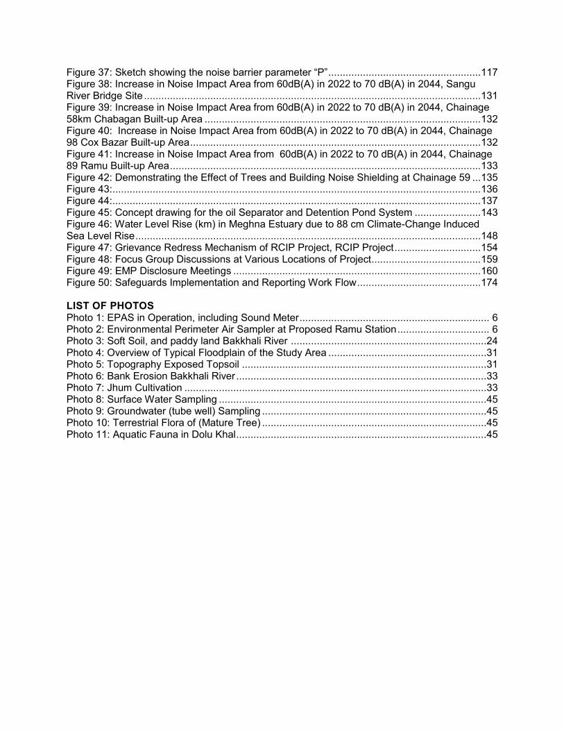
Figure 37: Sketch showing the noise barrier parameter “P” ..................................................... 117 Figure 38: Increase in Noise Impact Area from 60dB(A) in 2022 to 70 dB(A) in 2044, Sangu River Bridge Site ..................................................................................................................... 131 Figure 39: Increase in Noise Impact Area from 60dB(A) in 2022 to 70 dB(A) in 2044, Chainage 58km Chabagan Built-up Area ................................................................................................ 132 Figure 40: Increase in Noise Impact Area from 60dB(A) in 2022 to 70 dB(A) in 2044, Chainage 98 Cox Bazar Built-up Area ..................................................................................................... 132 Figure 41: Increase in Noise Impact Area from 60dB(A) in 2022 to 70 dB(A) in 2044, Chainage 89 Ramu Built-up Area ............................................................................................................ 133 Figure 42: Demonstrating the Effect of Trees and Building Noise Shielding at Chainage 59 ... 135 Figure 43: ................................................................................................................................ 136 Figure 44: ................................................................................................................................ 137 Figure 45: Concept drawing for the oil Separator and Detention Pond System ....................... 143 Figure 46: Water Level Rise (km) in Meghna Estuary due to 88 cm Climate-Change Induced Sea Level Rise ........................................................................................................................ 148 Figure 47: Grievance Redress Mechanism of RCIP Project, RCIP Project .............................. 154 Figure 48: Focus Group Discussions at Various Locations of Project ...................................... 159 Figure 49: EMP Disclosure Meetings ...................................................................................... 160 Figure 50: Safeguards Implementation and Reporting Work Flow ........................................... 174 LIST OF PHOTOS Photo 1: EPAS in Operation, including Sound Meter .................................................................. 6 Photo 2: Environmental Perimeter Air Sampler at Proposed Ramu Station ................................ 6 Photo 3: Soft Soil, and paddy land Bakkhali River ....................................................................24 Photo 4: Overview of Typical Floodplain of the Study Area .......................................................31 Photo 5: Topography Exposed Topsoil .....................................................................................31 Photo 6: Bank Erosion Bakkhali River .......................................................................................33 Photo 7: Jhum Cultivation .........................................................................................................33 Photo 8: Surface Water Sampling .............................................................................................45 Photo 9: Groundwater (tube well) Sampling ..............................................................................45 Photo 10: Terrestrial Flora of (Mature Tree) ..............................................................................45 Photo 11: Aquatic Fauna in Dolu Khal .......................................................................................45


i
EXECUTIVE SUMMARY
1. Bangladesh Railway has identified seven investment subprojects for sub-regional and Trans-Asian Railway (TAR) connectivity for improving rail connectivity among the South Asian and other Asian countries with Bangladesh. The subproject for which this Environmental Impact Assessment (EIA) has been prepared is Subproject 4: Construction of greenfield Single Line Dual Gauge Railway Track from Dohazari to Cox’s Bazar via Ramu herein referred to as the Project, for a total of about 102 Km. This work will also include eight new stations, one fully rebuilt station, their access roads and 95 level crossings, and possibly up to five elephant crossing structures. 2. The total length of the proposed single line is approximately 102 km, passing through eight upazilas in the Chittagong Division. The start of the Project is approximately 46 km south of Chittagong at Dohazari and extends south to Cox’s Bazar. The project alignment runs parallel to the N1 highway for most of its length. 3. This Project was classified as Category Red by the Department of Environment (DoE) requiring a full EIA and category A by the Asian Development Bank (ADB) also requiring a full EIA. Hence, the preparation of this EIA report. 4. The construction of the proposed Project, which will take about five years to complete and involve around 3,500 workers, 60% of whom are to be deployed from 8-10 work camps. The rest will live in local communities. The waste generated by camp residents (at least 2,100 people) will have to be carefully managed. DoE who will give the contractor building permits to build camps will regulate proximity to water bodies. The Environmental Management Plan (EMP) contains specific instructions on waste management that the contractor will need to comply with. 5. The Project will lead to permanent environmental changes to the area’s topography, surface drainage pattern, air quality, noise conditions, and will establish a land barrier across which local farmers, wildlife and livestock will have to become accustomed to. To make way for the railway alignment, the Project is expected to affect over 2000 households and will require about 536 ha of private land, impact 1,118 vulnerable households and require the removal of about 239,000 trees. To address these issues a detailed Resettlement Plan has been prepared, as well as a tree replanting plan, provided as Annex 9 in this EIA. 6. A total of 177 water crossings (bridges and culverts) need to be constructed between Dohazari and Cox’s Bazar. Six are more than 100 m in length (three of those have >240 m length). The other 33 bridges are all <100 m in length. Another 137 structures are concrete box culverts of various lengths and widths for drainage. Dual gauge single track design will be used for the initial formation boundaries although the land will be acquired so that one broad gauge track can be added at a later stage without further land acquisition. The track structure will be ballasted track throughout the line. 7. The construction of the new railway track will require the movement of 13.69 million m3 material. Of that more than 8.8 million m3 will be embankment, most of it dredged from local river channels and deposited at locations within or directly beside the alignment, thus minimising the truck haul distances. The concrete work will require more than 0.11 million m3 of aggregate and many thousands of litres of water to be obtained from carefully metered and permitted tube wells, opened by the contractor in consultation with local officials and the Ministry of Water Resources.

ii
8. The construction will generate very significant, albeit short distance, truck traffic which will be managed via a haul route plan defining where and during what time trucks will be able to use the road network, as well as a programme of truck inspection for air pollution and noise emissions. All haul roads will have a dust suppression programme, including watering and clearing of debris dropped by the trucks. All trucks will be equipped with covers to prevent dust blowing from the materials being transported. 9. Potential negative impacts were identified in relation to design, construction, and operation period activities. Mitigation measures were specified to prevent or reduce all negative impacts to acceptable levels. These results were presented in the Environmental Management Plan (Section IX). The EMP includes a description of when, where and by whom the mitigative action and the monitoring follow-up will be completed. 10. Most of the pre-construction and operating period measures will be implemented by BR, while the construction period measures will be the contractor’s responsibility and enforced by the Construction Supervision Consultant (CSC), also referred as the Engineer and overseen by BR. The construction period section of the EMP has been integrated into the construction contract as a set of environmental clauses and costed as a separate Bill of Quantities section, allowing for easy calculation of financial penalties. 11. Twenty-seven construction stage impacts were identified and addressed in the EIA. These include:
loss of productive agricultural lands and conservation of topsoil; impacts on low-lying areas and water bodies wherein protection measures are
required to minimise impacts on surface water drainage, constriction of existing water bodies leading to flooding and dewatering, and the loss of large areas of forest due the clearing of the right of way (RoW);
air, noise, and vibration impacts due to construction vehicles, equipment, and machinery in the vicinity of construction site and inhabited sections, in addition to dust control during construction activities;
impacts on the river courses and the water quality during the construction of the embankment;
management of spoil disposal due to the excavation, and setting of bridge piers into the river beds;
the application of adequate occupational health and safety measures during construction including traffic diversions;
management of sites temporarily used for construction activities, including borrow areas, embankment storage areas, construction camps, etc., and rehabilitation of the sites after completion of the temporary use;
impacts on community health and safety hazards posed to the public, specifically in inhabited areas;
impact due to elephant movement through construction areas as well as disruption of elephant travel routes due to construction; and
impact due to lack of awareness on elephants and poor preparation, design and construction of elephant mitigation measures and structures
12. Six large bridges will need bored pilings in river beds, and the use of drilling muds such as bentonite. Bentonite is fine clay that once released to the water body will remain in suspension for a long time, affecting the turbidity and degrading fish habitat. To avoid this, impact, a strict bentonite handling and recovery protocol involving both handling and recovery procedures and records will be defined by the contractor. The contractor will be encouraged to

iii
replace bentonite with muds available locally or substitutes available in the market. Fortunately, all but one of the large rivers is dry during the summer season between November and late April. Therefore, much of the in-river work will be conducted during this time of the year, avoiding having to deal with flowing water. In addition, the EIA contains a special section addressing impacts and mitigative measures associated with the six large bridges. 13. The contractor will be required to conduct quarterly air, water and noise quality monitoring and submit reports to the CSC and BR. The contractor’s environmental safeguard personnel will have to attend a mandatory training workshop on EMP implementation prior to/ during contractor mobilization. 14. The monitoring work will be conducted by CSC, and will focus on inspection of contractor work areas, their waste disposal sites, their rehabilitation/revegetation, proper landscaping, re-establishment of local access and debris clearance from reconstructed culverts. 15. Once the rail line is in operation, access restrictions, air quality and noise degradation in the local area and safety will become permanent negative impacts. 16. During full project operation, by 2044 the 50 dB(A) sound contour line corresponding to night time standards would extend to 171 meters from the railway centreline that will cause about 2,544 structures including 28 (1.1%) sensitive receptors to experience noise levels above the GOB standards without mitigation and shielding. With mitigation measures the impact distance decreases to less than 75 meters from the centerline and reduces the number of sensitive receptors to 23. Mitigation measures to minimize noise levels during train pass-by include rubber padding under the rail sleepers, the continuous welded rail and the use of disk or composite block brake shoes, instead of the existing braking systems, slowing of train speed at sensitive locations, restriction of train whistles. These measures will reduce noise level between 5 to 9 dB(A) and average of 6 dB(A)When compared against the already high baseline noise levels implementation of the mitigation measures will result in the noise levels being the same as baseline levels at a distance of 50 m from the rail centerline. However, this noise reduction hardly matters at a distance of 5 meters from the railway centerline. For receptors that will still experience noise levels above the WBEHS and GOB standards or an increase of more than 3dB(A) in comparison to baseline levels noise shields will be installed close to the railway to further reduce the noise level by 6-15 dB(A). 17. The Cox’s Bazar train stabling and cleaning yard, taking up around 12 ha of land will require special attention to manage contaminated wash water and the garbage from cleaning of up to 40 train interiors per day. To that end, an oil separation and wastewater detention pond system is proposed, subject to further study. During the operation phase, BR will regularly monitor the noise from the stabling operation, which will require the detaching and attaching of locomotives from the ends of trains, and will review and implement suitable mitigation measures if required. 18. To address noise and air quality changes, BR will implement a semi-annual air and noise quality monitoring programme in operating year 1, 3 and 5, with sampling taking place at the same locations as the baseline study. Air pollution issues will be addressed by the installation of catalytic converters, the use of biodiesel and the replacement of ageing locomotives with new and far less polluting ones. 19. The rail line passes through mostly the buffer and impact zone of three protected areas for a total of about 29km of its length. The three protected areas are the Chunati Wildlife

iv
Sanctuary, the Fasiakhali Wildlife Sanctuary and the Methakatchapia National Park. Consultations with the management of these protected areas have been carried out during project preparation. The Forestry officials support the project but would like the project to include proper elephant mitigation such as overpasses or underpasses. Further consultation and coordination will be held during project implementation to explore ways to support conservation activities within the protected areas. A generous budget provision of over $1.5 million has been allocated for under the afforestation program for this purpose. 20. The rail line will cross five active elephant travel routes and six seasonal routes. Three of the active crossing points fall inside CWS and 2 inside FWS. The Asian elephant (Elephas maximus) is an endangered species under the red list of the Interational Union for Conservation of Nature (IUCN) and as such BR undertook to find a practical yet robust mitigative measure to avoid impacts on this species. Based on a detailed review of options, a three different types of camera plus signalling system options to help early detection of elephant presence near the rail line will be pilot tested during the first two years of the construction period. The pilot testing period will be used to optimize and fine-tune parameters such as speed restrictions, type of cameras, portability of the cameras, line of sight, raising awareness, procedures for operation of the system, and other factors. Based on the results of the pilot programme the respective camera option will be selected and implemented during the start of train operations. In addition overpasses will be built at the active elephant crossing points. Preliminary designs, concept drawings and cost have been prepared for the overpasses and included in this EIA. Estimated cost for each overpass is about US $3 million. An elephant awareness programme will be provided to the BR staff working on the section, and elephant crossings and related signs will be erected along the line at crossing locations to alert train operators and maintenance staff. 21. Key climate change risks identified for the rail line over its design life of approximately 80 years are: increase in average temperature by 2.2C increase in rainfall and hence flooding of the rivers and overland. Sea level rise and cyclone may impact the Cox’s bazar section of the line due to its low elevation and proximity to the sea. To mitigate the climate risks the following measures have been taken: Major bridges have been designed using a 100-year storm return period and a 50-year storm return period for culverts; an additional freeboard of 100cm for the major six bridges and 60cm for minor bridges and culverts have been considered; the rail embankment height throughout the rail alignment has been increased by 100cm to accommodate climate change induced increase in water levels. The increase in embankment height has required additional land acquisition of approximately a 3m strip (1.5m on either side of the ROW). Additional costs for these measures amount to approximately $128.4 million or 7% of the civil works costs.
22. Reduction in greenhouse gas emissions (GHS) are expected from fuel savings due to diversion of traffic from road to rail. Estimates show there will be a savings of more than 10,500 tons of GHGs emissions after only 1 year of operations. This increases to more than 34,000 tons per annum by 2042.
23. A number of stakeholders were consulted during the preparation of the EIA through two seasons of consultations in six communities along the alignment. A cross section of all affected people attended the sessions and the details have been provided in Annex 5. The views expressed were incorporated into the EIA and the planning and development of the Project. The EIA contains a description of the specific actions taken by BR in response to the comments. 24. In addition to bringing economic benefits, the Project will be environment-friendly since stations will be built with environment-friendly solar panel systems, rainwater harvesting

v
systems, improved sanitation facilities and accessibility for physically challenged persons. Based on the economic and traffic forecasts, the Project will permit people wanting to travel to Cox’s Bazar to use the train instead of driving. 25. An indicative estimate of the cost for the implementation of the EMP including all items, and all provisional sums (detailed budget in EIA) will likely be US $27 million. These estimates are tentative and once more construction details are known, the EMP will need to be revised and associated costs adjusted. 26. The Environmental and Social Safeguard Unit (ESSU) under BR will oversee management of environment and social safeguards under the project. Currently the unit only has two social safeguard officers. One environment safeguard officer is currently under recruitment. The Project Management Consulants (PMC) who will be recruited to support BR will include an environment specialist to help manage environment safeguard issues under the project. 27. In addition the ADB will appoint a third party independent monitoring agency/persons, via a Capacity Building Technical Assistance (CDTA) grant to: conduct a baseline biodiversity study; provide technical guidance on the location and design of the elephant overpasses; monitor pilot testing of the Thermal Imaging Camera systems; monitor the progress of all elephant related mitigation and monitoring activities. This will be done throughout the 5 year construction period and three years of the operation stage to check the effectiveness of the mitigation and enhancement measures taken. The monitor will be appointed before the construction period begins. 28. A Grievance Redress Mechanism (GRM) will be established to receive, evaluate and facilitate the resolution of affected people’s concerns, complaints, and grievances. The GRM aims to provide a time-bound and transparent mechanism for expressing and resolving social and environmental concerns linked to the Project. 29. To conclude, the Project will generate a number of environmental impacts, most significant of all are impacts on the elephant crossings and the three protected areas. Innovative mitigation and enhancement measures have been proposed to address the significant impacts. Information sharing and coordination will be carried out by BR with the project team that is preparing the design of the N1 highway to ensure the use of a harmonized approach on environmental measures particularly on elephant mitigation. The EMP provides guidelines for the implementation of measures to prevent or mitigate all other impacts. BR is committed to implementing the EMP and has fully endorsed the EIA; the basis for the EMP. BR will ensure that the work is carried out in an environmentally acceptable manner and that the monitoring and reporting is completed in a compliant and timely fashion, acceptable to both DoE and ADB.


1
I. INTRODUCTION
A. Background
1. Bangladesh Railway (BR) has identified seven investment subprojects for improving rail connectivity between Bangladesh and its South Asian neighbours and other Asian countries. The Project, named “Construction of Single Line Dual Gauge Railway Track from Dohazari to Cox’s Bazar- Phase 1 via Ramu (totalling about 100.83 km), is one of the seven subprojects (Figure 1) of BR and the subject of this Environmental Impact Assessment (EIA). It shall be referred to hereafter as the Project. 2. The Government of Bangladesh (GoB) provided priority to the railway sector since it is considered the best land transportation option for the country. It is a safer and more environmentally sustainable mode of transport than trucks, buses or personal vehicles, and a far more cost-effective mover of bulk freight. Given Bangladesh’s congested and very limited road system1, land rail transport is no doubt the more environment-friendly mode of transport and considered the preferred solution to connecting in the country. At present there is no rail transportation service at the south of Dohazari, thus BR is undertaking extensive improvements including the construction of new rail line, rail stations, and purchase of new locomotives in the south eastern region of the country that will ultimately increase the economic activities in Bangladesh. 3. The GoB’s Sixth Five-Year Plan (2011–2015) assigned the highest priority to increasing the capacity of the Dhaka–Chittagong rail corridor and the Project is a critical missing link (Figure 1). To that end, the GoB is seeking a loan from the Asian Development Bank to complete this and six other railway improvements works. 4. The Project involves the construction of single line dual gauge railway track from Dohazari to Cox’s Bazar via Ramu covering Chandanaish, Satkania, and Lohagara Upazilas of Chittagong District; Chakaria, Cox's Bazar Sadar, Ramu and Ukhia Upazilas of Cox’s Bazar District. The proposed alignment will cross mainly crop land (59.67%), highland/hilly land (24.78%), orchard/ forest land (8.98%), homestead land (5.58%), and others (0.99%). The areas designated as reserve forest are owned mainly by the Bangladesh Forest Department (BFD). The first 29 km from Dohazari onward consist of flat-open land located in three Upazilas of Chittagong District. The next 33 km fall within the Chakaria Upazila of Cox’s Bazar District and traverse agricultural farmland and some forest land. For the next 33 km, within the Cox's Bazar Sadar and Ramu Upazilas of Cox’s Bazar District, the alignment climbs to about 400 m above sea level and passes through mostly tropical jungle and rural agricultural land. 5. In addition, eight new rail stations and access roads have been designed and their sites identified (Figure 2). No indigenous people have been identified on the alignment of the proposed railway line.
B. Need for Project
6. The Project will extend passenger rail service within Bangladesh south from Chittagong, Bangladesh’s second largest commercial centre to Cox’s Bazar and further to the Myanmar
1 Most major roads in Bangladesh now exceed their design capacity and experience massive and
frequent traffic delays, and huge cost to the economy.

2
border. Implementation of the Project will significantly benefit various sectors of the economy of Bangladesh, and will allow the operation of additional trains for sub-regional trade from Chittagong Port to Bhutan, India, Nepal, and eventually to South East Asia. 7. Dhaka is the main commercial and administrative centre of the country and Chittagong is the primary seaport; the two account for about 90% of nation’s imports and exports. More than a quarter of Bangladesh’s population of 150 million live in the Dhaka–Chittagong–Cox’s Bazar corridor. Therefore, the construction of single line dual gauge railway track from Dohazari to Cox’s Bazar via Ramu is Phase I of the larger project to build a new line from Ramu to the border with Myanmar (Phase II). 8. The Cox’s Bazar area, with more than 100 km of wide sandy beach that extends from Cox’s Bazar in the north to Teknaf in the south, is an important tourist area, used heavily by Bangladeshi nationals and to lesser extent, by foreign visitors during the dry and winter seasons. Rail access to Cox’s Bazar will be a welcome option as air transportation is expensive and only a few flights are available while transportation by car or bus involves long hours on heavily congested roads in uncomfortable and unsafe conditions.

3
Figure 1: RCI Rail Project – Location of Seven Subprojects (Note, this EIA addresses only the Dohazari-Cox’s Bazar Section)

4
Figure 2: Proposed Location, Alignment and Rail Stations of the Project

5
C. Scope of Environmental Assessment
9. According to the ToC submitted to the Department of Environment along with Initial Environmental Scoping Report in May 2013, the following tasks were undertaken:
The boundary of the assessment was delineated for field visits. Reconnaissance survey and consultation with local stakeholders were
completed. Sensitive components of the biophysical and socio-cultural environment in the
Project area were identified. Primary baseline condition data collection on water resources, land resources,
agriculture, livestock, fisheries, ecosystems and socio-economic condition was undertaken.
Engineering activities associated with the siting, construction and operation of the new railway line that may lead to negative impacts were identified and assessed in terms of the significance of the effects, and a provision to either prevent or mitigate the effect and to monitor the mitigative measure was specified (in an Environmental Management Plan).
A comprehensive public consultation programme was completed.
D. Objectives of the EIA
10. The overall objective of the EIA is to provide guidance to BR, its contractors and future railway operators on how to plan, build and operate the new line in an environmentally responsible manner, ensuring that all negative effects are prevented or mitigated and positive impacts are enhanced. In the EIA, BR has identified the necessary tools to do this, a set of actions that will need to be implemented in order to eliminate or at least reduce to a level acceptable to GoB and ADB the significant environmental impact identified during the assessment.
E. Methodology
11. In July 2013, BR received a written approval of the Terms of Reference (ToR) for the Project from the Department of Environment (DoE), which included guidelines for the development of the environmental assessment report (EIA) (Annex 1). A complete primary data collection programme was initiated, involving two sampling periods, the first in June 2013 and the second in January 2014. The purpose of the seasonal sampling was to record dry and wet (at least shoulder) season conditions. The sampling focused on air quality, noise, surface water quality and groundwater quality. A total of 4 air, 4 surface water, 9 groundwater and 9 noise measurement stations were established in the Project corridor (between-Dohazari and Cox’s Bazar). Multiple samples were collected at each station, and the resulting data provided information on existing conditions against which predictions of changes and field measurements during the construction period will be compared in order to assess change and its significance. The design of the environmental sampling programme and a map showing all the sampling stations are provided in Annex 2. 12. Information sources including published material, statistics, maps and reports were collected from various government and non-government organisations such as the Bangladesh Water Development Board, Bangladesh Meteorological Department, Soil Resource

6
Development Institute and the International Union for Conservation and Nature (IUCN). These were reviewed and relevant data extracted and added to the dataset on baseline conditions. 13. The field sampling and collection of environmental data was limited to the Project corridor extending 50 m on the sides of the proposed toe of the railway embankment, making the general corridor of impact about 120 m wide. Depending on the parameter being sampled, this boundary was adjusted as for example with noise, where measurements were taken at the closest receptor from the proposed foot of the embankment as shown on the corridor survey, as well as at 50 m and 100 m distances.
1. Air Quality and Noise
14. Air Quality – Five stations were established using GPS coordinates (Annex 2 for location details) and four air samples were collected from each of these stations located in populated areas, rural sites and proposed rail station sites within the100 m wide rail RoW2. Two samples were taken per station during each of two sampling seasons: the first at the closest sensitive receptor and the second at 50 m distance from the centreline of the proposed alignment. The parameters were measured in the field using a real-time sampling device, the Environmental Parameter Air Sampler or EPAS (Photo 1 and Photo 2) built by the Environmental Devices Corporation (EDC), USA. EPAS uses an automated air sampling sensor array system that collects air samples and analyses each one for the following seven parameters: CO, NO2, NO, PM10, PM 2.5,O3 and SO2, as well as air temperature, humidity, wind speed and direction. The instrument was calibrated using standard calibration gases (one for each parameter), certified by USEPA, and provided with the instrument3. A copy of the calibration certificate of the EPAS is provided in Annex 3.
Photo 1: EPAS in Operation, including
Sound Meter Photo 2: Environmental Perimeter Air Sampler at Proposed Ramu Station
15. Measurements were recorded continuously using a battery-operated instrument (Photo 1), sampling once every five minutes over a one-hour sample period (the sample time interval is selectable on the EPAS data logger)4. Further, these measurements were taken during pre and 2 To date, the construction corridor is only a basic centreline survey, with detailed design to follow. 3 The consultant was given a calibration certification course at the suppliers facilities in Canada 4 Detailed description of this sensor array and the calibration and certification information are provided in
Annex 2 of this EIA.

7
post monsoon seasons, and within these periods during the day and evening (See Annex 4 for the complete dataset). 16. Conversion of Hourly to 24-Hour Averages - Agencies, including the DoE, use the 24-hour collection period as the standard for establishing ambient air quality levels. However, with over 30 stations and hundreds of hours of sampling to complete, 24-hour sampling was not technically or financially feasible for this Project. Many agencies (e.g. New York State Department of Environmental Conservation, California Office of Environmental Health Hazards Assessment, USEPA, Ontario Ministry of Environment) face the same problems and have had to adapt by applying a conversion process using Pasquill’s (1961) air mass dispersion tables defining six air mass stability classes (Table 1) and a set of meteorological conditions (Table 2). Using the simple power law principle5 Schroeder and Jug off (2012) described the steps for converting one hour reading to 24-hour values. (Schroeder and Jugloff, 2012). 17. The stability classes (Table 1) are related to average wind speed, daytime solar radiation and night-time cloud cover as taken from the meteorological database for Chittagong. A second table (Table 2), refining these relationships, was also developed by Pasquill.
Table 1: Pasquill-Gifford Air Dispersion Stability Classes and Associated Dispersion Exponents
Stability Class p Definition A 0.5 Very unstable B 0.5 Unstable C 0.333 Slightly unstable D 0.2 Neutral E 0.167 Slightly stable F 0.167 Stable Source: Table 1, pg. 15, of (Schroeder and Jugloff, 2012)
Table 2: Meteorological Conditions Used to Define the Stability Classes
Surface Wind Speed Daytime Incoming Solar Radiation Night Time Cloud Cover
m/s Strong Moderate Slight >50% <50% < 2 A A – B B E F 2 – 3 A – B B C E F 3 – 5 B B – C C D E 5 – 6 C C – D D D D > 6 C D D D D Source: Table 2, pg. 15, of (Schroeder and Jugloff, 2012)
Note: Grey highlight indicates condition selected for Bangladesh, based on local area data 18. Therefore, taking the simple average of these three values from Table 1, the Project stability class was calculated as 0.39 (see below).
p= 𝟎.𝟓+𝟎.𝟓+𝟎.𝟏𝟔𝟕𝟑
= 0.389 ≈ 0.39
5 A relationship between two quantities such that one is proportional to a fixed power of the other.

8
19. This suggests a somewhat unstable air mass, resulting in considerable dilution of a one-hour sample when spread out over a 24-hour period. In order to provide 24-hour averages for the seven parameters, the following power-law equation as defined in Schroeder and Jugloff was applied:
C24h=C1h(tshort/tlong)0.39 20. Where C 1h is the measured 1 hour concentration and C 24 hour is the estimated average using the exponent 0.39., and “t” is time. Therefore:
C24h= C1h (1/24)0.39 = C1h X (0.0416)0.39 = C1h X 0.289
21. So, for example, for the one-hour measurement of PM10 of 80.72 µg/m3 the 24-hour average would be:
24hr Avg. PM10 = 80.72 x 0.289 = 23.36 µg/m3
22. This generalised approach was applied to all data, and the 24-hour averages generated in order to be able to compare Project results to GoB standards. 23. The Bangladesh University of Engineering and Technology laboratory (BUET) applied the same methodology for some of their data but used ‘p’ values specific to a given parameter, which is 0.068 for SO2 and 0.1267 for PM, suggesting extreme dispersion. The USEPA and Government of Ontario, Canada use a ‘p’ value of 0.29. This Project has adopted a single p-value of 0.39. If time permits and budget is available, these data will be field tested by completing a few 24-hour field samples and comparing those averages with the figures generated by the approach defined above. 24. Construction period air quality effects were estimated by determining the emissions from construction equipment and trucks to be used to transport embankment materials to worksites, i.e., primarily a qualitative approach but based on a complete baseline condition survey. 25. Operating period air quality was predicted based on the projected number of diesel locomotives put into service in 2022, 2025, 2030 and 2035. The number of one-way trips is to be expected to increase from 32 trains for 2022 to 40 trains in 2025 and 58 in 2035. Of these trains 4–6 per day, i.e., 2–3 round trips, will be local trains. The rest will be tourist trains projected to come from Dhaka.
2. Noise
26. Noise was measured at 10 stations along the rail corridor, two measurements per station, and in two time periods (50 m and 100 m from the source) during the day time 0700-1900 hours), and during the night time (2100 - 0600 hours) measurement6. For safety reasons, late night-time measurements were taken only in villages and at points where the proposed rail
6 Whenever a night reading exceeded the GoB standard additional readings were taken to better identify
the source(s).

9
line will cross an existing road. Measurements were taken using a Sper Scientific Sound Meter7, connected to the EPAS data recorder, thereby permitting locomotive emissions and train noise to be measured together. Daytime noise was recorded for one-hour periods while for only 15 minutes during evening hours. 27. Given the large number of samples to be collected and the significant logistical issues, the collection of noise readings was standardised as follows:
i) Measurements were taken during the day and after 2100 hours at each station. ii) At each station, measurements were taken at three distances from source:
50 m or closest receptor if less than 50 m 50 m 100 m from the centreline of the proposed line
iii) Measurements during the day were taken between 0700–1900 hours, using a one-hour cycle recording values every minute
iv) Measurements during the night were taken after 2100 hours; one measurement for 15 minutes with a one-minute interval.
28. Using these data, average day-time and night-time values were generated and used in this report. 29. Construction period noise levels were approximated based on assumptions about the types and condition of the construction equipment to be used and standard noise levels associated with them8, as well as the use of the noise measurements taken during the construction of the Tongi–Bhairab Double Line Project. Operating period noise levels were predicted using UK’s 1995 Calculation of Railway Noise (CRN) parameters, applied in the Cadna (Computer Aided Noise Abatement) version A 4.4 noise modelling software (http://www.datakustik.com/en/products/ cadnaa).
3. Surface and Groundwater
30. Surface water was sampled from 8 locations during two seasons at five water bodies for total of 16 samples. Sampling stations were established during a preliminary site visit. Samples were collected at six proposed bridge crossing sites: two water samples per bridge; one 25 m upstream and 25 m downstream from the planned bridge alignment. The samples were collected on 30-31 March 2013 and 19–22 January 2014. The parameters measured were pH, total organic carbon, total phosphate, total suspended solids, oil and grease, and dissolved oxygen. All samples were collected in plastic and amber sampling bottles and stored according to standard methods and analysed within 24 hours of being collected at an ISO 14000-certified laboratory. 31. Groundwater samples were collected from 8 sampling stations (nine tube wells around bridge crossings; and one sample per tube well). The parameters measured were pH, total dissolved solids (TDS), chloride (Cl), and four heavy metals: arsenic (As), iron (Fe), manganese (Mn), sulphur (S), and ecoli. All samples were collected in plastic sampling bottles, kept in an ice cooler, after necessary stabilisation/fixing, and analysed within 72 hours of being collected.
7 Sper-Scientific Brand, Type 2 (IEC651 Type 2, ANSI s1.4 Type 2); range 30 - 130 dBA sound recording
metre 8 https://www.fhwa.dot.gov/environment/noise/construction_noise/handbook/handbook09.cfm

10
4. Terrestrial and Aquatic Ecological Survey
32. A brief terrestrial and aquatic ecological survey was conducted in the Project corridor of impact areas to determine the extent, species composition and living condition of existing vegetation communities and wildlife. In particular the survey was focused on endangered species, threatened and protected flora and fauna, and important habitat for local migratory fish species. Impact of the construction of fish was examined by comparing the findings for the Tongi–Bhairab environmental surveys with construction work to be undertaken and the fish species likely affected. A tree inventory/survey was conducted by the social assessment group and was used to define the Project’s tree replacement programme.
5. Public Consultations
33. Public consultation sessions were completed in two phases during the study period, at five locations, mainly at Union Parishad Hall Bhabans, along the corridor. One-on-one as well as group discussions were held to record the perception of the proposed work by the local communities and to seek their support and cooperation, plus any suggestions on how to reduce any potential impacts to the community, the local landscape, the agriculture, and the natural environment (See Annex 5 for meeting minutes). A detail land use map was prepared including the locations of environmental sampling stations, wildlife features, public consultation sites, and other major features of this Project (See Annex 2). These maps were used during the consultation sessions.
F. Environmental Classification of Project
34. In accordance with the EIA requirements as outlined in the Environment Conservation Act (ECA) of 1995, as amended in 2000 and 2002 and the Environment Conservation Rules (ECR) of 1997, the Project is classified as a Red Category, requiring a complete EIA for BR to obtain clearance for construction. Further, ADB categorized this Project as a category A for environment safeguards requiring a full EIA report because:
the project is a greenfield rail project; the rail alignment passes through 3 protected areas: 1) Chunati Wildlife
Sanctuary (CWS), 2) Fasiakhali Wildlife Sanctuary (FWS) and 3) Methakhchapia National Park; and
the rail alignment passes through 5 active crossing points (falling inside CWS and FWS) and 6 seasonal crossing points of the IUCN endangered Asian Elephant (Elephas Maximus).
G. Organisation of Report
35. In addition to an executive summary, the EIA includes the following sections: (I) Introduction; (II) Policy, Legal and Administrative Framework; (III) Description of the Project; (IV) Description of the Environment; (V) Analysis of Alternatives; (VI) Impacts and Mitigative Measures (VII) Grievance Redress Mechanism; (VIII) Information Disclosure, Consultation, and Public Participation; (IX) The Environmental Management Plan and Costs; (X) Institutional Capacity, Needs and Proposed Strengthening (XI) Implementation Arrangement; and (XII) Conclusions and Recommendations.

11
II. POLICY, LEGAL, AND ADMINISTRATIVE FRAMEWORK
A. Bangladesh
36. For the protection, conservation, and management of the biophysical and social environment from damaging development pressures, the Government of Bangladesh (GoB) has developed a complete legal framework, including laws, regulations, decrees, and standards addressing environmental and social safeguards. Of the existing documents, those most relevant to this Project are summarised in this chapter.
1. GoB Environmental Policy, Regulations, and Guidelines
37. National Environmental Policy, 1992 - The Bangladesh National Environmental Policy, approved in May 1992, sets out the basic framework for environmental action together with a set of broad sectorial action guidelines. Key elements of the Policy are:
maintaining ecological balance and ensuring sustainable development of the country through protection and conservation of the environment
protecting the country from natural disasters identifying and regulating all activities that pollute and destroy the environment ensuring environment-friendly development in all sectors ensuring sustainable and environmentally sound management of the natural
resources maintaining active association, as far as possible, with all international initiatives
related to environment.
38. The Policy seeks to ensure that transport systems, including roads and inland waterways, do not pollute the environment or degrade resources. The Policy states that Environmental Impact Assessments (EIAs) must be conducted before projects are undertaken. 39. National Environmental Management Action Plan (NEMAP), 1995 - The NEMAP is a wide-ranging and multi-faceted plan which builds on and extends the statements set out in the National Environmental Policy. NEMAP was developed to address issues and management requirements during the period from 1995 to 2005, and set out of the framework within which the recommendations of the National Environmental Policy were to be implemented. It identified four broad objectives and remains highly relevant today. The four key environmental management directions specified were:
identification of key environmental issues affecting Bangladesh identification of actions necessary to halt or reduce the rate of environmental
degradation of the natural environment sustainable resource use and the conservation of habitats and biodiversity
improvement of the quality of life of the people.
40. The Environment Conservation Act, 1995 (Amended in 2000, and 2002) - The Act is applied by the Department of Environment, (DoE), within the Ministry of Environment and Forest. The Act forms the basis of the country’s environmental safeguard system. It authorises the Director General of DoE to undertake any activity deemed necessary to control, prevent, and mitigate pollution and to conserve and enhance the quality of environment. It lays out the basic rules on damage to the ecosystem, discharge of wastes, and the agency’s power to enter

12
and collect samples as part of any investigation. The Act also defined the powers of DoE to prepare Rules in support of the Act. 41. Environment Conservation Rules, 1997 (Amended in 2002) - The Environment Conservation Rules, 1997, is the first set of rules promulgated under the Environment Conservation Act, 1995. These Rules provide for, inter alia, the following:
procedures from planning and completion of EIAs, including the preparation of Environmental Management Plans, document format and content, as well as the and for the provision of environmental clearance
national Environmental Quality Standards (EQS) for ambient air, surface water, groundwater, drinking water, industrial effluents, emissions, noise and vehicular exhaust
a listing of industries, development projects and other activities. grouped into four environmental assessment categories on the basis of actual (for existing industries/development projects/activities) and anticipated (for proposed industries/development projects/activities) pollutant loading
procedure for damage-claim by persons affected or likely to be affected due to polluting activities or activities causing hindrance to normal civic life
42. Depending on the industry, activity, the Project location, type of work, size and severity of pollution loads, DoE classified 186 activities into four environmental assessment categories. These are Green category for work that does not require any environmental assessment, Orange B for work that requires Initial Environmental Examination (IEE), and Red for work that requires full environmental assessment. Subprojects 4 falls under the Red Category Item 67 in Schedule 1 (the listing) of the ECR. Although rail is not specifically mentioned in the Rules, in practice linear transportation development includes railway lines. Red Category Item 68 also applies to most of the RCIP-Rail and specifies that before construction of bridges with lengths ≥ 100 m, a full EIA must be completed and approved by DoE. This means that any rail line with a bridge having a length of ≥ 100 m triggers a Red Category or full EIA. This latter requirement is different from the ADB’s guidelines which does not categorise on the basis of bridge length. 43. The EIA Guidelines for Industry (1997) - The EIA Guidelines is a handbook defining procedures for preparing EIAs and for reviewing them, prepared for the benefit of the development partners, EIA consultants, reviewers, and academicians. The Guidelines provide a step-by-step methodology for the completion of EIAs, following slightly the more general ECR 1997 and its subsequent amendments in 2002, 2003, and 2010). 44. The Forest Act (1927) and the Forest (Amendment) Act (2000) - The Forest Act (1927) was enacted to control trespass, illegal resources extraction from forests and to provide a framework for the forestry revenue collection system. It is the main legislative context for forestry protection and management in Bangladesh. The Act allows for the notification of forest reserves in which the government, through the Forest Department, regulates the felling, extraction and transport of forestry produce in Bangladesh. 45. The Chunati Wildlife Sanctuary9 (CWS), Fasiakhali Wildlife Sanctuary (FWS) are listed as wildlife sanctuaries of Bangladesh. The rail alignment10 will pass through the buffer, “impact 9 Wildlife Sanctuary means an area closed to hunting, shooting or trapping of wild animals and declared
as such under Article 23 by the government of Bangladesh as undisturbed breeding ground primarily for

13
zone”11 and small section of the core zone of CWS, and will pass through the impact and buffer zone of the FWS (Figure 13 and Figure 14), thus minimising direct impacts on terrestrial flora and fauna associated with the listed Protected Forest. Based on the updated mapping provided in the management plans (Chunati Wildlife Sanctuary Management Plan 2015, Fasiakhali Wildlife Sanctuary Management Plan, 2015; Forest Department), the rail alignment passes through Protected Forest11 lands,; therefore permits from the Forest Department will be required. These areas are neither critical habitat nor forest regeneration areas; however the Forest Department intends to reverse these conditions by re-establishing native tree stands. Since the Dulahazara site is actually a fenced zoo and is located >1 km to the east of the alignment and is separated from the alignment by the national highway, no additional mention is required. 46. Further the boundary areas defined as buffer and impact zones in the management plans are heavily exploited with paddy lands, fields and housing. For Fasiakhali the rail alignment passes by what are defined as impacted land, in other words land used for commercial purposes. To illustrate this, Figures 13 and 14 show the boundaries, the rail alignment and the existing national highway. 47. There is also the Medhkachapia National Park, until 2010 a Reserve Forest. The proposed rail alignment will pass through around 300 m of its buffer zone, with the rest of the corridor in agricultural, scrub pasture and cut over forest land. National Forest Policy (1994) - The National Forest Policy of 1994 is the amended and revised version of the National Forest Policy of 1977. The policy is designed to conserve the existing forest areas, bring about 20 % of the country's land area under the Forestation Programme, and increase reserve forests12 by 10 percent per year to 2015 through coordinated efforts of GoB-NGOs and through active participation of the people. 48. Amendments of the existing laws (acts, rules and regulations) relating to the forestry sector and creation of new laws for sectorial activities have been recognized as important conditions for achieving the policy goals and objectives. The Forestry Policy also recognizes the importance of fulfilling the responsibilities and commitments under International Conventions, Treaties and Protocols (ICTPs). 49. The alignment will be located outside the sanctuary boundaries, but may pass through protected forest lands and impact lands which are heavily developed, pre-dominantly plantation trees for commercial and food production (betel palm). Since the project will replant three trees for every one removed and will insure their survival through a husbandry programme, the key policy objective of the National Forest Policy will be met. The construction activities of the proposed Project will disturb a corridor about 30m-40 m wide and 101.78 km long corridor, plus an additional 9 ha for the 9 stations. This in total will convert about 415 ha of mostly paddy fields and homesteads, legally defined as protected forest land, into a rail corridor. As indicated
the protection of wildlife inclusive of all natural resources such as vegetation soil and water (paragraph) (p) of Article 2).
10 The national highway parallels the proposed rail line about 100 to 600 m to the East passing through the Chunati Wildlife Sanctuary as well as passing close to the Fashiakhali
11 Buffer zone is defined as an area where housing, agriculture NTFP harvesting are permitted, and impact zone is defined as heavily degraded lands inside the sanctuary boundary.
12 Protected Forest in Bangladesh is a legal designation and has little to do with habitat protection or critical habitat management. Throughout the country Protected Forests contain thousands of ha of industrial plantations such as rubber, fuelwood and timber.

14
earlier, much of this area is plantation forest and under agricultural production (Protection Forest Mapping, 2015, from Forestry Department, Dhaka). 50. Bangladesh Wildlife (Conservation & Security) Act, 2012 (previously known as Bangladesh Wildlife (Preservation) Order, 1973; amended as Bangladesh Wildlife (Preservation) Act 1974) - This Order aims to protect and conserve wildlife in Bangladesh. Wildlife preservation, conservation and management fall within the jurisdiction of the Forestry Department. 51. The previous Wildlife (Preservation) Order, 1973 & Wildlife (Preservation) (Amendment) Act, 1974 have been revamped to Wildlife (Conservation & Security) Act of 2012. The Act has adopted new types of protected areas for conservation and protection of wildlife resources, created avenue for community conserved areas and also community based management of protected areas. This Act protects 1,307 species of plants and animals under four schedules that mandates imprisonment and fines for wildlife poaching, capturing, trapping, and trading. Bangladesh Wildlife (Preservation) Order (1973) and Act (1974) regulates the hunting, killing, capture, trade and export of wildlife and wildlife products. It designates a list of protected species and game animals. Protection of wildlife is provided with lists of species within four schedules of the Order:
First Schedule - The Schedule -1 (823) represents Protected Animal (Amphibians-14, reptiles-96, birds-578, mammals-110, fishes-25) of Bangladesh which are open to shooting and may be hunted on a special hunting permit (though since 1988 no hunting permits have been issued by the Government).
Second Schedule – Schedule-2 (424) also represents Protected Animal (Amphibians-18, reptiles-58, birds-44, mammals-3, fishes-27, phylum cnidaria – class anthozoa (coral)-32, molluscs – shells and snails-137, arthropods – crustacea (crabs and lobster)-22, insect (butterflies and moths)-59, Insect – beetles-24 those species that are not to be hunted, killed or captured and CITES Specification;
Third Schedule – Schedule -3 (6) represents Vermin-6Protected animals; and Fourth Schedule - Schedule -4 (54) represents Protected Plants-41 and Orchid-
13.
52. In addition to these, the Government of Bangladesh has declared 14 protected areas and is considering declaring more. Further, the Government of Bangladesh has recently declared seven areas as Ecologically Critical Areas under the Environmental Conservation Act (1995). These are Hakaluki Haor, Sonadia Island, St. Martin's Island, and Teknaf Peninsula (including the Cox's Bazar Sea Beach but not the buffer zones), Tanguar haor, Marjat baor and outside of Sundarbans Reserved Forest for a distance of 10 km. 53. Chunati and Fasiakhali Wildlife Sanctuaries were once home to a number of important wildlife species. Few species remain, such as the endangered gibbon, now thought to possibly exist only in the most remote corners of the Chunati sanctuary. Nevertheless, these are important areas for the protection and conservation of biological diversity within the country. As the proposed rail Project will be constructed in close proximity (the closest being inside the buffer zone of CWS) to both protected areas, appropriate mitigative and monitoring measures were developed which will be strictly followed during pre-construction, construction and operation periods of the Project. The details are provided in the environmental management in Chapter IX of this EIA.

15
54. Both management plans were reviewed and neither indicated that the Asian black bear (Ursus thibetanus) has been seen or is resident in the two sanctuaries. A further review of the report by the Wildlife Trust (2010)13 confirmed this observation. 55. The western hoolock gibbon (Hoolock hoolock) was reported as being extirpated14 from Chunati Wildlife Sanctuary by 2000, probably due to hunting and habitat destruction. The only other endangered species potentially impacted by the rail line is the Asian elephant. 56. East Bengal Protection and Conservation of Fish Act 1950 (Amended 1982) - The East Bengal Protection and Conservation of Fish Act of 1950, as amended by the Protection and Conservation of Fish (Amendment) Ordinance of 1982 and the Protection and Conservation of Fish (Amendment) Act of 1995, provides provisions for the protection and conservation of fish in inland waters of Bangladesh. This is relatively unspecific and simply provides a means by which the Government may introduce rules to protect those inland waters not in private ownership. 57. This is framework legislation with rule making powers. Among others, some of these rules may prohibit the destruction of, or any attempt to destroy, fish by the poisoning of water or the depletion of fisheries by pollution, by industrial effluent or otherwise. 58. The Protection and Conservation of Fish Rules (1985) - The Fish Rules (1985) specifies in section-5 that “No person shall destroy or make any attempt to destroy any fish by explosives, gun, bow and arrow in inland waters or within coastal waters”. In addition, section-6 of the Rules states that “No person shall destroy or make any attempt to destroy any fish by poisoning of water or the depletion of fisheries by pollution, by trade (industrial) effluents or otherwise in inland waters”. It is considered that the proposed railway construction works for the proposed rail Project are in line with the objectives of the above-mentioned Act and Rules. 59. Relevant Hill Cutting Legislations – The Building Construction Act, 1952, Hill Cutting Ordinance, 1986, Environmental Conservation Act, 1995 (amended in October 2010) specifies that no person shall without prior approval from the Government cut or raze any hill or hillocks in Bangladesh. The approval shall be granted from the Government of Bangladesh or the relevant authority. The Act specifies that cutting or razing of the hill can be approved for the benefit of public interest. By the implementation of the proposed Project, peoples of Bangladesh will be benefited as this rail Project will connects Cox’s Bazar, one of the country’s premier tourist destination, now cut off from the national rail network, with tourism hubs of Dhaka and Chittagong. The proposed Project may require at least 10 areas where hill cutting will be needed. As this Project has been designated a national benefit/interest undertaking and has been defined so by the prime minister, approval and no objection certificate in favour of hill cutting will be readily obtained from the concerned authority.
2. Secondary Relevant National Legislation
13http://www.bearbiology.com/fileadmin/tpl/Downloads/Grants/Final_Reports/ISLAM_et_al._2010_Baselin
e_Survey_Report_of_Bears_in_Bangladesh.pdf 14http://static1.1.sqspcdn.com/static/f/1200343/18634086/1339099072022/Western+Hoolock+Gibbon.pdf
?token=JQfeR6Ql4joG0s9E8uI5Y2FQU8A%3D

16
60. Annex 6 presents an annotated list of the other national legal instruments that have relevance to the proposed Project, addressing both social and environmental project planning and EIA preparation considerations.
B. Relevant International Conventions, Treaties and Protocols (ICTPs)
61. Bangladesh is a party to a large number of international conventions; treaties and protocols (ICTPs) related to the Project and are committed to ensuring that these protocols are complied with during all development works. The five applicable ICTPs that BR is also aware of and is complying with are enumerated in Table 3.
Table 3: International Conventions, Treaties and Protocols Signed by Bangladesh
Conventions Signed Ratified/Accessed (AC)/Accepted(AT) Relevance
International Plant Protection Convention (Rome, 1951) & Plant Protection Agreement for SE Asia and Pacific (1999 Revision)
01.09.1978 04.12.1974 (AC)
Ensuring that the Project work or construction materials do not introduce plant pests
Convention on Wetlands of International Importance (“Ramsar Convention”:1971)
20.04.1992 (ratified)
Protection of significant wetland and prevention of draining or filling during construction
Convention Concerning the Protection of the World Cultural and natural Heritage (Paris, 1972)
03.08.1983 (AT) 03.11.1983 (ratified)
Prevention of damage or destruction of culturally and/or historically significant sites, monuments, etc.
Convention on Biological Diversity, (Rio de Janeiro, 1992.)
05.06.1992 03.05.1994 Protection of biodiversity during construction and operation.
Convention on Persistent Organic Pollutants, Stockholm.
23.05.2001 In process Restrict use of pesticides and herbicides along rail lines
Source: (MoEF, 2013)
C. GoB Environmental Clearance and Public Consultation Procedure
62. Steps to be followed for obtaining the Environmental Clearance Certificate for this rail link are shown in Figure 3. For any Orange B or Red Category project, an IEE15 must be submitted to DoE in order to obtain clearance to proceed to construction, or to undertake the full EIA if Orange B is upgraded to Red by DoE. Once the Orange B IEE is approved by DoE, the environmental requirements have been met. All Red Category projects require a DoE-approved IEE before proceeding to EIA preparation. For the case of all proposed projects under RCIP,
15 The GoB IEE is significantly different from ADB’s IEE; essentially presenting the EIA’s ToR and ToC.

17
including the current Project, DoE agreed to replace the IEE with the Initial Environment Scoping Report (IESR) to speed up the document preparation process for RCIP, given that DoE and ADB would be overseeing these submissions jointly. Once the EIA has been approved, the clearance certificate is issued.
Figure 3: Government of Bangladesh Environmental Assessment Process 63. The Project is a Red Category project and prepared Initial Environmental Scoping Report (IESR) as suggested by DoE. With this EIA, the Project will have met all GoB environmental safeguard requirements. 64. Public participation/consultation during the EIA process is not a condition in the ECA of 1995, the ECR of 1997, or EIA Guidelines; it is, however, a mandatory requirement of the ADB SPS 2009. Therefore, public consultation programme has been considered as a mandatory task and was included in the environmental assessment process. 65. The No Objection Certificate (NOC) – this is a mandatory requirement to obtain environmental clearance from the Department of Environment. Usually DoE indicates the name of the agency/ies from whom NOC would be required. DoE requires that proponent obtain NOCs from affected agencies or local/regional administrations, which essentially sign off on the
C3. EIA review by DoE, sometimes conditions; & Env clearance certificate
A1. Project Authorisation letter A2. Schedule 1 Classification A3. If Orange B or Red Category, presentation to DoE needed
B1.Prepare GoB IEE & if Red, include ToC for EIA C1. DoE review of Red
Category IEE & issues letter to proceed with EIA
C2. Prepare and submit EIA as per approved ToC, plus Treasury Chalan, NOCs from local authorities and Eng. Fees. Study
Return to applicant for modification
Decision within 60 working days from the date of application / IEE submission
Within 30 working days from the date of submission
B2. Orange B IEE review by DoE, approved, with Fee Payment include NOC and Treasury Chalan
A2a. If Orange B or Red category, proceed with GoB IEE
A2b. If Orange, prepare EMP: if Green, no environmental action needed. No further consultation with DoE
IEE complete & implemented
EIA & EMP complete and implemented: Construction can begin

18
project. It is only after these NOCs are provided that DoE gives the Environmental Clearance certificate, or green light to proceed to construction. 66. Since obtaining these certificates can take more than a month from few agencies, speeding up the DoE notification by securing NOCs in advance of DoE’s request can speed up the process especially since, based on past experience. This is particularly important for this project since the Prime Minister’s Office, Forest Department, Bangladesh Inland Water Transport Authority, and from local authorities, especially Deputy Commissioners of Chittagong and Cox’s Bazar will need to provide clearances. The process to obtain these can begin as soon as the draft environmental assessment has been completed. 67. A NOC letter basically contains description of the project including location, justification to obtain NOC from that agency, and proposed measures under the project. In this Project, BR will submit the NOC letter to the agencies mentioned-above. This is a labour and time intensive process and can take more than a month, and is largely contingent on regular and persistent follow up. Therefore the NOC steps are: 68. BR submits NOC letter or submits the standard NOC form of DoE, if applicable. The steps are:
BR sends letters to head of the agency ; The requesting agency then evaluate the NOC request that sometime require
field investigation for verification; BR will pursue this and generally requires constant follow upto get a result; and Once the NOC’s are received-signed, they are forwarded by BR to DOE.
D. ADB Safeguard Policy
69. The ADB Safeguard Policy Statement, 2009 (ADB, 2009) defines, generally, the actions that should be undertaken to avoid, minimise, or mitigate adverse environmental and social impacts, including protecting the rights of those likely to be affected or marginalised by the development process. The three operational components of the safeguard policy are: protection of the environment, protection of vulnerable (indigenous) people, and preventing/minimising involuntary resettlement. These three safeguard policies involve a structured process of impact assessment, planning, and mitigation to address the adverse effects of projects throughout the project cycle. The safeguard policies require (i) identifying and assessing impacts early in the Project cycle; (ii) developing and implementing plans to avoid, minimise, mitigate, or compensate for the potential adverse impacts; and (iii) informing and consulting affected people during the Project preparation and implementation. 70. ADB classifies all its projects into three categories with Category A requiring full EIA, Category B requiring an ADB-style IEE (as distinct from GoB IEE), and Category C requiring only a short project description/justification statement. Category A projects requires two consultation phases as well as the placement of the EIA on ADB’s website for 120 days before ADB Board approval. The classification is completed primarily by ADB staff and the Project is implemented with a classification included. Occasionally the Consultant is asked to classify projects, as was the case with RCIP. 71. ADB’s safeguard policies have provisions for compliance monitoring throughout the Project cycle and an accountability mechanism whereby people adversely affected by ADB-financed projects can express their grievances and seek solutions. The procedure referred to as

19
the Grievance Redress Mechanism (GRM) must be defined in every IEE and EIA. It is presented in Chapter VII of this EIA. 72. The SPS has specific requirements on key subject areas: i) Biodiversity conservation and sustainable natural resource management; ii) Pollution prevention and abatement; iii) Health and Safety; and iv) Physical cultural resources.

20
III. DESCRIPTION OF THE PROJECT
A. General
73. Bangladesh Railway has initiated a project to improve railway operations throughout the country and the integration of rail transport with that of the South Asia region with funding provided by ADB Loan No. 2688-BAN (SF). The following are the priority Projects (Table 4) identified for potential investment by ADB, and which were derived from the SAARC Regional Multimodal Transport Study (SMRTS, 2006) and the UNESCAP Study on the Trans-Asian Railways (UNESCAP, 1999).
Table 4: Seven Subprojects of RCI-Rail Component Included in the Scope of PPTA Project Description
1 Feasibility Study for Construction of Railway Link from Dhaka-Bhanga-Jessore through Padma Bridge (Phase I and Phase II), and Detailed Design for Phase I (Dhaka-Bhanga Rail Line)
2 Feasibility Study, Detailed Design and Tendering Services for Construction of a 2nd track and Conversion to Dual Gauge of the entire rail line between Akhaura and Laksam
3 Feasibility Study for Construction of a Railway Bridge parallel to the existing Bangabandhu Bridge with provision of Dual Gauge Double Track over the River Jamuna
4 Update previous Feasibility Study and Detailed Design for Construction of Single Line Dual Gauge Railway Track from Dohazari to Cox’s Bazar via Ramu and Ramu to Gundum.
5 Feasibility Study for Construction of Double Line between Joydebpur-Ishurdi sections.
6 Feasibility Study for Strengthening / Reconstruction of Hardinge Bridge to allow Trans-Asian Traffic
7 Feasibility Study for Construction of Railway Bridge over the River Jamuna near Phulchari-Bahadurabad Ghat including Approach Rail Links.
Source: ToR RCIP-Rail Note: These Projects, along with investments in other modes of transport, will contribute to the development of national, regional, and international trade and economic growth.
B. Project Boundaries and Design
74. The Dohazari to Cox’s Bazar Phase I Rail Line, a section of the South Asia Association of Regional Cooperation (SAARC) corridor, passes through the districts of Chittagong, Bandarban and Cox’s Bazar, with a combined population of 8.1 million and a density of around 1,500 persons per km2. 75. This route will also be used as a link in the Trans-Asian Railway corridor. Therefore, it is necessary to construct new rail line from Dohazari to Gundum to meet international standards as well as future demands. The new rail line will cross agricultural lands, forest land, rivers, canals, khals, ponds, hills, infrastructure and elephant routes, etc. The Project activities will involve the construction of railway embankments, track and alignment works, earthworks including filling of low-lying areas and cutting across hills in the southern section of the corridor in order to achieve a design grade. Stations, their access roads and modern level crossings will also be completed. Given the large number of water crossings, hydrology and river training works at bridge and culvert sites received special attention.

21
76. Around Dohazari station, there is a section of existing track, approximately 2 km long, which will be reconstructed. This section is the last 2 km of the existing line. As the proposed extension of the railway south crosses the Sangu River to the immediate south of Dohazari, in order to achieve sufficient clearance in the new railway bridge across this river above the Highest Flood Level, the section of track immediately to the north of the Sangu River has to be lifted, to meet the maximum ruling grade design criteria. A new Dohazari station is proposed at Km -0.705, and the existing Dohazari station will be demolished. Therefore, there will be an overlap of around 2 km between the new line and the existing line, and there will be no gap between these two lines. 77. Boundaries - The impacts assessment was confined to BR’s general legal right of way, which for this new line will be 50 m centred over the proposed track alignment (Table 5), plus another 50 m, yielding a 100 m wide corridor centred over the track. However, these distances were adjusted in relation to sensitive receptors; e.g., where excessive noise was predicted to be an issue, at river crossings, wetland areas, and elephant habitat.
Table 5: Environmental Impact Assessment Boundaries Component Definition Boundary
General Right of Way Legal RoW of the BR rail line (centred over track) Non station sections:
50 m
Legal RoW of the BR rail line (centred over track) station sections:
100 m
Legal RoW of the BR rail line (centred over track) large bridges:
100 m
Air Quality Along line other than stations (centred over track)
50 m
Along line passing through stations (centred over track)
100 m
Noise: The boundaries for noise measurements will be a bit more complex since noise is relevant when it impacts a sensitive receptor and there will be rural track sections and sections through urban areas and stations
a) the nearest sensitive receptor (record distance);
Distance measured from source to receptor, and noise measurement taken
b) a) + 25 m Distance recorded and noise readings taken
c) a) + 50 m 50 m from source Stations and station sites 10 m, 25 and 50 m from
station footprint. Surface Water Quality Upstream at river crossing and at
least 5 m from shore 25 m U/S of crossing centreline and at 1 m below surface
Downstream at river crossing and at least 5 m from shore
25 m D/S of crossing centreline and at 1 m below surface
Groundwater Tube wells within General RoW of 100 m
Identify tube well and measures distance from work area
Terrestrial Ecosystem Can be exceptions if conditions warrant
50 m on either side of tracks centreline

22
Component Definition Boundary Aquatic Ecosystem Can be exceptions if conditions
warrant 50 m on either side of tracks centreline
Sensitive Protected Environmental Components
E.g. wetlands, special habitat, large river crossings.
2 km on either side of track centreline
Source: Designed by Environment Team of RCIP-Rail 78. Large Bridges (≥100m Length-DoE definition) - A total of 39 bridges and 144 culverts will be built along the Dohazari-Cox’s Bazar via Ramu Phase 1 section. The six large bridges, with length greater than 100 m, over the River Sangu (287 m), river at Km 19.74 (104.2 m), Matamuhuri (492 m), Tributary of Matamuhuri (246 m), Idgaon Chara (104 m), and Bakkhali River (164 m). 33 are medium to small bridges. The 144 culverts will be of a single and multi-cell concrete design for drainage. 79. Stations – All eight proposed stations will be new structures, while the existing Dohazari station will be demolished and a new station will be built on the opposite side of the existing tracks, to accommodate the new alignment. Around Dohazari station, there is a section of existing track, approximately 2 km long, which will be reconstructed. This section is the last 2 km of the existing line. As the proposed extension of the railway south crosses the Sangu River to the immediate south of Dohazari, in order to achieve sufficient clearance in the new railway bridge across this river above the Highest Flood Level, the section of track immediately to the north of the Sangu River has to be lifted, to meet the maximum ruling grade design criteria. A new Dohazari station is proposed at Km -0.705, and the existing Dohazari station will be demolished. Therefore, there will be an overlap of around 2 km between the new line and the existing line. 80. Workforce and Timing - An estimated 3,000-3,500 people will work on this Project at any one time and about 60% or around 2,100 people will be housed in approximately 8-10 work camps, with locations to be identified and cleared with relevant local authorities before being finalised and before construction begins. The construction work is expected to start in the 3rd quarter of 2016 and will require five years to complete.
C. Project Design
1. Track and Alignment
81. Based on the survey of topography, hydrology and geology-soils features of the alignment, and designating the Dohazari Station as Km 0.00, a set of satellite image based maps were prepared (Annex 2). The alignment has been divided into 9 subsections and the distinguishing features of each are defined in Table 6.
Table 6: Description of the Alignment Chainage Description
Dohazari to Satkania Stations
This area is mainly agricultural land, river flood plain, vacant and fallow land, with scattered trees coverage and scattered homestead. Sangu River is 500 m south away from the station.
Satkania to Lohagara Stations
The area is mainly undulating and hilly with heavy trees cover.
Lohagara to Harbang Stations
This area has low population density and is covered by trees.
Harbang to Chakaria This area is mainly dense forest and vegetation, with low

23
Chainage Description Stations population density. Chakaria to Dulahazara Stations
This area is mainly forest with trees and vegetation. Population density is low. Bangabandhu Safari Park is at the east side of the rail alignment.
Chakaria to Dulahazara Stations
This area is low densely populated and low forest area with trees and vegetation coverage.
Dulahazara to Islamabad Stations Islamabad to Ramu Stations Ramu to Cox’s Bazar Stations
This area is densely populated in flat topography. Periodic trees and vegetation coverage, agricultural land and river exist in the area.
Source: (RCIP-FS, 2014)
2. Earthworks
82. The new line will require both filling of low land and cutting through hills in order to achieve a workable grade. The earth filling to create proper embankment heights will range from 2–12 m and the maximum hill cutting will be a vertical 19 m. The proposed embankment will be constructed with suitable fill material, likely obtained by suction dredging from the nearby rivers crossed by the alignment. Preparation of the rail alignment will require the excavation of 2.97 million m3 of surface materials and placement of more than 6.35 million m3 of dredged sand. More than 2.9 million m3 of sub grade material, comprised of sand, earth, and crushed brick will also need to be placed. Therefore these figures plus the sub-ballast material will require the movement of >11.4 million m3 of material (Table 7), of which at least 7 million m3 of materials will be conveyed onto the rail alignment as a sand blanket and as embankment material via dredging operations. Over the five year construction period, more than 5 million m3 of excavation materials, aggregate and backfill will need to be hauled by truck.
Table 7: Estimated Earthwork Quantities: Dohazari-Cox’s Bazar, Via Ramu Item Unit Quantity (m3)
1 Earthwork in Excavation 2,477,772.00 2 Embankment 6,356,428.00 3 Subgrade 2,463,952.00 4 Sub-Ballast 447,021.00 5 Sand Blanket 1,773,174.00 6 Backfilling 45,230.00 7 Aggregates for Concrete 106,489.00 8 Boulders for Filter Media 15,292.00
Total 13,685,358.00 Source: Plan and Profile, Cross Section of the Project
83. Turfing of slopes with grass will be completed on side slopes of the formation to prevent erosion during rain and flooding. Stone / concrete block / brick retaining works will be used for embankment slopes where the height is more than 6 m and in about 7 km of water logged alignment (Photo 3).

24
Photo 3: Soft Soil, and paddy land Bakkhali River
3. Foundation Preparation and Stabilisation
84. For foundation preparation, geotextile fabric will be installed first on the bed of embankment. Over this a “sand blanket” will be placed plus other sub-base material on the geotextile and then compacted. Construction of the embankments will be carried out with suitable material, mostly taken by river dredging and placement by pipeline on the alignment. The embankment will require proper design of the slope, ensuring that the subgrade has adequate bearing capacity. Performance of the embankment will depend to a large extent on the quality of the soil stabilisation done during execution. Hence there is a need to ensure proper compaction, which is addressed in the Project’s Feasibility Study, available with BR. 85. The seismic design criteria are defined in the Bangladesh National Building Code and the Project’s Design Management System which has been implemented for the Project, requires that all detailed design is subjected to peer review. All detailed design calculations have been signed off by the structural design engineers, and the Client will be provided with full documentation of the design calculations, signed off by the relevant structural design engineers. 86. The bridge designs have been undertaken in accordance with the Indian Railways Standard Bridge [design] Rules. As part of the detailed design, hydrological and hydraulic analyses have been undertaken to study the impacts of introducing piers into the channels. This analysis has included considerations of velocity and discharge and an assessment of the impacts of introduction of the bridge on the channel being crossed, to ensure that the introduction of the bridges will not adversely affect the channel banks upstream or downstream of the bridges, or impede water flow.
4. Stations and Buildings
87. Eight new stations (plus a fully reconstructed Dohazari St.) will be built (Table 8), and fitted with relay batteries, generator rooms, properly sized sewage and waste management facilities, as well as separate facilities specifically for women and access by persons with disabilities. The facilities will include energy saving designs, such as solar panels.

25
Table 8: New Rail Stations and Access Roads: Dohazari to Cox’s Bazar
Station Name, Class & Design Chainage (Km)
Location of Proposed Stations
Distance from Centreline of Rail to
Station (m)
Total Length of New Access
Road (m) Dohazari (Type 1), 0.705 West side 19.75 264.645 Satkania (Type 1), 8.760 East side 14.57 98.97 Lohagara (Type 1), 21.500 East side 14.34 190.48 Harbang (Type 1), 37.460 East side 14.57 430.24 Chakaria (Type 1), 48.970 East side 14.57 600.96 Dulahazara (Type 1), 59.625 East side 15.36 150.41 Islamabad (Type 1), 72.480 East side 14.57 196.38 Ramu (Type 1), 88.843 East side 13.59 163.21 Cox’s Bazar (Special Type), 99.980 South side 21.29 1038.15 Source: (RCIP-FS, 2014)
88. Cox’s Bazar-Station and Rail Yard (Special Case)- The Cox’s Bazar station will a special design and will include a large carriage washing area consisting of 3 washing bays where up to 30 trains a day will be washed on the outside and cleaned on the inside. There will also be a 9 slot stabling area where train sets will be temporarily parked, plus a shunting line and engine escape line. Fuelling and servicing is not planned at this facility. Trains will be washed using minimally caustic washing detergent similar dish washing material. Train interiors will also be cleaned, especially the toilet. The entire facility will be especially designed to contain and treat all the wash water (see mitigation section for details). 89. Universal Design - In this Project, one of the criteria is to prepare the detailed engineering/architectural design in accordance with BR’s codes and universal design for the elderly and persons with disabilities. The Consultant has adopted these criteria and one such example is the access ramps that have a slope of 1:12, permitting wheelchair access to the stations. The second is a toilet in each station that can access at least two wheelchairs. 90. Station Access Roads - Station access roads will range in length from 100 m to over 1 km to the nearest paved road as shown in Table 8. The construction of the access roads that falls within Construction Right of Way (CRoW) will be the responsibility of BR and will be implemented during construction of nine rail stations.
5. Bridges and Culverts
91. Along its 100.83 km length, the new rail line will require 177 water crossing structures between Dohazari and Cox’s Bazar. There will be 40 bridges with lengths varying from 21 m to 492 m. Of these six are large (length >100 m), 33 are medium (length between 21 m and 84 m) and remaining 137 will be reinforced concrete culverts of single and multiple cell designs for drainage (Figure 4).
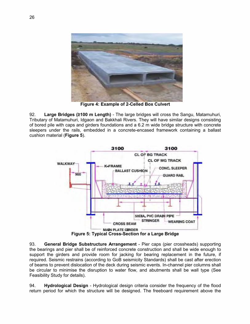
26
Figure 4: Example of 2-Celled Box Culvert 92. Large Bridges (≥100 m Length) - The large bridges will cross the Sangu, Matamuhuri, Tributary of Matamuhuri, Idgaon and Bakkhali Rivers. They will have similar designs consisting of bored pile with caps and girders foundations and a 6.2 m wide bridge structure with concrete sleepers under the rails, embedded in a concrete-encased framework containing a ballast cushion material (Figure 5).
Figure 5: Typical Cross-Section for a Large Bridge 93. General Bridge Substructure Arrangement - Pier caps (pier crossheads) supporting the bearings and pier shall be of reinforced concrete construction and shall be wide enough to support the girders and provide room for jacking for bearing replacement in the future, if required. Seismic restrains (according to GoB seismicity Standards) shall be cast after erection of beams to prevent dislocation of the deck during seismic events. In-channel pier columns shall be circular to minimise the disruption to water flow, and abutments shall be wall type (See Feasibility Study for details). 94. Hydrological Design - Hydrological design criteria consider the frequency of the flood return period for which the structure will be designed. The freeboard requirement above the

27
design high water level is another essential criterion. Based on and best engineering practice16, the following frequency and freeboard criteria were established for the design of embankment formation, bridges and culverts (Table 9).
Table 9: Freeboard Provide Based on Various Flood Return Periods17
Structure Safe Freeboard (m)
Design Frequency (Return Period in Years) Discharge Water Level Velocity
Bridges (>30 m) 1.00 100 100 100 Bridges (<30 m) 0.50 50 50 50 Culverts 0.60 50 50 50 Embankment Formation Level 0.60 20 20 20
Source: (RCIP-FS, 2014)
95. The 100-year and 50-year model storm flows were applied to properly size culverts and establish safe freeboard for bridges (Table 9). These freeboard measurements include the possible future climate change sea-level rise of 30cm. The designers therefore added a full metre above the Highest Flood Level (HFL) estimates using both historical and future predictions to 2015. Therefore this provides added security that water levels even with twice the climate induced rise will be accommodated. 96. Navigation Clearance - Bangladesh Inland Water Transport Authority (BIWTA) classified most perennial (water year round) rivers in Bangladesh as navigable channels. BIWTA has specified the horizontal and vertical clearance for various classes of navigation channels (Table 10).
Table 10: Navigation Clearance Requirement Navigation Class Horizontal Clearance (m) Vertical Clearance over SHWL (m)
Class I 76.22 18.30 Class II 76.22 12.20 Class III 30.48 7.62 Class IV 20.00 5.00
Source: (RCIP-FS, 2014) Note: SHWL=standard high water level
97. For the Sangu River near Dohazari, the vertical clearance for the new railway bridge will be matched to the existing highway bridge, plus the clearance as defined above, which is about 300 m downstream of the location of the railway bridge. No rivers in this Project fall under any of the above four categories of navigable channels as they are considered to be hilly rivers and therefore not navigable. However, local boats are used for crossing the rivers at many locations during floods. The navigation clearance provided caters to the need for such country boat navigation under the bridges. 98. The GoB’s SHWL vertical clearance requirements are extremely conservative, adding meters of clearance above the modelled 100 and 50 year flood crest. That is reflected in the 1 m freeboard addition to the HFL estimate for all large bridges. 16 BR has no specific guidelines for this. 17 Freeboard is the additional distance between the mandatory distance between the water surface and
lowest bridge girder.
28
99. Hill Cutting - Given that the project alignment passes across the toes of the Chittagong Hills forming a hilly and undulating landscape,91 hill cutting sites were identified, requiring cutting across some 12.89 km of alignment (see Feasibility Study for details) from between 6 to >1000 linear metres. An estimated 2.41 million m3 soil will need to be removed and either disposed of or uses in the fill sections of the alignment.
D. Social and Resettlement Considerations
100. The new single rail track will require a total of 552.83 ha of land. BR will acquire this land for Project construction through the resettlement of households and business establishments currently occupying on the land. About 59.67% of the land to be acquired is agricultural; the remaining portions are vitta/high/hilly land (24.78%), orchard/forest land (8.98%) and homestead land (5.58%). The Project will also require the removal of trees of various sizes and species. Approximately 118 employees of business structures in the Project area needing relocation will lose their jobs. 101. Impacts and Socio-economic Profiles - Within the Project’s Phase I alignment there are a total of 2008 households/units with a total population of 10,000. Of these, >80% will lose owned structures. Table 11 provides a summary of the Project impacts.
Table 11: Lands, Households and People Affected Project Impacts Unit Total
Amount of land to be acquired ha 552.838 Total number of households/units to be affected No. 2008 Number of titled households displaced physically and require relocation No. 1025 Number of non-titled households displaced requiring relocation No. 520 Number of households economically affected only (i.e., loss of land, fish ponds, and trees only – no relocation required)
No. 409
CPRs No. 44 Large scale businesses No. 4 Total number of persons affected No. 9,769 Number of trees affected No. 239,000 Source: (RCIP-RP, 2015)
E. Project Implementation Schedule
102. BR’s Consultant has prepared a detailed Work Programme which indicates how and when key components of the work will be completed and the EIA delivered in the time allocated for the work. The EIA must be approved and cleared by DoE before construction can begin, followed by the implementation of the Environmental Management Plan and compliance monitoring work by BR or its Consultant. The mitigative measures to be implemented will be particularly detailed during the construction period, during which time a construction supervision consultant will be responsible for monitoring the contractor’s progress. The Project is scheduled to be completed and commissioned in a period of 60 months (5 years) after the land acquisition process is substantially completed. This means that if the Project starts in 2016 it will be commissioned near the end of 2021.The draft Construction Implementation Schedule is provided in Annex 7 and arrangements are described in Chapter XI of this EIA.

29
IV. DESCRIPTION OF THE ENVIRONMENT
A. Biophysical Environment
1. Climate
103. The Project area has a tropical monsoon climate with four seasons: dry or winter season (December–February); pre-monsoon or hot season (March–May); monsoon or rainy season (June–September); and post–monsoon or autumn season (October–November). To define meteorological conditions in and around the proposed construction area of the Project, temperature, rainfall, humidity and wind data were collected. Within the Project corridor, two meteorological stations and one substation are located in Chittagong, Cox’s Bazar and Ambagan (Chittagong). 104. Temperature - The temperature of the country is related to the period of rainfall. In general, cool seasons coincide with the period of lowest rainfall. The monthly average mean, maximum and minimum temperatures at the Chittagong and Cox’s Bazar stations are 29.1oC and 19.9oC, respectively. Figure 6 shows the average mean, maximum and minimum temperatures for the last five years (2008–2012) at the Cox’s Bazar meteorological station, which is closest to the proposed alignment. Annual variation is less than 10oC.
Figure 6: Monthly Average Maximum, Minimum and Mean Temperatures at Cox’s Bazar
Project Site from 2008 to 2012
105. Rainfall - Rainfall varies considerably from year to year and month to month. The highest rainfall recorded between 2008 and 2012 was in 2012 when it peaked in June with 1,337 mm at the Chittagong Station and 1,226 mm for the same period at the Cox’s Bazar Station. The average rainfall at Chittagong and Cox’s Bazar stations between 2008 and 2012 was 258.35 mm/month and 281.97 mm/month over that five-year period. However, no rainfall was recorded during the months of November, December and January. Figure 7 shows the average monthly rainfall over the five-year period along the Project corridor, with most of the rainfall between May and August.
0
5
10
15
20
25
30
35
Tem
pera
ture
(oC
)
Monthly Temperature (2008-2012)
Mean Temp (oc)
Max Temp (oc)
Min Temp (oc)

30
Figure 7: Average Monthly Rainfall along Project Corridor 106. Relative Humidity - Humidity levels are consistently very high during the monsoon season and drop significantly for a relatively short period at the end of the dry season. The five-yearly average maximum relative humidity at the Chittagong and Cox’s Bazar stations are 86.2% and 87% respectively, and the average humidity recorded were 78.31% and 77.99%, respectively. 107. Wind Speed and Wind Direction - Monthly wind data of Chittagong and Cox’s Bazar stations show that wind speed is at a maximum in the early part of the monsoon, but drop substantially by the beginning of the dry season. The monthly average wind speeds for Chittagong and Cox’s Bazar stations over the last five years (2008–2012) are shown in Figure 8, and this pattern is assumed to reflect the conditions along the entire alignment.
Figure 8: Monthly Average Wind Speed Along the Alignment
.

31
108. Historical wind data (wind speed and wind direction) were collected from Chittagong and Cox’s Bazar stations, suggesting that around 22% of the year, wind blows from East to South with wind speed of 9–12 km/h (13%), 12–15 km/h (7%) and 18–25 km/h (2%). For the another 40% of the year, wind blows from north or northwest directions and other 16% of the year, wind blows from south with wind speeds of 6–to 15 km/h. The wind speed and wind direction data were collected in 2013 from the National Meteorological Department of Bangladesh. 109. The Project location seems to be more affected by natural calamities such as floods and cyclones near the coastal area than by wind. The collected information regarding flooding situation of the Project corridor roads indicates that the corridor was not affected by the 2004 flood, which was the worst in recent years.
2. Topography
110. The north west of the Chittagong Hills is a broad plain, cut by rivers draining into the Bay of Bengal that rise to a final chain of low coastal hills, mostly below 200 m, that attain a maximum elevation of 350 m. West of these hills is a narrow, wet coastal plain located between the cities of Chittagong in the north and Cox's Bazar in the south. The alluvial soils in the Anwara region’s coastal plain are generally fertile and are enriched with heavy silt deposits carried downstream during the rainy season. 111. Further, the Project area is a flat and almost level alluvial plain formed by the Sangu alluvial deposits. The land slopes from the northwest to southeast. Approximate elevation of the site and its area of influence vary from 10 m to 50 m above sea level. The significant geological feature of the Project area is the alluvium deposit. The depth of such deposits may vary up to several thousand metres and are of Pleistocene (50,000 years) to Recent (few hundred years) origin. 112. In general, the topography varies in altitude from the Lalmai Hills (30 msl) and the base of the Tripura Hills (7–8 msl) to the bank of the Meghna (1–2 msl). The floodplain varies from 1 msl to 5 msl. Tidal effects surges along the coast are generally up to 2 m above mean sea level, which in the on the floodplain are generally masked by rainfall-associated depth of river flooding.
Photo 4: Overview of Typical Floodplain of the Study Area
Photo 5: Topography Exposed Topsoil

32
3. The Terrain and Hydrological Setting
113. The proposed railway alignment near Cox’s Bazar is very close to the coast, and increases to about 15 km at Dohazari. To the west is the Bay of Bengal coastline and to the east is the Bangladesh–Myanmar border. The Project area thus slopes from East to West, with its level rising from Mean Sea Level near the coastal area to a maximum altitude of around 300 m in a distance of about 50 km. There are three major rivers in the area. The Sangu and Matamuhuri rivers originate near the Bangladesh-Myanmar border, flowing northward for more than 100 km. Just before crossing the alignment, they bend their course toward the west. The third significant river, Bakkhali, also originates near the border with Myanmar and flows from east to west. Thus, the terrain generally slopes from southeast to northwest. From Cox’s Bazar the elevation increases from 2–5 m above sea level to 12 m around Dohazari. These rivers are subject to flash-flooding and therefore the rail lines, embankments, bridges and culverts have been designed with this in mind. 114. To ensure that bridges and culverts were sized properly, Bangladesh Water Development Board (BWDB) data were used to calculate the 100-year flood return period, which was the basis for the design of the six large bridges as well as the other 177 bridges and culvert structures.
4. Geology
115. The geology of the Project area can be classified into four geological units: alluvial sand, alluvial silt, alluvial silt and clay, and deltaic sand. The alignment passes through active and nearly level floodplain, located in the Dohazari, Lohagara, Satkania, in Chittagong District and Chakaria, Dulahazara, Ramu, Ukhia in Cox's Bazar District and Cox’s Bazar. The geological profile along the proposed alignment consists of alluvial deposits, underlain by deltaic deposits of the Brahmaputra–Ganges–Jamuna River systems. These deposits include mostly fine sandy, silt and clay materials. Quite a number of incised channels and depressions within the alignment area are lined with recent alluvial deposits comprising lowland alluviums. 116. The Consultant conducted geotechnical investigation in 378 borehole locations along the proposed alignment RoW. Based on the findings of the site investigation, generally the top 10–15 m of the alignment consists of relatively weak compressible soft clayey silt layer of variable thickness which is then underlain by soft to stiff clay layers and medium, dense to very dense silty fine sand deposits (RCIP-FS, 2014). These were important findings incorporated into all structural load-bearing elements of the project (Geotechnical and Soils Reports, Consultant Reports, 2015)
5. Geotechnical Conditions
117. The proposed rail alignment passes through the Chittagong coastal plain for about 85 km, the Maheshkhali–Chakaria tidal flood plain for another 25 km and through the hills for about 20 km. The coastal plain, with all waters tidally influenced is almost flat but with a number of Chittagong hills (100–700 m high) interspersed.
6. Soils and Erosion
118. The soils consist of sandy, silt loam/fine sand and calcareous/fine textured, respectively. The soils are calcareous alluvial loam fine to medium textured homogenised and well drained. These are highly fertile and productive. Moisture content in the soils is very high.
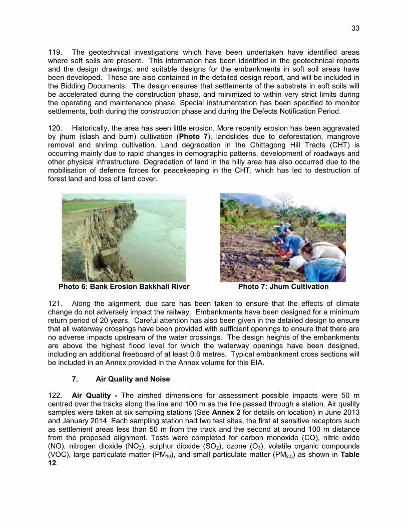
33
119. The geotechnical investigations which have been undertaken have identified areas where soft soils are present. This information has been identified in the geotechnical reports and the design drawings, and suitable designs for the embankments in soft soil areas have been developed. These are also contained in the detailed design report, and will be included in the Bidding Documents. The design ensures that settlements of the substrata in soft soils will be accelerated during the construction phase, and minimized to within very strict limits during the operating and maintenance phase. Special instrumentation has been specified to monitor settlements, both during the construction phase and during the Defects Notification Period. 120. Historically, the area has seen little erosion. More recently erosion has been aggravated by jhum (slash and burn) cultivation (Photo 7), landslides due to deforestation, mangrove removal and shrimp cultivation. Land degradation in the Chittagong Hill Tracts (CHT) is occurring mainly due to rapid changes in demographic patterns, development of roadways and other physical infrastructure. Degradation of land in the hilly area has also occurred due to the mobilisation of defence forces for peacekeeping in the CHT, which has led to destruction of forest land and loss of land cover.
Photo 6: Bank Erosion Bakkhali River Photo 7: Jhum Cultivation
121. Along the alignment, due care has been taken to ensure that the effects of climate change do not adversely impact the railway. Embankments have been designed for a minimum return period of 20 years. Careful attention has also been given in the detailed design to ensure that all waterway crossings have been provided with sufficient openings to ensure that there are no adverse impacts upstream of the water crossings. The design heights of the embankments are above the highest flood level for which the waterway openings have been designed, including an additional freeboard of at least 0.6 metres. Typical embankment cross sections will be included in an Annex provided in the Annex volume for this EIA.
7. Air Quality and Noise
122. Air Quality - The airshed dimensions for assessment possible impacts were 50 m centred over the tracks along the line and 100 m as the line passed through a station. Air quality samples were taken at six sampling stations (See Annex 2 for details on location) in June 2013 and January 2014. Each sampling station had two test sites, the first at sensitive receptors such as settlement areas less than 50 m from the track and the second at around 100 m distance from the proposed alignment. Tests were completed for carbon monoxide (CO), nitric oxide (NO), nitrogen dioxide (NO2), sulphur dioxide (SO2), ozone (O3), volatile organic compounds (VOC), large particulate matter (PM10), and small particulate matter (PM2.5) as shown in Table 12.

34
Table 12: Existing Air Quality along Project Corridor (24 hour average)18, June 2013
Note: NSE = No Standard Established; Sample stations are shown by ID number and sample location, GPS coordinates are marked on corridor maps in Annex 2, AQ=air quality. World Bank Guidelines. ** All station location designations are shown on the strip maps provided in Annex 2
123. Carbon monoxide ranged from 0 to 403.84 µg/m3. Nitric oxide and nitrogen dioxide ranged from 0 to 19.86 µg/m3 and 0 to 3.6 µg/m3, respectively. Sulphur dioxide ranged from 0 to 57.704 µg/m3. Ground ozone ranged from 0 to 49.59 µg/m3. VOC ranged from 0 to 0.0575. Particulate matters PM10 and PM2.5 varied from 0.96 to 10.2 µg/m3 and 0.1 to 4.53 µg/m3, respectively. None of the test results at all six stations exceeded the DoE acceptable limits. These results were some same when compared to World Bank standards. 124. The results of the air quality monitoring in the January 2014 (Table 13) revealed relatively higher pollution levels than June 2013 monitoring. This could be due to the timing of the survey later in the post-monsoon period by which time the airmass was much ‘dirtier’ than in September or October. The movement of diesel vehicles also contributed considerably. The exceedances of particulate matter PM10 and PM2.5 at Ramu station are likely due to the proximity of the monitoring station to a main highway with considerable vehicular traffic on it.
18 While the air quality measurements were not collected continuously for 24 hours the internationally
accepted methodology for converting hourly to 24-hr measures is provided in Chapter II of the EIA. The automated sampling device used collected 60 samples over an hour at two periods of the day and at many stations.
Sampling ID ** CO µg/m3
NO µg/m3
NO2 µg/m3
SO2 µg/m3
O3 µg/m3
VOC ppm
PM10 µg/m3
PM2.5 µg/m3
Air Temp o C
SP4_AQ_01_5 m 117.33 0.999 0 17.69 28.73 0.0206 3.79 0.51 25.77 SP4_AQ_02_50 m 96.73 1.33 0 0 31.57 0.0283 5.47 2.14 23.81 SP4_AQ_05_2 m 57.49 4.33 0 18.198 46.91 0.0167 1.46 2.53 21.03 SP4_AQ_06_50 m 2.85 0.75 0.3348 23.75 30.13 0 1.58 0.20 25.15 SP4_AQ_07_15 m 16.82 19.86 3.6 28.27 49.46 0.029 2.95 4.53 26.93 SP4_AQ_08_50 m 403.84 2.30 0 4.44 38.06 0 8.39 1.06 26.93 SP4_AQ_09_8 m 82.7 3.83 0 0 48.24 0 6.71 2.38 24.75 SP4_AQ_10_50 m 65.93 3.34 0 7.41 49.59 0.0575 4.22 1.15 23.37 SP4_AQ_11_5 m 0 0 0 0 25.61 0 10.20 2.49 23.21 SP4_AQ_12_50 m 0 0 0 0 27.588 0 8.69 3.10 22.82 DoE Standard (2006)
40,000 100 100 365 235 NSE 150 65
Avg-period (hours) 1 annual annual 24 1 24 24 WHO Standards 30,000
(1hr) - - 20
(24 hr) 235 (1hr)
- 150 (24 hr)
65 (24hr)
World Bank guidelines (2007)
8hr: 20,000
Not listed
None Prov.
125 8 hr 160
NSE 150 75
Canadian National Standards (2011)
1.0 ug/m3

35
Table 13: Existing Air Quality along Project Corridor (January 2014) Sampling ID Location
Name Parameter CO µg/m3
NO µg/m3
NO2 µg/m3
SO2 µg/m3
O3 µg/m3
VOC ppm
PM10 µg/m3
PM2.5 (µg/ m3)
Air Temp ºC
SP4_AQ2_01_5m Dohazari Station
1135.05 14.64 8.02 20.78 85.87 1.09 80.37 74.80 22.24
SP4_AQ2_02_50m 722.15 8.75 4.62 17.01 56.60 0.83 32.52 28.63 23.18 SP4_AQ2_05_2m Dulahaza
ra Station 530.08 5.02 3.08 26.48 67.80 0.60 15.96 11.17 23.61
SP4_AQ2_06_100m
431.08 3.22 2.80 23.79 60.37 0.74 14.87 12.87 25.34
SP4_AQ2_07_15m Ramu Station
3244.54 34.84 32.35 261.38 232.41 8.07 166.94 86.15 22.13 SP4_AQ2_08_100m
2038.11 28.15 21.54 176.38 167.55 7.83 146.14 75.80 23.09
SP4_AQ2_09_8m Cox's Bazar Station
935.05 10.74 4.84 19.04 57.81 0.95 57.17 38.51 22.61 SP4_AQ2_10_50m 823.13 12.25 6.64 23.88 76.20 1.07 66.52 51.06 24.01
DoE Air Quality Standard (2006)*
40,000 100 100 365 235 NSE 150 65
World Bank guidelines (2007)
8hr: 20,000
Not listed
None Prov.
125 8 hr 160
NSE 150 75
Canadian National Standards (2011)
1.0 ug/m3
Source: Primary data of RCIP-Rail. World Bank Guidelines; VOC 125. Noise - Other than the noise from the road located at some distance away, there are no major noise pollution sources in the Project areas. The noise measurements were relatively high in two locations, the Parishad Bazar Station in Chakaria and the Memorial Christian Hospital Station at Malumghat. Only these sites exceeded the DoE standard for commercial zoned areas (Table 14). Overall, the noise measurements (Table 14) were higher than what one would expect in a totally rural setting.
Table 14: Noise Level within 100 m of Existing RoW of the Project (June 2013) Noise Measurement Data
Sampling ID Sampling Location Sampling Date
Noise Level (Leq) dBA in CRW Day Night
SP4_NM_1,3_5 m Dohazari 13/06/2013 53.2 49.5 SP4_NM_1,4_50 m 13/06/2013 59.7 48.9 SP4_NM_5,7_2 m Satkania 13/06/2013 44.9 61.1 SP4_NM_6,8_50 m 13/06/2013 44.7 62.7 SP4_NM_9,11_5 m Lohagara 06/12/2013 50.5 55.8 SP4_NM_10,12_50 m 06/12/2013 56.2 50.7 SP4_NM_13,15_3 m Parishad Bazar,
Chakaria 06/12/2013 72.9 -
SP4_NM_14,16_50 m 06/12/2013 74.5 - SP4_NM_17,19_6 m Christian Hospital,
Malumghat 06/12/2013 69.6 66.8
SP4_NM_18,20_50 m 06/12/2013 70.8 60.8 SP4_NM_21,23_2 m Dulahazara 06/12/2013 51.1 61.3 SP4_NM_22,24_50 m 06/12/2013 45.2 55.6 SP4_NM_25,27_15 m Ramu 06/12/2013 53.4 58.9 SP4_NM_26,28_50 m 06/12/2013 61.8 65.2 SP4_NM_29,31_5 m Idgaon 14/06/2013 56.7 52 SP4_NM_30,32_50 m 14/06/2013 55.6 45.9 SP4_NM_33,35_8 m Cox’s Bazar 14/06/2013 45.2 59.4

36
Noise Measurement Data
Sampling ID Sampling Location Sampling Date
Noise Level (Leq) dBA in CRW Day Night
SP4_NM_34,36_50 m 14/06/2013 45.4 58.2 BD Noise Standard (2006)/World Bank Standard (2007)
Receptor Day Night Silent areas 50/NP 40/NP Residential 55/55 45/45 Mixed 60/NP 50/NP Commercial 70/70 60/70 Industrial 75/70 70/70
Note: Some night measurements were not taken due to security concerns. NP=none provided, Day 0700-1900, night 1900-0700. CRW is designated as mixed and commercial landuse 126. The January 2014 readings (Table 15) were very similar to the pre-monsoon samples and once again showed that the high traffic at the hospital drove the noise levels above the acceptable standard, even at 50 m from the source. The Parishad Bazar and the Memorial Christian Hospital were the only two sites where excessive noise readings, in relation to commercial zone standards, were recorded. The noise conditions at the hospital, which is considered a sensitive receptor and within a silent zone designation, consistently exceeded the DoE standard by as much as 20 dBA.
Table 15: Noise Level within 100 m of Existing RoW of Project (January 2014) Noise Measurement Data
Sampling ID Sampling Location Sampling Date Noise Level (Leq) dB Day Night
SP4_NM_1,3_5m Dohazari 19/01/2014 51.3 62.5 SP4_NM_1,4_50m 19/01/2014 49.7 46 SP4_NM_5,7_2m Satkania 20/01/2014 47.43 53.6 SP4_NM_6,8_50m 20/01/2014 46.69 49.1 SP4_NM_9,11_5m Lohagara 19/01/2014 53.1 51.4 SP4_NM_10,12_50m 19/01/2014 47.6 51.3 SP4_NM_13,15_3m Parishad Bazar,
Chakaria 20/01/2014 74.4 65.1
SP4_NM_14,16_50m 20/01/2014 63 69.1 SP4_NM_17,19_6m MC Hospital,
Malumghat 20/01/2014 70.9 64.5
SP4_NM_18,20_50m 20/01/2013 77.8 74.5 SP4_NM_21,23_2m Dulahazara 21/01/2014 47.05 52 SP4_NM_22,24_50m 21/01/2014 41.29 56.8 SP4_NM_25,27_15m Ramu 22/01/2014 49.59 51.4 SP4_NM_26,28_50m 22/01/2014 54.74 61.9 SP4_NM_29,31_5m Idgaon 21/01/2014 54.3 51.2 SP4_NM_30,32_50m 21/01/2014 52.9 51.3 SP4_NM_33,35_8m Cox’s Bazar 23/01/2014 42.82 50.6 SP4_NM_34,36_50m 23/01/2014 40.14 54.5
BD Noise Standard (2006)/World Bank Guidelines (2007)
Zone Day Night Silent areas 50/NP 40/NP Residential 55/55 45/45 Mixed 60/NP 50/NP Commercial 70/70 60/70 Industrial 75/70 70/70
Source: (RCIP-FS, 2014)

37
127. The existing general noise level within the study area varies from 41.29 dBA to 77.8 dBA during day time which is slightly above the standard of mixed zone land use (DoE, 1997), but not the commercial zone, which is the designation for the railway corridor (Annex 4). 128. The results of the noise measurements for June 2013 showed a marginally higher noise environment than the post-monsoon measurements. This maybe due to air temperature and relative humidity and the marginal attenuation effect of these two parameters on noise.
8. Cyclones and Storm Surges
129. Due to its vulnerable geographic location, Bangladesh suffers from frequent and devastating tropical cyclones and tidal surges. The funnel-shaped northern portion of the Bay of Bengal causes tidal bores when cyclones make landfall, and thousands of people living in the coastal areas are affected. Of the last 18 severe cyclones in Bangladesh that occurred between 1905 and 1991, as many as seven hit Chittagong City, Cox’s Bazar and vicinity, causing severe damage. 130. Based on these statistics, the Project corridor is in the coastal belt 10–20 km away from the Bay of Bengal, and directly in line with the cyclone tracks and associated tidal surges. To address this, BR will adopt required measures in designing and construction of the station and other buildings to be able to withstand such weather events (See
Figure 9: Cyclones Tracking over Bangladesh, 1902–1990 Source: Bangla

38
9. Climate Change
131. Since about 1900, the average near-surface temperature of the planet has increased by 0.75oC. Bangladesh is significantly vulnerable to the impact of climate change. Due to climate change, sea level is rising resulting in the ingress of salinity (Figure 9). Based on Figure 9 and Figure 10, the coastal area from Chittagong to Cox’s Bazar has a higher probability of being affected by climate change, especially the loss of land due to sea level rise coupled with the advance of the sea into the freshwater areas as the ocean pushes further into the river systems. BR has considered the issue of sea level rising and is designing all facilities with this in mind.
Source CEGIS 2008 Figure 10: Graphic of Potential Impact of Sea level Rise for Bangladesh
132. Findings generated as part of the Padma Bridge environmental study, which included an extensive climate risk section as well as the Bridge size and clearances dictated by the GoB were fully applied by the design team. A 30 cm climate/meteorologically induced water level rise was added to the clearance levels, this factored in to all designs. Given the location of the bridges from the coast and rise in elevation from sea level to the crossing structures, the original recommendation for the Padma Bridge of a 47 cm adjustment for climate change was adjusted to a 30 cm climate/meteorologically induced water level rise. Figure 11, taken from the Padma Climate Impact Report graphically depicts the approximate reach of three climate-induced water level increases in coastal rivers. Extrapolating these isolines to the SE coastline contributed to the decision to use a 30 cm adjustment (which was amply accommodate by the 1 m freeboard above HFL bridge designs

39
Figure 11: Potential Impact of Sea Level Rise on Bangladesh (Ainun Nishat, 2008,
and CEGIS 2008)
10. Hydrology and Drainage
133. The Sangu, Bakkhali, Matamuhuri, and Tributary of the Matamuhuri Rivers, all originating in India and Myanmar, dominate the hydrology along the proposed alignment. These rivers, especially the Bakkhali, Matamuhuri and Sangu exhibit flash flooding during heavy monsoon rains. The Bakkhali, Matamuhuri and Sangu and its tributaries have no or less than 10% of normal flow during the dry season (November–April), due to withdrawal of water for irrigation by low-lift pumps. Generally, ponds remain unchanged from year to year due to rejuvenation during the rainy season. No protected wetlands were found in the rail corridor. 134. Based on the 2013 survey, 177 crossing structures (bridges and culverts) need to be built. Of these, 40 are bridges, with six classified as large, i.e., with length of over 100 m. The other 137 structures are small bridges and single and multi-celled box culverts of various dimensions, to be installed as prefabricated as well as poured in place structures. The list of the

40
proposed major bridges, with other technical details is presented in Table 16. Further description is provided in Section VI (C). Water levels and discharge rates of the significant large rivers (Table 16) suggest very shallow and mostly seasonal waterways.
Table 16: Summary of Results of Hydrological Analysis River Sangu1 Matamuhuri Tributary of
Matamuhuri Idgaon Bakkhali
Station ID SW247, SW248
SW203, SW204
Ungauged Ungauged SW40
Location Dohazari Near Bethua Near Palakata Near Idgaon
Ramu
Latitude 22.15964 21.7911 21.75168 21.5522 21.4145 Longitude 92.07085 92.0285 92.04898 92.0533 92.0972 Bridge No. 3 64 79 124 155 River Width (m) 200 160 105 80 95 Navigation Class NC NC NC NC NC Horizontal Clearance (m) 30.48 NA NA NA NA Vertical Clearance (m) 7.62 1.00 1.00 1.00 1.00 Location (Chainage) 0+463 44+521 49+778 73+700 90+014 Spans (m) 7x40 12x40 6x40 4x25 4x40 Clear Waterway (m) 280 240 240 100 160 Design Flood (yr.) 100 100 100 50 100 Design HFL (m+PWD) 8.10 6.20 5.30 7.25 7.60 Design Discharge (m3/s) 3,950 3,450 1,600 350 1,100 Bridge Soffit Level 14.16 7.66 6.75 8.25 9.09 Silt factor (f) 0.58 0.56 0.58 0.56 0.79 Normal Scour Depth 8.91 8.62 6.59 4.03 5.25 Maximum expected Scour at Piers
15.48 12.67 13.37 8.05 11.55
Design Scour Level (m+PWD)
-6.92 -6.01 -7.62 -0.80 -3.46
Source: (RCIP-FS, 2014) Note: The road bridge located 300 m d/s of the rail bridge site is not compliant with the River’s Class III Navigation designation.
135. The Idgaon River width is 80 metres, and therefore the design frequency of 50 years has been used (GoB Standard). For bridges crossing rivers of width greater than 100 metres, design frequency of 100 years has been considered. 136. The other bridges for which the design frequency of 100 years has been used have rivers of widths ranging from 130 to 250 metres. The above design criteria, based on Bangladesh Water Development Board practice, is also consistent with international engineering practice. 137. Finally, all five large rivers are tidally influenced, but tidal bores do not reach any of the bridge crossing locations but do cause daily water level fluctuations when there is sufficient flow.
11. Surface Water Quality
138. People living in the corridor use the water from the rivers, canal and ponds for washing, bathing and for their livestock but generally not for consumption (tubewells are used). In the dry season local canals and channels are often dry, made worse by the withdrawal of irrigation

41
water for boro19 cultivation and for growing winter crops. Six stations were identified using GPS coordinates, with one station upstream and one downstream of the crossing area, for a total of 12 sampling points along the corridor (See Annex 2 for locations). 139. Surface water samples were collected for laboratory analysis from 10 locations between 30–31 March 2013 and 19–22 January 2014, respectively. The samples were submitted to ALS Laboratory and analysed for the presence of total organic content, orthophosphate, total suspended solids, oil and grease, dissolved oxygen and pH. Pre-monsoon (Table 17) and post-monsoon (Table 18) water quality results indicate that water quality condition was suited for irrigation and agricultural use. While those parameters tested indicate an acceptable quality for drinking water, parameters such as E.coli and other bacteria associated with sewage pollution were not tested and are likely quite high, at least near the urban areas. Low total phosphate (TP) levels and good dissolved oxygen (DO) levels would suggest that nutrient pollution is not a serious issue at the stations sampled.
Table 17: Surface Water Quality in Pre-Monsoon Season SAMPLE I.D
(UpS=upstream, DnS=
downstream) Date
Water Body Crossed/Site Description
GPS Location TOC (mg/
L)
Total Phosphate
(mg/L)
TSS
(mg/L)
Oil and Grease (mg/L)
DO (mg/L) pH Latitude Longitude
SW UpS_003 30/3/2013 Bakkhali 21⁰24′54.3″ 92⁰5′51.8″ 2.9 0.11 73 <1 7.61 7.45 SW DnS_004 30/3/2013 Bakkhali 21⁰24′53.5″ 92⁰5′50.8″ 3.1 0.03 22 <1 5.58 7.5 SW UpS_005 31/3/2013 Matamuhuri 21⁰45′4.7″ 92⁰2′51.6″ 5 0.17 88 <1 6.81 7.97
SW DnS_006 31/3/2013 Tributary of Matamuhuri 21⁰45′3.3″ 92⁰2′50.1″ 5.1 0.05 58 <1 6.85 8.17
SW UpS_007 31/3/2013 Tributary of Matamuhuri 21⁰47′24.8″ 92⁰1′49.7″ 2.3 0.06 24 <1 7.72 7.72
SW DnS_008 31/3/2013 Tributary of Matamuhuri 21⁰47′23.8″ 92⁰1′44.7″ 4.7 0.06 57 <1 6.66 8.12
SW UpS_009 31/3/2013 Dolu Khal 21⁰59′59.6″ 92⁰4′51.7″ 3.8 0.09 32 <1 7.14 8.19 SW DnS_010 31/3/2013 Dolu Khal 21⁰59′57.6″ 92⁰4′51.5″ 3.2 0.1 53 <1 7.12 8.36
DoE Surface water standard for irrigation1/World Bank Standard na/ na na <1 ≥5 6.5 to 8.5
Surface WQ standards for potability2/World Health Organization Drinking Water Standards and recommended values (20??)
Na/ np 6/np 10/np 0.01/np ≥6/np 6.5 to
8.5/np Note 1: The Schedule-3(A) of (Standards for Inland Surface Water) Environmental Conservation Rules, 1997, has been considered. Note 2: WQ criteria for agricultural use: http://www.saskh20.ca/DWBinder/epb356.pdf
Table 18: Surface Water Quality in Post-Monsoon Season SAMPLE I.D
(UpS=upstream, DnS=
downstream) Date
Water Body Crossed/Site Description
GPS Location TOC
(mg/L)
Total Phosphate
(mg/L)
TSS (mg/L)
Oil and Grease (mg/L)
DO (mg/L) pH Latitude Longitude
SW2 UpS_003 21/01/14 Bakkhali 21⁰24′54.3″ 92⁰5′51.8″ 3.1 0.06 7 <1 5.67 7.36 SW2 DnS_004 21/01/14 Bakkhali 21⁰24′53.5″ 92⁰5′50.8″ 3.4 0.07 4 <1 4.32 7.12 SW2 UpS_005 20/01/14 Matamuhuri 21⁰45′4.7″ 92⁰2′51.6″ 3.1 0.07 6 <1 4.01 7.6
19 The boro rice is commonly known as winter rice. The term boro is a Bengali term and originated from
the Sanskrit word "Boro" which refers to a cultivation from November to May under irrigated condition.

42
SAMPLE I.D (UpS=upstrea
m, DnS= downstream)
Date Water Body
Crossed/Site Description
GPS Location TOC
(mg/L)
Total Phosphate
(mg/L)
TSS (mg/L)
Oil and Grease (mg/L)
DO (mg/L) pH Latitude Longitude
SW2 DnS_006 20/01/14 Matamuhuri 21⁰45′3.3″ 92⁰2′50.1″ 3.9 0.07 10 <1 3.87 7.83
SW2 UpS_007 20/01/14 Tributary of Matamuhuri 21⁰47′24.8″ 92⁰1′49.7″ 3.2 0.06 5 <1 5.22 7.65
SW2 DnS_008 20/01/14 Tributary of Matamuhuri 21⁰47′23.8″ 92⁰1′44.7″ 3.2 0.08 8 <1 5.17 7.78
SW2 UpS_009 20/01/14 Dolu khal 21⁰59′59.6″ 92⁰4′51.7″ 4.2 0.09 33 <1 4.89 7.3 SW2 DnS_010 20/01/14 Dolu khal 21⁰59′57.6″ 92⁰4′51.5″ 3.2 0.06 31 <1 5.21 7.23
DoE Surface water standard for irrigation1 na na na <1 ≥5 6.5 to 8.5
DOE surface water standards for Recreation1 na na na <1 ≥5 6.5 to 8.5
WHO Surface WQ standards for potability2 na 6 10 0.01 ≥6 6.5 to 8.5
Note 1: The Schedule-3(A) of (Standards for Inland Surface Water) Environmental Conservation Rules, 1997 has been considered. Note 2: WQ criteria for agricultural use: http://www.saskh20.ca/DWBinder/epb356.pdf
140. During the post-monsoon season when water flows are very low and nutrients accumulate in the rivers, a few stations showed low DO levels,. This is a common occurrence when water levels drop, water temperatures rise and the natural nutrient processing, requiring oxygen, uses what little there is in the water column.
12. Groundwater Quality
141. Groundwater samples were collected from 9 tube wells near the Project corridor on 30–31 March 2013 and 19–22 January 2014, representing the pre- and post-monsoon sampling periods. The laboratory tests performed were for pH, total dissolved solids, arsenic, iron, manganese, sulphur and chloride (Table 20). For the pre-monsoon data, pH, and total dissolved solids, arsenic, sulphur and chloride levels from stations GW01 to GW10 were within DoE standards (Schedule 3 (B) of ECR, 1997), while iron and manganese levels were above DOE standards for potable water. During the post-monsoon season, total dissolved solids, arsenic, sulphur and chloride levels in groundwater samples collected from GW2_SP4_001- GW2_SP4_010- through 10 were all within acceptable limits for potable water (Schedule 3 (B) of ECR, 1997).
Table 19: Groundwater Quality within the RoW of the Project SAMPLED Date Water Body
Crossed/Site Description
GPS Location pH TDS (mg/L)
As (mg/L)
Fe (mg/L)
Mn (mg/L)
S (mg/L)
Cl (mg/L) Latitude Longitude
Pre-Monsoon Period GW_SP4_003
30/3/2013
Bakkhali River Rajarkul
21⁰24′47.5′′
92⁰ 5′ 56.2′′ 6.31 440 <0.001 <0.01 0.341 <1 6
GW_SP4_004
30/3/2013
Auto groundwater Special
21⁰11′45′′
92⁰10′ 19.8′′
- - - - - - -
GW_SP4_005
30/3/2013
Idgaon, Balakata, maijjapara
21⁰32′34.8′′″
92⁰ 3′ 7.5′′ 6.43 554 <0.001 0.56 0.365 <1 1

43
SAMPLED Date Water Body Crossed/Site Description
GPS Location pH TDS (mg/L)
As (mg/L)
Fe (mg/L)
Mn (mg/L)
S (mg/L)
Cl (mg/L) Latitude Longitude
GW_SP4_006
30/3/2013
Chawdhuripara jame mosque
21⁰25′54.2′′″
92⁰ 0′ 8.7′′ 6.24 306 <0.001 <0.01 0.428 2 4
GW_SP4_007
31/3/2013
Christian Memorial Hospital
21⁰40′ 56.6′′″
92⁰ 4′ 42.8′′ 5.8 1010 <0.001 1.97 0.386 <1 3
GW_SP4_008
31/3/2013
Shahpura 21⁰45′ 4′′ 92⁰ 2′ 47.7′′ 7.27 1740 <0.001 0.03 0.906 63 160
GW_SP4_009
31/3/2013
Near Dolu Khal
21⁰59′ 56.9′′″
92⁰ 4′ 53.5′′ 6.2 336 0.001 0.34 0.221 <1 17
GW_SP4_010
31/3/2013
Dohazari 22⁰9′ 46′′ 92⁰ 4′ 11′′ 6.16 231 <0.001 <0.01 0.065 <1 1
Post-Monsoon Period GW2_SP4_003
21/01/2014
Bakkhali River Rajarkul
21⁰24′47.5′
92⁰ 5 56.2′
6.47 201 <0.001 0.10 0.243 <1 8
GW2_SP4_004
22/01/2014
Auto groundwater Special
21⁰11′45 92⁰10′ 19.8′
7.47 252 <0.001 0.13 0.041 <1 3
GW2_SP4_005
21/01/2014
Idgaon, Balakata, maijjapara
21⁰32′34.8′
92⁰ 3′7.5′ 6.45 95 <0.001 8.96 0.405 <1 3
GW2_SP4_006
23/01/2014
Chawdhuripara jame mosque
21⁰25′54.2′
92⁰ 0′8.7′ 6.39 272 <0.001 0.02 0.401 4 7
GW2_SP4_007
21/01/2014
Christian Memorial Hospital
21⁰40′ 56.6′
91⁰8′43.3″ 5.92 46 <0.001 15.30 0.498 <1 5
GW2_SP4_008
20/01/2014
Shahpura 21⁰45′ 4′ 92⁰ 2′ 47.7′
7.38 2070 <0.001 0.09 0.601 68 614
GW2_SP4_009
20/01/2014
Near Dolu Khal
21⁰59′ 56.9′
91⁰11′45.6″
6.32 222 <0.001 0.03 0.101 <1 12
GW2_SP4_010
19/01/2014
Dohazari 22⁰9′ 46′ 91⁰12′17.7″
6.23 191 <0.001 0.54 0.078 <1 2
ECR Standard Limits for Potable Water Quality/WHO Standard for potable water
6.5 to 8.5/6.5 1000/np
0.05/0.01
0.3-1/np
0.1/np 100/na
150 – 600/np
Note: Cells shaded in light grey show values exceeding the ECR PWQS.= sample was not analysed due to shipment problems to Malaysia.
13. Flora and Fauna
142. Unless otherwise stated the following flora and fauna found in the Project area involves only commonly found species and none listed in any Bangladesh or international listing of vulnerable or higher status species. Given that most of the rail alignment passes through agricultural areas most habitat in the project area is modified and highly disturbed habitat. However some sections are critical habitat according to the ADB SPS, as described in section 17 143. Terrestrial Flora - Plant species within alignment are mehgani, arjun, pitali, eucalyptus, bot, jam, akashmoni, auricoliformis, am, kadam, shisoo, koroi, krishna chura, babla, ipil-ipil, shimul, shirish, etc. (Photo 11). Among crop-field vegetation, aman is grown during summer

44
rains and boro (winter rice) cultivated by irrigation in winter. Rabi crops like mustard and lentils are also grown. These are all common plants found in abundance in the study area and in the area of south of Chittagong. 144. Where the alignment passes through settlements, the most common trees are the raintree (Albizia saman), mango (Mangifera indica), coconut (Cocos nucifera), mahogany (Swietenia mahogany), gogon siris (Albizia richardiana), betel palm (Areca catechu) and guava (Psidium guajava) plus banana (Musa sp.). Sessile joy weed (Alternanthera sessilis), thorny amaranth (Amaranthus spinosus), bermuda grass (Cynodon dactylon), smartweed (Polygonum sp), creeping oxalis (Oxalis corniculata), etc., are the common weed species and are often the plants to re-establish after disturbances such as from bridge construction. 145. Terrestrial Fauna - Given the high density of people along the coastal strip, between the Chittagong Hills and the Bay of Bengal (approx. 1,250 persons/km2), where the rail alignment will be placed between the national highway and the coastline, and the fact that all land except the reserve forest patches are under cultivation, there remains almost no undisturbed natural habitat anywhere along the railroad alignment. There are some nearby wetland areas to the west of the alignment between Km 44 and Km 53, which provide habitat for common coastal wading birds including heron, dahuk, ibis and stork, as well as various gulls and terns. Common bird species noted in the Project corridor were Asian crow, myna, cuckoo, kingfisher, pigeon and dove satare, drongo, weaver bird choroi, babui, and dahuk. The mammals include shial, monkey, begi, bhodar, heza, various rodents, guishap, baghdash, and badur. There are also several species of frog, lizard, and snake, not considered to require any special measures to re-establish themselves. 146. Finally as described in paragraph 145 and Table 26, there are six species of concern which IUCN (2000) listed those to be possibly occurred in Southern Bangladesh proximate to Project corridor. Only the elephant has been sighted in the area and will be affected by the Project, but birds and reptiles should be able to cope given the many culverts and water crossing along the corridor. Further recent evidence (IUCN 2015), as referenced, indicates these species are either of least concern, are not found in the area or are locally extinct. 147. Fisheries - Local villagers reported catching fish in all the water bodies in the Project area. Major fishes in the rivers and canals in the Project area are carps (rui, catla, mrigal, ghania, kalbaus, and kalia), catfish (boal, pangas, silon, ayeir, and bacha) and snake head (shol, gazar, and taki), freshwater shrimp and several other tropical whitefish species. These species are well adapted to the silt-load extreme water temperature oxygen conditions in the Project Rivers. For the six rivers at the time of water quality testing, the key dissolved oxygen levels were found to be within the limits for supporting the carp, catfish and snakehead and invertebrate species listed. The major problem is water extraction for irrigation, resulting in near zero flows in these waters during the dry season, placing great pressure on the fish habitat and the health of the population20. 148. Fishing- All five larger rivers support at least a marginal artisanal fishery, i.e. nets and weirs during the higher water periods, as well as drift nets (illegal), seines. Elaborate traps are often set and, as with the Tongi-Bhairab project, fisher people actually used the new in-river piers to secure boats and/or fishing gear. Results from a fisher people census, known as a creel 20 Historically, at least the larger rivers had significant year-round flows that have now been drastically
reduced.

45
survey, suggested that fishing after a pier was installed improved over pre-construction conditions, due likely to the artificial reef effect. 149. Aquatic Flora and Fauna - The agricultural land along the proposed alignment is inundated during the monsoon season and dries up in the dry season every year. The biological characteristics indicated the presence of moderate variety of species and aquatic plants. A list of wet land flora as found in the Project area are helencha, hejol, kudipana, kuchuripana, shapla, shaluk, lotus, nol, sola, kalmi, etc. Aquatic fauna reported area includes crabs and oyster/ear shell (Photo 12).
Photo 8: Surface Water Sampling Photo 9: Groundwater (tube well) Sampling
Photo 10: Terrestrial Flora of (Mature Tree) Photo 11: Aquatic Fauna in Dolu Khal
14. The Asian elephant (Elephas maximus)
150. Status and classification- The Asian elephant is an endangered species in the South and SE Asian countries they occur in. It is listed as endangered in IUCN’s Red List and well as in Bangladesh’s red list. There are likely less than 300 animals remaining in the country with about 200 resident (i.e., not crossing international borders) and 100-150 having a trans-boundary range with India and Myanmar, and about 40,000 animals in the world, with the greatest populations found in Myanmar and India. The presence of elephant in an area is an indicator of a healthy ecosystem, and also one of the key drivers in maintaining a diversity of habitat and inhabitants. 151. General Life History, Habitat and Ecology -Asian elephants are very social animals, living in family groups consisting of related females and their offspring that are led by the oldest

46
female, the ‘matriarch’. The social bond between group members is very strong, and co-operative behaviour is common, particularly in the protection and guidance of the young. The average group size is around six or seven. There is no evidence of territoriality, and groups occasionally join to form herds when food is plentiful. “At around 20 years males first come into ‘musth’, which occurs annually and usually lasts two or three months. During this time males will wander widely in search of receptive females. Females become sexually mature at around 10 years and generally first give birth at around 15-16 years. When habitat conditions are favourable, they are capable of giving birth every 3-4 years. Elephants can live as long as 70 years, although the period of greatest female fecundity is between 25 and 45 years of age. The gestation period lasts 18-22 months, and usually results in the birth of a single calf, weighing an average of 100 kg. The calf may continue nursing for up to 18 months, and can suckle from its mother or from other lactating females in the group”. 152. The elephant’s diet consists mostly of grasses, but bark, roots, stems, and the leaves of trees, vines and shrubs are also eaten. Cultivated crops such as bananas, rice and sugarcane planted in their historical territory are also favoured foods, bringing them into conflict with local farmers. Individuals eat an average of 150 kg of food per day and leave about 100kgs of dung, much of it only partially digested. Calves often feed on their mother’s dung for extra nutrients. Elephants must drink frequently, as they require 70-90 litres of water each day.
153. Importance of Species and Key Threats- Elephants play a vital role in the ecosystems they inhabit. They modify their habitat by converting areas of forest to grassland, ecotones, and are important seed dispersers. They can provide water for other species by digging holes in dry riverbeds, and the wide paths they create as they wander through the forests act as firebreaks. Consuming on average 150 kg of plant material per day an adult elephant defecate frequently, producing about 100 kg of dung per day. Dung provided food for a host of other species and helps with seed dispersion and germination. 154. The three greatest threats to elephant survival are poaching, habitat loss and habitat fragmentation through conversion to agriculture (mostly paddy and production forest plantings such as rubber, and oil palm) and restriction/ blockages of travel routes to food and water.
155. Status in the Project Influence Area- Population Distribution- In the 1950s there were more than 500 elephant present in their natural habitats throughout Bangladesh. Based on a recent survey by IUCN (IUCN 2015) there appear to be around 270 individuals left in the wild, and are severely threatened throughout their range (Figure 12) in Bangladesh. About 85% of these animals now live in the Chittagong Hills and move mostly north-south in this range (Figure 22). Given the high level of habitat destruction and human intrusion into both CWS and FWS, elephant use these areas as feeding, crop raiding and watering areas. The Forest Department is making a significant effort to restore habitat and encourage local communities to coexist with the elephant. 156. Range and Discrete Management Unit- In Bangladesh the population of wild elephants has declined drastically in last two centuries because of habitat fragmentation and destruction caused by the expansion of agriculture and human settlement. The growing pressure on elephant habitats and movement corridors has meant that they are restricted to population pockets in the country, in the Chittagong hills area (Figure 12), Sylhet, Sherpur and migrating animals from Meghalaya State in India. 157. Diurnal and Seasonal Activities-The species feeds during the dawn and dusk as well as evening periods, sometimes night, and rests in the shade during the heat of the day. Their home range varies greatly, anywhere from 35 to 400 km2 (Williams, 2002 and Fernando et al,
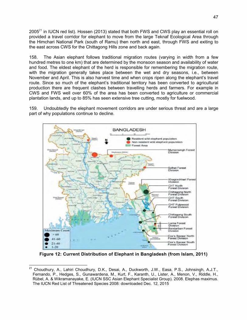
47
200521 in IUCN red list). Hossen (2013) stated that both FWS and CWS play an essential roll on provided a travel corridor for elephant to move from the large Teknaf Ecological Area through the Himchari National Park (south of Ramu) then north and east, through FWS and exiting to the east across CWS for the Chittagong Hills zone and back again. 158. The Asian elephant follows traditional migration routes (varying in width from a few hundred metres to one km) that are determined by the monsoon season and availability of water and food. The eldest elephant of the herd is responsible for remembering the migration route, with the migration generally takes place between the wet and dry seasons, i.e., between November and April. This is also harvest time and when crops ripen along the elephant’s travel route. Since so much of the elephant’s traditional territory has been converted to agricultural production there are frequent clashes between travelling herds and farmers. For example in CWS and FWS well over 60% of the area has been converted to agriculture or commercial plantation lands, and up to 85% has seen extensive tree cutting, mostly for fuelwood. 159. Undoubtedly the elephant movement corridors are under serious threat and are a large part of why populations continue to decline.
Figure 12: Current Distribution of Elephant in Bangladesh (from Islam, 2011)
21 Choudhury, A., Lahiri Choudhury, D.K., Desai, A., Duckworth, J.W., Easa, P.S., Johnsingh, A.J.T.,
Fernando, P., Hedges, S., Gunawardena, M., Kurt, F., Karanth, U., Lister, A., Menon, V., Riddle, H., Rübel, A. & Wikramanayake, E. (IUCN SSC Asian Elephant Specialist Group). 2008. Elephas maximus. The IUCN Red List of Threatened Species 2008: downloaded Dec. 12, 2015

48
160. Ongoing Conservation Efforts in relation to the elephant- In Bangladesh the CWS and FWS were established principally to provide habitat for the elephant. However due to large scale human encroachment and loss of traditional habitat, elephant do not appear to reside in these sanctuaries, but use them as access to food found in the illegal farming operations and water supply flowing from the hills to the east. Unfortunately, the original objectives of the two reserves have largely been lost.
15. Elephant Corridors, the CWS and FWS
161. Since the two wildlife sanctuaries are closely linked to the future welfare of the elephant a summary of the status is presented. Details are available in the recently completed management plans, available from the Forest Department. BR also has prepared pdf versions of the documents and they are available on request. 162. Chunati Wildlife Sanctuary (CWS) - Chunati was established in 1986 and has about 18.700 ha of land of which 7,760 are in the core zone and rest buffer and ‘impact’ zone (Figure 13). The buffer and impact zones are highly degraded and make up >33% of the entire area. As of late 2015 hardly any natural forest remains in CWS (CWS Management Plan, 2015). However, Chunati has a new management plan that will not permit new development in the core zone of the sanctuary, while permitting some activity in special cases of national significance, and based on a prime ministerial permit (which BR is obtaining from the Forest Department). 163. The plan calls for the existing roads to be converted to walking trails and encroachers discouraged by conversion of trails used for illegal resource extraction to tourist facilities. Enrichment plantings with indigenous forest trees on 3300 ha of degraded/barren land. Native tree species will be planted in the buffer zone as well as bamboo and bushes. Soil conservation measures such slope stabilization and erosion protection and soil conservation measures training will be provided to local communities. 164. Encroachers into the CWS will be encouraged to switch to the more sustainable non-timber-forest product extraction, but only in the buffer zone. In other words a significant effort to bring CWS back to a real sanctuary status is now under way (Chunati Wildlife Sanctuary Management Plan, 2015). 165. The management plan puts forward an ambitious set of tasks to re-establish the natural forest with many of the wild foods preferred by the elephant. First however the encroachment and illegal land conversion must be stopped. For example, in the 7,927 ha core zone of the CWS , 7,321 ha have been fully or partially degraded by human activity. 166. Fasiakhali Wildlife Sanctuary (FWS) - The FWS was established in 2001 and has about 7,093 ha of land of which 1300 ha is highly degraded core zone, and another 5,750 ha or buffer and impact zone (Figure 14). The core zone even contains 40 ha of private land. The forest areas were declared reserve forest in the early 19th century due to the lush stands of dipterocarp and other semi-evergreen forest tree species. At present most native trees are gone and what remains are plantations of teak, acacia, eucalyptus and other non-native species. Due to the excessive land conversion the area’s biodiversity has been greatly degraded (FWS Management Plan, 2015), especially along its western border where the national highway passes, and where the new rail line will run parallel (Figure 14). Thirty villages and around 50,000 people live in the FWS and continue to illegally harvest mostly NTFPs from the area.

49
167. There are however patches of diverse habitat deep in the centre of the FWS with a healthy diversity of plants and herbs. 168. Management of this sanctuary is complicated by the diversity of encroachers that have been allowed to operate in reserve including farmers grazing their livestock, loggers, sawmills and brickfield operators. At the moment the FWS is a reserve only in name and an ambitious programme to re-establish the ‘wildlife’ is being planned. The Forest Department plans to rehabilitate 700 ha of highly degraded core zone forest lands with indigenous trees and shrubs. Further the Forest Department is rallying local communities to undertake community based forest and wildlife management, in an effort to demonstrate to local communities the great value of health firsts and wildlife populations. To improve local area livelihoods, the Forest Department and local officials and villages are also planning a multi-tiered eco-tourism initiative (FWS Management Plan). 169. Despite both wildlife reserves being very heavily degraded they remain as the only movement corridors of the elephant west of the national highway and with the enhancements planned by the Forest Department should begin to recover. A new rail line, in addition to a doubling of the size of the national highway, will mean further obstructions to the elephant movements and BR is making large investments to minimize this and maintain travel routes and assist elephant to safely manoeuvre over the tracks, while at the same time building the rail connection between Dohazari and Cox’s Bazar.

50
Figure 13: Chunati Wildlife Sanctuary and Existing National Highway and Proposed Rail Alignment

51
Figure 14: Fasiakhali Wildlife Sanctuary Boundary, the National Highway and Proposed
Alignment

52
16. Elephant Routes and the Railway Alignment
170. The proposed Project alignment crosses elephant travel routes and this fact triggers special concern within the Government of Bangladesh (GoB) and Asian Development Bank (ADB), requiring clear and credible mitigative action by BR to prevent elephant-train collisions. To that end, alternative measures to avoid collisions have been assessed and a preferred option proposed (See Annex 12). The proposed rail alignment also passes through the edges of the forest reserves in the Chunati Wildlife Sanctuary22, cutting across the degraded core zone edge in the north and again in the south, and the buffer zone of the Fasiakhali Wildlife Sanctuary. The rail corridor is about 200m from the Dulahazara Safari Park (a large amusement park and zoo). The proposed rail alignment will start at Km 22 in the Impact zone and continue up to Km 38 in the CWS. It will start at Km 52.2 in the Impact zone and continue up to Km 62.8 in the FWS. These areas are protected and are either habitat or are used as travel corridors of the Asian Elephant (Elephas maximus) (DoF, 2011). in order to identify if and how many travel routes would be interfered with by the railway alignment, BR retained IUCN-Bangladesh to carry out an elephant survey between January and April 2014 to establish elephant movements and crossing points across the proposed Dohazari-Cox’s Bazar rail alignment. 171. Five active crossing points and six seasonal crossing points along the proposed railway alignment between Dohazari and Cox’s Bazar (IUCN, 2015) were identified. The summary of findings is shown in Table 20 as well as in Figure 15. The “active crossing points” were defined as places where the survey team found fresh or relatively fresh elephant dung, footprints and other signs (i.e., removal of barks, browsing habitats, etc.) of very recent elephant activity. In addition, the survey team interviewed local people to collect their observations and collected other anecdotal information. Based on the field observations and feedback from the local people “active crossing points’ were concluded to be regular crossing points that were part of long distance seasonal travel routes of the elephants used to move from one habitat area to another. Once identified, the crossing points were discussed with local people for comment and verification. Seasonal crossing points were identified in the same manner, and generally had old dried out dung heaps and fewer sightings by local people. Also seasonal crossing points were found to be used on an ad hoc basis mainly for purposes of eating crops during the harvesting season.
22 Wildlife Sanctuary means an area closed to hunting, shooting or trapping of wild animals and declared as such
under Article 23 by the government of Bangladesh as undisturbed breeding ground primarily for the protection of wildlife inclusive of all natural resources such as vegetation soil and water (paragraph) (p) of Article 2).

53
Table 20: Active and Seasonal Elephant Crossing Points: Dohazari to Cox’s Bazar and Ramu to Line Rail Alignment Sl. No.
Crossing Points
(Km)-from
Dohazari
Union (Upazila)
GPS Coordinates
(FFC and RST)
Herd Size (FFC)
Population
Growth (FFC)
Frequency of
Travel over Last Year (FFC)
Destination of Herds
(FFC)
Months of Active
Movement (FFC)
Movement in
24 Hours (FFC)
Reasons for Travel (FFC and RST)
Herds Last
Cross (RST)
Behaviour of
Elephant with
Human and Other Barriers
(FFC) Active Crossing Points
1 27.236 Chunati (Lohagara)
N21°56’18.85” E92°3’47.33” 9 2 6
Moving back and forth across the alignment
Any time specially January, June, August, October
18 hr to 3 hr
Water, food
24 hrs ago
Injured or killing, Destroy house
2 28.319 Puichari (Banshkhali)
N21°55’44.56” E92°3’31.89” 8 2 7
Moving back and forth across the alignment
Any time specially January, February, November
18 hr to 6 hr
Food, corridor
48 hrs ago
Injured or killing, Destroy house
3 29.017 Puichari (Banshkhali)
N21°55’23.13” E92°3’26.32” 10 2 12
Towards Rail Alignment
Any time of the year
00 hr to 4 hr
Corridor
No fresh dung
Injured or killing
4 55.407 Chiringa (Chakaria)
N21°42’42.34” E92°4’45.24” NI NI NI No
observatio Any time of the year
18 hr to 6 hr
Water, food, corridor
24 hrs… ago
No incident
5 56.262 Dulahazara (Chakaria)
N21°42’14.75” E92°4’42.83” 3 NI NI
Towards Rail Alignment
Any time of the year
00 hr to 6 hr
Corridor
48 hrs. ago
Injured or killing, Destroy house
Seasonal Crossing Points
1 25.123 Adhunagar (Lohagara)
N21°57'26.61" E92°3'40.03" NI NI NI NI
Monsoon- July to September Post-monsoon- October-December
18 hr to 4 hr Food No
sign No incident
2 27.995 Chunati (Lohagara)
N21°55'55.51" E92°3'33.62" 9 NI 3
From and towards Rail Alignment
Monsoon- July to September Post-monsoon- October-December
00 hr to 3 hr
Corridor
No sign
Destroy house

54
Sl. No.
Crossing Points
(Km)-from
Dohazari
Union (Upazila)
GPS Coordinates
(FFC and RST)
Herd Size (FFC)
Population
Growth (FFC)
Frequency of
Travel over Last Year (FFC)
Destination of Herds
(FFC)
Months of Active
Movement (FFC)
Movement in
24 Hours (FFC)
Reasons for Travel (FFC and RST)
Herds Last
Cross (RST)
Behaviour of
Elephant with
Human and Other Barriers
(FFC)
3 32.717 Harbang (Chakaria)
N21°53'24.05" E92°3'21.28" NI NI NI NI
Monsoon- July to September Post-monsoon- October-December
Any time at night Water,
corridor 48 hrs. ago No incident
4 36.308 Harbang (Chakaria)
N21°51'30.94" E92°3'14.42" NI NI NI NI
Monsoon- July to September Post-monsoon- October-December
18 hr to 4 hr
Food No sign No incident
5 58.366 Dulahazara (Chakaria)
N21°41'6.90" E92°4'44.90" NI NI NI NI
Monsoon- July to September Post-monsoon- October-December
18 hr to 4 hr
Food No sign No incident
6 64.075 Khuntakhali (Chakaria)
N21°38'11.11" E92°4'4.19" 14 2 11
Towards Rail Alignment
Monsoon- July to September Post-monsoon- October-December
18 hr to 24 hr
Food, corridor No sign Injured or
killing
Note: FFC= Face to Face Communication, RST= Recce Survey Transect, NI= No information provided by community people

55
172. The crossing points (Table 20) represent one of a number of tracks used by the family or group crossing the existing roadway and proposed rail alignment. Crossings 1 through 3 are all within 2 km of each other and the herd size is nearly the same, strongly suggesting that this is the same herd, moving within its territory. There are also two seasonal crossing within this travel corridor providing more evidence for single population, e.g. Seasonal Crossing Point 2 at Km 28.03 with 9 animals observed is also within the Chunati-Pulchari cluster. 173. The observations at crossing areas 4 and 5, also forming a cluster further south and to the west of the Fasiakhali Wildlife Sanctuary, and could also be a multi-family group since the observations and each crossing points are so low. Herd sizes below 5-6 animals are not viable and elephant will tend to form lager family groups, usually closer to 10 (Hossen, 2013). Seasonal Crossing Point 6 with a herd size up to 14 animals, has the largest observed number of animals, however is only used when the crops on the west side are mature and the elephant find these irresistible. 174. Hossen estimated that the elephant migration route is in the Chittagong Hills basically north and south, into and out of the Hill Tract districts (Figure 22), making journeys into the sanctuary areas to feed, primarily on paddy rice illegally planted by local farmers (who have lived inside the boundaries of sanctuaries for generations) and to access the more permanent water supplies in the Chunati and Fasiakhali Wildlife Sanctuaries. 175. The Active Elephant Crossings- Given their importance as markers of the travel routes the area’s elephant groups use to move to feeding and watering sources, these corridors are described in more detail below and are summarized in Table 20 and illustrated in Figure 15 through Figure 20.

56
Figure 15: Active Elephant Crossings, March–April 2014 (the last two southern sites are not included in this EIA)
176. Figures 16 to 20 show the crossing areas where thermal imaging camera systems (TIC) would be most useful. Appendix 13 shows concept drawings of where overpasses (designated by the blue elephant symbols), and where the level crossing areas (designated in pink) where

57
elephant would be funnelled to safe crossing areas, could be located (the green elephant symbols indicate the actual documented crossing area). The concept drawing also includes ‘funnelling’ structures and bollard fencing locations to help direct elephants to the structures/locations. In the case of Crossing Point 3 where underpasses are not possible (see Table 30 for details), the location of directional fencing to a safe level crossing site is also shown. 177. Crossing Points 2, 3 and 4 also show bollard fencing lines which help to funnel the elephant to safe level crossing points, when cuts are deep and long. These drawings are all prepared as full size engineering concepts, from which detailed designs can be prepared. Finally detailed cost estimates have been prepared for each option and these data are also with BR. 178. Chunati Active Crossing Point 1 Km 27.132 - The map prepared by IUCN (IUCN 2015) actually identified three groups of crossing tracks (two plus) very close to each other (Table 22), further, underscoring the fact that the elephant herd uses a corridor and can pass at any number of locations within that corridor (likely the result of habitat and corridor degradation by farming and tree cutting requiring track adjustments).

58
Figure 16: Active Elephant Crossing Point 1 - Chunati

59
Table 21: Active Elephant Crossing Point 1 - Chunati, Site Conditions and Observations Site Condition Cut about 100 m in length with fill on either side
Elephant Corridor width 500 m wide centered over Km 27.236 Proximity to other crossings
Active Elephant Crossing Point 2 - Pulchari-1 km south, Active Elephant Crossing Point 3 Pulchari - 1.8 km south plus Seasonal Crossing Points 1 and 2
Herd size No. 9 2013-14 Frequency of sighting No.. 6 2013-14 Reason for elephant travel
Water, food
Risk of elephant –train accident
Moderate: in relation to herd size and frequency of travel
Existing ground (m) MSL 36.008 Formation height (m) MSL 28.095 179. The topography and especially the hill cutting extend for around 100 m with fill sections on either side of the cut. The track is generally in a cut area 1 m below the existing ground. Line of sight is 240 m on the Chittagong side and 800 m on the Cox’s Bazar side. Figure 16 provides a concept of where a potential overpass, with wing walls and guiding bollards and where an underpass might be located (shown by the red elephant marker). Further the light yellow line above the design grade gives an indication of the lift needed to place an underpass. 180. At that location the alignment is close to the N1 Highway, which will be widened to a four lane divided highway. The EIA of this four laning highway project has been reviewed, but this does not provide details of the arrangements which have been made to enable the elephant to cross the highway. It is noted from international experience that highway underpasses for elephant crossing have been proven to be successful, with notable example from Kenya23, India (Assam)24, and Bhutan25. However, the provision of underpasses under railways is prohibitively expensive and because of the flatter ruling grades required (0.5% for railways compared to 5% for highways). This section of corridor is on heavily utilized plantation forest, mostly fuel wood, with paddy farming to the west of the of the rail alignment, elephant track intersection. In addition, a nursery is located in this area, and a diversion of the railway alignment was made to avoid this nursery. 181. Active Elephant Crossing Point 2, Pulchari, Km 28.289- the Pulchari crossing site is located at Km 28.36 at a transition from a straight, minimally elevated section to a minor cut section (about 1.9m) for about 400, where it flattens and straightens out again for the next 600 m or more. Since the cut embankment will be about 2 m above grade and the locomotive is more than 4m high, the line of sight will be approximately 700 m on the Chittagong side and 294 m on the Cox’s Bazar side. It traverses a part of the buffer zone of Chunati Wildlife Sanctuary, directly to the west of the existing national highway which is being widened to a 4-lane divided expressway, with an as yet unknown divider configuration or structure.
23 http://www.lewa.org/wildlife-security/the-elephant-underpass/ [accessed on 13 January 2016] 24 http://www.wwfindia.org/?4720/elephant-movement-across-highways [accessed on 13 January 2016] 25 ADB. 2013. Environmental Impact Assessment. IND: SASEC Road Connectivity Investment
Programmeme (formerly SASEC Road Connectivity Sector Project). Asian Highway 2 (India /Nepal Border to India/Bangladesh Border). Asian Highway 48 (India/Bhutan Border to India/Bangladesh Border). ADB Manila

60
Figure 17: Active Elephant Crossing Point 2 – Pulchari

61
182. At this crossing point an elephant herd size of 8 was recorded via interviews with local people and elephant dropping counts, passing this point only 7 times in 2013-14.
Table 22: Active Elephant Crossing Point 2 - Phulchari, Site Conditions and Elephant Observations
Site Condition Cut about 100 m in length with fill on either side Elephant Corridor width 500 m centered over Km 28.319 Herd size No. 8 2013-14 Frequency of sighting No. 7 2013-14 Reason for elephant travel Food Risk of elephant–train accident Moderate: in relation to herd size and frequency Existing ground (m) MSL 30.906 Formation height (m) MSL 32.000
183. The vegetation cover at the crossing site is scrub forest, plantation and crop lands. The rail alignment passes from north to south in the impact zone of Chunati WS, within 200 m to the west of the existing national highway to be widened from a two to four lane expressway. 184. Active Elephant Crossing Point 3, Pulchari, Km 29.764- This crossing point at Km 29.04 of the alignment is in the middle of a deep cut area 300 m northward and >400 m southward (Figure 18). Emerging from the cut the rail line will be on a very shallow embankment for at least the next 500 m. The line of sight is close to 294 m on the Chittagong side and 400 m on the Cox’s Bazar side, due the 8-9 m deep cut.

62
Figure 18: Active Elephant Crossing Point 3 - Pulchari 2

63
Table 23: Active Elephant Crossing Point 3 - Phulchari, Site Conditions and Observations Site Condition In deep cut for several hundred metres Elephant Corridor width Up to 500 m centered over Km 29.017 Herd size No. 10 2013-14 Frequency of sighting No. 12 2013-14 Reason for elephant travel Water, food Risk of elephant –train accident High: in relation to herd size and frequency Existing ground (m) MSL 44.024 Formation height (m) MSL 32.000
185. While the point of the documented crossing was at Km 29.04, the corridor may be as much as 500m wide, with crossings anywhere between Km 28.50 and 29.40. 186. This corridor, less than 700 m south of the Pulchari 1 crossing is treed and provides good elephant habitat for movement and feeding and a herd size of up to 10 animals has been reported, with movement taking place monthly. The underpass is not feasible at this location since a formation lift of >18 m would be needed. An overpass concept and guide fencing to lead elephant to a level crossing point is shown. 187. Active Elephant Crossing Point 4, Chiringa, Km 55.42- within this corridor at least two trails were found crossing over the highway and proposed rail alignment within 200 m of each other. The crossings are in marginally treed lands opening into large paddy fields and other agricultural crops to the west of the rail alignment. The Chiringa crossing point is on a shallow curve, coupled with intermittent 1-3 m high cut areas for least 600 m on either side of Km 55.42. Line of sight is therefore less than 300 m in both directions (Figure 19).

64
Figure 19: Active Elephant Crossing Point 4 – Chiringa

65
188. While the underpass would be technically feasible it would require a 7 m formation lift for around 1.7 km centred over the crossing point moved around 250 m to the south. No elephant sighting data were available at this location (Table 25) and only elephant dung indicated past activity. The specific crossing point is along a 120 m long 3 m deep cut, such that the top > 1.2 m of a moving locomotive (4.3-4.7 m high) is visible above the cut banks and thereby greatly increasing the line of sight from the cab and at the level above the front windshield, or 4.1 m above the track.
Table 24: Active Elephant Crossing Point 4 - Chiringa, Site Conditions and Elephant Observations
Site Condition In centre of a 120 m long cut Elephant Corridor width 500 m centered over Km 55.407 Herd size No. NI 2013-14 Frequency of sighting No. NI 2013-14 Reason for Travel Unknown Risk of elephant –train accident Unknown Existing ground (m) MSL 10.410 Formation height (m) MSL 6.50
189. Active Elephant Crossing Point 5, Dulahazara, Km 56.280- This crossing site, only 860 m south of the Chiringa crossing, passes from the west side of the national highway in degraded forest into wide open farming land, likely rice paddies. On both sides of the alignment for at least 700 m north and south significant clearing has taken place, making way for field and paddy crops. The track at the crossing is on an approximately 4 m high embankment that extends southward for > 300 m after exiting from a 200 m cut. Line of sight is at least 527 m on the Chittagong side and 427 m on the Cox’s Bazar side.

66
Figure 20: Active Elephant Crossing Point 5 – Dulahazara

67
190. The ground level at this crossing is only about 2 m above sea level and flood prone, requiring a 4 m high embankment for about 300 m to the south of the crossing and a cut section to the north toward Dohazari (Figure 20). The line of sight is >800m in both directions, and with a locomotive height of 4.3-4.7 m, visibility from above the windshield and forward on the track should be good. The recorded herd size has been only three animals, which has been observed only once in 2013-14, suggesting that this may not be a separate active site but instead a track of Active Passage No. 5 (Table 25 seasonal crossing point (Table 25 ).
Table 25: Active Elephant Crossing Point 5 - Dulahazara, Site Conditions and Observations
Site Condition In a moderate cut with fill on one side Elephant Corridor width 500 m centered over Km 56.262 Herd size No. 3 2013-14 Frequency of sighting No. 1 2013-14 Reason for Travel Water, food Risk of elephant –train accident Low: in relation to herd size and frequency Existing ground (m) MSL 2.879 Formation height (m) MSL 6.205
191. Given the proximity to sea level and flood likelihood an underpass would need a 7 m formation lift plus reinforced earth walls. 192. Seasonal Elephant Crossings- The IUCN study also identified 6 season elephant crossing were herds passed periodically sometimes only once per year26. At the Khuntakhal (Figure 21) seasonal crossing the herd size was observed at 14, the largest observed at any time. This suggests that they are important and cannot be ignored. A suite of measures has been proposed to minimize the impact on travel routes and maintain these important habitat corridors, with the ability to adapt should conditions change.
17. Critical Habitat
193. Guidance on critical habitat designation is provided in the ADB SPS 2009 and 2012 sourcebook. Of the 6 criteria27 under ADB SPS criteria i) and iii) are triggered as the elephant is an IUCN endangered species and it is also a migratory species. Therefore the project area is considered as critical habitat for the Asian Elephant.
26 A seasonal crossing, as distinct from an active crossings, has far fewer activity, sometimes only once
every 2 years. However more observations are clearly needed to better understand elephant movement. This will be undertaken during the Pilot Study as defined in the EMP.
27 6 criteria for criticial habitat under ADB SPS: i) habitat required for the survival of critically endangered or endangered species; ii) areas having special significance for endemic or restricted-range species; iii) sites that are critical for the survival of migratory species; iv) areas supporting globally significant concentrations or numbers of individuals of congregatory species; v) areas with unique assemblages of species that are associated with key evolutionary processes or provide key ecosystem services; and vi) areas having biodiversity or significant social, economic or cultural importance to local communities. These may include areas that are either legally protected or officially proposed for protection, such as areas that meet the criteria of the World Conservation Union classification, the Ramsar List of Wetlands of International Importance, and the United Nationals Educational, Scientific, and Culturual Organization’s world natural heritage sites.

68
194. The five ‘active’ crossing areas impacted by the rail alignment will be fully maintained by a set of mitigative measures designed to protect the crossing areas and minimize elephant train accidents and encourage continued movement back and forth across the alignment. The habitat on either side of the tracks bordering the elephant corridors will not be impacted by the Project, but rather by the continuing conversion of forest to fields by farmers and woodcutters encroaching into these areas, especially into the CWS and FWS. With the new management plans for CWS and FWS the Forest Department is embarking on changing this pattern and restricting further land conversion and replacing it with rehabilitation and revegetation. 195. The rail alignment passes through the margins of the buffer and impact zones of the Chunati Wildlife Sanctuary (Figure 13 and Figure 14) and along the border (but not into) of the Fasiakhali Wildlife Sanctuary. Discussions with the Forest Department Chief have already taken place in this regard. BR will proceed with all requisite applications for passage through these areas and will undertake the necessary replanting and revegetation plan ad advised by the Forest Department, however keeping in mind that new vegetation attracts elephant and track side vegetation obscures the view (although the TIC system proposed can see though vegetation as it picks up heat signatures not light).
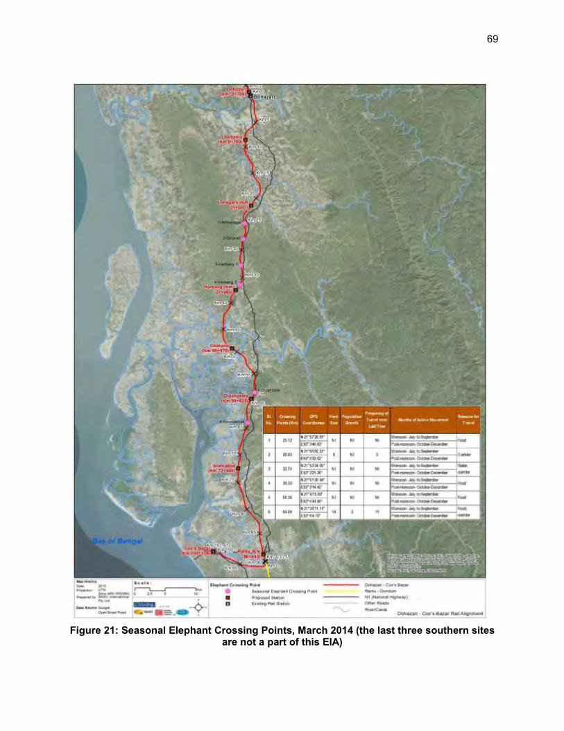
69
Figure 21: Seasonal Elephant Crossing Points, March 2014 (the last three southern sites are not a part of this EIA)

70
Figure 22: Main travel routes of the Asian elephant in southern Bangladesh (Hossen, 2013)
18. Methakatchpia National Park (MCNP)
196. “The MCNP was established to save the old growth (hundred year old) Garjan Forest. It is the biggest among the few remaining patches of Garjan Forest in the sub-continent and under enormous pressures as garjan wood is prized in plywood production. The main floral species of this NP is Garjan and associated species are Bhadi and Dhakijam. The park is gently hilly with a tropical semi-evergreen forest type in the Garjan (Dipterocarpus spp) belt that extends from Chittagong to Cox‘s Bazar. Originally the entire park area was a rich Garjan forest area, with associated trees including Telsur (Hopea odorata) and Chapalish (Artocarpus chaplasha). Species of Laughing Thrush, White Throated Bulbul and Little Spider hunter are some of the common residents (www.Nishorgo.org, 2015). 197. Encroachment, including expanding settlements agriculture, tree poaching, hunting, collection of fuel wood, bamboo and cane and other forest products cutting are the major causes for the continuing severe degradation of MKNP. Functioning sawmills coupled with local unemployment are the major underlying factors fuelling the for the marked dependency of the local communities upon the park. Less stringent monitoring and a negative influence of some locally powerful individuals have further exacerbated the sustainable maintenance of MKNP. 198. The park is split in half through its core zone by the N1 National Highway, and the proposed rail alignment would be along the western boundary of the park, for about 300m through the highly disturbed buffer zone. 199. The park’s core zone on either side of the national highway has large garjan tree stands, which represent an important ecosystem which should not be subject further degradation. For
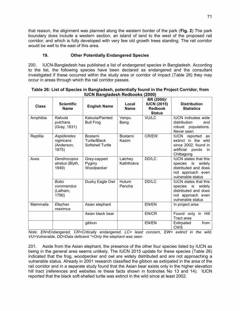
71
that reason, the alignment was planned along the western border of the park (Fig. 2) The park boundary does include a western section, an island of land to the west of the proposed rail corridor; and which is fully developed with very few old growth trees standing. The rail corridor would be well to the east of this area.
19. Other Potentially Endangered Species
200. IUCN-Bangladesh has published a list of endangered species in Bangladesh. According to the list, the following species have been declared as endangered and the consultant investigated if these occurred within the study area or corridor of impact (Table 26) they may occur in areas through which the rail corridor passes.
Table 26: List of Species in Bangladesh, potentially found in the Project Corridor, from IUCN Bangladesh Redbooks (2000)
Class Scientific Name English Name Local
Name
BR (2000)/ IUCN (2015)
Redbook Status
Distribution Statistics
Amphibia Kaloula pulchara, (Gray, 1831)
Kaloula/Painted Bull Frog
Venpu Bang
VU/LC IUCN indicates wide distribution and robust populations. Never seen
Reptilia Aspideretes nigiricans (Anderson, 1875)
Bostami Turtle/Black Softshell Turtle
Bostami Kasim
CR/EW IUCN reported as extinct in the wild since 2002, found in artificial ponds in Chittagong
Aves Dendrocopos atratus (Blyth, 1849)
Grey-capped Pygmy Woodpecker
Lalchey Kaththokra
DD/LC IUCN states that this species is widely distributed and does not approach even vulnerable status
Bubo coromandus (Latham, 1790)
Dusky Eagle Owl Hutum Pencha
DD/LC IUCN states that this species is widely distributed and does not approach even vulnerable status
Mammalia Elephas maximus
Asian elephant EN/EN In project area
Asian black bear EN/CR Found only in Hill Tract area
gibbon EN/EN Extirpated from CWS
Note: EN=Endangered, CR=Critically endangered, LC= least concern, EW= extinct in the wild, VU=Vulnerable, DD=Data deficient.*=Only the elephant was seen 201. Aside from the Asian elephant, the presence of the other four species listed by IUCN as being in the general area seems unlikely. The IUCN 2015 update for these species (Table 26) indicated that the frog, woodpecker and owl are widely distributed and are not approaching a vulnerable status. Already in 2001 research classified the gibbon as extirpated in the area of the rail corridor and in a separate study found that the Asian bear exists only in the higher elevation hill tract (references and websites re these facts shown in footnotes No 13 and 14). IUCN reported that the black soft-shelled turtle was extinct in the wild since at least 2002.

72
20. Agricultural and Mineral Development
202. Agriculture is the dominant sector of employment for the people living along the RoW. Out of the total of 1,400 household units that own land, 1,302 (93%) will lose area up to 50 decimals (Table 11). The remaining 6.9% households will lose 51 to 500 decimals of land, of which 5.2% and 1.3% will lose 51 to 100 and 101 to 200 decimals of land, respectively. Almost all of the households within the RoW will lose all of their lands they have at present. Crops grown on these lands include varieties of rice and other vegetables including potato, cauliflower cabbage and tomatoes. The lowlands are used for irrigated high yield variety paddy cultivation during the early Amon season. boro or winter rice, grown from February through July, and Rabi28, the cooler season rice, grown between November and April. Aus29, rice is grown throughout the summer. Around 7.2% of all villagers grow some types of crops. However, in the corridor between Dohazari and Cox’s Bazar, especially as the corridor passes through urban areas, lands are used for housing, industrial, institutional, rice husking and other purposes.
B. Social Environment
203. A socio-economic survey completed by the Consultant’s Social Safeguard group for the Project was the primary data source for this discussion. A comprehensive environmental consultation process was also undertaken and is reported in Chapter VIII of this EIA. 204. The household census (CEGIS, 2013) completed by the Consultant contains very detailed information on the status of the population in the Project corridor and surrounding areas, including health, education and livelihood data. The following is a summary of the socio-economic profile of the Project corridor. 205. The numbers of affected households (HHs) are 2,008 with a total population of 9,769 of which 53.54% is male and 46.46% female. The average HH size is 5, which is higher than the national figure (4.50). There are 9.75% female-headed HHs. The highest section of the population constitutes the age category of 5 to 14 years. The dependence ratio is estimated to be 67.75. Most of the people are educated (80.85%), 28.21% of whom have received education of up to Class 10 and 7.35% of up to SSC or equivalent. About 21.64% of the total population is engaged in business, 22.16% in day labour, and 18.85% in farming. The highest income comes from business (36.80%) followed by remittance (17.17%), day labour (16.28%) and service (14.33%). In the Project area, most of the annual expenditure is spent on food (56.57%). 206. About 63.93% (1,283) of the affected households own land. Almost all of the households are poor in terms of land ownership, as the vast majority (87%) own less than or equal to 50 decimals of land and 12% out of the remaining 13% own 51 to 249 decimals of land. Out of the 1,400 HHs that own land, 1302 (93%) will lose up to 50 decimals of land; 5.2% and 1.3% from the remaining 6.9% HHs will lose 51 to 100 and 101 to 200 decimals of land, respectively. It indicates that almost all of the households will lose all of their lands they have at present. 207. 57.70% of households in the project corridor are connected to the national power grid, which is a little higher than the national average (55.26%). About 99.6% of the population use
28 Rabi crops or Rabi harvest refers to agricultural crops sown in winter and harvested in the spring. 29 Amon is a term used in Bangladesh and east India for lowland rice, grown in the wet season during
June to November. Aus is a rice, grown in Bangladesh during the early part of the wet season from March to September.

73
tube well water for drinking, which is higher than the national average (85.37%); 68% use sanitary latrines. About 95% of HHs use fuel wood for cooking purposes. 208. In the Project area, poor people have the tendency to seek primary health care from pharmacies (22.1%) and local village doctors, both trained (21.40%) and untrained (15%), located within 1 km distance from their residences. People mostly prefer to seek emergency care from trained and experienced physicians in government hospitals (4.0%), upazila health centres (9.6%) and private hospitals (7.7%), although in most cases these health facilities are situated more than 5 km away.
1. Human Settlement in the RoW
209. The study area consists of linear markets and business places with tin shed shops that are common here and there and locally some semi-pucca structures with reinforced concrete roof are also common. There are housing areas in blocks that are scattered within the Project site. The rural people living between Dohazari and Cox’s Bazar along the alignment and within the RoW, occupy around 553 ha are involved in agriculture, day labour, artisanal fishing in the rivers and also commercial fishing in the Bay of Bengal, and transportation. Most of these structures are temporary and built with tin, earth and bricks (RCIP-RP, 2015). 210. Nevertheless, the corridor is rural agricultural and a new rail line signals a major change in living conditions for communities along the line. This issue is discussed in the Poverty and Social Assessment (RCIP-PSI Report 2015).
2. Archaeological, Cultural and Heritage Scenic Areas
211. There are no physical cultural resources (PCRs), which have historical, religious and cultural significance in the locality. There are 44 community property resources (CPRs) in the Project area (Table 27).
Table 27: Number of Community Property Resources (CPRs) by Category Sl. No. Category of Community Resources No. of CPRs
1 School 2 2 College 2 3 Clinic 4 4 Mosque 18 5 Mondir 2 6 Pagoda 1 7 Graveyard 2 8 Cremation Ground 1 9 Madrasha 7
10 Club 1 11 Party Office 0 12 Asrayan Project (Community Centre) 2 13 Samajik Banaon Karmosuchi 2
Total CPR 44 Source: (RCIP-RP, 2015)
C. The Large Bridges >100 m

74
212. As agreed with DoE, this EIA addresses all river crossings where bridges of more than 100 m long lengths are to be built, providing details on all aspects of the natural environment, the work, impacts and mitigate and monitoring measures throughout the construction period and into the operating life of the structure.
1. Description
213. Sangu River Crossing (287 m and Chainage Km 0.460) - The Sangu River flows from Myanmar across Bangladesh. Its source is in the North Arakan Hills of Myanmar, located at 21°13´N 92°37´E. The proposed railway bridge consists of seven spans. Of these spans only Spans 2, 3, 4 and 5 over the active channel. Spans 1, 6 and 7 cross primarily the floodplain and flows are present only during the monsoon season. 214. The river has a year-round flow, which is greatly reduced from January to April and high flow in the months of July to September. Bed width varies from 17 m to 132 m and 60 m at the railway bridge location. There is existing bank revetment of 938 m in the left bank and 1986 m in the right bank. There is negligible bank erosion at the proposed railway bridge location, with an average rate of bank line propagation of 1 metre/year. The right bank is comparatively more erodible than the left bank. 215. The Matamuhuri River Crossing (492.0 m and Km 44.515) - The Matamuhuri River originates to the north east of the source of the Sangu River in the ranges of hills that divide Arakan from Chittagong. Matamuhuri is the Bangla version of the Magh name Mamuri. Like Sangu, this river also flows northwest in the Hill Tracts and enters Cox's Bazar district from the east. The entire area has been brought under cultivation by erecting embankments. The principal upazila adjoining to this river is Chakaria. 216. The proposed railway bridge consists of six spans. Of these spans only Spans 2, 3 and 4 over the active channel. Spans 1, 5 and 6 cross primarily the floodplain and flows are present only during the monsoon season. 217. Matamuhuri Distributary River Crossing (246.0 m and Km 49.776) - The Matamuhuri River, which bifurcates near Chakaria, flows Westward through the Upazila of Maheshkhali and falls into Maheshkhali Channel. Total length of the river is approximately 25 km. Width is 105 m at the railway bridge location. The river is meandering in nature with many sinuous curves and has an average bed slope of 10 cm/km. It has tidal effect in the lower reach. There is cognisable bank erosion on the Right Bank at the proposed railway bridge location. There is siltation on the Left Bank. Bank protective work, in the form of bank revetment, is planned on the right bank both at upstream and downstream of the proposed railway bridge. 218. Idgaon River Crossing (104.0 m and Km 73.706) - Proposed Rail Bridge length is 103.7 m and located at Km 73.700. The proposed railway bridge consists of four spans. The length of each span is 25 m. Of this span only Spans 2 and 3 will be over the active channel. Flows are present only during the monsoon season. 219. Bakkhali River (164.0 m and Km 90.012) - The Bakkhali River originates from the hilly area of Nykhongchari Upazila of Bandarban District. Flowing towards the West through Ramu and Cox’s Bazar Sadar Upazila, it discharges into the Maheshkhali Channel. This river has many bends in its way, which is why it is called Bakkhali (in Bengali, ‘Bak’ means many bends). Its major tributary is the 23 km long Docharichara River that meets the Bakkhali River near Garjania Union of Ramu Upazila.

75
220. Average river gradient is 13 cm/km, and the river’s water level at the railway bridge fluctuates with the tidal cycle. The river has almost no flow in the months of January to April/May and high flow in the months of July to September. Bed width varies from 17 m to 132 m and 60 m at the railway bridge location. There is existing bank revetment of 938 m in the left bank and 1986 m in the right bank. Bank erosion at the proposed crossing site is now around 1 m/yr. The bridge will consist of four spans, with Spans 2 and 3 over the active channel. Spans 1 and 4 will cross the floodplain, where flows are only seasonal.
2. Geotechnical Investigations
221. No specific geotechnical investigations have been undertaken for the river training works at Bridge 3 (Sangu Bridge). The geotechnical investigation report of rail embankment and bridge piers did not identify any unusual sub-surface conditions at the site. The banks are primarily composed of sandy and silty-sand materials. The average size of the bed materials (D50 from local Borehole 2) is 0.008 mm taken at a depth of about 2-2.5 m below the river bed. 222. Temporary bank protection consisting of sand/earth filled plastic bags and timber stakes were placed along 85 m of the left bank after the 2012 floods to stop active lateral erosion and possible upstream propagation of the erosion towards Pier 1 and the abutment foundations. Based on the proximity to the deepest scour in the channel, it is suspected that the bank erosion is a result of decades of high localised velocity and back eddies along the left bank, due to poor bridge pier placement.

76
V. ANALYSIS OF ALTERNATIVES
A. Alternatives to the Project
223. Analysis of alternatives involves the examination of optional solutions, e.g., road improvement, or air service, instead of rail, and alternative alignments and/or technologies to be applied, such as electric versus diesel locomotives. Optional solutions were assessed by BR during the early stages of the Project planning with ADB. A fully upgraded highway N1 is now being designed so land options did not need to be considered, other than the appropriate economic forecasting. The use of electric locomotives was not as economically viable as the use of diesel locomotives. 224. The viability of railway electrification depends on several factors, including the availability of a stable and reliable source of electrical energy, and sufficient volumes of rail traffic to ensure that there are sufficient benefits to offset the additional capital costs of installation of the infrastructure for railway electrification, including power supply and overhead electric traction systems. Further since the Bangladesh fleet is entirely diesel-powered, a entire new maintenance infrastructure is needed. For these reasons, focused primarily on cost, electrification was not considered beyond concept-level discussions. 225. The Without-Project Alternative - From a purely physical and environmental point of view, the ‘do-nothing’ approach is preferable to any project implementation since it would avoid creation of any of the adverse impacts associated with a new rail line. The ‘without Project alternative’ was not acceptable since this will significantly reduce the potential for socio-economic development of the country. Despite having great potential, the industrial and tourist growth is retarded mainly due to absence of safe and reliable transportation facility. Further, as a major future tourist destination in Bangladesh, Cox’s Bazar City does not yet have the required transportation infrastructure to give it the momentum to reach that status. A new rail link to the rest of Bangladesh and to the region will help realise this objective. 226. Therefore the ‘no-build’ alternative is unacceptable, and the potential socio-economic benefits of implementation of such Project far outweigh the adverse impacts, all of which can be controlled and minimised to an acceptable level.
B. The Alternative Alignments
227. Alignments studied in 2001 and 2013. A study on the alignment option was first was carried out in 2001 (shown as option 2 in figure 23 and 25). This was further studied and modified in 2013. A comparative analysis of these two options using the ADB Rapid Environmental Assessment (REA) checklist was carried out. Under the checklist 37 factors and with a score value of between 0 for no effect and 5 for maximum negative impact was considered. Therefore, the worst possible score is 185. The factors addressed both environmental and social concerns and examined possible effects, not just during the construction period but the impacts once the line is in operation. 228. Both alignments crossed a known elephant travel route, an issue that will receive concentrated attention and both will significantly raise the risk of pedestrian accidents at level crossings and all along the tracks which will not be fenced. Both alignment options will severely restrict access of people across this area due to the new embankment and the train traffic of, for example, 10 trains between 0700 and 1900 hours each day.

77
229. The overall results of these comparative charts as shown in Table 29 showed that the total score for the 2001 alignment option is 68 and for the 2013 alignment option it is 62. Hence showing that impacts are more severe for the 2001 option. 230. New Alignment to the West near N 170. Another an alignment to the West of the existing alignment was considered, but found not viable due to the following reasons. With the rail alignment located towards the west, i.e., closer towards the coast, it would be exposed to the large tidal surges and cyclones, plus having to cross mangrove flats, wetlands and many tidal bays. The length of the bridges would have to be greater, and the culvert openings larger. The rail alignment in this area would need at least an 8-10m high embankment, requiring massive excavation and trucking. Further, the rail embankments would have to have special protection against large tidal surges and cyclones and would be impacted more greatly by the effects of climate change. As the alignment would pass through low lying, tidal areas, the likelihood of more soft soils encountered would be higher, and more soft soil treatment would likely be required. 231. The capital costs of considering a shift in the alignment further to the west would greatly increase, and in addition this would have severe ecological impacts because of the nature of the and ecological importance of the terrain through which the alignment would have to pass. Shifting the alignment further to the east would result in severe land acquisition and resettlement impacts, as the areas closer to the N1 Highway are more densely settled. 232. Therefore, moving the alignment or even proposing it is not economically or environmentally feasible. 233. Varying Sections Along the Alignment – In addition to the overall alignment there were specific sections which required further examination. These were:
The nursery section realignment in order to miss passing through the facility at Km 25–Km 28;
The rail alignment past the Chunati Wildlife Sanctuary, Km 22-36 East versus West options; and
The alternative to the rail alignment near the Memorial Christian Hospital at Malumghat in order to avoid bisecting the hospital grounds and passing through the residences of visiting doctors.
The alignment at the Medhakhapia National Park, Km 63.98 – Km 65.20
1. The Tree Nursery Section, Km 25 - 28
234. Of the two alignment options considered the preferred alignment (option 1) will see the demise of the brick field (Figure 23)Figure 23: Brick Field and Tree Nursery, in Relation to the Rail alignment (preferred shown in Green) in that area and compensation for that loss has been included in the Resettlement Plan. However, the nursery which would have been affected by the 2001 alignment or option 2, will now not be impacted by the preferred option 1 (2013) alignment. To conclude, the selected alternative has an insignificantly lower impact than the original 2001 alignment.

78
Figure 23: Brick Field and Tree Nursery, in Relation to the Rail alignment (preferred shown in Green)
2. Rail Alignment past Chunati Wildlife Sanctuary; Km 22-36 East Versus West
235. The two optional alignments past the Chunati Wildlife Sanctuary were carefully evaluated and the western alignment was selected since (a) the western alignment would pass through the impact or buffer zone of the Chunati Wildlife sanctuary, an area already highly disturbed area and (b) since the cost of acquiring private lands and displacing families and structures would have been significantly higher. The summary Table 28 provides the detailed description of the two alignment options.
Table 28: Comparison of West versus East Alignment Chunati WS Km 22-36 Chainage
(Km) Features in Western Side of the
Existing Highway Features in Eastern Side of the
Existing Highway 23-24 -less settlement
-impact zone of CWS -level crossing not required
-dense settlement -inside Chunati reserve forest -level crossing required
26-27 -no settlement -impact zone of CWS
-dense settlement -inside Chunati reserve forest
27-28 -highly disturbed zone inside Chunati Sanctuary -brick field and settlement observed
-inside reserve forest -virgin forest -active elephant crossing point
29-30 -less plantation area -inside buffer zone of forest
-dense forest

79
Figure 24: Google images (2015) showing land use between Km 22 and 30
3. The MC Hospital Alignment Alternative, Km 56 and Km 62
236. The 2001 alignment (option 2) bisected the hospital ground and passed through the middle of the housing area for visiting doctors essentially destroying the entire housing area for visiting staff and specialists. The hospital has no reserve lands on which to rebuild, and the rail line would separate the hospital from the staff living quarters.

80
237. The 2013 alternative passes directly across the front entrance of the hospital, which has up to 3,400 pedestrians and at least 100 vehicles moving across it per day. With the new buildings, that number would climb to over 4,000 pedestrian movements. The risk of accidents will climb rapidly if proper controls and fencings are not installed for the section in front of the hospital, as the rail line passes in front of the hospital entrance. As the crossing will be at-grade, the level crossing will be that of a ‘B’ Class level crossing, with boom gates which are manually operated by a Gateman round the clock.
Figure 25: Memorial Christian Hospital Alternative Alignments (Red is Preferred Alignment)
238. The social and access issues have increased the impact score of the new alternative from 43 to 53 (Table 29), making it somewhat less desirable than the original design. If the traffic levels increase in the future, the long-term effects of this option could be mitigated by either upgrading the level crossing to an Á’ Class crossing, with automatically activated boom gates which are designed to detect the presence of oncoming trains, or providing a road and pedestrian overpass at this location. However, because of the tight physical constraints of the site, including the proximity to the highway and the hospital buildings and infrastructure, such an overpass will be a complex one. 239. The alignment to relocate the railway in front of the MC Hospital, with a level crossing provided at the entrance to the hospital, has been extensively discussed with the administration of the hospital and with Bangladesh Railway. Both parties agree that this is the best solution at this location. 240. At the Consultation Meeting with ADB and BR at the hospital on 02 December 2015, the hospital management indicated that the noise from the proposed railway operations was not a concern for them, especially since the ambient noise levels were already fairly high, and further, because the in-patient areas were located 150m away from the hospital entrance and with an administration building between it and the railway alignment. Other hospital buildings between

81
the inpatient areas and the railway would also shield the in-patient areas. Therefore, no noise mitigation measures are anticipated at this hospital. 241. To conclude, the 2013 alternative will create social and access problems. These will be addressed by installing a ‘B’ Class level crossing with a Gateman to ensure the safety of the crossing at all times.
Table 29: Project Environmental Screening and Categorisation Checklist
Screening Questions
2001 Alignment-Previous Assessment 2013 Alternative
Yes
Impact Scale 0=None 1=Lowest 5=Highest
No If “Yes”, Provide Remarks
Yes
Impact Scale 0=None 1=Lowest 5=Highest
No If “Yes”, Provide Remarks
A. Component Pre-Construction and Sighting
A-1: Is this component a ‘green-field undertaking, i.e. new rail corridor or new bridge(s) > 100 m length?
X 4 X 4
A-2. Extent, duration and severity of possible impacts:
If viewed collectively, will the predicted impacts extend beyond 1 km of the component RoW?
0 X 0 X
Will new features introduced through the component be out-of-scale with the existing environment?
X 3 New Rail Line X 3 New Rail
line
Will the effect of the component’s scale in the impact corridor or area be unusual or particularly complex?
X 3 X 3
Will there be any potential for trans-boundary (frontier) impact?
0 X 0 X
Will more than 3 receptor groups, (fauna, flora, water resources, air quality, noise, businesses and facilities) be affected?
X 3 X 3
Is there a risk that environmental standards will be breached? X 4 Noise at
hospital X 2
Noise close to hospital and Mosque
Will impacts be continuous? 0 X 0 X Will the impacts be intermittent?
X 2 New Train Traffic
X 3 New Train traffic
If it is intermittent, indicated interval and total likely duration, e.g. 3hr/day/ two construction
X 2 When Train Passes
X 3 Noise source closer to

82
Screening Questions
2001 Alignment-Previous Assessment 2013 Alternative
Yes
Impact Scale 0=None 1=Lowest 5=Highest
No If “Yes”, Provide Remarks
Yes
Impact Scale 0=None 1=Lowest 5=Highest
No If “Yes”, Provide Remarks
years 4-5x/Day receptor Impact will not be reversible? X 2 X 2 A-3: Is the component corridor as defined by the Rail RoW and the boundary specifications within 2 km of any of the following environmentally sensitive areas?
Cultural heritage site 0 X 0 X Buffer zone of a protected area 3 X 3 X Significant wetland providing important habitat 0 X 0 X
Old-growth forest 3 X 0 X Mangrove forest or plantation 0 X 0 X Special area for protecting biodiversity 0 X 0 X
A-4: Is the Proposed Rail Corridor:
Any part of it in a densely populated area (s)?
0 X X 2
Around hospital and close to new tracks
In potential conflict with other development activities? X 4 Hospital
housing X 2 Hospital Construction
Inside or very close to boundary of a tribal or indigenous people area
0 X 0 X
In terrain with > 15o and <20o slopes or in known erosion-prone soils area
X 2 X 1
B. Construction and Operating Periods
B-1: Will the subproject lead to: Construction Period Encroachment on historical/cultural areas? 0 X 0 X
Disfiguration of landscape by rail RoW embankments, cuts, fills and quarry sites?
X 1 X 1
Encroachment on precious ecology (e.g. sensitive or protected areas)?
X 4 3 X
Alteration of surface water hydrology of waterways due to rail line crossing, resulting in increased sediment in
0 X 0 X

83
Screening Questions
2001 Alignment-Previous Assessment 2013 Alternative
Yes
Impact Scale 0=None 1=Lowest 5=Highest
No If “Yes”, Provide Remarks
Yes
Impact Scale 0=None 1=Lowest 5=Highest
No If “Yes”, Provide Remarks
rivers/streams and soil erosion? Increased pollutant discharges into streams, including oil and fuel wastes, as well as construction materials spilled into the waterway during construction?
0 X 0 X
Deterioration of surface water quality due to silt runoff and sanitary wastes from worker-based camps and chemicals used in construction?
0 X 0 X
Sewage runoff from tracks in bridge over waterway due to custom of direct discharge of sewage waste onto tracks
0 X 0 X
Increased local air pollution due dust from construction activity including demolition of stations and preparation of embankments and access roads?
X 1 X 1
Noise and vibration due to ANY civil works? X 4 Noise
only X 4 Noise only
Dislocation or involuntary resettlement of people X 5 - 3
Other social concerns relating to inconveniences of living in component corridor during construction and operating period
X 3 Proximity of trains X 3
Hazardous vehicle movement conditions interference of construction with rail transport/traffic increasing danger of accident or spill?
0 X 0 X
Poor sanitation and solid waste disposal in construction camps and work sites, and possible transmission of communicable diseases from workers to local populations?
0 X 0 X
Creation of temporary breeding habitats for insect-borne diseases, by poor management of standing water, and waste construction materials, used equipment etc.?
0 X 0 X

84
Screening Questions
2001 Alignment-Previous Assessment 2013 Alternative
Yes
Impact Scale 0=None 1=Lowest 5=Highest
No If “Yes”, Provide Remarks
Yes
Impact Scale 0=None 1=Lowest 5=Highest
No If “Yes”, Provide Remarks
Operating Period Increased risk of accidents associated with increased traffic volume leading to greater no. of spills of toxic and hazardous materials and loss of life?
X 4 X 5
Increased noise and air pollution resulting from operation of new rail lone or doubling of line capacity?
X 4 X 4
Increase in loss of access for people and livestock, due to increased rail traffic and lack of adequate passages?
X 4 X 4
Elephant-Rail operations Incidents X 3 X 3
Score Total 68 62
4. Alignment at Medhakachhapia National Park, Km 63.98 and Km 65.20
242. The feasibility study of this Project conducted in 2001 considered two options which were an East Option and West Option -1. The East Option was parallel to the existing Chittagong-Cox’s Bazar Highway and West Option-1 was around one km west of the existing highway mostly through the disturb/impact zone of the forest. The then-study consulted with Forest Department, Bangladesh before finalizing the west alignment. 243. Again in 2015-2016, the new feasibility study compared previous two options plus another option, which was a West Option-2 (outside of the west boundary of the forest area) and selected the previous west option-1 as final alignment. The reasons to adopt the west option were
East Option (parallel to existing highway) requires 2.5 km length of the forest East Option requires to cross core zone of the Garjan forest. West Option-1 requires to cross impact zone of the forest which is currently
encroached by the local settlers. The land use map of the West Option-1, provided by Forest Department,
identifies most of the western side of the forest comprises of agricultural land, settlements, and shrub.
West Option-2 (outside of the west boundary of the forest) would pass through low lying soft soil area that will require extensive excavation and cost.
West option -2 will have significant impact on floodplain ecological habitats.
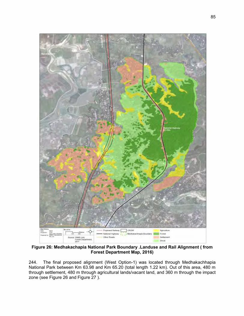
85
Figure 26: Medhakachapia National Park Boundary .Landuse and Rail Alignment ( from Forest Department Map, 2016)
244. The final proposed alignment (West Option-1) was located through Medhakachhapia National Park between Km 63.98 and Km 65.20 (total length 1.22 km). Out of this area, 480 m through settlement, 480 m through agricultural lands/vacant land, and 360 m through the impact zone (see Figure 26 and Figure 27 ).

86
Figure 27: Details of Alignment Crossing through Medhakatchhapia National Park

87
245. After drafting the proposed alignment, Chief Conservator of Forest of Forest Department, Bangladesh was consulted in 2016 for his comments. He suggested that Forest Department has no objection if Bangladesh Railway selected the West Option-1 and will provide No Objection Certificate to Bangladesh Railway if required. He also added that western option will help them to protect the forest from further degradation by encroachers, by provided an inspection route.
C. Conclusions
246. The preferred alignment options, take into consideration not just environmental and social considerations, but also financial, economic and engineering requirements, will be the 2013 corridor from Dohazari to Cox’s Bazar. The passage of the alignment through highly degraded sections of CWS and FWS will be compensated by compensatory afforestation programs carried out by BR in cooperation with the Forest Department. The passage around the MCNP while creating a corridor along the western border of the park, should be viewed as potential management benefit, since much of the illegal logging takes place from communities located to the east of the rail corridor and having an operating line could act as a deterrent , making illegal activities more visible and ,possibly allowing effective patrol using the frequent train passages. 247. BR will also engage the MCNP in afforestation efforts, although at present it has only one staff.

88
VI. IMPACTS AND MITIGATIVE MEASURES
248. This section of the EIA report describes the probable environmental effects stemming from the activities associated with the pre-construction, construction and operating periods of the Project and mitigative measures to be applied and monitoring actions to be taken, to ensure compliance and to track the effectiveness of the measured specified in the Environmental Management Plan.
A. Pre-Construction Period
249. The idea of environmental impact assessment is to, firstly, prevent detrimental effects from occurring and, secondly, to mitigate unavoidable negative impacts, such that these are within acceptable national and international guidelines. Pre-construction period mitigation and monitoring is all about prevention. Spending adequate time examining the work to be undertaken, the possible impacts and designing ways to avoid serious negative effects is the most effective and least costly impact management strategy. To that end, BR has defined nine pre-construction period actions designed to avoid or minimise negative effects once the work begins, and which will be implemented prior to the mobilisation of the contractor. Each measure defined below is also specified in the EMP.
1. Terrestrial Flora and Fauna
250. A straighter and flatter alignment means shorter travel time, lower travel cost and less fuel. These critical engineering and economic factors do not always lead to the least environmentally intrusive alignment. The three features that railway planners considered while preparing the preferred alignment were sensitive settlement areas, waterways, protected/conservation forests, and special habitat for wildlife corridors. Encroaching into these areas is environmentally unacceptable and very costly. The loss of habitat, cutting trees in protected forests or blocking wildlife routes would mean permanent damage to the ecosystem. 251. To minimise losses, route-planning engineers made a survey for an alignment that minimises private land requirement and nearly totally eliminates loss to protected forests and wildlife habitat. For example, the alignment skirts along the eastern edge of the Chunati and Himchari Wildlife Reserves instead of passing through them. Given that this is a new route, considerable tree clearing is unavoidable and will be required for the rail line of the 9 stations and their access roads. The alignment will require the removal of 142,844 timber trees (mostly saplings and medium sizes), 66,433 edible fruit bearing trees, 569 trees used in the production of medicinal medicines, 8,024 banana plants, and 22,124 bamboo thickets, each with their own economic, biological, ecological and aesthetic function and significance specified in the RP (2014)30. These trees were enumerated within a 25 m wide corridor, centred over the Project survey centreline the proposed station building areas, and new station access roads. The mitigative measures in relation to the tree management were defined in the Project RP. 252. As soon as the construction boundaries are surveyed, the exact number of trees will be inventoried and a replanting plan for trees removed outside the BR RoW will be prepared by the BR’s ESMU (or the CSC until the ESMU becomes operational). For safety reasons and to avoid providing attractants to grazing animals, such as buffalo and elephant, trees will not be
30 Center for Environmental and Geographic Information Service (CEGIS). 2014 .SP4 Draft Resettlement
Plan.

89
replanted inside the RoW, other than for erosion protection, landscaping and visual screening along the edge of the RoW. The replanting plan will be implemented as soon as construction on one section of the rail line is complete.
2. The Elephant-Train Accident Prevention Options
253. Prevention of elephant-train accidents and maintenance of active travel corridors is a major objective of the EMP prepared for this Project. The five active crossing sites were identified and details about topography and lines of sight calculated in Figure 15, Table 20) and further details in Chapter IV of the EIA. To reach the recommendation on the preferred solution for elephant-train accident prevention the following eight options were assessed. 254. 1) Underpasses - Wildlife underpasses are permanent structures, typically large culverts or arched passages, extending beneath a roadway to facilitate safe passage of animals across an alignment. Fencing is often used in conjunction with underpasses, to prevent crossings at other locations and funnel wildlife to the intended safe crossing point. Underpasses have been used for roads, with mixed results, for numerous wildlife species in various parts of the world. They were found to be ineffective for elephants when used for crossing roads in Nepal, because the elephants were reluctant to enter tunnel-like openings.31 However, there is no available information which indicates that underpasses have been provided for the movement of elephants under railways, possibly because the grading requirements for railways require the construction of extremely high embankments and extensive changes to the natural landscape compared to those for roads. 255. Experience with wildlife undrpasses indicates that the structures are more likely to be used if the approaches and the structures themselves are made to appear similar to surrounding habitat areas; this means that thoughtful landscaping with appropriate species is required during the construction period, and that vegetation must be managed throughout the operation period to maintain desirable plant communities. Where fencing is used, this must also receive regular maintenance. 256. Concerns have been raised in some contexts about the potential for underpasses to contribute to poaching problems, as the concentration of individuals in a wildlife population at a single location can provide a rich opportunity for hunters. Monitoring and enforcement may therefore be required throughout the life of the infrastructure. 257. Strengths and weaknesses -Thoughtfully designed and implemented underpasses would seem to offer a straightforward means of preventing elephants from getting hit by trains, as they offer a means of having the elephants avoid actually crossing over the tracks. Combined with effective fencing, it is theoretically possible to have all elephants in the region pass safely through these structures. The possibility of keeping trains and elephants physically separate is this mitigation option’s greatest strength. However, in practice it would not be considered feasible to fence the entire 102 km rail alignment, and it is clear that the current state of knowledge regarding what makes an underpass truly acceptable to elephants is weak. There is actual video evidence of underpasses working under roads in Bhutan. This example is a unique setting in a dry streambed, the preferred travel route of the elephant herd impacted and the underpass is fully removed from human habitation. It is therefore likely, even if underpasses are built at all known crossing points that a significant portion of elephants will still choose to cross 31 Personal communication, Karma Yangzom, Environmental Specialist, ADB, Manila, 2014.

90
at other places within the corridor. In the context of the five crossings the underpass option, while possible would require the elevation of the rail formation from 4 to 7 m, which means procuring of large amount of embankment fills to construct several km of higher embankment and the requirements for additional land or the establishment of retaining walls, as well as changes to the natural landscape, in order to maintain the necessary grades for train operations. This issue is not as much a problem for roads, which can accept steeper grades on the approaches to the underpasses. 258. Estimated costs – It is expected that underpasses suitable for use by elephants would cost about USD 3.3 – 3.8 million each, not including fencing and maintenance and training, equipment and personnel costs associated with anti-poaching efforts. 259. 2) Overpasses - Wildlife overpasses are essentially very wide bridges with landscaped decks designed to mimic surrounding habitat and provide a safe and psychologically non-threatening route over a linear infrastructure right-of-way. Overpasses have been successfully used for large ungulates and other wildlife, but never elephants. Singh and Chalisgaonkar (2006) conducted an in-depth study of the concept for the United Nations Environment Programme (UNEP), and determined that such overpasses are environmentally feasible but that there is no guarantee that elephants will use them. Because many species will not use overpasses if noise and visual intrusion from vehicles or trains passing below are in evidence, the structures typically need to be quite wide (at least 100 m) to be effective; they can become major undertakings requiring careful design, massive earthworks, and long-term vegetation management. Like underpasses, overpasses typically require fencing to funnel wildlife to them, and may therefore provide heightened opportunity for poachers. 260. Strengths and weaknesses- Wildlife overpasses offer the possibility of completely avoiding the risk of contact between elephants and trains. The railway could operate without restriction or concern as the elephants pass safely overhead on a strip of favourable habitat. Properly designed and maintained and supported by adequate funnel fencing, overpasses would likely be more acceptable to elephants than tunnel-like underpasses. However, the familiar problems of placement and permanence remain. Available data on elephant movements is incomplete at best, migration and habitat use patterns may change over time, and once built, and these very substantial and expensive structures cannot be moved to a new site. Finally, given 5-years of construction interfering with travel routes could mean that the herds move to a completely different corridor. 261. Estimated costs-The cost of constructing an effective wildlife overpass for elephants is estimated to be around USD 2.73 – 6.51 million each, depending on the crossing location, the terrain and existing infrastructure to be crossed, not including landscaping fencing and maintenance, plus security. The single advantage of an overpass is that it can be built relatively easily after the rail line has been built, in the same way a bridge is constructed over an operating rail line. 262. Overpasses versus underpasses- For the five crossings the costs of both over and underpasses were estimated, showing the high cost of underpasses due to the need for large volumes of fill to maintain the necessary shallow grade.

91
Table 30: Comparison of Technical Solution and Capital Cost of Overpasses at Five Active Elephant Crossings Crossing Number and Name of the Crossing Feature 1. Chunati 2. Pulchari 3. Pulchari 4. Chiringa 5. Dulahazara Underpass Technically feasible
at Km 27.32; vertical alignment needs to be raised by about 4.3 m. Affected length is around 2.5 km. Three box culverts to be raised.
Technically feasible at Km 28.30 – vertical alignment needs raising by 5.3 m. Affected length is about 2.2 km. One major bridge and two box culverts to be raised.
Not feasible as underpass would require a 18 m lift at approaches because of high natural ground at the crossing point. Affected length around 15.9 km. One major bridge and 24 box culverts to be raised. In addition, Harbang rail station and four level crossings to be raised.
Technically feasible if located at Km 55.64: embankment needs to be raised by about 6.9 m. Affected length is 1.7 km. Reinforced earth walls may be required to limit land impacts. Three box culverts and one level crossing to be raised.
Technically feasible at Km 56.30; requires raising formation level by around 7.2 m. Affected length is about 1.9 km. RE walls may be required. Three box culverts and one level crossing to be raised.
Capital ($) 3.29 M 3.50 M More than 18 M 3.80 M 3.83 M Overpass Technically feasible
Km 27.20-27.60, but raise embankment by ≥ 2.75 m for the 30 m wide overpass in allow the train to pass underneath. Adversely impacts on around 50% of the nursery of Km 27 of which the diversion of the railway was implemented. Additional 76 m long box culvert will be required to cross a watercourse.
Technically feasible between Km 28.40-28.54 from an engineering standpoint
Technically feasible between Km 28.90-29.20 from an engineering standpoint
Technically feasible between Km 55.30-55.42 from an engineering standpoint
Technically feasible between Km 56.04-56.16 from an engineering standpoint A 80m long box culvert will be required to cross a watercourse
Capital ($) 4.75 M 2.73 M 2.73 M 2.73 M 2.73

92
263. Since there was interest expressed by local Forest Department officers concerning elephant crossings when rail operation is in place with mitigation measures of overpass underpasses, and thermal imaging cameras, therefore, a further investigation of each site was carried out to address the cut and fill work as well as suitable level crossing areas for elephants and to compare the inflexibility of fixed crossings with the flexibility of thermal imaging cameras mounted on the locomotives (Table 31).
Table 31: Location of Underpass and Overpass In Relation to Topography, and Safe Level Crossing Locations Using the TIC System
Active Elephant Crossing
Location of
Existing Active
Elephant Crossing
(Km)
Location/Range of Proposed Elephant Crossing Due to Cutting with Mitigation Measures
Remarks Overpass Underpass Thermal Imaging Cameras (TIC)
Starting Km
Ending Km
Starting Km
Ending Km
Starting Km
Ending Km
1 27.236 27.215 27.265 27.315 27.345 27.095 27.170
Elephants will use this route for railway track crossing with TIC option in place.
2 28.319 28.415 28.465 28.285 29.315 28.235 28.343
Elephants will use this route for railway track crossing with TIC option in place.
3 29.017 29.015 29.065 Not feasible* 28.724 28.804
To accommodate underpass 18 m lift over present design embankment needed, affecting Active Crossings 1 and 2. Therefore, underpass at Crossing 3 is not feasible.
4 55.407 55.335 55.385 55.625 55.655 55.607 55.707
Elephants will use this route for railway track crossing with TIC option in place.
5 56.262 56.075 56.125 56.285 56.315 56.230 56.330
Elephants will us this route for railway track crossing with TIC option in place.
264. Extensive literature reviews conducted indicate that elephant underpasses for railway projects have not been attempted anywhere in the world. This maybe due primarily to the strict limits on gradual grade changes, thus requiring long and costly lift sections. Elephant overpasses on rail projects are also completely untested systems. however the overpass option has been retained as a potential mitigative measure under this project. 265. 3) Cellular-Enabled Infrared Camera Traps - Camera traps are digital cameras set up to be triggered when an animal with a specific heat signature and size moves through a defined sensing area. Cameras would be installed on steel poles along elephant trails on both sides of the railroad tracks at each crossing, with settings calibrated to trigger a photograph only when elephants pass by. The cellular-enabled camera units would send photographs via instant

93
message to stationmasters at nearby stations. Stationmasters would review the photographs to confirm the presence of elephants, before sending alerts to conductors with location-specific information so the trains could be slowed or stopped in time to avoid collisions with elephants. 266. Camera traps have been used in wildlife studies around the world, including South Asia, for many years. There is a large body of research literature that provides insight as to the kinds of operational challenges that are likely to arise in this particular application, as well as lessons suggesting how such challenges can be overcome. Vandalism and theft are often a problem, especially in locations near settlements, as are environmental challenges such as heavy precipitation, high humidity, and vigorous vegetation. These factors are all potentially significant in the context of the proposed alignment, and would require significant ongoing maintenance effort to overcome. 267. Strengths and weaknesses Camera traps have the advantage of being an adaptable solution, in that cameras and their support poles can be moved with relatively little expense incurred, should that prove a necessary response to changing elephant movement patterns. The cameras and support poles are relatively inexpensive compared to some of the equipment required for other options, and well within the capacity of local technicians to operate and maintain, given a small amount of training. Overall, this is the least expensive option aside from trackside warning signs. On the other hand, legitimate concerns have been raised about the vulnerability of an array of camera traps to vandalism and theft at the hands of people living and working in the vicinity of the tracks, and the generation of useful images does face a host of environmental challenges. It is probable that successful operation of this system will require multiple iterations of innovative, site-specific troubleshooting on an ongoing basis, in addition to more routine maintenance and protection tasks. 268. Estimated costs-The estimated costs associated with setting up and operating an array of camera traps covering all 5 active crossing sites over a 10 year period would be US$ 129,700.00 269. 4) Locomotive-Mounted Thermal Imaging Cameras (TIC) - Thermal imaging cameras capture infrared emissions (heat, not light) from heat sources in the field of view and convert them to an image shown on a digital video display. Objects with a temperature warmer than the ambient (as with a person or animal generating normal body heat) are clearly delineated and identifiable by shape and motion. 270. Commercially available thermal imaging cameras are capable of generating imagery that train operators could theoretically use to detect elephant-sized objects on or near the tracks 4 to 6 km ahead, and recognize them as elephants within the range of 1 to1.2 km. This could give train operators monitoring the display adequate time to bring the train to a stop before reaching the animals. In the most practical application scenario, a single thermal camera would be mounted on top of the locomotive, with imaging fed directly to an in-cab laptop computer running image stabilization software. 271. Strengths and Weaknesses- Locomotive-mounted thermal cameras have the significant advantage of being much less exposed to theft and vandalism than other technological solutions deployed trackside. The train-top housings installed to protect the cameras from damage by branches and flying objects could be outfitted with heavy locking mechanisms, and access to locomotives themselves is in any case generally restricted as a matter of course. This mitigation solution would also involve no on-the-ground management of vegetation, installation of poles, power supply issues, or security monitoring to protect

94
equipment. Locomotive-mounted cameras would also do their job anywhere along the track, not just where surveys suggest elephants are most likely to cross. They will be effective in detecting the presence of elephants near both active and seasonal elephant crossings. 272. The foregoing notwithstanding, successful implementation of the locomotive-mounted thermal cameras would require a number of technical solutions, based on trial and error. Most significant would be the line-of-sight issue, restricting the view to straight ahead of the locomotive with a side to side view at 1000m of 176 to 210m. Due to curves and deep cuts the line-of-sight at crossings is reduced to as low as 200m at Crossing No.4. Solutions to be tested will be mounting the camera on the locomotive cab as high as possible and using a camera with a wide angle lens allowing for a wider field of vision.
Table 32: Operating parameters of thermal imaging camera at five crossing structures
# Active Crossing at Km
TIC Line of Sight Available to see Elephant based on a cone of vision with an 25o angle and a field of
vision of 210 m at 1000 m distance from the TIC
Speed Restriction Required (km/h),
Stopping Distance
(m)
Stopping Time (sec)
Time needed for herd to
reach track at 100 m
distance @ 10 km/h (sec)
From Chittagong
Side
From Cox’s Bazar Side
30 <= 122 m 18 23
1 27.236 (27.095 to 27.170)
232 1000
2 28.319 (28.235 to 28.343)
1000 166
3 29.017 (28.724 to 28.804)
222 1000
4 55.407 (55.607 to 55.707)
259 768
5 56.262 (56.230 to 56.330)
422 377
273. The manufacturer of the camera has indicated that wide angle lenses can be installed, therefore allowing for vision around corners while still maintaining at least 600m field of vision. 274. One other factor that seems to be quite clear is that this route will require a speed restriction since there are not only the 5 active crossings but another 6 seasonal crossings along the line. Based on a 20 carriage passenger train traveling at 45km/h the stopping distance is about 350 m and time required is 25 seconds, enough time to avoid collision (Table 32). Whistle blowing should be a last resort. 275. Estimated costs -The estimated cost of an appropriate thermal imaging system fully installed with in-cab laptop computer and protective housing is estimated to be about US$ 36,000 per locomotive, with annual recurring costs about USD 800 per train, over ten years. If installing on 20 locomotives (the estimated number of trains using the rail line initially), the total estimated cost would be about US$ 750,000. If installation is planned with portability in mind, the imaging system could be transferred from train to train with relative ease, thus limiting overall cost.

95
276. 5) Signage and Training - This option would involve the placement of ‘elephant area’ warning signs at an appropriate distance on either side of each identified crossing area, coupled with training of locomotive operators. The warning signs would include information for train operators about typical crossing periods, and identify these areas as slow speed zones. Training would be provided to operators with regard to correct procedures to be followed when nearing or passing through signed areas. This system is by far the least expensive alternative, but has generally not worked well where it has been tried, such as in India, due to errors in judgment and poor compliance on the part of train operators. The general conclusion is that this approach is typically only marginally successful, and is not recommended by experts in such organizations as IUCN, UNEP, and ADB.32 277. Strengths and Weaknesses - The only advantage associated with the signage option is low cost. Even with communicative signs and appropriate training for engineers, the likelihood of perfect compliance with operating protocols is low; this is the experience with signage in varied contexts worldwide. At the same time, the signage option faces the basic problem of uncertainty regarding the location of actual elephant crossings. Engineers following the rules will proceed slowly within the identified ‘elephant areas’, but there is no guarantee that the elephants will cross only in those areas. Outside ‘elephant areas’, engineers will be expected to maintain full speed, with no knowledge of any elephant that chooses to cross somewhere else until it is too late to take preventive action. 278. Estimated Costs - Although 5 active elephant crossing points have been identified, some of these are grouped quite closely together, and for the purposes of installing trackside signage to warn train engineers about ‘elephant areas’, there are effectively 3 areas to mark. Each of these 3 areas would require 2 signs (one in each direction), for a total of 12 signs located 1000 m from each crossing point and then within 100m of the crossing for another 12 signs and finally one sign at each crossing point for another 6 signs for a total of 30 signs. Assuming a cost of approximately USD 500 per sign including installation, and a one-day annual training session for train engineers on proper ‘elephant area’ operating protocol (estimated cost USD 300), the cost associated with this mitigation option is around US$ 25,000. 279. 6) Stationary Thermal Cameras in Direct Communication with Train Operators -This system would operate in a similar fashion to the option described in the previous section, but instead of illuminating trackside signal lights, the identification of an elephant by a camera would trigger an auxiliary sending unit, which would send a warning signal with location data directly to train operators using the rail-telecom system or via cellular network. Each locomotive would have on board a receiving device, which could simply be a smartphone carried by the engineer or mounted in the cab. Upon receiving an alert, the engineer would be required to implement a specific elephant avoidance protocol, e.g. activating flashing lights and auditory alarms, and reducing speed. If desired, the camera could be set up to trigger an auxiliary device capable of sending an image rather than just a warning message, so the engineer could have visual verification of a positive detection; this would entail additional complexity and expense. A system similar to this has been implemented in Israel to detect cars and other obstructions on railway tracks at crossing points. 280. Strengths and weaknesses - This enhanced version of the trackside thermal imaging option shares all the strengths of the system described in the previous section, and most of the weaknesses. However, it has a significant advantage in that a warning triggered by the 32 Personal communication, Karma Yangzom, Environmental Specialist, ADB, Manila, 2014.

96
appearance of an elephant would be received by the train operator regardless of where the train was on the track, so that even if the train had already passed the 1,000 m mark, action could be taken to at least slow the train. In many instances there would not be time to stop completely, but speed could be reduced and whistles sounded to scare elephants off the tracks. 281. Estimated costs - All included, and for a 10 year period, costs would be around US$ 700,000. 282. Recommended Approach- After analysing the six mitigation options, their strenghts and weaknesses and detailed discussions with Bangladesh Railways it was agreed that a combination of options including overpasses with one of the three camera options and signage and training will be implemented under the project.
283. A pilot test of the three camera options will be implemented during the first two years of project construction to determine the most feasible camera option. To address the line of sight issue, a speed restriction of around 30 km/h from Km 27 up to Km 30 shall be considered. Further the different camera systems will be tested with wide angle lenses, increasing the line of sight (although reducing the sighting distance). The pilot testing period will be used to optimize and fine-tune parameters such as speed restrictions, type of cameras, portability of the cameras, line of sight, raising awareness, procedures for operation of the system, and other factors. 284. Preliminary discussions with BR in relation to suitable testing locations for the thermal imaging cameras and possibly the infra-sound alarms have indicated that the Rashidpur-Satgaon (6.91km) and Srimangal-Bhanugach (8.10km) sections in Akhaura to Kulaura railway line may be suitable for pilot testing of these systems. Both the above sections have rail lines, not unlike the proposed new line, i.e. curves, cuts and fills. 285. The elephant TIC mitigation should be viewed as an opportunity to promote the line as a tourist train where the viewing of elephant is possible and at night the TIC signal could be transmitted to seatback monitors, enhancing the experience and making the train journey unique. 286. Action to be taken - Prior to the start of construction a year long study will be conducted on elephant movement patterns in the Project area by a Wildlife Expert who will be part of an Independent Monitoring Team that will be recruited separately under a Capacity Building Technical Assistance (CDTA) by ADB. Based on the updated findings of the study a plan to minimize impact on elephant routes during construction will be prepared by the Wildlife Expect in consultation with relevant experts from IUCN Bangladesh, Wildlife Trust, the Forest Department and representatives of the villages bordering the elephant travel corridors. A workshop will be held in the elephant zone, possibly the Dulahazara Safari Park or one of the Forest Department’s District offices. The pilot testing programme will be designed in detail by the contractor under the technical guidance of the Environment Specialist of the Construction Supervision Consultants and Independent Monitor Wildlife Experts prior to the start of the construction period. 287. Review of Supporting Literature- There are no data on elephant –train collisions or indeed vehicle elephant interactions in Bangladesh. Given that India has likely with World’s largest population of wild Asian elephant and also a huge railway network running throughout
97
the country, the occurrences of elephant-train collisions in the thousands per year and elephant deaths are in the hundreds. In 2013 the Supreme Court of India33 instructed the Ministry of Railways and the Ministry of Environment and Forests to explore ways of help forewarn locomotive operators of approaching elephant. A number of options were suggested included vegetation clearance from trackside, overpasses, underpasses and speed restrictions to 50 km/h, as well as elephant fencing. However the long term strategy was to find a wireless warning system and specifically a thermal Imaging camera approach or satellite based system testing programme was urged. 288. This was further underscored by the Indian Apex Court in 201434 , reiterating the need to test the TIC approach as well as exploring advanced radar systems and underpasses. 289. In response to the Supreme Court ruling the government of Karnataka, which supports 20% of India’s elephant population, responded by indicating that they had an effective accident prevention system, which included enforcing speed controls along 1600 km of rail line which passed through reserve forest areas, and construction of 500km of elephant proof trenches and 600 km of electric fencing. The article however implied that wireless ‘tracking’ technology, such as TIC systems needed to be tested.. 290. Finally in Sri Lanka, where the TIC system is already being tested35 further research has uncovered a new potentially exciting approach, namely to reproduce the elephant warning infra-(low frequency) sound warning calls, discovered by S O’Connell (Connell, 2007) a researcher from the USA’s Stanford University and published in her book Elephant’s Secret Sense. 291. These activities in India and Sri Lanka fully support the direction proposed by BR and during the work contacts (which have already been made with researchers) will be strengthened any lessons learned will be applied to this work.
3. Land, Assets and Livelihood Disruption
292. According to the census and Inventory of Losses (IoL) survey in the Project corridor, 2,182 affected households/units will experience different types of losses (a full list of IoL is in Annex 1 of the RP, 2014). Table 33 presents a summary of the Project impacts.
Table 33: Land and Fixed Assets Impacted Project Impacts Quantity Details Quantity/No.
Amount of land to be acquired (in ha) 552.82 No. of Structures Private Structures 1,555
Government Structures 38 CPR Structures 44
No. of Displaced Households with structures
Titled 1,025 1,555 Non Titled 520
No. of Displaced Physically Displaced 1,025 1,498
33 Indian Supreme Court Ruling 107/2013 34 The Times of India. 3 September 2014. SC: Use Radars to Stop Jumbo Deaths on Tracks, New Delhi 35 A. K. Kulatunga, J. Gowrynathan, R. Ekanayake, D. Athauda, C. Chandrakumar Intelligent Vision
Based Driver Assisted System for Trains – Elephants Accidents International Journal of Electrical and Electronic Science 2015; 2(2): 6-16 Published online August 10, 2015 (http://www.aascit.org/journal/ijees)

98
Project Impacts Quantity Details Quantity/No. Households Economically Displaced 409
Both Economically and Physically displaced
64
No. of Vulnerable Households 1,489 No. of trees 239,000 No. of CPRs (TOTAL) 44 Source: (RCIP-RP, 2015)
293. The survey data on land use within the rail corridor indicated that 352 households would lose agricultural lands. The Project would also lead to the loss of 1,413 residential structures, 83 commercial structures, 49 residential cum commercial structures, 4 large businesses, and 44 CPRs. Details are presented in Table 34 In all cases, affected CPRs will be rebuilt at alternative sites selected by the community who will identify a relocation site. These costs are already included in the Project cost estimates.
Table 34: Types of Losses by Number of Affected Households and Businesses Households/Units Dohazari-
Jungle Chunti Harbang-Phulchari
Napitkhali-Jhilwanja Total
Losing agricultural land 172 55 125 352 Losing residential structures 310 641 462 1,413 Losing commercial structures 44 23 16 83 Losing residence cum commercial structures 7 26 16 49 Losing trees only
4 13 17
CPRs 13 17 14 44 Losing only crops 5
5
Losing other auxiliary structures 9 11 15 35 Large scale business 3
1 4
Bangladesh Railway 1 0 0 1 Other GoB agency 1 2 2 5 Total 565 779 664 2,008 Source: Census & IoL survey, 2013 & 2014
294. To address these losses the RP team prepared an entitlement matrix, defining the optional compensation available to each affected person, household or business. The entitlement matrix was approved by the government and is now a legally binding compensation mechanism that BR will adhere to (See Project RP). 295. According to the Land Acquisition Plan, an estimated >550 ha of land will be acquired by the Project, of which about 400 ha is agricultural. In the process of acquisition, if any plot of land so acquired becomes unviable (for example, if less than 10% remains) and if the owner(s) wants the same plot to be acquired, BR will acquire the entire plot and pay compensation as per the set entitlement in this Project. 296. Fixed Assets - During the social survey, 2,008 items were identified as having to be removed from the rail corridor prior to the start of construction, i.e., before physical field work begins. Twenty-four types of fixed assets were identified, ranging from septic tanks, fences and walls to tube wells and pit privies. As much as 60% of these losses were attributed to the removal of tube wells, latrines and water pumps (RCIP-RP, 2015).
4. Employment and Livelihood

99
297. In order to build the line, 1,413 residential structures will have to be acquired and their families relocated, 83 commercial structures, and 49 residential cum commercial structures plus four large businesses will be moved from within the new rail corridor (Table 34). 298. All the physically displaced households, shops, business enterprises and CPR structures whether owned or just occupied, were included in the survey and will be compensated according to the agreement reached during the IoL survey and during the Detailed Measurement Survey (DMS) to be completed once the corridor boundaries are surveyed. 299. In total, 118 employees working in the affected businesses for over six months in a year (considered more permanent employees) will lose their jobs because of the Project. The number of employees losing their jobs due to the impacts on businesses is higher in the Dohazari–Jangle Chunti section (58.47) followed by Harbang–Phulchari (18.64%), Ramu–Gundum (11.02%) and Napitkhali–Jhilwanja (11.86%) sections.
5. Heritage and Culture
300. The 40 CPRs (Table 27) were identified by local community and Project designers are working to avoid impacting as many as possible, through adjustments to the alignment. The CPRs might be relocated and reconstructed by BR according to local wishes. Compensation will be provided according to the guideline specified in the RP. 301. According to the entitlement policy defined in the RP, all communities loosing CPRs will be given cash compensation for the land, structure and additional transfer grants for relocation of each structure. Dismantling and reconstruction cash assistance will be provided as per assessed value. In this way CPRs will be rebuilt at Project cost, in consultation with the APs and the affected communities. Affected graveyards will be dealt with sensitively, and in consultation with the concerned families as these graveyards are not registered with local Government, but rather are on private and mostly homestead lands. The concerned DC will pay compensation as homestead land and will not recognise the “graves” as they are not on record. The international non-government organisation (INGO) will assist the families to exhume the bodies for reburial provided the concerned families wish relocation of graves. Further details are provided in the RP.
6. Utilities and Level Crossings
302. Overhead Power Line, Telecommunications - A number of overhead power lines cross the rail corridor and BR will request the electrical authority to move those that pose a safety threat, and pay to have this work done. These lines and other utilities affected are defined in detail in Project’s Feasibility Study report. 303. Safety and Level Crossings - Operations of at-grade crossings have frequently caused major accidents resulting in severe injuries. These regularly cause serious traffic jams regardless of location, sometimes blocking traffic even after the train has passed. To mitigate these problems vehicular traffic management systems will be installed at the 116 proposed level crossings. All crossings will be assessed with a view to applying the best available technology to address safety concerns. BR has already undertaken a separate national study addressing safety at crossings and will be applying findings to this Project, during the detailed design period. Further, Pajunen (2000) defined a set of measures for improving safety at level crossing which together with the BR study will result and safe crossings along this line.

100
304. All major road crossings have been provided with automatic gated crossings, which will also be manned around the clock. Other roads carrying significant amounts of road traffic will be provided with gated crossings, which will be manned around the clock. For very minor roads, where there is very little traffic, the level crossings will not be manned, but speed breakers will be constructed on the approach roads, and appropriate warning signs will be erected to warn the public of the level crossings. 305. The two crossings of National Highway No.1 will initially be Special Class Level Crossings with automatic boom gates. These operations and their effectiveness will be monitored and on-going discussions with RHD will be undertaken and the need for grade separated crossings.
7. Transport of Construction Materials
306. More than 13 million m3 of embankment materials will be required to build the 100.8 km long rail line (Table 7). More than 7.39 million m3 will be brought to the work areas via pipeline using the river dredging approach, used throughout Bangladesh. The contractor will prepare an earthworks management plan, maximising the use of materials from hill cuttings and keeping haul distances to a minimum. 307. A checklist and guideline for the handling of all construction materials and the designation of roads not suited for hauling materials will be prepared by BR in consultation with local police, provided the contractors for implemented and strictly enforced by BR. Specific measures defined in these guidelines will include dust control and road maintenance due to the movement of heavily loaded trucks, as well as noise management through settlement areas. The eight components of the plan are defined below and need to be incorporated into the plan to be developed by the contractor and CS.
(i) Haul roads will be designated via plan developed between the contractor, BR and local communities and the police, to avoid high density urban areas, high traffic areas;
(ii) Haul roads will be maintained with dust supression and strict speed controls, inforced by the contractor and monitored by the CSC;
(iii) All trucks hauling materials will be maintained so that no exhaust soot and black smoke is evident and will provide safety inspection certificates to CSC on initiation of the work;
(iv) All dry and dusty materials will require covers to prevent or deter spillage; (v) Much of the embankment material will be dredged sand taken from designated
rivers and sent in a slurry via pipeline to storage areas were it will be taken by truck to the nearby embankment worksites;
(vi) Aggregate will be brought by truck or barge as large boulders either from the Sylhet region or India, and crushed at a mobile crushing opearation, located at least 500m from any settlement, ( and moved from site to site) then hauled by truck to be used as the sub-ballast and ballast materials;
(vii) Cement will be delivered in bulk to a number of concrete batch plants where it will be mixed with gravel and water to produce concrete than taken to work sites in ready-mix trucks. Batch plants will be a minimum of 500m from any settlement;
(viii) Topsoil will be removed and stored from all disturbed sites, the reused to revegatate embankment slopes and rehabilitation temporary work and storage areas;
8. Borrow Sites, Work Camps, Storage Area

101
308. Borrow Sites-Over 70% of the borrow material (for the embankment) will be sand dredged from local rivers, via private operators working under a GoB permitting process, Other material will be obtained from licensed operators and all aggregate will be purchased from India, then transported to the project areas by rail and truck. The contractor is not permitted to undertaken large side borrow operations, and if needed will have to develop a special borrow site, requiring an environmental application submitted to DoE.
9. Work Camps
309. An estimated 3,500 + people will work on the project and 60-65% will reside in construction camps Seven to ten camps are anticipated. At this time there are no details on location, but limits of 500m from any surface water drainage and 500m from any housing facility will need to complied with. 310. Options for management of campsite domestic waste and construction waste will be studied and included in the Environmental Management Implementation Work Schedule (EMWS). Waste management options may consider waste segregation, linking up with local urban waste disposal systems, disposal in approved designed areas using environmentally friendly methods. Further EMP Tasks 2.5.1, 2.11 and 2.12 all apply to work camp operations and environmental compliance. The contractor and CSC will report on actions taken by the contractor in their quarterly and semi annual reports. 311. Storage Areas- will include sites along the alignment and sometimes within the alignment were the dredged sand will be stored, Bricks and ballast materials will also be stores immediately along the rail alignment. These materials are relatively dust free and once stored will say in place
10. Environmental Clauses in Contract Specifications
312. To make sure the contractors address environmental safeguard measures, BR has integrated environmental clauses into the construction contracts, referred to as Sub-section H of the contract. These clauses underscore the requirements for environmentally responsible construction (See Annex 10) and specify the need for the contractor to apply the mitigation and monitoring measured defined in the Environmental Management Plan, as described in the Project EIA. Further, BR has prepared a section of the contract Bill-of-Quantities dedicated to environmental safeguards. This now addition will help to link specific payments to the implementation of mitigative and monitoring actions as defined in the contract specifications.
11. Safeguard Documents, Training in EA and EMP to Contractors and Engineer
313. Mobilising the contractor without the EIA and its EMP will not provide the intended safeguards to the environment. Therefore, BR will confirm that an electronic and hard copy of the EIA documentation is distributed to the contractors, Upazilas and the Engineer for use during the construction period and beyond. In addition, before construction mobilisation, BR will organise a briefing session for the contractor to review the EMP and its implementation and reporting requirements. The Environmental Safeguards officers under the Contractor should have been mobilized as soon as the contract is awarded.
12. Environmentally Responsive Design Considerations

102
314. Failure of the engineers and architects to consider environmentally responsible design that minimises immediate as well as long term impact during the construction and operating periods will jeopardise Project implementation and environmentally acceptable operations. Therefore, the focuses of all design elements that encroach on key natural resources such as the rivers and forests have been examined to minimise permanent damage and losses. Alignments have been adjusted, work campsites limits identified, waste management procedures specified and interference with wildlife and wildlife habitat restricted. Instructions on how this is to be achieved are presented in the EMP, which BR is committed to enforcing. 315. Station Design - Inadequate provisions of sewage, sanitation and garbage management may lead to chronic problems. The design of each station has considered estimated passenger through-put, and sized each station’s waste management facilities accordingly; and incompliance with BNBC. The designs include the use of solar energy and rainwater harvesting, as well as natural ventilation, intended to reduce the energy requirement of each station. 316. Solid Waste - For Cox’s Bazar, solid waste will be collected in bins and it will be transported and disposed by Cox’s Bazar Municipality. BR will pay for this according to the rules of the Municipality. The volumes of waste are approximated as follows: for passengers 4 hour of waste accumulation will be: 22 trains/day x 22 carriages/train x 60 p/carriage x0.48 kg/day x 4hr/24hr= 2,323 kg/day at Cox’s Bazar, for staff 18 operation hours = 300 p x0.48kg/p/24hr x 18 hr/24 hr=108 kg, others users of station building for 12 hours= 1,517p x0.48kg/p x12hr/24hr= 364 kg, for a grand total of 2,795 kg/day at the cox’s Bazar Station operation. 317. At the Cox’s Bazar Station there is no central waste collection system operated by the municipality at the station, so a soak well and septic tank system has been designed and will have the following capacity: 318. For other stations waste bins have been provided for collecting of solid waste and BR will dispose of site in approved and managed waste disposal site. Maximum amount of solid waste for each of the other stations will be; for passengers: 700 people over 24hrs /station x 0.48kg/psgr. x 4hr use time/ 24hr =112 kg/station/day, non-passengers: 50 people x0.48 kg/day x18hr /24 hr.= 18 kg/station/day, for a total of 130 kg/station/day. 319. Septic tank shall be emptied every year with vacuumed tanker and disposed in accordance with local authority directions. Soak well and septic tank system has been provided for liquid waste management. 320. All building and design standard defined in the Bangladesh National Building Code (BNBC) have been carefully complied with including sizing of the waste management facilities for all stations. 321. Occupational and Environmental Health and Safety- The contractor will need to adhere closely to the OHS and EHS items defined in EMP clauses 2.11 and 2.16, addressing all relevant ADB, WHO and ILO requirements. 322. Bridge Site Planning - There will be six major (>100 m length) bridges to be constructed over the Sangu, Matamuhuri 1, Matamuhuri 2, Bakkhali and the Idgaon Rivers, plus another 47 medium to smaller bridges. The pre-construction activities in and around bridge sites include topographic surveys and geotechnical investigations, including boring under water. Every effort has been taken to design the crossing alignment such that it minimally impacts

103
people and structures as well as the flow of the river while meeting the rail engineering specifications. The work schedule will be planned around the dry season, such that maximum construction work in and along river shorelines is done when the flow is very low or the river bed is dry. Each large bridge will have its own work camp, which will have site restrictions, specific waste management requirements and approved potable water sources.
B. Construction Period Impacts and Proposed Mitigation
323. Construction period effects are those resulting directly or indirectly from a construction activity, be it site clearing, hauling material along a public road or dredging sand from a river. The construction period section of the EMP, lists the impacts needing mitigation, the mitigative measures to be applied, where they need to be applied, when and by whom. The set of mitigative measures highlighted here and listed in detail the EMP (Table 54) describe proposed actions to be taken by the contractor to avoid or minimise unacceptable environmental degradation. There are 22 possible impacts, mitigation and monitoring measures listed in the EMP. Highlights follow.
1. Physical Environment
324. Topography and Landscape - The impacts to site topography will be due to the construction of rail embankment, the access roads, the need to cut through a number of hilly sections and the placement of 8 new station buildings. The new embankment will have the greatest effect as it will rise above the mostly flat landscape, by as much as 12 m. Secondly, in order to achieve an acceptable operating grade, cutting through hills will be required at about 40 locations for >11,000 m (See Annex 2 maps for the approximate locations) of the rail corridor, significantly and permanently impacting the local topography. Hill cutting is strictly controlled in Bangladesh and BR will make specific applications for each site with the both national and district officials. Each site will require a design, earthworks quantities calculation, showing exactly what will be cut, how all materials will be managed and a time bounded landscaping and rehabilitation programme. The key mitigative measure will be rapid erosion protection via revegetation, replanting and any other actions needed to protect the embankments and the cut areas against rain damage, slope slippage and water body siltation. 325. Sand from River Beds - While details are not available, an estimated 7.39 million m3 of sand, to be used as embankment material and will need to be dredged from the rivers crossed by the new alignment. As a minimum, the five large rivers will be important sources, and will be dredged based on permits obtained from DoE and the Ministry of Water Resources. The process will be the erection of temporary pipelines from the rivers to the alignment, then pumping of sand slurry via one or several large suction dredgers. This methodology can only be used during the monsoon period when there is water in the rivers. 326. The pipelines will be moved from one location to another, ensuring the sand storage areas are as close to the rail alignment as possible and within BR’s RoW at all times. From these locations the sand will be trucked, a relatively short distance to the exact embankment locations. BR has been monitoring the impact on downstream water quality of the dredging operations at the Tongi–Bhairab Project and found that while Total Suspended Sediment levels rose by as much as 15% in a narrow plume 50 m downstream of the dredge operations, the heavy metal concentrations tested were not affected, however total phosphorus levels did rise during dredging and then returned to background conditions as soon as the operation stopped. This temporary rise was not viewed as a significant issue. Given the extreme natural movement of bed materials in these rivers (flooding during monsoon and tidal surges) and their regular use

104
(mining) as sources of building materials, the dredging operations are not expected to result in re-suspension of toxins trapped in the sediments (as would be expected from a less disturbed river or lake bottom). 327. Mitigative measures defined for this activity are (i) obtaining permits for extraction sites and quantities from appropriate authorities and adhering to the prescribed extraction volume limits per site, and (ii) conducting a survey at each dredging site to establish water quality conditions while the dredging is on-going. To this end, water samples will be collected upstream and downstream of the dredger while in full operation and tested for nutrient, sediment loads, heavy metals as well as oil and grease concentrations.
2. Air Quality
328. Air quality sampling was undertaken along the Project corridor at 10 stations providing the baseline against which construction period monitoring will be measured. These results are provided in Chapter IV-A-7 of this EIA. Survey results indicated a very clean rural air shed, with all parameters well within GoB standards (Table 12 and Table 13). A few samples had SP10 and SP2.5 levels exceeding the standard, likely due to wind generated dust. 329. All earthworks construction, site clearing, dry materials stockpiling, station demolition, operation of batch plants, and hauling of materials will generate dust and affect the local air shed. Air pollution from trucks generating emissions and dust from the thousands of truck trips needed to place the material as well as the hill cutting and excavation work will be the most significant direct potential impact on the local community. NO2, SO2 and Particulate Matter levels will increase by as much as 15% each day during the construction hours, but should not exceed GoB standards and should drop back down to ambient levels, as shown Table 12 and Table 13, during the night. The materials must be trucked and placed on site in order to build the new line, however the following mitigative measures to minimise the impacts as much as possible will be implemented by the contractor and enforced by BR and its Engineer. These measures will be as follows:
i) trucks transporting fine materials, soils and wastes to and from the Project site will be covered to reduce the release of dust;
ii) the truck fleet used to haul materials must provide vehicle maintenance records to the Engineer, confirming that the fleet is in working order and that all engines are tuned so as to minimise emissions, especially particulate matter and black smoke. Uncertified trucks will not be permitted on any worksite;
iii) generators, compressors, equipment must be shut down when not in use; iv) air emission monitoring programme must be undertaken quarterly by the
contractor, according to the design used during the EMP and the contract specifications and included as a minimum testing for NO2, SO2, PM2.5, and PM10;
v) all construction and other disturbed areas must to be stabilised e.g., with crushed concrete/brick or regularly wet down along heavily used haul roads to reduce dust generation in populated areas;
vi) to reduce dust and emission of pollutants, truck speed limits will be restricted to ≤60 km/h, and no trucks will be permitted to keep their engines on when idling for longer than three minutes (unless they are being loaded);
vii) sections on compliance monitoring checklist must be filled in; and, viii) All aggregate processing, concrete and asphalt batch plants will be located at
least 500 m from the nearest residence (or separated by a hill) and will be

105
required have dust suppression equipment installed and in operation throughout the construction period. The contractor(s) will be required to provide BR with the specifications for this equipment.
3. Surface Water Hydrology and Quality
330. To establish existing water quality in the corridor, baseline surface water quality sampling in water courses crossed by the new line was completed. Sample were collected at both upstream and downstream locations of the at six major river crossings36. The results showed that for the most part surface water quality was within DoE standards, with a number of parameters exceeding recommended levels (Table 17 and Table 18). 331. Changes to the natural surface water drainage and temporary degradation of surface water quality are common at railway construction sites particularly when a new line is being built. The rail embankment, at least 20 m wide at the base, will cut across a coastal plain and hilly area with many rivers, creeks and canals; therefore, proper design and good mitigative measures will be essential. A total of 77 large box culverts (in addition to 99 bridges) will be sized to pass 50-year and 100-year model storms, respectively (as defined in the SP4 Feasibility Study). 332. After each culvert is constructed, the contractor will place a number on each structure (as provided by BR) and take at least two photographs of the finished culvert, one upstream and downstream of the culvert showing the unobstructed inflow and outflow as well as the clean-up of any coffer dam or bypass used during the placement of the culvert. The work for any culvert will only be paid once this record has been submitted to the Engineer. 333. Surface water at Project sites may become contaminated due to faecal runoff from camp toilet facilities, erosion from poorly secured construction sites, spilled lubricants and fuels and other contamination from work camps and the construction operations. To prevent sewage pollution, contractors will be required to install proper construction camp toilet facilities, either via septic tanks, engineered pit privies or other toilet facilities that do not result on area sewage pollution. 334. The contractor will be required to carefully control all wastes and manage the use of petroleum products and implement, inter alia, EMP mitigative actions 2.4.1 and 2.5.1, in accordance with GoB standards. A water quality monitoring programme will be undertaken quarterly during the construction years, with semi-annual reports to ADB, tracking water quality conditions in relation to the background data collected during this EIA. 335. Groundwater- The Project will require millions of litres of groundwater for preparation of concrete for all 179 to 180 bridges and culverts. River water cannot be used since its suspended sediment levels are too high rendering the concrete substandard. To obtain the water, a number of shallow tube wells will be dug and water extracted, based on a permit obtained from the local authorities. The contractor will be required to place a metering device on the well that will record exactly the amount being extracted and cease extraction once the limit is reached. These records will be filed with the Engineer and BR.
36 Only these sites were sampled since these were the only locations were work would be needed in the river

106
336. Around 8-10 work camps will be built to house >3,000 construction workers, i.e., 250-300 people per work camp. For these, a set of at least 150 pit privies (approx. 1 privy per 20 workers) will be constructed. These have the potential for leaching pollutants, mostly nutrients, bacteria and viruses into nearby tube wells. 337. Implementation of the following mitigation measures will reduce both the risk and the potential severity of each these predicted impacts:
Install groundwater wells to a depth (generally >100 m) typical for deep water tube wells in the area in order to reduce the potential for depleting shallow aquifers. Location of any wells will be at least 100 m from a toilet facility, including any septic tanks and will be sealed to prevent leakage and groundwater contamination.
338. For Cox’s Bazar station soak well have been proposed at 128 m away from the water pump. 339. For other stations soak wells will be designed to be least 50 m away from the water pump, and no wells should be dug within a 50 m radius of sewage soak wells. According to the Bangladesh National Building Code contamination distance is 15 m and according to WHO it is a minimum of 30 m. As the building has been designed according to the BNBC Building Code, and BR has designed all facilities using these standards, provision of 100 m distance is not applied for any of the stations. BR will at all times:
design and construct all latrines at construction camps and any contractor facility with extra caution concerning location in relation to water wells, and ensure lining and sealing of tube well ring slabs to minimise the risk of sewage contaminating the groundwater aquifer.
4. Noise
340. During the construction phase, there are three major activities that will increase the noise level: i) pile driving during bridge construction, ii) rail embankment formation, and iii) construction of train terminals. 341. Noise from Pile Driving for construction of bridges - Six large bridges will need bored pilings in river beds, and the use of drilling muds such as bentonite. The six large bridges, with length greater than 100 m will be constructed over the: i) River Sangu with 287m length located at chainage 0.460Km; ii) Matamuhuri, 492 m, 44.515km; iii) Tributary of Matamuhuri, 246 m, 49.776km; iv) Idgaon Chara 104 m, 73.706km; and v) Bakkhali River, 164m, 90.012km. 33 are medium to small bridges. These bridges will have similar designs consisting of bored pile with caps and girders foundations and a 6.2 m wide bridge structure with concrete sleepers under the rails, embedded in a concrete-encased framework containing a ballast cushion material. Pier caps (pier crossheads) supporting the bearings and pier shall be of reinforced concrete construction and shall be wide enough to support the girders and provide room for jacking for bearing replacement in the future, if required.

107
342. The succeeding Figures 28 to 33 depict the location and general land uses surrounding the proposed bridge locations. With the exception of the Sangu River Bridge, all major bridges are surrounded dominantly by agricultural land use. At the northern bank of the Sangu River Bridge location is a section of the Dohazari village. Immediately north of the bank is the Dohazari Rail Station, and on the west located in between the rail alignment and N-1: Dhaka-Chittagong Highway is a commercial area where the Shamshuddin Shopping Mall, Post Office, and several banks are located. About 250m northeast of the Dohazari Rail Station is the Hazrat Shamzer Awalia Jame Mosque. Finally, about 1.3 km south of the Rail Station on the southern bank of the Sangu River is the Bangladesh Dohazari 100 MW Diesel Peaking Power Plant.
Figure 28: Sangu River Bridge Proposed Site
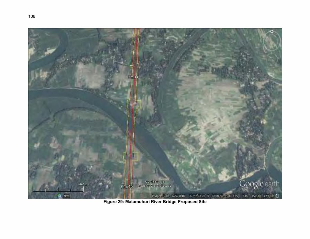
108
Figure 29: Matamuhuri River Bridge Proposed Site

109
Figure 30: Matamuhuri Distributary River Bridge Proposed Site

110
Figure 31: Igdaon Chara Bridge Proposed Site

111
Figure 32: Igdaon River Proposed Bride Site

112
Figure 33: Location of Noise Sensitive Receptors in Sangu River
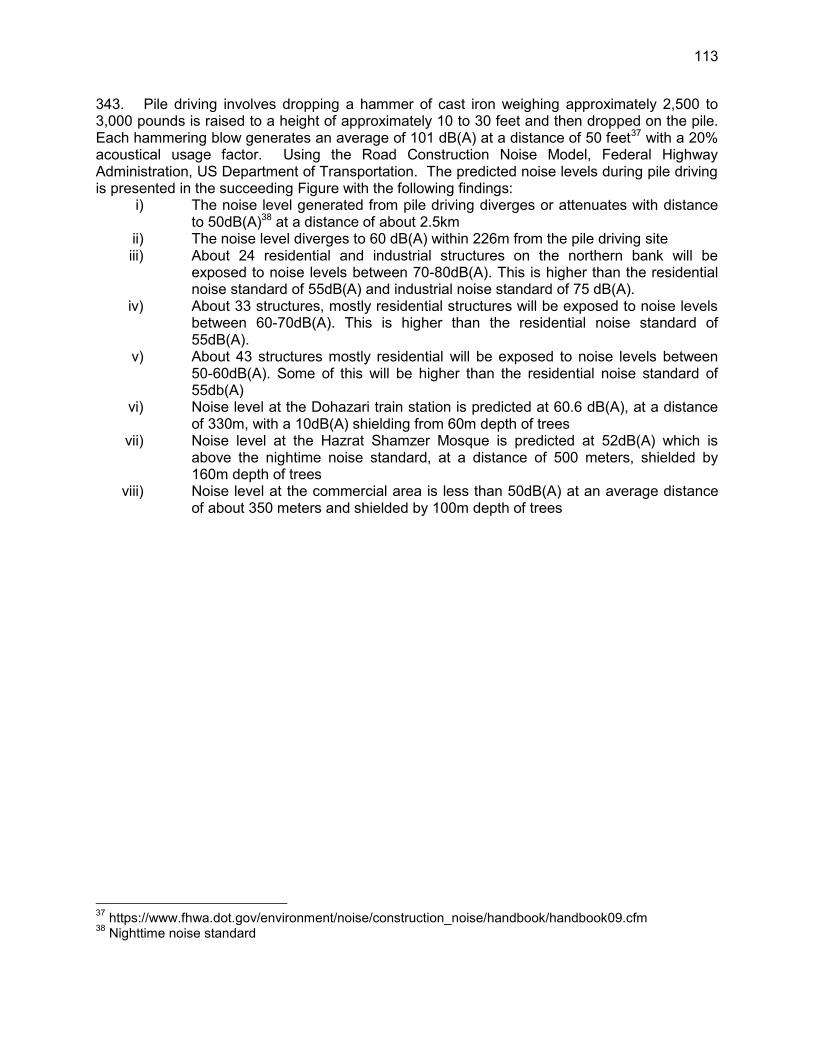
113
343. Pile driving involves dropping a hammer of cast iron weighing approximately 2,500 to 3,000 pounds is raised to a height of approximately 10 to 30 feet and then dropped on the pile. Each hammering blow generates an average of 101 dB(A) at a distance of 50 feet37 with a 20% acoustical usage factor. Using the Road Construction Noise Model, Federal Highway Administration, US Department of Transportation. The predicted noise levels during pile driving is presented in the succeeding Figure with the following findings:
i) The noise level generated from pile driving diverges or attenuates with distance to 50dB(A)38 at a distance of about 2.5km
ii) The noise level diverges to 60 dB(A) within 226m from the pile driving site iii) About 24 residential and industrial structures on the northern bank will be
exposed to noise levels between 70-80dB(A). This is higher than the residential noise standard of 55dB(A) and industrial noise standard of 75 dB(A).
iv) About 33 structures, mostly residential structures will be exposed to noise levels between 60-70dB(A). This is higher than the residential noise standard of 55dB(A).
v) About 43 structures mostly residential will be exposed to noise levels between 50-60dB(A). Some of this will be higher than the residential noise standard of 55db(A)
vi) Noise level at the Dohazari train station is predicted at 60.6 dB(A), at a distance of 330m, with a 10dB(A) shielding from 60m depth of trees
vii) Noise level at the Hazrat Shamzer Mosque is predicted at 52dB(A) which is above the nightime noise standard, at a distance of 500 meters, shielded by 160m depth of trees
viii) Noise level at the commercial area is less than 50dB(A) at an average distance of about 350 meters and shielded by 100m depth of trees
37 https://www.fhwa.dot.gov/environment/noise/construction_noise/handbook/handbook09.cfm 38 Nighttime noise standard
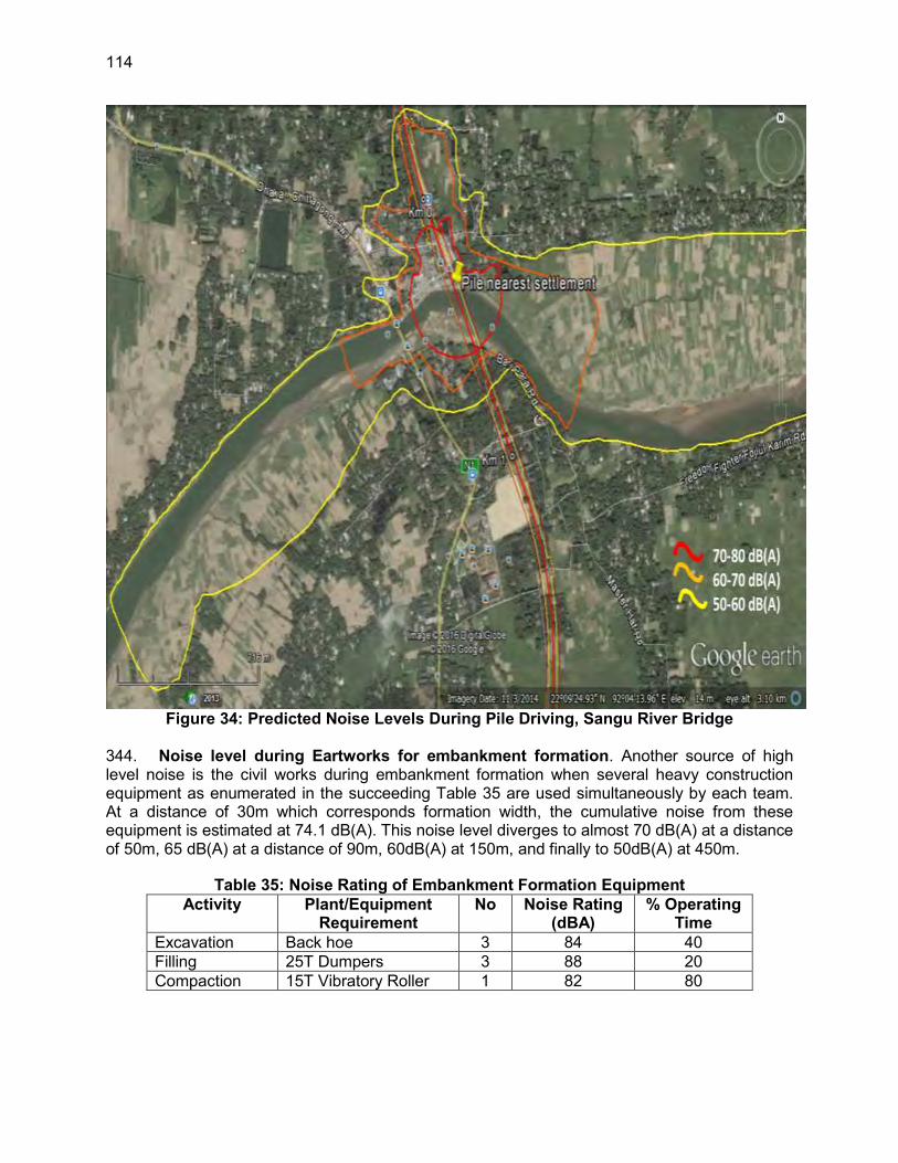
114
Figure 34: Predicted Noise Levels During Pile Driving, Sangu River Bridge
344. Noise level during Eartworks for embankment formation. Another source of high level noise is the civil works during embankment formation when several heavy construction equipment as enumerated in the succeeding Table 35 are used simultaneously by each team. At a distance of 30m which corresponds formation width, the cumulative noise from these equipment is estimated at 74.1 dB(A). This noise level diverges to almost 70 dB(A) at a distance of 50m, 65 dB(A) at a distance of 90m, 60dB(A) at 150m, and finally to 50dB(A) at 450m.
Table 35: Noise Rating of Embankment Formation Equipment Activity Plant/Equipment
Requirement No Noise Rating
(dBA) % Operating
Time Excavation Back hoe 3 84 40 Filling 25T Dumpers 3 88 20 Compaction 15T Vibratory Roller 1 82 80

115
Figure 35: Typical Equipment Used in Railway Embankment Formation39
Construction of new stations
345. The construction of new stations will introduce new noise sources from the use of powered mechanical equipment and the carrying out of the construction activities like installation and dismantling of formwork and hammering. Table 36 provides the noise rating of construction activities for new stations.
Table 36: Noise rating for station construction activities and equipment Equipment/Activity No. Noise Level
(dBA) % Acoustical Usage Factor
Concrete Mixer Truck 1 81 15 Dump Truck 2 76 40 Generator 1 73 50 Welder 1 74 40 Formworks 1 88 30 Carpentry 1 90 20
346. The equivalent noise level of these equipment and activities during the 15-hour daytime period from 7:00am to 10:00pm was estimated using equation below at 89.7 dB(A) at 50 feet. This noise level will diverge at periphery of the station at 50 meters from the rail tracks where a 3 meter perimeter wall will be constructed providing further noise shielding as depicted in the following Figure 36.
L10 in dBA = Lmax@50ft - 20 LOG (D/50) + 10 LOG (U.F.%/100) + 3 - ILbar 39 Source: https://www.iadc-dredging.com/ul/cms/terraetaqua/document/1/5/7/157/157/1/terra-et-aqua-
nr93-02.pdf
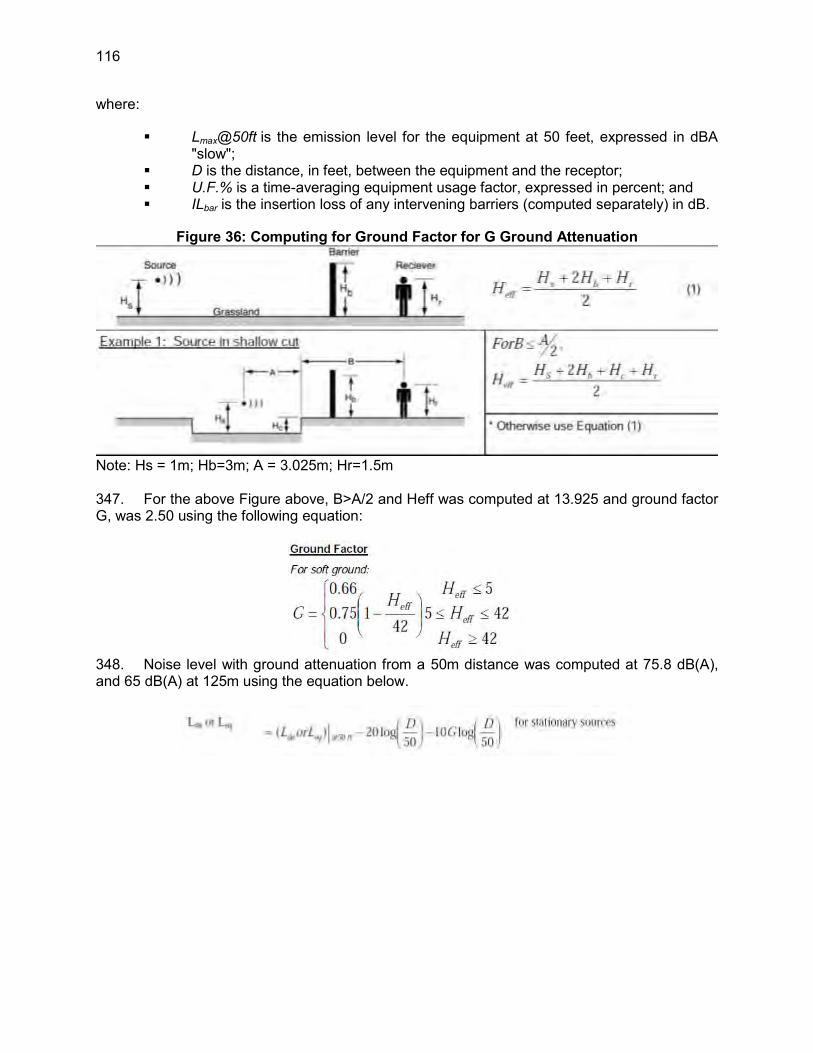
116
where:
Lmax@50ft is the emission level for the equipment at 50 feet, expressed in dBA "slow";
D is the distance, in feet, between the equipment and the receptor; U.F.% is a time-averaging equipment usage factor, expressed in percent; and ILbar is the insertion loss of any intervening barriers (computed separately) in dB.
Figure 36: Computing for Ground Factor for G Ground Attenuation
Note: Hs = 1m; Hb=3m; A = 3.025m; Hr=1.5m 347. For the above Figure above, B>A/2 and Heff was computed at 13.925 and ground factor G, was 2.50 using the following equation:
348. Noise level with ground attenuation from a 50m distance was computed at 75.8 dB(A), and 65 dB(A) at 125m using the equation below.

117
Figure 37: Sketch showing the noise barrier parameter “P”
5. Mitigation of Noise Impacts during Construction Phase
349. Pile Driving. Very limited options are available in reducing the noise levels generated in pile driving and viable alternatives in noise shielding will be implemented:
a. At least 30 days prior to the start of pile driving activities, tag all structures that are at risk from exposure to more than 60 dB(A) and conduct consultations on the expected level of noise, health impacts, mitigation and compensation measures
b. Provide absorptive noise barriers to all residential structures with a direct line of site from the pile within 250 meter radius.
c. Prohibit pile driving during evenings and day of worship 350. Embankment construction. Avoidance and mitigation measures to address impacts related to high level noise during embankment formation are as follow:
a. Maintain at least 150m separation distance between the construction team and noise receptors during daytime works
b. Maintain at least 450m separation distance between the construction team and noise receptors during nighttime works
c. In case none of the separation distances is possible, prohibit the construction of embankment until the any or all mitigation measures are implemented:
i) On design consideration and project layout: a. Construct noise barriers, such as temporary walls or piles of
excavated material, between noisy activities and noise-sensitive receivers.
b. Construct walled enclosures around especially noisy activities or clusters of noisy equipment. For example, shields can be used around pavement breakers and loaded vinyl curtains can be draped under elevated structures.

118
c. Sequence of operations: Maximize the use of noisy operations during daytime. The
total noise level produced will not be significantly greater than the level produced if the operations were performed separately.
d. Alternative construction methods: Use specially-quieted equipment and properly working
mufflers on all engines.
351. The most sensitive construction sites will be Parishad Bazar and Memorial Christian Hospital at Malumghat. Existing noise levels at both sites were recorded as marginally exceeding mixed/commercial area noise limits, making them both noisy sites. Hence extra efforts for reducing noise will need to be made in these areas. 352. To mitigate plant-operating noise, the location of batch plants and aggregate crushing facilities will be at least 500 m from the nearest residence (or separated by a hill) and generators will be either far away from noise sensitive sites or housed in noise attenuating casings. Where work is required within close vicinity of settlements such as Chakaria, Dulahazara and Ramu, it will be undertaken only during the daytime (0600-1800). In some cases, some work will have to take place during the night period in order to reduce disruption to local traffic, in which cases extremely loud equipment such as large vibrators, pile driving equipment and jack hammers will not be used. 353. Station construction. The early construction of the boundary wall must be accomplished to provide shielding. 354. Enclosures may be installed around stationary work. Enclosures may be constructed of wood or any other suitable material and typically surround the specific operation area and equipment. The walls could be lined with sound absorptive material to prevent an increase of sound levels within the structure. 355. Hill Cutting – Hill cutting is permitted in Bangladesh, only after permission/a permit from the Chief of State. Only after this permit has been received by BR will this work proceed. 356. Improper hill cutting can lead to slope destabilization and landslides during construction of after the work is completed and after prolonged rains. A well-grounded geotechnical survey to identify soils conditions and provided necessary retaining walls and other engineering measures to prevent slope slippage. In extreme situations slopes may need to be dewaters by placing drain pipes in toe cut face. Another method is to build an impervious drainage channel above the cut slope diverting the rainwater around the slope, instead of over it. There are also a number of bioengineering techniques possible and the contractor will work with the CSC do establish the best approach. 357. Hill cutting is often associated with erosion, which can easily be mitigated by stabilizing and revegetating the slopes as quickly as possible after the work is done. Steep slopes will require the placement of engineered stabilization blankets, such as woven jute mats that can be secured to the slope and then planted with grass plugs (which are used along newly built railway embankments).

119
358. During construction silt runoff from open slopes (if unavoidable) needs to be diverted to a grassed area or a detention area, allowing the silt to settle out of the runoff water before it reaches a natural stream.
6. Ecological Environment
359. Terrestrial Flora and Fauna- None of Bangladesh’s endangered species and, indeed, much of wildlife have had seen in the Project construction corridor during several field surveys. The one major exception is the endangered Asian elephant for which at least five active travel routes and six seasonal travel routes have been identified as across the rail alignment during a survey of the area. 360. During the construction period, the contractor will need to be aware that an elephant may cross through work areas and be ready to accommodate it, record its movement and sending this information to the Engineer. Slopes of rail embankments near established elephant routes will need to be gradual enough to permit an elephant to walk over the tracks or quickly establish new routes along flatter terrain. 361. Tree Removal - The Project will also require the removal of trees of various sizes and species. The inventory completed by the social survey team found large variety of trees on both private and Bangladesh Forest land. Different species of trees are divided into four categories by size: big, medium, small and sapling. There are 102 species of trees found in the Project areas: 35 species of fruit trees, 53 species of timber and 6 species of medicinal trees. The number of affected trees on private and government (forest) land in the Project areas by type and size are presented in Table 37. The highest number of trees/plants/bamboo on private and government land were found in the Harbang–Phulchari (113,514), Napitkhali–Jhilwanja (82,625), and Dohazari–Jangle Chunti (43,855) sections. 362. Assuming an approximately 25 m wide construction corridor extending for 102 km, plus another 30 ha for stations and another 10 ha for access roads, a total of about 290 ha of land will need to be disturbed and occupied by the work. A further 20 ha may be used temporarily for storage of mostly embankment materials and track components. These areas will be fully rehabilitated. 363. The most effective mitigative measure will be to keep the disturbance to natural vegetation to a minimum, cutting or clearing trees only where it is really necessary and having contractors work in among the trees, not clear all and then work. This approach will be defined in considerable detail during the mandatory 1–1.5 day contractor safeguards training session delivered by BR and the Engineer, within the first week of construction mobilisation.
Table 37: Total Number of Trees Affected on Government and Private Land Categories of Trees Name of Sections Total
Dohazari- Jungle Chunti
Harbang-Phulchari
Napitkhali-Jhilwanja
Fruit (no.) 12,075 26,413 27,945 66,433 Percentage of fruit trees 18.18 39.76 42.06 100 Timber (no.) 25,098 74,455 43,291 142,844 Percentage of timber trees 17.57 52.12 30.31 100 Medicinal (no.) 162 218 189 569 Percentage of medicinal trees 28.47 38.31 33.22 100 Banana (no.) 2,537 2,473 3,014 8,024

120
Categories of Trees Name of Sections Total Dohazari- Jungle
Chunti Harbang-Phulchari
Napitkhali-Jhilwanja
Percentage of banana plants 31.62 30.82 37.56 100 Bamboo (no.) 3,983 9,955 8,186 22,124 Percentage of bamboo 18.00 45.00 37.00 100 Grand Total (no.) 43,855 113,514 82,625 239,994 Percentage of Grand Total 18.27 47.30 34.43 100
Source: Census and IoL survey by 2013 & 2014
364. For every tree removed, three will be replanted in areas where they are needed. Replanting at the edge of the RoW will be carefully evaluated and will be completed at the instruction of BR in order to avoid interference with rail operations and line of sight distances to level crossings, as well as embankment stability. 365. BR will adhere to the principle of no net loss, ensuring that the areas disturbed in the CWS impact and buffer zones, will be replanted, however not within 25 m of rail embankment as it passes by the active elephant and seasonal elephant crossings. The Engineer will consult the Forest Department to find vegetation cover that is not consumed by elephant and can be planted. No vegetation that restricts the field of vision will be planted. 366. Elephant –Over the five-year construction period elephant will continue to use the crossing locations and there will be unavoidable interactions between the construction crews and elephant. To minimize this, an elephant awareness and construction period conflict minimization plan will be prepared as soon as the contractor is mobilized. Within 500 m of each crossing point construction work will take place only during the full daylight hours and each day that work takes place at the construction site, any obstructions restricting the elephant track will be minimized. In the situation where cuts will need to be establishes, as will be the case for crossings 2 and 3, the removal of construction machinery to a parking location and minimization of obstructions will be completed. Work at each crossing site will be completed as quickly as possible. At each crossing point a local nearby village warden will be retained to monitor and alert the contractor of approaching elephant. These procedures will be adapted based on experience and reported on in the semi-annual monitoring report.
367. As defined in the EMP and Annex 11, pilot testing of various mitigative measures, as described in Chapter VI of this EIA will be implemented and undertaken for no less than 2 years starting immediately after the Project’s CSC has been assigned. According to BR standards the contract for the pilot testing will be a part of a ‘provisional sum’ used once a programme has been designed and approved by ADB. BR will instruct the CSC to lead this work, assign the appropriate specialist consultants and conduct the work for a 2 year duration.
Monitoring of elephant movement as they manoeuvre around the construction works which interfere with their traditional crossing point will be very useful, in order to establish how far they move to bypass worksites e.g., a large cut area. It may be that new temporary crossing points could become the new active sites and therefore close monitoring will be undertaken.

121
368. Two optional locations have been identified and one or both may be selected to conduct the pilot study. These two sites are Rashidpur-Satgaon (6.91 km) and Srimongal-Bhanugach (8.10 km) section in Akhaura to Kulaura railway line. 369. Secondly, the elephant travel and movement patterns will continue to be monitored for the entire construction period through the CSC’s specialist and/or the 3rd party consultant. The objective of the monitoring will be to get a better idea of herd size, movement patterns and timing, in order to fine tune mitigative measures. A ½ day workshop will be held at the end of each construction year, attended by the contractor the CSC, Forest Department and affected communities to review findings and adjust mitigative measures based on the past years’ experience. The workshop will be organised by the CSC in cooperation with BR. 370. Thirdly, if it is learned that the elephant freely move several hundred metres to new temporary crossings the use of guide bollards fences should be considered to help funnel the herd(s) to safer crossing points. 371. Finally, BR will, as specified in a ToR included in this EIA, and funded via a special technical assistance grant from ADB, contract an independent monitoring agency, likely an NGO or specialist with specific knowledge of elephant, to undertake third party monitoring of the EMP, its implementation and delivery. The monitoring will include, inter alia:
field verification of mitigative and monitoring actions defined in the EMP updating the IUCN database on elephant movement and population statistics reviewing and updating EMP actions for elephant crossings (including the
location of the crossings); and, implementation of conservation/habitat enhancement activities as agreed with
the Forest Department; etc.
372. The independent monitor will be recruited separately under an ADB CDTA and will function as a part of the Project during the entire construction period and the 3 years during operation. Their role during operation will be to monitor the effectiveness of the elephant mitigation measures, success of the habitat restoration programme, and noise and vibration impacts of the operating trains and mitigative measures applied or to be applied. 373. Elephant overpasses land requirements- Based on a more detailed examination of the five active crossing sites, overpasses are technically feasible at all sites , but will require land for the structure as well as the guide fencing totalling 4.2 ha (Table 38), all forest land, some of which is settled. The figures in this table will be updated after conduction of the detailed study on elephant movement and behavior by the Independent Monitor Wildlife Expert during the pre-construction stage.
Table 38: Land Requirements for Elephant Overpasses and Five Active Crossing Points SI. No.
Active elephant crossing at
Overpass for elephant crossing
Additional Land Required Overpass (Left side) Overpass (Right side)
CH. (Km) CH. (Km) Required area (m2) Required area (m2) 1 27.236 27.06 6,866.63 6,291.71 2 28.319 28.44 980.54 3,511.26 3 29.017 29.04 1,125.21 3,472.80 4 55.407 55.36 5,441.29 3,884.69 5 56.262 56.10 3,002.79 7,304.28
Total area 17,416.46 24,464.74

122
7. Social Environment
374. Land use- There will be a significant impact on local land use because of the need to acquire about 540 ha of land and relocate more than 2,000 households and a number of commercial structures, the need for temporary storage areas for embankment materials, the construction of more than 8 km of access roads and the need to make significant (>10 km) cuts through hilly sections of the alignment. 375. Assets and Livelihoods-The Resettlement Plan for SP4 addresses these items in detail to mitigate the impact of the Project to people, their assets and their livelihood. To address these impacts, the following mitigative measures will be carried out:
Implement the measures as defined in the Project Resettlement Plan. Clearly mark work area to prevent unnecessary or careless clearing by the
contractor and explain, at the contractor training workshop with severe penalties to be applied for errors and non-compliance.
376. Construction Camp Management-Environmental health issues and disease contamination are common in labour camps. This would stem from poor work camp conditions, inadequate and unsanitary toilet facilities, lack of potable water and sanitary washing areas. Mitigation, as defined in the EMP, will involve the following:
weekly compliance checks by BR (it’s ESSU) and the Engineer; contractor posting a cleaning schedule at each toilet and washing facility which
Engineer will inspect weekly; contractor providing potable water (based on WQ tests), sanitary toilet and
hygienic accommodation for workers at camp sites at all times. Ensure that these facilities are cleaned and disinfected regularly;
contractor provides a garbage disposal service such that no garbage and food waste is dumped in the contractor’s yard or work camp at any time. There should be no litter or food scraps dumped anywhere but in appropriate bins that are collected and cleaned at least weekly; and
contractor proving Personal Safety Equipment and a First-Aid facility at each work camp.
377. The work camps and/or construction yards often include fuelling areas, which will have to comply with GoB, fuel storage and handling standards. In addition, all fuelling areas will be required to be equipped with drip pans, proper fuelling nozzles, and crank pumps if fuel is dispensed from barrels. Fuelling areas as well as any construction camps must be located at least 500 m from any housing area. No drainage from any such areas can enter any natural waterway without previous retention. 378. Given that the contractor will be working in elephant habitat, construction camps should not be located at least 500m from any elephant travel corridor as identified in the IUCN report and as shown in this EIA. Further camps will not be allowed in the sanctuaries or the national park. 379. Other Land Requirement - The RP includes provisions for an additional 4 ha ofland for the a maximum of 5 elephant overpasses. As given in table 38, currently the estimate for additional land requirement for this is about 4 ha. This will be reconfirmed and updated if necessary in the RP after the detailed elephant study completed.

123
380. Vector-Borne Diseases - Construction leaves depressions in the ground that allow stagnant puddles to form, ideal to become breeding areas for malaria and dengue mosquitoes. There will be inspections for stagnant water and puddles every three days, including stored construction materials such as tyres and old empty oil drums to prevent water ponding. All such sites will need to drained and or filled in and tires disposed of or kept in a covered area. This will be required during the entire rainy season and within three days of every major rainfall (EMP Clause 2.11.1).
8. Occupational Health and Safety
381. BR will ensure that the contractor and any subcontractors will implement the following mitigative measures:
For each construction camp, the contractor will appoint an OHS officer who will monitor the health and safety of a work camp and oversee OHS at number of field sites. The contractor will assist the OHS office to establish contact with the nearest medical clinic and hospital in order to define steps to be taken in case of any medical emergency,
Construction workers will be trained in general health and safety matters and on specific hazards of their work, by the OHS office at least every 4 months;
Workers will be provided with appropriate personal protection equipment, such as safety boots, helmets, gloves, protective clothing, goggles and ear protection.
Safe drinking water will be provided to all workers, as confirmed by independent water quality testing and submission or lab results to the Engineer.
Contractors must inform their drivers of the location of noise and safety sensitive areas,. In these areas, speed limits will be restricted to 40 km/h and use of vehicle horns and engine breaking will not be permitted at all times, unless in emergency situations.
Contractors will not hire, use or benefit from child labour. Child labour (as defined by ILO Conventions 138 and 182) means that no workers under the age of 14 may be hired as general labours, and no workers under the age of 17 are to be hired for hazardous jobs, such as working on scaffoldings and structures elevated above the ground, etc.
Contractors will not enter into any bonded labour arrangement with any workers at any time while working on this Project.
When hiring workers, contractors will be expected to not discriminate based on race, caste, origin, religion, disability, gender, sexual orientation, union or political affiliation, or age.
Sexual harassment will not be tolerated and if the contractor is found in violation of this, court action will be taken.
BR expects the contractor to pay all labourers and employees according to minimum wage standards as defined in the Bangladesh Labour Act.
382. The contractor will be required to provide each hired person with a letter contract, stating the above and confirming that these conditions are being upheld and include the names and contact information of people to contact within the contractor’s organisation, BR and with the Engineer, that any person wishing to file a complaint or table a concern can do so without fear of retribution.
124
383. BR will instruct the Engineer to undertake a random check of these documents, verify the age of younger workers, report findings to BR and take immediate, on-the-spot action if non-compliance is identified.
9. Heritage and Culture
384. There might be some impact on existing important regional and local structures and monuments such as mosques and graveyards. A social survey of RCIP identified 44 structures, of which none are regionally important. 385. Replacement and relocation to a suitable location will be done with the help and consent of the affected local community. Local community and religious leaders will be consulted to determine what modifications may be applied to the works scheduling and methodology to limit these potential impacts. Mitigative measures applied will be based on the joint decision by BR and officials from the local communities affected.
10. Environmental Management Implementation Work Schedule (EMWS)
386. Within 1 month of the mobilization of the contractor the EMWS needs to be prepared. This means that the Environmental officers under the contractor should also be mobilized as soon as the contract is awarded inorder to enable him/her to prepare the EMWS on a timely basis. If the contractor does not prepare a work plan defining how and when mitigation and monitoring actions as defined in the EMP and Contract Specification Section H, the Engineer will not approve the first interim payment (mobilisation) until the EMWS is submitted to BR and approved as compliant. In addition, the contractor working closely with the Engineer, will be required to prepare up to 9 other plans addressing the following areas:
(i) noise mitigation (ii) protection of wetlands, (iii) borrow and dredge site management, (iv) dust control, disposal of construction debris, (v) management of petroleum products, (vi) occupational health and safety measures, (vii) servicing and operating equipment according to specifications, (viii) management of hill cutting and (ix) topsoil collection and erosion control
387. The contractor will be briefed concerning this requirement during the pre-mobilisation contract review session delivered by BR or the Engineer.
11. The Six Large Bridges
388. Sangu, River at Km 19.74, Matamuhuri, Tributary of Matamuhuri, Idgaon Chara and the Bakkhali are all large bridges requiring long spans. In addition, 33 other smaller bridges (less than 99 m) and 144 culverts will be built. The Sangu is the only river with water flowing year round and will require care to avoid serious impact to the watercourse, through work in or over the water. For all other rivers and streams crossed by the rail line, much of the work will be completed during the dry season, will not require diversion or coffer dams, and with measures to ensure that no blockages are left in place once work is completed and monsoon season begins. 389. Noise and Vibration - Noise level will rise due to other construction activities, transportation and loading, unloading of construction materials, suction dredging for

125
embankment materials at rivers, and electricity generation. It is expected that the noise caused by these activities will still be below the 70 dBA level and at most river crossings will not be relevant since the sites will be in uninhabited areas. Construction work such as pile driving and operation of batch plants near the rivers will have a marginal impact and will contribute to the increases in noise levels within 50 m of the construction site, which will be in rural, uninhabited areas except for the Sangu River crossing area which has a market on the north side of the bridge alignment (see further details in Chapter VI subsection (6). 390. Fish - Rail bridge construction activities particularly the in-river pile driving operations, could temporarily impact the capture fisheries around the proposed bridge sites on the Sangu, Matamuhuri, Tributary of Matamuhuri, Idgaon Chara Bridge and Bakkhali Rivers (all but the Sangu are dry for >6 months of the year). The 2013–2014 environmental monitoring and fisher folk interviews for the Tongi–Bhairab Double Tracking Project, which included intensive in-river pile driving at a number of major river crossings, showed no significant change in water quality and no change in the diversity and quantity of fish taken by fishers upstream and downstream of four bridge construction sites. Fishermen interviews suggested that the impact on fish for SP4 will be marginal40. The Matamuhuri, Tributary of Matamuhuri, Idgaon Chara Bridge and Bakkhali rivers all have only an intermittent flow and are nearly completely dry during six months of the year, making work in and over these waterways easy and minimally invasive. For these crossings, contractors will be restricted to working in the channel sections during the dry season only, and not during fish spawning periods which fortunately also coincide with the start of the monsoon period. 391. Secondly, the recently completed survey of fishing activities at the bridge construction sites on the Tongi–Bhairab Double Line Project (2013–2014) showed that fishing and fish catches are not impacted by the construction work, since both catch total numbers and species diversity has not changed since before construction began (based on fishermen responses), and in fact they use the new piers as anchor points for fishing, and fishing success is reported to be up, possibly due to the artificial reef-effect of large piers. 392. Hydrology, Bank Erosion and Navigational Channel - River bank erosion is possible if the river width is constricted due to incorrect designs and inappropriate shore pier placement. The six large bridges have been designed using the river’s estimated 100-year flood volume and as such should easily pass all flows. 393. Therefore, BR will instruct the contractor to implement the following mitigative measures during the Sangu, Matamuhuri, Tributary of Matamuhuri, Idgaon Chara and Bakkhali bridge constructions:
Ensure that channel width at the crossing point will not be narrowed and corrective actions to mitigate the existing erosion problems will be addressed, through careful design of shore erosion prevention structures and the sizing of all structures to pass the 100-year ‘design storm’.
Provide slope protection measures to the portion of the rail alignment that will be in contact with the river channel.
40 The fact that aside from Sangu, these rail bridges will be the first bridges across these rivers was
examined during the fisher surveys at Sangu and Matamuhori river crossing sites. The opinion of the local fishermen was that this would be insignificant as this was not a road bringing additional fishing pressure to these locations.

126
Design proper river training measures at the upstream and downstream sides of the bridge crossings such that they do not narrow the channel.
Monitor and manage river traffic on Sangu to ensure that there is no obstruction of local country vessel traffic.
394. Dredging for Embankment Material - River dredging will be undertaken to provide much of the sub-base material for the 100.83 Km long rail embankment where possible. In fact, around 7.39 million m3 of river bed materials (mostly sand) will be dredged. The material is dredged from government-approved sites (permits provided by the Ministry of Water Resources) using a suction dredger. The mostly sand material is pumped to the embankment sites in a pipeline (OD 15–25 cm) and discharged on the ground within the boundary of the embankment, let drain and dry, forming a solid base. Given the high TSS levels in these rivers and that fact that all fish species are well adapted to zero-visibility waters, the dredging operation which will temporarily and locally elevate TSS levels downstream of the dredging site by no more than 15% (Tongi–Bhairab Water quality sampling in 2013 and 2014) is not considered an impact requiring any mitigative action41. The rivers supplying the material for the Project embankment will likely be Sangu, Matamuhuri, Tributary of Matamuhuri, Idgaon Char and Bakkhali, but will ultimately depend on the permits received by the contractor.
12. Cox’s Bazar Train Station, Stabling Yard and Washing Facility
395. This facility will take up a 1.6 km x 100 to 300m area of land, most of this used for stabling up to 9 train sets at one time. The train cleaning will require the management of two waste streams, i.e. the wash water for cleaning the train exterior and garbage pick-up and interior cleaning, including disposal of paper, plastic and food scraps, which according to existing practice is dumped on the tracks. This facility will not be involved in any fuelling or mechanical servicing activity. 396. The following description does not address the washing bay construction, only the conveyance of 100% of the wash water-rainwater discharge to the treatment system. All water from the washing operation and rainwater accumulation must be treated. 397. Washing Facility - There are two components of this facility a) the water supply and conveyance system and the wash water drainage and treatment facility. 398. Water Supply System: The washing facility will need a continuous supply of water, up to 1,280 m3 of water per day42, or 38, 4000 m3 per month, which will need to be supplied by one or several new tube wells. To that end, the contractor will be required to first establish the water availability through a groundwater supply analysis, and then seek permission from the Department of Public Health and Engineering, and then the Cox’s Bazar Municipality for a permit to extract from that aquifer (which is likely the municipal water supply). Notwithstanding the need for a permit, the Chittagong aquifer is very large and extraction should not be an issue.
41 The common practice of taking material from a river and allowing the dredge water to immediately drain
back into the river does not happen since the liquid is essential for transporting the sand slurry to the embankment sites, which are often kilometres away from the dredger.
42 The best available data for washwater use is for buses, and these data suggest that a hand washed full size bus requires around 2,440L of water (Zaneti et al 2012). Assuming that this is more or less the same as for a single train carriage, multiplying by 20 yields 48,800L/train wash. With a capacity for 32 trains a day this means 1,561,600 L/day.

127
399. Train Wash Water Treatment Facility: The facility when fully operational will process up to 32 trains per day, involving the production of about 1,560 m3 of wastewater for 32 trains/ per day plus another approximately 3,500 m3 of rainwater falling into the three 600 m x 4 m washing bays. Therefore, about 5,100 m3 of water will need to be treated daily. This estimate assumes manual washing of the vertical sides of each railway carriage as well as the locomotive. 400. All wash water used for the trains will need to be drained first into an oil separator and then into a settling pond, from where some of the water will percolate into the soil via a pervious pond bottom, allowing for naturally treated, and the rest will be discharged into a drainage canal after a minimum detention time in the pond. Given that paddy lands surround the area, this wash water may be diverted to paddy lands and BR working with local farmer organizations will investigate such measures. 401. The contractor will be required to design and install a wash water detention pond and oil separator capable of treating the mixture of wash water and rainwater—sometimes reaching >6,000 m3 per 24 hours (including rainwater). The facilities will need to be properly sized to manage all water drained from the washing system. 402. Oil Separator. The oil separator system must be able to remove at least 80% of all oil and grease from the receiving water. This treatment capability will need to demonstrated by “before and after” water quality tests for oil and grease. The separator must be able to stabilize the flow, allowing for oil and grease to come to the surface for removal. Further the separator unit must have an efficient means for the draining of the captured oil and grease as well as the removal of sludge. These two wastes will need to be treated and disposed of in compliance the DOE specifications and standards. 403. The Detention Pond- The detention pond(s) must detain water long enough such that the discharge water meets the government’s Environmental Conservation Rule (1997), Annex II Schedule 10 standards and the settling pond(s) to detain the water for at least 40 hours. The detention pond can be fully grassed allowing for effective settling and treatment via natural percolation through the soil. The detention pond dimensions will need to be sized to accommodate the maximum water volumes discharge and detain the water for 40 hours. The pond should be located at a sufficient distance from surface water and tube wells to avoid cross contamination. 404. A final evaluation of BR’s existing washing facility in Dhaka will be completed to establish the best approach to the wash water requirements and treatment needs helping to fine-tune the design parameters match the facility’s requirements.
C. Operating Period
405. After five years of construction, the contractor, working under the supervision of an Engineer and BR, will have completed a large number of mitigation and monitoring activities. The BR agency operating the new rail line will need to receive a report/checklist of the mitigative actions completed the monitoring in place and the list of actions required to continue what has been done during the operating period. 406. In a previously rural agricultural setting, a rail line, its 9 rail stations and their access roads will be put into operation in 2021, with 32 locomotives travelling 203 km each per day between Dohazari and Cox’s Bazar. There will be a number of major environmental impacts that

128
will need to be managed if the effects are to remain within GoB standards and the trains operate in a safe and environmentally acceptable manner. In the EMP, BR identified 11 major mitigative actions needing to be implemented during the operating period of the Project. These are highlighted below and presented in detail in the EMP (Table 54).
1. Environmental Completion Report
407. The contractors will be required to submit an environmental mitigation completion report, essentially a compliance monitoring checklist defining all the mitigative actions taken, the dates work was done and on-going actions needed to maintain what was started. This would include comments on the decommissioning of the work camps, the waste facilities, the rehabilitation of the embankments, and stabilisation of cut areas and clean-up of all temporary storage areas.
2. Air Quality and Dust
408. Predicting changes in air quality due to variations in fuel consumption due to traffic diversion is complicated by the fact that the viability of the Dohazari-Cox’s Bazar line is closely linked having in place a new luxury train service from Dhaka to Cox’s Bazar, via Chittagong, providing direct service between the capital and the tourist destination. This new traffic must be added to the local Dohazari-Cox’s Bazar rail passenger traffic. The economic modelling revealed that of the total train-passenger-km (Train-Pax-km) starting in 2022 when the new service would begin, all of the passenger-km would be assumed to be former vehicle and bus users, resulting in large diversion-related savings in fuel cost as well as thousands of tons of emissions (Table 40). 409. Therefore this analysis examined both the local Dohazari to Cox’s Bazar line, as addressed in the EIA and then the scenario which assumes that the Dohazari-Cox’s Bazar link is the driver for the new Dhaka-Cox’s Bazar luxury train service and therefore can be legitimately included in the emission and GHG savings attributable to the Project. 410. Dohazari to Cox’s Bazar Line. The main atmospheric pollution during the operating period will come from locomotives burning diesel fuel, and increasing as the number of locomotives operating on the track grows from 28 trains per day in 2022 to 54 trains per day by 2042. Starting in 2022, more than 2.56 million litres of diesel fuel will be used annually to operate these trains, rising to >4.94 million litres by 2042. By 2035 annual emissions will range from 351 tons of NOx to 10.4 tons of Particulate Matter (TPM) and 42.3 tons of CO in the local air shed (Table 39).
Table 39: Emission Factors and Estimated Fuel Consumption of Locomotives Operating on the Dohazari-Cox’s Bazar New Line (including the Dhaka-Cox’s Bazar Tourist Trains)
Loco Type (1100hp)♦♦
No. of Trains
Average Annual Diesel Consumed – DC (Litre/km)—
all round trips
Emission Factor* – EF (g/Litre)
Main Engine Annual Emission Per Year
(Tonnes/Yr.) NOx PM CO NOx PM CO
2022 14 trains x 2
28 trains x 102 km x 360d x 2.50 L/km/train ♦♦ =2,565,360L/yr.
83.48 2.10 8.54 214.2 5.4 21.9
2025 16 trains x 2
32 trains x 102 km x 360d x 2.5L/km /train = 2,931,840 L/yr.
83.48 2.10 8.54 244.8 6.2 25.0

129
Loco Type (1100hp)♦♦
No. of Trains
Average Annual Diesel Consumed – DC (Litre/km)—
all round trips
Emission Factor* – EF (g/Litre)
Main Engine Annual Emission Per Year
(Tonnes/Yr.) NOx PM CO NOx PM CO
2035 23 trains x 2 46 trains x 102 km x 360d x2,5L/km/train = 4,214,520.00 L/yr.
83.48 2.10 8.54 351.8 8.9 36.0
2042 27 trains x 2
54 trains x 102 km x 360d x 2.5 L/km/train = 4,947,480 L/yr
83.48 2.10 8.54 413.0 10.4 42.3
♦ Estimated by Transport Economist of the Consultant. ♦♦ Gross main engine HP identified is from 550 to 1650 and average gross HP 1100 has been considered for the above calculations. Fuel consumption is per train. * EF used for this study has been derived from NESCAUM study.
411. As the operating period progresses, the air shed within 50 m on either side of the rail line will see significant increases in air pollution. The combustion of diesel fuel by locomotives will generate mainly particulate matters (TSP, PM10 & PM2.5), carbon monoxide (CO), carbon dioxide (CO2), nitric oxide (NO), nitrogen dioxide (NO2), sulphur dioxide (SO2), volatile organic compounds (VOCs), and trace level of non-combustible VOCs (benzene) (Transport for New South Wales, 2012) . The emission volumes shown in Table 37 illustrate what can be expected with the local train traffic. 412. For the eight parameters tested during the EIA field survey , air emissions for NOx, PM and CO are expected to increase dramatically since prior to the project the corridor between Dohazari and Cox’s Bazar had no train traffic and the only national highway traffic. Therefore BR will undertake a semi-annual air quality-monitoring programme to establish changes in emissions for the first five years the line is operational, i.e., 2022 through 2042 when train traffic will reach an estimated 54 one way train movements per day, (Table 36). If test results show unacceptable emission levels, BR will install additional pollution control equipment on the locomotives such as catalytic NO2 reduction systems and initiate other operating changes such as use of lower sulphur fuel, biodiesel and LNG propulsion conversions. 413. Under normal circumstances, regional air quality may benefit since the added rail service should divert road traffic (car and mostly bus) to rail. The economic forecasts looking at the service through 2044 indicated significant diversion due to the introduction of the luxury train between Dhaka and Cox’s Bazar (Table 37), as discussed in the following paragraphs. 414. Dhaka- Cox’s Bazar Luxury Train Scenario. With the addition of up to 10 luxury trains starting in 2022 and climbing to 54 in total by 2042 the noise increases within the 100 m-wide impact corridor will be on the order of an additional 3 dBA along the existing main line between Dhaka and Chittagong. Since there it will be a new line from Dohazari onwards, noise levels at varying distances from the source are expected to be according to the values shown in . Instead of experiencing noise peaks 4-6 times per day from local traffic in 2022, residents along the Dohazari-Cox’s Bazar section of the line will be exposed to ‘train-passing noise pulses high noise levels 28 times per day (14train sets per day, each way).
3. Air Quality and the Luxury Train Service
415. The modelling assumed that all the train-passenger kilometres would be allocated as diverted traffic and representing a benefit; which then was applied the 25 year projection period.

130
This yielded significant pollutant savings and total GHG emission reductions (Table 40), and predicted savings in fuel costs by billions of taka per year.
Table 40: Diverted Train Passenger Kilometres and Resulting Reduction Air Pollutant
416. Greenhouse Gas Savings - The forecasts for six selected (40 years annual data are available) operating years (Table 38) show a steady increase in passenger-km. The reduction, accredited to diversion from road to rail transport, via the tourist trains, indicated for the four key pollutants, showing that more than 10,500 t of emissions are not released after only 1 year of operations. This savings increases to 34,000 t, most of this being CO2. This estimated reduction in fuel consumption translates into a $ 21.53 million savings after the 2022 operating years, climbing to $69 million by 2042. 417. These are important environmental benefits for Bangladesh as a whole, notwithstanding the fact that air pollution and noise along the Dohazari to Cox’s Bazar section of the entire Dhaka-Cox’s Bazar line will increase significantly (Table 39) especially with the added luxury trains. The local residents within 100 m of the line (50m on either side of the centre line) will see a very significant increase in the noise and air pollution conditions in their communities. For this reason, an operating period air quality monitoring program is defined in the EMP.
4. Surface and Groundwater Quality
418. Surface water pollution during operating period comes primarily from untreated sewage effluent discharged by passing trains, which then washes into local surface waters. There is also some spillage of fuel and other hazardous chemicals from freight train cargo; however, this latter pollution has not been an issue. There is of course the issue of accidental spillage of oil and other noxious chemicals, after a train accident, and the leakage of materials into rail side ponds and canals. A spill contingency plan and good maintenance of track and rolling stock will help reduce the risk of such accidental spills, permit rapid action if an accident does occur.
Loco HP-1100 NOx TPM CO CO2
Locomotive EF
reference only; not
used83.48 2.1 8.54 2713
Fuel used by Train passengers if travel is by cars and buses
NOx PM 2.5 CO CO2Avg. Diesel price/L,
July 2013; TakaL65.81
Diesel Cars and
Bus Avg. EF Used6.5 0.1000 7 410
Yr Diverted pax Km L/yearTons/yr Tons/Yr Tons/Yr Tons/Yr
Taka savedUSD saved (M)
2022 262,570,000.00 25,490,000.00 165.69 2.55 178.43 10,450.90 1,677,496,900.00 21.53 2026 331,480,000.00 32,250,000.00 209.63 3.23 225.75 13,222.50 2,122,372,500.00 27.24 2030 418,490,000.00 40,680,000.00 264.42 4.07 284.76 16,678.80 2,677,150,800.00 34.37 2034 528,340,000.00 51,360,000.00 333.84 5.14 359.52 21,057.60 3,380,001,600.00 43.39 2038 667,000,000.00 64,790,000.00 421.14 6.48 453.53 26,563.90 4,263,829,900.00 54.73 2042 842,090,000.00 81,880,000.00 532.22 8.19 573.16 33,570.80 5,388,522,800.00 69.17
EmissionfactorsforNox,TPM,andCOtakenfromUpdatedEmissionFactors2013,Caietal.ArgonneNtn/l
Lab:https://greet.es.anl.gov/files/vehicles-13
CO2emissionfactorobtainedfromUSEPA2009.EmissionFactorsforLocomotives:EPA420-F-09-025
car=2.5pax,bus38pax,train=1100pax,fuelused:car0.1L/km,bus0.3L/km,train=5L/km
EF (g/Litre diesel)
Fuel and Emission Savings Using Diversion Passenger Km: Dhaka-Cox's Bazar-362 rail km

131
419. Groundwater contamination could result from poorly dug and inadequately sealed tube wells allowing polluted surface drainage to enter the well and reach the aquifer below. The contamination from train operations would be mostly bacteria, viruses and nutrients from the sewage-laden track runoff leaking into the well. BR is investigating retrofitting existing cars with holding tanks in order to collect sewage and dispose of it at treatment facilities, and also will inspect that all wells established during construction are secure and sealed.
5. Noise
420. Using UK’s 1995 “Calculating Rail Noise (CRN) Guideline”, parameters, applied in the Cadna (Computer Aided Noise Abatement) Version A 4.4 noise modelling software (http://www.datakustik.com/en/products/cadnaa), the 45, 55, 60 and 70 dBA noise levels contours (distances) were estimated for the new line (Table 41). The findings showed that between 2022, when the new rail line will become operational, and 2044 when the number of trains will increase from 32 to 58 trips per day, the 50 dBA contour representing the preferred night-time maximum noise level for mixed landuse zone, will likely extend 104 m on either side of the new track to 171m without mitigation and shielding. The 60dB(A) contour representing the daytime noise standards for mixed land use will extend from 33m to 54 meters during the planning period without mitigation and shielding. This modelling served as preliminary screening did not include the noise attenuation measures being introduced as part of BR’s and natural shielding from trees and rows of buildings between the track and the receptors. The succeeding Figures 38 to 41 provides the spatial expansion of the area impacted by noise.
Figure 38: Increase in Noise Impact Area from 60dB(A) in 2022 to 70 dB(A) in 2044, Sangu
River Bridge Site
Sewage on Tracks- To date BR trains discharge all sewage directly onto tracks as the train is moving. BR is developing a plan to retrofit trains with holding tanks and pump-out facilities at major stations, plus management and processing the sewage by transport to a sewage treatment facility. However at the present time all train carriages discharge directly onto the tracks.

132
Figure 39: Increase in Noise Impact Area from 60dB(A) in 2022 to 70 dB(A) in 2044,
Chainage 58km Chabagan Built-up Area
Figure 40: Increase in Noise Impact Area from 60dB(A) in 2022 to 70 dB(A) in 2044,
Chainage 98 Cox Bazar Built-up Area

133
Figure 41: Increase in Noise Impact Area from 60dB(A) in 2022 to 70 dB(A) in 2044,
Chainage 89 Ramu Built-up Area
Table 41: Average distances from trackside at which four noise levels (no attenuation applied) were estimated for train operations during four periods
Noise Level Contour Interval
Projection year and distance of the four contour intervals from the source 2032(m) 2037(m) 2042(m) 2044(m)
45 280 340 410 470 50 104 171 55 80 98 120 130 60 33 40 49 54 70 4 5 7 8.5
Modelled Train Traffic (trips/24hr)
3 2 40 52 58
421. To gauge the impact of full project operation, by 2044 the 50 dB(A) sound contour line corresponding to night time standards would extend to 171 meters without mitigation and shielding from the railway centreline. With mitigation measures the distance from the centerline decreases to less than 75 meters including background noise. Overlaying the noise countour without mitigation with the existing land use, an estimated 2,544 structures would experience noise levels higher than the standards of which 28 receptors or 1.1% are deemed sensitive. Mitigating the noise by 6dB(A) at source through reduces the number of sensitive receptor to

134
23. The succeeding Table provides the distribution of affected noise receptors, including sensitive structures.
Table 42: Distribution of Receptors Exposed to Noise Level Greater than 50dB(A). Chainage Noise Impacted Structures Sensitive Receptor
From To LHS RHS Chainage Distance from C.L
Description
-2 0 127 88 0 5 55 62
1.34 30 Madrasa
2.27 61 Temple
2.49 40 Temple
2.5 44 Temple
5 10 100 56 10 15 58 109 13.21 59 Mosque
14.54 37 Mosque
15 20 75 84 15.5 64 School
19.9 71 Mosque
20 25 73 101 25 30 6 8
30 35 28 51 31.2 24 School 35 40 34 20 39.6 21 Mosque 40 45 52 64
45 50 62 51
49.6 50 Mosque
50 55 38 75 55 60 57 49 58.8 100 Hospital
58.9 15 Mosque
59.5 174 School
59.9 23 Madrasha
60 65 61 26 65 70 24 31 63.3 82 School
65.1 40 Madrasha
69.3 66 Mosque
70 80 69 88 80 85 13 34 80.1 70 Madrasha
80.1 80 Mosque
85 90 45 50 85.6 53 Mosque
85.88 53 Mosque
88.1 60 Mosque
89.6 88 Mosque
89.9 65 Mosque
90 95 16 15 90.8 55 School 95 100 44 60 95.8 72 Mosque 100 101.57 20 11 98.6 38 Mosque 1 30 190 174
Total 1247 1307

135
422. As mentioned earlier the use of the Cadna (Computer Aided Noise Abatement) Version A 4.4 noise modelling software serves as preliminary screening and free field noise divergence can be considered as worst-case scenario. The succeeding Figure illustrates the effect of trees and buildings in shielding noise where a built-up area at chainage 59km is selected. The free field noise attenuation takes 171m to reduce the noise from train pass-by to 50 dB(A), However in this case the layer of buildings and trees were able to reduce the distance to around 150m using the following computations:
Table 43: Computation of Shielding: Rows of Buildings and Dense Trees
Figure 42: Demonstrating the Effect of Trees and Building Noise Shielding at Chainage 59

136
70-80 dB(A) 60-70 dB(A) 50-60 dB(A)
423. However, not all exiting shielding will result to lower predicted noise levels from the screening exercise. Existing noise levels particularly transit noise from nearby roads and more particularly where the railway alignment is near the N1: Dhaka-Chittagong Highway, attenuation of noise may not reach the 50dB(A) within 171m. To illustrate, the following Figures are provided depicting noise levels considering shielding and existing noise. In the succeeding Figure 43: to the north of the railway alignment noise within 30 feet from the railway centreline noise attenuates to 70dB(A), and around 60dB(A) within 200 feet. However, the proximity of the N1: Dhaka-Chittagong increases the noise levels from 50-60dB(A). This is more clearly presented in the last Figure where the distance separation between the railway and N1 around chainage 99km is not enough to reduce the noise level lower than 60dB(A). In these situations, BR will implement additional mitigations measures to distort the noise wave path by installing sound barriers in addition to train speed reduction.
Figure 43:

137
Figure 44: 424. Mitigation measures to minimize the impacts from high level noise due to train pass-by are enumerated will be implemented by BR to include rubber padding under the rail sleepers, the continuous welded rail and the use of disk or composite block brake shoes, instead of the existing braking systems; any two of these reducing the noise level between 5 to 9 dB(A) and average of 6 dB(A). These measures alone will reduce the 50 dB(A) contour line distance from a maximum 171m to 76m. Other measures to further reduce noise from changing the characteristic of the source, path, and receiver are provided in the succeeding Table.

138
Table 44: Transit Noise Mitigation Measures
425. The impact of reducing the noise levels at source by 6dBA at the monitoring stations where baseline were gathered is presented in the suceeding Table. Of the 19 stations, without the project 50% of the daytime noise levels comply with the WB EHS standard. With the exception of the Dohazari monitoring located within the train station and considered as industrial land use, all night time background noise levels already exceed the guide values. Unmitigated noise levels, with the project scenario degrades the noise levels even further reducing the compliant stations from 50% with-out the project to 22.2% with the project during daytime and smilarly almost all night time predicted noise levels exceeds nightime standards. Implementing the mitigation measures and reducing noise at source by an average of 6dB(A) reduces returns the noise levels the same level as the baseline witout the project at a distance of 50 m from the rail centerline. However, this noise reduction hardly matters at a distance of 5 meters from the railway centerline. Installing noise shields close to the railway will further reduce the noise level 6-15 dB(A) which ensures noise levels stays at the baseline levels. 426. To further reduce the railside noise issue, BR will attempt to enforce a 50 m (25m in either side of the tracks) no-build residential noise and safety corridor, keeping residences and ceremonial areas outside that line. Agriculture and industrial commercial operations may be permitted inside this zone, but with BR permission and on a case-by-case basis. 427. A noise monitoring programme will be undertaken during Years 1, 3 and 5 of the operating period to establish the effects on sensitive receptors, especially the hospitals and schools, and to discuss attenuation measures will local communities affected. These actions are defined in the EMP and Subsection H of the technical specifications. A sample of the environmental clauses is also provided in Annex 8.

139
Table 45: Assessment of Predicted Noise Levels, Unmitigated and Mitigated Against World Bank EHS Guide Values
Dominant
LandUse
Noise Shield
Day Night Day Night Day Night Day Night
SP4_NM_1,3_5 m Industrial 13/06/2013 53.2 49.5 66.2 64.2 66.2 64.2 53.2 49.5
SP4_NM_1,4_50 m 13/06/2013 59.7 48.9 61.9 56.8 59.7 48.9 59.7 48.9
SP4_NM_5,7_2 m 13/06/2013 44.9 61.1 66 65.8 66 65.8 44.9 61.1
SP4_NM_6,8_50 m 13/06/2013 44.7 62.7 51.1 62.4 44.7 62.7 44.7 62.7
SP4_NM_9,11_5 m 06/12/2013 50.5 55.8 66.1 64.6 66.1 64.6 50.5 55.8
SP4_NM_10,12_50 m 06/12/2013 56.2 50.7 60.2 57.1 56.2 50.7 56.2 50.7
SP4_NM_13,15_3 m Residential 06/12/2013 72.9 - 73.7 - 73.7 0 72.9 -
SP4_NM_14,16_50 m 06/12/2013 74.5 -74.5 - 74.5 0 74.5 -
SP4_NM_17,19_6 m Silent 06/12/2013 69.6 66.8 71.2 68.9 71.2 68.9 69.6 66.8
SP4_NM_18,20_50 m 06/12/2013 70.8 60.870.8 61 70.8 60.8 70.8 60.8
SP4_NM_21,23_2 m 06/12/2013 51.1 61.366.1 65.9 66.1 65.9 51.1 61.3
SP4_NM_22,24_50 m 06/12/2013 45.2 55.6 52 56.3 45.2 55.6 45.2 55.6
SP4_NM_25,27_15 m 06/12/2013 53.4 58.966.2 65.2 60.2 59.6 53.4 58.9
SP4_NM_26,28_50 m 06/12/2013 61.8 65.2 62.6 65.3 61.8 65.2 61.8 65.2
SP4_NM_29,31_5 m 14/06/2013 56.7 52 66.5 64.3 66.5 64.3 56.7 52
SP4_NM_30,32_50 m 14/06/2013 55.6 45.9 56.9 50.1 55.6 45.9 55.6 45.9
SP4_NM_33,35_8 m 14/06/2013 45.2 59.4 66 65.3 61.9 61.2 45.2 59.4
SP4_NM_34,36_50 m 14/06/2013 45.4 58.2 52.1 58.9 45.4 58.2 45.4 58.2
Receptor Day Night
Silent areas 50/NP 40/NP
BD Noise Standard
(2006)/World Bank
Standard (2007)
Residential 55/55 45/45
Mixed 60/NP 50/NP
Commercial 70/70 60/70
Industrial 75/70 70/70
Mitigate Noise (-
6dB at Source)
Unmitigate Noise
Cox’s Bazar
Agri/
Residental
Agri/
Residental
Agri/
Residental
Agri/
Residental
Agri/
Residental
Agri/
Residental
Lohagara
Parishad
Bazar,
Chakaria
Christian
Hospital,
Malumghat
Dulahazara
Ramu
Idgaon
Sampling ID Sampling
Location
Sampling
Date
Noise Level (Leq) dBA
in CRW (Baseline)
Dohazari
Satkania

140
6. Vibration
428. Without a doubt passing passenger trains generate vibration pressure waves which travel through the ground. Since BR will be operating mainly passenger trains and travelling at around 80 km/h , and since the embankment and ballast will be properly compacted, sitting on relatively soft soils, vibration will be attenuated by at least 50% every 15 m (California Department of Transportation –TAV-02-01-2002). Therefore, the vibration at 35 m (as shown in the graph above) within the structure exclusion area, will be at the threshold of perception.
7. The Station Access Roads
429. Once the trains begin to operate the access roads to the stations will be busy. To make sure that noise and air quality condition remain within GoB standards, BR will undertake semi-annual air and noise quality monitoring to track changes relative to the before Project level (Table 14 and Table 15). Access roads will be constructed as all weather two-lane paved roads with paved shoulders. Exceedances in air quality will be addressed through better maintenance of the access road surface, e.g. regular cleaning and speed limit restrictions (generally 30 kph). Where noise levels at nearby receptors along the access road alignments are exceeded, mitigative measures such as berms and noise barriers will be considered and an action decided on with thorough consultation with local people.
430. These measurements will be taken at the Harbang, Chakaria and Cox’s Bazar Station access roads at one location at the nearest sensitive receptor such as a school or residences at the boundary of the road RoWs,.
8. Terrestrial Fauna
431. The implementation of the Project will result in the loss of trees and understory within the BR RoW. The aggressive replanting programme (See Annex 9), will, over several years, restore

141
this habitat and attract birds and insects. Other than the Asian elephant, no other large mammals that could be endangered by the single track rail line exist in this area. Herptiles such as snakes, lizards and frogs should not find the embankment a serious obstruction. Hundreds of culverts will be installed thus helping with the maintenance of surface water drainage and the provision of small animal crossing facilities. Culverts will be concrete box-types with a minimum dimension of 2m x 2m opening. 432. Elephant- With “green field” (new) projects ADB’s revised guidelines encourage proponents to undertake monitoring activities for at least three years into the operating period. To that end BR plans to undertake not only air quality and noise monitoring as defined in the EMP, but also, elephant movement and travel pattern monitoring for years 1, 3 and 5 of the operating period. The focus will be to establish how travel routes have been impacted by the new rail line and of course to track the success of the TIC system. 433. Given that the Thermal Imaging Camera (TIC) system has not been used in the past, it will be necessary to adapt as issues arise, e.g. speed adjustments, signage improvement and improvements in the elephant alarm system for locomotive engineers. 434. The independent monitor required by ADB will participate in all of these activities, acting a specialist advisor and compliance monitor, participating in the work and helping with reporting and delivery of all mitigative and monitoring actions.
9. Health and Safety
435. Level Crossing - Operations of at-grade crossings have frequently caused major accidents resulting in severe injuries and even deaths. Operation of at-grade rail crossings often creates serious traffic jams regardless of location, sometimes blocking traffic even after the train has passed. Problems at level crossings increase as the number of passing trains increases. 436. To mitigate these problems, each of the 116 or so new level crossings will be will be manually managed, i.e., will be electronically operated but with human oversight. Each crossing will be built according to BR standards in terms of line of sight distances and with an approved gating system. 437. The Memorial Christian Hospital crossing at Malumghat will have a gated system, given that the rail line crosses the main entrance to the hospital within 100 m of the hospital building and over 7,000 people use this access road daily. 438. Accidents Involving Hazardous Materials - At present and for at least the next ten years, BR will not likely transport hazardous materials on this rail line. However, BR’s hazardous materials transport protocol (Spill Contingency Plan) will be in force and updated as required to improve the emergency response in the event of a spill. BR will undertake this work.
10. Heritage and Culture
439. Loss of some ancestral properties, graveyards and mosques may bring stress to the communities affected. Proper protection, restoration and rehabilitation of the religious and cultural monuments and structures, based on focused discussion with local authorities, should minimise the impact of these losses. The RP completed in May 2014 identified 40 Community Property Resources (CPRs) and a protocol for relocating and repairing those needing to be moved out of the rail corridor was agreed to with all local communities. As specified in the RP,
142
BR will retain an independent non-government organisation to complete this work before the contractor(s) is mobilised.
11. Construction Work Areas Decommissioning
440. The clean-up by the contractor of its work camps, operating yards, borrow sites, materials storage areas, etc., is often not done carefully leading to chronic contamination problems, long term erosion and safety issues. Before the final payment is made to the contractor, a decommissioning audit will be conducted by BR, working jointly with the contractor. At that time, all non-compliant work will need to be brought into compliance, and payment will be released only after BR is satisfied with the contractor’s clean-up.
12. Station Operations
441. New stations will have to accommodate passengers and their wastes. Poor waste management will lead to polluted conditions. Designs will have properly sized facilities for sewage, waste management and utility services. To ensure that the stations can handle the passenger loads, and the installation has been properly sized ( 700 passengers per day, not including Cox’s Bazar, which will be for 2800 passengers/day) , the actual use of the stations versus the design specifications will be compared during the three monitoring years. BR will undertake this survey at the three most heavily used stations annually between 2022 and 2026. Survey details will be established at the start of the operating period but will focus on passenger count-throughputs at stations.
13. Cox’s Bazar Train Stabling, Cleaning and Washing Facility
442. Contaminants in train wash water include the following:
Oil and grease, which contain hazardous materials such as benzene, lead, zinc, chromium, arsenic, pesticides, herbicides,nitrates, other metals;
Detergents, including biodegradable detergents, that can be poisonous to fish; Phosphates, which are plant nutrients and can cause excessive growth of
nuisance plants in water bodies; Chemicals, such as hydrofluoric acid and ammonium bifluoride products (ABF),
and solvent-based solutions that are harmful to living organisms; Chemicals and oils used for the maintenance of cleaning machinery (for
automatic systems); and Debris that can clog grates and thereby prevent storm water drainage to the
sewer.

143
Figure 45: Concept drawing for the oil Separator and Detention Pond System 443. The detention pond will help to reduce the pollutants by allowing many of the metals and nutrients and sediment to settle out of the water column, for wash water to percolate through the pervious pond bottom into the ground and for bacterial action to take place. 444. BR will encourage the selected contractor to consider using manufactured wetland as a means of managing the wash water discharge. The area available between the tracks is, based on present schematics 200 m x 60 m. Regular maintenance of this detention pond, i.e. periodic removal of sediment, will be essential. 445. Prior to the start of any construction, BR will undertake a short investigation at its existing washing facility to establish the volume of water used and the oil and grease content. With these data in hand, , a final decision can be made in relation to the facilities required for treatment of the waste water from train washing activities at Cox’s Bazar. 446. Management of Oil Separator Sludge and Oil and Grease - As sludge accumulates in the separator it will be removed into a holding tank and disposed of at an approved landfill site and in compliance with DOE specifications (this might require sludge testing before disposal is permitted). The oil and grease skimmed from the tank will be transferred to a holding tank and from taken by a licensed operator to a waste oil recycling facility. 447. Noise - Stabling of nine trains at one time, then replacing them with a new set over the course of 24 hours will require the entry and exist of up to 32 train sets per day. However, since this movement will involve only complete passenger train sets being relocated as a unit, unlike the requirement for freight train shunting which requires the assembly of one or several cars at a time for hundreds of short loco. trips, noise will be minimal. Based on BR’s estimates from their

144
washing facility in Dhaka noise levels will likely be around 55 dBA as trains move in and out of the three washing bays. Since there are occupied dwellings and residences along the south side of the yard, an operating period noise monitoring system will be undertaken semi-annually during years 1, 3 and 5 of the operating period, and should exceedances be recorded or complaints are received from local residents, necessary actions such as the construction of noise barriers will be undertaken. 448. Garbage - Garbage, consisting of paper, plastic and food scraps estimated to be around 15-20 kg for every train cleaned, will be collected and disposed of at a solid waste management area designed for the Cox’s Bazar Station. That material will be collected and taken for processing, via a licensed (by the municipality) service provider retained by BR.
14. Induced and Cumulative Impacts
449. Induced impact- is when Project-generated effects stimulate an, often-unexpected negative or positive impact. In relation to this Project, and that maybe through the provision of safer crossing points, helping the elephant population to remain stable. On the negative side the redirecting of crossings via guide fencing to new locations my cause more human-elephant conflict since herds may need to pass close or through fields and villages. 450. It is likely that the general elephant awareness, signage and TIC system will generate interest and awareness among the residents who have to live with the elephant as well as road users, therefore reducing elephant-human conflict. 451. The newly operating train line will attract and facilitate private vehicle and bus users to switch to the train, thereby vastly reducing fossil fuel consumption and emission of greenhouse gases. This impact has been discussed earlier in this EIA. 452. The new arrivals to Cox’s Bazar on the luxury trains will put new pressure on all municipal services, which need to be improved to deal with the large liquid and solid waste loads. 453. The 8 new stations will attract small business development around the stations (albeit minimally as only local trains will be stopping) which may minimally stress water and waste services, while at the same time stimulating the economy, or adding to the competition among shop owners. 454. The new train service will induce more travel by local people, increasing commerce along the line, reducing the difficulty for local producers to bring products to market (given that there will be 9 stations/stops along the new line). 455. The GoB is planning a major deep sea port development on Maheshkhali Island, just north of Cox’s Bazar and on the border with the Sonadia Island. A large coal-fired power plant in Matarbari will be its focus. A freight rail line is proposed, and will link this industrial zone into the Dohazari-Cox’s Bazar line at a junction point in between Harbang and Chakaria stations. A preliminary assessment of the potential rail freight to and from the deep sea port indicates rail freight of around 1,918,000 tons per year of general freight and 1,091,000 Twenty-Foot-Equivalent-Units (TEUS) in 2035 increasing to 5.02 million tons per year of general freight and 4.043 million TEUs by 2055. The level of future train traffic is expected to significantly increase between Harbang and Dohazari (within the Project), and clearly beyond to at least Chittagong. In fact facility planners have indicated that there will need to be two tracks to the deep sea port,

145
and for that reason the Dohazari-Cox’s Bazar right-of-way has been designed to accommodate a second set of tracks. Timing of this work has not been provided and as of 2016 is only a conceptual plan and a full environmental assessment will be carried out once the project is launched. 456. Construction of the project rail line will make it possible to further extend the rail line and construct the phase II or Ramu to Gundum rail line which will eventually enable connectivity to the Myanmar border. The design and EIA for phase II of the rail line from Ramu to Gundum has been prepared. Key issues identified are similar to those of the project rail line with the line still running parallel to the N1 highway. Elephant crossings also exist along the Ramu – Gundum section. Mitigation and enhancement measures proposed under the Project will also be proposed for the Ramu – Gundum rail line. 457. Cumulative effects- are those arising when an area is subjected to impacts from the Project under study in addition to existing or other on-going works or future undertakings, leading to combined negative or positive effects for the physical ecological and social environment in the Project area. Paralleling the rail corridor development is the Project to double the national highway’s (N1) capacity between Chittagong and the Myanmar border. This will increase the road width from about 10m to between 30 and 50m, and divert hundreds of trucks and buses travelling the lesser roads such as Hwy 170 to the national highway (at present >900 buses travel this route daily), at least for some distances. The road now generates daytime noise levels of around noise 70-75 dBA, about equal to what the rail line is expected to generate within 15m of the track. In those section where the rail and road will be less than 50m apart, which will be for 4-5 km, the cumulative Leq (24) noise levels will likely rise by up to 6 dBA43 (a barely noticeable rise for the human ear) in an already noisy environment due to the national highway. The train noise will be heard in pulses as each train passes a given point, whereas the road noise will be relatively steady, but increasing during the day and fall at night to around 60 dBA. The train travel will also continue at night but fewer train passes per hour. Noise monitoring will be carried out during the first few years of the rail line operation. Similar recommendations will be made for the highway project operation stage to guage the noise levels after the rail and expanded highway operate together. BR and the Road and Highways Department (RHD) will jointly propose noise mitigation (such as noise barriers) if noise levels are found to be higher than the standards or significanlty above baseline levels. 458. The existing national highway (N1) also crosses the three protected areas, Chunati Wildlife Sanctuary, Fasiakhali Wildlife Sanctuary and Methakatchpia National Park and the active and seasonal elephant crossings. The Project rail will add to further fragmenting the habitat areas inside the protected areas and disrupting elephant movement. To minimize further incremental impacts of habitat fragmentation from the rail line, to the extent possible the rail line alignment has been placed close to the national highway alignment. The design of the road is still underway; therefore, no design data are available. This EIA report will be shared with the National Highway Project team and consultations will be held with them to coordinate efforts on mitigation and enhancement measures for reducing impacts on the three protected areas and elephants. 459. Sometime after 2022, the GoB plans to introduce luxury non-stop tourist trains travelling from Dhaka - Chittagong to Cox’s Bazar. This will number up to 2 trains per day, but will travel through the Dohazari-Cox’s Bazar section mostly during the day. These will be completely new 43 http://www.engineeringtoolbox.com/adding-decibel-d_63.html

146
train sets, including new quieter locomotives, and carriages will be equipped with the noise attenuation features defined earlier. Undoubtedly, all the train activity will impact the noise environment, especially in the rural sections of the alignment, such as the section from Ch. 85 through to the Ramu Station, and between Lohagara and the proposed Harbang Railway station. Based on known conditions in these areas and coupled with road noise, the Leq (24) in the joint railroad-road impact zone will rise from an average of 58dBA to 62-64 dBA, fluctuating by as much as 7-8 dBA between day and night. Without any mitigative measures these will cause n increase of a maximum of 6 dBA from baseline levels, barely perceptible to the human ear. However, as mentioned above BR and the Road and Highways Department (RHD) will jointly propose noise mitigation (such as noise barriers) if noise levels are found to be higher than the standards or significanlty above baseline levels. 460. While travelling through the elephant zones, which will be essentially from Ch. 20.00 through 85.00, train speed can be restricted to 30 and 60 km/hr, thus significantly reducing noise generation and reducing stopping distance to around 150m, in the event of an elephant alarm. 461. On balance, these cumulative noise and access obstruction impacts will undoubtedly permanently impact the elephant, despite the plans for extensive and elaborate mitigative measures proposed as part of this Project. To date, the road mitigative measures are only roadside warning signs. The deep sea port development will bring double track freight traffic across three of the active elephant crossing identified and the environmental issues will be the subject of a separate study in connection with establishment of the deep sea port. 462. Little is known about the tourist train option, other than that these trains will be subject to speed restrictions. With operating TIC systems, the video image of the view from the locomotive with possible elephant sightings at night, could be transmitted to passenger seat back TVs (to be provided), increasing the overall eco-tourism experience. 463. All cumulative impacts associated with this Project will be mitigated to a level that will reduce noise significantly and as much as possible, prevent elephant train encounters and allow the herds to remain within their corridor. These measures have been defined in detail in this EIA and specifically in the EMP.
15. The Six Large Bridges
464. During the operational phase, the only impact associated with the bridges will be during repair and repainting, as well as discharge of any raw sewage from the train as it passes across the bridge. BR is looking into stopping the sewage discharge by installing sewage holding tanks. The maintenance work will be very infrequent and will minimally affect the water since most components of new bridges do not need painting. However, any maintenance will be planned to take place during the driest part of the year.
16. Climate Risks
465. The Dohazari–Cox’s Bazar–Ramu alignment passes through the coastal plain to the west and low hilly areas with significant forest patches. The rail alignment closely parallels the existing road highway. The approximate elevation is just about 8 m amsl at Dohazari and close to near sea level at 1 m amsl at Cox’s Bazar. The rail track alignment gradually rises to about 40 m amsl at around 40 to 45 km from Dohazari and then onwards descends gradually to about 8 m amsl at Ramu, about 90-95 km from Dohazari, following a dip to Cox’s Bazar. A detailed

147
climate risk assessment conducted for this EIA is provided in annex 17. The key findings of the study is presented in the paragraphs below. 466. Temperature - A review of annual temperature variation at Chittagong and Cox’s Bazar provided the temperature regime of the Project corridor, as there is not much difference in temperature at these two places (Figure 6). The mean monthly day temperature at Chittagong and Cox’s Bazar ranges from 250C to 340C, with the lower values occurring in January and the higher value occurs in April at both the places. Mean monthly night temperature at Chittagong ranges from 120C to 260C and 120C to 250C at Chittagong. The lower value of the range occurs in January and the higher value occurs in July and August at both locations. 467. A report on tidal area study44 by Fisheries and Aquaculture Department of the Republic of Bangladesh records the highest and average maximum temperature at Cox’s Bazar for the Chittagong region during the period 1967 – 1981. An extract is provided in Table 46 below.
Table 46: Extreme recorded temperature, 0C, (1967-1981) Temp Jan Feb Mar Apr May Jun Jul Aug Sep Oct Nov Dec
Highest 32.8 33.9 37.2 37.2 36.7 40.6 35.0 33.9 33.9 35.0 33.9 31.7 Lowest 7.8 9.4 11.1 16.7 16.7 20.6 21.7 19.4 21.7 17.2 13.3 8.9
468. Rail literature express that extreme high temperatures are associated with increased incidences of rail buckling. Climate change is predicted to alter the temperature profile in Bangladesh and according to these predictions extreme high temperatures will become a more frequent occurrence. Considering that in future decades extreme high temperatures would exceed way above 410C, and further be exacerbated by more frequent occurrence of heat waves. The track design, using long welded steel rails with concrete sleepers and materials selected can withstand thermal expansion and contraction from rail even with the predicted increase 2.2oC climate change temperature increase under A2 scenario. The long welded rails tied to concrete sleepers can resist buckling. 469. Rainfall - The entire corridor is in a high rainfall zone, with average annual precipitation of 2,185 mm, of which 1,418 mm (64% of annual) occurs in the Monsoon months (June–September). During May to September, the average number of rainy days remains quite high and often impacts construction work. 470. Flooding - For establishing suitable design specifications for bridges and culverts, the extreme flows, i.e., annual maximum floods and annual minimum flows were collected from the Bangladesh Water Development Board (BWDB). The extreme flows from five stations of interest along the rail alignment indicated a flood elevation at Sangu River with an average rise in water level of 5 m during the monsoon and about 1 m for the other two rivers where data records exist. Table 41 exhibits the recorded data. For establishing suitable design specifications for bridges and culverts, the extreme flows, i.e., annual maximum floods and annual minimum flows are of interest and were collected from the Bangladesh Water Development Board (BWDB). Three rivers with their BWDB station IDs, data periods and statistics for high and low flows are shown in (Table 47). The extreme flows at the five stations indicated a flood elevation of between 20.70 m, with Sangu River showing an average rise in water level of 5 m during the monsoon and about 1 m for the other two rivers where data records exist.
44 FAO Corporate Document Depository, http://www.fao.org/docrep/field/003/ac352e/AC352E03.htm

148
Table 47: Recorded Extreme Water Levels at Three Rivers Crossed by the Rail Line River Station Period of
Data Analysis
HWL (M-PWD) LWL (M-PWD) Max Medium Min Max Medium Min
Sangu SW247 Bandarban
1965-2012 20.70 14.94 9.82
SW248 Dohazari
1971-2010 8.37 7.00 4.92 1.26 0.90 0.80
Matamuhuri SW203 Lama
1962-2012 15.46 12.42 9.35 6.67 6.02 5.72
SW204 Chiringa
1971-2010 7.03 6.32 4.24 2.27 2.01 1.85
Bakkhali SW40 Ramu
1971-2010 8.44 6.86 5.09 2.90 2.42 1.62
471. Sea level rise. Bangladesh is a low-lying country and sea level rise is likely to propagate upstream. Whole or parts of coastal plains of Cox’s Bazaar and Chittagong are subject to tidal inundation twice in a day by the semi-diurnal tide originating from the Bay of Bengal and that during low flow season the tide penetrates far inland. This natural cyclical on and off tidal inundation could be worsened by the sea level rise generated by climate change and is a cause of concern. The Padma Bridge environmental study included an extensive evaluation of possible climate change effects and the need to consider increasing the freeboard at the bridge (WARPO, 2005). The study concluded that the climate induced sea level rise (Figure 46) could be between 32 cm and 88 cm, backing up the freshwater upstream. The study showed that at Daulatkhan in Shahabazpur channel, high tide levels would increase between 30 cm and 80 cm (but with a very low level of certainty). It was further estimated that such a small change would not impact the existing sizing which already accommodates for climate change water level fluctuations as defined by BIWTA.
Figure 46: Water Level Rise (km) in Meghna Estuary due to 88 cm Climate-Change Induced Sea Level Rise
Figure 9

149
472. Fortunately, the railway track alignment is designed to take to safer grounds towards inland undulating and hilly vegetated areas except at Cox’s Bazar coastal zone where the elevation is just a 1 to 3 m above mean sea level. 473. The Sangu, Matamuhuri, Idgaon Char and Bakkhali Rivers all empty into the south-eastern coastal zone of the Bay of Bengal and all are tidally influenced with fluctuations of as much as 1 m felt 6–10 km upstream of the river estuaries. By applying the same principle to these rivers as at the Padma, the climate-induced sea level rise may be as much as 0.5 m experienced at the five large bridge crossing points. Translating this into a risk suggests a negligible sea level rise (SLR) impact. 474. Climate adaptation measures. A 100-year storm return period for the bridge design and the 50-year storm return period for all culverts plus an additional freeboard of 100cm for the major six bridges and 60cm for minor bridges and culverts have been considered under the project. In addition the rail embankment height throughout the rail alignment has been increased by 100cm to accommodate climate change induced increase in water levels. This has required additional land acquisition of approximately a 3m strip (1.5m on either side of the ROW). Thus the bridge design engineers feel confident that climate risk has been accommodated under the project. The additional costs for these measures as provided in the table below amount to approximately $128.4 million which comprises 7% of the civil works costs.
Table 48: Climate Adaptation Costs Design Measure Costs (million $)
1. Increase in rail embankment height by approximately 100cm throughout the line
81
2. The higher embankment height has required extra land acquisition of 3m along the rail alignment
12.4
3. The height of major bridges has been increase by approximately 100cm. Minor bridges and box culverts have been designed to have a freeboard of 60cm
35
TOTAL 128.4
D. Summary of Potential Impacts
475. The EIA study revealed that the high impact areas of the proposed Project will be corridor air quality and dust, hydrology, visual intrusion, agriculture, tree felling , temporary obstruction of elephant travel corridors and permanent diversion of travel routes, some wildlife habitat loss, noise, waste mismanagement and drainage congestion. Social environment impacts will be extensive and will involve land acquisition, homestead loss, loss of agriculture production, income loss, split communities, cultural loss. (RCIP-RP, 2015) as well as the significant change in the noise and air quality environment within a minimum of 50 and likely 100 m of the rail centreline. All environmental impacts will be mitigated, and in many cases avoided all together by careful planning and compliance with EMP actions during the construction period. Monitoring during the operating period of mitigative measures put in place to prevent elephant movement restrictions and injury will be monitored for three years and adjustments made if problems arise. BR will make every effort to ensure that this takes place and the EMP measures as defined in Chapter IX are maintained once the contractor and Engineer leave and full responsibility reverts back to BR.
150
E. Environmental Benefits and Enhancements
1. Traffic Diversion and Fuel Savings
476. The modelling data suggest that based on the mix of local and tourist trains, there will be no traffic diversion benefit, i.e., no diversion fuel saving is predicted (See the Project Economic Study).
2. Reduction of Carbon Footprint
477. Carbon footprint refers to the total amount of carbon dioxide (CO2) and other greenhouse gases (GHG) emissions released per unit time during the operation of the Project. For this Project, the life cycle includes pre-construction through the operating and maintenance phases (ADB, 2013). 478. Regional air quality may benefit since the added rail service should divert significant volumes of road traffic to rail. The economic forecasts looking at the service through 2035 indicated appreciable diversion between Dohazari and Gundum, thus this benefit should be realized, under predicted operating conditions. However, during the operational stage of the Project, the localised air quality will be impacted due to the generation of air emission by the added diesel train locomotive traffic. Locomotive emission would result from the combustion of diesel fuel that will mainly generate particulate matters (TSP, PM10 & PM2.5), carbon monoxide (CO), carbon dioxide (CO2), nitric oxide (NO), nitrogen dioxide (NO2), sulphur dioxide (SO2), volatile organic compounds (VOCs), and trace level of non-combustible VOCs (benzene) (Transport for New South Wales, 2012). 479. Based on the existing modelling results and when considering regional airmass pollution, these emissions will be very significantly offset by the diverted traffic.
3. Environment and People-Friendly Stations
480. Solar Panel - Solar panels will power the cooling and electrical system of each station, reducing the carbon emission significantly and lowering the need to draw energy from the grid. This will reduce the carbon footprint of each station by as much as 30%. The units will be placed on the station roofs. 481. Rainwater Harvesting at Railway Stations - The collected rainwater will be stored in a cistern or tank above the station, and used for all non-potable purposes. This will reduce the need for groundwater extraction and will save on energy used to pump the water. 482. Station Access - Universal design in building a modern the railway stations has to be applied wherever applicable for the benefit of the elderly passengers and those with disabilities. The station site should be landscaped and have optimum parking facility and smooth inclined access path for people requiring access assistance. In addition, easy entry, ground level entrances without stairs, buttons and other controls that can be distinguished by touch, bright and appropriate lighting, etc., have been included in the design drawings for all stations to be upgraded. This is in accordance with international universal design for the elderly and persons with disabilities. 483. Creating a New Tourism Amenity- BR will investigate the value of the TIC system and the proposed requirement for speed restriction, defining this section of the future tourist train

151
service an eco-tourism segment, and taking advantage of the camera signal, piping it to the proposed seatback screens for passengers to watch the night scenery as the train moves and the chance to glimpse an elephant approaching the track. Potentially, since an installation would make this train service unique and a significant tourist attraction and enhance the journey to Cox’s Bazar.

152
VII. GRIEVANCE REDRESS MECHANISM
A. Introduction
484. As a partner in the delivery of this Project, the ADB’s environmental safeguard requirements were carefully considered during the preparation of this EIA. The description of a Grievance Redress Mechanism (GRM) is not required under GoB environmental legislation but is mandatory for any ADB-funded project or subproject. To that end, a step-by-step process is defined in this chapter. 485. Grievance redress refers to the set of actions available to anyone negatively impacted by the Project and not properly dealt with, ignored or overlooked the implementation of mitigative and monitoring measures defined in the EIA. The overriding principle of any GRM is that it must be non-threatening, easily accessible, quick and impartial, and delivers decisions to the complainant in an unbiased a-political manner. The GRM must also adhere to ADB’s SPS 2009 objectives. GRMs have been developed for many past donor-funded projects and have been accepted by the GoB and ADB and been reasonably successful in doing what they are supposed to do45. The GRM described in this chapter (Figure 27) builds on that success.
B. The Grievance Redress Committee
486. Formation and Operation of the GRC - Rather than suggesting a route normally taken when a citizen has a concern, namely the local administrative official route, grievance redress committees (GRCs) will be formed in each upazila the Project passes through. For this Project, there are five Union Parishad within Dohazari and Cox’s Bazar administrative area. Each subproject will likely trigger both environmental (as defined in this EIA) and social impacts (as defined in the Project’s Resettlement Plan) and therefore the GRC will address both areas. Prior to the start of construction, BR will meet with upazila heads to request the establishment of such committees, with the understanding that they will have to meet when complaints are received. As a minimum, the composition of the GRC will be as follows:
BR Regional Director or Representative - GRC chair and convener Concerned Upazila Chairman or Senior Representative - GRC Committee
member Female member of concerned ward(s) of the UP - GRC Committee member Implementationn NGO Representative - GRC Committee member (Social) District DoE Representative - GRC Committee member (Environment) Representative from area where grievance was filed - GRC Committee member
487. When dealing with environmental matters, the GRC should have five permanent members, with the DoE representative replaced by the INGO Representative and Female Representative of the AP when social or resettlement matters are on the agenda. In order to convene, a GRC meeting with a quorum of three persons will be required. 488. To function in a fair and transparent manner, GRC conditions of operation will form the framework for the decision making process for the GRCs established for this Project. The following seven GRC operating conditions, largely adapted from the Padma Bridge EIA report (pg. 9-13 and 9-14), are:
45 Padma Bridge, Jamuna Multipurpose Bridge Project, Bhairab Bridge Project

153
i) GRC meetings must be announced and held locally. ii) The complainant must be given the opportunity to appear before the GRC, prior
to or during the GRC decision meeting. iii) The time between submission of the grievance by a citizen and a decision/
resolution should be five days, and any decision/resolution must be placed with the office where grievance was made. If the decision will take longer than five days, the complainant must be notified with an explanation.
iv) Maximum time for resolution should be one month. v) GRC decisions should be based on a majority vote, and should adhere to the
objectives defined in the EIA’s Environmental Management Plan and related Construction Contract Specifications.
vi) The GRC will not deal with any matters pending in the court of law. vii) Any resolution/decision must, as a first priority, deal with eliminating the source of
the environmental effects resulting in the complaint and, secondly, finding ways to mitigate the effect to the satisfaction of the complainant.
489. Further, the GRC would only be convened if direct communication between the contractor, the complainant and the Engineer cannot solve the issue quickly. Once the complaint reaches the GRC, the GRC has two weeks to render a decision based on discussion with all parties involved. The GRC will be used as the third step when filing a complaint.
C. Steps to a Solution
490. Step 1: The complainant will be advised to first attempt to settle the complaint through direct communication with the either in person or by a phone, and a call to the local BR office. If the discussion with the complainant/community is successful, the contractor will be responsible for undertaking corrective measures as defined in the grievance decision and recording the decision and filing the same with BR, via the Engineer or the BR ESSU. 491. Step 2: Should the complaint not be addressed within a week, the next level would be to notify the Upazila office and BR of the unresolved issue. The Upazila official will then communicate either to the contractor or BR and a solution will be discussed with the complainant within one working week. If more time is required, the Upazila or BR should communicate directly with the complainant describing the reasons of the delay. 492. Step 3: If Step 2 fails to resolve the issue within two weeks of the receipt of the complaint, the GRC should be formed and a formal hearing undertaken. At this point a decision must be rendered within two weeks or the complainants concerns will be deemed correct and immediate mitigative actions will be required and fully executed within five days of the end of the two-week period. 493. Step 4: If Step 3 fails to resolve the issue, the complainant may proceed to legal arbitration. 494. The above steps serve as a general guide for resolving grievances. However, if the complainant prefers he/she may directly file a complaint with the local or central level GRC. All GRC decisions will be recorded by the GRC, and sent to the local and head office of Bangladesh Railway.
D. Publicising the Grievance Redress Steps and the Committee
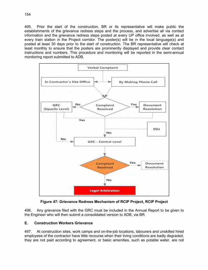
154
495. Prior the start of the construction, BR or its representative will make public the establishments of the grievance redress steps and the process, and advertise all via contact information and the grievance redress steps posted at every UP office involved, as well as at every train station in the Project corridor. The poster(s) will be in the local language(s) and posted at least 30 days prior to the start of construction. The BR representative will check at least monthly to ensure that the posters are prominently displayed and provide clear contact instructions and numbers. This procedure and monitoring will be reported in the semi-annual monitoring report submitted to ADB.
Figure 47: Grievance Redress Mechanism of RCIP Project, RCIP Project 496. Any grievance filed with the GRC must be included in the Annual Report to be given to the Engineer who will then submit a consolidated version to ADB, via BR.
E. Construction Workers Grievance
497. At construction sites, work camps and on-the-job locations, labourers and unskilled hired employees of the contractor have little recourse when their living conditions are badly degraded, they are not paid according to agreement, or basic amenities, such as potable water, are not

155
supplied. Under this contract, as part of the written agreement with each hire, the contract or letter of assignment with the work will include the name and contact information of a BR and/or the Engineer’s employee for the worker to contact. The letter/agreement will contain a second statement indicating that the contractor will not penalise the worker for reporting a complaint and if that occurs, the contract will be levied a fine equal to the employee’s contract duration from the time of the incident to the end of the contract period. That amount will be paid to the complainant. 498. The contractor will provide a complaint box, sealed by the CSC and collected by the CSC, thus allowing the construction worker to file complaints by going directly to the CSC.

156
VIII. INFORMATION DISCLOSURE, CONSULTATION, AND PUBLIC PARTICIPATION
A. General
499. The public consultation programme is an essential part of the environmental assessment process and has been undertaken both formally and informally throughout the study to ensure that the knowledge, experience and views of stakeholders and the general public are taken into account during the EIA work. The findings from the public consultations were utilised in the development of the EMP, especially in identifying the significant impacts of the proposed Project and developing the corresponding mitigation measures. 500. The objectives of the consultations were as follows:
disseminate information about the Project to the stakeholders provide stakeholders with a better understanding of existing environmental
conditions encourage stakeholders to contribute meaningfully toward improvements in the
delivery of the Project. familiarise the stakeholder with BR and its operations move toward minimising the disruption of the local communities affected, through
dialogue and interaction.
501. The information shared and recorded (See Annex 5) has, where relevant, been applied to justify design, alignment, construction methodology and timing changes, in order to reduce predicted negative effects. This approach satisfies statutory consultation requirements of ADB and DoE. 502. In late April 2013, Bangladesh Railway sent invitation letters to relevant Upazila Nirbahi Officers (UNOs) requesting them to assist the BR’s Consultant with the organisation of public meetings at a number of locations in the Project Upazilas (see Annex 13). The UNOs were also asked to actively participate in, and in most cases chair the consultations. 503. The copy of the final EIA report (in English) and executive summary and EMP of the EIA report, in both English and Bengali, will be placed at the following offices for the references to the general public:
Local office of Bangladesh Railway, Dohazari Local office of Bangladesh Railway, Chittagong Head office of Bangladesh Railway, Rail Bhaban, Dhaka
B. Stakeholder Identification Process
504. To make the public consultation process effective, BR invited a broad range of people from the communities within the Project’s impact zone. These participants included religious and political leaders, business owners, journalists, doctors, engineers, leaders of the bus and truck owners’ associations, Project affected people, farmers, local elites and representatives of NGOs. During the consultation, all participants welcomed the Project because they expected that the Project will play an important role in improving the area’s transportation services. 505. To ensure that a broad spectrum of society was at least made aware of the consultations, BR sent letters of invitation to 16 stakeholder groups. These included (Table 49)

157
staff of DoE, Local Government, Bangladesh Railway staff, local women’s groups, farmers whose lands border the rail line, fishermen who use the rivers crossed by the proposed alignment, businessmen, transport workers. At least 40 were invited, but it was made known to the UNOs that anyone interested was welcome to any of the sessions. An attendance sheet of each consultation was filled in and minutes were taken and summarised (see Annex 5 for these items).
Table 49: Stakeholders Identified Regulatory Agencies Primary Stakeholders
Department of Environment, Ministry of Environment and Forests, Bangladesh Railway, Department of Forests
Relevant union chairman Women’s Group in Project area Teachers of Educational Institutes Religious Leaders Villagers, especially those require involuntary resettlements Fishermen Group Local Environmentalist Group Department of Forest Local Business Association Farmers Group
Secondary Stakeholders Local Government Engineering Department (LGED) Rural Electrification Board
C. Public Consultation Locations and Approach
506. During the field visit on 26–29 November 2012, six locations were selected, based on the significance of those areas in relation to resettlement issues, loss of agricultural lands, loss of trees, elephant conflict with human, and disturbance to livelihoods. The final selection was made after discussion with local villagers within the corridor and local BR representatives. These locations for both consultation sessions were:
DC Office, Cox’s Bazar Sadar Upazila Ukhia Union Parishad Bhaban Ukhia Upazila Ramu Upazila Parishad Bhaban, Ramu Upazila Dulahazara Union Parishad Bhaban , Chakaria Upazila Keranihat Union Parishad Bhaban Chandanaish Upazila Dohazari Union Complex, Dohazari Upazila
507. Public Consultation Methodology and Approach - For the first round of sessions in May 2013, the local people were informed one day ahead of the consultation through the local body representative, UNO and local newspaper. A power point presentation was delivered with photographs, maps, posters, accompanied with a hand-out folder (See Annex 5) informing the audience about the detail of Project activities, the proposed scope of the Project, the alternative corridors, river crossing, and the elephant movement issue. After the presentation followed by discussions and Q/A sessions. The participants easily understood the Project activities and participated in the discussions and provided comments and suggestions. Face-to-face interviews and phone calls with sector specific experts, including Department of Forest (DoF), Local Government Engineering Department (LGED) and Department of Environment (DoE), were completed. There were also Project briefings provided during the focus group discussion (FGD), followed by question and answer sessions. 508. An indicative work timetable was also provided defining the construction period and when actions could be expected. BR assessed the inputs and took actions where relevant, adjusted the approach to the EIA and recorded all of these in minutes (See Annex 5) and
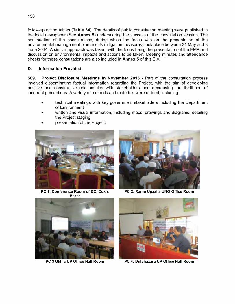
158
follow-up action tables (Table 34). The details of public consultation meeting were published in the local newspaper (See Annex 5) underscoring the success of the consultation session. The continuation of the consultations, during which the focus was on the presentation of the environmental management plan and its mitigation measures, took place between 31 May and 3 June 2014. A similar approach was taken, with the focus being the presentation of the EMP and discussion on environmental impacts and actions to be taken. Meeting minutes and attendance sheets for these consultations are also included in Annex 5 of this EIA.
D. Information Provided
509. Project Disclosure Meetings in November 2013 - Part of the consultation process involved disseminating factual information regarding the Project, with the aim of developing positive and constructive relationships with stakeholders and decreasing the likelihood of incorrect perceptions. A variety of methods and materials were utilised, including:
technical meetings with key government stakeholders including the Department of Environment
written and visual information, including maps, drawings and diagrams, detailing the Project staging
presentation of the Project.
PC 1: Conference Room of DC, Cox’s
Bazar PC 2: Ramu Upazila UNO Office Room
PC 3 Ukhia UP Office Hall Room PC 4: Dulahazara UP Office Hall Room

159
PC 5: Dohazari UP Office Hall Room PC 6: Satkania-Keochia UP Office Hall
Room Figure 48: Focus Group Discussions at Various Locations of Project
510. EMP Disclosure Meetings in June 2014 - Prior to the commencement of the EMP meetings, materials were disseminated with the aim of developing positive and constructive relationships with stakeholders and improving their knowledge about the Project and therefore enhance their ability to ask informed questions and to provide useful input and advice. 511. These materials were:
summary of the mitigations proposed during Project Disclosure meetings written and visual information, including brochure in Bangla, maps, drawings and
diagrams, detailing the Project activities identification of elephant crossing pathway and its safe way crossing
management measure the draft EMP
PC 1: Conference Room of Cox’s Bazar UNO
Office PC 2: Conference Room of Ramu UNO Office
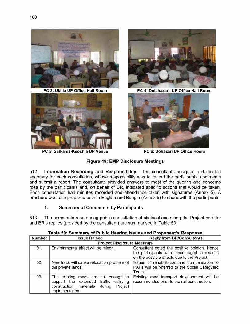
160
PC 3: Ukhia UP Office Hall Room PC 4: Dulahazara UP Office Hall Room
PC 5: Satkania-Keochia UP Venue PC 6: Dohazari UP Office Room
Figure 49: EMP Disclosure Meetings 512. Information Recording and Responsibility - The consultants assigned a dedicated secretary for each consultation, whose responsibility was to record the participants’ comments and submit a report. The consultants provided answers to most of the queries and concerns rose by the participants and, on behalf of BR, indicated specific actions that would be taken. Each consultation had minutes recorded and attendance taken with signatures (Annex 5). A brochure was also prepared both in English and Bangla (Annex 5) to share with the participants.
1. Summary of Comments by Participants
513. The comments rose during public consultation at six locations along the Project corridor and BR’s replies (provided by the consultant) are summarised in Table 50.
Table 50: Summary of Public Hearing Issues and Proponent’s Response Number Issue Raised Reply from BR/Consultants
Project Disclosure Meetings 01. Environmental affect will be minor. Consultant noted the positive opinion. Hence
the participants were encouraged to discuss on the possible effects due to the Project.
02. New track will cause relocation problem of the private lands.
Issues of rehabilitation and compensation to PAPs will be referred to the Social Safeguard Team.
03. The existing roads are not enough to support the extended traffic carrying construction materials during Project implementation.
Existing road transport development will be recommended prior to the rail construction.

161
Number Issue Raised Reply from BR/Consultants 04. What will be the source of land filling
works? According to the Project policy, the source of the land filling will be mostly the river dredging materials where possible
05. Hill cutting should be avoided along the alignment
If hill cutting cannot be avoided then, as per present rule, permission will be taken from appropriate authority before hill cutting commences.
06 Slope stability After cutting hill slope of hill should be properly maintained through using geotextile and turfing at the slopes of the hills.
07. Construction sound / vibration will hamper local market, household, etc. How we are planning to compensate on that?
The solution will be prescribed in Environmental Management Plan (EMP).
08. Due to the construction of the rail Project, existing environment will be imbalance
It is true that existing environment will be affected but it is manageable through implementation of appropriate mitigative measures. EMP will be consisting of all aspects of existing environmental issues.
09. Developed countries always protect their environment. We have to save our natural resources including water bodies, rivers and biodiversity.
Proper suggestion will be given to minimise the effects on local hydrology, Biodiversity and other natural resources.
10. All the people welcomed the new railway Project.
Consultant noted the positive opinion.
11. Noise and vibration pollution at the Near Hospital
The consultant suggested that modern equipment will be used, so that noise impact will not arises. Noise barrier to be discussed with hospital.
12. Traffic congestion will increase. Traffic signalling system must be developed at busy rail crossings.
Traffic safety will be considered in EMP.
13. This Project will be very positive for the local people. Development brings betterment to our life.
Consultant noted the positive opinion.
14. Long-time construction will cause air pollution, soil pollution, water pollution and sound pollution. Social forestation will be hampered.
Proper suggestion will be given to minimise the environmental effects.
15. Fast construction is expected. Consultant noted the point of optimism. 16. Road communication will be hampered
during the bridge construction period. Existing road transport development will be recommended prior to the rail construction.
17. Long term construction camps may cause health hazards.
A waste management plan will be developed for the camps to ensure little impacts from construction camps. Details will be prescribed in Environmental Management Plan (EMP).
18. Very impressive Project connecting international boundaries
Consultant noted the positive opinion.
19. Unnecessary land should not be acquired by railway and existing agricultural lands should be protected during construction.
The least possible, vacant and unutilised land will be acquired.
20. There will be accident during collision between the elephant and train.
Structure or arrangement will be provided for save passing of the elephant.
21. Arrange elephant’s food and water. Elephant are coming out for their food and salt water. Need proper elephant management

162
Number Issue Raised Reply from BR/Consultants system with food and salt water away from the construction areas.
22. Government must ensure proper compensation for Project affected people.
Issues of rehabilitation and compensation to PAPs will be referred to the Social Safeguard Team
23. We should not compromise possible environmental issues in the name of development.
Consultant is well aware that and the meeting is also one of the approaches to identify the issues.
24. The proposed alignment will cross Christian Memorial Hospital which causing the safety of staff of the hospitals
Consultant ensure participants that concern alignment area will be realigned after inspected by both social and environment teams of RCIP and will propose alternative route alignment on that section of alignment if necessary.
25. Blocking farmers’ access to agricultural production areas and livestock.
Sufficient access will be proposed.
26. Flooding due to improper removal of cofferdams and clearing new culverts of construction debris
Hydrology team of the RCIP is currently studying last 100 years flooding patterns and also investigating current drainage channel and water flow during flooding. Based on the results of the investigation, sufficient culverts will be proposed to be constructed to reduce water clogging.
EMP Disclosure Meetings 01 Earth cutting for construction of
embankment top soil protection Top soil will be stored for reuse once construction is finished and landscaping/restoration of construction areas takes place
02 Government must ensure proper compensation for Project affected people.
Issues of rehabilitation and compensation to PAPs will be referred to the Social Safeguard Team
03 Hill cutting Hill cutting should be minimised and slope stability will be ensured.
04 Tree cutting Tree plantation will be done according to the plan. Moreover he suggested to plant trees which has very negligible timber value so that people do not cut them later on. Proper tree plantation must be done on the slope of the embankment.
05 During construction of 5 major bridges, air, noise and traffic congestion will create problem.
Participant suggested using alternate road for traffic and pedestrian movement.
06 Fish species reduction Construction will be done within a fixed time. There will be cofferdams to protect the water quality and the fish species. Construction schedule will be fixed considering the fish breeding season. During construction period ground water will not polluted externally.
07 Flash flood and drainage system In recent times there have been some flash floods occurring at Fatekharkul a flood-prone area in short period time at hilly area, inundating the whole area. Proper management will be required.

163
Number Issue Raised Reply from BR/Consultants Enough bridges and culverts, to maintain proper drainage system, will be installed. Bridge design must be done considering the flash flood in hilly areas. Alignment height must be fixed very carefully because there are a lot of flood prone areas the rail track will go through. And the people are certainly not expecting a permanent problem in rail way transport due to sudden flood. River dredging must be done carefully to protect the aquatic flora and fauna. Road capacity must be increased to support rail line construction. We must not harm other resources to improve rail transport.
08 Safety issue during construction period Different safety measures including barricade, warning light and caution signboard and underpass have been suggested by the Consultant which will minimise the risk for the local transport and pedestrian movement.
09 Drinking water, sanitation and other facilities at worker camps
Due to heavy work some specific area like the work camps where workers will be in need of drinking water, a limited tube wells will be bored with prior approval from authority.
10 Elephant movement and conflict with human is a major problem in this region.
Many suggestions come from the participants. Elephant friendly environment should be created along the elephant path. Food (various types of trees) and salt water should be arranged along the elephant pass path. IR camera will not better solution due to sustainability, it may theft or sabotage. Elephant will never cross the over pass, underpass and is not a good solution. Engine head mounted IR Camera is a better idea. In India elephant crossing bridge project failed. Protecting elephant habitat and foods can reduce their movement in the human settlement.
11 Consultant tree plantation plan is very appreciable
Consultant noted the positive opinion.
12 Using River water where possible for the construction to reduce ground water demand.
Consultant noted the suggestion.
13 Environmental issues are negligible compared to compensation and resettlement issues.
Issues of rehabilitation and compensation to PAPs will be referred to the Social Safeguard Team.
14 During construction, surface runoff from the proposed embankment area would impact the adjoining agricultural lands. Therefore, the impacted lands will lose its fertility and it will not possible to grow anything after few years.
EMP adequately addresses this issue and proposed to plant grasses on embankment slope. However, if construction activities affect the adjoining agricultural lands, it is requested to place a complaint through GRC.

164
E. Consultation Outcomes
514. First Session - Six public consultations were arranged to disclose the Project as identified in Annex 5 and six consultations were arranged for EMP disclosure. The respective number of participants in the six Project disclosures were 19 (94.74% male and 5.26% female), 14 (100% male and 0% female), 29 (100% male and 0% female), 30 (96.67% male and 3.33% female), 44 (81.82% male and 18.18% female) and 39 (97.44% male and 2.56% female) and In relation to the groups invited, the attendance was reasonably successful in Project disclosure meetings. Nine of the 16 groups invited attended in Project disclosure meetings.
Table 51: Stakeholder Attendance (Male/Female) in Project Disclosure Consultations Agency or Participant Affiliation Location
Ramu Cox’s Bazar
Dulahazara Keranihat Dohazari
Consultations on Project Disclosure
M F M F M F M F M F
Department of Environment, Government of Bangladesh
0 0 1 0 0 0 0 0 0 0
Bangladesh Railway (BR) 0 0 1 0 1 0 0 0 0 0 Local Government Engineering Department (LGED)
0 0 1 0 0 0 0 0 0 0
Rural Electrification Board 0 0 0 0 0 0 1 0 0 0 Elected representatives/ Government official
7 0 9 0 14 0 28 8 8 0
Women’s Group in Project area 0 0 0 0 0 1 0 0 0 1 Teachers of Educational Institutes/ Students
1 0 1 0 1 0 0 0 5 0
Doctor/ Engineer/ other profession 2 0 7 0 4 0 0 0 5 0 Newspaper/ Media personnel 3 0 7 0 1 0 0 0 3 0 Religious leaders 0 0 0 0 0 0 0 0 0 0 Villagers, especially those require involuntary resettlements
0 0 0 0 0 0 1 0 0 0
Fishermen Group 0 0 0 0 1 0 1 0 1 0 Local Environmentalist Group 0 0 0 0 0 0 0 0 0 0 Department of Forest 0 0 0 0 0 0 0 0 0 0 Local Business Association 1 0 2 0 6 0 3 0 12 0 Farmers Group 0 0 0 0 1 0 2 0 4 0 Subtotal (gender wise) 14 0 29 0 29 1 36 8 38 1 Total 14 29 30 44 39
515. The comments summarised in Table 50 were carefully examined and contributed significantly to shaping how the environmental effects and mitigative measures were defined in the EMP. The actions taken by BR in response to the comments are defined in Table 34, and show that comments were taken seriously and integrated into Project planning. 516. Second Session - Another set of public consultation meetings focusing in the EMP (Table 52) were also useful in getting feedback from stakeholders on where the EMP was adequate and where changes were necessary.

165
Table 52: Stakeholder Attendance in EMP Disclosure Meetings Agency or Participant Affiliation Location
Ramu Cox’s Bazar Dulahazara Keranihat Dohazari Consultations on EMP Disclosure M F M F M F M F M F Department of Environment, Government of Bangladesh
0 0 1 0 0 0 0 0 0 0
Bangladesh Railway (BR) 0 0 0 0 0 0 0 0 0 0 Local Government Engineering Department (LGED)
0 1 1 0 0 0 0 0 0 0
Rural Electrification Board 0 0 0 0 0 0 0 0 0 0 Elected representatives/ Government official
16 4 6 0 3 0 6 1 5 0
Women’s Group in Project area 0 0 0 0 0 14 0 2 0 3 Teachers of Educational Institutes/ Students
1 0 1 0 0 0 5 0 2 4
Doctor/ Engineer/ other profession 6 0 7 0 13 0 5 0 6 1 Newspaper/ Media personnel 8 0 6 0 0 0 0 0 1 0 Religious Leaders 0 0 0 0 2 0 0 0 Villagers, especially those require involuntary resettlements
0 0 0 0 0 0 0 0 0 0
Fishermen Group 1 0 2 0 5 0 3 0 2 0 Local Environmentalist Group 0 0 0 0 0 0 0 0 0 0 Department of Forest 0 0 1 0 0 0 0 0 0 0 Local Business Association 1 0 3 0 8 0 9 0 11 0 Farmers Group 0 0 1 0 27 0 6 0 3 0 Subtotal (gender wise) 32 5 29 0 58 14 34 3 24 8 Total 37 29 72 37 32 517. Overall, participants were supportive of the Project and recognised the value of having a rail service connecting that southern tip of Bangladesh with the rest of the country. They felt that the Project was nationally important, and that it will bring economic development to the region.
F. Follow-Up Programme
518. Follow-up to Project Disclosure - During six public consultations, a number of issues were raised by the participants, and Bangladesh Railway and the Consultant assured them that BR would follow up the following issues, provide all environmental documentation and address the issues stressed at the sessions. The information to be passed and issues to be addressed were, inter alia:
details on how river bank erosion along the five large River Bridge has been mitigated by the Project’s hydrologists; and,
provision by the social assessment team of more specific information on the rehabilitation of private property likely damaged during construction and compensation to Project Affected People.
519. Follow Up to EMP Disclosure - The final version of the EIA report along with EMP and Executive Summary (in Bangla) will be provided to relevant UNOs.BR will advise the contractor to give Project Affected Persons (PAPs) first rights to be employed by the Project (e.g., employment, business, etc.) during implementation.
1. Use of Consultation Results

166
520. Key issues and concerns identified through the consultation process, and the means by which they have been assessed and addressed in this EIA report is shown in Table 53. These matters have also been translated in practical actions which are contained in the associated Environmental Management Plan (Refer to Section IX).
Table 53: Addressing Key Stakeholder Concerns Key Stakeholder
Concerns Addressing Stakeholders Concerns
In Project Disclosure Meetings Potential impacts to the existing environment.
A detailed Environmental Impact Assessment has been undertaken investigating potential impacts to all aspects of the existing environment including surface and groundwater, flora and fauna, air quality and noise. Mitigation measures have been proposed for all Project activities which have the potential for significant negative impacts on the existing environment. Section IV of this report provides baseline information for the existing environmental conditions. Section VI provides a detailed assessment of potential impacts and mitigation measures. Section IX provides an EMP where practical actions are proposed in order to reduce potential impacts.
Tree cutting Cutting of 471,000 trees is dangerous to ecological balance. Three trees will be planted against one tree cut. Plantation will also be done on the slopes of embankment along the rail road; except at elephant crossing sites—to maintain visibility.
Potential impact on hill cutting and slope stability
Some of the hills need to be cut along the rail alignment up to 16 m height (Topo Map).Slope stability will be properly done through geotextile and turfing as require design, so that during rain the hill will not erode into the alignment.
Elephant movement Locomotive mounted IR Cameras will be used as an early detection system, to track elephant movement across the railway tracks, helping to prevent the possible accident.
Flash flood During monsoon period flash flood inundated the area and created suffering to the general people. Bridge and culvert opening will be properly designed to be able accommodate flash flood water.
Potential impacts of noise and vibration on the community
80 noise readings were recorded to assess the existing noise conditions. It was observed that noise impacts will be much lesser than any greenfield project as the study area already has an operating highway nearby. However, potential impacts have been assessed, and mitigation measures have been provided in Section VI including:
Undertaking noise-generating construction works during the daytime (rather than night-time) whenever possible
Liaising with local community leaders to negotiate specific mitigation measures for sensitive areas such as mosques or schools which are within the potential noise impact zone
Investigating any noise-related complaints and – if complaints are valid – providing mitigation measures on a case-by-case basis
Potential impacts on land, crop production and surface water bodies
Section VI provides potential significant negative impacts on agriculture and water bodies, and provides specific mitigation measure to reduce the pollution for impacts to occur. This includes: Installing effective sanitation and waste management systems
Applying appropriate protocols for the safe transport, handling, use and storage of hazardous substances such as fuels
Clearly delineating the Project sites in order to reduce the potential for over-clearing of crop land

167
Key Stakeholder Concerns Addressing Stakeholders Concerns
Managing dredging material to reduce the potential for sedimentation/siltation of surrounding cropland
Land filling materials – dredge materials - will be imported from outside of the Project area
Section VI also provides an assessment of potential impacts to site surface water bodies, including relevant mitigation measures. These include:
Utilising groundwater bores as a water source, rather than pumping from surface water bodies
Complying with the requirements of Schedule 10 of the ECR regarding discharge of wastewater from the Project sites
Monitoring water quality within the Study Area on an on-going basis Managing potential erosion in order to reduce the potential for
sedimentation of waterways Properly sized culverts and bridges to handle 50- and 100-year
design storms and reduce water clogging during flooding. Potential impact on livelihoods for farmers and sharecroppers currently using land to be acquired.
All landholders and sharecroppers will be provided with compensation in accordance with – at a minimum – relevant Bangladesh legislation such as the Acquisition and Requisition of Immovable Property Ordinance 1982.
Potential for increased risk of accidents on the local roads as a result of the Project and existing road upgrades.
Potential impacts, such as road accidents, were assessed in EIA Section VI, and management measures are provided in EIA Section IX. Key recommended mitigation measures include:
Developing a Traffic Management Plan and driver code-of-conduct for the site, and enforcing speed limits and other road safety regulations
Informing contractors’ drivers of sensitive areas where the chances of a collision are higher e.g. schools, markets and madrasas. Speed limit signage
Liaising with community representatives to inform them of increased traffic volumes in certain areas
Potential for the utilisation of local labour and local business
Local labour and local businesses will be engaged wherever possible. Consultants will suggest Bangladesh Railway to utilise local labour pool at maximum during both construction and operational phase of the Project.
Potential compensation process particularly on the adherence to laws and the fair, timely and adequate compensation for loss of land, crops, livelihood, etc.
The requirements of relevant Bangladesh legislation such as the Acquisition and Requisition of Immovable Property Ordinance 1982 set the minimum requirements for the compensation process. BR will adhere to this process to provide fair, timely and adequate compensation for loss of land, impacts to livelihood, damage to property etc.
Concerns were raised over safety and security of the local community both during construction and operational phase of the Project. Increasing train –vehicle, train-livestock and train pedestrian accidents of train traffic
Potential impacts to the health and safety of the local community, and relevant mitigation measures, are provided in Section VI. Proper traffic signs and signals will be developed in construction areas Visible signs and vest will be worn at all times when construction goes on at night Work camps will be under periodic monitoring to reduce any health concern Sprinklers will be used for dust suppression. Proper safety equipment will be used for staff safety.
Flooding do to improper removal of cofferdams and clearing new culverts of
Proper / sufficient culverts and bridges will be construction for water flow especially for flooding prone areas Sufficient access route to crop lands will be constructed if proposed rail
168
Key Stakeholder Concerns Addressing Stakeholders Concerns
construction debris Blocking farmers’ access to agricultural production areas and livestock
alignment split the lands of mass community
Protection of archaeological sites and heritage during construction
Archaeological sites and cultural places will be protected as much as possible during finalisation of the rail alignment based on the importance of the site.
In EMP Disclosure Meetings Potential risk of elephant human collision
Proper mitigation measure like locomotive-mounted IR camera will be installed, permitted the early detection of the animals as far as 1,000 m ahead of the moving train, permitted actions by the Engineer to slow down the train like blowing of warning whistles, etc.
Flash flood Proper and necessary opening of bridge and culvert will be constructed (using design storm specifications) along the alignment to permit natural drainage to continue.
Potential risk at level crossings
Proper and sufficient measure will be taken to reduce any potential accidental risks at the level crossing areas. Details impact and mitigation measures are discussed in Chapter VI.
Existing roads and road bridges condition
All existing roads and road bridges that will be used during construction period will be assessed during pre-construction period.
Abstraction of Ground water level
It is proposed in EIA and EMP to use surface water first and not to disturb the groundwater. However, a limited tube wells will be bored in workers’ camp areas (Chapter VI).
Potential damage due to cut the trees agricultural lands of the embankment construction areas
It is proposed in EMP to plant quick growing vetiver/napitar grasses to reduce the surface soil run off from the embankment areas.
G. Consultation with Wildlife NGOs
521. The elephant survey for identifying elephant behaviour and movement routes was conducted by IUCN Bangladesh. Various attempts were made by BR and the EIA consultants to consult with other wildlife or environmental NGOs in Bangladesh including invitation to BR for consultation with ADB officials in February 2016. However, it was only NGOs with social causes46 that responded positively and participated in consultations with BR the consultants and ADB officials.
H. Consultation with Forestry Department
522. Consultations were carried with at Bangabandhu Safari Park with the Divisional Forestry Officers (DFOs) and Forest Rangers of Chittagong Division and Cox’s Bazaar North Division on 2 December 2015. It is the DFO of the Chittagong Division that is responsible for manages activities in CWS, FWS and MNP. The Forestry officers expressed their preference for inclusion of underpasses and overpasses for the elephant crossings. 523. According to the Forest Act (1927) and the Forest (Amendment) Act (2000) of Bangladesh, government clearances are required for any clearing of forest inside a protected 46 Development Organization of the Rural Poor (DORP); Kangaroo Mother Care, (KMC) Bangladesh;
Samahar

169
area. Representatives from BR, the EIA consultant and ADB met with the Chief Conservator of Forests47 (CCF) of the Forestry Department in Dhaka on 6 December 2015 to seek guidance on securing such government clearances since the project alignment passes through the CWS, FWS and MNP and a number of reserved forests. The CCF advised that MOR should submit a clearance request to the Prime Minister’s office for the project as whole clearly presenting details on land acquisition, project alignment passing through the protected areas and reserved forests, hill cutting and others rather than processing many separate clearances for various issues under the project.
47 Mr. Md. Yunus Ali, B.C.S (Forests), Chief Conservator of Forests, Forest Department

170
IX. THE ENVIRONMENTAL MANAGEMENT PLAN AND COSTS
524. This section of the EIA report presents the Environmental Management Plan (EMP) for this Project (Table 54). The EMP defines a set of mitigation and monitoring actions to be taken, in response to potential impacts predicted to take place during the pre-construction, construction and operating periods of the Project. The sources of the impacts and the impacts were identified during the EIA study. The EMP is presented as two tables, defining not only the impacts and mitigative and monitoring actions to be implemented, but also where, when and who will be responsible for implementing them. The EMP describes well known and best available mitigative actions to be taken to prevent negative impacts from taking place, and if that is not possible to mitigate them to an acceptable48 level. In addition, this EMP will:
define measures to off-set or compensate irreversible49 negative impacts specify the institutional arrangement for the implementation of the EMP identify means to enhance and maximise positive impacts
525. The EMP (Table 54) will be the main tool with which BR will manage environment impacts by applying both mitigative and monitoring measures defined beside each impact, in a technically credible and timely manner. The mitigative measures are considered successful when the impacts have either been eliminated or the residual effect complies with the environmental quality standards, policies, and legal requirements set by DoE. Mitigative measures are tracked via the monitoring programme, which is described in the second of two EMP tables (Table 55 and Table 56), and focuses on the impacts during the construction and operating periods. 526. As agreed with DoE, the construction of any large bridge (>100 m lengths), which under DoE regulations would normally require their own EIA and which DoE has exempted BR from doing, will be presented in more detail and with its own mitigative and monitoring requirements.
A. Environmental Management Plan
1. Pre-construction Period
527. BR identified 14 impacts which if not properly addressed could lead to impact during the other two Project phases or totally eliminate the objective of completing an EIA. These included, having a tree replacement plan in place, minimising land requirements by fine tuning where the new alignment is placed, and having a process in place that protects the sensitively manage the relocation of 40 community-level sites (CPR) identified during consultations. 528. The Project will have eight new stations (plus one fully rebuilt) as well as access roads. These can have serious effects on land and people, thus must be carefully designed and sited. The EMP underscores BR’s actions to make sure the designs and alignments are sensitive to local conditions and wishes.
48 Acceptable is defined as an impact that is within GoB permissible standards 49 an impact that the environment cannot return to its original state from, e.g. the extinction of an animal
or plant species

171
529. The knowledge that there will be an impact on the Asian elephant, an endangered species, requires that planning the delivery of effective mitigative measures be completed before the work begins. The following actions are defined in the EMP and will be that:
(i) Include, as part of the ToR of the CSC, the requirement for a trained ecologist who will lead the pilot testing programme and and later the construction period monitoring effort as part of the CSC.
(ii) Independent Monitor - Further an indepdent monitoring agency/person will be appointed during the pre-construction period. This agency/person will be responsible for third party monitoring of all aspects of the EMP implementation and supervision related to elephant. This will include field verification, revision and updating the IUCN study on elephants, then reviewing and updating the mitigation proposals for elephant crossings (including the location of the crossings); implementation of conservation/habitat enhancement activities; etc. as agreed with BR. The independent monitor will be recruited separately under an ADB’s Capacity Development Technical Assistance (CDTA) grant and will function as a part of the Project, but at arms length, during the entire construction period and 3 years when the railroad is in operation. The agency’s/person’s role during operation will be to monitor the effectiveness of the elephant mitigation measures, success of the habitat restoration programme, noise and vibration levels management as related to elephant, etc.
2. Construction Period
530. BR identified 28 mitigative and monitoring actions that will need to be implemented if significant construction-related effects are to be minimised (see Table 54). The following nine construction activities are likely to trigger negative effects which have been addressed in the EMP:
clearing of alignment RoW of > 239,000 trees and shrubs; unrestricted movement of construction, machinery and vehicles; railway embankments construction; earthworks including rail embankment and hill cutting; inadequate station and access road siting; bridges crossing structures, culverts and any training works; installation of signalling and interlocking system, platforms, foot over bridges at
stations, platform sheds and level crossing safety facilities; blockage of elephant travel routes by railway embankment construction; and poor good housekeeping practices by the contractor and failure to properly
implement an occupational health and safety programme.
531. Of these, the most important will be the effects stemming from the placement of the 4-8 m high embankment or 4-9 m deep cuts along the 102 Km alignment (See Annex 2 maps), in order to reach a grade that locomotive can manage efficiently. The transport of large volumes of embankment materials, mostly for short distances of less than 1 km will impact traffic, air quality and noise conditions. Dust suppression, and limits to truck traffic during low noise periods (evening and night), as well as care with fleet maintenance will be important. Ensuring that the trucks and construction machinery do not idle for more than three minutes when not in use will markedly reduce the emissions and provide considerable fuel savings. Revegetation and slope stabilisation will be essential actions, particularly in the hilly sections of the alignment.

172
532. Elephant- Prevention and minimization of possible impacts on the internationally endangered elephant needs special attention. To that end the following actions (as defined in the EMP) will be implemented:
(i) Implement the construction period elephant avoidance plan prepared during the pre-construction period;
(ii) Contractor to conduct the camera pilot testing programme under the supervision of the CSC; and
(iii) Implement monitoring programme to track elephant movement during the construction period and better understand local population dynamics, herd size and a better knowledge of movement patters. Do this in collaboration with engagement of local villagers and small monitoring contracts.
533. To better track the air and noise pollution the contractor will be required to undertake a compliance monitoring programme, testing the parameters defined in EIA Section IV and at the same stations as shown in the strip maps (Annex 2). Noise monitoring will be completed at and the selected CPRs (closest hospital, schools, mosques and residences) to be identified once the social sector work is complete. The sampling sequence will be more or less the same as the sampling completed during the field work for this EIA. 534. Another common impact involves the failure of contractors to properly maintain work camps, allowing sewage to leak, garbage to be left unmanaged, fuel to leak and even bitumen to spill over the ground near the asphalt batch plant50 occupational health and safety (OHS) practices are often ignored, the contractor either not providing adequate safety equipment or not enforcing its use. Contractors will be required to provide hard hats, ear plugs, dust masks and eye protection, and deliver OHS training sessions, once a year. 535. Construction of six large bridges, 33 medium to minor bridges, and 144 culverts could result in impact on surface water quality and to that end the Sangu, River, Matamuhuri, Tributary of Matamuhuri, Idgaon Char and Bakkhali River crossing works will have water quality sampling completed, according the design used in this EIA. This is particularly true if bentonite drilling mud is used during the pile boring operations on the five larger rivers. Contractors will be required to provide a bentonite recovery plan, should this material be used. 536. Finally, the Subproject will require concrete since all piles, piers and large culverts will be cast at casting yards and therefore a mobile concrete batch plant will have to be set up, generating noise and dust. The contractor will be required to have dust and noise suppression features built into any concrete batch plant. The plant will need to be located at an approved site, at least 500 m from the nearest occupied dwelling, as well as at least 1 km from any active or seasonal elephant crossing areas.
3. Operating Period
537. The Project is a new line and as such air quality, noise, safety and access will be major permanent changes that need to be managed as best as possible to limit negative effects. Eleven mitigative and monitoring actions will need to be implemented during the operating period. Five important impacts that BR will address are:
50 The batch plant will only be necessary for the access roads to the stations and for the restoration of the
level crossings

173
538. possible inadequate clean up and rehabilitation of contractors camps and yards and borrow areas;
noise and air pollution from operation of 32 trains starting in 2022 and increasing to 54 by 2035, impacting on local sensitive receptors. The addition of the luxury train traffic will further increase the daily train traffic by 3-5 times. This will not increase the maximum noise levels but will very significantly increase the average noise environment along the line. This will be particularly acute when trains travel at night along the Dohazari to Cox’s Bazar section of the route; which is basically through rural farming areas;
possible train elephant accidents due to inadequate preventative measures; lack of adequate new safety measures/equipment at level crossing resulting in
more accidents and traffic congestion; and Insuffienc management of washwater, garbage and noise, the result of the
operation of the Cox’s Bazar train stabling and washing facility.
539. These impacts, mitigative measures and monitoring requirements are defined in detail in the EMP. 540. Monitoring of the effectiveness of the TIC, signage and operator training programme will be undertaken by BR, through a specialist consultant retained via an ADB CBTA grant to complete the monitoring during the construction period and during years 1, 3 and 5 of the operating period. After each year of the pilot study a ½ day results -review session will be held and any adjustments to the elephant protection plan made before the next year begins. Locomotive engineers will be required to keep exact records of elephant sightings and any interactions. Should any serious issue arise monitoring will resume immediately. 541. The specialist consultant will be a 3rd party independent agency/person and will be appointed by the ADB, but will be overseen, at arm’s length, by the CSC team leader. 542. As BR is establishing its ESSU, this work could be overseen by the specialist on staff, and participation from the safeguards specialist with the CSC will be expected.
4. Institutional Arrangements
543. At all times during the preparation and construction of the Project, BR’s Project Director will have the final say on all administrative and technical decisions. The key agencies or units which will have to play major roles in the implementation of the EMP are:
Bangladesh Railway’s newly proposed Environmental and Social Safeguards Unit (ESSU);
The Contractor; The Engineer (usually an international firm) also known as the Construction
Supervision Consultant ( CSC); and Bangladesh Department of Environment (DoE).
544. The implementation oversight of all safeguard items in the EMP and indeed the construction contract will be with BR and its ESSU. When the Engineer is appointed, BR’s technical management of the work will be delegated to the Engineer, but with final approval always passing through BR (Figure 30), with annual audit reports submitted to Asian

174
Development Bank (ADB), who may undertake periodic inspection trips to confirm that safeguards are being fully implemented.
Figure 50: Safeguards Implementation and Reporting Work Flow 545. BR’s Environmental and Social Safeguards Unit (ESSU) – The objective of an ESSU is to build enough technical capacity within BR to permit it to oversee environmental and social safeguard matters arising from donor projects and to respond with technical knowledge to specific safeguard issues triggered by Project activities, or community complaints. Secondly, the ESSU should be able to manage consultants and oversee consultant deliverables. Thirdly it will need to be able to fully address EIA requirements for the pre-construction and operating periods of the Project when The Engineer is no longer on the job. The ESSU will have to be able to assess environmental data, analyse it and define actions required to address non-compliant findings in a credible and timely manner. Finally the ESSU should be able to provide training as needed to both contractors and BR staff in all aspects of environmental and social safeguards management. Therefore, the ESSU’s main tasks will be the following:
Oversee the implementation of the EMP. Implement the EMP. Supervise and monitor the progress of the consultants engaged by BR for
addressing safeguard requirements such as air quality or resettlement plan implementation monitoring.
Liaise with all regulatory agencies, including DoE and the public. Prepare all manners of safeguard monitoring and compliance reports. Provide training to contractors and BR staff.
546. At this time BR is in the early stages of planning such a unit within its organisation. During this planning stage BR will appoint at least one safeguards person to look after the project safeguard needs, and be the direct contact for safeguard matters between stakeholders, regulators, donors and BR. 547. BR’s Regional Offices and Staff – The day-to-day oversight of the construction work on this Project has not been decided but will likely are done by the Regional BR Office and its Chief Engineer in charge. Therefore, the Engineer will work closely with the BR’s Regional office.
Construction Supervision Consultant (The Engineer)
Bangladesh Railway (BR)
Contractor
Environmental Management Group
Specialist
Office of Project Director, BR
Department of Environment (DOE)
Com
munity R
epresentation/GR
C
ADB
Environmental and Social Safeguards Unit, BR
Social Management Specialist

175
548. Construction Supervision Consultants/The Engineer – The proposed framework for implementation of the Project shall utilise consultancy services from both international and national companies for the overall management and supervision of construction work and for preparation of the EA documents. 549. Contractor(s) – A contractor selected on the basis of international competitive bidding shall carry out construction work based on a contract containing a set of environmental clauses, conditions and/or specifications (Section 6, Subsection H of contract specifications and Annex 11). The contractor will need to demonstrate environmental capacity in the proposal submitted to BR, and be prepared to have that person(s) participate in the mandatory pre-construction training exercise delivered by BR’s ESSU or its consultant. 550. Other GoB Organisations – The organisations involved in regulating the Project are Department of Environment (DoE), Bangladesh Water Development Board (BWDB), Roads and Highways Department (RHD) and Department of Forest (DF), Local Government Engineering Department (LGED), Bangladesh Inland Water Transport Authority (BIWTA), and local administration (UNO, DC, Police, etc.). They will provide supporting services as required.
5. EMP Implementation Arrangements
551. The approved EIA and the certificate from DoE will trigger the implementation phase for the EIA, i.e., the actions to mitigate and monitor the predicted impacts resulting from the building and operation of the Project. 552. BR is committed to exploring the establishment of an ESSU and has included that as an action item in the Project’s feasibility study. BR will address this internally, to establish if such a staff compliment is available. The EMP has been integrated into the contract specifications, making it a mandatory set of task for the contractor to implement. By preparing and approving the EIA and its EMP, BR has already confirmed its commitment to following through on the EMP. Until an ESSU is established BR will assign at least one safeguards specialist to deal with Project safeguard matters. 553. During the pre-construction period BR will be responsible for implementing the seven mitigative and monitoring measures, according the timetable defined in the EMP and submitting a final monitoring checklist – prior to the start of construction. BR will ensure that the contractors receive all relevant safeguard documents and that a training workshop be held to help the contractors understand the EMP, how to prepare their mandatory work plan, and deliver the required documentation. 554. The Contractors will implement all 13 mitigative and monitoring actions (See EMP), providing environmental safeguard compliance update as a section of the overall Project monthly progress report. The contractor will also submit semi-annual summaries of surveys, findings and compliance. During the pre-mobilisation workshop BR or its Engineer will review all these requirements (which are all defined in the EIA and its EMP). Construction bid documents have been prepared with a specific environmental bill-of-quantity section, allowing for unambiguous calculation of environmental penalties. 555. Monthly and quarterly progress reports on EMP implementation shall be prepared by the contractor in cooperation with the Engineer appointed by BR. All reports to be submitted to BR via the Engineer. The quarterly reports will include a compliance monitoring checklist reporting

176
(See Annex 14) on the progress of all 20 construction-period actions. Incidents of significant contamination / pollution caused by the contractor’s activities shall be reported. Recommendation shall be made for mitigation of environmental damage and for prevention of any recurrences. 556. During the construction period (five years) the Engineer will prepare annual environmental due-diligence reports, based on the monthly and quarterly submissions by the contractor. Additional details describing the Implementation arrangements are provided in Chapter XI.

177
Table 54: Environmental Management Plan
Project Period and
Environmental Parameters
Project Impact Mitigation Measures Details of Monitoring
Action to be Undertaken
When/ Frequency/
Duration
Performance indicators/
Performance Target
Who Implements
Who Supervises
1. PRE-CONSTRUCTION PERIOD 1.1 Trees and Landscape
Around 239,000 trees and saplings within the construction right of way of the proposed alignment, workers camp sites, and station areas ,will be cut down during the construction period resulting in potential ecological and economic loss.
Notice of removal of trees will be provided. BR or local NGOs will ensure compensation and planting of at least three trees for every one cut. A basic tree replacement plan has been prepared and is included as Annex 9. For every tree cut, three will be replanted. As each section of the construction work is completed, trees and understory vegetation must be planted, in order to help stabilise the cleared areas and attract some wildlife such as birds. At the 5 active elephant crossing locations, no trees will be planted but the areas will be fully revegetated to prevent erosion while maintaining visibility for approaching trains.
Confirm that a tree cutting and replanting programme is fully ready to implement when during the pre-construction period Confirm that this planting plan is in agreement with local people who lost food-trees.
During the pre-construction period and throughout the pre-construction and construction period
Tree replanting plan and record of compensation/Tree planting plan implemented as defined in the plan
BR, Local NGOs and BR’s ESSU if available
BR
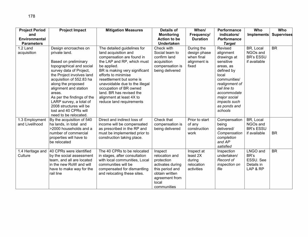
178
Project Period and
Environmental Parameters
Project Impact Mitigation Measures Details of Monitoring
Action to be Undertaken
When/ Frequency/
Duration
Performance indicators/
Performance Target
Who Implements
Who Supervises
1.2 Land acquisition
Design encroaches on private land. Based on preliminary topographical and social survey data of Project, the Project involves land acquisition of 552.83 ha along the proposed alignment and station areas. As per the findings of the LARP survey, a total of 2008 structures will be lost and 40 CPRs will need to be relocated.
The detailed guidelines for land acquisition and compensation are found in the LAP and RP, which must be applied. BR is making very significant efforts to minimise resettlement but some is unavoidable due to the illegal occupation of BR owned land. BR has revised the alignment at least 4X to reduce land requirements
Check with Social team to confirm land acquisition compensation is being delivered
During the design phase when final alignment is fixed
Revised alignment drawings at sensitive areas, as defined by local communities/ realignment of rail line to accommodate major social impacts such as ponds and schools
BR, Local NGOs and BR’s ESSU if available
BR
1.3 Employment and Livelihood
By the acquisition of 540 ha lands, in total and >2000 households and a number of commercial properties will have to be relocated
Direct and indirect loss of income will be compensated as prescribed in the RP and must be implemented prior to construction taking place.
Check that compensation is being delivered
Prior to start of any construction work
Compensation being delivered/ Compensation completion and AP satisfied
BR, Local NGOs and BR’s ESSU if available BR
1.4 Heritage and Culture
40 CPRs were identified by the social assessment team, and all are located in the new RoW and will have to make way for the rail line
The 40 CPRs to be relocated in stages, after consultation with local communities, Local communities will be compensated for dismantling and relocating these sites.
Inspect relocation and protection activates during this period and obtain written agreement from local communities
Inspect at least 2X during relocation activities
Inspection undertaken/ Record of inspection on file
LNGO and BR’s ESSU. See Details in LAP & RP
BR

179
Project Period and
Environmental Parameters
Project Impact Mitigation Measures Details of Monitoring
Action to be Undertaken
When/ Frequency/
Duration
Performance indicators/
Performance Target
Who Implements
Who Supervises
1.5 Infrastructure – Utility Relocation
Some utility lines such as electric transmission lines, gas pipelines, and water supply pipelines are shifted or accessed without proper approval or knowledge, leading to damage.
Utilities will only be removed and relocates with proper agency approvals and permits.
Confirm that permits. Location and relocation site plans have been approved
Prior to construction starting
Inspection undertaken/ Inspection report including copies of permits or records on file
BR, utility agencies and possibly the ESSU
BR
1.6 Safety and Level Crossings
Inadequate planning and design consideration could add to the risk of accidents at new level crossings and even cause train operating problems
The level crossing issue will be carefully examined by BR and designs incorporate safety features to protect the public but also recognise the need to move traffic and include a rapid crossing clearing system
Complete inspection of level crossings, and complete safety checklist for each crossing
Review design drawings and inspect site prior to construction
Safety checklist provided to Engineer (CSC)/ A completed safety checklist as per https://www.google.ca/?gfe_rd=cr&ei=m9KMU-mcLciC8Qeg9IHQDg#q=railway+level+crossing+safety+checklist
Engineer (CSC) BR
1.7 Transport of Construction Materials
With millions of m3 of construction materials to be moved there is the potential for serious local negative air quality, noise and traffic problems
A materials transport plan will be prepared in consultation with the contractor, prior to the start of construction
Inspection of a materials haul plan
Prior to start of construction period
Materials haul plan available/ Designated haul routes being taken
Engineer and contractor
BR

180
Project Period and
Environmental Parameters
Project Impact Mitigation Measures Details of Monitoring
Action to be Undertaken
When/ Frequency/
Duration
Performance indicators/
Performance Target
Who Implements
Who Supervises
1.8 Station Design
Inadequate sizing of station sewage and garbage management facilities, leading to chronic problems during the operation of the new and upgraded stations.
The design of all waste, water and access for each station is will be designed ,using the estimated passenger through-put at each station, and according to GoB Class 1 station design specifications.
Compare the estimate of station passenger/user throughput for 2030 and check that sewage. Garbage and water system can cope with the discharges
Prior to final design being completed
A table showing each station, daily passenger loads. Waste production and waste management capacity/ Same as Indicator
The Engineer BR
1.9 Labour Standards
Poorly prepared labour standards, leading to infractions regarding child labour, minimum wage, forced labour, and unsanitary working conditions and unsafe water supplies
BR will strictly adhere to ADB and ILO and other international standards as defined in the EIA text
Confirm that these standards are specifically incorporated into the contract documents either as clauses or by appending this EMP to the contract.
Once as contract documentation is being prepared
Consult with labourers to check labour standard application/ Copy of the contract section that has the labour standards section or a listing if the section and clause numbers on file
BR. The Engineer and Contractor
BR and its ESSU-if in place

181
Project Period and
Environmental Parameters
Project Impact Mitigation Measures Details of Monitoring
Action to be Undertaken
When/ Frequency/
Duration
Performance indicators/
Performance Target
Who Implements
Who Supervises
1.10 Technical Capacity to Undertake All Environmental Work
Inability of contractor and ESSU or Engineer to implement the EIA and it EMP resulting in a breakdown of safeguards implementation.
BR to conduct a 1.5 day briefing and training for contractors and BR staff on EIA and EMP implementation, surveys and data recording
Minutes of workshop, attendance list and presentation review
During the pre-construction period
Demonstrated better understanding of safeguards and EMP/Workshop documentation package for filing
BR and Engineer
BR’s ESSU and Engineer
1.11 Environmental Clauses in Construction Contracts
No specific environmental clauses in contracts will provide BR and the Engineer with few tools to force the contract to comply with requirements defined in the EIA and its EMP
A separate Environmental Specifications Section will be prepared , and BoQ; to be included in the bidding documentation
Inspect contract specifications and bill of quantities to establish environmental contents
Prior to call for proposals—while contract documents are being finalised
Copy of environmental clauses and bill-of quantities section
BR’s ESSU BR and Engineer
1.12 3r Party Environmental Monitor
No monitor and elephant safeguard programme not implemented or implemented and unsuccessful.
ADB to engage a monitor via a CDTA
Note appointment of 3rd party monitor
Recruitment to be carried out before start of major civil works
Monitor on the job/Monitor working with CSC to design pilot programme.
ADB, BR and ESSU, CSC
BR, CSC and ADB

182
Project Period and
Environmental Parameters
Project Impact Mitigation Measures Details of Monitoring
Action to be Undertaken
When/ Frequency/
Duration
Performance indicators/
Performance Target
Who Implements
Who Supervises
1.13 Elephant protection
Construction period interference with elephant travel trains and potential serious damage to elephant population as well as danger to construction workers. Blockages of travel routes by new rail alignment
Retain Environmental Specialist on Engineer’s staff and draft to prepare construction period elephant impact avoidance plan
Obtain CV of specialist retained Record location of pilot testing Review outsourcing plan and decision by BR Review impact avoidance plan
As soon as the Engineer/CSC is selected and the pre-construction period has started
Specialist on the Project/ Confirmed evidence that TIC system will be installed—on two locomotives and pilot testing begins Decision on outsourcing documented
BR, its SEMU and CSC
BR
1.14 Elephant –train collision
Elephant train collision causing death of elephant and serious damage to train and passengers.
Define details of and implement pilot testing study of the 3 camera systems and locomotive engineer-training programme. Identify the exact location and number of elephant overpasses required. Prepare detailed design of the overpasses based on the site specific topographic conditions
Ensure that the elephant study is completed Confirm that camera system pilot programme is ready to be implemented
The pilot testing plan and elephant study must be completed before construction works begin. The detailed design of overpasses must be completed before construction works begin the sections with elephant crossings
Plan for Pilot testing details completed/ Written documentation that pilot TIC programme is under way Detailed design of overpasses are ready before civil works start in the rail sections with elephant crossings.
Independent Monitor Wildlife Experts will conduct the elephant study Contractor will prepare the pilot testing plan and prepare detailed design of overpasses
BR/PMC and CSC

183
Project Period and
Environmental Parameters
Project Impact Mitigation Measures Details of Monitoring
Action to be Undertaken
When/ Frequency/
Duration
Performance indicators/
Performance Target
Who Implements
Who Supervises
1.15 Baseline environment data collection
Without baseline data on air and water (surface and ground) quality and noise levels in camp sites, crushing/batching plant sites, urban areas, residential areas and sensitive receptor locations before start of construction works it will not be possible to gauge the project impacts on air, noise and water during construction and operation
Collect baseline data on ambient air quality, surface and ground water quality and noise levels before start of physical construction works for the bridges, stations and rail line. Ensure the noise sampling locations are representative of the difference noise zones under both GOB and WB-EHS standards
Check the baseline data collection plan: sampling locations, parameters to be monitored, duration and method of data collection
Once, before civil works begin for construction of the bridges, stations, rail line and early stages of establishment of construction camps, crushing/batching plants etc.
Baseline data on ambient air and surface and ground water quality and noise levels have been collected/baseline air, water and noise data is available before start of civil works for construction of the bridges, stations and rail line
Contractor BR/PMU and CSC
2. CONSTRUCTION PERIOD 2.1 The Environmental Management Implementation Work Schedule (EMWS)
Contractor does not prepare a work plan defining details on when mitigation and monitoring actions are to take place, in relation to the work and then the EMP requirements are not implemented properly.
The Engineer will assist contractor prepare the EMWS, but interim payment (mobilisation) will be delayed until the EMWS is submitted to the Engineer. Further the contractor will prepare; - traffic management plan, - health and safety management plan, - emergency management plan, - waste management plan, - hazardous materials management plan, - dust management plan,
Confirm that a EMWS has been prepared
Within 1 month of contractor mobilisation
Contractor preparing all with help of CSC. All aprvoed by CSC before construction begins
Contractor, with help from Engineer
Engineer

184
Project Period and
Environmental Parameters
Project Impact Mitigation Measures Details of Monitoring
Action to be Undertaken
When/ Frequency/
Duration
Performance indicators/
Performance Target
Who Implements
Who Supervises
- noise management plan, - water pollution prevention management plan, - dredging management plan, and - construction biodiversity management plan, with method statements for all works in protected areas and in-river works all in accordance with requirements of the EHS general and railway guidelines.
2.2 Air Quality and Dust
The ambient levels of CO, NOx, SOx, PM2.5, and PM10 may increase at busy stations and construction areas leading to temporary localised air pollution.
A dust suppression programme will be used at all times during construction of embankment, stations and placement of ballast Dust suppression to include watering and suppression equipment on batch plant, as well as vehicle speed restrictions to ≤35 km/h, and finally rapid revegetation including grass seeding. Ambient air quality for SO2, NO2 and PM2.5, PM10 at busy stations and construction sites will be conducted quarterly, throughout the construction period at sensitive receptors, and immediate remedial actions taken 2 exceedances
Throughout the construction period: During dry season undertake air quality testing for CO, SO2, NO2, PM2.5, and PM10 at major bridge & station construction sites.
At 10 construction sites, quarterly for five years
Sampling programme being undertaken as scheduled/ Completed data table and short analysis submitted
Contractor Engineer

185
Project Period and
Environmental Parameters
Project Impact Mitigation Measures Details of Monitoring
Action to be Undertaken
When/ Frequency/
Duration
Performance indicators/
Performance Target
Who Implements
Who Supervises
occur at any one site 2.3 Topography, Landscape and Soils 2.3.1 Erosion Clearing topsoil in
proposed embankment area Can lead to erosion and dust from unprotected storage sites. The erosion risk at embankment slopes is possible. Gully erosion along the exposed track slope during rainy season may damage smother field crops in adjacent areas.
Topsoil storage areas must be protected during the dry season, wind erosion—by covering. Rapid revegetation and use of hydro-seeding and jute erosion protection mats will be applied in areas where erosion is noted during the regular monthly inspections
Inspect storage areas and record state of storage areas with 2 photos, and then report level of erosion and on-site dust. Inspect embankment construction areas for erosion and repair
As part of regular construction inspection, likely weekly
Evidence that erosion control measures are being applied/ Description of status of erosion control measures being implemented=phtogrphic evidence of revegetation of at least 75% of embankment
Contractor Engineer
2.3.2 Topography and Landscape changes
Visual intrusion from large piles of embankment materials and ballast obstructing views and excavation along the edge of the alignment leaving large unsafe holes is possible.
Embankment site to be planted with natural vegetation; as well as fast growing grasses such as Vetiver/Napitar, taking care to avoid planting at elephant crossing sites or close to the tracks to avoid wildlife Train collisions.. Material stockpiles will be removed as soon as work is completed and the area re-landscaped. Same applies to borrow areas
Inspection/ consultation with adjacent households and railway authority to get opinion on work being completed.
Construction and operation stage/ monthly inspection / long term
Visual evidence that programme is being implemented/ Contractor includes written progress of inspection in monthly progress reports
Contractor Engineer

186
Project Period and
Environmental Parameters
Project Impact Mitigation Measures Details of Monitoring
Action to be Undertaken
When/ Frequency/
Duration
Performance indicators/
Performance Target
Who Implements
Who Supervises
2.3.3 Hill Cutting Total length 11 km of cuts across hilly sections of the alignment (See Annex 2) will be needed to achieve a design grade. These areas will be highly erosion-prone.
Proper protection measure like slope retaining walls and bioengineered measures such as plant fascines, palisades and brush layering
Confirm that contractor has obtained all necessary permits and that hill cutting or proceeding in a safe manner
During construction, when hill cutting takes place
Include as part of inspection report or checklist/ statement confirming Hill cutting completed in compliance with GoB specifications and satisfying local communities.
Contractor Engineer
2.4 Water Resources 2.4.1 Hydrology and Surface Water Quality
i) Earthwork activities during construction of embankment may result in drainage congestion ii) The surface water at workers camp and Project site areas may be polluting due to faecal, organic and other contamination. Disposed wastes and effluents from the construction sites may cause further degradation of surface water.
i) Ensure all earthworks are constructed according to design and specifications. ii) Wastes, effluents and other contaminant materials at camp/work sites to be stored, handled, transported and disposed in planned manners. Garbage disposal service to be provided, Concrete refuse reused or disposed of without habitat loss; All other effluents not to be disposed of directly into natural waters, but via settling basins to allow suspended sediment to
Site inspection Inspect waste and field management at camps and record actions taken when non-compliance recorded Conduct surface water quality testing for
Construction and operation stage/ Monthly inspection/ Long term Complete WQ testing at stations as defined in this EIA, quarterly for 5 years for the 9 parameters listed:
Inspection reporting or checklist/ indidictiing Earthworks completed according to design and regulations,at all disturbed sites Include as part of inspection report or checklist/ No garbage found
Contractor Engineer

187
Project Period and
Environmental Parameters
Project Impact Mitigation Measures Details of Monitoring
Action to be Undertaken
When/ Frequency/
Duration
Performance indicators/
Performance Target
Who Implements
Who Supervises
settle out. A quarterly surface water quality testing programme will be completed during the construction period.
pH, Turbidity, Temperature, DO, BOD5, COD, TSS, TDS, oil and grease
strewn in work camps and work sites Test data., presented in tabular, well organised form/ Completed data tables available
2.4.2 Groundwater
The potential exists for drinking water sources to be contaminated by the seepage of wastes from workers’ camps through the soil profile into the GW aquifer (particularly if wells access the shallow aquifer).
Workforce camps will be located away from water resources. All practical measures such as provision of septic tanks, garbage bags, and other sanitation facilities will be implemented at the construction camps to prevent the wastewater and solid wastes from entering well and groundwater recharge areas. Wells used for drinking will be tested every year to ensure portability.
where the pile drilling to 30m depth is conducted and/or where any new wells are dug or a well becomes a camp potable water supply , testing to be undertaken for pH, TP, Mn, Fe, As, Oil and Grease and E. Coli,.
Every 6 months or until difference over 1 years does not vary significantly. Reduced to once a year.
Test being undertaken regularly/ Completed data table and short analysis
Contractor Engineer
2.5 Waste Management 2.5.1 Waste Management
Construction camp wastes are often poorly managed and can lead to chronic pollution of surface and groundwater.
Contain all solid wastes at designated location within construction sites. Service machinery and vehicles strictly at designated maintenance workshops where waste oils and
Undertake good housekeeping practices inspection at least every 2 months and report results
At all times Garbage in bins when inspected/ Weekly compliance checklist
Contractor Engineer

188
Project Period and
Environmental Parameters
Project Impact Mitigation Measures Details of Monitoring
Action to be Undertaken
When/ Frequency/
Duration
Performance indicators/
Performance Target
Who Implements
Who Supervises
lubricants can be collected and recycled. the monthly monitoring report will provide compliance update
and record what actions taken to mitigate
2.6 Noise Work sites will be noisy due pile driving, operation, power generator, rock crushing/ batch plants and movement of construction vehicles, as well as the constant movement of trains along the existing line.
Maintain noise levels within baseline or 55 dB (WB, EHS standard) near mosques, schools, health facilities,residential areas and other sensitive sites by erection of temporary baffles. Work timing restrictions if noise levels, based on field measures indicate exceedances of existing conditions. Contractor will also be required to use only well maintained functioning equipment.
Take noise readings at sensitive receptors 2X/day during full work activities, 2X/month
Sample Quarterly for the construction period
Noise sampling being undertaken as prescribed/ Data summarised in to monthly data summary table (one row per date sampled)
Contractor Engineer
2.7 Terrestrial and Aquatic Flora and Fauna
The clearing of 240,000 trees and associated understory vegetation and construction of a 2-12 m high by around 101 km long embankments and cuttings will reduce the habitat for mostly birdlife, given that the aquatic and terrestrial faunal is limited to common and pest species.
A rapid revegetation/tree replanting programme will permit the rail-side habitat to recover quickly The rapid reestablishment of pre-construction surface draining will help to bring wet areas, somewhat reduced (marginally) by the new embankment to re-establish pre-construction habitat conditions. Fisher surveys will be conducted to gauge effect of
As part of the monthly site inspection, examine embankments, new stations, subgrade storage areas, to confirm these facilities are not contributing to environmental degradation Fisher surveys
Monthly throughout the construction period at least once
Field evidence that work is under way/ Checklist as part of the monthly reporting
Contractor Engineer

189
Project Period and
Environmental Parameters
Project Impact Mitigation Measures Details of Monitoring
Action to be Undertaken
When/ Frequency/
Duration
Performance indicators/
Performance Target
Who Implements
Who Supervises
Small patches of wetland will be covered by the embankment
construction on fishing and fish at each of the 5 major bridge crossings during the fishing season, to track changes in total catch and species diversity.
at five major rivers at crossing locations
per fishing season for 5 years
Field check that fish survey being undertaken regularly/ Creel census report available
2.8 Elephant travel routes and Elephant population
Obstruction of elephant travel routes during construction and later via deep cuts as crossing locations
Implement plan developed during the preconstruction period to minimize impact during contruction, including establishing work hours near crossing areas to only full dalylight (0700-1700). Keep embankments at cut areas as low as possible ,i.e. less than 4.1m to allow TIC viewing Monitor movement of elephant at crossing points and ability to move around construction sites,--seek cooperation of local villages, to continue a monitoring program during the construction period at the five active crossing areas.
Obtain copy of plan and evaluate effectiveness Check embankment heights and request reduction where possible
Complete at 5 active sites and include seasonal sites, ate least monthly
A plan being developed/ Contractor’s monthly report
Contractor to implement plan to minimize impact during construction. Independent monitor to conduct monitoring on elephant movement during construction
BR/PMU Engineer
2.9 Land Use, Population and Culture 2.9.1 Land Use The most significant
potential impacts on land use in the study area will be the removal of 540 ha of land (primarily rice paddy) for
Land acquisition / requisition will be in accordance with the laws of Bangladesh and as defined in the Project RP, which specifies agreed to entitlement a grievance
No action needed since this is being thoroughly monitored and completed by
Prior to start of clearing work at any proposed construction area where
Copy of reporting from social safeguards team
Local NGO and BR’s ESSU if available and Engineer
BR

190
Project Period and
Environmental Parameters
Project Impact Mitigation Measures Details of Monitoring
Action to be Undertaken
When/ Frequency/
Duration
Performance indicators/
Performance Target
Who Implements
Who Supervises
the construction of the proposed rail embankment, station access roads and associated facilities.
mechanism and timetable for implementation. It will be used by BR as its mitigation guide concerning this issue.
the social safeguards team and local NGOs
land acquisition is involved
2.10 Heritage and Culture
40 CPRs will be affected by the rail line construction
BR has defined a plan (as part of the RP) to prevent undue damage to these sites and/or relocate the CPRs, which will have to be completed before the work begins
For 44 CPRs, discuss actions taken with local officials and get agreement that this is appropriate.
Prior to the start of construction
Check Table in EIA/ Inspection report or checklist
Contractor Engineer
BR
2.11 Health , Safety and Contractor Good Housekeeping 2.11.1 Health and vector-borne diseases
Personal and occupational health issues, stemming from unsanitary toilet facilities, lack of potable water and sanitary washing areas can lead to common disease outbreaks in work camps. Construction work creates areas for water to form stagnant puddles; Also, water can collect in old equipment waste tyre dump stored outside, ideal breeding areas for malaria and dengue mosquitoes.
Undertake check and cleaning at all sites and areas where clean conditions should exist. Provision of potable water, sanitary toilet facility and hygienic accommodation for workers at camp sites. All potable water supplies will be tested semi annually Provision of First-Aid facility for them. Ensure that these facilities are cleaned and disinfected regularly. Inspect for stagnant water and puddles every 3-days, including stored construction materials such as tyres and old oil drums--empty to prevent water ponding.
Undertake checks at all sites and instruct contractors to take immediate action if non-compliance identified
Weekly inspection
Compliance checklist/ no or few outbreaks of vector-born diseases reported during the construction period Contractor
Engineers BR’s ESSU if operational
BR

191
Project Period and
Environmental Parameters
Project Impact Mitigation Measures Details of Monitoring
Action to be Undertaken
When/ Frequency/
Duration
Performance indicators/
Performance Target
Who Implements
Who Supervises
2.11.2 Worksite safety management
Poor safety oversight and management of the worksites by the contractor, leads to accidents and unsafe working conditions
Construct fences separating the construction sites at rail stations from public access, and manage train movements collaborating with BR dispatch staff. Contractors must at all times ensure the local people needing to move from one side of the construction area to another can do so effectively and without undue delay.
Conduct regular inspection Once a month
Record of compliance included in audit report/ good record of worker safety and no accidents
Contractor Engineers BR’s ESSU if operational
BR
2.11.3 HIV awareness
Due to influx of workers in the Project area, AIDS/HIV may spread in local community
Workers health training programme will be organised during construction period to aware the health and hygienic issues. Training to be provided by health specialist such as a local NGO
As part of monthly inspection review all OHS requirement looking for poor enforcement as well distribution of proper safety equipment
Every 6 months for the 4-year construction period
Record of compliance included in audit report/ Programme of HIV awareness and attendance list filed with Engineer
Contractor Engineers and health specialist
BR
2.12 Occupational Health and Safety 2.12.1 Personal Safety Equipment (PSE)
Contractor does not provide adequate PSE or properly enforces its use, leading to accidents
Workers will be provided with appropriate personal protection equipment, such as safety boots, helmets, gloves, protective clothing, goggles and ear protection, and contractor will enforce its use, so long as safety does not suffer due to this action
Conduct monthly check to review PSE compliance.
Monthly at all work sites
PSEs in use at worksite/ Confirmation note in inspection reporting documentation sighting PSE use
Contractor Engineer Engineer
2.12.2 Drinking Water
See 2.11.1 above

192
Project Period and
Environmental Parameters
Project Impact Mitigation Measures Details of Monitoring
Action to be Undertaken
When/ Frequency/
Duration
Performance indicators/
Performance Target
Who Implements
Who Supervises
2.12.3 Safety Training
Lack of safety training by contractor can lead to accidents and lost productivity
Construction workers will be trained in general health and safety matters and on specific hazards of their work
Record of training times and attendance
quarterly Record and attendance sheets for each training session/ Steady improvement in construction safety record with contractor
Contractor Engineer/ CSC
2.12.4 Labour Standards
Labour standards ignored or not complied with leading to infractions of basic labour standards as defined by ILO conventions as listed in Item 1.8 above.
No use of child labour permitted-That no workers under the age of 18 may be hired as general labours, or for hazardous jobs such work on scaffolding, and structures elevated above the ground, etc. No Bonded labour-All forms of bonded labour and forced labour, as defined by ILO Conventions 29 & 105 Equal treatment, equal opportunity as defined by ILO Conventions 100 & 111 and ILO Code of Practice for HIV/AIDS 85. No discrimination based on race, caste, origin, religion, disability, gender, sexual orientation, union or political affiliation, or age; no sexual harassment Minimum wage-BR expects the contractor to pay all
Random check of 10% of the labour force, and check that labourers have contract letters and check age, working conditions and documentation
At start of Construction period and complete every 6 months
Spot checks to confirm compliance/ Findings of compliance presented as a table of compliance—against the 4 main factors
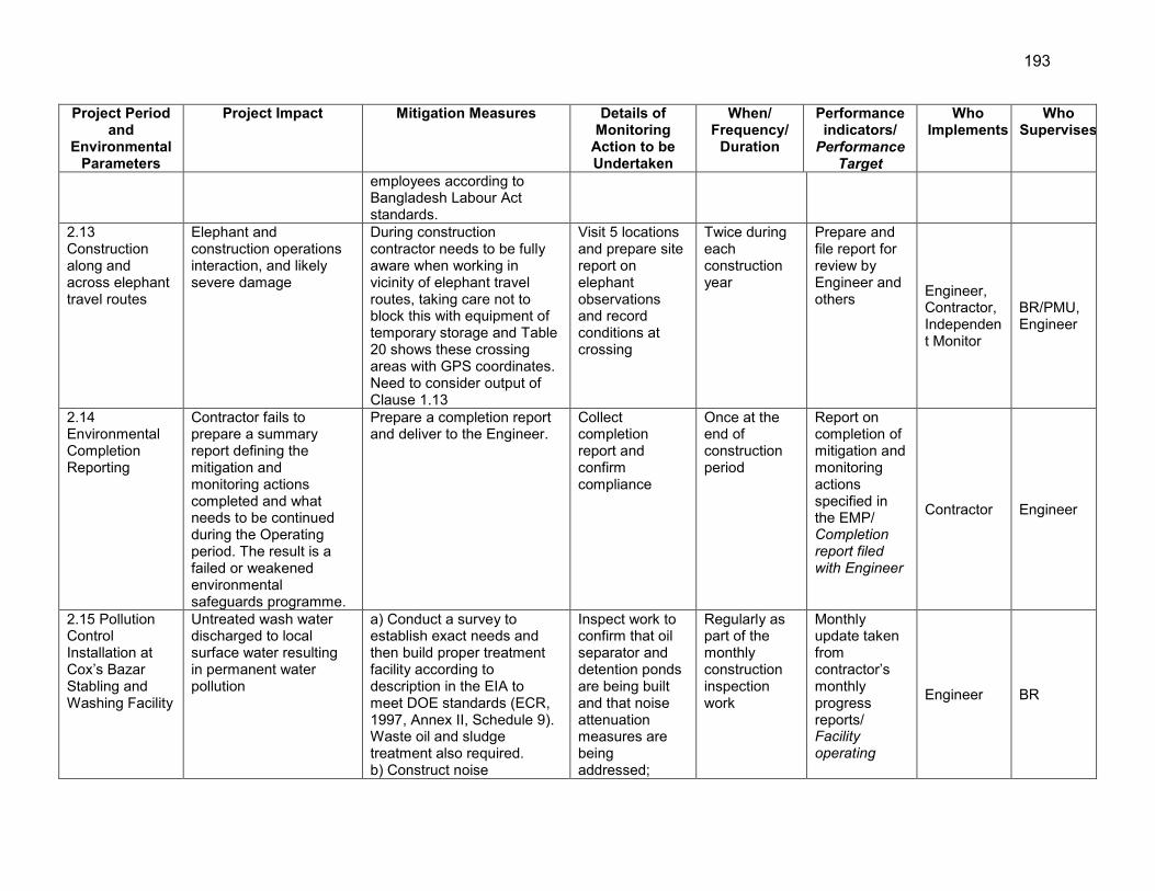
193
Project Period and
Environmental Parameters
Project Impact Mitigation Measures Details of Monitoring
Action to be Undertaken
When/ Frequency/
Duration
Performance indicators/
Performance Target
Who Implements
Who Supervises
employees according to Bangladesh Labour Act standards.
2.13 Construction along and across elephant travel routes
Elephant and construction operations interaction, and likely severe damage
During construction contractor needs to be fully aware when working in vicinity of elephant travel routes, taking care not to block this with equipment of temporary storage and Table 20 shows these crossing areas with GPS coordinates. Need to consider output of Clause 1.13
Visit 5 locations and prepare site report on elephant observations and record conditions at crossing
Twice during each construction year
Prepare and file report for review by Engineer and others Engineer,
Contractor, Independent Monitor
BR/PMU, Engineer
2.14 Environmental Completion Reporting
Contractor fails to prepare a summary report defining the mitigation and monitoring actions completed and what needs to be continued during the Operating period. The result is a failed or weakened environmental safeguards programme.
Prepare a completion report and deliver to the Engineer.
Collect completion report and confirm compliance
Once at the end of construction period
Report on completion of mitigation and monitoring actions specified in the EMP/ Completion report filed with Engineer
Contractor Engineer
2.15 Pollution Control Installation at Cox’s Bazar Stabling and Washing Facility
Untreated wash water discharged to local surface water resulting in permanent water pollution
a) Conduct a survey to establish exact needs and then build proper treatment facility according to description in the EIA to meet DOE standards (ECR, 1997, Annex II, Schedule 9). Waste oil and sludge treatment also required. b) Construct noise
Inspect work to confirm that oil separator and detention ponds are being built and that noise attenuation measures are being addressed;
Regularly as part of the monthly construction inspection work
Monthly update taken from contractor’s monthly progress reports/ Facility operating
Engineer BR

194
Project Period and
Environmental Parameters
Project Impact Mitigation Measures Details of Monitoring
Action to be Undertaken
When/ Frequency/
Duration
Performance indicators/
Performance Target
Who Implements
Who Supervises
attenuation berms or barriers as agreed in consultation with Engineer and Local Community
waste oil and sludge management system in place.
2.16 Pilot Program to Test TIC and other Elephant-Train Accident prevention methods
No adequate preventative measures leading to injuries or death to elephant as they try to cross the alignment when trains are passing
Undertake a two year pilot program to test the 3 camera options to define the best option or combination of options. Based on the selected camera option purchase, install and test 20 TIC systems on locomotives that will operate on the project rail line Organize a training for the train operators on the operation of the selected camera option
Monitor work monthly
Monthly for two years
Site visit reports including information on the progress on pilot program (during the first 2 years of construction); Procurement and installation of the selected camera option and training of train operators (within the last year of construction)
Contractor
BR, Engineer, Independent Monitor
2.17 Elephant overpasses
No physical structures to facilitate elephant movement across rail corridor leading to injuries or death to elephants as they try to cross the alignment when trains are passing
Construct elephant overpasses in locations identified and recommended by the Independent Monitor Wildlife Experts
Conduct standard construction inspection
Monthly inspection reports
Monthly reports include progress on elephant overpass construction
Contractor
BR, Engineer, Independent Monitor
2.18 Elephant Awareness
Lack of basic knowledge about elephant habits and movement, leading to
Design and deliver an Elephant awareness raising program to BR, Contractor and future locomotive
Review and approve program
To be conducted towards the latter half of
File program, attendance and evaluation
Engineer and Independent monitor
BR/PMU

195
Project Period and
Environmental Parameters
Project Impact Mitigation Measures Details of Monitoring
Action to be Undertaken
When/ Frequency/
Duration
Performance indicators/
Performance Target
Who Implements
Who Supervises
agriculture damage and potential inlury to people and structures
operators the construction period before the end of construction
with Engineer
2.19 Tree Replacement
239,000 trees to be removed from project construction corridor
Undertake a replanting program such that for each tree cut three are planted and all dead trees to be replanted. This replantation program may also be habitat enhancement activities for the elephant and other wildlife species in the Project area
Review and approve plan and inspect plantings
3X/year Number and species diversity of trees planted, location and total area of plantation, survival rate of trees
Replanting plan to be designed by Contractor and Engineer with inputs from the Independent Monitor (Wildlife Expert)
BR/PMU, Engineer
3.0 OPERATING PERIOD 3.1 The Construction Period Environmental Completion Report
Failure to adopt measures and continue mitigation actions defined in the Construction Period Environmental Completion report.
Assign environmental expertise to obtain, examine and take necessary actions defined in the Construction Period Environmental Completion report.
Record that the report in in the hands those responsible for maintaining existing measures and completing those required
Once prior to final payment to contractor
Contractor preparing Completion report during early days of “default period”/ Completion report on file with BR
Contractor/ Engineers and BR’s ESSU
BR
3.2 Construction Period Decommission-ing
Inspection of sites to be decommissioned by contractor, are:
• work camps; fuels storage areas
• waste dump sites;
Undertaken a complete construction area inspection.
Inspect to be sure that work camps, fuel storage areas, waste dumps, toilet facilities, construction
Prior to contractors final payment
Inspection of work areas, camps, waste dumps and construction access roads taking place/
Contractor/Engineer and BR’s ESSU if available
BR

196
Project Period and
Environmental Parameters
Project Impact Mitigation Measures Details of Monitoring
Action to be Undertaken
When/ Frequency/
Duration
Performance indicators/
Performance Target
Who Implements
Who Supervises
construct access roads
But not undertaken, leading to chronic environmental problems due to a lack of proper clean-up.
access roads have been properly decommissioned and no chronic contamination is likely
Decommissioning checklist completed
3.3 Air Quality and Dust
Degradation of local air quality due to increased train traffic.
Maintain locomotives according to factory specifications and accelerate decommissioning of > 20 year old locomotives.
Undertake air quality monitoring at 4 of stations sampled during the construction period and sample CO, SO2, NO2 and PM2.5 and PM10
Sample 2x/year for Years 1, 3, and 5 two samples per station or 22 samples per year
Sampling programme underway as specified/ Annual air quality table and analysis of results completed
Independent monitor to collect air quality monitoring data for first 3 years of operation. BR’s ESSU’s to continue date collection thereafter
BR, DOE
3.4 Spill Contingency Planning
Contamination of soil caused due to spillage of petroleum derivatives and other chemicals due to rail accidents
Rail accidents and spills will be managed through a spill contingency protocol.to be distributed to all BR management for implementation if a spill should occur
Prepare and implement Spill contingency plan in hand
Prepared as soon as operations begin
The spill contingency plan prepared/ Spill Contingency Plan distributed to rail operations units
BR or BR’s ESSU if available
BR, DOE
3.5 Noise Monitoring during the EIA field survey identified a number of sensitive sites where noise is already exceeding accepted
Install noise attenuation features at the sensitive sites - e.g., berms, plantings and noise barriers- where noise levels exceed standards with special attention to sensitive
Noise measurements to be continued at noise sensitive sites as defined
2x per year for operating Years 1, 3 and 5.
Semi-annual noise sampling on-going/ Annual noise measurement
Independent monitor to collect noise monitoring data for first
BR, DOE

197
Project Period and
Environmental Parameters
Project Impact Mitigation Measures Details of Monitoring
Action to be Undertaken
When/ Frequency/
Duration
Performance indicators/
Performance Target
Who Implements
Who Supervises
levels and as such creating more discomfort for local people.
locations such as the Christian memorial hospital. Consult with owners/mangers of impacted receptors if any and local authorities as the luxury train service is introduced to gauge what noise attenuation measures would be most suitableto reduce the noise to within GoB standards.
during pre-construction and construction measurements -2X/year at selected sites along the alignment
tables, highlighting exceedances.
3 years of operation. BR’s ESSU’s to continue monitoring noise levels thereafter
3.6 Employment and Livelihood and ribbon settlement
The area along the rail line will attract settlements and undesired structures including commercial facilities particularly near the railway stations.
Since this is very difficult to control, BR will as a minimum permit only agricultural activities, but no construction of structures
Inspect to be sure that basic actions as defined have been taken and that removed signs are replaced
As part of operating inspection by BR
Regulation prepared by BR in place/ Enforcement in action
BR or its ESSU if in place
BR
3.7 Level crossings
Inadequate safety at level crossings and stations leading to more and more frequent accidents, with vehicles, people and livestock . Also see Item 1.6 in this table.
Reduce Vehicle - train and human and livestock train accident by implementing sufficient awareness programme. Identify known hotspots and improve signage and crossing structures/signalling Installation of modern railway crossing and gate systems and training of crossing guards will be enhanced
Inspect crossings at least 1/yr. to check operation and collect incident records for each crossing
Quarterly and for Years 1,3 and 5
Inspection of level crossings/ Inspection report filed with BR
BR or its ESSU if in place
BR
3.8 Waste Management
Garbage is thrown and sewage discharged onto the tracks from trains
Provide adequate waste bins and waste biodegradable waste bags on trains.
Count bins and extent of maintenance
Take annual inventory
Garbage and other waste collection
BR or its ESSU if in place
BR

198
Project Period and
Environmental Parameters
Project Impact Mitigation Measures Details of Monitoring
Action to be Undertaken
When/ Frequency/
Duration
Performance indicators/
Performance Target
Who Implements
Who Supervises
leads to chronic contamination of the corridor and nearby drainage areas
Establish strict fines for garbage throwing and provide abundant bins on trains and signs. Initiate a programme of retrofitting trains with sewage collection tanks to be pumped out at collection stations for delivery to STPs.
Record no of trains with Sewage tanks
observed/ Waste management in action, no litter and leaking sewage
3.9 Elephant Travel Route obstruction and Train collision
Collision between elephants and trains
Use the selected imaging camera option to detect the presence of elephants in the vicinity of the rail line operating from Dohazari to –Cox’s Bazar. Conduct follow up elephant awareness programmes to BR staff as well as a programme to place elephant crossing signs at strategic locations before the crossing points—in both directions along the alignment Continue with monitoring of the TIC system success and record elephant movement observations by Locomotive Masters as well as local villagers
Daily/weekly monitoring sheets and elephant sighting, field of vision checks. Annual review and adjustment of TIC system Record elephant awareness raising programme timetable and locations
To be established, but records will be at least weekly.
Semi-annual monitoring reports files
BR and its ESMU plus specialist Independent monitor to conduct monitoring and prepare semi-annual monitoring reports during first 3 years of operation
BR and its ESMU
3.10 Station Operations and Access Roads
New stations will attract more passengers and as such more waste to manage. No sewage or waste management will quickly lead to highly polluted conditions in
Waste management system will be inspected by BR weekly to ensure sanitary operations and each station will have janitorial staff. Problems identified will be immediately rectified by add
Inspect that station waste facilities; capable of handling user wastes and the services are
Semi annually Safeguard controls for access roads developed/ Inspection report and photo record
BR or its ESSU if in place, and dedicated janitorial service at each
BR

199
Project Period and
Environmental Parameters
Project Impact Mitigation Measures Details of Monitoring
Action to be Undertaken
When/ Frequency/
Duration
Performance indicators/
Performance Target
Who Implements
Who Supervises
around the stations. The longer access road, i.e. Harbang, Chakaria and Cox’s Bazar will result in large traffic volumes matching the arrival of trains up to 40 times per day will likely degrade both air quality and noise conditions along the alignments
services, upgraded waste management systems or both. BR will monitor air and noise quality semi-annually for the first five years of operations and establish air quality and noise levels at one sensitive site at the edge of the RoW. If air and noise quality are found to exceed standards actions will be taken by BR to reduce noise and suppress sources of air quality degradation by ensuring proper maintenance of locomotive engines and railway tracks
being employed to maintain the stations. Collect 4-5 photo record Air and noise quality monitoring undertaken at 1 station at each of three access roads, applying the same methods as defined in the EIA and for the same parameters.
for the new stations
station BR and its ESSU
3.11 Elephant Crossing Problems
Elephants not using the overpasses due to poor guidance from poorly kempt vegetation and bollards etc. resulting in accidents
Immediately improve the guiding areas/structures by planting suitable plans and trees and constructing/maintaining the bollards
Inspect overpasses to review adequacy, bollard installation and landscaping
As each overpass in completed
Elephants successfully using the overpass; No rail – elephant collisions; Inspection report and photographs
Independent Monitor to monitor during first 3 years of operation. ESSU to continue monitoring after that
BR

200
4) River Sangu (287 m), River at Km 19.74 (104.2 m), Matamuhuri (492 m), Tributary of Matamuhuri (246 m), Idgaon Chara (104 m), and Bakkhali River (164 m)
557. The Bridge alignments will all be new, with all requiring at least three piers in the water. All rivers except the Sangu have only intermittent flow, such that during the dry season (and coupled with the diversions for irrigation) those river beds are virtually dry from November through April, presenting ideal working conditions. The work will require the placement of bored piles, using drilling mud followed by the pile casings being filled with concrete in place. All other elements of the bridge, namely the pile caps and piers will be fixed in place on top of the pile cap. The bridge deck, consisting or precast concrete lengths as well as steel girders will be set in place from the bridge as it is built and from the water using special cranes on a barge or with cranes when the river is dry. 558. There is, therefore, little danger that this work will result in permanent water pollution, diversion fish travel routes and erosion due to poorly designed shoreline erosion control features, so long as the work is conducted during the period when the river is dry and according to EMP specifications. All obstructions and construction wastes will be removed before the onset of the monsoon, and shore pier design and placement will be planned for the dry period. 559. For the Tongi-Bhairab Railway Project now underway and with very similar conditions, the issue of fish displacement and effects was investigated by conducting a number of fishermen interviews, or creel surveys, asking local fishermen if fishing had changed since the start of construction (now in its third year)51. The interviews confirmed that there was no negative impact and, in fact, the numbers of fish caught increased marginally, likely stimulated by the disturbance of sediment caused by the new piers and eddies formed, releasing nutrients, and the attraction phytoplankton and other food, resulting in slightly larger fish catches. This finding will be monitored during the construction of the Sangu, Matamuhuri, Tributary of Matamuhuri, Idgaon Char and Bakkhali River crossings, by first determining if fishing takes place and if so conducting the creel surveys. 560. The large bridge EMP (Table 55 and Table 56) lists each of these potential problem areas in detail and presents a set of mitigative actions and monitoring requirement that BR will include as part of the construction period monitoring programme.
51 SMEC Ltd. 2013. Annual Environmental Due Diligence Audit of the Tongi-Bhairab Double Tracking
Construction Project. Available from BR and Engineers, SMEC Pty, Ltd, Dhaka Project Office.

201
Table 55: Environmental Management Plan for Bridge Sites: Mitigative Measure Project Period
and Environmental
Parameters
Project Impact Mitigation Measures Location Timing/Duration Who will Implement
Who will Supervise
1.0 PRE-CONSTRUCTION PERIOD 1.1 The Bridge sighting
The impact at bridge site during pre-construction will be due to poor decisions about where to pace the work camps and the concrete fabrication areas as well as the batch plant(s)
BR to consult with local communities and remain within all GoB standards re sighting and proper planning for work camp. Agreeing on sites based on these boundaries.
Along the alignment Early during the Feasibility Study work or detailed design
BR BR
1.2 Provision of Early Training
Contractor not given adequate training on environmental safeguards when working in and over flowing waters, leading to construction period impacts affecting river hydrology and water quality
BR to provide a training as part of the overall 1.5-day training workshop to be delivered before construction begins
Location to be confirmed
Prior to the contractor mobilizing to the field
BR BR
2.0 CONSTRUCTION PERIOD 2.1 Navigation channel disruption
Temporary disruptions and navigation danger caused at bridge sites.
Movements of vessels in the navigation channel will be maintained through careful planning of work in the span over the navigation channel to low traffic times and with traffic controls in place. The contractor will place channel boundary buoys in the water to guide vessels around danger areas.
Focused in the navigation channels where the major bridges will be constructed, as they are important navigable waterways for local vessels, and are crossed by the rail line
Inspect weekly to ensure that navigability is properly maintained at earthworks do not interfere with water depth or channel width
Contractor
Engineer
2.2 Surface water quality and Hydrology
Construction of piers, especially in the permanent water sections could result on temporary erosion and deposition actions, potentially
The bridges and culverts are to be designed and built properly in line with existing bridges and latest hydrological model results. The water quality testing will focus in sampling
Take samples U/S and D/S of the Bridges,
Monthly during construction period at all pile drilling sites. After Yr. 1 the data will be assessed and if acceptable, the
Contractor
Engineer

202
Project Period and
Environmental Parameters
Project Impact Mitigation Measures Location Timing/Duration Who will Implement
Who will Supervise
impacting shoreline and causing water pollution.
both upstream and downstream of the bridge construction site to establish change over time. Parameters to be tested as shown in main EMP
sampling will be reduced to quarterly, as for all other stations
3.0 OPERATING PERIOD 3.1 river training works (RTW)
Drainage congestion, soil erosion and siltation
Undertake visual inspection of erosion on embankment of RTW slopes particularly any gully erosion and formulate and implement erosion protection measures, such bioengineering techniques, fascines, as appropriate. Regular monitoring of morphological changes of river at the bridge locations due to RTW, rand formulate remedial bank protection work immediately for implementation, particularly during monsoon.
At Sangu, Matamuhuri, Tributary of Matamuhuri, Idgaon Chara and Bakkhali River Bridges
During and after construction of Bridge
BR BR
3.2 Sewage disposal
Raw sewage disposed of directly from toilet onto tracks, and while over water into the river
Install holding tanks and dispose of sewage at pump-out facilities to STPs. This is being examined by BR
All trains operating on this line
At all times BR BR

203
Table 56: Environmental Management Plan for Bridge Sites: Monitoring Measure
Project Period and
Environmental Parameters
Project Impact Mitigation Measures Details of
Monitoring Action to be Undertaken
When/ Frequency/ Duration
Output to be Provided
Who Implements
Who Supervises
1. PRE-CONSTRUCTION PERIOD 1.1 The Bridge siting
The impact at bridge site during pre-construction will be due to poor decisions about where to pace the work camps and the concrete fabrication areas as well as the batch plant(s)
BR to consult with local communities and remain within all GoB standards re sighting and proper planning for work camp. Agreeing on sites based on these boundaries.
Examine site plans and establish if further protection of land and structures is possible
See Project LAP for details
See Project LAP for details
NOG and BR
BR
1.2 Provision of Early Training
Contractor not given adequate training on environmental safeguards when working in and over flowing waters, leading to construction period impacts affecting river hydrology and water quality
BR to provide a training as part of the overall 1.5-day training workshop to be delivered before construction begins
Obtain record of training session and component dealing with bridges
Immediately after the workshop
Training material package on file with BR
BR BR
2. CONSTRUCTION PERIOD 2.1 Loss of navigation route
Temporary disruptions and navigation danger caused at bridge sites.
Movements of the navigational traffic will be maintained through alternative arrangement, including proper channel markings and lighting.
Visual inspection to confirm that alternative navigation channels are properly marked and maintained
Monthly Include as part of inspection report or checklist
Contractor Engineer

204
Project Period and
Environmental Parameters
Project Impact Mitigation Measures Details of
Monitoring Action to be Undertaken
When/ Frequency/ Duration
Output to be Provided
Who Implements
Who Supervises
2.2 Surface water quality and Hydrology
Construction of piers, especially in the permanent water sections could result on temporary erosion and deposition actions, potentially impacting shoreline and causing water pollution.
The bridges and culverts are to be designed and built properly in line with existing bridges and latest hydrological model results. The water quality testing will focus in sampling both upstream and downstream of the bridge construction site to establish change over time. Parameters to be tested as shown in main EMP.
Site inspection and include bridge U/S and D/S sample stations in the water quality testing for pH, Turbidity, Temperature, DO, BOD5, COD, TSS, TDS, oil and grease
Construction stage according to survey schedule defined in EIA
Monthly data tables and indication if any exceedances
Contractor Engineers
3. OPERATING PERIOD 3.1 River training works (RTW)
Drainage congestion, soil erosion and siltation
Undertake visual inspection of erosion on embankment of RTW slopes particularly any gully erosion and formulate and implement erosion protection measures, such bioengineering techniques, e.g., fascines, as appropriate. Regular monitoring of morphological changes of river at the bridge locations due to RTW, rand formulate remedial bank protection work immediately for implementation, particularly during monsoon.
BR’s ESSU BR
3.2 Sewage disposal
Raw sewage disposed of directly from toilet onto tracks, and while over water into the river
Install holding tanks and dispose of sewage at pump-out facilities to STPs. This is being examined by BR
NA NA NA BR BR

B. EMP Implementation Costs
561. Including all the provisions sums and special activities the total EMMP implementation cost is expected to about US$ 27 million (Table 57). The EMP budget in Table 55 divides the work in to the three project period and where possible, between non-reccuring and reoccurring costs 562. The set up and operation of the BR ESSU, serving the entire agency for seven year period would be about US$ 830,400.00 (Table 59). 563. Cost of the locomotive mounted infra-red camera system, coupled with an awareness raising campaign and good signage, will require a capital investment of approximately US$ 6.1 million for 20 cameras that includes all installation costs and training in its operation and the placement of funnelling bollards to guide elephant to safe crossing points at steep cut areas near identified crossings. There will also be a US$ 15,600.00 cost for elephant awareness raising programme for 3 operating years and between US$ 1,900 and US$ 2,800/year for total system maintenance and operating expenses (See EMP No. 3.9). 564. Finally, a two year pilot application of the TIC system as well as the elephant alarm system, implemented on at least two rail corridors, is estimated to cost US$ 529,000.00 and will require both national and international specialists to be part of the implementing team, contracted through the construction contract but reporting to the CSC. 565. Further the separately funded 3rd party monitor, using an ADB CDTA (grant) stretching over an eight year period will be identified and developed by ADB, in consultation with BR. 566. Once all engineering costs and other normal expenditures associated with the construction work are better identified, a recalculation of the costs will be undertaken near the end of the construction period and a revised figure will be applied to the work.
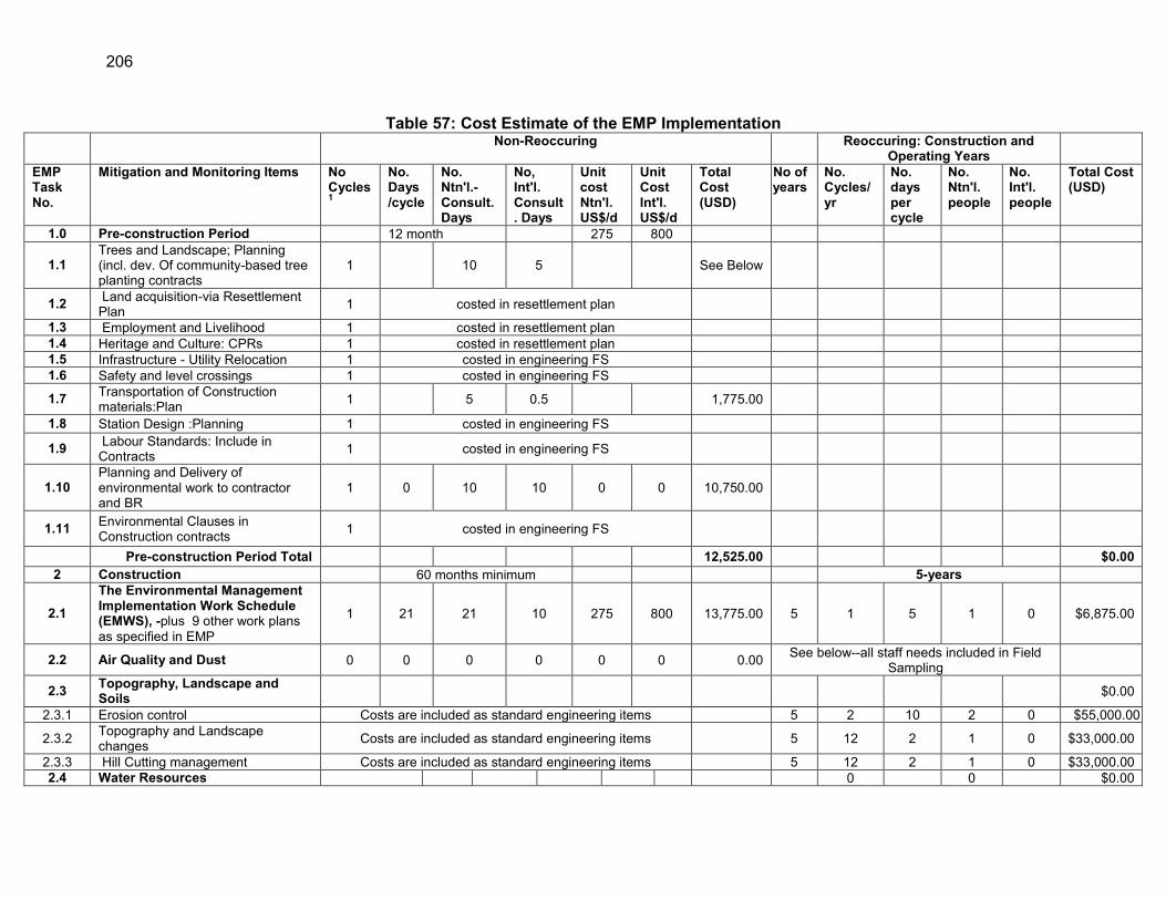
206
Table 57: Cost Estimate of the EMP Implementation Non-Reoccuring Reoccuring: Construction and
Operating Years
EMP Task No.
Mitigation and Monitoring Items No Cycles 1
No. Days /cycle
No. Ntn'l.-Consult. Days
No, Int'l. Consult. Days
Unit cost Ntn'l. US$/d
Unit Cost Int'l. US$/d
Total Cost (USD)
No of years
No. Cycles/ yr
No. days per cycle
No. Ntn'l. people
No. Int'l. people
Total Cost (USD)
1.0 Pre-construction Period 12 month 275 800
1.1 Trees and Landscape; Planning (incl. dev. Of community-based tree planting contracts
1 10 5 See Below
1.2 Land acquisition-via Resettlement Plan 1 costed in resettlement plan
1.3 Employment and Livelihood 1 costed in resettlement plan 1.4 Heritage and Culture: CPRs 1 costed in resettlement plan 1.5 Infrastructure - Utility Relocation 1 costed in engineering FS 1.6 Safety and level crossings 1 costed in engineering FS
1.7 Transportation of Construction materials:Plan 1 5 0.5 1,775.00
1.8 Station Design :Planning 1 costed in engineering FS
1.9 Labour Standards: Include in Contracts 1 costed in engineering FS
1.10 Planning and Delivery of environmental work to contractor and BR
1 0 10 10 0 0 10,750.00
1.11 Environmental Clauses in Construction contracts 1 costed in engineering FS
Pre-construction Period Total 12,525.00 $0.00 2 Construction 60 months minimum 5-years
2.1 The Environmental Management Implementation Work Schedule (EMWS), -plus 9 other work plans as specified in EMP
1 21 21 10 275 800 13,775.00 5 1 5 1 0 $6,875.00
2.2 Air Quality and Dust 0 0 0 0 0 0 0.00 See below--all staff needs included in Field Sampling
2.3 Topography, Landscape and Soils $0.00
2.3.1 Erosion control Costs are included as standard engineering items 5 2 10 2 0 $55,000.00
2.3.2 Topography and Landscape changes Costs are included as standard engineering items 5 12 2 1 0 $33,000.00
2.3.3 Hill Cutting management Costs are included as standard engineering items 5 12 2 1 0 $33,000.00 2.4 Water Resources 0 0 $0.00

207
Non-Reoccuring Reoccuring: Construction and Operating Years
EMP Task No.
Mitigation and Monitoring Items No Cycles 1
No. Days /cycle
No. Ntn'l.-Consult. Days
No, Int'l. Consult. Days
Unit cost Ntn'l. US$/d
Unit Cost Int'l. US$/d
Total Cost (USD)
No of years
No. Cycles/ yr
No. days per cycle
No. Ntn'l. people
No. Int'l. people
Total Cost (USD)
2.4.1 Hydrology and Surface Water Quality See below--all staff needs included in Field
Sampling
2.4.2 Groundwater See below--all staff needs included in Field Sampling
2.5 Waste Management Costs are included as standard engineering items 5 4 4 2 0 $44,000.00
2.6 Noise 0 0 0 0 0 0 0.00 See below--all staff needs included in Field Sampling
Incl in Air Qual.
2.7 Terrestrial and Aquatic Flora & Fauna 0 0 0 0 0 0 0.00 5 2 5 1 0 $13,750.00
2.8 Land use, Population and Culture Included in Resettlement Plan 0.00 Included in Resettlement Plan $0.0 2.9 Heritage and Culture 0 0 0 0 0 0 0.00 NA 0 0 NA
2.10 Health, Safety and Contractor Camp Costed as regular project budget items NA
2.10.1 Health and Vector Borne Diseases 2.10.2 Worksite Safety Management 2.10.3 HIV Awareness 2.11 Occupational Health and Safety Costed as regular project budget items NA
2.11.1 Personal Safety Equipment 2.11.2 Drinking Water 2.11.3 Safety Training 2.12 Pilot Testing Program (2 years) PS 529,024.39
2.13 Installatiion and testing of 20 TIC Systems PS
6,161,745.83
2.14 Elephant Awareness for BR and Operators PS 15,558.41
2.15 Tree Planting ( Afforestation ) PS 1,549,293.97 2.16 Cox's Bazar Washing and Pollution Control PS 577,021.82
2.14 Environmental Completion Reporting 1 10 1 0.5 675.00 5 6 5 2 0 $82,500.00
Other Expenses US$/ Yr. No. yrs
Transportation 1 1500 5 $7,500.0 Communication 1 400 5 $2,000.0 Reporting and Report Production 2500 5 $12,500.0

208
Non-Reoccuring Reoccuring: Construction and Operating Years
EMP Task No.
Mitigation and Monitoring Items No Cycles 1
No. Days /cycle
No. Ntn'l.-Consult. Days
No, Int'l. Consult. Days
Unit cost Ntn'l. US$/d
Unit Cost Int'l. US$/d
Total Cost (USD)
No of years
No. Cycles/ yr
No. days per cycle
No. Ntn'l. people
No. Int'l. people
Total Cost (USD)
Workshop costs (incl. prep): At least
one at start of Construction (Incl.Int'l Spec. Involvement)
PS $27,878.2
Field Sampling Lab Costs Unit
Cost. (US$)
No Statio
ns
No samples / Yr.
No years
Noise meter 2,500.00 $0.0 Air Quality sampling 293 18 12 5 $316,433.1 Noise sampling 45 10 4 5 $8,917.2 Surface water quality sampling 210 10 4 5 $42,038.2 Groundwater quality sampling 210 9 2 5 $18,917.2 Construction Period Total 16,950.00 $9,536,953.4 3 Operating Period 5-Year Period
3.1 The Construction Period Environment Completion Report 1 5 1 0.25 2,375.00
3.2 Construction Period Decommissioning DD Inspection
1 5 1 0.25 2,375.00 No. Year
s
Unit Cost/ Loc'n. (US$)
No Statio
ns
No samples / Yr.
No years
3.3 Air Quality Monitoring 0.00 293 6 12 4 $84,382.2 3.4 Spill Contingency Planning 1 5 1 0.5 3,375.00 3.5 Noise 0.00 45 10 2 4 $3,566.9
3.6 Employment and Livelihood and Ribbon Settlement Monitoring Costed as regular project budget items 0.00
3.7 Level Crossing Env. Inspection 0 0 0 0 0 0 NA 3.8 Waste Management Inspection Costed as part of Operating budget NA 0 0 $0.0
3.9 Final design, and install elephant overpasses and/or additoional measures
$16,919,035.8
No. Unit cost Unit
Cost
3,10 Elephant instrumentation maintenance 3 1 2800 1 0.25 $8,400.0
3.11 Elephant awareness raising 3 5200 Yrs. $15,600.0
3.12 Station Operations:Inspection of Waste Mgmt. systems 0 0 0 0 0 0 0.00 5 2 5 1 $13,750.0
0

209
Non-Reoccuring Reoccuring: Construction and Operating Years
EMP Task No.
Mitigation and Monitoring Items No Cycles 1
No. Days /cycle
No. Ntn'l.-Consult. Days
No, Int'l. Consult. Days
Unit cost Ntn'l. US$/d
Unit Cost Int'l. US$/d
Total Cost (USD)
No of years
No. Cycles/ yr
No. days per cycle
No. Ntn'l. people
No. Int'l. people
Total Cost (USD)
3.13
Cox's Bazar Stabling and Washing facility monitoring: Discharge water quality, oil and grease separation and detention pond operation
PS $3,000.00
Other Expenses (related to Environmental monitoring) US$/
Yr. No. yrs
Transportation 1500 5 $7,500.0 Communication 400 5 $2,000.0 Reporting and Report Production 2500 5 $12,500.0
Operation Period Total 8,125.00 17,069,734.84
Totals: Non Reoccuring and Reoccuring 37,600.00 $26,606,6
88.23 MITIGATION AND MONITORING Totals Pre Construction Period $12,525
Construction (5 years); Incl P. Sums $9,553,903
Operating Period ( Yrs. 1,2,3 and 5), Incl. P Sums) $17,077,860
Sub-Total $26,644,288
Total $26,644,288
Contingency Costs @ 6% of total $1,598,657

210
X. INSTITUTIONALINSTUTIONAL CAPACITY, NEEDS AND PROPOSED STRENGTHENING
A. The Existing Conditions
567. Bangladesh Railway (BR) has at least 10 large projects which will require the implementation of multi-year mitigative and monitoring actions, as defined in the Environmental Impact Assessments completed for each Project. BR will be responsible for ensuring that the pre-construction, construction and operating period mitigative and monitoring tasks defined in the EIA’s EMP are completed on time and in a technically sound manner. A consultant will assist during pre-construction and construction periods, but BR will be directly responsible during the operating period. Operating period mitigation and monitoring will require field surveys, analyses and technical reporting to ADB and/or DoE. Further, throughout the Project, BR will be receiving environmental reports from the contractor as well as the Engineer and will need to evaluate and comment on the technical content, etc. As of January 2014, BR had no such capability and will fill this gap by upgrading its skills in all aspects of environmental management, environmental assessment, environmental sampling design, data collection, analysis, reporting, and EMP implementation.
B. BR’s Environmental and Social52 Safeguards Unit (ESSU)
1. General
568. The Project loan has provision for the creation of an environmental safeguards unit within BR to manage the safeguard issues arising from the seven Projects now underway. Given that other projects are in the pipeline, the intent is to integrate this unit into the operations of BR, making environmental safeguards a business-as-usual task, not an add-on. Therefore, although repeated in every EIA the cost of the ESSU is a single cost to BR. 569. BR will create at least one environmental safeguards staff position and two if its mitigation and monitoring duties will not be given to consultants. In addition to staff, the ESSU will also need basic equipment to undertaken monitoring as well as staff training. It will be the staff’s duty to monitor the contractors environmental compliance, complete all the operating period EMP requirements and ensure that reporting is technically robust and meets ADB and GoB standards. 570. Generally, the seven RCI-Rail Projects will require between three and six years of construction mitigation and monitoring (undertaken mainly by the contractor(s) activity and the implementation of around three years during the operating period. The reporting requirements will also be considerable. Therefore, the unit must be trained and ready to take on varied tasks and be able to report to international donors. 571. In addition to basic equipment, a smoothly functioning ESSU will need a dedicated space/base within BR from which to undertake its work. To that end a set of tasks needs to be undertaken prior to the start of construction, to establish the ESSU with a view to having it
52 The social component of the ESSU is not discussed here as it is being addressed in the social studies
of these subprojects. Once BR begins to consider the ESSU formation both environmental and social components will be examined and a combined budget established.

211
operate for the duration of the RCI-Rail Project’s (Table 58) construction period and well into the operating period.
Table 58: Action Plan – Establishing an ESSU Task No. Task and Deliverable
i Prepare a ToR for the ESSU and staff; then obtain approval of BR ii Establish a budget, provide basic set of equipment and assign staff to the ESSU.
iii Train ESSU staff and key BR managers (1-2 months) in environmental management and all EIA-related tasks.
iv Prepare training materials for contractor training and deliver 2 day workshop
v
With assistance from the Construction Supervision Consultant (The Engineer), appointed by BR, the ESSU must undertake operating-period compliance monitoring and reporting according to EMP specifications. For the construction period this involves only compliance monitoring of the contractor (s).
vi vii
Prepare and deliver annual training programme for contractors Prepare semi-annual and annual monitoring reporting during the construction and operating periods to ADB
2. Estimated Costs
572. BR’s present approach to loan implementation is to appoint an Engineer, (sometimes referred to as the Construction Supervision Engineer or Consultant) who handles all day-to day dealings with contractor(s), including enforcing the mitigative and monitoring tasks defined in the Project EMP and agreed to by the contractor in the contract specifications. The ESSU needs to be able to implement pre-construction period mitigative and monitoring measures as defined in the environmental documents and to guide the contractor(s) in preparing for the environmental work to be undertaken during the construction period. During the construction period, the ESSU’s skills would be required to participate in the compliance monitoring effort as the representative of the executing agency, albeit the majority of the work would be done by the Engineer and the contractor. 573. An indicative budget for an ESSU, with 1 environmental safeguards staff53, responsible for all RCIP Projects, and including the capital expenditures to provide the necessary gear, will be BDT 63.88 million (approx. USD 830,440) for all seven Projects and seven operating years (Table 59). The cost for an operating social safeguards cell within the ESSU has yet to be estimated.
Table 59: Cost of Establishment and Operation of ESSU for Seven Years (BTK) Costs Unit Cost Unit No. of
Units First Year
Budget Estimated 7 Years Input
Non-recurring, Entire ESSU Computers & software 79,000.00 BDT 3 237,000.00 79,000.00 Data storage system 31,600.00 BDT 1 31,600.00 Laser Printer/scanner 47,400.00 BDT 1 47,400.00 94,800.00 Smart Phones with Digital camera, recording and GPS functions
52,350.00 BDT
3 157,050.00
Other Technical Equipment 632,000.00 BDT 01-Jan 632,000.00 SUBTOTAL 1,105,050.00 173,800.00 53 Single staffs are very risky since if anything should happen or the situation changes and the staff
leaves, the ESU will be left without any staff.

212
Costs Unit Cost Unit No. of Units
First Year Budget
Estimated 7 Years Input
Reoccurring, (annual), all Projects ESSU Staff 1 (based on present payments staff costs) 150,000.00 Months 12 1,800,000.00 Administrative support (annual) -
Provided by BR
IEE Field Survey and other assistance, Per Diem, etc. (all Projects)
100,000.00 Trips 14 1,400,000.00
Field audit trip; 4 /yr. to 7 Sub-project for one person and 5 days per Project
17,000.00 Trips 196 3,332,000.00
Per diems 1,975.00 Days 70 138,250.00 Field Transportation Costs (Implementation) 47,400.00 Months 6 284,400.00 Office Operation and consumables 125,000.00 No. 1 125,000.00 Driver 300,000.00 Year 1 300,000.00 Annual Training programme (without International involved)***
632,000.00 Lump sum all 1 632,000.00
Vehicle rental/use (part time) -- Months 6 Provided by BR
Annual Reoccurring Costs 8,011650.00 First Year Total Budget 9,116,700.00 Estimated TOTAL budget of 7 years for all Projects 63,817,900.00 Note: Costs for the social safeguards staffing and expenses need to be added; *** without international specialists involved, the cost are greatly reduced.
3. Functions
574. All rail projects require the ESSU to deliver operating period monitoring, data analysis and reporting, and be able to present information to senior staff, etc. During the construction period, the ESSU will function in an oversight mode, supervising and interacting with the consultants, contractors, and donors. Over time the ESSU will become the environmental decision point for all BR projects and will communicate more closely with DoE. The staff assigned to the ESSU will have a background in environmental management and assessment and be required to receive intensive training, and once trained deliver workshops, etc., to staff and contractors. 575. Content and Delivery of Training - The ESSU will focus on building environmental awareness among the BR engineering staff running specific projects, provide technical advice on environmental issues, prepare screenings of proposed undertakings, giving BR managers early warnings on a red-flag issues. Once the ESSU has a technical staff of two or more, it will be expected to deliver this sort of awareness raising and decision shaping advice to Regions and UPs. A parallel and essential task will be to confirm the environmental and social safeguards capability of contractors and to assist them with implement EMPs LAPs and RPs and making sure that they have all key documentation before mobilisation and that they are aware of the safeguard clauses in the contract(s) they have signed.

213
576. Finally the ESSU will need to monitor the delivery of environmental safeguard requirements in relation to BoQ payments and provide this record to the Project’s Chief Engineer.
C. Involvement of Local Government in Environmental Issues
577. The Project which will take five years to construct, during which time compliance monitoring will be needed. That task will include the inspection and monitoring of work at 11 railway stations and possibly three prefabrication yards. Therefore, it is essential to involve local government and other Divisional/District agencies to support Bangladesh Railway with the implementation of the EMP. Based on the 12 consultation sessions completed, it is clear that the local government has limited capacity in and knowledge of environmental issues. However, several local government leaders showed their interest to be involved in any environmental and social issues raised. BR will harness this interest and get local communities involved in compliance monitoring of the contractor. BR will instruct the Engineer to devise a number of pilot programmes with local villagers, e.g., monitoring hill cutting, dredging and GW extraction exercises.

214
XI. IMPLEMENTATION ARRANGEMENTS
A. General
578. Environmental management involves highly specialised multidisciplinary and multi sectorial-activities different from construction of bridge, embankments, railway tracks and associated components. Therefore, the implementation or execution of the mitigative and monitoring actions as defined in the environmental assessment’s EMP needs to be well understood. 579. The EMP (Table 54) for this Project is the critical deliverable (Chapter IX) of the EIA, and contains actions that must be undertaken starting during the pre-construction period through to the operating stage. The EMP contains an indication of who is responsible to execute and oversee each task but no specific implementation schedule. In this chapter, the details of the implementation are presented. BR’s Project Manager shall have the overall decision-making responsibility for EA studies, including the implementation of the EMP. 580. The BR’s Director General, who is responsible for this Project, will set the policies and strategies for all the environmental issues, with most decisions delegated to each Project’s General Manager. These managers take advice from the TA consultant and work jointly to deliver the environmental safeguards. In Chapter X, BR proposed to establish an internal Environmental and Social Safeguards Unit at BR Head Office in Dhaka consisting of environmental and social safeguard specialists and other required personnel, taken from the available manpower under the existing setup of BR. These would enable them to take over the monitoring role and deal directly with the consultant and contractor. 581. By transferring all access road land ownership and RoW’s from the LGEDs to BR, the government has placed all environmental responsibility with BR. Therefore all mitigative and monitoring actions defined in the EMP must be fully adhered to when access roads are being built. This applies particularly to the >1 km long 4-lane Cox’s Bazar Station access road as well as new Harbang (>400 m) and Chakaria (>600 m) access roads (Table 8).
B. Environmental Requirements and Implementation
582. During the construction period the work will be completed around 14 steps, and 7 of them addressing environmental safeguards. The seven, shown in italics and in green, are:
a. Preparation of Tender Documents b. Completion of EIA and its EMP c. Insertion of Environmental Clauses d. Invitation to bid using approved documentation e. Bid Evaluation, Clarifications and Contract Award f. Relocation of involuntary resettlement g. Environmental Safeguards briefing and training of contractors h. Construction mobilisation work commences i. Contractor prepares Construction Environment Work Plan j. Work continues for five years until completed k. Monthly environmental compliance reporting by contractor l. Contract Supervision Consultant - working with ESSU prepares construction
period semi-annual monitoring summary m. Testing and Commissioning-end of construction

215
n. Construction period Safeguards completion report/checklist
583. A typical construction programme is shown in Annex 7.
1. Pre-construction Period
584. During the pre-construction period, BR’s GM has the final say. This is when the pre-construction mitigative and monitoring actions, which are defined in the EMP and any additional applicable environmental clauses listed in Section H of the Contract specifications, are implemented by BR. 585. For the pilot testing of the TIC system, work will begin at the start of this period with the selection of the specialist and pilot location as well as the installation of the system on two locomotives. At the same time elephant monitoring will be initiated in order to get a better understanding of movement patterns, timing and numbers.
2. Construction Period
586. The construction supervision consultant (the Engineer) takes over the role of the TA consultant and administers all aspects of the construction contract. The Engineer’s environmental safeguards person would work with the contractor to ensure full compliance and delivery of construction period mitigation and monitoring measures. It is at this point that the ESSU’s work begins and staffs work closely with the Engineer to learn the compliance monitoring tasks and oversee the data analysis and report delivery. It is during this stage that BR’s Dohazari staff become directly involved and work with the Engineer and the ESSU to address any contractor non-compliance issues. 587. The obstruction of elephant trails by construction activity will be a formidable problem and a plan to avoid or minimize this will be prepared during the pre-construction period, then fine-tuned and applied as soon as construction begins.
3. Operating Period
588. Once the rail line becomes operational, the BR retains the major responsibility for undertaking those tasks defined in the operating period section of the EMP. The day-to-day involvement of the Regional BR staff will be required at this stage. The environmental specialist (Manager, ESSU) will be responsible for approvals and follow up of any documents, compliance issues, and concerns raised by local people. 589. BR will initiate a monitoring programme to be carried out during years 1, 3 and 5, Involving air and noise quality monitoring at a predefined set of locations, including those used to collect baseline data (i.e. selected sensitive sites). During this period the success of the TIC system and other elephant protection measures applied will also be monitored, and adapted as needed to changing elephant movement patterns. Elephant movement will of course also be recorded by village observers for at least the three monitoring years.
C. Roles and Responsibilities
590. BR is the Executing Agency (EA) for the project and will be responsible for ensuring that all components of this EARF are complied with. A Project Implementation Unit (PIU) based in Chittagong will manage the day to day activities of the project. The PIU will be headed by a

216
Project Director (PD) who will have an Assistant PD to support him. Under the PIU there will be an Environmental and Social Safeguards Unit (ESSU). The ESSU currently has two Resettlement Officers and is in the process of recruiting environment safeguards officers54. In the absence of environment safeguards officers in the PIU, the Project Management Consultants (PMC) will include 2 officers that will support the PIU on environment safeguard matters. 591. The Construction Supervision Consultants (CSC) will include a total of 6 staff55 that will be responsible for implementing various aspects of environment safeguards. The contractor’s team will include atleast 2 health and safety and environment specialists to ensure implementation of the Environmental Management Plan (EMP). An independent monitor for conducting third party monitoring of implementation of environment safeguards by the PIU, CSC and contractor will be recruited under a Capacity Building Technical Assistance (CDTA) that will be implemented together with the MFF.
592. Responsibilities of various agencies involved in the project implementation are described in subsequent paragraphs.
1. BR as Executing Agency (EA)
593. The EA’s responsibilities will mainly be focused on addressing environment safeguard issues that cannot be addressed at the PIU level. Specific responsible are the following:
Ensuring that all environment safeguard requirements as given in ADB SPS 2009, and applicable laws and rules under DOE are being complied with during all stages of the project.
Timely endorsement and signing of key documents and forwarding to the respective agency such as those required for processing of environmental clearance, forestry clearance etc. and disclosure of reports on ADB website.
Taking proactive and timely measures to address any environment safeguards related challenges such as delays in processing of clearances (during pre-construction stage), significant grievances (during construction stage)
Endorse environmental assessment and/or environmental monitoring reports submitted by the PIU or CSC and forward to ADB for disclosure on the ADB website
Coordinate and seek technical guidance and support from relevant government agencies, institutions and NGOs to address environmental challenges within the project when necessary
Information dissemination, consultation, and public disclosure of Project related information through the BR website or local media or by convening public meetings.
Overall management of the grievance and redress mechanism
2. ESSU, PIU and PMC
54 Given the lengthy internal government procedures for recruiting new staff, it is expected that it will take
a minimum of two years to recruit the Environment Safeguard Officers 55 1 Senior International Environment Specialist, 1 Senior National Environment and Safety Specialist, 1
mid-level national Health and Safety Specialist, 1 mid-level national Environment Specialist and 2 junior Environmental Safety Specialists,

217
594. The PIU will be responsible for overseeing day to day management of physical construction works on site and implementation of environment and social safeguards. In the absence of environment safeguards officers currently in the ESSU (see footnote 2), the PMC will support the PIU on environment safeguard matters. Specific responsibilities of the PIU on environment safeguards which will be implemented with the support of the PMC are:
Review and approve any environment safeguard documents prepared by the contractor or CSC and forward them to BR for endorsement
Review and approve all sub-plans submitted by the contractor such as camp site layout plan, compliance to regulatory requirement action plan, borrow area management plan, traffic management plan, waste disposal management plan, spill management plan, tree plantation management plan and others.
Monitoring, inspection and evaluation of EMP implementation by the contractor Require the contractor to modify the EMP when necessary, Prepare forms, reports and all documents etc. for processing of environmental,
forestry clearances, tree cutting permits and other relevant clearance and permits in a timely manner and submit for further review and signing by BR
If any problems or long delays are encountered when processing the clearance documents, immediately alert BR and seek ways resolve the problem at the soonest.
Ensure that all necessary regulatory clearances are obtained prior to commencing any civil work.
Ensure that the EMP which includes required mitigation measures and monitoring requirements with defined Bill of Quantity (BOQ), forms part of bidding document for the case of item rate based contracts.
Ensure that contractors have access to the EIA or IEE report including EMP of the project.
Ensure that contractor understand their responsibilities to mitigate environmental problems associated with their construction activities.
Ensure and monitor that all required permits, no objection certificates etc. are obtained by the contractor for establishment and operation of equipment and facilities as detailed in the EIA or IEE.
Ensure that the contractor implements the EMP as given in the EIA or IEE report. In case of unanticipated environmental impacts during project implementation
stage immediately inform ADB to make a decision on whether additional studies need to be carried out or updates need to be made to the EIA or IEE report or EMP
In case of unanticipated impacts, depending on the decision made above, instruct the CSC or recruit consultants to conduct additional studies or update the EIA or IEE and EMP.
In case during project implementation project needs to be realigned, review the environmental classification and revise accordingly, and identify whether supplementary environmental studies are required. If required, prepare the TOR for undertaking the studies and instruct the CSC or recruit consultants to carry out the study.
Where necessary seek technical guidance from relevant government agencies, NGOs, the independent monitor and coordinate implementation of environment safeguard activities such as compensatory afforestation, habitat restoration and other environmental enhancement measures.

218
Closely monitor the Pilot testing of the three camera options56 that will be implemented by the contractor for tracking movement of elephants across railway tracks.
Based on recommendations from the CSC and Wildlife Expert of the Independent Monitor make a decision on the incorporation of the most feasible camera option in project operations
Coordinate and ensure proper incorporation of the signaling systems or information transfer system of the selected camera option into the rail operating system including organization of training for the train operators
Ensure that construction workers work under safe and healthy working environment in accordance with the occupation health and safety requirements in the EMP.
Ensure effective implementation of Grievance Redress Mechanism to address affected people’s concerns and complaints.
Review the semi-annual environmental monitoring reports on implementation of environment safeguard requirements including the EMP prepared by the CSC and forward it for endorsement to BR for further forwarding to ADB for disclosure on the ADB website
Review semi-annual reports prepared by the Independent Monitor and provide feedback as necessary
Ensure that Environmental Due Diligence reports are prepared on existing project components and tranches by the CSC when preparing project documents for the subsequent tranches
Ensure proper disclosure of project related information to concerned parties through the BR website, public meetings or other means
3. Construction Supervision Consultant (CSC)
595. BR will mobilize the CSC for supervision of implementation of civil works, including the EMP. The CSC’s environment team will consist of an Environmental Specialist and a Health and Safety Specialist. The CSC Environmental team will ensure strict and effective implementation of the EMP by the Contractors. Specific responsibilities of the CSC environmental team are the following:
Support BR and the PIU on preparing documents and reports required for securing clearances, permits related to project implementation
Support BR and the PIU with all other measures to ensure relevant statutory clearances are secured on time;
Review all sub-plans required to be submitted by the contractor such as camp site layout plan, compliance to regulatory requirement action plan, borrow area management plan, traffic management plan, disposal management plan, spill management plan, tree plantation management plan and others and recommend to the PIU for approval of these sub-plans;
Provide training to PIU and Contractors’ staff on implementing environmental safeguard measures;
Conduct regular site inspections to examine environmental compliances and suggest corrective actions;
56 Locomotive mounted thermal imaging cameras, cellular enabled infrared camera traps, stationary
thermal cameras

219
Conduct day-to-day supervision of implementation of stipulated safeguard measures by the contractor to ensure accountability;
In case of unanticipated environmental impacts during project implementation stage immediately alert the PIU and provide recommendations on whether additional studies need to be carried out or updates need to be made to the EIA report or EMP
In case of unanticipated impacts, depending on the decision made by the PIU conduct additional studies or update the EIA or IEE and EMP.
In case the project needs to be realigned during project implementation, advise the PIU if there is a need to conduct supplementary environmental studies. Depending on instructions of the PIU conduct the supplementary environmental studies.
Provide on-site technical guidance, advise or on the job training to contractors on specific environment safeguard issues when necessary
Ensure that the contractor follows requirements on location, timing and method of construction activities to avoid or minimize adverse impacts on the local biodiversity with special attention on critical and natural habitat and endangered floral and faunal species such as the Asian Elephant
At times of emergencies concerning environment safeguards (example: having an elephant near the project construction site) immediately give appropriate instructions to the contractor to resolve the issue and coordinate with the relevant government agencies such as the Forestry Department if necessary
Coordinate with and support the Independent Monitor if required for conducting further studies on elephant movement patterns in the project area
Provide guidance to the contractor on the implementation of the Pilot testing on locomotive mounted thermal imaging cameras, cellular enabled infrared camera traps, stationary thermal cameras for tracking the movement of elephants across railway tracks. Based on advice from the Independent Monitor make necessary adjustments in the pilot test if necessary
Record the experiences and lessons from the pilot test of the three camera options on the technical, logistical and financial aspects and recommend the most feasible option for incorporation in the project operations
Support and guide the PIU for incorporating the signaling systems or information transfer system of the selected camera option into the rail operating system including organization of training for the train operators
Ensure the smooth functioning of the GRM, facilitate addressing of grievances from affected parties and maintain proper records of all grievances received and addressed under the project
Prepare semi-annual Environmental Monitoring Reports on implementation of environment safeguards and submit it for review and approval to the PIU
Prepare Environmental Due Diligence reports on existing project components and tranches when preparing project documents for the subsequent tranches
4. Contractor
596. The Contractor will provide a team of environmental and occupational health and safety specialist that will have presence in all construction and camp sites and active construction fronts. The key responsibilities of Environment and EHS Specialists of Contractor will include the following:

220
Prepare the contractors proposed Environmental Management and Work Schedule (EMWS) based on the EMP prepared in the EIA or IEE;
Prepare all sub-plans related to environment safeguards such as the traffic management plan, waste management plan, borrow area management plan, dredge management plan, occupational health and safety plan, tree plantation plan, camp layout plan and others as given in the contract document for approval by the PIU;
Regularly implement all mitigation measures as given in the EMP and approved EMWS
Under the guidance of the CSC implement the pilot testing of the three camera options (see footnote 4) for tracking elephant movement across rail tracks and accurately record experiences on operational aspects of each option
Procure and install the camera option that is selected based on the results of the pilot test
Incorporate necessary changes in the rail operating systems and rules for operation of the selected camera option
Organize training for train operators on operation of the new camera system Based on technical guidance and recommendations from the Independent
Monitor prepare the final design and construct the elephant overpasses including funneling structures, signboards etc.
Implement the EMP and ensure the construction works comply with the EMP and conditions of all environmental clearances and permits issued by respective statutory bodies;
Conduct monitoring of environmental quality parameters in accordance with Environmental Monitoring Plan
Conducting periodic environmental and safety training for contractor’s engineers, supervisors and workers;
Prepare and submit monthly reports to CSC on status of implementation environment safeguard measures.
5. Independent Monitor for Environment Safeguards (IMES)
597. For environment category A tranches involving significant environmental impacts ADB will employ under a separate CDTA an independent monitor for conducting third party monitoring of environment safeguards implementation under the project and conduction of further studies as necessary. The IMES will comprise of an International Biodiversity Expert, a National Biodiversity Expert and a National Environmental Specialist. Specific responsibilities of the IMES are:
Review the ecological study conducted on elephants by International Union for Conservation of Nature (IUCN) as part of the EIA
Conduct baseline field surveys and studies of elephant movement patterns and behavior over atleast one year inorder to provide site specific guidance to the contractor on the exact location and design of elephant overpass across the rail alignment including funneling structures
Continue monitoring elephant movement patterns in the project area during project construction stage and three years during project operation stage
Review the experiences and lessons of the pilot testing of the three camera options (locomotive mounted thermal imaging cameras, cellular enabled infrared camera traps, stationary thermal cameras) that will implemented by the

221
contractor and provide recommendations for the most feasible option to be included in the project operations
Review the EIA report and EMP prepared for subprojects and conduct third party monitoring on the implementation of the EMP by the contractor and supervision by the CSC throughout the construction period and defect liability period
Prepare semi-annual monitoring reports to document findings on third party monitoring activities during projection construction and submit to BR and ADB for disclosure on the ADB website
Monitor the performance of the elephant mitigation measures (overpass and recommended camera options) and other biodiversity enhancement and document the lessons learnt for atleast three years during project operations
Monitor the air quality and noise levels for atleast three years during project operations to gauge the changes in comparison the baseline levels
Based on the passenger numbers in the new rail line and other relevant data estimate the GHG emissions generated and reduced per annum for a minimum of three years during project operation.
Prepare annual monitoring reports during project operation period to document the effectiveness of the elephant mitigation measures, changes in air quality and noise levels, GHG emissions and other for submission to BR and ADB and disclosure on the BR and ADB website.
598. Other GoB Organisations - The organisations involved in implementing the Project are the Department of Environment (DoE), Bangladesh Water Development Board (BWDB), Roads and Highways Department (RHD) and Department of Forest (DF), Local Government Engineering Department (LGED), Bangladesh Inland Water Transport Authority (BIWTA), and local administration (UNO, DC, Police, etc.). They will have supporting roles only, as required.
6. ADB’s responsibilities
599. As a funding agency ADB is responsible for the following: Review EIA or IEE reports including EMP, provide feedback and disclose the
reports on the ADB website as required by the ADB SPS; Issue approval of projects, project components and tranches based on the
approval of the respective EIA or other environmental assessment reports; Provide assistance to BR, if required, in carrying out its responsibilities and for
building capacity for safeguard compliance; Monitor overall compliance of the project to EIA/IEE and EMP through review
missions; Review all environmental monitoring reports submitted by BR, provide feedback
and disclose the reports on the ADB website as required by the ADB SPS Provide guidance to the BR and PIU on issues related to inclusion of new project
components, changes in project design, occurrence of unanticipated environmental impacts during project implementation, emergency situations and others as necessary.
Organize capacity building activities on environment safeguards for BR the PIU, CSC as and when necessary
600. ADB - ADB’s role in relation to safeguards will be oversight, advisory, enforcement as well as periodic inspection and auditing. ADB will be expected to assist BR and the Engineer

222
with underscoring the need for credible environmental management to GoB officials when effort to improve performance is needed.
D. Reporting
601. Three types of environmental reports will be prepared in English, containing air, noise, and water quality data, maps, diagrams, plans, tables, etc. The following reports have to be prepared and submitted by the Contractor and Engineer.
Monthly Environmental Inspection Report (Contractor); Quarterly Environmental Inspections and Reports (Contractor); Quarterly Compliance Monitoring Checklists (Contractor and Engineer); and Semi-annual Monitoring Reports (Engineer).
1. Monthly Environmental Inspection Report
602. During the construction period, environmental reporting will be required monthly, which will be prepared by the contractor. The monthly reports will consist of a completed environmental compliance checklist developed using the EMP and approved by the Engineer such that actions necessary for each relevant mitigative action are identified and a summary of all actions recorded. 603. Where a monthly report is coincident with a quarterly and annual report, such monthly report shall be required but may be included with the respective quarterly and annual report.
2. Quarterly Environmental Inspections and Reports
604. During the construction period, environmental inspections and reporting will be prepared quarterly by the contractor. The quarterly report shall consist of a completed environmental compliance checklist developed using the EMP and approved by the Engineer together with a summary of significant items from the current and previous two monthly reports with an indication of trends, either positively or negatively. This Project has six predefined stations for which environmental data have been collected during pre-construction and construction periods. The EIA contains mandatory sampling specifications that the contractor will be required to adhere to. At the training workshop, the contractor will receive survey worksheets that will need to be completed for each sampling station and submitted to the Engineer. 605. Where a quarterly report is coincident with the annual report, such quarterly report shall be required but may be included with the respective annual report. 606. The Engineer reserves the right to increase the frequency of sampling subject to a review, which may be carried out at any time during the Construction period, and which could result in additional work for the contractor. If the additional sampling indicates that the contractor’s activities have caused the need for additional sampling, then there will be no additional payment to the contractor. If it is determined by the Engineer that the contractor is not responsible for the need for additional sampling, then payment will be made from EMP monitoring budget.
3. Quarterly Compliance Monitoring Checklist

223
607. This checklist consists of the slightly reworked Environment Monitoring Table found with the EMP, with a couple of columns replaced requiring comment on actions taken, when and by whom and what the observable results have been during that quarter. A sample form is included as Annex 14. The checklist will be prepared jointly by the Engineer and the contractor.
4. Semi-Annual Monitoring Reports
608. During the construction period, the CSC will prepare a Semi-Annual Report to include details of all environment related activities together with a summary of all tests and monitoring activities and conclusions to include assessment of effectiveness of current monitoring activities, possible changes in construction methodologies and any other thing(s) which may contribute to a reduction in environmental impact. This report is mandatory and must be submitted to ADB. 609. A special section on the elephant monitoring and observations during the construction period will be prepared, as well as the on-going results of the pilot testing.

224
XII. CONCLUSIONS AND RECOMMENDATIONS
610. This Project involves the construction of a new rail line and as such major permanent changes in terms of noise, air quality the barrier effect, access and safety concerns will remain. The EMP defines all these impacts and has proposed mitigative measures that will minimise impacts to within GoB standards, but not eliminate them. 611. As a ‘green field’ construction Project, the construction stage will trigger a number of potential impacts that need to be mitigated. These include the following:
management of work camps and the wastes generated by their thousands of workers
management of emissions from the construction fleet, control of dust at all construction sites
careful control of the large earthworks programme including river dredging of millions of cubic metres of embankment material, the hauling of large volumes of excavation materials from the more than 14 km of cutting in the hilly sections of the alignment
protection against elephant-train accidents major effort with erosion control along the many exposed slopes difficult task of enforcing the occupational health and safety measures defined in
the EMP
612. In the EMP, BR identified 14 mitigative actions needing to be addressed during the pre-construction period, another 24 during the construction period, and 10 more during the operating period of the new rail line. To track the mitigation work, an air, noise and surface water quality monitoring programme will be started during the construction period, conducted quarterly for the five construction years and carried out semi-annually from 2017 to 2021, the first three operating years. 613. There is little chance that impacts will extend much beyond the 50 m or 100 m wide corridor of impact centred over the rail line, given that all work will be strictly confined to the railways’ existing right of way. The noise model predictions for four future operating scenarios (Table 28) bear this out. 614. Careful implementation of the preventative pre-construction planning-related mitigative measure will help reduce the likelihood or scale of the construction period impacts. 615. The climate risk associated with sea level rise and the need to adjust bridge deck clearances was calculated for the Padma Bridge study to be between 20 and 60 cm rise. These findings were extrapolated to the five large crossing structure and a 30 cm rise was found to be adequate since the design already included a 1 m freeboard above the HFL. As indicated earlier in this EIA, the climate induced rise was based on past and future temperature and rainfall predictions through 2050 and extended to develop the 100-year storm data. For culverts the 50 year storm was used since railway box culverts pass flood waters freely and are far less susceptible to flood damage, Again climate-induced water level rises were also accommodated through ample culvert dimensions.

225
616. The economic forecast predicts a major traffic diversion; therefore, there is significant fuel or carbon-saving as soon as the entire line(including tourist trains from Dhaka) becomes operations. The fuel saved far outweighs the fuel requirements for the added locomotives. 617. The functioning of BR’s Environmental and Social Management Unit and recruitment of atleast one environmental officer will be essential and will make the job of implementing environmental safeguards much easier and more credible, since some expertise will reside in BR overseeing the entire EIA procedure instead of all of the expertise residing only with outside consultants. 618. Social impacts, especially those associated with land acquisition and the need to relocate people and use productive agricultural lands will be significant and will affect thousands of people. The procedure for determining entitlement and compensation is defined by the RP document that the BR will implement. 619. Five active and six seasonal elephant travel routes were identified and located using GPS coordinates, and found to cross the proposed rail alignment. Given that the Asian elephant is an internationally endangered species, a robust mitigative measure needed to be developed. A testing and then installation by BR of locomotive mounted infrared camera systems capable of picking up the heat signature of an elephant approaching the track from up to 1,000 m away and warning the train operator will be an important train-elephant accident prevention measure. This system, coupled with environmental training for BR staff working on this line, plus the placement of elephant crossing signs and warnings for the train operators should significantly reduce the risk of train-elephant accidents. The system will be tested on another line before installation to be sure that all components function smoothly. 620. BR will fully implement the EIA’s environmental management plan and quarterly monitoring will be used to adjust the monitoring programme defined in the EIA. Should problems be noted with the data, BR will recommend immediate actions, and the annual reporting will be used to adjust mitigative actions. These activities, coupled with the timely reporting, will provide the appropriate level of environmental oversight and demonstrate to ADB that the natural environment is being protected while the rail line is built and once the system becomes operational. 621. A 3rd party monitoring agency/person will be appointed by ADB to monitor all work related to the welfare of the elephant and as well the overall implementation of the EMP, however working under the CSC’s Project Manager and closely with the CSC’s safeguards specialist. The third party monitor will review and update the Ecological Study on Elephants based on atleast a full year’s observation of the elephant’s behaviour. Based on the findings of the study recommendations on habitat enhancement measures, to ensure “no net loss” of biodiversity will be provided. 622. BR and the project team members including relevant ADB staff will provide this EIA and follow information on the elephants to the N1 highway project team. Close coordination will be carried out to ensure that the highway expansion project follows a harmonized approach on environmental mitigation measures, particularly elephant mitigation and enhancement measures. 623. The potential impacts on the Sangu, Matamuhuri, Tributary of Matamuhuri, Idgaon Char and Bakkhali River Bridges were examined, focusing on pile driving in water, use of drilling lubricants, work camp operation near the shore and management of construction materials in

226
the dry river beds. To address these issues, a separate EMP, designed to deal with all possible effects that might endanger the river’s aquatic environment, was prepared and will be implemented. 624. The design of each station to accommodate sewage, waste, water, lighting and universal design features has been completed as a separate report. These environmental-friendly design features will be monitored in the field by BR to ensure that design matched actual conditions, especially in relation to waste generation. 625. By owning all access roads, their construction will be subject to all requirements defined in the EMP, including management of air, noise and water quality as well as public safety during construction. 626. Two full sessions of consultations (12 sessions) were completed and all issues raised that suggested mitigative actions were implemented and integrated into the EMP mitigative and monitoring tables. 627. BR concludes that this EIA is complete and addresses all relevant likely impacts and proposes a full set of time-bounded mitigative and monitoring actions, including the assignment of responsibilities. The application of the detailed EMP will ensure that the nature and socio-cultural environmental are not unduly affected by the work or the operation of the second line. Based on this EIA BR finds that no additional studies are needed and that GOB and international best practices regarding environmental safeguards are being adhered to. 628. Finally BR will complete a contractor briefing and training session prior to contractor field mobilization, to ensure that the EMP is understood by the contractor and all responsibilities are clear and will be undertaken as defined in the EMP.

227
References
SRDI. (1997). Physiography of Bangladesh. Dhaka: Soil Resource Development Institute, Ministry of Agriculture, GoB.
ADB. (2009). Safeguard Policy Statement. Manila: Environmental Division of the ADB.
Asian Development Bank, ADB. (2010). Methodology for Estimating Carbon Footprint of Road Projects-Case Study:India. Mandaluyong, Philippines: Asian Development Bank.
BBS. (2013). Bangladesh Population Census 2010. Bangladesh Bureau of Statistics, Statistics Division, Ministry of Planning, GoB .
BBS. (2013). Report of the Household, Income & Expenditure survey 2010. Bangladesh Bureau of Statistics Division, Ministry of Planning, GoB.
BMD. (2013). Meteorological Database 2013. Bangladesh Meteorological Department, Ministry of Defence, GoB.
DoE. (2005, July 16). Amended by notification SRO 220-Law/2005. Dhaka: Department of Environment, Ministry of Environment and Forests, GoB.
DoE. (1997). Environmental Conservation Rules. Department of Environment, Ministry of Environment and Forestry, GoB.
DoF. (2011, December 15). Protected Areas of Bangladesh. Retrieved September 08, 2014 from Bangladesh Forest Department: http://www.bforest.gov.bd/index.php/protected-areas
MoEF. (2013). Convention & Treaties. Retrieved 12 03, 2014 from http://www.moef.gov.bd/html/protocol/protocol_main.html
Pasquill, F. (1961). Atmospheric Diffusion: The Dispersion of Windborne Material from Industrial and other Sources. London: D. Van Norstand Company, Ltd.,.
RCIP-FS. (2014). Feasibility Study for Construction of Single Line Metre Gauge Railway Track from Dohazari-Cox's Bazar via Ramu and Ramu to Gundum near Myanmar Boarder. Dhaka: Bangladesh Railway, Ministry of Railways.
RCIP-RP. (2014). Resettlement Plan for Construction of Single Line Metre Gauge Railway Track from Dohazari-Cox's Bazar via Ramu and Ramu to Gundum near Myanmar Boarder. Regional Cooperation and Integration Project - Rail Component, Available at SMEC South Asia Regional Office, Dhaka, Bangladesh.
Schroeder and Jugloff. (2012). Interpretation of 24-hours sampling data: Development of 24-hour ambient air quality criteria and their use in Ontario,. Human Toxicology & Air Standards Section. Toronto, ON: Standards Development Branch, Ontario Ministry of the Environment.
SMRTS. (2006). SAARC Regional Multimodal Tranport Study. Kathmandu: SAARC
Transport for New South Wales. (2012, June). Retrieved February 24, 2013 from www.transport.nsw.gov.au:

228
http://www.transport.nsw.gov.au/sites/default/files/b2b/projects/TP_NSFC_NSRU_REF_Tech_Paper_4.pdf
UNESCAP. (1999). Development of the Trans-Asia Railway-in the Southern Corridor of Asia-Europe Route. New York: United Nations.