environmental hazards and risk management - espon · sarily reflect the opinion of the espon or...
TRANSCRIPT

Environmental Hazards and RiskManagement – Thematic Study of INTERREG and ESPON activities

Disclaimer
The views contained within this document are those of the authors. The content of this document is
based on the results of applied research provided by the Geological Survey of Finland and Centre for
Urban and Regional Studies/Helsinki University of Technology. As such the document does not neces-
sarily reflect the opinion of the ESPON or INTERACT Monitoring Committee. The Managing Authorities
of the INTERACT and ESPON programmes are in no way liable for any use made of the information
contained herein.
This document is part-financed by the European Union within the INTERREG III INTERACT
Programme. The ESPON Coordination Unit has been contracted to carry through this study.

page 3
Foreword
The European territory experiences a wide range of natural hazards that can adversely influenceregional development. This is also reflected in the work of ESPON and INTERREG regional coope-ration programmes, which fund many projects working on related themes.
This report presents a first review of the work carried out by INTERREG and ESPON projects add-ressing environmental hazards and risk management. Based on this, it provides input for the discus-sion of possible future activities and cross-fertilisation between ESPON and INTERREG.
The study has been conducted within a cooperation of the INTERACT and the ESPON 2006Programme. The study has been carried out by a research team composed by Philipp Schmidt-Thomé and Johannes Klein from the Geological Survey of Finland (GTK) and Kaisa Schmidt-Thoméfrom the Center for Urban and Regional Studies/Helsinki University of Technology (CURS/HUT),Finland.
The research team was supported by INTERREG, INTERACT and ESPON communities, which hel-ped in finding data on relevant projects and gave valuable feedback to the interim report. The INTE-RACT Conference on “Environmental Hazards & Risk Management”, in Valencia, November 2005offered a valuable platform for the research team to discuss the report with the interested parties.
All of this essential work on the analysis where INTERREG project activities are related to the haz-ard and risk patterns identified by the ESPON Hazards project (Schmidt-Thomé 2005), providesinteresting input for the discussion on future risk related actions.
INTERACT Point Qualification and Transfer and ESPON
INTERACT Point Qualification & TransferJernbanegade 22
DK-8800 ViborgDenmark
ESPON Coordination UnitTechnoport Schlassgoart66, rue de LuxembourgL-4221 Esch-sur-AlzetteLuxembourg

page 4
Summary ________________________________________________________________________________5
1. Methodology________________________________________________________________________7
1.1 Terminology _____________________________________________________________________7
1.2 Database _______________________________________________________________________7
1.3 Analysis ________________________________________________________________________8
2. Analysis of projects _________________________________________________________________9
2.1 Delphi Method ___________________________________________________________________9
2.2 Programme areas _______________________________________________________________10
2.2.1 INTERREG IIIC _________________________________________________________________10
2.2.2 INTERREG IIIB__________________________________________________________________12
2.2.3 INTERREG IIIA__________________________________________________________________16
3. ESPON-INTERREG analysis_________________________________________________________18
3.1 ESPON-INTERREG map analysis__________________________________________________18
4. Conclusions and recommendations on future INTERREG
environmental risk projekts ________________________________________________________34
4.1 Geohazards ____________________________________________________________________34
4.2 Meteorological hazards __________________________________________________________35
4.3 Technological hazards ___________________________________________________________37
4.4 Cooperation potential of INTERREG and ESPON ____________________________________37
5. References ________________________________________________________________________39
6. Annex _____________________________________________________________________________40
CONTENTS

page 5
The European territory experiences a wide range of natural hazards that can adversely influence regional development. The
hazards project carried out under the ESPON 2006 programme (The Spatial Effects and Management of Natural and
Technological Hazards in Europe - ESPON 1.3.1, "ESPON Hazards project") identified 11 natural hazards that can be con-
sidered the most relevant for spatial development. Using those as a base, this INTERACT-ESPON project has developed a
database including INTERREG hazard and risk projects of all strands A, B, and C. The data has been has been plotted into
maps and cross analysed with the spatial patterns of hazards identified in the ESPON Hazards project. The aim has been
to identify such regional hazard patterns that might be of interest for future Objective 3 (the new INTERREG programmes
for the next programming period).
This report summarises the main priorities of the INTERREG programmes as well as activities carried out in each strand in
order to identify in which areas hazards and risks have played a role so far. The analysis shows that hazards and risks have
not yet been seen as a major factor influencing the regional disparities and development potentials in Europe. A compari-
son of the INTERREG activities with the corresponding hazards and risks is also presented. Several maps support the
analysis.
The ESPON Hazards project carried out a survey among European experts on planning and risks in order to define the rel-
evance of hazards for regional development from a European perspective. This thematic study presents a cross-analysis of
these survey results with the hazard foci of the INTERREG project. The comparison gives a European level overview to rec-
ommend which types of hazards and risks should be considered in future Objective 3.
The report points out that future hazard and risk related projects should not only focus on single hazards and their effects,
but also strongly on vulnerability reduction, (e.g. a fire truck alone does not combat the problem of forest fires). The excel-
lent research examples found in other EU project initiatives (e.g. the EFFIS project on forest fires) should be used to iden-
tify potential fields of application in INTERREG projects to develop cross-border and interregional strategies to reduce both
the potential of hazards as well as potential impacts (risks). Regional decision-making and the involvement of local stake-
holders are vital in this context. In general, future projects should not only concentrate on the effects of hazards and risks
and on the possibilities to combat these locally and regionally, but strategies should reach towards the root causes of risks
(e.g. land use), to involve decision makers that can derive mitigation plans. In addition, hazard interactions should be more
respected, as well as the potential impacts of climate change.
In the field of technological hazards the main focus should lie on accident prevention and good (cross-border) coordination
of disaster management. Here the sources of disasters can also be addressed by appropriate land use, i.e. the location of,
e.g. chemical production plants in relation to settlements.
Summary
Environmental Hazards and Risk Management – Thematic Study of INTERREG and ESPON activities Summary

page 6
Introduction Environmental Hazards and Risk Management – Thematic Study of INTERREG and ESPON activities
Introduction
In the discussion on the future Structural Funds, risk pre-
vention has been mentioned as one potential objective.
Environment and risk prevention is one of the key themes
for EU cohesion policy after 2006 (European Commission
2004). The future Objective 3 programmes for the period
2007 to 2013 could therefore include measures on envi-
ronmental risk factors relevant for spatial development.
Environmental risks play a role in spatial development as
disastrous events can cause both short and long-term
environmental and socio-economic impacts.
Most of the geo-hazards, such as earthquakes and vol-
canic eruptions, cannot be controlled but appropriate plan-
ning can mitigate their effects by, e.g. adequate building
codes or appropriate safety zones. Some meteorological
hazards, such as storms and droughts are also not possi-
ble to control but adaptation can lessen potential harms,
e.g. by lowering the potential impacts by appropriate set-
tlement structures. Meteorological hazards that have natu-
ral causes but are strongly influenced by human activities
and land use (forest fires, floods, landslides, etc.) can be
managed to a greater extent by spatial planning, e.g. by
forest management, natural flood prone area management,
regulating building in hazardous zones, etc.
Since all of the technological hazards are man-made (i.e.
oil spills, major accident hazards), the production, storage
and transport of dangerous goods must be regulated
properly, not only by planning, and appropriate disaster
management in case of accidents are necessary.
Technological hazards triggered by natural hazards
(Natechs) are not especially considered here since the reg-
ulations concerning technological hazards should take
these into account.
This report gives a first overview on INTERREG IIIA, B and
C strand activities1 on environmental risks (mainly natural
hazards) and recommends areas in which future Objective
3 activities on hazards and risks could be appropriate. The
baseline for these recommendations is the spatial distribu-
tion of natural hazards and resulting risks in Europe,
derived from the results of the ESPON 1.3.1 project "The
Spatial Effects and management of Natural and technolog-
ical Hazards in Europe", further referred to as ESPON
Hazards project (Schmidt-Thomé 2005). This project has
assembled a first overview on the spatial distribution of
hazards in the ESPON space, i.e. 25 EU Member States,
Bulgaria and Romania (accession countries) and Norway
and Switzerland (associated countries). The ESPON haz-
ards project reported and displayed comparable hazard
data on the 3rd level of the Nomenclature of Territorial Units
for Statistics (NUTS), i.e. on NUTS 3 level.
As the ESPON Hazards project reported on European
scale, it is well possible that all hazard potentials have not
been addressed appropriately in all NUTS 3 regions. This
thematic study thus displays areas in which Objective 3
future activities on hazards appear appropriate according
to this overview. It is important to stress that this report
does not intend to exclude or discourage any areas of car-
rying out hazard projects, as some regions can have rele-
vant hazards locally, that would not appear on a European
scaled map. The aim of this report is to highlight hazardous
regions in order to stimulate more INTERREG activities on
these potentially adverse effects for territorial development.
1 It has not been possible to acquire information on all projects. Shortcomings relate to IIIA areas as well as more recently launched programmes involving new Member States and external countries. For detailed explanation see chapter 1.2.

page 7
Environmental Hazards and Risk Management – Thematic Study of INTERREG and ESPON activities Methodology
1.1 Terminology
This thematic study uses the following definitions for haz-
ards, vulnerability and risks (adopted from the ESPON
Hazards project):
Natural hazard: An extreme natural event (of the average
environmental, meteorological, hydrological or other
natural conditions) that is statistically rare at a particular
place and time. A natural hazard can be a source of risk
but does not necessarily imply potential degree or fre-
quency of occurrence. A natural hazard produces risk
only if exposures create the possibility of adverse con-
sequences.
Technological hazard: A hazard of human (artificial) ori-
gin that can harm people, the environment or facilities.
The emission from a technological hazard may leak out
of a production facility, a deposit, stockpile, transport
corridor, etc. through specific transmission media
(water, air, soil).
Vulnerability: Vulnerability is the degree of fragility of a
(natural or socio-economic) community or a (natural or
socio economic) system towards hazards. It is a set of
conditions and processes resulting from physical,
social, economical and environmental factors, which
increase the susceptibility of the impact and the conse-
quences of hazards. Vulnerability is determined by the
potential of a hazard, the resulting risk and the potential
to react to and/or to withstand it, i.e. its adaptability,
adaptive capacity and/or coping capacity.
Risk: A combination of the probability (or frequency) of
occurrence of a hazard and the extent of the conse-
quences of the impacts. A risk is a function of the expo-
sure of assets and the perception of potential impacts
as perceived by a community or system. In other words,
risk is a function of the hazard and the vulnerability.
In the context of this thematic study it was not possible to
apply these clear-cut definitions of hazards and risks to the
categorisation of INTERREG projects. It was evident that
the projects had used a range of differing definitions and
expressions (which might also be due to the wording used
in the priorities and measures of the INTERREG pro-
grammes) to address hazards and risk. It was decided to
include all projects that are related to hazards (and risks
related to these hazards) in the database and in the analy-
sis of this present study in order to achieve the broadest
possible overview.
1.2 Database
The identification of areas that are prone to certain haz-
ards, hazard patterns or clusters was mainly based on the
findings of the ESPON Hazards project, as it provided the
most comprehensive collection of natural and technologi-
cal hazards and risks in Europe. The INTERREG projects
were classified according to those hazards that are spatial-
ly relevant, as identified in the ESPON Hazards project. The
selected 11 natural hazards are: Avalanches, droughts,
earthquakes, extreme temperatures, floods, forest fires,
landslides, storm surges, tsunamis, volcanic eruptions,
winter and tropical storms.
Even though the title of this thematic study does not
specifically mention technological hazards, some informa-
tion on this topic was added. The technological hazards
identified by the ESPON Hazards project are very synthet-
ic and thus difficult to relate to the INTERREG projects.
Therefore all INTERREG projects dealing with phenomena
of technological hazards and risk were grouped into one
hazard category called "technological hazards".
The actual review of INTERREG projects was preceded by
a comprehensive search for data on all activities launched
under INTERREG (strands A, B and C). The ESPON
Coordination Unit provided the data on INTERREG IIIA
projects. The project team collected data on INTERREG
IIIB and IIIC strand projects between August and
December 2005. The approach was to identify as many as
possible INTERREG risk and hazard related projects via the
websites of the respective programme areas, and corre-
sponding project websites.
Some of the programme area websites delivered excellent
information, but many INTERREG websites are in a prelim-
inary state presenting data on projects in different quality;
some programme websites even display varying project
lists in different languages. Therefore the project team
1. Methodology

page 8
Methodology Environmental Hazards and Risk Management – Thematic Study of INTERREG and ESPON activities
could not obtain complete and reliable information on all
projects via the Internet. Additional information on projects
was provided by both several INTERREG programmes and
the INTERACT Qualification and Transfer Office and by the
ESPON Coordination Unit; some projects were specifically
searched for and some were provided by external sources.
Compiling project information is obviously a major chal-
lenge in itself- several thousands of INTERREG projects
have been initiated.
The total number of INTERREG (strand A, B and C) projects
that were classified as natural/technological hazard or risk
relevant is 144, taking into account information on 81 IN-
TERREG programme areas (46 from IIIA, all 13 from IIIB and
all 4 from IIIC)2. In many programme areas the necessary
information on the projects has not been available so far3.
In order to enable queries and comparisons on hazard
activities in INTERREG III projects, a database was con-
structed under MS Access. The database contains infor-
mation on the project's INTERREG strand, title, acronym,
hazard (risk) type(s), geographical coverage (NUTS 3
level4), website and contact information (not for public
access). Each project entry also contains a short descrip-
tion of the type of activity. The contents of the database are
easily extractable to MS Excel in order to enable its usage
for a broader audience. A list of all projects in the database
is in the Annex.
It should be noted that all projects of the database could
not be grouped according to a hazard type, as some deal
with emergency responses or risk management in general.
In the database this hazard focus is labelled as "not
defined".
The participants of the INTERACT Conference on
“Environmental Hazards & Risk Management”, in Valencia,
November 2005 were asked to provide feedback on the
first interim report of this thematic study. Valuable feedback
was received, and some new projects could be added to
the database. It was discussed that all activities dealing
with processes that might lead to hazards (e.g. climate
change) and projects that deal with processes that can be
worsened by hazards (e.g. erosion); as well as activities
that deal with other societal risks than those of natural haz-
ards (e.g. gene manipulation, radiation, etc.) do not auto-
matically belong to the scope of this study and the data-
base, unless having clear hazard and risk components.
Many programme areas have launched projects that relate
to risk management only partially or indirectly. However,
several of such projects are very valuable as they have
recognised important connections, for example between
land use patterns and hazard prevention. Despite of this, it
was decided to not include them in the database, as the
outspoken focus of the project activities lies elsewhere
than in hazard or risk prevention.
The final choice of selection was based on the project
descriptions. Projects mentioning either a specific hazard
or measures addressing several hazards (e.g. “risk man-
agement” or “civil protection”) were included in the data-
base. In this report, these projects are referred to as “risk
projects”.
1.3 Analysis
The identified hazard and risk management projects were
first analysed according to hazard types, as presented in
chapter 2.1. The chapter 2.2 in turn shows how the proj-
ects were reviewed according to programmes, reflecting
also their relation to the priorities and measures of the cor-
responding strand.
Finally, the results of the ESPON Hazards project have
been combined with the findings of the INTERREG project
analysis in chapter 3, where hazard data and project areas
are overlaid. The hazards identified in the ESPON Hazards
project were categorised by NUTS 3 regions and respec-
tive countries. These were then overlaid with the actual
INTERREG projects in order to identify areas that bear cer-
tain hazards but have not yet had relevant INTERREG proj-
ects. Chapter 4 then gives recommendations on future
hazard related INTERREG activities.
2 Some areas cannot provide information yet, as they are only issuing first calls for projects. So far 46 of the 64 IIIA areas have been checked for hazard projects.
3 IIIA: The database has no entries from 18 programme areas. IIIB: ARCHIMED is only in an early phase of implementation. IIIC: Information on programme area South is most likely incomplete.
4 The ESPON Coordination Unit supported the project work by compiling the area coverage of the projects. The main source for the data was oncemore the Internet. Some projects offered very detailed information on maps or descriptively, the coverage of other projects had to be estimated veryroughly on the basis of the involved project partners.

page 9
Environmental Hazards and Risk Management – Thematic Study of INTERREG and ESPON activities Analysis of projects
The analysis of projects focuses on the 11 natural hazards
identified as spatially relevant by the ESPON Hazards proj-
ect. In total 112 INTERREG hazards projects have been
included in the quantitative analysis presented in this chap-
ter. The remaining 32 projects of the database deal with
general risk assessment and are thus not addressed here.
Since this thematic study focuses on natural hazards and
not particularly on technological hazards, and also due to
the fact that the rather synthetic assessment approach for
technological hazards developed by the ESPON Hazards
project does not coincide with actual topics of INTERREG
projects on technological hazards, all INTERREG projects
that deal with technological hazards are grouped into one
single hazard category called "technological hazards".
Table 1: Amount of hazards addressed by INTER-REG III projects (total sums are not equal to sumsof projects in the database, as several projectsaddress a series of hazards)
* Due to data restrictions, only the following 46 INTERREG IIIA pro-grammes have been taken into account: Spain – Portugal, Italy –Slovenia, Ireland – Northern Ireland, France – Spain, South-East Finland –Russia, Sweden – Norway, Franco-British Programme, Italy – Switzerland,Euregio Karelia, Italy - France (Islands), Southern Finland - Estonia, Austria- Germany/Bavaria, Italy – Austria, EUREGIO - Euregio Rhine-Waal - eure-gio rhine-meuse-north, Ireland – Wales, Italy - France (ALCOTRA),Alpenrhein-Bodensee-Hochrhein, Oresund Region, France - Wallonia -Flanders, Adriatic New Neighbourhood Programme, Austria – Hungary,Upper Rhine Centre-South, France – Switzerland, Wallonia – Lorraine –Luxembourg, Kvarken – Mittskandia, Spain – Morocco, Euregio Meuse-Rhine, Brandenburg – Lubuskie, Austria – Slovenia, Ems Dollart region,Flanders - Netherlands, Greece – Bulgaria, Pamina, Austria – Slovakia,Sonderjylland –Schleswig, Austria – Czech Republic, Fyn – K.E.R.N.,Storstrom – Ostholstein-Lübeck, Skargarden, Greece – Albania,Saarland-Mosel (Lorraine) - Western Palatinate, Germany-Luxembourg-German Speaking Community of Belgium/Walloon Region, Greece –Cyprus, Greece - Former Yugoslav Republic of Macedonia, Gibraltar –Morocco.
2.1 Delphi Method
In order to determine the relevance of hazards for the
European regional development, the ESPON Hazards proj-
ect used the Delphi method as a tool to weight the relative
importance of each hazard. European experts were asked
to respond to a three-round survey that determined the
relations between hazards concerning their potential
effects on European spatial development. A comparison of
the results of the Delphi round and the actual amount of
hazards addressed in INTERREG projects reveals a similar
prioritisation what comes to the importance of the hazards.
It should be noted that the total number of hazards in the
tables below exceeds the total amount of projects, as
some projects address more than one hazard.
Furthermore, to ease the comparison, the single techno-
logical hazards evaluated under the Delphi round are clas-
sified in one group in this study.
Table 2: Results of the Delphi method weighting ofthe ESPON Hazards project (Schmidt-Thomé 2005)
Hazard Average estimation
Avalanches 2,3
Droughts 7,5
Earthquakes 11,1
Extreme temperatures 3,6
Floods 15,6
Forest fires 11,4
Landslides 6,0
Storm surges 4,5
Tsunamis 1,4
Volcanic eruptions 2,8
Winter storms 7,5
Air traffic hazards 2,1
Major accident hazards 8,4
Nuclear power plants 7,8
Oil handling, transport and storage 7,8
Sum 100
Tech
no-
Nat
ural
haz
ards
logi
cal
haza
rds
Hazard INTERREG IIIA* INTERREG IIIB INTERREG IIIC
Avalaches 2 3 –
Droughts - 9 1
Earthquakes 2 5 1
Extreme temperatures - 5 -
Floods 13 40 3
Forest fires 2 4 1
Landslides 5 8 1
Storm surges 2 10 -
Technological hazards 17 12 2
Volcanic eruptions - 3 -
Winter storms 1 6 -
Not defined 25 6 4
2. Analysis of projects

Tables 1 and 2 and figure 1 reveal that the spatial relevance
of hazards identified by the Delphi method used in the
ESPON Hazards project is in general rather equivalent to
the actual amount of hazards studied in INTERREG III proj-
ects. Four groups can be identified here. The first group
includes hazards that, by experts, were considered to have
a rather limited spatial relevance and that have also
received little attention in INTERREG projects. These haz-
ards were tsunamis, volcanic eruptions, extreme tempera-
tures and avalanches. The second group includes forest
fires and earthquakes. In the Delphi they were rated high
what comes to spatial relevance but seem to be underrep-
resented in the project activities. The third group includes
four hazards with intermediate spatial relevance in the
Delphi. Two of them (winter storms and droughts) have ini-
tiated less projects than the Delphi rating would suggest,
whereas the other two (storm surges and landslides) have
been addressed more often than one would expect
according to the Delphi. The fourth group with the top of
the rank includes technological hazards and floods. Floods
have been addressed in the projects significantly more
often than their relevance rating by the experts would sug-
gest. Technological hazards in turn seem to lack projects
in relation to their relevance rating. Here comparison has
some limitations as the category of technological hazards
actually sums up several more detailed classes.
2.2 Programme areas
To evaluate how efficiently the various INTERREG strands
have contributed to risk management, this INTERACT-
ESPON study has followed a multi-level analysis. It has 1)
reviewed the programme documents, 2) listed and studied
the scope of launched projects, and 3) evaluated the
achievements of some selected projects.
2.2.1 INTERREG IIIC
The INTERREG IIIC differs from A- and B-strands as the
programme documents list no specific thematic priorities
to choose from by the applicants. However, INTERREG IIIC
has encouraged numerous actors to become engaged in
risk projects or networks. Less than twenty operations5
page 10
Analysis of projects Environmental Hazards and Risk Management – Thematic Study of INTERREG and ESPON activities
5 The word operation refers to individual projects, networks or regional framework operations (RFOs), not to the projects that the RFOs fund in turn.
Figure 1 Distribution of projects studied in INTERREG projects and spatial relevance
of hazards identified by the Delphi Method

page 11
Environmental Hazards and Risk Management – Thematic Study of INTERREG and ESPON activities Analysis of projects
can be seen to somehow deal with risks at least indirectly.
They correspond to 6,4 % of all IIIC operations (as number
of approved IIIC operations was 264 in August 2005).
However, only nine operations can be categorised as actu-
al “risk projects”, having hazards or risk management as
the main focus. This corresponds to 3% of all IIIC opera-
tions. It was decided to include only these IIIC projects in
the database.
The programme areas South, East and West all have two
to four risk projects. Only in the programme area North
there are no activities related to hazards and risks. The
types of hazards and risks addressed by the IIIC opera-
tions are mostly not fully specified. Some operations refer
to risks or natural hazards in general, some give examples
of hazards linked to the theme at hand. Among the nine
“risk projects” the clearly specified themes include floods,
droughts, forest fires and volcanic eruptions. Among the
activities that are only indirectly risk-related the most refer-
ences are made to floods.
A closer review of the IIIC operations reveals that nearly all
natural hazard types could potentially be addressed by the
launched actions (both direct and indirect risk projects,
numbering 17). For example, the project NMF (Network
Mountain Forests) touches upon avalanches and land-
slides, whereas the network AMICA (Adaptation and
Mitigation – an Integrated Climate Policy Approach) is like-
ly to deal with extreme temperatures and storms. Only
earthquakes and tsunamis have no “home-base” in any
operation. However, the theme of civil protection
addressed by e.g. SIPROCI (Interregional response to nat-
ural and man-made catastrophes) is certainly very relevant
to both of these hazards.
There are Italian partners in all but two of the nine “risk proj-
ects”. France is also broadly represented, as well as Spain,
Germany, Portugal and Greece. All risk projects have at
least three nationalities represented in the group, mostly
more. The most international partnership has been built by
the network FLAPP (Flood Awareness and Prevention
Policy in border areas): there are participants from 14
countries.
The FLAPP network as an example of an INTERREG IIIC operation
FLAPP stands for ‘Flood Awareness and Prevention Policy in border areas’. Within the network the local and regio-
nal actors can transfer successful flood management approaches. Of special interest is to find sustainable solutions
for cross-border cooperation. FLAPP, which was initiated by the Euregio Meuse-Rhine, builds on various earlier acti-
vities in international water management. It brings together a considerable share of European expertise in the field.
Thus the manual of good practices in cross-border flood management, which will be produced by the network, is
probably going to become a key reference in its field. At least in the networking activities a wide array of topics has
been addressed, among others flood mapping, early warning systems, stakeholder awareness and the role of spa-
tial planning in flood risk management. Recommendations for the development of relevant EU policies are also anti-
cipated.

page 12
Analysis of projects Environmental Hazards and Risk Management – Thematic Study of INTERREG and ESPON activities
2.2.2 INTERREG IIIB
Priorities and measures
In the case of INTERREG IIIB, 4 out of 13 programmes
have clear indications of risk management in their priorities.
The focus is either on general prevention of disasters
(Alpine Space) or on water resources (floods in North West
Europe and CADSES; droughts in Western Mediterranean
(MEDOCC)).
A more detailed listing of the measures mentioned under
each priority indicates the risk focus of each programme
more clearly. This is the case especially in both the
MEDOCC and CADSES Programmes. The list also shows
that approximately half of the programmes touch upon
hazards or risk management, when judged by the word-
ings of the measures. In other words, reviewed this way,
also the programmes of the North Sea Area, Madeira -
Azores - Canaries (MAC) and ARCHIMED are dedicated to
the issue although the mere priorities do not indicate this.
The key foci of the measures in the reviewed programmes
remain more or less the same as at priority level: a) Floods
and coastal risks, b) droughts and desertification and c)
risk management in general. Here, direct references are
also made to forest fires and earthquakes, in ARCHIMED
Programme.
INTERREG IIIB
Programme
Alpine Space
(FR, DE, IT, AT)
North West Europe
(UK, IE, FR, BE,
NL, LU, DE)
CADSES
(DE, AT, IT, EL)
MEDOCC
(ES, FR, PT, IT)
Risk focus
Prevention of natural disasters
Water resources, floods
Water resources, floods
Risk prevention, desertification
Priority wording
Priority 3: Smart management of nature, landscapes and cultural heritage,
promotion of the environment and the prevention of natural disasters.
Priority 3: Sustainable management of water resources and prevention
of flood damage.
Priority 4: Environment protection, resource management and risk prevention.
Priority 4: Valorisation of heritage and risk prevention.
Table 3: INTERREG IIIB programme areas mentioning risk priority
INTERREG IIIB
Programme
Alpine Space
North West Europe
North Sea
CADSES
MEDOCC
MAC
ARCHIMED
Measure
3.3
3.2
4.3
4.2
4.3
4.3
4.4
4.1
3.3
Measure and wording
Cooperation in the field of natural risks.
Prevention of flood damage.
Risk management strategies for coastal areas prone to disasters and
natural threats and for the North Sea.
Promoting risk management and prevention of disasters.
Promoting integrated water management and prevention of floods.
Environment protection, prevention and management of natural risks.
Management of the water resources and combating dryness and
desertification.
Preservation of natural resources and biodiversity; management of risks;
civil protection; and waste management.
Management of natural hazards: Droughts, desertification, forest fires,
earthquakes, etc.
Table 4: INTERREG IIIB areas with risk measures

page 13
Environmental Hazards and Risk Management – Thematic Study of INTERREG and ESPON activities Analysis of projects
ProjectsThe number of the direct “risk projects” launched under
INTERREG IIIB is 72. Most (major) IIIB zones have risk proj-
ects. The ARCHIMED does not yet have any, neither the
Indian Ocean nor Caribbean zones.
Some of the “risk projects” have been launched under
other priorities and measures than those mentioned above
(for example in the North Sea Programme also under
measures 2.3, 3.4 and 4.1). This means on the one hand
that the programmes have been permissive, and, on the
other hand, that there has been a certain need for risk
management projects among the regional actors.
The programme that has generated the most risk related
projects is the one of North West Europe – altogether 15
projects. Rather productive have also been the pro-
grammes of CADSES (12 projects) and MEDOCC (10).
These are followed by North Sea (9), Alpine Space (9) and
Baltic Sea Region (7), as well as South West Europe (3),
Madeira - Azores - Canaries (4), Atlantic Area (2) and
Northern Periphery (1).
In North West Europe the wording of the Measure 3.2 (pre-
vention of flood damage) has clearly guided the scope of
activities. Nearly all risk projects are about floods, only
some touch also on storm surges. This flood focus is cer-
tainly not a mere limitation as the high number of interrelat-
ed projects could support learning from each other – a cer-
tain common knowledge base is about to evolve here. If
complemented with the lessons learnt in other program-
ming areas, the understanding of flood management in an
international context has a good base to build on, for
example in future INTERREG programmes.
The programme area CADSES with 12 risk projects has
also a slight flood orientation, or more widely, it has many
studies related to hydro-meteorological risks, also in the
context of the climate change. The MEDOCC area with 10
projects has addressed a wide scope of hazards. In addi-
tion to floods it addresses droughts, forest fires and land-
slides as well as technological hazards. The MEDOCC has
also launched a project called RINAMED, which is solely
about risk communication, raising awareness of how to
better deal with natural hazards.
The nine projects of the North Sea area deal mostly with
floods and storms (storm surges and winter storms), often
in the context of coastal protection. Importantly, many of
the projects have a strong connection to land use policies
in wider catchment areas. This holds true also for many
projects in the North West Europe.
In proportion to the number of the projects, the range of
addressed hazards is the widest in the Alpine Space (9).
These risk projects deal with floods, droughts, landslides,
avalanches and earthquakes. The MAC Programme with
three risk projects adds volcanic eruptions to the list of
hazards addressed by IIIB.
The programmes that have “risk projects”, although there
were no explicit measures in the respective programme
documents, form a somewhat peculiar group. Baltic Sea
Region has launched as much as seven projects, e.g. on
climate change induced risks and on hazardous waste.
South West Europe addresses risks of oil processing and
transport as well as floods and erosion of terrace land-
scapes, in three projects. The Atlantic Area has two proj-
ects on accidents in oil transport and shipping. In addition,
the Northern Periphery, that had no “risk measures” in the
programme, has launched one “risk project” that deals
with extreme temperatures.
The Caribbean Area and Réunion have no “risk projects”
but they have no “risk measures” either. These two pro-
grammes actually have few projects in the first place.
ARCHIMED, which is still in a very early stage of implemen-
tation, has a measure pointing to several hazards but no
related projects have been launched yet.
The hazard types studied in the ESPON Hazards project
have nearly all been taken into account by at least one IIIB
project. Of special interest have been floods; the least
attractive has been volcanic eruptions. Only tsunamis have
received no attention.
In sum, judging by the declared priorities of the different
programmes, the engagement of INTERREG IIIB is limited.
However, a closer examination of the programmes, at the
level of the listed measures, indicates that there would be
quite an amount of opportunities for actors in risk manage-
ment to become active. Finally, the review of the approved
actions reveals a surprisingly rich variety of risk related
projects.

Project achievementsWithin INTERREG IIIB a high number of projects have
addressed floods. These projects have clearly contributed
to something that could be called European expertise in
transnational flood management. However, these lessons
still need to be compiled to support future activities. An
example of a theme that could be built on a rather well-
studied base in the next programming phase, is flood mit-
igation through sensitive land use planning. Especially
North West Europe has launched various projects related
to this body of knowledge. A selection of these projects,
coupled with examples from other programming areas, is
presented in table 5. As this theme was already on the
agenda of the INTERREG IIC, the achievements of IRMA
programme (INTERREG Rhine-Meuse Activities, 1997-
2003) should be considered here, too.
Clearly, some kind of a southern counterpart for the North-
Western flood mitigation cluster is missing. The series of
studies on droughts, desertification and forest fires should
page 14
Analysis of projects Environmental Hazards and Risk Management – Thematic Study of INTERREG and ESPON activities
Focus
Water retention
measures
Sustainable retention
landscapes
Forested retention
areas
Land use solutions,
river restoration
Damage potential
reduction
Spatial planning
options, retention
Water storages and
land use solutions
Description
Supports integrated river catchment management, implying the active
involvement of farmers, foresters, and residents, through preventative
water retention measures. The efficiency of different measures will be
assessed with GIS-based systems and flood scenarios.
The objective is to promote new sustainable landscapes in planning that
combine water issues with nature conservation, agriculture, building and
recreation. The construction of a retention basin, is intended as a pilot
project to test theories, models and methods of public communication
and decision-making processes and their monitoring.
The objective is to develop and test strategies for the sustainable man-
agement of forested retention areas to prevent flood damage. Offers esti-
mates of the economic and ecological impacts of creating water retention
areas and raises awareness of the interest groups and political actors.
Aims at improving spatial planning to promote multifunctional land use,
restoring rivers to enhance water storage capacity, implementing new
technologies to link groundwater and surface water management, and
increase public awareness and support for innovative policy solutions.
Aims at improved safety of the valley populations through studies of the
riverbeds and reduction of damage potential in the risk zones. Combi-
nation of technical solutions, prediction models and additional space for
flood protection / retention. Involves stakeholders at an early stage.
Brings together nearly all regional spatial planning authorities in the Elbe
basin to improve flood prevention through long-term spatial planning.
Also studies possibilities to retain rainwater by various land use options.
Develops a transnational strategy for burden sharing incentives
(compensation funds, negotiations).
The project seeks to reduce flood risk in North Sea estuaries by combi-
ning Flood Control Areas, where water can be stored when water levels
are high, with alternative sustainable land use. Activities include specific
practical action at demonstration sites.
Acronym, Area
WARELA,
North West
FLOODSCAPE,
North West
FOWARA,
North West
J.A.F.,
North West
River Basin Agenda,
Alpine Space
ELLA,
CADSES
FRAME,
North Sea
Table 5: INTERREG IIIB flood mitigation project examples
Flood mitigation through sensitive land use decisions – project examples

page 15
Environmental Hazards and Risk Management – Thematic Study of INTERREG and ESPON activities Analysis of projects
grow in size and in depth to be able to take effect in region-
al practises. Innovative hydro-meteorological modelling
alone is not yet enough if key stakeholders are not brought
into the discussion.
Considering the devastation that forest fires have caused in
the recent years, there is an obvious lack of INTERREG
projects on forest fires. The projects such as
Grinfomed+Medifire (in MEDOCC) and INCENDI (INTER-
REG IIIC South) thus meet high expectations what comes
to transferable lessons. Especially long-term vulnerability
reduction should be promoted, i.e. identifying key intercon-
nections between land use planning and the forest fire risk.
Some kind of a project cluster has also evolved to support
risk management in mountainous areas. The Alpine Space
has a number of inter-connected projects, which can con-
tribute to a common body of knowledge. These projects
include e.g. DIS-ALP, Disaster Information System of
Alpine Regions, SISMOVALP (see description below) and
NAB, which is about natural space analysis for manage-
ment of natural hazards. There are also interrelated proj-
ects in other programme areas, e.g. CADSES.
Project
SEDEMED
MedCypre
NO REGRET
ACCRETe
Area
MEDOCC
MEDOCC
North Sea
CADSES
Focus
The project is about droughts and desertification. The aim is to carry out hydrological
analyses with various observation methods and to apply new indicators as well as point
out good practises.
The aim is to develop a method that uses cypress rows in preventing desertification and
forest fires.
Investigates the current situation and analyses long-term scenarios in order to combat
shortage of water of proper quality. Underlines transnational learning; despite the different
aspects of water shortage and drought in each participating region, they share the chal-
lenges as far as regional actions are concerned.
Aims to raise awareness about the mutualism “agriculture – climate change” and to
improve forecasting – and preventing systems of natural risks affecting agriculture.
Table 6: INTERREG IIIB drought and desertification projects
Combating droughts and desertification
SISMOVALP: An example of a seismic hazard and alpine valley response analysis
The fast building expansion in the Alpine environment has burdened the valleys, where the deep-filled sediments
house most major urban areas. At the same time, many seismological studies have shown that vibrations due to
earthquakes are strongly amplified by these alpine-specific soil conditions. The SISMOVALP project questions whet-
her the fast building expansion has been regulated by adequate levels of earthquake resistant design. The project
builds a transnational database for seismic hazard studies. Representative alpine valleys shapes and earthquake
scenarios are defined and the associated vibrations are calculated. Resulting analysis is compared with the level of
protection currently pursued at a national or European scale. The conclusion will be disseminated to civil engineers
and local authorities in the respective areas.

2.2.3 INTERREG IIIA
In the INTERREG IIIA strand, only 6 out of 53 programmes
reviewed for ESPON Hazards project included a clear indi-
cation of risk management (see table 7)6. Often risks were
mentioned in vague terms, in relation to environmental pro-
tection. The more deliberate cases focussed on forest fires
and civil protection (Italy - France (Islands)) and flood-relat-
ed risks (Mecklenburg - Vorpommern/Brandenburg -
Western Pomerania and Euregio Meuse - Rhein).
Altogether 63 of the identified 3495 INTERREG IIIA proj-
ects were classified as “risk projects”. As many as 22
INTERREG IIIA areas have grasped the opportunity to
launch projects related to hazards and risk management,
and 14 areas have more than one “risk project”. Thus look-
ing at the projects the picture appears more positive than
what the overview on programme priorities would have
suggested. However, it can also be noticed that most of
the programmes that mention risk management among
their priorities have so far not launched any projects which
are considered “risk projects” according to the definition
page 16
Analysis of projects Environmental Hazards and Risk Management – Thematic Study of INTERREG and ESPON activities
Programme
(DE/PL)
Saxony – Lower
Silesia
(DE/CZ)
Saxony –
Czech Republic
(DE/PL)
Brandenburg –
Lubuskie
(IT/FR)
Italy – France
(Islands)
(DE/PL)
Mecklenburg –
Vorpommern/
Brandenburg –
Western
Pomerania
(DE/NL/BE)
Euregio Meuse –
Rhein
Risk focus
Reducing pollution
and risk
Reducing pollution
and risk
Reducing pollution
and risk
Combating fires,
civil protection
Catastrophe,
disaster and high
water protection
Floods
Priority wording
Priority 3: The environment. Plans for the quality of water, reduction of environmental pollu-
tion and risks, and protection of nature, the countryside and the climate will guarantee
sustainable, overall development in the border area.
Priority 3: Environmental development of the area. Plans for the quality of water, reduction
of environmental pollution and risks, and protection of nature, the countryside and the
climate will guarantee sustainable, overall development in the border area. Cross-border
network systems will help make agriculture and forestry more competitive and take advan-
tage of the effects of the common agricultural policy established on the agenda for 2000.
Priority 3: The environment. The essential aims of this priority are the reduction of environ-
mental pollution and risks, in view of sustainable, environmentally friendly development in
the border area, the protection of residential areas that are close to nature and to natural
resources, elimination of abandoned industrial waste and cleansing of watercourses
polluted through mining, and the construction of purification plants and waste water treat-
ment systems.
Priority 2: Environment, tourism and sustainable development: This priority involves three
themes: protection and upgrading of the environment, development and promotion of
tourism in the border area and sustainable economic development. Among the most
important measures covered are cooperation in combating and preventing fires and civil
protection, waste treatment and recycling, joint promotion and marketing in the tourism
sector and services to SMEs in the field of innovation and technology transfer.
Priority 3: The environment. This priority contains measures for the protection of nature and
the countryside. Care for the countryside will preserve the attraction of the region’s cultural
landscapes, secure resources and provide the basis for creating a cross-border catastro-
phe, disaster and high-water protection facility. Further objectives are the improvement of
environmental consciousness and enhancement of the quality of the water in the interior
and along the coast.
Priority 3: Promoting environmental improvement (including agriculture). Key actions con-
cern the improvement of quality of life and the importance of agriculture. Special attention
is being paid to overcoming the risks of flooding and the treatment of waste.
Table 7: INTERREG IIIA areas with risk priorities
INTERREG IIIA
6 A full review of all programme documents is not feasible as access to the documents is limited.

used in this study. This can have multiple reasons, one of
which might be that the risk focus has been coupled with
more general theme of environmental protection.
The character of INTERREG IIIA projects addressing haz-
ards varies considerably, both as regards the focus of
activities, the actions taken and the size of the projects. In
some areas the IIIA projects seem to have been used to
purchase some equipment that can potentially be used in
preventing disasters in a cross-border context: Fire depart-
ment vehicles, etc. As each of these often interconnected
investments is considered as a project of its own, this
group should be kept in mind when analysing the project
list7. Namely, if one considers only the projects where local
and regional actors get engaged in a broader set of cross-
border hazard assessment and risk management activities,
IIIA has initiated 41 projects in 17 areas, instead of 63 in 22
areas.
There are only few IIIA areas that have been active in mul-
tiple themes with various actors. Within the France – Spain
Programme the launched actions deal with floods and
earthquakes, whereas Southern Finland – Estonia
addresses especially maritime safety and civil protection in
several projects. The Franco-British Programme has activ-
ities in coastal protection and management of technologi-
cal hazards. Also the area France – Wallonia – Flanders has
more than just focus. It addresses floods in the cross-bor-
der context and tries to raise farmers’ awareness of ero-
sion problems.
Among the various hazard types the most attention in
INTERREG IIIA has been received by technological hazards
(17 projects). Floods were the second most addressed
subject by IIIA projects. The picture is quite blurred though
as the number of projects which are not directly linked with
any hazard is high.
page 17
Environmental Hazards and Risk Management – Thematic Study of INTERREG and ESPON activities Analysis of projects
7 Interconnected investment projects have been carried out e.g. in Brandenburg-Lubuskie with its various projects related to disaster control. Also inIreland – Northern Ireland the programme has provided an opportunity to strengthen the marine safety procedures through series of investments.
Safety and Security in the Oresund Region http://www.oresund-civilsafety.com/
An interesting cross-border “risk project” was carried out in the Oresund Region, where the Swedish and Danish
authorities studied the possibilities of regional cooperation in civil protection. The opening of the bridge in 2000 was
a booster for many kinds of new cooperation forms in the region, but also incidents such as storms and major traf-
fic accidents had actualised a certain need for discussing cross-border civil protection. The existing ad hoc coope-
ration was found to function well, but new engagements required a better knowledge base about the current situa-
tion as well as future options.
The project gathered information about the existing arrangements, introduced GIS-methods to be used in case of
serious accidents as well as in daily use of the emergency vehicles. It also addressed the problems of risk commu-
nication in the cross-border context. Interestingly the project also underlined the importance of joint physical plan-
ning in the region. Another key proposal is an ‘Emergency Council for the Øresund Region’, to act as the administ-
rative body for the cooperation.

page 18
ESPON-INTERREG analysis Environmental Hazards and Risk Management – Thematic Study of INTERREG and ESPON activities
The cross-tabulation (table 8) of the hazard related INTER-
REG activities according to countries gives the first indica-
tion of the regional importance and differentiation what
comes to hazard and risk related projects in all INTERREG
strands.
In two thirds of the ESPON space (EU 27+2; i.e. 25 EU
Member States, Bulgaria, Romania, Norway and
Switzerland), floods have attracted more attention than any
other hazard. This group of countries is significant as it
includes eight of the eleven countries which are the most
active in risk projects (taking part at least in 15 risk proj-
ects). For instance, approximately two thirds of the proj-
ects with Austrian, Belgian, Dutch and German participa-
tion address floods. More specialised countries can be
found only among the smaller ones with lower overall par-
ticipation. All projects with partners from Luxembourg, for
example, deal with floods.
In countries which do not have the main focus on floods,
the key interest has been either on technological hazards
(Finland, Norway, Estonia, Ireland, Spain, and Portugal) or
storms (Denmark). What comes to the secondary focuses
some interesting profiles can be seen, e.g. Italy is active in
landslide studies, as 30% of all projects addressing land-
slides have at least one Italian partner (11 out of 37), and
France in dealing with earthquakes (12%).
3.1 ESPON-INTERREG map analysis
The following section analyses the cross-tabulation (table
8) and the overlain hazard and INTERREG project maps.
The analysis focuses on the INTERREG activities in com-
parison to the distribution and intensity of hazards. The aim
is to obtain an overview on those areas that experience
hazards and have been active in some kind of hazard and
risk related INTERREG activities and to point areas that
could be more active in hazard and risk related activities in
a future INTERREG programme. It is not the aim to dis-
courage any region from undertaking activities concerning
any hazard, since the underlying hazard maps often con-
sist of preliminary data sets that are harmonised for a
European perspective. Locally relevant hazards (that might
not be displayed in the maps) should in any case be dis-
cussed with the relevant INTERREG secretariats.
The section below displays hazards identified by the
ESPON Hazards project with INTERREG projects identified
in the present study. The INTERREG activities were derived
from websites and questionnaires and are presented on
NUTS 3 level. Since all INTERREG projects are not regis-
tered yet in a single database it is possible that some proj-
ects have not been included in the analysis. For the same
reason it is also possible that in some cases certain regions
have in fact not been involved in INTERREG projects, or
that different regions than those displayed have actually
participated.
In cases where many INTERREG activities in different
strands have taken place several maps per strand and
hazard were included. If only few activities per strand could
be identified, the three INTERREG strand activities are rep-
resented in a single map. In cases where hazard activities
were very scarce or very locally oriented, no maps have
been included at all. However, the projects can be found in
the attached database, which contains more information.
3. ESPON-INTERREG analysis

Austria 2 1 1 13 4 1 3
Belgium 3 1 13 1 5 3 3 1
Bulgaria 3
Croatia 1 1
Czech Republic 2 4
Denmark 1 2 3 3 3
Estonia 2 1 3 1 1 2 5 2 2
Finland 1 2 3 1 1 2 6 2 3
France 3 2 6 1 22 4 9 3 11 1 6
Germany 2 7 3 3 32 3 4 6 5 6 6
Greece 5 2 3 2 2 1 3 16
Hungary 1 4 1 4
Ireland 1 3 1 4 2
Italy 5 6 5 2 16 4 11 2 4 1 6
Latvia 1 1 1 1 1 1 1 1 1
Lithuania 2 1 3 1 1 1 3 1 1
Luxembourg 3
Malta 1 1
Netherlands 3 1 19 6 2 4 3
Norway 1 1 1 3 1 2
Poland 2 1 6 3 1 2 4 2 5
Portugal 3 2 3 3 2 4 2 2
Romania 3 3 1 1
Russian Federation 2 2 1
Serbia and Montenegro 1 1
Slovak Republic 2 1 3 1 1
Slovenia 2 1 3 1 5 3 1 1
Spain 1 4 3 1 7 4 3 1 9 3 4
Sweden 1 1 5 1 1 4 5 4 3
Switzerland 2 1 2 1 10 5
United Kingdom 1 2 12 6 10 3 2
page 19
Environmental Hazards and Risk Management – Thematic Study of INTERREG and ESPON activities ESPON-INTERREG analysis
Table 8: Amount of hazards studied per country
Note: In some cases only parts of countries are covered by INTERREG projects. The total sums are not equal to thedatabase on projects, as several projects address a series of hazards.
Ava
lanc
hes
Dro
ught
s
Ear
thq
uake
s
Ext
rem
e te
mp
erat
ures
Flo
od
s
Fore
st f
ires
Land
slid
es
Sto
rm s
urg
es
Tech
nolo
gic
al
haza
rds
Volc
anic
eru
pti
ons
Win
ter
sto
rms
No
t d
efin
ed
page 20
ESPON-INTERREG analysis Environmental Hazards and Risk Management – Thematic Study of INTERREG and ESPON activities
Origin of the Data: © EuroGeographics Association for the administrative boundaries
Hazard & risk projects © ESPON-INTERACT INTERREG III project database Number of hazard & risk related
INTERREG IIIA projects per NUTS3 area
1
2
3
4
5
6 - 7
Espon Space
Non Espon Space
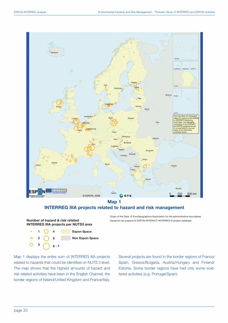
Map 1 displays the entire sum of INTERREG IIIA projects
related to hazards that could be identified on NUTS 3 level.
The map shows that the highest amounts of hazard and
risk related activities have been in the English Channel, the
border regions of Ireland/United Kingdom and France/Italy.
Several projects are found in the border regions of France/
Spain, Greece/Bulgaria, Austria/Hungary and Finland/
Estonia. Some border regions have had only some scat-
tered activities (e.g. Portugal/Spain).
Map 1INTERREG IIIA projects related to hazard and risk management

page 21
Environmental Hazards and Risk Management – Thematic Study of INTERREG and ESPON activities ESPON-INTERREG analysis
Origin of the Data: © EuroGeographics Association for the administrative boundaries European Avalanche Services USGS GTOPO30 Avalanche related projects © ESPON-INTERACT INTERREG III project data base
The map is based on the results of ESPON 1.3.1.Information in ESPON 1.3.1. was obtained from the EuropeanAvalanche Service (UK, Spain, France, Italy, Slovenia,Austria), from the USGS GTOPO30 digital elevation modeland from questionaires.The area of projects covers also regions without avalanche hazard, because many projects are dealing with more than one hazard.
Avalanche related projects in INTERREG IIIA and B
Area with avalanche related projects
Avalanche hazard
Avalanches possible
No avalanches
Non Espon space
Map 2 displays all INTERREG activities of the strands A
and B related to avalanches (INTERREG IIIC had no ava-
lanche activities so far). Obviously the Alps and parts of the
Pyrenees have had project activities but nevertheless many
areas, especially in the new Member States have not yet
dealt with this issue, neither have the Nordic countries.
Map 2Avalanche potential and avalanche related INTERREG IIIA and B projects

page 22
ESPON-INTERREG analysis Environmental Hazards and Risk Management – Thematic Study of INTERREG and ESPON activities
Origin of the Data: © EuroGeographics Association for the administrative boundaries ARIDE final report (2001) The Prudence project model database Drought related projects © ESPON-INTERACT INTERREG III project database
INTERREG IIIB and C projects related to droughts
Area with drought related projects
Change of dry spell length (climate change induced) affecting drought potential
No Data
No impact on drought potential
Very low impact on drought potential
Low increasing impact on drought potential
Moderate increasing impact on drought potential
Non Espon space
The map is based on the results of ESPON 1.3.1.The map represents the connection betweenchange of dry spell length (The Prudence projectmodel database) and drought potential, based onprecipitation deficit recordings 1904-1995.
The area covered by drought related INTERREG projects of
all strands goes well beyond those areas that are identified
as potentially experiencing the highest drought potential
increase by climate change. On the other hand, many
areas that are presumed to experience more droughts in
the future did not yet have any related INTERREG activities
(new Member States, central and northern part of the
Iberian Peninsula, parts of France and Italy). Only Greece
seems to have covered the drought aspect rather strongly.
Map 3Change of dry spell length affecting drought potential and
drought related INTERREG IIIB and C projects

page 23
Environmental Hazards and Risk Management – Thematic Study of INTERREG and ESPON activities ESPON-INTERREG analysis
Earthquake related projects, INTERREG III A, B and CArea with earthquake related projects
Earthquake hazard potentialVery low hazard
Low hazard
Moderate hazard
High hazard
Very high hazard
Non Espon space
Origin of the Data: © EuroGeographics Association for the administrative boundaries Pga data © Global Seismic Hazard Assessment Program Earthquake related projects © ESPON-INTERACT INTERREG III project database
The map is based on the results of ESPON 1.3.1.The hazard classification is based on the averagevalue of the peak ground acceleration(pga)/acceleration of gravity (%) in a NUTS3 region
As displayed in map 4, some of the highest earthquake
prone hazard areas have not had any projects related to
seismic hazards so far (as displayed by the Peak ground
acceleration related to NUTS 3 areas), even though this
map displays INTERREG activities of all strands, A, B and
C.
Map 4Earthquake hazard potential and earthquake related INTERREG IIIA, B and C projects

page 24
ESPON-INTERREG analysis Environmental Hazards and Risk Management – Thematic Study of INTERREG and ESPON activities
INTERREG IIIB projects related to extreme temperatures
Area with projects related to extreme temperatures
Extreme temperature hazard
Low hazard
Moderate hazard
High hazard
No data
Non Espon space
Origin of the Data: © EuroGeographics Association for the administrative boundaries Rosby Centre RCAO model Extreme temperatures related projects © ESPON-INTERACT INTERREG III project database
The map is based on the results of ESPON 1.3.1.The map shows the mean of four indicators (hot days,heat waves, cold days and cold waves)
The extreme temperature hazard (map 5) has been
addressed so far only by INTERREG IIIB projects. The proj-
ect areas mainly cover central and western Europe. In
other parts of Europe where the hazard intensity is actual-
ly higher (mainly eastern and northern but also parts of
southern Europe) this hazard has been addressed only by
scattered activities.
Map 5Extreme temperature hazard and related INTERREG IIIB projects

page 25
Environmental Hazards and Risk Management – Thematic Study of INTERREG and ESPON activities ESPON-INTERREG analysis
Flood recurrence
Very low
Low
Moderate
High
Very High
Non Espon space
Flood related projects
1 INTERREG IIIA project/NUTS3
2 INTERREG IIIA projects/NUTS3
3 INTERREG IIIA projects/NUTS3
Origin of the Data: © EuroGeographics Association for the administrative boundaries Large flood areas © Dartmouth flood observatory Flood areas © ESA - Earth Observation - Earth Online Rhine Atlas 2001 IKRS-CIPR-ICBR Flood related projects © ESPON-INTERACT INTERREG III project database
The map is based on the results of ESPON 1.3.1. It displays the hazard recurrence based on average number of large flood events on NUTS3 regions 1987-2001. The first class "Very low hazard intensity" includes the regions without large flood events.
Map 6 shows that among the border regions the most IIIA
projects on floods are located in the border area between
Italy and France, as well as France/Belgium/Luxemburg.
Map 6Flood recurrence and INTERREG IIIA flood related projects on NUTS 3 level

page 26
ESPON-INTERREG analysis Environmental Hazards and Risk Management – Thematic Study of INTERREG and ESPON activities
Flood recurrence
Very low
Low
Moderate
High
Very High
INTERREG IIIB projects
Areas with flood related projects
Non Espon space
Origin of the Data: © EuroGeographics Association for the administrative boundaries Large flood areas © Dartmouth flood observatory Flood areas © ESA - Earth Observation - Earth Online Rhine Atlas 2001 IKRS-CIPR-ICBR Flood related projects © ESPON-INTERACT INTERREG III project data base
The map is based on the results of ESPON 1.3.1. It displays the hazard recurrence based on average number of large flood events on NUTS3 regions 1987-2001. The first class "Very low hazard intensity" includes the regions without large flood events.
Floods have been addressed in INTERREG IIIB projects to
a very large extent (map 7). The areas with flood related
projects cover most of Europe. The only areas that are
highly flood prone and have not received attention by
INTERREG IIIB activities so far are located in the eastern
areas of the new Member States, as well as in Romania.
The INTERREG IIIC project area on floods (map 8) reveals
that meanwhile the coverage of the flood projects is high in
central Europe, it is here also extending further towards
eastern Europe than in the INTERREG IIIA or IIIB activities.
In sum, the high flood recurrence in many parts of the
Pentagon has been addressed with quite a number of
flood related projects. Especially the IIIA cross-border proj-
ects coincide quite neatly with the areas of high recurrence
in Western Europe. In the east the most problematic areas
have not yet got engaged in project activities. Only IIIC
Map 7Flood recurrence and INTERREG IIIB flood related projects on NUTS 3 level

page 27
Environmental Hazards and Risk Management – Thematic Study of INTERREG and ESPON activities ESPON-INTERREG analysis
reaches parts of the easternmost areas of very high flood
risk (map 8). On the other hand, also numerous areas of
very low flood risk at the European scale (e.g. in the Baltic
Sea Region) have become partners in flood projects.
Flood recurrence
Very low
Low
Moderate
High
Very High
INTERREG IIIC projects
Area with flood related projects
Non Espon space
Origin of the Data: © EuroGeographics Association for the administrative boundaries Large flood areas © Dartmouth flood observatory Flood areas © ESA - Earth Observation - Earth Online Rhine Atlas 2001 IKRS-CIPR-ICBR Flood related projects © ESPON-INTERACT INTERREG III project database
The map is based on the results of ESPON 1.3.1. It displays the hazard recurrence based on average number of large flood events on NUTS3 regions 1987-2001. The first class "Very low hazard intensity" includes the regions without large flood events.
Map 8Flood recurrence and INTERREG IIIC flood related projects on NUTS 3 level

page 28
ESPON-INTERREG analysis Environmental Hazards and Risk Management – Thematic Study of INTERREG and ESPON activities
Forest fire hazard
Very low
Low
Moderate
High
Very high
INTERREG IIIB projects
Area with forest fire related projects
Non Espon space
Origin of the Data: © EuroGeographics Association for the administrative boundaries Number of forest fires 1997 - 2003: ATSR world fire atlas European Space Agency - ESA/ESRIN Biogeographic regions: EEA Forest fire projects © ESPON-INTERACT INTERREG III project database
This map is based on the results of ESPON 1.3.1. The classification of forest fire hazard is based on a combination of the numbers of observed fires per 1000 sq. km 1997-2003 (ATSR) and the map of biogeopraphic regions in Europe (EEA).
The areas with high forest fire hazards do not correspond
very much with the related IIIB and IIIC projects (maps 9
and 10). There is no map representing INTERREG IIIA relat-
ed forest fire projects, because there was only one project
dealing directly with the forest fire hazard by setting up an
automatic forest fire monitoring system at the German-
Polish border. Greece has hardly any activities in this field,
with the exception of some IIIA projects used to procure fire
vehicles.
Map 9Forest fire hazard and INTERREG IIIB projects

page 29
Environmental Hazards and Risk Management – Thematic Study of INTERREG and ESPON activities ESPON-INTERREG analysis
Forest fire hazard
Very low
Low
Moderate
High
Very high
Forest fire related projects
1 INTERREG IIIC project/NUTS3
Non Espon space
Origin of the Data: © EuroGeographics Association for the administrative boundaries Number of forest fires 1997 - 2003: ATSR world fire atlas European Space Agency - ESA/ESRIN Biogeographic regions: EEA Forest fire projects © ESPON-INTERACT INTERREG III project database
This map is based on the results of ESPON 1.3.1. The classification of forest fire hazard is based on a combination of the numbers of observed fires per 1000 sq. km 1997-2003 (ATSR) and the map of biogeopraphic regions in Europe (EEA).
In INTERREG IIIB projects only the Western Mediterranean
coastal area is addressed nearly entirely (map 9). A major
lack of activities here can be found in central and northern
Portugal and North western Spain. The coverage of the
forest fire hazard in the Baltic Sea Region is addressed by
one IIIB project aiming at developing adaptation strategies
to climate change impacts (ASTRA). Map 10 displays one
single project on forest fires (INCENDI).
Map 10Forest fire hazard addressed by an INTERREG IIIC project

page 30
ESPON-INTERREG analysis Environmental Hazards and Risk Management – Thematic Study of INTERREG and ESPON activities
INTERREG IIIA, B and C projects
Area with landslide related projects
Areas with landslide hazard
Low hazard
High Hazard
No Data
Non Espon space
Origin of the Data: © EuroGeographics Association for the administrative boundaries Expert interviews Landslide related related projects © ESPON-INTERACT INTERREG III project database
The map is based on the results of ESPON 1.3.1. Areas with landslide hazards, based on national expert opinion of European Geological Surveys
The map on landslides (map 11) shows that the coverage
of landslide related project fits rather well to the landslide
prone areas among coastal zones of the western
Mediterranean and the Alpine Region. Also some related
project areas in the Baltic countries are located in landslide
prone areas. However, many large landslide prone areas
have not yet had any projects.
Map 11Landslide hazard and related INTERREG IIIA, B and C projects

page 31
Environmental Hazards and Risk Management – Thematic Study of INTERREG and ESPON activities ESPON-INTERREG analysis
INTERREG IIIA and B projects
Area with projects related to storm surges and winter storms
Espon space
Non Espon space
Origin of the Data: © EuroGeographics Association for the administrative boundaries winter storm and storm surge related projects © ESPON-INTERACT INTERREG III project database
The INTERREG activities on storms and storm surges (map
12) cover a much larger area than the highest storm surge
and winter storm prone regions issued by the Munich
Reinsurance Company (1998), which highlights the south-
ern North Sea area and southern Baltic Sea coast. The
coastal areas of the western Mediterranean also have sev-
eral areas with project activities related to storms, even
though Munich Re does not highlight these areas as
specifically hazardous. This shows that hazards have to be
evaluated on a regional and local scale to define the need
and structure of related project activities.
Map 12INTERREG IIIA and B projects related to winter storms and storm surges

page 32
ESPON-INTERREG analysis Environmental Hazards and Risk Management – Thematic Study of INTERREG and ESPON activities
Projects related to tech. hazards
1 INTERREG IIIA project/NUTS3
2 INTERREG IIIA projects/NUTS3
3 INTERREG IIIA projects/NUTS3
4 INTERREG IIIA projects/NUTS3
Non Espon space
Origin of the Data: © EuroGeographics Association for the administrative boundaries techn. hazards projects © ESPON-INTERACT INTERREG III project database
The map above shows that in central and northern Europe
most of the cross-border cooperations (IIIA) related to risks
and hazards have focussed on technological hazards
(compare with map 1). In southern Europe, all of the haz-
ards and risk related INTERREG IIIA projects have in turn
been focusing on natural hazards, with the exception of a
Spanish-Moroccan cooperation project.
Map 13INTERREG IIIA projects related to technological hazards

page 33
Environmental Hazards and Risk Management – Thematic Study of INTERREG and ESPON activities ESPON-INTERREG analysis
INTERREG IIIB projects
Area with techn. hazard related projects
Non Espon space
Origin of the Data: © EuroGeographics Association for the administrative boundaries Techn. hazard projects © ESPON-INTERACT INTERREG III project database
The map above shows that most of the INTERREG IIIB
activities related to technological hazards have focussed
on coastal zones. This implies that coastal pollution and
other maritime safety features are of high concern for terri-
torial development.
Map 14Technological hazards addressed in INTERREG IIIB projects

So far only few INTERREG III programme area measures
and priorities mention risk. Since natural and technological
hazards, as well as resulting risk patterns, can influence
regional development adversely, it is recommended that
both risk patterns and vulnerability factors should be taken
into account in order to reduce overall risk in future
Objective 3 programmes.
Based on an analysis where INTERREG project activities are
related to the hazard and risk patterns identified by the ES-
PON Hazards project (Schmidt-Thomé 2005), some general
and large scale recommendations on future risk related
actions are given below. These recommendations take the
spatial relevance of hazards into account, as well as the
activities that have so far been undertaken in INTERREG
projects, i.e. there is a stronger highlight on areas that have
had no or few INTERREG activities so far. It should never-
theless always be evaluated on regional or local levels, to
what extent hazards and risk related projects could support
regional development, both in areas that have not had proj-
ects yet and in areas that have already had several activities.
As mentioned above, these recommendations are based
on a European-scale perspective. Other hazards than
those identified here might be of great importance region-
ally and locally. These should be evaluated on programme
area scale in order to define potential needs of actions.
4.1 Geohazards
Hazard sources and the potential extent of damage can be
regionally better delimitated for most geohazards than for
meteorological hazards. Landslides are confined to valleys
and slopes, and here often the geology and climate deter-
mine certain areas of risk. Volcanic activities have mostly
local to regional effects, but ash plumes can reach larger
over-regional to global extents. Earthquakes appear,
besides those caused by underground failures and explo-
sions, in tectonically active areas. In this sense it is possi-
ble to delineate the immediate hazard and risk of geohaz-
ards to those areas were they mainly occur. Tsunamis are
confined to coastal areas and can be triggered by all geo-
hazards mentioned above.
Earthquakes are extremely dangerous and affect large
areas of the eastern Mediterranean and Eastern Europe. In
comparison to the relative importance of earthquakes
revealed by the Delphi method (see chapter above), it
would be strongly recommended to take this hazard more
into account in future Objective 3 activities in these areas.
Many very old settlement areas have always been located
in earthquake prone areas and earthquakes have always
affected the European civilisation. Old structures are diffi-
cult to protect, therefore future projects should focus on
enforcing appropriate engineering of new structures to be
earthquake proof, the development of disaster manage-
ment plans and cooperation of regions in cases of disas-
ters. Cross-border cooperation in case of disasters can be
planned well before an earthquake strikes so that relief
operations can start without delay. Future projects should
focus especially on the eastern and central Mediterranean
region as well as overseas territories.
Among the most widespread geohazards in European
regions are landslides. Landslides are used here as a
term that summarises all kinds of gravitational mass move-
ments (rock falls, debris flows, etc.). Landslides can occur
on very small spots that are not possible to display on
regional level, so that it is to be defined by the relevant pro-
gramme areas, where such hazards should be taken up in
future Objective 3 programmes. In general it can be said
that mountainous areas, in particular those with harsh cli-
mates favouring weathering processes, high precipitation
rates and a high settlement pressure, are those that are
most prone to landslides. Nevertheless, locally these con-
ditions might be very different, according to the geology,
morphology and land use. Since terrestrial landslides (rock
falls, etc.) into lakes or the sea can trigger tsunamis, this
hazard can also play a role in the development of some
settlement areas, e.g. in Norway where this hazard combi-
nation is most imminent. The need for landslide projects
has to be defined locally.
The most active volcanoes on the European continent are
found in Italy. Volcanoes are of particular relevance also for
distant EU areas of France, Portugal and Spain and should
be taken into account here as potentially affecting settle-
page 34
Conclusions and recommendations on future INTERREG environmental risk projects Environmental Hazards and Risk Management – Thematic Study of INTERREG and ESPON activities
4. Conclusions and recommendations on future INTERREG environmental risk projects

page 35
Conclusions and recommendations on futureEnvironmental Hazards and Risk Management – Thematic Study of INTERREG and ESPON activities INTERREG environmental risk projects
ment development. Since the active volcanoes are known,
regional and local settlement development plans should
respect safety zones. A considerable problem arises from
uncontrolled settlement in hazardous areas, which also
puts rescue teams in unnecessary danger. Appropriate
land use, evacuation plans and disaster management
plans in active volcanic areas, in close cooperation with
neighbouring regions, should enable sustainable develop-
ment of potentially affected areas.
Tsunamis are theoretically possible in all coastal regions,
even if they were located far away from seismically active
zones. The danger of tsunamis in the Mediterranean is
high. It should not be forgotten that most recent tsunami
catastrophe in the Mediterranean caused over 75 000
casualties in 1908 in Italy, Messina. Even though this event
occurred nearly 100 years ago, a geological perspective
reveals that this hazard is still imminent as large parts of the
Mediterranean area are tectonically active. Many distant
EU areas also show a tsunami risk pattern. It could be of
relevance to see if a tsunami warning system was feasible
to install and how this could support regional development
and decision-making.
Other georisks that were not identified by the ESPON
Hazards project comprise factors of geochemistry.
Various rock types and sediments have elevated contents
of potentially harmful elements such as arsenic, fluoride,
nickel, thallium or uranium. These elements pose health
risks both on local scale (related to certain mineralisa-
tions), and also on regional scale as shown in the geo-
chemical maps of Europe (Salminen 2005). For example,
the concentration of fluoride in stream waters is high in the
areas of certain granite types in alkaline volcanic rocks in
Italy and in Scandinavia. Elevated concentrations of
arsenic are found in large areas around ore potential areas
of Portugal, France and Greece as well as in black shale
areas of the Pyrenees. Here the risks are mostly linked to
the quality of drinking water. In the case of radiating ele-
ments, indoor radon concentrations can be high in urani-
um rich regions.
In coastal regions soils and sediments may locally be
extremely acid leading to significant financial loss due to
dissolution of concrete foundations and drainage systems.
Due to extreme acidity also harmful elements such as alu-
minium is released, leading to mass deaths of fish popula-
tions in rivers draining through acid soils. Acid soils are typ-
ically found in land areas where sulphide-rich sediments
are exposed to oxidation due to artificial processes such
as ditching and land reclamation. Such regions are espe-
cially found in Scandinavia where natural land uplift (glacial
isostacy) steadily exposes sulphide-rich sediments in
coastal areas.
4.2 Meteorological hazards
This chapter analyses meteorologically influenced hazards
in alphabetical order taking into account relevant hazard
interactions and climate change factors. Meteorological
hazards often have a wider and fuzzier impact space than
geohazards. Floods can affect large catchment areas (e.g.
the entire lower Rhine area), storms can hit very large
regions leading to both storm surges and inland damages,
droughts can even affect the entire continent. However, it
is seldom only the hazard itself that influences regional
development. Only in combination with disadvantageous
land use practices, infrastructure and settlement patterns
they lead to catastrophic impacts. In the discussion of
meteorological hazards vulnerability reduction should
therefore play a very important role.
The latest results of climate change models should also be
taken seriously into account. As an example of a close
cooperation between scientists and decision-makers in the
field of climate change related issues, the INTERREG IIIB
BSR project on Sea Level Change Affecting the Spatial
Development of the Baltic Sea Region (SEAREG) has had
close cooperation with spatial planners and other stake-
holders. The sea level change assessment carried out
under this project revealed that even though planning
mostly concerns time periods of 10-20 years, climate
change perspectives of up to 100 years are very relevant
for planning, especially when talking about long-term
investments and sustainable development. The resulting
scenarios of the SEAREG project have found their way into
many discussions and partly also development strategies
of regions and towns. The follow up project INTERREG IIIB
of SEAREG: "Developing Policies & Adaptation Strategies
to Climate Change in the Baltic Sea Region" (ASTRA)
focuses on several impacts of climate change on natural
hazards and analyses those in close cooperation with local
and regional authorities in case study areas around the
Baltic Sea.

The avalanche hazard is, just as the landslide hazard
described above, very much confined to particular slopes
and valleys. Since the avalanche hazard received an overall
rather low rating of importance in the Delphi exercise of the
ESPON Hazards project, and over 90% of the avalanche
accidents with casualties are triggered by human activities
in avalanche prone areas, the main focus of future projects
with this hazard should concentrate on the safety issue in
skiing and mountainous (snowy) hiking areas.
Droughts are a very important hazard that affects large
territories in Europe. So far there have been only few proj-
ects dealing with this hazard in INTERREG projects and it
is strongly recommended to focus more on the adverse
impacts of drought on regional development. It should be
taken into account that droughts affect not only agriculture
but also other industries, when cooling waters from rivers
cause energy production plants and other industries to run
on lower efficiency or even shut down due to the lack of
cooling water from, e.g. rivers or lakes. Since droughts are
difficult to predict, only long-term hazard management,
including the sustainable usage of water resources, can
prove sustainable. Hazard interactions should be taken
into account, as droughts can lead to an increase of the
forest fire potential, and heat waves occurring mutually
with droughts can increase both the drought and the for-
est fire hazard. Heat waves occurring at the same time with
droughts can also lead to an additional stress in the ener-
gy supply, as the water needed for energy production
might get too warm for cooling processes and the use of
air conditioning systems causes an increasing demand on
power production. It should also be taken into account,
that the latest climate change scenarios see a potential for
an increase of the drought potential in the Mediterranean
area and parts of central Europe.
Extreme temperatures are also difficult to forecast on a
mid to long-term basis and therefore the regions that are
most prone to this hazard should take long-term precau-
tions. In this category fall especially the areas highlighted in
the ESPON Hazards project. An important approach can be
the general life and working conditions in extreme cold cli-
mates in the Northern peripheral areas, and this also
accounts for areas in Eastern Europe that experiences
strong variations of very hot summers and very cold winters.
Materials and installations must be able to resist the temper-
ature variations, and energy support (heating and cooling
systems) must be adaptable to extreme situations. In addi-
tion, many people suffer from extreme heat waves so that
additional risks, e.g. for the health care systems, should be
taken into account. Potential new projects could develop
scenarios of, e.g. extreme temperatures during different
periods of the year to determine the vulnerability of an area
to those climatic extreme events. These scenarios can then
accordingly lead to long term action and mitigation plans.
By far the highest amount of all INTERREG III projects on
hazards has been focusing on the flood hazard. One rea-
son for this may lie in the dramatic recent flood events
across Europe, which have served as “focussing events”
guiding policy-makers’ attention. In any case, this meteoro-
logical hazard, the impact of which is increased by the type
and location of settlements and hydraulic engineering (e.g.
straightening of rivers), etc., is one of the most mentioned
in INTERREG priorities and measures. It should be evaluat-
ed on regional and local scales whether these projects have
actually lead to a decrease of the flood potential and vulner-
ability. This should help to determine the need for more
flood projects. In other words, the development of over-
regional (cross-border/catchment wise) cooperation should
be endorsed, with a clear focus on the development of
flood retention areas and natural flood prone areas. These
efforts will be conducted in relation to the implementation of
the recent EU Flood Directive, which also links with the
Water Framework Directive. An important aspect could also
lie on climate change, as the flood patterns might change
due to earlier snow melting in spring and increased precip-
itation, especially in central and northern Europe. Also
extreme weather events appear likely to increase in the
future. Since the flood potential is very high in central and
eastern Europe, most of these regions should get better
prepared for future extreme flood events, especially taking
over-regional and cross-border policy development on river
catchment management into account.
The hazard of forest fires has been addressed by INTER-
REG III projects far less than the relative importance indi-
cated by the results of the Delphi method would imply.
Forest fires are a natural hazard, but approximately 90% of
these fires are caused by human activities. There are
several forest fire research programmes under the EU
Frameworks and also ongoing in large EU research institu-
tions, but there should be a closer link to the actual impli-
cations of forest fires on regional development. It would
page 36
Conclusions and recommendations on future INTERREG environmental risk projects Environmental Hazards and Risk Management – Thematic Study of INTERREG and ESPON activities

therefore be highly recommended to take up the forest fire
hazard in future INTERREG programmes, especially in the
Mediterranean area and parts of Central and Eastern
Europe. Additionally, the potential interactions of forest fires
with other hazards, such as droughts and extreme temper-
atures should be taken into account in terms of long term
planning potentials concerning these interactions. The
effect of climate change on these mentioned hazard inter-
actions should also be respected.
Storm surges have so far been mostly dealt within North
Sea areas with few exceptions. This pattern follows the
one identified by the ESPON Hazards project. The possibil-
ity of forecasting storm surges has improved strongly in the
20th century and at the same time integrated coastal risk
management has lowered the casualties of storm surges.
Climate change models have so far not been able to devel-
op any reliable forecasts on changes of wind/storm surge
patterns. Nevertheless it is recommended to include haz-
ard interactions of (winter) storms with (coastal) floods into
future storm surge projects, such as already done by the
INTERREG IIIB projects SEAREG and ASTRA, for example.
These projects also include climate change models, a
trend that is recommended to be broadened in future
INTERREG activities.
There are no scenarios yet on the influence of climate
change on winter and tropical storms. Since storms
belong to the most important natural hazards on a global
scale, also Europe could focus more on the financial
effects of storms. In the case of storms the most appropri-
ate mitigation from the regional development perspective
could be to initiate a decrease in vulnerability, for example
by focusing on the reduction of the consequences of the
impacts and strengthening the coping capacity. In other
words, the consequences of storms on the infrastructure
and the other vital assets of regions should be taken into
account. Also the interactions of winter storms with storm
surges and floods can be addressed to a larger extent,
especially in the North Sea and the Baltic Sea as well as
cross-border cooperations to ensure timely early warning
and relief operations.
4.3 Technological hazards
In the field of technological hazards the most intense
focus should lie on accident prevention, e.g. by ensuring
that EU and international safety procedures and recom-
mendations are most strictly followed. Besides these,
close cross-border cooperation in cases of disaster should
be further ensured, especially in the case of monitoring and
relief operations (e.g. oil spills). Early and appropriate dis-
aster management is often a decisive factor in disaster
control. Appropriate land use planning can help to ensure
that, in case of accidents, disasters do not affect settle-
ments, vital infrastructure or protected nature areas. Since
technological hazards occur in many places in Europe, pri-
ority could lie on areas with a high population density and
those with important and/or fragile ecosystems.
4.4 Cooperation potential of INTERREG and ESPON
A future Objective 3 programme could cooperate more
tightly with ESPON. Since ESPON has developed data and
maps on all kinds of topics regarding the regional potential
of future terrestrial development covering the European
Union Member States, plus Bulgaria, Norway, Romania
and Switzerland (EU29), this information can be used by
INTERREG to define future programme strategies. In addi-
tion, ESPON can support future Objective 3 projects by
their large data sets and expertise in spatial and territorial
issues, e.g. on Territorial Impact Assessment (TIA). ESPON
on the other hand could benefit from cooperation with
Objective 3 projects to test some of the ESPON method-
ologies in project areas and refine those accordingly, main-
ly in order to support the definition of new strategies and
goals as well as policy making at any relevant geographical
level.
A future Objective 3 programme could take into account
the large amount of policy recommendations issued by
ESPON projects. The ESPON programme 2006 has been
developing an integrated picture on the potentials of terri-
torial development in Europe, based on several indicators
and typologies. These indicators and typologies can be a
fruitful base for INTERREG to outline the content and ori-
entation of future Objective 3 projects, for example by iden-
tifying territorial trends that either favour or pose an obsta-
cle on sustainable regional development. The ESPON
studies are of additional value because they cover the
entire programme area (EU 27+2) and have all reported on
regional (mainly NUTS 3) level. Those INTERREG areas
currently outside of the ESPON space can observe which
page 37
Conclusions and recommendations on futureEnvironmental Hazards and Risk Management – Thematic Study of INTERREG and ESPON activities INTERREG environmental risk projects

trends are of importance to them. The ESPON database
could be open to all INTERREG projects so that data sets
can be shared which might lead to an additional trans-
parency and comparability of results. In general it would be
recommended for INTERREG to give more guidelines on
the result reporting so that an inter-comparability would
nourish future projects, avoid research on similar topics
and ease evaluation of programmes and results. For exam-
ple, it would be of an added value if all projects had to
shortly describe how they have dealt with the measure they
claimed to address in the application form.
The Delphi method could play an important role if certain
trends, impacts, measures, etc. have to be compared over
larger areas, in both defining goals and evaluating results.
ESPON could take up some ideas from the management
of INTERREG activities. For example, at least for some of
the measures of the programme calls for proposals could
be issued instead of tendering of some pre-defined
requirements. This way project teams would have more to
say on how to structure research on certain issues or on
how to solve particular questions/obstacles, etc. This
would give another research perspective to ESPON, even
if it would be only a small part of the entire programme. The
strategy could be to hand over unsolved questions first to
a research oriented project type and then take up the
results and define the topics that are to be derived from
these into ESPON standards.
page 38
Conclusions and recommendations on future INTERREG environmental risk projects Environmental Hazards and Risk Management – Thematic Study of INTERREG and ESPON activities

page 39
Environmental Hazards and Risk Management – Thematic Study of INTERREG and ESPON activities References
EFFIS forest fire project http://inforest.jrc.it/effis/effccf.html, visited January 2006
European Commission 2004. Proposal for council regulation laying down general provisions on the European Regional
Development Fund, the European Social Fund and the Cohesion Fund, COM (2004) 492 final
Munich Reinsurance Company. 1998. World Map of Natural Hazards (Map, 3rd edition)
Salminen, R. (Chief-editor) 2005. Geochemical Atlas of Europe. Part 1 – Background Information, Methodology, and
Maps. FOREGS and the Geochemical Survey of Finland. 526 pages.
Schmidt-Thomé, P. (editor) 2005. The Spatial Effects and Management of Natural and Technological Hazards in Europe.
Final report of the ESPON 1.3.1 project. Espoo, Luxembourg: ESPON. 193 p. (available at
http://www.espon.lu/online/documentation/projects/thematic/thematic_60.html)
5. References

page 40
Annex Environmental Hazards and Risk Management – Thematic Study of INTERREG and ESPON activities
6. Annex: Table of INTERREG III projects (printed from the database)
titl
e
Dan
ube
flood
pro
tect
ion
Vie
nna
- G
yoer
Pan
noni
fire
-brig
ade
auth
ority
cent
er -
est
ablis
hmen
t of
a
plan
ning
gam
e an
d a
trai
ning
hall
with
sim
ulta
neou
s in
terp
retin
g,
as w
ell a
s tw
o ex
erci
se r
esou
ndin
g
Pre
stud
y: C
ross
boa
rdin
g
anal
ysis
of d
isas
ters
Em
erge
ncy
mea
sure
s/fir
e
prot
ectio
n
Dev
elop
men
t co
ncep
t
alpi
ne R
hine
Sch
aden
spot
enzi
ale/
Son
derr
isik
en in
the
alp
ine
Rhi
ne V
alle
y
Pub
lic w
ork
futu
re a
lpin
e R
hine
Tran
snat
iona
l co-
oper
atio
n an
d
trai
ning
in t
he d
isas
ter
cont
rol
Net
wor
k in
form
atio
n co
mm
uni-
catio
n w
ithin
the
ran
ge fi
re-b
rigad
e,
emer
genc
y se
rvic
e, d
isas
ter
cont
rol
Con
tain
er t
o be
use
d in
cas
e of
trai
n ac
cide
nts
Rol
l-off
cont
aine
r fo
r
dang
erou
s go
ods
Cre
atio
n of
exe
rcis
e m
odul
es fo
r
gren
zueb
ersc
hr. D
isas
ter
cont
rol
Acq
uisi
tion
of a
Fire
Brig
ade
vehi
cle
LF 1
6-12
Ext
ensi
on o
f the
aut
omat
ic fo
rest
fire
mon
itorin
g
Aro
und
and
deve
lopm
ent
of a
trai
ning
faci
lity
for
disa
ster
con
trol
Dev
elop
men
t of
met
hodo
logi
cal t
ools
for
the
dete
ctio
n an
d th
e st
udy
of t
he
spre
adin
g of
larg
e ca
ve-in
s
acro
nym
– – – – – – – – – – – – – – –
ww
w
ww
w.p
orto
fgyo
r.hu
http
://w
ww
.lfv-
bgld
.at
http
://in
terr
eg.z
.lst.s
e/
ww
w.o
.lst.s
e
– – – – – – – – – – – –
char
acte
r
Haz
ard
Ass
essm
ent
Res
cue
Ser
vice
Pre
pare
dnes
s
Ris
k M
anag
emen
t
Res
cue
Ser
vice
Pre
pare
dnes
s
Ris
k M
anag
emen
t
Haz
ard
Ass
essm
ent
Ris
k M
anag
emen
t
Ris
k M
anag
emen
t
Res
cue
Ser
vice
Pre
pare
dnes
s
Ris
k M
anag
emen
t
Ris
k M
anag
emen
t
Res
cue
Ser
vice
Pre
pare
dnes
s
Res
cue
Ser
vice
Pre
pare
dnes
s
Ris
k M
anag
emen
t
Res
cue
Ser
vice
Pre
pare
dnes
s
Haz
ard
Ass
essm
ent
coun
trie
s
Aus
tria
, Hun
gary
Aus
tria
, Hun
gary
Nor
way
, Sw
eden
Ger
man
y,
Net
herla
nds
Aus
tria
Aus
tria
Aus
tria
Ger
man
y, P
olan
d
Ger
man
y, P
olan
d
Ger
man
y, P
olan
d
Ger
man
y, P
olan
d
Ger
man
y, P
olan
d
Ger
man
y, P
olan
d
Ger
man
y, P
olan
d
Ger
man
y, P
olan
d
Fran
ce, I
taly
haza
rds
Floo
ds
Not
def
ined
Tech
nolo
gica
l
haza
rds
Not
def
ined
Floo
ds
Floo
ds
Floo
ds
Not
def
ined
Fore
st fi
res
Tech
nolo
gica
l
haza
rds
Tech
nolo
gica
l
haza
rds
Not
def
ined
Not
def
ined
Fore
st fi
res
Not
def
ined
Land
slid
es
pro
gra
mm
e
INTE
RR
EG
IIIA
Aus
tria
- H
unga
ry
INTE
RR
EG
IIIA
Aus
tria
- H
unga
ry
INTE
RR
EG
IIIA
Sw
eden
- N
orw
ay
INTE
RR
EG
IIIA
Em
s-D
olla
rt R
egio
n
INTE
RR
EG
IIIA
Alp
enrh
ein-
Bod
ense
e-H
ochr
hein
INTE
RR
EG
IIIA
Alp
enrh
ein-
Bod
ense
e-H
ochr
hein
INTE
RR
EG
IIIA
Alp
enrh
ein-
Bod
ense
e-H
ochr
hein
INTE
RR
EG
IIIA
Bra
nden
burg
- L
ubus
kie
INTE
RR
EG
IIIA
Bra
nden
burg
- L
ubus
kie
INTE
RR
EG
IIIA
Bra
nden
burg
- L
ubus
kie
INTE
RR
EG
IIIA
Bra
nden
burg
- L
ubus
kie
INTE
RR
EG
IIIA
Bra
nden
burg
- L
ubus
kie
INTE
RR
EG
IIIA
Bra
nden
burg
- L
ubus
kie
INTE
RR
EG
IIIA
Bra
nden
burg
- L
ubus
kie
INTE
RR
EG
IIIA
Bra
nden
burg
- L
ubus
kie
INTE
RR
EG
IIIA
Italy
- F
ranc
e (A
lcot
ra)

page 41
Environmental Hazards and Risk Management – Thematic Study of INTERREG and ESPON activities Annex
titl
e
Hyd
rolo
gica
l ris
ks in
the
mou
ntai
ns:
para
des
and
surv
eilla
nce.
Cre
atio
n of
the
Cen
tre
for
natu
ral
haza
rds
in t
he m
ount
ains
of t
he
CO
TRA
O
Nat
ural
haz
ards
soc
ial m
anag
emen
t-
His
toric
mem
ory
of n
atur
al c
atas
t-
roph
es a
nd t
he r
espo
nse
of s
ocia
l
and
adm
inis
trat
ive
acto
rs
The
Vess
el T
raffi
c M
anag
emen
t
Sys
tem
VTM
S (R
efer
ence
: 017
982)
Coa
stal
infra
stru
ctur
e an
d sa
fety
impr
ovem
ent
prog
ram
me
(Ref
eren
ce: 0
1901
8)
Pro
visi
on o
f mar
ine
safe
ty
equi
pmen
t at
Lon
dond
erry
Por
t
(Ref
eren
ce: 0
1886
7)
Am
bula
nce
Trai
ning
/Em
erge
ncy
Pla
nnin
g R
oom
(Ref
eren
ceL
0235
70)
EM
AR
T -
A C
AW
T R
espo
nse
to
CB
RN
(Ref
eren
ce: 0
2360
3)
Sei
smic
Mic
rozo
nage
of t
he a
rea
of t
he S
outh
ern
Hig
her
Rhi
ne
Gui
de o
f tec
hnic
al a
nd o
pera
tive
perfo
rman
ces
of t
he a
lert
sys
tem
s,
coor
dina
tion
and
fast
inte
rven
tion
befo
re s
ituat
ions
of e
mer
genc
y (c
ivil
defe
nce)
in t
he b
asic
sco
pe o
f tra
ns-
front
eriz
a co
oper
atio
n C
astil
e an
d
Nor
th L
eon-
Reg
ion
of P
ortu
gal
Info
rmat
ion
syst
em fo
r th
e P
reve
ntio
n
of S
hipw
reck
s in
the
Str
aits
Civ
il S
afet
y in
the
Øre
sund
Reg
ion
(Pha
se 2
)
Civ
il S
afet
y in
the
Øre
sund
Reg
ion
acro
nym
Ris
k Y
drog
eo
PR
INAT
– – – – – – – – – – –
ww
w
– http
://w
ww
.gre
nobl
e.
cem
agre
f.fr/
etna
/
proj
ets_
cour
s/re
ch_
euro
pe/p
rinat
.htm
– – – – – – – – – http
://w
ww
.ore
sund
-
civi
lsaf
ety.
com
/
http
://w
ww
.ore
sund
-
civi
lsaf
ety.
com
/
char
acte
r
Ris
k M
anag
emen
t
Haz
ard
Ass
essm
ent
Ris
k M
anag
emen
t
Ris
k M
anag
emen
t
Ris
k M
anag
emen
t
Ris
k M
anag
emen
t
Res
cue
Ser
vice
Pre
pare
dnes
s
Res
cue
Ser
vice
Pre
pare
dnes
s
Haz
ard
Ass
essm
ent
Ris
k M
anag
emen
t
Ris
k M
anag
emen
t
Ris
k M
anag
emen
t
Ris
k M
anag
emen
t
coun
trie
s
Fran
ce, I
taly
Fran
ce, I
taly
Fran
ce, I
taly
Irela
nd,
Uni
ted
Kin
gdom
Irela
nd,
Uni
ted
Kin
gdom
Irela
nd,
Uni
ted
Kin
gdom
Irela
nd,
Uni
ted
Kin
gdom
Irela
nd,
Uni
ted
Kin
gdom
Fran
ce, G
erm
any,
Sw
itzer
land
Por
tuga
l, S
pain
Spa
in
Den
mar
k,
Sw
eden
Den
mar
k,
Sw
eden
haza
rds
Floo
ds
Ava
lanc
hes,
Flo
ods,
Land
slid
es
Ava
lanc
hes,
Flo
ods,
Land
slid
es
Tech
nolo
gica
l haz
ards
Tech
nolo
gica
l haz
ards
Tech
nolo
gica
l haz
ards
Not
def
ined
Not
def
ined
Ear
thqu
akes
Not
def
ined
Tech
nolo
gica
l haz
ards
Sto
rm s
urge
s,
Tech
nolo
gica
l haz
ards
,
Win
ter
stor
ms
Tech
nolo
gica
l haz
ards
pro
gra
mm
e
INTE
RR
EG
IIIA
Italy
- F
ranc
e (A
lcot
ra)
INTE
RR
EG
IIIA
Italy
- F
ranc
e (A
lcot
ra)
INTE
RR
EG
IIIA
Italy
- F
ranc
e (A
lcot
ra)
INTE
RR
EG
IIIA
Irela
nd –
Nor
ther
n Ire
land
INTE
RR
EG
IIIA
Irela
nd –
Nor
ther
n Ire
land
INTE
RR
EG
IIIA
Irela
nd –
Nor
ther
n Ire
land
INTE
RR
EG
IIIA
Irela
nd –
Nor
ther
n Ire
land
INTE
RR
EG
IIIA
Irela
nd –
Nor
ther
n Ire
land
INTE
RR
EG
IIIA
Upp
er R
hine
Cen
tre-
Sou
th
INTE
RR
EG
IIIA
Spa
in -
Por
tuga
l
INTE
RR
EG
IIIA
Spa
in -
Mor
occo
INTE
RR
EG
IIIA
Ore
sund
Reg
ion
INTE
RR
EG
IIIA
Ore
sund
Reg
ion

page 42
Annex Environmental Hazards and Risk Management – Thematic Study of INTERREG and ESPON activities
titl
e
Pro
cure
men
t of
a t
rack
ed (w
ith
trac
ks in
stea
d of
whe
els)
, hin
ged,
mul
ti-pu
rpos
e fir
e de
part
men
t ve
hicl
e
whi
ch w
ill be
at
the
disp
osal
of t
he
Dep
artm
ent
of K
asto
ria o
f the
Reg
ion
of W
este
rn M
aced
onia
(MIS
890
61)
Pro
cure
men
t of
a t
rack
ed (w
ith
trac
ks in
stea
d of
whe
els)
, hin
ged,
mul
ti-pu
rpos
e fir
e de
part
men
t ve
hicl
e
whi
ch w
ill be
at
the
disp
osal
of t
he
Dep
artm
ent
of T
hesp
rotia
of t
he
Reg
ion
of E
piru
s (M
IS 8
9345
)
Pro
cure
men
t of
wat
er-b
earin
g fir
e
depa
rtm
ent
vehi
cles
whi
ch w
ill be
at t
he d
ispo
sal o
f the
Dep
artm
ent
of
Kas
toria
of t
he R
egio
n of
Wes
tern
Mac
edon
ia (M
IS 8
9343
)
Pro
cure
men
t of
3 w
ater
-bea
ring
fire
depa
rtm
ent
vehi
cles
whi
ch w
ill be
at
the
disp
osal
of t
he D
epar
tmen
t of
Ker
kyra
(Cor
fu) o
f the
Ioni
an Is
land
s
of M
aced
onia
(MIS
893
65)
Pro
cure
men
t of
6 w
ater
-bea
ring
fire
depa
rtm
ent
vehi
cles
whi
ch w
ill be
at
the
disp
osal
of t
he d
epar
tmen
ts o
f
Ioan
nina
and
The
spro
tia o
f the
Reg
ion
of E
piru
s (M
IS 8
9353
)
Pro
cure
men
t of
a s
peci
al, h
inge
d,
trac
ked
(inst
ead
of w
heel
s), m
ulti-
purp
ose
fire
depa
rtm
ent
vehi
cle
Pro
cure
men
t of
spe
cial
, hin
ged,
trac
ked
(inst
ead
of w
heel
s), m
ulti-
purp
ose
fire
depa
rtm
ent
vehi
cles
Pro
cure
men
t of
five
(5) w
ater
-
bear
ing
fire
depa
rtm
ent
vehi
cles
Pro
cure
men
t of
wat
er-b
earin
g fir
e
depa
rtm
ent
vehi
cles
Pro
cure
men
t of
tw
o w
ater
-bea
ring
fire
depa
rtm
ent
vehi
cles
(dat
e of
issu
e of
dec
isio
n 29
/07/
03)
acro
nym
– – – – – – – – – –
ww
w
ww
w.in
terr
eg.g
r/gr
ww
w.in
terr
eg.g
r/gr
ww
w.in
terr
eg.g
r/gr
ww
w.in
terr
eg.g
r/gr
ww
w.in
terr
eg.g
r/gr
ww
w.in
terr
eg.g
r/gr
ww
w.in
terr
eg.g
r/gr
ww
w.in
terr
eg.g
r/gr
ww
w.in
terr
eg.g
r/gr
ww
w.in
terr
eg.g
r/gr
char
acte
r
Res
cue
Ser
vice
Pre
pare
dnes
s
Res
cue
Ser
vice
Pre
pare
dnes
s
Res
cue
Ser
vice
Pre
pare
dnes
s
Res
cue
Ser
vice
Pre
pare
dnes
s
Res
cue
Ser
vice
Pre
pare
dnes
s
Res
cue
Ser
vice
Pre
pare
dnes
s
Res
cue
Ser
vice
Pre
pare
dnes
s
Res
cue
Ser
vice
Pre
pare
dnes
s
Res
cue
Ser
vice
Pre
pare
dnes
s
Res
cue
Ser
vice
Pre
pare
dnes
s
coun
trie
s
Gre
ece
Gre
ece
Gre
ece
Gre
ece
Gre
ece
Gre
ece
Gre
ece
Gre
ece
Gre
ece
Bul
garia
, Gre
ece
haza
rds
Not
def
ined
Not
def
ined
Not
def
ined
Not
def
ined
Not
def
ined
Not
def
ined
Not
def
ined
Not
def
ined
Not
def
ined
Not
def
ined
pro
gra
mm
e
INTE
RR
EG
IIIA
Gre
ece
- A
lban
ia
INTE
RR
EG
IIIA
Gre
ece
- A
lban
ia
INTE
RR
EG
IIIA
Gre
ece
- A
lban
ia
INTE
RR
EG
IIIA
Gre
ece
- A
lban
ia
INTE
RR
EG
IIIA
Gre
ece
- A
lban
ia
INTE
RR
EG
IIIA
Gre
ece
- Fo
rmer
Yugo
slav
Rep
ublic
of M
aced
onia
INTE
RR
EG
IIIA
Gre
ece
- Fo
rmer
Yugo
slav
Rep
ublic
of M
aced
onia
INTE
RR
EG
IIIA
Gre
ece
- Fo
rmer
Yugo
slav
Rep
ublic
of M
aced
onia
INTE
RR
EG
IIIA
Gre
ece
- Fo
rmer
Yugo
slav
Rep
ublic
of M
aced
onia
INTE
RR
EG
IIIA
Gre
ece
- B
ulga
ria
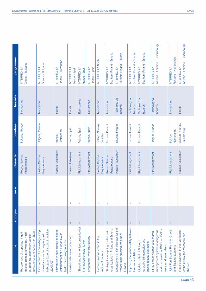
page 43
Environmental Hazards and Risk Management – Thematic Study of INTERREG and ESPON activities Annex
titl
e
Pro
cure
men
t of
a s
peci
al, h
inge
d,
trac
ked
(inst
ead
of w
heel
s), m
ulti-
purp
ose
fire
depa
rtm
ent
vehi
cle
(Dat
e of
issu
e of
dec
isio
n 29
/07/
03)
Pro
cure
men
t of
a fi
re e
xtin
guis
hing
,
surv
eilla
nce
and
emer
genc
y ai
d
helic
opte
r (d
ate
of is
sue
of d
ecis
ion
29/0
7/03
)
Pre
vent
ion
of r
isks
rel
ated
to
flood
s:
esta
blis
hmen
t of
a F
renc
h-S
wis
s
hydr
o m
eteo
rolo
gica
l rad
ar
Cro
ss-b
orde
r w
ater
wor
ksho
p
Sha
red
and
harm
onis
ed c
ross
-bor
der
info
rmat
ion
on s
eism
ic r
isk
Em
erge
ncy
Pyr
enee
s S
ecur
ity
Com
mon
res
cue
actio
n in
the
regi
on o
f Bar
ents
Str
ateg
y fo
r eq
uipp
ing
the
lifeb
oat
orga
nisa
tions
in F
inla
nd a
nd E
ston
ia
Dev
elop
men
t of
ris
k in
dica
tor
for
the
vess
el t
raffi
c cr
ossi
ng t
he G
ulf o
f
Finl
and
Impr
ovin
g th
e m
arin
e sa
fety
bet
wee
n
Hel
sink
i and
Tal
linn
Mod
els
of G
ulf o
f Fin
land
in
oper
ativ
e oi
l rep
ress
ion
and
mar
ine
resc
ue o
pera
tions
Stu
dy a
nd a
pplic
atio
n of
a s
hare
d
man
agem
ent
syst
em o
f dan
gero
us
and
toxi
c w
aste
of S
ME
s an
d V
SE
s
(ver
y sm
all e
nter
pris
es)
Join
t P
ort
Sec
urity
Pla
ns fo
r G
hent
and
Zeel
and
Sea
port
s
Floo
d pr
even
tion
in t
he r
iver
bas
ins
of t
he C
hier
s, t
he M
essa
ncy
and
the
Ton
acro
nym
– – – – – – – – – – – – – –
ww
w
– – – – – – – – – – – – – –
char
acte
r
Res
cue
Ser
vice
Pre
pare
dnes
s
Res
cue
Ser
vice
Pre
pare
dnes
s
Haz
ard
Ass
essm
ent
Haz
ard
Ass
essm
ent
Ris
k M
anag
emen
t
Ris
k M
anag
emen
t
Res
cue
Ser
vice
Pre
pare
dnes
s
Res
cue
Ser
vice
Pre
pare
dnes
s
Haz
ard
Ass
essm
ent
Ris
k M
anag
emen
t
Ris
k M
anag
emen
t
Ris
k M
anag
emen
t
Ris
k M
anag
emen
t
Haz
ard
Ass
essm
ent
coun
trie
s
Bul
garia
, Gre
ece
Bul
garia
, Gre
ece
Fran
ce,
Sw
itzer
land
Fran
ce, S
pain
Fran
ce, S
pain
Fran
ce, S
pain
Finl
and,
Nor
way
,
Sw
eden
Est
onia
, Fin
land
Est
onia
, Fin
land
Est
onia
, Fin
land
Est
onia
, Fin
land
Bel
gium
, Fra
nce
Bel
gium
,
Net
herla
nds
Bel
gium
, Fra
nce,
Luxe
mbo
urg
haza
rds
Not
def
ined
Not
def
ined
Floo
ds
Floo
ds
Ear
thqu
akes
Not
def
ined
Not
def
ined
Not
def
ined
Tech
nolo
gica
l
haza
rds
Tech
nolo
gica
l
haza
rds
Tech
nolo
gica
l
haza
rds
Tech
nolo
gica
l
haza
rds
Not
def
ined
Floo
ds
pro
gra
mm
e
INTE
RR
EG
IIIA
Gre
ece
- B
ulga
ria
INTE
RR
EG
IIIA
Gre
ece
- B
ulga
ria
INTE
RR
EG
IIIA
Fran
ce -
Sw
itzer
land
INTE
RR
EG
IIIA
Fran
ce -
Spa
in
INTE
RR
EG
IIIA
Fran
ce -
Spa
in
INTE
RR
EG
IIIA
Fran
ce -
Spa
in
INTE
RR
EG
IIIA
Nor
th
INTE
RR
EG
IIIA
Sou
ther
n Fi
nlan
d -
Est
onia
INTE
RR
EG
IIIA
Sou
ther
n Fi
nlan
d -
Est
onia
INTE
RR
EG
IIIA
Sou
ther
n Fi
nlan
d -
Est
onia
INTE
RR
EG
IIIA
Sou
ther
n Fi
nlan
d -
Est
onia
INTE
RR
EG
IIIA
Wal
loni
a -
Lorr
aine
- L
uxem
bour
g
INTE
RR
EG
IIIA
Flan
ders
- N
ethe
rland
s
INTE
RR
EG
IIIA
Wal
loni
a -
Lorr
aine
- L
uxem
bour
g

page 44
Annex Environmental Hazards and Risk Management – Thematic Study of INTERREG and ESPON activities
titl
e
Bea
ches
at
Ris
k
Impa
cts
of p
ollu
tant
s on
the
envi
ronm
ent
SU
RD
OV
Sus
tain
able
man
agem
ent
of
cont
aine
d se
dim
ents
(est
uary
wat
ch)
FLO
OD
1 -
Rol
e of
gro
undw
ater
in
flood
ing
even
ts
Ene
rgy
and
Air
Pol
luta
nts:
Pro
duc-
tion,
Tra
nspo
rt a
nd Im
pact
s
Mea
sure
s ag
ains
t er
osio
n an
d aw
are-
ness
rai
sing
of f
arm
ers
Tam
ing
the
wat
ers
of t
he b
asin
of
the
Lys
river
Nor
ther
n R
adar
: a n
ew c
ross
-bor
der
prec
ipita
tion
rada
r to
bet
ter
safe
guar
d
prop
erty
and
peo
ple
agai
nst
flood
ing
haza
rds
Pro
gram
me
de c
oopé
ratio
n po
ur la
gest
ion
du r
isqu
e in
cend
ie d
ans
les
terr
itoire
s du
bas
sin
méd
iterr
anée
n/
Coo
pera
tion
prog
ram
me
on m
anag
e-
men
t of
the
fore
st fi
re r
isk
in t
he
Med
iterr
anea
n ba
sin
Act
ions
pilo
te d
e pr
éven
tion
des
risqu
es d
´inon
datio
n da
ns d
es z
ones
fort
emen
t ur
bani
sées
/ P
ilot
actio
ns
in d
ecre
asin
g in
unda
tion
risks
in
heav
ily u
rban
ised
are
as
A c
atas
trop
he R
ES
pons
e an
d
reC
over
y tr
ansp
ort
and
logi
stic
s
deci
sion
sU
ppor
t sy
stE
m
Inte
rreg
iona
l res
pons
e to
nat
ural
and
man
-mad
e ca
tast
roph
es
acro
nym
– – SU
RD
OV
– FLO
OD
1
– – – Nor
ther
n
Rad
ar
INC
EN
DI
INU
ND
A
RE
SC
UE
SIP
RO
CI
ww
w
– – – – – – – – – – – http
://p
rodu
ctio
n.m
ie.
uth.
gr/r
escu
e/
resc
ue.h
tml
http
://w
ww
.sip
roci
.net
char
acte
r
Ris
k M
anag
emen
t
Haz
ard
Ass
essm
ent
Ris
k M
anag
emen
t
Haz
ard
Ass
essm
ent
Haz
ard
Ass
essm
ent
Haz
ard
Ass
essm
ent
Ris
k M
anag
emen
t
Ris
k M
anag
emen
t
Ris
k M
anag
emen
t
Ris
k M
anag
emen
t
Ris
k M
anag
emen
t
Ris
k M
anag
emen
t
Ris
k M
anag
emen
t
coun
trie
s
Fran
ce,
Uni
ted
Kin
gdom
Fran
ce,
Uni
ted
Kin
gdom
Fran
ce,
Uni
ted
Kin
gdom
Fran
ce,
Uni
ted
Kin
gdom
Fran
ce,
Uni
ted
Kin
gdom
Fran
ce,
Uni
ted
Kin
gdom
Bel
gium
, Fra
nce
Bel
gium
, Fra
nce
Bel
gium
, Fra
nce
Fran
ce, G
reec
e, It
aly,
Por
tuga
l, S
pain
Bel
gium
, Fra
nce,
Ital
y,
Por
tuga
l, S
pain
Gre
ece,
Hun
gary
, Ita
ly
Aus
tria
, Fin
land
,
Ger
man
y, Ir
elan
d,
Italy,
Pol
and
haza
rds
Sto
rm s
urge
s
Tech
nolo
gica
l
haza
rds
Tech
nolo
gica
l
haza
rds
Tech
nolo
gica
l
haza
rds
Floo
ds
Tech
nolo
gica
l
haza
rds
Land
slid
es
Floo
ds
Floo
ds
Fore
st fi
res
Floo
ds
Not
def
ined
Tech
nolo
gica
l haz
ards
pro
gra
mm
e
INTE
RR
EG
IIIA
Fran
co-B
ritis
h
INTE
RR
EG
IIIA
Fran
co-B
ritis
h
INTE
RR
EG
IIIA
Fran
co-B
ritis
h
INTE
RR
EG
IIIA
Fran
co-B
ritis
h
INTE
RR
EG
IIIA
Fran
co-B
ritis
h
INTE
RR
EG
IIIA
Fran
co-B
ritis
h
INTE
RR
EG
IIIA
Fran
ce -
Wal
loni
a -
Flan
ders
INTE
RR
EG
IIIA
Fran
ce -
Wal
loni
a -
Flan
ders
INTE
RR
EG
IIIA
Fran
ce -
Wal
loni
a -
Flan
ders
INTE
RR
EG
IIIC
Sou
th
INTE
RR
EG
IIIC
Sou
th
INTE
RR
EG
IIIC
Eas
t
INTE
RR
EG
IIIC
Eas
t
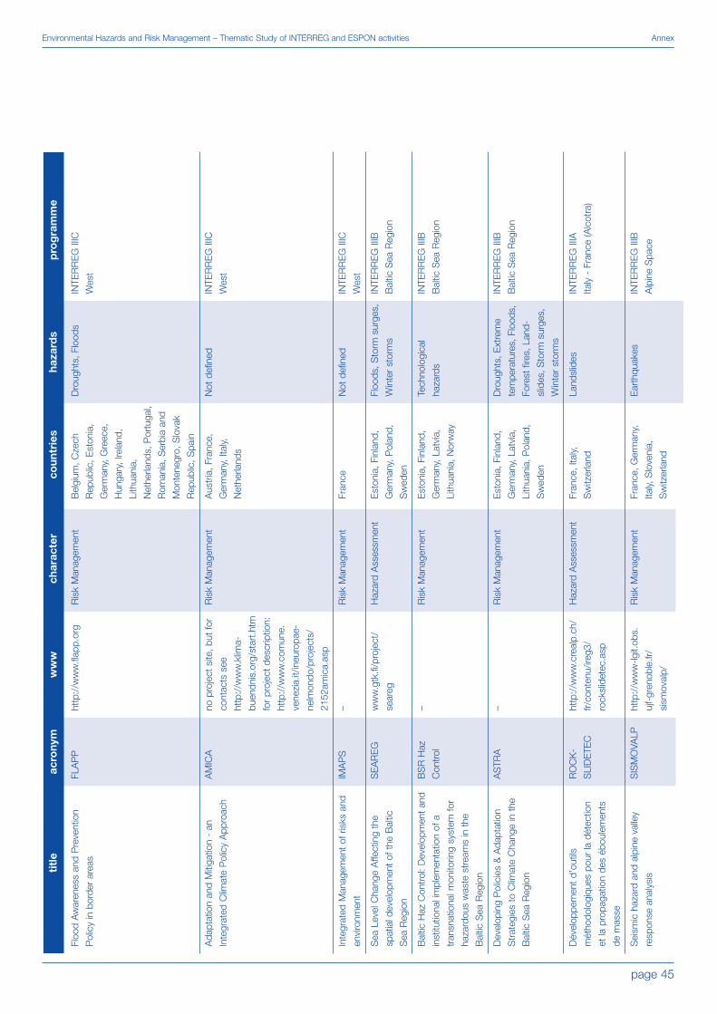
page 45
Environmental Hazards and Risk Management – Thematic Study of INTERREG and ESPON activities Annex
titl
e
Floo
d A
war
enes
s an
d P
reve
ntio
n
Pol
icy
in b
orde
r ar
eas
Ada
ptat
ion
and
Miti
gatio
n -
an
Inte
grat
ed C
limat
e P
olic
y A
ppro
ach
Inte
grat
ed M
anag
emen
t of
ris
ks a
nd
envi
ronm
ent
Sea
Lev
el C
hang
e A
ffect
ing
the
spat
ial d
evel
opm
ent
of t
he B
altic
Sea
Reg
ion
Bal
tic H
az C
ontr
ol: D
evel
opm
ent
and
inst
itutio
nal i
mpl
emen
tatio
n of
a
tran
snat
iona
l mon
itorin
g sy
stem
for
haza
rdou
s w
aste
str
eam
s in
the
Bal
tic S
ea R
egio
n
Dev
elop
ing
Pol
icie
s &
Ada
ptat
ion
Str
ateg
ies
to C
limat
e C
hang
e in
the
Bal
tic S
ea R
egio
n
Dév
elop
pem
ent
d’ou
tils
mét
hodo
logi
ques
pou
r la
dét
ectio
n
et la
pro
paga
tion
des
ébou
lem
ents
de m
asse
Sei
smic
haz
ard
and
alpi
ne v
alle
y
resp
onse
ana
lysi
s
acro
nym
FLA
PP
AM
ICA
IMA
PS
SE
AR
EG
BS
R H
az
Con
trol
AS
TRA
RO
CK
-
SLI
DE
TEC
SIS
MO
VALP
ww
w
http
://w
ww
.flap
p.or
g
no p
roje
ct s
ite, b
ut fo
r
cont
acts
see
http
://w
ww
.klim
a-
buen
dnis
.org
/sta
rt.h
tm
for
proj
ect
desc
riptio
n:
http
://w
ww
.com
une.
vene
zia.
it/in
euro
pae-
nelm
ondo
/pro
ject
s/
2152
amic
a.as
p
– ww
w.g
tk.fi
/pro
ject
/
sear
eg
– – http
://w
ww
.cre
alp.
ch/
fr/co
nten
u/ire
g3/
rock
slid
etec
.asp
http
://w
ww
-lgit.
obs.
ujf-
gren
oble
.fr/
sism
oval
p/
char
acte
r
Ris
k M
anag
emen
t
Ris
k M
anag
emen
t
Ris
k M
anag
emen
t
Haz
ard
Ass
essm
ent
Ris
k M
anag
emen
t
Ris
k M
anag
emen
t
Haz
ard
Ass
essm
ent
Ris
k M
anag
emen
t
coun
trie
s
Bel
gium
, Cze
ch
Rep
ublic
, Est
onia
,
Ger
man
y, G
reec
e,
Hun
gary
, Ire
land
,
Lith
uani
a,
Net
herla
nds,
Por
tuga
l,
Rom
ania
, Ser
bia
and
Mon
tene
gro,
Slo
vak
Rep
ublic
, Spa
in
Aus
tria
, Fra
nce,
Ger
man
y, It
aly,
Net
herla
nds
Fran
ce
Est
onia
, Fin
land
,
Ger
man
y, P
olan
d,
Sw
eden
Est
onia
, Fin
land
,
Ger
man
y, L
atvi
a,
Lith
uani
a, N
orw
ay
Est
onia
, Fin
land
,
Ger
man
y, L
atvi
a,
Lith
uani
a, P
olan
d,
Sw
eden
Fran
ce, I
taly,
Sw
itzer
land
Fran
ce, G
erm
any,
Italy,
Slo
veni
a,
Sw
itzer
land
haza
rds
Dro
ught
s, F
lood
s
Not
def
ined
Not
def
ined
Floo
ds, S
torm
sur
ges,
Win
ter
stor
ms
Tech
nolo
gica
l
haza
rds
Dro
ught
s, E
xtre
me
tem
pera
ture
s, F
lood
s,
Fore
st fi
res,
Lan
d-
slid
es, S
torm
sur
ges,
Win
ter
stor
ms
Land
slid
es
Ear
thqu
akes
pro
gra
mm
e
INTE
RR
EG
IIIC
Wes
t
INTE
RR
EG
IIIC
Wes
t
INTE
RR
EG
IIIC
Wes
t
INTE
RR
EG
IIIB
Bal
tic S
ea R
egio
n
INTE
RR
EG
IIIB
Bal
tic S
ea R
egio
n
INTE
RR
EG
IIIB
Bal
tic S
ea R
egio
n
INTE
RR
EG
IIIA
Italy
- F
ranc
e (A
lcot
ra)
INTE
RR
EG
IIIB
Alp
ine
Spa
ce

page 46
Annex Environmental Hazards and Risk Management – Thematic Study of INTERREG and ESPON activities
titl
e
Opt
imis
atio
n of
the
hyd
ro
met
eoro
gica
l for
ecas
t to
ols
Bal
tic E
utro
phic
atio
n R
egio
nal
NE
Twor
k -
Inte
grat
ed M
anag
emen
t
of C
atch
men
ts
Pro
gram
me
for
Civ
il P
rote
ctio
n in
the
Bal
tic S
ea R
egio
n
Mar
itim
e S
afet
y an
d th
e E
nviro
nmen
t
in t
he S
outh
Bal
tic S
ea R
egio
n
EU
RO
BA
LTIC
Civ
il P
rote
ctio
n
Pro
ject
II
„Kon
zept
ion
zur
raum
ordn
eris
chen
Hoc
hwas
serv
orso
rge
im E
inzu
gs-
gebi
et d
er O
der
Inte
grat
ed M
anag
emen
t of
Wet
land
s
(follo
w u
p)
Sus
tain
able
Use
and
Man
agem
ent
of
Allu
vial
Pla
ins
in D
yked
Riv
er A
reas
DR
AVA
RIV
ER
BA
SIN
PR
OJE
CT
(DR
BP
)
CA
DS
EA
LAN
D
ELB
E -
LA
BE
Pre
vent
ive
flood
man
agem
ent
mea
sure
s by
tran
snat
iona
l spa
tial p
lann
ing
Sys
tem
Inte
grat
ed fo
r S
ecur
ity
Man
agem
ent
Act
iviti
es t
o sa
fegu
ard
and
prot
ect
hist
oric
cen
tres
from
risks
. "C
itize
n as
the
firs
t re
scue
r"
acro
nym
Hyd
ropt
imet
BE
RN
ET-
CAT
CH
EU
RO
BA
LTIC
Bal
tic
MaS
TER
Eur
obal
tic II
OD
ER
RE
GIO
WE
TLA
ND
S II
SU
MA
D
DR
BP
CA
D-
SE
ALA
ND
ELL
A
S.I.
S.M
.A.
ww
w
http
://h
ydro
ptim
et.
med
occ.
org/
tiki-
inde
x.ph
p?pa
ge=
Pro
jet+
HY
DR
OP
TIM
ET
– http
://w
ww
.nor
dreg
io.
se/1
214e
urob
alt.h
tm
http
://w
ww
.syd
sam
.
se/b
altic
mas
ter.a
sp
– ww
w.o
derr
egio
.org
ww
w.w
etla
ndsm
anag
e-
men
t.org
ww
w.s
umad
.org
ww
w.d
rava
-riv
er-
basi
n.ne
t
http
://w
ww
.cad
-
seal
and.
net/
ww
w.e
lla-in
terr
eg.o
rg
http
://w
ww
.cad
ses.
net/
en/p
roje
cts/
appr
pro.
htm
l?
proj
ectId
=10
06
char
acte
r
Haz
ard
Ass
essm
ent
Ris
k M
anag
emen
t
Ris
k M
anag
emen
t
Ris
k M
anag
emen
t
Ris
k M
anag
emen
t
Ris
k M
anag
emen
t
Ris
k M
anag
emen
t
Ris
k M
anag
emen
t
Ris
k M
anag
emen
t
Ris
k M
anag
emen
t
Ris
k M
anag
emen
t
Ris
k M
anag
emen
t
coun
trie
s
Fran
ce, I
taly,
Spa
in
Sw
itzer
land
Den
mar
k, F
inla
nd,
Ger
man
y, P
olan
d,
Rus
sian
Fed
erat
ion,
Sw
eden
Est
onia
, Fin
land
,
Latv
ia, L
ithua
nia,
Nor
way
, Pol
and,
Rus
sian
Fed
erat
ion,
Sw
eden
Den
mar
k, E
ston
ia,
Finl
and,
Ger
man
y,
Lith
uani
a, P
olan
d,
Rus
sian
Fed
erat
ion,
Sw
eden
Sw
eden
Cze
ch R
epub
lic,
Ger
man
y, P
olan
d
Ger
man
y, It
aly
Aus
tria
, Ger
man
y,
Hun
gary
Aus
tria
, Cro
atia
,
Hun
gary
Gre
ece,
Ital
y,
Rom
ania
Aus
tria
, Cze
ch
Rep
ublic
, Ger
man
y,
Hun
gary
Gre
ece,
Ital
y,
Slo
vak
Rep
ublic
,
Slo
veni
a
haza
rds
Floo
ds
Floo
ds
Not
def
ined
Tech
nolo
gica
l
haza
rds
Not
def
ined
Floo
ds
Floo
ds
Floo
ds
Not
def
ined
Sto
rm s
urge
s
Floo
ds
Ear
thqu
akes
pro
gra
mm
e
INTE
RR
EG
IIIB
Wes
tern
Med
iterr
anea
n
(ME
DO
CC
)
INTE
RR
EG
IIIB
Bal
tic S
ea R
egio
n
INTE
RR
EG
IIIB
Bal
tic S
ea R
egio
n
INTE
RR
EG
IIIB
Bal
tic S
ea R
egio
n
INTE
RR
EG
IIIB
Bal
tic S
ea R
egio
n
INTE
RR
EG
IIIB
CA
DS
ES
INTE
RR
EG
IIIB
CA
DS
ES
INTE
RR
EG
IIIB
CA
DS
ES
INTE
RR
EG
IIIB
CA
DS
ES
INTE
RR
EG
IIIB
CA
DS
ES
INTE
RR
EG
IIIC
CA
DS
ES
INTE
RR
EG
IIIB
CA
DS
ES

page 47
Environmental Hazards and Risk Management – Thematic Study of INTERREG and ESPON activities Annex
titl
e
RIS
K-A
dvan
ced
Wea
ther
fore
cast
ing
syst
em t
o A
dvic
e on
Ris
k E
vent
s an
d
man
agem
ent
Agr
icul
ture
and
Clim
ate
Cha
nges
:
how
to
Red
uce
hum
an E
ffect
s an
d
Thre
ats
Red
Cod
e -
Reg
iona
l Dis
aste
r
Com
mon
Def
ence
Dev
elop
men
t of
sto
Rm
wat
er
Ope
ratio
nal P
ract
ices
Gui
delin
e
Hyd
rolo
gica
l cyc
le o
f the
CA
DS
ES
regi
ons
Str
ateg
ies
and
Act
ions
for
Floo
d
Em
erge
ncy
Ris
k M
anag
emen
t
Sus
tain
able
Sed
imen
t M
anag
emen
t
of A
lpin
e R
eser
voirs
con
side
ring
ecol
ogic
al a
nd e
cono
mic
al a
spec
ts
Terr
aced
land
scap
es o
f the
alp
ine
arc
Dis
aste
r In
form
atio
n S
yste
m o
f
ALP
ine
regi
ons
Alp
ine
Inte
grat
ed G
PS
Net
wor
k:
Rea
l-Tim
e M
onito
ring
and
Mas
ter
Mod
el fo
r C
ontin
enta
l Def
orm
atio
n
and
Ear
thqu
ake
Haz
ard
Miti
gatio
n of
hyd
ro-g
eolo
gica
l ris
k in
Alp
ine
catc
hmen
ts
acro
nym
RIS
K A
WA
RE
AC
CR
ETe
Red
Cod
e
Rai
nDR
OP
HY
DR
OC
AR
E
SA
FER
ALP
RE
SE
RV
ALP
TER
DIS
-ALP
ALP
S-
GP
SQ
UA
-
KE
NE
T
Cat
chR
isk
ww
w
http
://w
ww
.cad
ses.
net/
en/p
roje
cts/
appr
pro.
htm
l?
proj
ectId
=10
07
http
://w
ww
.cad
ses.
net/
en/p
roje
cts/
appr
pro.
htm
l?
proj
ectId
=10
08
http
://w
ww
.cad
ses.
net/
en/p
roje
cts/
appr
pro.
htm
l?
proj
ectId
=10
09
http
://w
ww
.cad
ses.
net/
en/p
roje
cts/
appr
pro.
htm
l?
proj
ectId
=10
16
http
://w
ww
.cad
ses.
net/
en/p
roje
cts/
appr
pro.
htm
l?
proj
ectId
=10
17
http
://w
ww
.eu-
safe
r.de/
http
://w
ww
.
alpr
eser
v.or
g
http
://w
ww
.alp
ter.n
et
http
://w
ww
.dis
-alp
.org
http
://w
ww
.alp
s-
gps.
units
.it/
http
://w
ww
.
catc
hris
k.or
g
char
acte
r
Haz
ard
Ass
essm
ent
Ris
k M
anag
emen
t
Ris
k M
anag
emen
t
Ris
k M
anag
emen
t
Haz
ard
Ass
essm
ent
Ris
k M
anag
emen
t
Ris
k M
anag
emen
t
Haz
ard
Ass
essm
ent
Ris
k M
anag
emen
t
Haz
ard
Ass
essm
ent
Ris
k M
anag
emen
t
coun
trie
s
Aus
tria
, Cro
atia
,
Ger
man
y, It
aly,
Pol
and
Cze
ch R
epub
lic,
Ger
man
y, G
reec
e,
Italy,
Rom
ania
,
Slo
veni
a
Gre
ece,
Hun
gary
,
Italy,
Slo
vak
Rep
ublic
,
Slo
veni
a
Cze
ch R
epub
lic,
Ger
man
y, G
reec
e,
Slo
vak
Rep
ublic
Ger
man
y, G
reec
e,
Italy,
Pol
and,
Rom
ania
, Slo
vak
Rep
ublic
Ger
man
y, Ir
elan
d,
Sw
itzer
land
,
Uni
ted
Kin
gdom
Aus
tria
, Ger
man
y,
Italy,
Slo
veni
a,
Sw
itzer
land
Aus
tria
, Fra
nce,
Ital
y,
Slo
veni
a, S
witz
erla
nd
Aus
tria
, Ger
man
y,
Italy,
Slo
veni
a,
Sw
itzer
land
Fran
ce, G
erm
any,
Italy,
Slo
veni
a
Aus
tria
, Ger
man
y,
Italy,
Sw
itzer
land
haza
rds
Floo
ds
Dro
ught
s
Not
def
ined
,
Tech
nolo
gica
l
haza
rds
Floo
ds
Dro
ught
s, F
lood
s
Floo
ds
Floo
ds
Land
slid
es
Ava
lanc
hes,
Flo
ods,
Land
slid
es
Ear
thqu
akes
Dro
ught
s, F
lood
s,
Land
slid
es
pro
gra
mm
e
INTE
RR
EG
IIIB
CA
DS
ES
INTE
RR
EG
IIIB
CA
DS
ES
INTE
RR
EG
IIIB
CA
DS
ES
INTE
RR
EG
IIIB
CA
DS
ES
INTE
RR
EG
IIIB
CA
DS
ES
INTE
RR
EG
IIIB
Nor
th W
est
Eur
ope
INTE
RR
EG
IIIB
Alp
ine
Spa
ce
INTE
RR
EG
IIIB
Alp
ine
Spa
ce
INTE
RR
EG
IIIB
Alp
ine
Spa
ce
INTE
RR
EG
IIIB
Alp
ine
Spa
ce
INTE
RR
EG
IIIB
Alp
ine
Spa
ce

page 48
Annex Environmental Hazards and Risk Management – Thematic Study of INTERREG and ESPON activities
titl
e
Nat
ural
spa
ce a
naly
sis
for
alpi
ne
mou
ntai
n ar
eas
for
a co
oper
ativ
e
deve
lopm
ent
of a
pre
vent
ive
safe
ty
and
risk
man
agem
ent
syst
em fo
r
natu
ral h
azar
ds
Riv
er B
asin
Age
nda
Alp
ineS
pace
Saf
ety
at S
ea
Sus
tain
able
Coa
stal
Ris
k
Man
agem
ent
in 2
050
Floo
d P
lain
Lan
d U
se O
ptim
isin
g
Wor
kabl
e S
usta
inab
ility
Pla
nnin
g fo
r U
rban
-rur
al R
iver
Env
ironm
ents
, Nor
th S
ea R
egio
n
NO
RE
GR
ET:
Fin
ding
the
rig
ht
mea
sure
s to
avo
id w
ater
sho
rtag
e
CO
Mbi
ned
Func
tions
in C
OA
STa
l
Def
ence
Zon
es
Com
mon
Str
ateg
ies
to r
educ
e th
e
risk
of s
torm
floo
ds in
coa
stal
low
land
s
Eur
opea
n S
olut
ions
by
Co-
oper
atio
n
and
Pla
nnin
g in
Em
erge
ncie
s (fo
r
coas
tal f
lood
ing)
Floo
d R
isk
Man
agem
ent
in E
stua
ries:
Sus
tain
able
New
Lan
d U
se in
Flo
od
Con
trol
Are
as
Join
t A
ppro
ach
for
Man
agin
g
Floo
ding
Ext
rem
e Fl
oods
and
Flo
od P
rote
ctio
n
alon
g th
e R
hine
Cre
atin
g N
ew L
ands
cape
s fo
r Fl
ood
Ris
k M
anag
emen
t
acro
nym
NA
B
Riv
er B
asin
Age
nda
S@
S
SA
FEC
OA
ST
FLO
WS
PU
RE
Nor
th S
ea
NO
RE
GR
ET
CO
MC
OA
ST
CO
MR
ISK
ES
CA
PE
FRaM
E
J.A
.F.
FAR
Floo
dsca
pe
ww
w
http
://w
ww
.tiro
l.gv.
at/n
ab
http
://w
ww
.flus
srau
m-
agen
da.d
e
ww
w.s
afet
yats
ea.s
e
– ww
w.fl
ows.
nu
ww
w.p
ure-
nort
hsea
.com
– – ww
w.c
omris
k.or
g
– ww
w.fr
amep
roje
ct.o
rg
– – ww
w.fl
oods
cape
.net
char
acte
r
Ris
k M
anag
emen
t
Ris
k M
anag
emen
t
Ris
k M
anag
emen
t
Ris
k M
anag
emen
t
Ris
k M
anag
emen
t
Ris
k M
anag
emen
t
Ris
k M
anag
emen
t
Ris
k M
anag
emen
t
Ris
k M
anag
emen
t
Ris
k M
anag
emen
t
Ris
k M
anag
emen
t
Ris
k M
anag
emen
t
Ris
k M
anag
emen
t
Ris
k M
anag
emen
t
coun
trie
s
Aus
tria
, Ger
man
y, It
aly,
Slo
veni
a, S
witz
erla
nd
Aus
tria
, Fra
nce,
Ital
y,
Slo
veni
a, S
witz
erla
nd
Bel
gium
, Net
herla
nds,
Nor
way
, Sw
eden
,
Uni
ted
Kin
gdom
Bel
gium
, Den
mar
k,
Ger
man
y, N
ethe
rland
s,
Uni
ted
Kin
gdom
Ger
man
y, N
ethe
rland
s,
Nor
way
, Sw
eden
,
Uni
ted
Kin
gdom
Net
herla
nds,
Sw
eden
,
Uni
ted
Kin
gdom
Bel
gium
, Den
mar
k,
Ger
man
y, N
ethe
rland
s
Bel
gium
, Ger
man
y,
Net
herla
nds
Bel
gium
, Den
mar
k,
Ger
man
y, N
ethe
rland
s,
Uni
ted
Kin
gdom
Bel
gium
,
Net
herla
nds,
Uni
ted
Kin
gdom
Bel
gium
,
Net
herla
nds,
Uni
ted
Kin
gdom
Ger
man
y, N
ethe
rland
s,
Uni
ted
Kin
gdom
Ger
man
y,
Net
herla
nds
Bel
gium
, Ger
man
y,
Net
herla
nds,
Uni
ted
Kin
gdom
haza
rds
Floo
ds, L
ands
lides
Floo
ds
Tech
nolo
gica
l
haza
rds
Floo
ds,
Sto
rm s
urge
s,
Win
ter
stor
ms
Floo
ds,
Sto
rm s
urge
s,
Win
ter
stor
ms
Floo
ds
Dro
ught
s
Floo
ds,
Sto
rm s
urge
s,
Win
ter
stor
ms
Sto
rm s
urge
s,
Win
ter
stor
ms
Sto
rm s
urge
s
Floo
ds
Floo
ds
Floo
ds
Floo
ds
pro
gra
mm
e
INTE
RR
EG
IIIB
Alp
ine
Spa
ce
INTE
RR
EG
IIIB
Alp
ine
Spa
ce
INTE
RR
EG
IIIB
Nor
th S
ea R
egio
n
INTE
RR
EG
IIIB
Nor
th S
ea R
egio
n
INTE
RR
EG
IIIB
Nor
th S
ea R
egio
n
INTE
RR
EG
IIIB
Nor
th S
ea R
egio
n
INTE
RR
EG
IIIB
Nor
th S
ea R
egio
n
INTE
RR
EG
IIIB
Nor
th S
ea R
egio
n
INTE
RR
EG
IIIB
Nor
th S
ea R
egio
n
INTE
RR
EG
IIIB
Nor
th S
ea R
egio
n
INTE
RR
EG
IIIB
Nor
th S
ea R
egio
n
INTE
RR
EG
IIIB
Nor
th W
est
Eur
ope
INTE
RR
EG
IIIB
Nor
th W
est
Eur
ope
INTE
RR
EG
IIIB
Nor
th W
est
Eur
ope

page 49
Environmental Hazards and Risk Management – Thematic Study of INTERREG and ESPON activities Annex
titl
e
From
Col
lect
ive
Test
ing
to a
Tra
ns-
natio
nal A
naly
sis
of t
he In
tern
atio
nal
Riv
er B
asin
Dis
tric
t of
the
Sch
eldt
as
a B
asis
for
a Tr
ansn
atio
nal I
nteg
rate
d
Wat
er M
anag
emen
t fo
r a
Cle
aner
and
Saf
er S
chel
dt
Pro
blem
s in
the
Rea
lisat
ion
of
Fore
sted
Wat
er R
eten
tion
Are
as :
Nat
ural
and
Soc
ial S
cien
tific
Stu
dies
in t
he R
iver
Rhi
ne C
atch
men
t
Wat
er R
eten
tion
by L
and
Use
Sus
tain
able
Dev
elop
men
t of
Flo
od
Pla
ins
Nat
ure-
Orie
nted
Flo
od D
amag
e
Pre
vent
ion
Sus
tain
able
Wat
er M
anag
emen
t in
Urb
an S
pace
Tran
snat
iona
l Int
erne
t M
ap
Info
rmat
ion
Sys
tem
on
Floo
ding
NO
AH
SA
ND
Eur
opea
n S
patia
l Pla
nnin
g:
Ada
ptin
g to
Clim
ate
Eve
nts
Cre
atin
g a
Sus
tain
able
Fra
mew
ork
for
ICZM
Red
ucie
ndo
el R
iesg
o S
ism
ovol
-
cáni
co e
n A
zore
s y
Can
aria
s:
Des
arro
llo e
Impl
emen
taci
ón d
e un
Sis
tem
a pa
ra la
Pro
tecc
ión
Civ
il
basa
do e
n la
Det
ecci
ón d
e S
eñal
es
Per
curs
oras
de
Eru
pcio
nes
Volc
ánic
a
acro
nym
SC
ALD
IT
FOW
AR
A
WA
RE
LA
SD
F
NO
FDP
Urb
an W
ater
TIM
IS
NO
AH
SA
ND
ES
PAC
E
CO
RE
PO
INT
ALE
RTA
ww
w
– – ww
w.w
arel
a.de
ww
w.S
DFp
roje
ct.n
l
– – ww
w.ti
mis
flood
.net
– – ww
w.e
spac
e-
proj
ect.o
rg
– http
://w
ww
.iter
.es/
I18N
Laye
r.are
asite
r/
es/m
edio
ambi
ente
/
riesg
o/al
erta
/
char
acte
r
Ris
k M
anag
emen
t
Ris
k M
anag
emen
t
Ris
k M
anag
emen
t
Ris
k M
anag
emen
t
Ris
k M
anag
emen
t
Ris
k M
anag
emen
t
Haz
ard
Ass
essm
ent
Ris
k M
anag
emen
t
Ris
k M
anag
emen
t
Ris
k M
anag
emen
t
Ris
k M
anag
emen
t
Ris
k M
anag
emen
t
coun
trie
s
Bel
gium
, Fra
nce,
Net
herla
nds
Fran
ce, G
erm
any,
Net
herla
nds
Fran
ce, G
erm
any,
Luxe
mbo
urg,
Sw
itzer
land
Ger
man
y,
Net
herla
nds
Ger
man
y,
Net
herla
nds
Fran
ce, G
erm
any,
Net
herla
nds,
Uni
ted
Kin
gdom
Fran
ce, G
erm
any,
Luxe
mbo
urg
Ger
man
y,
Net
herla
nds
Fran
ce, G
erm
any,
Net
herla
nds
Bel
gium
, Ger
man
y,
Net
herla
nds,
Uni
ted
Kin
gdom
Bel
gium
, Fra
nce,
Irela
nd, N
ethe
rland
s,
Uni
ted
Kin
gdom
Por
tuga
l, S
pain
haza
rds
Floo
ds
Floo
ds
Floo
ds
Floo
ds
Floo
ds
Floo
ds
Floo
ds
Floo
ds
Floo
ds
Dro
ught
s, E
xtre
me
tem
pera
ture
s, F
lood
s
Floo
ds,
Sto
rm s
urge
s
Ear
thqu
akes
,
Volc
anic
eru
ptio
ns
pro
gra
mm
e
INTE
RR
EG
IIIB
Nor
th W
est
Eur
ope
INTE
RR
EG
IIIB
Nor
th W
est
Eur
ope
INTE
RR
EG
IIIB
Nor
th W
est
Eur
ope
INTE
RR
EG
IIIB
Nor
th W
est
Eur
ope
INTE
RR
EG
IIIB
Nor
th W
est
Eur
ope
INTE
RR
EG
IIIB
Nor
th W
est
Eur
ope
INTE
RR
EG
IIIB
Nor
th W
est
Eur
ope
INTE
RR
EG
IIIB
Nor
th W
est
Eur
ope
INTE
RR
EG
IIIB
Nor
th W
est
Eur
ope
INTE
RR
EG
IIIB
Nor
th W
est
Eur
ope
INTE
RR
EG
IIIB
Nor
th W
est
Eur
ope
INTE
RR
EG
IIIB
Can
arie
s -
Mad
eira
- A
core
s

page 50
Annex Environmental Hazards and Risk Management – Thematic Study of INTERREG and ESPON activities
titl
e
Red
ucie
ndo
el R
iesg
o S
ism
o-
volc
ánic
o en
Azo
res
y C
anar
ias:
Des
arro
llo e
Impl
emen
taci
ón d
e un
Sis
tem
a de
Ale
rta
para
la P
rote
cció
n
Civ
il ba
sado
en
la D
etec
ción
de
Señ
ales
Pre
curs
oras
de
Eru
pcio
nes
Volc
ánic
as
Pla
n de
Con
tinge
ncia
de
Con
tam
inac
ión
Mar
ina
de la
Reg
ión
Mac
aron
ésic
a
Red
Inte
grad
a de
Mon
otor
izac
ión,
Ale
rta
y G
estió
n de
Rie
sgos
de
Vert
idos
Con
tam
inan
tes
e In
cide
ntes
Cat
astr
ófic
os e
n la
Zon
a M
aríti
ma
Mac
aron
ésic
a
Ext
rem
e W
eath
er C
ondi
tions
Pro
gram
me
Pue
rtos
lim
pios
Pro
gram
a de
inte
rven
ción
Pos
t-P
rest
ige
Rec
uper
ació
n de
pai
saje
s co
n
terr
azas
y p
reve
nció
n de
rie
sgos
natu
rale
s
Pat
rimoi
ne e
t pr
éven
tion
des
risqu
es
natu
rels
/ H
erita
ge a
nd p
reve
ntio
n of
"nat
ural
ris
ks"
Att
entio
n to
War
ning
And
Rea
dine
ss in
Em
erge
ncie
s
acro
nym
ALE
RTA
II
PLA
CO
N
ALE
RM
AC
EW
CP
Por
ts N
et
Pos
t P
rest
ige
TER
RIS
C
NO
É
AW
AR
E
ww
w
http
://w
ww
.iter
.es/
I18N
Laye
r.are
asite
r/
es/m
edio
ambi
ente
/
riesg
o/al
erta
/
– http
://w
ww
.fund
a-
cion
puer
tos.
com
/
0000
0/pa
gina
s/ht
ml/
defa
ult.h
tm
http
://w
ww
.ew
cp.o
rg/
http
://w
ww
.gen
cat.
net/
med
iam
b/
sost
en/p
orts
nets
/
port
snet
s.ht
m
– http
://w
ww
.inte
rreg
-
sudo
e.or
g/ca
stel
lano
/
proy
ecto
s/w
ww
.con
-
selld
emal
lorc
a.ne
t/
med
iam
bien
t/te
rris
c
http
://n
oe-
inte
rreg
3c.n
et/p
ublic
/
–
char
acte
r
Ris
k M
anag
emen
t
Ris
k M
anag
emen
t
Haz
ard
Ass
essm
ent
Ris
k M
anag
emen
t
Ris
k M
anag
emen
t
Ris
k M
anag
emen
t
Haz
ard
Ass
essm
ent
Ris
k M
anag
emen
t
Ris
k M
anag
emen
t
coun
trie
s
Por
tuga
l, S
pain
Por
tuga
l, S
pain
Por
tuga
l, S
pain
Finl
and,
Nor
way
,
Uni
ted
Kin
gdom
Fran
ce, P
ortu
gal,
Spa
in
Fran
ce, S
pain
Fran
ce, P
ortu
gal,
Spa
in
Fran
ce, G
reec
e,
Italy,
Por
tuga
l
Bel
gium
, Lith
uani
a,
Net
herla
nds,
Rom
ania
,
Rus
sian
Fed
erat
ion,
Uni
ted
Kin
gdom
haza
rds
Volc
anic
eru
ptio
ns
Tech
nolo
gica
l
haza
rds
Tech
nolo
gica
l
haza
rds
Ext
rem
e
tem
pera
ture
s
Tech
nolo
gica
l
haza
rds
Tech
nolo
gica
l
haza
rds
Floo
ds, L
ands
lides
Ear
thqu
akes
,
Land
slid
es,
Not
def
ined
Floo
ds,
Tech
nolo
gica
l
haza
rds
pro
gra
mm
e
INTE
RR
EG
IIIB
Can
arie
s -
Mad
eira
- A
core
s
INTE
RR
EG
IIIB
Can
arie
s -
Mad
eira
- A
core
s
INTE
RR
EG
IIIB
Can
arie
s -
Mad
eira
- A
core
s
INTE
RR
EG
IIIB
Nor
ther
n P
erip
hery
INTE
RR
EG
IIIB
Sou
th-W
est
Eur
ope
INTE
RR
EG
IIIB
Sou
th-W
est
Eur
ope
INTE
RR
EG
IIIB
Sou
th-W
est
Eur
ope
INTE
RR
EG
IIIC
Sou
th
INTE
RR
EG
IIIC
Wes
t

page 51
Environmental Hazards and Risk Management – Thematic Study of INTERREG and ESPON activities Annex
titl
e
App
licat
ion
des
mét
hodo
logi
es d
e
prév
isio
ns h
ydro
mét
éoro
logi
ques
orie
ntée
s au
x ris
ques
env
iron-
nem
enta
ux /
App
licat
ion
of
hydr
omet
eoro
logi
cal m
ethd
olog
ies
in
eval
uatin
g en
viro
nmen
tal r
isks
Dév
elop
pem
ent
d´ac
tions
pou
r le
mar
ketin
g et
la g
estio
n po
st-
évén
emen
t /
Dev
elop
men
t of
post
-eve
nt a
ctio
ns in
mar
ketin
g an
d
man
agem
ent
Com
mon
str
ateg
y fo
r th
e E
ster
n
Med
iterr
anea
n in
pre
dict
ing
and
pre-
vent
ing
maj
or fo
rest
fire
s
Use
of c
ypre
ss in
Med
iterr
anea
n ru
ral
econ
omy,
env
ironm
ent
and
land
scap
e
prot
ectio
n: n
atur
al r
isks
pre
vent
ion
and
man
agem
ent
Qua
lité
dans
le t
errit
oire
/
Terr
itoria
l qua
lity
Com
mon
str
ateg
y fo
r W
este
rn
Med
iterr
anea
n in
com
mun
icat
ing
natu
ral h
azar
ds a
nd r
isks
Mét
hodo
logi
e po
ur la
ges
tion
des
risqu
es d
´ébo
ulem
ent
et d
es
mou
vem
ents
du
sol a
vec
scén
ario
s
de p
oliti
que
d´as
sura
nce
/
Met
hodo
logy
for
man
agem
ent
of
land
slid
e an
d so
il dr
ift r
isks
Séc
here
sse
et D
éser
tific
atio
n da
ns
le B
assi
n M
édite
rran
éen
/ D
roug
hts
and
dese
rtifi
catio
n in
the
Med
iterr
anea
n ba
sin
acro
nym
AM
PH
OR
E
DA
MA
GE
Grin
fom
ed+
Med
ifire
Med
Cyp
re
QU
ATE
R
RIN
AM
ED
RIS
CM
AS
S
SE
DE
ME
D
ww
w
http
://a
mph
ore.
med
occ.
org/
tikiin
dex.
php
– – ww
w.c
ypm
ed.
cupr
essu
s.or
g
– http
://w
ww
.rin
amed
.
net
– http
://w
ww
.uirs
icilia
.it/
char
acte
r
Haz
ard
Ass
essm
ent
Ris
k M
anag
emen
t
Ris
k M
anag
emen
t
Ris
k M
anag
emen
t
Ris
k M
anag
emen
t
Ris
k M
anag
emen
t
Ris
k M
anag
emen
t
Haz
ard
Ass
essm
ent
coun
trie
s
Fran
ce, I
taly,
Spa
in
Fran
ce, G
reec
e,
Italy,
Spa
in
Fran
ce, I
taly,
Por
tuga
l, S
pain
Fran
ce, G
reec
e,
Italy,
Mal
ta,
Por
tuga
l, S
pain
Fran
ce, I
taly,
Spa
in
Fran
ce, I
taly,
Spa
in
Gre
ece,
Ital
y, S
pain
Gre
ece,
Ital
y,
Por
tuga
l, S
pain
haza
rds
Floo
ds
Not
def
ined
,
Tech
nolo
gica
l
haza
rds
Fore
st fi
res
Dro
ught
s,
Fore
st fi
res
Not
def
ined
Ava
lanc
hes,
Dro
ught
s,
Ear
thqu
akes
, Ext
rem
e
tem
pera
ture
s, F
lood
s,
Fore
st fi
res,
Lan
d-
slid
es, S
torm
sur
ges,
Volc
anic
eru
ptio
ns
Land
slid
es
Dro
ught
s
pro
gra
mm
e
INTE
RR
EG
IIIB
Wes
tern
Med
iterr
anea
n
(ME
DO
CC
)
INTE
RR
EG
IIIB
Wes
tern
Med
iterr
anea
n
(ME
DO
CC
)
INTE
RR
EG
IIIB
Wes
tern
Med
iterr
anea
n
(ME
DO
CC
)
INTE
RR
EG
IIIB
Wes
tern
Med
iterr
anea
n
(ME
DO
CC
)
INTE
RR
EG
IIIB
Wes
tern
Med
iterr
anea
n
Pro
gram
me
(ME
DO
CC
)
INTE
RR
EG
IIIB
Wes
tern
Med
iterr
anea
n
(ME
DO
CC
)
INTE
RR
EG
IIIB
Wes
tern
Med
iterr
anea
n
(ME
DO
CC
)
INTE
RR
EG
IIIB
Wes
tern
Med
iterr
anea
n
(ME
DO
CC
)

page 52
Annex Environmental Hazards and Risk Management – Thematic Study of INTERREG and ESPON activities
titl
e
Inte
rreg
iona
l and
tra
nsna
tiona
l
appr
oach
in m
ariti
me
safe
ty a
nd
prot
ectio
n of
the
env
ironm
ent
in
Wes
tern
Med
iterr
anea
n
Miti
gatio
n of
nat
ural
ris
ks t
hrou
gh
impr
oved
fore
cast
ing
of e
xtre
me
met
e-
orol
ogic
al e
vent
s
Rei
nfor
cem
ent
of t
he t
echn
ical
mea
ns a
nd w
ays
to d
eal w
ith t
he
cons
eque
nces
of t
he p
ollu
tion
caus
ed b
y th
e si
nkin
g of
the
Pre
stig
e
Em
erge
ncy
resp
onse
to
coas
tal o
il,
chem
ical
and
iner
t po
llutio
n fro
m
ship
ping
acro
nym
SE
CU
RM
ED
Met
eoris
k
PR
ES
TIG
E
ER
OC
IPS
ww
w
– ww
w.m
eteo
risk.
com
ww
w.m
eteo
risk.
com
http
://w
ww
.ero
cips
.
org/
char
acte
r
Ris
k M
anag
emen
t
Haz
ard
Ass
essm
ent,
Ris
k M
anag
emen
t an
d
Res
cue
Ser
v
Ris
k M
anag
emen
t
Ris
k M
anag
emen
t
coun
trie
s
Fran
ce, G
reec
e,
Italy,
Spa
in
Aus
tria
, Ger
man
y,
Italy,
Slo
veni
a,
Sw
itzer
land
Fran
ce, S
pain
Fran
ce, P
ortu
gal,
Spa
in,
Uni
ted
Kin
gdom
haza
rds
Tech
nolo
gica
l
haza
rds
Ava
lanc
hes,
Ext
rem
e te
mpe
ratu
res,
Floo
ds
Tech
nolo
gica
l
haza
rds
Tech
nolo
gica
l
haza
rds
pro
gra
mm
e
INTE
RR
EG
IIIB
Wes
tern
Med
iterr
anea
n
(ME
DO
CC
)
INTE
RR
EG
IIIB
Alp
ine
Spa
ce
INTE
RR
EG
IIIB
Atla
ntic
Are
a
INTE
RR
EG
IIIB
Atla
ntic
Are
a

ESPON Coordination UnitTechnoport Schlassgoart66, rue de LuxembourgL-4221 Esch-sur-AlzetteLuxembourg
INTERACT Point Qualification &Transfer Jernbanegade 22DK-8800 ViborgDenmark