environmental flows for kumbh 2013 at triveni sangam...
TRANSCRIPT

3
Environmental Flows for Kumbh 2013 at Triveni Sangam, Allahabad
Supported By:Supported By:

AUTHORSDr. Vinod Tare, Swami Gyanswaroop Sanand, Dr. I. C. Agarwal, Dr. Ravi Chopra,
Dr. Anil Gautam, Mr. Nitin Kaushal, Mr. Suresh Babu, Dr. Sandeep Behera,
Dr. K. D. Joshi, Mr. Paritosh Tyagi, Mr. Ravindra Kumar, Dr. R. P. Mathur,
Dr. Rajiv Sinha, Dr. Shivam Tripathi, Dr. Ashu Jain, Dr. Rajesh Srivastava and Dr. Anurag Ohri.
ACKNOWLEDGEMENTSThis work on “Environmental Flows for Kumbh 2013 at Triveni Sangam, Allahabad” was made
possible by the technical support of partners (IIT Kanpur, CIFRI, PSI Dehradun and experts).
We also sincerely acknowledge the guidance of all the Working Group members.
We also extend our gratitude to Prof. A. P. Sharma from CIFRI for being supportive of this
initiative and for the active engagement of CIFRI, Allahabad.
At WWF-India, we are highly obliged to Mr. Ravi Singh, Secretary General and CEO, who gave
us unparalleled support during this assignment and Dr. Sejal Worah, Director – Programmes,
who guided us and gave us critical inputs in shaping the study.
We would also like to acknowledge HSBC’s financial support through the HSBC Water
Programme.
Published by WWF-India
© WWF-India 2013
Designed by: Sarita Singh, Nirmal Singh
Photo Credit: Cover photo - CSE - Environment Library & facing page photo - Amritpal Singh
Printed on 100% recycled paper

Environmental Flows for Kumbh 2013 at Triveni Sangam, Allahabad

The E-Flows assessment for Kumbh 2013 was done by a multidisciplinary teamfrom various organizations as given below:
Component of Study Name Affiliation
Facilitation and overall Dr. Vinod Tare IIT KanpurCoordination Mr. Nitin Kaushal WWF-India
Mr. Suresh Babu WWF-India
Socio-Cultural Surveys Dr. Ravi Chopra PSI, DehradunDr. Anil Gautam PSI, Dehradun
Hydraulic Modeling Dr. Shivam Tripathi IIT KanpurDr. Rajesh Srivastava IIT KanpurDr. Ashu Jain IIT KanpurDr. Vinod Tare IIT Kanpur
Biodiversity Dr. R P Mathur IIT KanpurDr. K D Joshi CIFRI, AllahabadDr. Sandeep Behera WWF-IndiaDr. Vinod Tare IIT Kanpur
Fluvial Geomorphology Dr. Rajiv Sinha IIT Kanpur
Cross Section Survey Dr. Anurag Ohri IT (BHU) Varanasi
The Working Group members, namely Swami Gyanswaroop Sanand, Prof. IC Agarwal, Mr. Paritosh Tyagi and Mr. Ravindar Kumar also contributed tothis exercise.
RESOURCE PERSONS
Photo Credit: WWF-India
2

Environmental Flows for Kumbh 2013 at Triveni Sangam, Allahabad CONTENTSAcknowledgements
Resource Persons .................................................................................................................... 2
Chapter 1...................................................................................................................................... 5Prologue
Chapter 2 ..................................................................................................................................... 7The Process
Chapter 3 ..................................................................................................................................... 9Results
Chapter 4 ..................................................................................................................................... 11Epilogue
Appendix ................................................................................................................................... 13

4
Ph
oto
cre
dit: A
mritp
al S
ing
h
A Sadhu (holyman) worshipping the Ganga at Allahabad. The National River Ganga is considered sacred and
revered by millions of Indians.

Kumbh 2013 is expected to be the largestcongregation of people for a religious purpose,anywhere in the world. Over 80 million people areexpected to visit the city of Allahabad, Uttar Pradeshon the banks of the River Ganga from January 14 toMarch 10, 2013. It is believed that a holy dip in theGanga during this period will help pilgrims attainsalvation.
Kumbh has always been a socio-cultural mega eventwhere millions of cultural tourists and pilgrims visit
Sangam and take a holy dip for satisfaction of their spiritual aspirations. The flowsin the river Ganga and the quality of its water has always been a talking point, notonly amongst visitors and residents, but also within Government circles, as to howthese issues can be resolved to make sure that the event is a success. The Hon’bleHigh Court of Allahabad has directed the Government of Uttar Pradesh that 50% ofthe basic discharge be released. There is also a demand for ‘adequate’ flows toensure a free flowing and clean Ganga during Kumbh.
Kumbh is a unique opportunity for the Government of Uttar Pradesh to place itselfas a pioneer on the world map for its efforts in restoring Environmental Flows forthe welfare of people and nature. Environmental Flows (or simply E-Flows) aredefined as the flows required for the maintenance of the ecological integrity ofrivers, their associated ecosystems, and the goods and services provided by them.E-Flows are a pattern of flows required by the river to sustain its functions (socio-cultural, geomorphic or sediment transport, supporting biodiversity andlivelihoods) and to fulfill the aspirations of the people.
The question is “How much flow in the river Ganga will meet the socio-culturalaspirations of the people during Kumbh 2013?” A scientific assessment of E-Flowsis therefore warranted. This would greatly facilitate in making informed decisionsso as to ensure E-Flows during Kumbh. In this context, it was decided that a rapidassessment of E-Flows for Kumbh 2013 at Allahabad would be a valuablecontribution to the Government’s efforts to ensure a clean Kumbh.
This is a unique opportunity for the Government of Uttar Pradesh to demonstrateits commitment to the people and nature by releasing not just ‘adequate’ flows butE-Flows. U.P. will become the first state in India to have taken steps to restore E-Flows in stressed rivers. This will also set an example for other states to initiatethe process of E-Flows in their respective rivers.
Chapter 1PROLOGUE
5

6
Ph
oto
cre
dit: N
itin K
au
sh
al / W
WF
-Ind
ia
Current flows in the Ganga at Shastri Bridge, Allahabad during late December 2012. Lean flows in the Ganga are
a matter of concern for the pilgrims and the Government.

7
WWF-India initiated the assessment of E-Flowsrequirement during Kumbh 2013 using Building BlockMethodology (BBM) – recognized internationally as aholistic and robust methodology. BBM, which has beenused for rivers in different parts of the world, is alsoknown for its flexibility, applicability and reliabilityunder different levels of data and informationavailability. This methodology was further adapted toIndian conditions by WWF-India and its partners tocarry out the assessment of E-Flows in the UpperGanga basin1. The underlying principle that drove this
work was that the studies related to E-Flows are multidisciplinary, and theirassessment is both a social and technical process, with social choices at its core.Social choices reflect ‘what society wants a river to do for them – to support cultureand spirituality or livelihoods or biodiversity or all of the above functions and more’.
The BBM is being used for the assessment of E-Flows for the entire stretch of riverGanga2 by the Consortia of seven IITs working on the ‘Ganga River BasinEnvironment Management Plan’ (GRBEMP). A flow chart illustrating the broadsteps of BBM for the assessment of E-Flows is depicted below.
In order to assess the flow requirement at Allahabad during Kumbh 2013 that meetsthe aspirations of the people and nature, a multi-disciplinary Working Group wasconvened by WWF-India, comprising technical institutions, NGOs and independentexperts. The Working Group comprised the following expert members:
Chapter 2THE PROCESS
Figure 1:
BBM process chart
SCOPING &OBJECTIVE
SETTING
FIELDSURVEYS
E-FLOWSSETTING
� River stretch identified for E-Flows assessment� Listing of associated components plus any critical aspect� Set the objective for desired state of river
� Undertake detailed field investigations with regard to identifiedcomponents and local aspect
� Preparation of starter document or thematic reports
� Presentation of respective surveys and reports� E-Flows setting based on the hydrology of the river and
hydraulic modeling
1 O Keeffe Jay, Kaushal Nitin, Bharati Luna, Smakhtin Vladimir (2012) Assessment of EnvironmentalFlows for Upper Ganga. Published by WWF – India 2 Environmental Flows: State-of-the-Art with special reference to Rivers in the Ganga River Basin, Reportby Consortia of 7 IITs for Preparation of Ganga River Basin Environment Management Plan (GRBEMP),Report Code: 022_GBP_IIT_EFL_SOA_01_Ver 1_Dec 2011.
� Prof. Vinod Tare – IIT Kanpur� Swami Gyanswroop Sanand –
Vidya Math, Varanasi� Prof. I. C Agarwal – Former
Director, MNNIT, Allahabad� Mr. Paritosh Tyagi – Former
Chairman, CPCB, Delhi
� Dr. Ravi Chopra – PSI, Dehradun� Dr. Anil Gautam – PSI, Dehradun� Dr. K. D Joshi – CIFRI, Allahabad� Mr. Ravindra Kumar – SWaRA, U.P.� Mr. Nitin Kaushal – WWF-India� Mr. Suresh Babu – WWF-India� Dr. Sandeep Behera – WWF-India

The purpose of setting up this Working Group was to initiate a consultative processto guide the process of assessment of E-Flows. The group met at CIFRI3, Allahabadon November 16, 2012 and identified socio-cultural aspirations as the primemotivation for E-Flows during Kumbh. However, it was also suggested that flowsrequired for ecological and geomorphological purposes should also be considered.Primary socio-cultural surveys were conducted from November 27, 2012 toDecember 5, 2012 at Allahabad, Haridwar, Rishikesh and Varanasi. Reports fromthe Consortia of seven IITs preparing the Ganga River Basin EnvironmentManagement Plan were used for information about fluvial geomorphologicalsettings in the stretch of the river Ganga considered in this study. Existing researchand data on aquatic biodiversity in the Ganga (around Allahabad), which isavailable with consortia of seven IITs, CIFRI and WWF-India was used. Sincehydraulics and hydrology data was not available in the public domain, river crosssection surveys at seven select places along with gauge and discharge measurementswere also carried out to develop a hydraulic model and undertake reality checks.
All surveys and studies were documented in the form of thematic reports and the samewere presented and discussed at the E-Flows Setting Workshop organized onDecember 16 - 17, 2012 at IIT Kanpur. The objective was to arrive at the E-Flowsvalues for Kumbh 2013 in Allahabad. Thematic groups filled up flow motivation formsindicating the desired water depth, water surface width, and velocity for two scenarios:
1. During entire Kumbh period, i.e. from January 14 to March 10, 2013.2. Special Snans (bathing) scheduled on January 14, January 27, February 10,
February 15, February 25 and March 10, 2013.
8
Plate 1:
Snapshot of area around
Sangam at Allahabad
indicating location of
Cross Section surveys
Source: IIT-Kanpur
3 CIFRI-Central Inland Fisheries Research Institute
Teliarganj
Ashok Nagar
Allahabad
Jhunsi
•
•
•
•

9
3.1. DEPTH, WIDTH AND VELOCITY
The thematic groups recommended that the waterdepth considerations be treated as non-negotiable.Tables 1 and 2 summarize the recommendations madefor the entire duration of Kumbh and for “specialsnan days” respectively at the site just upstream ofSangam represented by Cross Section 4 shown onPlate 1. The site falls in the bathing area identified bythe Mela administration.
3.2. HYDRAULIC MODEL
The stage discharge curves were developed using Manning's equation assuminguniform flow condition. The Manning's roughness was obtained based on the valuesreported in the literature for similar conditions. The values were tested to be higherthan its lower limit estimated from sieve analysis of bed material. The water surfaceslope was obtained by calibrating the Manning's equation against field data.
Using average water surface slope and measured water velocities for the river crossCross Sections 1 and 4, a stage-discharge curve corresponding to Cross Section 2 wasdeveloped (Figure 3). This was used to assess the E-Flows corresponding to the flowmotivation parameters recommended at Section 4. Since the distance between Cross
Chapter 3RESULTS
Table 1: Flow
Motivation
parameters for
entire duration
of Kumbh
Socio-Cultural Bio-diversity Fluvial RecommendationsGeomorphology
Average depth 1.2-1.5 m 1.5 m; mid 1.2 m 1.2 m [which channel depth corresponds to4.0 m for a width stage of 73.20 mof 5.0 m at Cross Section 4]
Average velocity 0.4-0.6 m/s 0.5 m/s 1 m/s 0.4-0.5 m/s
Width Adequate width for bathing [25 m] 5 m – –
Note: 1. Biodiversity Group’s recommendations were driven by the requirements of keystone species—Indianmajor carps and Gangetic river dolphins; 2. Fluvial Geomorphology Group’s recommendations were driven bythe necessity to ensure longitudinal connectivity.
Table 2: Flow
Motivation
parameters for
“Special Snan Days”
Socio-Cultural Bio-diversity Fluvial RecommendationsGeomorphology
Average depth 1.2-1.5 m 1.5 m; mid 1.2 m 1.5 mchannel depth [this corresponds 4.0 m for a width to stage of 73.50of 5.0 m at Cross Section 4]
Average velocity 0.4-0.6 m/s 0.5 m/s 1 m/s 0.4-0.6 m/s
Width Adequate width for bathing [50 m] 5 m –
Figure 2: Schematic
representation of
Cross Section 4
depicting desired
conditions during entire
Kumbh duration
Desired Water Level
[73.20 m]
Water Level during Survey
[73.50 m]Average Bed Level for Taking
Dip [72.00 m]
Allahabad City Side
Jhunsi Side
0 m 225.00 m
69.50 m

10
Sections 2 and 4 are approximately 1115 m, the gauge difference between thesesections would be 0.33±0.11 corresponding to water surface slope 0.0003±0.0001. Astage versus water surface width correlation, as shown in Figure 4, was alsodeveloped corresponding to Cross Section 2. This relationship was used to assess theexpected water surface width corresponding to the recommended stage.
3.3. ASSESSMENT OF ENVIRONMENTAL FLOWS
a) Entire Duration of Kumbh: Using the recommended water depth of 1.2 m, astage of 73.53±0.11 m was determined for the entire duration of the Kumbh atCross Section 2. Corresponding to this stage the estimated flow is 225 cumecs(7,950 cusecs). The estimated water surface width for this stage is 175 m.
b) Special Snan Days: Using the recommended water depth of 1.5 m, a stage of73.83±0.11 m was determined for Special snan days at Cross Section 2.Corresponding to this stage the estimated flow is 310 cumecs (10,950 cusecs). Theestimated water surface width for this stage is 325 m.
For calculating the E-Flows requirements it is assumed that all the untreated andpartially treated wastewater discharges are stopped from entering the Ganga.
Figure 3: Stage-
Discharge Curve
developed for
Cross Section 2
Figure 4: Stage
versus estimated water
surface relationship for
Cross Section 2

11
It is hoped that this document will serve as areference for the Government of Uttar Pradesh andother stakeholders to ensure Environmental Flowsduring Kumbh 2013. Given the fact that decisionsregarding water are often political in nature, Kumbhacts as both an opportunity and a challenge for theGovernment of Uttar Pradesh. It is one of the greatestopportunities to demonstrate the Government’ssensitivity and commitment towards people andnature by releasing not just ‘adequate’ water butscientifically calculated Environmental Flows.
The Government of U.P. has already committed that 71 cumec (2,500 cusec) will bereleased from January 1 to February 28 and 43 cumec (1,500 cusec) during March 1to 10, 20134. By announcing the release of water during Kumbh 2013, theGovernment of Uttar Pradesh has already shown its commitment to the river andthe people. By releasing E-Flows the state of U.P. will set an example for manystates across the country that are grappling with the issue of water releases in rivers.
For this to happen, a water allocation plan will need to be developed that targetsthree key major water structures — the Tehri Dam, Bhimgoda Barrage and theNarora Barrage — and will probably need to reallocate water for the environmentand people. If increased releases result in a reduction of water available foragriculture, then this needs to be communicated to the farmers well in advance.
It is proposed that a Joint Monitoring Group comprising the U.P. Government(Mela administration, U.P. Irrigation Department, U.P. Pollution Control Board),reputed institutions like IIT Kanpur, MNNIT Allahabad, Civil Society Groups,cultural leaders, independent experts and NGOs, be setup. It is proposed that thestage at Shastri bridge be monitored by this group at 8:00 AM, 12:00 PM and16:00 PM on a daily basis. The recommended stages at the Shastri Bridge are73.46±0.09 for the entire duration of Kumbh and 73.76±0.09 on Snan days. Thesevalues correspond to the stages recommended for Cross Section 2 in page no. 10(Section 3.3 Assessment of Environmental Flows). Using the monitored stage,corresponding discharges can be worked out from the stage-discharge curve andpresented in the public domain.
It is also important to monitor the river’s health (a comprehensive way of lookingat the ecosystem health of the river—people’s perceptions, livelihood functions,ecology, water quality, catchment, flow, etc.) during and after Kumbh. This wouldenable the Government and the stakeholders to also assess the impact ofmaintaining Environmental Flows on river health. Probably a first and a bold steptowards the conservation of Indian rivers!
Chapter 4EPILOGUE
4 This is based on published news reports.

12
Ph
oto
cre
dit: N
itin K
au
sh
al / W
WF
-Ind
ia
The Ganga river supports a rich variety of flora and fauna all along its course. Releasing E-Flows will not only
fulfill the cultural aspirations of millions of pilgrims but also help restore the biodiversity.

13
1.1. FIELD SURVEY – CROSS SECTIONS(NOVEMBER 29, 2012 – DECEMBER 2, 2012)
Cross Section surveys were conducted at identifiedlocations in the Ganga around the Sangam area. Thisexercise was done by a joint team from IIT Kanpurand IT (BHU) Varanasi. The survey levels were takenfrom marks made on right bank pillar of railwaybridge. The locations of various sites where CrossSection surveys were done are presented in Table 3.
Discharges presented in Table 4 were calculated based on the Cross Section dataand velocity measurements carried out by the survey team.
APPENDIX
Table 3: Location
of Cross SectionsCS No Location Left Side Right Side
Latitude, N Longitude, E Latitude, N Longitude, E
CS-1 U/S of both bridges 25°26'42'' 81°53'04'' 25°26'29'' 81°54'20''
(Shastri bridge &
railway bridge)
CS-2 B/W bridges 25°26'28'' 81°52'59'' 25°26'04'' 81°54'05''
(Shastri bridge &
railway bridge)
CS-3 D/S of both bridges 25°26'11'' 81°52'46'' 25°25'43'' 81°54'01''
(Shastri bridge &
railway bridge)
CS-4 U/S of Sangam 25°25'58'' 81°52'43'' 25°25'25'' 81°53'59''
(Ganga)
CS-5 U/S of Sangam 25°25'14'' 81°52'45'' 25°25'45'' 81°52'53''
(Yamuna)
CS-6 Shivkuti 25°29'56'' 81°52'31'' 25°30'50'' 81°53'00''
CS-7 D/S Sangam 25°24'49'' 81°53'17'' 25°25'17'' 81°54'08''
Plate 2: Cross Section
surveys underway at
Allahabad
Ph
oto
cre
dit: A
nk
it Mo
di / IIT
-Ka
np
ur
Ph
oto
cre
dit: N
itin K
au
sh
al / W
WF
-Ind
ia

14
Table 4: Location,
Discharge and Average
Depth observed during
survey
C/S Location Date Time, h Discharge, Average
m³/s Depth, m
CS 1 U/S of both bridges November 30, 2012 14:00 395 1.57
(Shastri bridge &
railway bridge)
CS2 B/W bridges (Shastri December 1, 2012 08:00 260 1.61
bridge & railway
bridge)
CS 3 D/S of both bridges December 1, 2012 10:00 310 1.21
(Shastri bridge &
railway bridge)
CS 4 U/S of Sangam December 1, 2012 14:00 255 1.62
(Ganga)
CS 6 Shivkuti December 2, 2012 11:00 194 0.68
Note: During the survey, a diurnal variation in stage and discharge was noticed. The discharges reported arebased on a one-time measurement at the time of the survey. It is expected that the discharge is likely to reduceduring the period from January to March 2013
2. SOCIO-CULTURAL SURVEYS (NOVEMBER 26, 2012–DECEMBER 5, 2012)
People’s Science Institute (PSI, Dehradun) conducted socio-cultural surveys tocapture the aspirations of the people and cultural leaders. The socio-culturalsurveys focused on Allahabad, though interviews with spiritual leaders were alsoconducted in other towns such as Rishikesh, Haridwar and Varanasi.
Table 5: Respondents of
the Socio-Cultural
survey
Type of respondents Haridwar Rishikesh Allahabad Varanasi Total
Spiritual Leaders 13 8 2 3 26
Akhara Pramukh 5 - 14 4 23
Mela Prashasan 1 - 2 - 3
Pilgrims/panda - - 41 - 41
Residents - - 24 - 24
(including shopkeepers & boatmen)
Total respondents 19 8 83 7 117Plate 3: Socio-Cultural
survey underway Source: Starter Document-Socio-Cultural Surveys
Ph
oto
cre
dit: P
SI-D
eh
rad
un
Ph
oto
cre
dit: P
SI-D
eh
rad
un

The field surveys were conducted from November 26, 2012 - December 5, 2012.The questionnaires broadly covered three areas—social importance of river Ganga,effect of Ganga on people’s lives, and thresholds of probable concern.
The overall findings of the survey are:
i. The depth of the water at both banks (upto 25 m) and in the Sangam area (upto50 metres) should be 0.9-1.2 m (3-4 feet). However some spiritual leadersexpressed the desire for depths between 1.2-1.5 m (4-5 feet).
ii. The velocity of water should be normal (neither too fast nor too slow). iii. About 63% respondents opined that –
a. The flow of water during special snan days (January 14, January 27,February 10, February 15, February 25 and March 10) should be two timesmore than the flow of water in the Magh Mela last year around January 14.
b. The flow of water during the other days of Kumbh should be one and a halftimes more than the flow of water in the Magh Mela last year aroundJanuary 14.
iv. The discharge of untreated waste into the river should not be allowed.
15
Figure 5: Analysis of
Socio-Cultural Surveys
77% respondents expect
more than 3 feet water
level at Sangam and
Bairagi Camp area.
72% respondents wish to
see the velocity of Ganga
water to be normal
(neither too fast nor slow)
during Kumbh at
Allahabad.
Source: Starter Document-Socio-Cultural Surveys
16
3. INFORMATION ON AQUATIC BIO-DIVERSITY OF THE STRETCH REPRESENTING RIVERGANGA AT SANGAM
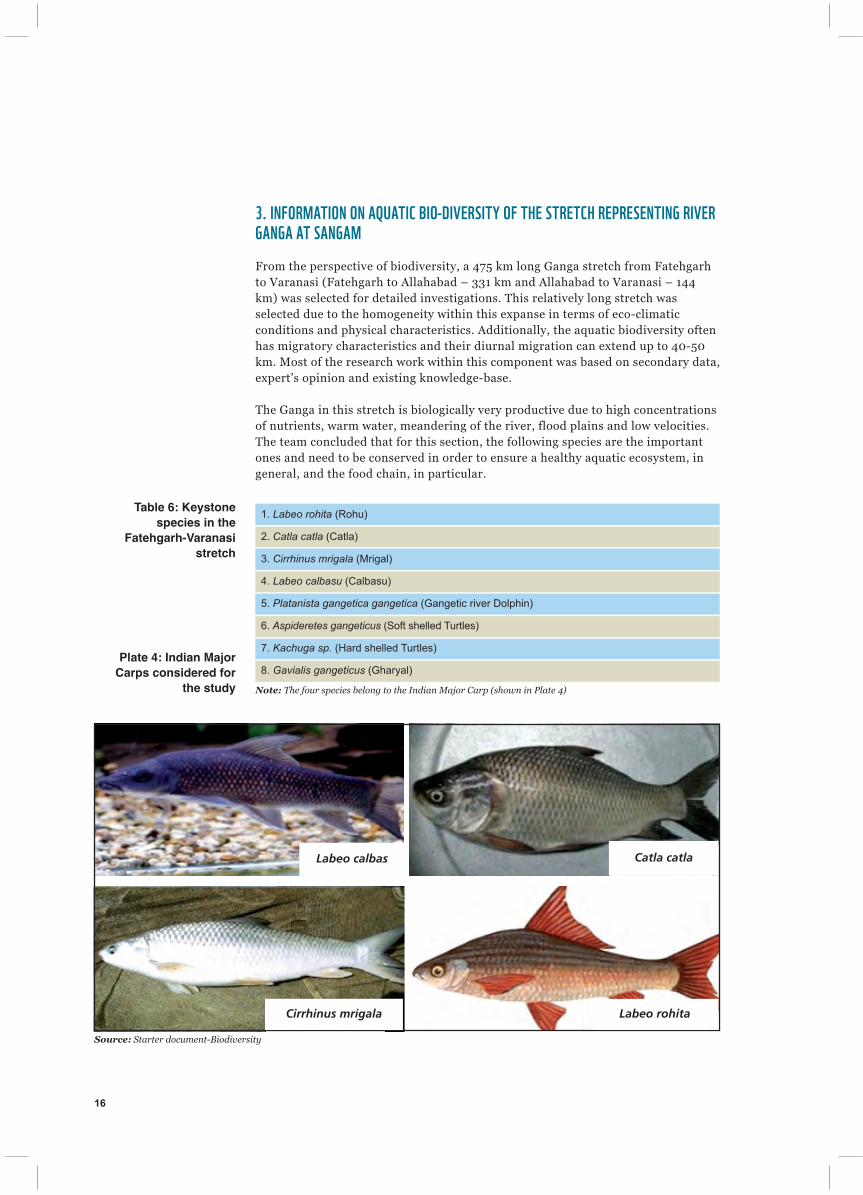
From the perspective of biodiversity, a 475 km long Ganga stretch from Fatehgarhto Varanasi (Fatehgarh to Allahabad – 331 km and Allahabad to Varanasi – 144km) was selected for detailed investigations. This relatively long stretch wasselected due to the homogeneity within this expanse in terms of eco-climaticconditions and physical characteristics. Additionally, the aquatic biodiversity oftenhas migratory characteristics and their diurnal migration can extend up to 40-50km. Most of the research work within this component was based on secondary data,expert’s opinion and existing knowledge-base.
The Ganga in this stretch is biologically very productive due to high concentrationsof nutrients, warm water, meandering of the river, flood plains and low velocities.The team concluded that for this section, the following species are the importantones and need to be conserved in order to ensure a healthy aquatic ecosystem, ingeneral, and the food chain, in particular.
Plate 4: Indian Major
Carps considered for
the study
Table 6: Keystone
species in the
Fatehgarh-Varanasi
stretch
1. Labeo rohita (Rohu)
2. Catla catla (Catla)
3. Cirrhinus mrigala (Mrigal)
4. Labeo calbasu (Calbasu)
5. Platanista gangetica gangetica (Gangetic river Dolphin)
6. Aspideretes gangeticus (Soft shelled Turtles)
7. Kachuga sp. (Hard shelled Turtles)
8. Gavialis gangeticus (Gharyal)
Note: The four species belong to the Indian Major Carp (shown in Plate 4)
Catla catlaLabeo calbas
Cirrhinus mrigala Labeo rohita
Source: Starter document-Biodiversity

Ecological conditions for maintenance and survival of keystone species (Indianmajor carps and Gangetic river dolphins) has been worked out and can besummarized as follows.
The above requirement will also meet the water requirement for other biota.
4. INFORMATION ON FLUVIAL GEOMORPHOLOGY AROUND SANGAMRiver morphology and its complexity is an important aspect of a riverine ecosystemand it is an integral part of the E-Flows assessment exercise. Figure 6 shows majorgeomorphic features present in the channel in this stretch and the most dominantunits are seen to be lateral bars and mid-channel bars. The channel belt isapproximately 2 km wide at the confluence and the valley margin is much wider.The channel is multi-thread and the channel multiplicity would generally increaseduring low flows.
17
Table 7: Requirements
of Keystone speciesShallow muddy banks with water < 0.5 m
Average depth of water column depth 1.5 m
Mid river channel 4 m
Average velocity of water 0.3 - 0.5 m/s
Substrate/Sand bars Silt over sand
Figure 6:
Geomorphologic
features of the River
Ganga around Sangam
Source: Starter document-Fluvial Geomorphology
TownsAbandoned meander belt
Abandoned braid bar
Abandoned channel
Chute Channel
Flood Channel
Main Channel
Mid Channel Bar
Meander Cutt off
Point Bar
Secondary channel
Side Bar
Ox Bow Lake
Ganga Active Floodplain
Ganga Valley Margin Kilometers
0 1 2

18
The key geomorphologic considerations along the stretch of the river Ganga aroundSangam are –
� Geomorphic connectivity – Longitudinal and lateral (during the month ofJanuary to March 2013, which is a low flow season, the longitudinalconnectivity will play the major role)
� Geomorphic processes including sediment supply and dynamics – Althoughthese are long term processes, it is important that there is a minimum flowavailable for movement of sediments and nutrients so as to maintain thedesired morphology of the river, even for a short time
� Bank characteristics such as sediment type, riparian vegetation – During theJanuary - March flows, it is not expected that riparian vegetation will beinundated, so, this criteria takes a low preference for determining the requiredflows.
It was recommended that the major geomorphic consideration for arriving atoptimum January - March flows would be the maintenance of longitudinalconnectivity of the river. The geomorphology team was present during the CrossSection surveys at the identified locations in and around Sangam. Based on thefield visit, secondary data and expert opinion, the team recommended a minimumwater level (depth) of 1.5 m, at which longitudinal connectivity would not be lost.
5. E-FLOWS SETTING WORKSHOPOn December 16 - 17, 2012, an E-Flows setting workshop was organized at IITKanpur, where all the Working Group members and thematic teams participated towork out the required E-Flows for Kumbh 2013 at Allahabad. The workshop beganwith an overview presentation, followed by a presentation of thematic reports anddiscussions on the recommendations.
Plate 5:
E-Flows
Setting
Workshop
Ph
oto
cre
dit: IIT
-Ka
np
ur

19
As part of the E-Flows setting process, Flow Motivation Forms were filled by thethematic teams along with the Working Group members. The recommended flowsby various thematic groups were discussed and debated to arrive at final values,which were agreeable to all members.
Plate 7 gives an overview of location on Ganga at where Cross Section 4 was taken.This place is at immediate upstream of Sangam.
Plate 6: Flow Motivation
Exercise
Plate 7: Snapshot of
area around Section 4,
upstream of Sangam,
considered for E-Flows
assessment
Source: IIT-Kanpur
Ph
oto
cre
dit: N
itin K
au
sh
al / W
WF
-Ind
ia
Ph
oto
cre
dit: N
itin K
au
sh
al / W
WF
-Ind
ia

20
Ph
oto
cre
dit: N
itin K
au
sh
al / W
WF
-Ind
ia
Sunset at Allahabad

WWF-India’s Rivers for Life, Life for Rivers programme envisions the Ganga as a healthy
river system that is rich in biodiversity, providing long term water security to communities and
nature. This initiative is supported by the HSBC Water Programme (HWP), a five year
partnership between HSBC, WWF, WaterAid and Earthwatch. During 2012 - 2017, HWP aims
to deliver a powerful combination of water provision, protection and education resulting in the
most ground-breaking water programme committed to by a financial organization.
WWF-India will be building on its Living Ganga Programme (LGP (2007 - 2012)), which has
developed, validated and implemented some of the most innovative pathways and processes for
sustainable water resources and energy management in the face of climate change. These
include pioneering work such as methodologies for assessment of Environmental Flows, water
and energy footprint work with industries, pollution abatement in cities using bioremediation,
engagement in the development of a dolphin action plan, reintroduction of gharials as well as
climate vulnerability assessment and ecosystem based climate adaptation. The LGP’s focus area
was the critical 800 kilometer stretch of the Ganga from Gangotri to Kanpur spanning the
Upper Ganga Basin.
The new phase of the programme, Rivers for Life, Life for Rivers seeks to implement the
lessons learned from the LGP and apply this basin management framework to the Ramganga
River– the first major tributary of the Ganga. The Ramganga River replicates the Ganga in
terms of major issues faced, thereby presenting some complex and nested challenges in water
resource management. It attempts to maximize the impact of ongoing work in the Ganga and its
mainstreaming by various actors, WWF-India plans to continue some of the key initiatives of
the LGP. The focus lies in the 300 kilometer stretch of the Ramganga and the 900 kilometer
stretch of the Ganga (from Bijnore to Varanasi).
The four pillars of the programme are:
• Sustainable Water Management: Working towards ensuring Environmental Flows
and sustainable water management.
• Habitat and Biodiversity Conservation: Improving the population and habitats of 7
endemic and endangered aquatic species (Gangetic Dolphins, gharial, Otters, Mahseer
(fish) and 3 species of turtles, across 400 km (6 districts) of the Ganga and the Ramganga
River.)
• Water stewardship: Collaborating with cities and SMEs in the Ganga basin to manage
water related risks by adopting water stewardship (protection of sources, cleaner
production, sustainable consumption, green financing along with concerted stakeholder
action and policy dialogues). Multi stakeholder groups will be formed to actively engage in
river conservation.
• Climate change adaptation: Developing a framework for climate adaptation so as to
reduce climate vulnerabilities and improve base-flows in the Ganga and its tributaries.
The approach of the programme will incline towards policy advocacy and engagement of
riparian communities with the aim of creating sectoral and basin level as well as state and
national level outreach to generate support and catalyse action towards conserving the revered
river Ganga.

REPORT .2013WWW.WWFINDIA.ORG
IND
WWF-India, 172-B, Lodi Estate, New Delhi 110 003
Supported By: