environmental firstsearch site detail report
TRANSCRIPT
Environmental FirstSearchSite Detail Report
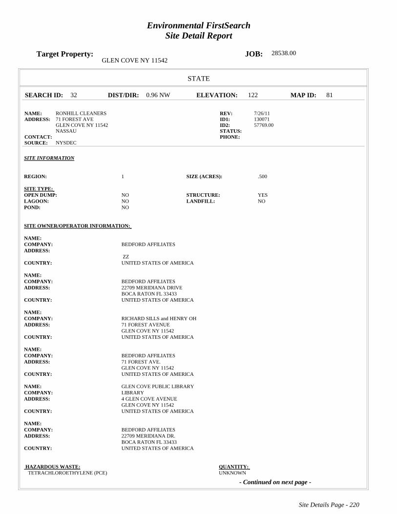
Target Property: JOB: 28538.00GLEN COVE NY 11542
STATE
SEARCH ID: 32 DIST/DIR: 0.96 NW ELEVATION: 122 MAP ID: 81
NAME: RONHILL CLEANERS REV: 7/26/11ADDRESS: 71 FOREST AVE ID1: 130071
GLEN COVE NY 11542 ID2: 57769.00NASSAU STATUS:
CONTACT: PHONE: SOURCE: NYSDEC
SITE INFORMATION
REGION: 1 SIZE (ACRES): .500
SITE TYPE: OPEN DUMP: NO STRUCTURE: YESLAGOON: NO LANDFILL: NOPOND: NO
SITE OWNER/OPERATOR INFORMATION:
NAME: COMPANY: BEDFORD AFFILIATESADDRESS:
ZZ COUNTRY: UNITED STATES OF AMERICA
NAME: COMPANY: BEDFORD AFFILIATESADDRESS: 22709 MERIDIANA DRIVE
BOCA RATON FL 33433COUNTRY: UNITED STATES OF AMERICA
NAME: COMPANY: RICHARD SILLS and HENRY OHADDRESS: 71 FOREST AVENUE
GLEN COVE NY 11542COUNTRY: UNITED STATES OF AMERICA
NAME: COMPANY: BEDFORD AFFILIATESADDRESS: 71 FOREST AVE.
GLEN COVE NY 11542COUNTRY: UNITED STATES OF AMERICA
NAME: GLEN COVE PUBLIC LIBRARYCOMPANY: LIBRARYADDRESS: 4 GLEN COVE AVENUE
GLEN COVE NY 11542COUNTRY: UNITED STATES OF AMERICA
NAME: COMPANY: BEDFORD AFFILIATESADDRESS: 22709 MERIDIANA DR.
BOCA RATON FL 33433COUNTRY: UNITED STATES OF AMERICA
HAZARDOUS WASTE: QUANTITY: TETRACHLOROETHYLENE (PCE) UNKNOWN
- Continued on next page -
Site Details Page - 220
Environmental FirstSearchSite Detail Report
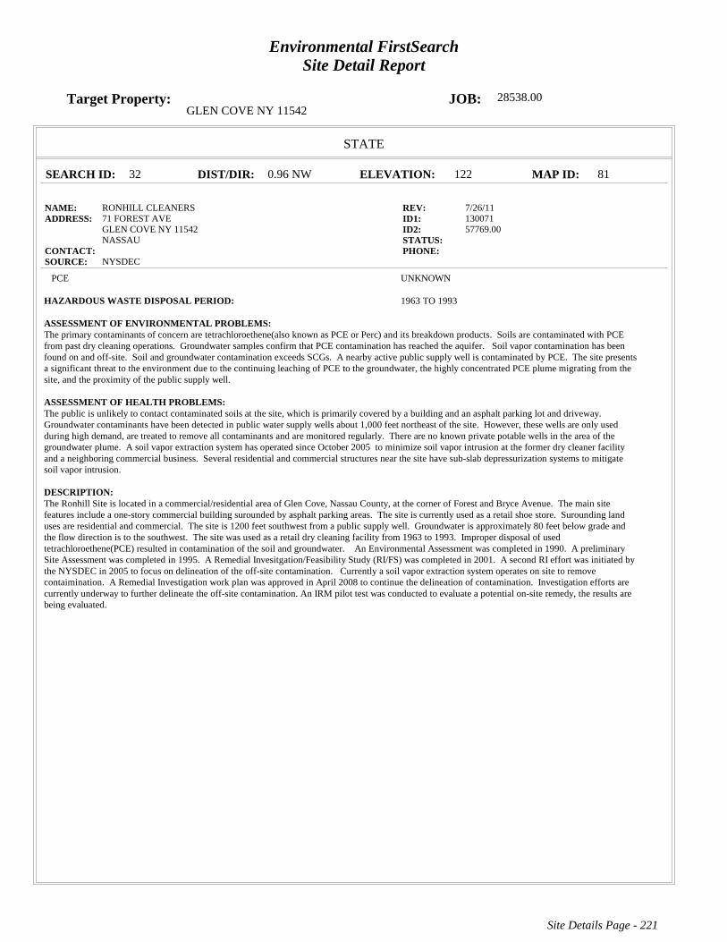
Target Property: JOB: 28538.00GLEN COVE NY 11542
STATE
SEARCH ID: 32 DIST/DIR: 0.96 NW ELEVATION: 122 MAP ID: 81
NAME: RONHILL CLEANERS REV: 7/26/11ADDRESS: 71 FOREST AVE ID1: 130071
GLEN COVE NY 11542 ID2: 57769.00NASSAU STATUS:
CONTACT: PHONE: SOURCE: NYSDEC
PCE UNKNOWN
HAZARDOUS WASTE DISPOSAL PERIOD: 1963 TO 1993
ASSESSMENT OF ENVIRONMENTAL PROBLEMS: The primary contaminants of concern are tetrachloroethene(also known as PCE or Perc) and its breakdown products. Soils are contaminated with PCEfrom past dry cleaning operations. Groundwater samples confirm that PCE contamination has reached the aquifer. Soil vapor contamination has beenfound on and off-site. Soil and groundwater contamination exceeds SCGs. A nearby active public supply well is contaminated by PCE. The site presentsa significant threat to the environment due to the continuing leaching of PCE to the groundwater, the highly concentrated PCE plume migrating from thesite, and the proximity of the public supply well.
ASSESSMENT OF HEALTH PROBLEMS: The public is unlikely to contact contaminated soils at the site, which is primarily covered by a building and an asphalt parking lot and driveway. Groundwater contaminants have been detected in public water supply wells about 1,000 feet northeast of the site. However, these wells are only usedduring high demand, are treated to remove all contaminants and are monitored regularly. There are no known private potable wells in the area of thegroundwater plume. A soil vapor extraction system has operated since October 2005 to minimize soil vapor intrusion at the former dry cleaner facilityand a neighboring commercial business. Several residential and commercial structures near the site have sub-slab depressurization systems to mitigatesoil vapor intrusion.
DESCRIPTION: The Ronhill Site is located in a commercial/residential area of Glen Cove, Nassau County, at the corner of Forest and Bryce Avenue. The main sitefeatures include a one-story commercial building surounded by asphalt parking areas. The site is currently used as a retail shoe store. Surounding landuses are residential and commercial. The site is 1200 feet southwest from a public supply well. Groundwater is approximately 80 feet below grade andthe flow direction is to the southwest. The site was used as a retail dry cleaning facility from 1963 to 1993. Improper disposal of usedtetrachloroethene(PCE) resulted in contamination of the soil and groundwater. An Environmental Assessment was completed in 1990. A preliminarySite Assessment was completed in 1995. A Remedial Invesitgation/Feasibility Study (RI/FS) was completed in 2001. A second RI effort was initiated bythe NYSDEC in 2005 to focus on delineation of the off-site contamination. Currently a soil vapor extraction system operates on site to removecontaimination. A Remedial Investigation work plan was approved in April 2008 to continue the delineation of contamination. Investigation efforts arecurrently underway to further delineate the off-site contamination. An IRM pilot test was conducted to evaluate a potential on-site remedy, the results arebeing evaluated.
Site Details Page - 221
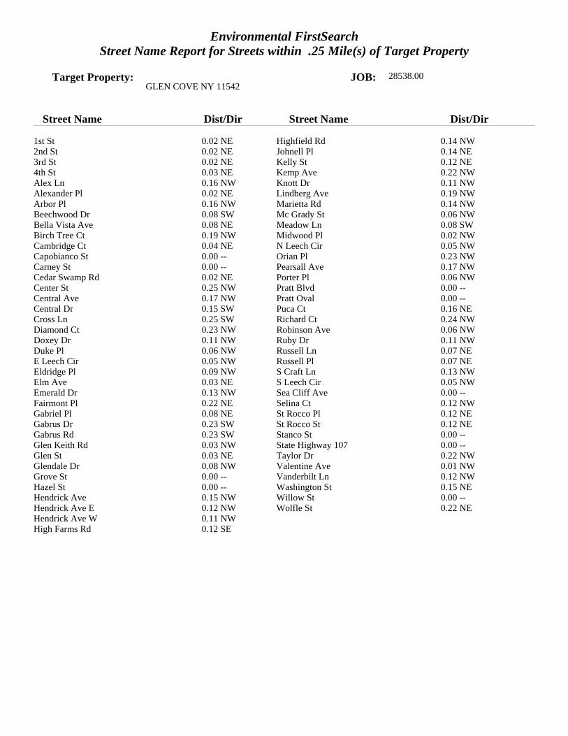
Environmental FirstSearchStreet Name Report for Streets within .25 Mile(s) of Target Property
Target Property: JOB: 28538.00GLEN COVE NY 11542
Street Name Dist/Dir Street Name Dist/Dir
1st St 0.02 NE Highfield Rd 0.14 NW2nd St 0.02 NE Johnell Pl 0.14 NE3rd St 0.02 NE Kelly St 0.12 NE4th St 0.03 NE Kemp Ave 0.22 NWAlex Ln 0.16 NW Knott Dr 0.11 NWAlexander Pl 0.02 NE Lindberg Ave 0.19 NWArbor Pl 0.16 NW Marietta Rd 0.14 NWBeechwood Dr 0.08 SW Mc Grady St 0.06 NWBella Vista Ave 0.08 NE Meadow Ln 0.08 SWBirch Tree Ct 0.19 NW Midwood Pl 0.02 NWCambridge Ct 0.04 NE N Leech Cir 0.05 NWCapobianco St 0.00 -- Orian Pl 0.23 NWCarney St 0.00 -- Pearsall Ave 0.17 NWCedar Swamp Rd 0.02 NE Porter Pl 0.06 NWCenter St 0.25 NW Pratt Blvd 0.00 --Central Ave 0.17 NW Pratt Oval 0.00 --Central Dr 0.15 SW Puca Ct 0.16 NECross Ln 0.25 SW Richard Ct 0.24 NWDiamond Ct 0.23 NW Robinson Ave 0.06 NWDoxey Dr 0.11 NW Ruby Dr 0.11 NWDuke Pl 0.06 NW Russell Ln 0.07 NEE Leech Cir 0.05 NW Russell Pl 0.07 NEEldridge Pl 0.09 NW S Craft Ln 0.13 NWElm Ave 0.03 NE S Leech Cir 0.05 NWEmerald Dr 0.13 NW Sea Cliff Ave 0.00 --Fairmont Pl 0.22 NE Selina Ct 0.12 NWGabriel Pl 0.08 NE St Rocco Pl 0.12 NEGabrus Dr 0.23 SW St Rocco St 0.12 NEGabrus Rd 0.23 SW Stanco St 0.00 --Glen Keith Rd 0.03 NW State Highway 107 0.00 --Glen St 0.03 NE Taylor Dr 0.22 NWGlendale Dr 0.08 NW Valentine Ave 0.01 NWGrove St 0.00 -- Vanderbilt Ln 0.12 NWHazel St 0.00 -- Washington St 0.15 NEHendrick Ave 0.15 NW Willow St 0.00 --Hendrick Ave E 0.12 NW Wolfle St 0.22 NEHendrick Ave W 0.11 NWHigh Farms Rd 0.12 SE
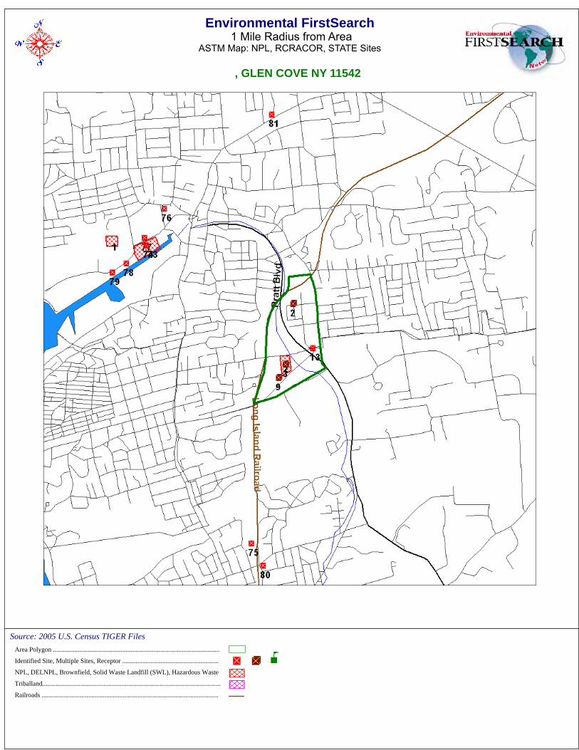
Environmental FirstSearch1 Mile Radius from Area
ASTM Map: NPL, RCRACOR, STATE Sites
, GLEN COVE NY 11542
Source: 2005 U.S. Census TIGER FilesArea Polygon .....................................................................................................
Identified Site, Multiple Sites, Receptor ..........................................................
NPL, DELNPL, Brownfield, Solid Waste Landfill (SWL), Hazardous Waste
Triballand............................................................................................................
Railroads ...........................................................................................................
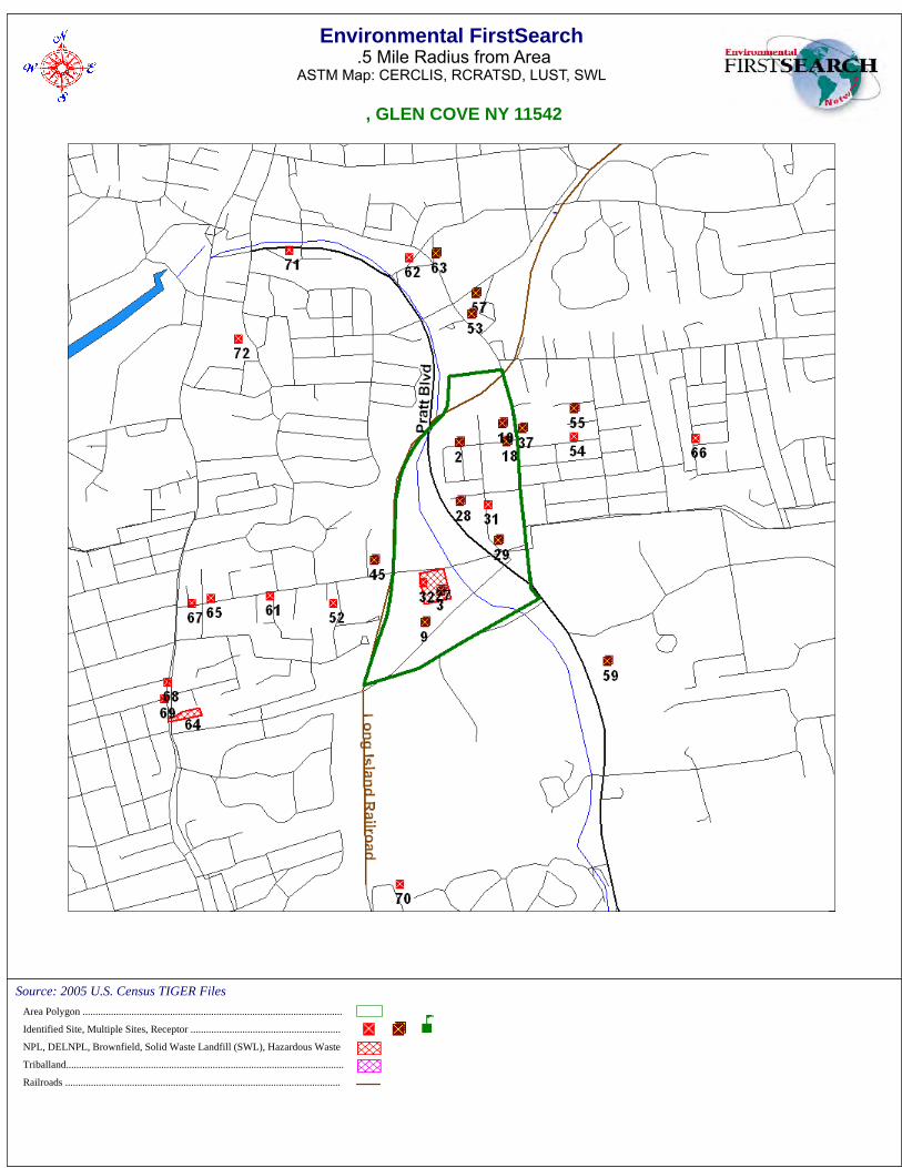
Environmental FirstSearch.5 Mile Radius from Area
ASTM Map: CERCLIS, RCRATSD, LUST, SWL
, GLEN COVE NY 11542
Source: 2005 U.S. Census TIGER FilesArea Polygon .....................................................................................................
Identified Site, Multiple Sites, Receptor ..........................................................
NPL, DELNPL, Brownfield, Solid Waste Landfill (SWL), Hazardous Waste
Triballand............................................................................................................
Railroads ...........................................................................................................
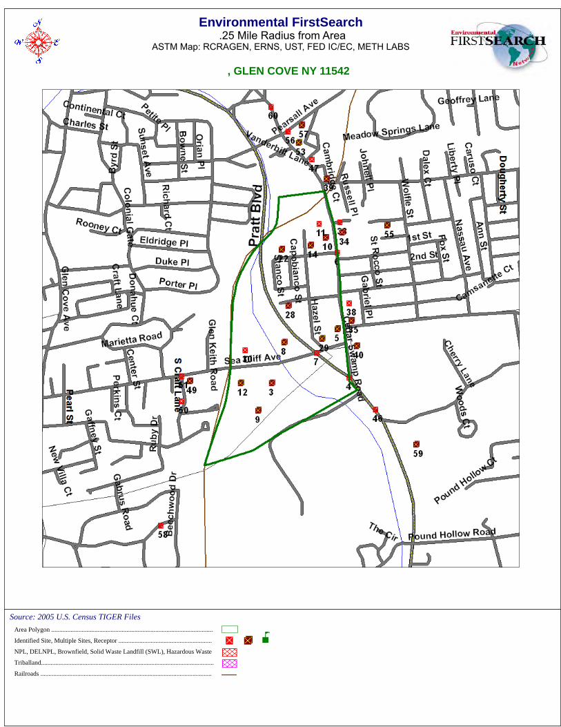
Environmental FirstSearch.25 Mile Radius from Area
ASTM Map: RCRAGEN, ERNS, UST, FED IC/EC, METH LABS
, GLEN COVE NY 11542
Source: 2005 U.S. Census TIGER FilesArea Polygon .....................................................................................................
Identified Site, Multiple Sites, Receptor ..........................................................
NPL, DELNPL, Brownfield, Solid Waste Landfill (SWL), Hazardous Waste
Triballand............................................................................................................
Railroads ...........................................................................................................
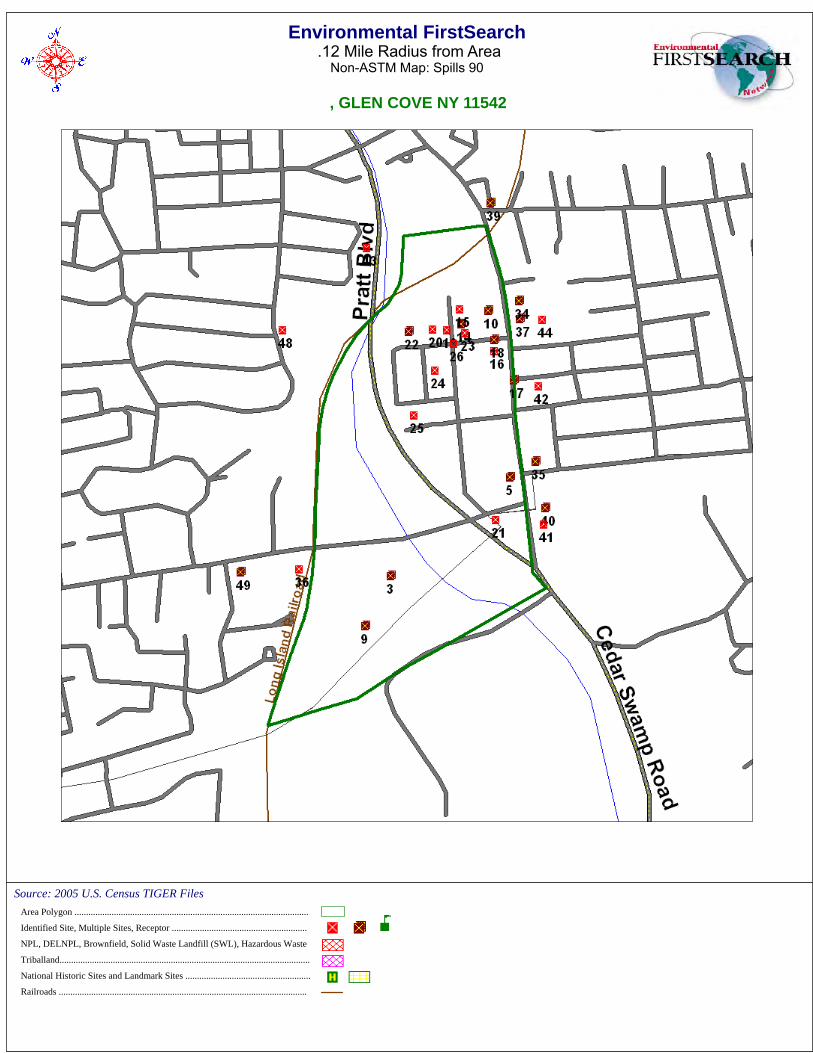
Environmental FirstSearch.12 Mile Radius from Area
Non-ASTM Map: Spills 90
, GLEN COVE NY 11542
Source: 2005 U.S. Census TIGER FilesArea Polygon .....................................................................................................
Identified Site, Multiple Sites, Receptor ..........................................................
NPL, DELNPL, Brownfield, Solid Waste Landfill (SWL), Hazardous Waste
Triballand............................................................................................................
National Historic Sites and Landmark Sites ......................................................
Railroads ...........................................................................................................
Environmental FirstSearch Descriptions
NPL: EPA NATIONAL PRIORITY LIST - The National Priorities List is a list of the worst hazardous wastesites that have been identified by Superfund. Sites are only put on the list after they have been scored using theHazard Ranking System (HRS), and have been subjected to public comment. Any site on the NPL is eligible forcleanup using Superfund Trust money.A Superfund site is any land in the United States that has been contaminated by hazardous waste and identifiedby the Environmental Protection Agency (EPA) as a candidate for cleanup because it poses a risk to humanhealth and/or the environment.FINAL - Currently on the Final NPLPROPOSED - Proposed for NPL
NPL DELISTED: EPA NATIONAL PRIORITY LIST Subset - Database of delisted NPL sites. TheNational Oil and Hazardous Substances Pollution Contingency Plan (NCP) establishes the criteria that the EPAuses to delete sites from the NPL. In accordance with 40 CFR 300.425.(e), sites may be deleted from the NPLwhere no further response is appropriate.DELISTED - Deleted from the Final NPL
CERCLIS: EPA COMPREHENSIVE ENVIRONMENTAL RESPONSE COMPENSATION ANDLIABILITY INFORMATION SYSTEM (CERCLIS)- CERCLIS is a database of potential and confirmedhazardous waste sites at which the EPA Superfund program has some involvement. It contains sites that areeither proposed to be or are on the National Priorities List (NPL) as well as sites that are in the screening andassessment phase for possible inclusion on the NPL.PART OF NPL- Site is part of NPL siteDELETED - Deleted from the Final NPLFINAL - Currently on the Final NPLNOT PROPOSED - Not on the NPLNOT VALID - Not Valid Site or IncidentPROPOSED - Proposed for NPLREMOVED - Removed from Proposed NPLSCAN PLAN - Pre-proposal SiteWITHDRAWN - Withdrawn
NFRAP: EPA COMPREHENSIVE ENVIRONMENTAL RESPONSE COMPENSATION ANDLIABILITY INFORMATION SYSTEM ARCHIVED SITES - database of Archive designated CERCLA sitesthat, to the best of EPA's knowledge, assessment has been completed and has determined no further steps will betaken to list this site on the National Priorities List (NPL). This decision does not necessarily mean that there isno hazard associated with a given site; it only means that, based upon available information, the location is notjudged to be a potential NPL site.NFRAP – No Further Remedial Action PlanP - Site is part of NPL siteD - Deleted from the Final NPLF - Currently on the Final NPLN - Not on the NPLO - Not Valid Site or IncidentP - Proposed for NPLR - Removed from Proposed NPLS - Pre-proposal SiteW – Withdrawn
RCRA COR ACT: EPA RESOURCE CONSERVATION AND RECOVERY INFORMATION SYSTEMSITES - Database of hazardous waste information contained in the Resource Conservation and Recovery ActInformation (RCRAInfo), a national program management and inventory system about hazardous wastehandlers. In general, all generators, transporters, treaters, storers, and disposers of hazardous waste are requiredto provide information about their activities to state environmental agencies. These agencies, in turn pass on theinformation to regional and national EPA offices. This regulation is governed by the Resource Conservation andRecovery Act (RCRA), as amended by the Hazardous and Solid Waste Amendments of 1984.RCRAInfo facilities that have reported violations and subject to corrective actions.
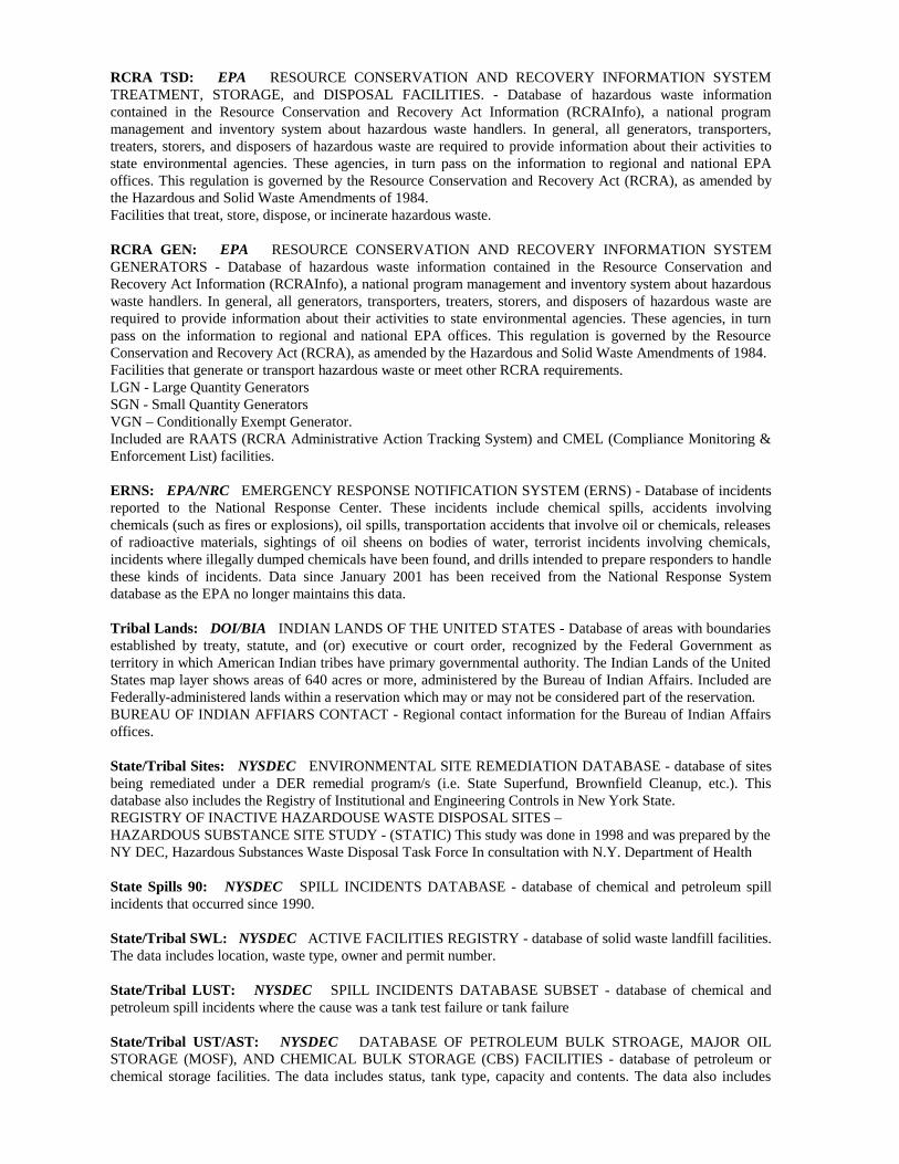
RCRA TSD: EPA RESOURCE CONSERVATION AND RECOVERY INFORMATION SYSTEMTREATMENT, STORAGE, and DISPOSAL FACILITIES. - Database of hazardous waste informationcontained in the Resource Conservation and Recovery Act Information (RCRAInfo), a national programmanagement and inventory system about hazardous waste handlers. In general, all generators, transporters,treaters, storers, and disposers of hazardous waste are required to provide information about their activities tostate environmental agencies. These agencies, in turn pass on the information to regional and national EPAoffices. This regulation is governed by the Resource Conservation and Recovery Act (RCRA), as amended bythe Hazardous and Solid Waste Amendments of 1984.Facilities that treat, store, dispose, or incinerate hazardous waste.
RCRA GEN: EPA RESOURCE CONSERVATION AND RECOVERY INFORMATION SYSTEMGENERATORS - Database of hazardous waste information contained in the Resource Conservation andRecovery Act Information (RCRAInfo), a national program management and inventory system about hazardouswaste handlers. In general, all generators, transporters, treaters, storers, and disposers of hazardous waste arerequired to provide information about their activities to state environmental agencies. These agencies, in turnpass on the information to regional and national EPA offices. This regulation is governed by the ResourceConservation and Recovery Act (RCRA), as amended by the Hazardous and Solid Waste Amendments of 1984.Facilities that generate or transport hazardous waste or meet other RCRA requirements.LGN - Large Quantity GeneratorsSGN - Small Quantity GeneratorsVGN – Conditionally Exempt Generator.Included are RAATS (RCRA Administrative Action Tracking System) and CMEL (Compliance Monitoring &Enforcement List) facilities.
ERNS: EPA/NRC EMERGENCY RESPONSE NOTIFICATION SYSTEM (ERNS) - Database of incidentsreported to the National Response Center. These incidents include chemical spills, accidents involvingchemicals (such as fires or explosions), oil spills, transportation accidents that involve oil or chemicals, releasesof radioactive materials, sightings of oil sheens on bodies of water, terrorist incidents involving chemicals,incidents where illegally dumped chemicals have been found, and drills intended to prepare responders to handlethese kinds of incidents. Data since January 2001 has been received from the National Response Systemdatabase as the EPA no longer maintains this data.
Tribal Lands: DOI/BIA INDIAN LANDS OF THE UNITED STATES - Database of areas with boundariesestablished by treaty, statute, and (or) executive or court order, recognized by the Federal Government asterritory in which American Indian tribes have primary governmental authority. The Indian Lands of the UnitedStates map layer shows areas of 640 acres or more, administered by the Bureau of Indian Affairs. Included areFederally-administered lands within a reservation which may or may not be considered part of the reservation.BUREAU OF INDIAN AFFIARS CONTACT - Regional contact information for the Bureau of Indian Affairsoffices.
State/Tribal Sites: NYSDEC ENVIRONMENTAL SITE REMEDIATION DATABASE - database of sitesbeing remediated under a DER remedial program/s (i.e. State Superfund, Brownfield Cleanup, etc.). Thisdatabase also includes the Registry of Institutional and Engineering Controls in New York State.REGISTRY OF INACTIVE HAZARDOUSE WASTE DISPOSAL SITES –HAZARDOUS SUBSTANCE SITE STUDY - (STATIC) This study was done in 1998 and was prepared by theNY DEC, Hazardous Substances Waste Disposal Task Force In consultation with N.Y. Department of Health
State Spills 90: NYSDEC SPILL INCIDENTS DATABASE - database of chemical and petroleum spillincidents that occurred since 1990.
State/Tribal SWL: NYSDEC ACTIVE FACILITIES REGISTRY - database of solid waste landfill facilities.The data includes location, waste type, owner and permit number.
State/Tribal LUST: NYSDEC SPILL INCIDENTS DATABASE SUBSET - database of chemical andpetroleum spill incidents where the cause was a tank test failure or tank failure
State/Tribal UST/AST: NYSDEC DATABASE OF PETROLEUM BULK STROAGE, MAJOR OILSTORAGE (MOSF), AND CHEMICAL BULK STORAGE (CBS) FACILITIES - database of petroleum orchemical storage facilities. The data includes status, tank type, capacity and contents. The data also includes
Nassau County Department of Health’s PBS TanksNassau County Fire Marshall’s PBS TanksSuffolk County Department of Health Services PBS TanksCortland County Health Department PBS TanksRockland County Department of Health PBS TanksWestchester County Department of Health PBS Tanks.
State/Tribal EC: NYSDEC REGISTRY OF INSTITUTIONAL AND ENGINEERING CONTROLS Subset- database of sites from the Registry that have Engineering Controls.
State/Tribal IC: NYSDEC/NYDOC REGISTRY OF INSTITUTIONAL AND ENGINEERINGCONTROLS Subset - database of sites from the Registry that have Institutional Controls.
State/Tribal VCP: NYSDEC VOLUNTARY CLEANUP PROGRAM - static database of voluntary clean upsites. The Brownfield Cleanup program has replaced the Voluntary Cleanup Program.
State/Tribal Brownfields: NYSDEC BROWNFIELD - database of old brownfield programs, brownfieldcleanup programs, environmental restoration projects.
RADON: NTIS NATIONAL RADON DATABASE - EPA radon data from 1990-1991 national radonproject collected for a variety of zip codes across the United States.
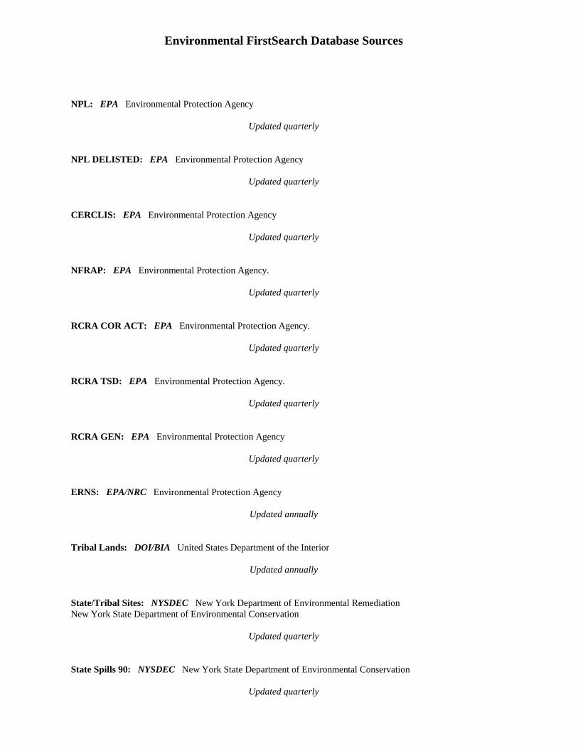
Environmental FirstSearch Database Sources
NPL: EPA Environmental Protection Agency
Updated quarterly
NPL DELISTED: EPA Environmental Protection Agency
Updated quarterly
CERCLIS: EPA Environmental Protection Agency
Updated quarterly
NFRAP: EPA Environmental Protection Agency.
Updated quarterly
RCRA COR ACT: EPA Environmental Protection Agency.
Updated quarterly
RCRA TSD: EPA Environmental Protection Agency.
Updated quarterly
RCRA GEN: EPA Environmental Protection Agency
Updated quarterly
ERNS: EPA/NRC Environmental Protection Agency
Updated annually
Tribal Lands: DOI/BIA United States Department of the Interior
Updated annually
State/Tribal Sites: NYSDEC New York Department of Environmental RemediationNew York State Department of Environmental Conservation
Updated quarterly
State Spills 90: NYSDEC New York State Department of Environmental Conservation
Updated quarterly
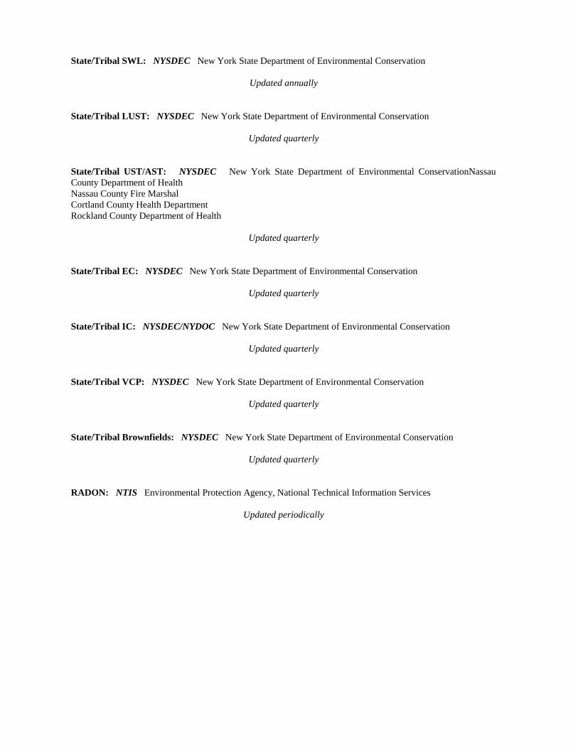
State/Tribal SWL: NYSDEC New York State Department of Environmental Conservation
Updated annually
State/Tribal LUST: NYSDEC New York State Department of Environmental Conservation
Updated quarterly
State/Tribal UST/AST: NYSDEC New York State Department of Environmental ConservationNassauCounty Department of HealthNassau County Fire MarshalCortland County Health DepartmentRockland County Department of Health
Updated quarterly
State/Tribal EC: NYSDEC New York State Department of Environmental Conservation
Updated quarterly
State/Tribal IC: NYSDEC/NYDOC New York State Department of Environmental Conservation
Updated quarterly
State/Tribal VCP: NYSDEC New York State Department of Environmental Conservation
Updated quarterly
State/Tribal Brownfields: NYSDEC New York State Department of Environmental Conservation
Updated quarterly
RADON: NTIS Environmental Protection Agency, National Technical Information Services
Updated periodically
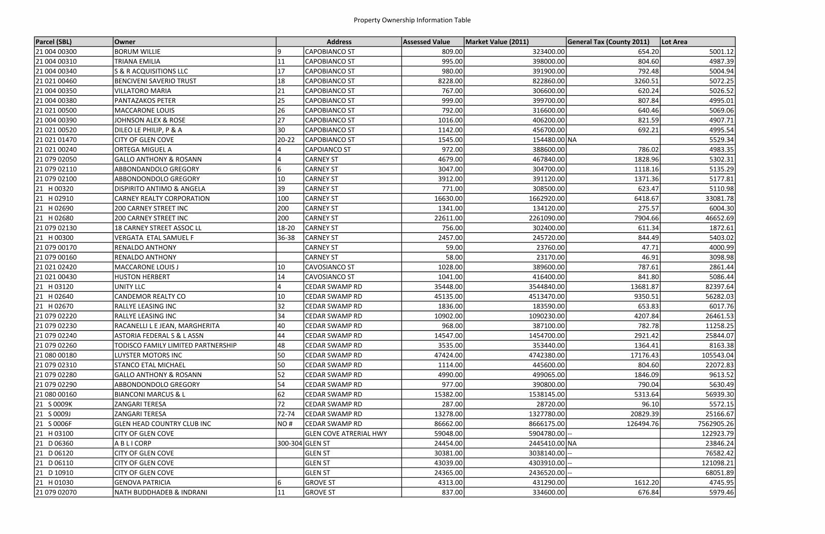
Property Ownership Information Table
Parcel (SBL) Owner Assessed Value Market Value (2011) General Tax (County 2011) Lot Area21 004 00300 BORUM WILLIE 9 CAPOBIANCO ST 809.00 323400.00 654.20 5001.1221 004 00310 TRIANA EMILIA 11 CAPOBIANCO ST 995.00 398000.00 804.60 4987.3921 004 00340 S & R ACQUISITIONS LLC 17 CAPOBIANCO ST 980.00 391900.00 792.48 5004.9421 021 00460 BENCIVENI SAVERIO TRUST 18 CAPOBIANCO ST 8228.00 822860.00 3260.51 5072.2521 004 00350 VILLATORO MARIA 21 CAPOBIANCO ST 767.00 306600.00 620.24 5026.5221 004 00380 PANTAZAKOS PETER 25 CAPOBIANCO ST 999.00 399700.00 807.84 4995.0121 021 00500 MACCARONE LOUIS 26 CAPOBIANCO ST 792.00 316600.00 640.46 5069.0621 004 00390 JOHNSON ALEX & ROSE 27 CAPOBIANCO ST 1016.00 406200.00 821.59 4907.7121 021 00520 DILEO LE PHILIP, P & A 30 CAPOBIANCO ST 1142.00 456700.00 692.21 4995.5421 021 01470 CITY OF GLEN COVE 20‐22 CAPOBIANCO ST 1545.00 154480.00 NA 5529.3421 021 00240 ORTEGA MIGUEL A 4 CAPOIANCO ST 972.00 388600.00 786.02 4983.3521 079 02050 GALLO ANTHONY & ROSANN 4 CARNEY ST 4679.00 467840.00 1828.96 5302.3121 079 02110 ABBONDANDOLO GREGORY 6 CARNEY ST 3047.00 304700.00 1118.16 5135.2921 079 02100 ABBONDONDOLO GREGORY 10 CARNEY ST 3912.00 391120.00 1371.36 5177.8121 H 00320 DISPIRITO ANTIMO & ANGELA 39 CARNEY ST 771.00 308500.00 623.47 5110.9821 H 02910 CARNEY REALTY CORPORATION 100 CARNEY ST 16630.00 1662920.00 6418.67 33081.7821 H 02690 200 CARNEY STREET INC 200 CARNEY ST 1341.00 134120.00 275.57 6004.3021 H 02680 200 CARNEY STREET INC 200 CARNEY ST 22611.00 2261090.00 7904.66 46652.6921 079 02130 18 CARNEY STREET ASSOC LL 18‐20 CARNEY ST 756.00 302400.00 611.34 1872.6121 H 00300 VERGATA ETAL SAMUEL F 36‐38 CARNEY ST 2457.00 245720.00 844.49 5403.0221 079 00170 RENALDO ANTHONY CARNEY ST 59.00 23760.00 47.71 4000.9921 079 00160 RENALDO ANTHONY CARNEY ST 58.00 23170.00 46.91 3098.9821 021 02420 MACCARONE LOUIS J 10 CAVOSIANCO ST 1028.00 389600.00 787.61 2861.4421 021 00430 HUSTON HERBERT 14 CAVOSIANCO ST 1041.00 416400.00 841.80 5086.4421 H 03120 UNITY LLC 4 CEDAR SWAMP RD 35448.00 3544840.00 13681.87 82397.6421 H 02640 CANDEMOR REALTY CO 10 CEDAR SWAMP RD 45135.00 4513470.00 9350.51 56282.0321 H 02670 RALLYE LEASING INC 32 CEDAR SWAMP RD 1836.00 183590.00 653.83 6017.7621 079 02220 RALLYE LEASING INC 34 CEDAR SWAMP RD 10902.00 1090230.00 4207.84 26461.5321 079 02230 RACANELLI L E JEAN, MARGHERITA 40 CEDAR SWAMP RD 968.00 387100.00 782.78 11258.2521 079 02240 ASTORIA FEDERAL S & L ASSN 44 CEDAR SWAMP RD 14547.00 1454700.00 2921.42 25844.0721 079 02260 TODISCO FAMILY LIMITED PARTNERSHIP 48 CEDAR SWAMP RD 3535.00 353440.00 1364.41 8163.3821 080 00180 LUYSTER MOTORS INC 50 CEDAR SWAMP RD 47424.00 4742380.00 17176.43 105543.0421 079 02310 STANCO ETAL MICHAEL 50 CEDAR SWAMP RD 1114.00 445600.00 804.60 22072.8321 079 02280 GALLO ANTHONY & ROSANN 52 CEDAR SWAMP RD 4990.00 499065.00 1846.09 9613.5221 079 02290 ABBONDONDOLO GREGORY 54 CEDAR SWAMP RD 977.00 390800.00 790.04 5630.4921 080 00160 BIANCONI MARCUS & L 62 CEDAR SWAMP RD 15382.00 1538145.00 5313.64 56939.3021 S 0009K ZANGARI TERESA 72 CEDAR SWAMP RD 287.00 28720.00 96.10 5572.1521 S 0009J ZANGARI TERESA 72‐74 CEDAR SWAMP RD 13278.00 1327780.00 20829.39 25166.6721 S 0006F GLEN HEAD COUNTRY CLUB INC NO # CEDAR SWAMP RD 86662.00 8666175.00 126494.76 7562905.2621 H 03100 CITY OF GLEN COVE GLEN COVE ATRERIAL HWY 59048.00 5904780.00 ‐‐ 122923.7921 D 06360 A B L I CORP 300‐304 GLEN ST 24454.00 2445410.00 NA 23846.2421 D 06120 CITY OF GLEN COVE GLEN ST 30381.00 3038140.00 ‐‐ 76582.4221 D 06110 CITY OF GLEN COVE GLEN ST 43039.00 4303910.00 ‐‐ 121098.2121 D 10910 CITY OF GLEN COVE GLEN ST 24365.00 2436520.00 ‐‐ 68051.8921 H 01030 GENOVA PATRICIA 6 GROVE ST 4313.00 431290.00 1612.20 4745.9521 079 02070 NATH BUDDHADEB & INDRANI 11 GROVE ST 837.00 334600.00 676.84 5979.46
Address
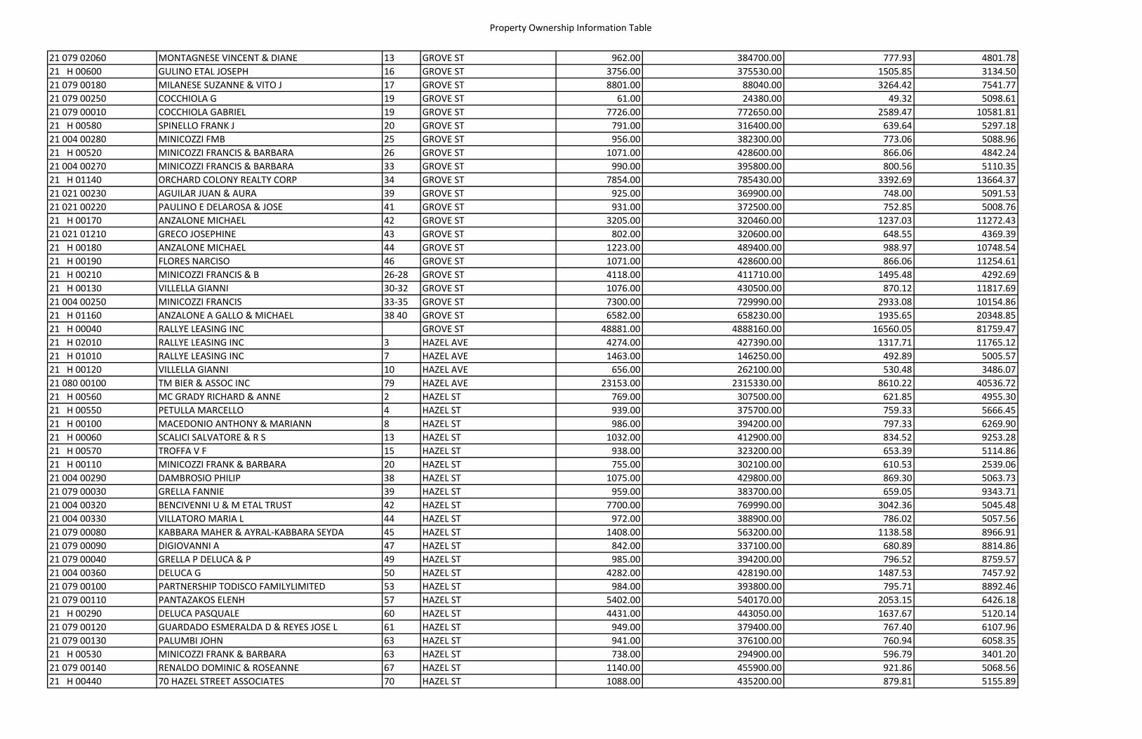
Property Ownership Information Table
21 079 02060 MONTAGNESE VINCENT & DIANE 13 GROVE ST 962.00 384700.00 777.93 4801.7821 H 00600 GULINO ETAL JOSEPH 16 GROVE ST 3756.00 375530.00 1505.85 3134.5021 079 00180 MILANESE SUZANNE & VITO J 17 GROVE ST 8801.00 88040.00 3264.42 7541.7721 079 00250 COCCHIOLA G 19 GROVE ST 61.00 24380.00 49.32 5098.6121 079 00010 COCCHIOLA GABRIEL 19 GROVE ST 7726.00 772650.00 2589.47 10581.8121 H 00580 SPINELLO FRANK J 20 GROVE ST 791.00 316400.00 639.64 5297.1821 004 00280 MINICOZZI FMB 25 GROVE ST 956.00 382300.00 773.06 5088.9621 H 00520 MINICOZZI FRANCIS & BARBARA 26 GROVE ST 1071.00 428600.00 866.06 4842.2421 004 00270 MINICOZZI FRANCIS & BARBARA 33 GROVE ST 990.00 395800.00 800.56 5110.3521 H 01140 ORCHARD COLONY REALTY CORP 34 GROVE ST 7854.00 785430.00 3392.69 13664.3721 021 00230 AGUILAR JUAN & AURA 39 GROVE ST 925.00 369900.00 748.00 5091.5321 021 00220 PAULINO E DELAROSA & JOSE 41 GROVE ST 931.00 372500.00 752.85 5008.7621 H 00170 ANZALONE MICHAEL 42 GROVE ST 3205.00 320460.00 1237.03 11272.4321 021 01210 GRECO JOSEPHINE 43 GROVE ST 802.00 320600.00 648.55 4369.3921 H 00180 ANZALONE MICHAEL 44 GROVE ST 1223.00 489400.00 988.97 10748.5421 H 00190 FLORES NARCISO 46 GROVE ST 1071.00 428600.00 866.06 11254.6121 H 00210 MINICOZZI FRANCIS & B 26‐28 GROVE ST 4118.00 411710.00 1495.48 4292.6921 H 00130 VILLELLA GIANNI 30‐32 GROVE ST 1076.00 430500.00 870.12 11817.6921 004 00250 MINICOZZI FRANCIS 33‐35 GROVE ST 7300.00 729990.00 2933.08 10154.8621 H 01160 ANZALONE A GALLO & MICHAEL 38 40 GROVE ST 6582.00 658230.00 1935.65 20348.8521 H 00040 RALLYE LEASING INC GROVE ST 48881.00 4888160.00 16560.05 81759.4721 H 02010 RALLYE LEASING INC 3 HAZEL AVE 4274.00 427390.00 1317.71 11765.1221 H 01010 RALLYE LEASING INC 7 HAZEL AVE 1463.00 146250.00 492.89 5005.5721 H 00120 VILLELLA GIANNI 10 HAZEL AVE 656.00 262100.00 530.48 3486.0721 080 00100 TM BIER & ASSOC INC 79 HAZEL AVE 23153.00 2315330.00 8610.22 40536.7221 H 00560 MC GRADY RICHARD & ANNE 2 HAZEL ST 769.00 307500.00 621.85 4955.3021 H 00550 PETULLA MARCELLO 4 HAZEL ST 939.00 375700.00 759.33 5666.4521 H 00100 MACEDONIO ANTHONY & MARIANN 8 HAZEL ST 986.00 394200.00 797.33 6269.9021 H 00060 SCALICI SALVATORE & R S 13 HAZEL ST 1032.00 412900.00 834.52 9253.2821 H 00570 TROFFA V F 15 HAZEL ST 938.00 323200.00 653.39 5114.8621 H 00110 MINICOZZI FRANK & BARBARA 20 HAZEL ST 755.00 302100.00 610.53 2539.0621 004 00290 DAMBROSIO PHILIP 38 HAZEL ST 1075.00 429800.00 869.30 5063.7321 079 00030 GRELLA FANNIE 39 HAZEL ST 959.00 383700.00 659.05 9343.7121 004 00320 BENCIVENNI U & M ETAL TRUST 42 HAZEL ST 7700.00 769990.00 3042.36 5045.4821 004 00330 VILLATORO MARIA L 44 HAZEL ST 972.00 388900.00 786.02 5057.5621 079 00080 KABBARA MAHER & AYRAL‐KABBARA SEYDA 45 HAZEL ST 1408.00 563200.00 1138.58 8966.9121 079 00090 DIGIOVANNI A 47 HAZEL ST 842.00 337100.00 680.89 8814.8621 079 00040 GRELLA P DELUCA & P 49 HAZEL ST 985.00 394200.00 796.52 8759.5721 004 00360 DELUCA G 50 HAZEL ST 4282.00 428190.00 1487.53 7457.9221 079 00100 PARTNERSHIP TODISCO FAMILYLIMITED 53 HAZEL ST 984.00 393800.00 795.71 8892.4621 079 00110 PANTAZAKOS ELENH 57 HAZEL ST 5402.00 540170.00 2053.15 6426.1821 H 00290 DELUCA PASQUALE 60 HAZEL ST 4431.00 443050.00 1637.67 5120.1421 079 00120 GUARDADO ESMERALDA D & REYES JOSE L 61 HAZEL ST 949.00 379400.00 767.40 6107.9621 079 00130 PALUMBI JOHN 63 HAZEL ST 941.00 376100.00 760.94 6058.3521 H 00530 MINICOZZI FRANK & BARBARA 63 HAZEL ST 738.00 294900.00 596.79 3401.2021 079 00140 RENALDO DOMINIC & ROSEANNE 67 HAZEL ST 1140.00 455900.00 921.86 5068.5621 H 00440 70 HAZEL STREET ASSOCIATES 70 HAZEL ST 1088.00 435200.00 879.81 5155.89
Property Ownership Information Table
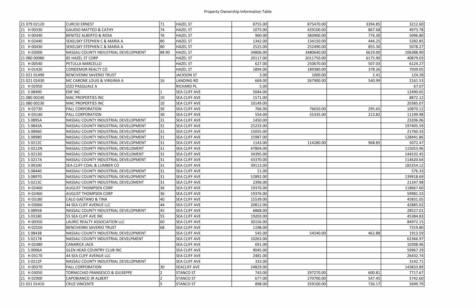
21 079 02120 CURCIO ERNEST 71 HAZEL ST 8755.00 875470.00 3394.85 3212.6021 H 00330 GAUDIO MATTEO & CATHY 74 HAZEL ST 1073.00 429100.00 867.68 4973.7821 H 00340 BENITEZ ALBERTO & ROSA 76 HAZEL ST 960.00 383900.00 776.30 5096.8021 H 02440 SEKELSKY STEPHEN C & MARIA A 80 HAZEL ST 1342.00 134150.00 444.25 5282.8521 H 00430 SEKELSKY STEPHEN C & MARIA A 80 HAZEL ST 2525.00 252490.00 855.30 5078.2721 H 03000 NASSAU COUNTY INDUSTRIAL DEVELOPMENT 88 90 HAZEL ST 34806.00 3480640.00 6619.00 106388.9021 080 00080 85 HAZEL ST CORP HAZEL ST 20117.00 2011750.00 6175.90 40879.0321 H 00540 PETULLA MARCELLO HAZEL ST 627.00 250670.00 507.03 6124.2721 H 01420 CONDEMOR REALTY CO HAZEL ST 1894.00 189380.00 378.26 7039.0521 021 01490 BENCIVENNI SAVERIO TRUST JACKSON ST 3.00 1000.00 2.41 124.2821 021 02430 MC CARONE LOUIS & VIRGINIA A 16 LANDING RD 669.00 267900.00 540.99 2161.5321 H 02950 IZZO PASQUALE A RICHARD PL 5.00 67.0721 S 08490 ENF INC 1 SEA CLIFF AVE 5044.00 12490.6521 080 00240 MAC PROPERTIES INC 10 SEA CLIFF AVE 1571.00 8872.1221 080 00230 MAC PROPERTIES INC 10 SEA CLIFF AVE 10149.00 20385.0721 H 02730 PALL CORPORATION 30 SEA CLIFF AVE 766.00 76650.00 295.65 10870.1221 H 03140 PALL CORPORATION 30 SEA CLIFF AVE 554.00 55335.00 213.82 11199.9821 S 0895A NASSAU COUNTY INDUSTRIAL DEVELOPMENT 31 SEA CLIFF AVE 1450.00 23206.0621 S 0843A NASSAU COUNTY INDUSTRIAL DEVELOPMENT 31 SEA CLIFF AVE 25233.00 197405.5921 S 08960 NASSAU COUNTY INDUSTRIAL DEVELOPMENT 31 SEA CLIFF AVE 15055.00 21760.3321 S 08980 NASSAU COUNTY INDUSTRIAL DEVELOPMENT 31 SEA CLIFF AVE 15987.00 128441.8621 S 0212C NASSAU COUNTY INDUSTRIAL DEVELOPMENT 31 SEA CLIFF AVE 1143.00 114280.00 968.85 5072.4721 S 0212N NASSAU COUNTY INDUSTRIAL DEVELOMENT 31 SEA CLIFF AVE 47804.00 115053.9621 S 0213D NASSAU COUNTY INDUSTRIAL DEVELOMENT 31 SEA CLIFF AVE 34395.00 144532.4521 S 0217A NASSAU COUNTY INDUSTRIAL DEVELOPMENT 31 SEA CLIFF AVE 43370.00 114620.6421 S 00100 SEA CLIFF COAL & LUMBER CO 31 SEA CLIFF AVE 39113.00 182254.1221 S 08440 NASSAU COUNTY INDUSTRIAL DEVELOPMENT 31 SEA CLIFF AVE 51.00 576.3321 S 08970 NASSAU COUNTY INDUSTRIAL DEVELOPMENT 31 SEA CLIFF AVE 52892.00 139918.6921 S 0213C NASSAU COUNTY INDUSTRIAL DEVELOMENT 31 SEA CLIFF AVE 2396.00 21347.9821 H 02460 AUGUST THOMPSEN CORP 36 SEA CLIFF AVE 19376.00 118667.6021 H 02460 AUGUST THOMPSEN CORP 36 SEA CLIFF AVE 19376.00 59981.5321 H 03180 CALO GAETANO & TINA 40 SEA CLIFF AVE 15539.00 45831.0521 H 03060 44 SEA CLIFF AVENUE LLC 44 SEA CLIFF AVE 20812.00 42885.0221 S 0895B NASSAU COUNTY INDUSTRIAL DEVELOPMENT 45 SEA CLIFF AVE 6868.00 28527.0121 S 03180 55 SEA CLIFF AVE INC 55 SEA CLIFF AVE 19203.00 45384.8321 H 00350 LAURIC REALTY ASSOCIATION LLC 60 SEA CLIFF AVE 30156.00 84972.1521 H 02550 BENCIVENNI SAVERIO TRUST 68 SEA CLIFF AVE 1198.00 7319.8021 S 0843B NASSAU COUNTY INDUSTRIAL DEVELOPMENT SEA CLIFF AVE 545.00 54540.00 462.88 1913.5921 S 0217B NASSAU COUNTY INDUSTRIAL DEVELPMENT SEA CLIFF AVE 10263.00 62366.9721 H 02480 CANARICK JACK SEA CLIFF AVE 691.00 10398.9621 S 0006A GLEN HEAD COUNTRY CLUB INC SEA CLIFF AVE 9045.00 59967.2921 H 03170 44 SEA CLIFF AVENUE LLC SEA CLIFF AVE 2481.00 26432.7421 S 0212P NASSAU COUNTY INDUSTRIAL DEVELOPMENT SEA CLIFF AVE 333.00 3142.7121 H 00370 PALL CORPORATION 30 SEACLIFF AVE 24829.00 143833.8921 H 03050 TORNICCHIO FRANSESCO & GIUSEPPE 2 STANCO ST 743.00 297270.00 600.81 7717.6721 H 02900 CAPOBIANCO JR ALBERT 2 STANCO ST 677.00 270700.00 547.45 5742.6021 021 01410 CRUZ VINCENTE 5 STANCO ST 898.00 359100.00 726.17 5699.79
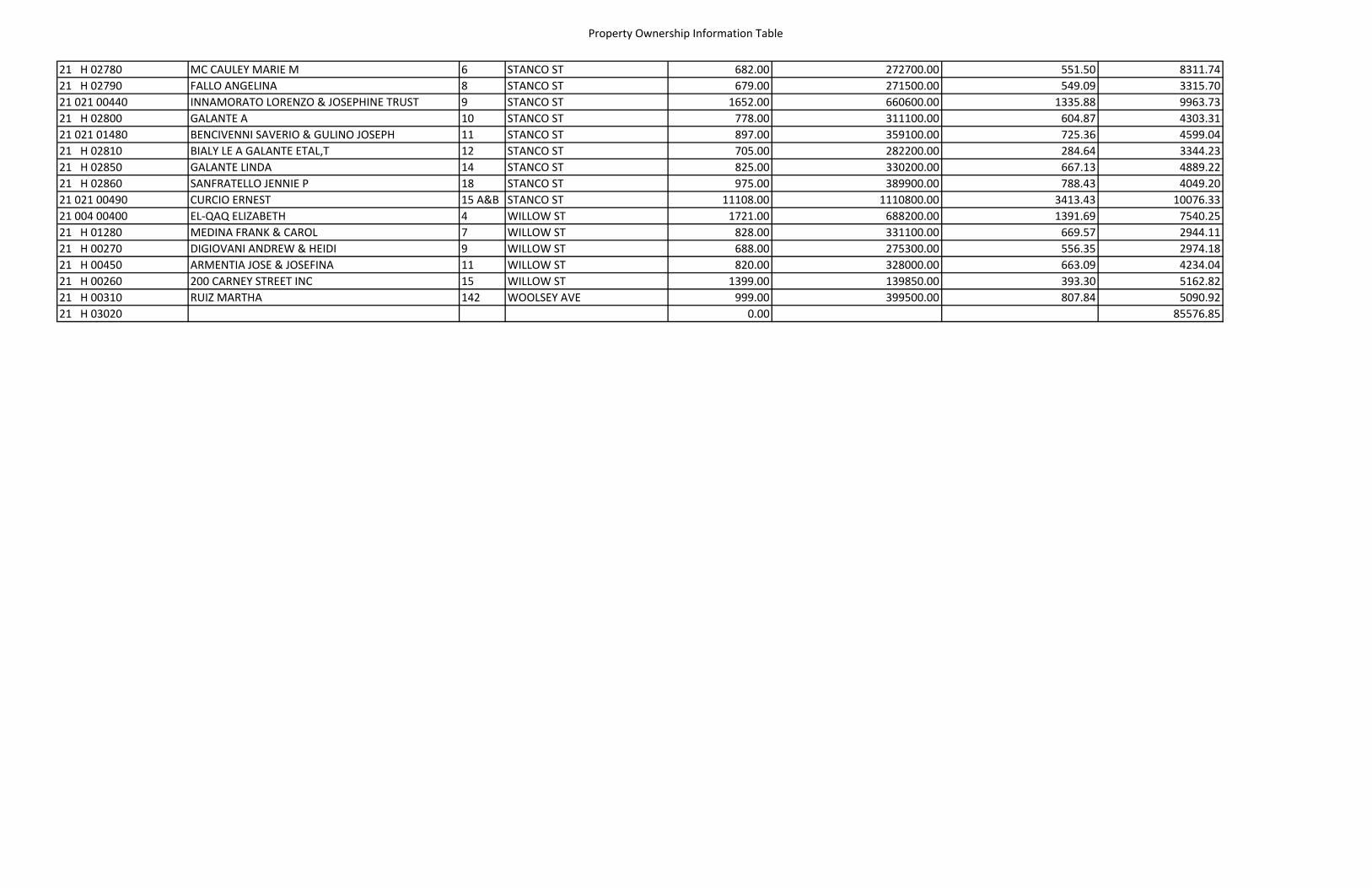
Property Ownership Information Table
21 H 02780 MC CAULEY MARIE M 6 STANCO ST 682.00 272700.00 551.50 8311.7421 H 02790 FALLO ANGELINA 8 STANCO ST 679.00 271500.00 549.09 3315.7021 021 00440 INNAMORATO LORENZO & JOSEPHINE TRUST 9 STANCO ST 1652.00 660600.00 1335.88 9963.7321 H 02800 GALANTE A 10 STANCO ST 778.00 311100.00 604.87 4303.3121 021 01480 BENCIVENNI SAVERIO & GULINO JOSEPH 11 STANCO ST 897.00 359100.00 725.36 4599.0421 H 02810 BIALY LE A GALANTE ETAL,T 12 STANCO ST 705.00 282200.00 284.64 3344.2321 H 02850 GALANTE LINDA 14 STANCO ST 825.00 330200.00 667.13 4889.2221 H 02860 SANFRATELLO JENNIE P 18 STANCO ST 975.00 389900.00 788.43 4049.2021 021 00490 CURCIO ERNEST 15 A&B STANCO ST 11108.00 1110800.00 3413.43 10076.3321 004 00400 EL‐QAQ ELIZABETH 4 WILLOW ST 1721.00 688200.00 1391.69 7540.2521 H 01280 MEDINA FRANK & CAROL 7 WILLOW ST 828.00 331100.00 669.57 2944.1121 H 00270 DIGIOVANI ANDREW & HEIDI 9 WILLOW ST 688.00 275300.00 556.35 2974.1821 H 00450 ARMENTIA JOSE & JOSEFINA 11 WILLOW ST 820.00 328000.00 663.09 4234.0421 H 00260 200 CARNEY STREET INC 15 WILLOW ST 1399.00 139850.00 393.30 5162.8221 H 00310 RUIZ MARTHA 142 WOOLSEY AVE 999.00 399500.00 807.84 5090.9221 H 03020 0.00 85576.85
www.vhb.com