environmental changes induced by the development of ranca
TRANSCRIPT
Landform Analysis, Vol. 10: 77–84 (2009)
Environmental changes induced by the developmentof Ranca resort in a mountainous area
Ioan Eustatiu Marinescu*, Emil Marinescu, Sandu Boengiu, Liliana Popescu
University of Craiova, Geography Department, Al. I. Cuza, no 13, Craiova, Dolj 1100, Romania
Abstract: The paper aims at analyzing the most important environmental aspects generated by the development of atouristic resort within a reference mountainous area of the Parang Mountains. The direct and indirect impact of the touristicactivity on the environment is evaluated both by analyzing the spatial evolution of the resort according to the French andAustrian Tyrol patterns, and by the integrated analysis of the negative effects induced by the touristic activity on the naturalecosystems characteristic for the high mountainous area. Using various techniques (for instance the Spatial Planning of theLocal Territory, the guide published by WTO, measurements on the 1:25,000 topographic map, satellite images), there thePOT and CUT urban indexes were determined, together with some specific indicators for touristic pressure on the environ-ment, such as stress and critical ecosystems. The final goal of mapping the ecologic fragility areas situated along the main di-rections for the settlement development is to underline the potential environmental changes determined by the touristiccapitalization of the region.
Key words: mountain tourism, touristic settlement, development patterns, touring activities, Southern Carpathians
Introduction
In Europe, the mountain tourism has differentlydeveloped, depending on the natural potential, thedistance to the well-known ‘tourism heartlands’, andother factors such as differences in mentality, social,political and administrative organization of the host-ing communities (Gordon & Goodall, 2000).
The development of mountainous tourist resortsin Europe is based on two antithetical referencemodels that approach quite differently the manage-ment of the touristic phenomena. They integrate the“French pattern” that predominated during the firstphase for the alpine region of Italy and SpanishPyrenées, and the “Tyrol pattern” that predomi-nated in southern Germany and north-eastern Italy.
The French pattern began with an elite and mod-ern mountain tourism related to villegiatura, relax-ation, promenade, and thermal baths in very popularresorts, such as Val d’Isere, Chamonix, SaintGervais. The resorts that emerged from an existingsettlement were consistently, yet spontaneously, de-pending on the fame of the area, on the financial in-
terests and local property conjunctures, and, most ofall, on the financial resources of the local community(Rogers, 2002).
This model is based on the development of atouristic zone with complex endowments, for inte-grated resorts that are rather large and concentrated,characterized by specialized human settlements – sky,high altitude, high density of constructions, strict andexclusivist functional zones, circulation segregation –pedestrians, sports, cars (with large parking areas),vast and expensive sport technical facilities, typical ur-ban technical equipment (Gordon & Godall, 2000).
The Austrian Tyrol pattern is concordant to thelatest conceptions regarding the mountainous tour-ism and urbanism, the identity of which is given bythe ‚green tourism’, ‚environment friendly’.
This development model of the mountain resortsis based on the host community, non aggression ofthe natural environment and the quality of touristicservices, as well as on the host-tourist human rela-tionships (personalized welcoming instead of largeseries, standard tourist series, depersonalization)(Kousis, 1998).
77
* e-mail: [email protected]

The Tyrol model for touristic development offersan optimal base for a sustainable local and regionaldevelopment, less vulnerable to the economic, socialand political conjunctures that affect the tourist in-dustry in the exclusively specialized centre.
According to the Spatial Planning of the Nationaland County Territory, Ranca is classified as recentlyachieved touristic settlement, strictly specialized andwith mono-profile. There are residential zones withhigh standard, made up of vacation homes of thewealthy people. The touristic infrastructure, al-though valuable from the built environment point ofview (large buildings, made of resistant, quality andexpensive materials), include mainly one type: build-ings for temporary dwelling, which are homoge-neously distributed throughout the area.
In order to underline the impact of the develop-ment of Ranca settlement on the environment, itsspatial evolution was compared to the French andTyrol patterns; there were used integrated analysesfor the unfavourable effects caused by the touristicactivity on the natural ecosystems characteristic forthe high mountainous area.
The present study aims at calculating some spe-cific indicators for tourist pressure on the mountainenvironment components and at mapping theecologic fragility areas, situated on the main direc-tions for the settlement development.
Area of study
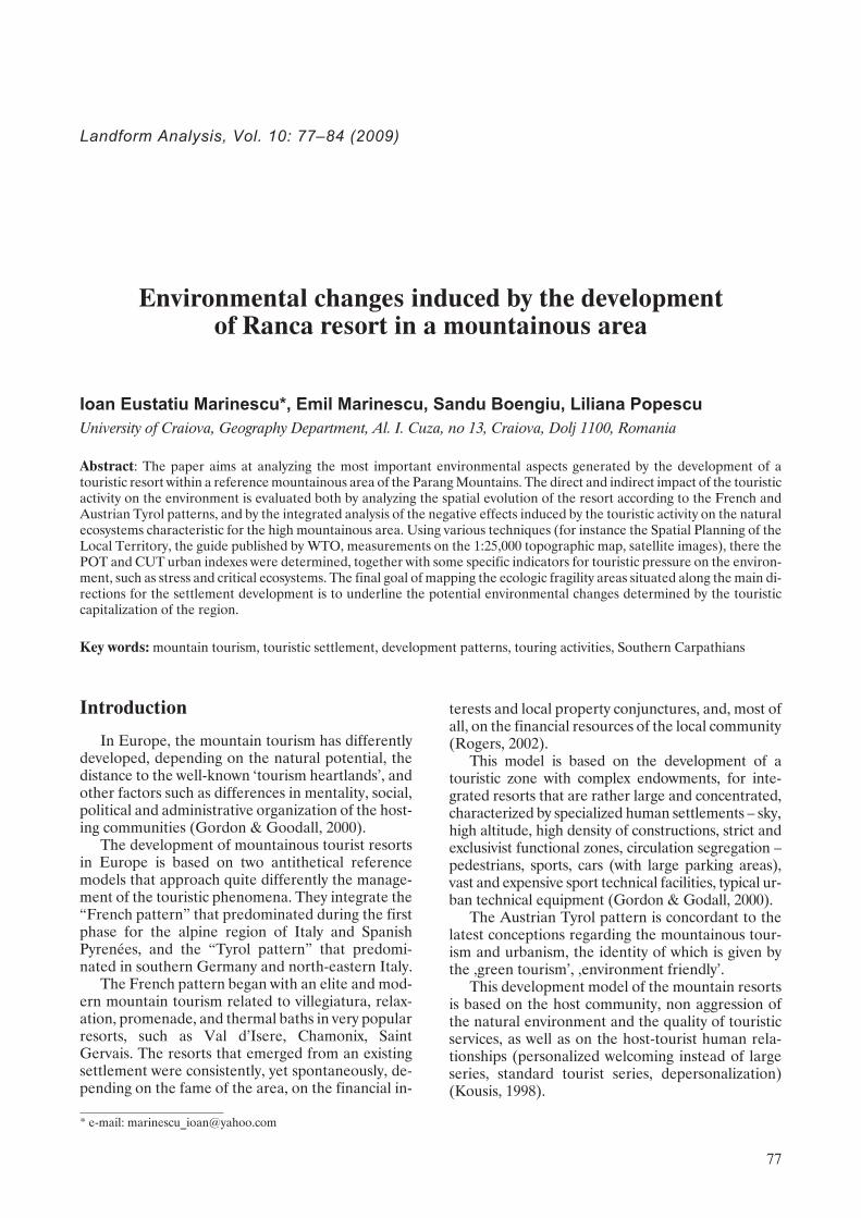
The analysed area lies in the central part of theSouthern Carpathians, on their southern slope, at anaverage height of approximately 1600 m (Fig. 1). Thebuilt-up territory of Ranca (Fig. 2) is included in theadministrative territory of the town of Novaci andBaia de Fier commune. Ranca area has a high
touristic potential as a result of the diversity of reliefforms, climatic conditions, hydrographical network,specific vegetation and fauna.
The main access road is DN 67 Novaci – Sugag –Sebes, which is modernized up to the northernRanca zone, from where it winds, at altitudes ex-ceeding 2,000 m, towards Obarsia Lotrului; the roadis paved with gravel. Being situated along a road ofnational importance, there are good premises for thesettlement of active people in the area and conse-quently, the man-induced pressure on theabove-mentioned areas will increase. The hearthland of Ranca settlement stretches from the north tothe south along the interfluve between the GilortRriver in the west and the Galben River in the east,corresponding to the Rau-Ses levelled surface situ-ated at 1,600–1,700 m a.s.l. in the SouthernCarpathians.
The Ranca area presents a high touristic poten-tial as a result of the landform diversity, climatic con-ditions, hydrographical network, and characteristicvegetation and fauna.
The relief is a result of lithological differentiationof the bedrock which acts differently to the action ofexternal agents. Within the high summits, on thegranitoids from the Parang Massif, there are frostand snow erosion processes that are modelling aperiglacial relief, characteristic on the southernslope, with high frequency of big frost-shatteredblocks. In the south, where there is a new alignmentof granite intrusions, the complex action of insula-tion, frost-work and crystallization forces of the solu-tions that are creeping inside the fissures, there is anintense physical wearing of the rocks, leading tolarge areas covered by grus.
From the climatic point of view, the average an-nual temperature at Ranca is 4.6°C, and the averageprecipitation quantity reaches 1,284 mm. Thenorth-western, north-eastern and northern windshave the highest frequency (20.2%, 18.2%, and17.3%, respectively), while the north-western windshave the highest intensity. The snow layer is presentapproximately 135 days per year, a fact which allowsthe development of Ranca settlement first of all as aresort for winter sports.
The area is situated between the upper limit ofthe spruce woods and alpine zone. The coniferouslevel lies in the southern Parang at altitudes of1,400–1,750 m. Picea abies is the dominant elementof these forests. Due to the continuously widening ofgrazing zone, the lower limit of the coniferous foresthas fallen sometimes by 200–250 m. In the spruceforests, one can also find Larix decidua, Pinussylvestris, Sambucus racemosa, Salix caprea, andSorbus aucuparia. The subalpine vegetation is foundat altitudes between 1,750 and 2,100 m. The subal-pine shrubs are dominated by Pinus mugo, Juniperusnana and Rhododendron myrtifolium. Along the wet
78
Ioan Eustatiu Marinescu, Emil Marinescu, Sandu Boengiu, Liliana Popescu
Fig. 1. The location of analysed area within the RomanianCarpathians
valleys, Alnus viridis shrubs occur. Vacciniummyrtillus, Vaccinium vitis – idaea and Bruckenthaliaspiculifolia also appear within this vegetation level.
Secondary grasslands with Agrostis rupestris, Fes-tuca ovina and Festuca supina have taken the placeof the juniper trees set on fire or cut by shepherds;subsequently, due to overgrazing, they evolved intograsslands dominated by Nardus stricta, which is anoligotrophic plant.
The alpine level is naturally represented in theParang Mountains at altitudes exceeding 2,100 m,but following the deforestation of subalpine scrubs,the limit has greatly descended. The herbaceous veg-etation includes meadows with Agrostis rupestris,Carex curvula, Nardus stricta, etc. There are also spe-cies found in the subalpine level too, such as Cam-panula alpina, Thymus alpestris, Cerastium alpinum,Phyteuma spicatum, Geum montanum, Hieraciumalpinum, Hieracium villosum, Primula minima,Scorzonera rosea, etc. Pioneer ligneous vegetationsuch as Dryas octopetala, Salix herbacea, Salix alpina,and Loiseleuria procumbens, due to grazing andstrong winds, has greatly degraded; at present, it isfound only as clumps here and there in the glacialcirques or on the interfluves.
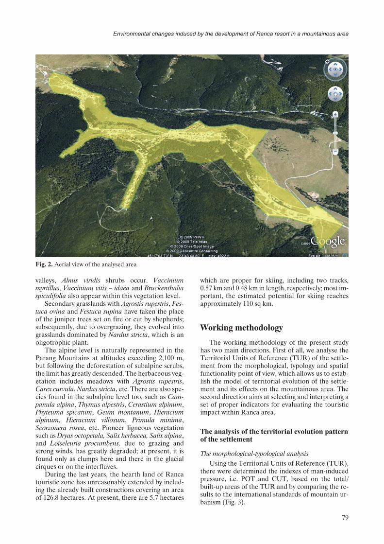
During the last years, the hearth land of Rancatouristic zone has unreasonably extended by includ-ing the already built constructions covering an areaof 126.8 hectares. At present, there are 5.7 hectares
which are proper for skiing, including two tracks,0.57 km and 0.48 km in length, respectively; most im-portant, the estimated potential for skiing reachesapproximately 110 sq km.
Working methodology
The working methodology of the present studyhas two main directions. First of all, we analyse theTerritorial Units of Reference (TUR) of the settle-ment from the morphological, typology and spatialfunctionality point of view, which allows us to estab-lish the model of territorial evolution of the settle-ment and its effects on the mountainous area. Thesecond direction aims at selecting and interpreting aset of proper indicators for evaluating the touristicimpact within Ranca area.
The analysis of the territorial evolution patternof the settlement
The morphological-typological analysisUsing the Territorial Units of Reference (TUR),
there were determined the indexes of man-inducedpressure, i.e. POT and CUT, based on the total/built-up areas of the TUR and by comparing the re-sults to the international standards of mountain ur-banism (Fig. 3).
79
Environmental changes induced by the development of Ranca resort in a mountainous area
Fig. 2. Aerial view of the analysed area
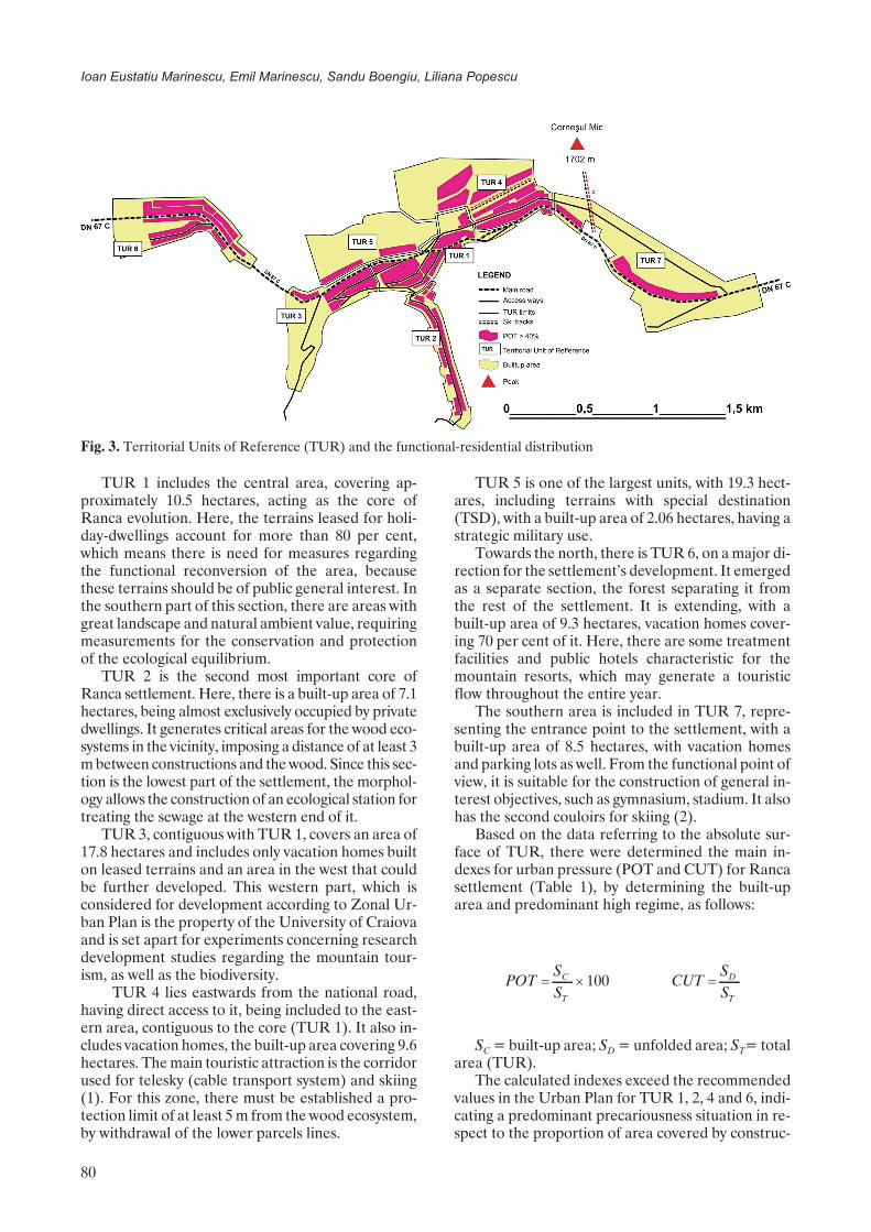
TUR 1 includes the central area, covering ap-proximately 10.5 hectares, acting as the core ofRanca evolution. Here, the terrains leased for holi-day-dwellings account for more than 80 per cent,which means there is need for measures regardingthe functional reconversion of the area, becausethese terrains should be of public general interest. Inthe southern part of this section, there are areas withgreat landscape and natural ambient value, requiringmeasurements for the conservation and protectionof the ecological equilibrium.
TUR 2 is the second most important core ofRanca settlement. Here, there is a built-up area of 7.1hectares, being almost exclusively occupied by privatedwellings. It generates critical areas for the wood eco-systems in the vicinity, imposing a distance of at least 3m between constructions and the wood. Since this sec-tion is the lowest part of the settlement, the morphol-ogy allows the construction of an ecological station fortreating the sewage at the western end of it.
TUR 3, contiguous with TUR 1, covers an area of17.8 hectares and includes only vacation homes builton leased terrains and an area in the west that couldbe further developed. This western part, which isconsidered for development according to Zonal Ur-ban Plan is the property of the University of Craiovaand is set apart for experiments concerning researchdevelopment studies regarding the mountain tour-ism, as well as the biodiversity.
TUR 4 lies eastwards from the national road,having direct access to it, being included to the east-ern area, contiguous to the core (TUR 1). It also in-cludes vacation homes, the built-up area covering 9.6hectares. The main touristic attraction is the corridorused for telesky (cable transport system) and skiing(1). For this zone, there must be established a pro-tection limit of at least 5 m from the wood ecosystem,by withdrawal of the lower parcels lines.
TUR 5 is one of the largest units, with 19.3 hect-ares, including terrains with special destination(TSD), with a built-up area of 2.06 hectares, having astrategic military use.
Towards the north, there is TUR 6, on a major di-rection for the settlement’s development. It emergedas a separate section, the forest separating it fromthe rest of the settlement. It is extending, with abuilt-up area of 9.3 hectares, vacation homes cover-ing 70 per cent of it. Here, there are some treatmentfacilities and public hotels characteristic for themountain resorts, which may generate a touristicflow throughout the entire year.
The southern area is included in TUR 7, repre-senting the entrance point to the settlement, with abuilt-up area of 8.5 hectares, with vacation homesand parking lots as well. From the functional point ofview, it is suitable for the construction of general in-terest objectives, such as gymnasium, stadium. It alsohas the second couloirs for skiing (2).
Based on the data referring to the absolute sur-face of TUR, there were determined the main in-dexes for urban pressure (POT and CUT) for Rancasettlement (Table 1), by determining the built-uparea and predominant high regime, as follows:
POTSS
C
T
� � 100 CUTSS
D
T
�
SC = built-up area; SD = unfolded area; ST= totalarea (TUR).
The calculated indexes exceed the recommendedvalues in the Urban Plan for TUR 1, 2, 4 and 6, indi-cating a predominant precariousness situation in re-spect to the proportion of area covered by construc-
80
Ioan Eustatiu Marinescu, Emil Marinescu, Sandu Boengiu, Liliana Popescu
Fig. 3. Territorial Units of Reference (TUR) and the functional-residential distribution

tions with residential and transport functions. Fromthe morphologic and typological point of view, only10 per cent of the buildings comply with the architec-tural principles for volumes, covering, materials thatwere used, orientation, POT and CUT indexes,adopted in the Urban Plan 6A01/2004.
The identification of the spatial functional modelThe identification of the spatial-functional model
of territorial evolution of the settlement was basedon the analysis of the spatial distribution of TUR,taking into consideration the percentage of the pres-ent and future building perimeters. This method al-lowed us to underline the main axes and directionsfor the development of Ranca touristic settlement(Fig. 4).
81
Environmental changes induced by the development of Ranca resort in a mountainous area
Table 1. Calculation of the occupied built-up territory by TUR (according to the Ranca Zone urban plan – Pilot study6A01/2007, INCD URBAN PROIECT, Bucharest)
No. Territorial Units of Reference (TUR) Area (hectares) Built-up area(hectares) POT (%) POT (%)
Maximum value
1 TUR 1 – Central core 10.5 6.70 63 50
2 TUR 2 – Western area 12.4 7.10 57 40
3 TUR 3 – Contiguous area [1] 17.8 4.60 26 40
4 TUR 4 – Eastern contiguous area [1] 20.9 9.60 46 40
5 TUR 5 –TDS area 19.3 2.06 11 40
6 TUR 6 – Northern area 21.6 9.30 43 40
7 TUR 7 – Southern area 24.3 8.50 35 40
Total 126.8 47.86 40.14 41.40
No. Territorial Units of Reference (TUR) Area (hectares) Height of buildings CUT RecommendedCUT
1 TUR 1 – Central core 10.5 Gf +1 4–8 m 1.27 1.05
2 TUR 2 – Western area 12.4 Gf +1 4–8 m 1.14 1.00
3 TUR 3 – Contiguous area [1] 17.8 Gf +M 3–6 m 0.25 1.00
4 TUR 4 – Eastern contiguous area [1] 20.9 Gf +2 6–9 m 0.91 1.00
5 TUR 5 –TDS area 19.3 Gf +1 4–8 m 0.21 1.00
6 TUR 6 – Northern area 21.6 Gf +1 4–8 m 0.86 1.00
7 TUR 7 – Southern area 24.3 Gf +2 6–9 m 1.04 1.00
Total 126.8
Fig. 4. Main directions for the development of Ranca touristic settlement
At present, the hearth land of Ranca is stretchingfrom the north to the south, with secondary axes, ac-cording to the terrain configuration, on one hand,and due to the presence of the main access road (DN67C), on the other hand.
The built-up area gradually extended, first by theemergence of some functional micro zones includedin the first TUR, and then by leasing plots from TUR6 and 4, with direct access to the main developmentaxis.
The built-up area includes mainly private vaca-tion homes erected on leased plots. Following thelack of a development strategy of the settlement,there emerged many buildings that do not fit into thelandscape. Consequently, there is a functional dis-continuity, leading to the fragmentation of the logi-cal structure of spatial and functional organizationand distribution within the analysed area.
That is why there is no clear, coherent and justi-fied functional zoning. Within the present limits,there is no area of public interest, there are hardlyany objectives of this kind, and the possibilities forrevitalisation are quite a few.
Comparing Ranca to the French and Tyrol modelsThe analysis of the main development patterns for
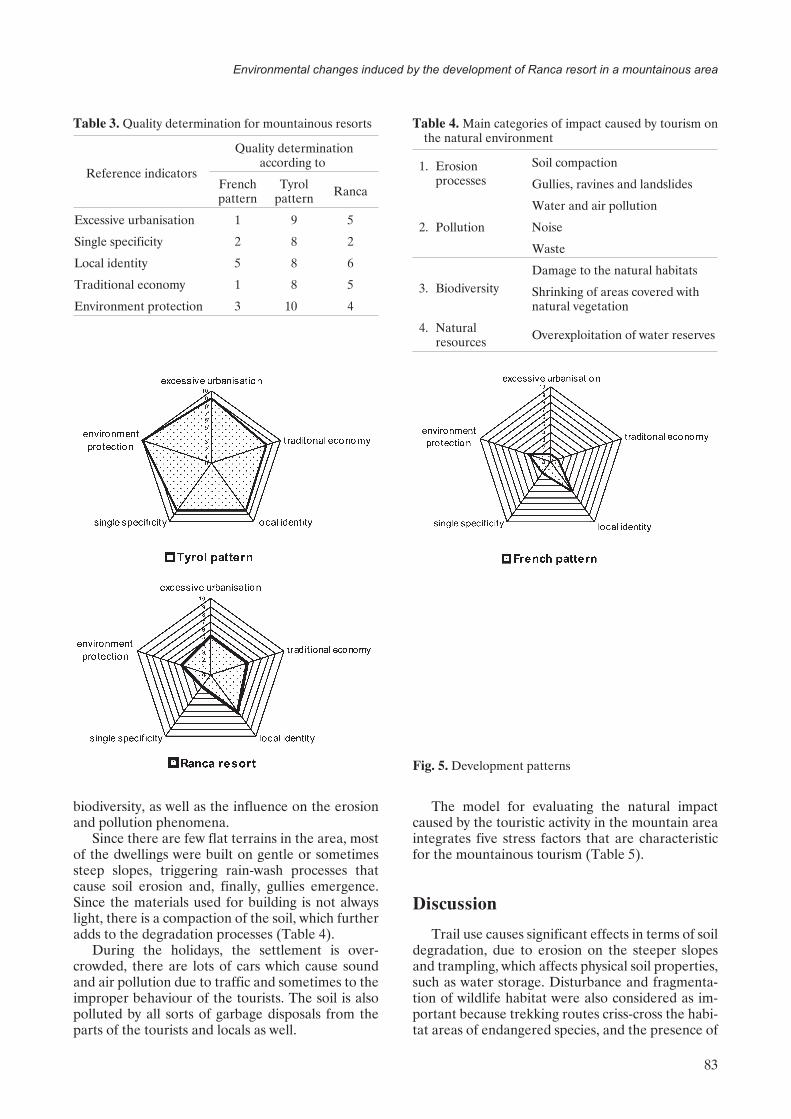
mountainous resorts in France and Austria indicatedthat there are five major components that play a vitalrole in the spatial and functional evolution of touristicsettlements. These are: excessive urbanisation, speci-ficity, local identity, traditional economy and tourismbased on environment protection (Table 2).
The evolution model was achieved by referring tothe five elements classified for quality determination(according to Mountainous Resorts DevelopmentStrategies, UGS, USA 1997).
This method allows the multi-criteria analysis ofthe potential effects of the development of a touristicsettlement in the mountainous area, by identifyingthe negative effects and the urban objectives of thesettlement.
Taking into account the spatial and functionalstructure of the built-up area, as well as the charac-teristics of Ranca area, the evolution pattern ofRanca was compared to those of the French andTyrol patterns (Table 3, Fig. 5).
The comparison between Ranca developmentand the two reference models from Europe pointsout that there is an evolution pattern with great ten-dencies for development, leading to the increase ofurbanisation degree of the mountainous area, amore diverse economy to the prejudice of traditionalactivities, limited support for the potential touristicforms and a touristic psychology that disregards thenatural environment quality.
The analysis of touristic impact on Rancamountainous area
The second methodological approach aims at de-scribing and highlighting the environmental changesinduced by the continuous spreading of the built-uparea at Ranca. The way was analysed, in whichtouristic activities interfere with natural resources,
82
Ioan Eustatiu Marinescu, Emil Marinescu, Sandu Boengiu, Liliana Popescu
Table 2. Quality determination for the morphological and typological classification of mountainous resorts (EC (EuropeanCommission), 2001)
Qualitydetermination
Excessiveurbanization
Traditionaleconomy
(traditionalactivities)
Single specificity(tourism forms)
Local identity(natural touristic
objectives)Green tourism
1 POT>60%
0–2
1
<3
Aggressive tourism, leadingthe functional decay of thenatural environment
2 CUT 2–7 1–2Aggressive tourism, withstructural decay of thenatural ecosystems
3 POT>50–60%
2–3
Tourism disturbing lifeforms4 CUT 2–5
3–6 3–55 POT 30–40% Tourism generatingdiscomfort6 CUT 1–3
7 POT>20%
>63-5
6-8Tourism that does notgreatly affect the naturalenvironment8 CUT 1–2
9 POT>10%>8 Ecologic tourism
10 CUT 1–2 6
biodiversity, as well as the influence on the erosionand pollution phenomena.
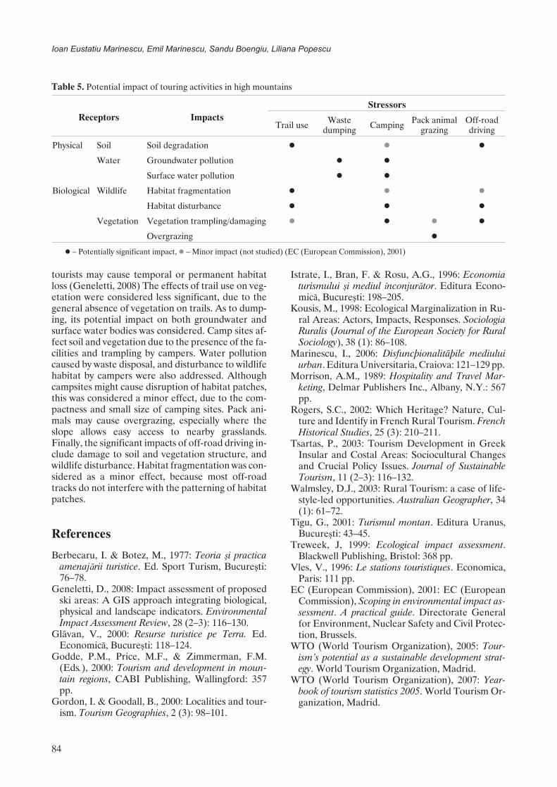
Since there are few flat terrains in the area, mostof the dwellings were built on gentle or sometimessteep slopes, triggering rain-wash processes thatcause soil erosion and, finally, gullies emergence.Since the materials used for building is not alwayslight, there is a compaction of the soil, which furtheradds to the degradation processes (Table 4).
During the holidays, the settlement is over-crowded, there are lots of cars which cause soundand air pollution due to traffic and sometimes to theimproper behaviour of the tourists. The soil is alsopolluted by all sorts of garbage disposals from theparts of the tourists and locals as well.
The model for evaluating the natural impactcaused by the touristic activity in the mountain areaintegrates five stress factors that are characteristicfor the mountainous tourism (Table 5).
Discussion
Trail use causes significant effects in terms of soildegradation, due to erosion on the steeper slopesand trampling, which affects physical soil properties,such as water storage. Disturbance and fragmenta-tion of wildlife habitat were also considered as im-portant because trekking routes criss-cross the habi-tat areas of endangered species, and the presence of
83
Environmental changes induced by the development of Ranca resort in a mountainous area
Fig. 5. Development patterns
Table 3. Quality determination for mountainous resorts
Reference indicators
Quality determinationaccording to
Frenchpattern
Tyrolpattern Ranca
Excessive urbanisation 1 9 5
Single specificity 2 8 2
Local identity 5 8 6
Traditional economy 1 8 5
Environment protection 3 10 4
Table 4. Main categories of impact caused by tourism onthe natural environment
1. Erosionprocesses
Soil compaction
Gullies, ravines and landslides
2. Pollution
Water and air pollution
Noise
Waste
3. BiodiversityDamage to the natural habitats
Shrinking of areas covered withnatural vegetation
4. Naturalresources Overexploitation of water reserves
tourists may cause temporal or permanent habitatloss (Geneletti, 2008) The effects of trail use on veg-etation were considered less significant, due to thegeneral absence of vegetation on trails. As to dump-ing, its potential impact on both groundwater andsurface water bodies was considered. Camp sites af-fect soil and vegetation due to the presence of the fa-cilities and trampling by campers. Water pollutioncaused by waste disposal, and disturbance to wildlifehabitat by campers were also addressed. Althoughcampsites might cause disruption of habitat patches,this was considered a minor effect, due to the com-pactness and small size of camping sites. Pack ani-mals may cause overgrazing, especially where theslope allows easy access to nearby grasslands.Finally, the significant impacts of off-road driving in-clude damage to soil and vegetation structure, andwildlife disturbance. Habitat fragmentation was con-sidered as a minor effect, because most off-roadtracks do not interfere with the patterning of habitatpatches.
References
Berbecaru, I. & Botez, M., 1977: Teoria ºi practicaamenajãrii turistice. Ed. Sport Turism, Bucureºti:76–78.
Geneletti, D., 2008: Impact assessment of proposedski areas: A GIS approach integrating biological,physical and landscape indicators. EnvironmentalImpact Assessment Review, 28 (2–3): 116–130.
Glãvan, V., 2000: Resurse turistice pe Terra. Ed.Economicã, Bucureºti: 118–124.
Godde, P.M., Price, M.F., & Zimmerman, F.M.(Eds.), 2000: Tourism and development in moun-tain regions, CABI Publishing, Wallingford: 357pp.
Gordon, I. & Goodall, B., 2000: Localities and tour-ism. Tourism Geographies, 2 (3): 98–101.
Istrate, I., Bran, F. & Rosu, A.G., 1996: Economiaturismului ºi mediul înconjurãtor. Editura Econo-micã, Bucureºti: 198–205.
Kousis, M., 1998: Ecological Marginalization in Ru-ral Areas: Actors, Impacts, Responses. SociologiaRuralis (Journal of the European Society for RuralSociology), 38 (1): 86–108.
Marinescu, I., 2006: Disfuncþionalitãþile mediuluiurban. Editura Universitaria, Craiova: 121–129 pp.
Morrison, A.M., 1989: Hospitality and Travel Mar-keting, Delmar Publishers Inc., Albany, N.Y.: 567pp.
Rogers, S.C., 2002: Which Heritage? Nature, Cul-ture and Identify in French Rural Tourism. FrenchHistorical Studies, 25 (3): 210–211.
Tsartas, P., 2003: Tourism Development in GreekInsular and Costal Areas: Sociocultural Changesand Crucial Policy Issues. Journal of SustainableTourism, 11 (2–3): 116–132.
Walmsley, D.J., 2003: Rural Tourism: a case of life-style-led opportunities. Australian Geographer, 34(1): 61–72.
Tigu, G., 2001: Turismul montan. Editura Uranus,Bucureºti: 43–45.
Treweek, J, 1999: Ecological impact assessment.Blackwell Publishing, Bristol: 368 pp.
Vles, V., 1996: Le stations touristiques. Economica,Paris: 111 pp.
EC (European Commission), 2001: EC (EuropeanCommission), Scoping in environmental impact as-sessment. A practical guide. Directorate Generalfor Environment, Nuclear Safety and Civil Protec-tion, Brussels.
WTO (World Tourism Organization), 2005: Tour-ism’s potential as a sustainable development strat-egy. World Tourism Organization, Madrid.
WTO (World Tourism Organization), 2007: Year-book of tourism statistics 2005. World Tourism Or-ganization, Madrid.
84
Ioan Eustatiu Marinescu, Emil Marinescu, Sandu Boengiu, Liliana Popescu
Table 5. Potential impact of touring activities in high mountains
Receptors ImpactsStressors
Trail use Wastedumping Camping Pack animal
grazingOff-roaddriving
Physical Soil Soil degradation � � �
Water Groundwater pollution � �
Surface water pollution � �
Biological Wildlife Habitat fragmentation � � �
Habitat disturbance � � �
Vegetation Vegetation trampling/damaging � � � �
Overgrazing �
� – Potentially significant impact, � – Minor impact (not studied) (EC (European Commission), 2001)