environmental assessment registration tailings management ...€¦ · environmental assessment...
TRANSCRIPT

December 12, 2017
Environmental Assessment Registration
Tailings Management Facility Expansion, Ming Copper-Gold Mine
Baie Verte Peninsula, Newfoundland and Labrador

Rambler Metals and Mining Ltd. Tailings Management Expansion, Ming Copper-Gold Mine
i
Rambler Metals and Mining Canada Limited Tailings Management Facility Expansion, Ming Copper-Gold Mine
Environmental Assessment Registration Pursuant to the Newfoundland and Labrador Environmental Protection Act (Part X)
Submitted by: Rambler Metals and Mining Canada Limited Route 418, Ming’s Bight Road PO Box 610 Baie Verte, NL A0K 1B0
Prepared with the assistance of: GEMTEC Consulting Engineers and Scientists 10 Maverick Place Paradise, NL A1L 0J1
December 12, 2017

Rambler Metals and Mining Ltd. Tailings Management Expansion, Ming Copper-Gold Mine
ii
EXECUTIVE SUMMARY
Rambler Metals and Mining Canada Limited (RMM or Rambler) is proposing to expand their Tailing Management Facility at their Nugget Pond Mill site on the Baie Verte Peninsula to accommodate tailings from ongoing mining operations at their Ming Copper-Gold Mine, in production since 2011. Past and current operation at the Ming Mine has included mining of relatively high-grade copper ore. Future operations will continue with the mining of the higher grade ore in addition to the mining of lower grade material to be blended for an overall higher production rate of 1,250 metric tonnes per day (mtpd). RMM has determined that their existing Tailings Impoundment does not have sufficient volume to contain the tailings generated for the new life of mine plan, approximately 5.6 Mm3 of tailings over the next 20 years, and therefore undertook to identify another storage facility. The proposed new Tailings Impoundment, to be located in a fishless waterbody, Camp Pond, was selected among several options for its stability, proximity to the Mill and predicted low environmental impact on the surrounding area. The proposed new Tailings Impoundment will be able to accommodate tailings generated during operations at Ming Mine from approximately 2019 through 2025. RMM is unable to predict with certainty the environmental, economic or social conditions that will be relevant beyond 2025, and that could influence a potential continuation of mining. This proposed Project does not, therefore, present or consider any proposed activities beyond this time frame. However, the current LOM tailings storage requirements can be satisfied within the proposed expanded TMF, in conjunction with additional future upgrades to the facility, if required. The proposed Project will include the construction of an earthen dam to facilitate the conversion of Camp Pond to a safe and environmentally reliable Tailings Impoundment. Other components of the Project include necessary and associated infrastructure such as a tailings slurry pipeline, an effluent decant line, a small pump house and powerline to Camp Pond, outflow stream maintenance and improvements to an existing exploration road. The proposed Project does not require that any additional infrastructure relative to the mill or mining operations be constructed. Given the natural features of Camp Pond, the Project provides a technically feasible and environmentally responsible means of accommodating increased tailings storage from ongoing operations. The commissioning of the Camp Pond Tailings Impoundment will ensure critical production targets are achieved, thus extending the life of mine and ensuring ongoing economic benefits to the region and the provincial economy.

Rambler Metals and Mining Ltd. Tailings Management Expansion, Ming Copper-Gold Mine
iii
RMM does not anticipate any significant adverse effects of the proposed Project on the following environmental and social components:
• Vegetation and Wetlands; • Wildlife and SAR; • Avifauna; • Fish and Fish Habitat; • Water Resources; • Historic and Heritage Resources; and • Communities and Economy.

Rambler Metals and Mining Ltd. Tailings Management Expansion, Ming Copper-Gold Mine
iv
TABLE OF CONTENTS
EXECUTIVE SUMMARY ............................................................................................................ II
1.0 INTRODUCTION ................................................................................................................ 1
1.1 Proponent Information ................................................................................................. 3 1.2 Rationale for the Undertaking ...................................................................................... 3 1.3 Environmental Assessment Process and Requirements .............................................. 6
2.0 PROJECT DESCRIPTION ................................................................................................. 6
2.1 Property Description and Location ............................................................................... 7 2.2 Land Tenure ...............................................................................................................11 2.3 Alternatives to the Project ...........................................................................................11 2.4 Project Components ...................................................................................................14
2.4.1 Access Road........................................................................................................16 2.4.2 Camp Pond Dam .................................................................................................16 2.4.3 Tailings Slurry Pipeline Construction and Installation ...........................................18 2.4.4 Effluent Decant Line and Pump ...........................................................................21 2.4.5 Powerline Installation ...........................................................................................21 2.4.6 Outflow Tributary Maintenance ............................................................................21
2.5 Construction................................................................................................................25 2.6 Operations and Maintenance ......................................................................................26 2.7 Possible Accidents and Malfunctions ..........................................................................26 2.8 Closure and Decommissioning....................................................................................27 2.9 Effects of the Environment on the Project ...................................................................28 2.10 Project Reports ...........................................................................................................28 2.11 Project Schedule .........................................................................................................29 2.12 Environmental Management and Protection................................................................29
2.12.1 Environmental Protection Plan .............................................................................30 2.12.2 Emergency Response Plan ..................................................................................30 2.12.3 Contingency Plan .................................................................................................30 2.12.4 Waste Management Plan .....................................................................................30
2.13 Other Required Approvals ...........................................................................................30
3.0 ENVIRONMENTAL BASELINE ........................................................................................ 31
3.1 Natural Environment ...................................................................................................31 3.1.1 Climate ................................................................................................................31 3.1.2 Geology, Soils and Topography ...........................................................................32 3.1.3 Vegetation and Wetlands .....................................................................................32 3.1.4 Wildlife and Species at Risk .................................................................................34 3.1.5 Avifauna ...............................................................................................................35 3.1.6 Fish and Fish Habitat ...........................................................................................36

Rambler Metals and Mining Ltd. Tailings Management Expansion, Ming Copper-Gold Mine
v
3.1.7 Water Resources .................................................................................................40
3.2 Human Environment ...................................................................................................41 3.2.1 Historic and Heritage Resources..........................................................................42 3.2.2 Socioeconomic Considerations ............................................................................42
4.0 CONSULTATION ............................................................................................................. 42
4.1 Regulatory Consultation ..............................................................................................43 4.2 Public Consultation .....................................................................................................43
5.0 ENVIRONMENTAL EFFECTS AND ANALYSIS ............................................................... 43
5.1 Natural Environment ...................................................................................................43 5.1.1 Construction ........................................................................................................43 5.1.2 Operations ...........................................................................................................46 5.1.3 Accidental Effects during Construction and Operation .........................................47 5.1.4 Cumulative Environmental Effects .......................................................................48
5.2 Human Environment ...................................................................................................49
6.0 ENVIRONMENTAL MONITORING AND FOLLOW-UP .................................................... 49
7.0 SUMMARY AND CONCLUSIONS.................................................................................... 50
8.0 REFERENCES ................................................................................................................. 52
LIST OF TABLES
Table 1 Comparison of Water Quality Data between Camp and Horseshoe Ponds (GHD
2016) 24
Table 2 Potential Permits, Approvals, and Authorizations ..................................................... 31
Table 3 Sop’s Arm, White Bay - Climate Normals (1981-2010) ............................................ 32
Table 4 Rare Flora Species identified within five km of the Nugget Pond Mill Site (2016) ..... 34
LIST OF FIGURES
Figure 1 Rambler Property Location on the Baie Verte Peninsula............................................ 2
Figure 2 Rambler Property Components Near Snook’s Arm .................................................... 8
Figure 3 Existing Layout at the Nugget Pond Mill Site ............................................................ 10
Figure 4 RMM’s Mining Lease and Mineral License for the Nugget Pond Mill Site ................. 13
Figure 5 Physical Components of Proposed Project .............................................................. 15
Figure 6 Photo of Camp Pond Looking Southwest ................................................................. 16
Figure 7 Photo of Camp Pond Looking Northeast .................................................................. 17

Rambler Metals and Mining Ltd. Tailings Management Expansion, Ming Copper-Gold Mine
vi
Figure 8 Photo of Camp Pond Outlet ..................................................................................... 17
Figure 9 Bathymetry of Camp Pond ....................................................................................... 19
Figure 10 Study Area and Flooded Zone ................................................................................. 20
Figure 11 Outflow Tributary Immediately Downstream of Camp Pond Showing Steep Decline 22
Table 1 Comparison of Water Quality Data between Camp and Horseshoe Ponds (GHD
2016) 24
Table 2 Potential Permits, Approvals, and Authorizations ..................................................... 31
Table 3 Sop’s Arm, White Bay - Climate Normals (1981-2010) ............................................ 32
Table 4 Rare Flora Species identified within five km of the Nugget Pond Mill Site (2016) ..... 34
Figure 12 Inflow Tributary 1 ..................................................................................................... 37
Figure 13 Inflow Tributary 2 ..................................................................................................... 37
Figure 14 Inflow Tributary 3 ..................................................................................................... 38
LIST OF APPENDICES
Appendix A Baseline Water Quality Results (GHD, 2016)
LIST OF ABBREVIATIONS AND TERMINOLOGY
% Percent
AAQS Ambient Air Quality Standard
ACOA Atlantic Canada Opportunities Agency
ARD Acid Rock Drainage
CAC Criteria Air Contaminants
Cadna A Computer Aided Noise Abatement
CCME Canadian Council of Ministers of the Environment
CH4 Methane
CO Carbon monoxide
CO2 Carbon dioxide
dBA A-weighted decibels

Rambler Metals and Mining Ltd. Tailings Management Expansion, Ming Copper-Gold Mine
vii
DFO
DMS
Department of Fisheries and Oceans
Dense media separation
EA Environmental assessment
ECCC Environment and Climate Change Canada
EEM Environmental Effects Monitoring
EML Exempt Mineral Land
EMP Environmental Management Plan
EPP Environmental Protection Plan
ERCP Emergency Response and Contingency Plans
GHD GHD Limited
GHG Greenhouse Gases
GHGRP Greenhouse Gas Emissions Reporting Program
GLC Ground level concentration
LFZ Lower Footwall Zone
LT-50 Acute Lethality Toxicity
masl Metres above sea level
ML Mineral lease
MMER Metal Mining Effluent Regulations
MMS Ming Massive Sulphides
mtpd Metric tonnes per day
NH3 Ammonia
NL Newfoundland and Labrador
NLCDC Newfoundland and Labrador Conservation Data Centre

Rambler Metals and Mining Ltd. Tailings Management Expansion, Ming Copper-Gold Mine
viii
NLDFLR
NLDMAE
Newfoundland and Labrador Department of Fisheries and Land Resources
Newfoundland and Labrador Department of Municipal Affairs and Environment
NLDNR Newfoundland and Labrador Department of Natural Resources
NLTCII Newfoundland and Labrador Department of Tourism, Culture, Industry and Innovation
N2O Nitrous oxide
NOC National Occupation Classification
O3 Ozone
oz/t Ounces per tonne
PAA Protected Areas Association
PAG Potentially acid-generating
RISS Regulatory Information Submission System
RMM Rambler Metals and Mining Canada Ltd.
SARA Species at Risk Act
SOx Sulphur oxide
SO2 Sulphur dioxide
TMF Tailings Management Facility
TSP Total suspended particulate
VOC Volatile organic compounds
WEP Women’s Employment Plan
WMP Waste Management Plan

Rambler Metals and Mining Ltd. Tailings Management Expansion, Ming Copper-Gold Mine
ix
WWTP Waste water treatment plant

Rambler Metals and Mining Ltd. Tailings Management Expansion, Ming Copper-Gold Mine
1
1.0 INTRODUCTION
Project Name: Tailings Management Facility Expansion, Ming Copper-Gold Mine Rambler Metals and Mining Canada Limited (RMM or Rambler) has been operating a fully approved/permitted mine (Ming Copper-Gold Mine), milling operation (Nugget Pond Mill) and shipping operation (Goodyear’s Cove) on the Baie Verte Peninsula in north central Newfoundland and Labrador (NL) (Figure 1) since 2011.
As part of RMM’s ongoing operational reviews and planning studies, it was determined that the existing Tailings Management Facility (TMF) located at the Nugget Pond Mill site (Mill), does not have sufficient capacity to contain the tailings to be generated from newly identified resources reported in the 2015 NI43-101 Prefeasibility Study. As a result, RMM identified potential locations that could accommodate such tailings and planned and executed baseline studies to support the required expansion of the existing TMF. Based on the results of those studies, and in consultation with federal and provincial regulators, RMM is currently proposing to develop a second tailings impoundment at Camp Pond to accommodate future tailings deposition.
The proposed TMF Expansion (the Project) will involve the following components:
• Upgrading an existing exploration road to access the outlet of Camp Pond for dam construction;
• Construction of an earthen dam at the natural outflow of Camp Pond to increase water elevations and storage capacity, and to control and manage tailings, water, and effluent in the basin;
• An emergency spillway will be constructed within the dam to address potentially significant flood events;
• Re-location and extension of the existing tailings slurry delivery pipeline (HDPE pipe) to Camp Pond;
• Installation of a powerline along the proposed access road corridor from the Mill to Camp Pond, and a small pump, pumphouse, and pipeline to pump effluent from Camp Pond back to the existing Tailings Impoundment; and
• Installation of a small, clean water supply system to maintain water flow to the outflow tributary of Camp Pond.
This Environmental Assessment (EA) Registration document has been prepared in relation to the proposed TMF expansion, with assistance from GEMTEC Limited. The document format follows the guidance for Project Registration under the Newfoundland and Labrador EA process.

Rigolet
Postville
Makkovik
Hopedale
Natuashish
Churchill
Falls
Sheshatshiu
Happy Valley
Goose Bay
Cartwright
Port Hope Simpson
Blanc Sablon
St Barbe
Red Bay
Labrador City
Baie Verte
Fogo Island
Gander
Bonavista
Bay de Verde
St. John's
Trepassy
Clarenville
Deer Lake
Rocky Harbour
Corner Brook
Stephenville
Channel
Port aux Basques
Burgeo
Harbour Breton
Marystown
Nain
G
u
l
f
o
f
S
t
L
a
w
r
e
n
c
e
North Altalntic
Ocean
TOWNS AND CITIES
RAMBLER'S PROPERTY
ROADS
TRANS CANADA HIGHWAY
FERRY ROUTE
PROVINCIAL BOUNDARY
LEGEND:
SCALE:
0 100
Kilometers
200 300
Figure 1: Rambler Property Location on the Baie Verte Peninsula

Rambler Metals and Mining Ltd. Tailings Management Expansion, Ming Copper-Gold Mine
3
1.1 Proponent Information
RMM is a mining company that has 100% ownership of the Ming Copper-Gold Mine on the Baie Verte Peninsula in Newfoundland and Labrador (NL).
Name of Corporate Body: Rambler Metals and Mining Canada
Limited
Corporate Address: P.O Box 610 Baie Verte, NL A0K 1B0
Chief Executive Officer: Mr. Norman Williams President and CEO P.O. Box 610 Baie Verte, NL A0K 1B0 Telephone: 709-800-1929 Fax: 709-800-1921 Email: [email protected]
Principal Contact Person for the Purpose of EA:
Mr. Peter Mercer Vice President, Corporate Secretary P.O. Box 610 Baie Verte, NL A0K 1B0 Telephone: 709-800-1929 ext 500 Fax: 709-800-1921 Email: [email protected]
1.2 Rationale for the Undertaking
The proposed TMF expansion is required to store tailings to be generated from recently confirmed resources at the Ming Mine. The existing TMF, as currently designed and operated has only sufficient storage capacity for the next 1.5 years of operations, and without further tailing storage capacity, RMM’s operations will be impacted or halted once that capacity is reached. The rationale for selecting Camp Pond as the new Tailings Impoundment, or tailings storage area, is as follows.
• Efficiency – Camp Pond is the closest available new tailings storage impoundment area to the Mill and existing TMF. It is also a very deep pond (>30 m) and therefore provides efficient storage capacity for its areal extent.
• Stability – the use of a natural, bedrock bound ‘bowl’ is the most stable scenario for subaqueous tailings deposition, required to prevent acid generation from the tailings.
• Low environmental impact: o Camp Pond is contained within the watershed in which the Mill and existing TMF
are located, and using it will have a minimal impact on the overall water balance in the watershed.

Rambler Metals and Mining Ltd. Tailings Management Expansion, Ming Copper-Gold Mine
4
o Camp Pond is a headwater pond that has been determined to be non-fish bearing, and is in a steep valley which means that increasing the level of the pond results in only a small increase in the flooded land area. Further, the pond is located in a remote area, not suitable for fishing, and is not readily accessible by the general public.
• Minimal construction – due to its proximity to the Mill, an existing exploration access road and the natural depth of the pond, the infrastructure required to utilize the area for tailings storage is minimal and thus minimizes the environmental impacts of the development.
As described in detail in Section 2.3 of this document, there are a number of alternatives to the proposed new Tailings Impoundment at Camp Pond. Engineering additional tailings storage space within the existing TMF area may result in lower overall environmental impacts relative to the conversion of Camp Pond to a Tailings Impoundment, however, the following issues support the use of Camp Pond as the best option:
• Deeper tailings storage areas are required for freezing and thawing conditions in early and late winter. Due to the extreme conditions in this area during the winter, the tailings lines cannot be practically, safely or expeditiously relocated to ensure a uniform deposition of tailings below the water surface. Raising the dams at the existing TMF will provide additional tailings storage volume, however, there will be no deep areas left in which to deposit tailings during winter freeze and thaw periods. This could result in beaching of tailings, increased safety issues, and substantially increased operating costs.
• The storage capacity of the existing TMF, even with dam raises or other means of expanding the current storage capacity, will not be sufficient to safely store and manage the tailings and effluent that will result from the currently estimated Life of Mine LOM production. However, with the inclusion of the proposed new Tailings Impoundment at Camp Pond, it is anticipated that the current LOM tailings storage requirements can be met with future dam raises and other work within the expanded TMF.
RMM’s currently confirmed Ming Mine resource will produce approximately 5.6 Mm3 of tailings over the next 20 years. However, Rambler continues to complete exploration drilling around their current deposit and with continued success, the potential total LOM tailings storage requirements are not fully understood. There are a number of options that RMM is currently evaluating that may change future tailings storage requirements beyond the scope of the Project being proposed under this EA:
• RMM requires tailings to make paste backfill for the Ming mine operation. RMM is currently completing studies to determine an adequate tailings source to be used for this requirement. If tailings from RMM’s Mill production are selected, this material would need to be dewatered and backhauled to the mine site, thus potentially reducing the long term storage requirements of the TMF at Nugget Pond.
• RMM is transitioning its production from the Ming Mine to include a blend of both massive sulphides (MMS zone) and stringer sulphides (referred to as the Lower Footwall Zone or LFZ). The acid rock drainage (ARD) potential of the LFZ has not been fully evaluated. The current mine plan requires mixing of LFZ ore with ore from the MMS zone currently

Rambler Metals and Mining Ltd. Tailings Management Expansion, Ming Copper-Gold Mine
5
being mined, which has been determined to be potentially acid generating (PAG), over most of the LOM. Therefore RMM is currently, and conservatively, assuming that all tailings will be PAG and will require subaqueous disposal. As the MMS ore is exhausted, Rambler will complete further studies on the LFZ ore to determine if all tailings produced will need to be treated as PAG. If LFZ ore is determined to be non-acid generating, it may not require subaqueous disposal and would change the storage volume requirements within the TMF.
• RMM’s Ming Mine is approximately 40 km away from the Nugget Pond Mill and the existing TMF and, as a result, there is a significant cost to haul the ore for processing. RMM is currently evaluating options to construct a mill closer to the mine site, which would then require alternative tailings disposal strategies. A full evaluation of this option is a minimum of five years away and will likely require another step-up in production to justify. The proposed TMF expansion at the Nugget Pond Mill will be required whether or not this is a viable future option for RMM.
The evaluation of these options will take years to complete, and if new options are considered feasible, additional timelines will be required to implement any resulting changes to RMM’s operations. As such, the currently proposed TMF expansion is considered the most prudent path forward. RMM is committed to further studies and evaluation, in consultation with provincial and federal regulators, to determine the most prudent tailings storage solutions should RMM’s planned operations change in the future. The proposed new Tailings Impoundment at Camp Pond, combined with the storage capacity in the existing impoundment will permit safe, efficient, and low environmental impact tailings deposition for the next seven to eight years of mine operation. During this time, RMM will complete the necessary work to determine if alternative tailings storage options will be considered based on a change in storage requirements, i.e., increase or decrease, and based on the issues discussed above. Ultimately, and as previously noted, the current LOM tailings storage requirements can be satisfied within the proposed expanded TMF, in conjunction with future facility upgrades that will be submitted for environmental assessment and permitting review as per the applicable regulations. In addition, RMM is unable to predict with certainty the environmental, economic or social conditions that will be relevant beyond the seven to eight year TMF expansion proposed, and that could influence a potential continuation of mining. For this reason, this proposed Project does not present or consider any proposed activities beyond this time frame. This phased development approach is consistent with other established mining developments in NL and Canada and ensures that the potential environmental effects from this proposed Project are assessed based on existing baseline conditions.

Rambler Metals and Mining Ltd. Tailings Management Expansion, Ming Copper-Gold Mine
6
1.3 Environmental Assessment Process and Requirements
The Newfoundland and Labrador Environmental Protection Act (NL EPA) requires anyone who plans a project that could have a significant effect on the natural, social or economic environment (an “Undertaking”) to present it for examination through the provincial EA process. Under the NL EPA (definitions), an Undertaking “includes an enterprise, activity, project, structure, work or proposal and a modification, abandonment, demolition, decommissioning, rehabilitation and an extension of them that may, in the opinion of the minister, have a significant environmental effect”. The associated Environmental Assessment Regulations (Part 3) list those projects (potentially including proposed modifications and extensions of same) that require registration and review. These include, for example:
“35 (4) An undertaking that will be engaged in
(b) the construction of a dyke, levee or other flood control structure; and
(d) inter basin or intra-basin water transfers;
shall be registered.” Following public and governmental review of this EA Registration, the Minister of Municipal Affairs and Environment will determine whether the Project may proceed, subject to any terms and conditions and other applicable legislation, or whether further assessment is required. RMM has provided a brief Project description to the Canadian Environmental Assessment Agency (the Agency). RMM has reviewed the Schedule of Physical Activities under the Regulations Designating Physical Activities and did not identify any formal federal triggers for this proposed undertaking. Section 4 of the Schedule references new dams that would increase the existing surface area by 1,500 ha. Although the proposed Project includes new dam construction, the flooded area will increase the existing surface area by approximately 2.1 hectares only.
Based on RMM’s assessment of the Regulations Designating Physical Activities, and the recent determination decision from Environment and Climate Change Canada (ECCC), RMM has concluded that this proposed Project should not trigger a federal environmental assessment.
2.0 PROJECT DESCRIPTION
The following sections describe the Project location, geographic setting and land tenure.

Rambler Metals and Mining Ltd. Tailings Management Expansion, Ming Copper-Gold Mine
7
2.1 Property Description and Location
Under previous owners and operators, the underground Ming Mine produced 2.1 million tonnes of ore at 3.5 percent (%) copper and 0.07 ounces/tonnes (oz/t) gold. Production ceased in 1982 when the deposit reached a neighboring property boundary. In 2004, RMM purchased the Ming Mine and the adjacent property, developed and permitted a new mining plan, and commenced commercial production in November 2012. In October 2009, RMM purchased the Nugget Pond Mill, an operational gold hydrometallurgical mill with a fully-permitted TMF located 6 km from the community of Snook’s Arm, NL, and approximately 40 km from the Ming Mine (Figure 2). RMM expanded the mill in 2012 to allow processing of massive sulphides (copper ore) from the mine to produce a copper concentrate with gold and silver as by-products. Access to the Baie Verte Peninsula is provided via the Dorset Trail (Route 410) off the TransCanada Highway and the Nugget Pond Mill site can be accessed via the La Scie Highway (Route 414) and then via Route 416 to Snook’s Arm. The Baie Verte Peninsula is serviced by the Deer Lake airport, located approximately 160 km southwest of Baie Verte (Figure 1). The Baie Verte Peninsula has a long history related to mining. Numerous historical mines have been operated on the Peninsula, and there are two predominant abandoned mines (former Baie Verte Advocate Asbestos Mine, and the former Consolidated Copper Mine). In addition to RMM’s current operations in the area, Anaconda Mining Inc. has several mining interests on the Baie Verte Peninsula, including the Point Rousse gold mine operation (3 km northeast of Baie Verte) and Stog’er Tight and Argyle Deposits (Ming’s Bight). Mining and mining supported businesses comprise the largest source of employment on the Baie Verte Peninsula.

TOWNS AND CITIES
MING MINE
NUGGET POND MILL
GOODYEAR'S COVE PORT
ROADS
TRANS CANADA HIGHWAY
LEGEND:
SCALE:
0 5
Kilometers
413
413
300
391
392
381
411
412
419
410
417
414
415
416
HIGHWAY 380
NEWFOUNDLAND
Ming Mine
Nugget
Pond Mill
Goodyear's Cove
Port Facility
T
r
a
n
s
C
a
n
a
d
a
H
w
y
Baie Verte
Springdale
1015
Figure 2: Rambler Property Components Near Snooks Arm

Rambler Metals and Mining Ltd. Tailings Management Expansion, Ming Copper-Gold Mine
9
The Mill, located adjacent to the proposed Project, occupies approximately ten (10) hectares of Crown land and RMM holds the surface rights for the Mill through a lease with the Crown. RMM’s current infrastructure relative to the TMF includes the Tailings Impoundment and Polishing Pond which cover and area of approximately 25 hectares (Figure 3). Components of RMM’s existing TMF include:
• Dams associated with the existing Tailings Impoundment; • All pipelines and pumps; and • A Final Discharge Point (under the Metal Mine Effluent Regulations (MMER)) where
regular water quality monitoring occurs. The existing TMF drains south to Bobby’s Cove via Horseshoe Pond. The approximate coordinates for the proposed Tailings Impoundment at Camp Pond are 49.5023°N, 55.4619°W at an elevation of approximately 130 metres above sea level (MASL).

EXISTING
TAILINGS
POND
QUARRY
POLISHING
POND
HORSESHOE
POND
THE STEADY
OUTFLOW
TRIBUTARY
Drawing File No.
Scale
Drawing
Calculations By
Project
Drawn By
Date
Checked By
800020207
DGH
NOVEMBER, 2017
Checked By
LS
FIGURE 3 0
Revision No.
RAMBLER METALS AND MINING
CAMP POND PROJECT REGISTRATION
CAMP POND
SITE LOCATION PLAN
NOTES:
1. Base mapping, aerial photo, and contours
provided by Rambler Metals and Mining.
2. Coordinate system is NAD83(CSRS) UTM
zone 21.
3. NTS map sheet 02/E13.
4. Contours are shown in metres (1m
interval).
LEGEND
2001000
1:5000
300m
CAMP
POND
EXISTING ROAD
( TO BE UPGRADED )

Rambler Metals and Mining Ltd. Tailings Management Expansion, Ming Copper-Gold Mine
11
2.2 Land Tenure
The proposed Project is located directly south of RMM’s existing Nugget Pond Mill and occurs on land that is covered by an existing mining lease (Mining Lease 140) which was issued to RMM in 2009 (Figure 4). 2.3 Alternatives to the Project
The proposed Project involves the development of Camp Pond as a new Tailings Impoundment and is the primary component of RMM’s proposed TMF expansion. The key considerations in selecting a new Tailings Impoundment may be summarized as follows:
• Relative proximity to the mill to avoid pumping tailings and effluent over long distances; • A location that minimizes negative environmental impacts to the terrestrial and aquatic
environments as a result of tailings and effluent management infrastructure; • The need for permanent water cover over the potentially acid generating (PAG) tailings
produced from RMM’s operations; and • The need for a deep tailings depositional area as movement of the tailings line during
seasonal freeze and thaw cycles (generally December to January and March to May) presents a number of issues.
When evaluating options for TMF expansion, RMM’s initial engineering and environmental baseline work addressed the considerations above and Camp Pond was quickly identified as the best potential Tailings Impoundment location as it is close to the existing TMF, it is partially accessible today and it is a deep (>30 m) pond that is naturally bounded by steep bedrock ridges that provide a very stable environment to contain the PAG tailings. In addition, through extensive environmental studies, Camp Pond has proven to be non-fish bearing. Overall, Camp Pond presents an optimum Tailings Impoundment solution and presents the least potential for adverse environmental impacts of any other option currently available. The other primary tailings management options considered included the following:
• Horseshoe Pond is located a similar distance from the Mill as Camp Pond and is also a deep water body. However, Horseshoe Pond has been identified as fish-bearing and therefore Camp Pond presents a better alternative.
• A dam raise on the existing Tailings Impoundment was also considered. A key disadvantage to this option is that even with a relatively substantial raise, there are no deep pockets remaining in the Impoundment into which tailings can be deposited during the winter months. This lack of depth renders this option operationally challenging and RMM determined that this could result in adverse environmental issues related to water quality and tailings water cover. In addition, the construction of a dam raise would present similar environmental effects to the terrestrial environment as the Camp Pond dam construction option. The option to raise the dams on the existing Tailings Impoundment will be considered further beyond 2025 if practicable.

Rambler Metals and Mining Ltd. Tailings Management Expansion, Ming Copper-Gold Mine
12
Based on an assessment of all practical and feasible options and scenarios, RMM determined that Camp Pond was the preferred Tailing Impoundment option. Detailed engineering of the proposed development has commenced. This Project has been planned to minimize potential adverse environmental effects while maximizing socio-economic benefits for the region and for the province as a whole. There is no viable alternative to the Project that will meet RMM’s current requirements, nor one that will further reduce the environmental risks associated with the mining operation. Without additional tailings storage capacity, mining and milling operations cannot proceed beyond 2018. Ceasing operations when the existing Tailings Impoundment facility is at capacity would result in the loss of 195 direct jobs, as well as an unknown number of indirect jobs in the region.

Rambler Metals and Mining Ltd. Tailings Management Expansion, Ming Copper-Gold Mine
13
Figure 4 RMM’s Mining Lease and Mineral License for the Nugget Pond Mill Site

Rambler Metals and Mining Ltd. Tailings Management Expansion, Ming Copper-Gold Mine
14
2.4 Project Components
The proposed Project involves permitting, construction, operations, and closure and rehabilitation activities. The proposed Project includes the following physical components (Figure 5):
• Upgrading of an existing exploration road to the proposed dam location for Camp Pond (at the only outflow tributary from the pond).
• Construction of an earthen dam (estimated height of 5 m) at the outflow tributary from Camp Pond. The dam is currently anticipated to be constructed primarily of rockfill with a glacial till core and/or geosynthetic liner. The dam will include an emergency spillway constructed within the dam that will discharge any significant flood event to ensure the safety of the dam structure.
• The following supporting infrastructure will be generally constructed along the proposed access road corridor:
o An HDPE tailings delivery pipeline from the Mill to Camp Pond; o An HDPE effluent pipeline, pump, and small pumphouse to transfer effluent from
Camp Pond back to the existing Tailings Impoundment; and o A powerline that will supply power from the Mill to the pump/pump house.
• Installation of a small, clean water supply system to maintain water flow to the outflow tributary of Camp Pond.
Each of these key components is discussed in the following sections.

TAILINGS
DELIVERY LINE
PUMP HOUSE
EFFLUENT DECANT LINE , TAILINGS
DELIVERY LINE CORRIDOR
EFFLUENT
DECANT LINE
Drawing File No.
Scale
Drawing
Calculations By
Project
Drawn By
Date
Checked By
800020207
DGH
NOVEMBER 2017
Checked By
LS
FIGURE 5 0
Revision No.
RAMBLER METALS AND MINING
CAMP POND PROJECT REGISTRATION
CAMP POND
PROJECT COMPONENTS
NOTES:
1. Base mapping, aerial photo, and contours
provided by Rambler Metals and Mining.
2. Coordinate system is NAD83(CSRS) UTM
zone 21.
3. NTS map sheet 02/E13.
4. Contours are shown in metres (1m
interval).
LEGEND
2001000
1:5000
300m
CAMP
POND
HORSESHOE
POND
THE
STEADY
PROPOSED NEW DAM
LOCATION
MAINTENANCE FLOW
FROM SOURCE
NUGGET POND MILL
EXISTING ROAD
EFFLUENT DECANT LINE
POWER LINE CORRIDOR
TAILINGS DELIVERY LINE

Rambler Metals and Mining Ltd. Tailings Management Expansion, Ming Copper-Gold Mine
16
2.4.1 Access Road
An existing exploration road of approximately 0.7 km connects the Mill area to Camp Pond. The existing road is traversable by tracked machinery and will require minor widening, grading and surfacing to be made safe and suitable for dam construction equipment. It is currently planned to extend the south end of RMM’s existing, permitted quarry to connect to the existing exploration road as this will eliminate some grading requirements and the rock blasted to extend the pit will be used in the access road and dam construction.
2.4.2 Camp Pond Dam
A small dam will be required at the existing outflow of Camp Pond in order to control tailings effluent and to provide additional tailings storage capacity within the basin. The dam is expected to be 4 to 5 m in height and approximately 60 to 80 m in length based on the surrounding topography. The dam will be constructed slightly upstream of the existing outflow in order to take advantage of the natural ‘bowl’ created by the surrounding bedrock ridges (see photos below) and to avoid the steep downhill grade immediately downstream of the outflow.
Figure 6 Photo of Camp Pond Looking Southwest

Rambler Metals and Mining Ltd. Tailings Management Expansion, Ming Copper-Gold Mine
17
Figure 7 Photo of Camp Pond Looking Northeast
Figure 8 Photo of Camp Pond Outlet
It is currently anticipated that the dam will be constructed in two phases, in terms of elevation, and this will be confirmed during detailed engineering. As the natural pond allows for considerable tailings storage, the initial phase of dam construction is only required for effluent management, i.e., to stop effluent from discharging through the existing outflow. A second phase to bring the dam to the full 4 to 5 m height would only be necessary after year 2 in order to increase tailings storage capacity to the planned elevation.

Rambler Metals and Mining Ltd. Tailings Management Expansion, Ming Copper-Gold Mine
18
Based on a general lack of overburden in the area, and the availability of good quality rock in RMM’s existing quarry south of the mill and northwest of Camp Pond, it is currently planned to construct the dam from blasted rockfill and geosynthetic liner. Glacial till may be incorporated into the design of the dam if sufficient material can be located in practical proximity to the site.
The dam will be sufficiently wide at the crest, approximately 6 m, to drive vehicles and equipment across for inspections, monitoring and maintenance as required. The crest will be tied into the access road to complete the access.
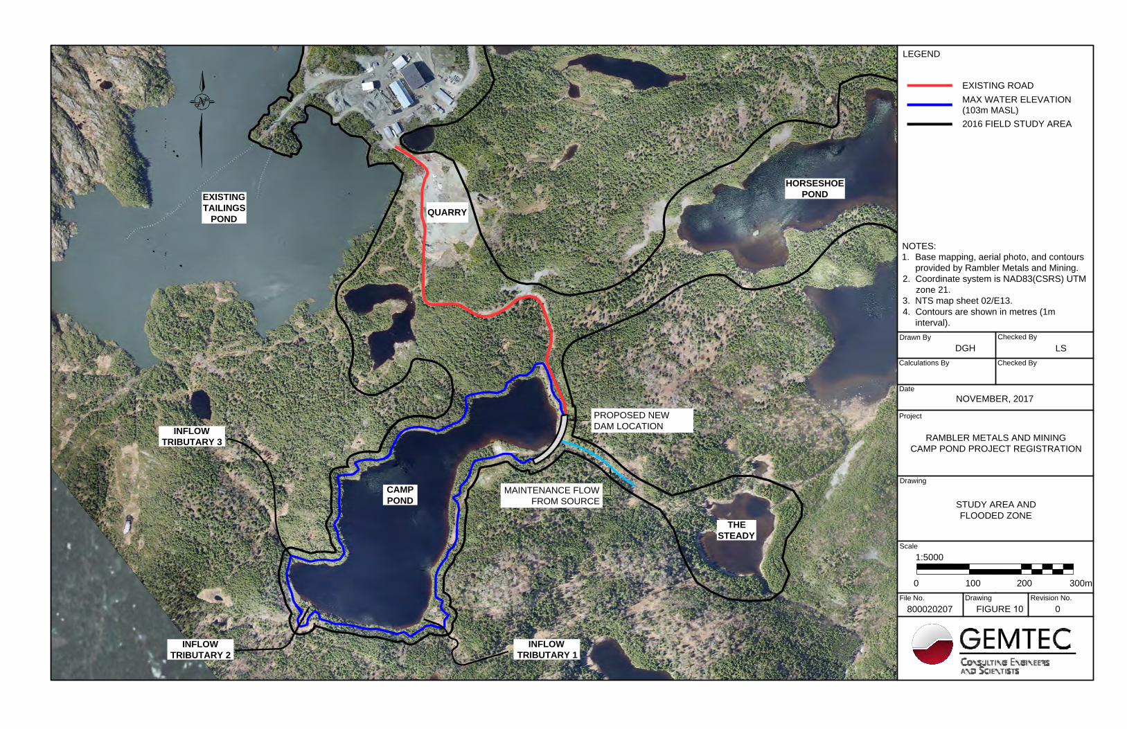
The existing bathymetry for Camp Pond is shown in Figure 9. With the addition of the estimated 5 m high dam, this new impoundment will have sufficient storage capacity for approximately 5 years of tailings deposition at RMM’s planned production level. The raise in the water level within Camp Pond of approximately 4 m, will increase the lateral extent of the pond by approximately 2.1 ha, or a surface area increase of approximately 23% (Figure 10).
An emergency spillway will be constructed within the dam to permit the discharge of significant flooding events without damage to the dam or a release of tailings. The dam and spillway will be designed, constructed, and inspected in accordance with the Canadian Dam Association guidelines for mining/tailings dams and in consideration of the latest climate data respecting climate change.
2.4.3 Tailings Slurry Pipeline Construction and Installation The tailings delivery pipeline, a 150 mm HDPE pipeline, will be extended from the Mill to Camp Pond via the access road corridor. In order to discharge subaqueously in specific areas of the pond, a floating tailings line will be placed in the new impoundment and moved around the pond using a small boat.

3
5
30
2
5
2
0
1
5
1
0
5
5
1
0
0
0
5
1
0
1
5
2
0
5
1
0
1
5
2
0
2
5
30
2
0
20
1
5
1
0
5
Drawing File No.
Scale
Drawing
Calculations By
Project
Drawn By
Date
Checked By
800020207
MAL
AUGUST, 2017
Checked By
LS
FIGURE 9 0
Revision No.
RAMBLER METALS AND MINING
DEVELOPMENT PLAN
CAMP POND
BATHYMETRY
NOTES:
1. Base mapping, aerial photo, and contours
provided by Rambler Metals and Mining.
2. Coordinate system is NAD83(CSRS) UTM
zone 21.
3. NTS map sheet 02/E13.
4. Contours are shown in metres (1m
interval).
LEGEND
80400
1:2000
120m
20CONTOURS
REPRESENTING DEPTHS
IM METERS AT TIME OF
SURVEY (16/05/09).
Drawing File No.
Scale
Drawing
Calculations By
Project
Drawn By
Date
Checked By
800020207
DGH
NOVEMBER, 2017
Checked By
LS
FIGURE 10 0
Revision No.
RAMBLER METALS AND MINING
CAMP POND PROJECT REGISTRATION
STUDY AREA AND
FLOODED ZONE
NOTES:
1. Base mapping, aerial photo, and contours
provided by Rambler Metals and Mining.
2. Coordinate system is NAD83(CSRS) UTM
zone 21.
3. NTS map sheet 02/E13.
4. Contours are shown in metres (1m
interval).
LEGEND
2001000
1:5000
300m
EXISTING ROAD
MAX WATER ELEVATION
CAMP
POND
INFLOW
TRIBUTARY 3
INFLOW
TRIBUTARY 2
INFLOW
TRIBUTARY 1
(103m MASL)
2016 FIELD STUDY AREA
EXISTING
TAILINGS
POND
HORSESHOE
POND
THE
STEADY
MAINTENANCE FLOW
FROM SOURCE
PROPOSED NEW
DAM LOCATION
QUARRY

Rambler Metals and Mining Ltd. Tailings Management Expansion, Ming Copper-Gold Mine
21
2.4.4 Effluent Decant Line and Pump
An HDPE pipeline will transport effluent from the proposed Camp Pond Tailings Impoundment to the existing Tailings Impoundment, to allow retention and eventual discharge via the existing Polishing Pond. The effluent decant line will generally be installed in the access road corridor to minimize surface disturbance. The pipeline will deviate from the access road near the existing Tailings Impoundment as shown in Figure 5. The decant line will be a small diameter (100 to 150 mm) HDPE pipeline supported on small wooden bents.
A small pump and pumphouse will be installed at Camp Pond to decant effluent from the pond and deliver it, via the pipeline, to the existing Tailings Impoundment. The pump will be sized to safely deliver all tailings effluent and additional environmental water inflow to the existing Tailings Impoundment to ensure that operational water levels are maintained in the Camp Pond Tailings Impoundment. Decanting will also ensure that no effluent is discharged through the Camp Pond emergency spillway except in the event of an extreme flood event. The pump will be housed in a small pumphouse located above the maximum waterline of the proposed impoundment and will be accessible from the access road (Figure 5). The pump will be powered via a powerline connecting to the Mill.
2.4.5 Powerline Installation
A small powerline, run on wooden poles, will be installed from the Mill to the Camp Pond dam. The powerline will follow the access road corridor and will provide power to the effluent decant pump and pumphouse.
2.4.6 Outflow Tributary Maintenance
As noted above, the dam proposed at the existing outflow of Camp Pond will cut off water flow to the downstream tributary. Based on the aquatics field work conducted in 2016, the outflow tributary was determined to be fish habitat below the steep grade exiting Camp Pond, i.e., approximately 100 m downstream and at the upstream end of a small wetland area. In order to maintain a flow to the outflow tributary, and thus maintain the existing fish habitat and productivity downstream, RMM is working closely with DFO to ensure that a system for providing appropriate flow and quality of water is in place prior to the disruption of the natural outflow by the dam construction.
To determine the most appropriate means of maintaining flow in the outflow tributary, RMM is undertaking a number of field studies to better understand the hydrology of the outflow stream. Hydrogeological information collected to date has provided initial estimates of flow and additional information will be collected during the winter of 2017 and during spring and summer of 2018 in order to ascertain seasonal details relative to the outflow stream hydrology as further discussed below.

Rambler Metals and Mining Ltd. Tailings Management Expansion, Ming Copper-Gold Mine
22
Figure 11 Outflow Tributary Immediately Downstream of Camp Pond Showing Steep Decline RMM is considering several options relative to sourcing an appropriate volume and quality of water to the outflow tributary. In consideration of the overall watershed dynamics and fieldwork results, and based on consultation with regulators, Horseshoe Pond is the best option from which to source water for the maintenance flow. Horseshoe Pond is located in close proximity to Camp Pond, is in the same watershed as the existing Tailings Impoundment and has similar water quality characteristics as the outflow tributary. Additional fieldwork, ongoing regulatory consultation and hydrological assessment will continue to inform this process and RMM is confident a reliable and technically feasible scenario can be installed such that no interruption in flow is experienced in the outflow tributary. In addition, the outflow tributary is known to be ephemeral at certain times of the year and, when these periods are documented, it may be possible to determine to what extent the wetlands located below the steep incline from the outflow are contributing to the overall water balance of the Camp Pond outflow tributary. RMM is also considering establishing a groundwater well in close proximity to the outflow location as a means of delivering an appropriate flow of water to the outflow tributary to mimic the natural flow rate. This option may be pursued as a contingency in the event there are operational challenges associated with sourcing water from Horseshoe Pond. Should this option be pursued, water quality testing will be carried out to ensure the groundwater quality parameters are similar to the water quality parameters of Camp Pond.

Rambler Metals and Mining Ltd. Tailings Management Expansion, Ming Copper-Gold Mine
23
Based on sourcing the required water from Horseshoe Pond, the maintenance flow system will consist of a very small pump and pumphouse installation on the western end of Horseshoe Pond, a small diameter HDPE pipeline and associated trail from the pumphouse to the proposed dam at the outflow of Camp Pond. The system construction will require minimal tree clearing and ground disturbance as only small (‘mini’) construction equipment will be required. 2.4.6.1 Water Quality
Water quality samples were collected from Camp Pond on August 15, 2016, and from Horseshoe Pond on August 21, 2016. In-situ water quality measurements were taken using a Horiba water quality meter and detailed laboratory analyses were also carried out by Maxxam Analytics.
To compare the water quality in Camp Pond and Horseshoe Pond, six parameters were considered: dissolved oxygen, pH, conductivity, temperature, turbidity, and light penetration / water clarity. The rationale and classification system for each is discussed below.
CCME Water Quality Guidelines for the Protection of Freshwater Aquatic Life (FWAL) have been used as indicators of water quality. The CCME FWAL guidelines were chosen because they are good indicators of common water quality problems (e.g., eutrophication, salinization, acidification, and organic pollution). Conductivity is not included in the CCME FWAL Guidelines; therefore, Environment and Climate Change Canada’s (ECCC) Freshwater Quality in a Global Context Target was used for comparison purposes. The three applicable targets are listed below:
• Dissolved Oxygen: greater than 6 mg/L; • pH: 6.5 – 9; and • Conductivity: less than 500 µS/cm (EC, 2016).
Many fish species have a distinct thermal optima; therefore, water temperature is an important factor in determining the habitat quality for fish survival and production. Salmonids are sensitive to warm water and tend to avoid areas of water with temperatures greater than 20°C (DFO, 2008). To classify the water temperature in these two ponds, the DFO classification system for Brook Trout (Salvelinus fontinalis) was used:
• Cool: < 16.5°C as ideal; • Intermediate: 16.5°C to 18.9°C as marginal; and, • Warm: ≥ 19°C as unsuitable.
Brook Trout were used as an indicator species as it was observed and captured during the 2016 aquatic field studies in the outflow tributary and has also been documented in Horseshoe Pond via Environmental Effects Monitoring (EEM) Studies.
Temperature, conductivity, dissolved oxygen and pH were measured at both Ponds over two days in August 2016. Water quality readings were taken at a depth of one metre as this allowed for a

Rambler Metals and Mining Ltd. Tailings Management Expansion, Ming Copper-Gold Mine
24
submerged probe that didn’t rest on the bottom in most areas of the pond. Complete water quality results from the 2016 aquatic field study are presented in Appendix A.
Increased stream sedimentation can smother eggs in spawning sites, in-fill deep holding areas for larger salmonids, and reduce insect production. The CCME defines a high turbidity, with the ability to negatively affect fish health and populations at 30 – 60 NTUs. Normal turbidity is 0 – 20 NTUs.
A Secchi disc (a weighted circular disc with alternating black and white quadrats) was used to measure the light penetration / water clarity in both ponds. The Secchi disc was lowered slowly into the ponds along a transect and was attached to a measuring tape to allow for the recording of the depth to which the disc could no longer be seen from the boat. The results of the Secchi disc monitoring shows that the water is very clear in both ponds and that light can penetrate the majority of the ponds.
Since water quality parameters are not significantly different between Camp Pond and Horseshoe Pond (Table 3), it is anticipated that an artificially maintained flow in the Camp Pond outflow tributary using water pumped from Horseshoe Pond will not negatively affect fish or fish habitat downstream of Camp Pond. Table 1 Comparison of Water Quality Data between Camp and Horseshoe Ponds (GHD 2016)
Parameter Guideline/ Recommended
Camp Pond Horseshoe Pond
pH 6.5-9
(CCME) 7.22 7.30
Dissolved Oxygen
> 6 mg/L (EC, 2016) 13.89 6.57
Conductivity
< 500 µS/cm (EC, 2016)
52 206
Temperature (1 m below surface)
< 19 C (DFO)
19.82 18.81
Turbidity (NTU)
0-20 NTU (CCME)
1.0 0
Light Penetration (secchi depth)
> 0.5 m 3.3 m 4.7 m
2.4.6.2 Water Quantity
The tributary downstream of Camp Pond is supplied by three sources: 1) Camp Pond surface drainage (including the upstream watershed); 2) direct surface runoff from the contributing portion of the watershed; and 3) anticipated groundwater recharge to the wetland (possible fen) through

Rambler Metals and Mining Ltd. Tailings Management Expansion, Ming Copper-Gold Mine
25
which the tributary flows on its route to the Steady. The construction of the dam at the outflow of Camp Pond will eliminate the contribution from the Camp Pond surface drainage, and therefore it is this water volume that needs to be maintained to supply the downstream tributary. Observation of the outflow of Camp Pond over a number of years indicates the outflow volume can be quite low to essentially non-existent during dry periods in the summer and fall. Based on a desktop assessment, the average outflow from Camp Pond is 0.0174 m3/s or approximately 62 m3/hr. Based on measurements taken in early mid-November 2017, the flow at that time was determined to be 0.0053 m3/s, or approximately 19 m3/hr. RMM has consulted with the federal department of Fisheries and Oceans (DFO) regarding the requirements for flow measurements and maintenance of flow to the outflow tributary. RMM is committed to taking additional flow measurements, designing the maintenance flow system, and carrying out water flow and quantity monitoring in consultation with DFO and the provincial department of Municipal Affairs and Environment (DMAE) and will follow their recommendations to ensure the downstream fish habitat is maintained. 2.5 Construction
Construction activities will commence upon receipt of all required permits and as early in the 2018 construction season as possible, typically May/June in this area. In addition to Release from the environmental assessment review process, other regulatory approvals and permits are required prior to the start of construction activities. RMM will ensure those approvals and permits are complete and submitted to the appropriate regulators as soon as possible in order to ensure an efficient transition to the construction phase. In preparation for dam construction, the access road will be upgraded as required to permit the required construction equipment access to Camp Pond. In tandem with the dam construction, RMM will carry out tree clearing in sections around Camp Pond where the slopes are moderate enough to ensure the safety of workers, and in areas that can be accessed without additional road or trail construction. For the Camp Pond dam construction, rockfill will be sourced from an existing, permitted, on site quarry located adjacent to the mill area and the dam will be constructed using conventional earthworks equipment including excavators, dump trucks, dozers, and compaction equipment. The powerline, effluent decant line, and tailings slurry delivery pipeline will be constructed in tandem with dam construction and will generally be located within the access road corridor. Due to limited overburden thickness, the pipelines will require insulation and/or heat tracing. The powerline will be constructed of standard wooden poles The pump, decant system, and small pumphouse will be constructed at the north end of Camp Pond adjacent to the access road.
Rambler Metals and Mining Ltd. Tailings Management Expansion, Ming Copper-Gold Mine
26
2.6 Operations and Maintenance
Once constructed, the Camp Pond Tailings Impoundment will be commissioned, tailings deposition will commence and effluent will be pumped via the pump, and decant pipeline system back to the existing Tailings Impoundment. As no change in chemistry is anticipated, effluent will be treated as it is for the current operation, i.e., through retention in the Tailings Impoundment, then the Polishing Pond and eventual release to the receiving environment. Effluent monitoring will also continue as per the current protocols and regulatory requirements and commitments. Tailings deposition within the new Tailings Impoundment will utilize deeper areas of the impoundment during winter months when moving the tailings line is difficult under the freezing conditions, and will take advantage of relatively shallow areas of the impoundment during other seasons when moving the tailings line is relatively easy. Bathymetry surveys will be completed annually to ensure the tailings deposition is optimized and sufficient water cover is maintained over the tailings to prevent acid drainage. RMM anticipates the Camp Pond Tailings Impoundment will provide adequate tailings storage until the end of 2025. Regular maintenance of the tailings slurry pipeline will be carried out year round and operations during winter months are not anticipated to create any new or substantial challenges for the new impoundment. 2.7 Possible Accidents and Malfunctions
Human health and safety and environmental protection will be paramount considerations for RMM in the planning and detailed design of the proposed Project. In the construction, operation and maintenance of the proposed Project, established safety procedures specific to human health and environmental protection will be strictly adhered to. Potential accidental events or malfunctions that may occur include, but are not limited to, the following:
• An accidental spill of chemicals, fuels or other deleterious substances; • Equipment failure; • Traffic accidents; and • Dam breach.
RMM has a site wide Environmental Protection Plan which details policies and procedures applicable to all aspects of the proposed Project construction and operation. The EPP will be updated, as required, to ensure all aspects of construction, operations and maintenance of the Camp Pond Tailings Impoundment are addressed. In addition, the design, construction, and operation of the Camp Pond Tailings Impoundment will be carried out in compliance with relevant legislation, regulations, standards and guidelines.
Rambler Metals and Mining Ltd. Tailings Management Expansion, Ming Copper-Gold Mine
27
RMM has an Emergency Response Plan, as required under MMER, to address potential issues associated with tailings and tailings effluent releases. In addition, RMM has a Contingency Plan to address potential chemical and hazardous materials spills, and a Waste Management Plan to address waste handling for all aspects of RMM’s projects. Each of these plans will play a role in the construction and operation and maintenance of the TMF and will be updated by RMM and submitted to the appropriate Regulators for review as required to address changes associated with the new impoundment, prior to commencing the work.
2.8 Closure and Decommissioning
RMM is currently completing a five (5) year update of the Development Plan and Rehabilitation and Closure Plan (RCP) for their Ming Mine Operations, including the Nugget Pond Mill site and TMF, in consultation with the Department of Natural Resources (NLDNR). RMM’s current plans for the new Tailings Impoundment have not been sufficiently advanced to incorporate them into the current Plan updates, however once the EA process is complete and additional engineering information is available, an amendment to these Plans will be submitted for NLDNR review. The rehabilitation of all infrastructure associated with the Camp Pond Tailings Impoundment will be added to RMM’s overall Rehabilitation and Closure Plan for the Nugget Pond Mill. The estimated rehabilitation costs will be calculated and appropriate financial assurances will be put in place through the NLDNR. The closure components of primary importance are the management of water/effluent, and the long term stability of the dam, which will remain in place after closure. Based on current planning, at the end of year 2025 when the Camp Pond Tailings Impoundment has reached storage capacity, RMM will monitor the quality of water contained in the Tailings Impoundment to determine when the water quality has stabilized. Once the water quality is determined to be suitable, and based on approval from the appropriate regulators, water will released through the dam spillway in order to restore a natural flow to the Camp Pond outflow tributary. Prior to closure, a Dam Safety Review (in accordance with the CDA guidelines) will be conducted and a final closure design for the impoundment and dam will be completed to ensure the permanent outflow and spillway is suitably designed for closure. Any maintenance and/or upgrades required to be completed to satisfy the closure requirements at that time will be completed.
Other rehabilitation and closure activities and requirements that will be addressed in the RCP amendment will include:

Rambler Metals and Mining Ltd. Tailings Management Expansion, Ming Copper-Gold Mine
28
• Dismantling and removal of all powerlines, pipelines, pumps and associate facilities and removal of all material from site;
• Revegetation of disturbed areas with the exception of the access road and dam which will require long term inspection and maintenance;
• Closure monitoring will continue after closure activities are complete and long term maintenance and inspection of the dam will be included; and,
• Removal of infrastructure put in place to maintain flow to the downstream tributary during tailings deposition.
2.9 Effects of the Environment on the Project
The regional topography, climate, biophysical and hydrological conditions primarily influenced the design of the proposed Project. The primary anticipated impact from the environment on the proposed Project is water inflow into the Camp Pond Tailings Impoundment. Camp Pond is a headwater pond with three very steep inflow tributaries, which means that there isn’t a large upstream catchment area to address. Due to the steep surrounding topography, the time of concentration for high precipitation events will be fairly quick and this has been accounted for in the water management design components of the impoundment. Operational water levels will be monitored constantly to ensure that designed water levels are maintained within the impoundment and that overtopping of the dam will not occur. In addition, effluent / water from Camp Pond will be pumped to the existing Tailings Impoundment via an effluent pipeline, sent to the Polishing Pond, treated if necessary and eventually released to the environment. In this way, no effluent will leave Camp Pond directly unless a sufficiently large flood event forces discharge through the engineered emergency spillway that will be designed to ensure the dam structure is not damaged. The dam and spillway will be designed and constructed in accordance with CDA guidelines with respect to potential storm and flooding events.
2.10 Project Reports
Several field-based baseline studies have been conducted which are relevant to the proposed Project and have been referenced in this Registration document.
• Preliminary Terrestrial Ecology Assessment Report – Tailings Pond and Boundary Shaft Areas. Rambler Copper-Gold Mine Expansion. GHD 2016.
• Baseline Aquatic Monitoring Program Report. Rambler Copper-Gold Mine Expansion. GHD 2016.
• Camp Pond Aquatic Monitoring Program Report – 2017. Rambler Copper-Gold Mine Expansion. GHD 2017.
These studies pertain to the terrestrial and aquatic environments of the proposed Project area and describe, amongst others, the vegetation cover types, the potential for terrestrial SAR,

Rambler Metals and Mining Ltd. Tailings Management Expansion, Ming Copper-Gold Mine
29
wetlands, avifauna, the aquatic environment etc. These reports are listed in the Reference section and are available upon request.
2.11 Project Schedule
RMM is anticipating a spring/summer 2018 start of construction activities, assuming Release from EA and the receipt of all required approvals and permits. Table 1 presents an approximate schedule for the proposed Project. The Camp Pond Tailings Impoundment will be in operation for approximately five to six years based on currently planned production rates. Closure and rehabilitation activities associated with the proposed Project will take place after Camp Pond has reached its full tailings storage capacity. Any post closure monitoring activities will be carried out in accordance with the overall RCP in place for RMM’s operations. Table 2: Project Schedule
2.12 Environmental Management and Protection
RMM and its management team are committed to conducting construction and operations in an environmentally and socially responsible manner. RMM is committed to the environment and the local communities in which it works. These commitments will be achieved through prudent environmental management that addresses environmental and resource management issues and outlines the different levels of responsibility for contractors and site personnel. RMM also tracks their environmental policies, regulatory standards, conditions of authorization, and direct field controls for implementation.
Jan Feb Mar Apr May June July Aug Sept Oct Nov DecEA ReleaseOther Permits & ApprovalsExploration Road Upgrades to Camp PondCofferdam Construction/DewateringCamp Pond Dam Construction
Installation of Outflow TributaryInstallation of Effluent Decant Pipeline & Construction & Installation of Tailings Slurry PipelinePowerline Installation from Mill to Camp Dam CommissioningTailings Deposition
2018Activity

Rambler Metals and Mining Ltd. Tailings Management Expansion, Ming Copper-Gold Mine
30
2.12.1 Environmental Protection Plan
RMM’s Environmental Protection Plan (EPP) outlines the prevention and mitigation measures to be applied to eliminate or reduce potential adverse environmental effects associated with construction and operation activities at all of RMM’s sites. RMM will amend their existing EPP, as required, to ensure all aspects of construction and operation relative to the new Tailings Impoundment at Camp Pond are addressed. The updated EPP is considered a working document for use in the field by Project personnel, including contractors that identifies and provides guidance for avoidance and mitigation of potentially negative environmental effects of Project construction and operation activities. The EPP is a part of the contract agreement between RMM and all contractors and subcontractors. 2.12.2 Emergency Response Plan
RMM has an approved Emergency Response Plan (ERP), as required under MMER with respect to unplanned tailings and effluent releases in place for the existing TMF, and this Plan will be amended to incorporate the planned TMF expansion described above. The MMER ERP is a risk-based approach to potential releases and incorporates specific roles and responsibilities for RMM personnel with respect to TMF maintenance, inspection, and monitoring, as well as emergency procedures in the event of an unplanned release. 2.12.3 Contingency Plan
RMM maintains an approved Contingency Plan for each of the sites which addresses specific roles and responsibilities for RMM personnel with respect to the storage and handling of hydrocarbons and hazardous materials required on the Project, as well as emergency procedures in the event of a spill or release. RMM will update the Contingency Plan to address changes associated with the construction and operation of the new tailings impoundment, as required, and submit the updated Plan to the appropriate regulators for review and approval. 2.12.4 Waste Management Plan RMM maintains an approved Waste Management Plan (WMP) which covers all Project operations. No changes to this plan are anticipated for the proposed new tailings impoundment, however all construction and operational activities associated with the new tailings impoundment will be required to conform to the WMP.
2.13 Other Required Approvals
In addition to approval under the provincial EA process, the proposed Project may require a number of other permits and authorizations. Some of these potential regulatory requirements are listed in Table 3 and RMM will ensure all necessary permits, approvals and amendments are obtained in a timely fashion.

Rambler Metals and Mining Ltd. Tailings Management Expansion, Ming Copper-Gold Mine
31
Table 2 Potential Permits, Approvals, and Authorizations
Agency Permit/Approval/Authorization Component NLDMAE – Environmental Assessment Division Release from EA process Camp Pond Tailings
Impoundment NLDMAE – Pollution Prevention Division
Certificate of Approval (amendment)
To include Camp Pond Tailings Impoundment
NLDMAE – Water Resources Management Division Dam Construction Permit New Camp Pond Dam &
Spillway
NLDMAE – Water Resources Management Division
Water Use License, Working around Water
New Camp Pond Dam & Spillway and to source water from Horseshoe Pond
NLDMAE – Water Resources Management Division Groundwater well permit (potential) Outflow Tributary Maintenance
System
NLDNR – Mines Branch
Development Plan (amendment) To include Camp Pond Tailings Impoundment and associated infrastructure
Rehabilitation and Closure Plan (amendment)
To include Camp Pond Tailings Impoundment and associated infrastructure
3.0 ENVIRONMENTAL BASELINE
The sections below provide an overview of the existing biophysical and socioeconomic environments for the proposed Project.
3.1 Natural Environment
The area surrounding the proposed Camp Pond Tailings Impoundment is an area that has been affected by mining activities since the 1980s. Although RMM purchased the Mill site in 2009 and began operations in 2011, other mining companies operated in the area prior to RMM. A number of components of the natural environment have been affected to varying degrees by previous activity in this area.
3.1.1 Climate The proposed Project occurs in the North Shore Forest Ecoregion, which has the warmest summers of any coastal area in Newfoundland and also the driest. Total annual rainfall is 1002 mm (Table 4) but moisture deficiencies are common in summer. As a result, the water table in this region is typically lower than in other regions of the province. Average winter snowfall is 31.1 cm. The mean summer temperature is 14.1°C and mean winter temperature is -3.6°C.

Rambler Metals and Mining Ltd. Tailings Management Expansion, Ming Copper-Gold Mine
32
Table 3 Sop’s Arm, White Bay - Climate Normals (1981-2010) Parameter Unit Jan Feb Mar Apr May Jun Jul Aug Sep Oct Nov Dec Totals
Rainfall mm 15.7 11.6 22.8 39.1 70.5 79.4 85.8 97.4 99.7 100.6 68.4 31.2 722.0
Snow cm 69.0 61.4 43.0 24.4 2.1 0.0 0.0 0.0 0.0 1.8 23.9 54.7 280.4
Precipitation mm 84.7 72.0 65.8 63.5 72.6 79.4 85.8 97.4 99.7 102.4 92.4 85.9 1002
Average Temp
oC -7.8 -8.1 -4.1 1.3 6.0 10.9 15.5 15.9 11.8 6.2 1.1 -3.9 na
Source: Environment and Climate Change Canada
http://climate.weather.gc.ca/climate_normals/results_1981_2010_e.html?searchType=stnProv&lstProvince=NL&txtCentralLatMin=0&txtCentralLatSec=0&txtCentralLongMin=0&txtCentralLongSec=0&stnID=6734&dispBack=0
3.1.2 Geology, Soils and Topography The proposed Project is located on the east side of the Baie Verte Peninsula in the Dunnage geologic zone which is comprised of shales, sandstones, conglomerates, and volcanic rocks formed 430 to 550 million years ago. The coastline of Betts Cove-Tilt Cove area is bounded by sheer cliffs rising to a plateau level of approximately 150 MASL. The shoreline is indented by many fjord-like coves and inlets, the largest of which, Snook’s Arm, is 3 km long.
The surficial geology within the area consists of granites, granitic gneiss and schists. Soils forming on these parent materials in the vicinity of Project are described as generally shallow over undulating bedrock and rock outcrops are common. Drainage varies dramatically based on slope and landscape position.
3.1.3 Vegetation and Wetlands
Land cover types at the Nugget Pond Mill site were identified through a desktop review of available data, as well as a field study conducted August 17-20, 2016 (GHD 2016). The study area for the terrestrial work in 2016 included Camp Pond, the Mill site, Horseshoe Pond and The Steady (Figure 10).
The Nugget Pond Mill site and surrounding area consists of four main land cover types: disturbed areas, mixed coniferous forest, rocky barrens, and small wetlands.
The existing exploration road, i.e., disturbed area, leading to Camp Pond from the Mill is primarily unvegetated. The common plant species found along the roadway includes heart-leaved birch (Betula cordifolia) saplings, black spruce (Picea mariana), and speckled alder (Alnus viridis) as well as flat topped aster (Doellingeria umbellata), fireweed (Chamerion angustifolium), pearly

Rambler Metals and Mining Ltd. Tailings Management Expansion, Ming Copper-Gold Mine
33
everlasting (Anaphalis margaritacea), wild raspberry (Rubus idaeus), yellow hawkweed (Hieracium vulgatum), coltsfoot (Tussilago fafara), northern bracken fern (Pteridium aquilinum), field horsetail (Equisetum arvense), Canada burnet (Sanguisorba canadensis), Canada bluejoint (Calamagrostis canadensis), and downy goldenrod (Solidago puberula). The plant species present are generally tolerant of disturbed conditions or are early successional species that colonize disturbed areas (GHD 2016). Mixed coniferous forest occurs in areas of the proposed Project area along the hill slopes, hill tops and valleys where soil conditions and moisture favor forest development. The forested canopy varies in density and height depending of soil conditions and exposure. Areas with thinner soils generally support thinner and somewhat stunted tree communities while areas with thicker soils support more fully developed forest communities. The dominant species present in the mixed coniferous forest include black spruce, balsam fir (Abies balsamea), heart leaved birch, sweet gale (Myrica gale) speckled alder, bunchberry (Cornus canadensis), northern bracken fern, cinnamon fern (Osmunda cinnamomea), Solomon’s Seal (Maianthemum racemosum), and creeping snowberry (Gaultheria hispidula) (GHD 2016). A talus slope occurs along the western side of Camp Pond and this area has no soil development, is dominated by boulders, is not stable and thus lacks significant vegetation (GHD 2016). Wetlands in the Study Area, including the environs of Camp Pond, consist of streamside and slope fens, forested swamps, and smaller raised bogs. The majority of the wetlands in the Study Area are peatlands and are classified depending on their vegetation cover type and whether they receive their wetland hydrology solely from nutrient poor rainwater and snowmelt or from nutrient rich ground or surface water. Some wetlands associated with ponds occur around the perimeter of Camp Pond. Other wetlands occur along the stream valleys between Camp Pond and The Steady and smaller tributaries to these ponds. These land cover types are not rare or limited in extent in the area (GHD 2016). Common wetland plant species present around Camp Pond includes sphagnum moss (Sphagnum spp.) woolgrass (Scirpus cyperinus), Canada bluejoint (Calamagrostis canadensis), Canada burnet, roundleaf sundew (Drosera rotundifolia), pitcher plant (Sarracenia purpurea), seven angled pipewort (Eriocaulon aquaticum), horned bladderwort (Utricularia cornuta), and cottongrass (Eriphorum sp.) (GHD 2016). Common plant species occurring in the forested wetlands include black spruce, balsam poplar, speckled alder (Alnus viridis), sweetgale, northern bracken fern, Solomon’s seal, creeping snowberry, bunchberry, bristly sarsaparilla (Aralia hispida), sphagnum mosses, and Canada burnet (GHD 2016). The vegetation in the emergent fens and bogs was dominated by speckled alder, a variety of sedges (Carex spp.), sphagnum moss, cotton grass, shrubby cinquefoil (Dasiphora fruticosa), purple stemmed aster (Symphyotrichum puniceum) (GHD 2016).

Rambler Metals and Mining Ltd. Tailings Management Expansion, Ming Copper-Gold Mine
34
The NLCDC database indicates there are six rare plant records within 5 km of the Mill site, an area that encompasses the proposed Camp Pond Tailings Impoundment (Table 5): common yarrow, cutleaf anemone, encrusted saxifrage, bristleleaf sedge (2 occurrences) and smooth whitlow grass. These plants are not listed provincially or federally and are not considered globally rare. Expert Opinion Maps suggest Boreal Felt Lichen (Special Concern under Species at Risk Act [SARA] and Vulnerable under the NL Endangered Species Act) is possible, but unlikely within 5 km of the Mill site. No rare plants were observed in the proposed Project footprint during the 2016 field studies. Table 4 Rare Flora Species identified within five km of the Nugget Pond Mill Site (2016) Species Provincial Status Habitat
Common Yarrow, Achillea millefolium
Not Applicable Disturbed habitats and less often on barrens and limestone barrens
Cutleaf Anemone, Anemone multifidi
Vulnerable Calcareous cliffs and barrens
Encrusted Saxifrage, Saxifraga paniculata
Vulnerable/Apparently Secure
Calcareous gravels, ledges and cliffs
Bristleleaf Sedge, Carex eburnea - 2 occurrences
Vulnerable Calcareous ledges and cliffs
Smooth Whitlow Grass, Draba glabella
Apparently Secure Calcareous gravels, ledges and cliffs
The additional footprint for the Camp Pond Tailings Impoundment is estimated to be 2.1 ha when the dam is fully constructed and the Tailings Impoundment is at full capacity. The land cover types to be affected by the flooding is not limited in the region and given the absence of rare plants there, the Project is not expected to result in residual adverse environmental effects to vegetation or wetlands.
3.1.4 Wildlife and Species at Risk The potential for wildlife and wildlife Species at Risk around the Mill site was assessed through a combination of desktop review and field study (GHD 2016). GHD consulted with the Newfoundland and Labrador Conservation Data Centre (NL CDC), a node of the Atlantic Canada Conservation Data Centre (AC CDC), to obtain a list of known elements of occurrence for Species at Risk for the Study Area. The NL CDC data also included an expert opinion on Species at Risk that could possibly occur within the Study Area. The study area for GHD’s terrestrial work in 2016 included Camp Pond, the Mill site, Horseshoe Pond and The Steady (Figure 10).
Rambler Metals and Mining Ltd. Tailings Management Expansion, Ming Copper-Gold Mine
35
Mammals commonly found in the region include moose, snowshoe hare, mink, red fox, black bear, meadow vole, otter, beaver, and the little brown bat. The red squirrel, lynx, and muskrat can also occur (PAA 2008). The nearest population of caribou (Rangifer tarandus) (i.e., the Hampden herd) occur to the southwest of the area in the Hampden Downs Caribou Management Area (NLDECC 2014), approximately 50 km from the Nugget Pond Mill site. No mammal species were observed during the field study.
The habitats present onsite were also assessed to determine if they could potentially support Species at Risk (SAR) identified as potentially occurring in the Study Area. The NLCDC indicates there are no rare animal records within 5 km of the Mill site, an area that encompasses the proposed Camp Pond Tailings Impoundment location. Expert Opinion Maps do suggest Polar Bears (Special Concern under SARA and Vulnerable under NL Endangered Species Act) and Newfoundland Marten are possible but unlikely within 5 km of the Mill site. The forested areas surrounding the Mill contain suitable structure and cover preferred by Newfoundland marten and thus could potentially provide habitat, though none were observed during field studies in 2016.
The Project is not expected to result in residual adverse environmental effects to wildlife. RMM has a Wildlife Encounter Contingency Plan within the EPP which includes procedures to follow and mitigation measures to implement in the event of a wildlife sighting.
3.1.5 Avifauna The habitats in the Study Area, including the area surrounding Camp Pond, were also assessed for their suitability to provide important habitats for migratory and other bird species. The existing Tailings Impoundment area has limited habitat value due to the tailings lining on the bottom of the pond and the disturbance associated with the ongoing tailings disposal operations. No waterfowl were observed on Camp Pond, Little Horseshoe Pond or The Steady during the 2016 field study.
The mixed coniferous forest habitat is generally important habitat for a variety of forest dwelling passerine species, including those that specialize in coniferous forests and large forest tracts. Mixed coniferous forest habitats are also stopover and resting habitats for many migratory passerine species. The forests surrounding the Mill site, including the Camp Pond environs, likely serve as migratory habitat for passerine species. However, this habitat type is not rare or limited in extent in the area.
The existing exploration road to Camp Pond is mostly vegetated with herbaceous species and does provide foraging habitat for passerine species that utilize edge habitats and open field habitats. Roadside habitats however are not rare or unique in the surrounding areas.
One bird species, Slate-colored junco, was documented during the 2016 field study. The NLCDC indicated there are no rare bird species records within 5 km of the Mill and proposed Project footprint. Expert Opinion Maps suggest Red Crossbills (Endangered under SARA and Endangered under NL Endangered Species Act) and Rusty Blackbirds (Special Concern under
Rambler Metals and Mining Ltd. Tailings Management Expansion, Ming Copper-Gold Mine
36
SARA and Vulnerable under NL Endangered Species Act) are possible, and Short-eared owls (Special Concern under SARA and Vulnerable under NL Endangered Species Act) are possible but unlikely, within 5 km of the Mill and proposed Project footprint. Expert Opinion Maps also suggest Ivory Gulls (Endangered under SARA and Endangered under NL Endangered Species Act) are possible within 5 km of the Mill. The Mill and proposed Project footprint occurs within the range for Barrow’s Goldeneye (Special Concern under SARA and Vulnerable under NL Endangered Species Act).
The Project will involve the construction of a small earthen dam at the outlet of Camp Pond and will also include flooding of approximately 2.1 ha for the Tailings Impoundment. Though the surrounding habitat may be suitable for avifauna, it is not rare or limited in the area. The Project is not expected to result in residual adverse environmental effects to avifauna.
3.1.6 Fish and Fish Habitat The NLCDC indicates that there are no rare fish records within 5 km of the Mill site, including within the proposed Project footprint. Expert Opinion Maps suggest Banded Killifish (Special Concern under SARA and Vulnerable under NL Endangered Species Act) are possible within 5 km of the Mill site.
3.1.6.1 Environmental Effect Monitoring Studies
Environmental Effects Monitoring (EEM) studies at the Nugget Pond Mill site found brook trout in Horseshoe Pond Brook, Bobby’s Cove Pond and Bobby’s Cove Brook (both downstream of Horseshoe Pond). In addition, Arctic char were captured in Horseshoe Pond and Horseshoe Pond Brook. No rare fish were documented in the fish studies conducted to date. Effluent from the final discharge point (Polishing Pond) must pass the LT-50 test on fish and to date and the mill effluent has never failed an LT-50 test related to the discharge from the Polishing Pond. RMM will continue to monitor the potential effects of milling activities on fish and fish habitat via EEM studies in accordance with MMER and provincial requirements.
3.1.6.2 Aquatic Field Studies- 2016 and 2017
Prior to proposing Camp Pond as a potential Tailings Impoundment, RMM undertook investigations over two field seasons in order to evaluate the status of the Pond, its tributaries and the waterbodies directly connected downstream of it. Camp Pond itself is a headwater pond with three steep inflow streams (Figures 12-14). This feature makes the inflow streams very unlikely fish habitat.

Rambler Metals and Mining Ltd. Tailings Management Expansion, Ming Copper-Gold Mine
37
Figure 12 Inflow Tributary 1
Figure 13 Inflow Tributary 2

Rambler Metals and Mining Ltd. Tailings Management Expansion, Ming Copper-Gold Mine
38
Figure 14 Inflow Tributary 3
In 2016, the aquatics program targeted three ponds and consisted of a fish habitat assessment, fish community presence/absence, benthic macroinvertebrate community monitoring, and surface water quality and sediment monitoring and sampling. The three ponds studied included Camp Pond, Horseshoe Pond, The Steady and the main inflow and outflow tributaries of each pond. This work was conducted over a period of 5 days, with 2 days spent focused on Camp Pond.
Minnow traps were used in shallow areas around the edges of each pond to target any baitfish species present. The initial sampling protocol included a sampling effort per pond of up to six fyke nets and ten minnow traps set for approximately a 16-18 hour period. Where no fish were caught, nets were reset for an additional period and/or an angling effort was added to assist in confirmation of the results.
Observations of fish habitat in the ponds and tributaries included general observations of substrate, channel dimensions (depths, widths), morphology, topography, forest cover, shoreline and aquatic vegetation, instream cover, and human use. Some electrofishing occurred and fish were observed in The Steady, Horseshoe Pond and in lower reaches of the Camp Pond outflow tributary.
This initial baseline aquatic monitoring program conducted by GHD in August 2016 did not find any evidence of fish within Camp Pond but did in the lower reaches of the outflow tributary (GHD, 2016).
Based on the apparent absence of fish in Camp Pond indicated by the 2016 sampling program, the 2017 program focused on Camp Pond only. In consultation with DFO, May 29, 2017, RMM

Rambler Metals and Mining Ltd. Tailings Management Expansion, Ming Copper-Gold Mine
39
undertook a field sampling program using methods intended to lead to defensible conclusions concerning the presence or absence of fish in Camp Pond. Those consultations, including general correspondence and a face-to-face meeting with DFO, occurred primarily in May 2017.
In order to conclude that a natural water body is not frequented by fish, it needs to be demonstrated, via industry standard sampling procedures and through a demonstrated high level of fishing effort, that no finfish are present. The following guidance provided by DFO was implemented and followed in the design and execution of the 2017 aquatics sampling program that was designed to supplement and further inform results obtained from the 2016 report:
• Schedule the 2017 field sampling for a period with higher flows than those encountered during the 2016 sampling regime, e.g., mid-June;
• Ensure unbaited fyke nets with wings are used; • Ensure fyke nets are not submerged rather set as close to the surface as possible; • Use beach seines in all littoral zones around the pond; • Use an electro fisher in shallow pond areas. A visual survey of any fish observed was
carried out; • Multi-panel gill nets that are constantly monitored and used in progressive
timeline/duration is recommended, including for an overnight period; • If any fish are caught, fork length measurements are to be recorded vs total length; and • Confirm via traditional ecological knowledge (TEK) whether any fish have been caught in
Camp Pond over the years.
The 2017 follow-up fisheries monitoring program targeted Camp Pond earlier in the season than the 2016 program in an attempt to target fish in different habitat types. The five-day 2017 monitoring program expanded the 2016 fisheries assessment methods to include more varied fyke netting scenarios, gill netting, seining, electrofishing and angling. The pond was extensively covered through a combination of these methods.
Five fyke nets were installed within Camp Pond, ranging in depth from approximately 0.75 to 1.5 m deep and were left in place for a total of approximately four days (average - 93 hours). Nets were checked daily but no fish were captured and no signs of fish were observed during sampling. Twelve (12) gill net sets, reaching depths up to 7.8 m, were installed in Camp Pond, and monitored progressively for four days. Two gill net sets extended overnight yet no fish were captured and no signs of fish were observed during the sampling effort.
Seine netting was conducted in shallow areas of the Pond and nine seine pulls were completed in four areas of the pond with no fish observed or captured.
Electrofishing of appropriate habitat was conducted on days when water clarity was excellent in littoral habitat areas. No fish were seen evading the electric field during the effort. All inflow and

Rambler Metals and Mining Ltd. Tailings Management Expansion, Ming Copper-Gold Mine
40
outflow tributaries were also electrofished within representative reaches with no fish observed or captured within the sampled reaches at the time of the survey. Habitat providing the most potential for viable fish habitat was contained within the electrofished reaches.
Habitats sampled included the littoral zone, through fyke netting, electrofishing and seine netting, as well as gill netting in depths ranging to 7.8 m. Angling (i.e., trawling) was used to sample the deepest bottom habitats. No fish were captured via any of these methods and no fish were observed during the five-day monitoring program.
RMM’s consultants also confirmed that no one locally had recalled ever catching any fish in Camp Pond.
Given this high level of fishing effort and the absence of any observations or fish captures, RMM concludes that this proposed Project is not expected to result in adverse environmental effects to fish and fish habitat relative to Camp Pond.
Further, RMM consulted with DFO and ECCC regarding the results of these aquatics programs relative to Camp Pond and subsequently requested a determination as to the status of Camp Pond with respect to fish presence/absence and the requirement for a Schedule 2 amendment of MMER. On November 7, 2017, RMM was advised by ECCC that DFO/ECCC were in agreement that no fish are present in Camp Pond and as such, would not require listing under Schedule 2 of the MMER for use as a tailings impoundment.
Field studies did indicate the presence of fish in lower reaches of the outflow tributary and in both the Steady and Horseshoe Pond. In order to ensure no adverse effects on these waterbodies as a result of converting Camp Pond to a Tailings Impoundment, RMM intends to supply water to the outflow tributary once the Camp Pond dam is under construction. This will require determining water quality and quantity parameters of the outflow tributary prior to the start of any construction associated with the Project. This work is being done in consultation with regulatory authorities and in this way, RMM will minimize any potentially adverse effects to fish and fish habitat downstream of the Camp Pond Tailings Impoundment. At closure of the proposed Tailings Impoundment, and once water quality within the pond is considered acceptable to regulators, water will be permitted to permanently discharge through the closure spillway in the dam to the original downstream tributary, permanently.
3.1.7 Water Resources The mill is located within the Fly Pond-Bobby’s Cove watershed, which encompasses an area of approximately 7.4 km2 and drains south into the head of Bobby’s Cove. There are four main ponds - the existing Tailings Impoundment (formerly Fly Pond), the Polishing Pond (formerly Rocky Pond), Horseshoe Pond and Bobby’s Cove Pond - and approximately 10 unnamed ponds located within the basin. The existing Tailings Impoundment drains south to Bobby’s Cove via the Polishing Pond and Horseshoe Pond. RMM operates their TMF in accordance with the MMER

Rambler Metals and Mining Ltd. Tailings Management Expansion, Ming Copper-Gold Mine
41
and provincial requirements. RMM has conducted EEM studies at the mill site since 2009 when RMM purchased the mill and began effluent testing from the final discharge points (i.e., the Polishing Pond). The next EEM report for the mill will be submitted to ECCC for review in 2018. Surface water quality monitoring as per the provincial Certificate of Approval (C of A) is ongoing.
The primary impact of the use of Camp Pond as RMM’s new tailings impoundment will be the diversion of water from Camp Pond to the existing TMF. This impact is expected to include a very modest increase in flow through the existing TMF and discharge from the Polishing Pond through to Horseshoe Pond. However, as the current plan is to source water from Horseshoe Pond to maintain flow to the tributary downstream of Camp Pond, the change to the water balance in expected to be very small and will only relate to Horseshoe Pond itself. Additional minor flows through the existing TMF is not sufficient to require changes to the existing infrastructure or operating protocols. Significant precipitation or runoff events will be attenuated within the TMF using the stormwater (environmental) storage within the TMF design capacity, and therefore should not result in incremental environmental impact downstream during natural flooding events.
At the start of dam construction, as the outflow from Camp Pond is cut off, RMM will pump water from Horseshoe Pond to the outflow location to deliver an appropriate flow of water to the outflow tributary to mimic the natural flow rate. RMM may also establish a groundwater well as a contingency in the event there are operational constraints associated with sourcing water from Horseshoe Pond. If a groundwater source is ultimately used for maintaining the outflow tributary, RMM will ensure this meets all regulatory approvals and that the water quality is similar to that of Camp Pond today. Once the Camp Pond Tailings Impoundment has reached storage capacity in 2025, the intention is to monitor the water quality in the Tailings Impoundment and to restore flow to the outflow tributary through a permanent spillway at the dam.
Once natural flow is returned to the outflow tributary, any ancillary infrastructure (pipelines, pump, pumphouse, etc.) will be removed. Based on the maintenance of water flow of suitable quality to the downstream tributary, and with the proper execution of planned operational and closure activities, the Project is not expected to result in residual adverse environmental effects to regional water resources.
3.2 Human Environment
There are no federal or provincial parks or protected areas on the Baie Verte Peninsula (NLDECC 2010). There is one private campground, Flatwater Pond, located 25 km from Baie Verte. The Project is located within Moose and Black Bear Management Area 14: Baie Verte (NLDFLR2017). The Project is northeast of Caribou Management Area 78: Hampden Downs (NLDFLR2017) and caribou are not hunted in the region.

Rambler Metals and Mining Ltd. Tailings Management Expansion, Ming Copper-Gold Mine
42
3.2.1 Historic and Heritage Resources Multiple recorded archaeological sites exist on the Baie Verte Peninsula and coastlines that provide evidence of Palaeoeskimo, Maritime Archaic Indian, and early European presence (NLBTCRD 2016). There are no recorded archaeological sites at the Mill property however, and no sites have been discovered to date. The Provincial Archaeology Office (PAO) indicated there is low potential for historic or heritage resources to be found within the proposed Project footprint.
3.2.2 Socioeconomic Considerations The Baie Verte Peninsula includes 21 communities that are organized into two areas: Local Area 58, White Bay South and Local Area 69, Burlington. Area 58 consists of Baie Verte, Brent’s Cove, Coachman’s Cove, Fleur de Lys, Harbour Round, La Scie, Ming’s Bight, Pacquet, Purbeck’s Cove, Seal Cove, Tilt Cove, Westport, Wild Cove, and Woodstock. Area 69 consists of Burlington, Middle Arm, Nipper’s Harbour, Round Harbour, Shoe Cove, Smith’s Harbour, and Snook’s Arm.
The Baie Verte Peninsula is characterized by a declining population, out-migration and high unemployment. The 2016 Census population for White Bay South (local area 58) was 4,185, representing a decline of 4.8 % since 2011. The 2016 Census population for Burlington (local area 69) was 1,180, a decline of 6.0 % since 2011. Over the same period, the province experienced a population increase of 1.0 %. During the reference week of the 2011 National Household Survey (May 1-7, 2011), the unemployment rate for White Bay South was 21.5 %, higher than the provincial unemployment rate of 14.6% (NL Statistics Agency 2017).
The main areas of employment in White Bay South are trades, transport and equipment operators, natural resources, agriculture and production and sales and service. Employment data is not available for Burlington (NL Statistics Agency 2016). Major employers on the Baie Verte Peninsula include, Service Canada, Government of Newfoundland and Labrador, Royal Canadian Mounted Police, senior and child care services, Anaconda Mining Inc. and RMM. In more recent years there have been a significant number of individuals who work outside the province on a rotation schedule but still maintain their main place of residence on the island (Central Health 2013).
RMM currently employs 195 people and it is not anticipated that the proposed Project will require any additional operations personnel, and a suitable, safe, and economic tailings disposal impoundment is required to ensure RMM’s operations are able to continue. During construction however, some temporary positions, approximately 10, will be created. The Project will have a positive impact on employment and the economy in the region.
4.0 CONSULTATION
A number of consultation activities have been undertaken to date in relation to the proposed Project. These primarily include discussions with relevant government departments and agencies.
Rambler Metals and Mining Ltd. Tailings Management Expansion, Ming Copper-Gold Mine
43
4.1 Regulatory Consultation
RMM and their consultants completed consultation meetings with government agencies at different stages during Project planning and prior to the submission of this Registration document.
Prior to proposing Camp Pond as a Tailings Impoundment, RMM had a number of meetings with federal representatives in order to determine the likelihood of Camp Pond being considered a non-fish bearing waterbody, and as such, a suitable Tailings Impoundment. RMM sought to determine what the requirements were under federal legislation, e.g., the Metal Mining Effluent Regulations (MMERs), Canada Fisheries Act, to reach a justifiable conclusion concerning the fish bearing status of Camp Pond. On September 13, 2017, RMM formally requested a letter of determination from ECCC relative to the status of Camp Pond as a fish bearing waterbody under the MMER. A response was provided on November 17, 2017 whereby ECCC indicated that they concurred with RMM’s conclusion that Camp Pond was fishless and therefore would not require listing on Schedule 2 of the MMER.
4.2 Public Consultation
RMM has been operating on the Baie Verte Peninsula since 2011 and has been a contributor to the local communities and overall region.
Rambler has conducted public consultation meetings in Baie Verte, Ming’s Bight and South Brook throughout the Ming Mine operations; initially when they acquired the property in 2009 and as additional activities have been added to their operations in the area. RMM has regular, informal communication with the Mayor and other people in Snook’s Arm regarding the project, and to some degree the planned Tailings Impoundment at Camp Pond. In addition, ongoing public consultation occurs through forums such as the Baie Verte Mining Conference, the Mineral Resources Review Conference, etc. and in 2017 the proposed use of Camp Pond as a Tailings Impoundment was presented. The provincial EA review process will provide an opportunity for public commentary on this proposed Project as well.
5.0 ENVIRONMENTAL EFFECTS AND ANALYSIS
5.1 Natural Environment
The Natural Environment is comprised of relevant components of the biophysical environment that may interact with the Project, including vegetation, soils, wetlands, avifauna, wildlife, fish and fish habitat and water resources. The proposed Project footprint is characterized by patches of coniferous forest interspersed with areas of small wetlands, lichen cover and exposed rock.
5.1.1 Construction Project construction will involve vegetation clearing activities relative to the corridor for the access road upgrades, powerline and pipelines installation, pump house construction, vegetation clearing within the flooded zone of the impoundment, dam and spillway construction and infrastructure

Rambler Metals and Mining Ltd. Tailings Management Expansion, Ming Copper-Gold Mine
44
development for downstream water management. Construction activities will be completed using small to mid-sized, standard construction equipment and construction activities are anticipated to take 3 to 4 months to complete.
5.1.1.1 Vegetation, Wetlands and Soils
There were no listed or rare plant species identified during field studies in close proximity to the proposed Project footprint. During construction, the corridor that is to be upgraded for the existing access road, powerline and pipelines will see some vegetation and soil removal. The proposed Camp Pond Dam, expected to raise the existing water level by approximately 3.5 metres, is anticipated to result in limited loss of adjoining terrestrial habitats due to the steep surrounding slopes. Some loss of forested habitat, rocky barren habitat, and small wetlands will occur, however, these habitats are common on the surrounding landscape.
5.1.1.2 Wildlife and Species at Risk
A number of measures will be implemented during the construction phase of the proposed Project to reduce the potential for interactions between Project activities and any wildlife that may occur in the area:
• Construction areas will be kept clear of garbage; • Construction personnel will not hunt of harass wildlife while on site; • Pets will not be permitted on the construction site; • Equipment and vehicles will yield the right-of-way to wildlife; and • Any nuisance animals will be dealt with in consultation with the NL Wildlife Division.
No SAR were encountered during field studies at the proposed Project footprint. Project activities will result in limited loss of terrestrial habitat and those habitats impacted are not lacking on the surrounding landscape. RMM does not anticipate any adverse effects to wildlife or SAR in the area as a result of Project construction activities.
5.1.1.3 Avifauna
RMM anticipates initial Project construction activities to begin by in spring / summer 2018. RMM will endeavor to carry out any required clearing outside of the regional bird breeding season, (May 1-August 15). RMM does not anticipate any negative interactions between Project construction activities and avifauna. If clearing is required during the regional bird breeding season, RMM will ensure the following mitigations, outlined in their EPP, and specific to avifauna are carried out:
• Monitoring for bird nests will be conducted in advance of site clearing during the breeding season (May 1st to August 15th) and efforts will be made to avoid trees with nests during that time. Non-intrusive surveys for nests will be conducted, in accordance with the

Rambler Metals and Mining Ltd. Tailings Management Expansion, Ming Copper-Gold Mine
45
Specific Considerations Related to Determining the Presence of Nests (Environment Canada 2012).
• The Migratory Birds Convention Act (MBCA) protects most bird species and their nests, with the exception of the following groups: certain game birds (grouse, quail, pheasants and ptarmigan), raptors (hawks, owls, eagles and falcons), cormorants, pelicans, crows, jays and kingfishers, and some species of blackbirds (starlings, mynas).
• Should a nest of a migratory bird be found, the following steps will be taken (in accordance with guidelines outlined in the MBCA):
o all activities in the nesting area should be halted until nesting is completed (i.e., the young have left the vicinity of the nest);
o any nest found should be protected with a buffer zone appropriate for the species and the surrounding habitat until the young have left their nest; and
o nests should not be marked using flagging tape or other similar material as these increase the risk of nest predation.
• Raptors, although not protected under the MBCA, are protected under Newfoundland and Labrador’s Wild Life Act. In accordance with provincial guidelines, should a nest of a raptor be found, the following steps will be taken:
o a buffer zone of 800 m should be maintained while the nest is active; o after the young have left their nest, a buffer zone of 250 m should be maintained;
and o if work within the appropriate buffer zone cannot be avoided, the Newfoundland
Department of Fisheries and Land Resources (DFLR) should be contacted for advice on how to minimize disturbance of the nest.
Mixed coniferous forest habitats in Newfoundland and Labrador are generally important habitats for a variety of forest dwelling passerine species, including those that specialize on coniferous forests and large forest tracts. Mixed coniferous forest habitats are also stop over and resting habitats for many migratory passerine species. The forests in the Camp Pond area likely serve as migratory habitat for passerine species of birds. While forest habitat is recognized for its importance for these wildlife values, this habitat type is not rare or limited in extent in the vicinity of Project area. RMM does not anticipate that Project construction activities will have an adverse environmental effect on avifauna in this area.
5.1.1.4 Fish and Fish Habitat
The main mitigations relative to fish and fish habitat during the construction phase will be implemented relative to the Camp Pond outflow tributary at the point where the Camp Pond Dam will be constructed. Construction of the Camp Pond Dam will prevent any outflow from Camp Pond through this tributary. Prior to dam construction, RMM will ensure water flow is maintained via a pumping system whereby an appropriate volume of water from Horseshoe Pond will be diverted to the outflow location at Camp Pond. RMM will ensure that the general chemistry of the

Rambler Metals and Mining Ltd. Tailings Management Expansion, Ming Copper-Gold Mine
46
sourced water for maintaining flow in the outflow tributary is similar to the existing chemistry in the outflow tributary. A water quality monitoring program will be implemented in this watercourse for the duration of the construction phase to ensure the water quality conditions continue to provide suitable fish habitat similar to conditions prior to the start of construction.
5.1.1.5 Water Resources
Safeguarding the water quality and quantity of the outflow tributary from Camp Pond will require specific mitigations during the construction phase. RMM will follow all protocols outlined in their EPP specific to work in and around water bodies and wetlands during the construction period for the Camp Pond dam and during the installation of any infrastructure designed to maintain flow through the outflow tributary. In addition, RMM will obtain all required permits and abide by all conditions related to construction activities.
5.1.2 Operations During the operations phase of the proposed Project, it is unlikely there will be many interactions with the biophysical environment (e.g., vegetation and wetlands, wildlife and SAR, avifauna, fish and fish habitat, water resources). Operational activities will be characterized primarily by a gradual increase in the level of water in the Camp Pond Tailings Impoundment. RMM anticipates that at the end of five years, the water level in the Tailings Impoundment will be approximately 1.5 m below the maximum dam level of 5 m. The tailings slurry delivery line will be monitored and maintained to ensure discharge to the Tailings Impoundment is occurring in a controlled fashion and in the deepest parts of the Pond. This is a common strategy that RMM employs in the management of their existing Tailings Impoundment.
RMM does not anticipate that the Project will have significant negative environmental effects on key components of the natural environment due to careful planning, monitoring and continued implementation of mitigative measures. All operations activities of the proposed Project will be carried out using existing personnel and RMM anticipates that operation of the Camp Pond Tailings Impoundment will result in minimum additional disruption to the area.
5.1.2.1 Vegetation and Wetlands
During operations, there will be no additional soil or vegetation disturbance, therefore, little or no potential for further effects to these biophysical components are anticipated. As the water level in the Tailings Impoundment rises, there will be some loss of forested habitat, forested bog and some rocky barren habitat. However, these habitats are common on the surrounding landscape and as Camp Pond’s slopes are fairly steep, losses to terrestrial habitat will be minimal (2.1 ha.).
5.1.2.2 Wildlife and Species at Risk
RMM does not anticipate any disruption to wildlife and SAR as a result of operations activities. Existing mitigations relative to wildlife sightings and management during the operations phase will ensure no adverse impacts to wildlife or SAR.

Rambler Metals and Mining Ltd. Tailings Management Expansion, Ming Copper-Gold Mine
47
5.1.2.3 Avifauna
No vegetation clearing is anticipated to be carried out during the operations phase. RMM does not anticipate, therefore, any adverse environmental effects to avifauna as it is expected that any avifauna species previously using the affected habitat will have relocated to adjacent undisturbed areas before operations activities commence.
5.1.2.4 Fish and Fish Habitat
Since the downstream aquatic environment from Camp Pond is considered fish habitat, RMM will ensure that operations activities do not negatively impact this environment. In consultation with ECCC and DFO, RMM has proposed a strategy for maintaining an appropriate volume of water to the outflow tributary such that viable fish habitat is maintained in the outlet tributary. During construction, operations and decommissioning, the outlet tributary will be maintained at an appropriate flow and no negative environmental effects are predicted to either fish or fish habitat downstream of the proposed Tailings Impoundment as a result of Project operational activities.
5.1.2.5 Water Resources
Water management activities during operations will primarily involve maintaining normal flows in the Camp Pond outflow tributary to ensure that water quantity and quality parameters for fish habitat are maintained during operations as it was prior to the start of any construction and operation activities associated with the Project. Water will be drawn from Horseshoe Pond to maintain this flow and RMM does not anticipate any significant adverse effects from using this approach.
The process tailings that will be deposited into Camp Pond will remain underwater at all times to prevent acid generation and metal leaching. The water cover will inhibit the oxygen supply that is normally required to feed the chemical reactions responsible for acid generation.
The effluent decant line will be operated to ensure appropriate water levels are maintained in the Camp Pond Tailings Impoundment during operations. Effluent pumped from Camp Pond will go initially to the existing Tailings Impoundment and will follow the same effluent treatment scenario that is currently in place at the Mill site, i.e., from the Tailings Impoundment, water will be decanted to the Polishing Pond where it will be discharged to the receiving environment when it has been demonstrated to be within regulatory discharge limits.
Relative to water resources, RMM does not predict any adverse environmental effects at the Project site as a result of operations activities.
5.1.3 Accidental Effects during Construction and Operation Spills or releases of hazardous substances (e.g., fuels, oils, effluent, tailings etc.) from accidents or malfunctions of vehicles and equipment are possible during all Project phases. Such accidental events have the potential to result in adverse environmental effects to soil and water.

Rambler Metals and Mining Ltd. Tailings Management Expansion, Ming Copper-Gold Mine
48
The likelihood of occurrence of an accidental spill or release of hazardous substances, and extent of resulting environmental effects, is minimized through adherence to applicable mitigation measures throughout all Project phases. Fuel and other hazardous materials securely stored, vehicles and equipment will be refueled at designated areas. Emergency spill kits are located onsite, and will be located at the new tailings impoundment site, at all times.
Potential accidental events or malfunctions during Project construction and operations such as a fire, a fuel or chemical spill could affect vegetation, water quality, soils or other aspects of the Natural Environment in or around the proposed Project area. In addition, a release of tailings or a dam breach are potential accidents that could occur during operations. The resulting environmental effects of such incidents would depend on the nature and magnitude of the event.
RMM maintains a number of management and emergency response plans, as further described in this document that will aid in avoidance and/or mitigation of any potential accidental events.
5.1.4 Cumulative Environmental Effects The proposed Project will have an effect on vegetation and soils within the Camp Pond Tailings Impoundment footprint as a result of partial clearing and construction activities that will lead to a rise in water level in Camp Pond. The clearing activities associated with this proposed Project, i.e., corridor improvements for road, pipelines and powerline as well as within the flooded zone of the proposed Tailings Impoundment, will not overlap or interact cumulatively with those of other projects and activities in the area.
The operations phase of the proposed Project will result in deposition of tailings to the Camp Pond Tailings Impoundment. The metallurgical and chemical composition of these tailings are well understood and RMM does not anticipate any fundamental challenges to their management than the protocols and procedures currently in place for the existing Tailings Impoundment area. Extensive field studies demonstrated that Camp Pond does not contain fish, and as such is not considered productive fish habitat by virtue of the physical barriers to fish migration. As such, this proposed Project will not contribute in any way to a net loss of fish or productive fish habitat in the area. The tailings will be maintained in a sub-aqueous state in the Camp Pond Tailings Impoundment until the Tailings Impoundment has reached full capacity.
During the infilling period, the outflow stream from Camp Pond will be maintained through pumping actions from a drilled groundwater well such that fish habitat downstream will not be negatively impacted. Once the Camp Pond Tailings Impoundment has reached capacity, water will be released in a controlled manner to reintroduce flow to this stream once water quality results indicate that it is safe to do so. In this way, RMM predicts no adverse cumulative effects to any fish bearing water bodies or productive fish habitat in the proposed Project footprint or downstream of the proposed Project footprint. Any water release from Camp Pond will be in compliance with all applicable provincial and federal regulations.

Rambler Metals and Mining Ltd. Tailings Management Expansion, Ming Copper-Gold Mine
49
There is a low potential for cumulative environmental effects relative to changes in surface or groundwater flows in the Project area as these flows will return to normal or near-normal at closure.
The Project will not affect listed or rare species, and will not have any effect on overall biodiversity in the region including the Hampden caribou population or other wildlife. The Camp Pond Tailings Impoundment is unlikely to contribute measurably to any overall, negative cumulative environmental effects to the wildlife, SAR or avifauna in the region.
5.2 Human Environment
The Project is not expected to result in any land use conflicts. The proposed Project will occur in a rural area and since Camp Pond has been demonstrated to be fishless, there is no probability for conflict relative to an existing recreational fishery at the site. It is unlikely that the site will interfere with other recreational activities as the terrain is difficult, i.e., steep, and is unlikely that hikers, hunters, and berry pickers would typically use this area. There is anecdotal evidence to suggest that some local residents of Snook’s Arm travel via snowmobile across Camp Pond in the winter time. If it is determined that this is an established winter travel route, RMM will endeavor to reroute the trail to avoid any passage across Camp Pond. Signage will also be posted to advise snowmobilers to avoid travelling on Camp Pond.
RMM is intending to extend the life of the Ming Mine and Nugget Pond Mil operations, and this is reliant on the proposed expansion of the TMF. In this way RMM will continue to contribute in a very positive way to the local communities and their economies. RMM is confident the Project will have positive socioeconomic effects in the region and for the province as a whole by extending employment at the mine for many years to come.
The Project is not expected to result in residual adverse environmental effects to heritage resources. RMM has a Discovery of Historic Resources Contingency Plan which includes procedures to follow and mitigation measures to implement in the event of discovery of an historic resource.
6.0 ENVIRONMENTAL MONITORING AND FOLLOW-UP
RMM has strong environmental, health and safety management systems and associated plans, practices and procedures in place for their Ming Copper-Gold Mine operations. Any potential environmental or human health effects which may be associated with the proposed Project will be addressed and mitigated through the application of these established practices and procedures. Any potential effects can be further addressed through specific permitting requirements and compliance standards and guidelines which will apply to the proposed Project.
Once operational, the Project will be subject to regular inspections and maintenance as required.

Rambler Metals and Mining Ltd. Tailings Management Expansion, Ming Copper-Gold Mine
50
All water/effluent returned to the original Tailings Impoundment area from the Camp Pond Tailings Impoundment via the effluent decant line will be subject to federal and provincial regulations. In accordance with ECCC’s MMER, and as per the conditions of the NLDMAE approvals, RMM conducts Environmental EEM and Water Quality and Effluent Monitoring at the Mill as required.
As part of its regular monitoring procedures, RMM will carry out monitoring activities in the Camp Pond Tailings Impoundment and in the downstream tributary as required. Details of these monitoring procedures will be determined in consultation with government regulators.
During the decommissioning phase, the water level in the Camp Pond Tailings Impoundment will be maintained at a level to ensure perpetual sub-aqueous coverage of the deposited tailings. Once water quality parameters allow, natural flow will be restored to the downstream tributary. Details specific to decommissioning sampling and discharge procedures will be outlined in RMM’s Rehabilitation and Closure plan for its operation including the Camp Pond Tailings Impoundment.
7.0 SUMMARY AND CONCLUSIONS
The scope of the proposed Project includes construction of an earthen dam to facilitate the conversion of Camp Pond to a safe and environmentally reliable Tailings Impoundment. Other components of the Project include necessary and associated infrastructure such as a tailings slurry pipeline, an effluent decant line and pump, a small pump house, a powerline to Camp Pond, outflow tributary maintenance system and some necessary road upgrades. The proposed Project does not require that any additional infrastructure relative to the Mill or mining operations be constructed as these facilities already exist. The Project provides a technically feasible, environmentally and socially responsible means of accommodating increased tailings storage as a result of ongoing operations that are anticipated to extend the life of mine. The commissioning of the Camp Pond Tailings Impoundment will ensure critical production targets are achieved and thus RMM will continue to provide meaningful employment and to contribute to the local and provincial economy.
The proposed Project will be planned and implemented in accordance with RMM’s environmental and health and safety policies, plans and practices, to help ensure that it is constructed and operated in a safe and responsible manner. This approach will avoid and reduce any negative environmental effects of their activities while maximizing socio-economic benefits.
The proposed Project will be constructed and operated in accordance with applicable provincial and federal legislation and regulations. RMM is committed to complying with all relevant legislation and regulations, and any conditions associated with environmental assessment release.
RMM does not anticipate any significant adverse effects of the proposed Project on the following environmental and social components:

Rambler Metals and Mining Ltd. Tailings Management Expansion, Ming Copper-Gold Mine
51
• Vegetation and Wetlands; • Wildlife and SAR; • Avifauna; • Fish and Fish Habitat; • Water Resources; • Historic and Heritage Resources; and • Communities and Economy.
RMM has, and will continue to, consult as required with all relevant government and community organizations throughout the EA process, and will continue as required through all stages of the Project life, including the decommissioning phase.

Rambler Metals and Mining Ltd. Tailings Management Expansion, Ming Copper-Gold Mine
52
8.0 REFERENCES
• AMEC Earth and Environment Ltd. 2005. Richmont – Nugget Pond Division BiologicalEEM Study Design for MMER. Prepared for Richmont Mines-Nugget Pond Division, BaieVerte, NL. April 6, 2005. 34 pp.
• AMEC Earth and Environment Ltd. 2008. Aquatic Survey of Tailings Options – Final.Prepared for Rambler Metals and Mining PLC. August 2008. 180 pp.
• Central Health. 2013. Baie Verte Peninsula Community Profile. 99 pp. September 2013.http://www.centralhealth.nl.ca/assets/Community-Profiles/Community-Profile-Baie-Verte-Sept-2013.pdf . Accessed October 2017.
• Department of Tourism, Culture, Industry and Innovation. Archaeological Sites ofNewfoundland and Labrador. http://www.tcii.gov.nl.ca/pao/arch_sites/allsites.html.Accessed October 2017.
• GHD 2016. Preliminary Terrestrial Ecology Assessment Report – Tailings Pond andBoundary Shaft Areas. Rambler Copper-Gold Mine Expansion. November 23, 2016. 75pp.
• GHD 2016. Baseline Aquatic Monitoring Program Report. Rambler Copper-Gold MineExpansion. January 2017. 143 pp.
• GHD 2017. Camp Pond Aquatic Monitoring Program Report – 2017. Rambler Copper-Gold Mine Expansion. September 2017. 74 pp.
• Newfoundland and Labrador Statistics Agency. 2016. Community Profiles.http://nl.communityaccounts.ca. Accessed October 2017.
• Newfoundland and Labrador Department of Tourism, Culture, Industry and Innovation.Provincial Parks. http://www.tcii.gov.nl.ca/parks/find.html. Accessed October 2017
• Newfoundland and Labrador Department of Fisheries and Land Resources. Baie VerteNewfoundland Moose Management Area 14. Accessed October 2017.http://www.flr.gov.nl.ca/wildlife/hunting/pdf/MMA14_y2014m07d28pm_17by22.pdf
• Newfoundland and Labrador Department of Fisheries and Land Resources. HampdenDowns Newfoundland Caribou Management Area 78. Accessed October 2017.http://www.flr.gov.nl.ca/wildlife/hunting/pdf/CMA78_y2014m07d31am_17by22.pdf
• Newfoundland and Labrador Department of Fisheries and Land Resources. 2014.Caribou Data Synthesis-Progress Report #2. Status of the Newfoundland population of

Rambler Metals and Mining Ltd. Tailings Management Expansion, Ming Copper-Gold Mine
53
woodland caribou. http://www.mae.gov.nl.ca/env_assessment/sustainable_dev/pdf/tech_bulletin_008.pdf
• Town of Baie Verte. 2013. Baie Verte Economic Action Plan. http://www.townofbaieverte.ca/town_plan.php. Accessed October 2017.

Rambler Metals and Mining Ltd. Tailings Management Expansion, Ming Copper-Gold Mine
54
APPENDIX A
Baseline Water Quality Results (GHD, 2016)

B2.1
B1.1
B3.1
Camp PondTributary
B5.3B5.2
B5.1
B4.3B4.2
B4.1
B3.3B3.2
B2.3
B2.2
B1.3B1.2
WQ&S-3
WQ&S-2
WQ&S-1
Figure 3\\ghdnet\ghd\CA\Mississauga\Projects\Legacy\Geomorphic\Temporary_Projects\11102962\GIS\MXD\11102962_Camp_Pond.mxd
LEGEND
© 2012. Whilst every care has been taken to prepare this map, GHD (and DATA CUSTODIAN) make no representations or warranties about its accuracy, reliability, completeness or suitability for any particular purpose and cannot accept liability and responsibility of any kind (whether in contract, tort or otherwise) for any expenses, losses, damages and/or costs (including indirect or consequential damage) which are or may be incurred by any party as a result of the map being inaccurate,incomplete or unsuitable in any way and for any reason.
Job NumberRevision A
11102962-05
Date 16 Jan 2017o SAMPLING LOCATIONS -CAMP POND
Data Source: Watercourse, and Waterbody: Natural Resources Canada, 2016; Imagery: Terrane Geoscience Inc., 2016; Sampling Locations: GHD, 2016. Created by:rgalos
6705 Millcreek Drive Unit 1 Mississauga ON L5N 5M4 Canada T 1 416 213 7121 F 1 905 890 8499 E [email protected] W www.ghd.com
Map Projection: Transverse MercatorHorizontal Datum: North American 1983
Grid: NAD 1983 UTM Zone 21N
Paper Size ANSI A0 20 40 60 80
Meters
Rambler - Nugget PondBaie Verte, Newfoundland and LabradorBaseline Aquatic Monitoring Report
WatercourseBenthic Sampling
Fyke Net
Minnow Trap
Water Quality and Sediment Sampling

B2.2
Upstreamof Horshoe Pond
Horseshoe Pond
Tribut
ary
B3.3
B3.2B3.1
B2.3B2.1
B1.3 B1.2
B1.1WQ&S-1
WQ&S-2
WQ&S-3
Figure 4\\ghdnet\ghd\CA\Mississauga\Projects\Legacy\Geomorphic\Temporary_Projects\11102962\GIS\MXD\11102962_Horseshoe_Pond.mxd
LEGEND
© 2012. Whilst every care has been taken to prepare this map, GHD (and DATA CUSTODIAN) make no representations or warranties about its accuracy, reliability, completeness or suitability for any particular purpose and cannot accept liability and responsibility of any kind (whether in contract, tort or otherwise) for any expenses, losses, damages and/or costs (including indirect or consequential damage) which are or may be incurred by any party as a result of the map being inaccurate,incomplete or unsuitable in any way and for any reason.
Job NumberRevision A
11102962-05
Date 16 Jan 2017oMap Projection: Transverse MercatorHorizontal Datum: North American 1983
Grid: NAD 1983 UTM Zone 21N
Paper Size ANSI A0 25 50 75 100
Meters
Data Source: Watercourse, and Waterbody: Natural Resources Canada, 2016; Imagery: Terrane Geoscience Inc., 2016; Sampling Locations: GHD, 2016. Created by:rgalos
6705 Millcreek Drive Unit 1 Mississauga ON L5N 5M4 Canada T 1 416 213 7121 F 1 905 890 8499 E [email protected] W www.ghd.com
SAMPLING LOCATIONS -HORSESHOE POND
Rambler - Nugget PondBaie Verte, Newfoundland and LabradorBaseline Aquatic Monitoring Report
Watercourse
Benthic Sampling
Fyke Net
Minnow Trap
Fish Sampling
Water Quality and Sediment Sampling

GHD | Baseline Aquatic Habitat Assessment Report | 11102962 (05) | Page 23
Table 3 In-situ water quality measurements
Camp Pond Horseshoe Pond The Steady
Date Sampled August 15, 2016 August 21, 2016 August 18, 2016
Site
WQ&S-1 WQ&S-2 WQ&S-3 WQ&S-1 WQ&S-2 WQ&S-3 WQ&S-1 WQ&S-2
1m Below Surface
1m Above Substrate
(approx. 4 m deep)
1m Below Surface
1m Above Substrate
(approx. 4.4 m deep)
1m Below Surface
1m Above Substrate
(approx. 10 m deep)
1m Below Surface
1m Above Substrate
(approx. 11.9 m deep)
1m Below Surface
1m Above Substrate
(approx. 4.2 m deep)
1m Below Surface
1m Above Substrate
(approx. 6.2 m deep)
1m Below Surface
1m Above Substrate
(approx. 2.2 m deep)
1m Below Surface
1m Above Substrate
(approx. 1.2 m deep)
Conductivity (uS/cm) 52 90 51 58 53 85 208 224 211 231 199 203 218 218 207 209
Dissolved Oxygen (mg/L)
12.81 14.63 13.65 12.74 15.20 13.30 6.90 4.86 6.35 6.40 6.45 6.53 6.25 5.92 6.94 7.55
pH 4.86 5.52 5.09 5.62 5.33 5.93 7.22 6.74 7.15 7.19 7.03 7.13 6.89 6.81 6.92 6.90 Water
Temperature (oC)
20.15 17.32 20.17 13.28 19.15 11.87 18.98 12.59 18.98 17.46 18.65 18.48 17.43 17.21 19.96 19.26
Turbidity (NTU) 1.2 3.2 0.0 7.1 33.5 3.9 0.0 0.6 0.0 0.2 0.0 1.0 0.0 0.0 0.0 0.0
Average Secchi Depth
(m) 3.29 3.28 3.38 4.15 > 4.20 5.29 > 3.20 > 2.20
Camp Pond Horseshoe Pond The Steady
1 m Below Surface 1 m Above Substrate 1 m Below Surface 1 m Above Substrate 1 m Below Surface 1 m Above Substrate
Average Conductivity
(uS/cm) 52 78 206 219 212 214
Average Dissolved Oxygen (mg/L)
13.89 13.56 6.57 5.93 6.60 6.74
Average pH 5.09 5.69 7.13 7.02 6.91 6.86
Average Water
Temperature (oC)
19.82 14.16 18.81 16.18 18.70 18.24
Average Turbidity
(NTU) 11.57 4.73 0.0 0.6 0.0 0.0
Average Secchi Depth
(m) 3.32 4.72 > 3.20

GHD | Baseline Aquatic Habitat Assessment Report | 11102962 (05) | Page 24
Table 4 Laboratory Water Quality Results
Chemical
Name
Freshwater Guideline
Lab Units
RDL
Camp Pond Horseshoe Pond The Steady
Short Term Concentration
(ug/L)
Long Term Concentration
(ug/L) WQ&S-1 WQ&S-2 WQ&S-3 WQ&S-1 WQ&S-2 WQ&S-3 WQ&S-1
Duplicate of WQ&S-1
WQ&S-2
Calculated Parameters
Anion Sum No Data No Data me/L NA 0.520 0.530 0.520 2.15 2.16 2.05 2.12 2.24 2.00
Bicarb Alkalinity (calc. as CaCO3)
No Data No Data mg/L 1.0 13 13 13 17 17 18 18 18 19
Calculated Total Dissolved Solids (TDS)
No Data No Data mg/L 1.0 31 31 31 140 140 130 140 140 130
Carb. Alkalinity (calc. as CaCO3)
No Data No Data mg/L 1.0 <1.0 <1.0 <1.0 <1.0 <1.0 <1.0 <1.0 <1.0 <1.0
Cation Sum No Data No Data mg/L NA 0.570 0.550 0.550 2.20 2.13 2.09 2.12 2.18 2.07
Hardness (CaCO3) No Data No Data mg/L 1.0 17 17 17 82 80 78 78 81 77
Ion Balance (%Difference) No Data No Data % NA 4.59 1.85 2.80 1.15 0.700 0.970 0.00 1.36 1.72
Langelier Index (@ 20C) No Data No Data NA NA -2.15 -2.26 -2.24 -1.38 -1.36 -1.75 -1.45 -1.40 -1.48
Langelier Index (@ 4C) No Data No Data NA NA -2.40 -2.51 -2.49 -1.63 -1.61 -2.00 -1.70 -1.65 -1.73
Nitrate No Data No Data mg/L 0.50 NA NA NA 0.76 0.77 0.73 0.74 0.76 0.60
Saturation pH (@ 20C) No Data No Data NA NA 9.46 9.48 9.48 8.65 8.66 8.66 8.64 8.63 8.62
Saturation pH (@ 4C) No Data No Data NA NA 9.71 9.73 9.73 8.90 8.91 8.91 8.89 8.88 8.87
Inorganics
Total Alkalinity (Total as CaCO3)
No data No data mg/L 5.0 13 13 13 17 17 18 18 19 19
Total Ammonia-N No data
http://st-
ts.ccme.ca/en/index.html
?lang=en&factsheet=5#a
ql_fresh_concentration
mg/L 0.050 0.13 <0.050 <0.050 0.067 0.097 0.10 <0.050 <0.050 <0.050

GHD | Baseline Aquatic Habitat Assessment Report | 11102962 (05) | Page 25
Chemical
Name Freshwater Guideline
Lab Units
RDL Camp Pond Horseshoe Pond The Steady
Colour No data Narrative TCU 5.0 47 46 48 16 16 15 13 14 14
Total Organic Carbon No data No data mg/L 0.50 6.7 6.5 6.3 4.1 4.2 4.2 2.9 3.2 2.9
Orthophosphate No data No data mg/L 0.010 <0.010 <0.010 <0.010 <0.010 <0.010 <0.010 <0.010 <0.010 <0.010
pH No data 6.5 to 9.0 pH N/A 7.31 7.22 7.24 7.27 7.30 6.91 7.19 7.23 7.14
Reactive Silica No data No data mg/L 0.50 2.3 2.2 2.2 <0.50 <0.50 <0.50 1.4 1.0 1.3
Dissolved Sulphate No data No data mg/L 1.0 <1.0 <1.0 <1.0 68 68 62 63 59 70
Turbidity No data Narrative NTU 0.10 0.26 0.28 0.790.79 0.68 0.45 0.26 0.29 0.36 0.35
Total Dissolved Chloride 640,000 (640
mg/L) 120,000 (120 mg/L) mg/L 1.0 9.3 9.7 9.5 12 12 12 14 13 12
Conductivity No data No data uS/cm 1.0 58 56 57 230 230 220 230 230 220
Nitrate 550,000 (550
mg/L) 13,000 (13 mg/L) mg/L 0.10 <0.10 <0.10 <0.10 0.76 0.77 0.73 0.74 0.76 0.60
Nitrite No data 60 NO2-N mg/L 0.010 <0.010 <0.010 <0.010 <0.010 <0.010 <0.010 <0.010 <0.010 <0.010
Nitrate + Nitrite No data No data mg/L 0.10 <0.10 <0.10 <0.10 0.76 0.77 0.73 0.74 0.76 0.60
Total Kjeldahl Nitrogen (TKN)
No data No data mg/L 0.10 0.49 0.31 0.21 0.46 0.42 0.40 0.25 0.28 0.37
Total Suspended Solids No data Narrative mg/L 1.0 <1.0 <1.0 <1.0 <1.0 <1.0 <1.0 <1.0 <1.0 <1.0
Metals
Total Aluminum No data 100 ug/L if pH > 6.5 ug/L 5.0 130 120 130 47 53 53 53 52 34
Total Antimony No data No data ug/L 1.0 <1.0 <1.0 <1.0 6.5 6.1 5.9 6.1 6.3 5.8
Total Arsenic No data 5 ug/L 1.0 <1.0 <1.0 <1.0 1.0 1.0 1.0 1.6 1.5 1.3
Total Barium No data No data ug/L 1.0 1.0 <1.0 1.2 3.9 3.9 3.7 6.5 6.5 6.1
Total Beryllium No data No data ug/L 1.0 <1.0 <1.0 <1.0 <1.0 <1.0 <1.0 <1.0 <1.0 <1.0
Total Bismuth No data No data ug/L 2.0 <2.0 <2.0 <2.0 <2.0 <2.0 <2.0 <2.0 <2.0 <2.0

GHD | Baseline Aquatic Habitat Assessment Report | 11102962 (05) | Page 26
Chemical
Name Freshwater Guideline
Lab Units
RDL Camp Pond Horseshoe Pond The Steady
Total Boron 29000 29,000 ug/L 50 <50 <50 <50 <50 <50 <50 <50 <50 <50
Total Cadmium 1.0 0.09 ug/L 0.010 0.011 <0.010 <0.010 0.014 0.016 0.015 0.018 0.014 0.012
Total Calcium No data No data ug/L 100 5200 5100 5100 30000 30000 29000 29000 28000 30000
Total Chromium No data No data ug/L 1.0 <1.0 <1.0 <1.0 <1.0 <1.0 <1.0 <1.0 <1.0 <1.0
Total Cobalt No data No data ug/L 0.40 <0.40 <0.40 <0.40 <0.40 <0.40 <0.40 <0.40 <0.40 <0.40
Copper No data 2 (when hardness <
82 mg/L) ug/L 2.0 2.0 <2.0 <2.0 3.5 3.7 3.7 3.3 3.7 3.0
Iron No data 300 ug/L 50 <50 <50 <50 120 56 <50 <50 <50 <50
Lead No data 1 (when hardness is
< 60 mg/L) ug/L 0.50 <0.50 <0.50 <0.50 <0.50 <0.50 <0.50 <0.50 <0.50 <0.50
Total Magnesium No data No data ug/L 100 950 930 900 1500 1500 1500 1600 1700 1600
Total Manganese No data No data ug/L 2.0 3.1 2.7 10 18 17 16 21 19 22
Molybdenum No data 73 ug/L 2.0 <2.0 <2.0 <2.0 <2.0 2.0 <2.0 2.2 2.2 <2.0
Nickel No data 25 (when
hardness is < 60 mg/L)
ug/L 2.0 <2.0 <2.0 <2.0 <2.0 <2.0 <2.0 <2.0 <2.0 <2.0
Total Phosphorus No data Hyper-eutrophic >100 ug/L 100 <100 <100 <100 <100 <100 <100 <100 <100 <100
Total Potassium No data No data ug/L 100 270 240 230 2400 2300 2300 2500 2500 2400
Selenium No data 1 ug/L 1.0 <1.0 <1.0 <1.0 12 11 11 10 11 8.9
Silver NRG 0.25 ug/L 0.10 <0.10 <0.10 <0.10 <0.10 <0.10 <0.10 <0.10 <0.10 <0.10
Sodium No data No data ug/L 100 5000 4900 4900 11000 11000 11000 11000 11000 11000
Strontium No data No data ug/L 2.0 7.0 7.4 6.8 45 44 44 45 47 46
Thallium No data 0.8 ug/L 0.10 <0.10 <0.10 <0.10 <0.10 <0.10 <0.10 <0.10 <0.10 <0.10

GHD | Baseline Aquatic Habitat Assessment Report | 11102962 (05) | Page 27
Chemical
Name Freshwater Guideline
Lab Units
RDL Camp Pond Horseshoe Pond The Steady
Tin No data No data ug/L 2.0 <2.0 <2.0 <2.0 <2.0 <2.0 <2.0 <2.0 <2.0 <2.0
Titanium No data No data ug/L 2.0 <2.0 <2.0 <2.0 <2.0 2.3 <2.0 <2.0 <2.0 <2.0
Uranium 33 15 ug/L 0.10 <0.10 <0.10 <0.10 <0.10 <0.10 <0.10 <0.10 <0.10 <0.10
Vanadium No data No data ug/L 2.0 <2.0 <2.0 <2.0 <2.0 <2.0 <2.0 <2.0 <2.0 <2.0
Zinc No data 30 ug/L 5.0 <5.0 <5.0 <5.0 <5.0 <5.0 <5.0 <5.0 <5.0 <5.0 ug/L – Micrograms per litre RDL – Reportable Detection Limit me/L - Milliequivalent per litre (mg/L / equivalent weight) NA – Not Available mg/L – Milligrams per litre TCU – True Colour Unit NTU – Nephelometric Turbidity Units uS/cm – Microsiemens per centimetre NRG – No recommended guideline