environmental assessment - interchange … · 11 kane county forest preserve district land and...
TRANSCRIPT

ENVIRONMENTAL ASSESSMENT
ROUTE: FAP 326 IL Route 47 at
FAI 88 Ronald Reagan Memorial Tollway I-88
Section: Old Oaks Road to Green Road
Kane County
Job No.: P-91-015-14
Illinois Department of Transportation
District 1
October 2017


ILLINOIS ROUTE 47 (FAP 326) AT RONALD REAGAN MEMORIAL TOLLWAY I-88
(FAI 88)
SECTION: Old Oaks Road to Green Road
Kane County, Illinois
ENVIRONMENTAL ASSESSMENT
Submitted Pursuant to 42 USC 4332 (2) (c)
By the
U.S. Department of Transportation
Federal Highway Administration
And
Illinois Department of Transportation
Cooperating Agencies
United States Army Corps of Engineers
United States Environmental Protection Agency
Illinois Department of Agriculture
Illinois Department of Natural Resources
Date of Approval For IDOT
Date of Approval For FHWA
The following persons may be contacted for additional information concerning this document:
Catherine (Kay) Batey Anthony Quigley, P.E.
Division Administrator Illinois Department of Transportation
Federal Highway Administration Deputy Director of Transportation
3250 Executive Park Drive Region One Engineer
Springfield, Illinois 62703 201 West Center Court
Telephone: 217-492-4640 Schaumburg, Illinois 60196-1096
Telephone: 847-705-4000


i
Table of Contents 1 Introduction ........................................................................................................................................... 1
2 Purpose and Need .................................................................................................................................. 3
2.1 Purpose of the Project ................................................................................................................... 3
2.2 Project Need .................................................................................................................................. 3
2.2.1 System Linkage ....................................................................................................................... 3
2.2.3 Land Use and Economic Development .................................................................................. 8
3 Alternatives .......................................................................................................................................... 11
3.1 Introduction ................................................................................................................................. 11
3.2 Proposed Highway Design Guidelines ......................................................................................... 11
3.3 Alternatives Development ........................................................................................................... 12
3.4 Evaluation Process ....................................................................................................................... 14
3.4.1 Purpose and Need Screening ............................................................................................... 15
3.4.2 Preliminary Alternative Screening ....................................................................................... 17
3.4.3 Detailed Screening Process .................................................................................................. 30
3.4.4 Preferred Alternative ........................................................................................................... 39
4. Environmental Resources, Impacts, and Mitigation ............................................................................ 42
4.1 Social/Economic ........................................................................................................................... 42
4.1.1 Community Characteristics and Cohesion ........................................................................... 42
4.1.2 Title VI and Environmental Justice ....................................................................................... 45
4.1.3 Public Facilities and Services ................................................................................................ 46
4.1.4 Changes in Travel Pattern and Access ................................................................................. 46
4.1.5 Relocations (Business and Residential) ................................................................................ 47
4.1.6 Economic Impacts ................................................................................................................ 47
4.1.7 Land Use ............................................................................................................................... 47
4.1.9 Growth and Economic Development ................................................................................... 47
4.1.10 Pedestrian and Bicycle Facilities .......................................................................................... 48
4.2 Agricultural ................................................................................................................................... 48
4.2.1 Farmland and Soils Identification ........................................................................................ 48
4.2.2 Erodible Soils ........................................................................................................................ 49
4.3 Cultural ......................................................................................................................................... 50

ii
4.3.1 Archaeological Sites ............................................................................................................. 50
4.3.2 Historic Bridges .................................................................................................................... 50
4.3.3 Historic Districts and Buildings ............................................................................................. 50
4.3.4 Unanticipated Discovery during Construction ..................................................................... 50
4.4 Air Quality .................................................................................................................................... 51
4.4.1 Microscale Analysis .............................................................................................................. 51
4.4.2 Conformity Statement ......................................................................................................... 51
4.4.3 Mobile Source Air Toxics (MSAT) ......................................................................................... 52
4.4.4 Construction Related Particulate Matter ............................................................................. 54
4.5 Noise ............................................................................................................................................ 55
4.5.1 Noise Abatement Criteria .................................................................................................... 55
4.5.2 Evaluation of Abatement Measures .................................................................................... 58
4.5.3 Coordination with Local Government Officials .................................................................... 62
4.5.4 Construction Noise ............................................................................................................... 62
4.5.5 Likelihood Statement ........................................................................................................... 63
4.6 Natural Resources ........................................................................................................................ 63
4.6.1 Upland Plant Communities .................................................................................................. 63
4.6.2 Wildlife Resources ................................................................................................................ 63
4.6.3 Threatened & Endangered Species ...................................................................................... 66
4.6.4 Invasive Species.................................................................................................................... 69
4.6.5 State Designated Lands ........................................................................................................ 70
4.7 Water Resources and Aquatic Habitats ...................................................................................... 71
4.7.1 Surface Water Resources ..................................................................................................... 71
4.7.2 Impacts ................................................................................................................................. 74
4.7.3 Best Management Practices ................................................................................................ 75
4.8 Groundwater Resources .............................................................................................................. 76
4.8.1 Geology ................................................................................................................................ 76
4.8.2 Hydrogeology ....................................................................................................................... 77
4.8.3 Groundwater Recharge ........................................................................................................ 77
4.8.4 Wellhead Protection Areas .................................................................................................. 78
4.8.5 Wells ..................................................................................................................................... 78
4.8.6 Groundwater Quality ........................................................................................................... 78

iii
4.9 Floodplains ................................................................................................................................... 79
4.10 Wetlands ...................................................................................................................................... 81
4.10.1 Project Study Area Wetlands ............................................................................................... 81
4.10.2 Wetland Impacts .................................................................................................................. 86
4.10.3 Avoidance/Minimization/Compensatory Mitigation ........................................................... 88
4.10.4 Only Practicable Alternative Finding .................................................................................... 88
4.11 Special Waste ............................................................................................................................... 88
4.12 Special Lands ................................................................................................................................ 89
4.13 Section 4(f) Evaluation ................................................................................................................. 90
4.14 Permits/Certifications Required .................................................................................................. 90
4.15 Other Issues ................................................................................................................................. 91
4.15.1 Aesthetics ............................................................................................................................. 91
4.15.2 Construction Impacts ........................................................................................................... 92
4.15.3 Energy Consumption ............................................................................................................ 92
5 Environmental Commitments and Mitigation ..................................................................................... 94
5.1 Environmental Commitments ...................................................................................................... 94
5.2 Special Design and Construction Considerations ......................................................................... 94
6 Coordination and Public Involvement ................................................................................................. 95
6.1 Public Information Meeting #1 (July 29, 2015) ............................................................................ 95
6.2 Community Advisory Group Meeting #1 (September 1, 2015) ................................................... 95
6.3 Community Advisory Group Meeting #2 (November 18, 2015) .................................................. 96
6.4 Community Advisory Group Meeting #3 (March 10, 2016) ......................................................... 96
6.5 Public Information Meeting #2 (May 3, 2016) ............................................................................. 96
6.6 Community Advisory Group Meeting #4 (November 15, 2016) .................................................. 97
6.7 Public Information Meeting #3 (March 28, 2017) ....................................................................... 97
6.8 Community Advisory Group Meeting #5 (May 31, 2017) ............................................................ 98
6.9 Public Hearing (Tentatively Scheduled) ....................................................................................... 98
6.10 Next Steps .................................................................................................................................... 98

iv
Tables 2.1 I-88 Cross Roads Summary 2.2 Population Trend and Projections, 1990 – 2040 3.1 Roadway Design Criteria 3.2 IL 47 Impact Matrix (Round 1) 3.3 IL 47 Impact Matrix (Round 2) 3.4 Interchange Impact Matrix 3.5 IL 47 Impact Matrix (Detailed Screening) 3.6 Interchange Impact Matrix (Detailed Screening) 4.1 2000 – 2010 Population Change 4.2 2010 Age Distribution 4.3 2010 Home Ownership and Occupancy 4.4 2010 Income and Poverty 4.5 2010 Racial Composition 4.6 Global and Illinois GHC Emissions 4.7 FHWA Noise Abatement Criteria (NAC) Hourly 4.8 TNM 2.5 Model Parameters 4.9 IL 47 at I-88 Noise Impact Summary 4.10 Absolute Noise Level Consideration 4.11 Increase in Noise Level Consideration 4.12 New Alignment/ Construction Date Consideration 4.13 Barrier X at CNE X 4.14 Wildlife Resources in Project Study Area 4.15 Federally Listed T&E Species in Project Study Area 4.16 State Listed T&E Species in Project Study Area 4.17 Streams and Ponds in Project Study Area 4.18 Floodplain Locations and Impacts in the Project Study Area 4.19 Wetlands Identified by INHS 4.20 Wetland Impacts 4.20 Recognized Environmental Conditions Exhibits 1 Project Location Map 2 Existing Land Use(1) 3 Future Land Use(1)
4 2015 Kane/Kendall County Bicycle Planning Map(2) 5 Projected No Build Traffic Volumes 6 Projected 2040 Build Traffic Volumes 7 Design Hourly Volumes 8 Level of Service Diagrams 9 Environmental Inventory Map 10 Well Location Map 11 Kane County Forest Preserve District Land and Water Conservation Fund Properties (1) Source: Village of Sugar Grove Comprehensive Plan, www.sugar-grove.il.us
(2) Source: 2015 Kane/Kendall County Planning Map, www.kdot.countyofkane.org/publications/planning

v
Appendices A NEPA/404 Merger Meeting Minutes and Concurrence Letters B IL 47 Build Alternatives
C IL 47/I-88 Interchange Build Alternatives
D IL 47/I-88 Interchange Alternatives Carried Forward Bridge Typicals
E Environmental Surveys and Coordination
F Illinois State Historic Preservation Officer Concurrence Letter
G Northern Long-eared Bat Coordination
H Public Involvement Meeting Minutes
I Wetland Impact Exhibits
Acronyms
AADT AAI
Average Annual Daily Traffic All Appropriate Inquiries
ACM Asbestos Containing Materials
ADID Advanced Identification
ADT Average Daily Traffic
ANSI American National Standard Institute
BCR Bridge Condition Report
BDE Bureau of Design and Environment
BLR Bureau of Local Roads
BMP BOL
Best Management Practice Bureau of Land
CAG Community Advisory Group
CERCLA Comprehensive Environmental Response, Compensation, and Liability Act
CFR Code of Federal Regulations
CMAP Chicago Metropolitan Agency for Planning
CNE Common Noise Environments
CSS Context Sensitive Solutions
CWA Clean Water Act
CWS Community Water Supply
dBA Decibels
DBLA District Bureau of Land Acquisition
DHV DOT
Design Hourly Volume Department of Transportation
DSATS DeKalb Sycamore Area Transportation Study
EA Environmental Assessment
EcoCAT Ecological Compliance Assessment Tool
EO Executive Order

vi
EPFO Eastern Prairie Fringed Orchid
ESA Endangered Species Act
ESR Environmental Survey Request
FEMA Federal Emergency Management Agency
FHWA Federal Highway Administration
FIRM Flood Insurance Rate Map
FONSI Finding of No Significant Impact
FTA FQI
Federal Transit Administration Floristic Quality Index
GHG HCS
Greenhouse Gas Highway Capacity Software
HEI HFV
Health Effects Institute High Functional Value
HQAR High Quality Aquatic Resource
HUC Hydrologic Unit Code
IAC IDNR
Illinois Administrative Code Illinois Department of Natural Resources
IDOA Illinois Department of Agriculture
IDOT Illinois Department of Transportation
IEMA Illinois Emergency Management Agency
IEPA Illinois Environmental Protection Agency
ILCS Illinois Compiled Statutes
INHS Illinois Natural History Survey
IRIS ISGS
Integrated Risk Information System Illinois State Geologic Survey
ISWS Illinois State Water Survey
LAWCON Land and Water Conservation Fund
LESA Land Evaluation and Site Assessment
LOS Level of Service
LUST Leaking Underground Storage Tank
mIBI Macroinvertebrate Index of Biological Integrity
MPO MOU
Metropolitan Planning Organization Memorandum of Understanding
MSAT NAAQS NAC
Mobile Source Air Toxics National Ambient Air Quality Standards Noise Abatement Criteria
NEPA NLEB NPDES
National Environmental Policy Act Northern Long-Eared Bat National Pollutant Discharge Elimination System
NRCS Natural Resources Conservation Service
NWI National Wetland Inventory
OSLAD Open Space Lands Acquisition and Development
OWR Office of Water Resources

vii
PESA Preliminary Environmental Site Assessment
PSG Project Study Group
PSI Preliminary Site Investigation
RCRA Resource Conservation and Recovery Act
REC RPW
Recognized Environmental Conditions Relatively Permanent Waters
SHAP Stream Habitat Assessment Procedure
SHPO State Historic Preservation Officer
SIP SRA
State Implementation Plan Strategic Regional Arterial
SWPPP Storm Water Pollution Prevention Plan
T&E TDS
Threatened and Endangered Total Dissolved Solids
TIP TNM
Transportation Improvement Program Traffic Noise Model
USACE United States Army Corps of Engineers
USDA USEPA USFWS
United States Department of Agriculture United States Environmental Protection Agency United States Fish and Wildlife Service
UST Underground Storage Tank
VPD VMT VPH
Vehicles Per Day Vehicle Miles Traveled Vehicles Per Hour
WOUS Water of the United States
WQC Water Quality Certification


Chapter 1 Introduction
IL 47 / I-88 Interchange Environmental Assessment
1
1 Introduction This Environmental Assessment was conducted to
assess potential impacts that could result from
proposed interchange improvements at Illinois Route
47 (IL 47) and the Ronald Reagan Memorial Tollway (I-
88). The project also involves proposed widening of IL
47 from the Waubonsee Community College north
entrance as the southern logical termini to Green Road
as the northern logical termini in Sugar Grove, Illinois
(see Exhibit 1). The existing IL 47/I-88 Interchange is a
partial service interchange that provides access to and
from the west only. Peace Road is the closest full access
service interchange to the west of IL 47 (15.5 miles),
while to the east the closest full access service
interchange is Orchard Road (5.3 miles). IL 47 is
classified as a rural Strategic Regional Arterial (SRA) and
is included as part of the National Highway System. IL
47 is important to the north-south transportation
linkage because it provides access to residential, retail,
commercial, agricultural, and recreational lands
throughout the region.
Within the project study area, IL 47 is designated with a Principal Arterial classification and a
Class II truck route. IL 47 can legally carry 80,000 pounds maximum per vehicle. The existing lane
configurations consist of 12-foot lanes in each direction south of Finley Road, two 12-foot lanes in
each direction between Finley Road and Seavey Road, and 12-foot lanes in each direction north of
Seavey Road. The speed limit is 55 mph throughout the corridor. A total of 13 roadways intersect
IL 47 in the project study area, of which only one is signalized at the Waubonsee Community
College north entrance.
The project would serve to improve system linkage and accommodate land use and economic
development. The Village of Sugar Grove’s Comprehensive Plan, approved November 18, 2014,
indicates the area around the IL 47 and I-88 Interchange is planned for corridor commercial zoning,
which would be designated for retail, service, office, and limited manufacturing uses. The
northeast quadrant of the interchange is partially planned as business park zoning and designated
for small office buildings. Along the west side of IL 47, north of Seavey Road and south of Finley
Road, future land use is planned to remain as estate residential.
What is an Environmental Assessment? An Environmental Assessment (EA) is a document prepared for a proposed project under the National Environmental Policy Act. The EA describes the purpose and need for the project, the alternatives, the existing socioeconomic and environmental conditions in the project study area, and any anticipated impacts on socioeconomics or environmental resources. The EA serves to advise the public on impacts to socioeconomics or environmental resources. The EA serves to advise the public and stakeholders on the project and help make a decision as to the desirability of the project.
If the EA determines that there are no significant impacts anticipated from the project, a Finding of No Significant Impacts (FONSI) can be issued. If a FONSI cannot be concluded, additional studies or an Environmental Impact Statement may be warranted.

Chapter 1 Introduction
IL 47 / I-88 Interchange Environmental Assessment
2
The proposed improvements to the IL 47/I-88 Interchange and IL 47 Mainline will facilitate the
expected economic growth from the land use changes and allow full movement of goods and
services to the east and west with a full access interchange.
The Village of Sugar Grove is leading this Phase I study in partnership with the Illinois Department
of Transportation (IDOT), Kane County, and the Illinois Tollway. This project is included in the FY
2014-2019 Transportation Improvement Program (TIP) endorsed by the Metropolitan Planning
Organization Policy Committee of the CMAP for the region in which the project is located. Phase
II and Phase III funding is also identified in the TIP.
If the proposed widening of IL 47 Mainline and the completion of the IL 47/I-88 Interchange is
undertaken, the following environmental impacts are anticipated.
1.7 acres of wetland impacts
0.8 acres of waters of the U.S. (WOUS) impacts
6.1 acres of agricultural impacts
4.7 acres of floodplain impacts
1.5 acres of 4(f) Kane County Forest Preserve Impacts
This Environmental Assessment discusses the purpose and need for the proposed improvements,
summarizes the alternatives and reasons for choosing the preferred alternative, as well as
discusses the environmental impacts that could be expected. Minimization and mitigation
strategies are also included, where appropriate.

Chapter 2 Purpose and Need
IL 47 / I-88 Interchange Environmental Assessment
3
2 Purpose and Need
2.1 Purpose of the Project The purpose of the proposed action is to improve system linkage and accommodate land use and
economic development for IL 47 and I-88 from the north entrance of Waubonssee College at the
south end of the project to Green Road at the north end.
2.2 Project Need
2.2.1 System Linkage
The current IL 47/I-88 Interchange is a partial service interchange that provides access to and from
the west only. Peace Road is the closest full access service interchange to the west of IL 47 (15.5
miles), while to the east the closest full access service interchange is Orchard Road (5.3 miles).
Crossing roadways throughout this 20.8 mile long corridor were evaluated for their interchange
improvement value to the transportation system and the results are summarized in Table 2.1.
Figure 2.1 shows the locations of the crossing roadways.
Figure 2.1: Cross Roads Evaluated For Potential Interchange

Chapter 2 Purpose and Need
IL 47 / I-88 Interchange Environmental Assessment
4
Table 2.1: I-88 Cross Roads Summary
Somonauk Road (County Highway 12)
Hinckley Road
Keslinger Road/ Pritchard Road
County Line Road (County Highway 1)
Watson Road
Dauberman Road (County Highway 62)
Main Street (County Highway 10)
Illinois Route 47 (Sugar Grove Parkway
Bliss Road (County Highway 78)
State Route X
Regional Class II Truck Route
X
Rural SRA X
Existing partial access service interchange creating issues with Driver Expectancy
X
Existing ADT over 10,000
X
Projected 2040 ADT over 10,000
X X
Serves the high density population within the CMAP MPO at and east of IL 47
X X

Chapter 2 Purpose and Need
IL 47 / I-88 Interchange Environmental Assessment
5
Of these cross roads, IL 47 is the only state route and the only regional Class II truck route.
Furthermore, IL 47 is the only designated SRA, and it is the only location with existing partial access
that creates driver expectancy issues. Drivers expect to have both ingress and egress to the
interstate at the same location. Not having full access causes confusion and delay by motorists.
IL 47 is the only crossing roadway with an existing average daily traffic (ADT) over 10,000 vehicles
per day (vpd). Bliss Road and IL 47 are the only cross road with projected 2040 ADT volumes over
10,000 (Source: Kane County 2040 Transportation Plan). The limits of the corridor extend from
the DeKalb Sycamore Area Transportation Study (DSATS) planning boundaries to the Chicago
Metropolitan Agency for Planning (CMAP) planning boundaries. Within that CMAP planning
boundary, only Main Street (County Highway 10), IL 47 and Bliss Road (County Highway 78) would
serve the currently developed limits of the area (higher density populations).
The interchanges on I-88 to the east of IL 47 include a full cloverleaf service interchange at
Farnsworth Ave, a full-access partial cloverleaf service interchange at IL 31, a full-access partial
cloverleaf service interchange at Orchard Road, and a directional service interchange at IL 56. To
the west, there is a full-access partial cloverleaf service interchange at Annie Glidden Road and a
full-access partial cloverleaf service interchange at Peace Road. Due to the locations of the nearest
full access interchanges and the configurations of connecting arterial roads, travel to and from
the east at IL 47 is indirect resulting in longer trips, increased travel times, and increased fuel
usage. For example, westbound commuters exiting at IL 56 can expect approximately an extra 3.5
miles to reach the same point as they would if they were able to exit at IL 47. Eastbound
commuters can expect a similar impact to their travel time. See Figure 2.2 for all interchanges
within the project study region.

Chapter 2 Purpose and Need
IL 47 / I-88 Interchange Environmental Assessment
6
Figure 2.2: Interchanges on the Reagan Memorial Tollway (I-88)
Waubonsee Community College is justified as the southern termini because it is a major
destination along the corridor and is served by a signalized intersection that has no observed
operational issues and provides a four lane cross section already exists south of the intersection.
Green Road is justified as the northern termini based on the 2040 Projected No-Build ADT’s. There
is a significant drop-off in projected traffic volume north of Green Road; 19,100 vehicles per day
(vpd) south of Green Road, and 12,600 vpd north of Green Road. Reference Exhibit 5 for the
existing ADT as well as the 2040 No-Build ADT.
The Illinois Department of Transportation (IDOT) is proposing improvements to the next major
intersection north of Green Road. This intersection is at IL 47 and Main Street and has an
approved Phase I Environmental Report processed as a Categorical Exclusion II in July of 2012.
IDOT’s proposed improvement to the intersection of Main Street and IL 47 includes the addition
of left turn lanes on all legs of the intersection, widening the roadway, reconstructing and raising
the profile of the intersection, and traffic signal installation to address safety, capacity, and
flooding issues. This proposed improvement at IL 47 and Main Street is a separate project and is
currently in the Contract Plan Preparation and Land Acquisition Phase. Given the limited south
extension of the Main Street and IL 47 intersection improvement, and the aforementioned drop
off in ADT at Green Road, the selection of Green Road as the northernmost project limit is justified.

Chapter 2 Purpose and Need
IL 47 / I-88 Interchange Environmental Assessment
7
IL 47 from IL 173 in McHenry County to IL 71 in Kendall County is designated as an SRA by the
CMAP. SRA routes carry larger volumes of traffic at higher speeds as a complement to the regional
expressway and Tollway system. As an SRA route, IL 47 is a key corridor in the regional travel
network for commuters and freight and provides an important link for the two nearby east-west
SRA routes, IL 64 (North Avenue) and IL 71. Within this region, State Route 71, Baseline Rd (US
30), North Ave (IL 64), Lake Street (US 20), Algonquin Road (IL 62), IL 176, Northwest Highway (US
14), and Charles Road (IL 120) are designated SRA routes that intersect with IL 47.
See Figure 2.3 for all SRA’s within the project study region.
Figure 2.3: IL 47 SRA’s in Kane County, IL
The current IL 47 partial access interchange creates longer travel and emergency response times
to and from I-88 than what could be achieved with a direct route to medical centers in the area.
Figure 2.4 illustrates the expected response routes and times. Presence Mercy Medical Center,
located east on I-88, south of the IL 31 (Lake Street) Interchange, is the most logical facility for
emergency service for incidents occurring in the Village of Sugar Grove.
For any IL 47 incidents that occur north of the IL 47 at I-88 interchange, Case 1 in Figure 2.4,
emergency response vehicles proceed south on IL 47, over I-88, before heading east to Presence

Chapter 2 Purpose and Need
IL 47 / I-88 Interchange Environmental Assessment
8
Mercy Medical Center on some combination of local/collector roads resulting in an approximate
distance of 13 miles and a travel time of 20 minutes.
For any I-88 incidents occurring east of IL 47 and west of IL 56, Case 2 in Figure 2.4., emergency
response vehicles use the emergency turnaround approximately 1 mile west of the IL 47 and I88
interchange to get to Presence Mercy Medical Center, which is 13 miles in distance and
approximately 15 minutes of travel time.
Kishwaukee Hospital is an alternate hospital in DeKalb, approximately 21 miles west of the IL 47
at I-88 interchange, but per discussions with local emergency response personnel, it is unlikely
this hospital is ever utilized for incidents occurring between IL 47 and IL 56.
Figure 2.4: Emergency Vehicle Response Routes/Times
2.2.3 Land Use and Economic Development
The Village of Sugar Grove’s Comprehensive Plan,
approved November 18, 2014, indicates the areas
around the IL 47 and I-88 Interchange is planned
for land use changes. The existing land use
breakdown consists of: 58% agricultural, 26%
residential, 15% forest preserve/open space, and
1% institutional. The proposed land use
Kishwaukee Hospital
No benefit to emergency response times
south o f I -
88
at IL 47
Land Use Types:
Estate Residential Large lot rural zoning
classification
Open Space/Environmental: Undeveloped land,
parks, forest preserves, or wetlands.
Detached Single Family: land dedicated to homes
occupied by just one household or family

Chapter 2 Purpose and Need
IL 47 / I-88 Interchange Environmental Assessment
9
breakdown consists of: 48% residential, 30% commercial, 6% corporate campus, 15% forest
preserve/open space, and 1% institutional.
Furthermore, the northwest, northeast, and southwest quadrants are planned for corridor
commercial zoning, which would be designated for retail, service, office, and limited
manufacturing uses. The northeast quadrant of the interchange is partially planned as business
park zoning and designated for small office buildings. Along the west side of IL 47, north of Seavey
Road and south of Finley Road, future land use is planned to remain as estate residential.
Exhibit 2 shows the existing land use in the project study area. Exhibit 3 shows the future land
use in the project study area.
Population trends and future projections in the project study area are summarized in Table 2.2
below. The immediate project study area (Sugar Grove) is in Kane County. Kane County has
experienced population increases during each year studied. Kane County’s population increased
by 59% from 1990 to 2010. CMAP has projected that the county’s growth rate will slow between
2010 and 2040; however, the population is still expected to grow by 55%.
The Village of Sugar Grove grew by 448% between 1990 and 2010. CMAP projects that Sugar
Grove’s population will increase by 194% between 2010 and 2040. The Village of Elburn is
approximately five miles to the north along IL 47. CMAP projects that Elburn’s population will
increase by 194% between 2010 and 2040.
Table 2.2 Population Trends and Projections, 1990 – 2040 (Per CMAP forecast as of October 10, 2014)
Sugar Grove Elburn Kane County
1990 2,005 1,338 319,491
2000 3,918 2,756 404,119
2010 10,991 6,197 508,482
2040 32,299 18,224 789,295
Population Change from 1990 to 2010, percent
448 363 59
Predicted Population Change from
2010 to 2040, percent 194 194 55
At the southern logical terminus, Waubonsee Community College has been among the fastest
growing community colleges in the state in terms of student enrollment. The College supports
twelve public school districts: Aurora, Batavia, Big Rock, Bristol, Elburn, Geneva, Hinckley,
Kaneville, Leland, Maple Park, North Aurora, Plano, Sandwich, Somonauk, Oswego, and Yorkville.
Of these public school districts, five are east of the IL 47 and I-88 Interchange.
Chapter 2 Purpose and Need
IL 47 / I-88 Interchange Environmental Assessment
10
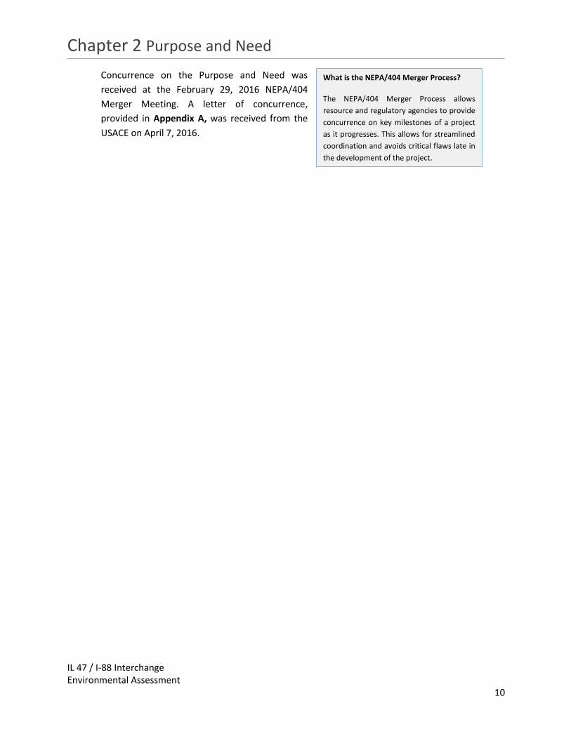
Concurrence on the Purpose and Need was
received at the February 29, 2016 NEPA/404
Merger Meeting. A letter of concurrence,
provided in Appendix A, was received from the
USACE on April 7, 2016.
What is the NEPA/404 Merger Process?
The NEPA/404 Merger Process allows
resource and regulatory agencies to provide
concurrence on key milestones of a project
as it progresses. This allows for streamlined
coordination and avoids critical flaws late in
the development of the project.
Chapter 3 Alternatives
IL 47 / I-88 Interchange Environmental Assessment
11
3 Alternatives
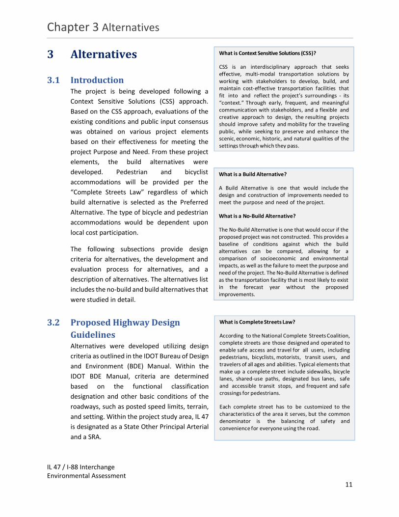
3.1 Introduction The project is being developed following a
Context Sensitive Solutions (CSS) approach.
Based on the CSS approach, evaluations of the
existing conditions and public input consensus
was obtained on various project elements
based on their effectiveness for meeting the
project Purpose and Need. From these project
elements, the build alternatives were
developed. Pedestrian and bicyclist
accommodations will be provided per the
“Complete Streets Law” regardless of which
build alternative is selected as the Preferred
Alternative. The type of bicycle and pedestrian
accommodations would be dependent upon
local cost participation.
The following subsections provide design
criteria for alternatives, the development and
evaluation process for alternatives, and a
description of alternatives. The alternatives list
includes the no-build and build alternatives that
were studied in detail.
3.2 Proposed Highway Design
Guidelines Alternatives were developed utilizing design
criteria as outlined in the IDOT Bureau of Design
and Environment (BDE) Manual. Within the
IDOT BDE Manual, criteria are determined
based on the functional classification
designation and other basic conditions of the
roadways, such as posted speed limits, terrain,
and setting. Within the project study area, IL 47
is designated as a State Other Principal Arterial
and a SRA.
What is Context Sensitive Solutions (CSS)?
CSS is an interdisciplinary approach that seeks effective, multi-modal transportation solutions by working with stakeholders to develop, build, and maintain cost-effective transportation facilities that fit into and reflect the project’s surroundings - its “context.” Through early, frequent, and meaningful communication with stakeholders, and a flexible and creative approach to design, the resulting projects should improve safety and mobility for the traveling public, while seeking to preserve and enhance the scenic, economic, historic, and natural qualities of the settings through which they pass.
What is a Build Alternative?
A Build Alternative is one that would include the design and construction of improvements needed to meet the purpose and need of the project.
What is a No-Build Alternative?
The No-Build Alternative is one that would occur if the proposed project was not constructed. This provides a baseline of conditions against which the build alternatives can be compared, allowing for a comparison of socioeconomic and environmental impacts, as well as the failure to meet the purpose and need of the project. The No-Build Alternative is defined as the transportation facility that is most likely to exist in the forecast year without the proposed improvements.
What is Complete Streets Law?
According to the National Complete Streets Coalition, complete streets are those designed and operated to enable safe access and travel for all users, including pedestrians, bicyclists, motorists, transit users, and travelers of all ages and abilities. Typical elements that make up a complete street include sidewalks, bicycle lanes, shared-use paths, designated bus lanes, safe and accessible transit stops, and frequent and safe crossings for pedestrians.
Each complete street has to be customized to the characteristics of the area it serves, but the common denominator is the balancing of safety and convenience for everyone using the road.

Chapter 3 Alternatives
IL 47 / I-88 Interchange Environmental Assessment
12
The design guidelines utilized for intersecting side roads were determined based on individual
roadway’s functional classification, projected traffic, and other existing conditions. The
alternatives developed at the intersections utilized design criteria from the IDOT BDE Manual, as
well as the IDOT Bureau of Local Roads (BLR) Manual for the side road locations. Side roads within
the corridor are either a Local Street or a Local Major Collector.
The design guidelines utilized for I-88 were based on the March 2016 Tollway’s Roadway Design
Criteria.
Table 3.1 shows basic elements of the design criteria utilized for both the mainline roadway, I-88
and the side roads throughout the project study area.
Table 3.1: Roadway Design Criteria
Description Illinois Tollway Rural SRA Highway
Local Major Collector
Local Street
Design Speed Limit (mph)
70 45-60 30-45 30-35
Number of Lanes 4 4 2-4 2
Lane Width 12’ 12’ 10’ minimum 12’ Desirable
10-11’ Minimum 12’Desirable
Median Width and Type
50’ Minimum Depressed
50’ Minimum Depressed
10’-14’/12’ N/A
3.3 Alternatives Development After concurrence on the Purpose and Need, a list of
alternatives was developed for both the IL 47 Mainline
and the IL 47/I-88 Interchange. Initial alternatives were
developed through a collaborative effort between the
Community Advisory Group (CAG), the public, the
Project Study Group (PSG), and by utilizing the
Feasibility Study conducted by the Village of Sugar
Grove. The objective of this process was to develop an
initial list of alternatives and reduce this list to the
alternatives that were then carried forward for further
study.
Separate alternatives were then developed for IL 47 Mainline and the IL 47/I-88 Interchange,
these alternatives were developed independently of each other and evaluated separately. The IL
47 Mainline limits are from Old Oaks Road to Finley Road on the south end and Seavey Road to
Green Road on the north end. The interchange limits are from Finley Road to Seavey Road. Finley
Road and Seavey Road improvements were part of the IL 47 alternatives. The interchange will
likely be completed by others as an operational improvement separate from the IL 47 widening.
Project Study Group: group of stakeholders consisting of IDOT, Tollway, Kane County, Village of Sugar Grove and the Federal Highway Administration (FHWA).
Community Advisory Group: voluntary group of community leaders, including elected officials, representatives from local municipalities, homeowners, business owners, and local special interest groups.

Chapter 3 Alternatives
IL 47 / I-88 Interchange Environmental Assessment
13
The IL 47 Mainline Alternatives include the following:
No Build: maintains existing facility without any improvements except for routine
maintenance.
M-1A: maintains existing centerline with two 12-foot lanes in each direction, a 30-foot
raised median, and 10-foot shoulders.
M-1B: maintains existing centerline with two 12-foot lanes in each direction, a 50-foot
depressed median, and 10-foot shoulders.
M-1C: maintains existing centerline with two 12-foot lanes in each direction, a 30-foot
median that is reduced to 6-feet in the area of Hannaford Woods/Nickels Farm Forest
Preserve, and 10-foot shoulders.
M-2A: shifts existing centerline 26 feet to the east with two 12-foot lanes in each
direction, a 30-foot raised median, and 10-foot shoulders.
M-2B: shifts existing centerline 26 feet to the east with two 12-foot lanes in each
direction, a 50-foot depressed median, and 10-foot shoulders.
M-2C: shifts existing centerline 26 feet to the east with two 12-foot lanes in each
direction, a 30-foot median that is reduced to 6 feet in the area of Hannaford
Woods/Nickels Farm Forest Preserve, and 10-foot shoulders.
M-3: shifts existing centerline 1,050 feet to the east with two 12-foot lanes in each
direction, new alignment from Merrill Road to Green Road, a 50-foot depressed median,
and 10-foot shoulders.
M-4: shifts existing centerline west on new alignment from Old Oaks Road to the I-88
ramps with two 12-foot lanes in each direction, a 30-foot raised median, and 10-foot
shoulders.
The IL 47 and I-88 Interchange Alternatives include the following:
No Build: maintains existing facility without any improvements except for routine
maintenance.
I-1: A conventional diamond interchange that would add an entrance ramp from IL 47 to
I-88 eastbound and an exit ramp from westbound I-88 to IL 47.
I-2: A conventional diamond with roundabouts interchange would include an entrance
ramp from IL 47 to I-88 eastbound, an exit ramp from westbound I-88 to IL 47, and a
roundabout at each ramp terminal.
I-3: A diverging diamond interchange would add an entrance ramp from IL 47 to I-88
eastbound and an exit ramp from westbound I-88 to IL 47. IL 47 would cross at the north
and south sides of the bridge.
I-4: A partial cloverleaf with a loop ramp in the northeast quadrant would include an
entrance ramp from IL 47 to I-88 eastbound, an exit ramp from westbound I-88 to IL 47,
and a loop for northbound IL 47 traffic to enter I-88 westbound.

Chapter 3 Alternatives
IL 47 / I-88 Interchange Environmental Assessment
14
I-5: A partial cloverleaf with a loop ramp in the northeast quadrant and southwest
quadrant would include an entrance ramp from IL 47 to I-88 eastbound, an exit ramp from
westbound I-88 to IL 47, a loop for northbound IL 47 traffic to enter I-88 westbound, and
a loop ramp for southbound IL 47 traffic to enter I-88 eastbound.
I-6: A partial cloverleaf with a loop ramp in the southwest quadrant would include an
entrance ramp from IL 47 to I-88 eastbound, an exit ramp from westbound I-88 to IL 47,
and a loop ramp for southbound IL 47 traffic to enter I-88 eastbound.
I-7: A partial cloverleaf with a loop ramp terminating at Finley Road would include an
entrance ramp from IL 47 to I-88 eastbound, an exit ramp from westbound I-88 to IL 47,
and a loop ramp that terminates at an intersection with Finley Road.
3.4 Evaluation Process An evaluation and screening process was developed through a collaborative effort with
stakeholders and the PSG. The objective of this process was to develop an initial list of alternatives
and reduce this list from plausible alternatives to feasible alternatives by conducting rounds of
screening analyses. The goal of the process was to refine the number of alternatives and develop
a Preferred Alternative for both the IL 47 Mainline and the IL 47/I-88 Interchange (see Figure 3.1).
Each set of alternatives was screened against the Purpose and Need. All build alternatives were
determined to meet the Purpose and Need by
improving system linkage and accommodating
future land use and economic development.
The IL 47 Mainline Alternatives were then
subjected to two separate rounds of preliminary
screening. In Round 1 of the preliminary
screening process, alternatives were screened
against residential and commercial
displacements, right-of-way required, and
environmental resource impacts including
National Wetland Inventory (NWI) wetlands,
Federal Emergency Management Agency (FEMA)
Flood Insurance Rate Maps (FIRM), lands
currently being farmed, and forested areas.
Alternatives that were carried forward to the next
round of preliminary screening were screened against cost, operational review data, and
Environmental Survey Request (ESR) data such as Kane County Forest Preserve Property and
Illinois Natural History Survey (INHS) wetlands and Waters of the United States (WOUS). Some
categories from Round 1 were also carried forward, such as displacements, right-of-way required
and floodplains, for comparison.
Figure 3.1: Evaluation Process

Chapter 3 Alternatives
IL 47 / I-88 Interchange Environmental Assessment
15
The IL 47/I-88 Interchange alternatives were subjected to one round of preliminary screening,
which included right-of-way required, operational reviews, cost, impacts to the existing IL 47
bridge, and environmental resources.
The next step in the evaluation and screening process was to subject the alternatives to detailed
screening which evaluated alternatives against further engineering and environmental review.
Each screening process is described in the following subsections.
3.4.1 Purpose and Need Screening
The alternatives were reviewed in detail to determine if they meet the project’s Purpose and
Need. There were two critical components of the Purpose and Need: (1) improve system linkage
and (2) accommodate land use and economic development within the IL 47 and I-88 project study
area. The first criteria was evaluated based on the design of the interchange. The second criteria
was evaluated based on review of future land use plans of the Village of Sugar Grove (see Exhibit
3), separation of land parcels zoned for future commercial development, and an operational
review.
3.4.1.1 Purpose and Need Screening of IL 47 Alternatives
In order for IL 47 to meet the Purpose and Need, it needs to be able to facilitate the 2040 traffic
projections. The IL 47 Mainline Alternatives were analyzed with Highway Capacity Software
(HCS) 2010, which considered factors like directional traffic volume, heavy vehicle percentage,
and aspects of the roadway design to identify a directional Level of Service (LOS) for each
segment during the morning and evening peak hours. LOS grades range from A to F with LOS A
as the highest (best traffic flow and least delay), LOS E as saturated or at-capacity conditions,
and LOS F as the lowest (oversaturated conditions) (see Figure 3.2). Given IL 47’s status as a
SRA, LOS C or better is desirable for corridor operation.
Figure 3.2: Level of Service

Chapter 3 Alternatives
IL 47 / I-88 Interchange Environmental Assessment
16
As the basis for capacity analysis of the IL 47 corridor,
the CMAP developed Average Daily Traffic (ADT)
volumes for each segment of IL 47, for I-88 and the
interchange ramps, and for each side street within
the study area. These ADTs are illustrated in Exhibit 5
and 6 for 2040 No-Build and 2040 Build conditions,
respectively. Based on these ADTs, Design Hourly
Volumes (DHVs) were prepared by IDOT for each
study intersection during the weekday morning and
evening peak hours. These DHVs, which are presented in Exhibit 7, were provided to the project
team for use in analyzing corridor operation at this stage of the Phase I study.
The existing IL 47 cross-section provides two lanes in each direction at the interchange ramps
and, in the northbound direction only, between the I-88 eastbound ramp and Finley Road. The
remainder of IL 47 is one lane in each direction through the study area. It is assumed that this
cross-section would be maintained under 2040 No-Build Conditions.
The HCS 2010 roadway segment analyses indicate that nearly all portions of IL 47 providing a
single directional travel lane will operate at LOS E during one or both peak hours under 2040
No-Build conditions. The remaining one-lane directional sections are projected at LOS D. As
such, all build alternatives are proposing to build IL 47 with two lanes in each direction from Old
Oaks Road to Green Road. Since all build alternatives are proposing the same number of lanes,
they will be evaluated together. HCS 2010 analyses of the 2040 Build condition indicate that
this cross-section will allow all study segments of IL 47 to operate at LOS C or better. As long as
two lanes are provided in each direction, the median width or specific alignment are unlikely to
have meaningful impact on the LOS results (see Exhibit 8).
Based on the results of the operational review, IL 47 should be widened to support projected
future traffic volumes and to facilitate the anticipated economic development. The No-Build
alternative is not expected to adequately support traffic volumes from a capacity perspective,
nor does it the meet the Purpose and Need because it does not facilitate economic
development. However, for comparison it will be carried forward.
3.4.1.2 Purpose and Need Screening of IL 47/I-88 Interchange Alternatives
All of the IL 47/I-88 Interchange Build Alternatives meet the Purpose and Need to improve
system linkage by providing a full access interchange between IL 47 and I-88 and facilitate future
economic development and land use. The No-Build Alternative does not meet the Purpose and
Need because it does not provide improved access at the IL 47/I-88 Interchange; however, for
comparison, it will be carried forward.
Who is Chicago Metropolitan Agency for Planning (CMAP): CMAP is the official regional planning organization for the northeastern Illinois counties of Cook, DuPage, Kane, Kendall, Lake, McHenry, and Will. CMAP establishes coordinated strategies that help the region's 284 communities address transportation, housing, economic development, open space, the environment, and other quality-of-life issues.

Chapter 3 Alternatives
IL 47 / I-88 Interchange Environmental Assessment
17
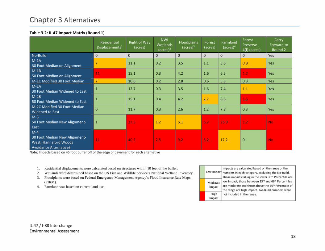
3.4.2 Preliminary Alternative Screening
3.4.2.1 IL 47 Preliminary Screening
The IL 47 Mainline Alternatives were then subjected to two separate rounds of preliminary
screening. In Round 1 of the screening process, alternatives were screened against residential
and commercial displacements, right-of-way required, and environmental resources including
NWI wetlands, FEMA FIRM maps, land currently being farmed, and forested areas. The results
of this screening can be seen in Table 3.2. Alternatives that were carried forward to the next
screening process were screened against cost, operational review data, and ESR data. ESR data
included 4(f) property, wetland and WOUS delineations, and other biotic surveys. Some
categories from Round 1 were also carried forward, such as displacements, right-of-way
required and floodplains, for comparison. The results of this screening can be seen in Table 3.3.

THIS PAGE INTENTIONALLY LEFT BLANK
Chapter 3 Alternatives
IL 47 / I-88 Interchange Environmental Assessment
18
Table 3.2: IL 47 Impact Matrix (Round 1)
Note: Impacts based on 45 foot buffer off of the edge of pavement for each alternative
1. Residential displacements were calculated based on structures within 10 feet of the buffer.
2. Wetlands were determined based on the US Fish and Wildlife Service’s National Wetland Inventory.
3. Floodplains were based on Federal Emergency Management Agency’s Flood Insurance Rate Maps
(FIRM).
4. Farmland was based on current land use.
Residential
Displacements1 Right of Way
(acres)
NWI Wetlands (acres)2
Floodplains (acres)3
Forest (acres)
Farmland (acres)4
Forest Preserve – 4(f) (acres)
Carry Forward to
Round 2
No-Build 0 0 0 0 0 0 0 Yes
M-1A 30 Foot Median on Alignment
7 11.1 0.2 3.5 1.1 5.8 0.8 Yes
M-1B 50 Foot Median on Alignment
11 15.1 0.3 4.2 1.6 6.5 1.2 Yes
M-1C Modified 30 Foot Median 7 10.6 0.2 2.8 0.6 5.8 0.3 Yes
M-2A 30 Foot Median Widened to East
1 12.7 0.3 3.5 1.6 7.4 1.1 Yes
M-2B 50 Foot Median Widened to East
1 15.1 0.4 4.2 2.7 8.6 1.6 Yes
M-2C Modified 30 Foot Median Widened to East
0 11.7 0.3 2.6 1.2 7.3 0.3 Yes
M-3 50 Foot Median New Alignment-East
1 37.5 1.2 5.1 6.7 25.9 1.2 No
M-4 30 Foot Median New Alignment-West (Hannaford Woods Avoidance Alternative)
11 40.7 2.5 9.2 5.2 17.2 0 No
Low Impact Impacts are calculated based on the range of the
numbers in each category, excluding the No-Build.
Those impacts falling in the lower 33rd Percentile are
low impact, those between 33rd and 66th Percentiles
are moderate and those above the 66th Percentile of
the range are high impact. No-Build numbers were
not included in the range.
Moderate
Impact
High
Impact

THIS PAGE INTENTIONALLY LEFT BLANK

Chapter 3 Alternatives
IL 47 / I-88 Interchange Environmental Assessment
19
Table 3.3: IL 47 Impact Matrix (Round 2)
Note: Impacts based on 45 foot buffer off of the edge of pavement for each alternative
1. Residential displacements were calculated based on structures within 10 feet of the buffer.
2. Cost was estimated for improving IL 47 from Old Oaks Road/College Drive to Green Road.
3. Wetlands and Waters of the U.S. were determined based on the INHS 2016 survey.
4. Floodplains were based on Federal Emergency Management Agency’s Flood Insurance Rate
Maps (FIRM).
5. Farmland was based on current land use.
Residential
Displacements1
Right of Way
(acres)
Estimated Cost in
Millions (2016
Dollars)2
Operational Review
INHS Wetlands (acres)3
Floodplains (acres)4
Farmland (acres)5
INHS Waters of the U.S. (linear feet)
Forest Preserve
– 4(f) (acres)
Carry Forward
No-Build 0 0 0 Unacceptable 0 0 0 0 0 Yes
M-1A 30 Foot Median
7 11.1 $16.5 Acceptable 1.9 3.5 5.8 2000-3000
0.8 Yes
M-1B 50 Foot Median
11 15.1 $17.2 Acceptable 2.2 4.2 6.5 2000-3000
1.2 No
M-1C Modified 30 Foot Median
7 10.6 $16.5 Acceptable 1.3 2.8 5.8 2000-3000
0.3 Yes
M-2A 30 Foot Median
1 12.7 $18.3 Acceptable 2.1 3.5 7.4 2000-3000
1.1 No
M-2B 50 Foot Median
1 15.1 $18.8 Acceptable 2.5 4.2 8.6 2000-3000
1.6 No
M-2C Modified 30 Foot Median
0 11.7 $18.3 Acceptable 1.3 2.6 7.3 2000-3000
0.3 Yes
Low Impact Impacts are calculated based on the range of the numbers
in each category for Round 2 alternatives only, excluding
the No-Build. Those impacts falling in the lower 33rd
Percentile are low impact, those between 33rd and 66th
Percentiles are moderate and those above the 66th
Percentile of the range are high impact. No-Build numbers
were not included in the range.
Moderate
Impact
High
Impact

THIS PAGE INTENTIONALLY LEFT BLANK

Chapter 3 Alternatives
IL 47 / I-88 Interchange Environmental Assessment
20
3.4.2.2 Illinois 47 Alternatives Eliminated
3.4.2.2.1 Round 1 Elimination
The alternatives eliminated during Round 1 contained high amounts of farmland, floodplain,
and forest impacts and right-of-way required. Each of the alternatives eliminated during Round
1 are described below.
Alternative M-3: 4-Lane New Alignment East
Description
This alternative includes two 12-foot lanes in each direction with a 50-foot depressed median and 10-foot shoulders.
The centerline is shifted 1,050 feet to the east.
The new alignment would begin at Merrill Road and end at Green Road.
The alternative takes into account the potential for a 10-foot wide multi-use trail to be located on both sides of IL 47.
All intersections would be improved geometrically to accommodate design traffic volumes and design vehicles.
The new alignment would have new intersections at Seavey Road, Thornapple Tree Road, and Scott Road.
Reasons for Elimination
This alternative had the second highest amount of right-of-way required (37.5 acres).
This alternative had the highest amount of impacts to farmland (25.9 acres), and forest (6.7 acres), and moderate impacts to floodplain (5.1 acres) and wetlands (1.2 acres) compared to other alternatives.
It would create an entirely new crossing of Seavey Road Run.
Alternative M-4: 4-Lane New Alignment West (Hannaford Woods Avoidance Alternative)
Description
This alternative includes two 12-foot lanes in each direction with a 30-foot raised median and 10-foot shoulders.
The alignment is shifted west south of Old Oaks Road and merges back on existing alignment just south of the I-88 ramps.
The alternative takes into account the potential for a 10-foot wide multi-use trail to be located on both sides of IL 47.
All intersections would be improved geometrically to accommodate design traffic volumes and design vehicles.
Reasons for Elimination
This alternative impacts the highest number of residential properties (11).
This alternative requires the highest amount of right-of-way (40.7 acres).
This alternative had the highest amount of impacts to wetlands (2.5 acres) and floodplains (9.2 acres), high impacts to forest (5.2 acres) and moderate impacts to farmland (17.2 acres) as compared to other alternatives.

Chapter 3 Alternatives
IL 47 / I-88 Interchange Environmental Assessment
21
3.4.2.2.2 Round 2 Elimination
The alternatives eliminated during Round 2 had high costs and higher amounts of impacts to
the Hannaford Woods/Nickels Farm Forest Preserve, and wetlands. Each of the alternatives
eliminated during Round 2 are described below.
Alternative M-1B: 4-Lane on Existing Alignment with 50 foot Median
Description
This alternative includes two 12-foot lanes in each direction with a 50-foot depressed median and 10-foot shoulders.
The alternative maintains the existing centerline of IL 47.
The alternative takes into account the potential for a 10-foot wide multi-use trail to be located on both sides of IL 47.
All intersections would be improved geometrically to accommodate design traffic volumes and design vehicles.
Reasons for Elimination
This alternative had the highest of potential residential displacements (11).
Among the alternatives carried to Round 2, it tied for the highest amount of right-of-way (15.1 acres).
This alternative tied for the highest impacts to floodplains (4.2 acres) and had high impacts to wetlands (2.2 acres) and Hannaford Woods/Nickels Farm Forest Preserve (1.2 acres) as compared to other alternatives carried to Round 2.
Alternative M-2A: 4-Lane Widened to the East with 30 foot Median
Description
This alternative includes two 12-foot lanes in each direction with a 30-foot raised median and 10-foot shoulders.
The centerline is shifted 26 feet to the east.
The alternative takes into account the potential for a 10-foot wide multi-use trail to be located on both sides of IL 47.
All intersections would be improved geometrically to accommodate design traffic volumes and design vehicles.
Reasons for Elimination
Among the alternatives carried to Round 2, it had the second highest amount of right-of-way (12.7 acres).
This alternative has the second highest cost of those advanced to Round 2 ($18.3 Million).
This alternative had moderate impacts to wetlands (2.1 acres), floodplains (3.5 acres), farmland (7.4 acres), and Hannaford Woods/Nickels Farm Forest Preserve (1.1 acres) as compared to other alternatives carried to Round 2.

Chapter 3 Alternatives
IL 47 / I-88 Interchange Environmental Assessment
22
Alternative M-2B: 4-Lane Widened to the East with 50 foot Median
Description
This alternative includes two 12-foot lanes in each direction with a 50-foot depressed median and 10-foot shoulders.
The centerline is shifted 36 feet to the east.
The alternative takes into account the potential for a 10-ft wide multi-use trail to be located on both sides of IL 47.
All intersections would be improved geometrically to accommodate design traffic volumes and design vehicles.
Reasons for Elimination
Among the alternatives carried to Round 2, it tied for the highest amount of right-of-way (15.1 acres).
This alternative has the highest cost for those advanced to Round 2 ($18.8 Million).
This alternative had the highest impacts to farmland (8.6 acres), wetlands (2.5 acres), floodplains (4.2 acres), and Hannaford Woods/Nickels Farm Forest Preserve (1.6 acres) as compared to other alternatives carried to Round 2.
3.4.2.3 Illinois 47 Alternatives to be Carried Forward
The IL 47 alternatives to be carried forward were based on the design’s ability to minimize
environmental and socioeconomic impacts. The alternatives to be carried forward were
approved at the February 22, 2017 NEPA/404 Merger Meeting. The meeting minutes indicating
concurrence are provided in Appendix A. The following alternatives were carried forward:
No Build Alternative
Description
The No-Build Alternative would maintain the existing facility without any improvements except for routine maintenance (i.e. shoulder resurfacing or pavement patching and resurfacing) and those projects currently planned and programmed.
The No-Build alternative would not include any lane widening or lane additions.
Comments
Based on 2040 No-Build DHVs provided by IDOT, the IL 47 corridor is projected to operate at LOS E on most study segments under this alternative.
The No-Build is being carried forward for comparison.

Chapter 3 Alternatives
IL 47 / I-88 Interchange Environmental Assessment
23
Alternative M-1A: 4-Lane on Existing Alignment with 30 foot Median
Description
This alternative includes two 12-foot lanes in each direction with a 30-foot raised median and 10-foot shoulders.
The alternative maintains the existing centerline of IL 47.
The alternative takes into account the potential for a 10-ft wide multi-use trail to be located on either side of IL 47.
All intersections would be improved geometrically to accommodate design traffic volumes and design vehicles.
Comments
Based on 2040 Build DHVs provided by IDOT, the IL 47 corridor is projected to operate at LOS C or better on all study segments under this alternative.
This alternative tied for the lowest cost ($16.5 Million).
This alternative has low impacts to right-of-way (11.1 acres).
This alternative has tied for lowest impacts to farmland (5.8 acres) and has moderate impacts to wetlands (1.9 acres) and floodplains (3.5 acres) as compared to other alternatives carried to Round 2.
Alternative M-1C: 4-Lane on Existing Alignment with Modified 30 food Median
Description
The alternative includes two 12-foot lanes in each direction with a 30 foot raised median through most of the corridor.
The median is reduced to 6 foot through the Hannaford Woods/Nickels Farm Forest Preserve.
The alternative maintains the existing centerline of IL 47.
The alternative takes into account the potential for a 10-ft wide multi-use trail to be located on either side of IL 47.
All intersections would be improved geometrically to accommodate design traffic volumes and design vehicles.
Comments
Based on 2040 Build DHVs provided by IDOT, the IL 47 corridor is projected to operate at LOS C or better on all study segments under this alternative.
This alternative has the lowest impacts to right-of-way (10.6 acres).
This alternative tied for the lowest cost ($16.5 Million).
This alternative tied for the lowest impacts to wetlands (1.3 acres), Hannaford Woods/Nickels Farm Forest Preserve (0.3 acres) and farmland (5.8 acres) as compared to other alternatives carried to Round 2.

Chapter 3 Alternatives
IL 47 / I-88 Interchange Environmental Assessment
24
Alternative M-2C: 4-Lane Widened to East with Modified 30 foot Median
Description
The alternative includes two 12-foot lanes in each direction with a 30 foot raised median through most of the corridor.
The median is reduced to 6 feet through the Hannaford Woods/Nickels Farm Forest Preserve.
The alternative shifts the centerline north of the forest preserve to the east to avoid residences.
The alternative takes into account the potential for a 10-foot wide multi-use trail to be located on both sides of IL 47.
All intersections would be improved geometrically to accommodate design traffic volumes and design vehicles.
Comments
Based on 2040 Build DHVs provided by IDOT, the IL 47 corridor is projected to operate at LOS C or better on all study segments under this alternative.
This alternative has a low impacts to right-of-way (11.7 acres).
This alternative has the second highest cost of the alternatives in Round 2 ($18.3 M)
This alternative tied for the lowest impacts to wetlands (1.3 acres) and Hannaford Woods/Nickels Farm Forest Preserve (0.3 acres. It has the lowest impacts to floodplains (2.6 acres) as compared to other alternatives carried to Round 2.
This alternative impacts no residential displacements.
3.4.2.4 Preliminary Screening of Interchange Alternatives
The IL 47 and I-88 Interchange Alternatives include the no-build, conventional diamond
interchange, conventional diamond interchange with roundabouts, diverging diamond
interchange, partial cloverleaf in the northeast quadrant, partial cloverleaf in the northeast and
southwest quadrants, partial cloverleaf in the southwest quadrant, and a partial cloverleaf with
a loop ramp terminating at Finley Road.
The alternatives were then screened against right-of-way required, operational reviews, cost,
impacts to the existing IL 47 Bridge, environmental resources, and socio-economic impacts. For
the interchange design alternatives, the operational review for the ramp intersections was
based on IDOT BDE design standards and a preliminary opinion of the probable geometric
configurations that would be required to accommodate the projected DHVs. Note that LOS
analyses were not performed as a part of this initial screening process, since the selected
geometric layouts for each alternative are expected to yield acceptable operational
characteristics and conform to BDE criteria. The impacts are presented in Table 3.4 and do not
include impacts for the IL 47 widening.

THIS PAGE INTENTIONALLY LEFT BLANK

Chapter 3 Alternatives
IL 47 / I-88 Interchange Environmental Assessment
25
Table 3.4: Interchange Impact Matrix
Note: Impacts were calculated based on a 45 foot buffer from edge of pavement for each alternative.
1. Additional square feet of bridge surface area required. 2. Wetlands and Waters of the U.S. were determined based on the INHS Wetland Survey conducted in 2016. 3. Floodplains were based on Federal Emergency Management Agency’s Flood Insurance Rate Maps (FIRM).
Right of Way
(acres)
Operational Review
Estimated Cost in
Millions (2016
Dollars)
Existing IL 47 over I-88
Bridge Impacts
(square feet)1
Wetlands (acres)2
Waters of the U.S.
(linear feet)
Floodplains (acres)3
Forest (acres)
Farmland (acres)4
Carry Forward
No-Build 0 Not Acceptable
0 None 0 0 0 0 0 Yes
Alternative I-1: Conventional Diamond
0.7 Acceptable $16.2 2622 <0.1 0 0 <0.1 0.9 Yes
Alternative I-2: Conventional Diamond w/ Roundabouts
0 Acceptable $15.9 1261 <0.5 10 0 <0.1 <0.1 Yes
Alternative I-3: Diverging Diamond
0 Acceptable $15.8 0 <0.1 0 0 <0.1 0 Yes
Alternative I-4: Partial Cloverleaf-NE Quadrant
0.7 Acceptable $19.8 2606 <0.1 0 0.1 0 0.8 Yes
Alternative I-5: Partial Cloverleaf-NE and SW Quadrant
2.9 Acceptable $21.7 3218 <0.6 <100 0.1 0.2 3.3 No
Alternative I-6: Partial Cloverleaf-SW Quadrant
2.3 Acceptable $20.3 2608 <0.6 <100 0 0.2 2.5 No
Alternative I-7: Partial Cloverleaf-Loop Ramp terminating at Finley Road intersection
7.5 Acceptable $20.2 2608 <0.1 <1000 0 2.4 6.1 No
Low Impact Impacts are calculated based on the range of the numbers in each category excluding the No-Build. Those impacts
falling in the lower 33rd Percentile are low impact, those between 33rd and 66th Percentiles are moderate and those
above the 66th Percentile of the range are high impact. No-Build numbers were not included in the range. Moderate Impact
High Impact

THIS PAGE INTENTIONALLY LEFT BLANK

Chapter 3 Alternatives
IL 47 / I-88 Interchange Environmental Assessment
26
3.4.2.5 Interchange Alternatives Eliminated
Environmental and socioeconomic impacts were minutely different between interchange
alternatives and are weighted less in the evaluation due to their small ranges of impacts. The
bridge superstructure was fully reconstructed in 2007. Due to the recent reconstruction of the
bridge, preservation of the structure is weighted heavily. The cost and right-of-way required
also received a heavier weight. Each interchange alternative eliminated is described below:
Alternative I-5: Partial Cloverleaf with Loop Ramp in Northeast and Southwest Quadrants
Description
The partial cloverleaf with loop ramp in the northeast and southwest quadrant interchange would include an entrance ramp from IL 47 to I-88 eastbound and an exit ramp from westbound I-88 to IL 47.
It also includes a loop ramp for northbound IL 47 traffic to enter I-88 westbound, and a loop ramp for southbound IL 47 traffic to enter I-88 eastbound.
Finley Road would be a right-in/right-out road onto IL 47.
This alternative requires a tapered exit lane for southbound vehicles to access the I-88 EB entrance loop ramp. The taper begins on the bridge, and requires additional widening beyond the existing structure. To provide the required lane geometry and 10-ft multi-use path on both sides of the roadway, the existing structure will require an additional 3,218-SF of bridge surface area.
Reasons for Elimination
This alternative has the highest cost ($21.7 Million).
This alternative has the highest impacts to the existing IL 47 bridge over I-88 (3,218 square feet).
This alternative has moderate impacts to right-of-way (2.9 acres).
This alternative ties for the highest impacts to wetlands (<0.6 acres) and floodplains (0.1 acres) and has moderate impacts to farmland (3.3 acres).
There is no operational need for a loop ramp in the northeast or southwest quadrants based on 2040 traffic data. Due to the increased cost, impacts to the bridge, and environmental impacts, it is eliminated.

Chapter 3 Alternatives
IL 47 / I-88 Interchange Environmental Assessment
27
Alternative I-6: Partial Cloverleaf with Loop Ramp in Southwest Quadrant
Description
The partial cloverleaf with loop ramp in the southwest quadrant interchange would include an entrance ramp from IL 47 to I-88 eastbound and an exit ramp from westbound I-88 to IL 47.
It also includes a loop ramp for southbound IL 47 traffic to enter I-88 eastbound.
Finley Road would be a right-in/right-out road onto IL 47.
The SW quadrant requires a tapered exit lane for southbound vehicles to access the I-
88 EB entrance loop ramp. The taper begins on the bridge, and requires additional
widening beyond the limits of the existing structure. To provide the required lane
geometry and 10-ft multi-use path on both sides of the roadway, the existing structure
will require an additional 2,608-SF of bridge surface area.
Reasons for Elimination
This alternative has the second highest cost ($20.3 Million).
This alternative has high impacts to the existing IL 47 bridge over I-88 (2,608 -SF).
This alternative ties for the highest impacts to wetlands (<0.6 acres) and has moderate impacts to farmland (2.5 acres).
There is no operational need for a loop ramp in the southwest quadrant based on 2040 traffic data. Due to the increased cost, impacts to the bridge, and environmental impacts, it is eliminated.
Alternative I-7: Partial Cloverleaf with Loop Ramp Terminating at Finley Road Intersection
Description
The partial cloverleaf with loop ramp terminating at Finley Road intersection would include an entrance ramp from IL 47 to I-88 eastbound and an exit ramp from westbound I-88 to IL 47.
It modifies the I-88 east bound exit ramp to IL 47 into a loop ramp that terminates at an intersection with Finley Road.
This alternative requires dual-left turn lanes for IL 47 traffic to access the I-88 entrance
ramps at both ends of the bridge. The existing structure width of 91’-8” is insufficient
and will need to be widened 7.75-ft on both sides in order to accommodate the
proposed IL 47 lane geometry, as well as a 10-ft multi-use path on both sides. This
results in an additional 2,608-SF of bridge surface area.
Reasons for Elimination
This alternative has the highest impacts to right-of-way, more than twice as much as the next closest alternative (7.5 acres).
This alternative has a high cost ($20.2 Million).
This alternative has high impacts to the existing IL 47 bridge over I-88 (2,608 SF).
This alternative has the highest impacts to WOUS (<1000 linear feet), forest (2.4 acres), and farmland (6.1 acres) and low impacts to wetlands (<0.1 acres).
There is no operational need for a loop ramp in the southeast quadrant based on 2040 traffic data. Due to the increased right-of-way, cost, impacts to the bridge, and environmental impacts, it is eliminated.

Chapter 3 Alternatives
IL 47 / I-88 Interchange Environmental Assessment
28
3.4.2.6 Interchange Alternatives to be Carried Forward
The interchange alternatives to carry forward were based on minimizing right-of-way, cost,
bridge impacts, and environmental and socioeconomic impacts. The alternatives to carry
forward were approved at the February 22, 2017 NEPA/404 Merger Meeting. A letter of
concurrence from the USACE is provided in Appendix A.
No Build Alternative
Description
The No-Build Alternative would maintain the existing facility without any improvements except for routine maintenance (i.e. shoulder resurfacing or pavement patching and resurfacing) and those projects currently planned and programmed.
The No-Build Alternative would continue to operate as a partial interchange.
Comments This alternative does not meet purpose and need as it does not improve system linkage by providing a full access interchange however; for comparison, it will be carried forward.
Alternative I-1: Conventional Diamond Interchange
Description
The conventional diamond interchange would include an entrance ramp from IL 47 to I-88 eastbound and an exit ramp from westbound I-88 to IL 47.
Finley Road will be a right-in/right-out road onto IL 47.
This alternative requires dual-left turn lanes for IL 47 traffic to access the I-88 entrance
ramps at both ends of the bridge. The existing structure width of 91’-8” is insufficient
and will need to be widened 7.9-ft on both sides in order to accommodate the
proposed IL 47 lane geometry, as well as a 10-ft multi-use path on both sides. This
results in an additional 2,622-SF of bridge surface area.
Comments
This alternative has low impacts to right-of-way (0.7 acres).
This alternative has a low cost ($16.2 Million).
This alternative has high impacts to the existing IL 47 bridge over I-88 (2622 square feet).
This alternative has no impacts to WOUS or floodplains and ties for the lowest impacts to wetlands (<0.1 acre) and has low impacts to forest (<0.1 acre) and farmland (0.9 acres).

Chapter 3 Alternatives
IL 47 / I-88 Interchange Environmental Assessment
29
Alternative I-2: Conventional Diamond with Roundabouts
Description
The conventional diamond with roundabouts interchange would include an entrance ramp from IL 47 to I-88 eastbound and an exit ramp from westbound I-88 to IL 47.
Roundabouts would be provided at both ramp terminals.
Finley Road would be a right-in/right-out road onto IL 47.
This alternative provides for a 95-ft wide roadway section for IL 47, which includes a 10-ft multi-use path on both sides. The existing structure width of 91’-8” is insufficient and will need to be widened 3.8-ft on both sides in order to accommodate the proposed IL 47 lane geometry, as well as a 10-ft multi-use path on both sides. This results in an additional 1,261-SF of bridge surface area.
Comments
This alternative has no impacts to right-of-way.
This alternative has the second lowest cost ($15.9 Million).
This alternative has moderate impacts to the existing IL 47 bridge over I-88 (1261 square feet).
This alternative has no impacts to floodplains and low impacts to WOUS (10 linear feet), forest (<0.1 acres), and farmland (<0.1 acres).
Alternative I-3: Diverging Diamond Interchange
Description
The Diverging Diamond Interchange would include an entrance ramp from IL 47 to I-88 eastbound and an exit ramp from westbound I-88 to IL 47.
Opposing lanes of IL 47 crisscross at traffic signals on the north and south side of I-88.
Finley Road would be a right-in/right-out road onto IL 47.
This alternative provides for an 88-ft wide roadway section for IL 47, which includes a
10-ft multi-use path within the median. The existing structure width of 91’-8” is
sufficient and will not require widening in order to accommodate the proposed IL 47
lane geometry.
Comments
This alternative has no impacts to right-of-way.
This alternative has the lowest cost ($15.8 Million).
This alternative has the no impacts to the existing IL 47 bridge over I-88.
This alternative has no impacts to WOUS, floodplains and farmland and ties for the lowest impacts to wetlands (<0.1 acre) and has low impacts to forest (<0.1 acre).

Chapter 3 Alternatives
IL 47 / I-88 Interchange Environmental Assessment
30
Alternative I-4: Partial Cloverleaf with Loop Ramp in Northeast Quadrant
Description
The partial cloverleaf with loop ramp in the northeast quadrant interchange would include an entrance ramp from IL 47 to I-88 eastbound and an exit ramp from westbound I-88 to IL 47.
It also includes a loop ramp for northbound IL 47 traffic to enter I-88 westbound.
Finley Road would be a right-in/right-out road onto IL 47.
The NE quadrant requires a tapered exit lane for northbound vehicles to access the
I-88 WB entrance loop ramp. The taper begins on the bridge, and requires
additional widening beyond the limits of the existing structure. To provide the
required lane geometry and 10-ft multi-use path on both sides of the roadway, the
existing structure will require an additional 2,606-SF of bridge surface area.
Comments
This alternative has a high cost ($19.8 Million).
This alternative has high impacts to the existing IL 47 bridge over I-88 (2,606 square feet).
This alternative ties for the highest impacts to floodplains (0.1 acres).
The results of the preliminary screening process resulted in the no-build, and three build
alternatives being carried forward for the IL 47 Mainline and four build alternatives carried
forward for the IL 47/I-88 Interchange.
3.4.3 Detailed Screening Process
3.4.3.1 IL 47 Detailed Screening Process
The IL 47 Mainline Alternatives carried forward were further evaluated and refined based on
stakeholder input, geometric studies, and design criteria. The detailed screening of IL 47
Mainline Alternatives consisted of geometric studies and rescreening the revised designs in
order to update the environmental and socioeconomic impacts. See Appendix B for IL 47 Build
Alternatives.
The IL 47 Mainline Alternatives were screened using the most up-to-date geometries. Median
widths were revised to address IDOT standards and requirements. Below is a summary of the
alternatives used during the detailed screening process:
The No-Build maintains the existing alignment through the corridor. The current
alignment has one through lane in each direction from Old Oaks Road to Finley Road, two
lanes in each direction from Finley Road to Seavey Road and one lane in each direction
from Seavey Road to Green Road. It does not meet the project P&N; however it is being
carried forward for comparison purposes.
The M-1A alternative is a 30 foot raised median on the existing alignment with two 12
foot lanes in each direction from Old Oaks Road to Green Road and 10-foot shoulders.
Chapter 3 Alternatives
IL 47 / I-88 Interchange Environmental Assessment
31
The M-1C alternative is a 30 foot raised median on the existing alignment; however, the
median is reduced to a 14 foot raised median with 4 foot inside shoulders through the
Hannaford Woods/Nickels Farm Forest Preserve. M-1C has two 12 foot lanes in each
direction from Old Oaks Road to Green Road with 10 foot shoulders.
The M-2C alternative is a 30 foot raised median on the existing alignment from Old Oaks
Road to Thornapple Tree Road, then the alignment shifts to the east. The median is
reduced to a 14 foot raised median with 4 foot inside shoulders through the Hannaford
Woods/Nickels Farm Forest Preserve.
3.4.3.1.1 IL 47 Intersection Geometries
As stated in Section 3.4.2.3, the IL 47 build alternatives consist of two 12-foot through lanes in
each direction with a 30 foot median. These alternatives are being considered a single Build
Alternative for these studies due to their similar cross sections. Intersection geometries outside
of the interchange area (study intersections are defined as the IL 47 intersections at Green Road,
Scott Road, Merrill Road, and Old Oaks Road/College Drive) were studied in more detail for the
Build Alternative. As part of this assessment, signal warrant analyses were conducted for all
unsignalized study intersections under Year 2025 conditions (presumed to coincide with
Opening Day plus five years) and Year 2040 conditions. This approach included the development
of a straight-line growth rate for each turning movement (based on existing volumes compared
to 2040 DHVs) and applying these rates to 12-hour count data collected in March 2015 in order
to yield projected traffic volumes for the two design years being considered. The resulting 12-
hour traffic projections were then used to perform signal warrant analyses in accordance with
criteria in the Manual on Uniform Traffic Control Devices (2009) and IDOT standards for
signalization on a SRA route. The results of signal warrant analyses revealed that none of the
study intersections are expected to meet signal warrant criteria in Year 2025; as a result, no
new traffic signals are expected to be installed for Opening Day of the improved IL 47 corridor.
Under Year 2040 conditions, non-interchange area intersections that are expected to warrant
the installation of a new traffic signal include IL 47/Scott Road and IL 47/Merrill Road. IL 47 at
Green Road is assumed to operate under minor-leg stop control in Year 2040. Given that the IL
47/Old Oaks Road/College Drive intersection is currently signalized, no change in intersection
control was contemplated at this location.
In order to develop recommended intersection geometry for the IL 47 corridor that lies outside
of the interchange area, reference was made to BDE criteria and to the results of Year 2040
capacity analyses (prepared in both Synchro and HCS 2010 software). As a baseline, it was
assumed that left-turn lanes would be provided on IL 47 at all study intersections due to the 30-
foot median width proposed as a part of all three build alternatives. Similarly, it was assumed
that dedicated right-turn lanes would be provided on IL 47 at all study intersections given the
Chapter 3 Alternatives
IL 47 / I-88 Interchange Environmental Assessment
32
shoulder width proposed for this corridor.
The resulting intersection geometrics for
Year 2040 conditions are listed below:
• IL 47/Green Road:
o North leg – Dedicated left-
turn lane and two through
lanes
o South leg – Two through
lanes and dedicated right-
turn lane
o East leg – Separate left- and right-turn lanes
• IL 47/Scott Road:
o North leg – Two through lanes and a dedicated right-turn lane
o South leg – Dedicated left-turn lane and two through lanes
o West leg – Separate left- and right-turn lanes
• IL 47/Merrill Road:
o North leg – Dedicated left-turn lane and two through lanes
o South leg – Two through lanes and dedicated right-turn lane
o East leg – Separate left- and right-turn lanes
• IL 47/Old Oaks Road/College Drive:
o No change from existing geometry
3.4.3.1.1 IL 47 Resource Impacts
Resource impacts were calculated for the refined IL 47 Mainline Alternatives from Old Oaks
Road to Green Road based on preliminary proposed right-of-way. The IL 47/I-88 alternatives
overlap the IL 47 alternatives from 845 feet south of Finley Road to 828 feet north of Seavey
Road. Where overlap occurs, interchange alternative impacts were assumed to be in addition
to impacts already identified with IL 47 alternatives. Provided in Table 3.5 are the results of the
Detailed Screening Round.
Highway Capacity Software (HCS) 2010 directly applies the principles in the latest version of Highway Capacity Manual (HCM). Through the various HCS 2010 modules, traffic operation can be analyzed at intersections, on roadway segments, and for various aspects of a freeway system.
Synchro builds on the HCM methodologies by incorporating a proprietary algorithm for evaluating progression between coordinated traffic signals. This algorithm is often used to develop optimized signal timings as a part of intersection capacity analyses on a given roadway corridor.
When used for intersection analysis, both software packages provide an average delay per vehicle for use in assigning a Level of Service (LOS) grade.

Chapter 3 Alternatives
IL 47 / I-88 Interchange Environmental Assessment
33
Table 3.5: IL 47 Impact Matrix (Detailed Screening Round)
Note: Impacts were calculated based on proposed right-of-way for each alternative.
1. Wetlands and WOUS were determined based on the INHS 2016 survey.
2. Floodplains were based on FEMA’s FIRM maps.
3. Farmland was based on current land use.
Residential
Displacements
Right-of-Way
Required (acres)
Estimated Cost in Millions (2016
Dollars)
Operational Review
INHS Wetlands (acres)1
Floodplains (acres)2
Farmland (acres)3
INHS WOUS (acres)
Forest Preserve
– 4(f) (acres)
No-Build 0 0 0 Unacceptable 0 0 0 0 0
M-1A 30 Foot Median
6 11.4 $16.7 Acceptable 1.6 3.5 4.4 0.7 0.9
M-1C Modified 30 Foot Median
6 10.9 $16.7 Acceptable 1.4 3.0 4.4 0.6 0.6
M-2C Modified 30 Foot Median
0 12.0 $18.5 Acceptable 1.3 3.0 6.2 0.6 0.6

Chapter 3 Alternatives
IL 47 / I-88 Interchange Environmental Assessment
34
3.4.3.2 IL 47/I-88 Interchange Detailed Screening Process
The IL 47/I-88 Interchange Alternatives carried forward were refined based on stakeholder
input, geometric studies and engineering criteria. The revised alternatives were subjected to
the detailed screening round that consisted of traffic and geometric studies and
environmental/socioeconomic screening. See Appendix C for IL 47/I-88 Interchange Build
Alternatives.
3.4.3.2.1 IL 47/ I-88 Interchange Traffic and Geometric Studies
The existing IL 47/I-88 interchange consists of two lanes in each direction on IL 47 with an
entrance ramp to westbound I-88 from IL 47 and an exit ramp from eastbound I-88 to IL 47. The
partial interchange does not allow full access between IL 47 and I-88. The IL 47/I-88 interchange
build alternatives all complete the interchange to allow full access between the two roadways.
Each of these full access interchanges were evaluated based on ability to handle 2040 traffic
projections. The results of this analysis and the potential consequences of each build alternative
carried forward are described below:
Alternative I-1 Conventional Diamond
Based on a preliminary review, it is anticipated that adequate capacity could be provided for a
conventional diamond interchange to accommodate 2040 DHVs. A consequence of the
conventional diamond interchange is the back to back left turn lanes that would be necessary
to access the on-ramps. There is a limited distance between these on-ramps within which the
left turn lanes and taper lengths need to be placed, which would impose a constraint on the
ability to increase capacity in the future. Based on a preliminary assessment of the capacity
threshold of the conventional diamond interchange, it is estimated that it could accommodate
30% to 40% additional traffic beyond the 2040 DHVs estimated by IDOT.
Alternative I-2 Conventional Diamond with Roundabouts
Based on a preliminary review (including a roundabout analysis performed by IDOT), it is
anticipated that adequate capacity could be provided for a conventional diamond with
roundabouts to accommodate 2040 DHVs. It is worth noting that concerns exist about the
ability to manage ramp queues under this configuration, particularly for the I-88 westbound
exit ramp. In the event of excessive queues, roundabouts would not provide the option to flush
traffic from the ramps (as could be done under signalized control) to prevent backups onto the
I-88 Mainline. Additionally, concerns were raised regarding potential wrong way drivers on the
ramps.

Chapter 3 Alternatives
IL 47 / I-88 Interchange Environmental Assessment
35
Alternative I-3 Diverging Diamond
Based on a preliminary review, it is anticipated that adequate capacity could be provided for a
diverging diamond interchange to accommodate 2040 DHVs. This design would be expected to
include two travel lanes in each direction through the interchange area.
Since IL 47 is an SRA Route with a 55 mph speed limit, IDOT has requested that the crossover
intersection angles for the diverging diamond interchange be 45 degrees. This is advisable
based on IDOT’s recent experience with other Diverging Diamond Interchange
intersections. Additionally, the geometrics through the crossover intersections should assume
a 45 mph design speed. These requirements lead to curve radii in excess of 1,000 feet, which
will impact the existing bridge and would lead to the construction of a new bridge to
accommodate one direction of travel. There will also be significant earthwork requirements and
new alignment of the roadway.
Alternative I-4 Partial Cloverleaf- NE Quadrant
Based on a preliminary review, it is anticipated that adequate capacity could be provided for a
partial cloverleaf with a loop ramp in the northeast quadrant to accommodate 2040 DHVs. This
alternative attempts to remediate the drawbacks of the other three alternatives. The loop ramp
in the northeast quadrant eliminates the concern of back to back left turn lanes. It would
provide signalized interchanges to prevent backups onto I-88. It would also be able to utilize
the existing bridge with minimal impacts.
Finley Road Access
The access at the Finley Road/IL 47 intersection will need to be evaluated for all interchanges
under consideration. Since Finley Road will be within the Access Control limits of the
interchange, access will need to be restricted. Access to Finley Rd. for the various interchange
options is discussed below:
• Conventional Diamond: A raised median will be placed in IL 47 at Finley Road, thus
restricting Finley Road access to a right-in/right-out at the intersection.
• Conventional Diamond with Roundabouts: A raised median will be placed in IL 47 at
Finley Road, thus restricting Finley Road access to a right-in/right-out at the
intersection.
• Diverging Diamond Interchange: The northbound and southbound directions of IL 47
will be significantly apart at the Finley Road intersection, thus restricting Finley Road
access to a right-in/right-out at the intersection.
• Partial Cloverleaf with Loop Ramp: A three-quarter access may be permitted at the
Finley Road intersection in this configuration. The movement not permitted would be
a left turn from eastbound Finley Road to northbound IL 47.

Chapter 3 Alternatives
IL 47 / I-88 Interchange Environmental Assessment
36
3.4.3.2.2 Alternative I-4 Partial Cloverleaf Capacity Analysis
In order to develop recommended geometrics for a partial cloverleaf interchange with a loop
ramp in the northeast quadrant, capacity analyses were prepared for the IL 47/I-88 ramp
intersections and for the adjacent IL 47 intersections at Seavey Road and at Finley Road. As a
basis for this capacity assessment, signal warrant analyses were performed for each intersection
that comprises the interchange area. It was assumed that the IL 47/Finley Intersection would
be restricted to three-quarter access (left-in, right-in, and right-out movements only with the
provision for southbound U-turns on IL 47 between Finley Road and Scott Road); this
intersection was therefore not evaluated for signalization.
Using the same signal warrant methodology detailed in Section 3.4.3.2.1, it was determined
that traffic signals will not be warranted at the two interchange ramps or at Seavey Road under
Year 2025 conditions. By Year 2040, it is anticipated that signal warranting criteria will be met
at all three of these intersections.
Recommended lane geometrics were then developed for the interchange area with reference
to BDE criteria and to the results of Year 2040 capacity analyses (prepared in both Synchro and
HCS 2010 software). As a baseline, it was assumed that left-turn lanes would be provided on IL
47 at all study intersections due to the 30-foot median width proposed as a part of all three
build Alternatives carried forward to this point. Similarly, it was assumed that dedicated right-
turn lanes would be provided on IL 47 at all study intersections given the shoulder width
proposed for this corridor. The resulting intersection geometrics for Year 2040 conditions are
listed below:
• IL 47/Seavey Road:
o North leg – Dedicated left-turn lane, two through lanes, and an exclusive right-
turn lane
o South leg – Dedicated left-turn lane, two through lanes, and an exclusive right-
turn lane
o East leg – Dedicated left-turn lane and shared through/right-turn lane
o West leg – Dedicated left-turn lane and shared through/right-turn lane
• IL 47/I-88 W ramps:
o North leg – Two through lanes and a dedicated right-turn lane
o South leg – Two through lanes and a dedicated right-turn lane
o East leg – Dual left-turn lanes and a dedicated right-turn lane
• IL 47/I-88 E ramps:
o North leg – Dedicated left-turn lane and two through lanes
o South leg – Two through lanes and a dedicated right-turn lane
o West leg – Dedicated left-turn lane and dual right-turn lanes
Chapter 3 Alternatives
IL 47 / I-88 Interchange Environmental Assessment
37
These intersection geometrics were also analyzed for Year 2025 conditions in both Synchro and
HCS 2010 software; this vetting assumed that any dual turn lanes recommended for 2040
conditions would be striped as a single lane in Year 2025.
3.4.3.2. Interchange Resource Impacts
As shown on the Environmental Inventory Map included in Exhibit 9, there are several
environmental resource areas within the IL 47/ I-88 study area including the Hannaford Woods/
Nickels Farm Forest Preserve, Blackberry Creek and Seavey Run Road, wetlands, floodplains,
and farmland. The majority of these environmentally sensitive areas are located south of the IL
47/I-88 Interchange. Environmental resources were evaluated for potential impacts from the
alternatives to be carried forward based on preliminary proposed right-of-way and are shown
in Table 3.6.

Chapter 3 Alternatives
IL 47 / I-88 Interchange Environmental Assessment
38
Table 3.6: Interchange Impact Matrix (Detailed Screening Round)
Note: Impacts were calculated based on proposed right-of-way.
1. Additional square feet of bridge surface area required. See Appendix D for more details.
2. Wetlands and WOUS were determined based on the INHS Wetland Survey conducted in 2016. 3. Floodplains were based on FEMA’s FIRM maps. 4. Farmland was based on current land use. * 14,640 square feet of new structure is required for the Diverging Diamond, but it does not impact the existing structure.
Right-of-
Way Required
(acres)
Estimated Cost in
Millions (2016
Dollars)
Operational Review
Existing IL 47 over I-88
Bridge Widening
(square feet)1
Wetlands (acres)2
WOUS (acres)
Floodplains (acres)3
Forest (acres)
Farmland (acres)4
No-Build 0 0 Unacceptable None 0 0 0 0 0
Alternative I-1: Conventional Diamond
0.7 $15.6 Acceptable 1,311 <0.1 0 0 <0.1 0.9
Alternative I-2: Conventional Diamond w/ Roundabouts
0 $15.4 Acceptable 631 0.5 0 0 <0.1 <0.1
Alternative I-3: Diverging Diamond
7.2 $23.6 Acceptable 0* 0.9 <0.1 0 0.9 5.2
Alternative I-4: Partial Cloverleaf-NE Quadrant
0.7 $19.8 Acceptable 0 <0.1 0 <0.1 0.1 0.7

Chapter 3 Alternatives
39
3.4.4 Preferred Alternative
A Preferred Alternative was selected for both IL 47 Mainline and the IL 47/I-88 Interchange. The
Preferred Alternative was based on operational reviews, capacity studies, environmental
impacts, and project constraints. The Preferred Alternative was concurred upon by the resource
and regulatory agencies at the June 19, 2017 NEPA/404 Merger Meeting. Meeting minutes
reflecting concurrence are provided in Appendix A.
3.4.4.1 IL 47 Mainline Preferred Alternative
It is recommended that the Preferred Alternative for the IL 47 Mainline be Alternative M-2C;
which consists of two 12-foot lanes in each direction, a 30-foot raised median through the
majority of the corridor but reduced through the Hannaford Woods/ Nickels Farm Forest
Preserve, and shifts the alignment to the east, north of Thornapple Tree Road. The Preferred
Alternative is proposing a five-foot sidewalk on the west side of IL 47 and a 10-foot multi-use
path on the east side.
All three IL 47 build alternatives provide adequate capacity for 2040 traffic volumes with the
provision of two through lanes in each direction for the entirety of the study corridor. M-1A
does not minimize impacts to the Hannaford Woods-Nickels Farm Forest Preserve and
therefore impacts more forest, wetlands, and WOUS. M-1C and M-2C have minimized their
footprints through the forest preserve and therefore have similar impacts in that area. The
differences in M-1C and M-2C include the cost, residential impacts and agricultural land
impacts. M-2C has an increase in cost and agricultural impacts due to the shift of the centerline
to the east, but by doing so, has eliminated potential residential displacements. Considering the
elimination of residential displacements M-2C is the recommended Preferred Alternative.
3.4.4.2 IL 47/I-88 Interchange Preferred Alternative
It is recommended that the Preferred Alternative for the IL 47/I-88 Interchange be Alternative
I-4, the partial cloverleaf with loop ramp in northeast quadrant of the interchange. This
alternative creates a full service interchange by adding an entrance ramp from IL 47 to I-88
eastbound and an exit ramp from westbound I-88 to IL 47. It also includes a loop ramp in the
northeast quadrant for northbound IL 47 traffic to enter I-88 westbound. The loop ramp
improves the operations of travelers utilizing the entrance ramps of the interchange.
The IL 47/I-88 Interchange build alternatives all provide adequate capacity for 2040 traffic
volumes. Also, since the majority of the land is already either IDOT or Tollway right-of-way, the
difference in environmental impacts is small. The concerns of the IL 47/I-88 Interchange are
then based on cost, previous experience, and functionality. Specifically, the concerns include
back to back left turn lanes, backups onto I-88 Mainline, and the existing IL 47 bridge over I-88,
which had the superstructure fully reconstructed in 2007.
The I-1 Conventional Diamond Interchange was eliminated due to back to back left turn lanes
needed to access the on-ramps. There is a limited distance between these on-ramps within
which the left turn lanes and taper lengths need to be placed, and this configuration constrains

Chapter 3 Alternatives
IL 47 / I-88 Interchange Environmental Assessment
40
the ability to provide increased capacity in the future. The addition of a loop ramp in the I-4
alternative eliminates the concern of back to back left turn lanes and provides greater flexibility
to accommodate future increases in demand.
The I-2 Conventional Diamond Interchange with Roundabouts was eliminated due to its inability
to manage ramp queues, particularly for the I-88 west bound exit ramp. In the event of
excessive queues, roundabouts would not provide the option to flush traffic from the ramps (as
could be done under signalized control) in order to prevent backups onto the I-88 Mainline. The
I-4 Alternative would provide signalized interchanges which would eliminate the concern of
backups to I-88 Mainline. The I-2 Alternative would also require separate bypass lanes for all
right-turn movements onto and off of the I-88 ramps for movement to operate at LOS B or
better; however without bypass lanes, movements would operate at a LOS C or better and there
would not be much excess capacity to accommodate future traffic growth at the interchange.
The I-3 Diverging Diamond Interchange has crossover angles of 45 degrees and a curve radius
in excess of 1,000 feet. This will lead to the construction of a new bridge to accommodate one
direction of travel. Due to the construction cost, new right-of-way, and additional
environmental impacts, this alternative was eliminated. Therefore the I-4: Partial Cloverleaf
with Loop Ramp in Northeast Quadrant of the interchange is the preferred alternative.
3.4.4.3 Preferred Alternative Impact Analysis
After selecting the Preferred Alternative and all other alternatives were eliminated, the Project
Study Group began their detailed analysis of the Preferred Alternative. Table 3.7 shows updated
impacts as a result of Project development and refined geometric studies as well as the
refinement of critical cross sections. These impacts are further discussed in Section 4.

Chapter 3 Alternatives
41
Table 3.7: Preferred Alternative Impact Matrix
Residential
Displacements
Right of Way
Required (acres)
Estimated Cost in Millions (2016
Dollars)
Operational Review
Existing IL 47 over I-88 Bridge
Widening(square feet)1
Wetlands (acres)2
Floodplains (acres)3
Farmland (acres)4
Waters of the U.S.
(acres)2
Forest Preserve
– 4(f) (acres)
M-2C Modified 30 Foot Median
0 15.2 $18.5 Acceptable N/A 1.7 4.7 5.4 0.7 1.5
I-4: Partial Cloverleaf-NE Quadrant
0 0.9 $19.8 Acceptable 0 <0.1 <0.1 0.7 0.1 0
TOTAL 0 16.1 $38.3 Acceptable 0 1.7 4.7 6.1 0.8 1.5
1. Additional square feet of bridge surface area required. See Appendix D for more details. 2. Wetlands and Waters of the U.S. were determined based on the INHS 2016 survey. 3. Floodplains were based on Federal Emergency Management Agency’s Flood Insurance Rate Maps (FIRM) 4. Farmland was based on current land use.

Chapter 4 Environmental Resources, Impacts, and Mitigation
IL 47 / I-88 Interchange Environmental Assessment
42
4. Environmental Resources, Impacts, and Mitigation The project study area was inventoried for environmental resources. The environmental
inventory map Exhibit 9 identifies all sensitive cultural, natural, physical, and socioeconomic
resources in the project study area. Resources potentially impacted by proposed action or that
require discussion pursuant to applicable laws and regulations are addressed in this Section.
Impacts reported in Section 4 reflect the combined impacts the IL 47 Mainline improvements and
the IL 47/I-88 Interchange improvements. It is possible that these two will be separated for design
and construction with the Illinois Tollway leading the IL 47/I-88 Interchange and IDOT leading the
IL 47 Mainline. Impacts were calculated based on proposed right of way limits for all resources
except wetlands. Wetlands were calculated based on construction limits.
4.1 Social/Economic The project study area is located in Kane County, IL in both the Village of Elburn and the Village of
Sugar Grove. The project study area is zoned for estate districts, annexation agreement territories,
open space, and single family residential (Exhibit 2). The Future Land Use Plan (Exhibit 3) for Sugar
Grove has the area zoned as estate residential, single family residential, corridor commercial,
business park, and open space.
The project study limits are along IL 47 with a southern terminus at Old Oaks Road/College Drive
and a northern terminus at Green Road. The study limits also extend a half mile to the east and
west of the interchange along I-88. See Exhibit 1 for the Project Location Map.
4.1.1 Community Characteristics and Cohesion
Data included and referenced in this Section comes from:
U.S. Bureau of the Census, 2000 Decennial Census
U.S. Bureau of the Census, 2010 Decennial Census
Analysis of the data revealed that the project study area consists primarily a homogeneous
population comprised of middle aged, middle class, white families living in their own single family
home.
4.1.1.1 Population
According to the U.S. Census, the population of the State of Illinois was 12,830,632 in 2010. This
represents a 3.3% increase from the State of Illinois’ 2000 population of 12,419,293 (See Table
4.1). This is a much lower rate of growth than Kane County, which increased 27.5%. During the
2000 to 2010 time frame, the Villages of Sugar Grove and Elburn experienced a rate of growth
of 130.2% and 103.3%, respectively.
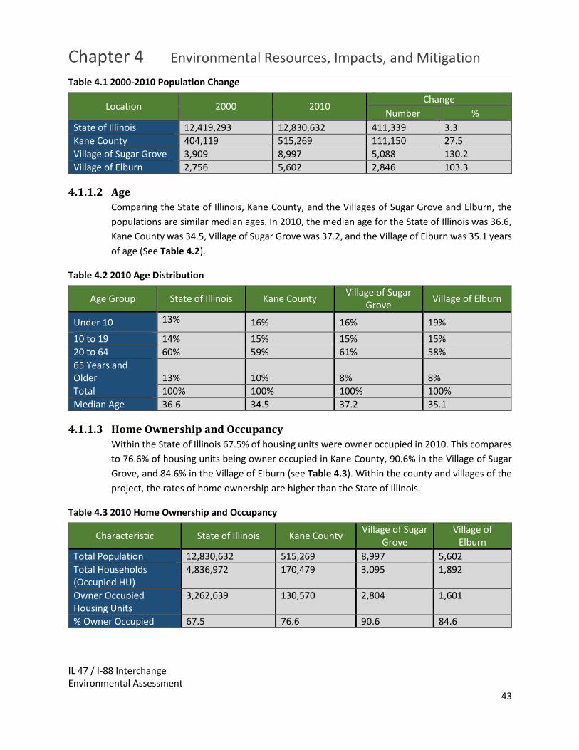
Chapter 4 Environmental Resources, Impacts, and Mitigation
IL 47 / I-88 Interchange Environmental Assessment
43
Table 4.1 2000-2010 Population Change
Location 2000 2010 Change
Number %
State of Illinois 12,419,293 12,830,632 411,339 3.3
Kane County 404,119 515,269 111,150 27.5
Village of Sugar Grove 3,909 8,997 5,088 130.2
Village of Elburn 2,756 5,602 2,846 103.3
4.1.1.2 Age
Comparing the State of Illinois, Kane County, and the Villages of Sugar Grove and Elburn, the
populations are similar median ages. In 2010, the median age for the State of Illinois was 36.6,
Kane County was 34.5, Village of Sugar Grove was 37.2, and the Village of Elburn was 35.1 years
of age (See Table 4.2).
Table 4.2 2010 Age Distribution
Age Group State of Illinois Kane County Village of Sugar
Grove Village of Elburn
Under 10 13% 16% 16% 19%
10 to 19 14% 15% 15% 15%
20 to 64 60% 59% 61% 58%
65 Years and Older 13% 10% 8% 8%
Total 100% 100% 100% 100%
Median Age 36.6 34.5 37.2 35.1
4.1.1.3 Home Ownership and Occupancy
Within the State of Illinois 67.5% of housing units were owner occupied in 2010. This compares
to 76.6% of housing units being owner occupied in Kane County, 90.6% in the Village of Sugar
Grove, and 84.6% in the Village of Elburn (see Table 4.3). Within the county and villages of the
project, the rates of home ownership are higher than the State of Illinois.
Table 4.3 2010 Home Ownership and Occupancy
Characteristic State of Illinois Kane County Village of Sugar
Grove Village of
Elburn
Total Population 12,830,632 515,269 8,997 5,602
Total Households (Occupied HU)
4,836,972 170,479 3,095 1,892
Owner Occupied Housing Units
3,262,639 130,570 2,804 1,601
% Owner Occupied 67.5 76.6 90.6 84.6

Chapter 4 Environmental Resources, Impacts, and Mitigation
IL 47 / I-88 Interchange Environmental Assessment
44
4.1.1.4 Income and Poverty
A review of the median household incomes showed that Kane County, Village of Sugar Grove
and the Village of Elburn had higher median incomes that the State of Illinois (See Table 4.4). A
review of the poverty levels show that the county and two villages also have a lower poverty
level than the State of Illinois.
Table 4.4 2010 Income and Poverty
Characteristic State of Illinois Kane County Village of Sugar
Grove Village of Elburn
Median Household Income
$56,797 $69,530 $103,194 $81,667
Poverty Status-% of people below poverty level
14.1 11.1 1.0 6.1
4.1.1.5 Race and Ethnicity
A review of the racial composition of the State of Illinois, Kane County, the Village of Sugar
Grove, and the Village of Elburn can be seen in Table 4.5. The review indicates that while Kane
County was similar in racial composition to the State of Illinois with 71.5% and 74.6% white
respectively, The Villages of Sugar Grove and Elburn were higher with 93.2% and 93.1% white
respectively.
Table 4.5 2010 Racial Composition
Characteristic State of Illinois Kane County
Village of Sugar Grove
Village of Elburn
Number % Number % Number % Number %
White 9,177,877 71.5 384,548 74.6 8,387 93.2 5216 93.1
Black or African American
1,866,414 14.5 29,422 5.7 143 1.6 30 0.5
American Indian and Alaska Native
43,963 0.3 2,887 0.6 16 0.2 12 0.2
Asian 586,934 4.6 17,895 3.5 155 1.7 176 3.1
Native Hawaiian or Other Pacific Islander
4,050 0 193 0 0 0 0 0
Some Other Race
861,412 6.7 66,818 13 160 1.8 101 1.8
Two or More Races
289,982 2.3 13,506 2.6 136 1.5 67 1.2

Chapter 4 Environmental Resources, Impacts, and Mitigation
IL 47 / I-88 Interchange Environmental Assessment
45
4.1.1.6 Community Cohesion
The proposed project is located in the Village of Sugar Grove and the Village of Elburn along IL
47 in Kane County, Illinois. These two villages have similar characteristics in their racial
composition, age distribution, and economic conditions. The proposed project would increase
IL 47 from two-lanes to four-lanes of traffic and it would improve the interchange at IL 47 and
I-88 to allow traffic to enter and exit I-88 from both east bound and west bound lanes. This
project is not anticipated to divide or cause isolation to any of the project study areas or
communities or neighborhoods.
These improvements provide a positive effect on the community cohesion for both Villages by
providing a Preferred Alternative that:
Improves system linkage.
Accommodates land use and economic development.
4.1.2 Title VI and Environmental Justice
The results of the demographic characteristics discussed in Section 4.1.1 above indicate that the
Villages of Sugar Grove and Elburn do not have any significant minority groups. The communities
have mostly white populations above the poverty level.
4.1.2.1 Title VI
Title VI of the Civil Rights Act of 1964 addresses discrimination issues associated with federally
funded projects. No groups or individuals have been or will be excluded from participation in
public involvement activities, denied the benefit of the project or subjected to discrimination in
any way on the basis of race, color, age, national origin, disability, or religion.
4.1.2.2 Environmental Justice
Executive Order (EO) 12898, Federal Actions to Address Environmental Justice in Minority and
Low-Income Populations (EO 1994), directs federal agencies to "promote nondiscrimination in
federal programs substantially affecting human health and the environment, and provide
minority and low-income communities access to public information on, and an opportunity for
public participation in matters relating to human health or the environment."
The Department of Transportation (the Department or DOT) issued an update to Departmental
Order 5610.2(a) (Actions to Address Environmental Justice in Minority Populations and Low-
Income Populations) (originally published April 15, 1997) on May 2, 2012. The Order updates
and clarifies environmental justice procedures for the Department in response to the
Memorandum of Understanding on Environmental Justice signed by heads of Federal agencies
on August 4, 2011, DOT’s revised environmental justice strategy issued on March 2, 2012, and

Chapter 4 Environmental Resources, Impacts, and Mitigation
IL 47 / I-88 Interchange Environmental Assessment
46
EO 12898, Federal Actions to Address Environmental Justice in Minority Populations and Low-
Income Populations, dated February 11, 1994.
The No-Build Alternative would not have disproportionate adverse impacts on minority or low
impact populations.
The Preferred Alternative would not result in property acquisitions or relocations from minority
or low-income residents or populations in the project study area nor result in disproportionately
adverse impacts to minority or low-income residents or populations.
4.1.3 Public Facilities and Services
All public lands, institutions, schools, libraries, places of worship, and emergency community
services located within the project study area have been identified.
4.1.3.1 Public Facilities
Public facilities located within a half mile of the project study area were identified. There are
two public facilities located within a half mile of the project study area. Waubonsee Community
College a two-year public institution of higher learning. The district encompasses nearly 600
square miles and has an assessed valuation of approximately $8.4 billion. The college is located
at the southern termini of the project study area. During construction, access to the college will
need to be maintained at all times.
Kaneland Harter Middle School teaches 6th, 7th, and 8th grade students in District #302. The
district encompasses 140 square miles in southwestern Kane County and is at the western edge
of the Fox River Valley. Within its boundaries are all or parts of the incorporated Villages of
Aurora, Cortland, Elburn, Kaneville, Maple Park, Montgomery, North Aurora, Sugar Grove and
Virgil. It is located half a mile southwest of the southern termini on Esker Drive. No impacts are
anticipated for Kaneland Harter Middle School.
4.1.3.2 Emergency Services
Identification of emergency services, such as police, fire, and hospitals, was made for facilities
within one mile of the project study area. There are no emergency service facilities along IL 47.
4.1.3.3 Transit Facilities
There are no transit facilities or services along IL 47.
4.1.4 Changes in Travel Pattern and Access
The Preferred Alternative will increase IL 47 from two-lanes to four-lanes. This should improve
traffic congestion along the route once the project is complete. The updated interchange between
IL 47/I-88 will provide improved access both entering and exiting I-88. The improved access on I-
88 may increase traffic to the area.

Chapter 4 Environmental Resources, Impacts, and Mitigation
IL 47 / I-88 Interchange Environmental Assessment
47
Access to IL 47 will be limited to right-
in/right-out at the north and south
entrances to Thornapple Tree Road.
Additionally, a three-quarter (right-
in/right-out/left-in) access will be
provided to IL 47 at Finley Road. The
eastbound to northbound (left out)
movement at Finley Road will be
prohibited. All other side roads within the
project limits will maintain full access.
4.1.5 Relocations (Business and Residential)
Construction of the Preferred Alternative will not require relocations of residences or businesses.
Easements and partial right-of-way takes will be required from parcels along the corridor, but full
parcel takes will not be required. This action is being done in accordance with the Uniform
Relocation Assistance and Real Property Acquisition Act, and the IDOT Land Acquisition Procedure
Manual.
4.1.6 Economic Impacts
No businesses will be relocated. Impacts to businesses as it relates to sales tax revenue, access
changes, or parking are not expected as a result of the project. The Preferred Alternative was
designed to facilitate economic development; therefore it is anticipated that economic growth
and an increase in tax revenue will be expected. The improved I-88 access and the proposed
Future Land Use of the Village of Sugar Grove should bring in commercial and business
opportunities to the area.
4.1.7 Land Use
The Land Use Plans for the project study area will be improved by the proposed transportation
project. The Future Land Use Maps for the Villages of Sugar Grove (see Exhibit 3) indicate creating
business districts and commercial corridors around the IL 47 and I-88 Interchange. The Preferred
Alternative will improve access to this area and improve the ability of these land use plans. The
current land use in the area is residential, agriculture, and open land.
There will be approximately 16.1 acres of new right of way required to facilitate four lanes of
traffic and a centerline shift to the east.
4.1.9 Growth and Economic Development
The adjacent land uses within the project study area are mostly undeveloped open spaces and
residential subdivisions. Growth is expected as a result of the project and is consistent with the
land use plans of the Villages within the project limits. The Preferred Alternative will enhance the
Three-Quarter Access
A three-quarters access allows three of the four standard turning movements to/from a minor approach to take place. In most cases, this limited access configuration allows right turns onto and off of the minor street (referred to as “right-in/right-out”) and left turns onto the minor street (“left in”). Left turns off of the minor street (the “left out” movement) are typically restricted in a three-quarters access configuration with the use of a barrier median.

Chapter 4 Environmental Resources, Impacts, and Mitigation
IL 47 / I-88 Interchange Environmental Assessment
48
area’s and region’s economic stability by providing improved access and mobility, improved
access and connections, and improved roadway facilities.
4.1.10 Pedestrian and Bicycle Facilities
There are existing bicycle and pedestrian paths both south and north of the project study limits.
Near the south end of the project study area, the Virgil Gilman Trail in Kane County extends to the
east side of Waubonsee Community College. North of the project limit at Green Road, the
Anderson Road Trail exists at the south side of the Village of Elburn. No other significant paths
are in the immediate vicinity of the interchange.
The Preferred Alternative is proposing a five-foot sidewalk on the west side of IL 47 and a 10-foot
multi-use path on the east side. The accommodations along the IL 47 corridor are consistent with
the planning improvements identified in the 2015 Kane/Kendall County Bicycle Planning Map (see
Exhibit 4). The plan identifies a future extension of the Virgil Gilman Trail, at the western terminus
on the Waubonsee Community College campus. This trail extension would be connected from
the north by a multi-use path along IL 47.
4.2 Agricultural
4.2.1 Farmland and Soils Identification
4.2.1.1 Existing Farmland
The Preferred Alternative would convert 11.0 acres of land identified by CMAP as land use:
agricultural. Of this, only 6.1 acres is actively being farmed.
Coordination with the Illinois Department of Agriculture (IDOA) was initiated on November 1,
2017 utilizing a Farmland Conversion Impact Rating (Form AD-1006) (see Appendix E).
4.2.1.2 Soils
Soils in the project study area consist primarily of loams, silt loams, and silty clay loams. A loam
soil is one that is composed of sand, silt, and clay in relatively even amounts. Loam soils are the
most desirable for growing crops because they retain nutrients and water, while still allowing
for drainage. This soil type is often associated with prime farmland. Loam soils have engineering
properties that make them suitable for road construction and no special design measures would
be needed for construction in areas containing these soils.
4.2.1.3 Farm Operations
The proposed improvements would not directly affect farm operations. No parcels would be
severed and there are no locations where access to agricultural fields would be impeded. The
majority of the 11.0 acres of agricultural land needed for this transportation project is zoned as

Chapter 4 Environmental Resources, Impacts, and Mitigation
IL 47 / I-88 Interchange Environmental Assessment
49
a corporate campus and commercial use; therefore, farming operations are not anticipated in
the future for this farmland.
Construction may temporarily cause adverse travel conditions during spring planting and fall
harvesting.
4.2.1.4 Prime Farmland
The Natural Resources Conservation Service (NRCS) National Soil Survey Handbook Section
622.04 defines prime farmland as “land that has the best combination of physical and chemical
characteristics for producing food, feed, forage, fiber, and oilseed crops and that is available
for these uses.”
Prime farmland is recognized by the United States Department of Agriculture (USDA) under the
Farmland Protection Act. Land does not have to be under agricultural production to be
considered prime farmland, but land that is urbanized or developed is not considered prime
farmland. Of the 11.0 acres of agricultural land located within the project study area, the NRCS
determined that 7.7 acres are prime or unique farmland and 2.0 acres are farmland of statewide
importance.
4.2.1.5 Centennial Farms
A Centennial Farm is one that has been owned by the same family for at least 100 years. The
family must be in the direct line of descent, such as a child or a grandchild, or of collateral
descendent, but is otherwise closely related, such as a brother, sister, uncle, aunt, or cousin.
Per the U.S. Consolidated Farmed Service Agency, there are two Centennial Farms in the
Blackberry Township and three Centennial Farms in the Sugar Grove Township. Based on
coordination with the IDOA, there are no registered Centennial Farms located within the project
limits.
4.2.2 Erodible Soils
Information on the soil types present in the project study area was evaluated based on
classifications of soils with regards to the slopes identified in the Web Soil Survey (WSS). Highly
erodible soils are those soils found in areas with slopes between than 4% and 12%. Extremely
erodible soils are those found in areas with slopes greater than 12%. Based on soil classifications
provided by the WSS, it was determined that there are 50.7 acres of highly erodible soils and 8.1
acres of extremely erodible soils within the project study area.
During construction, a Storm Water Pollution Prevention Plan (SWPPP) will be developed that will
identify best management practices (BMPs) for erosion and sediment control to be used
throughout construction. The SWPPP will be developed using guidance from IDOT’s BDE
Manual and Section 280 of IDOT’s Standard Specification for Road and Bridge Construction (2016).

Chapter 4 Environmental Resources, Impacts, and Mitigation
IL 47 / I-88 Interchange Environmental Assessment
50
The choice of BMPs for use in areas with highly erodible and extremely erodible soils will be
developed during the Phase II design and may include erosion control blankets, more robust
sediment control fencing, earlier vegetative seeding.
4.3 Cultural Cultural coordination was initiated through the submittal of
an ESR. The State Historic Preservation Officer (SHPO)
concurred on November 02, 2016 with IDOT’s determination
of “no historic properties affected” (Appendix F). This
completes coordination under Section 106 of the National
Historic Preservation Act of 1966.
4.3.1 Archaeological Sites
The Archaeological Phase I Survey completed by the Illinois
State Archaeological Survey, two archaeological sites were documented (11K965 and 11K1404).
These sites lack the integrity and information potential to warrant National Register consideration
or preservation in place.
Per SHPO concurrence dated November 02, 2016, no archaeological sites subject to protection
under Section 106 of the National Historic Preservation Act of 1966 will be affected by the
proposed improvements.
4.3.2 Historic Bridges
No bridges eligible for listing on the National Register are present in the project study area. Per
SHPO concurrences dated November 02, 2016, no historic bridges subject to protection under
Section 106 of the National Historic Preservation Act of 1966 will be affected by the proposed
improvements.
4.3.3 Historic Districts and Buildings
Per the older structures photographic log provided with the ESR submitted on April 24, 2015,
several structures older than 50 years are present in the project study area. IDOT BDE determined
that none of the structures are eligible for listing on the National Register.
Per SHPO concurrences dated November 02, 2016, no sites subject to protection under Section
106 of the National Historic Preservation Act of 1966 would be affected by the proposed
improvements.
4.3.4 Unanticipated Discovery during Construction
If any unanticipated discoveries of historic properties, sites, artifacts, or objects occur during the
implementation of any project, IDOT will coordinate with FHWA to comply with 36 CFR 800.13
State Historic Preservation Officer
(SHPO) play a critical role carrying
out many responsibilities in
historic preservation. The SHPO
surveys, evaluates and nominates
significant historic buildings, sites,
structures, districts and objects to
the National Register of Historic
Places.

Chapter 4 Environmental Resources, Impacts, and Mitigation
IL 47 / I-88 Interchange Environmental Assessment
51
and the Illinois Human Skeletal Remains Protection Act [20 Illinois Compiled Statutes (ILCS)] 3440),
as appropriate. This will involve stopping work in the immediate area, and informing the SHPO
and County Coroner of the unanticipated discoveries or effects within two business days. IDOT
will coordinate with Illinois State Archaeological Survey to ensure that any necessary
archaeological investigations are conducted according to the provisions of the Illinois Human
Skeletal Remains Protection Act.
If any unanticipated effects on historic properties are found to be occurring during the
implementation of any project, IDOT will coordinate with FHWA to comply with 36 CFR 800.13
and inform the SHPO immediately.
4.4 Air Quality A summary of microscale analysis, air quality conformity, mobile souse air toxics (MSATs), and
construction related particulate matter for the project is below.
4.4.1 Microscale Analysis
In accordance with the IDOT/Illinois Environmental Protection Agency (IEPA) “Agreement on
Microscale Air Quality Assessments for IDOT Sponsored Transportation Projects,” this project is
exempt from a project-level carbon monoxide air quality analysis because the highest design-year
approach volume is less than 5,000 vehicles per hour (vph) or 62,500 ADT.
4.4.2 Conformity Statement
The National Ambient Air Quality Standards (NAAQS), established by the U.S. Environmental
Protection Agency (USEPA), set maximum allowable concentration limits for six criteria air
pollutants. Areas in which air pollution levels persistently exceed the NAAQS may be designated
as “nonattainment.” States where a nonattainment area is located must develop and implement
a State Implementation Plan (SIP) containing policies and regulations that will bring about
attainment of the NAAQS. Areas that had been designated as nonattainment, but that have
attained the NAAQS for the criteria pollutant(s) associated with the nonattainment designation,
will be designated as maintenance areas
All areas of Illinois currently are in attainment of the standards for four of the six criteria
pollutants: carbon monoxide, nitrogen dioxide, sulfur dioxide, and lead.
For the eight-hour ozone and PM2.5 standards, Cook, DuPage, Kane, Lake, McHenry, and Will
Counties, as well as Aux Sable and Goose Lake Townships in Grundy County and Oswego Township
in Kendall County, have been designated as nonattainment areas. Jersey, Madison, Monroe, and
St. Clair Counties in the St. Louis area also have been designated as moderate nonattainment
areas for the eight-hour ozone standard. In addition, Madison, Monroe, St Clair, and Baldwin
Township in Randolph County are nonattainment for PM2.5.

Chapter 4 Environmental Resources, Impacts, and Mitigation
IL 47 / I-88 Interchange Environmental Assessment
52
The Lake Calumet area and Lyons Township in Cook County have been designated as a
maintenance area for the particulate matter (PM10) standard. In addition, Oglesby and several
adjacent townships in LaSalle County and Granite City Township and Nameoki Township in
Madison County have been designated as maintenance areas for the PM10 standard. All other
areas of Illinois currently are in attainment for the ozone and PM10 standards.
This project is included in the FY 2014-2019 Transportation Improvement Program (TIP) endorsed
by the Metropolitan Planning Organization Policy Committee of the CMAP for the region in which
the project is located. Projects in the TIP are considered to be consistent with the 2040 regional
transportation plan endorsed by CMAP. The project is within the fiscally constrained portion of
the plan.
On October 9, 2014, the Federal Highway Administration (FHWA) and the Federal Transit
Administration (FTA) determined that the 2040 regional transportation plan conforms with the
SIP and the transportation-related requirements of the 1990 Clean Air Act Amendments. On
October 9, 2014, the FHWA and the FTA determined that the TIP also conforms with the SIP and
the Clean Air Act Amendments. These findings were in accordance with Determining Conformity
of Federal Actions to State or Federal Implementation Plans 40 CFR Part 93.
The project’s design concept and scope are consistent with the project information used for the
TIP conformity analysis. Therefore, this project conforms to the existing State Implementation
Plan and the transportation-related requirements of the 1990 Clean Air Act Amendments.
The TIP number for this project is 09-14-0010. Phase II and Phase III funding is identified in the
TIP.
4.4.3 Mobile Source Air Toxics (MSAT)
On October 18, 2016, the US Department of Transportation and FHWA issued an updated interim
guidance on when and how to analyze Mobile Source Air Toxics (MSAT) in the NEPA process for
highway project. See “Updated Interim Guidance Update on Mobile Source on Air Toxic Analysis
in NEPA Documents” for additional guidance.
The Clean Air Act identified 188 air toxics, also known as hazardous air pollutants. USEPA has
assessed this expansive list of toxics and identified a group of 93 compounds emitted from mobile
sources, listed in the USEPA Integrated Risk Information System (IRIS). USEPA also identified a
subset of this list of 93 that are considered the seven priority MSATs. These are acrolein, benzene,
1,3-butidiene, diesel particular matter plus diesel exhaust organic gases (diesel PM),
formaldehyde, naphthalene, and polycyclic organic matter. While FHWA considered these to be
the priority MSATs, USEPA stresses that the list is subject to change and may be revised in future
rules.

Chapter 4 Environmental Resources, Impacts, and Mitigation
IL 47 / I-88 Interchange Environmental Assessment
53
FHWA developed a tiered approach for analyzing MSATs in NEPA documents, depending on the
specific project circumstances. FHWA has identified three levels of analysis:
no analysis for projects with No Potential for Meaningful MSAT Effects,
qualitative analysis for projects with Low Potential for MSAT Effects, or
quantitative analysis to differentiate alternatives for projects with Higher Potential MSAT
Effects.
FHWA’s interim guidance provides examples of “Projects with Low Potential for MSAT Effects.”
The types of projects included in this category are those that serve to improve operations of
highway, transit, or freight without adding substantial new capacity or without creating a facility
that is likely to meaningfully increase MSAT emissions. The Preferred Alternative for the IL 47 at
I-88 project was categorized as a project with “Low Potential for MSAT Effects,” because the
project serves to improve operations of a highway without adding substantial new capacity or
without creating a facility that is likely to meaningfully increase MSAT emissions. The design year
traffic is also projected to be less than 140,000 to 150,000 Average Annual Daily Traffic (AADT).
For the Preferred Alternative in this EA, the
amount of MSAT emitted would be proportional
to the vehicle miles traveled, or VMT, assuming
that other variables (e.g., fleet mix) are the
same for each alternative. The VMT estimated
for the Preferred Alternative is slightly higher
than that for the No Build Alternative, because
the additional capacity increases the efficiency
of the roadway and attracts rerouted trips from
elsewhere in the transportation network. This
increase in VMT would lead to higher MSAT
emissions for the Preferred Alternative, along with a corresponding decrease in MSAT emissions
along the parallel routes. The emissions increase is offset somewhat by lower MSAT emission
rates due to increased speeds; according to USEPA’s MOVES 2014 model, emissions of all of the
priority MSAT decrease as speed increases.
Because the estimated VMT under the Preferred Alternative is slightly higher No Build Alternative,
varying by less than nine percent, it is expected there would be no appreciable difference in
overall MSAT emissions. Also, regardless of the alternative chosen, emissions will likely be lower
than present levels in the design year as a result of USEPA’s national control programs that are
projected to reduce annual MSAT emissions by more than 90 percent between 2010 and 2050.
Local conditions may differ from these national projections in terms of fleet mix and turnover,
VMT growth rates, and local control measures. However, the magnitude of the USEPA-projected
Air Quality: Air Quality is protected by the Clean Air
Act (CAA) and air quality standards called the
National Ambient Air Quality Standards (NAAQS),
established by the USEPA. Predicted air quality
resulting from a roadway project is compared to the
NAAQS established by the USEPA for carbon
monoxide, lead, nitrogen dioxide, ozone, particulate
matter (PM2.5 and PM10), and sulfur dioxide. These
standards are set at levels designed to protect public
health. If any of the standards are not met, the area
is called “non-attainment” and air quality is required
to be improved.

Chapter 4 Environmental Resources, Impacts, and Mitigation
IL 47 / I-88 Interchange Environmental Assessment
54
reductions is so great, even after accounting for VMT growth, that MSAT emissions in the project
study area are likely to be lower in the future in nearly all cases.
The additional travel lanes procured as part of the Preferred Alternative will have the effect of
moving some traffic closer to nearby homes, schools and businesses; therefore, under the
Preferred Alternative there may be localized areas where ambient concentrations of MSAT could
be higher than the No Build Alternative. The localized increases in MSAT concentrations would
likely be most pronounced along the roadway sections that would be widened closer to existing
neighborhoods along IL 47 under the Preferred Alternative. However, the magnitude and the
duration of these potential increases compared to the No Build Alternative cannot be reliably
quantified due to incomplete or unavailable information in forecasting project-specific MSAT
health impacts.
In summary, where a highway is widened, the localized level of MSAT emissions for the Preferred
Alternative could be higher relative to the No Build Alternative, but this could be offset due to
increases in speeds and reductions in congestion, which are associated with lower MSAT
emissions. Also, MSAT will be lower in other locations when traffic shifts away from them.
However, on a regional basis, USEPA’s vehicle and fuel regulations, coupled with fleet turnover,
will over time cause substantial reductions that, in almost all cases, will cause region-wide MSAT
levels to be significantly lower than today.
4.4.4 Construction Related Particulate Matter
Demolition and construction activities can result in short-term increases in fugitive dust and
equipment-related particulate emissions in and around the project study area. (Equipment-
related particulate emissions are usually insignificant when equipment is well maintained). The
potential air quality impacts will be short-term, occurring only while demolition and construction
work is in progress and local conditions are appropriate.
The potential for fugitive dust emissions typically is associated with building demolition, ground
clearing, site preparation, grading, stockpiling of materials, on-site movement of equipment, and
transportation of materials. The potential is greatest during dry periods, periods of intense
construction activity, and during high wind conditions.
The Department’s Standard Specifications for Road and Bridge Construction include provisions
and requirements on dust control. Under these provisions, dust and airborne dirt generated by
construction activities will be controlled through dust control procedures or a specific dust control
plan, when warranted. The contractor and the Department will meet to review the nature and
extent of dust-generating activities and will cooperatively develop specific types of control
techniques appropriate to the specific situation. Techniques that may warrant consideration
include measures such as minimizing track-out of soil onto nearby publicly-traveled roads,
reducing speed on unpaved roads, covering haul vehicles, and applying chemical dust

Chapter 4 Environmental Resources, Impacts, and Mitigation
IL 47 / I-88 Interchange Environmental Assessment
55
suppressants or water to exposed surfaces, particularly those on which construction vehicles
travel.
4.5 Noise Noise is composed of different frequencies, each of which is perceived differently by the human
ear. Human hearing is not sensitive to low and very high frequencies. To compensate for low and
very high frequencies, insensitivity, and to render noise levels readings more meaningful, an “A-
weighting” scale is used to approximate the response of the human ear. The A-weighted decibel
(dB(A)) unit measures perceptible sound energy, factors out the fringe frequencies, and is the
typical unit of measure for environmental noise.
The IL-47 at I-88 project is classified by 23 CFR 772 as a Type I Project, and therefore traffic noise
from the proposed action must be studied. Type I projects are proposed Federal or Federally-
Aided projects that entail the construction of a highway on new location or the physical alteration
of an existing highway which significantly changes either the horizontal or vertical alignment or
increases the number of through traffic lanes.
Because the intensity of noise fluctuates with time, the equivalent noise level (Leq) is used. Leq is
defined as the steady-state, A-weighted sound level which, in a stated period of time, contains
the same acoustic energy as the time-varying sound level during the same period. Leq (h) is the
hourly value of Leq. Changes in decibels are measured on a logarithmic scale. A 3 dB(A) increase
in noise is barely perceptible, while an increase in 10 dB(A) is perceived as twice as loud.
The Noise Assessment for this project was conducted in accordance with 23 CFR 772, FHWA
“Procedures for Abatement of Highway Traffic Noise and Construction Noise” and the IDOT
Highway Traffic Noise Assessment Manual 2017 Edition. The FHWA Traffic Noise Model (TNM)
2.5 was used to assess the existing noise levels and to predict the noise levels for the 2015 Existing,
2040 No-Build and 2040 Preferred Alternative conditions. The following summarizes the Traffic
Noise Analysis that was completed for this project.
4.5.1 Noise Abatement Criteria
The FHWA established Noise Abatement Criteria (NAC) to determine where noise abatement
should be evaluated (Table 4.7). The FHWA defines seven (7) noise activity categories based on
land use and existing sound levels. Each land use has its own NAC, except Activity Categories F
and G. If the project would result in traffic noise levels that approach, meet or exceed the NAC or
if the project would result in substantial increases, a traffic noise impact is identified at that
location and abatement measures must be evaluated.

Chapter 4 Environmental Resources, Impacts, and Mitigation
IL 47 / I-88 Interchange Environmental Assessment
56
Table 4.7: FHWA Noise Abatement Criteria (NAC) Hourly “A-Weighted” Sound Level; Decibels (dB(A))
Activity Category
Leq(h) Description of Activity
A 57 dBA (Exterior)
Lands on which serenity and quiet are of extraordinary significance and serve an important public need and where the preservation of these qualities is essential if the area is to continue to serve its intended purpose.
B(1) 67 dBA (Exterior)
Residential.
C(1) 67 dBA (Exterior)
Active sport areas, amphitheaters, auditoriums, campgrounds, cemeteries, day care centers, hospitals, libraries, medical facilities, parks, picnic areas, places of worship, playgrounds, public meeting rooms, public or nonprofit institutional structure, radio stations, recording studios, recreation areas, Section 4(f) sites, schools, television studios, trails, and trail crossings.
D 52 dBA (Interior)
Auditoriums, day care centers, hospitals, libraries, medical facilities, places of worship, public meeting rooms, public or nonprofit institutional structure, radio studios, recording studios, schools, and television studios.
E(1) 72 dBA (Exterior)
Hotels, motels, offices, restaurants/bars, and other developed lands, properties or activities not included in A-D, or F.
F - Agriculture, airports, bus yards, emergency services, industrial, logging, maintenance facilities, manufacturing, mining, rail yards, retail facilities, shipyards, utilities (water resources, water treatment, electrical), and warehousing.
G - Undeveloped lands that are not permitted. (1) Includes undeveloped lands permitted for this activity category
Source: FHWA, 23 CFR, Part 772 [2]
The FHWA regulations allow State Highway Authorities to define what noise level constitutes an
approach to the NAC. IDOT defines “approach” as 1 dB(A) less than the NAC. States are also
allowed to define what constitutes substantial increase in noise. The IDOT defines noise impacts
as follows:
Design-year traffic noise levels that approach, meet or exceed the NAC, with approach defined as 66 dB(A) for the residential property and 71 dB(A) for the commercial property.
Design-year traffic noise levels that are 15 dB(A) or more over the existing noise level.
4.5.1.1 Methodology
Existing noise levels along the IL-47 at I-88 Project were
determined through TNM 2.5 modeling analysis for the areas
near the existing roadway, using 2015 traffic data and existing
roadway design information. For the Design Year 2040 noise
analysis, No-Build and Build Scenario noise levels were
predicted at nearby receptors representing the eight
Common Noise Environments (CNEs) identified in the project study area.
CNE: A CNE is a group of receptors
in the same Activity Category that
are exposed to similar noise
sources and levels, traffic volumes,
traffic mix, traffic speed, and
topographic features.

Chapter 4 Environmental Resources, Impacts, and Mitigation
IL 47 / I-88 Interchange Environmental Assessment
57
4.5.1.2 Existing Noise Levels
The existing noise levels for each CNE ranged from 60 dB(A) to 70 dB(A) and were compared to
the NAC. There are three (3) CNEs representing 74 noise sensitive receptors that are currently
experiencing noise levels that approach, meet or exceed the NAC. Existing noise levels are
shown in Table 4.8.
Table 4.8: IL-47 at I-88 Noise Impact Summary with 2015 & 2040 DHV
Receptor /Common Noise Environment
ID & Land Use
Activity Category
Number of Receptors
Represented
2015 Existing
2040 No Build Alter-native
2040 Preferred Alternative
Dist. To Nearest Edge of
Pavement (ft)
Existing Noise Level (dBA)
Noise Level (dBA)
Dist. To Selected
Alternative (ft)
Noise Level (dBA)
Noise Impact
Res 1/ CNE 1
SFR B 4 140 60 62 148 65 No
Res 2/ CNE 2
SFR B 36 45 70 72 55 72 Yes
Res 3/ CNE 3
SFR B 12 74 68 70 74 72 Yes
Res 4/ CNE 4
SFR B 3 85 50 59 85 58 No
Res 5/ CNE 5
SFR B 26 56 69 72 56 71 Yes
Res 6/ CNE 6
SFR B 2 170 60 63 118 66 Yes
Res 7/ CNE 7
SFR B 6 217 59 62 161 63 No
Res 8/ CNE 8
SFR B 8 122 62 66 122 67 Yes
SFR = Single-Family Residential
NOTE: Traffic noise impacts shown in bold font NOTE: Data estimated from aerial photography
4.5.1.3 Design Year Noise Levels
The 2040 Preferred Alternative noise levels for each CNE ranged from 58 dB(A) to 72 dB(A ) and
were compared to the NAC. There are five (5) CNEs, representing 84 noise sensitive receptors,
that are predicted to experience noise levels that approach, meet or exceed the NAC in the 2040
Preferred Alternative. These five (5) CNEs were determined to have traffic noise impacts from

Chapter 4 Environmental Resources, Impacts, and Mitigation
IL 47 / I-88 Interchange Environmental Assessment
58
the proposed action. The Preferred Alternative results also indicate no substantial increases in
noise (15 dBA or greater) over the existing noise levels will occur. Preferred Alternative 2040
noise levels are shown in Table 4.8.
4.5.2 Evaluation of Abatement Measures
The proposed project would result in noise impacts at five (5) CNEs. The noise abatement
measures considered at these sites include traffic management measures, alteration of horizontal
and vertical alignments, construction of noise barriers, and the acquisition of undeveloped land
for buffer zones.
The implementation of traffic management measures for the purpose of noise abatement is not
deemed reasonable or likely for this project. Traffic management measures that limit motor
vehicle types, travel speed, traffic volume, or time of operation may be used as noise abatement
measures, but were not found to be feasible for this project. A reduction in speed would affect
the roadway’s ability to accommodate anticipated traffic volumes, thus not fulfilling a purpose of
this project to increase capacity. Furthermore, limiting truck volumes or their time of operation
would be restrictive to the existing industrial and commercial businesses within the project study
area and impede the potential economic opportunities associated with the upgrade of IL-47 at I-
88.
The rural nature of the proposed project and intermittent spacing of potential noise receptors
presents opportunities to alter horizontal and vertical alignments along the Preferred Alternative
that will only serve to introduce new noise receptor impacts to the noise study area that weren’t
previously included. As such, alterations of the horizontal and vertical alignment are not likely to
reduce traffic noise impacts. Alterations of horizontal and vertical alignments are not deemed
reasonable or likely noise abatement measures for this project.
Buffer zones are undeveloped, open spaces that border a highway. Buffer zones occur when land
or developments rights are purchased, in addition to the normal right-of-way to prohibit the
construction on noise-sensitive land uses close to the highway. Currently, undeveloped land is
not available to act as a buffer zone between IL-47 and the impacted noise receptors. As a result,
the acquisition of real property to act as a buffer zone is not a feasible noise abatement measure
for this project.
There are no Activity Category D land uses located along the IL-47 at I-88 Project corridor;
therefore, noise insulation of Activity Category D land uses was not evaluated.
4.5.2.1 Noise Barrier Analysis
Noise barriers can reduce noise levels by blocking the sound propagation path between a
roadway and a noise sensitive site. The IDOT Highway Traffic Noise Assessment Manual
requires that the noise barriers be both feasible and reasonable. Feasibility deals with the

Chapter 4 Environmental Resources, Impacts, and Mitigation
IL 47 / I-88 Interchange Environmental Assessment
59
practicality of building a barrier, with regard to specific site characteristics, safety and
maintenance requirements, and the ability of the barrier to provide a noise reduction. In order
to be considered a feasible, a barrier must achieve at least a five-dB(A) reduction for at least
two impacted receptors.
The reasonableness evaluation for noise barriers consists of
three parts: the noise reduction design goal, economic
reasonability, and the viewpoints of the benefitted receptors.
The noise reduction goal requires that at least one benefitted
receptor behind the noise wall receive at least an eight-dB(A)
reduction in traffic noise.
Economic reasonableness is the cost-effective evaluation of the noise barrier. This considers the
overall cost of the noise barrier, the number of benefited receptors, and the cost per benefited
receptor. According to the IDOT Highway Traffic Noise Assessment Manual, benefited receptors
are those properties that would receive at least a five-dB(A) reduction regardless of whether or
not they are identified as impacted. The base value for the allowable cost is $30,000 per
benefitted receptor. Three other reasonableness factors are considered to potentially adjust
the allowable noise abatement value per benefitted receptor. Please see Tables 4.9, 4.10, and
4.11.
Table 4.9: Absolute Noise Level Consideration
Predicted Build Noise Level before Noise Abatement Dollars Added to Base Value Cost per
Benefitted Receptor
Less than 70 dBA $0
70 to 74 dBA $1,000
75 to 79 dBA $2,500
80 dBA or greater $5,000
Benefitted Receptor: The recipient
of an abatement measure that
receives a noise reduction of 5
dB(A) or greater. A benefited
receptor does not need to be an
impacted receptor.

Chapter 4 Environmental Resources, Impacts, and Mitigation
IL 47 / I-88 Interchange Environmental Assessment
60
Table 4.10: Increase in Noise Level Consideration
Incremental Increase in Noise Level Between the Existing Noise Level and the Predicted Noise Level Before Abatement
Dollars Added to Base Value Cost per Benefitted Receptor
Less than 5 DBA $0
5 to 9 dBA $1,000
10 to 14 dBA $2,500
15 dBA or greater $5,000
Table 4.11: New Alignment/ Construction Date Consideration
Project is on new alignment OR the receptor before the original construction of the highway
Dollars Added to Base Value Cost per Benefitted Receptor
No for both $0
Yes for either $5,000
Only one value from each of the three factors may be used for each receptor, resulting in a
maximum allowable cost of $45,000 per benefitted receptor.
Potential noise barriers were considered at five (5) receptor locations under the predicted 2040
Preferred Alternative condition (CNE 2, CNE 3, CNE 5, CNE 6 and CNE 8). The noise barriers
evaluated at CNE 6 and CNE 8 are not feasible, as they do not satisfy the five-dB(A) noise
reduction for at least two (2) impacted receptors. Table 4.12 below summarizes the three (3)
feasible noise barriers that were assessed for reasonableness (CNE 2, CNE 3 and CNE 5).

Chapter 4 Environmental Resources, Impacts, and Mitigation
IL 47 / I-88 Interchange Environmental Assessment
61
Table 4.12: Summary of Feasible Noise Barriers
CNE and Receptor
(s)
Barrier Height (feet)
Barrier Length (feet)
Total Barrier Cost
Modeled Reduction
(dBA)
Feasibility Goal Achieved?
(5 dBA Reduction at
two impacted receptors)
Noise Reduction
Design Goal Achieved?
(8 dBA Reduction at
one benefitted receptor)
Likely to be Implemented
CNE 2 (Res 2)
6 - 10 2,186 $471,156 0 - 8 Yes Yes
No – the cost per benefitted receptor ($39,263) exceeds the adjusted allowable cost per benefitted receptor ($31,000).
CNE 3 (Res 3)
9 - 11 762 $217,785 0 - 10 Yes Yes
No – the cost per benefitted receptor ($54,446) exceeds the adjusted allowable cost per benefitted receptor ($30,750).
CNE 5 (Res 5)
10 - 14 1,441 $508,099 1 - 14 Yes Yes
No – the cost per benefitted receptor ($65,512) exceeds the adjusted allowable cost per benefitted receptor ($30,500).
The three (3) feasible noise barriers are not reasonable because the cost per benefitted receptor
exceeds the adjusted allowable cost per benefitted receptor (CNE 2, CNE 3, and CNE 5). Table
4.13 below summarizes the cost reasonableness analysis for the three noise barriers.
Table 4.13: Noise Barrier Cost Reasonableness
CNE and Receptor
(s)
Number of
Receptors
Total Barrier Cost
Number of Benefitted Receptors
Cost per Benefitted Receptor
Base Allowable Cost per
Benefitted Receptor
Adjusted Allowable Cost per Benefitted
Receptor
Recommendation
CNE 2 (Res 2)
36 $471,156 12 $39,263 $30,000 $31,000 Not Cost Effective
CNE 3 (Res 3)
12 $217,785 4 $54,446 $30,000 $30, 750 Not Cost Effective
CNE 5 (Res 5)
26 $508,099 8 $63,512 $30,000 $30,500 Not Cost Effective

Chapter 4 Environmental Resources, Impacts, and Mitigation
IL 47 / I-88 Interchange Environmental Assessment
62
Cost averaging of noise abatement among CNEs also may be used when conducting the economic
reasonableness evaluation. For a single noise abatement measure to be considered a part of a
cost averaging evaluation, the estimated build cost of noise abatement per benefitted receptor
may not exceed two times the adjusted allowable noise abatement cost per benefitted receptor.
For cost averaging analyses, the noise abatement measures achieve the cost reasonableness
criterion if the common CNE collective average estimated build cost of noise abatement per
benefitted receptor is less than the collective average adjusted allowable cost per benefitted
receptor. The three (3) feasible noise barriers were not found to be reasonable through cost
averaging (CNE 2, CNE 3, and CNE 5).
The third component of reasonableness is obtaining the viewpoints of benefitted receptors. The
viewpoints will be sought for noise abatement measures determined to be feasible, cost effective
and achieving the noise reduction design goal. In order for a proposed noise abatement measure
to be implemented, greater than 50 percent of the benefitted receptors responding must be in
favor of the proposed abatement measures. Since the noise barriers evaluated failed meet the
IDOT feasibility or reasonableness criteria, obtaining the viewpoints of benefitted receptors is not
required.
4.5.3 Coordination with Local Government Officials
The purpose of coordinating with local officials is to provide information and promote compatible
land development and land use planning adjacent to proposed highway projects. Compatible land
use is an important tool for preventing future noise impacts. The traffic noise study results will
be presented to the local officials within the noise project study area.
Noise contours were generated at several undeveloped locations (Activity Category G) for the 66
dB(A) and 71 dB(A) noise levels. The agriculture land uses (Activity Category F) adjacent to the
proposed project was also assessed to determine their potential for future development into uses
that have an established NAC. The results of the undeveloped land analyses are located in the
Noise Report.
4.5.4 Construction Noise
Trucks and machinery used for construction produce noise which may affect some land uses and
activities during the construction period. Residents along the alignment will at some time
experience perceptible construction noise from implementation of the project. To minimize or
eliminate the effect of construction noise on these receptors, mitigation measures have been
incorporated into the Illinois Department of Transportations’ Standard Specifications for Road and
Bridge Construction as Article 107.35.

Chapter 4 Environmental Resources, Impacts, and Mitigation
IL 47 / I-88 Interchange Environmental Assessment
63
4.5.5 Likelihood Statement
Based on the traffic noise analysis and noise abatement evaluation conducted, highway traffic
noise abatement measures are not likely to be implemented based on preliminary design. The
proposed project is anticipated to have traffic noise impacts, but the noise barriers studied and
identified in Table 4.12 and Table 4.13 do not meet the feasibility and reasonableness criteria. If
it subsequently develops during final design that constraints not foreseen in the preliminary
design or public input substantially change, the abatement measures may need to be modified or
removed from the project plans. A final decision on the installation of abatement measure(s) will
be made upon the completion of the project’s final design and the public involvement process.
4.6 Natural Resources
4.6.1 Upland Plant Communities
The project study area is composed primarily of residential or agricultural land. Natural areas
comprise only approximately 9.8 acres of the 133.1 total acres within the project study area.
Upland grassland plant communities within the project study limit show signs of degradation and
are dominated by invasive plants species, including white clover (Trifolium repens), tall fescue
(Festuca arundinacea), dandelions (Taraxacum officinale), Kentucky bluegrass (Poa pratensis),
crown vetch (Securigera varia), reed canary grass (Phalaris arundinacea), cutleaf teasel (Dipsacus
laciniatus), Queen Anne’s Lace (Daucus carota), and wild parsnips ( Pastinaca sativa).
Wooded upland natural areas are dominated by trees including bur oak (Quercus macrocarpa),
mockernut hickory (Carya tomentosa), white oak, (Quercus alba), black walnut (Juglans nigra),
black cherry (Prunus serotina), American elm (Ulmus americana), and Siberian elm (Ulmus
pumila). The understory was dominated by invasive Amur honeysuckle (Lonicera maackii),
Tartarian honeysuckle (Lonicera tatarica), winter creeper (Euonymus fortunei), garlic mustard
(Allaria petiolata), common burdock (Arctium minus), common buckthorn (Rhamnus cathartica),
and poison ivy (Toxicodendron radicans).
Landscape trees are scattered throughout the residential areas within project study area. The
most common landscape trees are white oak (Quercus alba) and blue spruce (Picea pungens).
4.6.2 Wildlife Resources
Wildlife habitat present is moderate and consist of forests, crops, mowed lawn, and ornamental
plantings. Wildlife habitat, the types of wildlife expected to be present, and the impacts to these
resources are discussed below.
4.6.2.1 Habitat in the Project Study Area
Land use in the project study area is primarily residential or agricultural with forested areas on
the southern end. Generally, the available wildlife habitat are the upland woods/riparian

Chapter 4 Environmental Resources, Impacts, and Mitigation
IL 47 / I-88 Interchange Environmental Assessment
64
habitats associated with Seavey Road Run and the upland woods/riparian habitats associated
with Blackberry Creek and Hannaford Woods/Nickels Farm Forest Preserve which is part of the
Bliss Woods Forest Preserve (see Exhibit 9). Below is a discussion of the wildlife habitat located
in the project study area. Table 4.14 summarizes the locations and attributes of the larger
habitat areas.
Table 4.14: Wildlife Resources in Project Study Area
Location Available Habitat/Resource
Perennial Water
Available
Animals Most
Likely Present
North of Old Oak Road to approximately 550 feet south
of Thornapple Tree Road
Blackberry Creek and Hannaford
Woods/Nickels Farm Forest Preserve is
an upland wooded site that transitions
to riparian woods and wet meadow
along Blackberry Creek
Yes
Small and large mammals,
amphibians, reptiles, and
birds
750 feet north of Scott Road to
Finley Road
Upland wooded site that transitions to riparian woods and wet meadow along
Seavey Road Run Yes
Small and large mammals,
amphibians, reptiles, and
birds
The transition between upland woods, grasslands, and riparian habitat provide edge habitats
as the soil and topography change. These naturally occurring edge habitats can increase the
biodiversity by providing multiple niches for different species.
4.6.2.2 Wildlife Present in Project Study Area
Wildlife present in the project study area is represented by species that are adapted to
suburban or agricultural environments and are common, disturbance tolerant species.
Common mammals include white-tailed deer, coyote, raccoon, eastern cottontail, squirrels,
mice, and Virginia opossum. Common amphibians include frogs, toads, and salamanders.
Common reptiles include snakes and turtles. Aquatic inhabitants include a variety of micro and
macroinvertebrates and fish.
The project study area is within the eastern half of the Mississippi flyway, which is used by
neotropical migrant birds in the United States and Canada. A tree clearing restriction will be in
place from April 1 to October 14, which will protect migratory birds during their breeding
season.

Chapter 4 Environmental Resources, Impacts, and Mitigation
IL 47 / I-88 Interchange Environmental Assessment
65
4.6.2.3 Wildlife Impacts by Cover Type
Below is a discussion of the proposed project’s impact on wildlife and habitat in the project
study area by cover type.
4.6.2.3.1 Agricultural Land
Impacts to agricultural land are not anticipated to result in measurable impacts to any species
present.
4.6.2.3.2 Residential Land
Residential lands are located primarily along the west side of the project study area. Residential
areas provide habitat for species that tolerate human activities, such as rabbits, squirrels, and
mice. The proposed improvements would result in minimal impacts to residential land and is
not anticipated to result in measurable impacts to wildlife.
4.6.2.3.3 Riparian Habitat
Riparian areas are lands that occur along watercourses and water bodies. Typical examples
include floodplains and streambanks. They are distinctly different from surrounding lands
because of unique soil and vegetation characteristics that are strongly influenced by the
presence of water. The riparian zones also provide wildlife habitat, increased biodiversity, and
wildlife corridors, enabling aquatic and riparian organisms to move along river systems avoiding
isolated communities. Riparian vegetation can also provide forage for wildlife and livestock.
The Preferred Alternative would not increase fragmentation of any existing riparian habitat and
would only result in small net loss of 4.0 acres of existing habitat. Because the proposed
improvements would result in a minimal amount of impacts to riparian habitat, it is not
anticipated that measureable impacts would occur to any species utilizing this habitat.
4.6.2.3.4 Forested Areas
Forests are a large and important environmental resource in Illinois. Forests provide a
considerable economic contribution, providing timber, employment, outdoor recreation,
protection of soil and water resources, and habitat for many plant and animal species. Wildlife
within forested areas may consist of white-tailed deer, common raccoon, and various species
of birds and a variety of other species.
In Illinois, a Memorandum of Understanding (MOU) between the Illinois DNR and IDOT (IDOT
Bureau of Design and Environment [BDE] Manual, 2013) requires IDOT to determine whether
an alignment bisects or fragments forested areas greater than 20 acres. Exhibit 9 depicts the
location of forested areas greater than 20 acres within the corridor. The proposed
improvements would impact 4.0 acres of forested area immediately adjacent to IL 47 that is
currently greater than 20 acres in size. These impacts will not cause fragmentation or bisect any
of the forested areas. The impact does include impacts to the Hannaford Woods/Nickels Farm

Chapter 4 Environmental Resources, Impacts, and Mitigation
IL 47 / I-88 Interchange Environmental Assessment
66
Forest Preserve. Due to the forest already being fragmented by the existing roadway and
residential areas the small amount of impact will not cause a significant impact to any species
utilizing this habitat.
4.6.2.3.5 Wetland and WOUS Habitats
The project study area crosses two creeks that are Relatively Permanent Waters (RPW),
Blackberry Creek and Seavey Road Run. According to the June 2016 INHS Wetland
Determination Report: FAP 326/FAI 88 (IL 47) Kane County, Illinois IDOT Sequence Number:
19435, both creeks are categorized as Kane County ADID High Functional Values wetlands.
Blackberry Creek was also identified in the ADID study as ADID 3105 and as a HQAR, contains
wetland sites 4, 5, and 6 as delineated by INHS. The wetland at Seavey Road Run, identified by
the Kane County ADID study as wetland 2569 contains Wetland Site 10 as delineated by INHS.
All these wetlands were identified as wet floodplain forest.
The wetlands and two creeks provide habitat to a variety of wildlife including mammals,
reptiles, amphibians, and fish. The INHS Fish Collection has collected nearly 50 species of fish
from Blackberry Creek, all are common inhabitants of Northern Illinois streams. The mussel
survey conducted by INHS revealed two species of mussels in Blackberry Creek: Giant Floater
(Pyganodon grandis) and Fatmucket (Lampsilis siliquoieda). Minimal impacts to these species
may be caused with the replacement of IL 47 bridges.
4.6.2.4 Wildlife Crossing
The Bridge Condition Report (BCR) dated March 2017 recommends complete replacement of
the current bridge located over Blackberry Creek (Structure Number 045-0024). In order to
reduce the potential of vehicle/wildlife conflicts, any replacement structure will consider
incorporating a 20 foot wide shelf with at least 9 feet of vertical clearance from the bottom of
the structure. The shelf elevation would be at least two feet above ordinary high water in order
to facilitate a dry crossing except during infrequent events. The crossing will be able to
accommodate all wildlife that could potentially cross at this location.
4.6.3 Threatened & Endangered Species
Federal Threatened and Endangered species are protected under the Endangered Species Act
(ESA) (16 U.S.C. 1531-1544, 1973). The ESA provides for the conservation of species that are
endangered and threatened throughout all or a significant portion of their range, and the
conservation of the ecosystems on which they depend. The law requires federal actions, including
actions authorized or funded by a federal agency, to ensure that those actions are not likely to
jeopardize the continued existence of any listed species, or result in the destruction or adverse
modification of designated critical habitat of such species. Threatened and Endangered species
identified by the State of Illinois are protected by the Illinois Endangered Species Protection Act.

Chapter 4 Environmental Resources, Impacts, and Mitigation
IL 47 / I-88 Interchange Environmental Assessment
67
Consultation for the protection of state-listed species is required by 17 Illinois Administrative Code
(IAC) Part 1075.
4.6.3.1 Federally Listed Species
Federally-listed threatened and endangered species assessments were conducted through the
use of the U.S. Fish and Wildlife Service’s (USFWS) web-based Information for Planning and
Consultation (IPaC) for planning purposes only. According to USFWS, three federally-protected
species are known to occur within Kane County, the eastern prairie fringed orchid (Platanthaera
leucophaea), rusty patched bumble bee (Bombus affinis), and northern long-eared bat (Myotis
septentrionalis).
According to the September 2016 INHS Botanical Survey and Assessment of the IDOT 2016
Illinois Route 47 Eastern Prairie Fringed Orchid Study Area, a survey for the federally threatened
eastern prairie fringed orchid was conducted due to potential habitat identified at Wetland 8.
Habitat for the eastern prairie fringed orchid includes mesic prairie, sedge meadows, marsh
edges, and bogs in full sunlight. The survey was conducted on June 28 and 30 and July 6, 2016.
No individual eastern prairie fringed orchids were found.
The rusty patched bumble bee was listed as endangered under the Endangered Species Act of
1973 (ESA), effective March 21, 2017. Through Interagency Cooperation under Section 7(a)(2)
of the ESA, Voluntary Implementation Guidance was issued March 21, 2017 for the rusty
patched bumble bee. This guidance states, “if the species is not on the list of endangered species
generated for the action area by IPaC, it is unlikely to be present in the action area.” The rusty
patched bumblebee is not identified by IPaC within the project study area; therefore, no
impacts are anticipated.
The northern long-eared bat (NLEB) winters in caves and mines (hibernicula) and spend the
summer foraging and breeding season in live or dead trees in forests areas. The northern long-
eared bat 4(d) rule prohibits incidental take that may occur from tree removal activities within
150 feet of a known occupied maternity roost tree during the pup season (June 1 to July 31) or
within a quarter of a mile of a hibernation site, year round. There are no hibernacula in Kane
County. The 4(d) consultation form was submitted to USFWS on September 15, 2017 (Appendix
G). No tree clearing will occur between April 1st and October 14 of any year per IDOT
commitment to IDNR.
See Table 4.15 for a list of T&E species in the project study area.

Chapter 4 Environmental Resources, Impacts, and Mitigation
IL 47 / I-88 Interchange Environmental Assessment
68
Table 4.15: Federally Listed T&E Species in Project Study Area
Species Habitat Preferences Habitat Present in
Corridor Status
Platanthaera
leucophaea
(eastern prairie
fringed orchid)
Moderate to high quality
wetlands, sedge meadows,
marshes, and mesic to wet
prairies.
No Federally Threatened
Bombus affinis (rusty
patched bumble
bee)
Dry to mesic prairies with gravelly
soil. No Federally Endangered
Myotis
septentrionalis
(northern long-eared
bat)
Caves, mines (hibernicula); live or
dead trees, woods/forests.
Possible, No Tree
Clearing from April 1 to
October 14 Federally Threatened
4.6.3.2 State-Listed Species
Five state protected species were identified in the project study area utilizing the Natural
Heritage Database and surveys conducted by INHS: the Blanding’s turtle (Emydoidea blandingii),
Wilson’s phalarope (Phalaropus tricolor), American Bittern (Botaurus lentiginosus), Least Bittern
(Ixobrychus exilis), and Northern Harrier (Circus cyaneus).
According to the August 2016 INHS Survey and Habitat Assessment for Blanding’s Turtle,
Emydoidea blandingii, along Illinois Route 47, a survey was conducted for the Blanding’s turtle
which is listed as an endangered species in Illinois. Six sites were identified and examined for
habitat suitability for the Blanding’s turtle. No T&E reptiles or amphibians were encountered,
and no suitable habitats for Blanding’s turtle were documented in the project study area.
According to the August 2017 INHS Three-season Avian Surveys at IL-47/I-88 Interchange
Report, there is no breeding habitat for the Wilson’s phalarope, Least Bittern, American Bittern,
or Northern Harrier within the project study area. The Avian Survey was conducted over three
seasons.
These species are listed in Table 4.16.

Chapter 4 Environmental Resources, Impacts, and Mitigation
IL 47 / I-88 Interchange Environmental Assessment
69
Table 4.16: State Listed T&E Species in Project Study Area
Species Habitat Preference Habitat Present
in Corridor Status
Emydoidea blandingii
(Blanding’s turtle) Wet prairie or wetlands, near water. No
State
Endangered
Phalaropus tricolor
(Wilson’s phalarope)
Shallow waters of smaller lakes and rivers
with grassy surrounding, shallow pools,
mud flats, rain pools in pasture and
meadowland.
No State
Endangered
Botaurus lentiginosus
(American Bittern) Fresh water marshes with tall vegetation. No State
Endangered
Ixobrychus exilis
(Least Bittern)
Freshwater or brackish marshes with tall
emergent vegetation No
State
Threatened
Circus cyaneus
(Northern Harrier)
freshwater and brackish marshes, lightly
grazed meadows, old fields, dry upland
prairies, drained marshlands, and
riverside woodlands
No State
Endangered
4.6.4 Invasive Species
Invasive species are defined by the Federal EO 13112 as “an alien species whose introduction does
or is likely to cause economic or environmental harm or harm to human health”. Kane County is
the fifteenth leading county in the State of Illinois with the most invasive species. According to
the Early Detection and Distribution Mapping System the invasive species likely to occur in Kane
County include
spotted knapweed (Centaurea stoebe ssp. micranthos)
leafy spurge (Euphorbia esula)
Japanese knotweed (Reynoutria japonica)
watercress (Nasturtium officinale)
European buckthorn (Rhamnus cathartica)
multiflora rose (Rosa multiflora)
oriental bittersweet (Celastrus orbiculatus)
poison-hemlock (Conium maculatum)
garlic mustard (Alliaria petiolata)
dalmatian toadflax (Linaria dalmatica)
perennial ryegrass (Lolium perenne)
bittersweet nightshade (Solanum dulcamara)

Chapter 4 Environmental Resources, Impacts, and Mitigation
IL 47 / I-88 Interchange Environmental Assessment
70
Per the Illinois Noxious Weed Law, a noxious weed “means any plant which is determined by the
Director, the Dean of the College of Agricultural, Consumer and Environmental Sciences of the
University of Illinois and the Director of the Agricultural Experiment Station at the University of
Illinois, to be injurious to public health, crops, livestock, land or other property.” (505 ILCS 100/2).
Per the U.S. Department of Agriculture Natural Resource Conservation Service state listed noxious
weeds and the Illinois Noxious Weed Law, the following are noxious weeds and may be found in
Kane County, Illinois.
Ambrosia artemisiifolia L. (common ragweed)
Ambrosia trifida L. (giant ragweed)
Cannabis sativa L. (marijuana)
Cardus nutans (musk thistle)
Cirsium arvense (Canada thistle)
Pueraria lobata (kudzu)
Sonchus arvensis (field thistle)
Sorghum almum (Columbus grass)
Sorghum halepense (Johnson grass)
Construction of the proposed improvements may result in conditions that would allow for the
establishment or expansion of populations of invasive species. Many of the invasive species are
already occurring within the project study area. Vegetative clearing and ground disturbances can
create conditions that promote the establishment or spread of invasive species. IDOT has
developed Special Maintenance Provisions to combat invasive plant species. IDOT provisions
include the use of herbicides and other measures to control invasive species within the roadway
rights of way. These provisions also apply during construction activities. Measures that may be
instituted to manage invasive species during construction include immediate seeding of bare soil,
cleaning of construction equipment prior to entering areas near sensitive habitats, and active
management of invasive plants that become established during construction. Measures that may
be instituted to manage invasive species after construction include the use of herbicides, manual
cutting, and timely mowing of rights of way. Utilization of these measures would minimize the
potential for invasive species to become established. Landscaping and erosion control plans
developed for the proposed corridor will not use species listed as invasive species or noxious
weeds. In areas adjacent to natural areas, such as the Hannaford Woods/Nickels Farm Forest
Preserve, if invasive species or noxious weeds are found in or adjacent to construction areas,
precautions will be taken to ensure the proposed improvements do not result in invasive species
or noxious weed impacts the adjacent natural area.
4.6.5 State Designated Lands
State Designated Lands include Illinois Natural Areas, Land and Water Reserves, and Nature
Preserves. The Bliss Woods Forest Preserve, which includes Hannaford Woods/Nickels Farm, is a

Chapter 4 Environmental Resources, Impacts, and Mitigation
IL 47 / I-88 Interchange Environmental Assessment
71
231 acre forest preserve owned by the Forest Preserve District of Kane County and located in the
southern portion of Kane County. Thirty acres of the preserve are considered an Illinois State
Nature Preserve due to the outstanding ecological and geographical features. The nature preserve
is located southeast of this project, outside of the Hannaford Woods/Nickels Farm Forest
Preserve, and will not be impacted by the Preferred Alterative.
There are no other state designated lands within the project study area.
4.7 Water Resources and Aquatic Habitats
4.7.1 Surface Water Resources
The project study area is located within the Lower Fox River drainage basin, hydrologic unit code
(HUC) 07120007. The INHS conducted wetland delineations in June of 2016. In their report FAP
326/FAI 88 (IL 47) Kane County, Illinois IDOT Sequence Number: 19435, the INHS identified eight
streams or creeks as WOUS in the project study area. The WOUS located in the project study area
are summarized in Table 4.17 and their locations can be found in Exhibit 9. The project study area
is crossed by two relatively permanent WOUS, Blackberry Creek, approximately 771 feet south of
Thornapple Tree Road and under I-88 approximately 3,355 feet west of IL 47, and Seavey Road
Run (also known as Tributary C of Blackberry Creek), approximately 636 feet northwest of
Thornapple Tree Road. There are no wild or scenic rivers located within the project study area.
The Preferred Alternative is proposing to replace the existing bridge over Blackberry Creek on the
existing centerline. The median for the roadway is reduced from 30 feet to 18 feet in this area in
order to minimize impacts.
Blackberry Creek has been given a Stream Integrity Rating of B and Stream Diversity Rating of C
by the IDNR Illinois Biological Stream Characterization Study. No other WOUS in the project study
area has been rated in the IDNR Illinois Biological Stream Characterization Study.
A total of 0.8 acres of WOUS will be impacted within the project study area, including 0.4 acres of
impact to Blackberry Creek and 0.2 acres to Seavey Road Run. Impacts to the WOUS are not
avoidable as the proposed road improvements are adjacent to or crossing these water bodies.
Impacts were minimized by reducing the median to 18 feet at the Blackberry Creek.

Chapter 4 Environmental Resources, Impacts, and Mitigation
IL 47 / I-88 Interchange Environmental Assessment
72
Table 4.17: Streams and Ponds in Project Study Area
INHS Site No. Site Name Location Water
Type2 NWI Code Community
Type1 Impacts
(acres)
Biologically Significant
Stream1 HQAR1
Stream Integrity/
Diversity Rating1
T&E Species
Present
Riffles/ Pools
Present1 Mussels1
W1 Blackberry Creek
Crosses under IL 47 approximately 771 feet south of Thornapple Tree Road
RPW R2UBH Stream 0.36 Yes Yes B/C No Yes/Yes Yes
W2 Unnamed tributary to Blackberry Creek
Approximately 46 feet
west of IL 47 NRPW Unavailable Ditch 0.05 No No Not Rated No No/Yes No
W3 Seavey Road Run
Crosses under IL 47 approximately 636 feet northwest of Thornapple Tree Road
RPW Unavailable Stream 0.16 No No Not Rated No No/Yes Yes
W4 Unnamed Tributary
to Seavey Road Run Approximately 51 feet
northeast of IL 47 NRPW Unavailable Ditch 0.02 No No Not Rated No No/No No
W5 Unnamed tributary to Blackberry Creek
Approximately 297 feet
south of I-88 NRPW Unavailable Ditch 0.00 No No Not Rated No No/Yes No
W6 Unnamed Tributary
to Seavey Road Run
Crosses under Seavey Road approximately 771 feet northwest of
Finley Road
NRPW Unavailable Ditch 0.00 No No Not Rated No No/Yes No
W7 Unnamed Tributary
to Seavey Road Run Approximately 72 feet
northeast of I-88 NRPW Unavailable Ditch 0.13 No No Not Rated No No/No No
W8 Unnamed tributary to Blackberry Creek
Approximately 13 feet
north of Seavey Road NRPW Unavailable Ditch 0.05 No No Not Rated No No/No No
1As determined by the INHS Wetland Reports 2As determined by the INHS, Waters type:
RPW- relatively permanent waters that flow directly or indirectly to traditionally navigable water
Isolated – waters isolated from Waters of the US
NRPW – non-RPWs that flow directly or indirectly to traditional navigable waters
Chapter 4 Environmental Resources, Impacts, and Mitigation
IL 47 / I-88 Interchange Environmental Assessment
73
4.7.1.1 Water Quality Assessment
According to the IEPA Illinois Integrated Water Quality Report and Section 303(d) List- 2016, no
water body in the project study area is listed as impaired and this segment of Blackberry Creek
is listed as fully supporting aquatic life and aesthetic quality.
There is a Blackberry Creek Watershed Management Plan. The plan identifies fecal coliform for
reduction in the watershed. This project will not contribute to the fecal coliform load.
The INHS conducted a biological, chemical, and physical water quality assessment of Blackberry
Creek and Seavey Road Run. INHS conducted site assessments in January 2017 utilizing IEPA’s
Qualitative Stream Habitat Assessment Procedure (SHAP). The SHAP score ranks stream habitat
quality within the ranges below:
SHAP Score Range
Excellent >= 90%
Good 75-89%
Fair 60-74%
Poor <=59%
Seavey Road Run scored a 53.1 on the standardized IEPA SHAP scale, a score associated with
Poor values.
Blackberry Creek scored a 78.0 on the IEPA SHAP scale. This is a standardized score associated
with the lower range of Good values.
Macroinvertebrate Index of Biotic Integrity (mIBI) represents the relative ecological integrity
(or health) of the stream. This is compared with other streams across the state of Illinois to
provide a ranking. The mIBI examines three components of the macro-invertebrate
community to determine its health: the abundance (total number of macroinvertebrates), the
diversity (number of different species), and tolerance to pollution. A high mIBI score indicates
biological species are similar to least-impacted sites of comparable size and type within
Illinois. A low mIBI score indicates the species are significantly different or degraded
compared with compatible sites within Illinois.
mIBI Score Range
Exceptional >= 73.0%
Good 41.8-72.9%
Fair 20.9-41.7%
Poor <=20.8%

Chapter 4 Environmental Resources, Impacts, and Mitigation
IL 47 / I-88 Interchange Environmental Assessment
74
Seavey Road Run scored a 44.2 on the mIBI, which is in the lower range of Good. It consisted of
Filter-feeders (45%) and collector-gatherers (32%) together accounted for over ¾ of the
individuals in the assemblage.
Blackberry Creek scored a 50.1 on the mIBI, which is in the middle of the Good range. It
consisted of Filter-feeders (41%) and collector-gatherers (37%) together accounted for over ¾
of the individuals in the assemblage.
4.7.2 Impacts
4.7.2.1 Construction Impacts
Impacts to water quality can occur as a result of construction. Grading and earth moving
activities, the removal of vegetative cover, and other activities that expose the soils create the
potential for erosion during storm events. This erosion in turn has the potential to run off into
streams, causing sedimentation impacts and increased suspended solids. In addition, in-stream
construction for the installation of bridges or culverts can increase turbidity by disturbing the
stream bottom.
During construction, water quality impacts would be minimized through the use of a SWPPP.
The SWPPP will identify BMPs for erosion and sediment control to be used throughout
construction. The SWPPP will be developed using guidance from IDOT’s Bureau of Design and
Environment Manual and Section 280 of IDOT’s Standard Specification for Road and Bridge
Construction (2016). Standard BMPs will require that any in-stream construction or soil
disturbing activities near streams be conducted during low or no-flow conditions. Perimeter
sediment control devices, such as silt fencing, would be installed before any soil disturbing
activities. Perimeter silt fence, stabilized construction entrances, drainage inlet protection,
ditch checks, diversions, sediment traps, and other appropriate BMPs will be used as defined by
the SWPPP. The SWPPP will also describe appropriate responses should an accidental spill of
hazardous materials occur. Through the use of BMPs during construction, it is anticipated that
there will be only minimal impacts to water quality.
4.7.2.2 Operational Impacts
Contaminants, including sediments, metals, oils, and grease may occur on roadway surfaces as
a result of vehicle operations. These contaminants can be washed from the roadway into
adjacent streams during storm events. Additionally, increased impervious surfaces result in
greater amounts of stormwater runoff, which may increase the velocity of the stream and
increase erosion. Stormwater management for the proposed improvements has been designed
with the intention of minimizing impacts to water quality utilizing BMPs. See Section 4.7.3 for a
description of BMPs to be utilized.

Chapter 4 Environmental Resources, Impacts, and Mitigation
IL 47 / I-88 Interchange Environmental Assessment
75
4.7.2.3 Maintenance Activity Impacts
Maintenance activities associated with roadways includes deicing during the winter months and
herbicide spraying for invasive/noxious weeds in the summer. IDOT and the Tollway use liquid
calcium chloride and sodium chloride to deice roadways. The amount of deicing salt that leaves
the right-of-way is dependent on the number and severity of winter storms.
IDOT uses the following BMPs to reduce chloride impacts on waterways: 1) IDOT utilizes
calibrated spreaders equipped with ground speed sensors that can accurately control the rate
of spreading; 2) IDOT determines the rate of salt to be used depending on the amount of ice
and snow on the roadway; and 3) IDOT pre-wets the application of chloride to roads which
allows the pre-wetted slat to stick to the pavement and is less prone to blowing or bounding off
from traffic before it activates.
Impacts from herbicide application would be minimized through the strict adherence to
manufacturer’s application instructions which will minimize the amount of airborne drift or
runoff into receiving waters. The IEPA requires a National Pollutant Discharge Elimination
System (NPDES) permit if pesticides, including herbicides, are applied near WOUS. Water quality
impacts would be minimized through conformity to permit requirements
4.7.3 Best Management Practices
In order to minimize pollutants from entering either Blackberry Creek or Seavey Road Run, Best
Management Practices (BMPs) will be implemented to the extent practical. IL 47 crosses over
Blackberry Creek and Seavey Road Run. Currently, there are ditches on both sides of IL 47 that
outfall into Blackberry Creek and Seavey Road Run.
Because of new impervious area introduced by the widening of the road and the addition of a
future shared use path, IDOT intends to provide stormwater treatment. The stormwater
treatment is primarily runoff control (which will require storage/detention). Detention basins and
other stormwater features will likely require pollution and volume control BMP’s since the
discharge will go directly into Blackberry Creek and Seavey Road Run.
Options for runoff control being considered include infiltration trenches, oversized pipes, and
detention basins. Each of these features has its own advantages and disadvantages:
1. Infiltration trenches: These are rock filled filter fabric lined trenches where the spaces
between rocks are used as storage volume.
a. In case rock doesn’t provide enough storage an oversized perforated pipe can be
placed within the trench.
b. The trench provides environmental benefits and volume control because of the
infiltration. Sand would be the best media for the trenches to be built on, but it’s rare
to have such conditions in Illinois. Some of the borings studied in a geotechnical

Chapter 4 Environmental Resources, Impacts, and Mitigation
IL 47 / I-88 Interchange Environmental Assessment
76
report should include percolation rates in order to determine if infiltration trenches
will be effective.
c. The underground trenches are typically 10 foot wide, so additional ROW may need to
be acquired in order to accommodate the width.
2. Oversized pipes: Large diameter storm sewer pipes that don’t just convey storm runoff,
but detain runoff during storms with the use of a restrictor structure.
a. Limited environmental benefit, but could use expensive oil and grit separators at
outfalls. This would be a middle ground solution between the infiltration trenches
and detention basin.
3. Detention basins: Easy to maintain and provide the most storage, but would require
greater additional right of way than the other two options. Depending on the soils found
through a geotechnical report, these basins could also be considered infiltration basins
and account for volume control.
Vegetated swales (bio-swales) will be utilized in order to filter pollutants and provide additional
pollution control.
4.8 Groundwater Resources Kane County uses both groundwater and surface water its potable water supply. The Fox River is
the largest surface water resource and supplies drinking water to the cities of Aurora and Elgin.
All wells within the County obtain groundwater from either locally recharged shallow aquifers or
deeper, regionally recharged. All the drinking water for the Village of Sugar Grove comes from
groundwater supplies.
The following geologic, hydrogeologic, and well information was obtained from the Illinois State
Geologic Survey’s (ISGS) Preliminary Environmental Site Assessment (PESA) ISGS: 1321, dated
September 13, 2016.
4.8.1 Geology
The topmost bedrock unit in the project study area south of I-88 exit ramp has been mapped as
the Ordovician-age Maquoketa Shale Group, which in this area consists primarily of shales and
limestones. The topmost bedrock unit in the project study area north of I-88 exit ramp has been
mapped as undifferentiated rocks of Silurian age, which in this area consist primarily of limestones
and dolomites. There are no known karsts or sinkholes located in the project study area according
to the Illinois State Geological Survey.
Surficial materials in the project study area have been mapped as follows: 30-60 m (100-200 feet)
thick from the southern project limits to approximate IL 47 station 145+00 LT and RT, approximate
IL 47 station 228+00 LT and RT to the northern project limits, and approximate I-88 station
5811+00 LT and RT to the eastern project limits; 15-30 m (50-100 feet) thick between approximate

Chapter 4 Environmental Resources, Impacts, and Mitigation
IL 47 / I-88 Interchange Environmental Assessment
77
IL 47 stations 145+00 to 164+00 LT and RT, between approximate IL 47 stations 189+00 to 228+00
LT and RT, and between approximate I-88 stations 5788+00 to 5811+00 LT and RT; and 8-15 m
(25-50 feet) thick between approximate IL 47 stations 164+00 and 189+00 LT and RT and
approximate I-88 station 5788+00 LT and RT to the western project limits. From the southern
project limits to approximate IL 47 station 100+00 LT and RT, the topmost unit has been mapped
as 6-15 m (20-50 feet) of the Henry Formation which overlies 6-15 m (20-50 feet) of the 10 Wedron
Group. Between approximate IL 47 stations 100+00 to 110+00 LT and RT, the topmost unit has
been mapped as less than six meters (20 feet) of the Cahokia Formation which overlies less than
six meters (20 feet) of the Henry Formation which overlies less than six meters (20 feet) of the
Wedron Group. In the remaining portion of the project study area, the topmost unit has been
mapped as less than six meters (20 feet) of discontinuous Carmi Member of the Equality
Formation which overlies less than six meters (20 feet) of discontinuous Henry Formation which
overlies 6-15 meter (20-50 feet) of the Wedron Group. The Henry Formation is composed
primarily of sand and gravels deposited by glacial outwash. The Wedron Group is composed
primarily of glacially deposited silts and clays. The Cahokia Formation is composed primarily of
floodplain silts, clays, and silty sands. The Carmi Member is composed primarily of lake-deposited
clays and silts.
4.8.2 Hydrogeology
Surficial drainage in the project study area is generally toward the direction of Blackberry Creek
(Site 3121-6) and its unnamed tributaries (Sites 3121-15 and 3121-22). Blackberry Creek crosses
the project study area underneath IL 47 at approximate IL 47 station 111+00LT and RT. The
unnamed tributaries cross underneath IL 47 at approximate station 145+00 LT and RT and I-88 at
approximate station 5823+00 LT and RT. However, since the project study area is partially
developed and drainage ditches are present, most surficial runoff will be controlled by the
drainage system; such systems typically are designed to follow natural drainage patterns. The
proposed project is not likely to impact surficial public water supplies.
4.8.3 Groundwater Recharge
The project study area is located in Zone 3 for groundwater recharge potential, where Zone 1
indicates the highest potential for groundwater recharge and Zone 7 indicates the lowest
potential as mapped by Keefer and Berg (1990). Groundwater recharge potential information is
provided for a general regional perspective only, as this map was prepared at a scale of
1:1,000,000 and is not applicable on a site-specific basis. The project study area does not fall
within the watershed for the Mahomet aquifer, the only sole-source aquifer in Illinois according
to the USEPA's list of designated sole-source aquifers as defined by Section 1424(E) of the Safe
Drinking Water Act. Therefore, the proposed project will not affect any such aquifers in Illinois.
The project study area is located in Zone B1, according to the map "Potential for contamination
of shallow aquifers from land burial of municipal wastes" (Berg et al., 1984). Zone B1 is described

Chapter 4 Environmental Resources, Impacts, and Mitigation
IL 47 / I-88 Interchange Environmental Assessment
78
as sand and gravel less than six meters (20 feet) thick over relatively impermeable till or bedrock.
Zones A indicate the highest potential for contamination and Zone G the lowest. This information
is provided for a general regional perspective only, as the map was prepared at a scale of
1:500,000 and is not applicable on a site-specific basis. No borings were made to a depth of 15
meters (50 feet) to verify the geology of this site.
The project study area is not located within an Illinois EPA designated Class III Special Resource
Groundwater or identified sensitive ecological systems.
4.8.4 Wellhead Protection Areas
This project crosses a wellhead protection recharge area for a public well for the Waubonsee
Community College. The wellhead protection area is crossed by IL 47 between approximate IL 47
stations 96+00 and 108+50.
4.8.5 Wells
ISGS well records indicate that water in the project study area is obtained from sand and gravel
and limestone at depths ranging from 25 to 85 meters (80 to 280 feet) below the surface. Eighteen
wells were mapped and were associated with residences and farmsteads along IL 47. Other wells
not in the ISGS database may be present near the project study area. The location of the known
wells in the project study area is shown in Exhibit 10.
All water wells that are on or adjoining the Preferred Alternative will be properly capped and
abandoned. Consequently, the proposed improvements would not create any new potential
routes for groundwater pollution (e.g., dry wells, borrow pits) or any new potential sources of
groundwater pollution (e.g., storage facilities for bulk road oil or deicing salt). The proposed
improvements are therefore not anticipated to result in any impacts to any wells, and the project
would not be considered a new potential secondary source of groundwater pollution as defined
in the IEPA Act (415 ILCS 5/3.350 and 415 ILCS 5/3.355).
Accordingly, the project would not be subject to compliance with the minimum setback
requirements for community water supply wells or other potable water supply wells as set forth
in 415 ILCS 5/14, et seq.
4.8.6 Groundwater Quality
According to the Illinois State Water Survey’s (ISWS) Shallow Groundwater Quality Sampling in
Kane County, October 2003, Kane County has generally good shallow groundwater quality,
especially in the western and central thirds of the County. Nitrate-N concentrations were low and
no atrazine was detected in any well, suggesting that any degradation of groundwater quality
from agricultural activities is slight enough that it does not present a human health hazard. Arsenic
was above the drinking water standard in slightly more than 10% of the wells. Iron and manganese
were elevated in most wells, but this is common in aquifers throughout Illinois. Toxic metals other

Chapter 4 Environmental Resources, Impacts, and Mitigation
IL 47 / I-88 Interchange Environmental Assessment
79
than arsenic were not present at concentrations exceeding their standards in any well. The Total
Dissolved Solids (TDS) and major ion concentrations of samples from the urban corridor were
significantly greater than elsewhere in Kane County. Road-salt runoff, vehicular exhaust, and
industrial discharges are the most likely sources of these elevated solutes.
According to Illinois Integrated Water Quality Report and Section 303(d) List, 2016 Clean Water
Act Sections 303(d), 305(b) and 314 Water Resource Assessment Information and List of Impaired
Waters Volume II: Groundwater July 2016, no Community Water Supply (CWS) well in the project
study area is listed as impaired.
The proposed improvements would not create any new potential routes for groundwater
pollution (e.g., dry wells, borrow pits) or any new potential sources of groundwater pollution (e.g.,
storage facilities for bulk road oil or de-icing salt). Any minor increases in contaminants in
stormwater runoff, the result of increasing the amount of pavement, are not anticipated to result
in groundwater pollution because these increases would be minimal.
4.9 Floodplains Federal EO 11988, Floodplain Management, requires federal agencies to avoid to the extent
possible the long and short-term adverse impacts associated with the occupancy and modification
of floodplains, and to avoid direct and indirect support of floodplain development wherever there
is a practicable alternative.
Floodplains provide numerous values and benefits, including the storage of excess water during
storm events, water quality benefits such as the filtering of nutrients and sediments, recharge of
groundwater through infiltration, fish and wildlife habitat, and open space/recreational
opportunities.
A regulatory floodplain is an area that is subject to flooding during a 100-year frequency storm.
Regulatory floodplains within the project study area are associated with Blackberry Creek and
Seavey Road Run. All of these floodplains are located within the Lower Fox River drainage basin,
HUC watershed 07120007. Federal Emergency Management Agency (FEMA) Flood Insurance Rate
Maps (FIRMs) were used to identify the location of floodplains in the project study area. The
locations of these floodplains are shown on Exhibit 9 and summarized in Table 4.18. There are
three types of flood hazard categories identified in the project study area. AE flood hazard is 100-
year floodplain that has a base elevation established, A flood hazard is 100-year floodplain
without a base elevation established, and X flood hazard is an area of moderate flood hazard
between the 100 year and 500 year floodplain.

Chapter 4 Environmental Resources, Impacts, and Mitigation
IL 47 / I-88 Interchange Environmental Assessment
80
Table 4.18: Floodplain Locations and Impacts in the Project Study Area
Floodplain Location Waterway Association Impacts
(acres)
Transverse or Longitudinal
Crossing
Crosses under IL 47 approximately 771
feet south of Thornapple Tree Road Blackberry Creek 2.9 Transverse
Crosses under IL 47 approximately 636
feet northwest of Thornapple Tree Road Seavey Road Run 1.5 Transverse
Parallel to IL-88, approximately 1790 feet
west of IL 47
Blackberry Creek 0.3 Longitudinal
Total Acres 4.7
Impacts to floodplains would be minimized in several ways:
Stream crossings will be designed to minimize the amount of fill within the floodplain.
The median will be reduced to 18 feet on IL 47 through Blackberry Creek portion of the
floodplain.
Compensatory storage will be provided at the IL 47 crossings
with Blackberry Creek and Tributary C to Blackberry Creek
to account for any fill of floodplains in these
areas. Compensatory storage will be provided at the
Blackberry Creek crossing by replacing the existing structure
with a larger bridge that provides a wider effective
waterway opening. The compensatory storage volume can
be provided by grading the overbanks between the existing
tops of banks to the proposed toes of abutments. Since the
Seavey Road Run culvert is being extended rather than
replaced, the compensatory storage at the tributary
location will be provided within proposed ditch/basin
grading along the proposed IL 47 embankment, adjacent to
the regulatory floodway.
An IDNR/ Office of Water Resources (OWR) permit will be obtained for any construction in the
regulatory floodplain (tributary area no less than 1 square mile) prior to any work within the
floodplain.
Impacts from the loss of floodplain will not result in increased flood risks due to the incorporation
of detention and compensatory storage. Natural and beneficial values, such as wildlife habitat and
water quality functions, will not be substantially impacted because these values are already
Compensatory Storage
When fill or buildings are placed in
the floodplain, the flood storage
areas are lost and flood heights
will go up because there is less
room for the floodwaters. One
approach that may be used to
address this issue is to require
compensatory storage to offset
any loss of flood storage capacity
(volume).

Chapter 4 Environmental Resources, Impacts, and Mitigation
IL 47 / I-88 Interchange Environmental Assessment
81
minimized due to the presence of the existing road. The proposed roadway improvements will
not promote incompatible floodplain development any more than currently exists.
4.10 Wetlands Executive Order (EO) 11990, Protection of Wetlands, requires federal agencies to take action to
minimize the loss of wetlands. The USACE regulates the discharge of dredged or fill material into
WOUS, including wetlands, pursuant to Section 404 of the Clean Water Act (CWA).
Wetlands are also protected under the Illinois’ Interagency Wetland Protection Act of 1989.
4.10.1 Project Study Area Wetlands
In order to ensure compliance with EO 11990 and the CWA, wetland delineations were conducted
by INHS on April 13-14 and May 3-5, 2016 following the Corps of Engineers Wetlands Delineation
Manual (Environmental Laboratory 1987) and the Regional Supplement to the Corps of Engineers
Wetland Delineation Manual: Midwest Region (Version 2.0) (USACE 2010). In total, INHS
investigated 33 sites and determined that 18 of these sites are wetlands. The locations of the
wetland sites identified during all delineation efforts are included in Exhibit 9. Five of the wetlands
are highly disturbed and are currently or have been recently farmed. Eight of the wetlands have
been identified by Kane County as ADID wetlands for having High Functional Value (HFV) for water
quality/stormwater functions. Seven of the eight ADID wetlands were also identified as HQAR
wetlands with a high habitat value. Only wetland 9 was identified as an ADID site, but not a HQAR
wetland because it was an excavated wetland pond that was no longer part of the natural wetland
complex. Wetland site 8 was determined to be potential habitat for the endangered eastern
prairie fringed orchid (EPFO), but subsequent threatened and endangered species surveys found
no EPFO’s. INHS Wetlands 4, 5, 6, 7, 8, and 9 coincides with ADID wetland 3105 and INHS Wetland
10, coincides with ADID wetland 2573 and 2569.
All areas of agricultural land use within the project study area were delineated following the NRCS
method of wetland determination (for more information, see: USDA-NRCS 2015). Briefly, this
method involves examining 5 years of aerial photography taken during the early summer for
evidence of saturation or inundation (wetland signature). The years used are determined to be 5
years during which precipitation was closest to the long term precipitation averages. In addition,
when possible, the NRCS wetland maps were consulted to find areas previously delineated by the
NRCS as wetland. Any area which showed a wetland signature in three years out of five, or in two
years out of five if the site was also mapped as wetland by the NWI, was investigated by a site
visit. If hydric soils were present at the site, the site was determined to be wetland. The site was
then delineated from the aerial photography based on an average of the years during which a
wetland signature was evident.
Chapter 4 Environmental Resources, Impacts, and Mitigation
IL 47 / I-88 Interchange Environmental Assessment
82
A Floristic Quality Assessment (FQA) was performed for each wetland area to assess the quality
of the wetland. Each native plant found in a wetland is assigned a number from 1-10. This number
is called a “coefficient of conservatism” or C-value (Swink and Wilhelm 1994). A low C value
indicates the plants grow in areas commonly disturbed by humans; whereas a high C-value means
the plant grows in more pristine areas. A mathematical analysis is conducted on the average of
the c-values (defined as Mean-C) to produce a number called a Floristic Quality Index (FQI). The
FQI rates the wetland for its quality of native vegetation. An FQI from 1-19 means a low quality,
20-35 indicates high quality and over 35 indicates a “natural area” quality.
High Quality Aquatic Resources are defined by the 2012 Chicago District Regional Permit Program
as an area having an FQI 20 or greater or a Mean-C value of 3.5 or greater. ADID wetlands are also
considered high quality aquatic resources. Wetlands that meet this criteria are typically mitigated
at a higher ratio than lower quality wetlands.
Table 4.19 summarizes the wetlands identified by the INHS.

Chapter 4 Environmental Resources, Impacts, and Mitigation
IL 47 / I-88 Interchange Environmental Assessment
83
Table 4.19: Wetlands Identified by INHS
Site No. NWI
Code1
Community
Type
Area Inside
Project
Limits
(Acres)
FQI Mean C ADID HQAR Functions
Performed
USACE
Jurisdictional Dominate Plant Species
Water
Type 2
1 U Wet
Meadow 0.22 8.1 2.9 None No
Surface water storage, aquatic and terrestrial wildlife habitat
Yes
bald spike rush (Eleocharis
erthropoda), reed canary grass
(Phalaris arundinacea)
NRPWW
2 U Farmed
Wetland 0.16 9.2 3.3 None No
Limited wildlife
habitat Yes
cursed buttercup (Ranunculus
sceleratus) NRPWW
3 U Farmed
Wetland 0.34 5.8 2.6 None No
Limited wildlife
habitat Yes
cursed buttercup (Ranunculus
sceleratus) NRPWW
4 U
Wet
Floodplain
Forest
1.75 18.8 3.1 HFV Yes
Surface water storage, good aquatic and terrestrial wildlife habitat
Yes
reed canary grass (Phalaris
arundinacea), downy
hawthorn(Crataegus mollis),
eastern cottonwood (Populus
deltoides)
RPWWD
5 U
Wet
Floodplain
Forest
0.008 8.4 2.4 HFV Yes
Surface water storage, fair aquatic and terrestrial wildlife habitat
Yes
downy hawthorn (Crataegus
mollis), bur oak (Quercus
macrocarpa), reed canary grass
(Phalaris arundinacea), Tatarian
honeysuckle (Lonicera tatarica), red
osier dogwood (Cornus sericea),
highbush cranberry (Vibernum
opulus), garlic mustard (Alliaria
petiolata), riverbank grape (Vitis
riparia)
RPWWN

Chapter 4 Environmental Resources, Impacts, and Mitigation
IL 47 / I-88 Interchange Environmental Assessment
84
Site No. NWI
Code1
Community
Type
Area Inside
Project
Limits
(Acres)
FQI Mean C ADID HQAR Functions
Performed
USACE
Jurisdictional Dominate Plant Species
Water
Type 2
6 PEMC,
U
Wet
Meadow 1.03 12.1 2.9 HFV Yes
Surface water storage, good aquatic and terrestrial wildlife habitat
Yes
downy hawthorn (Crataegus
mollis), reed canary grass (Phalaris
arundinacea), common buckthorn
(Rhamnus cathartica), boxelder
(Acer negundo), spotted touch- me-
not (Impatiens capensis), stinging
nettle (Urtica procera)
RPWWN
7 PEMC,
U
Wet
Meadow 0.49 8.7 2.9 HFV Yes
Surface water storage, fair aquatic and terrestrial wildlife habitat
Yes reed canary grass (Phalaris
arundinacea) RPWWN
8 U Sedge
Meadow 0.66 18.5 4.6 HFV Yes
Surface water storage, fair aquatic and terrestrial wildlife habitat
Yes upright sedge (Carex stricta) RPWWN
9 U Wetland
Pond 0.16 0.6 0.3 HFV No
Surface water storage, aquatic habitat
Yes
narrowleaf cattail (Typha
angustifolia,) reed canary grass
(Phalaris arundinacea)
NRPWW
10
PEMCd,
PSS1A,
U
Wet
Floodplain
Forest
1.79 11.8 2.3 HFV Yes
Surface water storage, good aquatic and terrestrial wildlife habitat
Yes
eastern cottonwood (Populus
deltoides), black willow (Salix
nigra), boxelder (Acer negundo)
common buckthorn (Rhamnus
cathartica), reed canary grass
(Phalaris arundinacea), fowl
manna grass (Glyceria striata)
RPWWD
11 U Wet
Meadow 0.66 6.6 2.1 None No
Surface water storage, aquatic and terrestrial wildlife habitat
Yes
reed canary grass (Phalaris
arundinacea), narrowleaf cattail
(Typha angustifolia)
NRPWW

Chapter 4 Environmental Resources, Impacts, and Mitigation
IL 47 / I-88 Interchange Environmental Assessment
85
Site No. NWI
Code1
Community
Type
Area Inside
Project
Limits
(Acres)
FQI Mean C ADID HQAR Functions
Performed
USACE
Jurisdictional Dominate Plant Species
Water
Type 2
12 PEMCd,
U
Wet
Meadow 0.63 6 2 None No
Surface water storage, aquatic and terrestrial wildlife habitat
Yes reed canary grass (Phalaris
arundinacea) NRPWW
13 U Farmed
Wetland 0.3 N/A N/A None No
Surface water storage, aquatic and terrestrial wildlife habitat
Yes No hydrophytic vegetation present (active cropland)
NRPWW
15 U Wet
Meadow 0.64 2.8 2 HFV Yes
Surface water storage, aquatic and terrestrial wildlife habitat
Yes reed canary grass (Phalaris
arundinacea) RPWWD
16 U Wet
Shrubland 1.11 8.5 2.7 None No
Surface water storage, aquatic and terrestrial wildlife habitat
Yes
sandbar willow (Salix interior), reed
canary grass (Phalaris
arundinacea), eastern cottonwood
(Populus deltoides)
NRPWW
17 U Farmed
Wetland 1.45 N/A N/A None No
Limited wildlife
habitat Yes
No hydrophytic vegetation present (active cropland)
NRPWW
18 PEMC,
U Marsh 1.12 8.5 2.7 None No
Surface water storage, aquatic and terrestrial wildlife habitat
No narrow-leaf cattail (Typha
angustifolia) ISOLATE
19 U Farmed
Wetland 0.26 N/A N/A None No
Limited wildlife
habitat No
No hydrophytic vegetation present (active cropland)
ISOLATE
1. NWI Code: U=Upland, PEMC= Palustrine, Emergent, Seasonally Flooded; PEMCd= Palustrine, Emergent, Seasonally Flooded, Partially Drained Ditch; PSS1A= Palustrine, Scrub-
Shrub, Broadleaf Deciduous, Temporarily Flooded
2. RPWWN= Wetlands adjacent to but not directly abutting Relatively Permanent Waters (RPWs) that flow directly or indirectly into Traditional Navigable Waters (TNWs)
NRPWW= Wetlands adjacent to non-RPWs that flow directly or indirectly into TNWs
RPWWD= Wetlands directly abutting ROWs that flow directly or indirectly into TNWs
ISOLATE= Isolated interstate or intrastate waters including isolated wetlands

Chapter 4 Environmental Resources, Impacts, and Mitigation
IL 47 / I-88 Interchange Environmental Assessment
86
4.10.2 Wetland Impacts
The Preferred Alternative will impact a total of 1.7 acres of wetlands. Impacts were calculated
based on proposed construction limits (Appendix I). The Preferred Alternative will impact 0.9
acres of ADID and HQAR wetlands. Table 4.20 summarizes the wetland impacts, the floristic
quality, the ADID number of the wetland (if applicable), and provides the proposed amount of
mitigation that would be provided. Mitigation ratios are based on previous experience and are
subject to change pending further coordination with resource agencies. Typically wetlands that
are considered High Quality Aquatic Resources are mitigated at a higher ratio.

Chapter 4 Environmental Resources, Impacts, and Mitigation
IL 47 / I-88 Interchange Environmental Assessment
87
.
1 Mitigation Ratios are subject to change pending resource agency coordination.
Table 4.20: Wetland Impacts
Site
Wetland Acreage
Inside Project
Limits (acre)
extends outside Right-of-
Way
FQI Mean C ADID Community Type Impacts Proposed Mitigation
Ratio1 Proposed Mitigation Acreage
4 1.75 Yes 18.8 3.1 HFV Wet Floodplain Forest 0.25 3.0 : 1 0.75
5 0.08 Yes 8.4 2.4 HFV Wet Floodplain Forest 0.02 3.0 : 1 0.06
6 1.03 Yes 12.1 2.9 HFV Wet Floodplain Forest 0.17 3.0 : 1 0.51
7 0.49 Yes 8.7 2.9 HFV Wet Meadow 0.03 3.0 : 1 0.09
8 0.66 Yes 18.5 4.6 HFV Sedge Meadow 0.17 5.5 : 1 0.94
10 1.79 Yes 11.8 2.3 HFV Wet Floodplain Forest 0.26 3.0 : 1 0.78
11 0.66 Yes 6.6 2.1 None Wet Meadow 0.25 1.5 : 1 0.38
16 1.11 Yes 8 2 None Wet Shrubland 0.22 1.5 : 1 0.33
17 1.45 Yes N/A N/A None Farmed Wetland 0.23 1.5 : 1 0.35
18 1.12 Yes 8.5 2.7 None Marsh 0.04 1.5 : 1 0.06
19 0.26 Yes N/A N/A None Farmed Wetland 0.01 1.5 : 1 0.02
Total 1.65 4.27

Chapter 4 Environmental Resources, Impacts, and Mitigation
IL 47 / I-88 Interchange Environmental Assessment
88
4.10.3 Avoidance/Minimization/Compensatory Mitigation
The proposed improvements were designed to minimize the amount of wetland impacts to the
greatest extent practicable. Once the alternatives were selected, they were further refined in
order to minimize impacts. The median at the Blackberry Creek crossing has been narrowed from
30 feet to 18 feet which will reduce wetland, WOUS, and floodplain impacts.
For those wetland impacts that cannot be avoided, compensatory mitigation must be provided.
IDOT will provide compensatory mitigation through coordination with and approval from USACE
and IDNR. Mitigation ratios are determined by both the USACE and the IDNR. The USACE
mitigation ratios will be determined during submittal of the CWA Section 404 Permit, which occurs
after the Environmental Assessment has been approved and design engineering is almost
complete. Under the Programmatic Agreement that IDOT has with the IDNR for compliance with
the Interagency Wetland Protection Act, mitigation ratios are determined based on whether or
not the mitigation is provided within the watershed basin of the impacted wetland.
4.10.4 Only Practicable Alternative Finding
Federal EO 11990 requires the avoidance of adverse impacts to wetlands wherever there is a
practicable alternative. The proposed improvements were designed to avoid and minimize
wetland impacts to the greatest extent possible. There are no practicable alternatives that could
avoid wetland impacts entirely. The roadway corridor is constrained to the setting where the
current IL 47 is located. Construction on an entirely new corridor was studied in Alternatives M-3
and M-4, both will create new crossings of Blackberry Creek and Seavey Road Run, which
increases wetland, WOUS, and floodplain impacts. All impacts have been avoided and minimized
to the greatest extent practicable, as discussed above. Based upon these considerations, it is
determined that there is no practicable alternative to the proposed construction in wetlands and
that the proposed action includes all practicable measures to minimize harm to wetlands that
may result from such use.
4.11 Special Waste The ISGS performed a PESA for the project study area, their finding can be found in ISGS PESA
#3121, dated September 19, 2016. Table 4.21 identifies sites along the project route that were
determined to contain recognized environmental conditions (RECs).
Based on the results from the PESA, it has been determined that a preliminary site investigation
(PSI) is required if any identified REC involves any of the following situations:
• New right-of-way or easement (temporary or permanent);
• Railroad right-of-way, other than single rail rural with no maintenance facilities; or
• Building demolition / modification.

Chapter 4 Environmental Resources, Impacts, and Mitigation
IL 47 / I-88 Interchange Environmental Assessment
89
Further environmental studies will be conducted if the proposed improvements require
excavation on or adjacent to a property identified with a recognized environmental condition
(REC) or requires excavation, including subsurface utility relocation, on a property with an
easement. Table 4.21 indicates the anticipated impacts for the RECs. There are areas of proposed
right-of-way for several of the RECs. Other areas are within existing right-of-way but work is
proposed for those areas.
Table 4.21: Recognized Environmental Conditions
Property name
IDOT parcel # ISGS site #
Recognized Environmental
Conditions Regulatory database(s) Land use Impacts
Waubonsee
Community
College NA
3121-1
Former Underground Storage Tanks (USTs) with documented releases; potential (USTs); Above Ground Storage Tanks (ASTs); evidence of chemical use; metals; transformers; natural gas pipeline; potential Asbestos Containing Materials (ACM) and lead paint
Resource Conservation and
Recovery Act (RCRA), USTs,
Leaking Underground
Storage Tanks (LUSTs),
Bureau of Land (BOL),
Illinois Emergency
Management Agency
(IEMA), Activity and Use
Limitations (AULs)
Commercial No impacts
Agricultural land NA
3121-2 Metals; transformer; likely
pesticide or herbicide use None Agricultural No impacts
Right-of-Way
NA 3121-3 Spill; metals None Transportation
Work proposed in
this area
Residences NA 3121-4 Metals; natural gas pipeline;
potential ACM None Residential
Proposed ROW for
this parcel
Blackberry
Creek NA 3121-6 Spill IEMA Stream
Proposed ROW for
this parcel
Right-of-Way
NA 3121-23 Fill None Transportation
Existing Tollway
ROW, work
proposed in area.
Illinois State
Tollway
Highway
Authority M-11
Salt Dome NA
3121-24
AST; former USTs with a documented release; former monitoring wells; evidence of chemical use; road salt; transformers; potential ACM and lead paint
RCRA, UST, LUST, BOL,
IEMA Transportation
Existing Tollway
ROW, work
proposed near area.
4.12 Special Lands Special lands are those lands that have Land and Water Conservation Fund (LAWCON) or Open
Space Lands Acquisition and Development (OSLAD) grants involved in their purchase or
development. LAWCON is a federal-financed grant program and OSLAD is a state-financed grant
program. Both programs provide funding assistance to local government agencies for acquisition

Chapter 4 Environmental Resources, Impacts, and Mitigation
IL 47 / I-88 Interchange Environmental Assessment
90
or development of land for public parks and open space. In Illinois, both grants are managed by
IDNR.
Portions of the Bliss Woods-Waubonsee College Forest Preserve were purchased using OSLAD
and LAWCON funds. Portions of the Hannaford Woods/Nickels Farm Forest Preserve did utilize
these funds; however, Kane County Forest Preserve has confirmed that the parcels bordering both
east and west of IL 47 did not utilize OSLAD/LAWCON funds. A Map showing the border of
OSLAD/LAWCON fund properties is included as Exhibit 11.
4.13 Section 4(f) Evaluation Significant publicly-owned parks, recreational areas, wildlife and waterfowl refuges, and historic
sites of national, state, or local significance, are afforded special protection under Section 23 CFR
774, Parks, Recreation Areas, Wildlife and Waterfowl Refuges, and Historic Sites (Section 4(f)).
Bliss Woods, which contains the Hannaford Woods/Nickels Farm Forest Preserve, is owned by the
Forest Preserve District of Kane County. It is located within the project study area on both sides
of IL 47 south of Merrill Road and north of Waubonsee Community College. The Preserve is 402
acres. Recreational activities include picnic areas, hiking, and bike/nature trails totaling 2.89 miles.
The Kane County Forest Preserve purchased the portion of the forest preserve on the east side of
IL 47 from Waubonsee Community College on August 9, 2012. As a part of the Special Warranty
Deed, a 60 foot strip of land along the east side of IL 47 was planned to be purchased by IDOT at
a fair market value, if IL 47 is widened. The portion of forest preserve west of IL 47 was not planned
for transportation use, but the Kane County Forest Preserve has stated that there is no planned
use preventing it from being purchased by IDOT.
The Preferred Alternative will impact approximately 1.5 acres of the Hannaford Woods/Nickels
Farm Forest Preserve. A total of 0.2 acres on the west side of IL 47 and 1.3 acres on the east side
of IL 47. All of the 1.3 acres on the east side of IL 47 are inside the 60 foot strip of land planned
for transportation purposes. After subtracting the acreage of land that is planned for
transportation purposes, the approximate impacts are 0.2 acres. This impact is not anticipated to
adversely affect the activities, features, or attributes of the Hannaford Woods/Nickels Farm Forest
Preserve.
4.14 Permits/Certifications Required Table 4.22 summarizes the permits, certifications and resource reviews that are expected to be
required for the IL 47/I-88 Interchange project based on the information available and the
preliminary geometries. Other permits may be required as the project design is refined and if
impacts change.

Chapter 4 Environmental Resources, Impacts, and Mitigation
IL 47 / I-88 Interchange Environmental Assessment
91
Table 4.22: Permits and Certifications
Permit Responsible Agency Reason
Floodway Construction
Permit
IDNR, Office of Water
Resources
Construction of widened or new bridge
structures within a floodway and temporary
construction activities with the
floodway/floodplain.
National Pollution
Discharge Elimination
System Permit (NPDES) IEPA Land disturbance area is greater than 1 acre.
Section 401, Clean Water
Act, Water Quality
Certification
IEPA
Required in conjunction with Section 404
permit process by Clean Water Act due to the
impacts to wetlands and WOUS.
Section 402, Clean Water
Act, NPDESa IEPA Disturbance and construction impact to an area
greater than one acre.
Individual Section 404
Permit, Clean Water Act
USACE, Chicago
District
Discharge of dredged or fill material into
Waters of the U.S., including jurisdictional
wetlands and streams. Determination whether
regional or individual permit applies is
determined by the USACE. Wetland and some
WOUS impacts requires mitigation.
4.15 Other Issues
4.15.1 Aesthetics
The view shed along IL 47 is composed of primarily flat, open space land and residential areas. In
the southern and northern portions of the project study area, residential and agricultural areas
are the primary view shed. The southeast portion of the view shed is dominated by Waubonsee
College. In the central portion of the corridor, the landscape is primarily open space interspersed
with wooded areas and grasslands primarily associated with Blackberry Creek and Seavey Road
Run.
The proposed construction will not greatly affect the view shed or aesthetics. The project consists
of the widening of an existing roadway, and changes will be minimal. The improvements and any
associated landscaping will improve the aesthetics of the corridor.

Chapter 4 Environmental Resources, Impacts, and Mitigation
IL 47 / I-88 Interchange Environmental Assessment
92
4.15.2 Construction Impacts
Construction activities have the potential to impact travel patterns if lane closures or temporary
detours are needed; lane closures can also result in increased congestion. Emergency services
should not be interrupted as a result of the proposed project.
Construction has the potential to impact water resources due to increased erosion and
sedimentation. Vegetation removal and soil disturbances would increase the potential for
erosion, and structures placed within stream crossings can result in increased sedimentation.
Increased sedimentation in turn can impact aquatic habitat and species. Erosion and sediment
control will be managed per the IDOT BDE Manual Chapters 41 Construction Site Storm Water
Pollution Control (2010) and Chapter 59 Landscape Design (2010. Project specific sediment and
erosion control plans and a SWPPP will be developed, coupled with compliance with the NPDES
permit, these measures will help minimize sedimentation impacts.
During construction there is the potential for short term increases in fugitive dust and equipment
related particulate emissions to impact air quality. Soil disturbance during grading activities and
emissions released from construction equipment can contribute to these impacts.
Any air quality impacts that would occur as a result of construction would be short term.
Compliance with IDOT’s Standard Specifications for Road and Bridge Construction (April, 2016)
provisions for dust control during construction will minimize these impacts.
During construction, increased noise will be experienced due to vehicles and equipment. These
increased noise levels would be confined to normal working hours and would be experienced
primarily by residents adjacent to the roadway. Increased noise would be temporary and
localized.
Construction activities would generate solid wastes that would require offsite disposal. Wastes
most often generated during construction would include vegetation, old pavement, and
miscellaneous debris. Disposal of solid waste will be done in accordance with all state and federal
laws. It is not anticipated that any hazardous waste will be generated, but if it is, the onsite
storage, transportation, and disposal will be done in accordance with all state and federal laws
4.15.3 Energy Consumption
Construction of the proposed improvement would require indirect consumption of energy for
processing materials, construction activities, and maintenance for the lane miles to be added
within the project study area. Energy consumption by vehicles in the area may increase during
construction due to possible traffic delays.
Operation of the proposed improvement would reduce traffic congestion and turning conflicts
along the route and thereby reduce vehicular stopping and slowing conditions. Additional benefits
would be realized from increased capacity and smoother riding surfaces. This would result in less

Chapter 4 Environmental Resources, Impacts, and Mitigation
IL 47 / I-88 Interchange Environmental Assessment
93
direct and indirect vehicular energy consumption for the proposed improvements than for the
No-Build Alternative. Thus, in the long term, post-construction operational energy requirements
should offset construction and maintenance energy requirements and result in a net savings in
energy usage.

Chapter 5 Environmental Commitments and Mitigation
IL 47 / I-88 Interchange Environmental Assessment
94
5 Environmental Commitments and Mitigation
5.1 Environmental Commitments Wetlands and waters of the U.S. will be mitigated per the requirements of the anticipated
Clean Water Act Section 404 Permit from the USACE and any additional mitigation
requirements from IDNR.
All tree removal will occur between October 15 and March 31 to avoid impacts to the
northern long-eared bat (Myotis septentrionalis) habitat.
Wildlife crossings are recommended for the area near Blackberry Creek.
5.2 Special Design and Construction Considerations Special waste issues that may arise in the construction phase will be managed in accordance with
IDOT’s Bureau of Design and Environment Policies and IDOT’s Bureau IDOT Standard
Specifications for Road and Bridge Construction and Supplemental Specifications and Recurring
Special Provisions. Further environmental studies will be conducted if the proposed
improvements require excavation adjacent to a property identified with a REC or requires
excavation, including subsurface utility relocation, on a property with an easement.

THIS PAGE INTENTIONALLY LEFT BLANK

Chapter 6 Coordination and Public Involvement
IL 47 / I-88 Interchange Environmental Assessment
95
6 Coordination and Public Involvement Public outreach and coordination has been extensive on this project. Coordination meetings have
been conducted with resource and regulatory agencies through regularly conducted NEPA/404
Merger Meetings.
Five CAG have been conducted. A copy of minutes from these meetings can be found in Appendix
H. In addition, meetings have been conducted with the general public and the local communities.
Three Public Meetings have been held during this project. Public comments have been
summarized in Appendix H. The following sections provide a summary of each of the public
outreach meetings.
6.1 Public Information Meeting #1 (July 29, 2015) The first public information meeting for the project was held on Wednesday, July 29, 2015 at the
Academic and Professional Center (APC) Event Room at Waubonsee Community College, Route
47 at Waubonsee Drive, Sugar Grove, IL 60554 (Waubonsee Community College), from 4:00 PM
to 7:00 PM. Advertisements for the meeting were published in the Daily Herald and Kane County
Chronicles on July 8th, 2015 and July 28th, 2015 and meeting invitations/brochures were sent out
in the mail. The meeting was attended by 103 people. Seventeen comment forms were received.
For more information, please see Appendix H.
There were two rooms, one which contained a continuous audio-visual presentation that
described the project, outlined the study process, provided a background and history, provided
some information regarding the existing conditions, and described the opportunities for
stakeholder involvement. The second room contained information, comment forms, and project
study representatives. Information in the second room included boards and strip maps. The
boards included information regarding the existing access along I-88, the limits of the project
study, land use plans, existing and projected no-build traffic volumes, crash locations and
statistics, and the project study timeline.
6.2 Community Advisory Group Meeting #1 (September 1, 2015) The first CAG meeting for the project was held on Wednesday, September 1, 2015 from 10:00
A.M. to 12:30 P.M. in the APC Event Room at Waubonsee Community College. Twenty-nine CAG
members were identified and 21 CAG members attended the meeting.
The meeting included a power point presentation that provided an introduction of the project
team and CAG members, an overview of the project, a description of the CSS element, an
overview of the Stakeholder Involvement Plan (SIP), and the CSS ground rules. Meeting attendees
asked questions related to these topics, and were given the opportunity to work in small groups

Chapter 6 Coordination and Public Involvement
IL 47 / I-88 Interchange Environmental Assessment
96
to document issues and concerns as part of a Community Context exercise. Based on the results
of this exercise, CAG members crafted a draft Problem Statement through a facilitated discussion.
For the detailed CAG meeting summary, see Appendix H.
6.3 Community Advisory Group Meeting #2 (November 18, 2015) The second CAG meeting for the project was held on Wednesday, November 18, 2015 from 10:00
A.M. to 12:15 P.M. in the APC Event Room at Waubonsee Community College. The meeting was
attended by 19 CAG members.
The meeting included a power point presentation that reviewed the previous meeting and the
results of the community context audit, facilitated discussion on the problem statement,
presented technical data, presented the draft purpose and need, and facilitated discussion of
potential evaluation criteria. The goal of this meeting was to obtain an approved problem
statement, obtain input from the CAG on the Draft Purpose and Need, and to identify potential
evaluation criteria. For the detailed CAG meeting summary, see Appendix H.
6.4 Community Advisory Group Meeting #3 (March 10, 2016) The third CAG meeting for the project was held on Thursday, March 10, 2016 from 9:30 A.M. to
11:30 A.M. at the in the APC Event Room at Waubonsee Community College. The meeting was
attended by 15 CAG members.
The meeting included a power point presentation that reviewed the previous meeting, reviewed
and attained a general understanding of agreement on the purpose and need, presented a primer
on interchanges and highway corridor tools, and facilitated an alternatives exercise to help
develop the initial range of alternatives. The goal of this meeting was to attain a general
understanding of agreement on the Purpose and Need and for the CAG to assist in developing an
initial range of alternatives. For the detailed CAG meeting summary, see Appendix H.
6.5 Public Information Meeting #2 (May 3, 2016) The second public information meeting for the project was held on Tuesday, May 3, 2016 in the
APC Event Room at Waubonsee Community College, from 4:00 PM to 7:00 PM. Advertisements
for the meeting were published in the Daily Herald and Kane County Chronicles on April 7th, 2016
and April 28th, 2016 and meeting invitations/brochures were sent out in the mail. The meeting
was attended by 58 people. Eleven comment forms were received. For more information, please
see Appendix H.
There were two rooms, one which contained a continuous audio-visual presentation that
described the project summary, provided the study process and schedule, reviewed the purpose

Chapter 6 Coordination and Public Involvement
IL 47 / I-88 Interchange Environmental Assessment
97
and need, and described development of project alternatives. The second room contained
information, comment forms, and the project study representatives. Information in the second
room included boards, binders and strip maps. The boards included: information regarding the
existing access along I-88, the limits of the project study, the purpose and need information, the
public involvement process, environmental study overview, existing and projected no-build traffic
volumes, existing level of service, crash locations and statistics, the community advisory group
summary to date, and the project study timeline. The binders and strip maps included the project
location, the CAG interchange alternative sketches, and the range of interchange alternatives.
Attendees were provided an opportunity to speak with representatives from the Village of Sugar
Grove, IDOT, Kane County, and the Illinois Tollway.
6.6 Community Advisory Group Meeting #4 (November 15, 2016) The fourth CAG meeting for the project was held on Tuesday, November 15, 2016 from 9:30 A.M.
to 11:30 A.M. in the APC Event Room at Waubonsee Community College. The meeting was
attended by 10 CAG members.
The meeting included a power point presentation that reviewed the previous CAG #3 meeting,
Public Information #2 meeting, range of IL 47 Mainline Alternatives and IL 47 and I-88 Interchange
Alternatives, and the screening process for the range of alternatives. The goal of this meeting was
to present a range of alternatives considered, explain the Alternative Screening Process, and
describe and seek input on the range of alternatives to be carried forward for the project. For the
detailed CAG meeting summary, see Appendix H.
6.7 Public Information Meeting #3 (March 28, 2017) The third public meeting for the project was held on Tuesday, March 28, in the APC Event Room
at Waubonsee Community College, from 4:00 PM to 7:00 PM. Advertisements for the meeting
were published in the Daily Herald and Kane County Chronicles on March 9th, 2017 and March
16th, 2017 and meeting invitations/brochures were sent out in the mail. The meeting was
attended by 99 people and 16 comment forms were received. For more information, please see
Appendix H.
Attendees signed in and a brochure unique to Public Meeting #3 was provided. There were two
rooms for attendees to learn more about the project. One room contained a continuous audio-
visual presentation that described the project summary, provided the study process and schedule,
outlined the alternative screening process, and described the alternatives carried forward. The
second room contained more detailed information, comment forms, and project study team
representatives. Information in the second room included exhibit boards and roll plot maps.

Chapter 6 Coordination and Public Involvement
IL 47 / I-88 Interchange Environmental Assessment
98
The exhibit boards generally included: the limits of the project study; the purpose and need for
the project; the public involvement process and schedule; an environmental study overview;
traffic volumes and projections; capacity analysis results, crash locations and statistics; the
alternatives evaluation, screening process and results; and the alternatives to be carried forward.
Roll plot maps included plan layouts of the IL 47 and I-88 Alternatives Carried Forward which
identified impacts.
6.8 Community Advisory Group Meeting #5 (May 31, 2017) The fifth CAG meeting for the project was held on Wednesday, May 31st from 9:30 A.M. to 11:30
A.M. in the APC Event Room at Waubonsee Community College. The meeting was attended by 25
CAG members.
The meeting included a PowerPoint presentation that reviewed the previous public involvement
activities and feedback (CAG #4 and Public Meeting #3), presented the potential evaluation
criteria suggested by the CAG (from CAG #2) in relation to the alternatives to be carried forward
for the interchange at I-88 and the IL 47 corridor, presented the alternatives evaluation, and
presented the decision-making process for selection of the Preferred Alternative. The goal of this
meeting was to address issues and concerns, identify the Preferred Alternative, and obtain input
on the Preferred Alternative for further study, design refinement, and impact identification. For
the detailed CAG meeting summary, see Appendix H.
6.9 Public Hearing (Tentatively Scheduled) The next public outreach meeting is the Public Hearing, which is tentatively scheduled for the end
of 2017.
6.10 Next Steps The process IDOT uses to complete a project is broken into three Phases. Phase I is where the
purpose and need is developed, an alternative analysis, environmental studies and stakeholder
involvement is completed followed by the publication of the EA which is the next step for
proposed Project. The EA will be published in order for agencies and the public to review and
make comments; then a public hearing will be held. If any changes are needed, IDOT will prepare
an Errata to the EA which will also be made public. The public hearing transcript, response to any
comments, and the Errata will be submitted to FHWA by IDOT with a recommendation to issue a
Finding of No Significant Impact (FONSI). This will conclude the NEPA process. If FHWA issues a
FONSI then the Project may proceed to final design and construction. If FHWA determines there
are significant impacts, then IDOT will prepare an Environmental Impact Statement (EIS).

Chapter 6 Coordination and Public Involvement
IL 47 / I-88 Interchange Environmental Assessment
99
This project is included in the FY 2014-2019 Transportation Improvement Program (TIP) endorsed
by the Metropolitan Planning Organization Policy Committee of the CMAP for the region in which
the project is located. Phase II and Phase III funding is identified in the TIP. Phase II includes the
final design, contract document, and land acquisition process. Construction of the proposed
Project will begin in Phase III.

THIS PAGE INTENTIONALLY LEFT BLANK