environmental and social issues associated with tropical ... · on the environmental and social...
TRANSCRIPT

ENVIRONMENTAL AND SOCIAL ISSUES
ASSOCIATED WITH TROPICAL WOOD IN
INDONESIA
August 2008
ITTO Project: PD391/06 Rev. 2 (M) Promoting and Creating the Market Demand for
Certified Tropical Wood and Verified Legal Tropical Wood


TABLE OF CONTENT GLOSSARY ...............................................................................................................................1 PURPOSE..................................................................................................................................2 I. INTRODUCTION ............................................................................................................2 1. Forest Management in Indonesia ............................................................................2 2. Forestry Regulation ..................................................................................................3 3. Assessment Methodology..........................................................................................5 4. Overview ...................................................................................................................6 II. ECOLOGICAL RISK ASSESSMENT .............................................................................7 1. Biodiversity ...............................................................................................................7 2. Intact Forest Landscape .........................................................................................11 3. High Conservations Value ......................................................................................12 4. Genetically Modified Trees ...................................................................................113 III. ENVIRONMENTAL RISK ............................................................................................14 1. Remaining of Forest Cover .....................................................................................14 2. Forest Cover Changes.............................................................................................15 3. Illegally Harvested Wood........................................................................................17 4. Forest Conversion ...................................................................................................20 5. Forest Fire...............................................................................................................22 IV. POLITICAL AND GOVERNANCE RISKS...................................................................25 V. SOCIAL RISK ................................................................................................................26 VI. LIVELIHOOD AND RIGHTS RISK..............................................................................31 VII. CONCLUSION OF RISK ASSESSMENT ....................................................................32 VIII. LEGAL VERIFICATION SYSTEMS OF WOOD PROCUREMENT ...........................33 1. Defining Legality in Indonesia...............................................................................33 2. Guidance for defining legality in Indonesia...........................................................33 3. The TLAS legality definition ..................................................................................35 4. Assessment of legal verification systems...............................................................36 IX. Conclusion and discussion against the Fair Wood Standard for Legality...................39 Annex I Terms of Reference ............................................................................................40 Annex II FSC minimum criteria for assessing high-risk forest areas............................43 Annex III Qualitative Risk Assessment for Regions of Indonesia Using FSC Minimum Criteria .....................................................................................45

1
GLOSSARY AMAN : Aliansi Masyarakat Adat Nusantara BP : Badan Pelaksana SVLK BRIK : Badan Resturkturisasi Industri Kehutanan FPIC : Free and Prior Informed Consent FWI : Forest Watch Indonesia HKTM : Hasil Kayu Tanah Milik HKm : Hutan Kemasyarakatan HPH : Hak Pengusahaan Hutan (Logging Concession) HTI : Hutan Tanaman Industri (Timber Plantation) HTR : Hutan Tanaman Rakyat (Community Forest Plantation) ILS : Ijin Lainnya yang Sah IPK : Ijin Pemanfaatan Kayu (Clear Cutting Permit) IPO : Indegenous People Organisation IUPHHK-HA : Ijin Usaha Pengelolaan Hasil Hutan Kayu – Hutan Alam IUPHHK-HT : Ijin Usaha Pengelolaan Hasil Hutan Kayu – Hutan Tanaman KA : Komisi Akreditasi Kepmenhut : Keputusan Menteri Kehutanan KL : Komisi Lisensi SVLK LEI : Lembaga Ekolabel Indonesia LP : Lembaga Pemantau SVLK LPI : Lembaga Penilai Independen LPK : Lembaga Penyelesaian Keberatan SVLK LV : Lembaga Verifikasi SVLK NGO : Non Govermental Organisation P/C/I : Principles/Criteria’s/Indicators Permenhut : Peraturan Menteri Kehutanan PHBM : Pengelolaan Hutan Berbasis Masyarakat SFM : Sustainable Forest Management SK : Surat Keputusan SVLK : Standar Verifikasi Legalitas Kayu Telapak : Perkumpulan Telapak TFF : Tropical Forest Foundation TLAS : Timber Legality Assurance System TNC : The Nature Conservancy UM/UUK : Unit Manajemen/Unit Usaha Kehutanan (Management Units) UU : Undang Undang (Act) WWF : World Wildlife Fund

2
PURPOSE Friends of the Earth Japan (FoE Japan) and Global Environmental Forum (GEF) are carrying out an ITTO (The International Tropical Timber Organization) project entitled “Promoting and Creating Market Demand for Certified Tropical Wood and Verified Legal Tropical Wood” (ITTO Project PD 391/06 Rev.2 (M)). This project seeks to promote the use of certified/verified wood in Japan and support the introduction of credible certification and verification systems in tropical wood exporting countries.
One of the outputs of the ITTO Project (Output 1-2) is the production of a guidebook on the environmental and social issues associated with tropical wood, including wood from Indonesia. As a contribution to this guidebook, FoE Japan and GEF contracted Forest Watch Indonesia to collect and analyze environmental and social information related to wood products from Indonesia (see Terms of Reference in Annex I). The deliverable assignment is agreed to be a report consisting of three parts: (1) quantitative data (GIS data and non-GIS data) for a map-based risk
assessment and a map created according to the collected data; (2) minimum 30- page of qualitative risk assessment; and (3) assessment of legal verification systems.
I. INTRODUCTION 1. Forest Management in Indonesia
Forest as a renewable resource should be sustained and managed, so they could give their maximum benefit for Indonesian people, just as stipulated in 1945 Constitution. Forest management system in Indonesia in fact has not yet met the recommendation of ’45 Constitution; this happens because of domination and capitalism by forest private companies in line with the opening of foreign and domestic capital investment to exploit forest resources through governmental regulation No. 21 of 1970 and No. 18 of 1975. Opening to the investment causes the over exploitation on forest resources, which results in an increase of deforestation and forest degradation time to time. Forest claimed by state causes the marginal process to indigenous people which results in poverty and conflict between local communities against private companies. Repressive approach applied by armed forces during the Soeharto’s regime only made the conflict latent. Various initiatives have been conducted by the Indonesian government after the fall of the Soeharto’s regime. The efforts to solve the forest management problems are started by making various government regulation and national regulation by strengthening the multi-stakeholders’ role, forest certification scheme, data and information transparency and also giving a special autonomy to certain province, so that there is an authority separation between local and national governments. Various initiatives are also conducted by Indonesian government in the conservation

3
sector. For example, initiation of conservation area and national park. Between 2001-2006 Terrestrial Conservation Area increased from 368 areas (17,802,372.06 ha)1 to 452 areas (22.702.527,17 ha)2
2. Forestry Regulation
As its function and duty, Indonesian government has released various regulations, which are expected to reduce deforestation and forest degradation and to achieve the sustainable forest management that stakeholders should take it as a mandate. There are many policies in effort of realizing sustainable forest management which translated into law and regulation. Particularly, some technical rules are specified to respond to the international agreement, such as those specified in the ITTO’s 8th board meeting held in Bali at 1990. In line with Law No. 41 of 1999 representing completion and substitution of Law No. 5 of 1967, Indonesian government has published PP. No. 34 of 2002 on Forest Management Planning, Forest Utilizations, and Forest Area Utilizations. As implementation of PP. No. 34 of 2002, Indonesian Ministry of Forestry has determined the assessment of forest management unit performance in order to address sustainable forest management as obligatory (mandatory certification). This regulation acting as completion and substitution of former rule (1993) addresses criteria and indicator of mandatory certification: Assessment of Natural Forest IUPHHK (HPH) holder’s Performance: Decree of Forestry Ministry Number 4795/Kpts-II/2002 on Criteria and Indicator of Sustainable Natural Forest Utilization on Management Unit Decree of Forestry Ministry Number 208/Kpts-II/2002 that substitute Decree of Forestry Ministry Number 4796/Kpts-I/2002 on The Assessment Methods of Sustainable Natural resource Management Unit performance. Assessment of Plantation Forest IUPHHK (HTI) holder’s performance: Decree of Forestry Ministry Number 177/Kpts-II/2003 on Criteria and Indicator Sustainable Forest Management on Plantation Forest Management Unit. Decree of Forestry Ministry Number 178/Kpts-II/2003 on The Assessment Methods for Sustainable Forest Management on Plantation Forest Management Unit performance. Through performance assessment program (mandatory certification), technical rule that already decided by government could be implemented effectively. Based on the assessment, the explanation of forest management unit performance will be obtained, which to be used as a stipulating base to determine the further guidance. Performance assessment (mandatory certification) is conducted by Lembaga Penilai Independen (LPI), is subjected to natural forest and plantation forest concession holders as requirement to permit extension and conducted every 3 years as evaluation materials. Besides the mandatory certification on natural and plantation forest, there is also an
1 http://www.dephut.go.id/INFORMASI/STATISTIK/2001/III_1_01.pdf 2 http://www.dephut.go.id/INFORMASI/STATISTIK/2006/II11_06.pdf

4
assessment to Primary Wood Industries (IPHHK) as stipulated in PP. 34 of 2002. Ministry of Forestry’s decree on performance assessment of primary wood industries (IPHHK): Decree of Forestry Ministry Number 6884/Kpts-II/2002 on Criteria and Evaluation Procedure for Primary Wood Industry. Decree of Forestry Ministry Number 303/Kpts-II/2003 on Assessment Procedure for Primary Wood Industry. As well as the sustainable forest performance assessment, primary wood industries evaluation also is conducted by the LPI. This evaluation goal is to realize good industry, efficient and competitive industry by paying attention to sustainable supply. The risk assessment in this paper is based on the map analysis that had been compiled. The maps are: HPH (Logging Concession) Map, HTI (Timber Plantation) Map, Hot Spot Distribution Map, HPK (Production Forest which can be converted) Distribution Map, and Area Function Map. HPH is a license that is granted for selective harvest of natural forests over a given period, typically 20 – 30 years, and is renewable for a further period. The licenses are intended to maintain the forest as permanent production forest3. HTI is (Timber Plantation) a license to grow an industrial forest to supply industrial fiber, usually pulpwood, for 35 years plus 1 rotation period (typically 8 years for pulpwood.) The license may be renewed for a further 35 years. Licensees are allowed to clear 100 percent of the land area but are required to plant only 25 percent. This limited planting requirement is not always met. Industrial forests are supposed to be established on degraded land, but in practice they are sometimes established after clear-cutting natural forest4. The locations of the research are in the eight provinces, namely: West Kalimantan, Central Kalimantan, East Kalimantan, South Kalimantan, Riau, Jambi, Papua and West Papua. The eight provinces had been selected for this case study because they still have a lot of natural forest resources and the valid logging concessions, so the study can show us about the relation between timber extraction with social and environmental threats that happen today. Distribution of forest management units in the research sites
Province
Logging Concession (Total of Unit Management)
Timber Plantation (Total of Unit Management)
TOTAL
West Kalimantan 34 35 69 Central Kalimantan 66 27 93 East Kalimantan 96 43 139 South Kalimantan 9 20 29 Riau 37 134 171 Jambi 6 16 22 Papua 37 6 43 West Papua 29 0 29
3 FWI/GFW. 2002. The state of the Forest: Indonesia, Bogor, Indonesia 4 FWI/GFW. 2002. The state of the Forest: Indonesia, Bogor, Indonesia

5
Source: Analysis result, FWI 2007
3. Assessment Methodology
The concept of ‘risk’ is related to the various environmental and social issues associated with origin of wood products. The risks are those related to the negative publicity that a company may be exposed to should it be seen as dealing with wood products of an ‘illegal’ origin or one resulted in negative environmental or social impacts. Given the increased prominence of environmental and social issues associated with wood production, timber companies have become increasingly interested in avoiding exposure to such risks. As part of the process of risk avoidance, companies are interested in verifying the origin of its wood products and evaluating the various sources as ‘low’ or ‘high’ risk. For high risk forest areas, further evaluation and documentation (along the lines of verification and certification) would be needed to determine whether the risk associated with such wood could be considered ‘controlled’. The various environmental and social risks have been sub-divided as follows (Section 3-2 of the TOR):
1. Ecological risks (destruction of ecology) 2. Environmental risks (destruction of landscapes, e.g., rivers and hill slopes) 3. Political/governance risks (e.g., corruption) 4. Conflict/violence risks 5. Rights risks (e.g., rights of indigenous people and/or forest dependent
communities are ignored) 6. Livelihood risks (e.g., livelihoods of forest dependent communities are
undermined) These risks can be evaluated for each forest area based on a set of criteria for evaluating the risk. A set of criteria have been developed by the Forest Stewardship Council, A.C. (FSC) to address the following five risks:
1. Violation of traditional and civil rights. 2. Forests with high conservation values which are threatened. 3. Genetically Modified Trees. 4. Illegally Harvested Wood. 5. Wood harvested from areas which have been converted from natural forest to
plantations or non-forest uses. The criteria above are known as the ‘FSC minimum criteria for assessing high-risk forest areas’ and are listed in full in Annex II. These criteria form the basis for an objective and quantitative assessment of forest areas which can be mapped following the creation of a GIS database. If the answer to of any of the five questions is ‘yes’, then the forest area is considered ‘high risk’ and additional checks (i.e. certification and verification) would be needed in order to control the risk.

6
The topics covered by both sets of risks can be cross-referenced as follows: TOR FSC FSC TOR 1 Ecological 2,3,5 1 Violation of rights 4,5,6 2 Environmental 2,5 2 Threat to HCVF 1,2,5,6 3 Political 4 3 Genetic Modification 1 4 Conflict 1,4 4 Illegal Harvesting 3,4,5 5 Rights 1,2,4 5 Conversion 1,2 6 Livelihood 1,2
4. Overview
Following an assessment whereby the presence of risk results in a score of ‘1’ and the absence of risk yields a score of ‘0’, all 8 Provinces of this research (Riau , Jambi , Kalimantan Barat, Kalimantan Tengah, Kalimantan Selatan, Kalimantan Timur, Irian Jaya Barat, and Papua) can be considered ‘high-risk’ forest areas under the FSC criteria. Although Riau, Jambi, Kalimantan Selatan , Irian Jaya barat and Papua appear a somewhat lower risk based on the un weighted scoring of criteria. Risk assessment of regions of Indonesia following the FSC minimum criteria
Province/Criteria Violation of rights
Threat to HCVF
Genetic Modification
Illegal Harvesting Conversion Total
Riau 2 3 0 2 3 10 Jambi 2 3 0 2 3 10 Kalimantan Barat 2 4 0 2 3
11
Kalimantan Tengah 2 4 0 2 3
11
Kalimantan Selatan 2 3 0 2 3
10
Kalimantan Timur 2 4 0 2 3
11
Irian Jaya Barat 2 3 0 2 3 10 Papua 2 3 0 2 3 10
For more detail see Annex III. The detailed map-based source of this assessment is contained below.

7
II. ECOLOGICAL RISK ASSESSMENT
Forest ecosystem represents a place to live (natural habitat) for various number of animals and plants. In forest ecosytem, many species live side-by-side and interdepend one another and become a unity as ecosystem. It means everything that resulting changes to condition of forest ecosystem, will deeply influence to flora and fauna condition. Besides the wild animal hunting activity, other factor which represent threat to animal existency is forest management practices. It causes degradation to the forest ecosystem because there is a destruction of forest cover or deforestation caused by destructive logging and illegal logging.
The ecological risk in this paper refers to the threat of forest being and sustainability based on the ecological damages that might turn up as the impact of forest management activities, such as destructive logging, illegal logging and opening land activities by land clearing or burning.
1. Biodiversity
Forests with high conservation values which are threatened. forest area shall be considered high risk in relation to threat to high conservation values if:
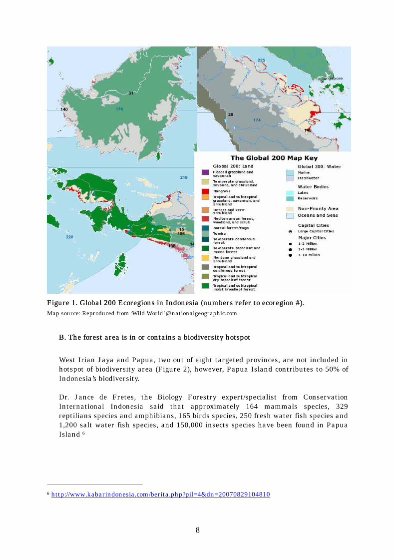
A. The forest area is in or contains a ‘Global 200’ Ecoregion
For eight Provinces, a total of eight terrestrial ecoregions have been assessed under WWF’s ‘Global 200 initiative 5’ (Figure 1). These ecoregions range from relatively stable or intact (RS) and vulnerable (V) to critical or endangered (CE) as follows: #14. Southern New Guinea Lowland Forests (V); #15. New Guinea Montane Forests (RS); #26. Sumatran Islands Lowland and Montane Forests (CE); #31 Borneo lowland and montane forests (CE); #106. Central Range Subalpine Grasslands (RS); #138. New Guinea Mangroves (RS); #140. Greater Sundas mangroves (CE); #174. Sundaland rivers and swamps (V);
5 http://www.worldwildlife.org/science/ecoregions/WWFBinaryitem4810.pdf The Global 200
Priority Ecoregions for Global Conservations
8
Figure 1. Global 200 Ecoregions in Indonesia (numbers refer to ecoregion #). Map source: Reproduced from ‘Wild World’ @ nationalgeographic.com
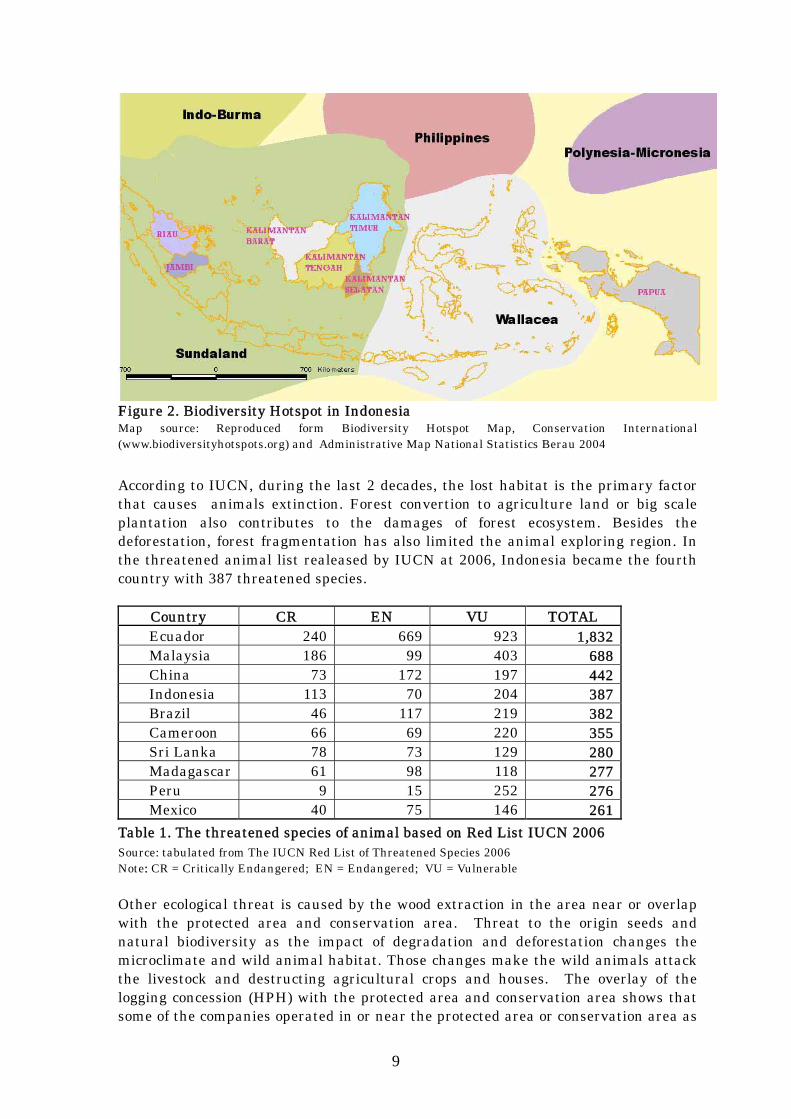
B. The forest area is in or contains a biodiversity hotspot West Irian Jaya and Papua, two out of eight targeted provinces, are not included in hotspot of biodiversity area (Figure 2), however, Papua Island contributes to 50% of Indonesia’s biodiversity. Dr. Jance de Fretes, the Biology Forestry expert/specialist from Conservation International Indonesia said that approximately 164 mammals species, 329 reptilians species and amphibians, 165 birds species, 250 fresh water fish species and 1,200 salt water fish species, and 150,000 insects species have been found in Papua Island 6
6 http://www.kabarindonesia.com/berita.php?pil=4&dn=20070829104810
9
Figure 2. Biodiversity Hotspot in Indonesia Map source: Reproduced form Biodiversity Hotspot Map, Conservation International (www.biodiversityhotspots.org) and Administrative Map National Statistics Berau 2004
According to IUCN, during the last 2 decades, the lost habitat is the primary factor that causes animals extinction. Forest convertion to agriculture land or big scale plantation also contributes to the damages of forest ecosystem. Besides the deforestation, forest fragmentation has also limited the animal exploring region. In the threatened animal list realeased by IUCN at 2006, Indonesia became the fourth country with 387 threatened species.
Country CR EN VU TOTAL Ecuador 240 669 923 1,832 Malaysia 186 99 403 688 China 73 172 197 442 Indonesia 113 70 204 387 Brazil 46 117 219 382 Cameroon 66 69 220 355 Sri Lanka 78 73 129 280 Madagascar 61 98 118 277 Peru 9 15 252 276 Mexico 40 75 146 261
Table 1. The threatened species of animal based on Red List IUCN 2006 Source: tabulated from The IUCN Red List of Threatened Species 2006 Note: CR = Critically Endangered; EN = Endangered; VU = Vulnerable Other ecological threat is caused by the wood extraction in the area near or overlap with the protected area and conservation area. Threat to the origin seeds and natural biodiversity as the impact of degradation and deforestation changes the microclimate and wild animal habitat. Those changes make the wild animals attack the livestock and destructing agricultural crops and houses. The overlay of the logging concession (HPH) with the protected area and conservation area shows that some of the companies operated in or near the protected area or conservation area as
10
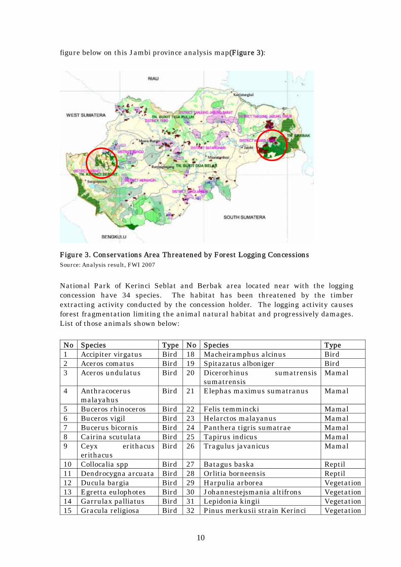
figure below on this Jambi province analysis map(Figure 3):
Figure 3. Conservations Area Threatened by Forest Logging Concessions Source: Analysis result, FWI 2007
National Park of Kerinci Seblat and Berbak area located near with the logging concession have 34 species. The habitat has been threatened by the timber extracting activity conducted by the concession holder. The logging activity causes forest fragmentation limiting the animal natural habitat and progressively damages. List of those animals shown below:
No Species Type No Species Type 1 Accipiter virgatus Bird 18 Macheiramphus alcinus Bird 2 Aceros comatus Bird 19 Spitazatus alboniger Bird 3 Aceros undulatus Bird 20 Dicerorhinus sumatrensis
sumatrensis Mamal
4 Anthracocerus malayahus
Bird 21 Elephas maximus sumatranus Mamal
5 Buceros rhinoceros Bird 22 Felis temmincki Mamal 6 Buceros vigil Bird 23 Helarctos malayanus Mamal 7 Bucerus bicornis Bird 24 Panthera tigris sumatrae Mamal 8 Cairina scutulata Bird 25 Tapirus indicus Mamal 9 Ceyx erithacus
erithacus Bird 26 Tragulus javanicus Mamal
10 Collocalia spp Bird 27 Batagus baska Reptil 11 Dendrocygna arcuata Bird 28 Orlitia borneensis Reptil 12 Ducula bargia Bird 29 Harpulia arborea Vegetation13 Egretta eulophotes Bird 30 Johannestejsmania altifrons Vegetation14 Garrulax palliatus Bird 31 Lepidonia kingii Vegetation15 Gracula religiosa Bird 32 Pinus merkusii strain Kerinci Vegetation
11
16 Lacedo pulchella Bird 33 Rafflesia sp Vegetation17 Leptoptilos javanicus Bird 34 Shorea sp Vegetation
Table 2. The List of Species in Kerinci Seblat and Berbak National Park Sources: Forest Watch Indonesia National Park Database, Based on 50 National Parks Book, Ministry of Forestry
2. Intact Forest Landscape
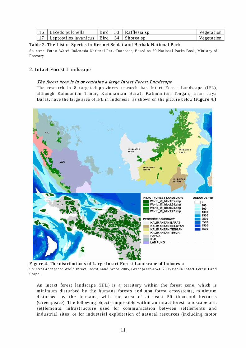
The forest area is in or contains a large Intact Forest Landscape The research in 8 targeted provinces research has Intact Forest Landscape (IFL), although Kalimantan Timur, Kalimantan Barat, Kalimantan Tengah, Irian Jaya Barat, have the large area of IFL in Indonesia as shown on the picture below (Figure 4.)
Figure 4. The distributions of Large Intact Forest Landscape of Indonesia Source: Greenpeace World Intact Forest Land Scape 2005, Greenpeace-FWI 2005 Papua Intact Forest Land Scape.
An intact forest landscape (IFL) is a territory within the forest zone, which is minimum disturbed by the humans forests and non forest ecosystems, minimum disturbed by the humans, with the area of at least 50 thousand hectares (Greenpeace). The following objects impossible within an intact forest landscape are: settlements; infrastructure used for communication between settlements and industrial sites; or for industrial exploitation of natural resources (including motor

12
roads, railways, navigable waterways, pipelines, trunk power transmission line and other linear objects), with buffer zones of one kilometer wide; agricultural lands, except those used by local communities for their needs and not connected with the rest of the world by infrastructure; territories disturbed by economic activities during the last 70 years (logging, mining operation sites, abandoned agricultural lands, etc.); artificially restored forests, tree plantations; burnt lands and young tree sites adjacent to infrastructure objects.
Many of the plants and animals live in these forests face extinction. And many of the people and cultures who depend on these forests for their way of life are also under threat. They influence weather by controlling rainfall and evaporation of water from soil. They help stabilise the world's climate by storing large amounts of carbon that would contribute to climate change.
The intact forest landscape in Indonesia remains 37 million hectare. Papua has the biggest IFL compared to other regions. The existence of IFL nowadays will not be quitted from exploitation activities by human being because some of this forest overlaps with logging concession.
REGION Area (ha) SUMATRA 4,420,989 PAPUA 17,941,722 MALUKU 1,325,786 KALIMANTAN 10,247,169 SULAWESI 3,118,854 TOTAL 37,054,523
Table 3. Remain of Intact Forest Landscape in Indonesia Source: Greenpeace-FWI, 2006. In April 2006, Greenpeace and Forest Watch Indonesia launched a map depicting the condition of Intact Forest Landscape (IFL) in Papua. The map shows the recent condition of relatively intact natural forests, not yet encroached by commercial exploitation. Satellite imagery interpretation showed 17.9 million hectares of the IFL left, or 43% of the total land7. Currently, 23% of the total 17.9 million hectares are under severe threat. The area overlaps logging concession (HPH/IUPHHK-HA) and will some day be exploited. Thus, the relatively safe IFL covers only 13.8 million hectares.
3. High Conservations Value
High conservation values as defined by FSC endorsed national or regional standards are not protected by national or local law HCVF (High Conservation Value Forest) concept was introduced in 1999 as the ninth principle of Forest sustainable management standard, which is conducted by Forest Stewardship Council (FSC). Although the HVC concepts designed to be applicable for
7 Greenpeace & Forest Watch Indonesia’s Press Release: Industrial logging threat looms large over rainforest Eden, April 2006.
13
productions forest, rapidly this concept became famous and used for another purpose. The main problem of HVC concept development which started at 1999 is the limitation of guide and instruction support provided by FSC 8 Indonesian HCVF (High Conservation Value Forest) Toolkit Development In 2001 ProForest, the forest consultant in England, published “The High Conservation Value Forest: Global (toolkit) Guide”. At the end of 2003 this guide was translated to Indonesian language with the new title “Mengidentifikasi, Mengelola dan Memantau Hutan Dengan Nilai Konservasi Tinggi: Sebuah Toolkit untuk Pengelola Hutan dan Pihak-pihak Terkait lainnya”. In the middle of 2006 the multi-stakeholder using the guide agreed to revise, to make it more usable for Indonesia condition 9. In June 2008, the establishment process of Indonesian High Conservation Value Forest Guide has been finished. However, until nowadays the government has not issued the regulations especially for HCVF implementations yet, although there are many regulation issued for conservation in Indonesia.
4. Genetically Modified Trees. forest area shall be considered high risk in relation to avoiding timber from Genetically Modified trees if:
A. The forest area has commercial plantations of GM trees The tissue culture micro propagations of Teak, Acacia, and Eucalyptus were developed in Indonesia for mass productions of seedling. Monfori Nusantara Indonesia, founded in 1996, has been involved in mass production of tissue cultures of Tectona grandis, Acacia and Eucalyptus for field trial of establishment and commercialization10. The tissue culture micro propagations technology is not part of the genetically modified trees as far as there are no new genes inserted to the origin plant. However, because of the weak monitoring, there is a risk that some GM tree may threat Indonesian original species. Based on the report of CIRAD Forestry Department, Montpellier, France there is no GM tree reported to be commercialized in international databases to date (Mayer 2004; www.agbios.com)11. B. There is a GM variety of the species in question None of the species listed as having GM varieties undergone field trials as of June 2004 are commercially important species in Indonesia.
8 Panduan Identifikasi Kawasan Bernilai Konservasi Tinggi Di Indonesia - Bahasa Indonesia
Version, June 2008 http://hcvnetwork.org/resources/national-hcv-interpretations/ 9 Panduan Identifikasi Kawasan Bernilai Konservasi Tinggi Di Indonesia - Bahasa Indonesia
Version, June 2008 http://hcvnetwork.org/resources/national-hcv-interpretations/ 10 (ftp://ftp.fao.org/docrep/fao/008/ae574e/ae574e00.pdf Preliminary review of biotechnology in
forestry, including genetic modification 11 http://www.fao.org/docrep/008/ae574e/AE574E06.htm Biotechnology in the forestry sector, Gilles Chaix & Olivier Monteuuis – CIRAD Forestry Department, Montpellier, France

14
III. ENVIRONMENTAL RISK 1. Remaining of Forest Cover
Forest cover is the barometer of forest degradation, along with the conversions and exploitations. In 2005, Department of Forestry as the provider institution of forest data said that the total forest cover left was about 94 million hectares or approximately a half of total land area in Indonesia based on Landsat7 ETM+ images interpretation data that acquired in 2003 (Table 3). The Ministry of Environment (KLH) in 2007 interpreted the Landsat7 ETM+ images, using satellite images of 2004-2006 that generalized to be the data of 2005, shows the forest cover in all regions in Indonesia has decreased to 83 million hectares (see Table 3). The different number of forest cover data from MOF and KLH can be caused by different methodology or class used to interpret the satellite imaginary and because of the amount of data that cannot be interpreted. Notice that there still have been about 33 million hectares not recognized as forest and non-forest due to the cloud noises (no data).
(unit: thousand ha) 2000 2003 2005
REGIONS Forest Non
ForestNo
data Total Forest Non forest
No data Total Forest Non
Forest No
data Total
BALI -NUSRA 1,980 4,550 806
7,336 2,702 4,074 548 7,323 2,381 4,391 683 7,455
JAWA 2,349 10,613 411
13,373 3,092 10,197 122 13,411 1,791 10,941 502 13,234
KALIMANTAN 29,443 18,466 5,275
53,184 28,233 22,371 5,437 53,040 22,768 20,158 10,675 53,600
MALUKU 3,761 2,041 1,998
7,800 4,017 2,448 1,325 7,791 3,563 1,825 2,081 7,469
PAPUA 33,838 4,934 2,007
40,779 32,358 6,415 2,007 40,779 25,134 5,475 10,623 41,232
SULAWESI 8,209 6,409 3,736
18,354 8,873 7,440 2,141 18,454 8,473 7,189 2,861 18,523
SUMATERA 14,344 26,459 6,294 47,097 14,650 30,330 2,153 47,132 19,545* 20,632 5,565 45,742
Total 93,924 73,472 20,527 187,923 93,925 83,275 13,733 187,930 83,655 70,609 32,990 187,255
Table 4. The conditions of Indonesian forest cover in 2000, 2003 and 200512 Sources: Manufactured from various resources: Land Cover of Landsat-7 ETM+ 2004 – 2006 Satellite Image Interpretation of KLH, Land Cover of Landsat-7 ETM+ 2003 Satellite Image Interpretation, Forestry in Statistics 2004, Strategic Data of Forestry 2005, Forestry in Statistic 2001, Manufactured data of TGHK 1999 * Data of Sumatra 2005 excluding Bangka-Belitung regions
The condition of forest cover in Kalimantan and Papua tends to decrease year after year, while other regions experience the degradation of forest cover and expansion of its area. However, some factors influencing to those calculations are the size of the manufactured data because of the cloud noise and different methods13 in analyzing.
12 Info sheet FWI. Brief Note: the State of Indonesian Forest and Performance of Actors in Forestry. 2007 13 The different methods on screen digitizer (interpretation based on vector data) used by
Department of Forestry, with the supervised classification (interpretation based on raster data) used by Ministry of Environment, is one of the factors which influenced to the calculation of forest and land cover in Indonesia.

15
So far, the data of 2003 satellite image interpretation is still being a reference in calculating the forest cover and being a legitimate data used by Department of Forestry. Various data resources and different methods and classification will make a complicated calculation of annually forest cover changes 14. For example, the FAO (Food and Agricultural Organization) analysis shows Indonesian forest cover in 2005 is 88.5 million hectares or approximately 48.8% of total land area and 46.5% of total region area15.
Land Area Forest16 Other land18
1000 ha % Other wood land17 Total
Other land 19 with tree cover
Inland Water Bodies (1000 ha)
Total area (1000 ha)
88,495 48.8 - 92,662 9,648 9,300 190,457
Table 5. The condition of forest and other land cover in 2005 Source: FAO, 2007. State of The World’s Forests
2. Forest Cover Changes
The changing of forest cover has been caused by the impact of big scale deforestations since early 70s, when the forest work companies started to run their operation. In the period of 70s to 90s, the fast deforestation was estimated from 0.6 to 1.2 million
14 In 1996, World Conservation Monitoring Centre (WCMC) published a data set which clustered
the forest area in Indonesia in to 13 classes but it uses the resources data of 1989 (Data Set World Conservation Monitoring Centre 1996). In 2000/2001, WCMC recalculated the forest cover in Indonesia by clustered it in to 3 classes (forest, non forest, and no data or cloud noises). National Forest Inventory (NFI) (GoI/FAO, 1996), produced forest cover and land use maps in the scale of 1:250,000. This map was based on the MSS satellite data in from 1986 to 1991. Besides, this activity produced a GIS basis data by using RePPProT data. FAO (Food and Agricultural Organization) also published the classification of forest and land cover which clustered as forest, other forest land, and other land. The other land with tree cover is a sub cluster of other land. Besides, there are also inland water bodies), such as main river, lake, and reservoir.
15 FAO, 2007. State of The World’s Forest. 16 Forest: Land area more than 0.5 ha with the trees over 5 meters height and with the canopy
over 10% or trees that could grow over the height limits in one area. The land dominated by agricultural plants or urban land use is excluding forest category (quoting from FAO)
17 Other wood land: the non forest land, with the area of more than 0.5 ha with the trees over 5 meters height and with the canopy of 5-10% or trees that could grow over the height limits in one area or combined with bushes and plants over 10%. The land dominated by agricultural plants or urban land use is excluding forest category (quoting from FAO).
18 Other land: non forest land and none other wood land are agriculture farm, grass land, developed area, open land, etc. The sub cluster of this area category is the other land with tree cover (quoting from FAO).
19 Other land with tree cover: Other land category with the area of more than 0.5 ha with the trees over 5 meters height and with the canopy over 10%. Included in this category are trees in agriculture landscapes, parks, gardens, and surroundings construction with the suitable condition of height and canopy, including garden with non timber production, such as fruits garden (quoting from FAO).
16
ha per year20. While according to the mapping of government in collaboration with the World Bank, the deforestation in the period of 1986 – 1997 was about 1.7 million ha per year, and significantly increased to 2 million ha per year (FWI/GFW, 2001)21. With the various data provided and different resources and methods, FWI tries to calculate the fast rate of deforestation in the term of 1989 – 2003. The result of provisional analysis shows that Indonesian land cover has experienced the changes by degradation* and deforestation, which is estimated about 4.6 million ha per year22. The rate of deforestation is estimated about 1.99 million ha per year23.
REGIONS Degradation (thousand ha)
Deforestation (thousand ha)
Java 339 648 Kalimantan 15,814 10,931 Maluku 2,349 1,033 Bali-Nusa Tenggara 173 257 Papua 4,539 3,136 Sulawesi 4,561 1,915 Sumatera 9,185 9,951 INDONESIA 36,960 27,871 Rate of Forest Cover Changes(thousand ha/year) 2,640 1,991
Table 6. The rate of forest cover changes in Indonesia in period 1989-2003** Source: The result of Overlaying WCMC 1989 and Interpretation of Landsat7 ETM+ 2003 Satellite Image, FWI 2007. Notes: *The definition of degradation is: the forest cover that changed from primary forest type to secondary forest type. ** Data Set of National Forest Inventory (NFI) published in 1996, using data resources of RePPProT 1989/1990). The deforestation is the permanent removal of forest cover and conversion of the land to other uses. According to the land use definition used by FAO and accepted by most governments, forest land that has been harvested, even clear cut, is not regarded as deforested because in principle, trees may re-grow or be replanted. Deforestation is recorded only when the land is permanently converted to non forest use24. In the period of 2000 – 2006, there are some versions of publication on Indonesian deforestation estimation. The number from the Department of Forestry is 2.83 million ha per year in the period of 1997 – 2000 (2005)25. In 2007, in the State of the World’s Forests, FAO (Food and Agricultural Organization) placed Indonesia as the 8th widest natural forest country in the world. With the speed of deforestation in Indonesia reached 1.87 million ha in the term of 2000 – 2005, Indonesia was the 2nd
20 W.D. Sunderlin and I.A.P. Resosudarmo, 1996. Rates and Causes of Deforestation in
Indonesia: Towards a Resolution of the Ambiguities. Bogor, Indonesia: Centre for International Forestry Research
21 FWI/GFW. 2002. The state of the Forest: Indonesia, Bogor, Indonesia 22 Info sheet FWI. Brief Note: the State of Indonesian Forest and Performance of Actors in
Forestry. 2007 23 Info sheet FWI. Brief Note: the State of Indonesian Forest and Performance of Actors in
Forestry. 2007 24 FWI/GFW. 2002. The state of the Forest: Indonesia, Bogor, Indonesia 25 Strategic Plan of Forestry Department 2005-2009 on MoF Regulation No P.04/Menhut-II/2005

17
fastest deforestation country in the world.
Forest Other Woodland Annual change rate Area (x 1000 ha) Area
(x 1000 ha) 1990-2000 2000-2005
1990 2000 2005 (x 1000 ha/year) % (x 1000
ha/year) % 1950 2000 2005
116,567 97,852 88,495 -1,872 -1.7 -1,871 -2,0 - - -
Table 7. Forest cover and other woodland changes in the period of 1990 – 2005 Source: FAO, 2007. State of The World’s Forests.
3. Illegally Harvested Wood A. forest area shall be considered high risk in relation to illegal harvesting if: 1) Large scale illegal harvesting occurs in the forest area
The government policies related to the forest industries26 have driven the wood industries grow fast. Unfortunately, this situation is not accompanied with good forest governance and it creates the great imbalance in the wood supply and demand27. This condition has forced the wood producer to do the logging outside the appropriate area. The HPH concession holders overcut the timber out of the RKT (Rencana Kerja Tahunan, Annual Work Plan), and Non HPH concession holders log inside other state’s forest area. Even the conservation forests such as national parks are not invulnerable from illegal logging28. Recently, with the better potential timbers than other forest area, national parks have even become the main target for illegal logging. The weak law enforcement contributes to the wide spreading illegal logging practices 29 , not only for domestic needs, but also for exports. The weak law enforcement also intensifies the timber smuggling activities30. In 2005, EIA/Telapak reported that at least 300,000m³ merbau had been smuggled from Papua monthly31. The hotspots of illegal logging in Papua are Sorong, Nabire, Fakfak, Serui and Manokwari, and those logs mainly have been shipped to China32. Picture below shows illegal logging location in Sumatera and Kalimantan Island occurred in 2001-2003 which was observed successfully by Forest Watch Indonesia
26 Road Map Revitalisasi Industri Kehutanan Indonesia, Departemen Kehutanan, 2007. 27 Briefing Note: Still, a long way to go! Lesson learned from civil society involvement in fighting
illegal logging to improve forest governance. EIA/Telapak. 2008 28 The Final Cut. Illegal logging in Indonesia’s Orang Utan Park. EIA/Telapak. 1999. 29 Briefing Note: Still, a long way to go! Lesson learned from civil society involvement in fighting
illegal logging to improve forest governance. EIA/Telapak. 2008 30 Profiting from Plunder. How Malaysia Smuggles Endangered Woods. EIA/Telapak. 2004. 31 The Last Frontier. Illegal Logging in Papua and China’s Massive Timber Theft. EIA/Telapak.
2005 32 Briefing Note: Still, a long way to go! Lesson learned from civil society involvement in fighting
illegal logging to improve forest governance. EIA/Telapak. 2008

18
(Figure 5). Illegal logging cases in Papua were not monitored well by mass media.
Figure 5 Illegal Logging Case Spot 2001-2003 in Sumatera and Kalimantan Source: Analysis result, FWI 2004 based on Mass Media Illegal Logging Case data Tabulations 2001-2003
The tabulation of mass media news in 2007 shows that as those period, there are about 90 cases of illegal logging handling in Indonesia; from those 90 cases, the frequency is dominated by two regions: Sumatera and Kalimantan with 56 and 18 cases respectively. In Sumatra region, the biggest illegal logging case is still placed by the evidences in the concession area as illustrated below:
Table of Illegal Logging Case and Treadment
0
5
10
15
20
25
BALI-NUSATENGGARA
JAWA KALIMANTAN MALUKU-PAPUA SULAWESI SUMATERA
Region
Cas
e
Count of OccupationCount of w ood theftCount of AdministrationCount of Wood SmugglingCount of law enforcement
Chart 1: Distribution Cases of illegal Logging at Each Region in year 2007 Source: Analysis FWI from mass media 2007
19
2) The district of origin processes and trades in wood or wood products from forest areas where large scale illegal harvesting occurs
The main reason of illegal logging in Indonesia is the over capacity of timber industry, domestic and international supply on the illegal timber, no clarity about the territorial of forest area, the weakness of law enforcement supported by the system of thick KKN (Corruption, Collusion, and Nepotism). The sharp unbalance between demand and supply of timber and the sustainable capacity of natural forest is one of the trigger factors of illegal logging. Timber industries (pulp mill, ply mill, and saw mill) have to compete to get the timber from the natural forests, legally or illegally, or buy from the illegal logging product to cover the supply of the raw material needed33. Based on the realization of forest production, the total consumption of timber by the timber industries sharply increased from 11.7 million m3 in 1980 to 24.1 million m3 in 1985, the peak is 52.7 million m3 in 2003, and then sharply decreased to 44.5 million m3 in 2005. The log production in Indonesia came from many resources, such as natural forest, industrial plant forest, other licenses, and the conversion area. The total production of logs in 200534 is 24.22 million m3 from the natural forest (5.72 million m3)35, plantations forest (12.82 million m3), Perhutani Plant Forest (0.76 million m3), clear cutting permits – IPK (3.61 million m3) and other valid licenses/ISL (1.31 million m3). In 2002, the illegal log consumed by the timber industries was estimated to be 42.2 million m3. This number decreased to 20.3 million m3 in 2005. It means that the timber industries take the role on the heavy degradation of environment at present, such as deforestation and forest degradation. Furthermore, the decrease of illegal logs consumption by the timber industries also indicates how hard it is to get the timber material36. This raw material demand, excluding the demand of the small scale sawmill industries, mostly has no license (illegal) spreading all over Indonesia. The total volume of this illegal timber will be bigger if it includes the timber volume smuggled to the foreign countries. There are so many timbers from Indonesia smuggled through the territorial of Indonesia and Malaysia (in Kalimantan Island) 37 or smuggled by the sea from Papua38. The other factor is the illegal log demand which is getting increased because those timber are available in low price. The weakness of law enforcement, especially due to the corrupt political and economic system and full of KKN (Corruption, Collusion, and Nepotism) effects to the growing of illegal logging. The resistance of illegal logging actors against the law is related with the government institution and
33 FWI/GFW. 2002. The state of the Forest: Indonesia, Bogor, Indonesia 34 Department of Forestry (2006). Executive, Strategical Data of Forestry 2006. 35 The Annual Cut Effort that has been agreed by the Department of Forestry in the period of
2002-2007 are: 12 million m3 (2002), 6,3 million m3 (2003), 5,7 million m3 (2004), 5,1 million m3 (2005), 8,2 million m3 (2006) and 9,1 million m3 (2007).
36 Road Map Revitalisasi Industri Kehutanan Indonesia, In-house Experts Working Group of Forestry Industry Revitalisation, Department of Forestry 2007.
37 Profiting from Plunder. How Malaysia Smuggles Endangered Woods. EIA/Telapak. 2004 38 The Last Frontier. Illegal Logging in Papua and China’s Massive Timber Theft. EIA/Telapak.
2005

20
immorality of civil or military officers that back up their operation, so it seems like they are out of reach by the law. In reality, there is still a big obstacle that barriers the effort against illegal logging --that is the weak law enforcement. However, the Minister of Forestry, MS Kaban stated that the illegal logging occurred because of the weakness of the control function at the committee meeting ad hoc II with the Region Representatives Council (DPD) in the MPR/DPR house on February 22, 2005. This is seen by the ratio of police watching 5 – 12 thousand hectares of forest. The illegal logging problems are not a trivial problem, because the actors are such a syndicate with a strong network and capital. The integration of the institution of law enforcement is expected to threaten the illegal logging actors39. The growing of illegal logging is still being a problem in the forest management in Indonesia, even though since 2005 the fight against illegal logging has been conducted as the implementation of Presidential Instruction no. 4 / 2005 on “Fight against illegal logging in the Forest Area and its Distribution in Indonesia”. Implementation from the law enforcement process is not always effective to erase the illegal logging practices in some Islands such as Sumatra and Kalimantan, even though the tabulation of mass media news in 2007 shows that there are significant decreases of illegal logging practices in Papua, compared to the previous years.
4. Forest Conversion Forest area shall be considered high risk in relation to conversion of natural forest to plantations or non-forest uses if: 1) Wood supplied is from native forest species
Almost 100 % of timber traded in Indonesia is native species, even though its magnitude is different for each species. Based on data from Ministry of Forestry, 120 timber species are traded40. According to the statistic date of Ministry of Forestry, there were small amount of imported seed and seedling from foreign countries between 2000-2001 for Acacia, Eucalyptus and Tectona Grandis species.41 Based on the research conducted by Forest Research and Development Center Ministry of Forestry, Indonesia Indigenous species of eucalypt are found in the eastern parts of Indonesia, such as E. deglupta (from Celebes Island), E. urophylla and E. alba (from East Nusa Tenggara), and E. pellita (from West Papua) 42.
2) It is legal to convert the natural forest to plantation or non-forest use in the country or district
Indonesia has planned to manage the forest in national scale with creating map of
39 Media Indonesia_24_02_05_75 Persen Cukong Kayu Illegal Kabur 40 http://www.dephut.go.id/informasi/propinsi/SUMSEL/jenis_kayu_dagang.html 41 http://www.dephut.go.id/informasi/statistik/2004/RLPS/III_8_1.pdf 42 http://www.fao.org/docrep/005/AC772E/ac772e09.htm
21
forest-designated area. Based on this map, forest is divided into three main functions: production forest, national park, conservation park, and protected forest. For the production forest function, Indonesian Government has determined the area for conversion as shown in the figure below, marked by red color (Figure 6):
Figure 6. Map of The Ministry of Forestry Forest for Conversion Distributions Planning Source : Forest Watch Indonesia, Reproduced from Ministry of Forestry Designated Area Map 2001, MoF Land Cover Map 2003
Ministry of Forestry’s forest-designated area map has set production forest area, which can be converted as non-forestry utility. The purpose of Indonesian forest area conversion plan is to accommodate the need of land for area development, road construction, plantation and other non-forest use. The process of forest conversion in Indonesia is legal as long as it is not conducted in the national parks, conservation areas, and protected areas. Rejection against area setting on the map is occurred in Riau and Central Kalimantan, thus forest conversion process to a plantation and for area development is relatively easy, and threatens the condition of forest cover.
3) Large scale conversion of forest to non-forest use takes place in the forest area
Plantation sector takes part in forest-designated area conversion process massively in Indonesia (Figure 7). The process usually starts with extrication of forest area permit; then continues with clear cutting permit from Ministry of Forestry. In another case at non-forest designated area, which is also called “areal penggunaan lain” (APL), the clear cutting permit is issued by the local government and there is no extrication processes. Compared to the conversion at forest-designated area, the permit from the local government is easier to get by the plantation companies because of the weak policy. The impact of conversion forest at outside of forest-designated area is increase of deforestation. This problem happens because there are still wide area, which is covered by forest outside of forest-designated area.

22
Figure 7. Map of Riau, Jambi, and Kalimantan, Non Forest Plantations from National Forest Inventory 2001 Source: Forest Watch Indonesia 2008, Reproduced from Ministry of NFI Plantations Map 2001, MoF Land Cover Map 2003 In the case of Papua Island, the forest designated area extrication is dominated by development purpose such as, road construction, resettlement, and district development. Based on Papua district forestry officer reported in 2005, there were 241,118 hectares of forest area converted to non forest43.
5. Forest Fire
Based on the analysis of logging concession maps that has been undertaken for eight provinces, we can see from the total of unit management that Riau, East Kalimantan, and Central Kalimantan Province are the three provinces with the highest environmental threat level. The data resources and concessions maps which actively running to 2005 are from the Directorate for Forestry Production Building of Forestry Department. The activities of opening land by slashing and burning also contribute a serious threat to the forest.
Table 8. Distribution of hot spot in research site Source: Analysis result, FWI 2007 based on NOAA Hotspot Coordinate that captured between January-
43 Papua Province forestry office, Forest Statistics Report 2005
Hot Spot Location Province
Forest Fire (Total of Hot
Spot) In Conservation
Area In Forest
Concession In Production Forest
for Conversion West Kalimantan 6,458 418 1,570 331Central Kalimantan 6,193 146 1,982 1,933East Kalimantan 856 38 160 0South Kalimantan 186 19 10 7Riau 3,483 678 2,904 207Jambi 1,018 165 136 0Papua 0 0 0 0West Papua 0 0 0 0

23
September 2006 The hotspot distribution map identifies the condition of opening land by slashing and burning. The data of hot spot distribution was based on the NOAA’s (National Oceanic and Atmospheric Administration of the United States) satellite images from January to September 2006. Based on the hotspot map analysis in eight provinces, it is identified that West Kalimantan, Central Kalimantan and Riau Province have the highest ecological threat. The hotspot distribution is found in almost all area function, but in this context, information is provided only for the functions of conservation area, forest concessions, and HPK, which has a strong relation to the threat of forest. Based on the number of hotspot distribution in the three area function (conservation forest, concessions, and HPK), the three provinces ofRiau, West Kalimantan and Central Kalimantan are identified with the highest ecological threat. In those three provinces, most of the hotspot are located in the forest concessions. It indicates that the company also plays the role in burning the land. Land conversion and hotspot distribution in this case is the environmental threat, which affects the global climate change by increasing a significant carbon emission because of the domination of peat land especially in Central Kalimantan and Riau Provinces. On the peat land, the land conversion by drying will disturb the soil water stabilization which leads to the dry peat land materials and burnt easily. In the condensed peat land, the fires do not only emerge on the soil surface, but also from inside the soil, so the extinguishing could not be done efficiently. Some area of HPK is inside of peat land area that can be figured in Riau case based on map analysis which created by overlaying between the peat land map with forest production for conversion (HPK) in Riau province (Figure 8).

24
50 0 50 100 Kilometers
Peat Land AreaSecondary Forest
Forest for conversion (hpk) 2001Primary Forest
Figure 8. Distribution of peat land with Production forest can converted (HPK) at Riau province Source: FWI 2007 Reproduced from peat land RePPRort Map, the forest productions for conversion Ministry of Forestry Designated Area Map 2001.
This leads to those three provinces with more distributions and number of hotspots. This analysis result is still as the potential environmental risk possibility that yet has become the actual references in the field. For more accurate information, an investigation is needed.

25
IV. POLITICAL AND GOVERNANCE RISKS
The most of deforestation in Indonesia is caused by the politic and economic system that suggests the natural resources, especially forest resources, as the source of income that could be exploited for the political interest and private income (FWI/GFW. 2001) 44 . The increasing deforestation and degradation of forest in Indonesia are also caused by the impact of illegal logging, the minimum control in the forest resources management through the system of Forest Enterprises Rights (HPH), conversion of natural forest resources (the development of Industrial Plant Forest, plantation, transmigration), forest fire, and the non-clarity of the land tenure rights which frequently causes the social conflict among local and indigenous communities. Illegal practice done by HPH is cutting trees outside the territory of Annual Work Plan (RKT) working area. The owner of HPH concession is used to do the re-logging before the end of HPH concession period.Further more, there are some HPH who conducted a ‘big sale,’ especially to fulfill the log supply as the raw material of timber industry. The potential existence of natural forest resources in Indonesia, especially in the location of ex-HPH, has sharply decreased due to the over exploitation of forest resources by exceeding the limit of the annual sustainable cut, and this has been happening for about 40 years. The risks get more widely recognized after the fall of the Suharto regime in 1998 that ran the Indonesian government for 32 years, where organized commercial scale illegal logging practices were massively operated (threatening most of protected areas), and after the occurrence of series of serious ecological disasters (landslides, floods, and drought). Those disasters are a direct result of the destruction of forest due to improper and unsustainable practices. These practices were clearly responsible for the highest rate of deforestation of the Indonesian forest. The rate of deforestation increases time to time, both as announced by the government and by an independent institution, such as Forest Watch Indonesia that monitor the forest utilizations and the forest cover changes over time. One of the required information is the most recent forest cover and land use. This information is the base to manage the forest resources, so it could realize a forest implementation which guarantees the sustainability of forest and enhances people’s prosperity45.
44 FWI/GFW. 2002. The state of the Forest: Indonesia, Bogor, Indonesia. 45 Strategic Plan of Forestry Department 2005-2009 in MoF Regulation No P.04/Menhut-II/2005.

26
V. SOCIAL RISK
Violation of traditional and civil rights. A forest area shall be considered high risk in relation to violation of traditional and civil rights if: 1) There is a UN Security Council ban on timber exports from the country in which the
district is located
There is no UN Security Council ban on timber from Indonesia.
2) Conflicts of substantial magnitude relating to long term tenure and use rights to the land and forest resources take place and involve indigenous people in the forest area
The conflict of land tenure involving the indigenous people in Indonesia cannot easily be assessed by GIS. This problem happens because of the limited information about indigenous people land and tenure data. This happens because the government has used only the administrative boundary map to divide the village and settlement until nowadays. This problem causes the conflicts around forest logging concession which occurs, indistinguishably between indigenous people tenure conflict and villager tenure conflict. However, based on the illustrations below (Figure 9), the overlapping area between logging concession with village of indigenous people can be identified, and giving indications that the government does not recognize the indigenous people land tenure’s right.
Figure 9.Threat of Logging Concession to Indigenous People Villages in Riau Province Source: Forest Watch Indonesia 2008, Based On Forest Logging Concession Map 2005, Administrations Map, National Statistics Berau 2004. Note: The red circles illustrate the area of indigenous people communities which is near/in the concession area in Riau Province.
Indigenous Indonesian People Indonesia consists of more than 17,000 Islands with population of around 220 million and is listed as one of “mega-biodiversity” countries with more than 47 distinctive

27
ecosystems. The government officially recognizes 1.1 million indigenous population so-called komunitas adat terpencil (remote indigenous communities). However, there are many more peoples that consider themselves, or are considered by others, as indigenous. The nationwide indigenous people organization, Aliansi Masyarakat Adat Nusantara (AMAN), uses the term masyarakat adat46 to refer to Indigenous People. The existence of this biodiversity and culture relies on the existence of indigenous people who live and spread in this entire archipelago. AMAN estimates that 50 to 70 million of 220 million Indonesian people are indigenous people, “people who live in the community based on the ancestors history by generations on the indigenous area, which has the authority on their land and natural wealth and social culture life regulated by the customary law and indigenous institution which order their community life” (Congress of Archipelago Indigenous People, 1999). From that number, AMAN also estimates that 30 to 50 million of the indigenous people still rely on the indigenous forest, the forest ecosystem in their indigenous areas (Figure 10)47.
Figure 10. The Distribution of Indigenous Community (which is the member of AMAN) Source: Data processing from members of AMAN, FWI 2007
Although Indonesian government at international level persistently argues that all Indonesian are indigenous therefore the concept of Indigenous People does not apply them. However, the 1945 Constitution 48 (Second Amendment, 2001) recognizes
46 Masyarakat adat is also used consistently in the Act No 27/2007 on Coastal and Small Islands
Management. 47 Nababan Abdon: Revitalisasi Hukum Adat untuk Menghentikan Penebangan Hutan secara
‘Illegal’ di Indonesia. 2002 48 There is no official translation of Indonesians’ Constitution, Laws and Policies. Bahasa
Indonesia version of these instruments can be downloaded from the official website of Badan Pembinaan Hukum Nasional(BPHN) at http://www.bphn.go.id/pusdokinfo/index.php?action=reg&cat=regPeraturanPusat

28
Indigenous Peoples rights. Article 18B Para 2 (concerning regional government) recognizes indigenous peoples’ rights. Article 28I Verse 3 (regarding Human Rights) respects cultural identity of indigenous peoples.49 These two articles use two terms to refer indigenous peoples, namely masyarakat hukum adat (Article 18 Verse 2) and masyarakat tradisional (Article 28I Verse 3). In addition, these two articles emphasize that the recognition of Indigenous Peoples shall apply as long as they still exist, in accordance to the society/cultural development and civilization within the Unitary State of Indonesia, and they are recognized legally by law. In more recent legislation there is an implicit recognition of indigenous people’s rights such as Act No. 5/1960 on Basic Agrarian Regulation, Act No. 39/1999 on Human Rights, MPR Decree No 9/2001 on Agrarian Reform, Act No 27/2007 on Coastal and Small Islands Management, Act No. 41/1999 on Forestry and others. However, the implementations of these laws in fact limit indigenous people from exercising their rights. For example the Presidential Decree No, 6/2007 on Forest Regulation and Planning Development of Forest Management and Utilization is still not technically implemented on the ground. Lack of indigenous peoples’ full participation in forest management planning further denies their access to land and forest recourses. The situation has led to further marginalization, impoverishment, and escalation of conflicts and human rights abuses. The contribution of forest resource conflict to natural resource conflict between 2005-2007 can be described in the chart below. The total contribution of forest resource conflict is 33.4% from 138 Natural resource management conflict cases (Chart 2).
Chart 2. The contribution of forest resource conflict for natural resource conflict Source: The analysis of conflict data from mass media, FWI 2007
According to the analysis above, there are relationships between natural resources exploitation and the evidences to threaten people around the forest that lead to
49 Constitution 1945 – Second Amendment, 2001 uses two terms as to refer indigenous peoples. Article 18B-2 uses masyarakat hukum adat while Article 28I-3 uses masyarakat tradisional

29
conflicts. Natural resources management which marginalizes the communities leads to the conflict of interest between the companies and communities; such as tenure issues, access of rights and the changing of communities life pattern around the forest because it is so hard for them to fulfill their basic need by the ecological impacts.
3. Conflicts of substantial magnitude relating to long term tenure and use rights to the land and forest resources take place in the forest area and which involve a significant number of interests
The conflict risk assessment in this study refers to the threat potential to the conflict as the impact of forest management activities. The assessment is based on the map analysis compiled by the sites of indigenous people to the logging concessions (HPH, HTI) or to the conservation area (Protected Forest, Nature Preservation, and National Park). During the period of 1997 – March 2008 based on mass media analysis, conflict that happens on Forest Concession (HPH) and Forest Plantation (HTI) is 112 cases for HPH and 159 cases for HTI all over Indonesia (Chart 3).
Chart 3. Conflict case on logging Concession and Plantation Forest during the period of 1997-2008 Source: The analysis of conflict case data from mass media, FWI 2008 Based on the map analysis, the number of conflict distribution in the eight provinces based on the data of media is as figured below (table 11):
4 16
2
1510 11
1 1 51
561
16
65
643
2620
62
0
10
20
30
40
50
60
70
HPH 6 1 16 65 4 1 6 2 5 1 5
HTI 3 26 20 62 15 10 11 1 1 4 6
1997 1998 1999 2000 2001 2002 2003 2004 2005 20062007 - Maret 2008

30
TOPICS
No. PROVINCES HPH HTI Plant
ation MiningNatural Resources/Environ.
ConservArea Inhutani Agri
culture Forest Industry Other
Conflict
1 JAMBI 2 5 3 10
2 R I A U 1 6 9 4 1 1 22
3 KALIMANTAN BARAT 1 8 1 2 12
4 KALIMANTAN SELATAN 1 6 1 3 11
5 KALIMANTAN TENGAH 1 7 8
6 KALIMANTAN TIMUR 3 1 1 1 1 7
7 IRIAN JAYA
T O T A L 9 7 30 7 1 7 1 0 7 1 138 Table 11. The number of conflict distribution in eight provinces based on the data media Source: The analysis of conflict data from mass media, FWI 2007
The analysis of this media data is an attribute to strengthen the map analysis that has been undertaken. From this conflict data and map analysis, it is identified that the three provinces: Riau, West Kalimantan and South Kalimantan have the highest risk of conflict of natural resources management. Cases for Papua and West Papua are not found by the mass media analysis. This is probably because of the less attention to the cases happened there, so it had not been exposed by the mass media.

31
VI. LIVELIHOOD AND RIGHTS RISK The over-exploitation and forest conversion have caused a never-ending conflict of the land authority and also the rights of benefiting their indigenous forest. This is the biggest problem that still always happens in the history of forest resources management. Each party defends and feels that it has the rights on the forest resources as the law enforcement, because the different claims on this right of course bear the different dimensions of interest. So, expectation cannot be high on this conflict resolution if there are no protection guarantees, certainty and adjustment of the indigenous and local communities’ right on their natural resources. Taking care of the harmony relationship between human and its forest has generally developed the concept on tenure rights with the communal and exclusively on an indigenous forest area. To support the management of indigenous forest as the joint rights, the indigenous community also has the knowledge system, customary law and indigenous (state) institution. Customary law is the social regulation which is the most important to protect the resources in the indigenous forest area from the over logging by the communities or by the outside parties50.
In order to rehabilitate the sustainable natural resources management in Indonesia in the future, communities involvements in the forest management should be a priority in the government policies and companies, so the control mechanism to the natural resources management could be done by integrating the participatory in the social economic condition of community around the forest where the companies operated. Other essential social risks are namely: poverty, escalated violence/abuses and unsettled tenure conflicts. Indigenous people that dependent to their forest are those affected the most. The social risk in this study refers to the threat potential to the conflict as the impact of forest management activities. The assessment is based on the map analysis that compiled by the sites of indigenous people to the logging concessions (HPH, HTI) or to the conservation area (Protected Forest, Nature Preservation, and National Park).
Overlapping area between forest concession and indigenous people region happens because there are no indigenous people entangled on forest area delineation, even though the indigenous people’s region had been established before the government made the delineation of forest area.
Country/district is a conflict timber area Indonesia has not been categorized as a “conflict timber area” after Suharto regime fell down in 1998. The deliberations between Government of Indonesia with the “Gerakan Aceh Merdeka” (GAM) reduce the large scale of conflict involving military. At reformation era, Indonesian Government gives the special autonomy to Aceh and Papua Province. The impact of the new policy for those two provinces is the opportunity of local government to make forest management plan more independently.
50 Nababan Abdon: Revitalisasi Hukum Adat untuk Menghentikan Penebangan Hutan secara ‘Illegal’ di Indonesia. 2002

32
VII. CONCLUSION OF RISK ASSESSMENT
In the risk assessment research for eight provinces based on the minimum standard of FSC and FAIRWOOD standard for wood procurement, Indonesia is considered as high risk for wood procurement, because a lot of threats for ecological, environmental, and social problems were found on the map and data analysis. The case of illegal harvesting, and social conflict in forest area happen because the history of forest management policy was centralized at the national level without considering that there are a lot of stakeholders depending on the forest area. The miss-management of the forest is because of the weak monitoring process caused by corruptions and bribe during the Suharto regime. The change of authority from Suharto era to Reformation era after 32 years (there have been several negative impacts decentralization in the beginning) has caused weak law enforcement especially in forestry sectors. The impact of the weak law enforcement caused the natural resource conflict and illegal logging case to increase in 2000. The forest policy and forest management in the old regime tended to consider only in silviculture approach than social approach, and in the end this approach cannot save the forest conditions because of the community dependant was not accommodated by this scheme. The forestry development process only gives benefit to the company, without considering that there are some settlements of indigenous people depending on the forest in or near the forest area. In this case, the land tenure problem will trigger many conflicts and illegal harvesting in the ends. The conflict case analysis between forest company and people near the forest area in 1997 to March 2008 at the forest concession area show that there are still serious problems which should be confirmed if the forest can be managed well and prosperity is given for every stakeholders there. Based on the analysis of illegal logging case for the year 2007, there are some fact findings that many of the illegal logging case are connected with the forest area occupation. Sumatra Island can be explained about the connection between conflict of land tenure and deforestation process that threaten forest area. Moreover, if there are no actions to solve those problems, the sustainable forest management will not be materialized.
In another case, the threat for forest area existence has come from the forest conversion process of development of oil palm plantations, construction of new road, resettlement, and district development. The process of conversions has been started by the cutting permit process (IPK) that will give the company the right to clear cutting the forest area for conversion purpose. The clear cutting process then sometimes continues to the burning process to remove the grass and shrub completely. This process sometimes cannot be controlled、 especially at peat land, because there are a lot of organic materials that buried inside the soil. Central Kalimantan, Riau, and some Jambi Province are the areas that are susceptible of fire spread and threatening the forest area because there is an abundant of peat land area. In this case, forest fires do not only threat the forest area, but also the wild life existence.

33
VIII. LEGAL VERIFICATION SYSTEMS OF WOOD PROCUREMENT
1. Defining Legality in Indonesia
In Indonesia, there are various systems for verifying so called the legality of extracted and produced wood/wood products. There are several similarities among those systems, yet only one of them that resulted from a multi-stakeholder process provide significant extends of credibility. The multi-stakeholder formulated system is an acceptable assurance of legality by all major forestry stakeholders because of its nature and the stakeholder legitimate institutional setup.
2. Guidance for Defining Legality in Indonesia
The multi-stakeholder initiative in Indonesia to define legality and formulate the timber legality verification standard was started in the year 2003. This initiative is being made as an approach to halt illegal logging practices, as the demand/market side play a key role of facilitating this practices due to loss and/or unclear distinction of legal wood/wood products out of the illegal one. The major stakeholders involved in the process are government, private sector, indigenous people organization, academician, and nongovernmental organization which include key standard developers. Here are the main points in the formulation process: ・ Full engagement of potential stakeholders, including participation of actors
instead of the state, is essential in establishing the system. ・ Clear legality definition is very important. Thus, necessary to set up basic criteria
to review the legality. Partner should guarantee legality accordance to the scheme; adhere to national definition of legality.
・ Licensing should cover all products that may contain illegal raw material. ・ Free and Prior Informed Consent (FPIC) principles recognized and included in
the scheme. ・ The verification should be based on clear traceability (assurance to the origin
source) and assurance in accordance to legal compliance matched up with reality on the ground, in which ecological and social aspects are incorporated.
・ Implemented by credible institution with independent third party monitoring built in since beginning.
・ The verification valid for certain period. In the event of proved violation, license will be revoked.
Under LEI (Lembaga Ekolabel Indonesia) facilitation, eight field tests were undertaken in two timber plantations, one natural concession, two community-based forests, two primary industries, and two secondary industries. Lessons learned from these activities were then used to improve the formulation to ensure credibility, and efficiency of a workable standard. The final formulation –which labeled as standard version 3.3–resulted from this multi-stakeholder process called “Standar Verifikasi Legalitas Kayu” (SVLK) or the “Timber Legality Assurance System” (TLAS) was completed in January 2007. The
34
TLAS incorporated the accepted/agreed legality definition and the five different categories/components; consist of four that covered all acceptable sources of wood extraction [A1, A2, B, C] and one covering wood processing and its trade [D]. A follow up work is being put in place to setup an accountable, credible, and transparent governing bodies, aimed to be finalized in early 2008. The governing bodies consist of four institutions as the governing bodies: executive bodies (Badan Pelaksana/BP), verification bodies (Lembaga Verifikasi/LV), appeal/resolution bodies (Lembaga Penyelesaian Keberatan/LPK), and monitoring bodies (Lembaga Pemantau/LP). Two commissions, namely Accreditation Commission (Komisi Acreditasi/KA) and Licensing Commission (Komisi Lisensi/KL), are situated in the executive bodies (Badan Pelaksana/BP).
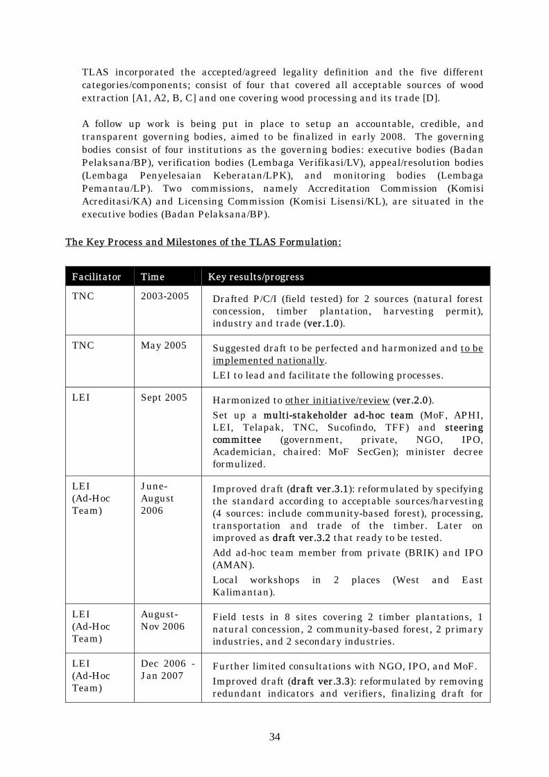
The Key Process and Milestones of the TLAS Formulation:
Facilitator Time Key results/progress
TNC 2003-2005 Drafted P/C/I (field tested) for 2 sources (natural forest concession, timber plantation, harvesting permit), industry and trade (ver.1.0).
TNC May 2005 Suggested draft to be perfected and harmonized and to be implemented nationally. LEI to lead and facilitate the following processes.
LEI Sept 2005 Harmonized to other initiative/review (ver.2.0). Set up a multi-stakeholder ad-hoc team (MoF, APHI, LEI, Telapak, TNC, Sucofindo, TFF) and steering committee (government, private, NGO, IPO, Academician, chaired: MoF SecGen); minister decree formulized.
LEI (Ad-Hoc Team)
June-August 2006
Improved draft (draft ver.3.1): reformulated by specifying the standard according to acceptable sources/harvesting (4 sources: include community-based forest), processing, transportation and trade of the timber. Later on improved as draft ver.3.2 that ready to be tested. Add ad-hoc team member from private (BRIK) and IPO (AMAN). Local workshops in 2 places (West and East Kalimantan).
LEI (Ad-Hoc Team)
August-Nov 2006
Field tests in 8 sites covering 2 timber plantations, 1 natural concession, 2 community-based forest, 2 primary industries, and 2 secondary industries.
LEI (Ad-Hoc Team)
Dec 2006 - Jan 2007
Further limited consultations with NGO, IPO, and MoF. Improved draft (draft ver.3.3): reformulated by removing redundant indicators and verifiers, finalizing draft for

35
general verification guidelines and its norm. Later on finalized and handed over to Steering Committee (January 22, 2007). Inputs and notes regarding governing bodies (key functions/roles include: accreditation, verification, licensing, dispute settlement, monitoring).
LEI February – July 2007
Preparation stage of institutional (governing bodies) arrangement.
LEI (Ad-Hoc Team)
August 2007 - January 2008
Regular meetings of ad-hoc team on designing and formulating guideline and structure of 4 (four) institutions as the governing bodies: executor bodies (Badan Pelaksana/BP), verification bodies (Lembaga Verifikasi/LV), dispute settlement/resolution bodies (Lembaga Penyelesaian Keberatan/LPK), and monitoring bodies (Lembaga Pemantau/LP).
LEI (Ad-Hoc Team)
February 2008 - …
Public consultation and finalizing stage.
Each category has several set of principals, criteria, indicators, verifiers, and guideline of verification that covers key areas on production, environmental, and social aspects. All set of principals, criteria, and indicators have clear references on the relevant laws that they incorporate; namely forestry regulation, taxes/finance regulation, enterprise regulation (details in attachment A; please note that it is in Bahasa Indonesia as the English version is not yet available).
3. The TLAS legality definition:
Wood is called legal if wood origin, felling permit, felling system and procedure, transport administration and documentation, processing, and its trade or transferal can be verified as complying with all applicable legal requirements.
The categories/components of TLAS and number of set of principles (#P), criteria (#C) and indicators (#I): Categories/Components #P/#C/#I Wood extraction in state forest area A1 Applied for natural forest concession (HPH or IUPHHK-HA), timber
estate (HPHTI or HTI or IUPHHK-HT), and state own timber estate operation (Perhutani)
3/8/13
A2 Applied for community concession (PHBM, HTR, HKm) 2/3/6 B Applied for timber harvesting permit for converted forest land
(known as IPK or ILS) 2/4/8
Wood extraction in private/owned forest land and non forest area C Applied for community operation (HKTM) 1/1/3 Wood processing and trade D Applied for industry and trade 3/5/10

36
4. Assessment of Legal Verification Systems Verification System Strengths Possible Weak Points
Forest concessions performance verification is mandatory.
Closed verification process: possible un-transparent and peculiar decision.
Only covering forest concessions.
No accreditation requirement for the verification companies.
No appeal mechanism.
LPI performance verification and BRIK export endorsement
Export endorsement is a mandatory check for each shipment on the consistency of required administration legal documents.
Closed process: possible un-transparent and peculiar endorsement decision.
Managed and operated by industry/private sector under mandate from government: possible conflict of interest.
Mainly document based verification: possible miss-declare documents.
Not covering all wood and wood products.
No appeal mechanism.
Ecolabel Legality of all supply/timber materials is a must (100%).
Incorporated ecological and social aspects.
Appeal mechanism available.
Voluntary approach and higher standard: possible only limited number of applicants is able to pass under current/existing performance.
Industry initiatives i.e. Keurhout Protocol, WWF’s Nusa Hijau Conditions of Participation (verified legal requirement), EUROCERTIFOR OLB (Origine et Legalite des Bois) Certification and Control System
Stronger business to business engagement.
Voluntary approach, lower standard and sort of internal process: possible un-transparent and peculiar decision.
No appeal mechanism.
TLAS Mandatory approach and set as an approach toward SFM.
Incorporated ecological and social aspects.
Covering all wood and wood products that may contain illegal raw material.
Driven by all major stakeholders.
Integrated monitoring bodies.
Appeal mechanism available.
There will be transition period to set up the governing bodies and phase period for this system to cover all concessions and industries.

37
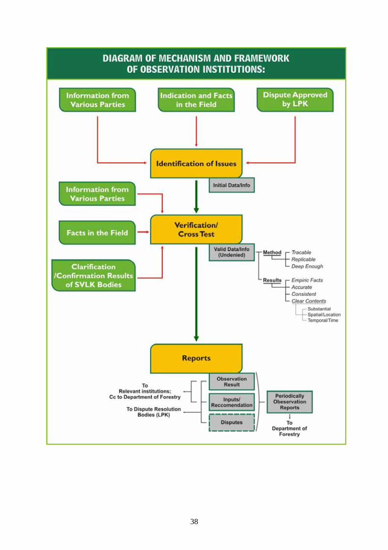
38
39
IX. Conclusion and discussion against the Fair Wood Standard for Legality
The surveillance system for monitoring the wood trading and circulation today has been implemented by using the legal document called SKSHH (certificate of legal log letter) issued by district forest office. The certified legal log letter contains the information about trunk number, block number, kind of timber, diameter, length and seal of corporate identity is put into every trunk. However, the main problem about this system is, there are no multi-stakeholders monitoring and verification processes for this document. The minus point of this system is that there is no tracking scheme to verify the origin of wood derivation to the cutting block source (CoC process). In this case, there are no guarantees that the wood will not be mixed with another illegal wood source in the process of producing panel board or furniture. The institutions issuing the letter monitor the weakness, and some corruption still occur and has caused this certificate of legal log letter distrusted for legal wood verifications system. And also at the SKSHH letter, another purpose of this letter actually is to make sure the companies have paid for forest product tax (PSDH) and the forest rehabilitations fund (DR). The SKSHH letter will not be issued by district forest office if the company does not pay for the tax and forest rehabilitations fund.
The problems of wood trading and circulations in Indonesia make some forest stakeholders more conscious with legal issue, and made some initiative to create standard procedure for legal timber trading source called Timber Legality Assurance System (TLAS). Many stakeholders expect the standard can guarantee the legality of wood trading and circulation, not only based on legal document issued as usually used. The opportunity of this new system is a multi-stakeholder involved to develop this standard, and when the standard has been implemented already, this verification legality for wood will be mandatory. The multi-stakeholder in TLAS will make sure whether the legal verification process was monitored correctly or not. The verification process in TLAS is arranged and maintained to accommodate the objections if there are some problems discovered. The opportunity of TLAS For Timber Company is the legality verification system which will verify their timber product legal for trading.
The system and verification legality standard has been finalized for the implementation in Indonesia, the stakeholders nowadays are still waiting for the regulation which will be issued by Indonesian government so it will have a force of law when it is implemented. The latest news of the progress for this standard implementation is that, the multi-stakeholders who have developed this standard are waiting for the government issuing the regulation at the end of this year, so hopefully this standard can be applied by 2009.
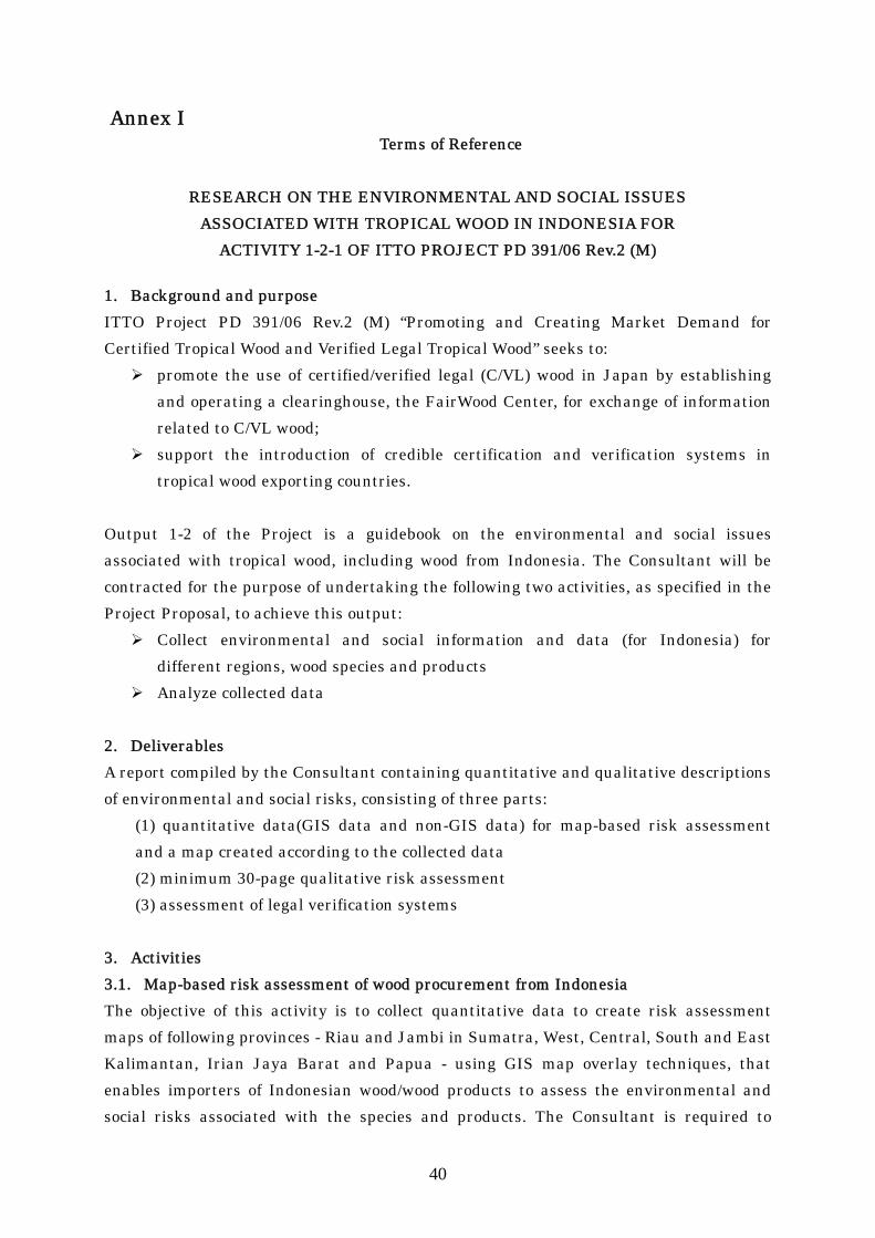
40
Annex I Terms of Reference
RESEARCH ON THE ENVIRONMENTAL AND SOCIAL ISSUES
ASSOCIATED WITH TROPICAL WOOD IN INDONESIA FOR ACTIVITY 1-2-1 OF ITTO PROJECT PD 391/06 Rev.2 (M)
1. Background and purpose ITTO Project PD 391/06 Rev.2 (M) “Promoting and Creating Market Demand for Certified Tropical Wood and Verified Legal Tropical Wood” seeks to:
promote the use of certified/verified legal (C/VL) wood in Japan by establishing and operating a clearinghouse, the FairWood Center, for exchange of information related to C/VL wood;
support the introduction of credible certification and verification systems in tropical wood exporting countries.
Output 1-2 of the Project is a guidebook on the environmental and social issues associated with tropical wood, including wood from Indonesia. The Consultant will be contracted for the purpose of undertaking the following two activities, as specified in the Project Proposal, to achieve this output:
Collect environmental and social information and data (for Indonesia) for different regions, wood species and products
Analyze collected data 2. Deliverables A report compiled by the Consultant containing quantitative and qualitative descriptions of environmental and social risks, consisting of three parts:
(1) quantitative data(GIS data and non-GIS data) for map-based risk assessment and a map created according to the collected data (2) minimum 30-page qualitative risk assessment (3) assessment of legal verification systems
3. Activities 3.1. Map-based risk assessment of wood procurement from Indonesia The objective of this activity is to collect quantitative data to create risk assessment maps of following provinces - Riau and Jambi in Sumatra, West, Central, South and East Kalimantan, Irian Jaya Barat and Papua - using GIS map overlay techniques, that enables importers of Indonesian wood/wood products to assess the environmental and social risks associated with the species and products. The Consultant is required to
41
provide GIS data of the best available resolution (grid), or, if GIS data is not available, the latest conventional maps and quantitative data, for each province and to compile a map. The Consultant is required to gather data on the following subjects:
GIS data for Forest Resource Classification, Distribution and Vulnerability • Natural forest cover (2003) • Conservation Area (Kawasan Konservasi) (2003) • Protected Area (Kawasan Lindung) (2003) • Concession Area, HPH and HTI (2006 or 2007) • Production Forest for Conversion (HPK) (2001) • Forest fires (only spot distribution for current risk/2006) • Location of export ports (ports where is generally known for export) • Road map
Non-GIS data
• Census data (Population and density) 3.2. Qualitative risk assessment of wood procurement from Indonesia The Consultant should provide a minimum 30-page qualitative assessment, supported with quantitative data as appropriate, of the environmental and social risks of wood procurement from Indonesia. Information should be gathered from a literature review of academic material, articles in popular media (such as newspapers and the Internet) and official reports. In addition, it's highly recommended to visit two actual locations to update and verify the gathered data. The assessment should present a balanced perspective covering the views of all major forest stakeholders including indigenous people’s organizations, non-governmental organizations, industry representatives and government departments. 3.3. Risk assessment of the legal verification systems for wood procurement In Indonesia, various systems for verifying legality of exported wood/wood products are available. The objective of this activity is to provide importers with an indication of the credibility of these systems to provide assurance of legality.
Guidance for defining legality in Indonesia The Consultant should describe the initiatives in Indonesia to define legality, including their criteria and indicators and the laws that they incorporate. The Consultant should compare these definitions/standards with the FairWood Center

42
generic legality standard (see Attachment) and highlight similarities and differences.
Assessment of legal verification systems The Consultant should provide a description and assessment of existing legal verification systems, highlighting strengths and possible weak points, using the FairWood Center generic standards for legality (see Attachment) and ISO standards as a guide. The Consultant should begin this task by reviewing independent studies of these schemes. 4. Reporting Schedule 1. Monthly Progress Report
To be sent to the Executing Agencies monthly from the date of the contract by e-mail. This should include brief description of any progress of the research
2. Interim Report by 31st October, 2007 Compile information gathered by the above deadline.
3. Draft Final Report by31st December, 2007 Compile the research result. This should be nearly completed version of the report. The executing agencies will review the draft report and send comments back to FWI within 3 weeks. The Subcontractors to work on the report to reflect the Executing Agencies’ comments.
4. Final Report Final Report shall be submitted by the Subcontractors within 2 weeks from receiveing the Executing Agencies’ comments on the draft final report.
End of the Documents

43
Annex II
FSC Minimum criteria for assessing high-risk forest areas ===========================================
Criteria Resources 1 Violation of traditional and civil rights. A forest area shall be considered high risk in relation to violation of traditional and civil rights if: 1.1 There is a UN Security Council ban on timber exports from the country in which the district is located
E.g. This has been applied to Liberia since July 2003 www.un.org/esa/africa/UNNews_Africa/timber.htm E.g Global Witness www.globalwitness.org
1.2 Conflicts of substantial magnitude related to long term tenure and use rights to the land and forest resources take place and involve indigenous people in the forest area 1.3 Conflicts of substantial magnitude related to long term tenure and use rights to the land and forest resources take place in the forest area and involve a significant number of interests 1.4 Country/district is a conflict timber area E.g USAID Type 1 conflict Timber
The final report of the expert panel on illegal exploitation of natural resources and other forms of wealth in Democratic Republic of Congo, 2002, Annexes I and III (S/2002/1146) www.naturalresources.org/minerals/CD/docs/other/N0262179.pdf Conflict Timber: Dimensions of the Problem in Asia and Africa. Volume I. Synthesis report. June 2003, available at: www.usaid.gov/hum_response/oti/pubs/vol1synth.pdfConflict Timber: Dimensions of the Problem in Asia and Africa. Volume I. Synthesis report. June 2003, available at: www.usaid.gov/hum_response/oti/pubs/vol1synth.pdf
2 Forests with high conservation values which are threatened. A forest area shall be considered high risk in relation to threat to high conservation values if: 2.1 The forest area is in or contains a ‘Global 200’ Ecoregion
www.panda.org
2.2 The forest area is in or contains a biodiversity hotspot
www.conservation.org
2.3 The forest area is in or contains a large Intact Forest Landscape
www.greenpeace.org, www.fwi.or.id
2.4 High conservation values as defined by FSC endorsed national or regional standards are not protected by national or local law
FSC National Initiatives contacts www.fsc.org Regional forest authority responsible for country/district in question
3 Genetically Modified Trees. A forest area shall be considered high risk in relation to avoiding timber from Genetically Modified trees if: 3.1 The forest area has commercial plantations of GM trees, and
Preliminary review of biotechnology in forestry, including genetic modification ftp://ftp.fao.org/docrep/fao/008/ae574e/ae574e00.pdf Biotechnology in the forestry sector

44
Criteria Resources http://www.fao.org/docrep/008/ae574e/AE574E06.htm
3.2 There is a GM variety of the species in question
As of June 2004, GM varieties of the following species have so far undergone field trials: Poplar (Populus hybrids, also known as Aspen and Cottonwood); Eucalyptus (E. grandis and E. globulus); Pines (Pinus taeda, Pinus pinaster); Douglas Fir (Pseudotsuga menziessii); Spruces (Picea sitchensis, Picea abies, Picea nigra)
4 Illegally Harvested Wood. A forest area shall be considered high risk in relation to illegal harvesting if: 4.1 Large scale illegal harvesting occurs in the forest area, and
FSC National Initiatives (contacts from www.fsc.org); The Royal Institute of International Affairs (www.illegal-logging.org); Environmental Investigation Agency (www.eia-international.org); Global Witness: (www.globalwitness.org); Telapak (for Indonesia - www.telapak.org); WWF (www.panda.org); UK Government’s Department for International Development (DFID) EU FLEGT process)
4.2 The district of origin processes and trades in wood or wood products from forest areas where large scale illegal harvesting occurs
See above
5 Wood harvested from areas which have been converted from natural forest to plantations or non-forest uses. A forest are shall be considered high risk in relation to conversion of natural forest to plantations or non-forest uses if: 5.1 Wood supplied is from native forest species, and 5.2 It is legal to convert the natural forest to plantation or non-forest use in the country or district
FSC National Initiatives. Please contact www.fsc.org
5.3 Large scale conversion of forest to non-forest use takes place in the forest area
See above
Source: Annex 2 of the standard FSC-STD-40-005, FSC standard for non FSC-certified controlled wood (see: www.fsc.org).

45
Annex III Quantitative Risk Assessment for Regions of Indonesia
Using FSC Minimum Criteria ========================================
‘1’ = Risk Present ‘0’ = Risk Absent
Criteria Riau Jambi West
Kalimantan Central Kalimantan
South Kalimantan
East Kalimantan
Irian Jaya Barat
Papua
1 Violation of traditional and civil rights. A forest area shall be considered high risk in relation to violation of traditional and civil rights if:
1.1 There is a UN Security Council ban on timber exports from the country in which the district is located
0 0 0 0 0 0 0 0
1.2 Conflicts of substantial magnitude related to long term tenure and use rights to the land and forest resources take place and involve indigenous people in the forest area
1 1 1 1 1 1 1 1
1.3 Conflicts of substantial magnitude related to long term tenure and use rights to the land and forest resources take place in the forest area and involve a significant number of interests
1 1 1 1 1 1 1 1
1.4 Country/district is a conflict timber area 0 0 0 0 0 0 0 0
Total 2 2 2 2 2 2 2 2
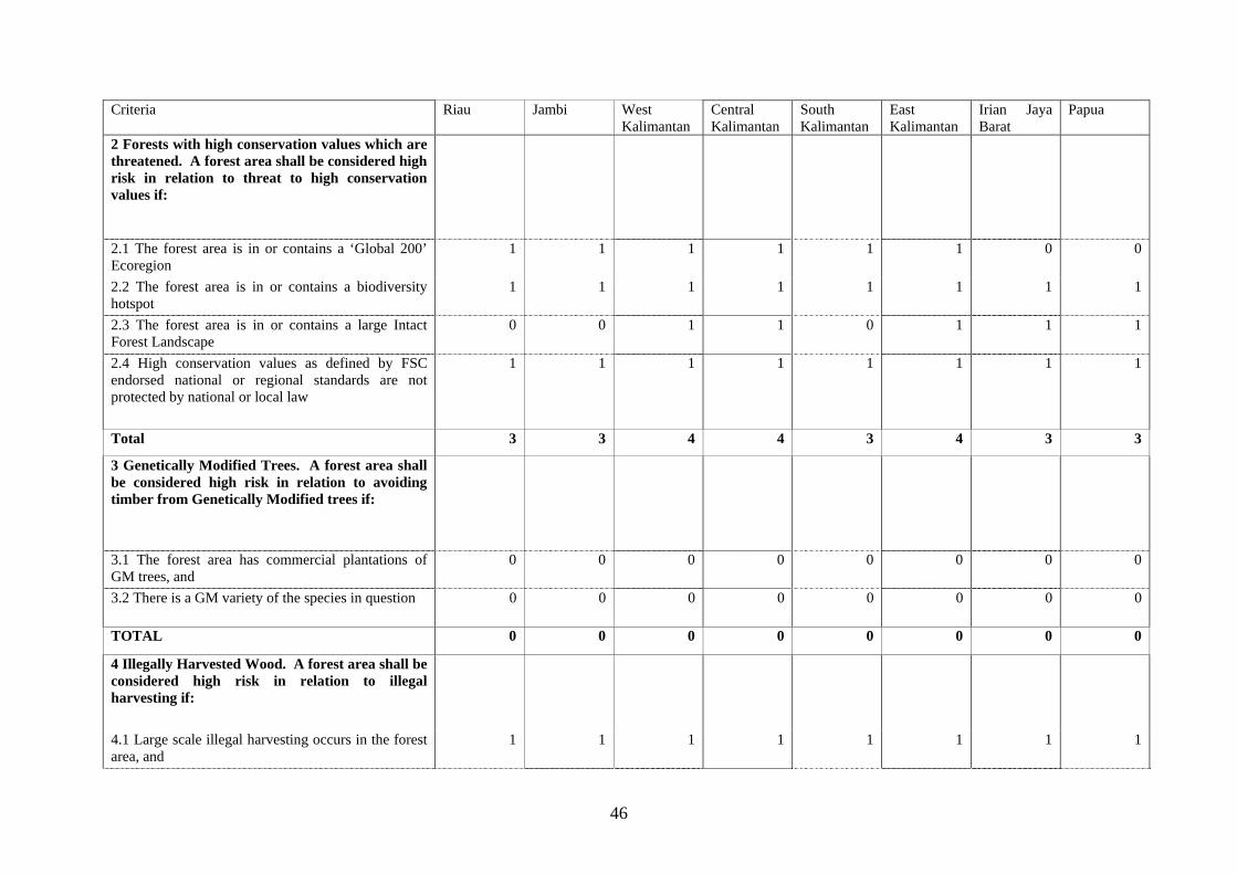
46
Criteria Riau Jambi West Kalimantan
Central Kalimantan
South Kalimantan
East Kalimantan
Irian Jaya Barat
Papua
2 Forests with high conservation values which are threatened. A forest area shall be considered high risk in relation to threat to high conservation values if:
2.1 The forest area is in or contains a ‘Global 200’ Ecoregion
1 1 1 1 1 1 0 0
2.2 The forest area is in or contains a biodiversity hotspot
1 1 1 1 1 1 1 1
2.3 The forest area is in or contains a large Intact Forest Landscape
0 0 1 1 0 1 1 1
2.4 High conservation values as defined by FSC endorsed national or regional standards are not protected by national or local law
1 1 1 1 1 1 1 1
Total 3 3 4 4 3 4 3 3
3 Genetically Modified Trees. A forest area shall be considered high risk in relation to avoiding timber from Genetically Modified trees if:
3.1 The forest area has commercial plantations of GM trees, and
0 0 0 0 0 0 0 0
3.2 There is a GM variety of the species in question 0 0 0 0 0 0 0 0
TOTAL 0 0 0 0 0 0 0 0
4 Illegally Harvested Wood. A forest area shall be considered high risk in relation to illegal harvesting if:
4.1 Large scale illegal harvesting occurs in the forest area, and
1 1 1 1 1 1 1 1

47
Criteria Riau Jambi West Kalimantan
Central Kalimantan
South Kalimantan
East Kalimantan
Irian Jaya Barat
Papua
4.2 The district of origin processes and trades in wood or wood products from forest areas where large scale illegal harvesting occurs
1 1 1 1 1 1 1 1
TOTAL 2 2 2 2 2 2 2 2
5 Wood harvested from areas which have been converted from natural forest to plantations or non-forest uses. A forest are shall be considered high risk in relation to conversion of natural forest to plantations or non-forest uses if:
5.1 Wood supply is from native forest species, and 1 1 1 1 1 1 1 1
5.2 It is legal to convert the natural forest to plantation or non-forest use in the country or district
1 1 1 1 1 1 1 1
5.3 Large scale conversion of forest to non-forest use takes places in the forest area
1 1 1 1 1 1 1 1
TOTAL 3 3 3 3 3 3 3 3
GRAND TOTAL 10 10 11 11 10 11 10 10
Source: Annex 2 of the standard FSC-STD-40-005, FSC standard for non FSC-certified controlled wood (see: www.fsc.org).