english heritage extensive urban survey an … · somerset extensive urban survey glastonbury...
TRANSCRIPT

English Heritage Extensive Urban Survey
An archaeological assessment of
Glastonbury
Clare Gathercole
Jane Murray Corporate Director Culture and Heritage Directorate Somerset County Council County Hall TAUNTON Somerset TA1 4DY 2003
SOMERSET EXTENSIVE URBAN SURVEY
GLASTONBURY
ARCHAEOLOGICAL ASSESSMENT
by Clare Gathercole
CONTENTS
I. INTRODUCTION . . . . . . . . . . . . . . . . . . . . . . . . . . . . . . . . . . . . . . . . . . . . . . . . . . . . . . . 3
II. MAJOR SOURCES . . . . . . . . . . . . . . . . . . . . . . . . . . . . . . . . . . . . . . . . . . . . . . . . . . . . 3
1. Primary documents . . . . . . . . . . . . . . . . . . . . . . . . . . . . . . . . . . . . . . . . . . . . . . . 3
2. Local histories . . . . . . . . . . . . . . . . . . . . . . . . . . . . . . . . . . . . . . . . . . . . . . . . . . . 3
3. Maps . . . . . . . . . . . . . . . . . . . . . . . . . . . . . . . . . . . . . . . . . . . . . . . . . . . . . . . . . . . 3
III. A BRIEF HISTORY OF GLASTONBURY . . . . . . . . . . . . . . . . . . . . . . . . . . . . . . . 4
IV. THE ARCHAEOLOGY OF GLASTONBURY . . . . . . . . . . . . . . . . . . . . . . . . . . . . 7
GENERAL COMMENTS . . . . . . . . . . . . . . . . . . . . . . . . . . . . . . . . . . . . . . . . . . . . . . 7
1. PREHISTORIC . . . . . . . . . . . . . . . . . . . . . . . . . . . . . . . . . . . . . . . . . . . . . . . . . . 8
2. ROMAN . . . . . . . . . . . . . . . . . . . . . . . . . . . . . . . . . . . . . . . . . . . . . . . . . . . . . . . 10
3. DARK AGE/ SAXON . . . . . . . . . . . . . . . . . . . . . . . . . . . . . . . . . . . . . . . . . . . . . 12
4. MEDIEVAL AND POST-MEDIEVAL . . . . . . . . . . . . . . . . . . . . . . . . . . . . . . . 27
5. INDUSTRIAL (LATE 18TH AND 19TH CENTURY) . . . . . . . . . . . . . . . . . . 51
6. 20TH CENTURY . . . . . . . . . . . . . . . . . . . . . . . . . . . . . . . . . . . . . . . . . . . . . . . . 56
V. THE POTENTIAL OF GLASTONBURY . . . . . . . . . . . . . . . . . . . . . . . . . . . . . . . . 57
1. Research interests . . . . . . . . . . . . . . . . . . . . . . . . . . . . . . . . . . . . . . . . . . . . . . . 57
2. Areas of potentially exceptional preservation . . . . . . . . . . . . . . . . . . . . . . . . . . 57
3. Limitations . . . . . . . . . . . . . . . . . . . . . . . . . . . . . . . . . . . . . . . . . . . . . . . . . . . . . 57
4. Extent of current protection, shown on Map G and Map H . . . . . . . . . . . . . . 58
5. Management Proposals . . . . . . . . . . . . . . . . . . . . . . . . . . . . . . . . . . . . . . . . . . . 58
VI. SOURCES . . . . . . . . . . . . . . . . . . . . . . . . . . . . . . . . . . . . . . . . . . . . . . . . . . . . . . . . . . 58
1. General documentary (Somerset/ Wessex) . . . . . . . . . . . . . . . . . . . . . . . . . . . . 58
2. Glastonbury . . . . . . . . . . . . . . . . . . . . . . . . . . . . . . . . . . . . . . . . . . . . . . . . . . . . 59
3. Maps . . . . . . . . . . . . . . . . . . . . . . . . . . . . . . . . . . . . . . . . . . . . . . . . . . . . . . . . . . 64
VII. COMPONENT INDEXES . . . . . . . . . . . . . . . . . . . . . . . . . . . . . . . . . . . . . . . . . . . . 64

1. Component to map . . . . . . . . . . . . . . . . . . . . . . . . . . . . . . . . . . . . . . . . . . . . . . . 64
2. Component to page . . . . . . . . . . . . . . . . . . . . . . . . . . . . . . . . . . . . . . . . . . . . . . 65
VIII. TABLE OF ARCHAEOLOGICAL INVESTIGATIONS . . . . . . . . . . . . . . . . . . . 68
Appendix: Maps


4 Somerset Extensive Urban Survey - Glastonbury Archaeological Assessment
SOMERSET EXTENSIVE URBAN SURVEY
GLASTONBURY
ARCHAEOLOGICAL ASSESSMENT
Somerset County Council would like to thank all the people who assisted in the compiling or
editing of this report.
I. INTRODUCTION
This report forms one of a series commissioned by English Heritage and prepared by Somerset
County Council with the aim of assessing urban archaeology as part of the Monuments Protection
Programme. The work was carried out from 1994 to 1998 by Clare Gathercole and Miranda
Richardson (from 1996), managed by Chris Webster. The reports are essentially as completed
during that period but have been updated by Chris Webster with new archaeological information
in 2003.
English Heritage has funded two programmes assess the urban archaeological resource -
intensive and extensive. The former is restricted to the major historic cities, characterised by a
great depth of archaeological remains, a wealth of historical documentation and in many cases,
by a great deal of archaeological investigation. The extensive urban surveys cover the smaller
towns and are based on information in the local Sites and Monuments Record with limited
amounts of new information collected during the project. Once the information has been
collected and mapped, attention is focused on the analysis of the town plan and defining
topographic units within the town. This will lead to the preparation of guidance for planners,
developers and others involved in the management of the town.
II. MAJOR SOURCES
1. Primary documents
Glastonbury is exceptionally well-documented. Though most material relates to the medieval
and later periods, more than ninety pre-Conquest charters have been identified, the oldest
probably 7th century. Much was lost in the great fire of 1184, and, like Glastonbury’s chronicles
and the saints’ lives (many of which were produced at the medieval Abbots’ behest), the
surviving charters are not wholly reliable sources. But the earliest of the medieval Abbey’s
chroniclers, William of Malmesbury, was perhaps the most careful; his work, De Antiquitate
Ecclesiae Glastonie, which was written in the early 12th century, is a valuable historical source,
if read carefully.
As well as national and local taxation and governmental records, Glastonbury has an abundance
of documentary material, including cartularies, rentals and surveys. Much of this has still not

5Somerset Extensive Urban Survey - Glastonbury Archaeological Assessment
been fully digested by historians, but some details are given in Dunning’s history of Glastonbury
(1994).
Glastonbury was much visited in the post-medieval period and a number of travellers’
descriptions exist.
2. Local histories
Historical studies of Glastonbury abound, though there is as yet no VCH coverage. Amongst the
more recent studies of the town of Glastonbury are those by Rahtz (1993) and Dunning (1994),
on both of which this report leans heavily.
3. Maps
The earliest detailed map of part of Glastonbury is dated c1609, though the earliest map showing
the whole town in any detail is much later, being dated c1778. A number of post-medieval
illustrations of the town also exist, notably those made by Hollar in the later 17th century.
III. A BRIEF HISTORY OF GLASTONBURY
Glastonbury stands on a peninsula which protrudes westward into the Somerset Levels. The
peninsula, dominated by the hard-sandstone capped Tor, has for millennia formed a prominent
landmark, an apparent island in the often flooded lowlands (though a natural causeway in fact
links it with the Mendip uplands to the east). Enough raised limestone, marl and clay beds
surround the Tor to form a shelf suitable for occupation, cultivation and quarrying, whilst the
Levels below have provided a range of natural resources varying with sea and rainfall levels.
The Brue Valley, which runs to the south of Glastonbury, separating it from Street, and north-
west into the Levels, has in the last 150 years been the scene of archaeological discoveries of
international importance. The Prehistoric trackways and ‘lake settlements’ are the remains of
thousands of years of exploitation of a wetland environment which has only gradually been
domesticated. These remains have been preserved by the alluvial and peat deposits created by
the endemic flooding which brought each individual episode of activity to an end. The same
deposits are responsible for the potential richness of the land around Glastonbury, and therefore
in part for the huge effort that its historic rulers have put into maintaining drainage and
controlling sea floods. However, the area has always been, and remains, liable to flooding, with
the peninsula of Glastonbury providing a constant focus, always accessible by water, and a less
constant refuge, the lower reaches (including the town) having been flooded many times.
There is curiously little firm archaeological evidence (though many beliefs) relating to the role
of the peninsula of Glastonbury, and the Tor itself, in the Prehistoric landscapes.
Evidence of a Roman presence at Glastonbury is also fragmentary at present, but coins and the
remains of glass, tiles and building materials found in the Abbey area imply that an establishment
of some kind existed near there. It has been suggested that at least one of the wells in the Abbey
- that in the crypt of the Lady Chapel - may be of Roman date, and that, in a similar process to
that seen at Wells, an early sacred place venerated in the Roman period (and perhaps earlier) may

6 Somerset Extensive Urban Survey - Glastonbury Archaeological Assessment
have formed the nucleus of later churches (Rahtz, 1993). Other finds of building materials on
Wearyall Hill may represent activity along the Roman road, as it is thought that the southern
causeway onto the peninsula, the Street, may have been established in this period. However,
much work remains to be done before the Roman period at Glastonbury can be understood.
The legends of Glastonbury suggest that it was an important place in the shadowy years between
the collapse of imperial government in Britain and the establishment of Anglo-Saxon power in
the west. Glastonbury’s associations with post-Roman British resistance to the Anglo-Saxon
expansion - and in particular with Arthur - may have been exaggerated by the medieval monks,
but are not necessarily wholly without foundation. High status dark age occupation on the Tor,
perhaps a chieftain’s stronghold (though perhaps a monastic site), has been confirmed by
archaeological excavations.
It is also possible that the traditions of a British origin for the Abbey may be based in truth,
though this remains more problematical. The first reliable charters for the estates of the Abbey,
the driving force of Glastonbury’s medieval history, are late 7th century, and there is no proof -
archaeological or documentary - that the Abbey existed before this. However, an earlier charter
of 601, though not considered authentic in its present form, may record an actual grant of land
by an unnamed British king of Dumnonia to the Old Church (Bond, c1990). The Saxon charters
also show that some (though not the earliest recorded) of the early Abbots had British names,
which may support the idea of an existing British tradition, later taken over by the Saxons (Rahtz,
1993), as may the close links between Glastonbury and Ireland.
The interest of the Irish in Glastonbury is recorded in Irish documents (Thomas, 1994). The
association with the Irish church was potently expressed in the later Saxon belief that the Abbey
had been founded by Patrick, and that it held the remains or relics of a number of saints of the
Celtic church; it may also have been expressed in the form of the Abbey and outlying monastic
sites in the 7th and 8th centuries. Glastonbury was certainly on the cross-peninsular pilgrim route
heading for the Continent, by the later Saxon period, by which time there must have been some
kind of settlement servicing the pilgrims. In fact a named settlement is first referred to in charters
also of the late 7th and the early 8th century, the name appearing as Glestingaburg. The ‘burg’
element is Anglo-Saxon and could refer either to a fortified place or, more likely, a monastic
enclosure; the ‘Glestinga’ element is obscure, and may derive from a British word or from a
Saxon personal name.
Even by the 9th century, the settlement would have been dominated by Abbey, which had a
‘special relationship’ with the Wessex dynasty (Abrams, 1996). However, there is an indication
of the effect that the unsettled years of the Danish incursions had on the Abbey’s growth in the
fact that Alfred the Great apparently granted it no land at all. Whilst a small number of 9th and
early 10th century charters nevertheless indicate the continued existence of some kind of
community at Glastonbury (Abrams, 1996), it is possible that it was weakened by the
appropriation of many of its lands by the king to reward his men (Costen, 1992), and it may itself
have been attacked during the wars (though this is not certain). William of Malmesbury indeed
states that Glastonbury was without monks from Alfred’s time until the mid 10th century. Whilst
the church would probably have continued to function, served by clerks like other minsters, it

7Somerset Extensive Urban Survey - Glastonbury Archaeological Assessment
would have been a far cry from the rich royal monastery of the previous century.
In this context, Dunstan’s reform and virtual refoundation of the monastery as a Benedictine
house in the mid 10th century was a true renaissance. He expanded and remodelled the Abbey
and one must also assume that he presided over an expansion of Abbey lands to support the
building programme, perhaps a recovery of lands lost in the 9th century. Following Dunstan,
Glastonbury continued to ride the crest of a wave: witangemots were held there, Kings Edmund
(946), Edgar (975) and Edmund Ironside (1016) were buried there; and for a short time the
English treasury was held at Glastonbury. The Abbey became “one of the richest, and at times
the richest, of all the great Benedictine houses in England” (Rahtz, 1993), and its special
jurisdiction over the Twelve Hides became established.
There must have been a sizeable settlement serving the Abbey by Domesday, but there is no
evidence that it was in any sense urban: there was no mint, and no town was recorded at
Domesday. As already stated, the pilgrim trade must have been a major driving force for the
settlement. Certainly by the late 10th or early 11th century, several saints (including both Aidan
and Patrick) were already popularly believed to lie at Glastonbury and “lives” of famous figures
associated with Glastonbury (especially Dunstan himself) were already circulating.
The extent of the lands granted to Glastonbury between the mid 10th and the mid 11th century
reflects the importance of the place not only to the populace but also to the English aristocracy.
The Domesday Book reveals Glastonbury Abbey to have been the wealthiest in England in the
second half of the 11th century, even though the Conquest had disrupted its economic, and its
spiritual, life. Perhaps because it was such a Saxon power base, the first Norman Abbot (Turstin,
appointed 1082) came in determined to bend the monks to his will, and was not averse to the use
of force. He began a new church which was never completed, and his successor, Herlewin, began
an even larger one. Just as significantly for the town, Herlewin and Turstin also extensively
remodelled the precinct boundary, laying the foundations of a new stage in Glastonbury’s
development.
The 12th century brought both successes and misfortunes to the Abbey and its settlement.
Herlewin’s church was completed in the 12th century by Henri de Blois, an aristocrat and an
extremely able man. During his term he sorted out the Abbey’s finances, and refurbished,
improved and extended its buildings and territory. He was also the patron of William of
Malmesbury, who wrote his “De Antiquitate...” in the first half of the 12th century (to prove that
Glastonbury was more venerable than Westminster). This work, the original text of which does
not survive, was manipulated and “improved” in the later 12th century by other Abbey
chroniclers, the most important being Adam of Domerham (to 1291) and John of Glastonbury
(to the end of the 15th century), and their forgeries have shaped the popularly perceived history
of the town.
Part of the reason for the treatment of William’s work was the huge and long-lasting financial
crisis provoked by the serious fire which took place in 1184, not long after the death of Henri de
Blois. This destroyed the Old Church and many books, vestments and relics which had been
accumulated. Glastonbury was therefore bereft of some of its greatest “tourist attractions” just

8 Somerset Extensive Urban Survey - Glastonbury Archaeological Assessment
as it needed the income in order to rebuild. Henry II was very supportive of the Abbey but at the
time of his death, in 1189, its future must have looked very uncertain. It is in this context that
the monks’ 1191 exhumation of “Arthur” took place. This ‘coup’ proved to be a mixed blessing
as the Abbot responsible (Henry de Soilly) was quickly promoted to a bishopric and left. His
successor, Savaric, who was also bishop of Bath, attempted, sometimes brutally, to subordinate
Glastonbury to Bath. The Pope had to intervene, undoing the union of Bath and Glastonbury,
and ushering in a period of intense rivalry for the control of the resources of the Levels, leading
to lawsuits and physical attacks.
Up to this point, the growth of the medieval settlement had been inhibited by the proximity of
Wells and the degree of control exercised by the Abbots (Dunning, 1994). After the fire, in an
attempt to foster the revenues, the new precinct was slightly adjusted to form the nucleus of a
new medieval town. This, the Nova Villa referred to in documents of 1260, was gradually laid
out in the late 12th and 13th centuries, probably across the old settlement: archaeology is
building up a picture of wholesale reorganisation in the town at this time.
The mid 13th to the 15th centuries were comparatively settled times for the Abbey and the town.
The Abbey’s buildings and estates continued to expand, as did the legendary associations (such
as that between Glastonbury and Joseph of Arimathea), which were vigorously promoted. The
town rode on the back of the Abbey’s success, attracting many visitors, some of whom left
descriptions. These visitors included William of Worcester, who came in 1478 and 1480, and
gives much useful information on locations and dimensions of buildings and streets. The town
did not entirely depend on the Abbey: the wool trade was also important to it. But the Abbots
maintained control of their town, which did not become a free borough; a request to send MPs
to Westminster in 1319 was ignored and was not repeated.
One of the latest Abbots, Richard Bere (1494-1525), is also regarded as having been one of the
greatest since Dunstan, and a number of his buildings still survive in town. The last Abbot,
however, was Richard Whiting (1525-1539), who presided during the Dissolution. Though the
Abbey, valued in 1535 as the richest in the land, survived longer than any other Somerset Abbey,
its final closure was particularly traumatic. Whiting, then in his 70s, was hanged, beheaded and
quartered on the Tor for alleged “robbery” (that is, concealing the Abbey’s treasure, which he
probably did). The shocked and demoralised monks were pensioned off and a long chapter in
Glastonbury’s history drew to a close.
One of the earliest post-medieval accounts of Glastonbury is that of Leland, who had actually
been entertained by Abbot Whiting when he visited the town in 1533. It was after his second
visit, in 1542, however, that Leland wrote his description of the route in across the marsh and the
town’s layout, market and churches: he did not even mention the Abbey, which was by then
closed and being dismantled. The loss of business, status and confidence caused by the Abbey’s
closure could have crippled the town, and there was some concern amongst the major landlords.
An attempt to revivify the economy took place under Edward, though the plantation of a large
community of Walloon weavers in the precinct failed on the accession of Mary. An attempt in
1554 to make Glastonbury the county town of Somerset also failed, and in the later 16th century
the town experienced intermittent difficulties. A 1598 crown survey of the manor showed some

9Somerset Extensive Urban Survey - Glastonbury Archaeological Assessment
urban decay, but, significantly, also showed that the inns continued to flourish, for Glastonbury
was still in a good location.
Other travellers’ accounts - of which there are a good number, including those of Brereton,
Savage, Fiennes, Defoe and Stukeley - show that the town continued in reasonably good repair
and survived as a communications and local market centre in the 16th to 18th centuries, though
the economy was never buoyant, and the Abbey itself was virtually left to rot. Sir William
Brereton visited in 1635, and described the town as good and fair, mentioning the precinct wall,
the “dainty” market house and the surrounding lands. But by the 1640s, though Glastonbury was
still considered one of the “great towns”, it was not keeping up with places like Bridgwater and
Wells, and its reputation suffered. It was plundered in 1645 by Parliamentary troops on the
retreat, and the precinct was used as a campsite by Monmouth’s forces in 1685. In the late 17th
century Celia Fiennes described the Abbey as “now a ragged poor place” and in the early 18th
Stukeley described the awful state of the old Abbey, and the sales of fine stone which he
observed. The post-medieval accounts and other documents also show that flooding was still a
serious, if occasional, problem.
Despite these problems, the potential for growth was still there. Notwithstanding the failure of
the Walloon weavers, clothiers are consistently recorded in the 17th century. The charter of
incorporation received in 1705 was perceived as a major boost to the town and Peter King, the
first Recorder for the town under its terms, and afterwards Lord High Chancellor of England, was
a great local celebrity. The cloth trade and the market continued for a while to grow, though
competition from Somerton was a problem in the mid 18th century. The early drainage and
enclosure of Common Moor (the 1722 act was the first Parliamentary enclosure Act in Somerset)
and the establishment of a small spa (in the 1750s) gave the town an edge for a while, though it
was short-lived.
In common with many towns in Somerset, Glastonbury’s woollen trade failed in the late 18th
century, though the recent agricultural and communications improvements (the enclosures and
the turnpikes) buffered the economy to some extent. The town emerged from the Municipal
Reform process with a confirmed and amended charter of incorporation, and the mid 19th
century saw concerted efforts to boost the economy. Ambitions were concentrated on further
enclosure and improvement of the infrastructure. The success of the Brue Drainage (which
followed another great flood of 1794) and the early canals prompted a project to connect
Glastonbury to the canal network. The opening of the Glastonbury Canal did indeed cause an
upturn in trade, especially in the building trade. But the canal soon had drainage problems and
the Company almost collapsed, causing a great furore in the town and the suicide of one of the
shareholders, who jumped from St John’s tower.
The dramatic failure of the canal depressed the economy. In 1848 many houses in the town were
empty, and rentals had collapsed. But in that year the Canal Company sold out to the railways.
The Somerset Central opened its Highbridge to Glastonbury line in 1852, the line running
parallel to the Canal, which had been used to facilitate its construction and was shortly closed
despite undertakings to keep it open. Further lines linked Glastonbury to Wells and Blandford
by the mid 1860s. Some commercial growth in the sheepskin and footwear industries took place,

10 Somerset Extensive Urban Survey - Glastonbury Archaeological Assessment
largely in Northover and connected to the growth of Street. Moreover, the rise of antiquarianism
and the improvement in communications led in the 19th century, and has done so even more in
the 20th, to an increase in tourism. Indeed, though there was no dramatic expansion in
Glastonbury as a result of the initiatives of the 19th century, the resident population has been
rising steadily since 1801, except for minor hiccups in the 1840s and the 1890s.
IV. THE ARCHAEOLOGY OF GLASTONBURY
GENERAL COMMENTS
0.1 Archaeological work in the town
A summary of the excavations which have taken place in Glastonbury is given in the table on
p68.
There has been a relatively large amount of archaeological work in and around the town - relative
to other towns in Somerset, that is - though the bulk of it has until comparatively recently
concentrated on a few important sites including the Tor, Beckery, the Mound and, of course, the
Abbey. Though it was heavily quarried in the post-medieval period, the Abbey was largely
protected from disturbance - including that by antiquaries - in the 19th century. However, in
1907 it was sold to the Church of England, after which an extensive but inconsistently executed
programme of low-budget excavations was undertaken between 1908 and 1979. Sadly, the work
which has taken place “has not ... always been of the highest quality” (Rahtz, 1993) and much
of it has not been properly published: recent attempts to synthesise the Abbey results have
revealed numerous inaccuracies and discrepancies. On the other hand, not all of the excavations
removed all the archaeological deposits in the opened areas. This fact, together with the amount
of undisturbed ground remaining in the Abbey precinct, means that the Abbey precinct is still an
area of considerable archaeological potential, despite the missed opportunities of the past.
A number of smaller projects have been undertaken on other sites in and around the town, largely
in advance of developments. These have provided extremely important clues to the development
of the main elements of the settlement, but have raised as many questions as they have answered.
The peat deposits west of the town, which formed from the Prehistoric to the late-Saxon periods,
have been extensively studied by the Somerset Levels Project over many decades: though it
impinges on the western fringe of the town, much of that work is beyond the remit of this report.
In summary, the proportion of the available resource in Glastonbury which has been examined
so far is tiny; much remains to be done in integrating historical and archaeological evidence.
0.2 Standing structures and visible remains
Glastonbury contains a considerable number of surviving buildings of interest, many of which
are mentioned in the appropriate sections: as well as the ruins of the Abbey itself, these include
a small number of outstanding medieval urban buildings. The medieval town plan also survives
fairly well, as does the landscape to the east of the town, around the Tor and towards Ponter’s
Ball. In contrast, important features on the western margins of the town have been seriously

11Somerset Extensive Urban Survey - Glastonbury Archaeological Assessment
affected by modern industrial developments.
1. PREHISTORIC
(Map A)
1.1 Archaeological work in the town/ Archaeological knowledge
A summary of the excavations which have taken place in Glastonbury itself is given in the table
on p68.
The Wetlands: There have been a number of major excavations on the Levels west of the town
in the 20th century which have shown how the wetlands were being exploited in the Prehistoric
periods. These are beyond the scope of this report. However, more recent evaluations on the
west side of Glastonbury town have also taken place. These have shown the potential of the peat
deposits there to provide important environmental information. Preserved wood from trenches
near Benedict Street, for example, has helped to extend the Somerset tree ring sequences back
into the fifth millennium BC and, therefore, to date the oak used in two prehistoric trackways in
the Brue Valley (Brunning, Jones and West, 1996). Though no archaeological features are
defined in this area (see below) its potential cannot be disregarded.
The Peninsula: The peninsula has produced less tangible evidence of activity the Prehistoric
periods, though it is believed to have been of considerable importance in the landscape. The
SMR contains references to a number of finds of Prehistoric flints and pottery in and around
Glastonbury: these are described below. Several of the excavations, such as those at Ponter’s
Ball (Rahtz, 1993), Fairfield (Hollinrake, C & N, 1992b) and Maidencroft Farm, Wick
(Hollinrake, C & N, 1988a), have also recovered Prehistoric artefacts; but definite evidence of
settlement remains elusive.
1.2 Context
Glastonbury is one of eight out of the 45 historic towns covered by this project in the vicinity of
which Prehistoric activity and/or occupation has been shown, and at which there is also evidence
(limited, in this case) of settlement on or near the site of the later town - possibly, though not
necessarily, implying continuity of settlement. It is probable that the figure is far too low, for it
is notoriously difficult for archaeologists to demonstrate a Prehistoric presence in modern urban
areas. Though ‘towns’ were not, generally speaking, a feature of Prehistoric landscapes, many
of the same factors which made the site desirable in later periods would already have been
operative. In the case of Glastonbury, these would have included control of routes and springs
on the peninsula itself, and both access to and refuge from the marshland Brue Valley landscape,
which includes the famous Prehistoric trackways and settlements. However, the context of
Glastonbury cannot wholly be explained in such terms, for it can reasonably be regarded as being
a site of unique ritual importance in the Prehistoric landscape of Somerset.
1.3 Standing structures and visible remains
Though there are few certain visible remains of the Prehistoric period on the Glastonbury
peninsula, there is a possibility that Ponter’s Ball (SMR 23564) may have Iron Age origins, and
12 Somerset Extensive Urban Survey - Glastonbury Archaeological Assessment
that the Tor itself may have been sculpted in an even earlier time.
1.4 Archaeological features, shown on Map A
1.4.a The peat deposits
See above comments (section 1.1).
1.4.b Water
GLA/101 Chalice Well
Excavations in 1961 at Chalice Well recovered flints, probably Mesolithic, and
Iron Age or Roman potsherds at the original ground level (some four metres
below that of 1961). These show that the springs were already important as a
water source. However, the only archaeological evidence of possible long-
standing religious associations was the Roman yew stump found close to the
spring: yews still grow around the Well.
For the later history of the Well, see p30.
The marked area is based on information in the SMR and the 1844 map.
1.4.c Religious sites
GLA/104 Glastonbury Tor
The character of any activity on Glastonbury Tor in the Prehistoric periods is not
well understood. The theory that the terraces on the slopes of the Tor are the
remains of a gigantic Neolithic ritual maze cannot be absolutely ruled out, though
there is no archaeological evidence which unequivocally supports it (the theories
that the terraces are either natural geological features or medieval strip lynchets
are more widely accepted). The 1964-66 excavations on the Tor shoulder and
summit recorded no Prehistoric structures, though they did recover flints of the
Upper Palaeolithic, Mesolithic, and Neolithic periods, as well as a Neolithic axe:
this evidence was considered by the excavator to represent occasional activity on
the Tor rather than occupation (Rahtz, 1971).
For main entry, see GLA/302 (p16).
The marked area is from the SMR.
GLA/301 Ponter’s Ball
Though the balance of evidence so far is in favour of a Dark Age date for this
earthwork (see p16), its origins require further research. The theory that it
defends - or at least defines - an Iron Age (or earlier) territory or precinct are also
tenable.
The main entry for GLA/301 is on p16.
The marked alignment is from the OS maps and the SMR.
13Somerset Extensive Urban Survey - Glastonbury Archaeological Assessment
1.4.d Settlement
The Glastonbury Lake Village site (SMR 23637; SM Som 406) lies beyond the urban area and
is not included in this Assessment.
GLA/103 Coxwithy settlement site
A settlement at Coxwithy (SMR 23590) has been postulated from place name and
aerial photographic evidence, but remains unproven. The area is sloping to the
south and contains a number of visible lynchets, and one large rectangular
building platform (possibly belonging to a later barn). The evidence is not yet
sufficient to confirm the date and character of any settlement here.
From the SMR.
1.4.e Other sites
GLA/308 The Mound, Beckery
The Mound produced evidence of both Prehistoric and Roman activity as well as
the later occupation. For main entry, see p27.
From the SMR.
1.4.f Artefact scatters
GLA/102 Prehistoric artefact finds
Well provenanced finds in and around Glastonbury include a Neolithic axe on
Wearyall Hill (SMR 23571). A number of other Bronze Age flints and bronze
artefacts (including axes, palstaves, spearheads, a dagger and a pin) have been
found in the Turbaries to the west of the town. Though the exact provenance of
most of these is not known, the approximate focal point of the distribution is
marked in the SMR (SMR 23630).
Not mapped Unlocated Prehistoric finds include a perforated stone axe (SMR 23602), two
Bronze Age palstaves (SMR 26077), and other small items.
2. ROMAN
(Map A)
2.1 Archaeological work in the town/ Archaeological knowledge
A number of excavations in Glastonbury have shown evidence of some Roman activity in the
general area of the later town, though remains in situ have been limited. The 1964-66 excavations
on the Tor recovered finds of reused Roman building material, which may have been moved to
the Tor during the construction of the Dark Age settlement. Reused building material and
abraded potsherds have also been found at several other sites, including the Abbey precinct itself
(Radford, 1955-1973), the Mound (Rahtz, 1971; Carr, 1985), Beckery Chapel (Rahtz & Hirst,
1974), Fairfield (Hollinrake, C & N, 1992b), Bove Town (Hollinrake, C & N, 1985) and Wick
(Hollinrake, C & N, 1988a). The SMR also contains records of Roman material on Wearyall
Hill, described below.

14 Somerset Extensive Urban Survey - Glastonbury Archaeological Assessment
The meaning of the distribution of Roman material on Glastonbury peninsula is not yet clear.
Possible sites of structures have been suggested on the Abbey site and Wearyall Hill, and these
are the sites shown on the map, which necessarily gives only an incomplete picture of the
potential of Glastonbury’s Roman archaeology.
2.2 Context
The Roman period was one of deliberate, strategic urbanisation. The area which is now Somerset
appears to have been less affected than some other areas by this, in that few really urban sites are
known, and this probably reflects its marginal position. However, the widespread distribution
of Roman or Romanised settlements shows that the county - particularly east of the Parrett - was
heavily populated and exploited in this period.
Glastonbury is one of seven of the 45 historic towns covered by this project at which there is
evidence of a Roman site at the core of the later town. Four of these towns, including
Glastonbury (and Cheddar, Wells and - perhaps - Street) have probable villa sites at their heart,
and in each case there is also an apparent association with a (pre-existing?) religious site: each
was later reused as a religious precinct. There are signs of further occupation and agriculture
elsewhere on the peninsula, which, as in earlier periods, formed a significant island in the Brue
Valley.
2.3 Standing structures and visible remains
The only structure possibly remaining from the Roman period is St Jospeh’s well in the crypt of
the Lady Chapel.
2.4 Archaeological features, shown on Map A
2.4.a Communications
(a) Roads, streets and routeways
GLA/201 Possible Roman roads
Evidence is at present insufficient to allow a convincing reconstruction of the
Roman infrastructure immediately around Glastonbury. Old Street Road and Dod
Lane have both been put forward as being of Roman origin (Rahtz, 1993). The
name of the town of Street suggests that settlement may have flanked a Roman
route and finds of Roman material close to the Old Street Road (SMR 23571,
23631) tend to support this idea, though it is also possible that a more direct route
to the main Roman site followed the line later used by the Saxon canal (see p14).
Dod Lane links the Tor with the Abbeysite, which may have been occupied in the
Roman period (see below, GLA/203), but it may also be a continuation of a
Roman road from East Street, part of which survives on the east side of Norwood
Park (C. Hollinrake, in litt., 1997). The existence of a possible further Roman
site at Wick (below) also implies an early origin for the lanes serving it.
The Old Street Road alignment is from the 1778 map; the Dod Lane alignments
are from Hollinrake, C & N (1993b; in litt., 1997) and Rahtz (1993).
2.4.b Water

15Somerset Extensive Urban Survey - Glastonbury Archaeological Assessment
GLA/202 Roman wells in the Abbey
The only in situ structural evidence of Roman occupation of the Abbey site so far
has been the discovery of two probably Roman wells - St Joseph’s Well, later
incorporated into the Lady Chapel (Rahtz, 1993) and another, under the north
transept of the Great Church, which had been cut by Radford’s precinct ditch
(Radford, 1958).
The significance of St. Joseph’s Well has been the subject of much debate since
its rediscovery during the 19th century clearance of the crypt of the Lady Chapel.
It was immediately dubbed an ancient holy well because of its proximity to the
site of the Old Church. An archaeological investigation was carried out in 1991
and 1992 and the results of this support the view that the well is of some
antiquity, since the stonework of the lower part is comparable with other Roman
wells excavated in the area: a shaft 65cm in diameter was lined with well-laid
limestone blocks.
The trouble to which later builders went to make the well-head accessible
suggests that it was of significance to the founders of the Abbey. The form which
the well took in the days of the Old Church is not known: it would have lain just
outside the building and may have determined its location. Subsequent building
works incorporated the well, though they may have required the resetting of the
well head at its current low level in order to allow the construction of the new
chapel foundations (Rahtz, 1993).
The approximate positions of the wells are shown from Rahtz (1993) and Radford
(1958).
2.4.c Settlement
GLA/203 Roman occupation in the Abbey area (SMR 23565)
In the Abbey area, around St. Joseph’s well (see above, GLA/202), the
excavations have produced not only Roman potsherds, glass and coins but also
building materials - tiles and so on - suggestive of structures. The Saxon glass
kilns (see p22) were partly constructed of Roman box flue tiles which most
probably came from a building of some quality, perhaps a small villa (Woods,
1994) and estate centre. The remains were - except for the wells - not in situ,
being largely found in the 12th/13th century clay levelling deposits. However,
they are unlikely to have travelled far, and most unlikely to have been imported
onto the site as backfill for the post-medieval fishponds, as has sometimes been
stated (C Hollinrake, in litt., 1997).
Though the building itself has not yet been uncovered by the Abbey excavations,
not all of which went down to natural, the Abbey area remains the most obvious
16 Somerset Extensive Urban Survey - Glastonbury Archaeological Assessment
location for such a site (C J Webster, pers. comm.; Hollinrake, C & N, 1989b).
Nevertheless, the area shown must be regarded as highly conjectural.
The area is conjectural.
GLA/204 Wearyall Hill
Roman pot, coins and other artefacts have been recovered from a number of sites
in Glastonbury. The prominent antiquary, Morland, discovered quantities of
Roman pottery while he was building his house, 86 Roman Way (SMR 23571).
More material has come from the area of the old vineyards south of Roman Way,
on the south slopes of Wearyall Hill (SMR 23631). Rahtz suggests that the
quantity of material found at these sites, together with evidence of terracing on
the hillside suggests substantial occupation, possibly a temple (Rahtz, 1971:5).
The findspots at the west end of the hill are shown, from the SMR.
GLA/320 Wick
There is a possibility that settlement at Wick (a placename possibly deriving from
the Latin vicus: C. Hollinrake, in litt., 1997) may be of Roman or pre-Conquest
origin, since some abraded Roman material possibly indicative of Roman/ Dark
Age occupation has been recovered from the area. The exact location and extent
of such occupation is uncertain, but a possible area is indicated here.
The area shown is conjectural.
Not mapped The finds at Fairfield (Hollinrake, C & N, 1992b) may also have come from
another site at the eastern end of the hill, the location of which is unknown. They
could also be from the “villa” site (see above, GLA/203).
3. DARK AGE/ SAXON
(Map B)
3.1 Archaeological work in the town/ Archaeological knowledge
Many of the excavations which have taken place in Glastonbury have produced evidence relating
to post-Roman and Saxon occupation at Glastonbury. These are mentioned in the text below as
appropriate, and listed in the table (p68). Though a considerable amount of information has been
obtained, the excavations, particularly the smaller evaluations and watching briefs of the last
twenty-five years, have also raised many questions. A number of major sites relating to the post-
Roman/ Saxon transition (on the Tor, at Beckery and in the Abbey grounds) have been partially
investigated at Glastonbury and, as for the Prehistoric period, it has been suggested that the
whole peninsula may have been of importance. It is quite possible, therefore, that there may be
further significant sites as yet unlocated around the town.

17Somerset Extensive Urban Survey - Glastonbury Archaeological Assessment
3.2 Context
Though the Post-Roman and early Saxon periods were characterised by a return to non-urban
lifestyles, the later Saxon period (from the 9th century onwards) saw the beginnings of a
resurgence of trading places and towns. This was controlled, in England, by the Saxon royal
families (though it was part of a wider trend), and took place in the context of a network of royal
estate administration centres which was already established (in some cases long-established).
The reasons for the changes were many and complex, combining defensive, adminstrative and
ecclesiastical considerations with, increasingly, purely commercial aspirations.
As one of the heartlands of the kings of Wessex, Somerset played an important part in the early
re-urbanisation of the south, and there are a number of places amongst those studied for this
project which can claim to have been towns before the Norman Conquest. However, there are
also a number which can claim to have been ‘central places’ performing more limited, and non-
commercial, functions: not all such places developed into towns, but many towns originated in
such specialised settlements.
Glastonbury is one of seven of the 45 historic towns covered by this project which, whilst it had
not developed any really urban functions by the end of the Saxon period, had both ecclesiastical
and administrative functions. It is one of 22 towns associated with a known or probable pre-
Conquest minster - in this case also an extremely important monastic house (one of the richest
Benedictine Houses in the whole country) - and one of 22 associated with a royal manor centre
(though the estate was transferred to the church before the Conquest). Indeed, it was one of only
four of the historic towns to appear on the pre-Conquest royal itineraries of Wessex.
3.3 Standing structures and visible remains
Earthwork remains which may date to this period include those of part of the ‘canal’ (SMR
23600) and the bank of Ponter’s Ball (SMR 23564). No other Saxon structures survive.
3.4 Archaeological components, shown on Map B
3.4.a Redevelopment in earlier settlement components
It is possible that the early Abbey precinct represents a reuse of a high status Roman site (see
GLA/203, p11), but excavations in the precinct, though they have produced Roman material (not
in situ) have failed so far to prove this.
3.4.b Communications
(a) Roads, streets and routeways
GLA/306 Modern roads of Saxon or earlier origin
It is not possible at the moment to say with certainty which roads in Glastonbury
itself are of Saxon or earlier origin. The probable major routes towards Wells,
West Pennard, Edgarley/ Shepton, the Tor and Street/ Somerton are shown, as is
the lane towards Wick: some of these may also have served the unlocated Roman
sites on the peninsula. The route to West Pennard was apparently altered in the
medieval period with the establishment of Norwood Park, previously passing less
directly through Edgarley Field (C. Hollinrake, in litt., 1997; see below,
GLA/305). It is possible that some of the minor lanes may be of pre-medieval

18 Somerset Extensive Urban Survey - Glastonbury Archaeological Assessment
origin too, but archaeological evidence is lacking. The routes to both Wells and
Somerton crossed low lying ground and needed to be built up on causeways.
The road lines are from the 1778 map and the origins conjectural.
GLA/310 The pre-Conquest causeway
A causeway (SMR 25522) which possibly dated to the pre-Conquest period
(though it was in use until the 13th century) was partially excavated between
Northover and Street in 1881 and 1921. The structure, which is now Scheduled
(SM 27984), is not visible as an earthwork, but lies not far below the current
ground surface. The excavations showed it to be relatively well-preserved,
though cut by 19th century drains in several places (the cause of its discovery).
The initial excavation in 1881 was close to the south bank of the river. Here, the
road was built on a surface of peat 2.31 metres below the surface of the field. The
base of the road consisted of a track of boughs and brushwood forming a layer
0.45 metres deep which was overlain by a mortar spread. On the southern river
bank, a framework of large squared timbers was built on the brushwood
foundation; this frame was infilled with rough limestone and lias (from quarries
near Street) and a further embankment of stones, logs and brushwood sloped out
for 9m either side to further support the causeway. These large timber structures
were considered by the excavators to perhaps represent the footings for a bridge.
Further excavations north of the river in 1921 picked up the road, though no signs
of a bridge head. However, the level of the road on each side was such that there
must have been a bridge in such wet land. From the road’s surface was recovered
a 12th/ 13th century spur, and from beneath it came Roman pottery. However,
there was no evidence of any wheeled traffic ever having used the road at that
point, though the surface was not as well preserved as to the south of the river.
Though the causeway may have veered towards Northover north of the river,
Morland implies that traces of a trackway found in Northover Nurseries directly
connected it with the old Street Road.
Mapped from the 1886 map and Morland (1922)
GLA/305 Possible superseded alignments
Vanished road alignments may include a possible continuation of Chilkwell
Street to meet an apparent gap in the eastern vallum monasterii (monastic precinct
boundary) located during the Abbey excavations. C. Hollinrake (in litt., 1997)
also suggests on the basis of the parchmark survey (Hollinrake, C & N, 1989c)
that this may have run slightly more to the west.
If the suggested old alignment of the West Pennard route is correct, then parts of
it have now disappeared. The old lane crossing Ponter’s Ball and located in
19Somerset Extensive Urban Survey - Glastonbury Archaeological Assessment
excavations there may be part of this route (see p16) (Rahtz, 1993).
From Rahtz, 1993 and C. Hollinrake (in litt., 1997).
(b) Bridges
GLA/309 The old bridge
The old bridge, the predecessor of the medieval stone bridge, was referred to in
documents of 1163, but may have been pre-Conquest in origin. The excavations
which located the pre-Conquest causeway north of Street also encountered heavy
oak timbers which might be part of the structure of this bridge. However, a 10th
century charter appears to refer to a stone bridge carrying this road (Costen,
1992).
The approximate area in which remains of an early bridge is given, based on the
causeway alignment suggested by the accounts of Morland (1922) and Rahtz
(1993).
(c) Canals
GLA/312 The late-Saxon “canal” (SMR 23313)
An artificial waterway ran for over a mile between the centre of town and
Northover, fed by the water sources near the Abbey. Its line can still be traced in
part from visible earthworks, though most has now been filled in; less visible
stretches were located by ground and aerial photographic survey and by
excavation in advance of development in the late 1980s. The Fairfield and the
visible line of the canal west of the field were surveyed in 1985 and 1986;
excavations took place in the Fairfield and the Convent Field in 1987; and at the
same time core samples were taken along the waterway’s length (Hollinrake, C
& N, 1992b); further excavations at Heritage Court in 1988 may also have picked
up the Glastonbury terminus (Hollinrake, C & N, 1988b), though the Northover
terminus has not yet been located. On the strength of these investigations, the
waterway has been provisionally interpreted as a late Saxon canal (though it has
also in the past been interpreted as a mill leat). If this interpretation is correct,
then the feature must be regarded as of national importance, since few such
structures of this period are known in Britain.
The archaeological dating of the canal depends in part on a sample of wood
recovered from a bank revetment at the Glastonbury end during the Fairfield
excavations. This sample was carbon-dated to the late 10th or early 11th century.
The canal feature contained 12th and 13th century pottery in its uppermost fills:
the pottery content was therefore consistent with other ditch features in
Glastonbury which have been interpreted as late Saxon (see GLA/304, p19) and
possibly the work of Dunstan. It also cut earlier ditches, for which carbon-dates
were obtained (see GLA/307, p26), and in fact represented a major change of land
use on the Fairfield site. The recovery of dating evidence from other sections of
the canal is highly desirable.

20 Somerset Extensive Urban Survey - Glastonbury Archaeological Assessment
The shape and gradient of the feature has been taken into account in its
interpretation. Sections have appeared to show a flat base, whilst core samples
showed that the gradient of the channel was very slight: the waterway ran more
or less along the ten metre contour on the north side of Wearyall Hill all the way
to Northover (Hollinrake, C & N, 1991). The spoil from the construction of the
canal formed an embankment on the north-west side. The post-medieval new
road from Street was built along this embankment at least for part of its route:
1989 observations during the construction of a roundabout confirmed this
(Hollinrake, C & N, 1989e).
There are few pre-19th century documentary references for the canal. A post-
Dissolution survey of Wirrall Park, however, refers to a watercourse through the
park: this indicates that parts of the canal have only fully silted up in the post-
medieval and later periods, though the excavations showed that the town end had
silted up or had been filled in by the 14th century. It has also been noted that the
postulated existence of a late-Saxon canal may explain the curious account of the
translation of St Benignus in 1093 which is given in John of Glastonbury’s
Chronicle: the cortege, recorded as arriving by water, stopped close to the site on
which St Benedict’s was afterwards built (Radford in litt. 1987; Hollinrake, C &
N, 1992b).
The line of the canal is taken from Hollinrake, C & N, 1992b.

21Somerset Extensive Urban Survey - Glastonbury Archaeological Assessment
GLA/317 A possible waterway to the Mound
The Hollinrakes suggest that there may have been a minor waterway, with an
adjacent causeway, connecting the industrial site on the Mound with the centre
of town. This is on the basis of segments of a ditch found in the north part of the
excavated area in the Convent Field and Fairfield (Hollinrake, C & N, 1992b) and
probably contemporary with the canal (see above). The line of this feature can
be extrapolated to connect the Mound and the canal wharf, and this interpretation
may be supported by the results of some other work in Wirrall Park. The latter
includes the Hollinrakes’ earthwork survey of Wirrall Park (C Hollinrake, in litt.)
and a watching brief on the Wirrall Park development during which the remains
of a waterway sealed by peat deposits were observed running between the Mound
and the clay rise to the north of it (Hollinrake, C & N, 1989e).
The alignment shown is the extrapolated one shown by the Hollinrakes (1992b).
Only a part of this has been recorded in survey or excavation.
(d) Harbour and quays
Not mapped There may have been wharves somewhere along the old course of the Brue, not
necessarily in the same location as the postulated early medieval ones at Benedict
Bridge.
3.4.c Water
Water levels continued to be high until the late Saxon period and some areas around Glastonbury
were probably semi-permanently flooded. Whilst work in and around Benedict Street has
produced some information relating to this period(see p8), information is insufficient to map the
situation.
GLA/315 The Northload Street ditch
A 1984 watching brief on the rear of 2 Market Place (SMR 25557) showed a
ditch (approximately three metres wide) crossing the plot from east to west. The
upper fills contained pottery possibly of 10th or 11th century date, and the feature
was sealed by layers containing 13th century pottery (and stakes used to
consolidate the ground when the medieval plots were laid out at that time).
Though only a small section of the ditch has been securely located by this
watching brief, it had previously been noted in the next plot to the west and again
during work in Northload Street, the line of which it crossed (Hollinrake, C & N,
1989a). Its function is unclear, but since it was at a gradient it may have been
principally a drain, carrying running water or sewage (a medieval culvert seen
running roughly parallel may represent its replacement, and the stream along the
Benedict Street backs a further course extension). However, if it was also a
boundary marker it indicates that the layout of this area was quite different before
the 13th century. For this reason, and because it is rich in pottery and preserved
organic remains, the ditch is considered to be an important find, and any sites
which may contain its extensions are of potential importance: C. Hollinrake (in
litt., 1997) notes the particular potential in this respect of the undeveloped

22 Somerset Extensive Urban Survey - Glastonbury Archaeological Assessment
tenement behind the Crown Hotel. The relationship with the area around St
John’s and the Abbey north gate may be of particular interest.
Only a small fragment of this ditch is shown, that actually located in the Market
Place.
GLA/314 St Bride’s Well
Associated with the site at Beckery (see GLA/313, p24) was St Bride’s Well,
which was presumably originally by the spring still visible on the site. The well
basin and an inscribed stone were noted in situ in the 1920s, but the stone has
since been moved to another position.
From Rahtz, 1993.
GLA/311 The Brue
A navigable branch of the Brue skirted the Mound in the pre-Conquest and early
medieval period. There has been some archaeological work close to the river near
the Morlands site, which has shown the potential of the river deposits for organic
preservation and environmental information (Brunning, forthcoming). No
associated structures were found at this site, but elsewhere along the riverside
remains of wharfs, fisheries, river craft and cargo may be encountered. Any work
which helps to pinpoint the old river course will therefore be of value, and any
sites along its length may be of potential importance.
The approximate old course of the river is marked from Rahtz (1993) and the
1844 Tithe Map.
3.4.d Manors and estates
GLA/301 Ponters Ball linear earthwork, shown on Map A
The origins and significance of Ponter’s Ball (SMR 23564; SM Som 402), which
separates the peninsula of Glastonbury from the higher ground to the east are still
the subject of debate. It could fit into either an Iron Age or a Dark Age/Saxon
context, and either a secular or monastic one. The archaeology is also consistent
at this stage with an early medieval date; though the orientation of the feature
does not fit well into a medieval context, a refurbishment at this time is possible
(C. Hollinrake, in litt., 1997).
The remains of the bank (which still stands up to 10 metres wide and 3.5 metres
high) and ditch (to the east of the bank) can still be seen running for more than
one kilometre across the neck of the Glastonbury peninsula. South of the main
road, the earthwork formed part of the medieval open field (Edgarley Field), and
is disturbed; north of the road, it was in Norwood Park and is better preserved.
The earthwork appears to fade out at about 10 metres OD, the approximate limit
of flooding, though it is possible that it may have extended further: the areas at
each end have not yet been investigated. The highest part is just north and south

23Somerset Extensive Urban Survey - Glastonbury Archaeological Assessment
of the road, but the interpretation of this fact is not certain: it could mean that the
road is a later cut, throwing up earth, or it could mean that there was originally
some kind of “gate”. References in medieval documents to the New Road to
West Pennard suggest the former (C. Hollinrake, in litt., 1997), but further
research will be necessary in this area.
Bulleid excavated north of the road in 1909. The bank at this point sealed
Prehistoric pottery (Bronze Age) beneath it; Iron Age pottery (of Lake Village
type) was also found in the lower fills of the ditch. Excavations also took place
on a site just south of the road in 1970: the ditch proved to be 2-3 metres deep,
and the bank was probably 2-3 metres high, perhaps palisaded and/or revetted.
These excavations contrasted with Bulleid’s, as the bank at this point sealed not
only Iron Age but also late-Saxon or medieval potsherds. There is a possibility
that the southern excavation may have by chance intercepted an old lane (see
GLA/305, p13), though this remains uncertain (Rahtz, 1993).
The marked alignment is from the SMR.
GLA/302 Glastonbury Tor Dark Age settlement
Excavations on Glastonbury Tor in 1964-66 uncovered the remains of a
settlement in use between the 5th and 7th centuries (SMR 23603). There is
insufficient space in this report to fully detail the discoveries: the SMR, the
relevant excavation reports , or the English Heritage volume on Glastonbury
(Rahtz, 1993) may be consulted for further details.
The nature of the Dark Age settlement has been the subject of much debate. The
site, though dominant and highly visible, is inconvenient of access and without
an internal water supply (though Chalice Well is not far away). It is therefore not
an obvious settlement site, but could be regarded as suitable for either a secular
stronghold or a monastic establishment, both of which interpretations have been
proposed. The artefacts and structures revealed by the excavations are consistent
with either interpretation (and medieval ‘traditions’ can also be adduced in
support of each).
In fact, the finds from the Tor settlement, which are earlier than anything found
in the Abbey, form an assemblage important in its own right. They include
reused Roman pottery and building materials and fragments of high quality
imported Mediterranean wares, the latter comparable with sherds found at other
high status sites - both secular and religious - in the South West. Many of these
are the remains of amphorae believed to have been used to trade wine and oil.
Evidence of the survival of trading networks - strictly controlled by the powerful -
in the post-Roman South-West is of particular importance as this survival
contrasts so strongly with the situation in much of the rest of the country.
The Tor site also yielded quantities of animal bones (mostly cattle, but also some

24 Somerset Extensive Urban Survey - Glastonbury Archaeological Assessment
sheep and pig). Since only certain bones were represented, this is interpreted as
evidence of meat butchered elsewhere being brought onto site. There was
evidence of small-scale, perhaps specialised, metalworking: several
metalworking hearths were found in association with crucibles and copper alloy
slag. It is possible, too, that a bronze ‘mask’ (probably part of a pail handle
escutcheon or something similar) found on the Tor was manufactured there.
The excavations revealed a series of not particularly substantial timber structures
(evidenced by rock-cut post-holes and beam-trenches), hearths and pits, all
concentrated on the summit (though there is a possibility that certain building
platforms in the area of the Saxon monastery may also have been in use: see
GLA/303, p23). Just to the north of the medieval church site there were also two
north-south graves which have been associated with the earliest phase of
occupation: the much damaged remains of two young people of undetermined
sex were recovered. No well defined settlement structure survived, though an
entrance area containing the end of a holloway and a crude flight of steps up
from the shoulder of the Tor was identified. Nor was any evidence of an
obviously substantial hall recovered from these excavations. It should be
remembered, however, that erosion and later buildings on the Tor (especially St
Michael’s Church) have removed whole areas of the earliest archaeological
deposits.
Though it was hoped that the 1964-66 excavations would shed light on early
Christian Glastonbury, the first published analysis of the site favoured the secular
interpretation. The Tor site is comparable to other ‘Iron Age style’ post-Roman
hill strongholds in Somerset (such as South Cadbury), and there was no specific
evidence of Christianity on site. Moreover, the north-south grave orientations
(not typical of Christian sites) and the evidence of meat eating were thought to be
incompatible with early Christian monastic sites. In this scenario, the Tor site,
which was close to the 6th and 7th century British/ Saxon frontier, might also be
associated with the Ponter’s Ball linear earthwork.
However, Rahtz (1993) has revised this interpretation, partly because of more
recent archaeological evidence of meat eating recovered from Iona and Whithorn
- which were certainly early monastic establishments. He suggests that the Tor
could well have housed an early hermitage - either a Christian establishment or
an adaptation of an earlier Pagan shrine - and that the excavations did indeed
reveal the pre-Saxon religious nucleus of Glastonbury. However, this need not
preclude the existence of a secular stronghold successfully targeted by
missionaries (or, indeed, a further religious centre on the site of the Saxon
Abbey). A major element in Rahtz’s interpretation is the later monastic history
of the site (though no continuity has been established between the Dark Age and
Saxon activity on the Tor - see below): he suggests that though the religious
significance of the Tor was recognised by the incoming kings of Wessex, its
cramped and inaccessible nature necessitated the use of an alternative site for the
25Somerset Extensive Urban Survey - Glastonbury Archaeological Assessment
Abbey.
The extent of the site is mapped from the plans of the partial excavations
reproduced in Rahtz, 1993.
Not mapped There is a possibility that a major royal site, as yet unlocated, may exist at
Glastonbury in addition to the Abbey. Glastonbury was a ‘royal central place’ in
the 8th and 10th centuries (Hollinrake, C & N, 1989b). Witans were held there
in both these centuries, and the Hollinrakes suggest that buildings comparable
with those at Cheddar would have been appropriate to these; these could have
been either within the Abbey enclosure (since there was also an eremitic
monastery on the Tor) or beyond it, perhaps in the area later enclosed by the
medieval precinct. Ellis agrees that “There is obviously a major monastic and
royal site at Glastonbury not as yet located by archaeology” (in litt, 1989).
GLA/319 Edgarley
Traditions of a royal palace at Glastonbury focus on Edgarley, to the south-east
of the settlement itself. Edgarley (or Ederisige) was a separate landholding of
two hides at Domesday; the fact that it had never been rated for geld supports the
idea that it was a royal possession. However, the nucleus of the possible pre-
Conquest occupation has not been located. Phelps gives a description of the
location of the ‘old (= medieval?) manor house’and its chapel (see also p47),
which might provide important leads into more detailed research than was
possible for this report. He says that:
“The ancient manor-house was a spacious building, decorated
with sculpture... A large hall called King Edgar’s Kitchen, was
standing about fifty years since, but it has been pulled down, and
fragments of it are still seen... fixed in a handsome cottage ornee
built on the site... Here was a chapel dedicated to St Dunstan, now
converted into a barn.” (Phelps, 1836, p559-60)
One possible site of a Saxon centre might be that on which Edgarley House, now
a school, was later built. In the 19th century this was a sizeable house with
attached parkland (SMR 23607) including a fishpond (SMR 23608). However,
no archaeological work has taken place on the site and considerable further
research into its history and archaeology will be necessary before the idea that this
may have been a Saxon palace can be regarded as anything other than conjectural.
The area shown is that of Edgarley House on the 1811 and 1821 maps, and its
early origins are conjectural.
3.4.e Burial sites, religious houses and places of worship
(a) The Abbey
GLA/304 The pre-Conquest Abbey
26 Somerset Extensive Urban Survey - Glastonbury Archaeological Assessment
The earliest generally accepted date for the foundation of the Saxon Abbey is 7th
century, based on the study of the many charters which have been claimed to
relate to it. But it is possible that the site of the Saxon Abbey (SMR 23615,
SMR 23617) was already of religious significance before the 7th century: the
traditions of Glastonbury would certainly suggest that a British monastery (see
SMR 23614; Radford, 1978) preceded it. Archaeological evidence of a British
monastery is so slight, however, that it can at present only be considered in the
light of the Saxon successors.
Nevertheless, on the subject of the pre-Conquest Abbey, far more information is
available than could be included in this report. Parts of the 7th to 10th century
complexes have been excavated, and for further details the excavation reports
(detailed in the source list at the end of the report) may be consulted; or Rahtz
(1993) gives an accessible summary.
(i) Definition of the pre-Conquest Abbey bounds
A vallum monasterii or precinct boundary at Glastonbury is referred to in several
early medieval ‘Lives’. Excavations both within the Abbey itself and in the
surrounding urban area have revealed stretches of bank and ditch which may be
part of the pre-Conquest precinct boundary, though, if so, they probably represent
more than one phase of its development. However, the Abbey bounds have not
been satisfactorily defined. In particular, the question of continuity of area
between the pre-10th century Abbey and Dunstan’s 10th century enclosure has
not been answered. This should be a priority of any further work both within the
medieval Abbey precinct and in the town to the west of the medieval Abbey, for
within the precinct(s) it is possible that further extremely important
archaeological remains of ecclesiastical complexes may survive. Moreover,
considerable amounts of organic material, including datable fragments of wood,
have been recovered from the excavated stretches, and the ditches themselves
represent an important archaeological resource.
The 7th century ditch
Within the Abbey precinct, a bank and ditch (SMR 23617) running north-south
beneath the medieval church and chapter house was located in three places and
excavated (Radford, 1958, 1981); work in 1978 (SMR 23621) during widening
of Silver Street located a further stretch the north-south bank and ditch which may
be part of the same feature (Ellis 1982b), though this remains unproven as the
dimensions do not match particularly well (C. Hollinrake, in litt., 1997).
Radford’s ditch produced no datable artefacts, but was cut into no earlier features
(except for a probable Romano-British well), suggesting it must be of early date.
The Silver Street ditch produced part of a stake, perhaps from a palisade, and this
has been carbon-dated to the 7th century; in addition, the inner bank sealed a
ground surface from which Romano-British pottery was recovered. Though the
feature has been provisionally identified with the eastern precinct boundary of the
Saxon pre-Conquest Abbey, it therefore remains possible that it is of Romano-

27Somerset Extensive Urban Survey - Glastonbury Archaeological Assessment
British origin (Ellis in litt., 1989).
Two possible entrances on this side of the precinct have been suggested by the
excavators. The orientation of the Silver Street bank and ditch suggested that it
might have been curving to form an entrance to the enclosure (Ellis 1982b), in a
position close to that of the medieval north gate. There may also have been an
entrance to the south of the ditch segments excavated by Radford since further
work on the projected ditch line failed to encounter the feature (Rahtz, 1993).
Indeed, the projected alignments of Dod Lane and Chilkwell Street (see
GLA/201, GLA/205; p10) converge on this point.
The excavations showed that this boundary had gone out of use by the 12th
century, at which point the ditch had silted up, though the bank remained a visible
feature (later buildings were cut into it).
The 10th or 11th century ditches
Other sections of 10th or 11th century ditch have been located. Some of these
have been interpreted as part of a ditch documented as having been cut in the
second half of the 10th century, during Dunstan’s abbacy (Hollinrake, C & N,
1992b; Radford in litt. 1981). Others (see GLA/401, p32) may be part of the
early medieval precinct expansion. The situation may have been complicated by
the reuse and recutting of pre-Conquest boundary ditches under the Normans.
Work in advance of the Heritage Court development in 1984-5 (Hollinrake, C &
N, 1992b) revealed a twenty metre stretch of a very large ditch (SMR 23632),
which was running north-south, partly beneath the west side of Magdalene Street.
This ditch was probably larger than the 7th century ditch segments, though the
full dimensions were not seen in the trench cut. The size discrepancy may be
accounted for by later recutting or by the natural drainage of the site (Hollinrake,
C & N, 1993b). Indeed, the Magdalene Street ditch appeared to veer or branch
westward at the southern end of the site, and may have been feeding the “canal”
(see p14). No datable artefacts were recovered and though a small branch from
one of the lower ditch fills was carbon-dated at Harwell, two different readings
were obtained, one centring on 950 and the other on 1080. It has therefore not
been established beyond doubt that this ditch was cut before the Conquest.
In form and content the Magdalene Street ditch is comparable to other fragments
of ditch which have been identified to the south of the High Street. These include
a ditch located by excavations and bore holes which were positioned just to the
east of the medieval north-west gatehouse (Woods 1987, 1989). This ditch was
running almost east-west, just to the south of and parallel with the later medieval
precinct boundary at this point. It was more than 17.5 metres wide and 3.5 metres
deep and it continued beyond the limit of the investigations, running beneath the
later medieval gatehouse. The ditch appeared to have been accompanied by a
bank which had been razed and the ditch backfilled; the lower fills contained

28 Somerset Extensive Urban Survey - Glastonbury Archaeological Assessment
some 10th and 11th century pottery and a greater quantity of 12th and 13th
century pottery.
The extrapolated boundary
The information from the ditch excavations is insufficient to be certain of the
extent of the Abbey in the pre-Conquest period. The area shown is based on the
work of Leach and Ellis (particularly Leach & Ellis, 1993). While parts of two
or more phases of northern, eastern and western ditches have been picked up in
the northern half of the precinct, this is not the case in the southern half. The
location of the south-eastern and south-western corners of the pre-Conquest
precinct, for example, has not been established, though it is possible that the line
of early medieval millponds located under Chaingate Mills (see p26) may mark
the position of the southern boundary (Ellis, 1982a), and that the Chaingate itself
was a relic of a south-western entrance (see GLA/401, p33).
The most notable feature of the suggested pre-Conquest boundary is that it
includes the land on which Magdalene Street was later laid out. It is possible that
this remained the case until the precinct boundary was again revised in the 13th
century (see GLA/401, p32).
(ii) The precinct interior
The excavation campaigns in the Abbey (for details and references, see p68) have recovered
evidence which has allowed partial reconstructions to be made (with varying degrees of
confidence) of the churches, claustral complexes and other interior features. These suggest that
an extensive east-west alignment of churches, chapel and tomb structures, comparable with the
situations at Wells, Canterbury and Winchester (Hollinrake, C & N, 1989b), developed. This
alignment appears to have included the site of St Benedict’s (see GLA/403, p36), and possibly
the lines of Benedict Street and Dod Lane.
The churches
Pre-Saxon: Archaeological evidence of an early church is at present very slight.
Traces of wattle and daub structures have been found, but the burials which they
are associated are not well dated. It remains possible, however, that they
represent British chapels or oratories and a contemporary cemetery (see also
above, GLA/203, p11).
Early Saxon - the “Old Church”: The focus of the early Saxon Abbey was
probably the Old Church (the vetusta ecclesia or ealderchurche), to the
appearance and location of which there are a number of early medieval
references, since it survived until the fire of 1184. There are also transcriptions
of a brass plate (itself now lost), which was set up apparently in the late 14th or
early 15th century to give details of the (by then elaborate) traditions about the
Old Church, including its location and dimensions.
The original appearance of the Old Church remains uncertain, despite the

29Somerset Extensive Urban Survey - Glastonbury Archaeological Assessment
medieval descriptions. The ‘Glastonbury Seal’, which is dated to the 1170s, may
show the west end of the Saxon churches, but cannot be assumed to be a realistic
portrayal. William of Malmesbury describes a wattle and plank church which had
been incorporated into the later Saxon churches, and partly leaded. Though
William believed that the church predated the coming of the Saxons, most
archaeologists now consider it more likely that the Old Church itself was
originally a 7th century building. The dimensions given on the medieval brass
plate (about eighteen by eight metres) are too large for a wattled church but are
comparable with major Irish timber churches of the 7th century (Radford, 1981):
and there does appear to have been considerable Irish influence at Glastonbury
(see p24). However, a timber structure such as William describes must have been
much repaired between the 7th and 12th centuries. Details of the interior given
in the medieval accounts also make it clear that it was richly ornamented and
graced by a decorative stone floor by then.
The Old Church was destroyed in the 1184 fire and no trace of it has been found
in the Abbey excavations. Unfortunately, this is almost certainly because the 16th
century construction of a crypt for the medieval Lady Chapel obliterated all
remains of it. Medieval references explicitly state that the Lady Chapel was
constructed on the site of the Old Church, and the transcriptions of the brass
repeat these traditions. The brass appears to have been set up to pinpoint the east
end of the Old Church but may in fact have marked the east end of Ina’s church.
We therefore do not have an exact location for the Old Church. However,
archaeological excavations have recovered parts of the plans of the adjacent later
Saxon buildings, and these plans suggest that the alignments of the Saxon
churches were inexact. This evidence neither supports nor undermines the
assumption that the alignment of the medieval Lady Chapel echoes that of the Old
Church.
Mid-Saxon: Several phases of Saxon churches were distinguished in the Abbey
excavations, though their foundations were all badly damaged by those of the
medieval buildings. The phases were principally distinguished by variations in
mortar; few survived sufficiently to allow the building plans to be confidently
reconstructed, though Radford (who excavated 1951-63) produced a series of
conjectural plans based on analogy with other known churches. Little trace of
the superstructure of any of the buildings was recovered and we do not know that
they were wholly of stone: in particular the lack of any roofing tiles may indicate
shingle roofing. Some painted wall plaster was found.
The Anglo-Saxon Chronicle records the building of a church at Glastonbury by
Ina of Wessex (reigned 688-726). William of Malmesbury also mentions Ina’s
church, describing it as appended to the east end of the Old Church. Excavators
have encountered remains which may be the central part of the floor and
foundations of this church. The materials and proportions are comparable with
those of the 7th and 8th century in Kent; in particular, the floor materials said to

30 Somerset Extensive Urban Survey - Glastonbury Archaeological Assessment
be reminiscent of Roman opus siginum may reflect the direct influence of the
Augustinian mission.
The fragmentary floor plan recovered shows that Ina’s church was on a slightly
different alignment from that of the medieval Lady Chapel, which latter may have
echoed the approximate alignment of the Old Church. The west end of Ina’s
church, which would have showed its relationship to the Old Church, did not
survive.
The most distinctive feature associated with this church was the burial crypt or
hypogeum at the eastern end. This crypt is comparable with a 7th/8th century
example at Poitiers, which allowed saints’ tombs to be viewed from the outside.
However, it is also possible that it predates Ina’s church. Again, because the
eastern end of the church itself did not survive, the exact relationship of the crypt
to it is not known. The Hollinrakes (1989b) also mention a further tomb chamber
to the east “not published but noted by Mr W. Wedlake in the 1930s”.
The process by which Ina’s church developed is not fully understood. Traces of
8th and 9th century building work have been found. These include a courtyard
linking the nave to the Old Church (and therefore not built at a right angle to the
west end of the later church) and an elaboration of the east end.
The 10th century - Dunstan’s work: Dunstan (who was Abbot from 940 to 957)
brought the Abbey under the rule of St Benedict and also repaired and developed
the physical structure. There are documentary references to his alterations to the
church, which included the addition of further side chapels. The most notable
addition, however, was the tower: this was built directly above the burial crypt,
which was filled in at this time. The foundations of Dunstan’s tower were located
in the Abbey excavations. Fragments of walling suggesting extensions to the east
were also found, but their precise significance is uncertain.
The Chapel of St John the Baptist was also originally built by Dunstan. The
foundations of one version of this chapel were excavated by Bond in the early
20th century. Though these may be those of the medieval replacement for
Dunstan’s chapel, which was also destroyed in the 1184 fire, their overall shape
is consistent with that described in the early medieval ‘Life’ of Dunstan. Rahtz
(1993) suggests that the published plan is that of an archway - the gate into
Dunstan’s monastic complex - and that the chapel itself was in an upper storey.
The cemeteries
The exact extent of the pre-10th century cemeteries is not known, though burials
of this date have been excavated to the south of the Old Church site. Details of
all these burials, which included a number of apparently important individuals,
including “Arthur”, and the associated monuments (such as the famous
“pyramids”) cannot be given here. For further information, see Rahtz (1993),
31Somerset Extensive Urban Survey - Glastonbury Archaeological Assessment
p88. Not all of the early burials fell within the area of the 10th century cemetery,
but it remains probable that the latter marks the core of the earlier monks’
cemetery; there may also have been lay burials to the north of the church (see also
GLA/318, p22). It was certainly considered in the 10th century to hold the early
saints’ tombs: these were deliberately sealed and protected by Dunstan under a
metre deep layer of clay for which a new wall enclosing and defining the
cemetery, which was by then a centre of pilgrimage, served as a revetment. It was
also the area in which most of the medieval monastic digs for relics took place.
Elements of the 10th century cemetery enclosure have been detected in various
excavations, and it has been shown that a number of other minor chapels existed
within it.
The pre-Conquest monastic complex
Partial remains of Dunstan’s early cloisters have also been recovered by
excavation. These buildings are amongst the earliest physical expressions of the
10th century monastic reform movement, and may be an early version of the
cloisters Dunstan later created at Canterbury. The remains so far recovered are
of the cloisters themselves and flanking ranges, possibly originally two-storeyed,
to east, west and south; the southern wall of the cemetery formed the northern
range of the cloister.
The remains of many other features which may have existed, including
workshops, smithies, barns, fishponds, mills, orchards and gardens, have yet to
be located: most excavations so far have concentrated on the churches and
cloisters.
The evidence of industrial activity
Important, if fragmentary, evidence of industrial activity within the precinct, at
least by the 10th century, has been recovered by excavation. The most significant
finds were the two (possibly three) glass furnaces (SMR 23593), so far
unparalleled on late-Saxon sites in England. These were located between the
precinct boundary and the cloister ranges, and were associated with fragments of
glass vessels, beads and window glass, as well as crucibles, glass residue from the
blowing irons and structural debris (including reused Roman building materials).
Glass making was largely confined to the recycling of waste glass into beads in
post-Roman times: the Glastonbury furnaces represent some of the earliest
evidence of the resurgence of the technology in England (though they were still
probably recycling old glass, rather than making it from scratch).
The marked area and ditch line is from Leach & Ellis (1993) and from
information in the SMR.
(b) The lay church (St John’s)
GLA/318 St John’s Church and churchyard (SMR 23572)
St John’s Church, the parish church outside the Abbey, is first referred to in a

32 Somerset Extensive Urban Survey - Glastonbury Archaeological Assessment
document of 1175, but both documentary and archaeological evidence suggests
that it is an earlier foundation. The origins of the church may lie in Dunstan’s
introduction in the 10th century of the rule of St Benedict, which prohibited the
monks from having a cure of souls (Radford in litt., 1987). Certainly by the early
medieval period it was the mother church of St Benignus’ chapel, which became
St Benedict’s church, and St John’s was also one of the seven churches over
which the Abbey claimed ecclesiastical jurisdiction.
In 1171, St John’s was known as St John’s Northbin (hence the later Northbin’s
Lane), the name meaning something like “the northern enclosure”. Whilst this
might just mean enclosed land, it could refer to an old lay cemetery enclosure
north of the Saxon Abbey. In fact, several small archaeological interventions
took place in St John’s in the 1980s, and the results support this idea. In 1987,
work in the chancel resulted in the discovery of the foundations of a small
structure at a greater depth than the 12th century foundations previously
encountered (Ellis 1982a; Hollinrake, C & N, 1990). The exact date of this
structure is unknown: it may be later 11th century, but it could also be pre-
Conquest. This little church could be the first separate church set up beyond the
Abbey limits to cater for its lay settlement. The foundations of this structure cut
earlier burials, and the churchyard itself is therefore the earliest feature found so
far.
The limits of the early cemetery and its relationship to the Abbey enclosure have
not been established, and the marked early churchyard area should therefore be
regarded as conjectural. It is possible, for instance, that it extended further to the
south, across the line of the medieval Great Street, though there is no
archaeological evidence for this yet. However, early burials have been proven to
extend beyond the modern churchyard, at least to the west: in 1996, a watching
brief in Church Lane noted a grave beneath the 12th/ 13th century occupation
there (Hollinrake, C & N, 1996). St John’s still owned the land to the west of the
church and cemetery in the 15th century, by which time considerable secondary
development had taken place on the edges of the old cemetery (see GLA/318,
p35; GLA/436, p40).
The churchyard underwent considerable alteration in the 19th century. However,
any work either within the churchyard or in the adjacent urban and highway areas
should address the earliest date of the cemetery, the location and form of the
boundaries of its early cemetery, together with the question of its relationship to
the Abbey precinct enclosures and the 12th/ 13th century town plan.
The marked area is conjectural, based on the post-medieval churchyard and the
Church Lane observations.
(c) The Tor
GLA/303 The monastic retreat on the Tor
The 1964-66 excavations on the Tor also found remains which have been

33Somerset Extensive Urban Survey - Glastonbury Archaeological Assessment
interpreted as those of a Saxon monastic retreat (SMR 23604). This
interpretation is supported both by aspects of the plan (which is consistent with
known contemporary monastic sites) and by the food remains. The latter contrast
with those of the Dark Age settlement, consisting mostly of remains of domestic
birds, fish and eggs.
On the summit, the only Saxon structure was a probable cross foundation which
may be associated with a wheel-cross head found just below the summit.
Together the remains suggest a 10th or early 11th century cross about man height.
More Saxon structural remains - all of timber buildings - were found on the
shoulder of the Tor, which was only partially excavated. These included a large
north-south building (about 5.5 x 4.2 metres), which has been interpreted as a
communal building since its orientation would be unusual for a church. Two
possible ‘monastic cells’ - small, square buildings with sunken floors and the
remains of timber superstructures - were also found to east and west of the
communal building. Both ‘cells’ had terraces to the south: that of the larger cell
yielded the remains of a pit, a burnt floor and a containing timber wall. North of
the communal buildings were hearths and a deep pit (possibly a water tank) as
well as part of an enclosing fence.
Continuity of occupation between the Dark Age settlement and the Saxon
monastery has not been established, and the latter may be a daughter
establishment of the Abbey rather than its direct precursor. The cross date is late
Saxon and it is thought that the retreat was still in use after the Conquest; neither
of these facts, however, precludes early reuse of the Dark Age site.
The medieval activity on this site is described below, p47.
The marked site is defined from plans and information in Rahtz, 1993.
(d) Beckery
GLA/313 Beckery
The site at Beckery (SMR 23570; SM Som 427) is known from documentary
sources, including William of Malmesbury (c1135) and John of Glastonbury
(c1400) to have been an important chapel site, a daughter establishment of the
Abbey. Tradition also associates it with Glastonbury’s Irish connections, and
especially with St Bridget. The site was first excavated in the late 19th century
by Morland; further excavations took place in the late 1960s (Rahtz & Hirst,
1974) and a watching brief on a water main trench was carried out in 1985.
These have produced a significant amount of information on the site, showing
that it has been visited since the Prehistoric period, and that it has housed a series
of Saxon and medieval monastic buildings, chapels and burials.
Beckery is mentioned in 7th century and 10th century charters, though the former

34 Somerset Extensive Urban Survey - Glastonbury Archaeological Assessment
may not be genuine. The later charter refers to the site as ‘Little Ireland’.
However, though other documents, including the lives of Dunstan, support the
idea of an Irish connection, at least in the later Saxon period, it may be mistaken
to assume that Irish missionaries dwelt here: the name Beckery can
(coincidentally?) be interpreted as Becc-Eriu (Irish for Little Ireland), but in
English meant ‘Bee-keeper’s Island’ (Rahtz, 1993).
Prehistoric flints and fragments of Roman pottery found during the excavations
indicate a long history of activity on the site, which is on a low mound at the end
of the Glastonbury peninsula, just above average flood level. However, no
structural evidence was associated with these finds.
The earlier Saxon monastery
The earliest structural evidence was that of the first phase of Saxon monastery.
The excavations revealed early drainage ditches and recovered vestigial remains
of timber buildings, one of which may have been either a chapel or a tomb-shrine.
This building contained the stone-lined grave of an important individual, for
which radio-carbon dates were inconclusive, placing it between the 6th and 10th
centuries. The dates of the earliest foundation are uncertain, therefore, but the
large size of the surrounding cemetery implies that, unless the monastery was
larger than the physical size of the site would suggest, it may have been relatively
early, perhaps 8th century. The monastic cemetery is important because no
comparably large groups of burials have so far been excavated and analysed by
modern techniques in Glastonbury. At least 63 individuals had been buried there,
nearly all adult males (except for one woman and two children), in neat rows and
orientated approximately east-west (but influenced by the contour line). Few
artefacts of this period were recovered from the site, though the assemblage of
animal bones (cattle, sheep, pigs and poultry) suggest meat eating and, perhaps,
small-scale wool production.
The later Saxon chapel
In the late 10th or early 11th century, the cemetery was closed; the chapel (or
shrine) was rebuilt in stone around the important early grave, and a new timber
building about 6 metres by 8 metres was constructed to the north of it. Remains
of these structures have been recovered in excavations. The external dimensions
of the nave of the chapel, the stonework of which survived to four courses, were
6.7 metres by 4.95 metres: the chancel appeared to have been added later, since
it was asymmetric and on a slightly different orientation. With the chapel were
associated a number of bronze artefacts which may suggest that it may have been
quite richly furnished. About a metre to the south of the chapel was a
freestanding wall, which may be connected with the 13th century dedication of
a “penitent’s crawl”, and a further revetment wall lay south of this. A domestic
hearth (in the timber building) and iron-working hearths were excavated, and new
drainage ditches are also associated with this phase of occupation. The
archaeological evidence may, however, indicate a reduction of activity on the site;

35Somerset Extensive Urban Survey - Glastonbury Archaeological Assessment
it may represent a transition to the medieval situation, in which a chapel for
pilgrims was served by a single priest housed on the site.
36 Somerset Extensive Urban Survey - Glastonbury Archaeological Assessment
The medieval chapel
The late Saxon chapel survived until, probably, the late 13th century, though its
surviving stonework showed signs of 12th century repairs (dated by architectural
styles). The chapel was then rebuilt, the later shell totally enclosing the
foundations of the earlier, smaller building: its external dimensions were 14.77
metres by 6.41 metres. Decorated floor tiles (late 13th century) and slate roof
tiles were recovered from these levels. There are no visible remains of the chapel
which was in ruins by the 18th century (Collinson, 1791).
The ‘priest’s house’ was also rebuilt into a comparatively substantial dwelling in
the medieval period, and was separated from the chapel by a sturdy fence. There
were other buildings to the north-west of the house which have not been fully
excavated or interpreted; these may have been domestic outbuildings.
The mapped area to the south-west of the chapel represents the rest of the ridge
leading down to the river (at which point there was probably a ford) from the
chapel site itself, an area which contains the spring formerly marked by the
“Beckery Stone”; several ditches probably marking old field boundaries have
been traced in this area.
The boundary is taken from the SMR.
Not mapped Medieval documents refer to a ditched close surrounding Beckery chapel, lying
mainly to the north of the chapel, as far as the old water course to Meare (Rahtz
& Hirst, 1974). The extent of the close is not clear and no attempt has been made
to map it. A bank and ditch were encountered during construction of a water
pipeline some thirty-five metres to the north-east of the chapel site, though the
precise significance of this is unclear (Ellis, 1979). The land appears to have
been meadowland, which was let out by the later medieval period: its earlier
history is unclear. The fields around the chapel were still known as Brides in the
19th century.
3.4.f Settlement (Urban)
GLA/316 Possible Saxon settlement
The extent and character of pre-Conquest occupation without the Abbey is far
from clear. Whilst the cumulative evidence of excavations and watching briefs
in the town is that at least by the late-Saxon period there was some settlement
existing in areas later parcelled out in the 13th century, this evidence is mainly in
the form of sherds of pre-Conquest pottery. Much of this has come from ditches,
though late Saxon pot has also been found on the north side of Bove Town
(Hollinrake, C & N, 1985): apart from the precinct ditches, other possible late
Saxon boundary ditches have been found (behind 2 Market Place, for example:
Hollinrake, C & N, 1989a). But examination of these features has been so limited
that their interpretation must be uncertain.

37Somerset Extensive Urban Survey - Glastonbury Archaeological Assessment
Other structural evidence is sparse, with only one site producing possible pre-
Conquest structures so far. The remains of timber structures oriented NW-SE
were observed during work on the White’s Garage site in 1984-5 (SMR 23632;
Hollinrake, C & N, 1992b), close to the terminus of the Saxon canal and to the
monastic ditch. Even these structures could have been as late as 12th century.
There is no mention of a town in Domesday, and it is unlikely that any settlement
would have been either as extensive or as regular as the established medieval
town. However, it may by the late Saxon period have followed a pattern similar
to that of other extra-mural settlements of Benedictine abbeys. The conjectural
area shown therefore represents a possible small settlement focussed on a market
place outside the north-west gate of the Abbey and extending as far as St John’s
to the east and the site of St Benedict’s to the west.
The area shown is conjectural.

38 Somerset Extensive Urban Survey - Glastonbury Archaeological Assessment
3.4.g Settlement (Rural)
GLA/321 Edgarley
Edgarley was a Domesday landholding called Ederisige, which may have been
a royal centre (see GLA/319, p18). No archaeological work has yet taken place
at Edgarley and the exact location and character of any associated early settlement
is not known.
The area shown is conjectural.
For Wick, see p11.
3.4.h Industrial sites and areas
Important glass workings have been located within the precinct (see GLA/304, p22).
GLA/307 A possible industrial area south-west of the Abbey
Two excavations have shown that milling and/or other industrial activity may
have taken place within this area at various times within the pre-Conquest period,
though the evidence is very incomplete
a) Pre-10th century industrial activity near the Fairfield
Excavations in the Fairfield in 1987 revealed three (or possibly four) parallel
ditches running SW-NE along the northern edge of a (probably natural) terrace
(cf SMR 23627). These were interpreted as a series of boundary ditch cuts, at
least one of which was associated with the remains of a bank containing postholes
(for a fence). A wooden stake from the initial silting in the deepest of the ditches
was carbon-dated, the resulting date centring on the mid 7th century; the ditch
concerned must have been cut earlier than this, and the excavators considered that
it would be 6th or early 7th century (Hollinrake, C & N, 1992b), but some of the
series might predate this. Very abraded Roman sherds (as well as flints) were
recovered from some of the early fills of the ditches, which is consistent with late-
or post-Roman and/or early Saxon use and the disturbance of a previous
occupation site nearby. The ditches therefore predated the 10th century canal,
although parts of them were not finally sealed until the 13th or 14th century
(judging from the pottery recovered from the sealing layers).
An area south of the ditches, on the terrace, was also examined in the course of
the excavations. From this area (and from some of the ditch fills) were recovered
signs of post-Roman or early-Saxon industrial activity, including slag and nails.
The evidence is not sufficient to characterise the area as exclusively industrial,
however, and any opportunity to acquire more details of the character and extent
of occupation will be important.
b) Possible milling/ fisheries
The relationship between the canal and the Fairfield ditches implies that the
western part of the site at least was significantly altered, probably in the 10th
century (see p14). Excavations just to the east of this area on the Chaingate Mill

39Somerset Extensive Urban Survey - Glastonbury Archaeological Assessment
site in 1979 and 1980 (SMR 23587) have uncovered part of a pre-13th century
water system, possibly also associated with this redevelopment, which is likely
to extend westwards into the marked area. The remains of a possible dam and a
pond or ponds, which had silted up or been backfilled by the 13th century, were
found on an east-west alignment directly underneath the Magdalene Street east
street frontage. Whilst these have not been directly dated, their position and their
apparent inferior relationship to the earthworks to the east suggest that they
predate the laying out of the medieval precinct. Several garden walls slumping
into a marked ditch feature on the Street Road may indicate the position of
associated features west of the precinct (C. Hollinrake, in litt., 1997). No sign
of a mill structure was located in any of the 1979 trenches, and this too may be
located west of the Abbey and within the marked area. However, a late 12th
century chartulary entry refers to a messuage extending to the fishery in this area
(C. Hollinrake, in litt., 1997), and it may be that all the water features are
associated with this. Either way, it is possible that remains of considerable
archaeological importance, including waterlogged deposits, may survive here.
The approximate alignment of the Fairfield ditches is shown from information in
Hollinrake, C & N (1992b). The rest of the area is conjectural, based on
information in Hollinrake, C & N (1992b) and Ellis (1992a).
GLA/308 The Mound, Beckery
The Mound (SMR 23576), sometimes called Glastonbury Castle, was a knoll of
high ground to the south-west of the Abbey and town. Though it was destroyed
in the 1970s in advance of development, a number of small excavations had by
then taken place, recovering surprising amounts of artefactual evidence relating
especially to the late-Saxon and early medieval periods, but also to the Prehistoric
and Roman (Bulleid & Morland, 1924; Carr, 1985).
The extent of archaeological evidence relating to the pre-Norman periods rules
out Poyntz-Wright’s theory that the Mound was the artificial castellum recorded
as having been constructed by Abbot Henry of Blois in the 12th century. It is
now believed to have been a natural clay mound about 5 metres high, which
formed the first raised land encountered by travellers coming to Glastonbury from
the west. It offered a platform about 40 x 30 metres, which was relatively
protected from flood waters and was in use from the Prehistoric period onwards.
The Prehistoric flints recovered from excavations have not revealed the nature of
activity on the Mound. Fragments of Roman and imported post-Roman Dark Age
pottery, including amphorae, may suggest that the Mound was in that period a
landing place. By the 10th century, however, it was a specialised industrial site
at which iron was made: the excavations recovered evidence of two smelting
furnaces dated to the 10th to 12th centuries. The site probably belonged to the
Abbey: Domesday records the existence of several such sites. The advantages
of locating heavy industry some way from the town were twofold: the town and,

40 Somerset Extensive Urban Survey - Glastonbury Archaeological Assessment
more importantly, the Abbey were protected from the pollution caused by the
smelting; and the raw materials, almost certainly coming in by boat, did not have
to be carried long distances overland.
As well as the industrial remains, the Mound also yielded an astonishing amount
and variety of refuse, which contained: potsherds (more than 1000); iron tools and
part of a set of copper scales; spindle whorls; and over 5000 animal bones, which
included those of beaver, swan and pelican as well as the more common species.
The reason for these rubbish deposits is not completely clear. However, they are
potentially important for the understanding of the character of the landscape west
of the Abbey before the late Saxon and medieval drainage schemes. Taken
together with results from other evaluations around Benedict Street and in Wirrall
Park, which have produced evidence of high water levels and pieces of beaver-
chewed wood from early Saxon strata, they may suggest an environment of
shallow ponds (typical of beaver country) between, and exploited from, the
Mound and the Abbey.
It is possible that a minor waterway may have connected the Mound with town
(see p15).
The site is marked from information in the SMR.
4. MEDIEVAL AND POST-MEDIEVAL
(Maps C, D)
These two periods are considered together. This is partly because information on the
development of most sites in and around the town is scanty. Where information is available, it
suggests in most cases that the medieval components continued to form the skeleton of the
settlement pattern. Exceptions to this, which occurred around the Abbey, for instance, and on
Glastonbury Moor, are noted in the text.
4.1 Archaeological work in the town/ Archaeological knowledge
Whilst there has perhaps been more archaeological work in Glastonbury than in any other town
in Somerset, major questions about the development and extent of the medieval and post-
medieval town remain to be answered. The table (p68) lists the relevant excavations and other
investigations, many of which have been concentrated in the Abbey precinct. More recent work,
carried out within the context of the development control process throughout the town, is
beginning to provide a more rounded picture of Glastonbury’s medieval archaeology.
4.2 Context
Both in Britain and on the continent, the medieval period saw the growth of town foundation and,
to an extent, urban living (though the bulk of the population continued to live in villages). The
reasons for this growth were many and complex. In England they included both general factors -
such as the growth of mercantile trade (especially the cloth trade) - and more specific ones - such

41Somerset Extensive Urban Survey - Glastonbury Archaeological Assessment
as the post-Conquest establishment of a network of (theoretically) loyal magnates and prelates
with large estates and commercial priveleges. The latter led to the increasing relaxation of the
royal stranglehold on the profits of towns and chartered boroughs (where tenants paid cash rents
and were free of feudal ties), which in turn enabled the establishment of new purpose-built
commercial areas (the majority of places classed as towns in the medieval period have at least
some planned elements). Of course, some boroughs were already in existence by the Conquest,
and the existing pattern of Saxon urban or semi-urban centres was an important influence on the
medieval one. This is evident in Somerset which, like many parts of the south and west (where
the majority of the Saxon burhs and boroughs had been established), was peppered with small
boroughs in the medieval period.
In archaeological terms, the medieval towns are characterised by evidence of partially planned,
intensive occupation of restricted areas. Typical features which may occur include: regular, or
semi-regular, street layouts; large market places (usually obscured by later encroachments);
blocks of regular, long, narrow, plots end on to the commercial frontage; churchyards, either
within the medieval layout or outside it - the latter often indicative of a deliberate shift of
activity; regular or irregular suburbs or marginal areas occupied by quays, or industrial sites such
as mills; and high status sites such as castles, manor sites and large religious precincts.
Glastonbury is one of 20 of the 45 historic towns covered by this project which first acquired
urban status (though not in this case borough status) in the medieval period. Glastonbury is one
of eight of the towns which had at least one large or important religious establishment - in this
case, the Abbey, which remained one of the wealthiest houses in England. Not surprisingly,
Glastonbury was one of three of the eight towns (the others being Bruton and Wells) at which
the religious house was the major influence on the development of the town in the medieval
period. It was one of 19 of the 45 towns at which a planned area was laid out in the medieval
period partially across or - more commonly - immediately adjacent to an established settlement.
The basic pattern of towns had been established by the end of the middle ages, and there were
very few major changes in the post-medieval period, though the economic fortunes of particular
towns rose and fell. Nearly all the Somerset towns depended on either cloth manufacture or cloth
trade to some extent. Glastonbury was no exception, and was one of many of the 45 historic
towns covered by this project which held its own economically for much of this period.
Although it was one of several towns which suffered badly as a result of the Dissolution, it was
one of a small number of towns to acquire borough status in this period.
4.3 Standing structures and visible remains
Medieval:
Much of the plan of Glastonbury town as it was laid out in the high medieval period is still
visible today, and the town contains a number of high quality medieval structures. Though many
of the Abbey buildings (SMR LB 20626, 20627, 20628, SM 33050) are ruinous, the Abbots’
kitchen (SMR LB 20629) is said to be “one of the best examples surviving in Europe” (Bond,
c1990), and the Tithe Barn (SMR LB 20554; SM 29699) is also complete. St John’s Church
(SMR LB 20585) is “one of the most ambitious parish churches in Somerset” (from the List), and
St Benedict’s church (SMR LB 20520) is also medieval, as are the remains of St Mary’s Hospital

42 Somerset Extensive Urban Survey - Glastonbury Archaeological Assessment
(SMR LB 20643) and St Michael’s Church on the Tor (SMR LB 20667). A relatively small
number of ‘ordinary’ late medieval buildings around the market place have also been identified
(including SMR LB 20521, 20638, 20647, 20648, 20650, 20651). In addition there are two
outstanding buildings, the George and Pilgrim Inn (SMR LB 20574) and the Tribunal (SMR LB
20579; SM 22075) in the High Street.
A small number of medieval buildings survive on the town margins and in the surrounding area.
These include the well house at Chalice Well (SMR LB 20550), the slipper chapel on Bove Town
(SMR LB 20525) and a possible farmhouse further east (SMR LB 20532), and a building in
Chilkwell Street (SMR LB 20547); Higher Edgarley farmhouse (SMR LB 20514) and the
Abbots’ residence, Norwood Park Farmhouse (SMR LB 20664).
Post-medieval:
Glastonbury also contains a number of Listed structures of probable post-medieval (or, in some
cases, possibly earlier) origin, though only one of these, the Old Pump House in Magdalene
Street (SMR LB 20642) is Grade II* Listed. The other buildings are mostly distributed along
High Street, the southern end of Chilkwell Street, Magdalene Street and Bove Town, and include
a large number of cottages (eg SMR LB 20540, 20593) as well as houses (eg SMR LB 20587,
20590). Outlying buildings include farmhouses at Edgarley (SMR LB 20568), and Wick (SMR
20670, 20671).
The Listed Buildings of these periods in the historic core are shown on Map C.
4.4 Pre-1800 archaeological components (centre), shown on Map C
4.4.a Redevelopment in earlier settlement components
The components defined for the medieval period are those of the town laid out in the 12th and
13th centuries across earlier features.
4.4.b Communications
(a) Roads, streets and routeways
GLA/416 Medieval streets
Documentary and archaeological evidence suggests that many of the existing
streets were established by the 13th century. There are medieval references to
Great Street (High Street), Chilkwell Street and Lambrook Street (15th century),
Northload Street, South or Spittal Street (Magdalene Street), Maidlode Street
(Benedict Street), Dod Lane and Gropecunte Lane (part of St Benedict’s Close),
Cart Lane (Silver Street), Lavendry Lane (Launder Close), Blind Lane off
Chilkwell Street, and Schite Lane and (the last unlocated). St James Street is
referred to in the late 15th century: this may be Bove Town.
The medieval streets appear to have been at least in part a planned development
and little is known in many cases about their relationship to earlier alignments,
and the date at which the existing alignments became established. The roads to
the fords (Maidlode and Northload Streets), for example, may have been pre-
existing alignments (though Northload Street was realigned in the 19th century).

43Somerset Extensive Urban Survey - Glastonbury Archaeological Assessment
Any opportunity to examine the deposits underlying the modern roads should be
taken in order to accumulate evidence relating both to the date of the road lines
and to the character of the frontages. However, full understanding of the
development of the street plan will only be attained when the development of the
axial features of the town - particularly the Abbey, St John’s and St Benedict’s -
is understood. Excavations have shown that Magdalene Street, for example, must
have been created after the alteration of the precinct boundary (probably in the
13th century), having previously been on or just within the line of the precinct
ditch (see GLA/401, p32; GLA/433, p38). The first reference to it, as South
Street, is in 1302. Other documentary references and descriptions show that until
the 19th century the western frontage of this street was quite irregular, with
properties projecting some way into the carriageway, especially near the
Chaingate (Bullied, 1904).

44 Somerset Extensive Urban Survey - Glastonbury Archaeological Assessment
The line of Great Street (1313: it was called High Street in 1366) lies some
metres north of the early medieval precinct ditch (see GLA/401, p32), and the
street could therefore have been established in the early medieval period, or
conceivably earlier. However, it has been suggested that St John’s may have
formed the terminus of the street in the early medieval or pre-Conquest periods
(Hollinrake, C & N, 1996), at which time an alternative route eastward along the
Lambrook towards Dod Lane might have been available. Again, the lane to the
north of St John’s, Northbynne, is probably older than Church Lane in its present
form, which was laid out in the 19th century. The dating of the streets around St
John’s and the north gate of the Abbey is therefore of some particular interest.
Most of the road alignments are from the c1609 and 1778 maps.
(b) Roadside crosses
GLA/422 Roadside cross sites
Stickers Cross (SMR 23563) stood at the junction of Bere Lane and Chilkwell
Street. It appears in a 17th century illustration by Hollar. It is presumed to have
been a medieval cross, but no further details are available concerning its origin
or demise.
The position is marked as in the SMR.
4.4.c Water
(a) Springs and wells
GLA/101 Chalice Well (see also p8)
Chalice Well (SMR 23610) is a large chalybeate spring at the foot of the Tor,
issuing at the north end of the marked area. It has been in use since the
Prehistoric period, and contained and conduited since the medieval period.
Excavations took place there in 1960-61, concentrating on the well itself and the
area to its north, in an attempt to locate any early settlement around the well. No
sign of occupation was found, but the excavations shed light on the well structure.
The excavations showed that until the early medieval period the ground surface
was much lower, as the build up of hillwash was prevented by the vigorous issue
of water from the spring. This state of affairs was altered when the spring was
enclosed in a free-standing well house (SMR LB 20550), probably in the late 12th
century: it has been argued that the tooled lias blocks used in its construction
were salvage from the destruction of the 1184 fire, after which the Abbey’s water
supply system was partly rebuilt to take water from sources to the south-east
instead of the north-east (Rahtz, 1964). Enclosure of the spring resulted in a
dramatic build up of silt (shown by the relatively late date of the silts to the north
of the well, which were test-pitted during the excavations), which eventually
buried the well-house. The opening known as Chalice Well is in fact a covered
hole made in the roof of this well-house, perhaps when the adjacent spa structure
was constructed, in brick, in the 18th century.
45Somerset Extensive Urban Survey - Glastonbury Archaeological Assessment
No evidence was recovered that Chalice Well was regarded as a holy well before
the Post-medieval period (except for the Roman yew, for which see p8). The
name itself is given as Chalcewell (1210) or Chalkwell (1306) in the medieval
period. It appears to have acquired its reputation relatively late, the name perhaps
being read as Chalice Well by the Roman Catholic order who owned it in the late
19th century (Rahtz, 1993).
Chalice Well was converted into a spa in the mid 18th century (see GLA/608,
p53), which involved the construction of a second chamber - perhaps a
sedimentation tank - next to the medieval well house. The post-medieval
alterations have obscured the medieval water supply system fed by the well.
The site is now managed by the Chalice Well Trust (since 1959), who have
created gardens and fountains around the ancient spring.
The marked area is based on information in the SMR and the 1844 map.
GLA/414 White Spring
Opposite the chalybeate spring of Chalice Well was a limewater spring. There
may have been a medieval hermitage here - if so it was probably destroyed during
the construction of the reservoir (Mann, 1986). However, C. Hollinrake disputes
the existence of any such hermitage (in litt., 1997).
The area outlined is from the 1844 map.
(b) Watercourses and supply in the town
The complex history of the many ditches and drains in Glastonbury is far from understood and
any opportunity should be taken to establish their relative dates.
GLA/431 The Lambrook and other watercourses
For at least part of the medieval period a stream from Bushy Combe, the
Lambrook, ran down by Laundry Lane (Launder Close) along the line of what is
now Silver Street (Bulleid, 1904; Hollinrake, C & N, 1992c). The course of the
stream and of the culvert which replaced it have been picked up in excavations
behind High Street (SMR 25526). These showed that the stream deposits are
over two metres deep and are a rich source of archaeological material. However,
no finds earlier than the medieval period have yet been recovered from the silts
of this part of the Lambrook. Moreover, the stratigraphy of the Silver Street
excavations appeared to imply that it could not be earlier than the 13th century
(Ellis, 1989). The possibility that this was an artificial channel cut (or perhaps
recut) in connection with the filling in of the early medieval precinct boundary
ditch, and the redirection of the Abbey water supply therefore needs to be
explored, though other hypotheses cannot at present be ruled out.
A stream ran behind the Benedict Street north plots in the 19th century and may

46 Somerset Extensive Urban Survey - Glastonbury Archaeological Assessment
have been in existence in the medieval period: further research might clarify its
origins, which could be connected with the ditch seen behind 2 Market Place and
crossing Northload Street.
The Lambrook has been mapped from information in Hollinrake, C & N, 1992c.
The other stream shows most clearly on the 1844 map, by which time it might
have been diverted from an earlier course.
Not mapped In 1974-5 during alterations to a shop in Magdalene Street a large stone built
drain was observed running east-west from the Abbey precinct towards St
Benedicts (Aston, 1976b; SMR 25565).
Not mapped Other ditch fragments have been observed during work in Benedict Street
(Hollinrake, C & N, 1992d). These were interpreted by the excavators as possibly
medieval, or Saxon, but have not been securely dated. There is insufficient
information to extrapolate the courses.
Not mapped Until the 19th century there was a large horse pond at the top of High Street
(Bulleid, 1904). There was also in the market place a conduit, or fountain (SMR
23589), referred to in the 13th century, and appearing on 18th century prints.

47Somerset Extensive Urban Survey - Glastonbury Archaeological Assessment
4.4.d Manors and estates
GLA/426 Northload Manor House
Northload was part of the twelve hides and beyond the remit of this report.
However, the Old Manor House in Northload Street may have been associated
with it: further documentary research might clarify the connections. The house
was the family home of Peter King, the celebrated first Recorder of Glastonbury
(under the 1705 town charter): this might provide an alternative explanation for
the traditions surrounding the house. The building itself is shown in an
illustration of 1825 (reproduced in Dunning, 1994, p56); in the 19th century the
site had an orchard and a pond to the rear. The house was demolished in the 19th
century (Bulleid, 1904), when the road line was altered, though part of the ground
floor continued for some time to be used as the pound (SMR 23580).
The house site is marked from the c1609, 1821 and 1844 maps, and the 1825
illustration, together with information from Bulleid, 1904.
4.4.e Burial sites, religious houses and places of worship
(a) The Abbey
GLA/401 The medieval Abbey (SMR 23616)
As with the pre-Conquest Abbey, far more information is available than could be
included in this report. Parts of the 11th to 15th century complexes have been
excavated, and for further details the excavation reports (detailed in the source list
at the end of the report) may be consulted.
(i) Definition of the medieval Abbey bounds (SMR 23618)
Excavations in 1988 (SMR 25526) and 1992 (SMR 25525) have provided
important new information on the boundary of the medieval precinct (SMR
23618), particularly on the northern side. They have shown that there were
(probably) at least two major alterations of the boundary in the medieval period.
The first of these was an eastward expansion of the ditched enclosure, which
probably took place in the late 11th or early 12th century, to accommodate the
Norman churches (though it could have been earlier). On the north side of this
enclosure, the remains of a massive bank and ditch running roughly ten metres
south of, and parallel with, the High Street, to the east of the northern gatehouse,
were located; the form and pottery contents of the topmost ditch fills suggested
that it was silted up by the early 13th century and that the bank may have been
deliberately levelled into it. The western side of the late Saxon precinct (see
GLA/304, p19) may have remained in use at this time; the southern and eastern
extents of the probable Norman expansion have not been ascertained.
The second alteration is most likely to have taken place in the 13th century, when
the earlier bank and ditch were replaced by a wall: the truncated remains of its
foundation were found cut into the top silts of the southern edge of the ditch in
the High Street excavations. It may have been at this time that the line of

48 Somerset Extensive Urban Survey - Glastonbury Archaeological Assessment
Magdalene Street was excluded from the precinct in order to facilitate the laying
out of the town (see p37).
The stone precinct wall of which fragments survive today is described in most
sources as dating to the 15th century and later. If so, it may have differed in
alignment from the 13th century wall. However, medieval wall fragments west
of the north gate have been identified in a further survey; the wall here retained
traces of an abutting structure dated by construction techniques to the 12th or 13th
century (Rodwell, 1992; SMR 25564). It may be, therefore, that the 15th century
precinct wall was essentially a rebuild or repair of the earlier circuit. The
western, southern and eastern walls followed the respective sides of the square
defined by the 13th century street layout. The western precinct wall formed part
of the eastern side of Magdalene Street as late as 1810 (Phelps, 1836), and is
shown in post-medieval engravings. The southern wall along Bere Lane was
demolished in the 19th century, though a photograph exists (B.H., 1925).
The principal problem of interpretation arises in Silver Street, along which the
precinct boundary was, prior to the High Street excavations, believed to have run.
Stretches of apparently medieval walling were identified in surveys of the Silver
Street wall in the 1970s and proposed as precinct wall (Aston, 1976a). If so, then
the 15th century precinct must have differed from the 13th century one in this
area. However, the results of the wall survey have been reinterpreted as part of
some unidentified medieval structure respecting the course of the Lambrook
(Ellis, 1989); this would allow Silver Street, and therefore the adjacent tenement
block, to have been established in the post-medieval period (see p41). But a
watching brief on 4 Victoria Buildings, just south of (not exactly on) the
projected line of the northern precinct boundary, picked up not the east-west ditch
but a much smaller north-south ditch, dated to the late 12th or early 13th century
by a coin found in its base. This ditch was interpreted as a possible tenement
boundary by the excavators (Hollinrake, C & N, 1989d). If they are correct then
the site must have been outside the precinct in the medieval period.
The gatehouses
It is clear that certain details of the phases of medieval precinct boundary remain to be
clarified through future archaeological interventions. This is also true of the gatehouses,
of which there were at least four, not all of which have been located.
The west gatehouse
Part of the west gatehouse survives (SMR 23623; SMR LB 20626); the structure
is 14th century with 16th century refacing. Until the 17th century it was flanked
by a substantial porter’s lodge and surmounted by the sub-porter’s apartments.
A hoard of gold coins was found in the mantelpiece when it was taken down
(Phelps, 1836). Excavations in the late 1980s (Woods, 1989) showed that the
gatehouse is built partly across the late-Saxon/ early Norman precinct ditch.

49Somerset Extensive Urban Survey - Glastonbury Archaeological Assessment
The north gatehouse
The north gatehouse (SMR 23624) survived (though ruinous) until the 19th
century, and an illustration of it c1800 exists. This was the principal entrance to
the Great Church and the remains of an associated porter’s lodge survived in a
court of houses until the late 19th century (Bulleid, 1904).
The Chaingate
Of the possible south-western precinct entrance (SMR 23625), Bulleid says: “It
is to be remembered that part of Magdalen Street near the Pump House is called
Chain Gate, from the Gate-house supposed formerly to cross the street at that
point, though the Gate-house may have been the entrance to the Abbot’s lodging
within the Abbey enclosure, and lying to the east of Chain Gate.” (Bulleid, 1904,
p32). A gatehouse straddling Magdalene Street makes sense in the context of the
suggested late Saxon and early medieval precincts (qv). The extent to which
archaeological remains of the gatehouse may survive is unknown.
Other possible gates
A document of 1313 refers to “the monastery gate that was of old time”. The
location of this possible fourth gatehouse (SMR 23626) is unknown. The
reference could be to the Chaingate. However, it could also be to an eastern gate,
conceivably belonging to the pre-Conquest precinct. Other exits to the medieval
precinct are likely on the eastern and south-eastern sides.
(ii) The precinct interior
The churches
Two phases of post-Conquest building predated the 1184 fire. The earlier of
these was begun at the east end of Dunstan’s church by the first Norman Abbot,
Turstin (1082-1102), but never completed. Herlewin (1101-1126) demolished
both this church and the main Saxon church (but not the Old Church or the
Chapel of St John) and built on their sites a great new church in the Romanesque
style, completed c1140. Only small fragments of these churches have been
recovered by excavation.
Parts of the post-fire Great Church and Lady Chapel survive in a ruined state
(SMR LB 20628). The construction of the Lady Chapel began in 1184, in
response to the fire which had destroyed the Old Church together with most of the
rest of the Abbey; it was consecrated in 1186, almost certainly before it was fully
completed. The Chapel was built on the same site as the Old Church and
deliberately echoed its dimensions and alignment. The speed of the response and
the outstanding quality of the new building, of which much of the ruined shell
survives, is a testament to the importance of the Old Church even in the late 12th
century. The Lady Chapel was not linked to the main church until the 13th
century when the ‘Galilee’ was constructed. Though its foundations are deep
(over 3 metres), there was originally no crypt: this was not constructed until
c1500, at which time a direct access way to St Joseph’s well was also

50 Somerset Extensive Urban Survey - Glastonbury Archaeological Assessment
incorporated. The Chapel was ransacked and wrecked after the Dissolution.
Post-medieval accounts (such as that of Stukeley, 1724) describe the subsequent
flooding from the underlying springs, but state that many lead coffins had been
rescued. The crypt was cleared and stabilised in the 19th century.
Building of the Great Church commenced shortly after the fire and additions and
improvements continued until the Dissolution, though the building was dedicated
in the early 14th century. It was built partly over the earlier churches, both Saxon
and Norman, but also extended eastward, becoming with the construction of the
Edgar Chapel in the late 15th and early 16th centuries the longest ecclesiastical
building in England.
Other features
The medieval precinct interior is important at Glastonbury because its extent is
known with some precision and therefore there is an unusual opportunity to
produce a complete plan. The excavations which have taken place so far have not
reflected this, either because the excavators were interested principally in the
churches, or, more recently, because archaeological investigations have been
development led. However, extensive earthwork and parchmark surveys have
been completed (Burrow, 1982; Ellis 1982a; Hollinrake, C & N, 1989c), and
have revealed that archaeological features extend throughout the precinct, beyond
the Scheduled area (SM 33050), and into the grounds of the abbey house.
Other major buildings within the precinct include the pre- and post-1184
monastic complexes (SMR 23616), documented as including chapter house, the
monks’ dorter and refectory, brewery, kitchens, cloisters, lavatories, a bell tower,
infirmary, stables and other elements; and successive Abbot’s lodgings. Whilst
the former have not been given the same attention as the churches, some details
of the layout have already been recovered. The latter could be of exceptional
interest, but has been little studied. The Abbots’ hall, kitchen and gardens lay to
the south-west of the Great Church: the kitchen of the latest version of the
complex survives (SMR LB 20629). There were at least three successive halls,
the first of which may have been the 12th century “castellum” mentioned by the
13th century historian Adam of Domerham. The final version was demolished
c1720, and is portrayed in post-medieval illustrations such as the one by Hollar
(reproduced in Dunning, 1994, p15).
Many other minor buildings must have existed within the precinct. Collinson
quotes an early 16th century inventory of buildings showing numbers of
dwellings and offices, with their own kitchens, butteries, bake houses, as well as
still-houses, and private chapels. Excavations in the north-west corner of the
precinct (Woods, 1994) revealed traces of medieval priests’ accommodation and
of St Patrick’s Almshouses (SMR 23569). These almshouses, which originally
consisted of a hall, domestic buildings and chapel (which survives: SMR LB
20627), were built in the early 16th century by Abbot Bere, and appear to be a

51Somerset Extensive Urban Survey - Glastonbury Archaeological Assessment
partial refoundation of the 13th century Hospital of St John the Baptist, which had
long been succeeded by the Hospital and (men’s) Almshouses of St Mary
Magdalene (see p36). They were rebuilt in the 19th century but are now
demolished. A 1784 sketch of the almshouses before they were rebuilt survives.

52 Somerset Extensive Urban Survey - Glastonbury Archaeological Assessment
The Silver Street excavations in 1978 also found structures at the northern edge
of the medieval precinct together with large dumps of material associated with
industrial activity, such as bronze working and tile making. Phelps (1836) also
states that there was a mint in the late 11th century.
Other features mapped by the earthwork and parchmark surveys are believed to
include, as well as precinct buildings, complexes of streams, conduits and fish-
or mill- ponds, as well as terraced herb or vegetable gardens. Documentary
references to the early 14th century gardens at Glastonbury mention an orchard,
a vineyard, a herb garden, vegetable plots, flower beds and pasture. The
earthworks (SMR 23622) are relatively slight, perhaps as a result of repeated
attempts to level them in the post-medieval period. However, some of them are
also likely to be of post-medieval origin, reflecting changing field and plot
boundaries (see Burrow, 1978).
Some archaeological investigation into the water features has taken place. In
1980 the fishpond was cleaned and repaired and shown to be, in its present form,
18th century. However, the contours of the pond suggested that it might have
replaced an earlier fishpond or other water feature (Ellis, 1980). Work
undertaken in connection with the Chaingate Mills excavation (Ellis, 1982a)
showed that the fishpond overlies earlier features, which are probably medieval
and may be connected with the Abbey’s water management. Since these features
appear to have been truncated by post-medieval developments on Magdalene
Street whilst the pre-13th century ponds (see GLA/307, p26) were not, it is
thought that they must represent a later medieval realignment of the area, part of
the wholesale revision of the Abbey’s water management in the 13th century.
The exact form which this took is not known, but the observation of late medieval
waterlogged deposits to the north (behind 3a Magdalene Street) may mean that
the mill ponds could have been realigned north-south (Ellis 1982a). But much
still remains to be learnt about the Abbey Mill, and about its leat and pond
system.
The post-medieval period
In the post-medieval period, only the Abbots’ kitchen remained structurally
sound; it was in use as a Quaker meeting house in 1677. Otherwise, the precinct
fared badly, being used as industrial site, campsite, quarry and farmland. It was
granted to Edward Seymour, Duke of Somerset, by Edward VI, and in 1550 he
set up a sizeable colony of Walloon weavers (which only lasted until 1554) within
the precinct. Documentary sources indicate that they built two dyehouses, a
brewhouse and a bakehouse, though these did not long survive the failure of the
colony. Monmouth and his army camped in the grounds in 1685; and excavations
have found rubbish deposits attributed to this episode. By the early 18th century,
stone was still being quarried from the ruins and sold off, St Mary’s Chapel was
converted to a stable, and the crypt of the Lady Chapel was flooded (Stukeley,
1723). Much of the land was parcelled out for agriculture and houses and barns

53Somerset Extensive Urban Survey - Glastonbury Archaeological Assessment
built upon it (including SMR LB 20631; see also GLA/510, p42).
The area shown is based on all the above information.
(b) Other
GLA/318 St John’s Church and churchyard (SMR 23572; SMR LB 20585)
Though St John’s Church, the parish church outside the Abbey, is first referred
to in a document of 1175, other evidence suggests that it was an earlier
foundation. Archaeological work has proved the existence of a Norman, or
earlier, structure, and pre-Conquest burials. It has also been shown that the
churchyard must have contracted in the medieval period, probably when the town
was laid out in the 13th century (see GLA/318, p22). Though a little 12th or 13th
century fabric survives on the north side of the surviving church, the rest of the
building dates largely from the 14th and 15th centuries. The surviving 15th
century west tower is one of the highest in Somerset, but there was previously a
central tower, which collapsed in the mid 15th century. The foundations of this
central tower were seen during excavations in 1857, and were shown to be late
12th or early 13th century. Part of an early medieval cruciform church plan was
also recovered from these excavations and from further trenches in 1980 (Ellis
1982a).
Until the mid 13th century the Hospital and Almshouses of St John the Baptist
(SMR 23569) had existed to the north of the church; fabric from this structure
may be amongst that which survives on the north side of the church (Woods,
1995). Though the Hospital was closed and the almshouses moved to Magdalene
Street (SMR 23575, see GLA/405, p36) and, later, the Abbey Precinct (see
GLA/401, p34), the churchyard was not cleared of its other occupation. Until
1820 it was separated from the High Street by a rank of commercial properties,
the entrance to the churchyard being through an archway under the upper
chambers of one of these buildings. There is evidence that by the 1360s St John’s
possessed at least six shops, which could have been these buildings, believed to
have originated as market stalls on the edge of the churchyard (Hollinrake, C &
N, 1996). 19th century accounts describe the buildings as extending further into
the High Street than the churchyard now does.
Maps of the 17th and 19th centuries show rows of small cottages round all four
sides of the churchyard, which was itself marked only by hedges and flimsy
fences. The cottages were connected by a network of pathways, though Church
Lane itself was only created after 1820, when the buildings were cleared. At this
time the churchyard was levelled, and “more than 800 loads of earth and bones
were ... carted away, and used for manure” (Bulleid, 1891).
There was a vicarage for St Johns in the medieval period. The latest reference to
it is 1623 and the site is not known.

54 Somerset Extensive Urban Survey - Glastonbury Archaeological Assessment
The marked area is conjectural, based on the post-medieval churchyard and the
Church Lane observations.
GLA/403 St Benignus’ Church (St Benedict)
St Benedict’s Church and churchyard (SMR 25186) are probably of early
medieval origin. There are documentary references to the bringing of relics of St
Benignus from the Abbey’s properties at Meare to the Abbey in 1091; the
construction of the church (a dependent chapel of St John’s) was supposedly
associated with this event. However, there is little archaeological information on
the church’s origins, as no excavation has taken place. The earliest surviving
fabric is 14th century, but most of the church (SMR LB 20520) was rebuilt in the
early 16th century by Abbot Bere. The possibility of an earlier origin - perhaps
as a market chapel - should not be ruled out as the church is (approximately)
aligned with the Abbey churches and stands close to the possible entrance to the
market from the canal.
The marked area is from the 1821 map.
GLA/405 St Mary’s Hospital, Chapel and Almshouses
The Hospital of St Mary Magdalene (SMR 23575; SMR LB 20643; SM 33051)
originated in the mid-13th century, probably when almshouses previously sited
on the north side of St John’s Church (see GLA/318, p35) were moved out of
town. The move may have been due to the conversion of the almshouses into a
leper hospital, which had to be sited out of town (C. Hollinrake, in litt., 1997).
The St Mary’s ‘almshouses’ were originally just cubicles in a large infirmary hall,
of which some 14th century work survives, and to the east end of which was
attached a chapel, which still contains some 13th century fabric. The cubicles
were converted into two rows of small cottages in the 16th century and repaired
in the 18th century: the more southerly was demolished in 1958, and a garden
laid out, but the north row survives. Four paving slabs probably associated with
the almshouses were found at the eastern end of the garden of 1-17 Magdalene
Close in 1992 (SMR 25555).
The area marked is from the 1996 map.
GLA/404 St James’ Chapel
St James’ Chapel was the third of Glastonbury’s medieval pilgrim chapels, the
other two probably being on the Tor and at Beckery. It may originally have been
dedicated to St Katherine, for there is an early 16th century reference to a cottage
previously known as ‘St Katheren Chapell in Bovetown’, the original St James’
Chapel perhaps being a market chapel in the High Street. There are also earlier
medieval references to a chapel ‘against the windmill’ (1260) and to ‘la Chapele
in North field’ (Dunning, 1994). The chapel survives as a cottage (SMR LB
20525).
55Somerset Extensive Urban Survey - Glastonbury Archaeological Assessment
The site is marked from information in Aston & Leech (1977).
GLA/402 “Suicides’ graves”
“When excavating at the junction of the new road with Bere Lane and HillHead,
some bodies of suicides were dug up, each with a stake ... driven through it”
(Bulleid, 1904).
The site is marked from the above information.
4.4.f Settlement (Urban)
There is documentary evidence, and an increasing amount of archaeological evidence, that a
wholesale reorganisation of the earlier precinct and settlement took place in the 12th/ 13th
century. This is most reasonably interpreted as the laying out, by the Abbey, of the new medieval
town (SMR 23620), possibly at least in part as a consequence of fire damage. Though much of
this layout survives, the details of the process by which it was superimposed on existing features
are hardly understood and much remains to be discovered.
(i) Market place(s)
GLA/427 The medieval Tor Fair site (SMR 23588)
A charter of 1243 granted the right to hold an annual fair “at the monastery of St
Michael on the Tor”. Tor Fair was held in the fields south of the Tor. The “fair
field” is shown on the Tithe Map, opposite the end of Cinnamon Lane; the fair
probably spread into adjacent fields, but there is no good evidence of its extent.
The marked area is the site marked on the Tithe Map as the fair field. It is
unlikely to represent the entire fair site.
GLA/428 Medieval markets
The surviving town plan, and to a certain extent the documentary evidence,
suggest that Glastonbury’s 13th century and later market spaces were linear, with
stalls along the High Street (the south side of which may not have been
completely developed until the post-medieval period: see GLA/439, p41) and
part of Magdalene Street, against the Abbey walls. Whilst it is possible that the
area between St Benedict’s and the Abbey formed a market place which became
infilled, there is only slight evidence for this (see GLA/420, p38) and the area
may represent a relic of a previous Saxon market place. The medieval market
cross (SMR 25188) was not demolished until 1808, and appears on both the map
of c1609 and post-medieval illustrations, as well as being described by Leland.
These show that it was an octagonal pillared structure, in approximately the same
position as or slightly to the south of its 1848 replacement. Adjacent to the cross
was a conduit (SMR 23589), known as Fabian’s Put in the 13th century and still
there in the Post-medieval period. The engravings show that stalls encroached
upon the market place; there are also references to a shambles and a market
house, the positions of which are unclear.

56 Somerset Extensive Urban Survey - Glastonbury Archaeological Assessment
The central market place is from the c1609 to 1844 maps. The surrounding
streets were also market areas.
(ii) Burgages and tenements
A number of areas of Glastonbury can be shown from the medieval cartularies to have been laid
out by the 13th century. Archaeological investigations in the town have produced evidence
supporting a 12th/ 13th century origin for the town in its present form. However, only a small
part of the pattern has been uncovered. Moreover, the work which has taken place has shown that
the medieval plots may contain unpredicted remains of earlier medieval or pre-Conquest
alignments of great importance for the understanding of the earlier settlement (the extent of
which is not perfectly understood). These alignments include large infilled ditches offering
exceptional preservation.
GLA/420 Benedict Street south/ Magdalene Street west (possible encroachments)
These tenements appear fairly irregular on the 19th century maps, and it is
possible that they represent early encroachments on an open market area abutting
the late Saxon/ early medieval precinct boundary ditch. Any opportunity to date
the tenement boundaries in this area, and establish their relationship to the earlier
form of the settlement will therefore be important. No definitely early structures
survive, though one with an 18th century facade is probably post-medieval or
earlier (SMR LB 20519), and there is one other Listed building of late 18th
century origin (SMR LB 20527).
From the 1821 and 1844 maps.
GLA/421 Benedict Street south/ Magdalene Street west
By the early 19th century, this block contained two sets of tenements, one
fronting onto Benedict Street and one onto Magdalene Street. These were divided
by the medieval Gropecuntlane, for which 13th century property deeds survive.
Some archaeological work has taken place in this area (Aston & Murless, 1978 -
SMR 25559; Hollinrake, C & N, 1988b - SMR 25556). Watching briefs and
small trenches have found evidence not only of the pre-Conquest/early medieval
precinct ditch and contemporary occupation (on a different alignment from the
later medieval plots), but also iron slag indicative of late 12th and 13th century
industrial activity at the head of the canal (GLA/312, p14), which was probably
still open. It is possible that this activity is connected with the rebuilding
following the 1184 fire. Domestic pottery and wells were found only in
association with 14th century layers, post-dating the establishment of the street
itself, and the single medieval Listed Building in the block (SMR LB 20638) is
also of late-medieval origin.
The archaeological investigations also found evidence that significant industrial
activity was taking place in this area in the post-medieval period (the 17th and
18th centuries), with garden soil not being laid down until the late 18th century.
They uncovered large pits full of animal bones and skulls and woodchips
suggestive of an abattoir and tannery situated close to the market (Hollinrake, C
57Somerset Extensive Urban Survey - Glastonbury Archaeological Assessment
& N, 1988b). Similar debris has been encountered in extensive rubbish deposits
to the west and south of the town (Hollinrake, C & N, 1992b,d; SMR 90011),
showing that this must have been a large scale concern. The structures connected
with it have not yet been located, however.
The archaeological evidence recovered to date indicates that this may be an area
of complex and interesting deposits. The sequence of activities has so far only
been sketched, however, and any further opportunities to investigate the area
should be exploited to the full.
The area is defined from the 1821 and 1844 maps, together with information from
the SMR.
GLA/433 Magdalene Street west
There has been no archaeological work within this area, which includes St Mary’s
Hospital (see GLA/405, p36). The Hospital was established in the mid-13th
century, which suggests a date for the establishment of this block, which is
currently believed to partially overlie the previous precinct line and, perhaps, the
Chaingate (see GLA/401, p33). Documentary references appear to imply that this
area, between the Abbots’ lodgings and the park, may have been regarded as
beyond the town, or even in the park itself. The 19th century maps show
relatively broad, gracious plots and Hollar’s engraving of c1670 also appears to
show large residences, broadside on to the street; on the other hand, surviving
structures include two rows of 17th century cottages (SMR LB 20642, 20645) as
well as substantial 19th century buildings (such as Somerset House, SMR LB
20639). Further research will be necessary to establish the character of this area.
Defined from the c1609 to 1844 maps.

58 Somerset Extensive Urban Survey - Glastonbury Archaeological Assessment
GLA/434 Dod Lane and Chilkwell Street
Documentary and archaeological evidence suggests that properties along both
Dod Lane and Chilkwell Street were laid out by the 13th century. Dod Lane itself
is probably an earlier alignment than Chilkwell Street and has been the focus of
survey work in recent years. The Bushy Combe earthwork survey revealed
possible house platforms along the north side of Dod Lane (sites abandoned by
the 18th century); 12th century pottery has also been recovered from the gardens
of houses along the lane (Hollinrake, C & N, 1993b). Moreover, excavations
(SMR 25568) on the southern corner of the junction with Chilkwell Street
revealed part of the foundations of a substantial stone building, as well as ditches,
pits and a stone-capped drain, all dated to the medieval period. These were
interpreted as perhaps being associated with the Abbey. In addition to the above
features a large ditch containing 12th century pottery in its fills and running north-
south about 30 metres to the east of Chilkwell Street was observed (Hollinrake,
Hollinrake & Hearne, 1993). The exact significance of this ditch has not been
established.
Very little other work has taken place in Chilkwell Street, though a watching brief
on a sewerage scheme in 1991 (SMR 90012; Wessex Archaeology, 1991) noted
no signs of occupation on the western side of the road outside the Abbey. There
are references which suggest that at least by the late medieval period, the stream
was the focus of small-scale industry, and that there was at least one dye-house
there (Bulleid, 1904; see also GLA/401, p35). Much remains to be learnt about
the pattern of development along the street to the south-east, where one late
medieval Listed Building (SMR LB 20547), and several post-medieval cottages
(SMR LB 20543, 20548, 20556, 20557) and houses (SMR LB 20549, 20555,
20560), survive, together with a probable farm outbuilding (SMR LB 20561). A
number of other Listed properties of later date also survive along Chilkwell Street
and Lambrook Street (eg SMR LB 20544, 20620).
From the 19th century maps; the eastern end of Dod Lane is from Hollinrake,
C & N, 1993b.
GLA/435 Bove Town
Little is known archaeologically of the plots along either the south or the north
side of Bove Town. Their date of origin is unclear: though the plots are of a
form consistent with a medieval origin, there appear to be no references to
medieval deeds for this street and no development is shown along on the road on
the c1609 map (though this must be misleading). But 12th or 13th century
pottery has been recovered from a small east-west ditch in the back gardens of
properties south of the road (C. Hollinrake, in litt., 1997), and some structures of
medieval origin survive. St James Chapel (GLA/404, p36) is one such, and may
mark the limit of medieval development on the north side of the road. On the
south side another Listed building of possible medieval origin, probably
originally a farmhouse, survives further east (SMR LB 20532); other Listed

59Somerset Extensive Urban Survey - Glastonbury Archaeological Assessment
structures of post-medieval (or earlier) origin include cottages (SMR LB 20535,
20540 ) and a house (SMR LB 20529). The evidence tends to suggest
development from groups of smallholdings and farms rather than from burgage
tenements (C. Hollinrake, in litt., 1997).
An area behind the Bove Town south plots was noted as containing earthworks,
possibly to be interpreted as house sites, in the Bushy Combe environmental
assessment (Hollinrake, C & N, 1993b); (SMR 25517, 25518). These have not
been excavated or dated. Some may be post-medieval, but the possibility exists
that they could be earlier.
A considerable number of Listed properties in Bove Town date from the late 18th
and 19th centuries (eg SMR LB 20523, 20530), showing that it retained its
importance after the main Wells route was altered. The effect which these
buildings have had on the archaeology of the area has not been assessed, but it is
likely that potentially important archaeological deposits may remain between
them.
The main tenement block is from the late 18th and early 19th century maps. The
area of earthworks is from Hollinrake, C & N, 1993b.
GLA/436 High Street northwest
These tenements were laid out, probably in the late 12th or 13th century, in a
prime position on the north side of the main market area. Archaeological
investigations to the rear of 2 Market Place (Hollinrake, C & N, 1989a) revealed
a large east-west ditch only finally infilled and consolidated in the 13th century;
and in Church Lane (Hollinrake, C & N, 1996) the first occupation across part of
the old burial ground was shown to be of the same date. Medieval documents
also show that urban plots, which included administrative buildings, as well as
commercial properties, were located here by the 13th century. Abbot Sodbury’s
1325 survey mentions a sherrifs’ court, gaol, stalls and a tollhouse on the north
side of the High Street, opposite the Abbots’ court house.
Four Listed late medieval buildings and three post-medieval still survive in this
block (SMR LB 20647, 20648, 20574 and 20579; SMR LB 20572, 20581,
20582). The latter two - the George and Pilgrim Inn (SMR 25189, SMR LB
20574) and the Tribunal (SMR 24917, SMR LB 20579; SM 22075) - are Grade
I Listed. The George is an outstanding cellared medieval inn, built by the Abbots
in the mid 15th century. The Tribunal, the earliest surviving domestic building
in Glastonbury, was probably originally a merchants’s house, and not the
medieval Court House, the name ‘Tribunal’ becoming associated with it in the
18th century (Dunning, 1991; Rahtz, 1993). Excavations at the Tribunal in 1992
(Hollinrake, C & N, 1993a) revealed evidence of a timber building, probably 12th
century, underlying the later medieval stone foundations. The area also includes
the Crown Hotel, which may have been the medieval hostelry of Bruton Priory

60 Somerset Extensive Urban Survey - Glastonbury Archaeological Assessment
(C. Hollinrake, in litt., 1997).
The area shown includes parts of the Church Lane and Market Place frontages.
Excavations in Church Lane in 1996 produced evidence of a north-south plot
boundary preceding the east-west ones, which may imply that the High Street
burgages at first directly abutted the churchyard - or the property of St John’s
(which included an open space west of the church and a brewhouse west of the
cemetery in the 15th century). One Listed cottage of post-medieval or earlier
origin survives (SMR LB 20562). More information is needed to understand the
pattern of development here.
The frontages of this part of High Street and Market Place were extensively
redeveloped in the 19th century, and Listed survivals include a bank (SMR LB
20575) and hotel (SMR LB 20572) as well as cottages (SMR LB 20661) and
houses and shops (eg SMR LB 20583, 20584). The extent to which each of these
has damaged the underlying archaeology has not been assessed.
The area shown is from the 18th and 19th century maps.
GLA/438 High Street north-east
Very little is known of the archaeology of this area, though a medieval origin for
the plots is likely. A 1977 watching brief to the rear of 51 High St (SMR 23591)
recovered medieval and post-medieval pottery and post-medieval hearth and
garden features; and a more recent watching brief at 92 High Street found pits
containing 12th and 13th century pottery (C. Hollinrake, in litt., 1997). A number
of Listed structures of post-medieval or earlier origin survive, including houses
(SMR LB 20588, 20590, 20591) and cottages (SMR LB 20592, 20593, 20595,
20596).
From the c1609 - 1880s maps.
GLA/441 Northload Street
13th century deeds exist for properties in Northload Street, and archaeological
evidence of late 12th and 13th century occupation on its eastern side has also
been recovered from an evaluation in George Street (SMR 25572, a site in the
backs of the medieval tenements which preceded the street). This found traces
of medieval and post-medieval plot boundaries, one of them apparently a major
division, together with domestic refuse, including 12th and 13th century pottery,
and possible kiln wasters (Hollinrake, C & N, 1994). The evaluation showed
that, at least on this site, the plots extended further in the medieval period than
they did by the 19th century. The finds of possible kiln wasters also suggest that
a kiln may have existed nearby.
Little is known archaeologically of the plots on the western side of Northload
Street, but they are likely to have been similar in character to those on the east.
61Somerset Extensive Urban Survey - Glastonbury Archaeological Assessment
In the 19th century the plots backed onto orchards which occupied the land
between the town and the peat deposits. During the Wessex Water sewer trench
scheme (SMR 90011) a lynchet and stone spread was noted on the boundary
between the peat deposits and the clay.
Only one Listed structure of pre-1800 origin (SMR LB 20663) survives along
Northload Street.
Development on Northload Street is marked on the c1609 map and later maps.
The exact line of the rear of the tenement plots, which has been obscured by later
developments, is estimated from the 1821 map and the results of the George
Street evaluation.
GLA/439 High Street south/ (Silver Street)
The pattern of medieval development on the south side of the High Street is far
from clear, particularly to the east of the old Abbey north gate. Whilst several
small excavations there have shown that Silver Street in its present form is a post-
medieval development (Ellis, 1982a,b; 1989; Leach, 1988a; Hollinrake, C & N,
1992c), they have not unambiguously established the medieval layout of the area.
There are documentary references to properties on the south side of the High
Street in the medieval period. These include the Abbots’ courthouse (1325),
which was replaced by three tenements in the late 14th or 15th century when the
courthouse was rebuilt elsewhere (Dunning, 1991) by Abbot Bere. The original
hospitium, also replaced by Bere, is said by Phelps to have stood on the south side
of the High Street and to have survived until the 18th century, when it was
replaced by the White Hart Inn. It is possible that both of these buildings stood
to the west of the Abbey gate, between the market and the precinct boundary,
though their sites have not been archaeologically located. In fact, there has been
no archaeological work in the block west of the north gate and it is not known
whether short plots were laid out there, or whether the Abbey outbuildings were
surrounded by encroaching development or open space. However, two Listed late
medieval buildings survive on the Market Place itself (SMR LB 20650, SMR LB
20651).
East of the north gate, excavations south of the High Street and on Silver Street
(SMR 25525, 25526) have shown that the precinct boundary formerly extended
into plots which now run between the High Street and Silver Street (see
GLA/401, p32). These excavations recovered no signs of secular occupation
predating the 16th century, and revealed that, at this point, the apparently
Medieval plot boundaries in fact postdated the removal of the wall. The
accompanying post-medieval foundations were unusually substantial, because of
the wet ground. Moreover, no Listed structures of definite medieval origin
survive in this area - though there are four of 17th and 18th century date (SMR
LB 20604, 20605, 20608, 20616).

62 Somerset Extensive Urban Survey - Glastonbury Archaeological Assessment
The simplest hypothesis based on the Silver Street and High Street excavations
is that the medieval precinct boundary continued straight on towards Lambrook
Street, leaving some room for possible short plots or other development, the
nature of which has not been established, between the precinct boundary and the
main street (Leach & Ellis, 1993). Though this is the hypothesis shown on the
maps, it is not entirely satisfactory. There is documentary evidence of plots being
exchanged in Cart Lane (Silver Street) in 1240 (Hollinrake, C & N, 1989d).
Moreover, a watching brief on the rear of 4 Victoria Street (just south of the
extrapolated line of the precinct boundary and therefore within the precinct)
picked up a north-south ditch, interpreted as a tenement plot boundary, which
contained a late 12th century coin. This suggests that tenements were laid out
here, as elsewhere in the town, at this date. Whether these plots extended as far
as the stream, or whether the evidence can be accounted for by a minor variation
in the precinct boundary line, remains to be established.
The frontages along the south side of the High Street were extensively
redeveloped in the late 18th and 19th centuries, as is shown by the distribution of
Listed buildings of those dates (some of which may conceivably conceal earlier
structures). These are mostly houses (eg SMR LB 20602, 20607) not extending
as far as the precinct boundary; however, two at the eastern end of the street, the
Congregational Church (SMR LB 20613) and the former Avalon Museum (SMR
LB 20614) do straddle it.
The mapped areas are from the 18th and 19th century maps and the suggestions
of Leach & Ellis, 1993.
GLA/440 Benedict Street
There are references to properties on Benedict Street by the 13th century, but little
is known of them archaeologically. A pair of late medieval cottages survives,
near the Market Place end (SMR LB 20521), and a much-altered post-medieval
house on the Northload frontage (SMR LB 20658). There also a few Listed
properties which date from the later 18th and 19th centuries (eg SMR LB 20522,
20659).
A stream ran along or through the backs of the plots on the north side of the
street, at least in the 19th century. Though this has not been investigated it may
be of early origin, perhaps representing, or at least connected with, the
continuation of the watercourse picked up in Market Place and Northload Street.
From the 1844 map.
GLA/437 Possible medieval occupation
It is possible that urban occupation extended further at the height of
Glastonbury’s power; these areas appear as possible remains of tenement layouts
on the 1802 and 1821 map (though the former is somewhat stylised). Dunning
63Somerset Extensive Urban Survey - Glastonbury Archaeological Assessment
(1994) suggests that the suburb of Northbynne lay behind St John’s. It is also
possible that there was some development along the road which later became the
New Wells Road, though this was a minor road leading to the windmill in the
medieval period.
From the 1821 map plots - conjectural.
GLA/510 Development within the precinct
The available maps and the results of small excavations at Chaingate Mill (Ellis,
1982a; SMR 25565), the Library site (Broomhead, 1995; SMR 25559) and in the
precinct itself show that plots were established along the north side of Bere Lane
and the east side of Magdalene Street by the end of the post-medieval period.
One pair of Listed 18th century cottages survives (SMR LB 20636). The north-
west corner of the precinct was also laid out, though building in this area was
limited and may have been largely agricultural.
In the 19th century at least two large houses were built in the Abbey grounds.
Abbot’s Leigh House (SMR LB 20633) survives (see also GLA/618, p54),
together with two other 18th or 19th century houses (SMR LB 20634, 20635).
From the 1811 and 1821 maps.
GLA/512 Suburbs and roadside developments
Small cottages and farms straggled along the main routes out of town in the Post-
medieval period. Most of these, some of which may have been of medieval
origin, have been lost to redevelopment.
From the 1811 and 1821 maps.
(iii) The Abbey farm
GLA/418 The Abbey Tithe Barn and farm
Between the Abbey and the plots along the southern end of Chilkwell Street stood
the buildings of the Abbey farm, the farmland stretching away to the south.
The Abbey’s Tithe Barn (SMR 24918; SMR LB 20554; SM 24918) is one of four
surviving stone barns associated with Glastonbury’s estates (the others are at
Doulting, Pilton, and West Bradley; there were others which have not survived).
The surviving structure is thought to be 14th century, on the basis of both the
architectural style and felling dates obtained by dendrochronology from the roof
timbers. However the documentary evidence does not rule out the possibility that
the barn shell could be earlier than the roof, which is recorded as a thatched roof
in both 1302-1303 and 1364-1365, but as a tiled roof in 1389-1390 (Bond &
Weller, 1991).
There are several references to the barn in the Abbey surveys, and these show that

64 Somerset Extensive Urban Survey - Glastonbury Archaeological Assessment
it probably formed part of the home farm. There is reference to a barn-reeve by
1189. In 1274-1275 a barton and barn with an oast house are recorded (though the
site is not specified). 14th century references include mentions of a stable, a
granary adjoining the barn, and an ox-shed; and in the early 16th century a pigsty,
dovecot and slaughterhouse are also mentioned. Of the medieval structures, only
the barn now survives. The positions of the other structures, together with other
possible features connected with the post-medieval parsonage marked on the
c1609 map, are not known. But Bond & Weller note that the slightly odd
alignment of the 14th century barn, and its unusual position relative to the
contours of the hill, may relate to the earlier form of the site.
The site was largely rebuilt as Abbey Farm in the 19th century. Restoration and
survey work was carried out in the 1970s and 1980s (Bond & Weller, 1991) and
the barn is now part of the Somerset Rural Life Museum.
The marked area is that shown in Bond & Weller as probably containing the
home farm as well as the barn.
4.4.g Industrial sites
Not mapped There are references to saltworks (SMR 23592) in medieval Glastonbury. There
may be a kiln site near George Street: an evaluation in that area picked up
possible tile wasters (Hollinrake, C & N, 1994). There were probably also a
medieval mill and a short-lived weaving settlement in the Abbey precinct (see
p35), and there are references to at least one medieval horse mill, perhaps
attached to an inn.
4.5 Pre-1800 archaeological components (outlying area), shown on Map D
Medieval and post-medieval features in the outlying area are considered together.
4.5.a Redevelopment in earlier settlement components
The suggested early settlement areas at Wick and Edgarley have been redefined according to their
actual appearance on the post-medieval maps.
4.5.b Communications
(a) Roads, streets and routeways
GLA/412 Medieval causeways
In the 13th century the causeway on the southern route was rebuilt, slightly to the
west of the earlier causeway, and a new bridge built (see below, GLA/406). Less
is known archaeologically of this feature, which has carried the post-medieval
roads and has therefore been much altered, than of its predecessor (see GLA/310,
p13).
Hartlake Causeway was also a product of the high medieval drainage schemes of
Glastonbury Abbey. This feature was described by Leland in the 16th century.

65Somerset Extensive Urban Survey - Glastonbury Archaeological Assessment
From the 1778 map and Rahtz, 1993.
GLA/415, GLA/502
Main rural routes (pre-1778)
The surrounding routes could not be studied in any detail for this report. Those
shown are the main roads to Wells, Edgarley and West Pennard, and Street, and
the routes to Wick, Norwood, Butleigh, Meare and Glastonbury Moor. Other
lanes, including a number into the open fields, are likely to be of medieval origin.
Mainly from the c1609 and 1778 maps, with extra information from the 1821
map.
GLA/501 Enclosures (droves)
The moor west of Glastonbury was partially enclosed by c1609. The first major
enclosure was as early as 1721, and affected both Common Moor and South
Moor. Several droves were well-established by around 1800, though these were
not studied in any detail for this report. A continuation of Benedict Street which
shows on the c1609 map was obliterated by later post-medieval cuts.
From the 1778 and 1811 maps. One early alignment across what became New
Close is from the c1609 map.
(b) Bridges
GLA/406 Pomparles Bridge (SMR 23577)
A stone bridge was built in the 12th or 13th century as part of the Abbots’ Brue
improvements, and this came to be known as Pomparles Bridge, probably a
corruption of Pont Perlus, the “dangerous bridge” of medieval romance
(Morland, 1912). The bridge survived until 1826, and there is both documentary
and archaeological evidence for its appearance. The bridge is mentioned in 1502
as Street Bridge; Leland describes it as having four arches, though an illustration
in Phelps’ history (1839) shows only two, one round and one pointed.
Excavations preceding the construction of a new bridge in 1912 located some of
the elements illustrated in Phelps and also the remains of a second round arch to
the south of that illustrated in Phelps. This was dated to the 12th century, and the
excavator concluded that the two round arches were original and spanned the
main stream: when the pointed arch was added, in the 14th or 15th century, an
extension to the watercourse was cut out of the northern bank (Morland, 1912).
The 1912 excavations did not locate the entire bridge structure, but the extent to
which further remains might now survive is uncertain.
The mapped area is from the SMR.
GLA/410 Other medieval or post-medieval crossing points
Other medieval bridges, which may have been of stone, are also recorded from

66 Somerset Extensive Urban Survey - Glastonbury Archaeological Assessment
the 14th century onwards (though they were probably associated with the 13th
century water schemes). Bumbaley Bridge, as it was known in the 19th century
(Morland, 1922) carried the road from Pomparles Bridge over the millstream.
Two other bridges over the old course of the Brue, which was feeding the
millstream, probably replaced fords in the medieval period, and are marked on the
c1609 map: Maidlode Bridge (later Benedict Bridge), referred to by 1398, carried
traffic from Maidlode Street (later Benedict Street) west onto the moor; North
Bridge took Northload Street north-west onto the moor. There may also have
been a ford near St Bridget’s Chapel. To the north of the town was Hartlake
Bridge (SMR 23579), which was described by Leland as a single-arched stone
bridge in the mid 16th century: it was rebuilt in 1775. Cow Bridge carried the
Butleigh road south across the river. Very little is known archaeologically of any
of these early bridges, the exact sites of which are not known. All have remained
important crossing points and seen considerable development. The extent of
archaeological survival is not known for any of them.
The position of Bumbaley Bridge and Cow Bridge are from the 1778 map.
Benedict Bridge and North Bridge are from the c1609 map. Hartlake Bridge is
from the SMR.

67Somerset Extensive Urban Survey - Glastonbury Archaeological Assessment
GLA/507 Other pre-1800 bridges
Cradle Bridge crossed the river onto Hulk Moor.
From the 1778 map.
(c) Harbour and quays
GLA/432 Possible wharves
There are references to goods brought in by river being landed at Madelode
Bridge (Dunning, 1994) in the medieval period. This implies the possible
existence of some form of wharf. Large dressed timbers were seen during the
installation of a new sawmill in the 1970s (Hollinrake, C & N, 1992d): though
these are said to have “looked machine cut”, and therefore may have been 19th
century, there appears to have been no proper archaeological investigation, and
it remains possible that they may have been earlier.
The extent of the possible wharf area is conjectural.
4.5.c Water
(a) River canalisations and embankments
GLA/407 Brue canalisations and embankments
The Brue drainage was extensively managed in the medieval period, and stretches
of the river were canalised between Street Bridge and Meare Pool (by 1249), and
upstream of Street Bridge. There are documentary references to these ventures
in the 13th century; there has also been a small amount of archaeological
investigation. The excavations at Pomparles in 1912 showed that the medieval
bridge had a considerably higher base than the subsequent 1826 bridge. This was
interpreted at the time as meaning that the river was running shallow and
therefore probably flooding frequently. However, a more recent archaeological
investigation at Clyse Hole has shown that at this point, the watercourse was not
cut into the peat, clay dumps instead being built up on a bed of tree trunks (Rahtz,
1993): the reason for this may have been to provide a head of water for the mills
(C. Hollinrake, in litt., 1997). The water level in this stretch remains up to 60cm
higher than the surrounding ground level today. Nevertheless, there were flood
embankments: the 1774 map shows the Bere Wall, which may be of medieval
origin. Documentary evidence (principally Leland) suggests that the old course
of the Brue was still a larger watercourse than the canalisations at the end of the
medieval period (Brunning, forthcoming).
The canalisations are marked from information in Rahtz (1993).
GLA/411 The River Hartlake and Fountains Wall
Fountains Wall and the River Hartlake marked the boundary between Wells and
Glastonbury lands (C. Hollinrake, in litt., 1997). The embankment of Fountains
Wall (SMR 23629), described by Leland in the 16th century, extended either side
of the causeway across the River Hartlake, which was itself artificially created in

68 Somerset Extensive Urban Survey - Glastonbury Archaeological Assessment
1326 to combine the channels of the Redlake and Whitelake (Dunning, 1994).
Hartlake Dam was at the western end of the channel.
The embankments are shown from information in the SMR and in Rahtz (1993).
The dam is shown on the 1811 map.
GLA/408 The millstream
The millstream was constructed in the 13th century and fed mills at Beckery and
Northover (see GLA/409, p49). The millstream has not been archaeologically
investigated.
From the 1778 map.
4.5.d Manors and estates
GLA/413 Wirrall Park
Wirrall Park (SMR 23574) is first referred to by name in a document of 1247
though an earlier document of 1210 refers less specifically to a parker at
Glastonbury. There are few details of the park in the medieval surveys (Dunning,
1994) and its extent in this period is uncertain. Henry VIII’s commissioners after
the Dissolution give a relatively short perimeter measurement of about a mile and
a quarter. The c1609 map shows that at that date the actual deer park was on
Wearyall Hill: the perimeter of the area depicted approximates to that given by
the commissioners.
However, a much larger area, including most of the basin between Wearyall Hill,
the millstream and Benedict Street, was associated with the park estate in post-
medieval landholdings (and therefore probably earlier). The abandonment of
both the Mound (see GLA/308, p27) and the waterways (see GLA/312, GLA/317;
p14, p15) in the 13th century make more sense in the context of this larger area.
The park area has been shown to contain important archaeological deposits and
features., both on the hill and in the basin. The full extent of the archaeology is
not known, as it was not possible to undertake a detailed survey before the
levelling of parts of the park for development. Nevertheless, rapid earthwork
surveys (Hollinrake, C & N, in litt.) have shown traces of banks and ditches
(perhaps including parts of the park pale), and possible occupation platforms and
terraces, in addition to the major features (the Mound and the canal). Probable
pre-Conquest occupation within the medieval park area is indicated by the finds
of Roman material and by the results of the Fairfield excavations (see GLA/307,
p26). Wearyall Park also contains the “Glastonbury Thorn” (SMR 23613). This
tree allegedly marks the site of the ancient tree (destroyed in the 16th or 17th
century) which the medieval monks had made into a centre of pilgrimage by
inventing the legend of the coming of Joseph of Arimathea to Glastonbury.
Recent archaeological evaluations and watching briefs in the basin (Leach 1988b;

69Somerset Extensive Urban Survey - Glastonbury Archaeological Assessment
Hollinrake, C & N, 1989e) have shown how wet this area was until late medieval
or post-medieval drainage and enclosure. Whilst this means that relatively few
occupation features may be encountered in this area, it also means that important
environmental information may be obtained, as it has been from the area north of
Benedict Street.
The outline of the park is adapted from a sketch map in Hollinrake, C & N
(1992b). The park depicted on the c1609 map is also shown.
GLA/425, GLA/506
Norwood Park (SMR 23578)
Norwood was not called a park in the time of Abbot Sodbury (1323-1334),
though a residence is mentioned. It was, however, certainly a park by Abbot
Beere’s time (1494-1525), and was the largest of the Abbey’s deerparks. Henry
VIII’s commissioners described the park as being in two divisions, with a paled
perimeter of some four miles. The exact line of the perimeter was not established
from the information available for this report: the boundary reproduced here is
that in the SMR, but this requires further research. The most notable feature in the
park appears to have been the Abbots’ residence. The lodge (SMR 25190) built
c1480 by Abbot Selwood still survives in part in Norwood Park Farm. The post-
Dissolution survey noted a hall, buttery, kitchen and four chambers there; by this
time a dairy and sheep farm had also been established on the western edge of the
park (the Shepyn and the Nywedayry are referred to in Abbot Beere’s time).
After the dissolution the parkland was leased as a unit and continued to be used
for deer as well as cows. The 19th century maps show Norwood Farm, which has
since disappeared, at its centre. The rest of the park has remained mostly
undeveloped.
The park boundary is from the SMR, and the buildings from the 1811, 1821 and
1844 maps.
4.5.e Burial sites, religious houses and places of worship
GLA/303 St Michael’s church complex on the Tor
The medieval complex which included St Michael’s Church (SMR 23605)
represents a continuation and development of the Saxon monastic occupation (see
above, p23). Excavations in 1964-66 revealed a substantial building complex,
which has been interpreted as a possible pilgrimage centre for the cult of St
Michael (Rahtz, 1993).
Foremost amongst the medieval buildings was the stone church. The 1964-66
excavations revealed evidence of two phases of building, though interpretation
was complicated both by the extensive rock fissuring on the Tor (repaired by
boulders difficult to distinguish from actual foundations) and by later stone
robbing and other post-medieval and later disturbance.

70 Somerset Extensive Urban Survey - Glastonbury Archaeological Assessment
The earlier phase is believed to have been at least partly 12th century, based in
part on the fragments of Romanesque worked stone which were recovered. The
possible plan suggested by the excavators was somewhat wider than the later
medieval building; its full length was not discovered. There was an entrance on
the north side; the later medieval tower may have obscured any western entrance.
There is a medieval reference to the collapse of the early church following an
earthquake c1275 and the state of the geology encountered by the excavators is
not inconsistent with this. The building of its replacement by Abbot Adam of
Sodbury in the first half of the 14th century is documented. This church was
about 25 metres in length and 7.5 metres in width, including the 14th and 15th
century tower, which still stands (SM 29700). The excavations revealed not only
the probable plan, but also details of interior decoration - stucco wall rendering,
window lead and glass, and decorated floor tiles - and part of a portable altar. The
associated buildings were separated from the church by a boundary wall and a
paved footpath to the western tower (in the second phase), and overlay the Saxon
structures on the shoulder of the Tor. They were far more substantial than their
predecessors and had both glazed windows and tiled floors. Part of the range may
have functioned as a kitchen or bakehouse, but the complex has not been fully
interpreted yet.
The complex on the Tor has the dubious distinction of being the place of
execution of Richard Whiting, the last Abbot. After the Dissolution the church
was closed and its stone gradually “quarried”. In the 18th century only the partly
ruined tower still stood (it was restored in the 19th century and in 1948).
However, the Tor continued to be a focus of activity. Isolated artefacts and
several later features were encountered by the excavators. These included an 18th
century grave, a 19th century beacon, and structures associated with the
successive tower repairs. The Tor has also been much disturbed by treasure
hunters.
The marked area is from the plans in Rahtz (1993).
GLA/423 St Dunstan’s Chapel
There are documentary references to St Dunstan’s Chapel (SMR 23566) at
Edgarley, which was converted into a barn at the Dissolution. The site is marked
on the 1886 map, in a field called “Chapple” on the Tithe Map, but no evidence
has been found on the ground that the Chapel was actually located here and the
road itself does not appear on the 1778 map. It is therefore possible that the site
marked by the OS is wrong, and that the chapel was much closer to the present
nucleus of Edgarley (see GLA/319, p18).
The site has been marked from the SMR.
Not mapped There is a reference in Phelps (1836) to a supposed nunnery site (SMR 23573)

71Somerset Extensive Urban Survey - Glastonbury Archaeological Assessment
within Wirrall Park. However, no further evidence has been forthcoming and the
reference may be incorrect.
72 Somerset Extensive Urban Survey - Glastonbury Archaeological Assessment
4.5.f Settlement (Rural)
GLA/508 Edgarley
Edgarley may be an early settlement (see GLA/321, p26). It appears on the early
19th century maps as a dispersed hamlet, focussed on Edgarley House and
stretching along the road between Edgarley and Havyatt. One Listed medieval
building still survives at Higher Edgarley Farm (SMR LB 20514), and there are
two further of post-medieval or earlier origin (SMR LB 20567, 20568).
However, no archaeological work has taken place and the extent and character of
archaeological occupation on the sites at Edgarley remains uncertain.
The plots shown are from the 1811 and 1821 maps.
GLA/513 Havyatt
Havyatt - the name of which may derive from its position at the eastern entrance
to the manor of Glastonbury (C. Hollinrake, in litt., 1997) - has not been studied
in any detail for this report. The character and extent of archaeological deposits
are not known, though some deserted plots may survive around the road(s)
crossing Ponter’s Ball. It is likely that some remains of post-medieval or earlier
cottages and farmhouses may also survive. One Listed structure of probable 17th
century date, Havyatt Farmhouse (SMR LB 20571), and another of 18th century
date (SMR LB 20570), still stand.
Those plots west of the parish boundary which appear on the 1811 and 1821
maps are shown.
GLA/505 Wick
The scattered hillside settlement of Wick, or Week, was identified a separate
hamlet by Phelps in the early 19th century. It has probably evolved into its
present form since the Dissolution, but may be of much earlier origin (see
GLA/320, p11). The earliest detailed map, that of 1821, shows a patchwork of
small farmyards and enclosures linked by pathways and tracks; the significance
of the pattern of field boundaries, which may reflect only the topography, has not
been fully assessed. The land appears to have been demesne land (Hollinrake, C
& N, 1988a) and it has not yet been established which, if any, of the farmsteads
associated with Wick were worked in the medieval period or earlier. Higher
Wick Farmhouse (SMR LB 20671) is of 17th century origin; and the cross-
passage plan of Middle Wick Farmhouse (SMR LB 20670), a building which
certainly incorporates 17th century or earlier masonry, indicates that it may
possibly have originated in the medieval period (Hale, 1987). Since Lower Wick
Farm appears on the c1609 map it too must be of at least 17th century, almost
certainly earlier, origin.
Survey and limited excavations (SMR 25558) took place in 1988 to the east of
Maidencroft Farm (Hollinrake, C & N, 1988a), in advance of and during the
ploughing out of visible earthworks. They recorded a holloway partially overlain

73Somerset Extensive Urban Survey - Glastonbury Archaeological Assessment
by ridge and furrow, a long bank and ditch running roughly east-west, and a
number of building platforms. One of the latter was the site of a farm, visible on
the 1821 map, which had been abandoned by the time the 1886 map was
produced. An excavation here produced pottery sherds ranging from the early
medieval period to the 18th century, in a layer interpreted as a deep ploughsoil.
This was partially overlain by a cobbled way, dated by surface finds to the 18th
century, and containing three well-defined wheel ruts, leading towards the house
site. A further trench was cut to investigate the bank and ditch; finds within the
lower fills indicated a late 17th century origin for this feature, which had been
recut several times. The excavations therefore did not produce any evidence
specifically indicating earlier settlement on this particular site, though residual
Prehistoric flints and Roman and medieval pottery were recovered.
The plots shown appear on the c1609, and/ or the 1811 and 1821 maps.
GLA/503 Brindham
Brindham, another dispersed group of farms, has not been studied in any detail
for this report. Lower Brindham Farm dates from at least the early 17th century
as it appears on the c1609 map. This shows the early buildings lying to the west
of the modern farm buildings, closer to the road junction. Other plots, not all of
which survived the construction of the railway, are also shown on this map.
From the c1609, 1811 and 1821 maps.
GLA/504 Northover
A hamlet at Northover is mentioned by Phelps (1836) around the crossing point
and the mills (see below, GLA/409). This has not been studied in any detail, but
those plots appearing on the 1811 and 1821 maps are shown; the New Inn is
marked on the 1811 map. Northover Farmhouse (SMR LB 20655) is late 18th
century, but the plot may have been established earlier.
From the 1811 and 1821 maps.
4.5.g Industrial sites
(a) Mills
GLA/409 Mills on the millstream
A series of mills was built by the Abbey in the later medieval period. Two sites
are known. Rahtz suggests there may also have been a third, unlocated, site
possibly predating the changes to the river and millstream and being somewhere
south of the 15th century mill (Rahtz, 1993).
The earlier of the known medieval mills may have been the one at Beckery (SMR
23594). By the early 14th century two mills are mentioned in documents,
possibly representing one watermill and one windmill, or one watermill with two
sets of stones (Dunning, 1994). Post-medieval maps show a main house, gardens

74 Somerset Extensive Urban Survey - Glastonbury Archaeological Assessment
to the rear and mill buildings along the leats. Beckery Mill continued in use into
the 20th century and further research will be necessary to establish the
relationships, and states of preservation, of the series of mills on this site. The
area marked is the maximum extent of the 19th century mill.
Documentary sources suggest that the Abbot’s mill at Northover was built in the
late 15th century by Abbot Beere to complement that at Beckery. It was used as
a fulling mill, and the late 15th century Abbot’s fulling house (SMR 23598, SMR
LB 20654) still survives, having been converted into a caretaker’s house for the
Morlands factory. There are also references to tanning at Northover, and to a
blade mill, where metal was beaten (Dunning, 1994).
The two known mills are from the early 19th century maps. A suggested site for
a third mill is taken from Rahtz, 1993, p14.
GLA/430 Medieval windmills
There are 13th and 14th century references to at least one windmill at
Glastonbury, at Stonyacre, interpreted by Coulthard and Watts (1978) as being
Stone Down Hill. Their suggested site is marked in the SMR (SMR 23634).
There is also a reference in Collinson (1791) to a terrier of Abbot Bere (1493-
1524) which mentions a windmill above the town. It is possible that this refers
to the site on Edmund Hill, close to Windmill Hill Road (Windmill Field Lane
in 1886) suggested by Coulthard & Watts (1978) and marked in the SMR (SMR
23635). There may also have been a medieval windmill at Beckery but extent of
any remains of these mills is unknown. Though Edmund Hill has been built up
in this century, and Beckery Mill partly redeveloped, other sites may have fared
better.
The sites of the mills are from the SMR.
GLA/511 Post-medieval windmills
A pair of engravings of c1775 show a windmill on Wearyall Hill (SMR 23633).
Contemporary maps do not show this, but a windmill on Wearyall Hill is shown
on the earlier maps (Newcourts, 1660, and Ogilby’s, 1675, both small scale).
This may be the mill set up by one John Wrinckmore in the mid 17th century in
opposition to the town watermill.
From the SMR.
Not mapped The draining of Common Moor by 1722 was achieved by a water pumping
engine, possibly wind-powered (SMR 23636). The location is unknown.
(b) Other industrial sites
GLA/514 The dyehouse

75Somerset Extensive Urban Survey - Glastonbury Archaeological Assessment
The dyehouse (SMR 23597) which gave its name to Dyehouse Crossing and
Dyehouse Lane is marked on the 1811 map; it may be of post-medieval or earlier
origin. The site was extensively altered in the 19th century with the construction
of the canal, railway, and adjacent cottages. The extent of survival is unknown.
From the 1811 and 1821 maps.
GLA/509 Brick kiln
The 1811 map shows a brick kiln (SMR 23583) at the junction of the Old and
New Wells Roads. The extent of the site is unclear from the map.
From the 1811 map.
4.5.h Agricultural sites
The agricultural features around Glastonbury town could not be studied in any detail for this
report. However, the whole landscape, drained and managed by the Abbey in the medieval
period and further altered in the post-medieval period, is of considerable interest. Travellers in
the post-medieval period, including Leland (1542) and Brereton (1635), remarked on the
impressive arable and meadow around the town. Substantial field drains of both the medieval
and post-medieval periods have been found in excavations west of the town (Hollinrake, C & N,
1992b) and such structures may be encountered unexpectedly on otherwise blank sites.
GLA/417, GLA/419
The open fields and commons
Glastonbury had two open fields, known as North and South Fields, until the mid
14th century. These predated the medieval drainage schemes and were therefore
on the hill slopes. Documentary sources suggest that Glastonbury converted to
a three field system in the 14th century, as after this date there are references to
East Field (on St Katherine’s or Chalice Hill), Torre Field and North Field
(known as Windmill Field by the 17th century). Edgarley was a separate
landholding and had its own field, south and east of the Tor. See also GLA/424
(below).
The boundaries of the fields have not been mapped, but their rough locations are
shown from information in Dunning, 1994.
GLA/424 Medieval lynchets on and around the Tor (SMR 23567)
Traces of earthworks exist on and around Glastonbury Tor. Those in the field
called “the Lynches”, west of the Tor, show on aerial photographs. Others on the
Tor itself have been investigated by a series of test holes and anger holes, which
produced only soil and silt. Current archaeological opinion is that the earthworks
are probably medieval and the terraces on the Tor either medieval or natural.
However, an earlier origin as part of a ritual maze cannot at present be entirely
ruled out.

76 Somerset Extensive Urban Survey - Glastonbury Archaeological Assessment
From the SMR.

77Somerset Extensive Urban Survey - Glastonbury Archaeological Assessment
GLA/419 Commons
The other common lands around Glastonbury have not been studied in any detail
for this report. The fields were gradually enclosed from the 16th century onwards,
and part of the area was known as Tor Common in the 18th century, but some
strips were still being farmed in the 19th century.
From the 1778 map.
GLA/501 Enclosures
The Glastonbury enclosures have not been studied or mapped in any detail for
this report.
The process of drainage and enclosure for pasture began in the 12th or 13th
century, when the great drainage cuts were made north and south of the town. By
the late medieval period, the Abbey held improved land at Brindham (partly
shown on the c1609 map), Norwood and South Moor. No medieval enclosures
have been mapped for this report.
Further enclosure took place in the early post-medieval period, as Abbey land was
freed. So though the 1721 Parliamentary Act was one of the earlier ones, it
marked a relatively late stage in the process at Glastonbury. The area of early
18th century enclosures can be seen from the droves which were created across
Glastonbury Moor: the positions, though not the boundaries, of the 1722
enclosures (New Close, Common Moor and South Moor) enclosures are marked.
The post-medieval enclosures are from the c1609 and 1778 maps.
GLA/429 Vineyards (SMR 23601)
The vineyards at Glastonbury are mentioned in Domesday and subsequently in
the medieval period. In the early 14th century, there is a reference to thirty acres
of vineyard being converted to arable: Dunning suggests that this may imply they
were then located on the slopes to the east of the town, which were at that time
being incorporated into open field (Dunning, 1994). However, by the late
medieval period, if not earlier, there were certainly vineyards on the south side
of Wearyall Hill, as they are referred to in Abbot Bere’s survey. The 1821 map
shows a large area south of the road labelled “Vineyards”.
The marked area is based on the 1821 map.
4.5.i Artefact scatters
Not mapped Post-medieval potsherds have been recovered from Wearyall Hill (SMR 26079);
evaluations on the drained peat lands (eg Morlands SMR 90113, the SWEB
powerline SMR 11613) on the western side of the town have turned up large
quantities of 17th and 18th century pottery and general rubbish associated with
manuring.

78 Somerset Extensive Urban Survey - Glastonbury Archaeological Assessment
5. INDUSTRIAL (LATE 18TH AND 19TH CENTURY)
(Map E)
5.1 Archaeological work in the town/ Archaeological knowledge
There is very little archaeological information on late 18th and 19th century Glastonbury.
5.2 Context
The late 18th and 19th centuries saw some changes to the urban pattern, with the beginning of
the emergence of larger centres (often at the expense of smaller ones), linked by vastly improved
communication lines (turnpikes, railways and canals). Somerset was not characterised by the
kind of large scale industrialisation and urbanisation seen in other counties - indeed, the virtual
collapse of its most important industry, which was cloth, affected nearly all of the medieval and
post-medieval towns - but some did take place. The changes were reflected in a series of
alterations to town governance, which left the county with a total of only fifteen Municipal
Boroughs and Urban Districts by the end of the 19th century.
Glastonbury was one of the thirteen existing boroughs and towns which were either Municipal
Boroughs or Urban Districts at the end of the 19th century. These varied in character.
Glastonbury was one of eight of the 45 towns (all eight of which were either Municipal Boroughs
or Urban Districts) which were connected to both rail and canal networks during the 19th
century. Though there was some industrial development at Glastonbury, it was largely
overshadowed by its neighbour Street in this respect, but became one of a handful of tourist
centres in the county. It was one of a number of places at which there was moderate expansion
(though it was not one of the seven towns at which there was large scale growth).
5.3 Standing structures and visible remains
A considerable number of Listed late 18th and 19th century buildings survive in and around
Glastonbury. These are concentrated along two of the main streets of the town itself (High Street
and Magdalene Street) and also on the more suburban roads to the east (Bove Town and
Chilkwell Street/Edgarley Road). Those on the High Street are a mixture of town houses (eg
SMR LB 20578, 20589, 20600) and commercial buildings (such as the banks, SMR LB 20573,
20575), as well as the Congregational Church (SMR LB 20613). Magdalene Street contains the
Grade II* Listed Town Hall (SMR LB 20630) and several larger properties, including Somerset
House (SMR LB 20639) and Abbot’s Leigh House (SMR LB 20633), together with a stable
block (SMR LB 20637). There are also large houses on Chilkwell Street (eg SMR LB 20522,
20566) and both it and Bove Town are flanked by a number of other Listed houses (eg SMR LB
20538, 20619, 20546); on Chilkwell/ Lambrook Streets are also Avalon Hall, the converted
chapel (SMR LB 20625) and the Grade I Listed 18th century bath at Chalice Well (SMR LB
20550). The cemetery on Wells Road contains Listed structures (SMR LB 20515, 20516).
Outlying buildings include the late 18th century Northover Farmhouse (SMR LB 20655) and
Home Orchard (SMR LB 20570); late 18th century cottages on Northload Bridge (SMR LB
20656), Northload Road (SMR LB 20657), and New Wells Road (SMR LB 20669); and the 18th
and 19th century Edgarley Lodge (SMR LB 20569).

79Somerset Extensive Urban Survey - Glastonbury Archaeological Assessment
The Listed Buildings of late 18th and 19th century origin are shown on Map E.
5.4 Archaeological components (centre), shown on Map E
5.4.a Redevelopment in earlier settlement components
Whilst the town plan was not substantially altered in the 19th century, a considerable amount of
rebuilding took place. The pattern of redevelopment in the 19th century is shown by the
distribution of Listed buildings, both in the town centre (particularly on the High Street and
Magdalene Street) and the eastern suburbs (Bove Town and Edgarley Road). Those areas
described under previous periods are shown lightly shaded on Map E.
5.4.b Communications
(a) Roads, streets and routeways
GLA/601 19th century roads and turnpikes
There were several realignments of the approach roads to Glastonbury in the 19th
century, all postdating the establishment of the Wells and the Shepton Mallet
Turnpike Trusts in 1753. A number of changes took place within the period, not
all of which have been fully analysed (Bentley & Murless, 1987): few details
could be included in this report. The construction of the New Wells Road in
1792-4 used a substantial amount of material taken from the Abbey ruins, as did
parts of the new roads to Street constructed along the line of the old ‘canal’ and
the medieval causeway in the early to mid 19th century. The Edgarley road was
straightened c1780, and a new road made from Cow Bridge in the early or mid
19th century: there is a possibility that this was for a time a main route into the
town. The other major realignment was that of Northload Road which was
redirected over a bridge over the railway in the mid 19th century.
From the 1844 - 1904 maps and information in Bentley & Murless, 1987.
(b) Railways
GLA/609 Railways
The Somerset Central Railway opened its Highbridge to Glastonbury Line (SMR
25381) in 1852, the line running parallel with the canal (see GLA/607), which the
Bristol & Exeter Railway had originally purchased, for much of its approach to
Glastonbury: the station was built across part of the canal wharf. The line was
extended to Wells in 1859 (SMR 25523), and became part of the Somerset and
Dorset Railway in 1862, with a branch to Templecombe and Blandford (SMR
25524) opening in 1862/3. The Wells Branch closed in 1951 and the Blandford
and Highbridge lines in 1966.
From the SMR and the 1886 map.
(c) Canals
GLA/607 Glastonbury Canal
Glastonbury Canal (SMR 23609) was opened in 1833 between Highbridge and
Glastonbury and closed 21 years later. The hope was that it would both revive the

80 Somerset Extensive Urban Survey - Glastonbury Archaeological Assessment
trade of the town and help to drain the Levels. Though it appeared successful on
both counts in the first few years, the canal soon became obstructed (the bed rose
up over swelling peat deposits). This both blocked traffic and compromised the
drainage of the whole area. The company ran into financial trouble and had been
bought out by the Bristol & Exeter Railway Company by 1848, who resold it to
the Somerset Central Railway in 1852. When the SCR to Glastonbury was
complete the canal was closed in 1854, and the river crossing and wharf area
dismantled.
The marked line is from the 1844 map and the SMR.
(d) Harbour and quays
Not mapped The Wessex Water pipeline in 1992 (SMR 90011) reported a timber drain and
uprights at the end of Porchestall Drove and also quoted an eyewitness account
from the 1970s regarding the discovery of large, machine-cut dressed timbers
during the installation of a new sawmill. The structure, which has not been
identified on the 19th century maps, was removed and the hole, three metres
deep, filled with hardcore.
5.4.c Water
GLA/608 The Spa pump rooms
The short-lived mid- to late- 18th century health spa development (built in the
1750s) consisted of a brick header tank adjacent to the medieval well-house at
Chalice Well (see GLA/101, p30) and an immersion bath (SMR 23611). Water
was also conduited to the Pump Rooms in Magdalene Street (SMR 23612).
The pump rooms are marked from the SMR.
GLA/615 Water supply and reservoirs
Netten Radcliffe described the water supply of Glastonbury in 1871, noting the
existence of five conduits carrying water from the north-east, one from the south-
east and four further pumps. Some of these are identifiable on the 1886 map and
have been mapped on the GIS, though they are not shown on Map E.
In 1872 the White Spring was contained in a reservoir; and another reservoir is
marked north of Bove Town on the 1904 map. There was also a reservoir within
the chapel grounds on Lambrook Street.
From the 1886 and 1904 maps, and information in Netten Radcliffe (1871).
5.4.d Manors and estates
GLA/619 Edgarley Park
Edgarley House had a moderate amount of parkland attached at least by 1904, by
which time a number of properties visible on earlier maps had been cleared. The
park (SMR 23607) contained a fishpond (SMR 23608) which still survives.

81Somerset Extensive Urban Survey - Glastonbury Archaeological Assessment
From the 1904 map.
5.4.e Burial sites, religious houses and places of worship
GLA/613 Wells Road cemetery
The cemetery was opened in 1854 and expanded by 1904. It contains three Listed
structures: the lodge (SMR LB 20515) and two cemetery chapels (SMR LB
20516).
From the 1886 and 1904 maps.
GLA/617 St Andrew’s Church, Edgarley (SMR 23606)
From the 1904 map.
5.4.f Settlement (Urban)
(a) Market place(s)
GLA/602 Markets
Tor Fair was moved to what became known as the Fairfield in the 18th century,
having previously been held at the foot of the Tor. Treasure hunters have found
thousands of 18th and 19th century coins, as well as other small items, in this
field. The excavations there in 1987 (Hollinrake, C & N, 1992b) also found 18th
and 19th century debris, including clay pipes, smithing debris, pottery, nails, as
well as some postholes probably connected with the fair.
A new cattle market was also established on George Street in 1901.
The Fairfield is marked from information in Hollinrake, C & N (1992b) and the
cattle market from the 1904 map.
(b) Town plots and suburbs
GLA/612 Town plots and suburbs
Map E shows that whilst some urban expansion took place at Glastonbury in the
late 18th and 19th century, particularly on the north side of the town, growth was
not dramatic. There are few Listed buildings of the period in that area, the
exceptions being to the east and south of the town, round the foot of the Tor,
where SMR LB 20564, 20565 and 20566, all suburban houses, survive.
From the 1904 map.
GLA/618 Abbey House
The Church of England retreat house, Abbey House (SMR LB 20552) dates from
the first half of the 19th century (1829-30).
From the 1844 map.
5.4.g Settlement (Rural)

82 Somerset Extensive Urban Survey - Glastonbury Archaeological Assessment
(a) Farms
GLA/610 Farms
Some new farms, such as Landmead Farm and Manor Farm on Northload Road,
were created in the 19th century along realigned roads and on drained land;
others, such as those at Wick, expanded.
From the 1886 and 1904 maps.
(b) Unclassified
GLA/611 Other unclassified plots
A number of unclassified plots, some of which are probably agricultural
buildings, are marked.
From the 1886 and 1904 maps.
5.4.h Industrial sites
(a) Mills
GLA/614 Chaingate Mill (SMR 25387)
The 19th century Chaingate Mill was demolished in the 1970s. In advance of the
demolition a limited building and machinery survey by SIAS took place, and a
number of trial trenches were cut, recovering evidence of earlier milling, not
necessarily continuous, on the site (see GLA/307, p26).
.
From the SMR.
(b) Brickworks
GLA/603 Brickworks
There were several small brickworks in and around Glastonbury in the 19th
century. The Avalon Brick and Tile Works (SMR 23581), the Glastonbury Brick,
Tile and Pottery Works (SMR 23582) and another works (SMR 23585) were on
the New Wells Road. The Glastonbury Tor Brickworks (SMR 23584) predated
the Tithe Map (1844). The marked areas contain several small cottages and
houses which were either associated with or at least not destroyed by the
industrial developments. These include a Listed late 18th century building (SMR
LB 20669). Most of the sites have since been redeveloped.
The extents are from the 1886 and 1904 maps, and from the SMR.
(c) Other industrial sites
STREET (see separate report) grew within Glastonbury’s industrial hinterland.
GLA/604 The Northover factories
The industrial complex at Northover was only partially developed by the end of
the 19th century. A sheepskin rug factory (SMR 23599) had been established
between 1844 and 1886. On the opposite side of the road was a smaller site,
83Somerset Extensive Urban Survey - Glastonbury Archaeological Assessment
perhaps a house/ offices (from the 1886 map). A further rug factory (SMR
23595) also existed closer to Beckery Mill.
From the 1886 and 1904 maps.
GLA/605 Saw mills and timber yards by the Station
A complex of saw mills and timber yards (SMR 23596) lay to the south of the
Station by 1904.
From the 1904 map.
GLA/606 Gas works
Two gas holders built to the rear of Northload Street west had gone by 1904. The
site is now beneath a 20th century road.
From the 1886 map.
5.4.i Other
GLA/616 St Saviour’s Hospital
The infectious diseases hospital was located on the north side of the old Street
road.
From the 1904 map.
84 Somerset Extensive Urban Survey - Glastonbury Archaeological Assessment
6. 20TH CENTURY
(Map F)
6.1 Context
The 20th century has seen a vast physical expansion of some existing towns, and some expansion
in most of the 45 historic towns covered by the project. However, there have only been limited
alterations to the overall pattern of urban settlement. The County Structure Plan still contains
fifteen settlements defined as Towns: this is almost identical to the late 19th century list of
Municipal Boroughs and Urban Districts.
Glastonbury is one of 15 of the 45 historic towns covered by this project which is classed as a
Town in the County Structure Plan. When taken together with Street, it is one of seven towns
which has seen extremely high levels of expansion in the 20th century (the same seven as saw
large scale expansion in the 19th century).
6.2 Standing structures and visible remains
Listed 20th century structures include two K6 telephone kiosks (SMR LB 25549, 25550), the
Post Office on High Street (SMR LB 20536) and Chindit House (SMR LB 20668), which is
dated 1903. These are not shown on Map F.
6.3 Settlement components, shown on Map F
6.3.a Redevelopment in earlier settlement components
Components described under earlier periods are shown lightly shaded. There has been some
redevelopment in both the 19th century core and the outlying industrial areas of that period.
Some components have therefore been redefined, where the shape of the area has changed
significantly; others, notably the area of brickworks on Wells Road, have not.
All components are defined from the 1997 OS digital maps unless otherwise stated.
6.3.b Communications
(a) Roads, streets and routeways
GLA/705 New roads
There have been major alterations to the roads on the west side of the town,
where the relief road has been constructed. However, since this reused the old
railway line for much of its length it has had a limited impact on the town’s
morphology. There have also been road realignments at Northload and Northover
and in Paradise. Of these, only the latter, Sedgemoor Way, has affected the
medieval town core.
6.3.c Water
GLA/709 Reservoir
A reservoir was built on Well house Lane.
6.3.d Settlement (Urban)
(a) Commercial core
GLA/706 Urban plots

85Somerset Extensive Urban Survey - Glastonbury Archaeological Assessment
Whilst there has been piecemeal commercial development on the margins of
suburban areas, the only major expansion of the commercial core has been the
supermarket development on Convent Field. This destroyed the site used for
Roman Catholic meetings in the 1930s, on which treasure hunters had found
crucifixes, medallions and thimbles (the nuns used to give sewing lessons).
(b) Suburbs
GLA/704 General suburban development
There has in the 20th century been moderate suburban expansion to the north and
south of the town centre and along Roman Way. The areas shown include two
large schools and a caravan park which are shaded differently as they contain
large open areas.

86 Somerset Extensive Urban Survey - Glastonbury Archaeological Assessment
GLA/702 The open-air theatre
The open air theatre was built c1910 by Alice Buckton, authoress, in the orchard
just north of Chalice Well (which she also owned). The foundation platform was
still visible when excavations took place in this area in the 1960s. Though the
objective of the excavations was not to examine the theatre, a plan of its
surveyable remains at that date was produced (see Rahtz, 1964, SMR 23610).
Mapped from information in the SMR.
6.3.e Settlement (Rural)
GLA/707 General rural settlement
A number of new farms have been established and existing ones expanded. Also
shown are several unclassified rural plots.
6.3.f Industrial sites
GLA/703 Industrial sites
20th century industrial development has been concentrated to the west of the
town, with some small developments on the brickworks established in the 19th
century. That shown includes the modern expansion of the Morlands factory;
Beckery Sewage Works; Wirrall Park industrial estate and business park (not
differentiated); and various yards around the old station area. Some of the
brickworks extensions, mostly clay pits, are also shown, together with later
industrial development on the site. A little suburban development has also taken
place along the frontages of the old brickworks since they closed.
V. THE POTENTIAL OF GLASTONBURY
1. Research interests
The peninsula of Glastonbury is of exceptional archaeological importance and potential, and only
some of the most obvious major research priorities can be identified in one paragraph. For the
Prehistoric period, these include the understanding of the role of the Tor itself in the prehistoric
landscape, the identification and further investigation of possible contemporary monuments (the
‘maze’; Ponter’s Ball) and/ or settlement sites, and the continued investigation of the wetlands
on the west side of town. For the Roman period, the most pressing issue may be the location of
the suspected major Roman site(s) and the understanding of its relationship to later settlement
and route patterns. For the Dark Age/ Saxon periods the origins, location and changing
morphologies of earlier and later Abbey precincts, adjacent settlements and surrounding
landscapes are all of importance, with particular interest, perhaps, attaching to the location of the
hypothetical major Saxon royal site. The further elucidation of the establishment of the medieval
town plan, with particular reference to its relationship to the changing Abbey precinct, may be
a priority for that period; both for the medieval and for the earlier periods, the study of the
ditches, canalisations and culverts connected with the boundaries, water supply and drainage both
of the town and of the surrounding wetlands is also of great importance. Glastonbury is of lesser
importance for the study of the post-medieval and Industrial periods, though its industrial remains
87Somerset Extensive Urban Survey - Glastonbury Archaeological Assessment
are of some interest.
2. Areas of potentially exceptional preservation
Glastonbury contains extensive wet deposits, both on the west side of town, where alluvial and
peat deposits seal and preserve early archaeological remains, and in smaller pockets created by
numerous ditches, ponds and watercourses in and around the town. Moreover, the Abbey
precinct itself is of exceptional potential, having been relatively little disturbed by later
development.
3. Limitations
The potential of some areas of Glastonbury has been slightly limited either by natural factors or
by the extent of development. The geology of the Tor, for example, means that its slopes have
been considerably eroded. The concentration of medieval and later development within a
relatively small area beyond the precinct may have damaged earlier deposits, though there has
been little large modern development within the most sensitive areas.
4. Extent of current protection, shown on Map G and Map H
Glastonbury contains a large number of Listed Buildings (not shown on Map H for the sake of
clarity). There are eight Scheduled Monuments, which include: the Abbey precinct (SM
33050); the Tithe Barn (SM 29699); St Michael’s Church tower and the ealy occupation site on
the Tor (SM 29700); St Mary’s Hospital (SM 33051); Ponter’s Ball (SM Som 402); Beckery
Chapel (SM Som 427); the Tribunal (SM 22075); and the early medieval causeway (SM 27984).
An AHAP and a Conservation Area have also been defined.
5. Management Proposals
See the Archaeological Guidance Document.
VI. SOURCES
1. General documentary (Somerset/ Wessex)
Aston, M (ed), 1988 Aspects of the Medieval Landscape of Somerset
Aston, M (ed), 1976 Somerset Archaeology 1974-75, PSANHS vol 120, 72-76
Aston, M, 1977a Deserted settlements, PSANHS vol 121, 41-53
Aston, M (ed), 1977b Somerset Archaeology 1976, PSANHS vol 121, 107-128
Aston, M, 1983 Deserted farmsteads on Exmoor and the lay subsidy of
1327, PSANHS vol 127, 90-93
Aston, M, 1986 Post-Roman central places in Somerset, in Grant (ed)
Aston, M, 1994 Medieval settlement studies in Somerset in: Aston, M &
C Lewis (eds)
Aston, M & Burrow, I, 1982 The Archaeology of Somerset
Aston, M & Leech, R, 1977 Historic Towns in Somerset (CRAAGS)
Aston, M & C Lewis (eds), 1994 The Medieval Landscape of Wessex
Aston, M & Murless, B, 1978 Somerset Archaeology 1978, PSANHS vol 122, 124-134
Bentley, J B & Murless, B J, 1985 & 1987
Somerset Roads - The Legacy of the Turnpikes Parts 1 and 2

88 Somerset Extensive Urban Survey - Glastonbury Archaeological Assessment
Bettey, J H, 1986 Wessex from AD 1000
Bradbury, J & Croft, R A (eds), 1990
Somerset Archaeology 1989, PSANHS vol 133, 154-185
Braggs, 1840 Directory of Somerset
Burrow, I, Minnitt, S & Murless, B (eds), 1981a
Somerset Archaeology, 1979, PSANHS vol 124, 111-140
Burrow, I, Minnitt, S & Murless, B (eds), 1981b
Somerset Archaeology, 1980, PSANHS vol 125, 93-97
Burrow, I, Minnitt, S & Murless, B (eds), 1983
Somerset Archaeology, 1981, PSANHS vol 126, 61-91
Burrow, I, Minnitt, S & Murless, B (eds), 1984
Somerset Archaeology, 1982, PSANHS vol 127, 13-31
Burrow, I, Minnitt, S & Murless, B (eds), 1985
Somerset Archaeology, 1983, PSANHS vol 128, 1-23
Coleman-Smith, R & Pearson, T, 1988
Excavations in the Donyatt potteries
Collinson, J, 1791 The History and Antiquities of the County of Somerset
Coulthard, A J & Watts, M, 1978
Windmills of Somerset
Costen, M, 1992 The origins of Somerset
Dennison, E (ed), 1987a Somerset Archaeology 1985, PSANHS vol 129, 1-35
Dennison, E (ed), 1987b Somerset Archaeology 1986, PSANHS vol 130, 141-161
Dennison, E (ed), 1988 Somerset Archaeology 1987, PSANHS vol 131, 215-228
Dennison, E (ed), 1989 Somerset Archaeology 1988, PSANHS vol 132, 209-243
Dunning, R W (ed), 1974 Victoria History of the County of Somerset vol 3
Dunning, R W, 1975 Christianity in Somerset
Dunning, R W (ed), 1978 Victoria History of the County of Somerset vol 4
Dunning, R W, 1985 Victoria History of the County of Somerset vol 5
Dunning, R W, 1987 A history of Somerset
Dunning, R W, 1991 Some Somerset country houses
Dunning, R W (ed), 1992 Victoria History of the County of Somerset vol 6
Dunning, R W, 1995 Somerset Castles
Ellison, A, 1983 Medieval villages in south-east Somerset
English Heritage, 1994 County list of scheduled monuments: Somerset
Fowler, P J, 1971 "M5 and archaeology", Arch Rev 6, p10
Grinsell, L V, 1970 The Archaeology of Exmoor
Grundy, G B, 1935 The Saxon charters of Somerset
Haskell, T, 1994 By Waterway to Taunton
Hulbert, N F, 1936 A Survey of the Somerset Fairs, PSANHS vol 82, p83
Kelly, 1861 Directory of Somerset
Kelly, 1866 Directory of Somerset
Lawrence, B, 1952 Quantock Country
Leech, R, 1981 "The Somerset Levels in the Romano-British period" in
The Evolution of Marshland Landscapes
Leech, R & Leach, P, 1982 "Roman town and countryside" in Aston & Burrow, 1982, 63-81
89Somerset Extensive Urban Survey - Glastonbury Archaeological Assessment
Minnitt, S & Murless, B J (eds), 1980
Somerset Archaeology 1978, PSANHS vol 123, 94-95
Morris, 1872 Directory of Somerset and Bristol
Page, W, 1911 Victoria County History, vol 2
Pearce, S M, 1978 The Kingdom of Dumnonia
Pevsner, N, 1958 South and West Somerset (the Buildings of England)
Pigot & Co Pigot & Co's Directory, 1830
Pigot & Co Pigot & Co's Directory, 1842
Robinson, W J, 1914 West Country Churches
Rogers, 1976 Wiltshire and Somerset Woollen Mills
Rutter, J, 1829 Delineations of north-west Somerset
Savage, W, 1954 Somerset Towns, PSANHS vol 99, 49-74
Warren, D (ed), 1996 Somerset’s industrial heritage
Webster, C J & Croft, R A (eds), 1991
Somerset Archaeology 1990, PSANHS vol 134, 207-229
Webster, C J & Croft, R A (eds), 1992
Somerset Archaeology 1991, PSANHS vol 135, 135-164
Webster, C J & Croft, R A (eds), 1993
Somerset Archaeology 1992, PSANHS vol 136, 161-182
Webster, C J & Croft, R A (eds), 1994
Somerset Archaeology 1993, PSANHS vol 137, 129-156
Webster, C J & Croft, R A (eds), 1995
Somerset Archaeology 1994, PSANHS vol 138, 165-185
Webster, C J & Croft, R A (eds), 1996
Somerset Archaeology 1995, PSANHS vol 139, 151-177
Williams, M, 1970 The draining of the Somerset Levels
York, B, 1995 Wessex in the Early Middle Ages
2. Glastonbury
Anon, 1955 The excavations at Glastonbury Abbey 1951-4, NQSD vol 27, no.260,
p21
Anon (B.H.), 1925 Enclosure wall, Glastonbury Abbey, NQSD vol 18, no.146, p145
Abrams, L & J P Carley (eds), 1991
The archaeology and history of Glastonbury Abbey
Abrams, L, 1996 Anglo-Saxon Glastonbury: church and endowment
Aston, M, 1976a Glastonbury, Abbey Precinct Wall, PSANHS vol 120, p74
Aston, M, 1976b Glastonbury, Abbey Drain, PSANHS vol 120, p74

90 Somerset Extensive Urban Survey - Glastonbury Archaeological Assessment
Aston, M & B Murless, 1978
Filling station, Magdalene Street, Glastonbury, PSANHS vol 122, p129
Batten, E C The holy thorn of Glastonbury, PSANHS vol 26, no. 2, p117
Bond, C J, c1990 Glastonbury (Unpublished report for MPP)
Bond, C J & Weller, JB, 1991
The Somerset Barns of Glastonbury Abbey, in Abrams & Carley (eds),
1991, p57
Bond, F B, 1908 Glastonbury Abbey: Report on the discoveries made during the
excavations of 1908, PSANHS vol 54, p107
Bond, F B, 1909 Glastonbury Abbey: Second report on the discoveries made
during the excavations, 1908-9, PSANHS vol 55, no.2, p104
Bond, F B, 1910 Glastonbury Abbey: Third report on the discoveries made during
the excavations, 1909-10, PSANHS vol 56, no.2, p62
Bond, F B, 1911 Glastonbury Abbey: Fourth report (1910-11) on the discoveries
made during the excavations, PSANHS vol 57, no.2, p74
Bond, F B, 1912 Glastonbury Abbey: Fifth report on the discoveries made during
the excavations, PSANHS vol 58, no.2, p29
Bond, F B, 1913 Glastonbury Abbey: Sixth report on the discoveries made during
the excavations, PSANHS vol 59, no.2, p56
Bond, F B, 1914 Glastonbury Abbey: Seventh report on the discoveries made
during the excavations, PSANHS vol 60, no.2, p41
Bond, F B, 1915 Glastonbury Abbey: Eighth report on the discoveries made during
the excavations, PSANHS vol 61, no.2, p128
Bond, F B, 1916 Glastonbury Abbey: supplement to the series of reports on the
excavations, PSANHS vol 62, no.2, p113
Bond, F B, 1919 Glastonbury Abbey (the “Loretto” chapel): Ninth report on the
discoveries made during the excavations, PSANHS vol 65, no.2,
p76
Bond, F B, 1926 Glastonbury Abbey excavations: tenth annual report
Boyd, A M, 1977 The Glastonbury navigation and canal, J Railway Canal Hist Soc vol 23,
no.2, p45
Bridge, M & R W Dunning
The Abbey Barn, Glastonbury, PSANHS vol 125, p120
British Archaeological Association, 1981
Medieval art and architecture at Wells and Glastonbury
Broomhead, R A, 1995 An archaeological evaluation of the proposed site of a new
library at Glastonbury, Somerset (SMR files)
Broomhead, R A, 1998 Site off Wells Road, Glastonbury, Somerset (SMR files)
Broomhead, RA, 1999 Church of St John, Glastonbury (SMR files)
Broomhead, RA, 2002 Sedgemoor Way, Glastonbury: An Archaeological Evaluation
(SMR files)
Brunning, R, J Jones & S West, 1996
Excavations at Benedict Street, Glastonbury. PSANHS vol 139, pp17-46
Brunning, forthcoming An archaeological assessment of the proposed site of the lake at

91Somerset Extensive Urban Survey - Glastonbury Archaeological Assessment
the Gateway Centre, Glastonbury (SMR files).
Bulleid, A, 1926 Ponters Ball, PSANHS vol 72, plvii
Bulleid, A & J Morland, 1926
The Mound, Glastonbury, PSANHS vol 72, no.2, p52
Bulleid, J G L, 1891 The benefice and parish church of Saint John the Baptist, Glastonbury,
Glastonbury Ant Soc 2nd series, p19
Bulleid, J G L, 1904 The streets, highways and byeways of Glastonbury, Proc Glastonbury Ant
Soc 1904, p27
Burrow, I, 1980 Trial excavations against the north precinct wall, Glastonbury
Abbey, PSANHS 124, p164
Burrow, I, 1982 Earthworks in the south-eastern part of the Abbey precinct,
Glastonbury, PSANHS vol 126, p39
Burrow, I, 1987 Glastonbury, Glastonbury Abbey, PSANHS vol 131, p218

92 Somerset Extensive Urban Survey - Glastonbury Archaeological Assessment
Burrow, I, & H Woods, 1987
Glastonbury Abbey 1987: archaeological evaluation of entrance area for
the Abbey Trustees (SMR files)
Callister T and T Cottrell, 2002
Archaeological observations at 7 Church Lane, Glastonbury, Somerset
(SMR files)
Carr, J, 1985 Excavations on the Mound, Glastonbury, Somerset, 1971, PSANHS vol
129, p37
Carver, M (ed), 1993 In search of cult: archaeological investigations in honour of Philip Rahtz
Costen, M, 1992 “Dunstan, Glastonbury and the economy of Somerset in the tenth
century”, in Ramsay, Sparks & Tatton-Brown (eds), p25
Dobson, R, R Scutchings & T Pearson, 1976
Watching brief on 51 High Street (SMR files)
Dunning, R W, 1991 “The Tribunal, Glastonbury, Somerset”, in Abrams & Carley (eds), 1991,
p89
Dunning, R W, 1994 Glastonbury
Ellis, P. 1979 Glastonbury, St Bridget’s Chapel, Beckery, PSANHS vol 123, p92
Ellis, P, 1980a Glastonbury Abbey building survey, PSANHS vol 124, p129
Ellis, P, 1980b Glastonbury Abbey Fishpond, Somerset, PSANHS vol 124, p133
Ellis, P, 1982a Excavations in Glastonbury, 1978 and 1979, PSANHS vol 126,
p33
Ellis, P, 1982b Excavations at Silver Street, Glastonbury, 1978, PSANHS vol
126, p17
Ellis, P, 1989 The medieval monastic precinct at Glastonbury; a review of recent work
(SMR files)
Fyfe, T, 1926 Glastonbury Abbey excavations, 1926, PSANHS vol 72, no.2, p20
Fyfe, T, 1927 Glastonbury Abbey excavations, 1927, PSANHS vol 73, no.2, p86
Gaffney, N J W, 1983 Preliminary report on the findings of an experimental search
using ground radar for the 14C chapter house at Glastonbury
Abbey on the 29th/30th April and 1st May 1983
Glamorgan-Gwent Archaeological Trust, 1993
Archaeological Field Evaluation, Benedict Street, Glastonbury, Somerset:
GGAT 93/052 (SMR files)
Graham, A, 1998 Archaeological investigations on the south facing slope of
Wearyall Hill, Glastonbury (SMR files)
Grant, C The church of St Benignus, PSANHS vol 48, no.1, p27
Green, E, 1880 On some Flemish weavers settled at Glastonbury AD 1551,
PSANHS vol 26, no.2, p17
Hale, B C M, 1987 Vernacular architecture notes, PSANHS vol 131, p239
Hollinrake, C & N Hollinrake, 1985
Glastonbury, Bove Town, PSANHS vol 129, p11
Hollinrake, C & N Hollinrake, 1988a
Excavations at Maidencroft Farm, Wick, Glastonbury, 1988 (SMR files)
Hollinrake, C & N Hollinrake, 1988b
Heritage Court, Glastonbury - Excavations 1988 (SMR files)

93Somerset Extensive Urban Survey - Glastonbury Archaeological Assessment
Hollinrake, C & N Hollinrake, 1989a
No. 2 Market Place - watching brief (SMR files)
Hollinrake, C & N Hollinrake, 1989b
Archaeology - the last 25 years (draft copy in SMR files)
Hollinrake, C & N Hollinrake, 1989c
Glastonbury Abbey parchmark survey 1989 (SMR files)
Hollinrake, C & N Hollinrake, 1989d
Glastonbury, Victoria Buildings and the North Precinct Wall, PSANHS
vol 133, p174
Hollinrake, C & N Hollinrake, 1989e
Glastonbury, Wirrall Park, PSANHS vol 133, p175
Hollinrake, C & N Hollinrake, 1990
St John the Baptist Parish Church, Glastonbury, 1989 excavations (SMR
files)
Hollinrake, C & N Hollinrake, 1991
A late Saxon monastic enclosure ditch and canal, Glastonbury, Somerset,
Antiquity vol 65, p117
Hollinrake, C & N Hollinrake, 1992a
Archaeological Assessment at Dod Lane, Glastonbury

94 Somerset Extensive Urban Survey - Glastonbury Archaeological Assessment
Hollinrake, C & N Hollinrake, 1992b
Excavations in Glastonbury: Fairfield and Convent Field 1987; White’s
Garage 1985; Heritage Court 1988 (SMR files)
Hollinrake, C & N Hollinrake, 1992c
An archaeological watching brief on the rear of no. 44 High Street,
Glastonbury (SMR files)
Hollinrake, C & N Hollinrake, 1992d
Wessex Water pipeline 1992 (SMR files)
Hollinrake, C & N Hollinrake, 1992e
The Abbey enclosure ditch and a late-Saxon canal: rescue excavations at
Glastonbury 1984-1988, PSANHS vol 136, p73
Hollinrake, C & N Hollinrake, 1993a
Glastonbury Tribunal, 1992 (SMR files)
Hollinrake, C & N Hollinrake, 1993b
Bushy Combe, Glastonbury: environmental assessment (SMR files)
Hollinrake, C & N Hollinrake, 1993c
Glastonbury Relief Road GRR 93. Interim report (SMR files)
Hollinrake, C & N Hollinrake, 1994
An archaeological evaluation at George Street, Glastonbury. Interim
report (SMR files)
Hollinrake, C & N Hollinrake, 1995
An archaeological watching brief on the South-Western Electricity Board
Street to Wells 33kV overhead line (SMR files)
Hollinrake, C & N Hollinrake, 1996a
An archaeological watching brief at 2 Church Lane, Glastonbury
Hollinrake, C & N Hollinrake, 1996b
10-12 Bove Town, Glastonbury. PSANHS 140 (1996), 151
Hollinrake, C & N Hollinrake, 1997a
Glastonbury Chalice Well (SMR files)
Hollinrake, C & N Hollinrake, 1997b
Ms notes in SMR.
Hollinrake, C & N Hollinrake, 1998
An archaeological evaluation in Archers Way, Galstonbury (SMR files)
Hollinrake, C & N Hollinrake, 1999a
6-8 Benedict Street, Glastonbury (SMR files)
Hollinrake, C & N Hollinrake, 1999b
An archaeological watching brief at Chalice Well, Glastonbury (SMR
files)
Hollinrake, C & N Hollinrake, 1999c
An archaeological watching brief at the new Glastonbury Library site,
Archers Way, Glastonbury (SMR files)
Hollinrake, C & N Hollinrake, 2000a
An archaeological evaluation at Northload Hall, Glastonbury (SMR files)
Hollinrake, C & N Hollinrake, 2000b
An archaeological watching brief on excavations for electric cable
95Somerset Extensive Urban Survey - Glastonbury Archaeological Assessment
trenches in Glastonbury Abbey (SMR files)
Hollinrake, C & N Hollinrake, 2001a
An archaeological evaluation behind Somerset House, Magdalene Street,
Glastonbury (SMR files)
Hollinrake, C & N Hollinrake, 2001b
An archaeological watching brief at 55 Bere Lane, Glastonbury (SMR
files)
Hollinrake, C & N Hollinrake, 2001c
An archaeological investigation trench located between the Chapter
House and the Cloister in Glastonbury Abbey (SMR files)
Hollinrake, C & N Hollinrake, 2002
An archaeological evaluation to the rear of 31 High Street and within 41
Archers Way, Glastonbury (SMR files)
Hollinrake, C, N Hollinrake & C Hearne, 1993
Glastonbury, Dod Lane, PSANHS vol 137, p145
Hollinrake, N & D Mullin, 2002
An archaeological watching brief at the Merlin Centre (formerly
Glastonbury Magistrates Court) Benedict Street, Glastonbury (SMR files)
Horner, W & Williams, A, 1989
Glastonbury Abbey 1989: archaeological watching brief of piling
operations for the proposed Abbey Visitor Centre (SMR files)
Jones, J, S West & V Straker
Environmental assessment of deposits at Benedict Street, Glastonbury
(SMR files)
Leach, P, 1988a Silver Street, Glastonbury, Somerset: an archaeological
evaluation (SMR files)
Leach, P, 1988b Wirrall Park, Glastonbury: an archaeological evaluation (SMR
files)
Leach, P, 2002 Abbots Court, Glastonbury: an archaeological evaluation (SMR
files)
Leach, P & P Ellis, 1993 “The medieval precinct of Glastonbury - some new evidence”, in
Carver (ed), p119
Lennard, R V, 1975 The Glastonbury estates: a rejoinder, Econ Hist Rev vol 28, no.3, p517
Lewis, L S The church of St John the Baptist, PSANHS vol 72, no.1, p32
McCrone, P, 1990 Glastonbury, Benedict Street, PSANHS vol 134, p223
Mann, N, 1986 Glastonbury Tor
Miles, I, S Buchanan & B Murless, 1988
Chaingate Mill, SIASB no.49, p9
Morland, J, 1881 On an ancient road between Glastonbury and Street, PSANHS vol
27 (pt 2), p44
Morland, J, 1886 Underground Glastonbury, Proc Glastonbury Ant Soc 1886, pt 2,
p37
Morland, J, 1912 Pomparles, PSANHS vol 58, no.2, p53
Morland, J, 1922 The Brue at Glastonbury, PSANHS vol 68 (pt 2), p64
Morland, S C, 1970 Hidation on the Glastonbury estates: a study in tax evasion, PSANHS vol
96 Somerset Extensive Urban Survey - Glastonbury Archaeological Assessment
114, p74
Morland, S C, 1982 The origins of Glastonbury Abbey
Morland, S C, 1984 Glaston Twelve Hides, PSANHS vol 128, p35
Morland, S C, 1991 Glastonbury, Domesday and related studies
Netten Radcliffe, J, 1871
Report by Mr J Netten Radcliffe on the sanitary state of Glastonbury
Ovenden-Wilson, S, 2002 Glastonbury Tor, Somerset (SMR files)
Parker, J Glastonbury: the Abbey ruins, PSANHS vol 26, no.2, p25
Peers, C R, A W Clapham & E Horne, 1928
Glastonbury Abbey excavations, 1928, PSANHS vol 74, no.2, p1
Peers, C R, A W Clapham & E Horne, 1929
Glastonbury Abbey excavations, 1929, PSANHS vol 75, no.2, p26
Peers, C R, A W Clapham & E Horne, 1930
Interim report on the excavations at Glastonbury Abbey, Antiq Journal
vol 10, no.1, p24
Peers, C R, A W Clapham & E Horne, 1931
Glastonbury Abbey excavations, 1930-31, PSANHS vol 77, no.2, p83
Peers, C R, A W Clapham & E Horne, 1932
Glastonbury Abbey excavations, 1932, PSANHS vol 78, no.2, p109
Peers, C R, A W Clapham & E Horne, 1933
Glastonbury Abbey excavations, 1933, PSANHS vol 79, no.2, p30
Peers, C R, A W Clapham & E Horne, 1934
Glastonbury Abbey excavations, 1934, PSANHS vol 80, no.2, p32
Peers, C R, A W Clapham & E Horne, 1935
Glastonbury Abbey excavations, 1937, PSANHS vol 83, no.2, p153
Peers, C R, A W Clapham & E Horne, 1936
Glastonbury Abbey excavations, 1938, PSANHS vol 84, no.2, p134
Phelps, W, 1836 History and antiquities of Somersetshire vol 1, p492
Radford, C A R, 1956 The excavations at Glastonbury Abbey, 1955, NQSD vol 27, no.
262, p68
Radford, C A R, 1958 The excavations at Glastonbury Abbey, 1956-7, NQSD vol 27, no.
267, p165
Radford, C A R, 1960 The excavations at Glastonbury Abbey, 1959, NQSD vol 27, no.
271, p251
Radford, C A R, 1963 Excavations at Glastonbury Abbey 1962, NQSD vol 28, no. 277,
p114
Radford, C A R, 1965 Glastonbury Abbey excavations, 1963-4, NQSD vol 28, no. 282,
p235
Radford, C A R, 1979 Excavations at Glastonbury Abbey
Radford, C A R, 1981 Glastonbury Abbey before 1184: interim report on the
excavations, 1908-64, in British Archaeological Association,
1981, p110
Rahtz, P, 1964 Excavations at Chalice Well, Glastonbury, PSANHS vol 108, p45
Rahtz, P, 1971 Excavations on Glastonbury Tor, Somerset, 1964-6, Arch J vol
127, p1

97Somerset Extensive Urban Survey - Glastonbury Archaeological Assessment
Rahtz, P, 1991 “Pagan and Christian by the Severn Sea”, in Abram & Carley
(eds), 1991, p3
Rahtz, P, 1993 Glastonbury
Rahtz, P & Hirst, S, 1974
Beckery Chapel, Glastonbury 1967-8 (SMR files)
Ramsay, N, M Sparks & T Tatton-Brown, 1992
St Dunstan: his life, times and cult
Robinson, J A, 1921 Somerset Historical Essays
Robinson, J A, 1921 On the ‘Old Church’ at Glastonbury, NQSD vol 17, no.130, p58
Robinson, J A, 1927 The historical evidence as to the Saxon church at Glastonbury, PSANHS
vol 73, p40
Rodwell, W, 1992 Glastonbury Abbey, Somerset: a study of the North Precinct Wall (SMR
files)
Thomas, C, 1994 And shall these mute stones speak?
Wessex Archaeology, 1991
Chilkwell and Silver Street Sewerage Scheme: W412 (SMR files)
Woods, H, 1989 Glastonbury, Glastonbury Abbey, PSANHS vol 133, p173
Woods, H, 1992 Glastonbury, Glastonbury Abbey, PSANHS vol 136, p172
Woods, H, 1995 Excavations at Glastonbury Abbey 1987-1993, PSANHS vol 138,
p7
Woods, H, 1995 The Hospital and Almshouses of St Mary Magdalene,
Glastonbury (SMR files)
Woods, H, 1998 Excavations at Glastonbury Abbey, January 20-February 3, 1998
(SMR files)
3. Maps
c1609 The Earl of Devonshire’s lands in Glastonbury and Meare: SRO T/PH/not.2
1774 Blackgrove Farm: SRO T/PH/gat 1
1778 Plan of Glastonbury town: SRO DD/SAS C/1461/1
1811 OS surveyors’ drawings at 2": fiche in SSL
1821 Parishes of St John and St Benedict, Glastonbury: SRO DD/SAS C/212
1844 Glastonbury Tithe Map: fiche in SSL
1886 OS 1st ed: fiche in SSL
1904 OS 2nd ed
1997 OS digital maps
VII. COMPONENT INDEXES
1. Component to map
Component Map Component Map
GLA/101 A, C GLA/201 A
GLA/102 A GLA/202 A
GLA/103 A GLA/203 A
GLA/104 A GLA/204 A

98 Somerset Extensive Urban Survey - Glastonbury Archaeological Assessment
GLA/301 A, B GLA/425 D
GLA/302 B GLA/426 C
GLA/303 B, D GLA/427 C
GLA/304 B GLA/428 C
GLA/305 B GLA/429 C
GLA/306 B GLA/430 C
GLA/307 B GLA/431 C
GLA/308 A, B GLA/432 D
GLA/309 B GLA/433 C
GLA/310 B GLA/434 C
GLA/311 B GLA/435 C
GLA/312 B GLA/436 C
GLA/313 B GLA/437 C
GLA/314 B GLA/438 C
GLA/315 B GLA/439 C
GLA/316 B GLA/440 C
GLA/317 B GLA/441 C
GLA/318 B, C GLA/501 D
GLA/319 B GLA/502 D
GLA/320 B GLA/503 D
GLA/321 B GLA/504 D
GLA/401 C GLA/505 D
GLA/402 C GLA/506 D
GLA/403 C GLA/507 D
GLA/404 C GLA/508 D
GLA/405 C GLA/509 C
GLA/406 D GLA/510 C
GLA/407 D GLA/511 C
GLA/408 D GLA/512 C
GLA/409 D GLA/513 D
GLA/410 D GLA/514 C
GLA/411 D GLA/601 E
GLA/412 D GLA/602 E
GLA/413 D GLA/603 E
GLA/414 C GLA/604 E
GLA/415 D GLA/605 E
GLA/416 C GLA/606 E
GLA/417 C GLA/607 E
GLA/418 C GLA/608 E
GLA/419 C GLA/609 E
GLA/420 C GLA/610 E
GLA/421 C GLA/611 E
GLA/422 C GLA/612 E
GLA/423 D GLA/613 E
GLA/424 C GLA/614 E

99Somerset Extensive Urban Survey - Glastonbury Archaeological Assessment
GLA/615 E GLA/704 F
GLA/616 E GLA/705 F
GLA/617 E GLA/706 F
GLA/618 E GLA/707 F
GLA/619 E GLA/708 F
GLA/701 F GLA/709 F
GLA/702 F
GLA/703 F
2. Component to page
GLA/101 . . . . . . . . . . . . . . . . . . . . . . . . . . . . . . . . . . . . . . . . . . . . . . . . . . . . . . . . 8, 30, 53, 64
GLA/102 . . . . . . . . . . . . . . . . . . . . . . . . . . . . . . . . . . . . . . . . . . . . . . . . . . . . . . . . . . . . . . 9, 64
GLA/103 . . . . . . . . . . . . . . . . . . . . . . . . . . . . . . . . . . . . . . . . . . . . . . . . . . . . . . . . . . . . . . 9, 64
GLA/104 . . . . . . . . . . . . . . . . . . . . . . . . . . . . . . . . . . . . . . . . . . . . . . . . . . . . . . . . . . . . . . 9, 64
GLA/201 . . . . . . . . . . . . . . . . . . . . . . . . . . . . . . . . . . . . . . . . . . . . . . . . . . . . . . . . . . 10, 19, 64
GLA/202 . . . . . . . . . . . . . . . . . . . . . . . . . . . . . . . . . . . . . . . . . . . . . . . . . . . . . . . . . . 10, 11, 64
GLA/203 . . . . . . . . . . . . . . . . . . . . . . . . . . . . . . . . . . . . . . . . . . . . . . . . . . . . . . . 10-12, 20, 64
GLA/204 . . . . . . . . . . . . . . . . . . . . . . . . . . . . . . . . . . . . . . . . . . . . . . . . . . . . . . . . . . . . . 11, 64
GLA/301 . . . . . . . . . . . . . . . . . . . . . . . . . . . . . . . . . . . . . . . . . . . . . . . . . . . . . . . . . . . 9, 16, 64
GLA/302 . . . . . . . . . . . . . . . . . . . . . . . . . . . . . . . . . . . . . . . . . . . . . . . . . . . . . . . . . . . 9, 16, 64
GLA/303 . . . . . . . . . . . . . . . . . . . . . . . . . . . . . . . . . . . . . . . . . . . . . . . . . . . . . . . 17, 23, 47, 64
GLA/304 . . . . . . . . . . . . . . . . . . . . . . . . . . . . . . . . . . . . . . . . . . . . . . . . . . . . 14, 18, 26, 32, 64
GLA/305 . . . . . . . . . . . . . . . . . . . . . . . . . . . . . . . . . . . . . . . . . . . . . . . . . . . . . . . 12, 13, 16, 64
GLA/306 . . . . . . . . . . . . . . . . . . . . . . . . . . . . . . . . . . . . . . . . . . . . . . . . . . . . . . . . . . . . . 12, 64
GLA/307 . . . . . . . . . . . . . . . . . . . . . . . . . . . . . . . . . . . . . . . . . . . . . . . . . 14, 26, 35, 46, 55, 64
GLA/308 . . . . . . . . . . . . . . . . . . . . . . . . . . . . . . . . . . . . . . . . . . . . . . . . . . . . . . . . 9, 27, 46, 64
GLA/309 . . . . . . . . . . . . . . . . . . . . . . . . . . . . . . . . . . . . . . . . . . . . . . . . . . . . . . . . . . . . . 13, 64
GLA/310 . . . . . . . . . . . . . . . . . . . . . . . . . . . . . . . . . . . . . . . . . . . . . . . . . . . . . . . . . . 13, 43, 64
GLA/311 . . . . . . . . . . . . . . . . . . . . . . . . . . . . . . . . . . . . . . . . . . . . . . . . . . . . . . . . . . . . . 15, 64
GLA/312 . . . . . . . . . . . . . . . . . . . . . . . . . . . . . . . . . . . . . . . . . . . . . . . . . . . . . . . 14, 38, 46, 64
GLA/313 . . . . . . . . . . . . . . . . . . . . . . . . . . . . . . . . . . . . . . . . . . . . . . . . . . . . . . . . . . 15, 24, 64
GLA/314 . . . . . . . . . . . . . . . . . . . . . . . . . . . . . . . . . . . . . . . . . . . . . . . . . . . . . . . . . . . . . 15, 64
GLA/315 . . . . . . . . . . . . . . . . . . . . . . . . . . . . . . . . . . . . . . . . . . . . . . . . . . . . . . . . . . . . . 15, 64
GLA/316 . . . . . . . . . . . . . . . . . . . . . . . . . . . . . . . . . . . . . . . . . . . . . . . . . . . . . . . . . . . . . 25, 64
GLA/317 . . . . . . . . . . . . . . . . . . . . . . . . . . . . . . . . . . . . . . . . . . . . . . . . . . . . . . . . . . 15, 46, 64
GLA/318 . . . . . . . . . . . . . . . . . . . . . . . . . . . . . . . . . . . . . . . . . . . . . . . . . . . . 22, 23, 35, 36, 64
GLA/319 . . . . . . . . . . . . . . . . . . . . . . . . . . . . . . . . . . . . . . . . . . . . . . . . . . . . . . . 18, 26, 47, 64
GLA/320 . . . . . . . . . . . . . . . . . . . . . . . . . . . . . . . . . . . . . . . . . . . . . . . . . . . . . . . . . . 11, 48, 64
GLA/321 . . . . . . . . . . . . . . . . . . . . . . . . . . . . . . . . . . . . . . . . . . . . . . . . . . . . . . . . . . 26, 48, 65
GLA/401 . . . . . . . . . . . . . . . . . . . . . . . . . . . . . . . . . . . . . 19, 20, 29, 30, 32, 36, 38, 39, 41, 65
GLA/402 . . . . . . . . . . . . . . . . . . . . . . . . . . . . . . . . . . . . . . . . . . . . . . . . . . . . . . . . . . . . . 37, 65
GLA/403 . . . . . . . . . . . . . . . . . . . . . . . . . . . . . . . . . . . . . . . . . . . . . . . . . . . . . . . . . . 20, 36, 65
GLA/404 . . . . . . . . . . . . . . . . . . . . . . . . . . . . . . . . . . . . . . . . . . . . . . . . . . . . . . . . . . 36, 39, 65
GLA/405 . . . . . . . . . . . . . . . . . . . . . . . . . . . . . . . . . . . . . . . . . . . . . . . . . . . . . . . . . . 36, 38, 65

100 Somerset Extensive Urban Survey - Glastonbury Archaeological Assessment
GLA/406 . . . . . . . . . . . . . . . . . . . . . . . . . . . . . . . . . . . . . . . . . . . . . . . . . . . . . . . . . . 43, 44, 65
GLA/407 . . . . . . . . . . . . . . . . . . . . . . . . . . . . . . . . . . . . . . . . . . . . . . . . . . . . . . . . . . . . . 45, 65
GLA/408 . . . . . . . . . . . . . . . . . . . . . . . . . . . . . . . . . . . . . . . . . . . . . . . . . . . . . . . . . . . . . 45, 65
GLA/409 . . . . . . . . . . . . . . . . . . . . . . . . . . . . . . . . . . . . . . . . . . . . . . . . . . . . . . . . . . 45, 49, 65
GLA/410 . . . . . . . . . . . . . . . . . . . . . . . . . . . . . . . . . . . . . . . . . . . . . . . . . . . . . . . . . . . . . 44, 65
GLA/411 . . . . . . . . . . . . . . . . . . . . . . . . . . . . . . . . . . . . . . . . . . . . . . . . . . . . . . . . . . . . . 45, 65
GLA/412 . . . . . . . . . . . . . . . . . . . . . . . . . . . . . . . . . . . . . . . . . . . . . . . . . . . . . . . . . . . . . 43, 65
GLA/413 . . . . . . . . . . . . . . . . . . . . . . . . . . . . . . . . . . . . . . . . . . . . . . . . . . . . . . . . . . . . . 46, 65
GLA/414 . . . . . . . . . . . . . . . . . . . . . . . . . . . . . . . . . . . . . . . . . . . . . . . . . . . . . . . . . . . . . 31, 65
GLA/415 . . . . . . . . . . . . . . . . . . . . . . . . . . . . . . . . . . . . . . . . . . . . . . . . . . . . . . . . . . . . . 43, 65
GLA/416 . . . . . . . . . . . . . . . . . . . . . . . . . . . . . . . . . . . . . . . . . . . . . . . . . . . . . . . . . . . . . 29, 65
GLA/417 . . . . . . . . . . . . . . . . . . . . . . . . . . . . . . . . . . . . . . . . . . . . . . . . . . . . . . . . . . . . . 50, 65
GLA/418 . . . . . . . . . . . . . . . . . . . . . . . . . . . . . . . . . . . . . . . . . . . . . . . . . . . . . . . . . . . . . 42, 65
GLA/419 . . . . . . . . . . . . . . . . . . . . . . . . . . . . . . . . . . . . . . . . . . . . . . . . . . . . . . . . . . 50, 51, 65
GLA/420 . . . . . . . . . . . . . . . . . . . . . . . . . . . . . . . . . . . . . . . . . . . . . . . . . . . . . . . . . . 37, 38, 65
GLA/421 . . . . . . . . . . . . . . . . . . . . . . . . . . . . . . . . . . . . . . . . . . . . . . . . . . . . . . . . . . . . . 38, 65
GLA/422 . . . . . . . . . . . . . . . . . . . . . . . . . . . . . . . . . . . . . . . . . . . . . . . . . . . . . . . . . . . . . 30, 65
GLA/423 . . . . . . . . . . . . . . . . . . . . . . . . . . . . . . . . . . . . . . . . . . . . . . . . . . . . . . . . . . . . . 47, 65
GLA/424 . . . . . . . . . . . . . . . . . . . . . . . . . . . . . . . . . . . . . . . . . . . . . . . . . . . . . . . . . . . . . 50, 65
GLA/425 . . . . . . . . . . . . . . . . . . . . . . . . . . . . . . . . . . . . . . . . . . . . . . . . . . . . . . . . . . . . . 46, 65
GLA/426 . . . . . . . . . . . . . . . . . . . . . . . . . . . . . . . . . . . . . . . . . . . . . . . . . . . . . . . . . . . . . 32, 65
GLA/427 . . . . . . . . . . . . . . . . . . . . . . . . . . . . . . . . . . . . . . . . . . . . . . . . . . . . . . . . . . . . . 37, 65
GLA/428 . . . . . . . . . . . . . . . . . . . . . . . . . . . . . . . . . . . . . . . . . . . . . . . . . . . . . . . . . . . . . 37, 65
GLA/429 . . . . . . . . . . . . . . . . . . . . . . . . . . . . . . . . . . . . . . . . . . . . . . . . . . . . . . . . . . . . . 51, 65
GLA/430 . . . . . . . . . . . . . . . . . . . . . . . . . . . . . . . . . . . . . . . . . . . . . . . . . . . . . . . . . . . . . 49, 65
GLA/431 . . . . . . . . . . . . . . . . . . . . . . . . . . . . . . . . . . . . . . . . . . . . . . . . . . . . . . . . . . . . . 31, 65
GLA/432 . . . . . . . . . . . . . . . . . . . . . . . . . . . . . . . . . . . . . . . . . . . . . . . . . . . . . . . . . . . . . 45, 65
GLA/433 . . . . . . . . . . . . . . . . . . . . . . . . . . . . . . . . . . . . . . . . . . . . . . . . . . . . . . . . . . 29, 38, 65
GLA/434 . . . . . . . . . . . . . . . . . . . . . . . . . . . . . . . . . . . . . . . . . . . . . . . . . . . . . . . . . . . . . 39, 65
GLA/435 . . . . . . . . . . . . . . . . . . . . . . . . . . . . . . . . . . . . . . . . . . . . . . . . . . . . . . . . . . . . . 39, 65
GLA/436 . . . . . . . . . . . . . . . . . . . . . . . . . . . . . . . . . . . . . . . . . . . . . . . . . . . . . . . . . . 23, 40, 65
GLA/437 . . . . . . . . . . . . . . . . . . . . . . . . . . . . . . . . . . . . . . . . . . . . . . . . . . . . . . . . . . . . . 42, 65
GLA/438 . . . . . . . . . . . . . . . . . . . . . . . . . . . . . . . . . . . . . . . . . . . . . . . . . . . . . . . . . . . . . 40, 65
GLA/439 . . . . . . . . . . . . . . . . . . . . . . . . . . . . . . . . . . . . . . . . . . . . . . . . . . . . . . . . . . 37, 41, 65
GLA/440 . . . . . . . . . . . . . . . . . . . . . . . . . . . . . . . . . . . . . . . . . . . . . . . . . . . . . . . . . . . . . 42, 65
GLA/441 . . . . . . . . . . . . . . . . . . . . . . . . . . . . . . . . . . . . . . . . . . . . . . . . . . . . . . . . . . . . . 40, 65
GLA/501 . . . . . . . . . . . . . . . . . . . . . . . . . . . . . . . . . . . . . . . . . . . . . . . . . . . . . . . . . . 44, 51, 65
GLA/502 . . . . . . . . . . . . . . . . . . . . . . . . . . . . . . . . . . . . . . . . . . . . . . . . . . . . . . . . . . . . . 43, 65
GLA/503 . . . . . . . . . . . . . . . . . . . . . . . . . . . . . . . . . . . . . . . . . . . . . . . . . . . . . . . . . . . . . 48, 65
GLA/504 . . . . . . . . . . . . . . . . . . . . . . . . . . . . . . . . . . . . . . . . . . . . . . . . . . . . . . . . . . . . . 49, 65
GLA/505 . . . . . . . . . . . . . . . . . . . . . . . . . . . . . . . . . . . . . . . . . . . . . . . . . . . . . . . . . . . . . 48, 65
GLA/506 . . . . . . . . . . . . . . . . . . . . . . . . . . . . . . . . . . . . . . . . . . . . . . . . . . . . . . . . . . . . . 46, 65
GLA/507 . . . . . . . . . . . . . . . . . . . . . . . . . . . . . . . . . . . . . . . . . . . . . . . . . . . . . . . . . . . . . 45, 65
GLA/508 . . . . . . . . . . . . . . . . . . . . . . . . . . . . . . . . . . . . . . . . . . . . . . . . . . . . . . . . . . . . . 48, 65
GLA/509 . . . . . . . . . . . . . . . . . . . . . . . . . . . . . . . . . . . . . . . . . . . . . . . . . . . . . . . . . . . . . 50, 65

101Somerset Extensive Urban Survey - Glastonbury Archaeological Assessment
GLA/510 . . . . . . . . . . . . . . . . . . . . . . . . . . . . . . . . . . . . . . . . . . . . . . . . . . . . . . . . . . 35, 42, 65
GLA/511 . . . . . . . . . . . . . . . . . . . . . . . . . . . . . . . . . . . . . . . . . . . . . . . . . . . . . . . . . . . . . 49, 65
GLA/512 . . . . . . . . . . . . . . . . . . . . . . . . . . . . . . . . . . . . . . . . . . . . . . . . . . . . . . . . . . . . . 42, 65
GLA/513 . . . . . . . . . . . . . . . . . . . . . . . . . . . . . . . . . . . . . . . . . . . . . . . . . . . . . . . . . . . . . 48, 65
GLA/514 . . . . . . . . . . . . . . . . . . . . . . . . . . . . . . . . . . . . . . . . . . . . . . . . . . . . . . . . . . . . . 50, 65
GLA/601 . . . . . . . . . . . . . . . . . . . . . . . . . . . . . . . . . . . . . . . . . . . . . . . . . . . . . . . . . . . . . 52, 65
GLA/602 . . . . . . . . . . . . . . . . . . . . . . . . . . . . . . . . . . . . . . . . . . . . . . . . . . . . . . . . . . . . . 54, 65
GLA/603 . . . . . . . . . . . . . . . . . . . . . . . . . . . . . . . . . . . . . . . . . . . . . . . . . . . . . . . . . . . . . 55, 65
GLA/604 . . . . . . . . . . . . . . . . . . . . . . . . . . . . . . . . . . . . . . . . . . . . . . . . . . . . . . . . . . . . . 55, 65
GLA/605 . . . . . . . . . . . . . . . . . . . . . . . . . . . . . . . . . . . . . . . . . . . . . . . . . . . . . . . . . . . . . 55, 65
GLA/606 . . . . . . . . . . . . . . . . . . . . . . . . . . . . . . . . . . . . . . . . . . . . . . . . . . . . . . . . . . . . . 55, 65
GLA/607 . . . . . . . . . . . . . . . . . . . . . . . . . . . . . . . . . . . . . . . . . . . . . . . . . . . . . . . . . . 52, 53, 65
GLA/608 . . . . . . . . . . . . . . . . . . . . . . . . . . . . . . . . . . . . . . . . . . . . . . . . . . . . . . . . . . 30, 53, 65
GLA/609 . . . . . . . . . . . . . . . . . . . . . . . . . . . . . . . . . . . . . . . . . . . . . . . . . . . . . . . . . . . . . 52, 65
GLA/610 . . . . . . . . . . . . . . . . . . . . . . . . . . . . . . . . . . . . . . . . . . . . . . . . . . . . . . . . . . . . . 54, 65
GLA/611 . . . . . . . . . . . . . . . . . . . . . . . . . . . . . . . . . . . . . . . . . . . . . . . . . . . . . . . . . . . . . 54, 65
GLA/612 . . . . . . . . . . . . . . . . . . . . . . . . . . . . . . . . . . . . . . . . . . . . . . . . . . . . . . . . . . . . . 54, 65
GLA/613 . . . . . . . . . . . . . . . . . . . . . . . . . . . . . . . . . . . . . . . . . . . . . . . . . . . . . . . . . . . . . 54, 65
GLA/614 . . . . . . . . . . . . . . . . . . . . . . . . . . . . . . . . . . . . . . . . . . . . . . . . . . . . . . . . . . . . . 55, 65
GLA/615 . . . . . . . . . . . . . . . . . . . . . . . . . . . . . . . . . . . . . . . . . . . . . . . . . . . . . . . . . . . . . 53, 65
GLA/616 . . . . . . . . . . . . . . . . . . . . . . . . . . . . . . . . . . . . . . . . . . . . . . . . . . . . . . . . . . . . . 55, 65
GLA/617 . . . . . . . . . . . . . . . . . . . . . . . . . . . . . . . . . . . . . . . . . . . . . . . . . . . . . . . . . . . . . 54, 65
GLA/618 . . . . . . . . . . . . . . . . . . . . . . . . . . . . . . . . . . . . . . . . . . . . . . . . . . . . . . . . . . 42, 54, 65
GLA/619 . . . . . . . . . . . . . . . . . . . . . . . . . . . . . . . . . . . . . . . . . . . . . . . . . . . . . . . . . . . . . 53, 65
GLA/701 . . . . . . . . . . . . . . . . . . . . . . . . . . . . . . . . . . . . . . . . . . . . . . . . . . . . . . . . . . . . . . . . 65
GLA/702 . . . . . . . . . . . . . . . . . . . . . . . . . . . . . . . . . . . . . . . . . . . . . . . . . . . . . . . . . . . . . 57, 65
GLA/703 . . . . . . . . . . . . . . . . . . . . . . . . . . . . . . . . . . . . . . . . . . . . . . . . . . . . . . . . . . . . . 57, 65
GLA/704 . . . . . . . . . . . . . . . . . . . . . . . . . . . . . . . . . . . . . . . . . . . . . . . . . . . . . . . . . . . . . 56, 65
GLA/705 . . . . . . . . . . . . . . . . . . . . . . . . . . . . . . . . . . . . . . . . . . . . . . . . . . . . . . . . . . . . . 56, 65
GLA/706 . . . . . . . . . . . . . . . . . . . . . . . . . . . . . . . . . . . . . . . . . . . . . . . . . . . . . . . . . . . . . 56, 65
GLA/707 . . . . . . . . . . . . . . . . . . . . . . . . . . . . . . . . . . . . . . . . . . . . . . . . . . . . . . . . . . . . . 57, 65
GLA/708 . . . . . . . . . . . . . . . . . . . . . . . . . . . . . . . . . . . . . . . . . . . . . . . . . . . . . . . . . . . . . . . . 65
GLA/709 . . . . . . . . . . . . . . . . . . . . . . . . . . . . . . . . . . . . . . . . . . . . . . . . . . . . . . . . . . . . . 56, 65

102 Somerset Extensive Urban Survey - Glastonbury Archaeological Assessment
VIII. TABLE OF ARCHAEOLOGICAL INVESTIGATIONS
Archaeological investigations in Glastonbury to 2002
Year Site Notes SMR
References
1881 Street causeway Excavation of early medieval 25522 Morland, 1922
causeway and possible bridgehead
1886 Roman Way Excavation revealing evidence of 23571 Morland, 1886; Rahtz,
RB activity in area 1971
1904 Abbey precinct Excavation of medieval church 25547 St John Hope, 1904
1908- Abbey precinct Excavations of Saxon and medieval 25547 Bond, 1908, 1909, 1910,
1921 churches and Medieval claustral 1911, 1912, 1913, 1914,
buildings 1915, 1919, 1926
1909 Ponters Ball Excavation of earthwork, north of 23564 not published
modern road (prehistoric material)
1921 Street causeway Excavation of early medieval 25522 Morland, 1922
causeway
1924 The Mound Excavation on the Mound 23576 Bulleid & Morland, 1926
1926- Abbey precinct Excavations of Saxon and Norman 25547 Fyfe, 1926, 1927
1927 naves
1928- Abbey precinct Excavations of Saxon and medieval 25547 Peers & Horne, 1928,
1939 churches and claustral buildings 1929; Peers, Horne &
and medieval Abbot’s lodgings Clapham 1931, 1932,
1933, 1934, 1935, 1937,
1938
1951- Abbey precinct Excavations of Saxon and medieval 25547 Radford, 1955, 1956, 1958,
1964 churches and claustral buildings; 1960, 1963, 1965, 1973
Roman well (1956/7); Saxon glass
furnaces (1956/7)
1960s St Johns/ High St DoE, unpub.
1960s Tribunal DoE, unpub.
1960- Chalice Well Excavation of medieval and Post- 23610 Rahtz, 1964
1961 Medieval well strucures 23611
1964- Glastonbury Tor Excavations of Dark Age 23603 Rahtz, 1971
1966 settlement, Saxon and mediaval 23604
churches and monastic buildings 23605
1967- Beckery Chapel Excavation of Saxon monastery/ 23570 Rahtz & Hirst, 1974
1968 medieval chapel, with earlier
activity
1969 The Mound Excavation of Mound structure 23576 Carr, 1985

103Somerset Extensive Urban Survey - Glastonbury Archaeological Assessment
Archaeological investigations in Glastonbury to 2002
Year Site Notes SMR
References
1970 Ponters Ball Excavation of earthwork, south of 23564 Poyntz-Wright, unpub.
modern road (early medieval
material)
1971- The Mound Excavation and watching brief on 23576 Carr, 1985
1972 specialised industrial site/ landing
place
1974- Silver St, Abbey Survey of medieval/ post-medieval 23621 Aston, 1976a
1975 Precinct Wall wall
1975 8 Magdalene Street Observation of medieval drain 25565 Aston, 1976b
1976 51 High Street Watching brief on medieval and 23591 Dobson, Scutchings &
post-medieval backs (pits and Pearson, 1976
pottery)
1977 Magdalene St Watching brief on Med/ Post-Med 25559 Aston & Murless, 1978
site
1978- Abbey Excavation of medieval features 25547 (Radford, 1981)
1979
1978 Beckery Observation of bank and ditch near 23570 Ellis, 1979
Beckery Chapel
1978 Silver St Excavation of Saxon and medieval 23621 Ellis 1982b, 1989
Abbey ditches and buildings
1979- Chaingate Mill Excavation and survey of C19 23587 Ellis, 1982a
1980 mills, post-medieval frontages and 25566
early Medieval or Saxon
?millponds
1979- Abbey Survey of surviving buildings 25547 Ellis, 1980a
1980
1980 St Johns Excavations of early medieval 23572 Ellis, 1982a
foundations
1980 Abbey, North Wall Survey and excavation of medieval 23628 Burrow, 1980
wall and buildings
1980 Abbey fishpond Watching brief on post-medieval 25567 Ellis, 1980b
fishpond
1982 Abbey, SE precinct Earthwork survey 23618 Burrow, 1982
1983 Abbey, Chapter Geophysical survey 25547 Gaffney, 1983
House
1984 2 Market Place Watching brief: late Saxon/ early 25557 Hollinrake, C & N, 1989a
medieval ditch

104 Somerset Extensive Urban Survey - Glastonbury Archaeological Assessment
Archaeological investigations in Glastonbury to 2002
Year Site Notes SMR
References
1984- Whites Garage, Excavation and watching brief: 23632 Hollinrake, C & N, 1992b
1985 Magdalene St Saxon occupation, and precinct
ditch
1984- Dod Lane Excavation of medieval building 25568 Hollinrake, C & N, 1992a
1985
1984- Bove Town Watching brief: ditches, Roman & 25569 Hollinrake, C & N, 1985
1985 Saxon pot
1985- Fairfield & Convent Survey and excavation of early or 23313 Hollinrake, C & N, 1992b
1987 Field pre-Saxon ditches and late-Saxon
“canal”
1987 St Johns Observations of medieval 23572 Hollinrake, C & N, 1990
foundations
1987- Abbey, visitor Excavations and bore holes: Saxon 25570 Burrow, 1987; Woods,
1993 complex ditch and Medieval buildings 1989, 1992, 1994
1988 46-48 High Street Excavation of medieval precinct 25526 Leach, 1988a
ditch
1988 Wirrall Park Evaluation of peat deposits 90027 Leach, 1988b
1988 Maidencroft Farm, Survey and excavation of medieval 25558 Hollinrake, C & N, 1988a
Wick earthworks, Post-Medieval farm
and earlier residual material
1988 Heritage Court Excavation of late Saxon ?canal 25556 Hollinrake, C & N, 1988b
terminus and post-medieval
abbatoir/ tannery
1988 4 Victoria Buildings Watching brief: medieval 25571 Hollinrake, C & N, 1989d
?tenement ditch
1989 St Johns Excavation of early medieval fabric 23572 Hollinrake, C & N, 1990
1989 Abbey precinct Parchmark survey 25547 Hollinrake, C & N, 1989c
1989 Wirrall Park Watching brief 90027 Hollinrake, C & N, 1989e
1990 Benedict St (Park Negative evaluation 90028 McCrone, 1990
Fm)
1991 Chilkwell & Silver St Watching brief 90012 Wessex Archaeology, 1991
sewerage scheme (W412)
1992 Wessex Water Watching brief: possible medieval 90011 Hollinrake, C & N, 1992d
pipeline or earlier ditch fragments in 25552
Benedict Street 25553
25554

105Somerset Extensive Urban Survey - Glastonbury Archaeological Assessment
Archaeological investigations in Glastonbury to 2002
Year Site Notes SMR
References
1992 Dod Lane Excavation of medieval ditches, 25568 Hollinrake, C & N, 1992a;
pits and a drain; observations of a Hollinrake, Hollinrake &
large early Medieval ditch Hearne, 1993
1992 North Precinct Wall Survey of medieval wall 25564 Rodwell, 1992
1992 44 High Street Watching brief on medieval 25525 Hollinrake, C & N, 1992c
precinct ditch and watercourse
1992 High Street, Tribunal Excavation of early medieval 24917 Hollinrake, C & N, 1993a
timber building
1993 Bushy Combe Earthwork survey: possible 25516 Hollinrake, C & N, 1993b
medieval/ post-medieval house 25517
platforms 25518
1993 Benedict Street Evaluation of peat deposits 90029 Hollinrake, C & N, 1993c
1993 Benedict Street Excavation of peat deposits 90029 Glamorgan-Gwent
Archaeological Trust,
1993; Jones, West &
Strake,r 1993
1994 George Street Excavation of medieval/ post- 25572 Hollinrake, C & N, 1994
medieval plot boundaries and tile
wasters
1995 SWEB Street-Wells Watching brief: rubbish deposits 11613 Hollinrake, C & N, 1995
overhead power line
1995 Library site, Medieval silts and post-medieval 25559 Broomhead, 1995
Magdalene Street make-up layers
1996 Morlands (Gateway Test pits - peat deposits 90113 Brunning, 1996
Centre evaluation)
1996 2 Church Lane Watching brief: Saxon graves and 25573 Hollinrake, C & N, 1996a
medieval occupation
1996 10-12 Bove Town Watching brief: medieval pits and 16268 Hollinrake, C& N, 1996b
pottery
1997 92 High Street Watching brief: medieval pits and Hollinrake, C., in litt., 1997
pot
1997 Chalice Well Watching brief: little recorded 25607 Hollinrake, C & N, 1997a
1997 Glastonbury Abbey Watching brief on new pond 15079 Hollinrake, C & N, 1997b
recorded significant disturbance
1998 Archers Way Evaluation: late medieval property 25784 Hollinrake, C & N, 1998
boundaries
1998 Wells Road Evaluation: 90128 Broomhead, 1998

106 Somerset Extensive Urban Survey - Glastonbury Archaeological Assessment
Archaeological investigations in Glastonbury to 2002
Year Site Notes SMR
References
1998 Wearyall Hill Small hole dug to locate Abbey 35980 Graham, 1998
treasure. 3 field drains
subsequently recorded.
1998 Glastonbury Abbey Watching brief located foundations 12271 Woods, 1998
of almshouses
1999 St John’s Church Negative watching brief on cable 90133 Broomhead, 1999
trench
1999 Benedict Street Watching brief 90136 Hollinrake, C & N, 1999a
1999 Chalice Well Watching brief: large neolithic 44733 Hollinrake, C & N, 1999b
ditch
1999 Archers Way Watching brief: boundaries, some 44732 Hollinrake, C & N, 1999c
with pre-conquest radiocarbon
dates.
2000 Northload Hall Evaluation: little found. 44905 Hollinrake, C & N, 2000a
2000 Glastonbury Abbey Cable trench watching brief 11654 Hollinrake, C & N, 2000b
confirmed location of several
buildings and demonstrated good
survival
2001 Heritage Court Evaluation located Roman and 15089 Hollinrake, C & N, 2001a
significant medieval and post-
medieval deposits
2001 Bere Lane Negative watching brief 15093 Hollinrake, C & N, 2001b
2001 Glastonbury Abbey Evaluation recorded blocked drain 15165 Hollinrake, C & N, 2001c
2002 Benedict Street Evaluation recorded mostly 15374 Leach, 2002
nineteenth-century deposits
2002 Benedict Street Negative watching brief 15437 Hollinrake & Mullin,
2002a
2002 Glastonbury Tor Geophysical survey 15628 Ovendon-Wilson, 2002
2002 Archers Way Evaluation recorded back of 15897 Hollinrake, C & N, 2002b
medeival tenements
2002 Sedgemoor Way Evaluation recorded part of the gas 16200 Broomhead, 2002
works
2002 Church Lane Watching brief with few results 16294 Callister and Cotrell, 2002

�����
����������ABCDE�BF������E����
�������������������E��
Key: Components shown on earlier maps are shown in yellow.
����������B���������ECD���B����FE��
Key: Components shown on earlier maps are shown in yellow.
����������B���������ECD���B����
Key: Components shown on earlier maps are shown in yellow.
�������� !DA�F�D"�#�
Key: Components shown on earlier maps are shown in yellow.
����$���%&DA�F�D"�#�
Key: Components shown on earlier maps are shown in yellow.
����'�����BCDB����CB���DBE�C�(FE�)�
Key: Scheduled Monuments (dark blue)
Listed Buildings Grade I (light blue)
Grade II* (light green)
Grade II (dark green)
Conservation Area (light green)
Area of High Archaeological Potential (pink)
����*�����BCDB����CB���DBE�C�
Key: Scheduled Monuments (dark blue)
Conservation Area (light green)
Area of High Archaeological Potential (pink)

GLA/102 - Flint Finds (area)
GLA/308 - The Mound
GLA/203 - Roman occupation
GLA/204 - Roman Finds GLA/103 - Settlement site, Coxwithy
GLA/201 - Dod Lane
GLA/201 - Roman Road
GLA/104 - Glastonbury Tor
GLA/301 - Ponter's Ball
Somerset EUS
Scale 1:22000 Date 10/03/2003
OS Map © Crown copyright. All rights reserved. Licence LA 076835XOverlaid information © Copyright Somerset County Council.
Glastonbury Map A - Prehistoric & Roman
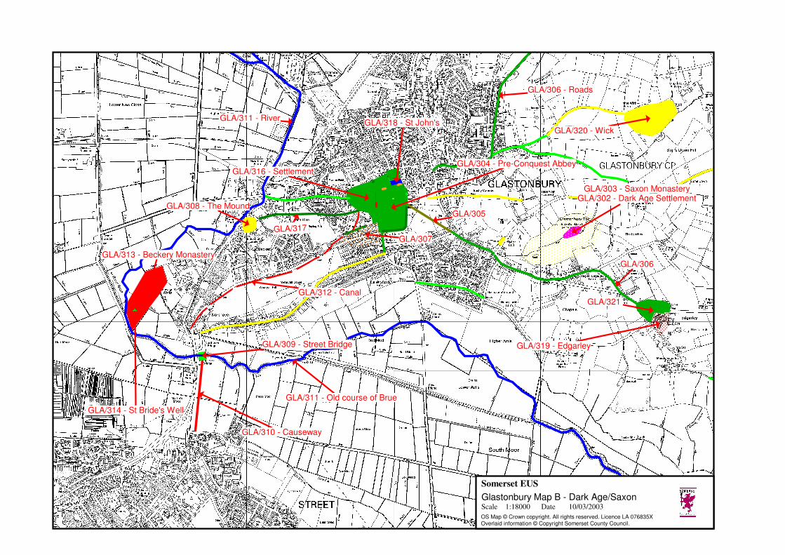
GLA/313 - Beckery Monastery
GLA/308 - The Mound
GLA/312 - Canal
GLA/303 - Saxon MonasteryGLA/302 - Dark Age Settlement
GLA/304 - Pre-Conquest Abbey
GLA/314 - St Bride's Well
GLA/310 - Causeway
GLA/309 - Street Bridge
GLA/311 - Old course of Brue
GLA/316 - Settlement
GLA/318 - St John's
GLA/305
GLA/307GLA/317
GLA/319 - Edgarley
GLA/320 - Wick
GLA/306
GLA/321
GLA/311 - River
GLA/306 - Roads
Somerset EUS
Scale 1:18000 Date 10/03/2003
OS Map © Crown copyright. All rights reserved. Licence LA 076835XOverlaid information © Copyright Somerset County Council.
Glastonbury Map B - Dark Age/Saxon
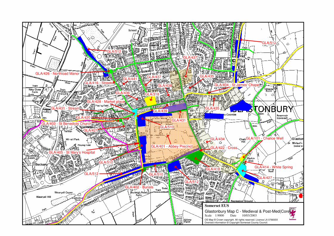
GLA/512
GLA/510
GLA/402 - Burials
GLA/437
GLA/435
GLA/438
GLA/437
GLA/404 - St James' Chapel
GLA/510
GLA/421
GLA/401 - Abbey Precinct
GLA/431 - Stream
GLA/428 - Market place
GLA/420
GLA/436 GLA/318
GLA/416 - StreetsGLA/441
GLA/431
GLA/510
GLA/439 GLA/435
GLA/434
GLA/418
GLA/403 - St Benedicts Church
GLA/426 - Northload Manor
GLA/512
GLA/512
GLA/414 - White Spring
GLA/427
GLA/101 - Chalice Well
GLA/512
GLA/405 - St Mary's Hospital
GLA/422 - Cross
Somerset EUS
Scale 1:9000 Date 10/03/2003
OS Map © Crown copyright. All rights reserved. Licence LA 076835XOverlaid information © Copyright Somerset County Council.
Glastonbury Map C - Medieval & Post-Med(Core)

GLA/424
GLA/430 - Windmill
GLA/425 - Norwood ParkGLA/511 - Windmill
GLA/430 - Windmill
GLA/406 - Pomparles Bridge
GLA/413 - Wirrall Park
GLA/313 - Beckery
GLA/423
GLA/410 - Hartlake Bridge
GLA/409 - Beckery Mill
GLA/417 - East Field
GLA/303 - St Michael's Church
GLA/417 - Torre Field
GLA/413
GLA/514 - Dyehouse
GLA/417 - North FieldGLA/505 - Wick
GLA/501 - Enclosures and Droves
GLA/502 - Roads
GLA/409 - Northover Mills
GLA/504 - Northover
GLA/409 - Mill ?
GLA/419 - Tor Common
GLA/407 - River Cut GLA/508 - Edgarley
GLA/429 -
GLA/410 - Cow Bridge
GLA/411 - Fountains Wall
GLA/503 - Brindham
GLA/432 - Possible Wharf Area
GLA/407 - River Cut
GLA/507 - Cradle Bridge
GLA/501 - New Close
GLA/412 - Causeway
GLA/407 - Bere Wall
GLA/509 - Brick Kiln
GLA/506
GLA/513 - Havyatt
GLA/412 - Hartlake Causeway
Somerset EUS
Scale 1:29000 Date 10/03/2003
OS Map © Crown copyright. All rights reserved. Licence LA 076835XOverlaid information © Copyright Somerset County Council.
Glastonbury Map D - Medieval & Post-Medieval

GLA/608
GLA/609 - Railway
GLA/619 - Park
GLA/609 - Railway
GLA/616 - St Saviours HospitalGLA/612
GLA/601 - New Street Road
GLA/604 - Rug factory
GLA/602 - Fairfield
GLA/606 - Gas works
GLA/605
GLA/601 - Edgarley Cut Off
GLA/618
GLA/604 - Rug factory
GLA/603 - Brickworks
GLA/602 - Cattle Market,
GLA/613 - Cemetery
GLA/612
GLA/607 - Canal Wharf
GLA/617 - St Andrews Church
GLA/612
GLA/615
GLA/610GLA/611
GLA/603 - Brickworks
GLA/612
GLA/609 - Railway
Somerset EUS
Scale 1:25000 Date 11/03/2003
OS Map © Crown copyright. All rights reserved. Licence LA 076835X.Overlaid information © copyright Somerset County Council.
Glastonbury Map E - 19th Century

GLA/707
GLA/704
GLA/707
GLA/704
GLA/704
GLA/705 - Roads
GLA/704
GLA/704
GLA/703 GLA/704
GLA/702
GLA/709 - Reservoir
GLA/704
GLA/703
GLA/703
GLA/706
GLA/707
Somerset EUS
Scale 1:23000 Date 11/03/2003
OS Map © Crown copyright. All rights reserved. Licence LA 076835X.Overlaid information © copyright Somerset County Council.
Glastonbury Map F - 20th Century

SM 29700 - St Michael's Church, monastic remains, and other settlement remains on Glastonbury Tor
SM 29699 - The Abbey Barn at Abbey Farm
SM 33051 - Part of the Hospital of St Mary Magdalene, Magdalene Street
SM 22075 - The Tribunal
SM 33050 - Glastonbury Abbey
Somerset EUS
Scale 1:10000 Date 06/06/2003
OS Map © Crown copyright. All rights reserved. Licence LA 076835X.Overlaid information © copyright Somerset County Council.
Glastonbury Map G - existing designations
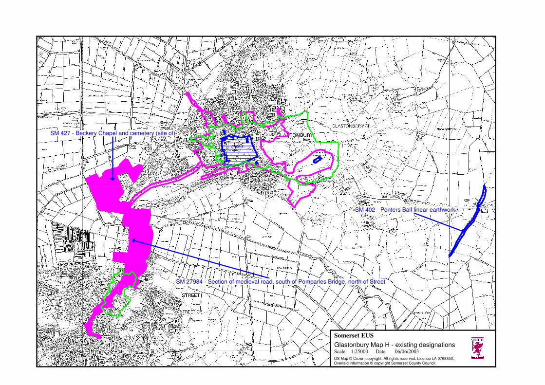
SM 27984 - Section of medieval road, south of Pomparles Bridge, north of Street
SM 402 - Ponters Ball linear earthwork
SM 427 - Beckery Chapel and cemetery (site of)
Somerset EUS
Scale 1:25000 Date 06/06/2003
OS Map © Crown copyright. All rights reserved. Licence LA 076835X.Overlaid information © copyright Somerset County Council.
Glastonbury Map H - existing designations