elements of a pastoral landscape: holowiliena, south ...ashadocs.org/aha/11/11_04_woodhouse.pdf ·...
TRANSCRIPT

AUSTRALASIAN HISTORICAL ARCHAEOLOGY, 11, 1993
Elements of a pastoral landscape: Holowiliena, South Auslralia in 1888'
MONTE C. A. WOODHOUSE
Holowiliena is a pastoral property in the Flinders Ranges of South Australia. This paper attempts a recon- struction of this pastoral landscape as it existed in 1888. Following a discussion of the concept of the cultur- al landscape, the various facets of the landscape of this property are examined. The material evidence used is that deriving from standing structures. Some insights into the property's social history are provided during a discussion which highlights pastoral practices and other factors influencing what happened on the property up to 1888. In addition, howevel; it is noted that Holowiliena shares with pastoral Australia in general some ofthe particular influences and practices which helped shape its landscape.
INTRODUCTION: THE CULTURAL LANDSCAPE
Landscape as a resource is a concept whose importance to historical geographers is recognised in the comment that 'history is written in the landscape just as much as it is written in document^.'^ It has been an important source of inspiration for geographers since it first came to prominence through the work of German geographers from the late 1800s to the early 1900s. James attributes the beginnings of the concept as used by geographers, to the German geographer, Otto Schluter, who wrote in the early 1900s of a pre-existing Urlandschaft being transformed into a Kulturlandschaft, the landscape created by a human c ~ l t u r e . ~ Despite a chequered history of acceptance and use, especially among non-European geographers, it has been found, particularly in more recent times, to be a useful concept in a number of fields of inquiry other than geography. Taylor in a discussion of cultural landscapes provides the following useful definition:
Cultural and rural landscapes are rural and urban settings that people have settled and altered through time. They include cultural and natural elements of the ordinary, familiar, everyday landscape. In Australian usage 'cultural landscape' is often applied where a rural setting is the focus of attention. However it is important to remember that cultural landscapes include townscapes as well as rural areas.4
It is to be noted that both urban and rural areas are included as are the ordinary, familiar and everyday elements; this latter aspect is discussed again later. Taylor mentions 'cultural and natural elements' which at a casual glance would seem to be mutually exclusive but which on closer examination may be seen to contain problems of differentiation. It would be unpro- ductive to become involved in a detailed discussion and analysis of where the boundary between natural and cultural elements lies. An indication of the problem can be gained by considering the impact of the practice among Aboriginal groups of the firing of the landscape; a case could no doubt be made for considering the subsequent changes to soils and vegetation as generating a 'cultural' rather than a 'natural' landscape. Another example relates to the introduction to the Australian landscape by Europeans of exotic fauna and flora. In both instances the elements themselves are 'natural' but their presence is a result of cultural activity. This paper is concerned with cultural elements as represented by buildings and other structures.
As we delve more deeply into the notion of the cultural landscape, it becomes increasingly apparent that much of its significance is derived from its function as a repository or storehouse of evidence relating to the ways in which a culture or a series of cultures has made use of the land. Marsden has drawn attention to this in her comment with reference to South Australians that 'the landscape is the repository of personal, family and community memory.'5 Because of this character- istic the cultural landscape provides a useful basis for historical study concerned with the 'whole enterprise of interpreting society.6 In this respect such study contributes to an under- standing of the social history of the culture or cultures concerned.7 Glassie has made this point nicely with his observation that 'buildings like poems and rituals realize culture'.8 When we speak of a culture or cultures making use of the land we are really talking about interrelationships between people and land; as a result much of the content of the cultural landscape represents the paraphernalia from the everyday lives of common people. Nevertheless, in the past much more emphasis has been put on the material evidence left behind, on the one hand, by important or famous people, and, on the other, by the public institutions of the culture; town halls and churches are examples which come readily to mind.9 If, however, we are to make legitimate claims to be interpreting society then we need to examine all types of evidence including that which can tell us about the lives of ordinary people; lives which have been lived out in 'ordinary landscapes'.10 Melnick, drawing on the ideas of Zelinsky, describes the situation as follows:
These ordinary landscapes, places which people have settled, lived in, manipulated, altered, and developed, are reflections of the settlement of this country. These rural cultural landscapes have evolved over time, often through many generations. If we look at them carefully, they display the imprint of human occupation and cultural response to natural forces and elements in the landscape.
While the reference above is to conditions as found in the United States, the processes described apply equally to Australia and certainly to what happened on Holowiliena.
It is in this sense that the term 'vernacular landscape' may be used to describe the landscape as a source of information about the social history of a culture as represented by material evidence associated with ordinary people. In particular, it is the vernacular building, for some observers a thing of beauty, which can tell us so much about a society.12 This interaction

between people and the land resulting in a body of evidence existence of subsequently abandoned townships. The nature contained in a vernacular landscape, there to be studied by and history of such pieces of evidence are of geographical and anyone with the inclination and skills to do so, is the basis of archaeological interest; they are 'the artefacts or fossils of this study. The Holowiliena landscape is a vernacular earlierages.' l4 Furthermore, as in marine archaeology, there is landscape in the sense referred to above and is of interest for a need to draw, document and conserve these artefacts; to some the reasons suggested. degree there is a parallel with vessels for quite often ruins
Moreover, the contemporary landscape more often than not associated with farming and pastoralism are artefacts which, contains within it material evidence of occupation either by because of adverse circumstances, have had to be abandoned. other groups from the contemporary culture or a previous This paper attempts to reconstruct a cultural landscape in the culture (or cultures) or some combination of the two. form of a sheep grazing property in the Flinders Ranges of Birmingham, Jack and Jeans have made this point in their South Australia (Fig. I), as it might have appeared in 1888. discussion of pastoralism and the landscape in Australia.l3 In Holowiliena is in essence part of a rural landscape which in the the Flinders Ranges, for example, particular areas may contain European phase of occupation has been the basis of extensive evidence of sequential occupation by Aboriginal communities, sheep grazing; it is, therefore, also a pastoral landscape which, pastoral landholders and farmers; furthermore, small sections as in all cultural landscapes, reflects the interaction between of contemporary pastoral or agricultural land may, at some the natural features of the landscape and the cultural activities stage in the past, have been urban land as represented by the which take place within it. Initially my interest in this
HOLOWILIENA SOUTH AUSTRALIA
SCALE Miles 2 2 Miles
Kilornetres 4 0 4 Kilometres
LEGEND
Track ........................ - - - - - Homestead; Hut ........ o Cadastral boundary ... - Gate ......................... H
................. Fence ....................... - Waterhole .............. .......................... Watercourse Well .$
Ranges ..................... Dam .......................... o
I SGF
Fig. 1: Location of Holowiliena and surrounding properties (Parliamentary Papers, 1886).
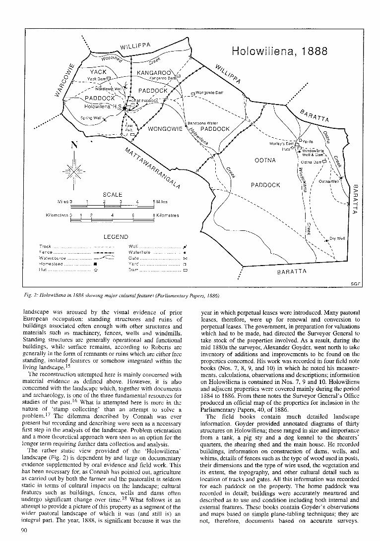
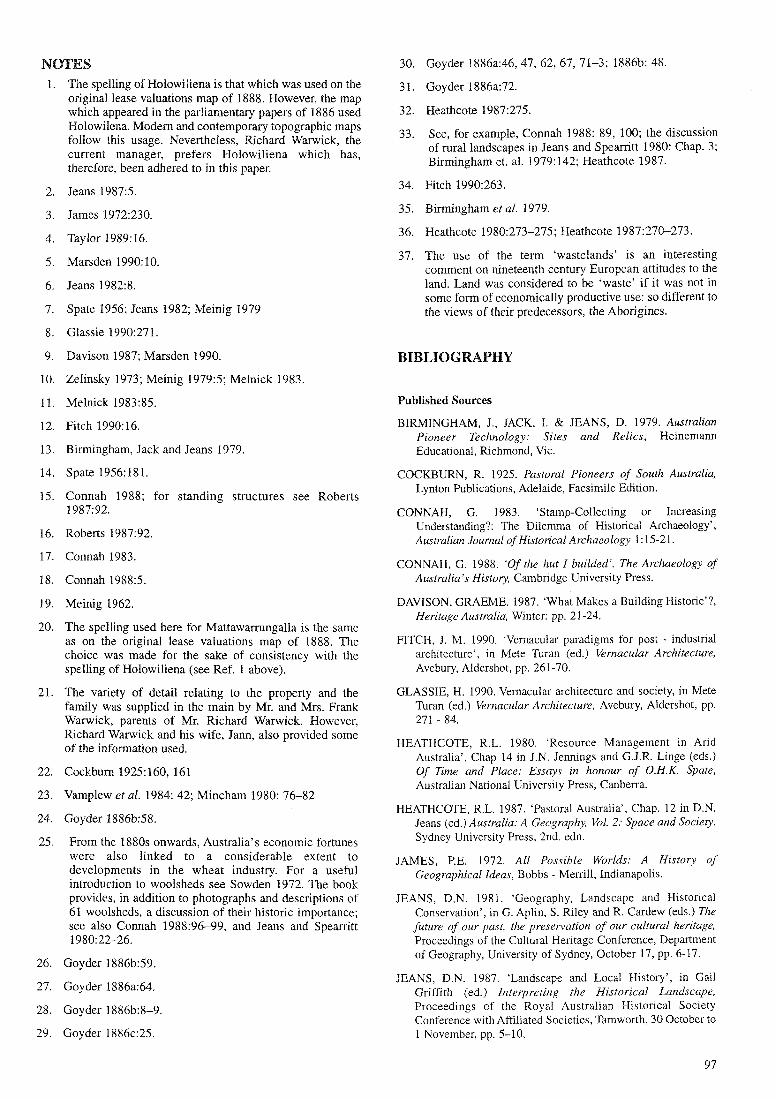
Fig. 2: Holowilienu in 1888 showing major cultural,feutures (Parliamentury 1
landscape was aroused by the visual evidence of prior European occupation: standing structures and ruins of buildings associated often enough with other structures and materials such as machinery, fences, wells and windmills. Standing structures are generally operational and functional buildings, while surface remains, according to Roberts are generally in the form of remnants or ruins which are either free standing, isolated features or somehow integrated within the living land~ca~e.15
The reconstruction attempted here is mainly concerned with material evidence as defined above. However, it is also concerned with the landscape which, together with documents and archaeology, is one of the three fundamental resources for studies of the past.16 What is attempted here is more in the nature of 'stamp collecting' than an attempt to solve a problem.17 The dilemma described by Connah was ever present but recording and describing were seen as a necessary first step in the analysis of the landscape. Problem orientation and a more theoretical approach were seen as an option for the longer term requiring further data collection and analysis.
The rather static view provided of the 'Holowiliena' landscape (Fig. 2) is dependent by and large on documentary evidence supplemented by oral evidence and field work. This has been necessary for, as Connah has pointed out, agriculture as carried out by both the farmer and the pastoralist is seldom static in terms of cultural impacts on the landscape; cultural features such as buildings, fences, wells and dams often undergo significant change over time.18 What follows is an attempt to provide a picture of this property as a segment of the wider pastoral landscape of which it was (and still is) an integral part. The year, 1888, is significant because it was the
year in which perpetual leases were introduced. Many pastoral leases, therefore, were up for renewal and conversion to perpetual leases. The government, in preparation for valuations which had to be made, had directed the Surveyor General to take stock of the properties involved. As a result, during the mid 1880s the surveyor, Alexander Goyder, went north to take inventory of additions and improvements to be found on the properties concerned. His work was recorded in four field note books (Nos. 7, 8, 9, and 10) in which he noted his measure- ments, calculations, observations and descriptions; information on Holowiliena is contained in Nos. 7, 9 and 10. Holowiliena and adjacent properties were covered mainly during the period 1884 to 1886. From these notes the Surveyor General's Ofice produced an official map of the properties for inclusion in the Parliamentary Papers, 40, of 1886.
The field books contain much detailed landscape information. Goyder provided annotated diagrams of thirty structures on Holowiliena; these ranged in size and importance from a tank, a pig sty and a dog kennel to the shearers' quarters, the shearing shed and the main house. He recorded buildings, information on construction of dams, wells, and whims, details of fences such as the type of wood used in posts, their dimensions and the type of wire used, the vegetation and its extent, the topography, and other cultural detail such as location of tracks and gates. All this information was recorded for each paddock on the property. The home paddock was recorded in detail; buildings were accurately measured and described as to use and condition including both internal and external features. These books contain Goyder's observations and maps based on simple plane-tabling techniques; they are not, therefore, documents based on accurate surveys.

"x, Holowiliena: Home Paddock
Track ................... - - - - - - - - -
I S G F
Fig. 3: Holowiliena home paddock us mapped by A.W. Goyder in 1885 (I888 Pustoral Lease Field Diagram, Sheet 12).
Nevertheless, they were good enough to be used as the basis of maps showing not only each property at large but also the location of all buildings in the home paddocks (Fig. 3). One of the major shortcomings of such a map is evident in the generalised location of creeks as shown from a comparison with contemporary topographic maps. This does not, however, detract from the.usefulness of such material. While material evidence from the late nineteenth century is slowly dwindling, it is indeed fortunate that such detailed documentary evidence of buildings and other structures from the period still exists for this part of the state.
HOLOWILIENA
Holowiliena was established as part of that Australia-wide settlement process of the mid-nineteenth century which saw the occupation of much of the country's arid lands by European settlers. As a result, the region has experienced major land use changes since the 1840s when the original inhabitants had to give way to the spread of pastoralists into the area. The land was occupied by groups of the Adnyamathanha Aboriginal People who were dispersed by pastoralism during the late 1840s and through the 50s and 60s. By the late 1860s, however, having suffered and recovered from the severe drought of 1864, pastoralists themselves had to face competition for the land. Ironically some pastoralists were in turn forced to give way to the next group of pioneers wishing to expand into the area. A combination of political, economic and favourable climatic conditions encouraged the spread of settlement by farmers into land well beyond what had been considered to be the limits for crop growing. This relatively short period of about fifteen years has been well analysed by Meinig. l9
Holowiliena, however, was able to resist this pressure. It is still a sheep grazing property but is now part of a larger pastoral
enterprise which includes the adjoining Holowiliena South. Known originally as Mattawarmngalla,20 Holowiliena South was taken up initially by Dr Charles Davis; eventually, however, it became part of the overall Warwick family business.21 The focus here is not the larger enterprise but the original Holowiliena property. It was selected by William Warwick in 1853 and has the distinction of being the only run in the north to have remained in the hands of the same family since the granting of the lease.22
THE PHYSICAL SETTING
The homestead, about 40 kms east of Hawker in South Australia (Fig. I), is set among hills known locally as 'The Ranges'; these provide a natural amphitheatre, which surrounds the homestead in all directions except the southeast, as a setting for a sheep grazing property which is 326 sq. kms in area. Altitudes vary from 550 to 800 metres; the highest section is to the west of the main house around Mt Plantaganet which stands at close to 930 metres. The altitude of the remaining terrain is about 450 metres except in the south east where, apart from the occasional peak which rises to 500 metres, it is about 350 metres. The main house is located at about 400 metres above sea level. The three main creeks Holowiliena, Siccus and Windowarta (pronounced Windarta) and their tributaries provide a network of streams which drain the property in a southeasterly direction emptying eventually into Lake Frome.
This is a region dominated by the Flinders Ranges which sprawl through this part of South Australia as a highly visible collection of ridges and valleys. The ridges or ranges are the outstanding feature of the natural landscape; their impact depends not only on the influence of local relief but also on the orange, yellow and red hues of the dominant Pound quartzite; other colours associated with the less dominant rocks are also

Holowiliena, 1888 Vegetation Zones
l l l e i a 1 2 su.,er - <no 2 L SK, P
B l a c h O a i M a s o Ssltadih B l u ~ b u i h
Mll l ie . Ya:(veptre Spn8iex
Matlee. Satbush B i v e i v i i
Fzg- 4: Approxzrnare vegetation zones, Holowiliena, 1888 (Goyder's Field Books; I888 Pastoral Lease Field Diagram, Sheet 13).
found. The ranges, however, are interspersed with quite extensive plains. Surrounding everything are the many salt lakes both large and small which not only play a significant role in the drainage of the area but also add considerably to the overall physical character of this part of the state.
VEGETATION
Using Goyder's field books it is possible to get a generalised picture of the vegetation as it existed at the time. As can be seen by reference to Figure 4, vegetation on Hoiowiliena in 1888 can be differentiated into four main zones. The distribution has the following features: 1. Mallee was widespread throughout, associated with pines to
the northwest and west of the homestead, with black oak to the north and northeast of the homestead and with sandalwood throughout the rest of the property. While the mallee is usually described as being scattered in distribution there are the occasional dense occurrences such as south of the complex of dams, wells, huts and yards at the Windowarta well site.
2. Saltbush and bluebush occurred widely, most often in association with mallee but also with patches of scattered sandalwood; they formed the dominant association in the south eastern section of the property.
3. Sandalwood occurred as groups of scattered trees throughout most of the property apart from the more rugged sections ; it is difficult to locate it precisely according to altitude but it appeared to occur below about 500 metres.
4. As is the case throughout the ranges, river red gums were commonly found in all creek beds.
5. Spinifex was found in the higher steeper area to the north-west of the homestead; this is the area which also had the 'pines and mallee' association.
6. Ti tree is indicated as growing on the boundary between Wongowie Paddock on Holowiliena and Plains Paddock on Mattawarrungalla; there were no other references in any of the field books to the occurrence of ti tree on the property.
7. Generally reference is made to there being 'little grass'; the area referred to above as the Windowarta site is noted as having a well grassed flat southwest of the well (this is also the area which has a dense stand of mallee). Reference is also made to 'bare hills' in an area about three or four kms northwest of the homestead. Historical statistics indicate that throughout Australia the mid to late 1880s were relatively dry years in which there were three to four months per year which experienced medium intensity drought conditions; around the nearby Hawker area the 1885--1886 season was very dry. It is perhaps not surprising then that Goyder's attention was drawn to the general lack of grass. 23
8. Relationship to topography is present but not marked; the association of mallee with pines and with black oak and the occurrence of sp i~ fex appear to be confined to the high, steep terrain to the west and northwest of the homestead; black oak and mallee, however, are also found in the less rugged parts of the terrain in the northeast section of the property; the open saltbush and bluebush plain in the southeast sector of the property is a relatively low-lying area at an altitude of about 350 to 400 metres through which Holowilena and Windowarta Creeks flow before joining the Siccus River on its way towards Lake Frome to the east. Sandalwood occurred widely throughout this part of the
Flinders Ranges. It is interesting to note that it was being cut and carted as late as the 1930s by licence holders. Additionally, however, much had been taken by teamsters on their way back through Holowiliena and adjacent properties.
The Home Paddock
Buildings and other structures in the home paddock are set beside or near Holowiliena Creek (Fig. 3). The nature of the creek is such that they are able to be sited on high ground out of reach of flood waters. All creeks in this part of the ranges were, and still are, marked by the occurrence of river red gums throughout their beds and along the banks. Given the right conditions associated with good falls of rain, they can be particularly attractive linear wet zones in what is basically an arid environment. The home paddock is surrounded by four others named, in keeping with local tradition and usage, Kangaroo, Horse, Yack and Ram. Two other paddocks, Wongowie and Ootna, occupy the rest of the property (Fig. 2). The reasons for the names 'kangaroo', 'horse', and 'ram' are self evident while 'Wongowie' and 'Ootna' are of local Aboriginal significance. The origin of the word 'Yack' is obscure; it appears in the name 'Yack Chimney', which is all that remains of the original home built by WiIliam Warwick in the 1850s, and in 'Yack Dam'.
As is the case today, the buildings in 1888 were sited near three branches of the creek. The main house is set well above the creek on a steep northern bank which has enough depth for the powder magazine to be built into it. There were a number of buildings and structures with various functions scattered around the property. Some, such as the smithy, were sited near the house; others such as the woolshed and shearers' quarters were sited well away from the main house but within easy reach; the remainder were located in more distant sections of the property. There were in addition three wells and a number of tracks associated with the home paddock. These were all recorded and described by Goyder in his field books where the main home is called 'Government House'. This is an unusual use of the term 'government'; it was, however, the standard terminology used in the surveyor general's department to refer to the main residence which the government required lease- holders to build. Figures 5 and 6 show the building and its roof as they appeared at that time.
Goyder's description provides much useful information about the building as it was when he surveyed it. His description is as follows:
Walls, rubble masonry 18 inches [46cm] thick. Gald Iron roof. Shaded portion of verandah shingle roof, poor repair. Rest Gald Iron. 32 feet [9.8cm] of slate floor in verandah rest gravel. 5 No. 8 wires around verandah. 3 rows of hoop iron with cross pieces 12 feet [3.7m] apart around verandah. Slate floors in Nos. (3), (2) , & (3, Rest board floors.
All rooms plastered & ceiled [sic]. Rooms (I), (2), & (3) 8 feet 6 inches [2.6m] high. All other rooms 10 feet 6 inches [3.2m] high. 2 cedar cupboards in No. (9) 2 feet x 4 feet x 3 feet 6 inches [0,6m x 1.2m x l . lm] high. 1 shelf (deal), Cedar mantel. No. (10) cedar mantel, 2 cedar cupboards 2 feet x 4 feet x 3 feet 6

I Holowiliena: 'Government Ho~tse'
I %- 32 feet ---, < 57 feet >
1 SGF
Fig. 5: Plan of the main ('government') house showing details of rooms and roof lines (Goyder; 1886b).
country.25 On any sheep grazing property, therefore, it is an important building. Figure 7 shows details of the Holowiliena shed as it existed when Goyder visited the property. This is not the original which was quite small and closer to the main house; it was built over a small, natural drainage channel so that the sheep droppings could be disposed of under the floor.
His description once again provides much interesting detail about the building:
Walls of pine and plaster, fair. Gald Iron roof, good. Sheep pens and portion marked A battens (good), Rest board floor (good). 4 small windows. 4 side partitions 4 feet x 6 feet [1.2m x 1.8mJ Match board 112 inch [1.3cm] BB.BB. 7 feet 6 inches [2.3m] of match board behind wool table. Fence around pens, Pine posts, 8 feet [2.4m] apart. 12 rails, good. Wool table (wooden bars). 14 shearing doors 2 feet x 3 feet 6 inches [0.6m x I.lm] match board, good. Wool press. Rack and pinion. (good). Big door 6 feet x 6 feet [1.8m x 1.8mI deal (good). 14 shearing pens Pine posts 6 inches [15cm] dia 24 links [4.8m] long with battened top (good) Loading stage, 15 feet x 18 feet. [4.6m x 5.5ml Mallee rails. Battened together. 26
This building still exists as part of a larger, contemporary woolshed.
Other Buildings and Structures
57 feet
'Government House' Roof
Note: The Shaded portion of the verandah has a shingie roof in poor repair. The rest of the roof is gaivanised iron.
All the buildings and structures on the property were mapped, measured, drawn and described by Goyder in the
Fig. 6: 'Government' house roof Note the portion of the rouf over the verandah where the shingles ure yet to be covered by corrugated iron (Goyder; 1886b).
inches [0.6m x 1.2m x l . lm] high with bookcases on top 4 feet x 1 foot x 7 feet [1.2m x 0.3m x 2.lml. Glass front, 3 cedar shelves. Log at ends AA of verandah, up to roof. All in good repair unless specially stated otherwise. 12 windows (large), 11 doors. Good.24
Australia's economic history, particularly in the second half of the nineteenth century, owed much of its changing fortunes to developments in the wool industry. In the production of wool, the woolshed is a structure of fundamental importance; it is a work building with a design based on its function. Furthermore, being an industrial building reflecting the requirements and practices of an important primary industry, it is a significant part of the vernacular architecture of this
same way as the examples shown above. They may be divided into two broad categories: those located near the main house and associated with the major activities on the property, and those found at some distance from the home paddock. The first and larger group included structures such as the woolshed, the smithy, the men's quarters and their kitchen; these appear to
Holowiliena: Woolshed
6 feet 6 inches/ / 6 feet 6 inches
Woo l tab le ............. Rest board f loor ..... SGF
Fig. 7: Holowilienci +voolshed (Goydel; 1886b)

have been generally quite well maintained and in good to fair condition. The second group consisted of the three Windowarta huts some sixteen to twenty kilometres east of the main house (Fig. 1). In the first group walls were in general of pine and plaster, slate floors were common, roofs were in the main galvanised iron though one or two were shingle including, as described above, part of the roof of the main house, ceiling heights varied from 6 feet [1.8m] to 7 feet 6 inches [2.3m], shelving and partitions were made from matchboard as were the twenty two bunks in the shearers' hut. In the second group there were three huts; two were old and in 'bad repair' while the main hut was more substantial and in 'good order'. The main hut had rubble masonry walls eighteen inches [46cm] thick, with an iron roof and a rough slate floor; the older huts had pine slab walls and shingle roofs, one had a slate floor the other had 'no floor'-and a rubble masonry chimney. Ceiling heights varied as in the first group. The main Windowarta Hut was lived in by at least two generations of a family which worked on Holowiliena. The main home is the only building with plastered walls and proper ceilings; in addition it is the only building in which cedar was used.
Additional cultural features were the wells and dams scattered around the property. Yack Dam, for instance, was located in an area of undulating country characterised by bare hills, very little grass and light stony soil. It was built in the bed of a small creek with a dam wall, varying in height from 2 feet [0.6m] to 7 feet [2.lm] with a width of 44 feet [13.4m], made from 5 inch [12.7cm] and 7 inch [17.8cm] gum posts. However, the most interesting were undoubtedly the Windowarta Well [Fig. 81 and Dam [Fig. 91. The dam is described as being 'in fairly good order' and as being able to hold water well. The construction is noted as consisting of 143 links [28.8m] of post and rail fence with five pine rails and four feet [1.2m] high gum posts ten feet [3m] apart; all is considered to be in 'good order'. The well and its action are described in detail as follows:
Well 79 feet deep x 6 feet x 4 feet [24m x 1.8m x 1.2mI sunk thro' a hard rock. Timbered with round pine to depth of 16 feet 6 inches [5.1m]. Good supply of fresh water, 7000 gals [31822 litres] per diem. Action Underground whim. Whim of substantial Gum beams & wire 1 foot [30cm] square, drum 8 feet [2.4m] diameter, 3 feet [0.9m] deep, Gum & pine frame & stringy bark battens. 265 feet [81m] of 1 114 inch [3.2cm] rope. In good order. 2 x 50 gallon 1227 litres] buckets & valves. Good. Also hand windlass, 7 inches [17.8cm] diameter, 35 feet [10.6m] 314 inch [1.9cm] rope and 15 gallon [68 litres] bucket. 36 feet 9 inches [11.2m] of log trough 12 feet x 10 feet [3.7m x 3m] deep. fair order 13 feet 6 inches [4.lm] of 3 inch [7.6cm] cast iron pipe connect tank to well. 4 x 1 foot [30cm] cast iron wheels, 2 mounted on 2 x 3 feet [0.9m] gum posts, other two on 4 substantial gum posts & cross beams. a. whim pit timbered with sound pine b. pine logs & dirt over passage for ropes c. pit for wheels, sundry ropes, timbered with round
pine d. collar timbered on outside with pine and posts except
at (el e. rubble masonry wall Tank and trough of rubble masonry cemented on inside, concrete bottom. p (= post??) & 3 rail fence around troughs Gum & pine 9 feet [2.7m] apart, bolted. Everything in good order. 27
Throughout the three field books there are numerous notes about the structure and condition of fences on the properties surveyed. On Holowiliena, for example, the Ootna paddock fence consisted of gum posts 21 feet [6.4m] apart with two mallee stakes and six wires, five of which were no. 10 and one was 6 strand galvanised wire; all was in good repair.28 The
Windowarta Well
3 feel 15 feet 9
7 7
2 feet 6 inches 4 feet 6 inches .
6 Inches
C' 21 feel 6 ~nches
5 inches 2 feet 2 ~nches
J 8 feel 6 inches
2 tee" n m t -he.
- -- SGF
--- -
Frg 8 W~ndowarru well in plrn nttd r rosr-tetr~on (Coydec ISR6n)
88 fee 7
96 feet
..... ............ ...........
. 7Weet .;.. i v- .:.. .:. .... .:. . . . :::; ..I:.
_/._.' , . . ,. . . . . . t.:, ., . '. (< iet 6 inches 5 feet 8 inches<j;.:.- .jll . 5 feet 8 inches
' 7 feet 6 inches 1 7 f e & ~ ~ ~ 1 0 i ~ d t ' ~ x ; 7 f e e f 2 feet 6 lnche:~~$.... ...... .A$ \2"
7 feet 6 inches - 55!ee!:'
u 255 feet ...... ...... . . 8 ,
5 feet <;:. 8 inches I -'.
t . . .. I,feet< : :::. . . . . . . . . . . . . .:..;:: ::.:. . . . 2 i i ;e&'::,..;.':..
. . . . . . . . . . . .
......... 239 feel ........ N . . . . . ....... . . ,.,.:; . ' ::. .: . . ..,. .:, . '
9 feel 6 lnches
Fig. 9: Windowartu durn in plun and cross-section (Goydel; 18860)
fence between Yack and Kangaroo paddocks consisted of five no. 8 wires between 'substantial gum posts 21 feet [6.4m] apart [and] 2 feet 9 inches [0.8m] high'.29
From Goyder's notes we are able to get a fairly detailed picture of the various paddocks. Ootna paddock, for example, which was located in the south eastern portion of the property contained a variety of interesting cultural features (Fig. 2). In

terms of its physical characteristics it is a relatively low lying section of the property where the average elevation is about 350 metres above sea level with the occasional point reaching about 500 metres. As described by Goyder, the vegetation was dominated by mallee, sandalwood, saltbush and b l u e b ~ s h . ~ ~ This combination occurred as a scattered, rather than dense, distribution throughout most of the paddock. There were, however, some variations such as a small patch of dense mallee just south of the Windowarta complex, a saltbush and bluebush dominated zone in the central area and an area around Ootna Dam which, although surrounded by scattered sandalwood, saltbush and bluebush, lacked mallee.
Other interesting features in the paddock were, firstly, the concentration of structures around Morley's and Windowarta Dams, secondly, the occurrence of a brush yard and chimney at Ootna Well. The collection of dams, huts, yards, and a well along the Windowarta Creek, referred to by Goyder as the Windowarta Sub Station, indicates an important secondary node of activity on the property; the structures were connected to the homestead by a track which ran more or less east -west through the property linking up with other tracks so providing access to surrounding properties. Ootna Well, located in Ootna Creek, was 38 feet [I 1.6mI deep and 7 feet 6 inches x 9 feet 6 inches [2.3m x 2.9ml to a depth of 17 feet [5.2ml from where it narrowed down to 6 feet x 4 feet [I .8m x 1.2mI. Goyder notes that it was timbered down to 12 feet [3.7m] with round timber. Associated with the well were 91 feet [27.7m] of log troughing in poor repair. The well was in good order but the lever whip associated with it was, like the trough, in poor condition. Daily supply of water was 1100 gallons 15001 ~ i t r e s ] . ~ ~ The use of timber for the storage and transport of water was common around the property.
The occurrence of a brush yard and a chimney near the well indicates 2 site used by shepherds for overnight stops. Tine yard was used to hold sheep while the chimney was used as a wall and anchorage point for a tent. These remnant chimneys represent an important clue to early practices necessary for the successful functioning of a pastoral enterprise. Goyder recorded one or two other such chimneys around the property; however, it is more than likely that, being a remnant from the early shepherding days on the property, these were no longer in use by the mid 1880s. Heathcote discusses, for pastoral Australia as a whole, this change in livestock management practices in the 1860s which reflected the high cost of shepherding and a realisation that it was not really necessary, so daily sheperding was replaced by the fencing of the range.32 By 1874, Holowiliena already had an extensive post and rail fencing system which from that time on was slowly replaced by one based on the use of wire.
DISCUSSION
Holowiliena as a pastoral property in the Flinders Ranges of South Australia has characteristics which it shares not only with other properties in the region but also with pastoral enterprises around the country. 33 It is clear from the details of fences and construction of major buildings that technology and techniques used were similar to those found elsewhere; this is also true of sheep management practices such as the manner of washing sheep and wool using suitable sections of Holowiliena Creek on Mattawurrungalla. As these latter practices unfortunately left no visible structures in the landscape, they cannot be considered in detail in this discussion.
As might be expected in an arid to semi-arid environment, the availability of water was an important consideration in the establishment of a pastoral enterprise. Holowiliena and surrounding properties were no exception to the observation that finding and establishing useful sources of water occupied the minds of leaseholders to a considerable extent. Much effort, with associated costs in time and money, was expended in establishing satisfactory watering points. The landscape
reflects this concern and effort. Throughout this and neigh- bouring properties words such as spring, springs, water, waters, and waterhole are found repeatedly as names of water sources They are used individually as in 'Bandoona Water' or in combination as in 'Spring Well Waters'. The latter is a good example of the cultural landscape reflecting the interaction of the natural and the cultural in the establishment and naming of a significant feature; the name identifies the occurrence of water ('waters'), its source ('spring') and the method of access ('well').
Furthermore, water was made available in a number of other ways. Reference has already been made to dams and wells throughout the property which included the three wells near the main home; moreover, some impression of the impact of the Windowarta Well on the landscape can be gained from the description above. All wells on the property were hand drawn and would therefore have had appropriate facilities for this. In addition, associated structures, such as stone tanks and the whim on Mattawarrungalla (Holowiliena South), were to be found in the landscape. In this instance, the whim's impact on the landscape was increased by its accompanying windmill and through its use in the naming of 'The Whim Road' which connected Mattawarrungalla to Holowiliena.
With Holowiliena, the contemporary cultural landscape bears some resemblance to that of 1888 but the two are by no means congruent. Contemporary buildings may have similar functions to those in existence in 1888; but any particular funct~on may be performed in a different structure not only at a new location but also built either out of new materials or out of materials from an older building whose function was different. This type of change involving as it does renewal of buildings or structures, at the same or a new site, through renovation and the re-use of materials, is a common feature of this region. Through the process of recycling there is a certain degree of persistence of materials in the landscape. Persistence, recycling and renewal of materials and structures are associated processes which make an important contribution to the nature of many landscapes. Fitch notes that the attraction of what he refers to as vernacular and primitive architecture lies partly in the type of 'economical use of both energy and materials' such as that described above on ~ o l o w i l i e n a . ~ ~ These processes have contributed significantly to the dynamic nature of many agricultural landscapes; the Flinders Ranges region is no exception.
Factors which enabled such persistence to occur are associated with aspects of the physical or natural environment and economic necessity. The arid to semi-arid climate of the region means that rates of weathering and erosion of natural materials used in the construction of buildings and other structures are slowed down due to the relative lack of moisture. Furthermore, the regional availability of a hard, quartzitic rock (Pound sandstone) provided a very suitable stone for building which, because of its durability and relative freedom from the intensity of erosion found in moister climates, is a long lasting element in the landscape. It is this longevity of materials which contributes to their availability for use in preservation and reconstruction of structures in the landscape. Moreover, in this part of South Australia the relative lack of trees, as compared to the eastern states of Australia, and the reliance on the local stone for building have provided the cultural landscape with a quintessentially Flinders Ranges look. The pound sandstone is not only durable as described above but also colourful with its combinations of red, orange and yellow hues; in addition, other hues are supplied by some of the less dominant rocks. The dependence to a considerable degree on the native pine, Callitris columellaris, for the wooden components of buildings only helps to add to this special quality as does the use of the local clay which, because of its origins, is mainly red in colour.
Moreover, aridity means that structures and the materials from which they are constructed not only last longer as remnants in the landscape but also can be recycled at later

stages. The same can be said of that other significant pioneer building material, galvanised or corrugated iron. However, it is the straight, column-like native pine, the red clay and the durable and colourful pound quartzite which, either as remnants of original structures or as part of reconstructed buildings, give the landscape some of its special quality. This is particularly true of the early pastoral landscape as evidenced in the ruins which exist in the contemporary landscape. Economic necessity in combination with frugality, common sense, and the necessary practical skills ensured that materials on the property would not be wasted; as noted earlier, the recycling of building materials is a common landscape feature throughout the Flinders Ranges.
Mention has been made of the nature of the fences on the property as found by Goyder in the mid-1880s. Reference has also been made to the fact that these had replaced earlier post and rail fences which had existed until 1874 when the first load of fencing wire reached Holowiliena from Port Augusta. From then on wire was used to replace and extend existing fences. Such work represents a good example of the renewal referred to above and was a widespread occurrence throughout pastoral ~ u s t r a l i a . ~ ~ The remnant chimneys referred to above, while no longer functional, provide an interesting example of the resistance to erosion of soundly constructed structures and of their subsequent persistence in the landscape.
This process occurred at other times also. The smithy, now near the main home, was originally an old kitchen adjacent to what were the shearers quarters further down the creek to the east of the homestead (Fig. 3). The building was 'moved' in the 1930s by the present manager's father. Moving involved restructuring the walls which was done by re-using the logs from the original building. These were then covered with wire mesh on the inside to add strength to the clay based mortar which was applied over the wire; eventually the inside waiis were dressed with a lime plaster. The alcove which now houses the bellows was where the kitchen stove in the original building used to be. Logs had been made from the native pine, which with its column-like trunk, was an ideal source of timber for buildings and fences. Mesh used in the reconstruction of relocated buildings was retrieved from around trees in creek beds after fences had been washed away during floods. While not relevant to the 1888 landscape, this example is indicative of the processes at work within the landscape.
The impact of management on the landscape is worth noting. Heathcote has described in detail the complex situation of Australian management practices and the philosophy which lies behind them. 36 Many managers carry out their duties in a way consistent with the running of a commercial enterprise. Because they work for a company they have no personal or family ties with the property. Their attitudes are likely to be fundamentally different to those of the owner-operators, such as the Warwicks, who regard their property as a permanent home and an environment to be cherished rather than exploited. The operation of Holowiliena was based on pastoralism as a way of life; it was and is home to the Warwick family. It is not merely a place where grazing is carried out with a view to establishing an efficient, highly profitable economic enterprise, though it goes without saying that every effort was made to establish a sound grazing property with a view to financial security. There is a sense of caring for and nurturing the land where establishing a way of life and earning a living appears to be as important as making a profit. No major changes were made in order to increase profits. Stocking rates, for example, in the 1930s and 1940s, when Holowiliena and Holowiliena South were run as one property, remained at 12500 in winter and 8500 in summer. Furthermore, there was little conspicuous consumption. Occasionally, income from the property was used to take holidays but at most times expenditure was limited to maintaining property and lifestyle consistent with the philosophy described above. A useful extension of the present study would be to examine the impact on the landscape of the
two different styles of management. Such an examination could include the effects of Aboriginal management styles as a contrast to the different approaches outlined above. This would further our understanding of the interaction between cultures and the land.
CONCLUSION
Holowiliena has developed in a landscape which has a number of essential characteristics. The basic features are derived from two sources. The first is that which comes from the qualities of the physical landscape with its most prominent features, the ridges, associated with quite extensive plains and lakes, and the strong colours provided by the dominant and sub-dominant rocks; in addition the area has its own characteristic vegetation associations. These, in conjunction with the man-made materials such as galvanised iron and wire, are the source of much of the raw material used in the cultural landscape of 1888. The second principal source, closely interwoven with the basic elements of the first, is the dominant land use of pastoralism or extensive sheep grazing. With its associated buildings, structures, construction materials, their functional association and distribution on the property, the pastoral industry provides a variety of cultural artefacts which, combined with the use and re-use of local and introduced materials, help to define the cultural landscape. This combination of physical and cultural characteristics has given rise to what is referred to above as the 'quintessential Flinders Ranges landscape'.
Ail of this was established in an economic milieu in which two staples, wool and wheat, provided, in association with minerals, an export base for a growing economy. Expansion was occurring in a political and social environment in which decision makers were attempting colonisation of the 'wastelands' according to Wakefield's Theory of Settlement; a theory which, although generated by someone who had never seen South Australia, was used as a basis of experiment and trial. 37 The government of the day did its best to produce an orderly expansion of occupation and settlement with a constantly evolving policy aimed at balancing the demands of those involved in either extensive or intensive forms of land use both of which, in combination with settlements, both existing and abandoned, and mining, have had their own characteristic impacts on the landscape.
ACKNOWLEDGEMENTS
Without the help of the Warwick family, it would have been virtually impossible to provide important detail about the development and management of Holowiliena. In particular, I would like to thank Mr and Mrs Frank Warwick who provided me with much detail during a number of interviews. Holowiliena is managed by their son, Richard and his wife, Jann, who also helped with information and hospitality while I carried out some basic field work.
NOTES 1. The spelling of Holowiliena is that which was used on the
original lease valuations map of 1888. However, the map which appeared in the parliamentary papers of 1886 used Rolowilena. Modem and contemporary topographic maps follow this usage. NevertheIess, Richard Warwick, the current manager, prefers Holowiliena which has, therefore, been adhered to in this paper.
2. Jeans 1987:s.
3. James 1972:230.
4. Taylor 1989:16.
5. Marsden 1990:lO.
6. Jeans 1982%.
7. Spate 1956; Jeans 1982; Meinig 1979
8. Glassie 1990:271.
9. Davison 1987; Marsden 1990.
10. ZeIinsky 1973; Meinig 1979:s; MeInick 1983.
11. Melnick 1983:85.
12. Fitch 1990:16.
13. Birmingham, Jack and Jeans 1979.
14. Spate 1956:181.
15. Connah 1988; for standing structures see Roberts 1987:92.
16. Roberts 1987:92.
17. Connah 1983.
18. Connah 1988:5.
19. Meinig 1962.
20. The spelling used here for Mattawarrungalla is the same as on the original lease valuations map of 1888. The choice was made for the sake of consistency with the spelling of Holowiliena (see Ref. 1 above).
21. The variety of detail relating to the property and the family was supplied in the main by Mr. and Mrs. Frank Warwick, parents of Mr. Richard Warwick. However, Richard Warwick and his wife, Jann, also provided some of the information used.
22. Cockburn 1925:160, 161
23. Vamplew et al. 1984: 42; Mincham 1980: 76-82
24. Goyder 1886b:58.
25. From the 1880s onwards, Australia's economic fortunes were also linked to a considerable extent to developments in the wheat industry. For a useful introduction to woolsheds see Sowden 1972. The book provides, in addition to photographs and descriptions of 61 woolsheds, a discussion of their historic importance; see also Connah 1988:96-99, and Jeans and Spearritt 1980:22-26.
26. Goyder 1886b:59.
27. Goyder 1886a:64.
28. Goyder l886b:8-9
29. Goyder 1886c:25.
30. Goyder 1886a:46,47, 62, 67, 71-3; 1886b: 48.
3 1. Goyder 1886a:72.
32. Heathcote 1987:275.
33. See, for example, Connah 1988: 89, 100; the discussion of rural landscapes in Jeans and Speamtt 1980: Chap. 3; Birmingham et. al. 1979: 142; Heathcote 1987.
34. Fitch 1990:263.
35. Birmingham et al. 1979.
36. Heathcote 1980:273-275; Heathcote 1987:270-273.
37. The use of the term 'wastelands' is an interesting comment on nineteenth century European attitudes to the land. Land was considered to be 'waste' if it was not in some form of economically productive use: so different to the views of their predecessors, the Aborigines.
BIBLIOGRAPHY
Published Sources
BIRMINGHAM, J., JACK, I. & JEANS, D. 1979. Australian Pioneer Technology: Sites and Relics, Heinemann Educational, Richmond, Vic.
COCKBURN, R. 1925. Pastoral Pioneers of South Australia, Lynton Publications, Adelaide, Facsimile Edition.
CONNAH, G. 1983. 'Stamp-Collecting or Increasing Understanding?: The Dilemma of Historicai Archaeology', Australian journal of Historical Archaeology 1 : 15-21.
CONNAH, G. 1988. 'Of the hut I builded'. The Archaeology of Australia's History, Cambridge University Press.
DAVISON, GRAEME. 1987. 'What Makes a Building Historic'?, Heritage Australia, Winter: pp. 21 -24.
FITCH, J. M. 1990. 'Vernacular paradigms for post - industrial architecture', in Mete Turan (ed.) Vernacular Architecture, Avebury, Aldershot, pp. 261-70.
GLASSIE, H. 1990. Vernacular architecture and society, in Mete Turan (ed.) Vernacular Architecture, Avebury, Aldershot, pp. 271 - 84.
HEATHCOTE, R.L. 1980. 'Resource Management in Arid Australia', Chap 14 in J.N. Jennings and G.J.R. Linge (eds.) Of Time and Place: Essays in honour of O.H.K. Spate, Australian National University Press, Canberra.
HEATHCOTE, R.L. 1987. 'Pastoral Australia', Chap. 12 in D.N. Jeans (ed.) Australia: A Geography, Vol. 2: Space and Society, Sydney University Press, 2nd. edn.
JAMES, P.E. 1972. All Possible Worlds: A History of Geographical Ideas, Bobbs - Merrill, Indianapolis.
JEANS, D.N. 1981. 'Geography, Landscape and Historical Conservation', in G. Aplin, S. Riley and R. Cardew (eds.) The future of our past, the preservation of our cultural heritage, Proceedings of the Cultural Heritage Conference, Department of Geography, University of Sydney, October 17, pp. 6-17.
JEANS, D.N. 1987. 'Landscape and Local History', in Gail Griffith (ed.) Interpreting the Historical Landscape, Proceedings of the Royal Australian Historical Society Conference with Affiliated Societies, Tamworth, 30 October to 1 November, pp. 5-10.

FEANS, D.N. & SPEARRITT, P. 1980. The Open Air Museum, Allen and Unwin, Sydney.
MARSDEN, S. 1990. 'History through the remains of the past', Historic Environment 7: 10- 14.
MEINIG, D.W. 1962. On the Margins of the Good Earth; the South Australian Wheat Frontiel; 1869-1884, Monograph Series 2, Association of American Geographers, Chicago.
MEINIG, D.W.(ed.) 1979. The Interpretation of Ordinary Landscapes, Oxford University Press.
MELNICK, R.Z. 1983. 'Protecting rural cultural landscapes: finding value in the countryside', Landscape Journal 2: 85-96.
MINCHAM, H. 1980. Hawkel; Hub of the Hinders. Hawker Centenary Committee, Hawker, South Australia.
ROBERTS, B.K. 1987. 'Landscape Archaeology', in J. M. Wagstaff (ed.) Landscape and Culture: Geographical and Archaeological Perspectives, Basil Blackwell, Oxford, pp. 77-95.
SOWDEN, H. (ed.) 1972. Australian woolsheds, Cassell, Melbourne.
SPATE, O.H.K. 1956. 'Bush and City: Some Reflections on the Australian Cultural Landscape', The Australian Journal of Science, May: pp. 177-84.
TAYLOR, K. 1989. 'Conservation and interpretation study of the rural heritage landscape of the Lanyon-Lambrigg area, ACT', Historic Environment 7: pp. 1623.
VAMPLEW, W., RICHARDS, E., JAENSCH, D., & HANCOCK, J. 1984. South Australian Historical Statistics Monograph. Australia, 1738-1988, A Biceiztennial History, for the
Reference Section of History Project Incorporated, University of New South Wales, Kensington.
ZELINSKY, W. 1973. The Cultural Geography of the United States, Prentice-Hall, Englewood Cliffs, New Jersey.
Official Sources
CSIRO, 1977. Environments of South Australia: Province 5- Eastern Pastoral and Province 6-Flinders Ranges, Division of Land Use Research, Canberra.
Geologic maps, Department of Mines, Adelaide.
South Australian Parliamentary Papers, 11 , 1886.
Topographic maps, Department of Lands, Adelaide.
Unpublished Sources
GOYDER, A.W. 1886a. Pastoral Field Book 7. Surveyor General's Office, Department of Environment and Natural Resources, Adelaide, South Australia.
GOYDER, A.W. 1886b. Pastoral Field Book 9. Surveyor General's Office, Department of Environment and Natural Resources, Adelaide, South Australia.
GOYDER, A.W. 1 8 8 6 ~ . Pastoral Field Book 10. Surveyor- General's Office, Department of Environment and Natural Resources, Adelaide, South Australia.
1888 Pastoral Leases Field Diagram, and other maps and plans in the Surveyor-General's Office, Department of Environment and Natural Resources, Adeiaide, South Australia.