el impacto del vertedero de oum azza sobre la calidad de...
TRANSCRIPT

68
Creative Commons Reconocimiento-No Comercial 3.0 e-ISSN 2340-0129
DOI: http://dx.doi.org/10.30827/cuadgeo.v58i1.6799Touzani, M. et al. (2019). The impact of the Oum Azza landfill on the quality of groundwater Cuadernos Geográficos 58(1), 68-82
The impact of the Oum Azza landfill on the quality of groundwater at the Rabat region (Morocco) Meryem Touzani 1 | Ilias Kacimi2 | Nadia Kassou3 | Moad Morarech4 Tarik Bahaj5 | Vincent Valles6 | Laurent Barbiero7 | Suzanne Yameogo8
Recibido: 27/01/2018 | Aceptado: 04/02/2019
AbstractA 110 ha dump, located in the Akrach shallow aquifer area in Morocco, was studied in order to characterize the quality of groundwater around the landfill, to delineate the contaminated area and to determine the factors favouring the contamination of groundwater. This dump is located in the city of Oum Azza (15 km south from Rabat), (Map 1). between the Akrach River in the west and the Sidi Mohamed Ben Abdellah Dam in the east. To assess groundwater pollution from this landfill, piezometric monitoring and Hydrochemical analyses were conducted on 22 wells. The results highlight a significant degradation in the groundwater quality, especially in the parts located in the direct vicinity downstream the dump. In the impacted areas, electrical conductiv-ity was above 1100 μS cm-1, bicarbonates were higher than 508 mg L-1, chlorides, sulphate, and nitrates contents were higher than 850, 200 and 1 mg L-1, respectively. In addition we found high cadmium (50 - 100 μg L-1) and chromium (40 - 230 μg L-1) contents, i.e. much higher than the WHO guidelines for drinking or irrigation water. A principal component analysis conducted on this dataset highlights the absence of a prevalent principal component (PC), with the variance distributed across many PCs. The mechanisms responsible for the chemical variance of the hydro system are therefore numerous and fairly balanced in terms of influence. Finally, a hierarchical classification brings out three groups of observations, each group corresponding to a level of pol-lution.
Keywords: Dump; Oum Azza; pollution; Hydrochemical; PC.
1. Université Mohammed V, Faculté des Sciences de Rabat, Département des Sciences de la Terre, laboratoire Géosciences, Eau et Environnement (LG2E). [email protected]. Université Mohammed V, Faculté des Sciences de Rabat, Département des Sciences de la Terre, laboratoire Géosciences, Eau et Environnement (LG2E). [email protected]. Université Mohammed V, Faculté des Sciences de Rabat, Département des Sciences de la Terre, laboratoire Géosciences, Eau et Environnement (LG2E). [email protected]. Université Abdelmalek Essadi- Faculté des Sciences de Tétouan, Laboratoire en Géosciences appliqués et marines, Géotech-nique et Géo risques (LR3G), Maroc. [email protected]. Université Mohammed V, Faculté des Sciences de Rabat, Département des Sciences de la Terre, laboratoire Géosciences, Eau et Environnement (LG2E). [email protected]. UMR EMMAH, Université d’Avignon et des Pays de Vaucluse, France.7. IRD, CNRS, UPS, OMP, Géoscience Environnement Toulouse, F31400, France.8. Laboratorio de geología, Universidad de Ouagadougou, Burkina Faso.
69
Creative Commons Reconocimiento-No Comercial 3.0 e-ISSN 2340-0129
DOI: http://dx.doi.org/10.30827/cuadgeo.v58i1.6799Touzani, M. et al. (2019). The impact of the Oum Azza landfill on the quality of groundwater Cuadernos Geográficos 58(1), 68-82
Resumen
El impacto del vertedero de Oum Azza sobre la calidad de las aguas subterráneas de Rabat (Marruecos)Un vertedero de 110 ha, ubicado sobre el acuífero superficial de Akrach en Marruecos, ha sido estudiado para caracterizar la calidad de las aguas subterráneas alrededor del vertedero, conocer la extensión del área contaminada y estudiar los factores involucrados en esta contaminación.
El vertedero se emplazó en la ciudad de Um Azza (15 km al sur de Rabat), entre el rio Akrach, al oeste, y la represa Sidi Mohaed Ben Abdallah, al este. Un control piezómetro y análisis químicos se hicieron sobre 22 pozos para estudiar esta contaminación. La calidad del agua es afectada por una contaminación importante, especialmente en las áreas al contacto cercano del vertedero, y aguas abajo de este mismo. En las zonas afectadas la conductividad eléctrica de las aguas supera 1100 µS.cm-1, los bicarbonatos superan 508 mg.L-1 , los cloruros, sulfatos y nitratos superan 850,200 y 1 mg.L-1. Además se consiguió alto contenido en cadmio (50-100 µg.L-1) y cromo (40-230 µg.L-1). En definitiva, se superaron olgadamente los valores estipulados en las normas de la OMS para el agua potable y de riego.
Un análisis en componentes principales se llevó a cabo sobre el conjunto de datos. No aparece un eje factorial consistente, sino más bien muchos ejes de importancia similar, lo que muestra un conjunto de mecanismos de la misma fuerza involucrados en la calidad química de las aguas contaminadas. Una clasificación jerárquica ascendente da tres grupos de muestras, cada grupo corresponde a un nivel de contaminación.
Palabra claves: Represa; Oum Azza; contaminación; hidroquímica; análisis estadístico.
Résumé
L L’impact de la décharge d’Oum Azza sur la qualité des eaux souterraines région de Rabat (Maroc)The impact of the Oum Azza landfill on the quality of groundwater at the Rabat region (Morocco) L’impact de la decharge d’Oum Azza sur la qualite des eaux souterain region de Rabat (Maroc)
La décharge étudiée est localisée dans la zone de l’aquifère peu profond d’Akrach (Map 1). Elle est d’une superficie de 110 ha, située sur la commune d’Oum Azza à 15 Km de Rabat, entre la rivière Akrach à l’ouest et le barrage de Sidi Mohamed Ben Abdellah à l’est. Le but de cette étude est de caractériser la qualité des eaux souterraines autour de la décharge, de délimiter la zone contami-née et de déterminer les facteurs favorisant la contamination des eaux souterraines. Pour évaluer la pollution des eaux souterraines due à cette décharge, des analyses de niveau piézométrique et Hydrochimique ont été réalisées sur 22 puits.
Les résultats des analyses géochimiques montrent une dégradation qualitative importante des eaux souterraines, en particulier dans les parties situées dans la zone de gradient descendant et à proximité directe de la décharge. Dans ces zones polluées, nous avons observé les valeurs sui-vantes: supérieure à 1100 μS/cm en conductivité électrique, 508mg/L en bicarbonates, 850mg/L et 200mg/L respectivement en chlorures et sulfate, 1mg/L en nitrates, 50 - 100 mg/L en cadmium, et 40 - 230 μg/L en chrome. Ces concentrations dépassent largement les valeurs standards de l’Or-ganisation Mondiale de la Santé (OMS) pour l’eau potable et l’eau d’irrigation.

70
Creative Commons Reconocimiento-No Comercial 3.0 e-ISSN 2340-0129
DOI: http://dx.doi.org/10.30827/cuadgeo.v58i1.6799Touzani, M. et al. (2019). The impact of the Oum Azza landfill on the quality of groundwater Cuadernos Geográficos 58(1), 68-82
Une analyse en composantes principales réalisée sur cet ensemble de données met en évidence l’absence d’une composante principale (PC) prévalente, la variance étant répartie sur de nom-breux PC. Les mécanismes responsables de la variance chimique d’hydro système sont donc nombreux et assez équilibrés en termes d’influence. Enfin, une classification hiérarchique fait apparaître trois groupes d’observations, chaque groupe correspondant à un niveau de pollution.
Mot clés : Décharge ; Oumazza ; Pollution ; Hydrochimie ; ACP.
1. IntroductionDumps are places of microbiological fermentations, which can generate organic- and nitrogen-rich leachates, and with high concentration of heavy metals. However, microbiological processes are highly temperature-dependent and, as a result, studies carried out in developed countries, often under temperate climates, cannot be immediately transfered to warmer regions. For gar-bage dump monitoring, a good knowledge of the occurring processes, their nature and intensity, as well as their impact on the local water table are essential, but usually not studied in southern countries.
Landfill leachate is generated by excess rainwater percolating through the waste layers and can be considered as an aqueous solution comprising four groups of pollutants, namely, dissolved organic matter and its decomposition products (including volatile fatty acids), inorganic macro-components, metals, and volatile organic compounds (VOCs). The composition of leachates var-ies considerably between landfills depending on the composition and/or the age of the waste, and the landfill technique. Clearly, there is a strong relationship between leachate composition and the advancement of decomposition.
The purpose of this work is precisely to study the case of a large dump facility located in Morocco. Many landfills were built in different parts of the kingdom of Morocco. In 2007, the first one was that of the capital Rabat in the district of Oum-Azza, today referred as ‘’Oum-Azza landfill’’ (Map 1). The constraints of the sector are numerous, namely, technical and financial constraints, delays in the implementation of the master plan, and above all the inadequacy of the control and moni-toring. First, it is logical to imagine that a landfill built between a water reserve dam and a river can affect the quality of the water table, at least locally. This work aims to search for evidence of seepage leachate from the landfill to surrounding soil and groundwater. Historical data collected from 2010 to 2018 has been aggregated. The processing of these data was performed through Principal Component Analysis (PCA) on physico-chemical parameters in order to discriminate, identify, and rank the processes that accompany the changes in groundwater quality. The aim is to define a tool for assessing the impact of the landfill on the aquifer (Ramanath et al., 2001) Chi-damabaram et al. 2002; Reghunath et al. 2002; Pujari and Deshpande 2005).
2. Material and methods
2.1. Study siteThe studied area is part of the large Bouregreg watershed, with an area of 10,130 km2. Its estu-ary is located between the cities of Rabat and Sale. Three main wadis roam the area studied: Bouregreg Wadi, Akrach Wadi and Korifla Wadi (Map. 1). The climate is temperate, semi-arid

71
Creative Commons Reconocimiento-No Comercial 3.0 e-ISSN 2340-0129
DOI: http://dx.doi.org/10.30827/cuadgeo.v58i1.6799Touzani, M. et al. (2019). The impact of the Oum Azza landfill on the quality of groundwater Cuadernos Geográficos 58(1), 68-82
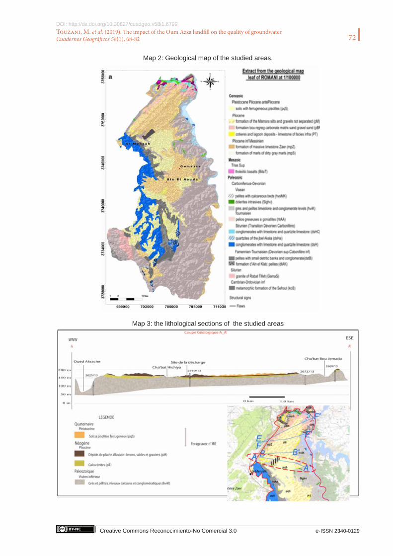
with a subhumid trend due to the influence of the Atlantic along the coast. The average annual precipitation is about 500 mm, the average annual temperature is 18 °C with a thermal amplitude of about 20 °C. The potential annual evapotranspiration in Rabat is 1370 mm, ranging from 46 to 187 mm per month in winter and summer, respectively (Chennaoui et al., 2004). The dump is lo-cated in the municipality of Oum-Azza at about 5 km south of Rabat, and covers an area of about 110 ha. At the regional scale, the geology consists of a set of diversified geological sedimentary, metamorphic and plutonic formations, ranging in age from Paleozoic to Quaternary (Map 2). In the immediate vicinity of the study site, the basement corresponds to gray-pelitic and schistose formations of the Upper Devonian and Lower Carboniferous The overlaying formations consist of calcarenites, sands and marly sands, silt and gravel, whose age extends from Miocene to Qua-ternary. These formations lie in unconformity related to Paleozoic formations. A lithological sec-tion based on the facies analogy from hydrogeological existing reconnaissance boreholes (IRE/ABHBC) and the comparison with outcrops is presented in (Map 3) (Michard ,1976; El Attari, 2001).
Map 1 : Geographical frame situation
It made it possible, at a regional scale, to locate the geological levels of the aquifers, to specify the nature and the variation of these reservoirs and to identify the interactions with the underlying circulations within the Primary terrains. The underground water circulations occur either in late Miocene sand, marly sand or calcareous layers, or in the Pliocene calcarenites, furtherly referred as Mio-Pliocene formations. In the Oum-Azza sector, these formations contain layers with high interstitial porosity allowing a significant flow of the groundwater, but they occupy a narrow ex-tent, generating unequal water productivity, which depends on their extension, of their structure and their supplying area.
72
Creative Commons Reconocimiento-No Comercial 3.0 e-ISSN 2340-0129
DOI: http://dx.doi.org/10.30827/cuadgeo.v58i1.6799Touzani, M. et al. (2019). The impact of the Oum Azza landfill on the quality of groundwater Cuadernos Geográficos 58(1), 68-82
Map 2: Geological map of the studied areas.
Map 3: the lithological sections of the studied areas

73
Creative Commons Reconocimiento-No Comercial 3.0 e-ISSN 2340-0129
DOI: http://dx.doi.org/10.30827/cuadgeo.v58i1.6799Touzani, M. et al. (2019). The impact of the Oum Azza landfill on the quality of groundwater Cuadernos Geográficos 58(1), 68-82
Thus, the Mio-Pliocene formations constitute the main regional aquifer reservoir. Rainwater in-filtrates almost exclusively at the level of these permeable and porous Mio-pliocene formations (silts, sands, gravels and alluvial deposits in wadis). A groundwater divide, which consists in a piezometric dome culminating at 300m altitude, crosses the region from the southeast to the northwest. Hydraulic gradients range from 0.8 and 6.6%. The flow lines converge towards the drainage axes of the surface waters (wadis) which also constitute privileged directions of the un-derground flows. The structural analysis of the lineaments reveals a preferential direction NE-SW well represented in the northeastern part of the study area (Fadi et al.,2011).The superposition of the piezometric map and that of the major lineaments of the fracturing network show that the large families of NW-SE direction coincide with the direction of the water table flow (Map 4).Less than one-meter thick hydromorphic soils with pisoliths, locally referred as “Daya” soils have de-veloped at the top of the Mio-Pliocene formations.
Table 1: Regional daily waste production (reference). All the waste except green space waste (1.5% of the total waste) is send to Oum-Azza Landfill.
Types of wasteDaily production of waste
T/j Pourcentage
Households 15,75 85,61%
Hospitals 0,06 0 ,2%
Markets 1,06 3%
Slaughterhouses 0,2 0,6%
Green areas 0,9 1,5%
Industrial 0,26 0,75%
Rubble, rubble and rubble, brickyard waste, residues from cleaning public roads ... 3,33 9,5%
Image 1 : Spatio-temporal evolution of the Oum Azza dump.
Map 4: Piezometric map of the study area
The landfill began to operate in 2008, and receives more than 800,000 tons of waste coming from 13 municipalities including Rabat, Salé and Temara is equipped with a leachate collection system that transports the leachate by gravity into a biological treatment pond. A collection system is also used to transport rainwater in a storage basin for multipurpose uses. The generated biogas is not collected. All types of waste are discharged to the Oum Azza landfill, as detailed in table 1, the

74
Creative Commons Reconocimiento-No Comercial 3.0 e-ISSN 2340-0129
DOI: http://dx.doi.org/10.30827/cuadgeo.v58i1.6799Touzani, M. et al. (2019). The impact of the Oum Azza landfill on the quality of groundwater Cuadernos Geográficos 58(1), 68-82
percentage of fermentable organic matter in waste produced at Oum-Azza, which is 85%, reflects a low socio-economic level. Recently, the problem of leachates has been aggravated from year to year, with a much higher amount of percolates in the storage ponds (Image 1).
2.2. Samples and measurementsGroundwater samples from twenty-two wells near the Oum-Azza dump were collected in 2012, 2014 and 2016 (Map 5) .A total of 88 water samples were taken using a 1 liter polyethylene bailer. All samples were then stored in polyethylene containers and in a cooler for transport. They were then maintained at 4 °C and in the dark until analysis.
Map 5: Map of sampling point location

75
Creative Commons Reconocimiento-No Comercial 3.0 e-ISSN 2340-0129
DOI: http://dx.doi.org/10.30827/cuadgeo.v58i1.6799Touzani, M. et al. (2019). The impact of the Oum Azza landfill on the quality of groundwater Cuadernos Geográficos 58(1), 68-82
In addition, 3 samples of leachates were taken .The pH and temperature were measured in situ. Electrical conductivity (EC) and Total Organic Carbon (TOC) were measured according to ASTM D1125-14 and ISO 8245: 1999, respectively. The biochemical oxygen demand (BOD5) was measured directly by the HANNA Instruments HI98186 equipment. Coliforme bacteria (CB) Nitrates (NO3
-) were analyzed by colorimetry (Spectronic 20D spectrophotometer). The cations (Na+, K+, Ca2+, Mg2+ and NH4
+) and the anions (Cl-, SO42-, NO2
-, NO3- and F-) were respectively
analyzed according to UNI EN ISO 14911:2001 and ISO 10304.1, CN- according to Method EPA 335.2, then the metals (Al, As, B, Cu, Cr, Fe, Hg, Mn, Ni, Pb and Zn) according to the method EPA 6020.
2.3. Spatial representationSpatial data processing was performed with the software Surfer (Golden software), including the study the spatial structure (variograms and correlograms) and cartographic representation.
2.4. Statistical tools Statistical processing was performed with the Xlstat 3.2 (Addinsoft) software suite. The statistical tools used are Principal Component Analysis (PCA), followed by an agglomerative hierarchical cluster analysis (HCA). The PCA treatment transforms n original variables into n orthogonal principal components that are a linear combination of the original variables (Singh et al., 2004, 2008a, b). In this study, this analysis is applied to the study of variance in groundwater quality, with the objective of determining the sources and mechanisms responsible for this variance (Gi-brilla et al. 2011; Guler et al., 2002; Manikandan et al., 2014). Orthogonal (uncorrelated) princi-pal components ensure the independence of the associated processes. Agglomerative hierarchical clustering is an analysis in which a bottom-up approach is used to obtain a hierarchy of clusters. This multivariate statistical analysis is widely used in environmental studies (Singh et al., 2016). The objective is to organize observations into meaningful groups using similarity measure, here quantified using the Euclidean distance. Unlike the PCA, whose display typically uses two or three principal components, the uHCA uses all the information contained in the original data set (Diaz et al., 2002). Field pH values were transformed into H+ activities to obtain a homogeneous set of parameters with H+, EC and other water quality parameters. The total dataset used for the PCA consists of 10 variables (referred as H+, T (temperature), EC (Electrical Conductivity), O2 (dissolved oxygen), SM (Suspended Material), DOC (Dissolved Organic Carbon), NO3-, SO42-, CB (Coliform Bacteria), NH4+), and 24 observations. The agglomerative hierarchical cluster-ing was conducted on three variables related to the level of pollution (pH, EC, T, NO3
-,SO42- and
NH4+) and 30 observations.
3. Results
3.1. Leachates characteristicsThe physical, chemical and biological characteristics of the leachate samples collected during the three surveys at different points of the landfill are presented in (Table 2).
(Graph 1) shows the relationship between dissolved organic carbon and biological oxygen de-mand. As expected, absolute values are high in leachates, which result from unsorted waste, and

76
Creative Commons Reconocimiento-No Comercial 3.0 e-ISSN 2340-0129
DOI: http://dx.doi.org/10.30827/cuadgeo.v58i1.6799Touzani, M. et al. (2019). The impact of the Oum Azza landfill on the quality of groundwater Cuadernos Geográficos 58(1), 68-82
1/3 of organic waste. Dissoved organic matter in leachates is almost 60% degradable, which is surprising because it is commonly assumed that leachate is barely degradable (Serena Indelicato & David Bongiorn). The concentration of NH4+ in the leachates is also high, reaching 3.5 g L-1. These values can be explained by the liberation of biogas with a high fraction of ammonia dur-ing the decomposition of organic waste (Mor et al., 2006, Halim et al., 2010). It also indicates that landfills are approaching the end of their life. Many parameters are analyzed for which the admissible limits are exceeded, in particular pH, TDS, DOC, BOD5, Cl-, NH4, Cu and Ni. Chlo-ride ions behave as a conservative pollutant that accompanies the flow of water, and interactions with the environment are generally low (Jhamnani and Singh 2009, Ilaboya et al., 2014). High concentrations of heavy metals have been detected in leachates, particularly copper. This can be attributed to the spillage of unsorted blends that include scrap metal, batteries, various medica-tions, paints, etc ... The presence of lead, nickel and to a lesser extent cadmium was also noted.
Graph 1 : Dissolved organic matter in the leachate (COD vs.BOD)
Table 2: Physico-chemical characteristics of leachates collected at Oum’Azza landfill
Ech1 Ech2 Ech3 Ech1 Ech2 Ech3
PH 7.1 6.95 7.9 AS 0.014 <0.005 0.518
T(C°) 27.8 35 27 Cd 0.013 0.031 0.013
Conductivité 6050 32900 37700 Co 0.161 0.16 0.161
O2(Dissous) 1.45 0 0 Cr 0.75 0.493 0.75
DCO 275 57792 12941 Cu 0.055 0.489 0.088
DBO2 159 38901 4621 Pb <0.0021 0.089 0.048
NH4+ 123 3514 1988 Ni <0.0025 0.653 0.747
PT 0.337 28.7 18.7 Zn 0.026 1.03 0.889
MES 26 2340 1171 Hg 0.00078 0.0017 0.0021
SO4- 9442 CF 4000
Cl- 2131 2230 1650
NO3- <0.793 37.9 10.8
3.2. The characteristics of groundwaterThe physicochemical and biological characteristics of the groundwater samples collected around the Azza Ould dump are described in (Table 5). The results obtained were also compared to the WHO and BIS Standards for drinking water quality (WHO 2008, BIS 10500 2012). The mean

77
Creative Commons Reconocimiento-No Comercial 3.0 e-ISSN 2340-0129
DOI: http://dx.doi.org/10.30827/cuadgeo.v58i1.6799Touzani, M. et al. (2019). The impact of the Oum Azza landfill on the quality of groundwater Cuadernos Geográficos 58(1), 68-82
value of pH for all groundwater samples surrounding the landfill was 7.26, ranging from 6.95 to 7.9, i.e. close to neutral. In a landfill of this type, the pH can vary considerably in a range from 4.5 to 9, according to the age of the landfill (Yadav et al. 2014; Umar et al. 2010). Also, the rather high values obtained on the site of Oum-Azza suggest that the leachates were stabilized and ripe (Umar et al., 2010).
The range of groundwater electrical conductivity (596 to 8150 μS cm-1) indicated high levels of dissolved ions due to the contamination by the landfill (Mor et al 2006, Manikandan et al 2014). The biological oxygen demand (BOD), which reflects the amount of organic pollutants present in the water (Longe and Balogun 2010), confirmed the effect of leachate percolation to the aquifer. Organic contamination was also evidenced by high levels of ammonium ranging from 0.03 to 1.7 mg l-1.
Graph 2shows the relationship between NH4+, NO3
-, organic matter and oxygenation of the groundwater in the immediate vicinity of the landfill. NH4
+ and MO, decreased, whereas NO3-
contents increased with increasing water oxygenation.
These results suggest a microbiological consumption of organic matter and a nitrification pro-cess. On the one hand, the highest levels of NH4
+ corresponded to anoxic waters, that is to say an environment where ammonium is stable. As the oxygen content increased, the NH4
+ content decreased. On the other hand, nitrate levels increased with oxygen. These two trends suggest nitrification. However, we note that the positive correlation between NO3- and O2 is low (R² = 0.0118) because of the presence, in the dataset, of water samples not impacted by the discharge, which have a high oxygenation rate without presenting high NO3- contents.
Table 3 . Underground water quality
PH T (°C)Cond (µs/cm)
Na+ K+ Ca2+ Mg2+ HCO3- Cl- NO3- SO42- NH4+
P1 7.45 20 740 41.5 0.991 100.2 11.54 207.4 114 37 12.72 0.03471429
P2 7.4 18 424 16.6 4.46 64.13 5.35 226.3 17.94 1.99 7.43 0.036
P3 7.25 21 1358 134 1.98 108.22 26.12 210.45 303 40.5 24.8 0.03728571
P4 7.05 25 780 332.00 10.58 200.00 76.00 572.00 613.00 27 153 0.176
P5 7.95 21 3290 518.00 55.12 120.00 62.00 463.00 892.00 11 41 0.314
P6 7.1 22 1842 102.00 2.27 43.00 21.00 143.00 170.17 114 134 0.332
P7 7.1 16 722 77.1 2.05 55.3 14.34 140.3 124.6 35.6 38.7 0.45385714
P8 6.9 22 1430 427.00 10.15 265.00 74.00 372.00 968.00 41 29 0.548
P9 7.6 25 765 11.90 7.62 24.05 13.50 420.70 180.44 10 53 0.781
P10 7.32 22 570 11.90 7.63 24.05 13.50 420.70 180.44 37.3 13.1 0.879
P11 7.45 23 2320 102.00 2.28 43.00 21.00 143.00 170.18 36.3 241 1.656
P12 7.2 30 3590 488 79.5 128 69.5 1006.5 723 5.8 54 1.76657143
P13 7.4 23 850 427.00 10.15 265.00 74.00 372.00 968.00 7.56 89 1.92
P14 7.19 17 354 20.02 4.007 31.26 9.72 62.83 29.78 22.74 58.56
P15 7.21 17.5 867 89.95 2.9 54.5 18 158 155.99 22.7 44.2
P16 6.84 18 3953 313.5 1.8 408.81 92.87 433 1028 23.27 142.5

78
Creative Commons Reconocimiento-No Comercial 3.0 e-ISSN 2340-0129
DOI: http://dx.doi.org/10.30827/cuadgeo.v58i1.6799Touzani, M. et al. (2019). The impact of the Oum Azza landfill on the quality of groundwater Cuadernos Geográficos 58(1), 68-82
Graph 2: Relationships between NH4+, NO3-, OM and O2 in the watertable in the vincinity of the landfill.
y = -0.2294x + 2.1178R2 = 0.5904
0
0.5
1
1.5
2
2.5
0 1 2 3 4 5 6 7 8 9
O2
NH
4
y = 43.505x-1.7032
R2 = 0.5854
0
10
20
30
40
50
60
70
0 1 2 3 4 5 6 7 8 9
O2
MO
y = 2.8176x + 41.608R2 = 0.0118
0
50
100
150
200
250
0 1 2 3 4 5 6 7 8 9
O2
NO
3
y = 1E-04x2 - 0.0197x + 1.2767R2 = 0.2452
0
0.5
1
1.5
2
2.5
0 50 100 150 200 250
NO3
NH
4
3.3. Statistical treatmentThe results of the PCA conducted on the 10 variables and 24 observations are reported in (Table 6). The first PC accounted for 37% of the total variance. It is positively correlated with the vari-ables DOC, EC, NH4 +, SM, and negatively correlated with the variable O2. In other words, this PC opposed heavily polluted water in reducing environments to unpolluted water in more oxi-dizing environments. Thus, the reducing conditions generated by the aquifer pollution by the or-ganic leachates constitutes the prevalent process of the groundwater chemical characteristics. The second PC accounted for a much lower proportion in the total variance (14%). Among the rather aerated waters, it is mainly supported by the more superficial waters with higher suspended mat-ter, warmer and oxygenated, and negatively correlated with the variables NO3-, SO42- and the presence of coliform. The weight of this PC is much lower compared to the first PC.

79
Creative Commons Reconocimiento-No Comercial 3.0 e-ISSN 2340-0129
DOI: http://dx.doi.org/10.30827/cuadgeo.v58i1.6799Touzani, M. et al. (2019). The impact of the Oum Azza landfill on the quality of groundwater Cuadernos Geográficos 58(1), 68-82
Table 4 : Analysis in principal components
F1 F2 F3 F4 F5 F6 F7 F8
Variability (%) 37.379 14.002 12.357 10.205 9.777 7.805 4.672 2.413
H+ 0.636 -0.079 0.370 0.279 0.351 0.207 0.435 0.122
T(°C) 0.357 0.582 0.082 0.545 -0.053 0.395 -0.194 -0.181
EC 0.840 -0.328 0.189 -0.061 -0.058 -0.227 0.085 -0.219
O2 -0.774 0.344 0.392 0.155 0.046 -0.120 0.057 0.195
SM 0.693 0.506 -0.024 -0.009 0.108 -0.419 -0.192 0.173
DOC 0.946 0.121 0.093 -0.058 0.103 -0.210 -0.073 0.020
NO3- -0.011 -0.527 0.742 0.142 -0.160 0.025 -0.341 0.069
SO4= -0.005 -0.300 -0.367 0.716 -0.384 -0.318 0.093 0.066
CB -0.215 -0.365 -0.288 0.260 0.786 -0.038 -0.220 -0.013
NH4+ 0.693 -0.239 -0.355 -0.115 -0.183 0.440 -0.120 0.262
The results of the Agglomerative Hierarchical Clustering (conducted on all the samples but only on the parameters that better characterized the pollution (pH, EC, T, NO3
-, SO42- and NH4
+) are presented in (Graph 3).in the form of a dendrogram. A first group (p10, p18, p22, p15, p19, and p12) consists of points located at a distance, upstream or offset from the flow lines crossing the landfill. These points have been shown in green on the associated map (Map 6) and with the same color on the dendrogram (Graph 3).A second group very different from the previous one consists of points p7, p21, p1, p5, p6 ‘, p7’. These are points in contact with the landfill. They are repre-sented by the blue color both on (Map 6) and (Graph 3). A third group consisting of the points p3, p14, p16, p9, and an isolated: p20, drawn in red both on the dendrogram and the map. This group is in an intermediate situation between the two previous groups, both in terms of pollution and location with respect to the landfill.
Graph 3: hierarchical classification

80
Creative Commons Reconocimiento-No Comercial 3.0 e-ISSN 2340-0129
DOI: http://dx.doi.org/10.30827/cuadgeo.v58i1.6799Touzani, M. et al. (2019). The impact of the Oum Azza landfill on the quality of groundwater Cuadernos Geográficos 58(1), 68-82
The landfill is in a high and dominant position in the landscape. It can locally induce border groundwater contaminations on its sides. But in addition, the position of the three groups of observations on a map shows that the impact is not randomly distributed (Map 6). The most contaminated points are located in contact with the landfill on the western side. The least con-taminated points are located south and east of the landfill. On the southern side, the points of two distinct observation groups are spatially very close, which suggests a strong pollution gradient in this sector. This spatial distribution suggests a flow of the water table from the southeast to the northwest, an hypothesis that has been confirmed by numerous piezometric surveys, which will be developed in future publication.
Map 6: The position of the three groups of observations
4. ConclusionThe physicochemical study of well water revealed that the groundwater quality near the Oum Azza landfill is strongly impacted by leachate from the landfill. Groundwater is mainly affected by organic substances, but also by inorganic anions and cations. The arguments to support an ongo-ing contamination of the water table by the discharge are multiple, but can be summarized in 3 points: (1) the chemical composition of the groundwater samples, in agreement with the compo-sition of the leachates emanating from the landfill; (2) the logic of distribution of the variables, in particular on the first PC of the principal component analysis which shows redox processes

81
Creative Commons Reconocimiento-No Comercial 3.0 e-ISSN 2340-0129
DOI: http://dx.doi.org/10.30827/cuadgeo.v58i1.6799Touzani, M. et al. (2019). The impact of the Oum Azza landfill on the quality of groundwater Cuadernos Geográficos 58(1), 68-82
induced by the organic pollution; (3) a non-random distribution of the contamination, which is maximum in the immediate vincinity but also downstream of the landfill along the flow lines.
5. Bibliographical references• Amhoud, S. (1997). Apports de la geologie et de l’hydrogéologie à l’étude d’impact de la decharge publique de l’oued
akrech sur les ressources en eau (Rabat-Maroc). Thèse de 3e cycle . Rabat: Faculté des Sciences Agdal.• Benabbou, A. ; Benhoussa, A.; El Blidi, S.; Fekhaoui, M.; El Abidi, A.; Bounagua, M. (2014). “Assessment the risk
of impact of waste treatment center on groundwater quality in Oum Azza (Rabat, Morocco)”. Journal of Materials and Environmental Science, 5(1) 143-152.
• Tahiri, A.; Laziri, F.; Yachaoui, Y.; El Allaoui, A.; Tahiri, H. (2017). “Heavy metals leached from the waste from the landfill in the city of Meknes, and their impact on groundwater”. Journal of Materials and Environmental Science, 8 (3), 1004-1014.
• Bouikbane, H.; Benamara, H.; Boualoul, M.; Sahbi, H.; Chahlaoui, A.; Ouhmidou, M. (2013). “Contribution de l’hydrochimie a l’étude du transfert entre le réservoir karstique du causse d’El Hajeb et la plaine de Saïs (Maroc)”. ScienceLib Editions Mersenne, 5, 131007.
• Chennaoui, K. (2004). Contribution à la reconstitution des paléoenvironnements et des paléoclimats préhistoriques à travers l’étude sédimentologique, complétée par une approche pluridisciplinaire. Thèse de doctorat. Meknès: Uni-versité Moulay Ismail, Faculté des Sciences.
• Merzouki, H.; Hanine, H.; Lekhlif, B.; Latrach, L.; Mandi, L.; Sinan, M. (2015). “Physicochemical Characteriza-tion of Leachate Discharge Fkih Ben Salah from Morocco”. Journal of Materials and Environmental Science 6(5), 1354-1363.
• Smahi, D.; Fekri, A.; El Hammoumi, O. ( 2013). “Environmental Impact of Casablanca Landfill on Groundwater Quality, Morocco”. International Journal of Geosciences, 4, 202-211.
• Debieche, T. (2002). Evolution de la qualité des eaux (salinite, azote et métaux lourds) sous l’éffet de la pollution saline, agricole et industrielle. Thèse de doctorat en Sciences et Techniques. France: Université de Franche-Comté.
• El Attari, A. (2001). «Lithostratigraphie et évolution tectono-métamorphisme hercynienne du paléozoique à la bo-roure NW du granite des Zaêr, entre Fouizir et Kat Cherif ( Maroc Central )”. Thèse de 3e cycle . Rabat: Faculté des Sciences Agdal.
• El Bouqdaoui, K.; Aachib, M.; Blaghen, M.; Kholtei, S. (2009). “Modelling of Nitrate Pollution of Groundwater Berrechid (Morocco)”. Africa Science, 5, 99-113.
• Benradi, F.; El Yahyaoui, A.; Bouhlassa, S.; Nounah, A.; Khamar, M.; Ghrissi, F. (2016). “Effect of pH and time on the leachate treatment by coagulation”. Journal of Materials and Environmental Science, 7(3), 1001-1007.
• Benradi, F.; El Yahyaoui, A.; Bouhlassa, S.; Nounah, A.; Cherkaoui, E.; Ghrissi, F. (2013). “Epaississement des concentrats d’osmose inverse (Thickening of concentrates from reverse osmosis)”. Journal of Materials and Envi-ronmental Science, 4(6), 832-839.
• Fadi, A.; Rhinane, H.; Kaoukaya, A.; Kharchaf, Y.; Bachir, O.A. (2011). “Hydrologic Modeling of the Bouregreg Watershed (Morocco) Using GIS and SWAT Model”. Journal of Geographic Information System, 3, 279-289.
• Ghazali, D.; Zaid, A. (2013). “Etude de la qualite physico-chimique et bacteriologique des eaux de la source ain salama-jerri (region de meknes –maroc)”. Larhyss Journal, 12, 25-36.
• Michard, A. (1976). Elément de géologie marocaine. Maroc: Service géologie.• Michard, A.;Saddiqi, O.; Chalouan, A.; Frizon de Lamotte, D. (2008). “Continental evolution : The geology of
Morocco”. Lecture Notes in Earth Sciences, 116.• Pulido Bosch, A.; Tahiri, A. ; Vallejos, A. (1999). “Hydrohydrochemical Characteristics of Processes in the Temara
Aquifer in Northwestern Morocco». Water Air and Soil Pollution, 114(3), 323-337.• Alaoui, Tahiri; Fatiha, Laziri; Youssef, Yachaoui; Samir El jaafari; Hicham, Tahiri (2014). “Etude des polluants
contenus dans les lixiviats issus de la décharge publique de la ville de meknes (maroc)”. European Scientific Journal, 10(35), 170-186.
• Gibrilla, A.; Osae, S.; Akiti, T.T.; Adomako, D.; Ganyaglo, S.Y.; Bam, E.P.K.; Hadisu, A. (2011). “Hydrohydro-chemical and groundwater quality studies in the northern part of the Densu River Basin of Ghana”. Journal Water Resource and Protection, 2, 1071-1081.

82
Creative Commons Reconocimiento-No Comercial 3.0 e-ISSN 2340-0129
DOI: http://dx.doi.org/10.30827/cuadgeo.v58i1.6799Touzani, M. et al. (2019). The impact of the Oum Azza landfill on the quality of groundwater Cuadernos Geográficos 58(1), 68-82
• Singh, C.M. Bitz; Nusbaumer, J.; Noone, D.C. (2016). “A mathematical framework for analysis of water tracers”. Journal of Advances in Modeling Earth Systems, 8(2), 991-1013.
• Diaz Martínez; Sanz Rubio; E. y Martinez Frias (2002). “Sedimentary record of impact events in Spain”. Geological Society of America.
About the authorsMeryem TouzaniEstudiante de Doctorado de Geología Ambiental en La Facultad de Ciencias de la Universidad Mohammed V de Rabat, y Master en Ingenieria de Agua y Medio Ambiente de la Facultad de Ciencias y Tecnologías de Marrakech. Su investigación se centra en el estudio de los recursos de aguas superficiales y subterráneas. Trabaja sobre la elaboración de un modelo hidrogeológico e hi-drológico, gestion y revalorización de los residuos sólidos.
Nadia KassouDoctora en Ciencias de la Tierra (Facultad de Ciencias de Rabat). Profesora investigadora en la Facultad de Ciencias ,Universidad Mohammed Vde Rabat (Marruecos). Lleva a cabo estudios de investigación sobre geología, hidrogeología y hidroquimica, así como en Analisis integrado de los recursos de agua de las zonas de captación, hidroquimica, calidad de aguas y SIG.
Moad MorarechDoctor en Geología Ambiental y Master en Ingeniería de Agua por la Universidad de Sevilla. Profesor Investigador en la Facultad de Ciencias de la Universidad Mohammed V de Rabat (Marruecos). Lleva una línea de investigación sobre los recursos de aguas superficiales y aguas subterráneas, análisis de cuencas, estudio de calidad de aguas superficiales, estudios hidrogeológicos y ex-tracción de los recursos hídricos de las zonas de captación, hidroquimica, calidad de agua y SIG.
Tarik BahajDoctor en Ciencias de la Tierra, opción hidrogeoquímica. Profesor investigador en Facultad de Ciencias de la Universidad Mo-hammed V de Rabat (Marruecos). Realiza estudios de investigación sobre recursos de aguas superficiales subterráneas, estudios hidrogeológicos y extracción de recursos hídricos, hidrogeoquímica, calidad de agua y SIG.
Ilias KacimiDoctor en Ciencias Hidrogeología e hidroquímica. Profesor Investigador y Director del Departamento de Ciencias de la Tierra en la Facultad de Ciencias de la Universidad Mohammed V de Rabat, Marruecos. Lleva a cabo estudios e investigaciones sobre el Medio Ambiente, Hidrogeología, hidroquímica y calidad del agua, SIG y teledetección aplicados a recursos hídricos superficiales y aguas subterráneas.
Vincent VallesProfesor catedrático Universidad de Avignon (Francia). Laboratorio EMMAH (Unidad Mixta de Investigación INRA- Avignon Université). Hidroquímico, PhD, HDR. Especialista de tratamiento de datos de la calidad química del agua.
Laurent BarbieroInvestigador IRD, Toulouse. Edafólogo, PhD, HDR. Especialista del estudio de secuencias de suelos tropicales y distribución espacial de los procesos biogeoquímicos en los suelos.
Suzanne YameogoProfesora ayudante. Laboratorio de geología Universidad de Ouagadougou (Burkina Faso). Especialista en hidrogeología, con-taminación de los acuíferos por aguas negras.