ek jpgfj`ld - columbia university · wkdq Û& 8qolnh wkh 66t record from the indo pacific warm...
TRANSCRIPT

>iX[lXk\�Jkl[\ek�Jpgfj`ldDXiZ_�(#�)'(*
:fcldY`X�Le`m\ij`kp�$�;\gXikd\ek�f]�<Xik_�Xe[�<em`ifed\ekXc�JZ`\eZ\j
/1+,�Xd�$�,1+,gd�`e�Dfe\cc�8l[`kfi`ld#�Xk�k_\�CXdfek$;f_\ikp�<Xik_�FYj\imXkfip
_kkg1&&\\jZ%ZfcldY`X%\[l&jkl[\ek$c`]\&^iX[lXk\$jkl[\ek$c`]\&^iX[jpdgfj`ld
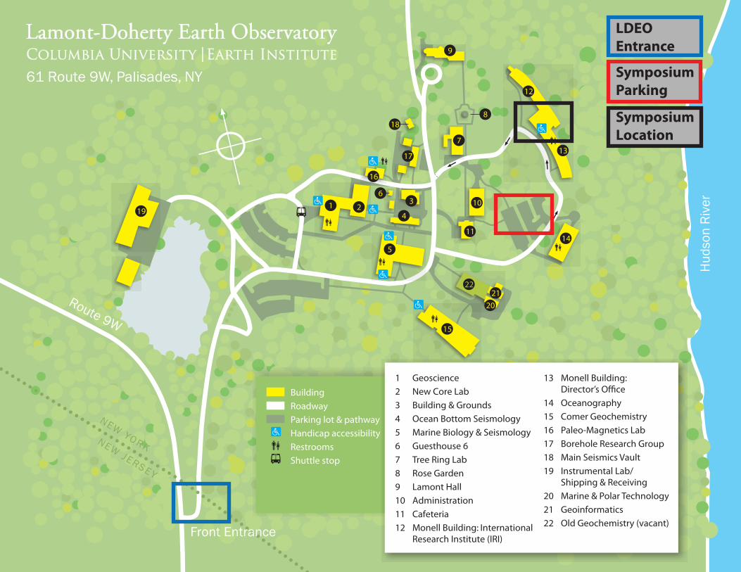
Building Roadway Parking lot & pathway
Handicap accessibility Restrooms Shuttle stop
19
9
13
12
5
36
18
17
7
8
10
11
15
14
41 2
16
KROY WEN
YESREJ WEN
Route 9W
Front Entrance
Huds
on R
iver
1 Geoscience2 New Core Lab3 Building & Grounds4 Ocean Bottom Seismology5 Marine Biology & Seismology6 Guesthouse 67 Tree Ring Lab8 Rose Garden9 Lamont Hall10 Administration11 Cafeteria12 Monell Building: International
Research Institute (IRI)
13 Monell Building: Director’s Office14 Oceanography15 Comer Geochemistry16 Paleo-Magnetics Lab17 Borehole Research Group18 Main Seismics Vault19 Instrumental Lab/
Shipping & Receiving20 Marine & Polar Technology21 Geoinformatics22 Old Geochemistry (vacant)
61 Route 9W, Palisades, NY
2120
22
LDEO Entrance
Symposium Parking
Symposium Location

8^\e[X
8:45-9:30 Breakfast, Registration, Poster setup
9:30-9:35 Welcome and Announcements
9:35-10:35 Oral Session 1: Geochemistry Amelia Paukert (Columbia University, LDEO) Sara Mana (Rutgers University) Alexander Lloyd (Columbia University, LDEO)
10:35-10:50 Co!ee Break
10:50-12:10 Oral Session 2: Paleoclimate/Biogeochemistry/Paleontology Andrew Babbin (Princeton University) Julie Kalansky (Rutgers University) Abagael West (Columbia University, AMNH) Benjamin Black (MIT)
12:10-14:00 Poster Session 1: Ocean and Atmosphere (with lunch)
14:00-15:00 Oral Session 3: Glaciology and Remote Sensing Kenneth Manko! (University of California, Santa Cruz) Michael Wolovick (Columbia University, LDEO) Marc Mayes (Brown University)
15:00-15:15 Co!ee Break
15:15-16:15 Oral Session 4: Geophysics Caroline Eakin (Yale University) Yang Zha (Columbia University, LDEO) Shuoshuo Han (Columbia University, LDEO)
16:15-17:55 Poster Session 2: Solid Earth (with reception)
8YjkiXZkj1�FiXc�J\jj`fej��(�f]�+ Speaker
Presenta-tion Title Session Abstract
Amelia Paukert
Carbon dioxide capture and storage by in situ mineral carbonation in peridotite Geochemistry
Carbon dioxide (CO2) capture and storage by in situ mineral carbonation in geologic formations offers a safe and permanent storage option for CO2. CO2 mineral carbonation- converting CO2 gas into carbonate minerals which are environmentally benign and stable over millenia- has been thought to be a prohibitively slow process in geologic formations. However, this is not always the case: the peridotite aquifer of the Samail Ophiolite, Oman, naturally mineralizes up to 100,000 tons of atmospheric CO2 per year, and acts as a natural analog for an engineered CO2 sequestration project [Kelemen and Matter, 2008]. Peridotite is a mantle rock usually found kilometers under the crust, so when it has been thrust onto a continent, as in the case of an ophiolite, it is far from equilibrium and reacts relatively quickly with water. Peridotite’s high reactivity could be used to engineer a CO2 capture and storage project which enhances CO2 mineral carbonation within the peridotite, perhaps enough to remove significant amounts of atmospheric CO2.
Reaction path modeling of the Oman peridotite aquifer system by Paukert et al. [2012] shows that the natural CO2 storage process is limited by the supply of dissolved inorganic carbon in deep aquifer water. Additionally, modeling of CO2 injection into the aquifer at 30 deg C (ambient temperature in Oman) and at 90 deg C (approximate temperature of a 2km deep borehole) shows that the rate of CO2 mineral carbonation could be enhanced by orders of magnitude by increasing the dissolved carbon supply and temperature [Paukert et al., 2012]. Multiplying the current estimate of natural CO2 mineral carbonation in Oman with the rate enhancement for CO2 injection at 90 deg C gives an enhanced CO2 mineral carbonation rate of 1.6 Gtons CO2/year in Oman, or the capacity to remove roughly 1/20th of the global annual anthropogenic CO2 emissions. This number is encouraging, but is only an estimate. The models do not incorporate injectivity or feedbacks on porosity, permeability, or reactive surface area from secondary mineralization. More sophisticated reactive transport models adding hydrogeology and incorporating such feedbacks are being developed.
Sara Mana
REE variation in alkaline mafic lavas across the North Tanzanian Divergence zone, a possible indicator of varying lithospheric thickness Geochemistry
The magmatic evolution of the North Tanzanian Divergence zone (NTD), the southern termination of the eastern branch of the East African Rift (EAR), is of interest as a currently active magmatic-rich continental rift. The NTD possesses a wide array of pre-rift Miocene to currently active volcanoes broadly distributed across the valley floor to the adjacent rift margins and characterized by having very heterogeneous chemical compositions. A highly diverse array of magmas from basalt to rhyolite, trachyte, phonolite and carbonatite occur at various volcanic centers, some of which have erupted more then one magma type. We analyzed 11 samples from Ketumbeine volcano for whole rock major and trace element abundances, Sr-Nd-Pb isotopic signatures and Ar/Ar ages. Two alkaline rock series representing distinct ages of volcanism are distinguished: the alkali basalt to basaltic trachy-andesite magma series is older with ages ranging between 2.2 and 1.9 Ma, while the basanite to tephra-phonolite magma series erupted at about 1.2 Ma. The temporal separation of the two magma series occurs on a regional scale as well with the basanite to phonolite lavas erupted during the entire period of the NTD volcanism (5.8 Ma to Present), whereas the basalt to trachyte magma series is restricted to two brief intervals: the first between 2.4 and 1.6 Ma, immediately before the major rifting event dated by MacIntyre et al. (1974) at 1.2 Ma, and the second at about 0.5 Ma at Kibo and Mawenzi (Kilimanjaro). We model the source of the NTD as being derived from a metasomatized lithospheric mantle including variable amounts of garnet and amphibole. The most mafic and presumably less contaminated NTD volcanics have systematic REE variations (Sm/Yb versus La/Sm) that are consistent with different degrees of partial melting (La/Sm), and varying amounts of garnet and amphibole in the source (Sm/Yb). Many of the more evolved samples have greater radiogenic isotopic ratios and evolve via assimilation and fractional crystallization to lower Sm/Yb and higher La/Sm. Different degree of partial melting may reflect heat flow variations, while heterogeneity in the source is consistent with pressure conditions that imply changes in the depth of melting.
Alexander Lloyd
NanoSIMS results from olivine-hosted melt embayments: Modeling ascent rate in explosive basaltic eruptions Geochemistry
Although several methods have been used to determine magma ascent rates, it remains a poorly constrained parameter for most volcanic eruptions. One promising method employs diffusion modeling of H2O and CO2 concentration gradients in melt embayments/open melt inclusions. Here we utilize the fine spatial resolution of the nanoSIMS to obtain concentration gradients for five volatile species, improving upon previous efforts that were more limited in spatial resolution and in number of volatile analytes. Focusing on explosive basaltic eruptions, for which very little is known about ascent rates, we selected samples from the Oct 1974 sub-plinian eruption of Volcán de Fuego. Glassy, olivine-hosted embayments with evidence of outlet bubbles were analyzed by nanoSIMS at a minimum distance between spots of 15 µm. Major element zonation in the embayments was investigated by EMP, and high resolution BSE images were captured to complement the nanoSIMS spot measurements for H2O.We report analyses for 5 embayments that vary in length from 100 to 350 µm. Low-solubility volatiles (CO2, H2O, S) decrease towards the embayment outlet, consistent with diffusive reequilibration with the degassing surrounding melt. High-solubility volatiles (Cl, F) increase towards the outlet, apparently behaving as magmaphile elements. Major elements exhibit constant concentrations along the embayment, except for a 20-50 µm wide zone near the embayment outlet, where concentrations vary consistent with olivine and clinopyroxene microlite growth. Forward modeling of CO2 and H2O profiles takes into account temperature- and composition-dependent diffusivities and a closed-system degassing path for the exterior magma (as observed in melt inclusions from the same sample). Assuming a constant decompression rate from 210-245 MPa and an initial composition of 245-480 ppm CO2 and 4.15-4.22 wt% H2O at 1030°C, models yield results with very rapid ascent times (600 s, or 15 m/s). In comparison to previous studies, this example highlights the additional constraints that come from measuring multiple diffusing species with fine spatial resolution.

8YjkiXZkj1�FiXc�J\jj`fej��)�f]�+
SpeakerPresenta-tion Title Session Abstract
Andrew R. Babbin
Organic matter controls pelagic marine nitrogen loss
Paleoclimate/ Biogeochemistry/ Paleontology
The organic matter controls on the two major marine nitrogen loss processes – denitrification and anaerobic ammonium oxidation (anammox) – were assessed in the Eastern Tropical North Pacific (ETNP) oxygen deficient zone (ODZ) using the paired isotope tracer technique in small incubation experiments. The in situ rates were estimated at multiple stations in the ETNP both at the base of the oxycline and within the core of the anoxic water, at the depth of the secondary nitrite maximum. Incubations were amended with organic matter and oxygen to investigate the roles of these parameters in regulating water column nitrogen loss. Measured rates of anammox and denitrification were generally low, both less than 3 nmol N2 L-1 day-1. Rates were stimulated by the addition of different forms of organic matter (in situ sinking particulate organic matter, amino acids, and carbohydrates); higher nitrogen loss rates corresponded to higher nitrogen contents of the organic source.
Julie Kalansky
Sea Surface Temperatures in the Eastern Equatorial Pacific during the Common Era
Paleoclimate/ Biogeochemistry/ Paleontology
On interannual time scales the Eastern Equatorial Pacific (EEP) sea surface temperatures (SST) can change significantly and rapidly due to El Nino events. These interannual changes have been to shown to have far reaching influences on precipitation and temperature patterns via atmospheric teleconnections. Although the EEP plays an important role in global climate, it is unclear how the EEP has changed on centennial time scales during the Common Era and what drives these changes. Recently collected sediment cores from off the coast of Ecuador have been used to reconstruct SST using alkenone ratios, and productivity using 13C of infaunal benthic foraminifera (Uvigerina spp. and Cassidulina subglobosa) and total C37 concentrations. Reconstructed SST suggest relatively stable SST EHWZHHQ�a�������Û&��,Q�WKH�EHJLQQLQJ�RI�WKH�UHFRUG��66T�LQFUHDVH�E\�a���Û&�EHWZHHQ������ AD and a VXEVHTXHQW�GHFUHDVH�RI����Û&�EHWZHHQ�����DQG�����&(� Around 870 AD, SST begin to increase again DQG�FRQWLQXH�WR�LQFUHDVH�WR�D�SHDN�RI�����Û&�DW����� AD. From 1600-2000 SST fluctuates minimally, less WKDQ����Û&��8QOLNH�WKH�66T record from the Indo Pacific Warm Pool, the EEP SST do not suggest temperature variability associated with the Medieval Climate Anomaly and only minor, if any, changes with the Little Ice Age. Based of on total C37 concentrations and infaunal benthic foraminifera 13C, upwelling does not appear to be driving the SST record. The only significant change in benthic 13C occurs around 1700 AD and this may be associated with the northward migration of the Intertropical Convergence Zone increasing cross equatorial winds, which would enhance upwelling. Additionally, the EEP SST do not indicate that ENSO variability is driving the SST changes. One possible cause of the increase in SST in the record is weaker cross equatorial winds enabling more influence of warm water north of the equator. The SST record suggests that various mechanisms might be working together in the EEP to maintain a relatively stable temperature throughout the Common Era.
Abagael West
Implications of an Updated Calibration of the South American Land Mammal "Ages"
Paleoclimate/ Biogeochemistry/ Paleontology
This talk describes the ongoing collection and analysis of new radioisotopic age data constraining the time scale of South American Land Mammal “Ages” (SALMAs). Land mammal “ages” are biochronologic units based on the distribution of mammalian fossil assemblages across a continent and can be independently dated by using radioisotopes, magnetostratigraphy, chemostratigraphy, sequence stratigraphy, and correlation with dated non-fossiliferous formations. The SALMA timescale is of particular interest because its calibration is less well-studied than its North American or European counterparts, and accurate “age” boundaries are crucial to understanding mammalian evolution and biogeography, particularly in relation to global climatic and tectonic history. Additionally, a fine-scale correlation to a global timescale allows testing of hypotheses about biotic-physical interactions during global events (e.g. Paleocene-Eocene thermal maximum, Eocene-Oligocene boundary interval). The present SALMA revision builds on data compiled in 2010 as an update of the most recent comprehensive Cenozoic SALMA chronology, published in 1995, doubling the size of that dataset and filling in temporal gaps in the SALMA sequence. Importantly, at least for mid-Eocene to late Miocene (between 40 and 10Ma), there appears to be a complete, gap-free sequence. However, uncertain age assignments (e.g. due to correlation of fossiliferous to non-fossiliferous formations, stratigraphic gaps, taxonomic uncertainty, incomplete sampling), imprecise isotopic dates (compared to the precision of 40Ar/39Ar), and questionable equivalency of dates determined by different methods typically result in artificially widened ranges and consequent overlap of oldest and youngest dates of successive “ages.” To the extent that temporal overlap of successive “ages” is not a result of error or uncertainty, it suggests diachronous or endemic faunas, and a complex patchwork of biogeographic and climatic processes. The newly compiled timescale thus provides both an updated chronology of Cenozoic South America, and an inspiration for further research into the continent’s biogeography and environmental evolution.
Benjamin Black
Acid Rain and Ozone Depletion: Modeling the climate effects of the eruption of the Siberian Traps
Paleoclimate/ Biogeochemistry/ Paleontology
The Siberian Traps are one of the largest known continental ood basalts, and have been invoked as a trigger for the catastrophic end-Permian mass extinction. Abnormal pollen grains across the Permian-Triassic boundary provide evidence that acid rain and/or ozone depletion contributed to environmentalstress. Previous two-dimensional modeling has shown that degassing of halogens and organohalogens associated with eruption of the Siberian Traps may have been sufficient to catalyze the destruction of a significant fraction of the late Permian ozone layer. We use recent petrologic estimates of the degassingbudget for the Siberian Traps as inputs to a global climate model to explore the atmospheric effects of a range of volcanic eruption scenarios. We find that individual pyroclastic eruptions may enhance already-acidic atmospheric conditions. Passive degassing of methylated halogens from contact heating and metamorphism of Tunguska sedimentary rocks may generate total ozone column depletions of 70% or more. Our modeling demonstrates that Siberian Traps magmatism was sufficient to generate global disruptions in atmospheric chemistry, with wide-ranging ecological effects.

8YjkiXZkj1�FiXc�J\jj`fej��*�f]�+
SpeakerPresenta-tion Title Session Abstract
Kenneth Mankoff
Mapping Subglacial Conduits with a Low-Cost 3D Camera and Novel Algorithms
Glaciology/Remote Sensing
We have explored a subglacial conduit by rappelling down a moulin and crawling underneath a glacier. We used standard speleological mapping techniques to map almost 1 km of subglacial conduits, and in addition used two independent methods to generate high-resolution (~10 cm) 3D digital maps of the subglacial conduits. We present an introduction to subglacial hydrology, results from the three mapping techniques, and initial results of a computational fluid dynamics model of subglacial hydrology that uses the maps as boundary conditions.
Michael Wolovick
Mobile Slippery Spots Produce Uplifted Basal Bodies in Ice Sheet Stratigraphy
Glaciology/Remote Sensing
Large uplifted basal reflectors have been observed in radio-echo sounding data from both Antarctica and Greenland and interpreted as the result of basal freeze-on. However, order-of-magnitude considerations of latent heat requirements suggest that these basal bodies are unlikely to be produced purely from basal freeze-on. Here, we propose a complimentary mechanism capable of building large basal bodies with a small volume fraction of freeze-on ice. Using a two-dimensional higher order thermomechanical flowline model coupled to a simple basal hydrology model, we show that temporal variability in water input can produce warm-based patches (“slippery spots”) that travel with the ice sheet and produce large amounts of uplift and subsidence of the ice sheet stratigraphy through changes in the sliding velocity. The amplitude of vertical motion produced by mobile slippery spots is larger than the amplitude of vertical motion produced by stationary slippery spots (the “Weertman Effect”), and the stratigraphic structures are more intricate as well. This theory makes three observational predictions that can be tested with borehole experiments: 1. the bed underneath regions of drawn down stratigraphy should be cold, 2. the bed underneath the uplifted basal bodies should be warm, and 3. the majority of the volume fraction of the basal bodies should be composed of deformed meteoric ice.
Marc Mayes
Forest Loss, Regrowth and Agricultural Expansion in the Miombo Woodlands of Tanzania: Understanding Land Cover Dynamics from the Field and Space to Improve Satellite Monitoring of Complex Landscapes
Glaciology/Remote Sensing
Sub-Saharan Africa is an emerging global hotspot of rapid land cover changes with significant implications for ecosystem biogeochemistry and people. Forest cover loss, regrowth and agricultural expansion are occurring at spatial scales of one- to ten-hectare patches amidst complex landscapes with long legacies of land use. Patterns, rates, drivers and consequences of land changes remain poorly understood at landscape scales. Combining analyses of data from satellites such Landsat and MODIS, field data and ecosystem modeling studies could improve understanding of land change patterns and their consequences for ecosystems and people. However, given high spatial-temporal variability in vegetation conditions, phenology, land use practices and small field sizes in sub-Saharan Africa, remote sensing methods of mapping land changes developed for temperate ecosystems and the Amazon simply do not translate to sub-Saharan African landscapes.
Here, I develop a new framework for quantitatively distinguishing forest and agricultural land areas with satellite data for the Miombo Woodlands of Tanzania, an area experiencing growing development pressures. Field data collected in 2012, time series of Landsat and MODIS satellite images and geospatial analyses give an empirical view of the variability of land cover materials (e.g. green vegetation, soils). My framework is a hypothesis for how land cover materials at field scales (0.5-5 ha) relate to the overall state of landscape phenology at larger (10s-100s ha) spatial scales, across the transition from the wet to dry season (May-August). I test relationships between measures of land cover at field scales, captured in Landsat data of 30 m2 pixel resolution (dependent variable), as a function of the seasonal state of landscape phenology, captured by MODIS data of 250 m2 pixel size (independent variable). Results will indicate the degree and accuracy with which my framework differentiates land cover areas seasonally in Landsat data. Additionally, I will explore use of Landsat spectral data to quantify sub-pixel forest and agriculture areas in MODIS data. Ideally, the framework will enable quantitative mapping of forest and agriculture land changes through time in Miombo ecosystems, in preparation for further study of their drivers and ecosystem impacts.

8YjkiXZkj1�FiXc�J\jj`fej��+�f]�+ Speaker
Presenta-tion Title Session Abstract
Caroline M Eakin
Influence of Peruvian Flat-Subduction Dynamics on the Evolution of the Amazon Basin Geophysics
Despite the global prominence of flat or shallow subduction comparatively littleis understood as to the dynamics of such systems and particularly how theoverlying continent is affected. We can address this issue by modeling dynamic topography; deflections of the Earth's surface due to the forces impinged by mantle flow, thus providing a crucial insight to the Earth's interior by linking deep mantle processes to the surface. For this we choose the Peruvian flat-slab segment as our study area, the largest region of flat subduction currently in the world. The onset of the flat-slab system here is thought to have begun in the Mid-Miocene (~12Ma), around the same time as a major upheaval to the Amazon Basin took place, when drainage switched from the Caribbean Sea to the Atlantic Ocean as seen today.
Computations of dynamic topography are highly sensitive to slab morphology,therefore in this study we create a realistic flat-slab model using hundreds ofhypocentre locations from the NEIC earthquake catalog. Predictions of dynamic topography from this flat-slab model produce long wavelength dynamic subsidence, >1km in amplitude, and at well over 1000 km from the trench. This subsidence is located directly over the steeply dipping portion of the slab to the east, and is broadly matched by negative residual (non-isostatic) topography over the Amazon Basin. This dynamic low also remarkably coincides with 800m of sediment accumulation in the Sub-Acre/Solimoes peri-cratonic basin of western Amazonia that cannot otherwise be explained by flexure from the Andean load, or by dynamic topography from a standard subduction model.
Furthermore considering a transition from normal to flat subduction during theMid-Miocene, our relative dynamic topography calculations suggest that theAndean foreland region would have been raised up whilst the Amazon Basin was dropped. Thus eastward fluvial transport would have been encouraged, leading to the formation of the Amazon River, one of world's largest river systems, as we presently know it.
Yang Zha
Upper mantle shear velocity structure beneath Eastern Lau back-arc Spreading Center from ambient noise tomography of OBS data Geophysics
We analyze ambient seismic noise data collected from 50 broadband ocean bottom seismographs (OBS) during a 13-months deployment over the Eastern Lau Spreading Center (ELSC). The ELSC is a 400-km-long back-arc spreading center lying close to the Tonga subduction trench in the southwestern Pacific. Fluids expelled from the subducting slab cause melting of the upper mantle above the slab, strongly influencing the structure of the southern ELSC. Seafloor morphology, crustal thickness and lava composition data show systematic variations along the ridge as the ridge migrates away from the volcanic arc front to the north, indicating a decreasing influence of the subducting slab. Phase velocities for Rayleigh between 3- to 20 seconds were obtained from inter-receiver coherences of ambient seismic noise. The phase velocity measurements have been inverted for 3D phase velocity maps and shear velocity models.
Preliminary inversion results suggest two separate low velocity zones (LVZs) beneath the back-arc basin. The shallow LVZ lies beneath the Tofua Volcanic Arc closer to the trench. The deeper LVZ underneath the back-arc spreading center widens and shifts laterally with respect to the ridge as the ridge migrates away from the volcanic arc. The two LVZs overlap to the south of 21°S but become distinct to the north, consistent with a decreasing influence of the slab on the spreading ridge as the ridge propagates away from the trench. Other components of the ELSC experiment include body wave tomography and measurements of surface wave phase velocities, body wave attenuation and shear wave splitting. Our results will be combined with these other results to improve our understanding of this rifting-spreading transition process.
Shuoshuo Han
3D Multichannel Seismic Imaging of Off-Axis Melt Lenses at the East Pacific Rise Geophysics
Mid-ocean ridge system is the longest mountain chain around the globe and is where much of the Earth’s volcanism is focused. Here as two plates move apart, mantle upwells and experiences decompressional melting, the basaltic melt produced solidifies and forms the oceanic crust. One surprising observation of fast spreading ridge is that although mantle melt region beneath the ridge can be 100-200 km wide, the new oceanic crust is generated in a narrow axial zone, which is characterised by a melt lens about 1 km wide sitting on top of a 4-6 km wide partially molten zone. However, the new findings from a recent 3D PXOWLFKDQQHO�VHLVPLF��0&6��VWXG\�DW�(DVW�3DFLILF�5LVH��(35���Û1�DUHD�VXJJHVW�WKDW�WKH�FUXVWDO�DFFUHWLRQ�zone at fast-spreading ridge may not be as narrow as previously thought. Here we show 3D MCS image of a group of ofI�D[LV�PHOW�OHQVHV��2$0/��FHQWUHG�DW�(35��Û��¶1�� The OAMLs are present as far as 10 km from the ridge axis with the most prominent one ~3 km x 3 km in size. The deepened Moho under the OAML on the time migration section suggests the rock beneath the OAML is partially molten and/or thicker than normal lower crust. The reflections beneath the major OAML are possibly lower melt lenses that feed the upper ones. These OAMLs imaged may be the source of enriched basalt sampled on the ridge flank, thus contribute to off-axis eruption. Also the OAMLs and their associated molten zone may serve as potential heat sources for localized high-temperature hydrothermal circulation on the ridge flanks, expanding the suitable living environment for deep-sea biological communities to broader region. The finding of OAML provides new information and raises new questions about the crustal accretion process at mid-ocean ridge and the thermal structure of young oceanic crust.

8YjkiXZkj1�FZ\Xe$8kdfjg_\i\�Gfjk\i�J\jj`fe Poster # Name
Institut-ion
Presentation Title Abstract
01Usama Anber
Columbia University / LDEO TBA
A Series of three-dimensional Cloud Resolving Model simulations is conducted to investigate the role of ambient unidirectional horizontal wind shear on the microphysical properties of the equilibrated tropical cumulus ensembles under large-scale dynamics parameterized by the weak temperature gradient (WTG) approximation. The mean horizontal wind profile in relaxed to zero at the surface and varies linearly with height. Both the target profile toward which horizontal mean free tropospheric temperature is relaxed and the surface fluxes of heat and moisture are held fixed.Wind shear affects the mesoscale organization of convection through interaction with evaporatively driven downdraft outflows (convective triggering). For weak shear, the convection has a point-like pattern, while for stronger shear the convection clusters into lines of thick pattern either aligned with the shear or tilted, indicating strong interaction of convective plumes.Domain and time mean precipitation is non monotonic with the shear strength.Shear also significantly affects the large-scale vertical velocity, convective heating and drying, mass fluxes, cloud fraction, and momentum transport.
02Chen Chen
Columbia University / LDEO
Predictability of ENSO diversity in a linear inverse model
ENSO as a tropical Pacific extreme event is previously viewed as one single climate mode, which can be predicted within one year by current forecast models. Recently, climate community started to investigate the higher modes of the climate system and defined at least two types of ENSO events. Whether different types of ENSO can be detected and predicted in current forecast models, at how long lead time? Whether new criteria are necessary to estimate the ability to model and reconstruct multiple modes? Based on new criteria, how to improve the model skill by proper construction? This work uses a statistical model as an tool to address the above questions. Compared to the large numerical model (time consuming and hard to tune all the parameters to the optimal setup), statistical model with quick calculation time and small construction framework is necessary and welcome for forecast purpose. Therefore, in this paper, a linear inverse model is constructed using GFDL GCM output as an example to discuss the statistical model's predictability of different flavors of ENSO phenomena, which is currently a hot topic in climate research community. Singular vectors (SV) analysis is applied to help decompose and define the diversity, which is based on the viewpoint of dynamical system instability theory. The results suggest that at least two SV modes are required to be recognizable and predictable in the model to reconstruct a variety of ENSO. The difference and consistence between model estimation criteria (SV indices and classic NINO indices) are discussed in the new framework. The results of a series of model parameter sensitivity test show that, within linear model framework, a proper weighted multivariate model (including sea surface temperature, ocean heat content, wind stress, precipitation, heat flux, etc.) with an optimal dimension projection and adjustable time step can improve the forecast skill of ENSO diversity in the lead time within one to two years.
03Darren C. McKee
Columbia University / LDEO
Transport of warm Upper Circumpolar Deep Water onto the West Antarctic Peninsula continental shelf
Upper Circumpolar Deep Water (UCDW) is a deep water mass of the Southern Ocean characterized by a maximum in temperature. It is a predominant source of heat and nutrients to the surrounding Antarctic continental shelf. Five thermistor-moorings were placed on the continental shelf of the western Antarctic Peninsula (between 2007 and 2010) in an effort to identify the mechanism(s) responsible for delivering warm UCDW onto the broad continental shelf from the Antarctic Circumpolar Current (ACC) flowing over the adjacent continental slope. Historically, four mechanisms have been suggested: (1) eddies shed from the ACC, (2) flow into the cross-shelf-cutting canyons with overflow onto the nominal shelf, (3) general upwelling, and (4) episodic advective diversions of the ACC onto the shelf. We observe the UCDW to be delivered as episodic warm features (~3 per month) whose characteristics are consistent with eddies. Mechanism 2 played no role, though the canyons have been shown previously to channel UCDW into Marguerite Bay. The eddies may be embedded within an intrusion of ACC waters, so both mean flow-topography interaction in the presence of a trough and the baroclinic instability of the shelf-break jet are considered as explanatory mechanisms. Finally, data from a recent glider (AUV) mission in January 2013 sampling the pathway of the warm water are briefly discussed for a spatial perspective.
8YjkiXZkj1�FZ\Xe$8kdfjg_\i\�Gfjk\i�J\jj`fe Poster # Name
Institut-ion
Presentation Title Abstract
04Jesse Farmer
Columbia University / LDEO
Investigating the boron isotopic composition of deep-sea bamboo corals: seawater pH versus biomineralization
The ocean is the largest exchangeable carbon reservoir in the global carbon cycle, and represents an important sink for anthropogenic carbon emissions. The addition of anthropogenic carbon is particularly troubling for deep-sea calcifying organisms, as these organisms grow in regions of already reduced carbonate saturation state due to the natural accumulation of carbon in the deep ocean and increased solubility of carbonate minerals under increasing pressure. Understanding how benthic calcifiers will fare with increased anthropogenic carbon uptake requires greater understanding of both the tolerances of these organisms and the range of natural variability within the deep ocean carbonate system. Boron-based proxies ( 11B, B/Ca) provide useful methods to reconstruct past changes in the deep-ocean carbonate system. Previous studies of aragonitic deep-sea corals using boron-based proxies suggest that these corals possess an ability to up-regulate their internal pH, potentially providing resistance to ocean acidification. However, to our knowledge, there have been no complementary studies on calcitic isidid gorgonian octocorals, or “bamboo corals”, and their tolerance to ocean acidification. Here we investigate the boron isotopic composition of a suite of deep-sea bamboo corals (genus Keratoisis) and seek to evaluate biological versus environmental controls on their boron isotopic composition using coupled stable isotope ( 13C and 18O) measurements. We test the fidelity of Keratoisis boron isotope records by calibrating a suite of modern samples to hydrographic pH measurements and comparing intra-coral 11B records from modern North Atlantic Keratoisis to modeled expectations of seawater pH change due to addition of anthropogenic DIC to the North Atlantic. Our results show that while surface coral 11B closely tracks the expected 11B of seawater borate, intra-sample
11B variability of 2-3‰ may suggest that environmental factors are overprinted by biological control on calcification. The implications for such biological control will be discussed in the context of resistance to ocean acidification.
05Anastasia Yanchilina
Columbia University / LDEO
Mediterranean-derived flooding of the Black Sea-lake: The story from the shelf.
A number of shallow cores are collected from the shelf areas of the Black Sea. Fresh and marine mollusk specimens taken from an interval in all the cores representing the evolution of the Black Sea from lake to sea to resolve whether the water that transgressed this shelf at the time was Mediterranean derived. These specimens are analyzed for 87Sr/86Sr, 18O, 13C, and 14C. The analyses clearly show that all of the specimens have the contribution from the Mediterranean water to varying degrees. Dreissina rostriformis, a common fresh mollusk, has isotope signatures that trend towards marine as a function of decreased water depth suggesting that those that inhabited water late in the transgression, lived in a more marine environment. Monodacna caspia, a mollusk that comes in during the transgression but disappears after fully marine conditions are reached, has isotope signatures that have a very large Mediterranean contribution. Cardium edule, a mollusk that prefers predominantly marine water, has isotope values indicating a fully marine habitat is reached. AMS 14C dating also supports this interpretation. In the deeper shelf cores, the offset between fresh and marine mollusks in 14C dates is ~1000 years but this difference decreases with water depth as the radiocarbon ages trend towards younger values suggesting that the reservoir age of the Black Sea is decreasing as more and more Mediterranean radiocarbon-equilibrated water is flowing in.
06Nicole Abdul
Rutgers University
A High-Resolution Deglacial Sea-Level Record from Barbados’ Reef-Crest Coral Acropora palmata: 14.0 to 8.4 kyrBP
Sea-level variability remains the most accurate global measure of the response of continental ice volume to climate forcing and provides one of the most precise benchmarks on which climate change hypothesis and models are tested. Our coral-based record of the most recent and best constrained deglaciation (20,000 cal-yrsBP) suggest a mode of sea-level rise whose rate was not constant and included two episodes of accelerated sea-level rise (Meltwater Pulses 1A and 1B). We generated a deglacial record of sea-level from 14.0 to 8.4 kyr BP using 99 U-Th dated, Acropora palmata fossil coral samples from Barbados. We observe a decrease in the rate of sea-level rise from the top of MWP1A (~14,000 cal-yrsBP) to the base of MWP1B (~11,430 cal-yrsBP), from an initial rate of 12 m/kyr in the Allerød decreasing to 7 m/kyr by the termination of the Younger Dryas. The coral data confirm MWP1B as a 12 ± 2 meter jump in sea-level rise between 11.4 and 11.1 kyrBP, where rates of sea-level rise approached 35 m/kyr, drowning the A. palmata reef-crest facies (< 5 m water depth habitat) and triggering the shoreward migration of said facies. The post MWP1B sea-level record is constrained by two overlapping cores that capture the landward re-establishment of the A. palmata reef-crest facies and define sea-level rise rates of 9 m/kyr though the mid-Holocene. At 8,400 cal-yrs BP, the Barbados A. palmata sea-level record splices into the Caribbean composite A. palmata record of Lighty et al., (1982) justifying our estimate of a constant uplift correction (0.34 m/ka) at Barbados. The spatial and temporal resolution of the Barbados A. palmata record leaves little doubt that our sea level reconstruction represents the interlocking framework of the shallow-water reef-crest facies and there is no evidence to suggest any non-reef-crest, deep dwelling A. palmata were sampled

8YjkiXZkj1�FZ\Xe$8kdfjg_\i\�Gfjk\i�J\jj`fe Poster # Name
Institut-ion
Presentation Title Abstract
07Leonard E Henry
Columbia University / LDEO
Breaking Down U-series in Ocean Sediments
Abrupt shifts in the Atlantic’s circulation regime have been inferred from carbon isotopes within benthic foraminfera, geostrophic gradient shifts captured in oxygen istope data from benthic foraminifera, and the change in burial rate of 231Pa/230Th in bulk sediment. Drift deposits areoften selected for 231Pa/230Th paleoceanographic reconstructions because the sedimentation rates far exceed those of the mean ocean average, thus allowing for resolution of transient climate events not preserved in other seafloor sediment cores. The fine sediment (<20um) that makes up the majority by mass of these deposits is chiefly carried from non-proximal localities. Previous work suggests that the fine fraction of the sediment carries a disporportionatly high concentration of authigenic thorium, 230Thxs, and extra-terrestrial helium, 3HeET, two nuclides frequently employed as constant-flux proxies in the aid of climate reconstructions from sediments. Here we present a side-by-side budgets of 230Thxs and 231Paxs for many of the time periods of interest to paleoceanographers over the last deglacial from core CDH-19 taken from a North Altantic drift deposit, near the Bermuda Rise, during sea trials of the RV Knorr’s long coring system developed at the Woods Hole Oceanographic Institute.
08
M. Rajib Hassan Mozumder
Columbia University / LDEO
Water Resources Management in the Maheshkhali Island, an Offshore Island of Bangladesh
This research provides the first report on the hydrogeology and water resources development and management in the Maheshkhali Island, a small, tropical, mixed-type high island of southeastern Bangladesh. The water development potential of this island is large. A large number of streams (locally known as ‘charas’) in the hilly area are the major sources of surface water. Groundwater occurs as a water-table aquifer, as a confined aquifer, as perched aquifers, and as ephemeral contact springs. Artesian wells (native name: 'jari pipe') are restricted only to the northern part of the island probably due to the discontinuity of the confining bed of Tipam Sandstone Formation. Inhabitants living in the southern part of the island depend on limited water resources from the perched aquifers that can’t meet their demand especially during the dry season when these aquifers deplete very fast. Since the maximum freshwater lens thickness is about 50 m in this portion (south) of the island, there’s no potential for deep wells also. Water type of most of the groundwater samples derived from the artesian wells, springs and charas is Ca-Na-HCO3 or Ca-Mg-HCO3. On the contrary, majority of the shallow or perched aquifer samples exhibit Na-HCO3-Cl or Na-Cl-HCO3 type of water indicating mixing of freshwater with saline water. Therefore, the southern part of the island is entangled with both quantity and quality problems which necessitates optimization of local water resources. Moreover, estimated approximate groundwater storage (36.2 Mm3) can meet only about 51% of the total (domestic plus agricultural) demand of 71.46 Mm3. Thus, only groundwater cannot sustain freshwater demand of the residents. The completely undeveloped available surface water resources, on the other hand, accounts for approximately 161.84 Mm3. Conjunctive uses of surface and groundwater resources, including traditional rainwater harvesting, and other nonconventional development options e.g. retention ponds, sand dams, transportation or importation have been proposed. Major management goals should include community education, enforcement for water resources protection zones, data collection, etc.
09Angelica Patterson
Columbia University / LDEO
Physiological response to temperature across nine tree species in a northeastern temperate forest
Extensive botanical surveys and long term plots at Black Rock Forest in southeastern New York have shown that since the early 1930’s, three northern-ranged tree species were extirpated and eleven tree species were introduced or had migrated from southern USA. These observations are consistent with a warming climate and suggest the Hudson River Valley may be an important location to study the effects of climate change on Northeastern forests. In this study, we compared a suite of physiological and leaf traits across nine tree species that have one of four distribution ranges (northern, central, southern, introduced) and one of two leaf types (broad-leaf and coniferous). Carbon to nitrogen ratio , and nitrogen content (N) differed significantly among species and range category for both broad-leaved and conifer trees. Specific leaf area (SLA) of broad-leaved trees differed significantly between species and range category. Photosynthetic rate at light-saturation (Amax), maximal rate of carboxylation (Vcmax), electron transport limitation (Jmax), triose phosphate limitation (TPU), and dark respiration (Rd) differed significantly between species and range category where southern ranged species had the highest photosynthetic and respiration rates for broad-leaved species. Pinus strobus, a centrally ranged conifer species had higher photosynthetic and lower respiration rates than Pinus resinosa, a northern ranged conifer species. There were strong correlations between leaf traits and physiological traits for both broad-leaved and conifer species revealing that trees with high N content and high SLA have higher photosynthetic rates and is consistent with the literature. These results highlight the physiological advantages southern and introduced species have over their northern ranged counterparts with influential effects on forest community composition and energy flows.
10Jonathan Gale
Columbia University / LDEO
Eliminating Topographic Shadow from Moderate Resolution Satellite Imagery: A New Technique Using a DEM Correction in Spectral Mixing Space
Land cover mapping from satellite imagery has had the challenge of eliminating variations in the solar illumination across uniform composition surface features. Using a new technique, the variability in Landsat imagery due to solar illumination is successfully removed for many land cover types, notably vegetated areas. This technique finds the linear correlation between solar illumination values calculated from ASTER DEM data and the SVD dark fraction (Small 2004) calculated from the Landsat image. This linear correlation is then corrected to a theoretical flat surface that has no solar illumination variations. The resulting image can then be used to study variations in land cover without the overprinting of topographic shadow.

8YjkiXZkj1�Jfc`[�<Xik_�Gfjk\i�J\jj`fe Poster # Name
Institut-ion
Presentation Title Abstract
11Cathleen Doherty
Columbia University / LDEO
Constraining the dynamic response of subcontinental lithospheric mantle to rifting using Re-Os model ages in the Western Ross Sea, Antarctica
In order to understand the dynamic response of the subcontinental lithospheric mantle (SCLM) to rifting, it is important to be able to distinguish the geochemical signatures of SCLM vs. asthenosphere. Recent work demonstrates that unradiogenic Os isotope ratios can indicate old depletion events in the convecting upper mantle (e.g. Hauri, 2002). Thus, if SCLM can be traced across a rifted margin, its fate during rifting can be established. Furthermore, similar ages beneath the rift shoulder and within the rift itself would suggest stretched SCLM reaches into the rift and thus precludes replacement by asthenospheric mantle. The Western Ross Sea is characterized by widespread Cenozoic xenolith-bearing volcanism that post-dates rifting and thus provides favorable conditions to test the dynamic response of SCLM to rifting. Re¬Os measurements from 8 locations extending from the rift shoulder to 200 km into the rift basin reveal 187Os/188Os ranging from 0.1056 at Foster Crater on the shoulder, to 0.1265 on Ross Island within the rift. While individual sample model ages vary throughout the margin, ‘alumina-chron’ ages (Reisberg & Lorand, 1995) reveal a narrower range of lithospheric stabilization ages. Four locations yield Paleoproterozoic stabilization ages, and Mount Morning and Conical Hill coincide with U¬Pb zircon ages from Transantarctic Mountain (TAM) crustal rocks, in support of SCLM stabilization at the time of crust formation along the central TAM. The Paleoproterozoic stabilization age recorded at Franklin Island is especially significant, since it lies 200km off of the rift shoulder. The persistence of thinned Paleoproterozoic SCLM into the rifted zone in WARS suggests that it represents a ‘type I’ margin of Huismans and Beaumont (2011), which is characterized by crustal breakup before loss of lithospheric mantle. The Archean Re¬depletion age of 3.3 Ga observed on the rift shoulder suggests that cratonic lithosphere extends beneath the TAM.
12
Maxim Gavrilenko
Rutgers University
Identification of source lithology at south segment of Kamchatka subduction zone
Kamchatka peninsula (Russia) is an island-arc with a complex geological history and structure. It has three distinct volcanic fronts, the origin of which is still debated. Moreover, a junction with the Aleutian Arc (at ~56oN) complicates the understanding of geodynamics at the region. However, the south part (from ~53oN) of Kamchatka peninsula is thought to be a “textbook case” of subduction zone with relatively rapid (over 8 cm/yr) near-normal convergence and a steep (over 50°) angle of subduction. Kamchatka is unusual in the world because its volcanoes contain a significant amount of primitive high MgO lavas that are rich in olivine crystals. Furthermore, high precision contents of Ni, Ca, and Mn can help to constrain the source lithology. Straub et al. (2008) reported high Ni contents on olivines from a limited number of samples from the Mexican Volcanic Front, and concluded that pyroxenite melting was important. Portnyagin et al. (2009) reported high precision Ni, Ca, and Mn contents of olivines from a wide range of volcanoes from Kamchatka, and similarly concluded that pyroxenite melting is widespread. We have extended the work of Portnyagin et al. (2009) by analyzing olivine phenocrysts from volcanoes in the southernmost Kamchatka peninsula. Our work confirms that there are regional variations in olivine phenocryst composition that likely arises from variations in pyroxenite composition, the amount of peridotite melt that mixes with pyroxenite melts, and a variable role played by magnetite fractionation. We conclude that pyroxenite melting is likely to be important in subduction zones world-wide, but its significance has been underestimated because of the general rarity of olivine-bearing high MgO lavas.
13Eleanor Ferguson
Columbia University / LDEO
The Dauki Thrust Fault and the Shillong Anticline: an incipient plate boundary in NE India?
The Shillong massif is a regional crustal-scale composite anticline developing across the Assam sliver of the Indian plate near the Eastern Himalayan Syntaxis. The steep southern limb preserves a Cretaceous-Paleocene passive margin sequence despite extreme rainfall and the gentle northern limb exposes Precambrian basement. The asymmetry suggests southward growth of the structure. From the south-verging structure, we infer a regional deeply-rooted north-dipping blind thrust fault. It strikes E-W and obliquely intersects the NE-SW margin of India, displaying three segments: Western, within continental India; Central, along the former passive margin; and Eastern, overridden by the west-verging Burma accretion system. We present findings from recent geologic fieldwork. The broadly warped erosional surface defines a single anticline in the central segment, east of the intersection with the hinge zone of the buried continental margin. The south limb of the anticline forms a steep topographic front, but is even steeper structurally. Some faults display thrust reactivation of rift-related faults. Less competent Neogene clastics are preserved only near the base of the mountain front. Drag folds and backthrusting indicate north-vergence and a roof thrust above a blind thrust wedge floored by the Dauki thrust fault. West of the hinge zone, the contractional structure bifurcates in the Indian continent. The Dauki Fault continues westward as the erosion-deposition boundary combined with a belt of N-S shortening. The Dapsi Fault branch is mostly blind below a topographically expressed fold involving basement and passive-margin cover, but is exposed in the west where Archean basement juxtaposes folded, steeply dipping fluvial sediment. The area between the two faults is a gentle southward monocline, thus uplift of this area stems from slip on the Dauki thrust fault, not pervasive shortening. The Burma foldbelt overrides the Shillong anticline and is warped but continuous across the eastern segment of the Dauki fault. Where the Dauki and Haflong-Naga thrusts cross, the thrust fronts are nearly parallel and opposite vergence. We trace a Dauki-related topographic front eastward across the Burma Range. We propose that the Dauki Fault continues below the foldbelt.

8YjkiXZkj1�Jfc`[�<Xik_�Gfjk\i�J\jj`fe Poster # Name
Institut-ion
Presentation Title Abstract
14
Natalia Zakharova
Columbia University / LDEO
Mechanical Properties of Fractured Aquifers in the Northern Newark Basin: Implications for Carbon Sequestration
One of the key factors in predicting the performance of low-permeability fractured reservoirs is a detailed understanding of the in-situ state of stress and the distribution and orientation of natural fractures and faults. In this study we analyze borehole geophysical data from a deep characterization well in the northern Newark Basin, a candidate CO2-storage site, located close to the populous New York Metropolitan Area. Induced seismicity presents a significant risk for carbon sequestration in low-permeability fractured formations because even small-magnitude earthquakes and slip on pre-existing fractures threaten the seal integrity of CO2 repositories. High-resolution wellbore images allow identifying both natural discontinuities and drilling-induced failures indicative of in-situ stress orientation. Combined with other geophysical logs, they allow for evaluation of geomechanical properties and facilitate modeling of effective stress perturbation due to CO2 injection. Preliminary analysis suggests strike-slip to reverse faulting stress regime but indicates that a more accurate estimate of the least horizontal stress magnitude is needed for evaluating the permissible range of injection pressure. We provide petrophysical and geomechanical characterization of fractured sedimentary and igneous formations, and discuss potential risks and implications for carbon storage at this locality.
15Taka Kanaya
Brown University
Effects of Pore Pressures on the Strength of Seismogenic Faults: Constraints from Laboratory Experiments
We are conducting triaxial compression experiments on quartz sandstone to characterize the Brittle-Ductile Transition at elevated pore pressures. This study aims to test the fundamental assumption commonly made in models of tectonic faults that the depths of the Brittle-Ductile Transition increase with pore pressure following the effective pressure law for brittle failure. A suite of undrained tests are performed through sealing up to 4 weight % of water in the sample at the pressure and temperature conditions where ductile flow has been observed under fluid absent conditions. Despite the inferred attainment of nearly lithostatic pore pressure throughout the experiments, our stress-strain curves and macro- and micro-structures suggest that the sandstone underwent ductile flow via dislocation creep at all pore-fluid contents. The sandstone exhibits reduced but nonetheless substantial flow strengths, which decrease from 200 to 50 MPa with increased pore-fluid contents. These observations are incompatible with the assumption that a lithostatic pore pressure promotes brittle failure associated with a near zero stress even at great depths, but suggest that in the ductile regime high fluid-contents may decrease effective viscosity beyond that expected by quartzite flow laws. /// A second series of experiments are conducted under a drained condition using an Argon as a pore fluid at the pressure and temperature conditions within the brittle-ductile transition. At temperatures of ~300 °C fracture strengths obey the effective pressure law, exhibiting a linear relationship between strength and differential pressure (confining pressure minus pore-pressure), consistent with previous work. Conversely, at a temperature of 900 °C we observe a significant reduction in fracture strength and brittleness under a greater pore pressure, but identical differential pressure, incompatible with the effective pressure law assuming a pore-pressure coefficient of unity. Elastic moduli and frictional strengths, however, appear to depend linearly on differential pressure under these conditions. The pore pressure coefficient associated with fracture inferred may be consistent with those predicted from models of effective pressure laws that consider modification in the geometrical configuration of granular solids and pore fluids via thermally-activated processes. Elastic and frictional deformation, in contrast, may involve a minimal change or fracture-induced renewal in the geometrical configuration, respectively, even under elevated pressures and temperatures, resulting in the inferred pore pressure coefficient of unity. We are conducting additional experiments to place further constrains on the depth extent to which the effective pressure law adequately bounds the strength and failure mode of plate boundary faults that display increasingly diverse slip behaviors.
16Heather Ford
Brown University
Localized shear in the deep mantle lithosphere beneath the San Andreas fault system
The extent and geometry of strike-slip plate boundaries in the deep mantle lithosphere is an important, yet unresolved, aspect of plate tectonics. Models range from localized shear zones that are deep extensions of individual crustal faults to broad zones of diffuse, distributed shear with widths of hundreds of kilometers. Here we use seismic waves that scatter from shear (S) to compressional (P) motion to image the base of the lithosphere across the San Andreas fault system. Amplitudes of Sp conversions indicate a systematically smaller shear-wave velocity gradient with depth across the lithosphere-asthenosphere boundary (LAB) on the western side of the plate boundary than to its east. The change in Vs gradient typically occurs over a horizontal length scale of less than 50 km. This result is best explained by the juxtaposition of mantle lithospheres with different properties across the plate boundary. The spatial correlation between the surface expression of the plate boundary and the laterally abrupt change in LAB properties points to the accommodation of relative plate motion on a narrow shear zone that extends throughout the entire thickness of the lithosphere.

8YjkiXZkj1�Jfc`[�<Xik_�Gfjk\i�J\jj`fe Poster # Name
Institut-ion
Presentation Title Abstract
17 Erin WirthYale University
Mantle wedge anisotropy in the Japan and Ryukyu subduction zones – Implications for mantle flow and wedge hydration
Many fundamental aspects of subduction, such as the dynamics of mantle flow and the transport of water in to the upper mantle by the subducting slab, have yet to be fully understood. However, a complete characterization of seismic anisotropy can yield powerful constraints on both mantle flow and the degree of mantle wedge hydration. We better characterize the geometry and strength of anisotropy in the mantle wedges beneath northeast Japan and the Ryukyu arc, which overlie the subducting Pacific and Philippine Sea plates, respectively. We compute radial and transverse component P-to-S receiver functions from 15 stations of the F-net array using the multitaper correlation receiver function estimator (Park and Levin, 2000). Backazimuthal variations in P-to-SH converted energy allow us to place constraints on the strength and orientation of the anisotropy, while the timing of the P-to-SH arrival constrains the depth to sharp gradients in anisotropy. We observe P-to-SH conversions that are consistent with the presence of multiple anisotropic and dipping layers. We compute synthetic receiver functions using a forward modeling scheme to create models for the depths, thicknesses, and strengths of the anisotropic layers beneath both northeast Japan and Ryukyu. In the mantle wedge beneath Ryukyu, we detect evidence for a layer of strong anisotropy with a high VP/VS ratio and an anisotropic symmetry axis oriented perpendicular to the plane of the subducting slab, consistent with serpentinized mantle. We see no evidence of this signature in receiver functions derived from the mantle wedge beneath northeast Japan, where we instead see evidence of relatively weak anisotropy and olivine fabric types. Since mantle wedge serpentinization requires that the mantle wedge become significantly hydrated, the fact that we see evidence of serpentinite in this specific area of the mantle wedge beneath Ryukyu but not beneath northeast Japan, has important implications for our understanding of volatile release by the subducting slab and the subsequent mantle wedge hydration.
18Colton Lynner
Yale University
Sub-Slab Shear Wave Splitting in the Pacific
The dynamics of subduction zones, while vitally important to our understanding of plate tectonics and mantle convection, are relatively poorly understood. A great deal of effort has been focused on the examination of anisotropy in the mantle wedges of the various subduction zones around Japan, while the sub-slab mantle of these subduction zones have remained poorly studied due to difficulties in constraining sub-slab mantle anisotropy. These difficulties arise from several different factors ranging from lack of seismic station coverage, the inability of SK(K)S phases to constrain depth of anisotropy, sampling multiple layers of anisotropy to inadequate backazimuthal earthquake coverage. Recently, a push to better understand the dynamics of the sub-slab mantle has lead to the utilization of source-side shear wave splitting to examine sub-slab anisotropy. The source-side splitting technique uses earthquakes originating in the subducting slab and seismic stations away from the subduction zone to probe the anisotropy in the sub-slab mantle while avoiding signal contamination from the mantle wedge, providing depth constraints on anisotropy, and greatly increasing the area of the sub-slab mantle generating shear wave splitting measurements. Here we present source-side shear wave splitting results from the Ryukyu, Izu-Bonin, Northwestern Honshu, and Kurile arcs in the northwestern Pacific. The Northwestern Honshu arc shows very strongly trench parallel shear wave splitting for shallow events, ~25-100 km depth, with trench oblique splitting for deeper events. The Izu-Bonin and Kurile arcs both show trench parallel splitting, while Ryukyu exhibits trench perpendicular shear wave splitting.
19Zach Eilon
Columbia University / LDEO
Anisotropy beneath a (seriously) strained continental rift.
The Woodlark Rift, in Papua New Guinea, is host to the youngest known UHP rocks,exhumed ahead of the propagating rift tip in metamorphic core complexes (MCC). A 2010-11 deployment of 31 land seismic stations and 8 broadband OBS instruments has yielded the first detailed seismic information from the region around these MCCs. We have used four different shear wave splitting techniques to investigate the anisotropy beneath these islands, with the aim of constraining mantle flow regimes that might accompany the rapid exhumation of coesite-eclogite facies rocks in <9Ma: specifically differentiating between the proposed end member models of coherent, fault-accommodated unroofing and felsic diapirism. Further from the nascent rift zone the fabric appears to be fairly consistently N-NE, parallel to the extension direction and observed GPS velocities. Closer to the rift, around the MCCs, complex structure is evinced by significant disagreement between different measurement techniques and rotations in anisotropic fast direction of up to 90 degrees over short length scales. We are in the early stages of modelling, but observe distinct depth sensitivities of different shear wave splitting techniques that may allow estimates of depth variations in anisotropy in this region. Intriguingly, significant splitting times of 2 seconds are apparent across the array, despite the relative youth of the tectonic regime; some combination of flow-induced fabrics and aligned melt lenses may be required to explain the inferred magnitude of anisotropy. The results from shear wave splitting must be interpreted consistently with our receiver function analyses, which indicate 10-15km of crustal thinning centred beneath the MCCs, compared to off-axis moho depths of >35km. The proposed tectonic environment of recent subduction followed by ongoing extension could produce unusual time-integrated mantle flow patterns, so it is notable that much of the data require no such exotic textures to explain observed splitting measurements. The anisotropy is instead consistent with a simple corner flow model despite the fact that lithospheric extension in this region has not yet matured to fully-fledged seafloor spreading.

8YjkiXZkj1�Jfc`[�<Xik_�Gfjk\i�J\jj`fe Poster # Name
Institut-ion
Presentation Title Abstract
20 Ge Jin
Columbia
University
/ LDEO
Imaging Crust and
Mantle Structure
beneath the
D'Entrecasteaux
Islands from
Rayleigh Wave
Tomography
The D’Entrecasteaux Islands and adjacent Papuan peninsula in eastern Papua New Guinea
are home to the earliest stages of extension associated with the Woodlark Rift system. Very
young (7-8 Ma) ultra-high pressure (coesite-eclogite facies) rocks within metamorphic core
complexes (MCCs) on the D’Entrecasteaux Islands indicates exhumation from 100 km depths
at plate-tectonic rates. We investigate the dynamic processes driving uplift and extension
using seismic images of crustal and mantle structure derived from surface waves across the
region. From March 2010 to July 2011, 31 on-shore and 8 off-shore broadband seismic
stations deployed across the extensional region recorded 68 earthquakes with high signal-to-
noise Rayleigh waves. We utilize a multi-channel cross-correlation technique to measure the
phase delay and amplitude across the array in a period band between 20-80 sec, which
images a depth range from lower crust to approximately 150 km depth. The phase difference
of Rayleigh-wave arrivals between nearby stations is measured for each earthquake by fitting
the narrow-band filtered cross-correlation between the observed seismograms. We then invert
these intra-array phase measurements for a slowness vector map using the Eikonal equation
to get the dynamic phase velocity and propagation direction. Averaging the dynamic phase
velocity of all available events produces set of final phase velocity maps that can be inverted
for shear-velocity structure, and the variations in phase-velocity as a function of azimuth
provide constraints on anisotropy.
For most of the frequency bands, the region beneath the MCCs on Goodenough Island and
Fergusson Island, adjacent to the tip of the Woodlark spreading center, shows slow phase
velocity, suggestive of high temperatures and/or partial melt, perhaps related to localized
mantle upwelling. In contrast, the region near the Trobriand Island to the north, and the
Papuan peninsula to the south, shows consistently higher phase velocity, implying that the
extension and upwelling are localized beneath the the MCC’s. These phase-velocity
observations will be combined with receiver-function measurements of bulk crustal properties
(crustal thickness and velocity) to produce three-dimensional shear-velocity models for the
crust and mantle across the region.
21
Ayda
Shokoohi
Razi
Rutgers
University
Crustal and
Uppermost Mantle
Structure Beneath
Western Tibet
from Seismic
Tomography using
Regional
Earthquakes
From the summer of 2007 to summer of 2011, we operated a network of ~30 temporary
portable seismic stations in Western Tibet. We selected 282 events from the China Earthquake
Administration (CEA) catalog with magnitudes greater than 3.0 from July 2007 to July 2010.
Due to a small number of permanent seismic stations in this region, hypocenters in the CEA
catalog are poorly constrained. Therefore, we decided to use the first 3-year CEA data to
relocate earthquakes in order to find an accurate location of hypocenters in this study. The
result of the earthquake relocation shows more clustering of seismic events than appears in the
CEA catalog. We picked the arrival times of P and S-waves (2496 and 1035, respectively) and
assigned a time uncertainty (0.2 s for P-waves and 0.6 s for S-waves). We performed regional
earthquake tomography inversion, using an algorithm by Roecker et al. 2004, to image the
crust and uppermost mantle structure beneath the western part of the Tibetan Plateau. After 40
iterations, the variance and RMS misfits in our final 3D model decreased by 22% and 12%,
respectively. The average P-wave velocity is low through the crust, with values on the order of
6.0-6.1 km/s found between 10 and 70 km below the surface.
We found no evidence of a low velocity zone in the middle or lower crust beneath our study
area. The crust and upper mantle have different patterns of velocity variations. The crustal
structure shows the presence of slow P-wave velocity anomaly. This slow pattern appears to be
within the Lhasa block, and its edges correlate well with the IYS and BNS sutures. The
uppermost mantle shows a narrow, long high P-wave velocity anomaly along a NE-SW
orientation, surrounded by two slow P-wave velocity anomalies. The cause of this high velocity
feature may be the metamorphic transformation of eclogite from the lower crust to the upper
mantle that occurs during the underthrusting of the Indian lithosphere beneath southern Tibet.
22Anna
Foster
Columbia
University
/ LDEO
Surface wave
arrival angles in
the western US
As surface waves propagate outward from an earthquake source, they encounter the
heterogeneous structure of the Earth's crust and upper mantle. This structure causes rays to
refract, scatter, and deviate from the simple great-circle path we would otherwise expect. With
the installation of the USArray Transportable Array network, the seismology community has
benefited from a great advance in the quantity and quality of available data. Using this data, we
make measurements of the arrival angle of energy from earthquakes around the world arriving
at stations in the western United States. This allows us to see in a qualitative manner how
waves are propagating through the area covered by the network, and has additional
implications for traditional measurement methods used in surface-wave studies.

8YjkiXZkj1�Jfc`[�<Xik_�Gfjk\i�J\jj`fe Poster # Name
Institut-ion
Presentation Title Abstract
23James Gibson
Columbia University / LDEO
Widespread Mega-Pockmarks Imaged Along the Western Edge of the Cocos Ridge
A large field (245km2) of 31 seabed mega-pockmarks was imaged between the Cocos ridge and the Quepos plateau on ~16.5 Ma oceanic crust generated at the Cocos-Nazca spreading center. The imaged pockmarks represent only a fraction of the much larger pockmark field evident in 100 m grid cell bathymetry data secured from MGDS. The pockmarks are clustered around 1800-2100 mbsl and were mapped using EM122 multi-beam sonar, a 3.5 kHz sub-bottom profiler, and 3D Multi-Channel Seismic (MCS) aboard R/V Marcus G. Langseth during the CRISP seismic survey (2011). Using a constrained swath width of 1.4 km, the increased sounding density facilitated bathymetry/backscatter to be gridded at 10 m and 8 m respectively. The diameter of the pockmarks varies from ~1 km to ~2 km with a relief range of ~30-80 m, and average slopes of 15°. The MCS data also reveal older buried pockmarks in trench adjacent sediments. Small high-backscatter mounds occur within a subset of the pockmarks, which may indicate bioherms or carbonate banks above focused fluid flow conduits. Based on drilling results of ODP Site 1381, the pockmarks appear to be the result of paleo-differential advancement of a silica diagenetic front (opal-A to opal-CT). Although, the pockmarks may be erosional features sourced at depth from dewatering of sediments inter-bedded with igneous layers.
24Tolulope Olugboji
Yale University
Mineral physics-based interpretation of the LAB: partial melting or sub-solidus processes?
Recent seismological studies using high-frequency body waves show relatively sharp and large velocity reduction at the oceanic lithosphere-asthenosphere boundary (LAB). We explore possible models for such seismological signature of the LAB using the latest mineral-physics observations. The key features that need to be explained by any viable model include (1) a sharp (<20 km width) and a large (5-10%) velocity drop, (2) at 70 km depth in the old oceanic upper mantle and (3) the age-dependent LAB depth in the young oceanic upper mantle. We examine the plausibility of both partial melt and sub-solidus models. Because many of the LABs in the old oceanic regions are located in areas where temperature is 1000-1200 K, significant partial melting is difficult, and some mechanisms of melt accumulation are required to explain a large velocity reduction. We examine the layered melt model and a model of melt accumulation at the LAB and show that both models are difficult to reconcile with seismological observations. We present a detailed analysis of a new version of sub-solidus model where the role of grain- boundary sliding is included. A broad range of parameter space is explored based on the statistical analysis of the experimental data. In contrast to the old model where only the absorption-band behavior was assumed, the new model predicts an age-dependent LAB structure including the age-dependent LAB depth and its sharpness.