‘ein ‘arik village profile -...
TRANSCRIPT

‘Ein ‘Arik Village Profile
Prepared by
The Applied Research Institute – Jerusalem
Funded by
Spanish Cooperation
2012

Palestinian Localities Study Ramallah Governorate
1
Acknowledgments
ARIJ hereby expresses its deep gratitude to the Spanish Agency for International Cooperation for
Development (AECID) for their funding of this project.
ARIJ is grateful to the Palestinian officials in the ministries, municipalities, joint services councils,
village committees and councils, and the Palestinian Central Bureau of Statistics (PCBS) for their
assistance and cooperation with the project team members during the data collection process.
ARIJ also thanks all the staff who worked throughout the past couple of years towards the
accomplishment of this work.

Palestinian Localities Study Ramallah Governorate
2
Background
This report is part of a series of booklets, which contain compiled information about each city, town, and
village in the Ramallah Governorate. These booklets came as a result of a comprehensive study of all
localities in Ramallah Governorate, which aims at depicting the overall living conditions in the
governorate and presenting developmental plans to assist in developing the livelihood of the population
in the area. It was accomplished through the "Village Profiles and Needs Assessment;" the project
funded by the Spanish Agency for International Cooperation for Development (AECID).
The "Village Profiles and Needs Assessment" was designed to study, investigate, analyze and document
the socio-economic conditions and the needed programs and activities to mitigate the impact of the
current unsecure political, economic and social conditions in Ramallah Governorate.
The project's objectives are to survey, analyze, and document the available natural, human,
socioeconomic and environmental resources, and the existing limitations and needs assessment for the
development of the rural and marginalized areas in Ramallah Governorate. In addition, the project aims
at preparing strategic developmental programs and activities to mitigate the impact of the current
political, social, and economic instability with the focus on the agricultural sector.
All locality profiles in Arabic and English are available online at http://vprofile.arij.org.
Palestinian Localities Study Ramallah Governorate
3
Table of Contents
Location and Physical Characteristics ______________________________ 4
History _______________________________________________________ 5
Religious and Archaeological Sites ________________________________ 6
Population ____________________________________________________ 6
Education ____________________________________________________ 7
Health Status __________________________________________________ 8
Economic Activities ____________________________________________ 8
Agricultural Sector _____________________________________________ 9
Institutions and Services ________________________________________ 12
Infrastructure and Natural Resources _____________________________ 12
Environmental Conditions ______________________________________ 14
Impact of the Israeli Occupation _________________________________ 15
Development Plans and Projects _________________________________ 17
Implemented Projects __________________________________________ 17
Proposed Projects _____________________________________________ 17
Locality Development Priorities and Needs _________________________ 18
References: __________________________________________________ 19

Palestinian Localities Study Ramallah Governorate
4
‘Ein ‘Arik Village Profile
Location and Physical Characteristics
„Ein „Arik is a Palestinian village in the Ramallah Governorate located 5.6km north-east of Ramallah
City. „Ein „Arik is bordered by Beituniya and „Ein Qiniya villages lands to the east, Beituniya town to
the south, Deir „Ibzi‟ village lands to the west and Deir „Ibzi‟ village to the north (ARIJ GIS, 2012) (See
Map 1).
Map 1: ‘Ein ‘Arik location and borders
Source: ARIJ GIS, 2012
„Ein „Arik is located at an altitude of 554m above sea level with a mean annual rainfall of 589mm. The
average annual temperature is 16 o
C and the average annual humidity is approximately 61% (ARIJ GIS,
2012).

Palestinian Localities Study Ramallah Governorate
5
Since 1998, „Ein „Arik has been governed by a village council which is currently administrated by 8
members appointed by the Palestinian National Authority. The village council is included within the
Joint Services Council for „Ein „Arik, Deir „Ibzi‟, Kafr Ni‟ma and Bil‟in. It has a permanent (rented)
headquarters and owns a vehicle for the collection of solid waste („Ein „Arik Village Council, 2011).
It is the responsibility of the village council to provide a number of services to the residents of „Ein
„Arik, including („Ein „Arik Village Council, 2011):
1. Infrastructure services, such as water and electricity provision and management.
2. Solid waste collection, road construction and restoration, street cleaning, and social development
services.
3. Management and supervision of the village kindergarten.
History
„Ein „Arik was named due to the many springs located in the area („Ein „Arik Village Council, 2011).
The village was established over 50 years ago („Ein „Arik Village Council, 2011) (See photo below for „Ein
„Arik village).
Photos of ‘Ein ‘Arik
Palestinian Localities Study Ramallah Governorate
6
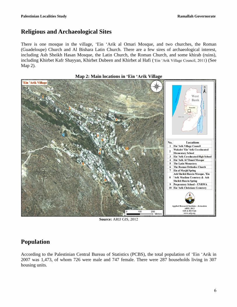
Religious and Archaeological Sites
There is one mosque in the village, „Ein „Arik al Omari Mosque, and two churches, the Roman
(Guadeloupe) Church and Al Bishara Latin Church. There are a few sires of archaeological interest,
including Ash Sheikh Hasan Mosque, the Latin Church, the Roman Church, and some khirab (ruins),
including Khirbet Kafr Shayyan, Khirbet Dubeen and Khirbet al Hafi („Ein „Arik Village Council, 2011) (See
Map 2).
Map 2: Main locations in ‘Ein ‘Arik Village
Source: ARIJ GIS, 2012
Population
According to the Palestinian Central Bureau of Statistics (PCBS), the total population of „Ein „Arik in
2007 was 1,473, of whom 726 were male and 747 female. There were 287 households living in 307
housing units.

Palestinian Localities Study Ramallah Governorate
7
Age Groups and Gender
The General Census of Population and Housing carried out by PCBS in 2007 showed the distribution of
age groups in „Ein „Arik was as follows: 38.8% were less than 15 years of age, 55.7% were between 15
and 64 years of age, and 5.6% were 65 years of age or older. Data additionally showed that the sex ratio
of males to females in the village is 97.2:100, meaning that males and females constitute 49.3% and
50.7% of the population respectively.
Families
„Ein „Arik residents are from several families, mainly the Shillu, Shaheen, Bassah, Zeitah and Nimer
families („Ein „Arik Village Council, 2011).
Immigration
The field survey conducted by the ARIJ team showed that approximately 10 people have left the village
since the Al Aqsa Intifada in 2000 („Ein „Arik Village Council, 2011).
Education
According to the results of the PCBS Population, Housing and Establishment Census-2007, the illiteracy
rate among „Ein „Arik population was approximately 6.6%, of whom 70% were females. Of the literate
population, 11.6% could only read and write with no formal education, 27.6% had elementary
education, 33.1% had preparatory education, 11.5% had secondary education, and 9.6% completed
higher education. Table 1 shows the educational level in the village of „Ein „Arik by sex and educational
attainment in 2007.
Table 1: ‘Ein ‘Arik population (10 years of age and above) by sex and educational attainment S
E
x
Illiterate
Can
read &
write
Elementary Preparatory Secondary Associate
Diploma Bachelor
Higher
Diploma
Maste
r
PhD Unknown Total
M 21 62 150 195 59 22 22 - 4 - - 535
F 49 62 144 158 64 28 25 - 1 - - 531
T 70 124 294 353 123 50 47 - 5 - - 1,066
Source: PCBS, 2009.
The village has one public school run by the Palestinian Ministry of Education and Higher Education
(MoEHE), one private school, and two UNRWA schools (Directorate of Education in Ramallah, 2011) (See
Table 2).

Palestinian Localities Study Ramallah Governorate
8
Table 2: Schools in ‘Ein ‘Arik by name, stage, sex, and supervising authority
School Name Supervising Authority Sex
„Ein „Arik Co-educated Secondary School Government Mixed
The Latin Patriarch /„Ein „Arik School Private Mixed
„Ein „Arik Co-educated First Elementary School UNRWA Mixed
„Ein „Arik Co-educated Second Elementary School UNRWA Mixed
Source: Directorate of Education in Ramallah, 2011
In 2011 there were 456 students, 36 teachers, and 22 classes registered in the village (Directorate of
Education in Ramallah, 2011). The average number of students per teacher in the school was 13, whilst the
average number of students per class is approximately 21.
Furthermore, there are two kindergartens in „Ein „Arik. In total, these kindergartens host 81 children
(Directorate of Education in Ramallah, 2011).
Table 3: Kindergartens in ‘Ein ‘Arik by name and supervising authority
Kindergarten Supervising Authority Number of Children
Children of Al Aqsa Kindergarten Private 50
The Latin Patriarch/ „Ein „Arik Kindergarten Civil Christian 31
Source: Directorate of Education in Ramallah, 2011
Health Status
There are a few health centers and services available in „Ein „Arik village, including Ein „Arik private
health center which includes a physician‟s clinic, a dental clinic and a pharmacy, and a physician‟s clinic
run by the UNRWA. In the absence of any required health service or in emergencies, residents of „Ein
„Arik use healthcare facilities in Beituniya town or visit Ramallah Governmental Hospital in Ramallah
city („Ein „Arik Village Council, 2011).
The health sector in the village faces some obstacles and problems, including („Ein „Arik Village Council,
2011):
1. The village‟s main clinic does not operate on a daily basis.
2. The lack of specialized physicians.
3. The lack of an ambulance.
Economic Activities
The economy in „Ein „Arik is entirely dependent on the industry sector, which absorbs 100% of the
village workforce („Ein „Arik Village Council, 2011).

Palestinian Localities Study Ramallah Governorate
9
„Ein „Arik village has 3 groceries, 3 vegetable and fruit shops, 2 butcheries, and 6 different professional
workshops (carpentry, blacksmith etc.). The unemployment rate in „Ein „Arik reached around 20% in
2011 („Ein „Arik Village Council, 2011).
Labor Force
According to the PCBS Population, Housing and Establishment Census-2007, 35.2% of the „Ein „Arik
labor force was economically active, of whom 82.4% were employed, and 64.4% were not economically
active, of whom 48.6% were studentsand 34.8% were housekeepers (See Table 4).
Table 4: ‘Ein ‘Arik population (10 years of age and above) by sex and employment status-2007
S
E
X
Economically Active Not Economically Active
Un-
known
Total Employed
Currently
Unemployed
Unemployed
(Never
worked)
Total Students House-
keeping
Unable
to work
Not working
& Not
looking
for work
Other Total
M 250 46 12 308 169 3 47 2 5 226 1 535
F 59 5 3 67 165 236 59 - 1 461 3 531
T 309 51 15 375 334 239 106 2 6 687 4 1,066
Source: PCBS, 2009.
Agricultural Sector
„Ein „Arik lies on an area of 5,948 dunums, of which 2,188 dunums are arable land and 215 dunums are
dedicated to residential services (see Table 5 and Map 3).
Table 5: Land use and land cover in ‘Ein ‘Arik village in 2010 (area in dunum)
Total
Area
Built
up
Area
Agricultural area
(2,188)
Inland
water
Forests Open
Spaces
Area of
Industrial,
Commercial
&
Transport
Unit
Area of
Settlement,
Military
Bases &
Wall Zone
Permanent
Crops
Green-
houses
Range
-lands
Arable
lands
5,948 215 2,146 0 0 42 0 69 3,075 401 0
Source: ARIJ – GIS Unit, 2012.

Palestinian Localities Study Ramallah Governorate
11
Map 3: Land use/land cover and Segregation Wall in ‘Ein ‘Arik Village
Source: ARIJ GIS, 2012
Table 6 shows the different types of rain-fed and irrigated open-cultivated vegetables in „Ein „Arik. The
most common crop cultivated within this area is squash.
Table 6: Total area of rain-fed and irrigated open cultivated vegetables in ‘Ein ‘Arik village (dunum)
Fruity vegetables Leafy vegetable Green legumes Bulbs Other vegetables Total area
RF Irr. RF Irr. RF Irr. RF Irr. RF Irr. RF Irr.
18 11 0 1 11 1 5 0 5 0 39 13 Rf: Rain-fed, Irr: Irrigated
Source: Palestinian Ministry of Agriculture, 2009
Table 7 shows the different types of fruit trees planted in the area. „Ein „Arik is famous for olive crops;
there are 1,435 dunums of land planted with olive trees in the village.
Table 7: Total area of fruit and olive trees in ‘Ein ‘Arik village (dunum) Olives Citrus Stone-fruits Pome fruits Nuts Other fruits Total area Rf Irr. Rf Irr. Rf Irr. Rf Irr. Rf Irr. Rf Irr. Rf Irr.
1,435 0 5 0 11 0 0 0 42 0 102 0 1,595 0 Rf: Rain-fed, Irr: Irrigated
Source: Palestinian Ministry of Agriculture, 2009

Palestinian Localities Study Ramallah Governorate
11
In terms of field crops and forage in „Ein „Arik, cereals (particularly wheat) are the most cultivated,
covering an area of about 40 dunums (See Table 8).
Table 8: Total area of field crops in ‘Ein ‘Arik village (dunum) Cereals Bulbs Dry
legumes Oil
crops
Forage
crops
Stimulating
crops
Other
crops
Total
area
Rf Irr Rf Irr Rf Irr Rf Irr Rf Irr Rf Irr Rf Irr Rf Irr
40 0 12 0 15 0 0 0 10 0 0 0 0 0 77 0 Rf: Rain-fed, Irr: Irrigated
Source: Palestinian Ministry of Agriculture, 2009
The difference between the two sets of results obtained from the Ministry of Agriculture and by ARIJ‟s
GIS Unit in sizes of agricultural areas is explained by the fact that the Ministry of Agriculture and the
Palestinian Central Bureau of Statistics (2010) conducted a survey which used a definition of
agricultural areas based on land ownership. Therefore, the areas included in the survey were those of
actual holdings of agricultural areas instead of seasonal ones. The survey did not consider fragmented
and small seasonal cultivated areas in residential and agricultural areas. ARIJ‟s survey, however,
indicated the existence of a high proportion of small and fragmented holdings (home gardens)
throughout the occupied Palestinian territories, thus accounting for the larger area of agricultural
holdings calculated by ARIJ.
The field survey shows that 3% of the residents in „Ein „Arik rear and keep domestic animals such as
sheep and goats (See Table 9).
Table 9: Livestock in ‘Ein ‘Arik village
Cows* Sheep Goats Camels Horses Donkeys Mules Broilers Layers Bee Hives
0 246 636 0 0 0 0 0 0 0 *Including cows, bull calves, heifer calves and bulls
Source: Palestinian Ministry of Agriculture, 2009
There are approximately 15 kilometers of agricultural roads in the village, divided as follows („Ein „Arik
Village Council, 2011):
Table 10: Agricultural Roads in ‘Ein ‘Arik Village and their Lengths
Suitability of Agricultural Roads Length (km)
For vehicles 2
For tractors and agricultural machinery only 3
For animals only 7
Unsuitable 3 Source: „Ein „Arik Village Council, 2011
The agricultural sector in the village faces some problems, mainly („Ein „Arik Village Council, 2011):
The economic infeasibility.
The lack of capital.

Palestinian Localities Study Ramallah Governorate
12
Institutions and Services
„Ein „Arik village has a village council and a post office division („Ein „Arik Village Council, 2011).
Infrastructure and Natural Resources
Electricity and Telecommunication Services:
„Ein „Arik has been connected to a public electricity network since 1986. It is served by Jerusalem
Electricity Company, which is the main source of electricity in the village and approximately 98% of the
housing units in the village are connected to the network. However, the village residents face some
problems concerning electricity, primarily the weak electrical power supply („Ein „Arik Village Council,
2011):
„Ein „Arik is connected to a telecommunication network and approximately 90% of the housing units
within the village boundaries are connected to phone lines („Ein „Arik Village Council, 2011).
Transportation Services:
There are 4 public buses and 1 taxi providing transportation to residents of „Ein „Arik village. Residents
seeking to travel are often delayed by the Segregation Wall („Ein „Arik Village Council, 2011). The village
has 5km of main roads which are paved and in good condition and 3km of secondary roads, also paved
and in good condition („Ein „Arik Village Council, 2011).
Water Resources:
„Ein „Arik is provided with water by the Jerusalem Water Department through the public water network
established in 2000. Approximately 98% of housing units in the village are connected to the water
network („Ein „Arik Village Council, 2011).
The quantity of water supplied to „Ein „Arik in 2010 was approximately 41,064 cubic meters. The
estimated rate of water supply per capita is therefore about 76 liters/day. However, no „Ein „Arik citizen
consumes this amount of water due to water losses, which are estimated to be approximately 26.5%.
These losses happen at the main source, major transport lines, in the distribution network, and at the
household level; therefore, the actual rate of water consumption per capita in „Ein „Arik is 56 liters per
day (Jerusalem Water Authority, 2011). This is a low rate compared with the minimum quantity of 100
liters/capita/day proposed by the World Health Organization.
To determine water costs, the water authority has adopted an upward rate where the price of water
increases with increasing consumption. Table 11 shows the price of water by category of consumption.

Palestinian Localities Study Ramallah Governorate
13
Table 11: Water tariffs of Jerusalem Water Authority adopted since 01.01.2012
Consumption
Category (m³)
Domestic
(NIS/m³)
Industrial
(NIS/m³)
Tourist
(NIS/m³)
Commercial
(NIS/m³)
Public
Institutions
(NIS/m³)
0 – 5 4.5 5.6 5.6 5.6 5.4
5.1 – 10 4.5 5.6 5.6 5.6 4.5
10.1 – 20 5.6 6.8 6.8 6.8 5.6
20.1 – 30 6.8 8.1 8.1 8.1 6.8
30.1+ 9 9.9 10.8 9 9
Source: Jerusalem Water Authority, 2012
„Ein „Arik has approximately 60 rainwater harvesting cisterns, in addition to two water springs („Ein „Arik
Village Council, 2011) (See Table 12 for more information on the springs).
Table 12: Water Springs in ‘Ein ‘Arik
Name of Spring Type of Use Average Pumping Rate (m³/ year) „Ein „Arik al Fauqa Spring Agriculture & Domestic 180,491
„Ein „Arik at Tahta Spring Agriculture 67,382
Source: PWA, 2010
Sanitation:
„Ein „Arik lacks a public sewerage network with most of the village residents using cesspits for the
disposal of wastewater („Ein „Arik Village Council, 2011).
Based on the estimated daily per capita water consumption, the estimated amount of wastewater
generated per day is approximately 66 cubic meters or 24,146 cubic meters annually. At the individual
level in the village, it is estimated that the per capita wastewater generation is approximately 39 liters
per day. The wastewater collected by cesspits is discharged by wastewater tankers directly to open areas
or nearby valleys without concern for the environment. There is no wastewater treatment either at the
source or at the disposal sites and this poses a serious threat to the environment and to public health
(ARIJ - WERU, 2012).
Solid Waste Management:
The Joint Services Council/ Group VII for Solid Waste is responsible for managing the collection and
disposal of solid waste generated by citizens and establishments in the village. As the process of solid
waste management is costly, a monthly fee of 15 NIS is charged to the population served by domestic
solid waste collection and transportation services. However, only 60% of these fees are collected from
the citizens („Ein „Arik Village Council, 2011).
Most of the population in „Ein „Arik benefit from the solid waste services, whereby waste is collected
from households, institutions, shops, and public squares in plastic bags and then transferred to 40
containers spread throughout the locality. The Joint Council collects the solid waste from the containers

Palestinian Localities Study Ramallah Governorate
14
once a week and transports it using a waste vehicle to a dumping site shared with neighboring localities,
5km from the village, where it is burnt and buried („Ein „Arik Village Council, 2011).
The daily per capita rate of solid waste production in „Ein „Arik is 0.7kg. Thus the estimated amount of
solid waste produced per day from the „Ein „Arik residents is nearly 1 ton, or 376 tons per year (ARIJ -
WERU, 2012).
Environmental Conditions
Like other villages and towns in the governorate, „Ein „Arik experiences several environmental
problems which must be addressed and solved. These problems can be identified as follows:
Water Crisis
Water is cut off by the Jerusalem Water Authority for long periods of time during summer in
several neighborhoods of the village for several reasons:
(1) Israeli control over Palestinian water resources causes problems in the organization of water
pumping and its distribution among populations. The Jerusalem Water Authority distributes
water to various areas on an interval basis because the amount of water available is not
sufficient to supply everyone‟s needs simultaneously.
(2) High rate of water losses, because the water network is old and in need of rehabilitation and
renovation.
Lack of a public water reservoir in the village to be used by residents during water shortages.
Wastewater Management
The absence of a public sewage network means that in „Ein „Arik residents are forced to use
unhygienic cesspits for the disposal of wastewater, and/or to discharge wastewater in the streets.
This is particularly common in winter, as citizens cannot afford the high cost of sewage tankers
during this period. These methods facilitate environmental damage, health problems, and the
spread of epidemics and diseases in the village. This wastewater also contaminates the
groundwater and water collected in household cisterns (rainwater harvesting cisterns) because
most cesspits are built without lining, allowing wastewater to enter into the ground and avoiding
the need to use sewage tankers. Moreover, the untreated wastewater collected from cesspits by
sewage tankers is disposed of in open areas without concern for the damage it causes to the
environment and to residents' health.
Solid Waste Management:
The lack of a central sanitary landfill to serve in „Ein „Arik and the other neighboring
communities in the governorate is due mainly to the obstacles created by the Israeli authorities
for local and national institutions in granting licenses to establish such a landfill, because the
appropriate land is within Area C and under Israeli control. Additionally, the implementation of

Palestinian Localities Study Ramallah Governorate
15
such projects depends on funding from donor countries. The lack of a sanitary landfill is a source
of pollution to the groundwater and soil through the leachate produced from the solid waste, and
produces bad odors and distortion of the landscape.
Impact of the Israeli Occupation
Geopolitical status in ‘Ein ‘Arik
According to the Oslo II Interim Agreement signed in 28th
September 1995 between the Palestinian
Liberation Organization (PLO) and Israel, „Ein „Arik was divided into areas “B” and “C”.
Approximately 435 dunams (7.3% of the village‟s total area) were assigned as area B, where the
Palestinian National Authority (PNA) has a complete control over civil matters but Israel continues to
have overriding responsibility for security. Area B constitutes most of the inhabited Palestinian areas,
including municipalities, villages and some camps. The rest of the village‟s area, constituting 5,514
dunams (92.7% of the total area), is classified as area C, where Israel retains full control over security
and administration related to the territory. In area C Palestinian building and land management is
prohibited unless through consent or authorization by the Israeli Civil Administration. Most of the lands
lying within the area C are agricultural areas and open spaces (table 13).
Table 13: The Geopolitical Divisions of ‘Ein ‘Arik – Ramallah Governorate
Percent of Total village
area Area in dunams Area
0 0 Area A
7.3 435 Area B
92.7 5,514 Area C
0 0 Nature Reserve
100 5,949 Total
Source: Source: ARIJ-GIS, 2012
‘Ein ‘Arik village and the Israeli Occupation Practices
The Israeli Occupation authorities confiscated thousands of dunams of land for the construction of the
Segregation Wall south of the village and on Beituniya lands. This led to the isolation of „Ein „Arik and
the neighboring villages from the northwest communities of Jerusalem Governorate and from the
agricultural lands in Beituniya and its neighboring villages that were isolated behind the Wall.
Following the outbreak of the second Palestinian Intifada in September 2000, the Israeli occupation
authorities established hundreds of Israeli military checkpoints throughout the West Bank. These include
a permanent military checkpoint that hinders the communication of villages west of Ramallah, including

Palestinian Localities Study Ramallah Governorate
16
„Ein „Arik, and prevents them from using the main linking bypass road no. 443. This road is exclusively
for the use of the Israeli settlers.
„Ein „Arik, like many Palestinian villages, was subject to the Israeli incursions aimed at spreading panic
and terror among Palestinian citizens. These incursions included attacks, arrests of Palestinians,
invading homes, and searching and tampering with their contents.
Issued Military Orders in ‘Ein ‘Arik Village
The Israeli Occupation Army has issued many military orders to confiscate lands in „Ein „Arik for the
construction of the Segregation Wall, including the following:
Israeli Military Order No. (21/96/T): Issued on the 31st
of January 1996. It confiscates lands from
„Ein „Arik and Beituniya localities for the purpose of establishing a 3.2km road between the two
localities to connect with Ofar Israeli Military Base.
Israeli Military Order No. (03/98/T): Issued on the 4th
of November 1998. It confiscates lands
from „Ein „Arik, Deir „Ibzi‟, Beituniya and „Ein Qiniya localities for the construction of a road
4470m long and 80m wide.

Palestinian Localities Study Ramallah Governorate
17
Development Plans and Projects
Implemented Projects
„Ein „Arik village council has implemented several development projects in „Ein „Arik during the past
five years (See Table 14).
Table 14: Implemented Development Plans and Projects in ‘Ein ‘Arik During the Last Five Years
Proposed Projects
„Ein „Arik Village Council, in cooperation with the civil society organizations in the village and the
village residents, hopes to implement several projects in the coming years. The project ideas were
developed during the PRA workshop conducted by ARIJ staff in the village. The projects are as follows,
in order of priority from the perspectives of workshop participants:
1. Constructing a services complex.
2. Establishing a sewerage network (5 km).
3. Establishing a health clinic with the necessary equipment and facilities.
4. Constructing agricultural roads (10 km).
5. Reclaiming agricultural lands.
6. Rehabilitating the public road.
7. Expanding the electricity and water networks (2 km).
8. Constructing retaining walls (6 km).
9. Establishing a public park.
10. Restoring archaeological sites in the village.
Name of the Project
Type Year Donor
Pavement of internal roads Infrastructure 2010 Ministry of Finance
Construction of „Ein „Arik Co-educated Secondary School Educational 2010 Arab Banks Fund
Source: ‘Ein ‘Arik Village Council, 2011

Palestinian Localities Study Ramallah Governorate
18
Locality Development Priorities and Needs
„Ein „Arik suffers from a significant shortage of infrastructure and services. Table 15 shows the
development priorities and needs in the village according to the village council‟s point of view.
Table 15: Development Priorities and Needs in ‘Ein ‘Arik
No. Sector Strongly
Needed
Needed Not a
Priority
Notes
Infrastructural Needs
1 Opening and Pavement of Roads * 12km
2 Rehabilitation of Old Water Networks *
3 Extending the Water Network to Cover New Built up
Areas *
2km
4 Construction of New Water Networks *
5 Rehabilitation/ Construction of New Wells or
Springs *
2 springs
6 Construction of Water Reservoirs *
7 Construction of a Sewage Disposal Network *
8 Construction of a New Electricity Network *
9 Providing Containers for Solid Waste Collection * 20 containers
10 Providing Vehicles for Collecting Solid Waste * 1
11 Providing a Sanitary Landfill *
Health Needs
1 Building of New Clinics or Health Care Centres * a health center
2 Rehabilitation of Old Clinics or Health Care Centres *
3 Purchasing of Medical Equipment and Tools *
Educational Needs
1 Building of New Schools *
2 Rehabilitation of Old Schools *
3 Purchasing of New Equipment for Schools *
Agriculture Needs
1 Rehabilitation of Agricultural Lands *
2 Building Rainwater Harvesting Cisterns * 50 cisterns
3 Construction of Barracks for Livestock *
4 Veterinary Services *
5 Seeds and Hay for Animals *
6 Construction of New Greenhouses * 20 greenhouses
7 Rehabilitation of Greenhouses *
8 Field Crops Seeds *
9 Plants and Agricultural Supplies *
5km are sub roads and 7km are agricultural roads Source: „Ein „Arik Village Council, 2011

Palestinian Localities Study Ramallah Governorate
19
References:
Applied Research Institute - Jerusalem (ARIJ), 2012. Geographic Information Systems and
Remote Sensing Unit; Land Use Analysis (2010) – Half Meter High Accuracy. Bethlehem -
Palestine.
Applied Research Institute - Jerusalem (ARIJ), 2012. Geographic Information Systems and
Remote Sensing unit Database. Bethlehem - Palestine.
Applied Research Institute - Jerusalem (ARIJ). 2012. Water & Environment Research Unit
Database (WERU). Bethlehem – Palestine.
‘Ein ‘Arik Village Council, 2011.
Jerusalem Water Authority (for Ramallah & Al Bireh areas) (2011). Detection showing the
amount of water sold from 1/1/2010 till 31/12/2010. Ramallah – Palestine.
Jerusalem Water Authority (2012). Jerusalem Water Authority's Website; Data Retrieved on the
first of March. http://www.jwu.org/newweb/atemplate.php?id=87.
Ministry of Education & Higher Education (MOHE) - Ramallah, 2011. Directorate of Education;
A database of schools (2010/2011). Ramallah – Palestine.
Palestinian Ministry of Agriculture (MOA), 2009. Directorate of Agriculture data (2008/2009).
Ramallah - Palestine.
Palestinian Central Bureau of Statistics. 2009. Ramallah, Palestine: General Census of
Population and Housing Censuses, 2007.
Palestinian Water Authority. 2011. Ramallah, Palestine: Quantities of Water Supply &
Consumption in the West Bank Governorates, 2009.