efficiency is in the field. - sensefly
TRANSCRIPT


Efficiency is in the field. The eBee Ag is a reliable, affordable fixed-wing drone that helps farmers, agronomists and service providers map and monitor crops quickly and easily. With its fixed Duet M multispectral/RGB camera, automated flight and vast coverage, eBee Ag delivers accurate and timely plant health insights for making better decisions to improve crop yields, save on inputs, allocate resources and achieve greater profit potential.
“Thanks to the eBee Ag multispectral maps we have managed to reduce our operational and logistical costs by 30%, through being able to define different sugarcane harvest zones based on the crop’s quality in different regions. That work resulted in an increase of 15% in the value of the product we sold to our customers.”
Jorge Gomez Andrade, CEO, Agronos Soluciones Agropecuarias
Optimized multispectral outputsComes with senseFly Duet M Camera a dual sensor of senseFly S.O.D.A. & Parrot Sequoia+.
Lightweight and durableDesigned to operate in the harshest conditions, thanks to its optimized airframe and ultra-tough under-body skin.
Safe and easy to use Simply plan your mission. Launch the drone and collect critical project data in minutes.
Up to 55 minutes flight time*45 minutes with standard battery and up to55 minutes with available endurance battery
Down to 2.5 cm absolute accuracy with RGBAvailable RTK allows you to achieve the high precisionaccuracy your project requires, without GCPs.
*Results can vary depending on the flight conditions
eBee Ag

The advanced dual-purpose agricultural camera
Duet M
The senseFly Duet M is an innovative dual-purpose RGB and 4-band multispectral mapping camera. By combining multispectral and RGB, users can quickly spot troublesome areas from above in high-resolution RGB and gain critical NDVI data invisible to the naked eye—all in one flight. Use it to create geo-accurate multispectral maps and digital surface models (DSMs) quickly and easily.
Vegetation indices (CCCI, GNDVI, LCI, MCARI, NDRE, NDVI, SIPI2)
• Crop Planning • Planting (stand & population counts)
• Plant health monitoring • Crop scouting • Water and soil management
• Pest, diseases and weed tracking • Prescription maps • Fertilizer and input efficacy • Yield monitoring & forecasting• Crop insurance assessments
senseFly
Use cases :
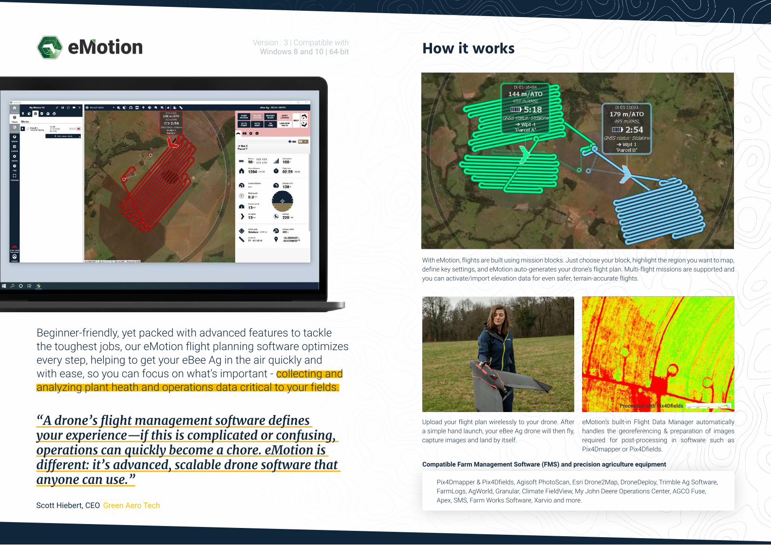
“A drone’s flight management software defines your experience—if this is complicated or confusing, operations can quickly become a chore. eMotion is different: it’s advanced, scalable drone software that anyone can use.”
Scott Hiebert, CEO, Green Aero Tech
Version : 3 | Compatible with Windows 8 and 10 | 64-bit
Beginner-friendly, yet packed with advanced features to tackle the toughest jobs, our eMotion flight planning software optimizes every step, helping to get your eBee Ag in the air quickly and with ease, so you can focus on what’s important - collecting and analyzing plant heath and operations data critical to your fields.
With eMotion, flights are built using mission blocks. Just choose your block, highlight the region you want to map, define key settings, and eMotion auto-generates your drone’s flight plan. Multi-flight missions are supported and you can activate/import elevation data for even safer, terrain-accurate flights.
Upload your flight plan wirelessly to your drone. After a simple hand launch, your eBee Ag drone will then fly, capture images and land by itself.
eMotion’s built-in Flight Data Manager automatically handles the georeferencing & preparation of images required for post-processing in software such as Pix4Dmapper or Pix4Dfields.
How it works
Processed with Pix4Dfields
Pix4Dmapper & Pix4Dfields, Agisoft PhotoScan, Esri Drone2Map, DroneDeploy, Trimble Ag Software, FarmLogs, AgWorld, Granular, Climate FieldView, My John Deere Operations Center, AGCO Fuse, Apex, SMS, Farm Works Software, Xarvio and more.
Compatible Farm Management Software (FMS) and precision agriculture equipment

Farm-ready andeasy to maintain
Autopilot Stack
Lower Body
Upper Body
The eBee Ag is designed for maximum uptime and offers incredible reliability in the field. Its robust underbody protects it from damage, while its modular design lets you easily swap out parts as needed.
Pitot Tube
senseFly Duet MCamera
Clipped Wings
Global network = local support senseFly’s renowned Technical Support is never far. Get your senseFly drone repaired locally, thanks to our global network of authorized repair centers.
Est-ce qu’on utilise cette image ou est-ce qu’on réunis quelques facts qui englobent la situation dans les différents pays ? (le poinds, l’altitude,...)
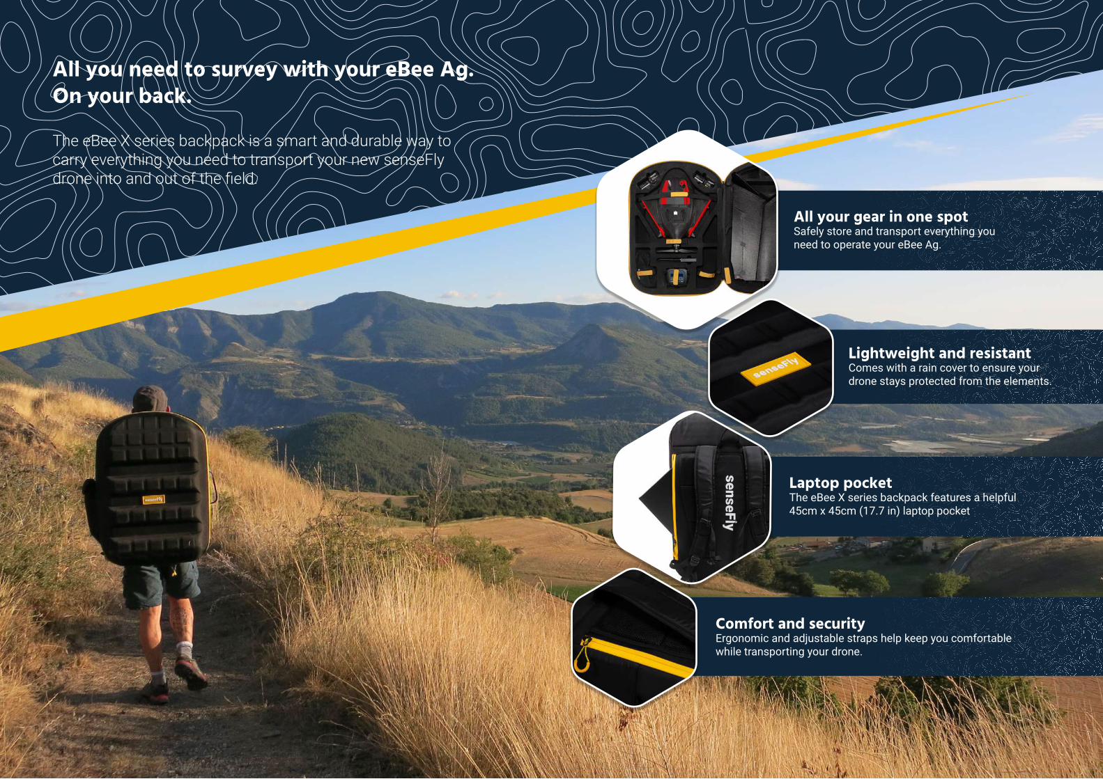
All you need to survey with your eBee Ag.On your back.
The eBee X series backpack is a smart and durable way to carry everything you need to transport your new senseFly drone into and out of the field.
All your gear in one spot Safely store and transport everything you need to operate your eBee Ag.
Lightweight and resistantComes with a rain cover to ensure your drone stays protected from the elements.
Laptop pocket The eBee X series backpack features a helpful 45cm x 45cm (17.7 in) laptop pocket
Comfort and security Ergonomic and adjustable straps help keep you comfortablewhile transporting your drone.
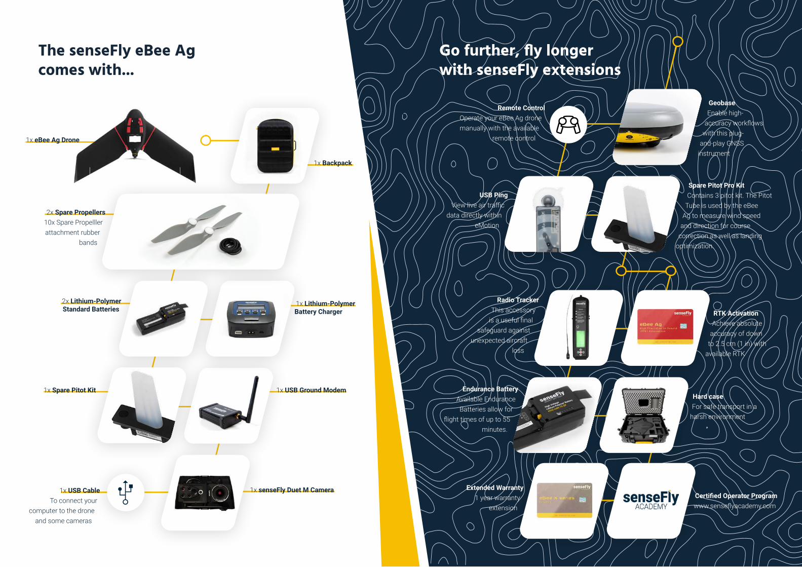
The senseFly eBee Ag comes with...
1x eBee Ag Drone
2x Lithium-Polymer Standard Batteries
1x Spare Pitot Kit 1x USB Ground Modem
1x Backpack
2x Spare Propellers 10x Spare Propelller attachment rubber
bands
1x Lithium-Polymer Battery Charger
1x USB CableTo connect your
computer to the drone and some cameras
GeobaseEnable high-
accuracy workflows with this plug-
and-play GNSS instrument
RTK Activation Achieve absolute
accuracy of down to 2.5 cm (1 in) with
available RTK
Hard case For safe transport in a
harsh environment
Certified Operator Program www.senseflyacademy.com
Extended Warranty 1 year warranty
extension
USB PingView live air traffic
data directly within eMotion
Remote ControlOperate your eBee Ag drone manually with the available
remote control
Radio Tracker This accessory
is a useful final safeguard against
unexpected aircraft loss
Spare Pitot Pro KitContains 3 pitot kit. The Pitot
Tube is used by the eBee Ag to measure wind speed
and direction for course correction as well as landing
optimization.
Endurance Battery Available Endurance Batteries allow for
flight times of up to 55 minutes.
Go further, fly longerwith senseFly extensions
1x senseFly Duet M Camera

Put accurate data to work.
Get the most out of eBee Ag with active RTK
While laying ground control points (GCPs) has been a necessary step in drone surveying workflows from the beginning, advancements in GNSS technology have led to the evolution of real-time kinematic (RTK) and post-processing kinematic (PPK) methods. Thanks to the improved vertical and horizontal accuracy, RTK is ideally suited for surveying stockpiles, land change mapping and more. The following is a quick look at the use of Ground Control Points and the added benefit of a drone with active RTK.
Ground Control Points (GCPs)
A Ground Control Point is a location or object on the ground that has precisely known coordinates. GCPs are used to accurately geo-reference and align projects from absolute accuracy —one to two meters—to absolute accuracy—two to five centimeters.
This method has been used for years and trusted to consistently produce a high level of precision and overall accuracy. Also, GCPs used as checkpoints allow the production of a defensible quality report to prove the validity of technology and are used for consistent ground-truthing of a project’s accuracy. There are some downsides however, as GCPs can take much longer to set up in comparison to RTK and large worksites may require an entire crew to set points. This can be a dangerous endeavor in certain environments and may require additional equipment including a GPS rover, base, VRS network license in addition to spray paint and targets. Also, there is a possibility of targets moving between the setup and data collection, impacting the accuracy of the results. And GCPs may require operator input during the processing phase to click on the target.
GCPs have been a proven method of accuracy for years, but with safer and faster methods available, it should be used only when RTK and PPK are not possible.
Real-Time Kinematic (RTK)
Real-time kinematic is a technique used to enhance the precision of position data derived from satellite-based positioning systems, which relies on a single reference station or interpolated virtual station to correct geotagged locations while in flight. In other words, RTK is a correction method that enhances GNSS precision.RTK is advantageous for many surveying professionals because it increases safety.
The technique eliminates the need for teams to maneuver through dangerous terrain to set GCPs while also efficiently saving time and productivity. RTK provides corrections to the drone onsite and is ideal for geo-tagging in absolute accuracy throughout flights in real-time. GNSS post-processing can be avoided as the eBee Geo can directly geo-tag the images in real-time during flight. Following, the images can be used for processing from the payload SD card. This technique does require a base station and a consistent connection to process data in real-time. While this extra piece of equipment provides the benefit of increased accuracy, it also has a moderate possibility of malfunctioning.
When considering factors such as ease of use, time and expense, the advantages of an RTK drone become more apparent. Difficult terrain, unreachable spots and safety concerns can be deterrents for using GCPs, not to mention the amount of time it could take to plan and measure each. By contrast, post-processing imagery collected via drone normally takes 10 to 20 minutes. And lastly, the measurement of GCPs is an expense you’ll need to factor into every project unlike the one-time activation of RTK on a drone, which ultimately is a better investment long term.
eBee Ag is available with RTK functionality to provide your operations with even greater precision and accuracy. With on-board RTK enabled, you can collect aerial imagery with an absolute accuracy down to 2.5 cm (1 in) with RGB. The position data can then integrate seamlessly into your existing GPS-enabled machinery and/or FMS.
The RTK methods work well in flat terrain where trees or mountains won’t get in the way of the communication signal. RTK is restricted by the power of ground and air communication with the drone. If there are more than three kilometers between the drone and the ground station, or if there are obstructions such as trees or mountains, there’s a chance it will lose signal.
As an operational best practice, it’s ideal to use RTK on flights in open terrain and within two or three kilometers of the ground station to maintain the communications link. These flights can deliver highly accurate results without the need for using GCPs. This is an extremely helpful advantage for land surveyors working in dense vegetation, crops and other hard to distinguish terrain.
Few centimetersAbsolute accuracy
Few centimetersAbsolute accuracy
1-2 metersAbsolute accuracy
Without Correction With GCPs With RTK

Flight performance
Cruise speed
Max wind resistance
Landing type
Service temperature
Humidity
Ground avoidance
40-110 km/h (11-30 m/s or 25-68 mph)
Up to 46 km/h (12.8 m/s or 28.6 mph)
Automatic linear landing (5 m/16.4 ft accuracy in 20° angle cone)
-15° to 40°C *
Light rain resistance
Yes - LiDAR (range 120m)
Maintenance and service
Spare Parts Available
Modular Repair
Service
Pitot Tubes, Wings, Propellers and vertical surfaces
Auto Pilot Stack, Upper Body and Lower Body
Every 100 flight hours
*Working above 35°C/ 95°F requires to protect the drone from the sun while on the ground
eBee Ag
Wingspan
Material
Underbody skin
Weight (Empty)
Max Take-off weight
Backpack dimensions
Motor
Detachable wings
Empty backpack weight
116 cm (45.7 in)
Expanded Polypropylene (EPP)
Curv® Polypropylene thermoplastic composite
0.8 kg
1.6 kg
75 x 50 x 29 cm (29.5 x 19.7 x 11.4 in)
Low-noise, brushless, electric
Yes
4.6 kg
High Precision
Upgradable on demand
RTK
GNSS
Yes
Virtual Base Station, Base Station Unknown point, Base Station Known point
GPS+GLONASS
Radio Link
Certification
Range
Frequency
Encryption AES 254
EIRP
CE or FCC
3 km nominal (up to 8 km) / 1.9 mi (up to 5 mi)
2.400 - 2.4835 GHz
Available
CE/JP 20.0 dBm max
FCC 22.5 dBm maxCoverage & accuracy
Max. nominal coverage at 122 m (400 ft)
Ground sampling distance at 122 m (400 ft)
Lowest ground sampling distance (42m)
160 ha (395 ac) with Standard battery
200 ha (494 ac) with Endurance battery
2.8 cm/px (1.1 in/px) RGB
11.5 cm/px (4.5 in/px) Multispectral
1.1 cm/px (0.4 in/px) RGB
4 cm (1.6 in) Multispectral
The above figures represent optimal flight conditions. It is not representative of all flight times and will vary depending on flight conditions. Also note that the condition of the pitot tube can influence flight time.
The drone is performing its mission and capturing images.
15% and below is enough to return Home and land.
Below 10%, it is no longer possible to continue the mission. The drone returns home to land.
Mission Low endurance Low battery
Automatic safe return when the battery is low
10% 0%100% 15%
Flight time in minutes
0 10’ 20’ 30’ 40’ 50’ 60’ 70’ 80’ 90’
How long can you fly with your eBee Ag?
Hardware Datasheet
Battery
Power
Voltage
Number of cells
Type
Energy
Weight
3700 mAh
15.2V
4 Cell
LiHV
56.24Wh
330g
EnduranceStandard
4900 mAh
15.2V
4 Cell
LiHV
74.48Wh
420g
senseFly Duet MEndurance BatteryStandard Battery

Efficiency is in the field.
The eBee Ag is a reliable, affordable fixed-wing drone that helps farmers, agronomists and service providers map and monitor crops quickly and easily. With its fixed Duet M multispectral/RGB camera, automated flight and vast coverage, eBee Ag delivers accurate and timely plant health insights for making better decisions to improve crop yields, save on inputs, allocate
resources and achieve greater profit potential.
senseFly SA Route de Genève 38
1033 Cheseaux-sur-LausanneSwitzerland
+41 21 552 04 40
senseFly Inc. RaleighNorth Carolina
+1 919 917 9602
At senseFly, we believe in using technology to make work safer and more efficient. Our proven drone solutions simplify the collection and analysis of geospatial data, allowing professionals in surveying, agriculture, engineering and humanitarian aid to make better decisions, faster. The company is a
commercial drone subsidiary of Parrot Group.
[email protected] EN V1 2021