effects of topographic and geological features on building
TRANSCRIPT

Geoenvironmental DisastersWang et al. Geoenvironmental Disasters (2016) 3:7 DOI 10.1186/s40677-016-0040-2
SHORT REPORT Open Access
Effects of topographic and geologicalfeatures on building damage caused by2015.4.25 Mw7.8 Gorkha earthquake inNepal: a preliminary investigation report
Fawu Wang1*, Masakatsu Miyajima2, Ranjan Dahal3, Manita Timilsina4, Tonglu Li5, Makoto Fujiu2,Yohei Kuwada6 and Quanli Zhao5Abstract
Background: The 2015.4.25 Gorkha earthquake affected about eight million people in Nepal. Most injuries and lossof life were due to building collapse and damage. This work aims to investigate the topographical and geologicaleffects on the severe damage caused by this earthquake.
Findings: In one-week field investigation in the earthquake-affected areas, several severely damaged areaswith different topographic and geological features were surveyed, as well as the site of Kaligandaki Riverlandslide dam failure. Some general tendency related to the building damage and landslide dam failure wasobtained.
Conclusions: Through the field investigation, it was found that geological and geomorphologicalcharacteristics of a site, combined with the structure feature of the building, such as the short columneffect, amplified the seismic vibration and caused severe building collapse and damages, i.e., 1) Forbuildings on flat area consisting of lacustrine deposit or diluvial deposit, resonance effect might be themain reason, while for the buildings on the top of hills or narrow ridges, topographic effect andsometimes, short column effect should take the main responsibility; 2) For buildings located on the gentleslopes or landslides, the settlement in the infill side caused by the strong seismic vibration can be themain reason; 3) Besides of the building failure on lacustrine deposit, failure patterns in three types oftopographic and geological features, i.e., narrow ridges formed by landslides, diluvial deposits and alluvialfans, and landslides, were proposed as the possible mechanism of the building damage caused by theearthquake. For landslide dam failure, it was found that landslide dam could easily breach or collapse,when the landslide-dam-deposits were fine.
Keywords: Gorkha earthquake, Investigation, Topographic effect, Resonance effect, Landslide dam, Buildingdamages
* Correspondence: [email protected] of Geoscience, Interdisciplinary Graduate School of Science andEngineering, Shimane University, Nishikawatsu 1060, Matsue 690-8504, JapanFull list of author information is available at the end of the article
© 2016 Wang et al. Open Access This article is distributed under the terms of the Creative Commons Attribution 4.0International License (http://creativecommons.org/licenses/by/4.0/), which permits unrestricted use, distribution, andreproduction in any medium, provided you give appropriate credit to the original author(s) and the source, provide a link tothe Creative Commons license, and indicate if changes were made.

Wang et al. Geoenvironmental Disasters (2016) 3:7 Page 2 of 17
BackgroundThe Gorkha earthquake occurred at 11:56 NST on 25April 2015. The focal depth is about 15 km. The epi-center is 77 km northwest of Kathmandu. Based onthe information from the United Nations, about eightmillion people have been affected by the strong earth-quake in Nepal, which is more than a quarter of theNepal’s population (Goda et al. 2015; Dahal andTimilsina 2015).To understand the damage caused by the earth-
quake, and find a solution to mitigate the geo-disasters in Nepal, a preliminary investigation on the2015 Gorkha earthquake was conducted from 2 to 9June 2015.Figure 1 shows the route taken for this investiga-
tion. In addition to the investigation on the culturalheritage and building damage in Katmandu city, Gor-kha Palace, Chautara town, and Sankhu town, we alsovisited Kaligandaki River landslide dam, and con-ducted measurements and investigation. The lineardistance traveled for this investigation was about250 km.In this report, the observation, investigation and mea-
surements on the following five geological settings aredescribed in detail respectively.
1. Cultural heritage and building damage in Katmanducity (located on lacustrine deposits)
2. Building damage in Gorkha Palace, Chautara andChangu Narayan (located on a narrow mountainridge)
3. Building damage in Sankhu (located on an alluvialfan)
Fig. 1 The route of the investigation for the 2015 Gorkha earthquake, Nep
4. Building damage in Purano Naikap (located in apossible landslide area)
5. An earthquake-induced landslide dam in KaligandakiRiver
Methodologies and findingsInvestigation on cultural heritage and building damage inKatmandu city (lacustrine deposits)According to a previous study (Sakai 2001), lacustrinedeposits are widely distributed in the Katmandu valley.The maximum depth reaches 600 m, and the averagethickness at the center of the Katmandu basin is about200 m. Many ancient buildings and temples were se-verely damaged or destroyed in Katmandu city.
Damage at the Swyambhunath world heritage siteFigure 2 shows the topography of the SwyambhunathWorld Heritage site and its surrounding area. It is lo-cated on an isolated hill near the mountainous areain the west side of Kathmandu city. On the hill, therewas a pond named Peace Pond. The local Buddhistmonks in the temple told us they have felt strongshaking during the earthquake. In this investigation,we found distinctively crooked trees, known as“drunken” trees, widely distributed on the north slopeof the heritage site (Fig. 3). These types of trees oftenindicate slope movement and probable slow-movinglandslide activity, known as creep, a process whichusually occurs over an extended period of time.The Swyambhunath World Heritage site is located
on the top of the hill. Figure 4 compares the worldheritage site before and after the earthquake. It showsthat the main temple in the middle was in a relatively
al

Fig. 2 The location map of the Swyambhunath World Heritage site and surrounding area
Wang et al. Geoenvironmental Disasters (2016) 3:7 Page 3 of 17
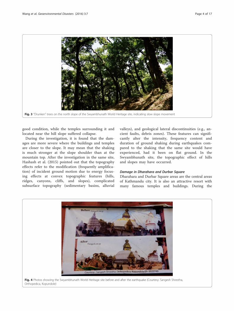
Fig. 3 “Drunken” trees on the north slope of the Swyambhunath World Heritage site, indicating slow slope movement
Wang et al. Geoenvironmental Disasters (2016) 3:7 Page 4 of 17
good condition, while the temples surrounding it andlocated near the hill slope suffered collapse.During the investigation, it is found that the dam-
ages are more severe where the buildings and templesare closer to the slope. It may mean that the shakingis much stronger at the slope shoulder than at themountain top. After the investigation in the same site,Hashash et al. (2015) pointed out that the topographyeffects refer to the modification (frequently amplifica-tion) of incident ground motion due to energy focus-ing effects at convex topographic features (hills,ridges, canyons, cliffs, and slopes), complicatedsubsurface topography (sedimentary basins, alluvial
Fig. 4 Photos showing the Swyambhunath World Heritage site before andOrthopedica, Kopundole)
valleys), and geological lateral discontinuities (e.g., an-cient faults, debris zones). These features can signifi-cantly alter the intensity, frequency content andduration of ground shaking during earthquakes com-pared to the shaking that the same site would haveexperienced, had it been on flat ground. In theSwyambhunath site, the topographic effect of hillsand slopes may have occurred.
Damage in Dharahara and Durbar SquareDharahara and Durbar Square areas are the central areasof Kathmandu city. It is also an attractive resort withmany famous temples and buildings. During the
after the earthquake (Courtesy: Sangesh Shrestha,

Fig. 5 The collapse of Dharahara tower. a damaged Dharahara tower; and (b) a poster showing two photos of the tower before the 1934 and2015 earthquakes
Wang et al. Geoenvironmental Disasters (2016) 3:7 Page 5 of 17
earthquake, those ancient temples and buildings sufferedheavy damage.During the earthquake, the Dharahara tower col-
lapsed and more than 180 people lost their lives. Themain body of the tower collapsed under the attack ofthis earthquake, only the base remained (Fig. 5a). Ac-cording to Wikipedia (2015), the Dharahara tower,was a nine-story, 61.88 m tall. The former Dharaharatower was built in 1832. The tower had a spiral stair-case with 213 steps. It can be seen from Fig. 5(a) thatthe main trunk of the tower is made by bricks withlime mortar cemented, which is weak for seismicaction.In Durbar Square, it is full of temples and cultural
architectures. During the earthquake, lots of ancienttemples were damaged severely (Fig. 6). Some of themwere completely destroyed (Fig. 7). In Fig. 7, the
Fig. 6 Damages on temples and buildings near the Durbar Square. a GaddHanuman Dhoka
Kashthamandap temple, from which the Kathmanducity got the current name, was completely destroyed.According to the fact sheet of the earthquake by USAID
(2015), 510,762 houses were destroyed, and 291,707houses were damaged by the Earthquake. Durbar Squarearea is one of the most severe areas suffered the damages(Fig. 8). Cracks appeared on the walls of those buildings,and the residents still lived in the damaged buildings andused wooden and metal sticks to support them.Through a study of local amplification effect of soil
layers on ground motion in the Kathmandu Valleyusing microtremor analysis, Paudyal et al. (2012) con-cluded that the multiple amplified frequencies in aparticular area can create a resonance effect both forlow rise and tall buildings. They pointed out that thebehavior of the surface layer as well as the layerunderneath should be taken into consideration for
i Baithak in Basantapur Durbar Square; b one building in
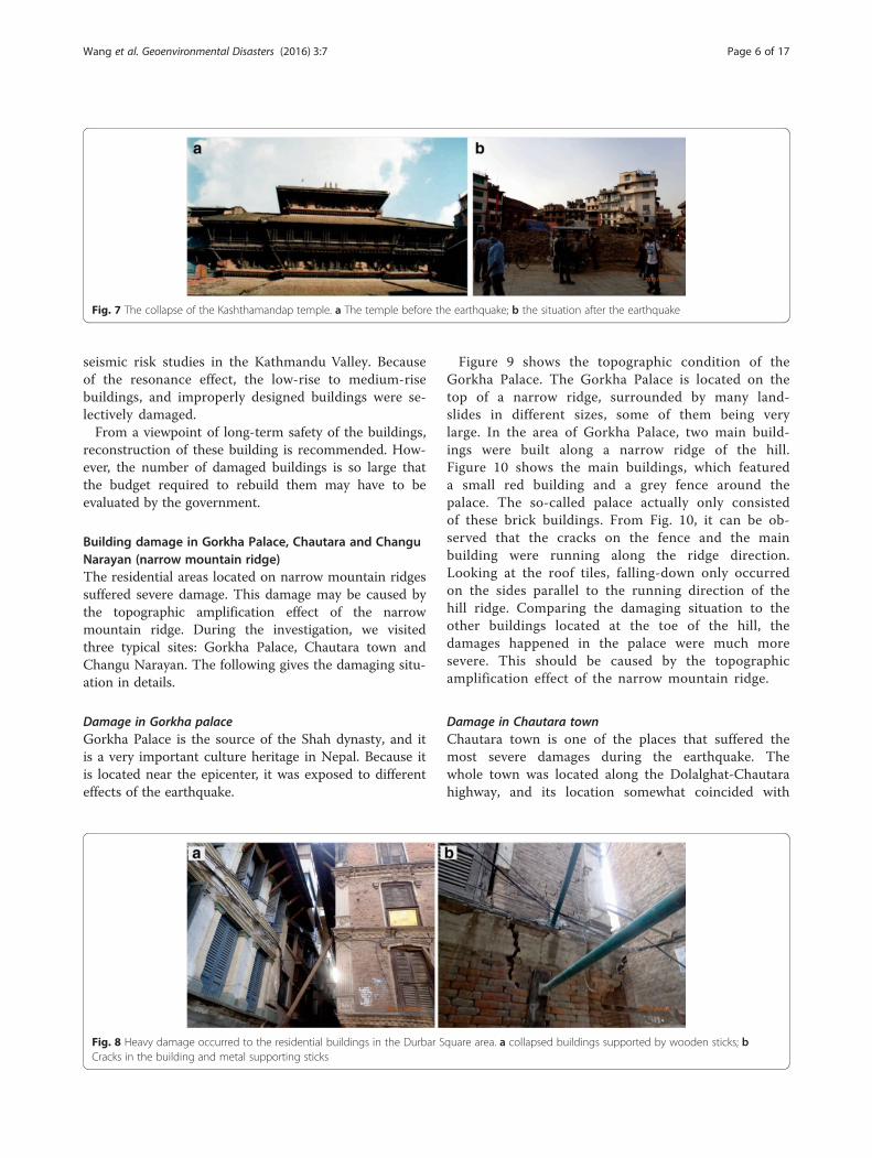
Fig. 7 The collapse of the Kashthamandap temple. a The temple before the earthquake; b the situation after the earthquake
Wang et al. Geoenvironmental Disasters (2016) 3:7 Page 6 of 17
seismic risk studies in the Kathmandu Valley. Becauseof the resonance effect, the low-rise to medium-risebuildings, and improperly designed buildings were se-lectively damaged.From a viewpoint of long-term safety of the buildings,
reconstruction of these building is recommended. How-ever, the number of damaged buildings is so large thatthe budget required to rebuild them may have to beevaluated by the government.
Building damage in Gorkha Palace, Chautara and ChanguNarayan (narrow mountain ridge)The residential areas located on narrow mountain ridgessuffered severe damage. This damage may be caused bythe topographic amplification effect of the narrowmountain ridge. During the investigation, we visitedthree typical sites: Gorkha Palace, Chautara town andChangu Narayan. The following gives the damaging situ-ation in details.
Damage in Gorkha palaceGorkha Palace is the source of the Shah dynasty, and itis a very important culture heritage in Nepal. Because itis located near the epicenter, it was exposed to differenteffects of the earthquake.
Fig. 8 Heavy damage occurred to the residential buildings in the Durbar SCracks in the building and metal supporting sticks
Figure 9 shows the topographic condition of theGorkha Palace. The Gorkha Palace is located on thetop of a narrow ridge, surrounded by many land-slides in different sizes, some of them being verylarge. In the area of Gorkha Palace, two main build-ings were built along a narrow ridge of the hill.Figure 10 shows the main buildings, which featureda small red building and a grey fence around thepalace. The so-called palace actually only consistedof these brick buildings. From Fig. 10, it can be ob-served that the cracks on the fence and the mainbuilding were running along the ridge direction.Looking at the roof tiles, falling-down only occurredon the sides parallel to the running direction of thehill ridge. Comparing the damaging situation to theother buildings located at the toe of the hill, thedamages happened in the palace were much moresevere. This should be caused by the topographicamplification effect of the narrow mountain ridge.
Damage in Chautara townChautara town is one of the places that suffered themost severe damages during the earthquake. Thewhole town was located along the Dolalghat-Chautarahighway, and its location somewhat coincided with
quare area. a collapsed buildings supported by wooden sticks; b

Fig. 9 Topographic setting of the Gorkha Palace
Fig. 10 Damage to one of the buildings and fence in the Gorkha Palace, shown by yellow arrows and red circles
Wang et al. Geoenvironmental Disasters (2016) 3:7 Page 7 of 17

Fig. 11 Investigation route along the highway in Chautara town
Wang et al. Geoenvironmental Disasters (2016) 3:7 Page 8 of 17
the mountain ridges. Figure 11 shows the investiga-tion route into the town, along the highway. It can beseen that the highway is located in the center of thetown, and was sandwiched by the buildings along thehighway. On the slopes at the two sides, step-plantation fields are widely distributed, and most ofthem shows evidence of landslides.The Chautara town consists of two parts: old town
and new town. In the old town area, the buildingshad a simple structure with bricks and wooden slabs.In the new town area, concrete buildings were builtthree stories or higher. Figure 12 shows the damagein the old town area. More than 80 % buildings weredestroyed by the earthquake.Figure 13 shows the damage in the new town area.
The buildings were made by reinforced concrete, with
Fig. 12 Almost completely destroyed old town in Chautara. a Completely
three or more stories. Some of the concrete buildinghad cracks at the first floor (Fig. 13a). Some of themcompletely collapsed (Fig. 13b), and some of themtilted to the slope side (Fig. 13c). Breakage had oc-curred even at the pillars of some buildings underconstruction (Fig. 13d). In the case shown in Fig. 13d,the so-called short column effect may have occurred.According to Murty (2016), poor behavior of shortcolumns is due to the fact that in an earthquake, atall column and a short column of same cross-sectionmove horizontally by same amount. Because the shortcolumn is stiffer as compared to the tall column, itattracts larger earthquake force. Stiffness of a columnmeans resistance to deformation. The larger the stiff-ness is, the larger the force required to deform it. If ashort column is not adequately designed for such a
flattened buildings; b Destroyed buildings with standing walls

Fig. 13 Partially destroyed or damaged new town area in Chautara. a Cracks in the concrete building; b completely destroyed building; cbuilding titled to the downslope side; d breakage in pillars of new uncompleted building
Wang et al. Geoenvironmental Disasters (2016) 3:7 Page 9 of 17
large force, it can suffer significant damage during anearthquake.The damage to the Chautara town was very severe
though it is far from the epicenter and earthquakefault. The reason may be the amplification of thenarrow mountain ridge, combined with the special
Fig. 14 Topography of Changu Narayan
structure of the buildings built on the slope alongthe highway. However, looking from another side ofthe town, it seems like that the whole town of theChautara might be located on a large-scale landslide.If it is true, the Chautara town should consider mov-ing to a safer place; otherwise, it will most likely

Fig. 15 Solid buildings in Changu Village. No obvious damage can be observed to these buildings a & b
Wang et al. Geoenvironmental Disasters (2016) 3:7 Page 10 of 17
suffer similar damage in the next large earthquakeevent. To solve this problem, more detailed investi-gation and landslide mapping are useful andeffective.
Damage to Changu Narayan temple at BhaktapurThe Changu Narayan temple is considered to be the old-est temple in Nepal. Figure 14 shows the topography ofChangu Narayan. It is located on an isolated hill. Atboth sides of the hill ridge, typical topography of a land-slide was confirmed.Figures 15, 16 and 17 show the different buildings
and their degree of damage in Changu village. Thenewly-constructed RC structure building has not suf-fered obvious damage during the earthquake (Fig. 15),while the old-style brick structure building collapsedor separated by cracks (Figs. 16 and 17). From thecollapse sections or faces, it can be found that themortar was sparse and inadequate.
Building damage in Sankhu (Alluvium fan)Sankhu area suffered from an extreme damage tothe residential buildings. Figure 18 shows some typ-ical collapses occurred in different buildings in thisarea. The old buildings with brick structure completelycollapsed or were severely damaged. While on the new
Fig. 16 Damaged buildings with brick structure in Changu village. a Heavi
buildings with concrete slabs in the brick structure orreinforcement by concrete on the walls, inclining occurredor X-shaped cracks were observed, indicating a strong ver-tical compression stress.To find the reason why the building were more
heavily damaged than the surrounding villages, we ob-served areas around the residential section and thentraveled in a northerly direction. Figure 19 shows thetrace of the investigation route. It is found that thisarea is an alluvial fan. At Position A, we found largeboulders in the shallow valley, and flowing water(Fig. 20a). On the terrace, two-floors or higher build-ing were in good condition. At position B, there wererice paddies, surrounded by concrete buildings of twoto four stories. The damage at point B was not so se-vere. It was observed that the most severe damageoccurred at the middle-lower part of the alluvial fan.It is estimated that at that part, ground deformationhas been amplified by the specified soil layer struc-ture, and caused the concentrated collapses in the oldbuildings.
Building damage in Purano Naikap (landslide area)During the investigation, we were reported that somestrong shaking and failure occurred to the residentialbuildings in Purano Naikap area (Fig. 21). This area
ly damaged brick building; b cracks in the brick building

Fig. 17 Damages occurred on the main gate building at the entrance to Changu Narayan. a Collapse around the main gate; b Collapse at thetwo sides of the gate building
Wang et al. Geoenvironmental Disasters (2016) 3:7 Page 11 of 17
is located at southwest part of the Kathmandu basinand inclined to the basin center. As can be seen fromFig. 22, this area is occupied by residential buildingsand agriculture fields on gentle slopes.Figure 23 shows some typical damages to residential
buildings in this area. A common tendency can befound in the nature of these damages, i.e., collapse orcracks mainly occurred at the downslope side of thebuildings. Even there were no permanent deformationleft on the ground after the earthquake, the severedamaged building were located in a limited area. Weestimated that under the limited area, a landslide mayexist. When the buildings were built on a probablelandslide, the ground shaking might be much stronger
Fig. 18 Building damage situation in Sankhu area. a and b Completely desbuilding; d X-shapes cracks in a new concrete building
than the surrounding area, and caused more severedamage on the buildings.
Landslide dam in Kaligandaki riverDuring the investigation, we had chance to visit alandslide dam in Kaligandaki River, learned of a suc-cessful story as how local government and peoplecooperated and prevented a possible geo-disaster. InKaligandaki river of Myagdi District at Baisari alongthe border of Bhagawati and Ramche VDCs (VillageDevelopment Committee), about 110 km west to theepicenter of the Gorkha earthquake, at 11:10 of 22May 2015 (about one month after the major shock),a small-scale rock fall occurred from a steep slope.
troyed wooden and brick buildings; c Partial collapses of a three-story

Fig. 19 Investigation route around the Sankhu area
Wang et al. Geoenvironmental Disasters (2016) 3:7 Page 12 of 17
After the small scale rock failure, the Central Dis-trict Officer (CDO) of Myagdi and Chief of Depart-ment of Soil Conservation visited the site andclimbed the slope for confirmation on slope deform-ation. During the visit, they noticed a scarp of morethan 2 m on the mountain top and understood thecritical situation of slope, then they forced the localpeople to move to safe place. Figure 24 shows freshcracks developed in the upslope area. The localswere unwilling to move at the beginning as they saidthat it is normal and they have been facing suchrockfall every year. However, the CDO insisted andforced them to leave and resettle in temporary shel-ters with the help of Nepal Army. Nearly 38 hourslater, a big event of rock fall happened at the place
Fig. 20 Evidences of the alluvial fan near Sankhu. a Large boulders and flohigh buildings
and blocked the Kaligandaki River, buried all 27houses, at 1:30 am of 24 May 2015. The collapseddebris deposited in the valley near the toe of therockfall slope, dammed the valley, and formed alandslide dam lake.Fortunately, before the major slope failure happened,
the local authority understood the situation and resettledthe local people to safe place. 124 people living in thevillage that was located at the opposite side to the cliffwere evacuated.What we felt was interesting about this site is the tim-
ing of landslide failure. With the cooperation from theNepal Army who conducted the evacuation during thelandslide occurrence and landslide failure, we can buildthe time record of the whole process. Figure 25 shows
wing water in the valley; b Rice paddies at the upslope side of
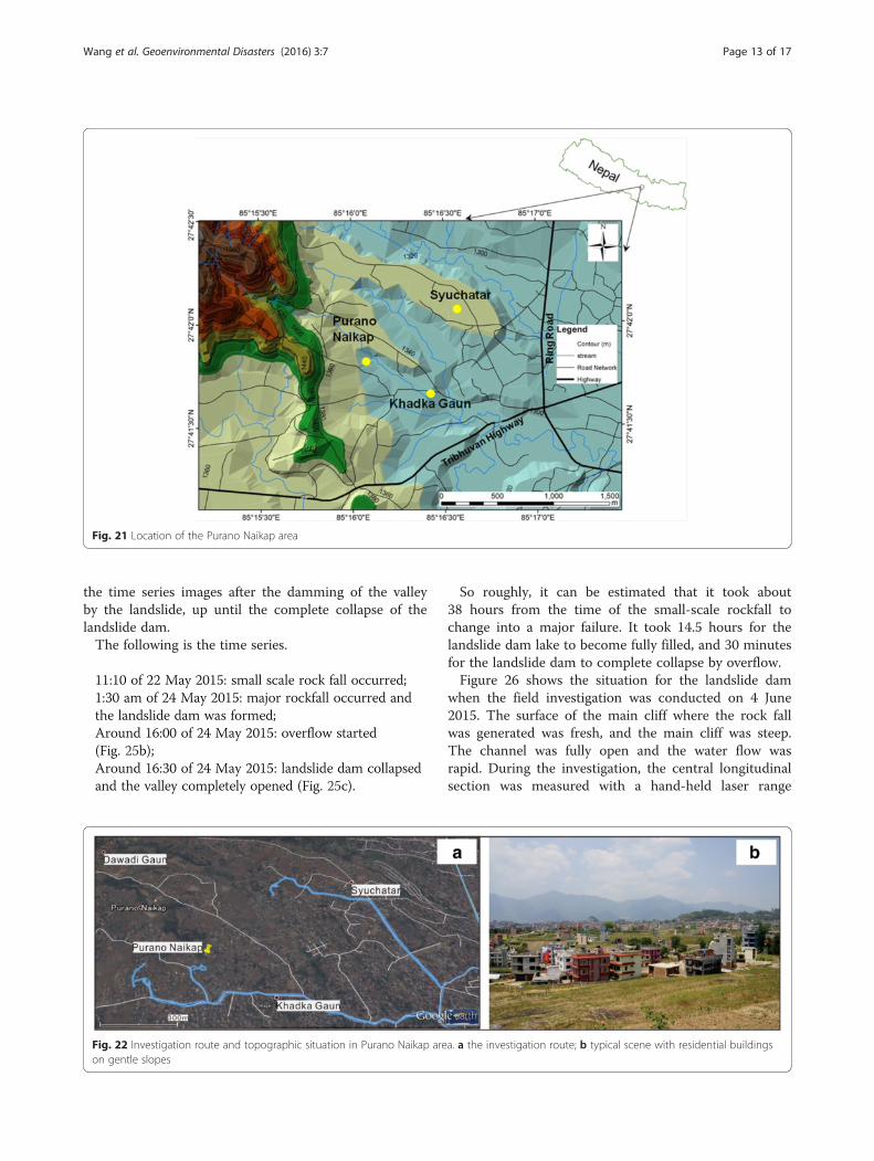
Fig. 21 Location of the Purano Naikap area
Wang et al. Geoenvironmental Disasters (2016) 3:7 Page 13 of 17
the time series images after the damming of the valleyby the landslide, up until the complete collapse of thelandslide dam.The following is the time series.
11:10 of 22 May 2015: small scale rock fall occurred;1:30 am of 24 May 2015: major rockfall occurred andthe landslide dam was formed;Around 16:00 of 24 May 2015: overflow started(Fig. 25b);Around 16:30 of 24 May 2015: landslide dam collapsedand the valley completely opened (Fig. 25c).
Fig. 22 Investigation route and topographic situation in Purano Naikap areon gentle slopes
So roughly, it can be estimated that it took about38 hours from the time of the small-scale rockfall tochange into a major failure. It took 14.5 hours for thelandslide dam lake to become fully filled, and 30 minutesfor the landslide dam to complete collapse by overflow.Figure 26 shows the situation for the landslide dam
when the field investigation was conducted on 4 June2015. The surface of the main cliff where the rock fallwas generated was fresh, and the main cliff was steep.The channel was fully open and the water flow wasrapid. During the investigation, the central longitudinalsection was measured with a hand-held laser range
a. a the investigation route; b typical scene with residential buildings

Fig. 23 Damages occurred on the residential buildings in Purano Naikap area. a X-shaped cracks in the first and second floors, some part col-lapsed; b Collapse occurred to one side of the first floor
Wang et al. Geoenvironmental Disasters (2016) 3:7 Page 14 of 17
finder. Figure 27 shows the results of the measure-ments. It can be seen from the figure that the heightof the main cliff was higher than 660 m, and theaverage slope angle was about 54 degree. The traveldistance of the collapsed debris in the deposit areawas about 200 m, with an average slope angle of 21degree. The maximum thickness of the landslide damwas estimated as 30 m.When we conducted the investigation at the Kali-
gandaki landslide dam, it was found that the landslidedam surface was covered by fine particles. The thick-ness of the fine particle layer was about 0.4 m. It wasso loose that footprints can be easily seen (Fig. 28a).Some soil samples were taken from the surface, andthe grain size distribution analysis was conducted(Fig. 28b). It shows the soil sample is well graded silt,and the mean grain size is 0.02 mm.For the purpose of time prediction for landslide
dam failure, we learned from that the collapse of thelandslide dam by overflow only took 30 minutes. Oneof the possible reasons might be the crushing of thethin rock mass when the rockfall fell to the ground.The bedrock of the cliff is thin bedding phyllite which
Fig. 24 The situation of the Kaligandaki village on 23 May 2015. a Large crand rolled down along the slope causing dust (Photos supplied by Nepal A
is relative soft and composed of fine scale-like min-erals. Because of the strong collision from about a700 m high position, the structure of the rock masswas pulverized. We concluded that the landslide damconsisting of loose deposits of the rockfall might bevulnerable for overflow, and the longevity of the damwill be short.
DiscussionsWhen we got the news about the Gorkha earthquake,we have estimated that lots of landslides should betriggered, because the epicenter of the earthquake islocated in the mountainous area. However, from ourinvestigation and other related investigations (Collinsand Jibson 2015a; Collins and Jibson 2015b; Hashashet al. 2015; Pandey and Mishra 2015), it is found thatthe amount of the large scale landslides is limited.However, lots of life was lost because of the collapseand damage of the buildings. Concerning the damageof building in hilly area by earthquake, through a casestudy of two cities in Indian Himalayas, Singh et al.(2015) concluded it is mainly due to the combinationof a number of factors, including topographic
ack was evident on the top of the cliff; b small-scale rockfall occurredrmy)

Fig. 25 Time series photos showing the process of landslide dam from its formation to complete failure (Photos supplied by Nepal Army). a thelandslide dam before overflowing; b overflow occurred on the landslide dam around 16:00 of 24 May 2015; c collapse of the landslide damaround 16:30 of 24 May 2015; d the opened channel of the valley
Wang et al. Geoenvironmental Disasters (2016) 3:7 Page 15 of 17
amplification, earthquake triggered ground failurehazard and higher vulnerability of hill buildings dueto irregular structural configurations. This reportconfirmed the significance of the combination of geo-logical condition, topographic condition, and struc-tural configurations. Through the investigation, wesummarized the reasons of the building collapse anddamages in Fig. 29.Figure 29(a) shows the case on the narrow moun-
tain ridges. The Chautara town belongs to this type.Because the ridge is narrow, buildings used non-homogeneous foundations. One side of the building is
Fig. 26 Main cliff from where the rockfall occurred and the landslide dam
directly located on the ground, and the other side issupported by piles, bricks, or concrete structures.Generally, the mountain ridge experienced strongershaking, and this may cause the failure at the outsidefoundations. If the outside foundation is located in alandslide area, the foundation will be prone to col-lapse even if the landslide does not show obvious dis-placement; if all of the mountain ridge is located in alandslide, the amplified shaking can cause any typesof failure because the ground shaking may cause notonly horizontal displacement or vertical displacement,but also rotational displacement. The building damage
(a) and the open channel of the collapsed landslide dam (b)

Fig. 27 Main longitudinal section of the collapsed landslide damand the main cliff after the rockfall
Wang et al. Geoenvironmental Disasters (2016) 3:7 Page 16 of 17
occurred in Gorkha Palace and Changu Narayan weremainly caused by the strong shaking due to the topo-graphic amplification as they are almost at the centerof the mountain ridges. The situation at the Swyamb-hunath World Heritage site is not fully understood,however, at least the failure distribution on the maintemple in the center and minor temples closing tothe slopes coincided with type (a) in Fig. 29.Figure 29(b) represents the geological structure in
Sankhu town. In the upstream side, gravels and sur-face water is abundant, while as it goes to down-stream side, the grain size of the soil becomes finerand finer, surface water becomes to groundwater, andthe groundwater gradually becomes deeper. The rea-son for the concentrated building damage in Sankhu
Fig. 28 Fine particles covering the landslide dam. a Photograph taken onsurface of the landslide dam
town may be resonance effect of the buildings to thedeposit layers.Figure 29(c) shows the failure pattern at Purano
Naikap area. The similar pattern may be widely dis-tributed around the Kathmandu basin. In this kind ofarea, the structure of the lacustrine deposit overlayingthe bedrock can form an enhanced structure for theoccurrence of landslides. If there is no earthquake,the gentle slopes are good for agriculture and hous-ing. However, during a large earthquake, existinglandslides can be reactivated. Because the lacustrinedeposit landslide mainly consists of clay, generallythey will not move for long distance during earth-quake, but they can amplify the vibration and causegeneral destruction to the buildings, especially if thebuildings in this area were located on shallow founda-tions on cut-slopes at the upper side, and infilledground at the lower side. The amplified shaking maycause intensive settlement at the infill and cause non-homogeneous deformation at the foundation. When abuilding is located at the boundary of a landslide, itwill suffer much more severe damage.
ConclusionsThrough the one-week field investigation on thehousing damage caused by the 2015.4.25 Gorkhaearthquake, considering the effects of topographiccondition, geological condition, and the building styleto the building damages, we found that geologicaland geomorphological characteristics of a site, com-bined with the structure of the building, such as theshort column effect, selectively amplified the seismicvibration and caused severe building collapse anddamages.
4 June 2015; b grain size distribution of the sample taken from the

Fig. 29 Three main patterns caused the building collapse and damages in 2015.4.25 Gorkha earthquake. a Building damage along narrowmountain ridge; b concentrated building damage on alluvial fan; and c building damage on existing landslide
Wang et al. Geoenvironmental Disasters (2016) 3:7 Page 17 of 17
1) For buildings on flat area consisting of lacustrinedeposit or diluvial deposit, resonance effect maybe the main reason, while for the buildings onthe top of hills or narrow ridges, topographiceffect and sometimes, short column effect shouldtake the main responsibility;
2) For buildings located on the gentle slopes orlandslides, the settlement in the infill side caused bythe strong seismic vibration can be the main reason;
3) Besides of the building failure on lacustrine deposit,failure patterns in three types of topographic andgeological features, i.e., narrow ridges formed bylandslides, diluvial deposits and alluvial fans, andlandslides, are proposed as the possible mechanismsof the building damage caused by the earthquake.
4) For landslide dam failure, it is found that landslidedam will easily breach or collapse, when thelandslide-dam-deposits are fine. The Kaligandakilandslide dam failure event gave us a good lessonthat geo-environmental disasters can be reduced bycatching the precursory phenomena and necessarymanagements.
Competing interestsThe authors declare that they have no competing interests.
Authors’ contributionsFW, MM, RD, MT, TL, MF, YK, and QZ participated the field investigations. FWdrafted the manuscript. MT prepared the topographic maps. All authors readand approved the final manuscript.
AcknowledgementsThis work was financially supported by JSPS KAKENHI Grant Number A-2424106 for landslide dam failure prediction (Principal Investigator: FawuWang). International Consortium on Geo-disaster Reduction (ICGdR) also fi-nancially supported the field investigation. Mr. Tek Bahadur KC, the Chief Dis-trict Officer of Beni and Mr. Uddhab Prasad Timalsena, the Chief DistrictOfficer of Gorkha, kindly gave us permission and supported our investigation.The authors thank Lynn Highland of USGS for her helpful and constructivecomments on the contents when the first author presented the results inGSA2015 in Baltimore, USA. She also reviewed and edited the first manu-script of this paper.
Author details1Department of Geoscience, Interdisciplinary Graduate School of Science andEngineering, Shimane University, Nishikawatsu 1060, Matsue 690-8504, Japan.2Faculty of Environmental Design, Kanazawa University, Kakuma, Kanazawa920-1192, Japan. 3Himalayan Geo-disaster Research Center, CentralDepartment of Geology, Tribhuvan University, Kirtipur, P.O. Box 9669,Kathmandu, Nepal. 4Nepal Himalaya Conservation Group, P. O. Box 9669,
Kathmandu, Nepal. 5College of Geological Engineering and Geomatics,Chang’an University, 126 Yanta Road, Xi’an 710054, China. 6InterdisciplinaryGraduate School of Science and Engineering, Shimane University,Nishikawatsu 1060, Matsue 690-8504, Japan.
Received: 23 December 2015 Accepted: 29 April 2016
ReferencesCollins BD, Jibson JW. 2015a. Assessment of existing and potential landslide
hazards resulting from the April 25, 2015 Gorkha, Nepal earthquakesequence. USGS Open-File Report 2015–1142.
Collins BD, Jibson JW. 2015b. Ground-shaking in the steepest terrain on Earth:landslides from the 2015 Gorkha, Nepal earthquake sequence. GeologicalSociety of America Abstracts with Programs. 47(7): 608.
Dahal RK, Timilsina M. 2015. Excursion Guidebook for the 2015 GorkhaEarthquake Damage Assessment Program. ICGdR, 29p.
Goda, K., T. Kiyota, R. Pokhrel, G. Chiaro, T. Katagiri, K. Sharma, and S. Wilkinson.2015. The 2015 Gorkha Nepal Earthquake: Insights from Earthquake DamageSurvey. Frontiers in Built Environment 1: 8. doi:10.3389/fbuil.2015.00008.
Hashash YMA, Tiwari B, Moss RES, Asimaki D, Clahan KB, Kieffer DS, Dreger DS,Macdonald A, Madugo CM, Mason HB, Pehlivan M, Rayamajhi D, Acharya I,Adhikari B. 2015. Geotechnical Field Reconnaissance: Gorkha (Nepal)Earthquake of April 25 2015 and Related Shaking Sequence. GeotechnicalExtreme Event Reconnaissance GEER Association, Report No. GEER-040.Version 1.0, 250p.
Murty CVR. 2016. Why are Short Columns more damaged during Earthquakes?http://www.iitk.ac.in/nicee/EQTips/EQTip22.pdf#search=%27short+column%27 (last visit: 5 April 2016).
Pandey, V.K., and A. Mishra. 2015. Geoenvironmental impact of Gorkhaearthquake, Nepal: April- May, 2015. International Journal of EngineeringSciences & Management Research 2(7): 50–57.
Paudyal, Y.R., R. Yatabe, N.P. Bhandary, and R.K. Dahal. 2012. A study of localamplification effect of soil layers on ground motion in the Kathmandu Valleyusing microtremor analysis. Earthq Engineering and Engineering Vibration 11:257–268.
Sakai, H. 2001. Stratigraphic division and sedimentary facies of the KathmanduBasin Group, central Nepal. Journal of Nepal Geological Society. 25(SpecialIssue): 19–32.
Singh Y, Lang DH, Narasimha DS (2015) Seismic risk assessment in hilly areas:case study of two cities in Indian Himalayas. Proc. SECED 2015 Conference:Earthquake Risk and Engineering towards a Resilient World 9–10 July 2015,Cambridge UK, SINGH_LANG_NARASIMHA.pdf, 1–10.
USAID. 2015. Nepal Earthquake - Fact Sheet #20, https://www.usaid.gov/nepal-earthquake/fy15/fs20. (last visit: 5 April 2016). (on June 12, 2015).
Wikipedia. 2015: https://en.wikipedia.org/wiki/Dharahara. (last visit: 5 April 2016).