edinburgh geologist no. 14. autumn 1983 · thomas charles hope was born in edinburgh in 1766, ......
TRANSCRIPT

The
Edinburgh
Geologist
No.14 Autumn 1983
The
Edinburgh
Geologist
No.14 Autumn 1983

Erratum: The Contents of pages 14 & 15 have been transposed
The cover illustration is taken from James Sowerby's British Mineralogy, Vol. 1, p. 137, MDCCCIV.
"Strontia carbonata" (Strontianite)
Erratum: The Contents of pages 14 & 15 have been transposed
The cover illustration is taken from James Sowerby's British Mineralogy, Vol. 1, p. 137, MDCCCIV.
"Strontia carbonata" (Strontianite)

EDITORIAL
Great Commuting Dinosaurs Just what was Surrey like 124 million years ago? This summer great
excitement was expressed at the finding of a good portion of a megalosaur-like, flesh-eating dinosaur well within the limit of the stockbroker belt. Life presumably in those early Cretaceous days in the Home Counties was less hectic - no mass day-return migration into the centre of the Thames basin, no mortgages. On the other hand 'Claws' as it has affectionately been nicknamed would have had to watch its big neighbours rather closely, for example Tyranosaurus Rex whose shear bulk and alleged ferocity has captured the imagination of twentieth century film makers. There would have been no shortage of prey for Clqws including small herbivorous dinosaur, fish and possibly small mammals and as for the climate, Britain is thought to have been enjoying a sub-tropical phase. On the wider front an East-West split seemed imminent as the North Atlantic began to grow with all its tectonic and volcanic ramifications but Surrey then as now was little affected by northern rumblings!
The Work of Ice? To our dismay, we note the passing of Agassiz Rock at Blackford Hill.
Recently one could never be sure that scratches on the rock were actually "the work of ice" for such details were obscured by the soot of many boyscouts' bonfires. However the locality's significance in the history of Quaternary research in this country will not be forgotten for it was here that in 1840 in the company of Charles MacLaren, Editor of the Scotsman, the Swiss geologist Louis Agassiz pronounced the striations to be the work of land ice.
The Fossil Man Readers who saw the BBC documentary on Stan Wood and his
Carboniferous sharks - 'Stan, Stan, the Fossil Man' - will have been impressed at the energy and dedication of a true enthusiast at work. Stan, who is a Fellow of the Society, demonstrated the fine preservation of the palaeoniscid and crustacean fauna found at Bearsden and.

clearly, the find is extremely important for morphological and palaeoecological reasons. Stan Wood's paper in Nature (Vol. 297, pp. 574-577, 1982) describes the discovery.
Outer Hebrides Data-bank Another Fellow of the Society, Dr. Frank Rennie writes to say that he
is co-ordinating the setting-up of a scientific data-bank of the Outer Hebrides and would welcome any information relating to scientific work carried out in the islands. The data-bank which will be regularly updated will be available for use by individuals and educational groups. If you can help or would like to know more please write to Dr. Rennie, c/o Hebridean Natural Environment Project, Hebrides Study Centre, Glen House Mill, Shawbost, Isle of Lewis.
Mrs Helena M. Butler 9 Fox Spring Crescent Edinburgh 10
Telephone: Home:445 3705
2
Mr. Andrew A. McMillan Institute of Geological Sciences Murchison House West Mains Road Edinburgh, EH9 3LA
Telephone: Office: 6671000

"STRONTIAN HOPE"
Alexander Mackie
This year, since the Society included a week's geology in the Ardnamurchan area, with headquarters at Strontian, it is appropriate to give some account of Thomas Charles Hope, who investigated the mineral, subsequently to become known as strontianite, obtained from the lead mines at Strontian, Argyll.
Thomas Charles Hope was born in Edinburgh in 1766, the third son of John Hope, the first Regius Professor of Botany in the University of Edinburgh, and the first to introduce the Linnaean system into Scotland. John Hope was instrumental in establishing the botanic gardens on the west side of Leith Walk, near the present Gayfield Square, the successor to the old physic garden, which was situated close to the site of platforms 10 and 11 in the Waverley Station. It was not till 1822-24 that the botanic gardens were laid out near Canonmills.
Thomas was educated at the Edinburgh High School from 1772 to 1778, when he attended a school in Dumfries, and then proceeded to the University of Edinburgh in 1779 at the age of 13, not unusual in those days. He took the usual course in general literature before proceeding to medical studies. He graduated Doctor of Medicine (M.D.) in 1787, and in the same year was appointed Professor of Chemistry in the University of Glasgow, but in 1789 relinquished that post to become Assistant Professor of Medicine. He continued to deliver lectures in chemistry however, but subsequently left the chemistry department to occupy the Chair of Medicine in 1791 in succession to his maternal uncle, Dr. Stevenson. In 1795 he returned to Edinburgh as joint Professor of Chemistry with Joseph Black, who was in declining health, and after the latter's death in 1799, became the sole incumbent. The popularity of Hope's chemistry lectures and the importance of his strontium investigations suggested to Black that his distinguished pupil would be a worthy successor.
Hope concentrated more on teaching than on research, but he did
3

carry out some important investigations. His first piece of published work, and of most interest to geologists, was read as a paper, entitled An Account of a Mineral from Strontian, and of a peculiar Species of Earth which it contains, before the Royal Society of Edinburgh in November, 17931
• This mineral, now called strontianite was regarded at first as barium carbonate, the aerated terra ponderosa of Dr. Withering, but Hope described its physical and chemical properties in great detail, and concluded that it was not barium carbonite (witherite), although it was similar in several respects. Its specific gravity was less than that of the barium mineral, but it effervesced with acids, liberating carbon dioxide, and the latter was also given off on very strong heating. The calcined mineral or earth resembled quicklime, and was called strontites by Hope, from the name of the locality. He observed the crimson colour imparted to a flame by compounds derived from the mineral. The term earth was given by chemists at that time to all non-metallic substances insoluble in water, and unchanged by heat. Hope concluded that the mineral was a carbonate of a new element, which was isolated electrolytically by Sir Humphrey Davy in 1808, and named strontium. Incidentally Hope was known as Strontian Hope! Martin Klaproth (1743-1817), a German chemist, also investigated Strontium compounds and in the Chemische Annalen for 1793-1794 compared stronianite with witherite. Apparently Klaproth and Hope were unaware of each other's investigations, and both could be considered the original discoverers of the nature of stronianite, but Hope, certainly, was the first to carry out a full examination of the mineral.
It had been previously recorded that water expands on freezing, but Hope carried out detailed and very accurate experiments on the cooling of water, and established the fact that its maximum density was attained at 4°C.2
Another series of experiments on the chemicals and colouring matters in the leaves and flowers of plants was effected by Hope, who communicated his findings in four papers read before the Royal Society of Edinburgh in 1836 and 1843. These were published postumously by the Society. 3
4

Latterly Hope discontinued his researches and concentrated his attention on the improvement of his lectures with a view to making them even more attractive. He was a very able lecturer, and large numbers of students attended his class, which in 1823 totalled 575! He illustrated his lectures with experiments, performed with great skill, and because of the size of his audience, carried out on a large scale. Students, not only from Scotland, but also from many parts of the world were attracted to hear this outstanding teacher. Popular lectures on science had not attained the success of similar ones in England, but in 1826 Hope delivered a series of lectures on chemistry. These were open to the public and proved to be highly successful.
Hope enjoyed the friendship of many people, some of whom were distinguished in their own sphere, e.g. James Watt, Sir Humphrey Davy, and of more interest to geologists, James Hutton and Sir James Hall. From his association with the latter two he became an ardent disciple of their geological theories, and "for many years was the only public teacher of science in this country, who inculcated doctrines of the Plutonic Theory of the earth". 4
Hope incorporated some lectures on geology with his chemistry course, mostly illustrated with his own specimens, obtained on excursions to the Highlands, Western Isles, and from other parts of Britain.
Hope enjoyed very good health for the most part of his life. On the 50th anniversary of his professional life in 1838, a public dinner was given in his honour in the Assembly Rooms, George Street, by his former students. More than 200 distinguished gentlemen were presentS, and in his speech of acknowledgement he said that "he had never been for a single day, either as a student or as a teacher, detained from the duties of his class. ,,4
Hope was elected a Fellow of the Royal Society of Edinburgh (1783), Vice-President (1823); a Fellow of the Royal College of Physicians Edinburgh (1796). President (1815); a Fellow of the Royal Society.
5

London (1810), and admitted an honorary member of the Royal Irish Academy (1820). He gave £800 to provide for a chemical prize for research.
He retired from his chair in 1843, but this highly esteemed man died, a bachelor, the following year at the age of 77.
References
1. Hope, T.e., Trans. Roy. Soc. Edin., 1794,3,141. 2. idem, ibid., 1805, 5, 379. 3. idem, Proc. Roy. Soc. Edin., 1845, 1, 110,126,403,419. 4. Traill, T.S., Trans. Roy. Soc. Edin., 1849, 16,419. 5. Kay, J., Original Portraits, Adam and Charles Black, Edinburgh,
1877, Vol. IV, p.450.
WET WEEKEND (PLACES NECKER DIDN'T VISIT No.17)
as recollected by Lizzie Davenport
Twenty odd members of the Society and their associates, led by Frank May, examined the Dalradian and Old Red Sandstone round Oban from 17 - 19 September. Socially, a mixed group, with the sybarites staying in the Caledonian Hotel, the Spartans in the dockside's Kelvin Guest House, and others in assorted rented accommodation.
At the first locality, near Loch Tromlee, we finally located the Crinan Grits amoung outcrops of metadolerite, and then examined a nearby limestone quarry, capped by coarse grit, formerly worked for local farmers. The limestone was interbedded with phyllite and cut by a highly carbonated dyke, which two dissidents insisted was felsite. We then drove to a hillside above Loch A vich to look at the succession at the
6

top of the Loch Awe syncline. What at first were dismissed as elongated sedimentary structures were finally accepted by most of the group at one exposure as the Lock Avich pillow lavas, recognisable by their pinched bottoms, which some thought would make a nice geological charade.
On Saturday night, the Kelvin Guest House group learned how long and hard the search for a meal in Oban can be, if you don't want fast fried food. And some of the Caledonian Hotel guests were wakened by a fracas on the promenade at 2 a.m.
The proposed trip to the Garvellachs on Sunday was abandoned when the boatman said that he would land the group on the islands but could not promise to take them off. With heavy seas, a gale and horizontal rain, the party visited Cuil Bay, where the slates proved an ideal material to demonstrate cleavage and bedding relationships, and crenulation. Some time was spent looking at kink bands in the Appin Phyllites, and for way-up structures in the quartzites. The locality was shared with two coach-loads of students from Oxford Polytechnic whose mapping techniques were severely tested by the weather. A diminished group struggled round the headland to examine a volcanic pipe at Rubha Mor; some of us empathising with a drowned and decayed seal in the laminaria on the shore.
On Sunday night,two members of the group were introduced to Furstenberg beer in the Oban Bar after escaping from a live bagpipe in the bar of their hotel.
Monday was just as wet. But almost the entire group made a stormy crossing to Kerrera. Philip GUIT, formerly a palaeontology lecturer and now a local freelance geological consultant, led us to the important localities of the Sand SW of the island where firstly he demonstrated the Easdale Slates. Interbedded with the slates are thin bands of dolomite which exhibit fine turbidite structures including graded bedding, cross bedding and slumps. Next, a wet lunch was eaten at Gylen Castle which sits on a promontory of Lower Old Red Sandstone conglomerate. The conglomerate rests uncomformably on folded slates nearby. Moving
7

west, we examined a fossil fish locality where, as a student, Frank May had found a CephaJaspis tail (which he gave to the British Museum). The new star on this horizon is HemicycJaspis. In the next bay at a trace fossil locality we saw a raindrop horizon which only a local man could have found, plugholes (made by fan feeders) and single and double trails like tiny tyre tracks: four enthusiastic members of the group were almost swept off a ledge looking at the finest examples, an incident photographed by their less intrepid colleagues.
A trailer load of sheep was first in the queue for the ferry back; the craft which crossed to collect them, as we thought, wasin fact for us, and we were spared the consequences of ovine seasickness.
On Monday night, relics of the group met by chance in a restaurant in Crianlarich and ate a poignant meal. And one carload travelled from Crianlarich to St Andrews Square Bus Station in 1 If2 hours. The President, or rather his car broke down in Callander amidst renewed downpours.
THE DEVIL'S HOLE IN THE NORTH SEA
Alan Fyfe Institute of Geological Sciences, Edinburgh
INTRODUCTION
In the middle of the North Sea, about 200km east of Dundee, there are a number of deep trenches known collectively as the Devil's Hole. Figure 1 is a map of the Central North Sea and shows the location of the deeps. The north-south trending depressions which make up the feature were noted as long ago as 1931 by J.W. Gregory in the Geographical Journal (vol. 77, p. 548). They were first charted by H.M. Survey Ship
8
west, we examined a fossil fish locality where, as a student, Frank May had found a CephaJaspis tail (which he gave to the British Museum). The new star on this horizon is HemicycJaspis. In the next bay at a trace fossil locality we saw a raindrop horizon which only a local man could have found, plugholes (made by fan feeders) and single and double trails like tiny tyre tracks: four enthusiastic members of the group were almost swept off a ledge looking at the finest examples, an incident photographed by their less intrepid colleagues.
A trailer load of sheep was first in the queue for the ferry back; the craft which crossed to collect them, as we thought, wasin fact for us, and we were spared the consequences of ovine seasickness.
On Monday night, relics of the group met by chance in a restaurant in Crianlarich and ate a poignant meal. And one carload travelled from Crianlarich to St Andrews Square Bus Station in 1 If2 hours. The President, or rather his car broke down in Callander amidst renewed downpours.
THE DEVIL'S HOLE IN THE NORTH SEA
Alan Fyfe Institute of Geological Sciences, Edinburgh
INTRODUCTION
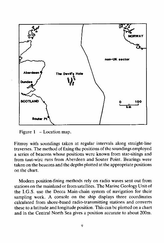
In the middle of the North Sea, about 200km east of Dundee, there are a number of deep trenches known collectively as the Devil's Hole. Figure 1 is a map of the Central North Sea and shows the location of the deeps. The north-south trending depressions which make up the feature were noted as long ago as 1931 by J.W. Gregory in the Geographical Journal (vol. 77, p. 548). They were first charted by H.M. Survey Ship
8
non-UK •• ctor
The De"II'. Hole
\J~
o 100 I
,
Figure 1 - Location map.
Fitzroy with soundings taken at regular intervals along straight-line traverses. The method of fixing the positions of the soundings employed a series of beacons whose positions were known from star-sitings and from taut-wire runs from Aberdeen and Souter Point. Bearings were taken on the beacons and the depths plotted at the appropriate positions on the chart.
Modern position-fixing methods rely on radio waves sent out from stations on the mainland or from satellites. The Marine Geology Unit of the I.G.S. use the Decca Main-chain system of navigation for their sampling work. A console on the ship displays three coordinates calculated from shore-based radio-transmitting stations and converts these to a latitude and longitude position. This can be plotted on a chart and in the Central North Sea gives a position accurate to about 200m.

Traverses run by the Marine Geophysics Unit of I.G .S. use a system of satellite navigation whereby fixes and updates are received every few hours, intermediate positions being determined by doppler sonar off the sea-bed. This system gives a position accuracy to about 100m.
SEABED TOPOGRAPHY
The presence of the Devil's Hole was known long ago to fishermen, some of whom managed to lose their trawl nets on the steep sides of the trenches and thence gave it its name. The average water depth over most of the surrounding area is between 80m and 90m but reaches over 230m in the deepest part of the trench. The sides are steep - up to ten degrees. This may not sound very great at first but for a seabed slope it is quite considerable. As a comparison, the Continental Slope northwest of Britain has an average gradient of around one degree, a point worth recalling when you next see a diagram of the Continental Shelf, Slope and Ocean floor.
Figure 2 shows a bathymetric map of the area of the Devil's Hole. The narrowness of the features and their approximate north-south trend can be clearly seen. There has been some debate as to what these features should be called - the words channels, valleys and trenches have all been used at various times in the literature. Channels and valleys both imply an origin which may not be appropriate. For the time-being I shall refer to them as trenches. These are not to be confused with deep sea trenches which are a product of plate tectonics! They are on average 1 to 2 kilometres wide, 20 to 30 kilometres long and at their maximum development 120m deep (below the seabed). The relief along the bottom of the trenches is sometimes quite dramatic when seen on echosounder recorders (Figure 3).
GEOPHYSICAL EVIDENCE
As well as echo-sounder profiles of the seabed, the geophysical records include shallow seismic lines. Differences in the frequency of the sound source mean that in addition to a surface trace, these show
10

.7" N line of .ectlon of Fig. 4 l 5
and lOS borehole
"'IO'N .. ·IO'N
o 10 I ,,'
km 1· E
Figure 2 - Bathymetric contour map of the Devil's Hole area (contours in metres).
reflections from below the seabed. The best type of equipment to show the nature of the deposits in the Devil's Hole is a high resolution 'boomer' seismic source. Figure 4 shows a 'boomer' record across a part of the Devil's Hole. It can be seen that below the present-day seabed surface there are a number of conformable reflectors. This apparent
11

•• t ... _ Sout" _ Nort"
dept" ti'-;;;'-I~-- .~. t ~. 0:< ('>.-i. -'------i-~ -:-. -,------tI----,~"-+. ,-::-----,--'------"'---~-,---
100m------------------~----~----------------"--~~ j-_ I
~~~------_~_-~--_,~_,~_-_-J~ __ - .. ~-L----~--~~~~~-:-_~ .. ~.~.
---------- --" ---~-----..------------- -- ------ - ~-------
150m ~-2-~-:J' ~.-~-:=-=-~~-~~-~ .. _~_-~-~_-~~_~~~. -~-~-~r~~~~~~~~~~~
200mB. IIf!BI. -
Figure 3 - Echo sounder profile across part of the Devil's Hole area showing irregular nature of the base of the trenches (vertical exaggeration x 25).
lamination is known as seismic layering and is caused by changes of the density in the sediment. These changes can be interpreted as representing variations in the nature of the sedimentary deposits. The 'multiple reflections' shown on the section are a function of the seismic process and are related to secondary reflections of sound waves from the seabed and sea-surface.
The scale along the top of the section is drawn by measuring the distance between fixes (heavy vertical lines) which are taken every 10 minutes. The thin horizontal lines across the section represent time measured in tens of milliseconds. This is the time taken for the sound wave to travel to a reflector and return to the receiver towed behind the ship. It is known as the 'two way time'. It is not a direct measurement of depth, the exact time being a function of the velocity with which sound travels through the sediments. Examples of some velocities are given below in metres per second:
Water Soft clay Sand Till
1470m/s 1600m/s 1800m/s 2000mls
12

Wast
o I
IGS borehole
I 0·5 I
kilometres
Ea.1
Figure 4 - 'Boomer' record across a trench in the Devil's Hole area.
If we take an average value of 1700 mis, the 10 millisecond scale mark on the side of the section can be seen to represent 8. Sm. It is clear therefore that there is a great deal of vertical exaggeration in this section (approx.17x).
GEOLOGICAL EVIDENCE
In 1981 the Marine Geology Unit drilled a borehole on the flank of this trench, shown in Figure 4, through the underlying sediments. The core returned showed that the top 11m consisted of sand which proved to be very fine to fine grained with a variable amount of silt. The sand
13

western side of the trench. Looking at other trenches in the Devil's Hole, this is found to be the case over much of the rest of the area as well. Locally there is also some seismic layering which resembles large scale cross bedding within the upper sand, the sediment transport appearing to have been from the west. Near the Scottish coast, fine grained sands very similar to those in the upper part of the Devil's Hole sediments appear to be related to river outwash fans.
Several types of microfossils have been recovered from the sediments in this borehole. These include foraminifera and dinoflagellate cysts which have been analysed by the Palaeontology Unit of J.G.S. The fossils from the basal gravelly sands and from the soft clays are commonly arctic species while in the sand at the top of the borehole several temperate and boreal forms are found.
RECONSTRUCTION OF DEPOSITIONAL ENVIRONMENT
The evidence suggests that the trench must have been cut during the last glaciation or early in the post-glacial period, probably by highenergy melt waters. The dimensions of the trenches are similar to those of 'tunnel valleys' found in Denmark and northern Germany. These, like the Devil's Hole features and unlike glaciated mountain valleys, are closed at both ends. It is thought that they were formed either subglacially or proglacially i.e. beneath a glacier or just in front of it. If this were the case, the main glaciated area would probably have lain to the south.
The basal sands and clays must have been laid down some time after the formation of the trenches but before the end of the ice-age. The occasional small pebbles most likely represent 'dropstones' which have fallen out of melting ice shelves, icebergs or pack ice. This in turn suggests that these sediments were laid down in the late glacial period. At this time the sea level was considerably lower than the present day and circulation in the North Sea much more restricted. After most ofthe ice had melted, there was no longer a local source of mud and pebbles and sedimentation became dominated by the sand swept down by rivers
14

grains were dominantly quartzose with a subsidiary quantity of metamorphic rock fragments and heavy minerals. Angular shell fragments were also recovered. Below the sand, the sediments comprised very soft silty clays with occasional interbedded sands. Shell fragments and small scattered pebbles were found through this unit. These soft clays were recovered down to 53m where the drill penetrated a 7m thick bed of slightly gravelly shelly sand. At 60m the drill encountered stiff clay and sand, which was taken to represent the base of the trench infill. From this information, we are able to construct a cross section of the trench and its infill (Figure 5).
Figure 5 - Geological cross-section across a trench in the Devil's Hole area (vertical exaggeration x 5).
We can see from this geological cross section that the soft clay makes up the greatest thickness of sediment in the trench. The seismic layering also suggests that the clay has been deposited in a more or less symmetrical distribution, although the axis of symmetry is not the same as the present axis of the trench. The basal gravelly shelly sand layer also has a generally symmetrical distribution. In contrast, the upper fine grained sand layer is markedly asymmetrical, occupying only the
15

draining the still-glaciated Scottish mainland. This sand was carried out into the shallow North Sea, probably reworked by waves and tides and deposited in the Devil's Hole area. The westerly sand source may explain why the sand in the Devil's Hole trenches is assymetrically distributed.
This model is only preliminary - it does not explain why some trenches are completely infilled with sediment while others are only partially filled. Much more work needs to be done on the cores and the seismic records before we can be certain of the precise depositional environments and before we can have a fuller understanding of the late glacial and post glacial history of the North Sea.
ACKNOWLEDGEMENT
This article is published with the permission of the Director of the Institute of Geological Sciences (N.E.R.C.).
THE BUILDING STONES OF EDINBURGH PROJECT
Richard Gillanders
It is now a year ago since I contributed a short note to the Edinburgh Geologist to say that the Society'S Building Stones project was underway. Alex Mackie and I were anxious that the project should not only consider the buildings and the different kinds of stone used but also the famous sandstone quarries around Edinburgh that supplied the stone. We very soon enlisted the help of other enthusiastic members; with Ian Bunyan, Norbert Pawlowski, John Fairhurst and Norman Butcher completing the Building Stones Team.
We set out by searching and gathering together as many bibliographic
16

and documentary references to Edinburgh building stones as possible. Many an hour has been spent thumbing through journals in libraries or looking at old plans in the Scottish Records Office. Did you know, for example, that duals were fought in one of the quarries at London Road; or that the quarry in Lothian Street (near the Royal Scottish Museum) supplied not only stone for the building of Lothian Street but furnished the Neptunist's proof of the aqueous origin of greenstone; or that the quarry at Granton flooded one stormy night in 1855 when the sea broke in and the manager and his family narrowly escaped when the house fell into the abyss? Although much useful information has been gathered together we have found, as George Craig found while researching his paper for the Society's Transactions 90 years ago that:
"very few records have been kept of the ultimate destination of many of the older building stones and even now [1892] much trouble is entailed finding out the quarries from which many of the modern buildings have been obtained"1
Before we looked at the buildings we visited the quarries. In the past year we collected samples of stone from over twenty quarries. These include Craigleith, Ravelston (at least three quarries), Maidencraig, Craigcrook, Barnton Park, Craigiemill and Hailes, to the west of Edinburgh; Binny, Hermand and Humbie in West Lothian; Cullaloe, Newbigging and Grange in Fife; Craigmillar (numerous quarries) and Hawkhill Wood in the Old Red Sandstone to the east of Edinburgh; and Locharbriggs and Corncockle in the New Red Sandstone of Dumfriesshire. Unfortunately many of the famous quarries have, within recent years been filled in or are in process of being filled with the result that little or no stone is now exposed. Hailes, Redhall and Granton quarries are now public parks and are unrecognisable as former quarries. Grange Quarry at Burntisland which supplied the stone for the dome of the Old College ofthe University, and Craigmillar Quarry which supplied stone for many of the villas on the South Side are at present local authority refuse tips. The Old Ravelston Quarry which provided stone for George Heriot's Hospital and the Parliament House was intended as the site for a large private hospital but planning consent
17

was turned down. Only a 10 to 15 feet high face of stone is now visible above the infill at Craigleith Quarry - a quarry that was once 200 feet deep and supplied stone for the building of New Town. Barnton Park Quarry, although flooded, was the only quarry we visited that was entirely free of dumped rubbish largely due to its situation in the middle of Bruntsfield Golf Course. It was interesting to see the reverse of the usual state of affairs at Newbigging and Cull aloe Quarries in Fife where large quantities of rock debris had been cleared away for bottoming for the new gas pipeline so that the original faces and floors of the quarries were again exposed.
The problem with collecting samples of stone from long abandoned quarries is the uncertainty that the sample you are taking is representative of the good quality stone worked for building purposes. Stone from a single quarry face can vary considerably in colour, texture, hardness and durability. However, it was gratifying for us to see that the block of stone we removed from a bed at Hermand Quarry matched very closely the stone of the Bank of Scotland in George Street stated by Craig to be from that quarry.
It should be recorded that much physical effort is expended by the team in procuring suitable samples of stone from the quarries. Sledge hammers, wedges and crowbars are usually necessary to secure a good sized fresh block of stone. Boys fishing at the flooded Humbie Quarry were astonished, one still summer's evening, when the Building Stones Team arrived with massive hammers and removed part of one of their fishing ledges in an attempt to procure a suitable sample of the stone.
Having looked at so many disused quarries we were keen to visit a working quarry and see, at first hand, the techniques of stone quarrying. In early July we set out for Locharbriggs Quarry near Annan in Dumfriesshire where the red Permo-Trias sandstone has been worked for well over a hundred years. Baird and Stevenson, quarrymasters of long standing, work the stone and have supplied stone for the Caledonian Hotel, and more recently, for the College of Art at Lauriston Place. The present quarry is on the edge of a much larger old
18

flooded quarry and usually employs six men. It was fascinating to see that the old traditional methods of quarrying are still used at Locharbriggs. Hammers, wedges, picks and crowbars of antiquated design are the quarryman's tools. The stone is lifted from the quarry by an old crane - originally powered by steam and now run by electricity but sadly condemned by the Mines and Quarries Inspectorate. The only modern tool is the pneumatic rock drill and compressor. Black powder is used for blasting rather than dynamite as this loosens the blocks of stone and doesn't shatter them. During our visit, the last shot that day was a "muck shot" sending fragments of stone high into the air. One piece missed Alex Mackie and I watched another large piece travelling through the air wondering if it would land on my car! We knew why the shotfirer had retired to a greater distance than usual. Blocks are pulled from the quarry face with the crane and we watched one of these blocks being split with hammer and wedges. We saw several blocks of2-3 tons each being loaded onto an articulated lorry destined for W. & J.R. Watson's yard at West Calder. Locharbriggs is a most entertaining quarry and after our day there we felt that we had stepped back in time perhaps 50 years. I would certainly recommend that the Society organise a visit to Locharbriggs before too long - preferably on a working day.
So far we have looked at quite a number of Edinburgh buildings where the source of the stone is known with certainty. With experience one can hazard a guess as to the stone used on a building. Hailes stone, for example - both 'grey Hailes' and 'pink Hailes' - we can easily recognise because of its characteristic 'wisps'. One evening we visited two examples - Sciennes School (1891) and DaIry School (1876) - both, according to Craig, built of grey Hailes. We weren't convinced that DaIry School was entirely 'grey' Hailes for there may be 'pink' stone as well- but the janitor received a telephone call informing him that there were four very suspicious persons in the playground prowling round the building!
We were grateful to Mr. W. Dey for showing us the interior of St. Anne's Church at Corstorphine. The ashlar work there is a good
19

example of 'pink' Hailes and the interior pillars and fine carvings are of Cullaloe stone from Fife.
We are embarking on our project at a time when there is renewed interest in the use of natural stone particularly in conservation areas such as the New Town and its extension to the west. Craigleith stone, for example, is no longer obtainable and other sources of similar stone have to be found to replace deteriorating stone work. There are firms in Edinburgh, some of long standing, who specialise in stone masonry work and we hope to contact them in the near future to obtain further information.
The tenements of Marchmont Road display a fine variety of sandstones from different quarries. This is just one example where, as yet no information has been found as to the source of the stones used. Consequently we are always pleased to hear from any member of the Society who could give us any information on Edinburgh building stones.
References
Craig ,G. 1893 On Building Stones used in Edinburgh: Their Geological Sources, Relative Durability and other Characteristics. Transactions of the Edinburgh Geological Society Vol. VI, pp. 254-273.
THE CHANGING LANDSCAPE
Bill Baird Royal Scottish Museum, Edinburgh
MAN AND WATER: Part I - Now you see it, now you don't
After the last ice age Scotland was a very wet place indeed. The
20

movement ofthe ice, and the debris it left behind when it melted, caused chaos in the drainage patterns which had evolved prior to glaciation. Lochs, swamps and beaver dams occupied many valley floors and consequently our Neolithic ancestors made their homesteads on high ground where they could get grazing for their animals and move around without either eternally having wet feet or alternatively malaria, the "ague" of old historical documents. That was all very well where there was some accessible high ground which we would regard today as arable or at the very worst marginal land. In the Highlands there was no such option; you were either right down amongst it or you were halfway up a very steep mountainside. However give our ancestors credit where credit is due: they very quickly realised that with so much water around they would be as well to make the best use of it and hence the Cranog.
There was not a great deal that early Scots could do about water. Certainly during the early hunting and gathering period and probably well into the early grazing and agricultural period they probably just regarded it as an obstacle in the journey from here to there or alternatively as a place to go and fish. It is true that from the time of the first cranog, man had realised the value of water as a barrier, and it was soon used to defend early fortifications, first by using natural sites, and then by digging moats and trenches. Not long afterwards it was first used as a power source to grind grain in the Norse type of meal mill. Probably at this time the first channels were dug to direct and control the flow of water. The use of water power continued to develop and then in the Middle ages we had the first use of water to leave a man-made scar with the use of the technique called hushing in the Leadhills area to remove a top soil and expose mineral veins. The use of water continued as a power source and means of communication with the establishment of large textile mills on many rivers and canals built to link cities and shorten sea routes. However the main effect on the landscape came about in the early 19th Century with the hunger for land in the arable areas of lowland Scotland. At the start of this period some land- hungry farmers realised that the loch which covered part of his estate was shallow and if drained would provide good rich ground able to support valuable crops. The result was inevitable especially as it was supported by a prize of
21

£1,000 Scots and the award of a gold plate by the Highland and Agricultural Society to the best scheme. The spade had been thrown down and now water would flow like blood and many Scottish lochs would shrink or even in some cases vanish for ever. In a few brief years the landscape of Scotland would be significantly changed. Not until the advent of Hydro electricity and the big city demand for water which resulted in the building of artificial reservoirs in the high valleys, would there be the same surface area of fresh water in Scotland.
The practice of loch drainage was so widespread that it would be impossible to list all the successful attempts and failures other than in a long index. However, one or two examples show just how widespread the practice was during the early 19th century. Perhaps the best known and most outstanding example is that of Loch Leven. Between the years 1826 and 1836 the level of the loch was lowered by nine feet by a great ditch in the south east corner of the loch known as the "New Cut". The area of the loch was reduced by a quarter and 1100 acres of previously marshy ground was brought into cultivation. This was not just a straightforward drainage operation as a system of sluices was arranged at the mouth of the cut so that the water flow could be used for flax and other mills lying along the lower course of the River Leven. It is quite obvious however that the plan would not have been proceeded with unless it had offered the eventual gain of many hundreds of acres of flat arable land. The lowering of water level in the loch has also had the rather unique effect of creating two man-made raised beaches on the steep southern shore. We have no knowledge of the overall effect on the fauna and flora of the loch due to the drainage but we have one interesting piece of information about the fishes. Up until the time that the water level was lowered Char had been widespread and abundant but afterwards they went into an immediate decline and no specimens were caught after 1837.
During the 'age of the improvers' in Scotland it was accepted as a selfevident fact that drying out the land would improve the climate. The mechanism of this alteration is first explained clearly by Cadell in 1892, and for those who might continue to doubt, Lamb, (1982) adds some of
22

the background physics. It is little wonder, then, that although there were many joint schemes for drainage which involved not only the exposure of more good arable land, but also the benefit of some secondary aspect of the drainage which would help to offset official costs, most were straightforward efforts to expand the acreage under productive agriculture. This was the type of enterprise which was carried on at Lochcoat Loch, Linlithgow. The proprietor of the small estate at Lochcoat set about draining Lochcoat Loch, some 22 acres in extent, during the winter of 1819 and the spring of 1820. By digging ditches and a short tunnel through a natural dam of basaltic rock the water was drained away and by August of the same year parts were being sown down with grass seed. The owner was well pleased with his efforts and indeed to this day the bed of Lochcoat Loch is still dry even if slightly boggy. However, only a quarter of a mile to the south lies the shore of Lochcote reservoir, a man-made loch of approximately equal size to the old loch. Here we see a perfect example of the wheel of progress having gone full circle.
Even a very superficial study of the drained lochs of Scotland shows that, over the centuries, man has had a tremendous effect on the appearance of the landscape. Although such changes are only skin deep, cosmetic even, we must be well aware of their magnitude when we come to interpret the landscape.
Further reading Cadell, H.M. 1982, Geological Changes wrought by Man within the Forth Basin. Transactions of the Edinburgh Geological Society, Vol. VI, Pt. XXXIII, pp. 275-286.
Lamb, H.H. 1982, Climate, History and the modern world. Methuen.
Lind, W.C.M. 1968, Loch Leven and its Islands. Scots Magazine, N.S., Vol. 89, No.l.
Wishart, P. 1824, On the Draining of Lochcoat Loch. Prize-essays and Transactions of the Highland Society of Scotland , Vol. VI, pp. 241-246, PI. V.
23

REVIEW
GEOLOGY OF SCOTLAND 1983, 2nd Edition, G.Y. CRAIG, Editor, Scottish Academic Press, 472 pp. Cloth Cover £35, Paper Cover £17.75.
To the geologist working in Scotland the appearance of this book is one of the notable events of 1983. Edinburgh may claim rightly to be the cradle of modern geology through the work of James Hutton. There was too a distinct Edinburgh flavour in the first edition of this book published in 1965, and this has been retained in the new edition for many of the authors have been able to rewrite their earlier chapters.
The new edition is an impressive book and reflects the immense amount of geological work that has been carried out in Scotland over the last eighteen years. The number of pages has dropped by nearly 100 but the content of a page of print has risen by two thirds; the text has increased overall by 25%.
Chapters are devoted to Growth and structure of Scotland (A.L.Harris), Lewisian (Janet Watson), Torridonian-Moine (M.R.W. Johnson), Lower Palaeozoic stratigraphy and Lower Palaeozoic structure and palaeogeography (both by E.K. Walton), Caledonian and earlier magmatism (P.E. Brown), Old Red Sandstone (W. Mykura), Carboniferous and Carboniferous-Permian igneous rocks (both by E.H. Francis), Permian and Triassic (J.P.B. Lovell), Jurassic, Cretaceous and Tertiary sediments (A. Hallam), Tertiary igneous activity (C.H. Emeleus), Quaternary (J.B. Sissons) and Economic geology (P.McL.D. Duff).
Major advances in geological research since 1965 have led to substantial changes in every chapter in the book. Widespread age dating has brought new insights and appreciation particularly in the chapters on the Precambrian and the Caledonian earlier magmatism. The SURRC laboratories in East Kilbride have played a major part in this field and also in obtaining isotopic data used to help unravel the complexities of both Caledonian and Tertiary igneous activity. Plate
24

tectonic theory now plays a major part in the interpretation of both the Scottish Highland and the Southern Uplands (Chapters by Johnson and Walton). Much of the stratigraphy has been strengthened by new palaeolatitude data, e.g. in the Old Red Sandstone and the Carboniferous. So too sedimentology has greatly enhanced our knowledge of almost the entire geological column from the Torridonian and Dalradian up through the Palaeozoic and Mesozoic. Many new palaeogeographical maps serve to give readers a clearer picture of conditions of deposition for example in the Old Red Sandstone and Triassic.
If we felt that by 1965 we knew many of the answers to questions about British stratigraphy, the discovery of oil in the northern North Sea soon disabused us of such a thought. The impact of this discovery is to be seen particularly in the chapters from the Permian to the Tertiary and that on economic geology. If the Quaternary has been little affected by plate tectonics, research has been just as active as elsewhere in the geological column and this has been ably integrated here too.
Two general comments on the book; all the authors have greatly expanded the numbers of references at the end of the chapters, and the book is excellently illustrated. There are many fine photographs new to this edition. Some of the diagrams are less pleasing - Fig. 1.2 has several unexplained symbols, in Fig. 13.5 some of the ornament has not reproduced and the captions to Fig. 2.1 and 3.2 are both wrong. These are small points (under most circumstances!) and overall the printing is of a high standard. Scottish Academic Press are to be congratulated in the production.
No book can be uniformly up to date in a lively science and doubtless every author would like to have gone to press later. For all that there will be few professional geologists in Scotland who will not wish to have a copy. For the amateur, any advanced scientific text book must contain technical terms. If this is recognised, the text, diagrams and photographs are a mine of information on the 'Geology of Scotland' .
A.R. MacGregor
25

GEOLOGICAL CROSSWORD
Across 1. Phyrric pot I remade (11 letters) 7. Growth by action out ofN.E.R.C. (9) 9. Alternative source of gold? (3)
10. I cut East for sea-level changes (8) 11. Wear to process minerals? (5) 12. Has been a marker bed (3) 14. Beg more in Assynt (3) 15. Succeed in extraction (3) 16. Calcareous by a mile (5) 17. For glaciation its essential! (3) 19. What one might do at Bal An Or (3,3,4) 20. A cleft out of one's ego (3) 21. Musical expressions? (5,5)
26

1 , ,
Down 1. Making aerodynamic furniture? (12) 2. Foundations of Geology (5) 3. Grand Heap (9) 4. Cornish containers (4) 5. Angered prisms (7,6) 6. Immature sediment? (9) 8. A lot of lice about in the Pleistocene (6)
11. Old fashioned prospector (6) 13. Manly genus (4) 17. "-- all the world was paper,
And all the seas were ink," (2) 18. Volcanic accumulation (4)
Compiled by Angela Anderson
27

EDINBURGH GEOLOGICAL SOCIETY Publications available from Mr. A.D. McAdam
Publication Sales Officer Edinburgh Geological Society c/o Institute of Geological Sciences West Mains Road Edinburgh EH9 3LA
Postage extra. Please make cheques payable to Edinburgh Geological Society.
Ardnamurchan Guide Ardnamurchan Map (Flat or folded) Assynt Guide
Geological Timescale, pubished for Manchester Mus.
Proceedings Edinburgh Geological Society 1-5 Proceedings Edinburgh Geological Society 6 -12
Postcards: Hutton; Murchison & Geikie; Peach, Horne & Clough; Cadell 1 & 2
Dalradian Offprints from Scottish Journal of Geology, Vol. 13, part 2,1977.
Introduction 1 Roseneath, Cowal 2 Knapdale, Kintyre 3 Tayvallich 4 Jura 5 Lunga, Luing & Shun a 6 Northern Loch A we 7 LochLeven
Transactions, Edinburgh Geological Society, various parts, details of price and availability may be obtained from the Publications Sales Oficer.
Geology of the Lothians ... (Hardback) ***************
Price to Price to Non-members Members
£2.00 £1.33 .60 .50
£2.00 £1.33
.25
.25
.50
.05
out of print .35 .25 .35 .25 .25 .25 .35
N.A.
.25
Free Free
.05
.30
.20
.30
.20
.20
.20
.30
£2.40
Non-members may be interested to note that the following publications are available from Scottish Academic Press
33 Montgomery Street Edinburgh EH7 5JX Scotland
Post & Packing Extra Please make cheques payable to Scottish Academic Press.
The Geology of the Lothians & South East Scotland: an Excursion Guide. (Hardback) £3.50
Scottish Journal of Geology, published 3 or 4 times per year, £40 per volume £15 per part.
28

