edge - hr wallingford · edge welcome to hr wallingford’s edge published twice a year, edge...
TRANSCRIPT

Issu
e 05
edgeVirtual perfection for
Thames TidewaySimulation makes perfect
Exploring in the deep
2 wwwhrwallingfordcom
7
8
10
12
14
4 Virtual perfection for Thames TidewayOur virtual-reality simulation is helping River Thames vessel masters to demonstrate their navigation skills
Modelling management amp mitigation
Exploring in the deep
Safe passage
Cool running
In this issueed
ge
Welcome to HR Wallingfordrsquos EdgePublished twice a year Edge features just a few of the ways we are supporting our clients around the globe as well as some of the smart research solutions wersquove delivered Edge Issue 05 has a focus on maritime and coastal engineering
We hope you enjoy reading about our work Please send feedback to marcommshrwallingfordcom
copy HR Wallingford 2017
Welcome to our world
wwwhrwallingfordcom 3
16
18
Simulation makes perfectManoeuvring the largest offshire floating facility ever built - Shellrsquos Prelude FLNG facility
Stable cables
20
22
24
26
Shingle-B
Aberdeen Harbour
The future of mooring analysis
Defending Conwyrsquos communities
Wersquod like to share our Edge with you
Sign up to our mailing list at wwwhrwallingfordcomedge and we will send you Edge by email
Have you seen Edge 04 our floods and water management issue Download a copy from wwwhrwallingfordcomedge
4 wwwhrwallingfordcom
A mega-project for LondonLondonrsquos sewer and surface water drainage systems are connected they rely on an integrated network of combined sewer overflows (CSOs) to manage water levels When heavy rainfall overwhelms the system these CSOs release overflows through discharge points along the Thames
Originally this would happen once or twice a year it now happens on a weekly basis and it no longer requires
a storm to trigger these overflows
To stop tens of millions of tonnes of untreated sewage flowing into the Thames each year construction work has started on the Thames Tideway project This 25-kilometre-long lsquosuper sewerrsquo is a tunnel running up to 65 metres under the Thames that will
When Joseph Bazalgette designed Londonrsquos sewerage system in the 19th century it was considered an engineering marvel and helped to rid the city of cholera But Bazalgettersquos sewers were built for a city of two million people not todayrsquos eight million plus inhabitants
The pound42 billion Thames Tideway Tunnel project will bring Londonrsquos sewers in to the 21st century We are assessing any vessel master that wishes to work on the Tideway Project to ensure that they meet Tidewayrsquos health and safety standards by putting them through their paces using our UK Ship Simulation Centre
intercept store and transfer the sewage overflow for treatment The tunnel starts in west London and follows the route of the River Thames to Limehouse before heading north-east to Abbey Mills Pumping Station near Stratford At Abbey Mills the Thames Tideway Tunnel will connect to the Lee Tunnel which will transfer the intercepted sewage for treatment at Beckton
Ensuring safe river navigationGiven the scale of the project itrsquos no surprise that excavation of the Thames Tideway Tunnel will generate immense volumes of spoil right in the heart of London Tideway plan on transporting at least 42 million tonnes of this spoil by river to minimise the impact on the capitalrsquos roads This will treble freight river traffic and create up to 200 maritime jobs including
Virtual perfection for Thames Tideway
wwwhrwallingfordcom 5
barge hands and vessel operators
HR Wallingford has developed a four-day course with the Tideway team designed to ensure boat masters are given the opportunity to demonstrate that they are fully prepared and are aware of the health and safety requirements to work on the Tideway Project The course uses our virtual reality simulation of the tidal River Thames developed using HR Wallingfordrsquos UK Ship Simulation Centre
ldquoOur simulation covers the tidal River Thames from Putney Bridge to Margaretness complete with accurate visual scene tides flows other river traffic and changeable weather conditionsrdquo said Dr James Clarke Technical Director at HR Wallingford Andy Mitchell Tideway CEO at the helm of a tug on the Thames
Our virtual-reality simulation is helping to ensure health and safety standards by allowing River Thames vessel masters to demonstrate their navigation skills
6 wwwhrwallingfordcom
The hydrodynamic model uses data from tide gauges and flow measurements along the Thames to simulate realistic flow and tide conditions on the river and our Naval Architects have developed a suite of realistic ship manoeuvring models for the vessels used in the simulation
The Thames simulation is the most detailed visualisation we have developed to date
ldquoWe know how important visual cues can berdquo explains James ldquoso we put a lot of effort in to creating a visually rich environment for the simulation On this project we went the extra mile as all the vessels masters have a local knowledge endorsement and a detailed knowledge of the river which allows them to use some relatively small features along the river as prompts and markersrdquo
So wersquove included details such as lions heads in the river embankments marker posts and even details on the undersides of the bridges
As well as being assessed during normal operations the vessel masters also have to demonstrate how they would respond in unexpected scenarios examining credible emergency situations in a safe risk free environment
Andy Mitchell Tideway CEO visited HR Wallingford to try out the simulator He said ldquoI can see that this could become a new standard for regular competency re-evaluation for the Thames rather like that required of airline pilots It was truly ground breaking stuff and I just have to thank the team who have been behind this over the past couple of yearsmdashthis is exactly what we mean when we talk about being transformationalrdquo
This detailed River Thames simulation has also been made available for other groups to use such as the Thames Skills Academy with funding from the Trinity House Maritime Charity They use it to provide River Awareness courses to river practitioners who are not connected with the Tideway Project
For more information
wwwtidewaylondon
We created a visually rich simulated environment that included the small features and markers along the river used by the River Masters
James Clarke +44 (0)1491 822491 jclarkehrwallingfordcom
Take a look at our River Thames simulation
wwwhrwallingfordcom 7
Modelling monitoring mitigationOver the last eight years wersquove been analysing the effect of the Thames Tideway Tunnel construction works on the river Now with construction starting we are helping the project to monitor and mitigate these effects
number of CSO interception and shaft construction sites
For the Central area we are supporting the contractor team
ndash a Ferrovial Agroman and Laing OrsquoRourke joint venture - to develop and implement a Scour and Accretion Monitoring and Mitigation Plan (SAMMP) for each site of temporary river works The SAMMP collates the predicted effects of the works on scour and accretion in the river the understanding of bed level variability and outlines how the river bed level will be monitored during and following the construction of the temporary works The SAMMP then describes the action that will be taken to mitigate the effects where necessary The SAMMP is an important document for the construction process and needs to be approved by the relevant regulatory bodies
The SAMMPs for the Thames Tideway Tunnel are based on an exceptional baseline dataset covering quarterly bathymetric surveys since the end of 2013 The baseline data is key in understanding the natural variability in bed levels which would be expected in a dynamic area such
as the tidal Thames and defining appropriate thresholds for any mitigation actions to be triggered
As the construction progresses we will continue to support FLo in interpreting the monitoring results to identify any effects of the construction itself compared to anticipated seasonal and year to year variations
For more information
Both the temporary works needed during construction and the permanent final structures will be located on the Thamesrsquo foreshore potentially changing the way water and sediment moves in the river Wersquove looked at these changes as input to understanding the impact they might have on nearby structures on river navigability ecology as well as being able to inform the design of the structures themselves to minimise these effects
Future proofing the designThe design life of Thames Tideway Tunnel is 120 years With the predicted effects of climate change average sea level and river flows are expected to change over this time so welsquove used the validated whole estuary numerical model to simulate the potential extreme currents which might occur over the design life of the tunnel redefining the extreme or lsquomost onerousrsquo hydrodynamic conditions which the designs will need to be ready for
Monitoring the effectsThe construction of the Thames Tideway Tunnel is split in to three work packages West Central and East Each package includes a
John Baugh +44 (0)1491 822261 jbaughhrwallingfordcom
Scientists Jon Taylor (left) and Neil Crossouard (right) prepare to board the RSS James Cook to embark on a six week research cruise
8 wwwhrwallingfordcom
Exploring in the deep
Itrsquos staggering to think that there are more active mobile devices than there are humans and gadgets like tablets and smartphones are multiplying five times faster than we are Itrsquos unsurprising then that the demand for raw materials used for computing communication and the production of clean renewable low-carbon energy is growing at an exponential rate
In light of these trends there is growing concern about the long-term availability of a particular group of resources known as e-tech elements so called because of their contribution to emerging green technologies High concentrations of some e-tech elements are found in ferromanganese (FeMn) crusts
seafloor mineral deposits which form on some underwater mountains But can we mine these deep sea deposits in a sustainable way
In depth researchHR Wallingford is partnering with the UK National Oceanographic Centre on Marine E-Tech a NERC-funded research project in the SoS Minerals Programme that will help us to understand how FeMn deposits are formed and given the unique ecosystems involved what potential environmental impacts may be associated with their recovery
Our scientists recently joined the Marine E-Tech research cruise on the RRS James Cook The team
Our scientists go to extremes to explore the impacts of deep ocean mining
Our scientists designed and deployed a unique benthic observatory on the Tropic Seamount
Watch our visualisation of the currents around the Tropic Seamount
wwwhrwallingfordcom 9
spent six weeks exploring the Tropic Seamount located 400 km south west of the Canary Islands in the north east Atlantic in depths of between 1000 and 4000 m HR Wallingfordrsquos unique expertise and experience in the technical disciplines of modelling and monitoring were used to simulate the behaviour of sediment plumes that could be released during deep sea mining operations on the sea bed and to measure their potential impacts
ldquoWe had to characterise the way the ocean currents circulated around the 3 km high seamountrdquo explains scientist Neil Crossouard ldquoThese hydrodynamic forces affect the way the sediment plumes disperserdquo
ldquoWe collected data using a variety of methods measurements from a range of moored instruments and instruments on board the ship full water column profiles using sensors lowered through the water and we also deployed a unique benthic observatory designed and built at HR Wallingfordrdquo
HR Wallingford recently extended our TELEMAC 3D modelling suite (see next page) to include simulation of the hydrodynamic regime experienced in the deep-sea This allowed our team to model simulations during the cruise providing valuable information for the planning of cruise missions in what was a unique and hydrodynamically complex environment Ten day forecasts generated as part of model outputs were regularly updated as data from cruise missions were frequently provided to the modelling team allowing ever-improved model predictions to be made
New predictive toolsldquoWe are using the data we collected during the measurement campaign to validate our sediment transport modelsrdquo explains Neil ldquoThe initial results are really promising we can use the models to reproduce the sediment plumes generated in deep water and the outputs compare favourably with the field observationsrdquo
Outputs from the modelling study will be further enhanced when the results of on-going settling tests provide further insights in to the sediment characteristics Advancement of this predictive modelling capability will allow the potential effects of deep sea mining to be better understood and lead to the development of schemes which minimise environmental impacts on the seabed
Imag
e co
urte
sy N
atio
nal O
cean
ogra
phic
Cen
tre
For more information
Neil Crossouard +44 (0)1491 822401 ncrossouardhrwallingfordcom
10 wwwhrwallingfordcom
Welcome to our worldOur new detailed global model bridges the gap between environmental hydraulics and oceanography
The numerical modelling applied to oceans on the other hand has in the main been restricted to research use such as for the study of climate change modelling decades or even centuries of ocean evolution but with an output frequency of one day at best The global resolution and the complexity of the physical ocean processes have improved lately thanks to increasing computer processing power Nevertheless ocean models are often based on less flexible legacy codes compared to their environmental hydraulics equivalents As a result there has existed a profound modelling gap between these two approaches
Now with the rising costs of extracting natural resources human activities are gradually linking the shores to much deeper ocean waters To meet the needs of our clientsrsquo water-related challenges it has therefore become essential for HR Wallingford to bridge this gap between environmental hydraulics and oceanography
modelling the complicated interaction of hydrodynamics waves or sediment processes for example and allowing for ever more detailed simulations right down to a few metres and a few seconds TELEMAC is a particularly flexible example of one of these hydraulic modelling suites Distributed worldwide by HR Wallingford as open source software (opentelemacorg) TELEMAC plays a key role in many of our research and consultancy projects
Bridging the gapThe numerical modelling used in environmental hydraulics studies has predominantly been applied to the study of inland and coastal areas Advanced 1D 2Dand later 3D software has been developed to provide scientists and engineers with the capability to model complex processes in the field of free-surface flow
wwwhrwallingfordcom 11
The solution we have identified is in the form of a new phased project aiming to deliver a detailed model The Earth by TELEMAC
A new state of the artThe first three phases of the project have already broken new ground in this field
gt Phase 1 We built a detailed model of the Earth with a finer resolution than anything else previously available and used it to propagate tsunami waves over the entire globe
gt Phase 2 We modelled tides worldwide by directly computing gravitational forces Tidal levels generated from the Earth by TELEMAC not only compare favourably to actual satellite observations but it also computes tidal current velocities something not currently obtainable at a global scale
gt Phase 3 We are now driving the Earth by TELEMAC with global atmospheric pressure and wind datasets to analyse storm surges for large cyclones typhoons and hurricanes
Subsequent developments will include its application to the forecasting of waves at unprecedented detail yet at global scale to computing mean dynamic topography (mainly caused by global temperature variations) and to modelling ocean currents then combined with all of the above none of which are currently available elsewhere
A world leading global modelling resourceOur aim is to deliver the most comprehensive and detailed global modelling resources yet to support all sorts of shallow- and deep-water environmental hydraulics studies at local national or global scales This
could include forecasting activities such as vulnerability to coastal flooding or for the tracking and circulation of pollution debris or plastics engineering designs for example for detailed 3D metocean analysis extremes and climates resource assessments such as for renewable energy or for deep sea mining or resilience and adaptation studies to look at the impact of global climate change
We are now looking to work with organisations from around the world to enhance the Earth by TELEMAC model with further knowledge expertise and data Please get in touch if you would like to get involved
For more information
Seacutebastien Bourban +44 (0)1491 822351 sbourbanhrwallingfordcom
12 wwwhrwallingfordcom
Safe passage
Wersquove been helping clients in Texas to develop inland waterway facilities that keep moored vessels safe from passing ships
In the United States the amount of waterborne transport completed by inland waterways is significant In Texas alone transport by inland waterway accounts for around 600 MT each year thatrsquos close to 30 per cent of waterborne trade in the entire US by tonnage
As the waterways continue to develop many of the prime locations have already been occupied leading developers to look at increasingly more complex sites to locate new marine facilities These sites may be on the bend in a channel or where it
is not possible to design traditional ship docks orientated parallel to the main shipping channel and can be considerably more complex from a marine design perspective
As the average size of the vessels using these waterways has increased notably in recent years so too has the frequency of mooring line failures resulting from vessels passing too close andor too fast past ships moored at existing facilities In recognition of this local pilotage organisations now require a passing vessel analysis as part
wwwhrwallingfordcom 13
of the permit conditions attached to the development of a new facility
So what is involved in a passing vessel analysisPassing vessel analysis is a fully dynamic ship mooring analysis which systematically considers a range of different conditions such as vessel draught speed and separation distance to build a risk profile of potential passing vessel effects at the new facility It ultimately serves two purposes
1 Validate the engineering design in terms of berth geometry and capacity of mooring hardware to be installed
2 Provide the local pilots with guidance on acceptable speeds and passing distances with which they may pass ships moored at the new facility
For over 70 years HR Wallingford has gathered data from hundreds of physical model tests to investigate ship mooring response These data along with full scale measurement campaigns carried out by industry have been used to continually develop and validate our numerical modelling tools against increasingly complex scenarios
For our clients this translates to the development of optimised marine facilities and a more informed picture of the operational risks associated with passing vessels on the adjacent waterway
As ships continue to grow in size so too comes the need to expand the waterways and provide additional channel capacity There are already several such projects proposed in Texas and many more across the United States
The introduction of larger vessels in deeper draught channels typically increases the risk of mooring line failure due to passing vessel interaction Consequently it is not only important to assess the situation for new terminals but also to reassess the risks associated with existing terminals
Of particular relevance in the US is the potential interim condition resulting from the sequence in which the US Army Corps of Engineers deepen the Federal Navigation Channel and the private industry operator chooses to deepen the access to its own ship dock(s) if at all These changes have the potential to significantly impact the operational risk profile associated with mooring operations at existing facilities and vessel passing is an issue that some operators are setting out to understand in more detail sooner rather than later
For more information
Richard Lewis +1 713 554 5371 rlewishrwallingfordcom
14 wwwhrwallingfordcom
Thermal power plants heat water in to steam which in turn drives turbines to produce electricity Power plants built on or near the coast rely on sea water to keep their operations cool A ready supply of sea water of appropriate quality is essential But how far out to sea do intakes need to be HR Wallingford helps clients to find the most reliable locations for their seawater intakes (and outfalls) balancing the competing and complex environmental and engineering demands
ldquoWe support our clients from the early stages of a project and look at how viable their plans for the water intake are and ultimately recommend a feasible design rdquo explains industrial hydraulics specialist Manuela
Escarameia ldquoDecisions need to be made about the location and depth of the intake the configuration size and type of pipeline used as well as how easy it will be to build and maintainrdquo
Sourcing cooling water in areas where silt and sand from the seabed gets disturbed by waves and currents for example during monsoon season is often a major concern If this sediment gets in to the intake and reaches the power plant it can cause costly damage and downtime This was one of the challenges faced by Udupi Power Corporation Ltd as they planned an extension of their operations at Udupi in Karnataka India
Cool runningWater is critical to the cooling operations of thermal power plants But just how far do asset owners need to go to for a reliable source
Modelling results showing average profiles of suspended sand and silt through the monsoon months Sand concentration (upper diagram) reduces rapidly with height so sand ingress may be almost eliminated by taking water from 2 m or higher above the bed In contrast silt concentration is an order of magnitude higher overall and unacceptable concentrations persist right up to the surface during the monsoon
wwwhrwallingfordcom 15
Udupi Power want to add two 800 MW units to their existing facilities and use a closed cycle cooling system with evaporative cooling towers The water evaporated from the towers will be replaced from the sea using a new offshore intake structure pipeline and onshore pumping station The initial concept for the offshore structure was a gravity pipe perforated opening or passive screens intended to exclude silt that may be mobilised by waves andcurrents at a location 78 m below mean sea level
ldquoWe start by assessing the feasibility of the location would sediment get in to the pipelines and if so how muchrdquo explains Manuela ldquoWe looked at flow demand and flow balance to inform the design of the pipelines prevent sediment deposition and minimise pumping costs We also looked at the options for pipe material and constructabilityrdquo
As our investigations progressed it became clear that even at this water depth monsoon conditions could
cause very high silt concentrations not only near the bed but right up to the surface In fact we found the same problem in water depths as great as 15 metres several kilometres offshore In such conditions the most careful design could only reduce but not prevent ingress of silt into an intake at any height above the seabed In order for the intake to be effective Udupi Power needed to look at other options
As well as making specific recommendations for the design of the intake to minimise sediment ingress our experts suggested alternative solutions including use of beach wells or sub-bed intakes use of alternative water sources during the monsoon and inclusion of a high-capacity silt removal facility at the pumping station Design of a silt removal facility requires detailed knowledge of average and maximum ingress rates and amounts together with the properties of the suspended silt We provided this information using our detailed wave and sediment modelling techniques and advised
on ongoing data collection to verify and improve the modelling results
By integrating knowledge experience analysis of field information and detailed modelling applied to the system as a whole HR Wallingfordrsquos experts have been able to advise on one of the key issues of this project and identify a way forward focusing on cost-effective measures to maximise the operability of the power plant its contribution to the energy needs of the country and the return on the ownerrsquos investment
For more information
Manuela Escarameia +44 (0)1491 822429 mescarameiahrwallingfordcom
16 wwwhrwallingfordcom
Simulation makes perfectManoeuvring the largest offshore floating facility ever built ndash Shellrsquos Prelude FLNG facility
HR Wallingford simulation (above and photograph by Shell (left) of the Prelude tow with POSH tugs
Captain Mike Johnson Tug Master in the HR Wallingford simulator
wwwhrwallingfordcom 17
At 488m in length and longer than four football pitches Shellrsquos Prelude FLNG facility was always going to represent a formidable challenge even for the skilled tug masters who were charged with towing the facility from the shipyard in South Korea where it was constructed and delivering it to its final destination a remote gas field 475 kilometres off the coast of Western Australia
But practice makes perfect and HR Wallingford using its Australia Ship Simulation Centre in Fremantle WA created an accurate and detailed navigation simulation of Prelude for
Shell which was used to prepare the Tow Masters Tug Masters and Pilots allowing them to familiarise themselves with a realistic simulation of Prelude manoeuvres at sea And in July 2017 Prelude arrived safely at its destination in the East Browse Basin
HR Wallingfordrsquos involvement in the project extends to the real time navigation simulation for the facilityrsquos departure from the Geoje Shipyard in Korea along the Busan Channel positioning and mooring Prelude once on site conducting berthing and departure simulations of the LNG LPG and condensate offtake tankers that will moor alongside the FLNG and providing ongoing pilot and tug master training in the Australia Ship Simulation Centre in Fremantle
We also created and provided to Shell Australia a bespoke web-based decision support tool to assist with operations planning
Dr Mark McBride HR Wallingfordrsquos Ships Group Manager said ldquoThere was a need to assess many aspects of this unique offshore floating facility which included the manoeuvring issues associated with the arrival and departure of the offtake LNG carriers For this we used real time navigation simulation so that we could identify the limiting conditions for safe manoeuvring as well as the tug requirements and for developing appropriate manoeuvring strategiesrdquo
Up to six integrated simulators at the Australia Ship Simulation Centre were used to simulate the FLNG facility and the tugs for the shipyard departure operation and for the positioning during
connection of the FLNGrsquos mooring lines once at its installation site Actual wind wave and tidal conditions were recorded and then modelled which meant that the crew were able to accurately test the capability and power of the tugs in advance The simulated positioning operation was used to prepare for the real-life operation in which the tugs were attached to the FLNG facility by 700-metre-long wires weighing approximately 30 tonnes each
Captain Roy Lewisson Master of the Deep Orient the vessel that connected Prelude to its 16 mooring lines and who took part in the simulator training said ldquoBeing able to accurately test the manoeuvring beforehand was a real advantage Never before in oil and gas history have we had the chance to practice in the simulator before we get on the waterrdquo
The Prelude FLNG facility is expected to develop gas fields for the next 25 years extracting natural gas from wells which is liquefied and chilled to minus162degC Offloading liquefied natural gas from large FLNG facilities provides a significant innovation cutting costs and eliminating the need for long pipelines to onshore LNG processing plants
For more information
Dr Mark McBride +44 (0)1491 822263 mmcbridehrwallingfordcom
Watch the simulation of Shellrsquos Prelude FLNG
18 wwwhrwallingfordcom
Stable cables
The supporting electrical infrastructure of the intra-array and export cables are an integral element of any commercial offshore renewable energy project The environments in which these devices operate can vary significantly but for some it will mean being located in regions of strong currents andor waves Protecting this power cabling is of vital importance to the successful implementation continued operation and ongoing maintenance of these developments
Design challengesFrom a design perspective standard approaches used to calculate on-bottom stability for small diameter cables and umbilicals can result in overly conservative designs on
rocky and even normal seabeds The main problem is inaccurate estimation of hydrodynamic loads
On rocky seabeds there is no allowance for the existence of intermittent gaps beneath the cable These gaps effectively relieve suction pressure along the cable and can dramatically reduce lift forces and increase stability Present design approaches also ignore wave boundary layer effects though itrsquos known in most design conditions that the wave boundary layer can be of a similar size to the cable diameter for cables with diameters of about 02 m or less
The best way to overcome these challenges is to evaluate the
performance of foundation and cable layout designs against the most realistic possible marine conditions in the laboratory This allows designs to be checked refined and further tested to assure their stability before they are deployed for real
Investigating tidal impactBy the early 2020s MeyGen intends to deploy up to 398 MW of offshore tidal stream turbines which must remain securely anchored to the seabed We investigated the impact of combined strong tidal currents and large waves on foundation and seabed cable stability for Meygen and the Carbon Trust This included tests with waves and currents flowing together and in opposing directions to simulate different tidal states
Exploring effective cable protection solutions for marine energy projects
wwwhrwallingfordcom 19
Stable cablesThe research was carried out in HR Wallingfordrsquos Fast Flow Facility one of the worldrsquos largest marine test facilities which delivers a world-leading capability in wave fast tidal current and sediment modelling
The way in which waves currents and sediments interact in the marine environment is extremely complex The Fast Flow Facility allows our scientists and engineers to examine these interactions at a larger scale and in more detail than has previously been possible helping to more effectively optimise clientsrsquo designs and minimising the water-based risks for projects In this controlled environment the performance of novel foundation designs can be evaluated and new and innovative scour protection systems tested
Providing adequate protection for undersea cables whether through sufficient burial or physical protection is complicated by additional considerations such as the thermal properties of the soil and the impact on cable overheating and whether the cable is to be placed on a rocky seabed
If physical protection is required it has to be able to accommodate the various bed level changes that may be encountered over a cablersquos lifetime This requires a risk-based approach that considers the environmental drivers that will impact on the stability such as seabed properties general bathymetric changes local scour hydrodynamic forcing and cable integrity Where cabling stability issues have arisen after a period of
operation it is important to provide an effective solution which can be retrofitted to solve the specific scour problems and to provide remediation measures that future-proof against further issues arising
Tidal energy projects in areas of fast currents usually have rocky seabeds where cable scour need not be considered but stability and increasing risk of cable fatigue through hydrodynamic loading and possible vortex-induced vibrations may be inherent risks in addition to the risks due to anthropogenic actions such as anchoring and bottom trawling Cable burial is frequently not an option as it is not economically viable however the use of scour protection methods can mitigate the risks A number of approaches can be taken to inhibit or mitigate scour or provide protection andor stability for the cables either as planned for or as a remedial measure The actual method employed will be determined on a case by case basis but may consist of rock or mattressing as two of the most frequently employed methods of protection
Other areas of potential high risk occur at locations where cables are crossing previously installed seabed infrastructure such as other submarine cables Careful consideration during the route selection stage can potentially avoid some of these problems by choosing for example to cross at a point where the cable can be aligned along the flow direction rather than perpendicular to it
Marine energy developments must continue to meet the need to develop cost-effective and structurally efficient foundations and cable layouts Scour hazards will remain a challenge for next-generation foundations and it is important that these are addressed at the design stage in order to reduce the cost over the lifetime of a project
For more information
Samantha Dawson +44 (0)1491 822487 sdawsonhrwallingfordcom
20 wwwhrwallingfordcom
Shingle beaches occur in relatively few places around the world with most of them found in the UK Japan and New Zealand Instead of consisting of fine sand they are made up of coarse beach material in varying sizes from 2 mm upwards
The UK is home to around 6000 shingle beaches most of which are found along the Channel coast or in eastern or north west England but the sea is constantly eroding and changing these shingle structures
Shingle beaches have received much less attention from the research community than sandy beaches with the result that fewer modelling tools exist to predict changes on shingle beaches Funded by an Environment
Agency flood and coastal erosion risk management grant New Forest District Council asked HR Wallingford in collaboration with the Channel Coastal Observatory to develop a shingle beach profiling tool which can also account for wave conditions which include swell
Mobile by nature shingle beaches are typically steep and come in many different forms including spits fringing pocket beaches and barriers and barrier islands As the incoming waves easily seep through the coarse porous surface of a shingle beach this reduces the impact of the erosion caused by the retreating waves leading to sediment deposition which forms a steeply sloping beach
On a typical shingle beach large material is deposited at the back during periods of high energy waves such as during a storm with minor ridges forming at lower elevations indicating the levels of lesser storms or lower tides Many shingle barrier systems are also undergoing major change due to rising sea levels which tend to move shingle inland as wave action pushes it to the top of the beach Major storms overtop the structure carrying shingle over and initiating gradual rollover migration
The new parametric model Shingle-B is an online tool which predicts the profile of shingle beaches as they respond to bi-modal sea states
Shingle-BThe online tool helping to monitor and protect shingle beaches
wwwhrwallingfordcom 21
For more information
ldquoIn this research we examined the profile response of gravel beaches to bi-modal wave spectra carried out by swell and wind wave periods in various combinationsrdquo explains Dr Tim Pullen a coastal structures specialist at HR Wallingford ldquoTo gather the data to inform the model we carried out an extensive 2D flume study in a 100 m long 18 m wide and 2 m deep wave flume at our physical modelling laboratories in Oxfordshirerdquo
ldquoThe rapid morphological changes of shingle beaches under wave action makes their monitoring and management a continual challengerdquo said Dr Travis Mason Director of the Channel Coastal Observatory
ldquoHR Wallingfordrsquos research has provided a new model to allow for more precise modelling of shingle
profile changes under complex sea conditions The development of Shingle-B provides us with a unique easy-to-use tool to assist with the prediction of the likely changes to specific shingle beaches and so help in their operational managementrdquo
The Shingle B tool is available on the Channel Coastal Observatory website as an open-source tool freely available worldwide for use by coastal engineers and engineering consultants Since its launch in 2016 the toolrsquos web page has already received over 7000 visitors
Shingle-B is available from wwwchannelcoastorgshingleb
Dr Tim Pullen +44 (0)1491 822231 tpullenhrwallingfordcom
22 wwwhrwallingfordcom
Aberdeen Harbour
After seven years of masterplanning design and consultation in June 2017 work began to build Aberdeen Harbour Boardrsquos pound350 million flagship expansion project South Harbour Wersquove supported Aberdeen at every stage of their journey
design construction and operation of the new harbour presented some significant challenges
Comprehensive support every step of the wayHR Wallingfordrsquos team worked with Aberdeen Harbour Board from the conceptual stages of the development right through to the construction
Ian Cruickshank HR Wallingfordrsquos Project Director explains how this worked in practice ldquoWe have taken this project right from an initial lsquoidearsquo to expand right through the design and planning process through to procurement and construction Our pre-feasibility feasibility and
detailed design work has helped to ensure that the design construction and operation of the new harbour provides the best possible solution for Aberdeen Harbour Board Our integrated suite of technology and tools has helped us to deliver a lower cost and safer design potentially saving millionsrdquo
We helped Aberdeen Harbour Board masterplan the development Studies have included extensive modelling of waves and currents layout and breakwater design navigation simulation in the state-of-the-art UK Ship Simulation Centre and support to the environmental approvals
Significant project significant challengesAberdeen Harbour is expanding into neighbouring Nigg Bay Construction work started in June 2017 and South Harbour is expected to be fully operational by 2020 Once complete the harbour will add 1700 metres of quay length to service the offshore oil gas and wind industries cruise ships and potentially ferries Itrsquos the largest greenfield port development project in the UK for many years and the Scottish Government consider it a project of national significance
Located on the east coast of Scotland Nigg Bay is exposed to severe waves under certain conditions waves can reach over eight metres in height The
Drone survey data - safer amp better quality
Ship movement model
Virtual reality simulation
Assessing the impact of currents
Design optimisation with physical models
Waves
On site - construction
has started
Itrsquos a breakwater
Imag
e co
urte
sy A
berd
een
Har
bour
Boa
rd
wwwhrwallingfordcom 23
ldquoHR Wallingfordrsquos work to optimise the design of the harbour has helped us to reduce both project cost and programmerdquoKeith Young Aberdeen Harbour Board Engineering Director
2D and 3D hydraulic physical modelling of the harbour has been used to test the proposed design and layout and to verify and optimise the performance of the harbourrsquos breakwaters under a range of wave conditions
A virtual reality simulation of the new harbour was set up in HR Wallingfordrsquos UK Ship Simulation Centre The simulation was underpinned by HR Wallingfordrsquos ship models tidal flow wave and wind models This allowed harbour pilots to navigate different vessels into the harbour under different conditions to check and optimise the layout
Keith Young Engineering Director Aberdeen Harbour Board said
ldquoHR Wallingfordrsquos team used a comprehensive package of tools and technology on the Nigg Bay project Their expertise and approach has enabled us to get planning consents and optimise the design of the harbour They have helped us to reduce both project cost and programmerdquo
For more information
Project snapshots
Imag
e co
urte
sy A
berd
een
Har
bour
Boa
rd
Ian Cruickshank +44 (0)1491 822489 icruickshankhrwallingfordcom
Watch a timelapse of the Aberdeen Harbour physical model
24 wwwhrwallingfordcom
The future of mooring analysis
SHIPMOORtrade is an innovative new mooring analysis tool to improve safety for the LNG industry
wwwhrwallingfordcom 25
HR Wallingford is collaborating with Witherby Publishing to develop an innovative ship-to-shore compatibility analysis tool for the LNG industry SHIPMOORtrade is a web-based service that matches data on LNG vessels and terminals to support mooring and cargo handling decisions
SHIPMOORtrade can be used by all ship types to validate their mooring arrangements against berth-specific conditions and in the case of tankers to validate the results against the industry-specific environmental criteria
The service embeds HR Wallingfordrsquos established mooring analysis capability within a port information system to analyse and fully visualise the mooring arrangement Safety is improved as the risk of disconnections between LNG terminals and carriers is reduced
Dr Mark McBride Ships Group Manager said ldquoSHIPMOORtrade can be used by all types of ships to validate their mooring arrangements against the conditions they will encounter at a specific berth In the case of LNG carriers the results will be validated against industry-specific environmental criteriardquo
By optimising a process that is usually completed manually SHIPMOORtrade helps to minimise mistakes and provides reliable data to port operators vessel ownerscharterers and cargo owners by maintaining up-to-date characteristics of individual ships and LNG terminals in a central database
Iain Gunn Oil and Gas Sector Lead explains why this is such a critical issue
ldquoSHIPMOORtrade improves safety by mitigating the risk of mooring line failure excessive vessel movement and emergency disconnection of the loading arms It typically takes around 12 hours to re-establish these connections with the associated demurrage The potential damage to the environment assets and reputation however are unquantifiablerdquo
SHIPMOORtrade will be launched globally by the end of 2017
For more information
Iain Gunn +44 (0)1491 822376 igunnhrwallingfordcom
26 wwwhrwallingfordcom
Defending Conwyrsquos communitiesWe are helping Conwy County Borough Council to protect coastal communities from the sea
Prediction of flood defencesThe winter of 201314 will live long in the memory of many residents on the coastline of North Wales Severe coastal flooding led to the evacuation of over 400 people with roof top rescues flood damage to many properties and major disruption to road and rail infrastructure Llanfairfechan Colwyn Bay and Kinmel Bay in Conwy have all suffered from coastal flooding in recent years Wersquove been working with Wallingford Hydrosolutions to help Conwy
County Council reduce the impact of future floods and manage coastal erosion in these areas
The way that waves storm surges and tides interact at the coastline is complex Wersquove been using advanced statistical modelling methods to understand how these factors combine to cause extreme floods Our flood simulation models verified with information from the recent events are being used to predict flooding for a range of extreme conditions While parts
of the coast are protected by flood defences these can and do fail in extreme conditions Unlike many traditional flood risk models we include critical information about the reliability of the flood defences in our analyses Including this asset data is required in order to avoid the underestimation of flood risk
Mitigation measures in the form of beach nourishment and improved structural defences are amongst the options being considered to reduce flooding and enhance the environment along this naturally attractive stretch of coast
wwwhrwallingfordcom 27
Modelling the life of a new beachIn Colwyn Bay a major redevelopment of the towns seafront is underway which will safeguard the town and its infrastructure from the threat of the sea for years to come
Falling beach levels at Colwyn Bay which have been eroded by both frequently occurring and more severe storms have left the sea wall exposed and therefore at risk of damage from the sea Part of the Colwyn Bay Waterfront Project includes replacing the lost sand with a beach recharge which will renew the natural sea defence and at the same time improve this local community asset and visitor attraction
To help Conwy Borough Council ensure the longevity of the new beach which so far has seen the placement of some 500000 m3 of dredged sand HR Wallingford is conducting physical modelling to estimate its future lifespan taking in to account the coastal storms that this area is exposed to
In a 35 m x 50 m wave basin our coastal engineers have created a detailed physical model of a 26 km section of Colwyn Bay at a scale of 150 from Rhos Jetty in Rhos on Sea eastwards towards Beach Road Old Colwyn A bank of 56 individual wave generators is being used to simulate typical wave and storm conditions
Tom Rigden a Senior Scientist at HR Wallingford said rdquoWersquove been working closely with Conwy Borough Council and with Alan Williams from Coastal Engineering UK and drawn on their experience of the site This has enabled us to ensure the physical model accurately replicates the natural processes that Colwyn Bay is exposed tordquo
We are using the complex physical model to calculate the rate of loss of the beachline and give an estimate of the number of years it will take to erode as well as advise on possible further protection measures should they be required Tests
using the physical model will take several months and are due to be completed at the end of March 2017
Our work is supporting a major investment in to the redevelopment of the towns seafront which aims to safeguard the community from the threat of the sea and predicted climate change for years to come
For more information
ldquoHaving a physical model of Colwyn Bay provides us with a valuable tool in the design process of our coastal defence scheme It means that the design can be tested and optimised to suit the specific conditionsrdquoGeraint Edwards Head of Environmental Services Conwy Borough Council
Ben Gouldby +44 (0)1491 822273 bgouldbyhrwallingfordcom
HR WallingfordHowbery ParkWallingfordOxfordshire OX10 8BAUnited Kingdom
tel +44 (0)1491 835381 email infohrwallingfordcomtwitter hrwallingford
wwwhrwallingfordcom
HR Wallingford is an independent engineering and environmental hydraulics organisation We deliver practical solutions to the complex water-related challenges faced by our international clients A dynamic research programme underpins all that we do and keeps us at the leading edge Our unique mix of know-how assets and facilities includes state of the art physical modelling laboratories a full range of numerical modelling tools and above all enthusiastic people with world-renowned skills and expertise
EG-006 R2
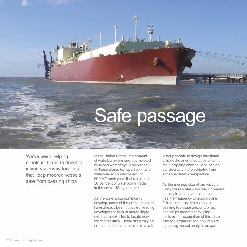
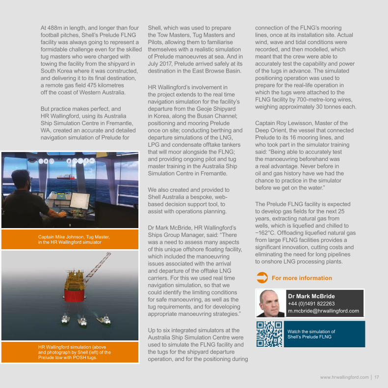
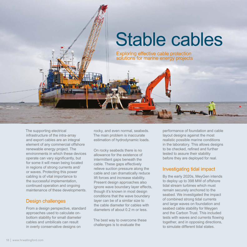
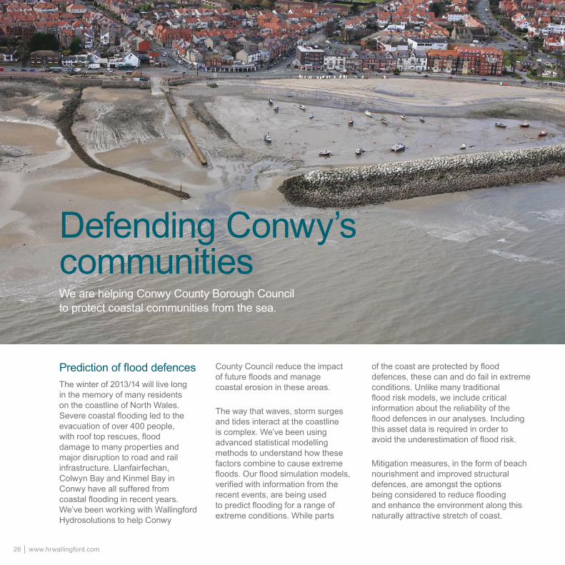