ection affected environment … · obtained from the national wetland s inventory ... ridge between...
TRANSCRIPT

SECTION 3 AFFECTED ENVIRONMENT, ENVIRONMENTAL CONSEQUENCES, AND MITIGATION
Wetlands 3.4-1
3.4 WETLANDS AND RIPARIAN AREAS This section presents an analysis of the potential effects of the proposed Project on wetlands (Section 3.4.2.1) and riparian areas (Section 3.4.2.2) within the Project Area. Wetlands are areas inundated or saturated by surface water or groundwater at a frequency and duration sufficient to support (and under normal circumstances do support) a prevalence of vegetation typically adapted for life in saturated soil conditions (USACE 1987). Riparian areas are the areas adjacent to streams and rivers, and have a distinct vegetative community associated with the higher groundwater level adjacent to the drainages.
Wetlands and riparian areas are of critical importance to the protection and maintenance of a large array of plants and animals, including threatened and endangered species, because they provide essential habitats. Wetlands and riparian areas help protect the quality of surface water by impeding the erosive forces of moving water and trapping waterborne sediment and associated pollutants, protecting water supplies by assisting the purification of surface water and groundwater resources, maintaining base flow to surface waters through the gradual release of stored floodwaters and groundwater, and providing a natural means of flood control and storm damage protection through the absorption and storage of water during high-runoff periods.
The wetland and riparian areas potentially affected by the Project are mostly associated with perennial and ephemeral intermittent
The following analysis assesses the potential effects to wetland and riparian resources from the No Action Alternative, the Echanis Wind Energy Project (Echanis Project), Alternative B – West Route (including the two route options), and Alternative C – North Route.
drainages. The wetlands include palustrine emergent (PEM), palustrine shrub scrub (PSS), palustrine forested (PFO), and palustrine unconsolidated shore (PUS) types. Isolated wetlands were also delineated. Section 404 of the Clean Water Act (CWA) established standards to evaluate and reduce the total and net Project effects to wetlands under the regulatory jurisdiction of the U.S. Army Corps of Engineers (ACOE). These standards require avoidance of wetlands, where possible, and minimization of disturbance where effects are unavoidable. Any unavoidable wetland effects could require compensatory mitigation. All wetland crossings would be subject to review and approval by the Seattle District of the ACOE, whereby the proposed Project would be required to comply with the conditions of any permits issued by the ACOE, including the provisions of any required wetland compensatory mitigation. Similar review and approval would be required by the Oregon Department of State Lands (DSL). Riparian areas in the Project Area typically have herbaceous or shrub scrub vegetation and are associated with perennial or intermittent streams.
3.4.1 For the purposes of this analysis, the Project Area was defined to include the area within the 150-foot wide transmission line right-of-way (ROW) and all areas affected by the construction and operation of access roads, interconnection stations, substations, turbine towers, power collection systems, and other permanent and temporary Project features, including temporary laydown areas and tensioning sites.
Methodology
Wetlands within the Project Area were identified during onsite inspections and with the use of mapping data available from the National Wetlands Inventory (NWI; USFWS 2010). Wetlands identified in areas affected by construction of proposed access roads were field-delineated (i.e., the boundary between wetlands and uplands was identified) using the Routine Onsite Determination Method (USACE 1987, pp. 52-69) and the Regional Supplement for the Arid West Region to determine the presence or absence of State of Oregon wetland boundaries and Federal jurisdictional wetlands.

NORTH STEENS TRANSMISSION LINE EIS OCTOBER 2011
3.4-2 Wetlands
The following field visits were conducted in 2008 and 2009:
• May 21, 2008 and June 12-17, 2008: The Echanis Project site and main access road were inspected and wetlands were identified, delineated, and mapped. These areas were inspected again in July 2008 to finalize the location of the main access road.
• December 3, 7, and 8, 2009: The Alternative B – West Route alignment (including the two route options) was inspected and wetlands were identified, delineated, and mapped.
• October 8, 20, and 21, and December 14, 2009: The Alternative C – North Route alignment was inspected and wetlands were identified, delineated, and mapped.
The majority of the Project Area was traversed using all terrain vehicles, with stops to take sample plot data approximately every mile. Sample plots were established wherever wetland indicators were observed. For each sample plot, data about vegetation, hydrology, and soils was collected, recorded in the field, and transferred to data forms.
Wetlands were not delineated in areas where there would be no direct effect from construction of new access roads. Wetland areas within the ROW that would be completely spanned by the transmission line also were not delineated. Field delineations were not conducted in the Cucamonga Creek canyon or Malheur National Wildlife Refuge (MNWR). Information about wetlands in areas where delineations were not conducted was obtained from the National Wetlands Inventory (NWI; USFWS 2010). NWI data also was used to identify the potential effects to wetlands from the transmission line alternatives and improvements to existing roads. Effects from construction of new roads and transmission line components are described as “acres of wetland effect,” whereas the amount of wetland area spanned by the transmission line alternatives is described as “miles crossed.”
In portions of Project Area where flowing water or bare creek channels were identified, the ordinary high water mark (i.e., the highest level reached by a body of water) was determined through direct observation. Where creek channels were vegetated, wetland conditions were generally present, and the areas were delineated and mapped as wetlands.
The wetland classification system described by Cowardin et al. (1979) was used to classify wetlands, based upon the following observed categories:
• Palustrine emergent (PEM) include wetlands characterized by erect, rooted, herbaceous hydrophytes (i.e., aquatic plants), excluding mosses and lichens. Wildlife frequently use these areas for nesting and feeding, particularly during migration.
• Palustrine scrub-shrub (PSS) wetlands include wetland areas dominated by woody vegetation less than 20 feet tall. PSS wetlands supply an abundance of food and cover resources for mammals and birds and provide the necessary breeding habitat for many migratory bird species.
• Palustrine forested (PFO) wetlands are dominated by woody vegetation that is at least 20 feet tall. PFO wetlands provide a diverse assemblage of vegetation and an abundance of food and water sources for wildlife.
• Palustrine unconsolidated shore (PUS) wetlands are dominated by trees, shrubs, persistent emergent vegetation, and emergent mosses or lichens, with unconsolidated shores characterized by substrates lacking vegetation, except for pioneering plants that become established during brief periods when growing conditions are favorable.
Riparian areas (i.e., the interface between land and a stream) are present at all stream crossing locations, as identified in Section 3.2. Vegetation in riparian areas was described as herbaceous or shrub-scrub based upon a review of aerial photography, and supplemented by field visits conducted in 2008 and 2009.
SECTION 3 AFFECTED ENVIRONMENT, ENVIRONMENTAL CONSEQUENCES, AND MITIGATION
Wetlands 3.4-3
The analysis presented in this section was informed by comments from the public scoping process that occurred from July to September 2009 and the DEIS comment period from July to September 2010.
• Potential effects to wetlands, floodplains, and riparian areas.
Agency representatives, local organizations, and private citizens requested that the following issues be addressed in the EIS:
• Methods to avoid or mitigate the potential effects to wetlands, floodplains, and riparian areas.
• Compliance with Section 404 of the Clean Water Act and Executive Order 11988.
• Description of all waters of the U.S. that could potentially be affected by the Project (if any), and the inclusion of maps that clearly identify all waters within the Project Area.
3.4.2 The Project would be located within the Basin and Range Province, which is characterized by a fault-block mountain enclosed basin with internal drainages. Steens Mountain is a typical example of the Province. The vegetation is typical of the steppe, shrub-steppe, and desert shrubs zones. The ridge tops tend to be very rocky, and are dominated by very low growing shrubs, such as low sagebrush (Artemisia arbuscula). Ground cover is sparse and is dominated by Idaho fescue (Festuca idahoensis), Sandberg bluegrass (Poa sandbergii), cheatgrass (Bromus tectorum), and bluebunch and crested wheatgrass (Pseudoroegneria spicataand A cristatum). The side slopes of the ridges typically are a western juniper/big sagebrush (Juniperus occidentalis/Artemisia tridentata) community.
Affected Environment
Because juniper management has been occurring for the last 30 years, seeps and springs have been emerging where there is no historical record of water presence. This is believed to increase the occurrence of water emerging onto the Echanis Project site. This has been documented by the Eastern Oregon Agricultural Research Center (EOARC), as well as the local ranchers who are reporting more water than was historically present (Schott 2008a). Most of the springs are typically dry by May, but in 2008 there was flowing water in June.
Drainages with sufficient water during the year typically have an associated riparian community. Wetter grass-forb communities are dominated by Kentucky bluegrass (Poa pratensis), Nebraska sedge (Carex nebrascensis), and Baltic rush (Juncus balticus). Riparian communities along streams include the aforementioned herb species as well as trees such as water birch (Betula occidentalis). An inland saltgrass (Disticilus spicata) community was observed in one location during recent site surveys.
Much of the bottomland in the Project Area has been under cultivation. These lands are primarily alfalfa (Medicago sativa) pastures, which are sprinkler irrigated. Some flood irrigation occurs in the Kiger basin. Wetter areas tend to be dominated by meadow foxtail (Aleopecurus pratensis), Kentucky bluegrass (Poa pratensis), and Baltic rush (Juncus balticus). A few willows (Salix sp.) are found along agricultural streams and irrigation ditches.
Alternative B (including the two route options) would be located completely within the Donner und Blitzen subbasin. Alternative C would be located within the Harney-Malheur Lakes subbasin. Both of these watersheds are within the Oregon Closed Basin. Alternative C would also be partially located in the Upper Malheur subbasin, which is part of the Middle Snake Basin. The Echanis Project site would be located on a ridge between the Donner und Blitzen and Alvord Lake watersheds, also located in the Oregon Closed Basin.
3.4.2.1 Wetlands Project Area wetlands provide valuable tree and understory plant diversity, stable stream banks that can attenuate and alter flood flows, and valuable nesting and foraging habitat for many birds and other wildlife

NORTH STEENS TRANSMISSION LINE EIS OCTOBER 2011
3.4-4 Wetlands
species. In particular, the shallow wetlands associated with the MNWR are managed to provide refuge and breeding ground for resident and migratory birds, because of its location on the Pacific Flyway.
PEM wetlands are the most common wetland type in the Project Area. Vegetation in these wetland areas include Baltic rush (Juncus balticus), few-flower spikerush (Eleocharis quinqueflora), Kentucky bluegrass (Poa pratensis), black medic (Medicago lupulina), flatsedge spp., and Nebraska sedge (Carex nebrascensis). Common species in adjacent upland areas include cheatgrass, Kentucky bluegrass, western juniper, and mountain brome.
PSS wetlands are less common in the Project Area. Vegetation in these wetland areas is dominated by quaking Aspen and Nebraska sedge. NWI maps show an area of PSS wetland along Alternative B where the alignment crosses Cucamonga Creek. NWI maps also show an area of PSS wetlands along a road at the northern end of Alternative C; however field surveys determined no wetlands were present.
Small areas of PFO wetland are present along Mud Creek.
3.4.2.2 Riparian Areas Riparian corridors are vegetated communities contiguous to and dependent on surface and subsurface water associated with perennial and intermittent waterbodies. Riparian areas are the transitional area between streams and upland features. Riparian vegetation at the Project site consists of forested, shrubby and herbaceous species. The vegetation that comprises riparian corridors is important to stabilizing streambanks and reducing floodwater velocities, which can prevent or limit streambank erosion. Riparian areas are distinctly different from surrounding lands because of the unique soil and vegetation characteristics that are strongly influenced by the presence of water. Many special status species rely on riparian areas during a portion of the year for cover, forage, or breeding habitat. Riparian areas discussed in this section include only areas adjacent to streams, and not any wetland areas extending further from the streams than the stream banks themselves.
3.4.3 The primary effects of the proposed Project to wetland and riparian resources would be from the construction and operation of the transmission lines, the Echanis Project, access roads, and other project-related improvements and support facilities. Effects would be both permanent (long-term operational effects) and temporary (short-term, associated with Project construction). The potential effects to wetlands and riparian areas identified and analyzed in this section include:
Environmental Effects and Mitigation
• Alterations to the wetland hydrology;
• Alterations to the wetland plant communities, and
• Loss of wetlands due to filling or sedimentation.
During development of the Project plan, the Applicant worked with wetland biologists to minimize the effect of Project development to wetlands and riparian areas. For example, the original design for the main access road to the Echanis Project site would have required five stream crossings, but the current plan has only three. In addition, bottomless arch culverts would be used instead of round culverts at several stream crossings along the access road to maintain the integrity of the streambed. These bottomless arch culverts were chosen because they could be installed without impacting the active stream channel.
The potential effects upon wetlands and riparian areas during the short-term construction phase and the long-term operational phase of the Project are described below. It should be noted that a variety of project design features (PDFs) and best management practices (BMPs) to reduce the effects upon wetlands and riparian areas, from both the Echanis Project and the transmission line alternatives, would be implemented as part of

SECTION 3 AFFECTED ENVIRONMENT, ENVIRONMENTAL CONSEQUENCES, AND MITIGATION
Wetlands 3.4-5
Proposed Action. These measures are not repeated in the mitigation sections below, but are summarized in Section 2 and are listed in Appendix A (A.1.4 and A.3.4).
3.4.3.1 Alternative A – No Action Under the No Action Alternative, no new transmission lines, substations, interconnection stations, or related wind energy facilities would be constructed and new or improved access roads would not be needed. The Echanis Project site would remain undeveloped and would continue to be used for livestock grazing and the existing Harney Electric Cooperative (HEC) distribution line located along South Diamond Lane would remain above ground. Wetlands and riparian areas would continue to be affected by the current uses.
3.4.3.2 Echanis Project Effects Common to All Action Alternatives The permanent and temporary effects to wetlands and riparian areas from construction and operation of the Echanis Project would be the same for all action alternatives (i.e., Proposed Action and action alternatives). Because the Echanis Project is a common element to all transmission line alternatives (i.e., a connected non-federal action), the effects from the Echanis Project are described separately from the effects of the transmission line alternatives. The effects associated with each transmission line alternative are described separately below. The combined effects of the Echanis Project and each transmission line alternative on wetlands and riparian areas are described in Section 3.4.3.9.
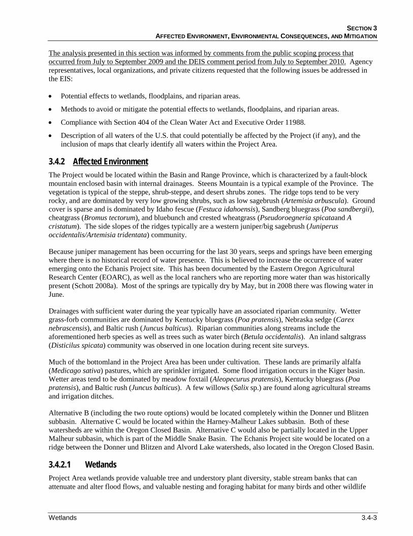
The Echanis Project would include the installation and operation of 40 to 69 wind turbines, a main access road to the Echanis Project site, a substation, an operations and maintenance (O&M) building, on-site access roads (i.e., string roads), and a 1.18-mile overhead power collection line. The Echanis Project would include several miles of 34.5-kV underground power collection cables connecting the wind turbines to the Echanis Substation. (see Figure 3.4-1, Map Units 1 through 11)
PERMANENT EFFECTS
No effects to wetlands or riparian areas would occur at the Echanis Project site. Construction and improvement of the main access road to the Echanis Project site (which is a project feature common to all action alternatives) would affect a total of 2.44 acres of wetlands. The new portions of the main access road to the Echanis Project site would cause a permanent loss of 1.76 acres of wetlands, mostly associated with Mud Creek and a connected tributary (Figure 3.4-1, Map Unit 1). Improvements to the existing portions of the main access road would also affect wetlands and would cause permanent effects to 0.68 acre of wetland area, mostly associated with Kiger Creek and Booners Creek (Figure 3.4-1, Map Unit 3). The majority of the effects upon wetlands, 1.91 acres, are to PEM wetlands, with an additional 0.53 acre of effect to PSS wetlands (Table 3.4-1).
Table 3.4-1 Wetland Crossings and Effects Common to All Action Alternatives
Wetland Type New Access Road Effects (acres) Access Road Improvement Effects (acres) PEM 1.26 0.65
PSS 0.50 0.03
PUS 0 0
Total 1.76 0.68
NORTH STEENS TRANSMISSION LINE EIS OCTOBER 2011
3.4-6 Wetlands
Figure 3.4-1a Unit 1: Wetland Crossings.

SECTION 3 AFFECTED ENVIRONMENT, ENVIRONMENTAL CONSEQUENCES, AND MITIGATION
Wetlands 3.4-7
Figure 3.4-1b Unit 2: Wetland Crossings.

NORTH STEENS TRANSMISSION LINE EIS OCTOBER 2011
3.4-8 Wetlands
Figure 3.4-1c Unit 3: Wetland Crossings.
SECTION 3 AFFECTED ENVIRONMENT, ENVIRONMENTAL CONSEQUENCES, AND MITIGATION
Wetlands 3.4-9
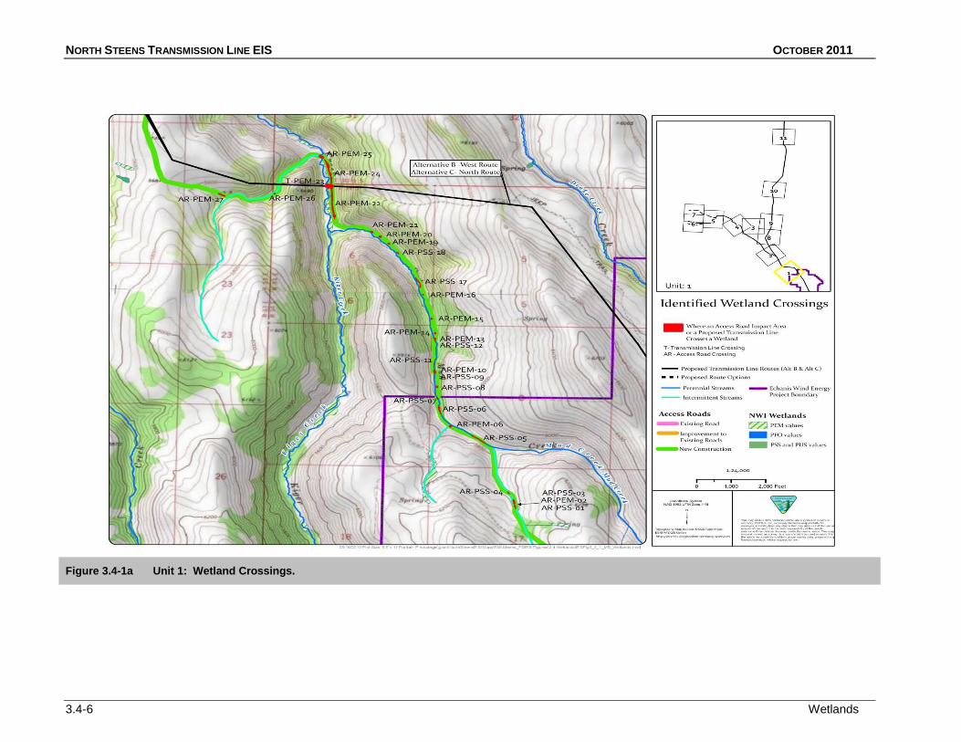
Figure 3.4-1d Unit 4: Wetland Crossings.
NORTH STEENS TRANSMISSION LINE EIS OCTOBER 2011
3.4-10 Wetlands
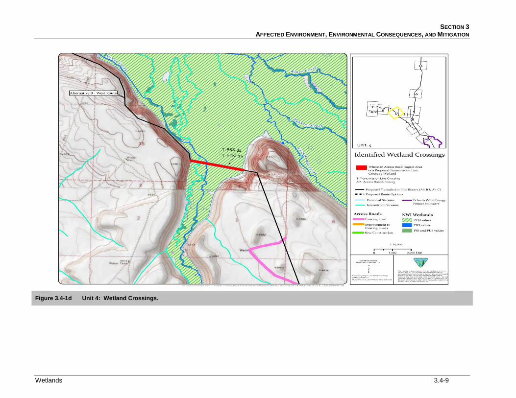
Figure 3.4-1e Unit 5: Wetland Crossings.

SECTION 3 AFFECTED ENVIRONMENT, ENVIRONMENTAL CONSEQUENCES, AND MITIGATION
Wetlands 3.4-11
Figure 3.4-1f Unit 6: Wetland Crossings.

NORTH STEENS TRANSMISSION LINE EIS OCTOBER 2011
3.4-12 Wetlands
Figure 3.4-1g Unit 7: Wetland Crossings.

SECTION 3 AFFECTED ENVIRONMENT, ENVIRONMENTAL CONSEQUENCES, AND MITIGATION
Wetlands 3.4-13
Figure 3.4-1h Unit 8: Wetland Crossings.
NORTH STEENS TRANSMISSION LINE EIS OCTOBER 2011
3.4-14 Wetlands
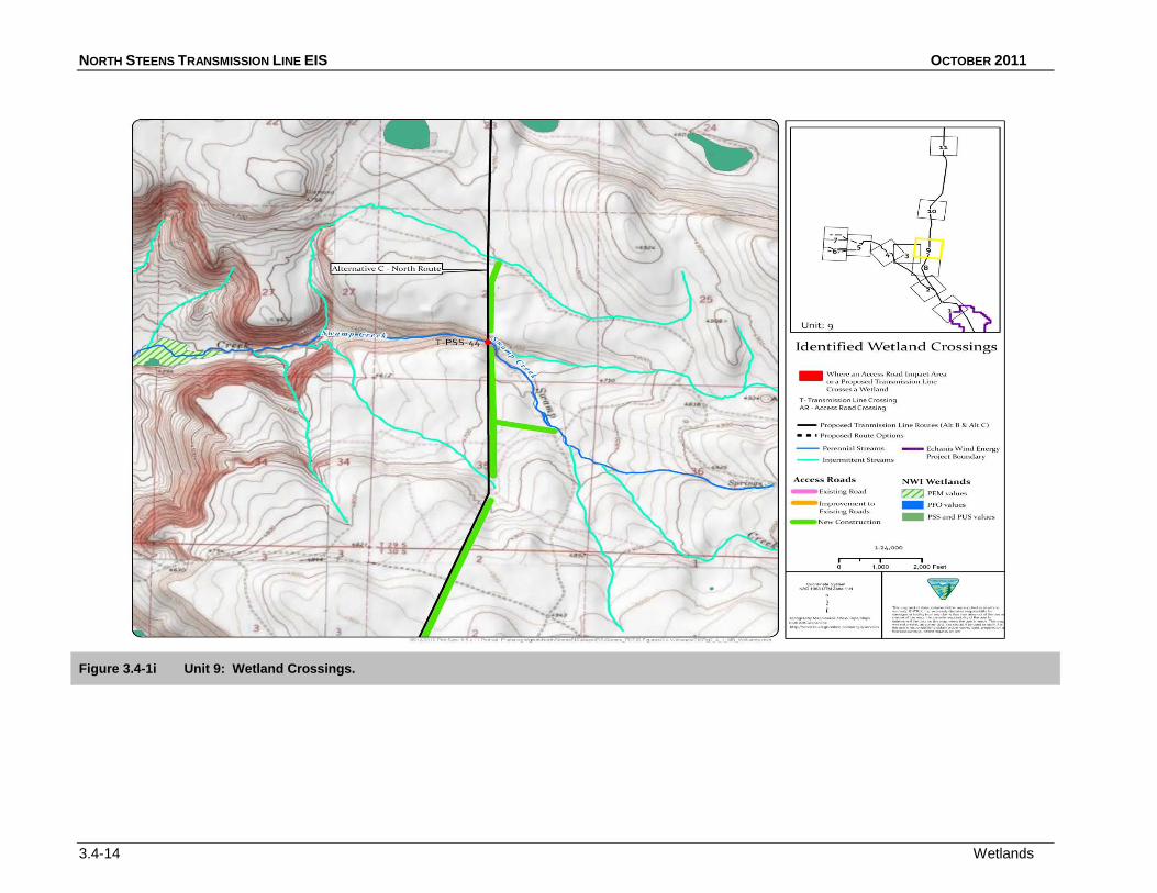
Figure 3.4-1i Unit 9: Wetland Crossings.

SECTION 3 AFFECTED ENVIRONMENT, ENVIRONMENTAL CONSEQUENCES, AND MITIGATION
Wetlands 3.4-15
Figure 3.4-1j Unit 10: Wetland Crossings.

NORTH STEENS TRANSMISSION LINE EIS OCTOBER 2011
3.4-16 Wetlands
Figure 3.4-1k Unit 11: Wetland Crossings.

SECTION 3 AFFECTED ENVIRONMENT, ENVIRONMENTAL CONSEQUENCES, AND MITIGATION
Wetlands 3.4-17
New construction for the main access road to the Echanis Project site would cross riparian areas in nine locations: once over perennial Kiger Creek, three times over perennial Mud Creek, twice over an intermittent tributary to Mud Creek, and three times over an intermittent tributary to Kiger Creek (Table 3.4-2). A 60-foot long bridge would be constructed to span Kiger Creek, with footings well outside the channel. The bridge would be placed in an existing break in riparian vegetation to prevent unnecessary woody vegetation removal.
Table 3.4-2 Riparian Areas Crossed by Echanis Wind Farm Access Roads
Waterbody Waterbody Types
Project Component
Kiger Creek
Access Roads* / Vegetation Type
Perennial Stream
Mud Creek
1/Scrub Shrub; 1/Herbaceous
Perennial Stream
Booners Creek
3/Scrub Shrub
Perennial Stream
Tributary to Mud Creek
1/Herbaceous
Intermittent Stream
Tributary 1 to Kiger Creek
2/Scrub Shrub
Intermittent Stream
Tributary 2 to Kiger Creek
3/Scrub Shrub
Intermittent Stream
Tributary 3 to Kiger Creek
1/Herbaceous
Intermittent Stream
Numbers indicate number of crossings
1/Herbaceous
The access road to the Echanis Project site would parallel Mud Creek for 2.5 miles, an intermittent tributary of Mud Creek for another 1.2 miles, and an unnamed tributary to Kiger Creek in Wildcat Canyon for 0.7 mile. The road bed would be constructed through cut and fill; upslope materials would be removed and placed downslope to build the road bed. The road alignment would be placed as far as possible from the creek. The minimum distance from the creek, as allowed by the canyon width and the position of creek meanders, would range from 6 feet to greater than 50 feet. Exact locations of the road have not yet been finalized. All construction would be outside of the channel and bed of the stream (Kane 2010b). The proposed alignment would be within approximately 75 feet of waterbodies and, therefore, has the most likelihood of affecting riparian areas, at the following locations:
• Kiger Creek Tributary 1, for approximately 0.7 mile.
• Mud Creek, for 1.9 miles.
• Mud Creek Tributary, for approximately 0.7 mile.
Roads would not be paved with impervious surfaces, but would be cleared and graded. Permanent effects would include reduced interception and infiltration of precipitation. In addition, the grading of roads and construction of the bridge has the potential to increase erosion near and in stream channels. Overland access roads would also be required. These overland roads would avoid riparian areas and stream crossings (avoiding Kiger Creek by driving around the creek) and would be monitored by the Applicant to avoid rutting.
Additional access road improvements would occur to roads that currently cross the riparian areas of Kiger Creek, Booners Creek, and two intermittent tributaries to Kiger Creek on existing bridges. The effects of the transmission line are discussed below.
These potential effects would be minimized by the design practices described in Section 2 and Appendix A (A.1.4 and A.3.4).
While most of the Project features common to all action alternatives would be located outside of wetlands and riparian areas, ground disturbance and construction activities could cause temporary effects to nearby wetland and riparian areas. The main access road would parallel waterbodies for a total distance of approximately 3.3
TEMPORARY EFFECTS

NORTH STEENS TRANSMISSION LINE EIS OCTOBER 2011
3.4-18 Wetlands
miles and would cross waterbodies 13 times, as discussed above. This access road could have temporary, construction-related effects to nearby wetland and riparian areas, including the effects of equipment working within and adjacent to these areas. During construction of the main access road and road crossings, BMPs would be followed to minimize erosion and other effects to wetlands and riparian areas. These BMPs are outlined in the Application for Conditional Use Permit for the Echanis Wind Farm (CEP 2007) and in the Erosion and Sediment Control (ESC) Plans for the Echanis Wind Farm Access Road (Westlake Consultants, Inc. 2008), in accordance with the ODEQ National Pollutant Discharge and Elimination System Stormwater Discharge Permit (ODEQ 2005) and pursuant to Oregon Revised Statutes 468B.050 and Section 402 of the Federal Clean Water Act.
BMPs, as described in Section 2 and Appendix A (A.1.4 and A.3.4), would be implemented during construction to decrease the temporary effects of Project construction.
Wherever possible, wetlands were avoided when determining the alignment of the main access road to the Echanis Project site. Specific mitigation measures for the effects related to construction of the main access road will be described in the Compensatory Wetland Mitigation (CWM) Plan in a revised Joint Permit Application that will be submitted to the ACOE and DSL. The objective of the CWM will be to create new PEM and PSS wetland areas at a ratio of 1:1.5 to replace the wetland area lost from construction of the main access road. The CWM would be designed to create additional high quality emergent wetlands to increase water storage and water delay functions, sediment stabilization, nutrient retention, and wildlife habitat functions within the Project Area. Mitigation would consist of wetland creation and riparian enhancement planting. The replacement wetlands would be vegetated with emergent and shrub scrub species native to the site. Vegetation would be salvaged from higher quality onsite wetlands.
MITIGATION
The CWM plan will propose to create 3.66 acres of wetland to compensate for the 2.44 acres of wetlands affected by construction of the access road. Mitigation through wetland creation would likely directly replace the lost wetland area, and more than compensate for lost wetland functions by maintaining the type and diversity of vegetation, as well as providing an enhanced riparian buffer for portions of the onsite drainage. Vegetation and topsoil in existing higher quality wetlands would be removed with the topsoil intact and re-established in the mitigation area. Where inadequate plants exist in the replaced topsoil, additional cuttings would be collected from other portions of the site.
Additional PDFs and BMPs, as described in Section 2 and Appendix A (A.1.4 and A.3.4), would be implemented on BLM-administered land and recommended to private landowners to minimize the effects upon wetlands and riparian areas described above.
3.4.3.3 Alternative B – West Route (Proposed Action) Construction and operation of Alternative B (including the two route options) would also have permanent and temporary effects upon wetlands and riparian areas.
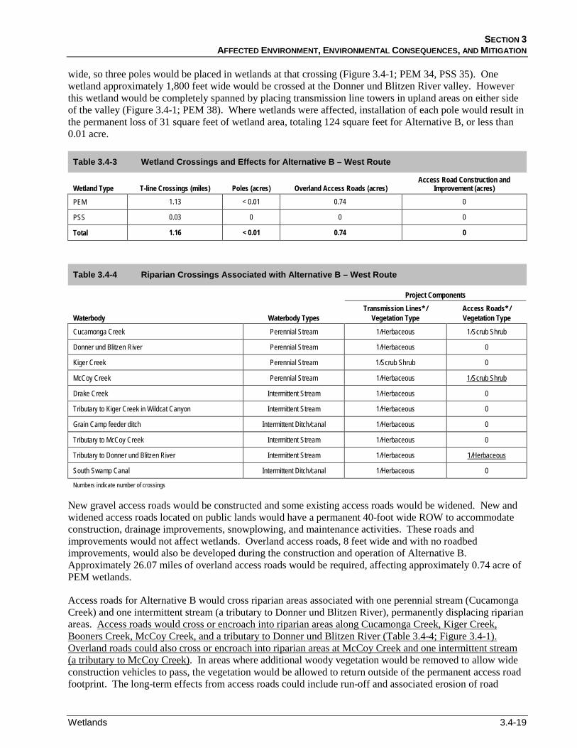
Alternative B would extend 28.87 miles from the proposed substation at the Echanis Project site to the proposed Interconnection Station (ICS) to be located west of Highway 205. The transmission line would span 1.16 miles of wetlands, including five wetland crossings and 10 riparian areas associated with four perennial streams and six intermittent streams or canals (Figure 3.4-1, Map Units 2, 4, 5, and 7; Table 3.4-3; Table 3.4-4). Approximately 196 poles would be installed for Alternative B. Where the length of the wetlands spanned was less than 600 feet, pole locations would be selected to avoid riparian areas and wetlands. However, at some locations poles would be placed in wetland areas. A wetland adjacent to Cucamonga Creek is approximately 1,000 feet wide, so one pole would be placed in the wetland at that crossing (Figure 3.4-1; PEM 28, PSS 29). McCoy Creek would be crossed at a location where wetlands are more than 2,000 feet
PERMANENT EFFECTS
SECTION 3 AFFECTED ENVIRONMENT, ENVIRONMENTAL CONSEQUENCES, AND MITIGATION
Wetlands 3.4-19
wide, so three poles would be placed in wetlands at that crossing (Figure 3.4-1; PEM 34, PSS 35). One wetland approximately 1,800 feet wide would be crossed at the Donner und Blitzen River valley. However this wetland would be completely spanned by placing transmission line towers in upland areas on either side of the valley (Figure 3.4-1; PEM 38). Where wetlands were affected, installation of each pole would result in the permanent loss of 31 square feet of wetland area, totaling 124 square feet for Alternative B, or less than 0.01 acre.
Table 3.4-3 Wetland Crossings and Effects for Alternative B – West Route
Wetland Type T-line Crossings (miles) Poles (acres) Overland Access Roads (acres) Access Road Construction and
Improvement (acres)
PEM 1.13 < 0.01 0.74 0
PSS 0.03 0 0 0
Total 1.16 < 0.01 0.74 0
Table 3.4-4 Riparian Crossings Associated with Alternative B – West Route
Waterbody Waterbody Types
Project Components Transmission Lines* /
Vegetation Type Access Roads* / Vegetation Type
Cucamonga Creek Perennial Stream 1/Herbaceous 1/Scrub Shrub
Donner und Blitzen River Perennial Stream 1/Herbaceous 0
Kiger Creek Perennial Stream 1/Scrub Shrub 0
McCoy Creek Perennial Stream 1/Herbaceous
Drake Creek
1/Scrub Shrub
Intermittent Stream 1/Herbaceous 0
Tributary to Kiger Creek in Wildcat Canyon Intermittent Stream 1/Herbaceous 0
Grain Camp feeder ditch Intermittent Ditch/canal 1/Herbaceous 0
Tributary to McCoy Creek Intermittent Stream 1/Herbaceous 0
Tributary to Donner und Blitzen River Intermittent Stream 1/Herbaceous
South Swamp Canal
1/Herbaceous
Intermittent Ditch/canal 1/Herbaceous 0
Numbers indicate number of crossings
New gravel access roads would be constructed and some existing access roads would be widened. New and widened access roads located on public lands would have a permanent 40-foot wide ROW to accommodate construction, drainage improvements, snowplowing, and maintenance activities. These roads and improvements would not affect wetlands. Overland access roads, 8 feet wide and with no roadbed improvements, would also be developed during the construction and operation of Alternative B. Approximately 26.07 miles of overland access roads would be required, affecting approximately 0.74 acre of PEM wetlands.
Access roads for Alternative B would cross riparian areas associated with one perennial stream (Cucamonga Creek) and one intermittent stream (a tributary to Donner und Blitzen River), permanently displacing riparian areas. Access roads would cross or encroach into riparian areas along Cucamonga Creek, Kiger Creek, Booners Creek, McCoy Creek, and a tributary to Donner und Blitzen River (Table 3.4-4; Figure 3.4-1). Overland roads could also cross or encroach into riparian areas at McCoy Creek and one intermittent stream (a tributary to McCoy Creek). In areas where additional woody vegetation would be removed to allow wide construction vehicles to pass, the vegetation would be allowed to return outside of the permanent access road footprint. The long-term effects from access roads could include run-off and associated erosion of road
NORTH STEENS TRANSMISSION LINE EIS OCTOBER 2011
3.4-20 Wetlands
materials into riparian areas associated with heavy rainfall, snowmelt, and maintenance activities. These potential effects would be minimized by implementing the PDFs and BMPs described in Section 2 and Appendix A (A.1.4 and A.3.4).
Temporary effects could occur during installation of the Alternative B transmission line poles, ICS, new and widened access roads, and other Project features, particularly in areas where poles would be placed in wetlands. These effects would be associated with vehicles and equipment accessing areas of construction, and surface disturbance in the area around each pole from equipment operation and materials stockpiling. Additionally, one tensioning site would be located in a wetland, and would temporarily affect 0.25 acre. As discussed above, woody vegetation would be removed at some overland road locations to allow wide construction vehicles to pass. At these locations, vegetation removal outside of the permanent access road footprint would be temporary and would be allowed to return after construction was completed.
TEMPORARY EFFECTS
Wetlands would also be temporarily affected by the relocation and burial of the HEC distribution line in the area of the Donner und Blitzen River and its associated wetlands. The 1.35-mile excavation would occur entirely within wetland areas and would cause a total of 2.45 acres of surface disturbance. Low impact construction techniques would be used. The equipment used to bury the line would move along the alignment at a slow pace, digging a narrow (less than 2-foot wide) trench, inserting the line, and burying it all in one pass. Disturbed areas would be restored to preexisting conditions. Mats would be used if necessary to prevent damage to vegetation from the wheels or tracks of the construction equipment.
Where the relocated distribution line would cross the Donner und Blitzen River and the Buena Vista Canal, directional boring methods would be used (Kane 2010a). This method would involve drilling a pilot hole under the waterbody and banks, then enlarging the hole through successive ream borings. Depending upon the angle of approach of the pipeline alignment to the water crossing, a temporary work area might have to be cleared. This method would generally reduce the effects to the waterbody banks, bed, riparian areas, and water quality. The distribution line burial also would cross two intermittent water courses, Center Canal and an unnamed stream. These would be crossed by trenching through the water courses when they were dry. If groundwater was encountered and had to be pumped out of the trench, BMPs would be implemented, as described in Section 2 and Appendix A (A.1.4 and A.3.4).
Riparian areas would also be temporarily affected by access road construction at two locations. At the Cucamonga Creek crossing, woody vegetation in the riparian zone would be removed during construction to allow wide construction vehicles to pass. Shrubs and trees would be removed manually, to minimize ground disturbance and damage to adjacent riparian vegetation. The loss of woody riparian vegetation would represent a small decrease in riparian area over the short-term (0 to 3 years), but would recover through the long-term (3 to 10 years). At the crossing of the Tributary to the Donner und Blitzen River, only herbaceous vegetation would be affected, and the area would be replanted with native species after construction was completed.
The upgrade of the initial single-circuit transmission line to a double-circuit 230-kV transmission line would require a second construction phase at a future date, when additional capacity was required for the transmission line. During the second construction phase, wetland and riparian areas would experience similar temporary construction-related effects, as described above, including the disruptive effects from equipment operation, additional surface disturbance, and vegetation damage.
FUTURE CONSTRUCTION PHASE – UPGRADE TO 230-KV
Because wetlands would be affected by overland roads, specific mitigation measures would be developed for these effects and would be described in the Project’s Compensatory Wetland Mitigation (CWM) Plan
MITIGATION

SECTION 3 AFFECTED ENVIRONMENT, ENVIRONMENTAL CONSEQUENCES, AND MITIGATION
Wetlands 3.4-21
submitted with the Project’s Joint Permit Application. The goal of the CWM plan for the Alternative B area would be to create 1.11 acres of wetlands to compensate for the 0.74 acre of wetland affected by the proposed overland road construction associated with this transmission line alternative. The mitigation would replace the lost area at a ratio of 1:1.5 and would compensate for lost wetland functions by maintaining the type and diversity of vegetation, as well as by providing an enhanced riparian buffer for portions of the onsite drainage. Vegetation and topsoil in existing higher quality wetlands would be removed with the topsoil intact and re-established in the mitigation area. Where inadequate plants existed in the replaced topsoil, additional cuttings would be collected from other portions of the site.
Additional PDFs and BMPs, as described in Section 2 and Appendix A (A.1.4 and A.3.4), would be implemented on BLM-administered land and recommended to private landowners to minimize the effects to wetlands and riparian areas described above.
South Diamond Lane Route Option
The South Diamond Lane Option would extend 28.26 miles from the Echanis substation to the tie-in with the HEC 115-kV line. The transmission line would cross 1.98 miles of wetlands (Figure 3.4-1) and riparian areas associated with four perennial streams and seven intermittent streams or canals (Table 3.4-5). Where wetlands were less than 600 feet wide, pole locations would be selected to avoid riparian areas and wetlands. A wetland adjacent to Cucamonga Creek is approximately 1,000 feet wide, so one pole would be placed in the wetland at that crossing (Figure 3.4-1; PEM 28, PSS 29). McCoy Creek would be crossed at a location where wetlands were more than 2,000 feet wide, so three poles would be placed in wetlands at that crossing (Figure 3.4-1; PEM 34, PSS 35). One wetland, approximately 5,500 feet wide, would be crossed at the Donner und Blitzen River valley, and nine poles would be located in this wetland (Figure 3.4-1; PEM 41). Each pole would result in permanent loss of 31 square feet of wetland area, so 13 poles would cause the loss of a total of 403 square feet or less than 0.01 acre.
PERMANENT EFFECTS
New gravel access roads would be constructed and some existing access roads would be widened. New and widened access roads on public lands would include a permanent 40-foot wide ROW to accommodate construction, drainage improvements, snowplowing, and maintenance activities. These gravel roads and improvements would not affect wetlands. Approximately 21.68 miles of 8-foot wide overland access roads would be required for the South Diamond Lane Option, affecting approximately 0.74 acre of wetland.
Roads would not be constructed adjacent to riparian areas; effects to riparian areas would occur only at stream crossings. Riparian areas associated with one perennial stream and one intermittent stream crossing would be permanently displaced by construction of new access roads or improvements to existing roads (Table 3.4-6). In addition, access roads would cross or encroach into the same riparian areas as described for Alternative B – West Route, including areas along Cucamonga Creek (two locations), Kiger Creek, Booners Creek, and McCoy Creek. Overland access road impacts to riparian areas would be the same as those discussed for Alternative B, with an additional possible crossing of an intermittent tributary to Donner und Blitzen River
Table 3.4-5 Wetland Crossings and the Effects of the South Diamond Lane Route Option
. Transmission lines associated with the South Diamond Lane Option would span riparian areas of perennial streams three times and span riparian areas of intermittent streams or canals six times (Table 3.4-6).
Wetland Type T-line Crossings (miles) Poles (acres) Overland Access Roads (acres) Access Road Construction and Improvement (acres) PEM 1.94 < 0.01 0.74 0
PSS 0.04 0 0 0
Total 1.98 < 0.01 0.74 0

NORTH STEENS TRANSMISSION LINE EIS OCTOBER 2011
3.4-22 Wetlands
Table 3.4-6 Riparian Areas Crossed by the South Diamond Lane Route Option
Waterbody Waterbody Types
Project Components Transmission Lines* /
Vegetation Type Access Roads* / Vegetation Type
Cucamonga Creek Perennial Stream 1/Herbaceous 1/Scrub Shrub
Donner und Blitzen River Perennial Stream 1/Herbaceous 0
McCoy Creek Perennial Stream 1/Herbaceous 0
Kiger Creek Perennial Stream 1/Scrub Shrub 0
Tributary to McCoy Creek Intermittent Stream 1/Herbaceous 0
Tributary to Donner und Blitzen River Intermittent Stream 0 1/Herbaceous
Tributary to Center Canal Intermittent Ditch/canal 1/Herbaceous 0
Buena Vista Canal Intermittent Ditch/canal 1/Herbaceous 0
Center Canal Intermittent Ditch/canal 1/Herbaceous 0
South Swamp Canal Intermittent Ditch/canal 1/Herbaceous 0
Drake Creek Intermittent Stream 1/Herbaceous 0
Tributary to Kiger Creek in Wildcat Canyon Intermittent Stream 1/Herbaceous 0
Numbers indicate number of crossings.
The temporary effects for this route option would be the same as those discussed for Alternative B – West Route.
TEMPORARY EFFECTS
The upgrade of the initial single-circuit transmission line to a double-circuit 230-kV transmission line would require a second construction phase at a future date, when additional capacity was required for the transmission line. During the second construction phase, wetland and riparian areas would experience similar temporary construction-related effects as described above, including the disruptive effects from equipment operation, additional surface disturbance, and vegetation damage.
FUTURE CONSTRUCTION PHASE – UPGRADE TO 230-KV
The same mitigation described above for Alternative B would apply to the South Diamond Lane Route Option.
MITIGATION
Hog Wallow Route Option
The Hog Wallow Route Option transmission line would cross a total of 29.06 miles of ROW from the Echanis substation to the substation interconnection, including crossing 1.06 miles of wetlands (Figure 3.4-1; Table 3.4-7) and riparian areas associated with four perennial streams and six intermittent streams or canals (Table 3.4-7). Where wetlands were less than 600 feet wide, pole locations would be selected to avoid riparian areas and wetlands. A wetland adjacent to Cucamonga Creek is approximately 1,000 feet wide, so one pole would be placed in the wetland at that crossing (Figure 3.4-1; PEM 28, PSS 29). McCoy Creek would be crossed at a location where wetlands were more than 2,000 feet wide, so three poles would be placed in wetlands at that crossing (Figure 3.4-1; PEM 34, PSS 35). One wetland, approximately 1,200 feet wide, would be crossed near the Donner und Blitzen River. However, as described for Alternative B - West Route, this wetland would also be completely spanned by placing towers in upland areas on either side of the valley (Figure 3.4-1; PEM 39). Each pole would result in the permanent loss of 31 square feet of wetland
PERMANENT EFFECTS
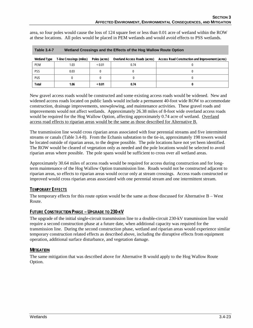
SECTION 3 AFFECTED ENVIRONMENT, ENVIRONMENTAL CONSEQUENCES, AND MITIGATION
Wetlands 3.4-23
area, so four poles would cause the loss of 124 square feet or less than 0.01 acre of wetland within the ROW at these locations. All poles would be placed in PEM wetlands and would avoid effects to PSS wetlands.
Table 3.4-7 Wetland Crossings and the Effects of the Hog Wallow Route Option
Wetland Type T-line Crossings (miles) Poles (acres) Overland Access Roads (acres) Access Road Construction and Improvement (acres) PEM 1.03 < 0.01 0.74 0
PSS 0.03 0 0 0
PUS 0 0 0 0
Total 1.06 < 0.01 0.74 0
New gravel access roads would be constructed and some existing access roads would be widened. New and widened access roads located on public lands would include a permanent 40-foot wide ROW to accommodate construction, drainage improvements, snowplowing, and maintenance activities. These gravel roads and improvements would not affect wetlands. Approximately 26.38 miles of 8-foot wide overland access roads would be required for the Hog Wallow Option, affecting approximately 0.74 acre of wetland. Overland access road effects to riparian areas would be the same as those described for Alternative B.
The transmission line would cross riparian areas associated with four perennial streams and five intermittent streams or canals (Table 3.4-8). From the Echanis substation to the tie-in, approximately 198 towers would be located outside of riparian areas, to the degree possible. The pole locations have not yet been identified. The ROW would be cleared of vegetation only as needed and the pole locations would be selected to avoid riparian areas where possible. The pole spans would be sufficient to cross over all wetland areas.
Approximately 30.64 miles of access roads would be required for access during construction and for long-term maintenance of the Hog Wallow Option transmission line. Roads would not be constructed adjacent to riparian areas, so effects to riparian areas would occur only at stream crossings. Access roads constructed or improved would cross riparian areas associated with one perennial stream and one intermittent stream.
The temporary effects for this route option would be the same as those discussed for Alternative B – West Route.
TEMPORARY EFFECTS
The upgrade of the initial single-circuit transmission line to a double-circuit 230-kV transmission line would require a second construction phase at a future date, when additional capacity was required for the transmission line. During the second construction phase, wetland and riparian areas would experience similar temporary construction related effects as described above, including the disruptive effects from equipment operation, additional surface disturbance, and vegetation damage.
FUTURE CONSTRUCTION PHASE – UPGRADE TO 230-KV
The same mitigation that was described above for Alternative B would apply to the Hog Wallow Route Option.
MITIGATION
NORTH STEENS TRANSMISSION LINE EIS OCTOBER 2011
3.4-24 Wetlands
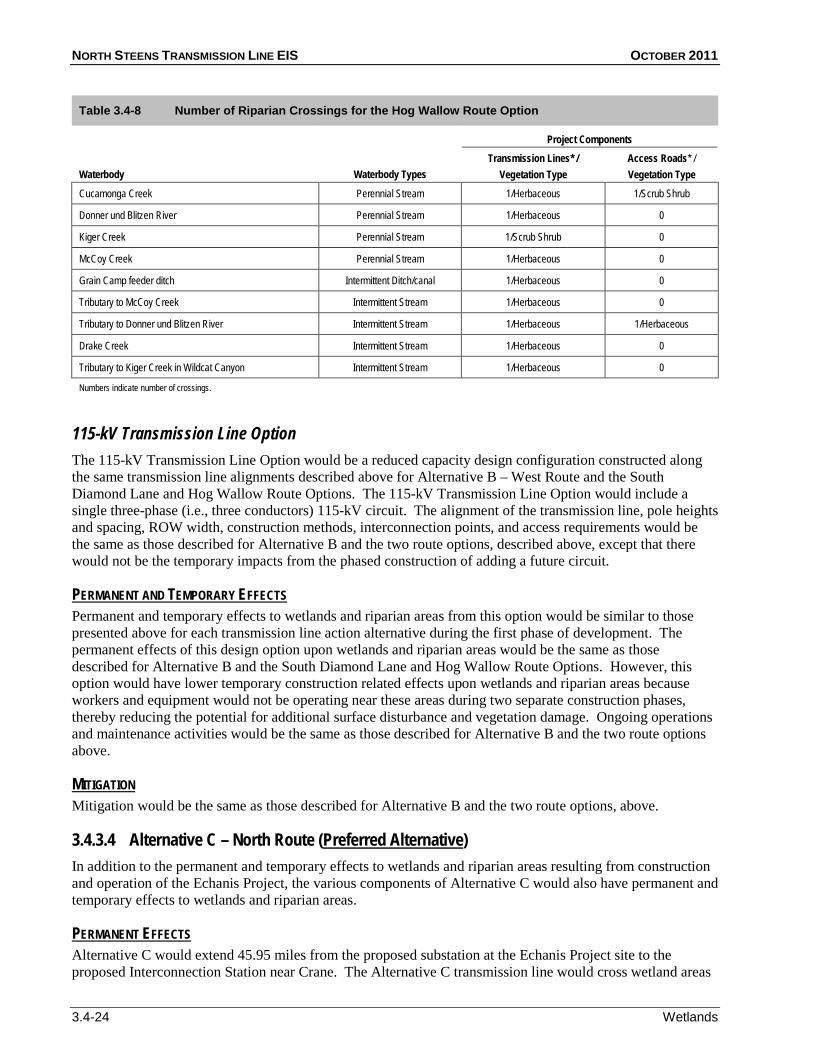
Table 3.4-8 Number of Riparian Crossings for the Hog Wallow Route Option
Waterbody Waterbody Types
Project Components Transmission Lines* /
Vegetation Type Access Roads* / Vegetation Type
Cucamonga Creek Perennial Stream 1/Herbaceous 1/Scrub Shrub
Donner und Blitzen River Perennial Stream 1/Herbaceous 0
Kiger Creek Perennial Stream 1/Scrub Shrub 0
McCoy Creek Perennial Stream 1/Herbaceous 0
Grain Camp feeder ditch Intermittent Ditch/canal 1/Herbaceous 0
Tributary to McCoy Creek Intermittent Stream 1/Herbaceous 0
Tributary to Donner und Blitzen River Intermittent Stream 1/Herbaceous 1/Herbaceous
Drake Creek Intermittent Stream 1/Herbaceous 0
Tributary to Kiger Creek in Wildcat Canyon Intermittent Stream 1/Herbaceous 0
Numbers indicate number of crossings.
115-kV Transmission Line Option The 115-kV Transmission Line Option would be a reduced capacity design configuration constructed along the same transmission line alignments described above for Alternative B – West Route and the South Diamond Lane and Hog Wallow Route Options. The 115-kV Transmission Line Option would include a single three-phase (i.e., three conductors) 115-kV circuit. The alignment of the transmission line, pole heights and spacing, ROW width, construction methods, interconnection points, and access requirements would be the same as those described for Alternative B and the two route options, described above, except that there would not be the temporary impacts from the phased construction of adding a future circuit.
Permanent and temporary effects to wetlands and riparian areas from this option would be similar to those presented above for each transmission line action alternative during the first phase of development. The permanent effects of this design option upon wetlands and riparian areas would be the same as those described for Alternative B and the South Diamond Lane and Hog Wallow Route Options. However, this option would have lower temporary construction related effects upon wetlands and riparian areas because workers and equipment would not be operating near these areas during two separate construction phases, thereby reducing the potential for additional surface disturbance and vegetation damage. Ongoing operations and maintenance activities would be the same as those described for Alternative B and the two route options above.
PERMANENT AND TEMPORARY EFFECTS
Mitigation would be the same as those described for Alternative B and the two route options, above. MITIGATION
3.4.3.4 Alternative C – North Route (Preferred AlternativeIn addition to the permanent and temporary effects to wetlands and riparian areas resulting from construction and operation of the Echanis Project, the various components of Alternative C would also have permanent and temporary effects to wetlands and riparian areas.
)
Alternative C would extend 45.95 miles from the proposed substation at the Echanis Project site to the proposed Interconnection Station near Crane. The Alternative C transmission line would cross wetland areas
PERMANENT EFFECTS

SECTION 3 AFFECTED ENVIRONMENT, ENVIRONMENTAL CONSEQUENCES, AND MITIGATION
Wetlands 3.4-25
for a total of 0.62 mile (Figure 3.4-1; Table 3.4-9) and riparian areas associated with three perennial stream crossings and five intermittent stream crossings (Table 3.4-10). Additionally, the transmission line would be adjacent to Smyth Creek. The ROW could affect the riparian area of a tributary to Smyth Creek three times where the tributary meanders in and out of the transmission line alignment (Table 3.4-10). The pole locations would not be placed in wetland areas, and would be sited to avoid wooded riparian areas where possible.
Table 3.4-9 Wetland Crossings and the Effects of Alternative C – North Route
Wetland Type T-line Crossings (miles) Poles (acres) Overland Access Roads (acres) Access Road Improvement (acres)
PEM 0.33 < 0.01 0.49 0
PSS 0.19 0 0 0
PUS 0.10 0 0 0
Total 0.62 < 0.01 0.49 0
A total of approximately 5.03 miles of access roads would be constructed and used for long-term maintenance. These road improvements would not be near wetlands, and no wetland effects were anticipated. Approximately 25.05 miles of overland vehicle access roads would be developed during construction and operation of Alternative C. Overland access roads would affect approximately 0.49 acre of wetland. New access roads would not be constructed adjacent to riparian areas. Overland roads would cross riparian areas associated with two intermittent streams in the adobe flats area. Additionally, overland roads utilized adjacent to Kiger Creek could impact the scrub shrub riparian areas along this creek.
There would be no temporary effects to wetland resources from construction of Alternative C, because the transmission line poles and supporting permanent access road construction would not occur in wetland areas.
TEMPORARY EFFECTS
Woody vegetation would be removed during construction by transmission lines at three locations (two at Kiger Creek and one at Swamp). Shrubs and trees would be removed manually, to minimize ground disturbance and damage to adjacent riparian vegetation. The loss of woody riparian vegetation would represent a minimal decrease in wildlife habitat over the short-term.
Table 3.4-10 Number of Riparian Crossings for Alternative C – North Route
Waterbody Waterbody Types
Alternative C Transmission Lines* /
Vegetation Type
Kiger Creek
Access Roads* / Vegetation Type
Perennial Stream 2/Scrub Shrub
Riddle Creek
Overland road - 1/Scrub Shrub
Perennial Stream 1/Herbaceous 0
Swamp Creek Perennial Stream 1/Scrub Shrub 0
Tributary to Kiger Creek (Wildcat Canyon) Intermittent Stream 1/Herbaceous 0
Tributary to Smyth Creek Intermittent Ditch/canal 3/Herbaceous 0
Intermittent stream 1 (adobe flat area) Intermittent Stream 1/Herbaceous
Intermittent stream 2 (adobe flat area)
Overland road - 1/Herbaceous
Intermittent Stream 1/Herbaceous
Drake Creek
Overland road - 1/Herbaceous
Intermittent Stream 1/Herbaceous 0
Tributary to Kiger Creek (Wildcat Canyon) Intermittent Stream 1/Herbaceous 0
Numbers indicate number of crossings.

NORTH STEENS TRANSMISSION LINE EIS OCTOBER 2011
3.4-26 Wetlands
Mitigation for the small amount of wetlands affected by overland roads would be developed and described in the Project’s Compensatory Wetland Mitigation (CWM) Plan submitted with the Project’s Joint Permit Application. The goal of the CWM plan for the Alternative C area would be to create 0.74 acre of wetland to compensate for the 0.49 acre of wetland affected by the proposed overland road construction associated with this transmission line alternative. The mitigation would replace the lost area at a ratio of 1:1.5 and would compensate for lost functions by maintaining the type and diversity of vegetation, as well as by providing an enhanced riparian buffer for portions of the onsite drainage. Vegetation and topsoil in existing higher quality wetlands would be removed with the topsoil intact and re-established in the mitigation area. Where inadequate plants existed in the replaced topsoil, additional cuttings would be collected from other portions of the site.
MITIGATION
Additional PDFs and BMPs, as described in Section 2 and Appendix A (A.1.4 and A.3.4), would be implemented on BLM-administered land and recommended to private landowners to minimize the effects upon wetlands and riparian areas described above.
The upgrade of the initial single-circuit transmission line to a double-circuit 230-kV transmission line would require a second construction phase at a future date, when additional capacity was required for the transmission line. During the second construction phase, wetland and riparian areas would experience similar temporary construction related effects as described above, including the disruptive effects from equipment operation, additional surface disturbance, and vegetation damage.
FUTURE CONSTRUCTION PHASE – UPGRADE TO 230-KV
115-kV Transmission Line Option The 115-kV Transmission Line Option would be a reduced capacity design configuration constructed along the same transmission line alignments described above for Alternative C – North Route. The 115-kV Transmission Line Option would include a single three-phase (i.e., three conductors) 115-kV circuit. The alignment of the transmission line, pole heights and spacing, ROW width, construction methods, interconnection points, and access requirements would be the same as those described for Alternative C, above, except that there would not be the temporary impacts from the phased construction of adding a future circuit.
Permanent and temporary effects to wetlands and riparian areas from this option would be similar to those presented above for each transmission line action alternative during the first phase of development. The permanent effects of this design option on wetlands and riparian areas would be the same as described for Alternative C. However, this option would have lower temporary construction related effects on wetlands and riparian areas because workers and equipment would not be operating near these areas during two separate construction phases, thereby reducing the potential for additional surface disturbance and vegetation damage. Ongoing operations and maintenance activities would be the same as described for Alternative C, above.
PERMANENT AND TEMPORARY EFFECTS
Mitigation for the 115-kV Transmission Line Option would be the same as those described for Alternative C, above.
MITIGATION
3.4.3.5 Residual Effects after Mitigation The residual effects of the Proposed Action that would occur during construction would include vegetation degradation and disturbance to wetland buffer vegetation and soils. The residual effects that would last at least as long as the life of the Project (an expected 40 years) and would include wetland fill and floodplain encroachment.
SECTION 3 AFFECTED ENVIRONMENT, ENVIRONMENTAL CONSEQUENCES, AND MITIGATION
Wetlands 3.4-27
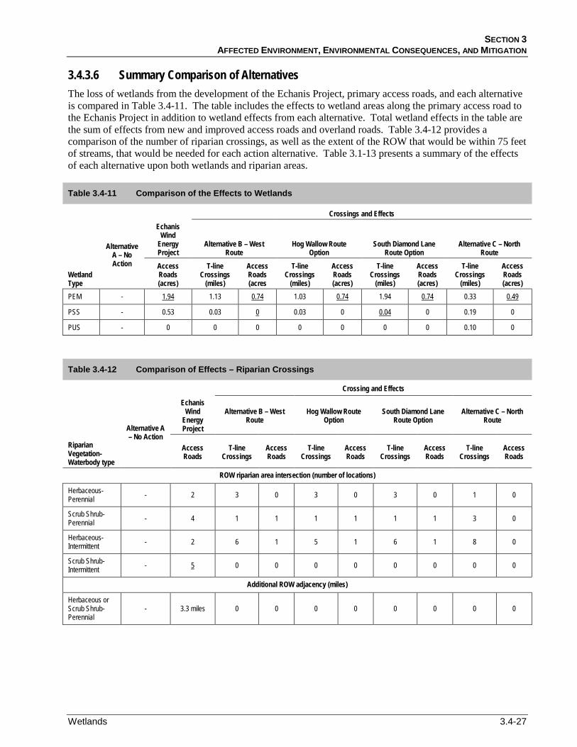
3.4.3.6 Summary Comparison of Alternatives The loss of wetlands from the development of the Echanis Project, primary access roads, and each alternative is compared in Table 3.4-11. The table includes the effects to wetland areas along the primary access road to the Echanis Project in addition to wetland effects from each alternative. Total wetland effects in the table are the sum of effects from new and improved access roads and overland roads. Table 3.4-12 provides a comparison of the number of riparian crossings, as well as the extent of the ROW that would be within 75 feet of streams, that would be needed for each action alternative. Table 3.1-13 presents a summary of the effects of each alternative upon both wetlands and riparian areas.
Table 3.4-11 Comparison of the Effects to Wetlands
Crossings and Effects
Alternative A – No Action
Echanis Wind
Energy Project
Alternative B – West Route
Hog Wallow Route Option
South Diamond Lane Route Option
Alternative C – North Route
Wetland Type
Access Roads (acres)
T-line Crossings
(miles)
Access Roads (acres
T-line Crossings
(miles)
Access Roads (acres)
T-line Crossings
(miles)
Access Roads (acres)
T-line Crossings
(miles)
Access Roads (acres)
PEM - 1.13 1.94 1.03 0.74 1.94 0.74 0.33 0.74
PSS
0.49
- 0.53 0.03 0 0.03 0 0 0.04 0.19 0
PUS - 0 0 0 0 0 0 0 0.10 0
Table 3.4-12 Comparison of Effects – Riparian Crossings
Crossing and Effects
Alternative A – No Action
Echanis Wind
Energy Project
Alternative B – West Route
Hog Wallow Route Option
South Diamond Lane Route Option
Alternative C – North Route
Riparian Vegetation-Waterbody type
Access Roads
T-line Crossings
Access Roads
T-line Crossings
Access Roads
T-line Crossings
Access Roads
T-line Crossings
Access Roads
ROW riparian area intersection (number of locations)
Herbaceous-Perennial - 2 3 0 3 0 3 0 1 0
Scrub Shrub-Perennial - 4 1 1 1 1 1 1 3 0
Herbaceous-Intermittent - 2 6 1 5 1 6 1 8 0
Scrub Shrub-Intermittent - 5 0 0 0 0 0 0 0 0
Additional ROW adjacency (miles)
Herbaceous or Scrub Shrub-Perennial
- 3.3 miles 0 0 0 0 0 0 0 0
NORTH STEENS TRANSMISSION LINE EIS OCTOBER 2011
3.4-28 Wetlands
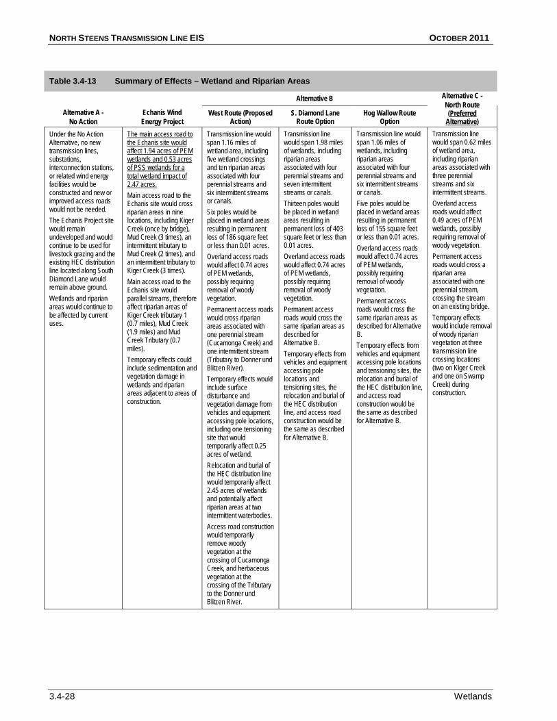
Table 3.4-13 Summary of Effects – Wetland and Riparian Areas
Alternative A - No Action
Echanis Wind Energy Project
Alternative B Alternative C - North Route (Preferred
AlternativeWest Route (Proposed
Action) ) S. Diamond Lane
Route Option Hog Wallow Route
Option Under the No Action Alternative, no new transmission lines, substations, interconnection stations, or related wind energy facilities would be constructed and new or improved access roads would not be needed. The Echanis Project site would remain undeveloped and would continue to be used for livestock grazing and the existing HEC distribution line located along South Diamond Lane would remain above ground. Wetlands and riparian areas would continue to be affected by current uses.
Main access road to the Echanis site would cross riparian areas in nine locations, including Kiger Creek (once by bridge), Mud Creek (3 times), an intermittent tributary to Mud Creek (2 times), and an intermittent tributary to Kiger Creek (3 times).
The main access road to the Echanis site would affect 1.94 acres of PEM wetlands and 0.53 acres of PSS wetlands for a total wetland impact of 2.47 acres.
Main access road to the Echanis site would parallel streams, therefore affect riparian areas of Kiger Creek tributary 1 (0.7 miles), Mud Creek (1.9 miles) and Mud Creek Tributary (0.7 miles). Temporary effects could include sedimentation and vegetation damage in wetlands and riparian areas adjacent to areas of construction.
Transmission line would span 1.16 miles of wetland area, including five wetland crossings and ten riparian areas associated with four perennial streams and six intermittent streams or canals. Six poles would be placed in wetland areas resulting in permanent loss of 186 square feet or less than 0.01 acres. Overland access roads would affect 0.74 acres of PEM wetlands, possibly requiring removal of woody vegetation. Permanent access roads would cross riparian areas associated with one perennial stream (Cucamonga Creek) and one intermittent stream (Tributary to Donner und Blitzen River). Temporary effects would include surface disturbance and vegetation damage from vehicles and equipment accessing pole locations, including one tensioning site that would temporarily affect 0.25 acres of wetland. Relocation and burial of the HEC distribution line would temporarily affect 2.45 acres of wetlands and potentially affect riparian areas at two intermittent waterbodies. Access road construction would temporarily remove woody vegetation at the crossing of Cucamonga Creek, and herbaceous vegetation at the crossing of the Tributary to the Donner und Blitzen River.
Transmission line would span 1.98 miles of wetlands, including riparian areas associated with four perennial streams and seven intermittent streams or canals. Thirteen poles would be placed in wetland areas resulting in permanent loss of 403 square feet or less than 0.01 acres. Overland access roads would affect 0.74 acres of PEM wetlands, possibly requiring removal of woody vegetation. Permanent access roads would cross the same riparian areas as described for Alternative B. Temporary effects from vehicles and equipment accessing pole locations and tensioning sites, the relocation and burial of the HEC distribution line, and access road construction would be the same as described for Alternative B.
Transmission line would span 1.06 miles of wetlands, including riparian areas associated with four perennial streams and six intermittent streams or canals. Five poles would be placed in wetland areas resulting in permanent loss of 155 square feet or less than 0.01 acres. Overland access roads would affect 0.74 acres of PEM wetlands, possibly requiring removal of woody vegetation. Permanent access roads would cross the same riparian areas as described for Alternative B. Temporary effects from vehicles and equipment accessing pole locations and tensioning sites, the relocation and burial of the HEC distribution line, and access road construction would be the same as described for Alternative B.
Transmission line would span 0.62 miles of wetland area, including riparian areas associated with three perennial streams and six intermittent streams. Overland access roads would affect 0.49 acres of PEM wetlands, possibly requiring removal of woody vegetation. Permanent access roads would cross a riparian area associated with one perennial stream, crossing the stream on an existing bridge. Temporary effects would include removal of woody riparian vegetation at three transmission line crossing locations (two on Kiger Creek and one on Swamp Creek) during construction.