economic geology, petrology and geochemistry of tas hall copper
TRANSCRIPT
Journal of Academic and Applied Studies
(Special Issue on Sciences & Engineering)
Vol. 3(7) July 2013, pp. 35-50
Available online @ www.academians.org
ISSN1925-931X
35
Economic Geology, Petrology and Geochemistry
of Tas Hall Copper Index
(South Azna,Lorestsn,Iran)
Amin Panahi,1 Mohsen balvasi
2
1Department of Geology, Islamic Azad University of North Tehran, Iran
2Department of Physics. Mahshahr branch. Islamic Azad University. Mahshahr. Iran
Abstract
The Tas hall copper index is located in 15 Km of south of Azna, Lorestan, Iran, and is regarded as a small
portion of Sanandaj – Sirjan Zone (SSZ). The studied region is affected by important orogenic phases of
Cimmerian and final cretaceous and several intrusive masses like Azna are injected in it. These masses
have penetrated into shales and Jurassic sandstone. The igneous rocks are mainly ranging from granodiorite
to andesite volcanic. The petrology studies show that volcanic rocks of the region are porphyry andesite. In
terms of mineralization : chalcopyrite, chalcosite, burnit, malachite, azurite, magnetite and limonite
minerals are the most important minerals that occurring as veinlets. In terms of alteration, sericitiazation,
chloritization, and epidotization are dominated alterations of the region. With regard to development of
alteration zones in volcanic rocks and vein mineralization in these rocks it seems that these rocks are the
main host rock of mineralization in the region and mineralize factor must be related to probably granodiritic
intrusive. Based on geotectonic data these rocks are related to arcs after collision volcanic. The under
studied region’s rocks are normalized based on primitive mantle and ORG values. All cases almost show
chemical-charactiritics and similar neicheru mantle metasomatism ore continental crust impregnation.
Keywords: Tas hall-copper-peterology-Alteration-mineralization-Geochemistry.
I. Introduction
The area under studied is located in 15Km south Azna (north-east of Lorestan province). The
area is limited to geographical latitude of 33 27' 42" N and longitude of 49 39' 56" E in a
mountain are with semi mountain geomorphological view. In the context of the structural
subdivisions of Iran (Zarasvandi et al., 2005), this area is a portion of Sanandaj-Sirjan Zone.
Seduction of the Tethyan oceanic lithosphere under the southwestern border Central Iran, caused
volcanic activity between the Jurassic and Quaternary within and adjacent to the Sanandaj-Sirjan
Zone in the Northwest-Southeast of Iran (Fig. 1) (Ricou et al.,1977; Berberian and King, 1981;
Berberian, 1983; Mohajjel et al., 2003). The tectonic history of the Tethyan region has been
studied by many authors (e.g. Takin, 1972; Stocklin, 1974, 1977; Farhoudi, 1978; Berberian,
1981, a, b; Berberian and King, 1981; Berberian and Berberian, 1981; Jankovic, 1984; Sengor,
˚
˚
Journal of Academic and Applied Studies
(Special Issue on Sciences & Engineering)
Vol. 3(7) July 2013, pp. 35-50
Available online @ www.academians.org
ISSN1925-931X
36
1984, 1990, 1991; Alavi, 1994; Sengor et al., 1988; Ahmadi Khalaji et al., 2007) lithological
point of view, porphyritic andesite is the mainly rocks and host rocks. In this limitation there are
alteration zones such as sericitication, epidotization and chloritization zone. Copper
mineralization as vein or alteration halos as primary and secondary oxides and sulfides minerals
have been visible. The main aim of this paper is considering petrography, alteration, and
mineralization in vein and inner alteration halos and drawing holes in Tas hall ore index.
I. Methods
The studied area is located in the Sanandaj-Sirjan Zone (Stocklin, 1968). This zone is extending
from north-west to south-east and is divided into three subzones (Soheili et al., 1992). Sanandaj-
Sirjan Zone is one of the most active zones and lead to the orogenic phases, many metamorphic
and magmatic activities (Darvishzadeh, 1991). The studied area is located in Sub-Mesozoic zone
and is mainly consisted of shales, Jurassic sandstones and replacement of numerous magmatic
bodies such as Azna. Tas hall ore index is located in an agglomerate unit. This unit included
lavas and pyroclastics to volcanic andesite along with granodiorite. Thickness of this complex
varies from100-150 meters in south of Dareh -takht village to about 20 meters in north of Tas
hall village, and can be seen more thickness in around ore index. Upper contact of this unit is
composed of thin layers to medium of limestone fossils to a little sandstone. Lower contact of
this unit is gradually with microsparite calcareous bearing fossils. In some places of this area can
be seen sub-marine lavas. (Mohammadbeigi, 1997)
:Structural setting
The Limestone rock of the area under the study is a portion of Sanandaj-Sirjan Zone. From the
structural point of view, Sanandaj-Sirjan Zone is part of Central Iran Zone. Based on occurrences
of later early Cimmerian can be seen many different part with variety trend which the one of it is
Uromieh-Hamedan trough. This sedimentary trough is formed with north west to south east
around of Aligodarz to the north of Dourod or south east of Boroujerd. Around of Hamedan to
south east of Uromieh lake (late Triassic) is formed. It is difficult to say about structural area by
two reasons. First little extent of area and the second extent of outcrop of rocks mainly belong to
Jurassic. Then it can't show occurrences before and after itself . with total evidences, based on
studies of are and around of area, we can draw tectonically situation of the area under study. This
was influenced of late Cimmerian and late cretaceous orogenic phases and has been occurred
Azna pluton (Mohammadbeigi, 1997).
There are three groups of faults: A-great faults with north-west to south east trend which mainly
over trusted and caused by squamous structural. This type of faults have cut the other structures
such as reverse faults ,thrusts, axial folds, that is double faults in total pressure system in time of
formed thrusts and folds B-accessory faults. These groups of faults that exactly cut the others
such as reverse faults and folds. C-normal faults or grabbens with a general trend vertical on

Journal of Academic and Applied Studies
(Special Issue on Sciences & Engineering)
Vol. 3(7) July 2013, pp. 35-50
Available online @ www.academians.org
ISSN1925-931X
37
other trends are formed by extension forces that are caused of intrusive magma such as Tas hall
intrusive body.
Fig. 1. Geological map of Iran (modified after: Zarasvandi et al, 2005) showing major
lithotectonic units.
Petrography studies:
Journal of Academic and Applied Studies
(Special Issue on Sciences & Engineering)
Vol. 3(7) July 2013, pp. 35-50
Available online @ www.academians.org
ISSN1925-931X
38
Petrography studied, show that area is included of pyroclastic ,volcanic and probably intrusive
rocks (granodiorite) with accessory types. The most alteration in area is sericitization,
chlortization and epidotization. The ore minerals in the area are chalcopyrite, chalcosite, bornite,
malachite, azurite -magnetite and limonite minerals. Malachite and chalcopyrite founded in
volcanic rocks (Shahrokhi, 2002). Pyroclastic rocks included of plagioclases, chlorite and
andesite with porphirc texture.
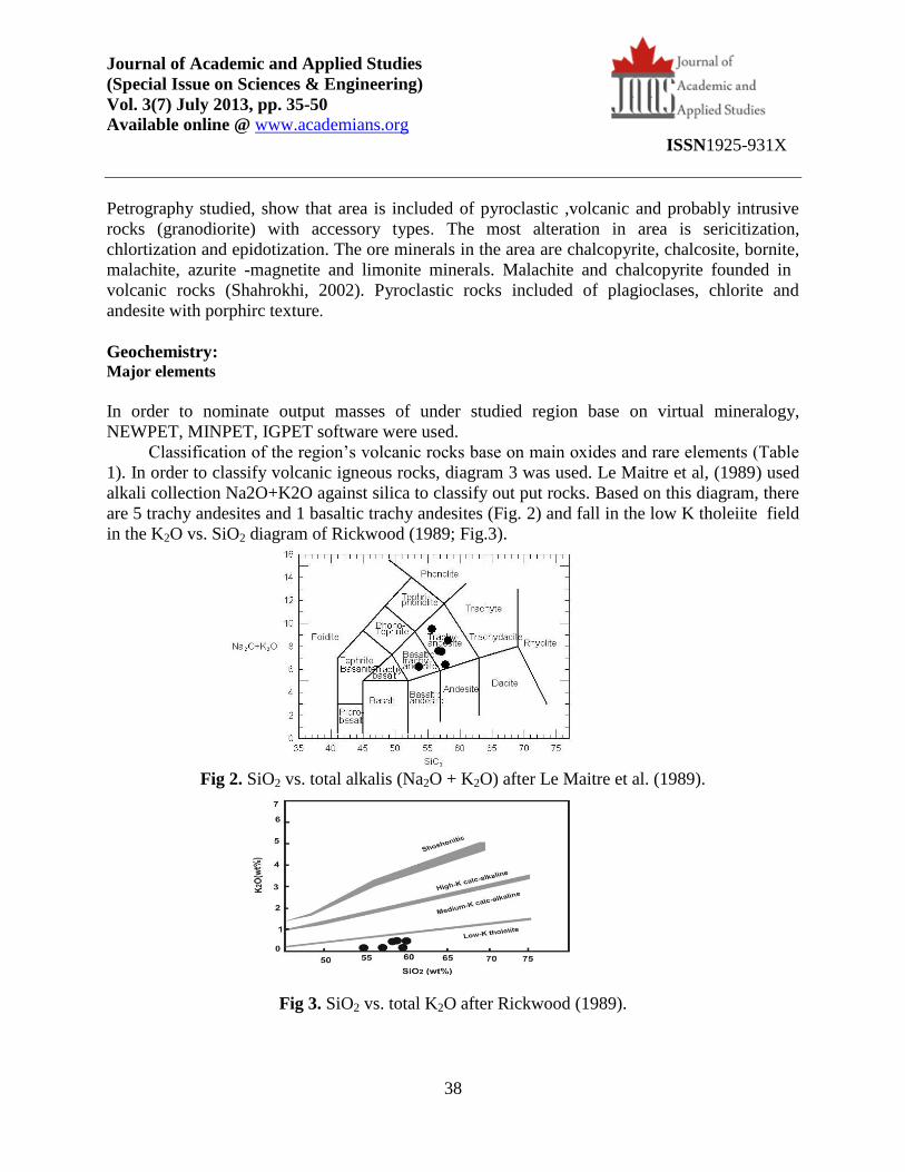
Geochemistry: Major elements
In order to nominate output masses of under studied region base on virtual mineralogy,
NEWPET, MINPET, IGPET software were used.
Classification of the region’s volcanic rocks base on main oxides and rare elements (Table
1). In order to classify volcanic igneous rocks, diagram 3 was used. Le Maitre et al, (1989) used
alkali collection Na2O+K2O against silica to classify out put rocks. Based on this diagram, there
are 5 trachy andesites and 1 basaltic trachy andesites (Fig. 2) and fall in the low K tholeiite field
in the K2O vs. SiO2 diagram of Rickwood (1989; Fig.3).
Fig 2. SiO2 vs. total alkalis (Na2O + K2O) after Le Maitre et al. (1989).
Fig 3. SiO2 vs. total K2O after Rickwood (1989).
Journal of Academic and Applied Studies
(Special Issue on Sciences & Engineering)
Vol. 3(7) July 2013, pp. 35-50
Available online @ www.academians.org
ISSN1925-931X
39
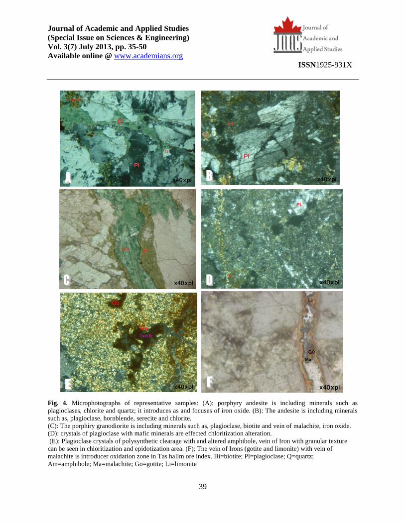
Fig. 4. Microphotographs of representative samples: (A): porphyry andesite is including minerals such as
plagioclases, chlorite and quartz; it introduces as and focuses of iron oxide. (B): The andesite is including minerals
such as, plagioclase, hornblende, serecite and chlorite.
(C): The porphiry granodiorite is including minerals such as, plagioclase, biotite and vein of malachite, iron oxide.
(D): crystals of plagioclase with mafic minerals are effected chloritization alteration.
(E): Plagioclase crystals of polysynthetic clearage with and altered amphibole, vein of Iron with granular texture
can be seen in chloritization and epidotization area. (F): The vein of Irons (gotite and limonite) with vein of
malachite is introducer oxidation zone in Tas hallm ore index. Bi=biotite; Pl=plagioclase; Q=quartz;
Am=amphibole; Ma=malachite; Go=gotite; Li=limonite
Journal of Academic and Applied Studies
(Special Issue on Sciences & Engineering)
Vol. 3(7) July 2013, pp. 35-50
Available online @ www.academians.org
ISSN1925-931X
40
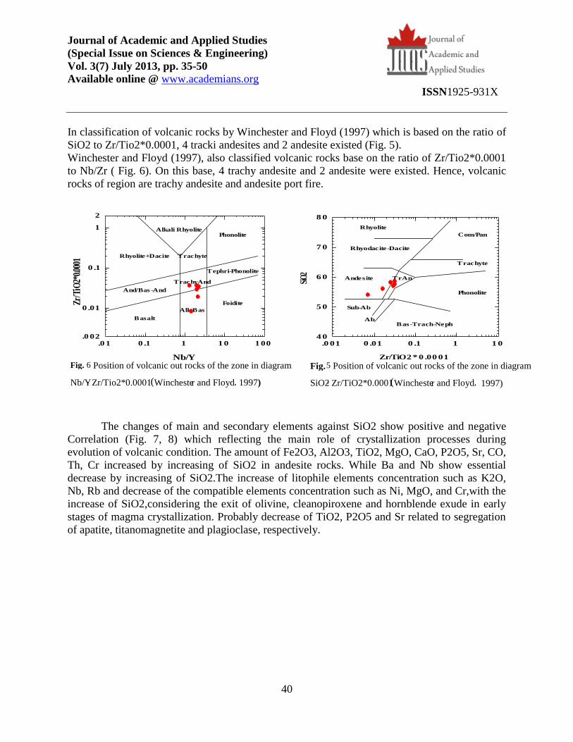
In classification of volcanic rocks by Winchester and Floyd (1997) which is based on the ratio of
SiO2 to Zr/Tio2*0.0001, 4 tracki andesites and 2 andesite existed (Fig. 5).
Winchester and Floyd (1997), also classified volcanic rocks base on the ratio of Zr/Tio2*0.0001
to Nb/Zr ( Fig. 6). On this base, 4 trachy andesite and 2 andesite were existed. Hence, volcanic
rocks of region are trachy andesite and andesite port fire.
The changes of main and secondary elements against SiO2 show positive and negative
Correlation (Fig. 7, 8) which reflecting the main role of crystallization processes during
evolution of volcanic condition. The amount of Fe2O3, Al2O3, TiO2, MgO, CaO, P2O5, Sr, CO,
Th, Cr increased by increasing of SiO2 in andesite rocks. While Ba and Nb show essential
decrease by increasing of SiO2.The increase of litophile elements concentration such as K2O,
Nb, Rb and decrease of the compatible elements concentration such as Ni, MgO, and Cr,with the
increase of SiO2,considering the exit of olivine, cleanopiroxene and hornblende exude in early
stages of magma crystallization. Probably decrease of TiO2, P2O5 and Sr related to segregation
of apatite, titanomagnetite and plagioclase, respectively.
Fig. 6 Position of volcanic out rocks of the zone in diagram
Nb/Y - Zr/Tio2*0.0001 ( Wincheste r and Floyd , 1997)
Fig. 5 Position of volcanic out rocks of the zone in diagram
SiO2 - Zr/TiO2*0.0001 ( Wincheste r and Floyd , 1997)
.0 01 0 .01 0 .1 1 1 04 0
5 0
6 0
7 0
8 0
Rhyolite
Rhyodacite-Dacite
Andesite TrAn
Sub-Ab
AbBas-Trach-Neph
Com/Pan
Trachyte
Phonolite
Zr/TiO2 * 0 .00 01
SiO
2
.0 1 0 .1 1 1 0 1 00.0 02
0 .01
0 .1
1
2
Basalt
Alk-Bas
Foidite
And/Bas -And
TrachyAnd
Tephri-Phonolite
Rhyolite+Dacite
Alkali Rhyolite
Trachyte
Phonolite
Nb/Y
Zr/T
iO2*
0.000
1
Journal of Academic and Applied Studies
(Special Issue on Sciences & Engineering)
Vol. 3(7) July 2013, pp. 35-50
Available online @ www.academians.org
ISSN1925-931X
41
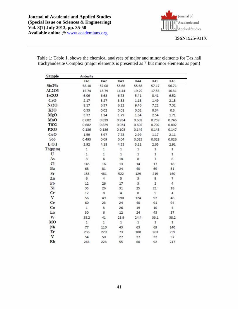
Table 1: Table 1. shows the chemical analyses of major and minor elements for Tas hall
trachyandesite Complex (major elements is presented as ٪ but minor elements as ppm)

Journal of Academic and Applied Studies
(Special Issue on Sciences & Engineering)
Vol. 3(7) July 2013, pp. 35-50
Available online @ www.academians.org
ISSN1925-931X
42
Fig. 7 . Harker diagrams for major of the Tas hall volcanic Complex
Journal of Academic and Applied Studies
(Special Issue on Sciences & Engineering)
Vol. 3(7) July 2013, pp. 35-50
Available online @ www.academians.org
ISSN1925-931X
43
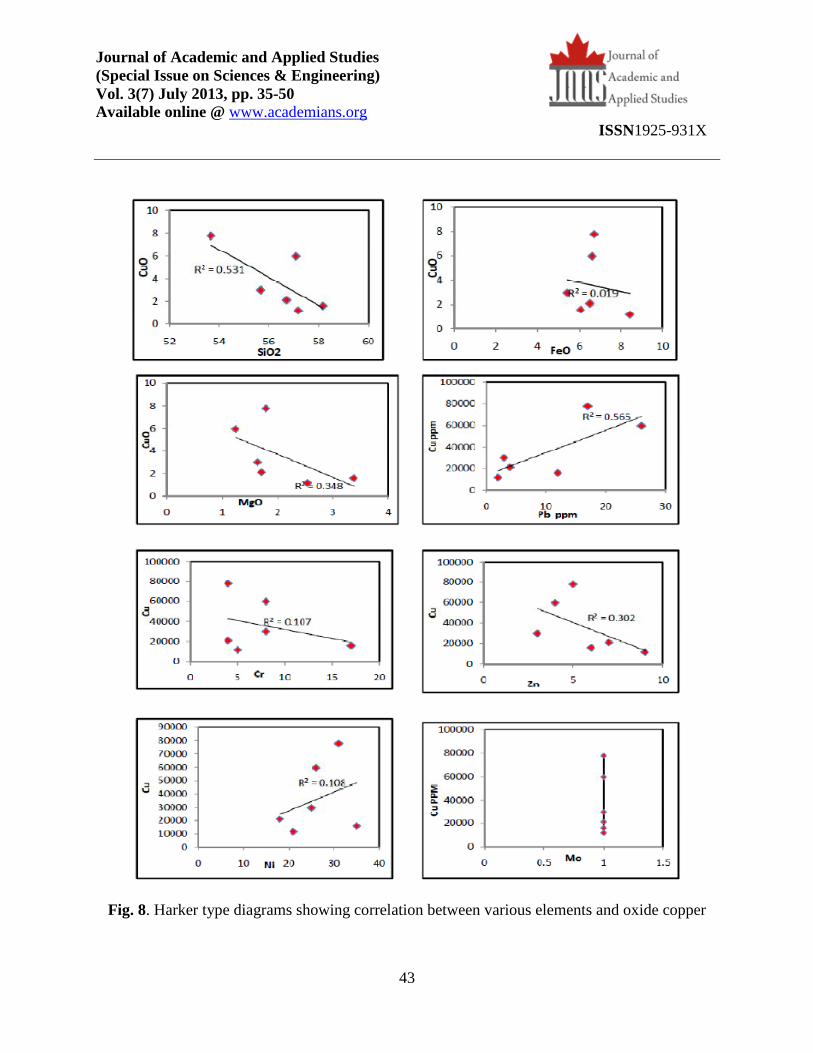
Fig. 8. Harker type diagrams showing correlation between various elements and oxide copper

Journal of Academic and Applied Studies
(Special Issue on Sciences & Engineering)
Vol. 3(7) July 2013, pp. 35-50
Available online @ www.academians.org
ISSN1925-931X
44
Geodynamic setting:
These rocks include different compounds of shoshonites with volcanic calc alkaline rocks to
lositites ultrapotassic (Peccerillo, 1976 & Taylor, 1976) that tend to be as separated ground
masses in tectonic positions Inside plate while the related kinds to subduction tectonic position
tend to be as final members of a contiguous spectrum of igneous rocks which include a range
from tholeiite to shoshonite and potassium enriched calc alkaline rocks during arc evolution. One
characteristic of calc alkaline rocks is their formation inside of subduction and also arc islands
which related subduction. In continental area, these rocks are almost felsic and have different
kinds, while when appear in the arc islands, have not variation of first group rocks and are so
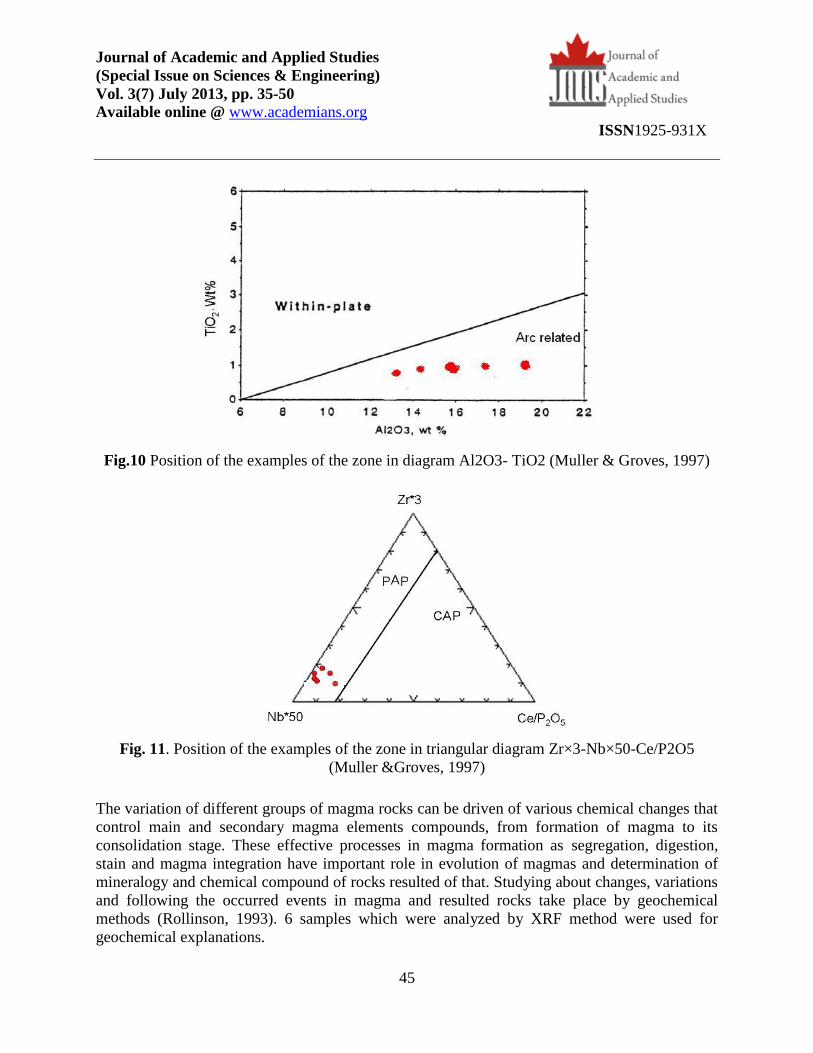
limited and form more than basalt and andesite. The diagrams which are represented by Pearce et
al. (1984), Muller & Groves (1997) are used for determination of geo-structure position of region
rocks. The special diagrams of potassic rocks which are represented by Muller & Groves (1997)
and are base on (Y-Zr) and (TiO2-Al2O3) are used for determination of tectonic area of potassic
rocks. Base on these diagrams, all cases located in the related area to volcanic arcs (Figures. 9,
10).
In order to have more precise determination of tectonic position of rocks and separation of
continent arcs from arcs after collision, three variables diagram (Zr×3-Nb×50-Ce/P2O) which is
represented by Muller & Groves (1997) was used. Based on this diagram, region’s cases in
tectonic position are located after collision (Fig. 11).
Fig. 9. Zr/y diagram after (Muller & Groves,1997) showing that this rock located on the Arc
related area
Journal of Academic and Applied Studies
(Special Issue on Sciences & Engineering)
Vol. 3(7) July 2013, pp. 35-50
Available online @ www.academians.org
ISSN1925-931X
45
Fig.10 Position of the examples of the zone in diagram Al2O3- TiO2 (Muller & Groves, 1997)
Fig. 11. Position of the examples of the zone in triangular diagram Zr×3-Nb×50-Ce/P2O5
(Muller &Groves, 1997)
The variation of different groups of magma rocks can be driven of various chemical changes that
control main and secondary magma elements compounds, from formation of magma to its
consolidation stage. These effective processes in magma formation as segregation, digestion,
stain and magma integration have important role in evolution of magmas and determination of
mineralogy and chemical compound of rocks resulted of that. Studying about changes, variations
and following the occurred events in magma and resulted rocks take place by geochemical
methods (Rollinson, 1993). 6 samples which were analyzed by XRF method were used for
geochemical explanations.

Journal of Academic and Applied Studies
(Special Issue on Sciences & Engineering)
Vol. 3(7) July 2013, pp. 35-50
Available online @ www.academians.org
ISSN1925-931X
46
Using analyzes data of 6 samples, the under studied region’s rocks have following geochemical
characteristics:
1- The range of SiO2 is rather high in these rocks and is between 53.66 to 58.38.
2- The amount of K2O+Na2O is between 6.23 to 8.5.
3- The amount of Fe/Mg is between 1.79 to 5.34.
4- The amount of Nb, Zr and Y is high.
5- The amount of CaO is between 1.18 to 3.58.
6- The amount of MgO is rather low and is between 1.24 to 3.37.
The spider diagrams are used in order to evaluate the amount of variation and productive magma
changes in proportion to primary magma, also to determine origin and their genetic relation. For
this purpose having a comprehensive model that by it could evaluate frequency of elements is beneficial, that it called normalization. Spider diagrams are plotted by main and rare elements
and their normalization in proportion to the amount of these elements in primary crust or
conderite and or ORG. As a result these diagrams frequently show more numbers of positive and
negative anomalies which reflecting behavior of different rare elements groups. For example
behaviors of elements with high mobility as (Eu, Rb, Ba, K, Cs, LILE) differ from elements with
low mobility (Ta, Nb, Ti, Zr, Hf, HFSE). By chemistry the origin rock and HFSE are a function
of fluid phase. While the concentration of LILE, concentration of crystallization-melting
processes are controlled that are occurred during rock formation. Because of high mobility, LILE
elements could be controlled by fluids, but these elements concentration in continent crust, their
concentration in magma may be appearing as crust stains. In order to geochemical expression of
rare magma rocks forming rocks in the tectonic area, spider diagrams are very significant
(Rolinson, 1993). Potassic igneous rocks are usually replete with elements LILE, LREE volatile
materials and halogens especially F, Cl (Muller & Grover, 1992) have some characteristics of
shoshonite magma depletion Clear rocks elements (Ta, Nb, Ti) TNT and enrichment elements
Rb, K by stones (Edwards et al, 1986). In other hand, depletion of LILE elements from
magmatism index is related to infra buoyancy zone (Arjemand, 2008). Also potassic igneous
rocks which related to arc show rather high content of elements K, Rb, Cs, Ba, and negative
certain abnormalities of elements Ti, Nb, Ta, Pb (Sun & Mc Donough, 1989). The under studied
region’s rocks are normalized base on primary crust and ORG (Pearce et al., 1984). All of the
samples almost have similar process which shows their similar magma (Fig. 12). Ba, Rb, in the
represented diagrams, show enrichment in the region’s rocks, enrichment of above elements
could be related to crust metasomatism or continent crust stains. Since ionic radius of barium is
equal to K ionic radius, so it can be accepted in place of potassium in the structure of alkali
feldspar, biotite, and plagioclase. This is the reason of positive anomaly of barium. On the other
hand the chemical behavior of rubidium element has so similarity to potassium and it can be a
replace for potassium in mines structure lattices as biotite and alkali feldspar. Generally,
frequency of these elements shows continent crust interference in evolution of magma
reproducing region’s rocks. According to Hezarkhani, et al. (1998), this negative anomaly of Nb
shows rare elements model of continent arc igneous masses and magmas index of calc alkaline.
Negative anomaly of Nb is the index of continent rocks and may show its contribution in magma
processes (Rolinson, 1993). In rocks of the zone effect of subduction on resources shows some
Journal of Academic and Applied Studies
(Special Issue on Sciences & Engineering)
Vol. 3(7) July 2013, pp. 35-50
Available online @ www.academians.org
ISSN1925-931X
47
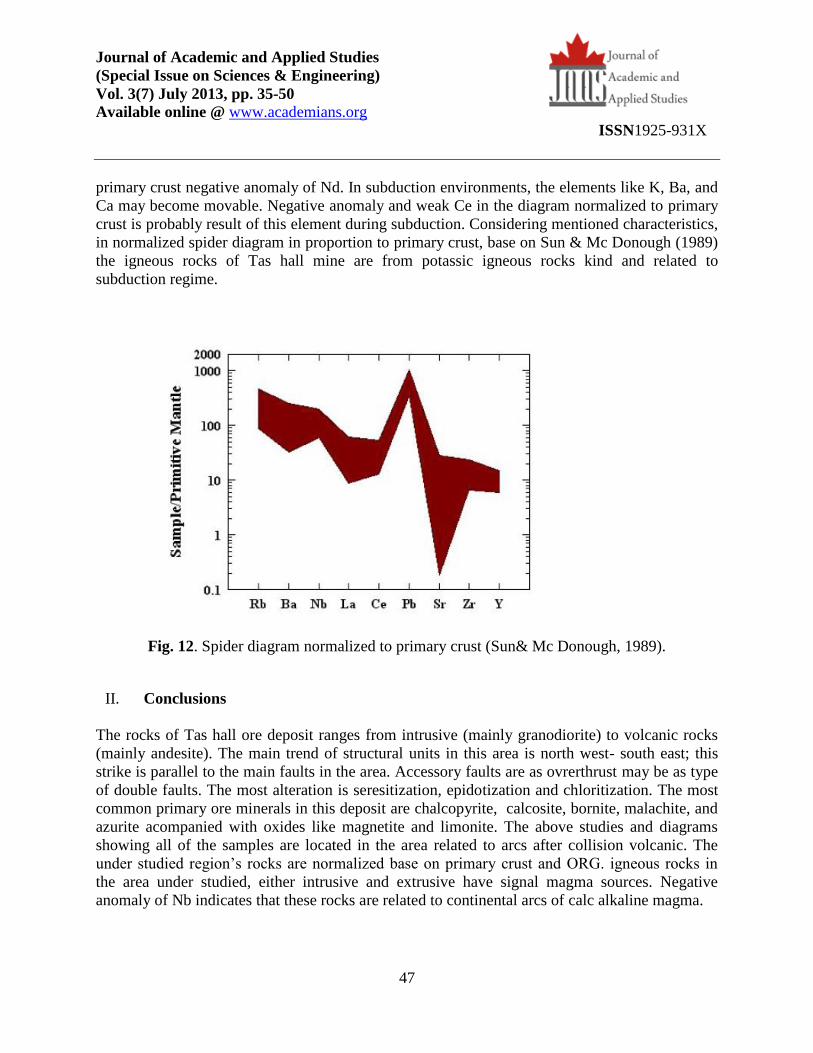
primary crust negative anomaly of Nd. In subduction environments, the elements like K, Ba, and
Ca may become movable. Negative anomaly and weak Ce in the diagram normalized to primary
crust is probably result of this element during subduction. Considering mentioned characteristics,
in normalized spider diagram in proportion to primary crust, base on Sun & Mc Donough (1989)
the igneous rocks of Tas hall mine are from potassic igneous rocks kind and related to
subduction regime.
Fig. 12. Spider diagram normalized to primary crust (Sun& Mc Donough, 1989).
II. Conclusions
The rocks of Tas hall ore deposit ranges from intrusive (mainly granodiorite) to volcanic rocks
(mainly andesite). The main trend of structural units in this area is north west- south east; this
strike is parallel to the main faults in the area. Accessory faults are as ovrerthrust may be as type
of double faults. The most alteration is seresitization, epidotization and chloritization. The most
common primary ore minerals in this deposit are chalcopyrite, calcosite, bornite, malachite, and
azurite acompanied with oxides like magnetite and limonite. The above studies and diagrams
showing all of the samples are located in the area related to arcs after collision volcanic. The
under studied region’s rocks are normalized base on primary crust and ORG. igneous rocks in
the area under studied, either intrusive and extrusive have signal magma sources. Negative
anomaly of Nb indicates that these rocks are related to continental arcs of calc alkaline magma.
Journal of Academic and Applied Studies
(Special Issue on Sciences & Engineering)
Vol. 3(7) July 2013, pp. 35-50
Available online @ www.academians.org
ISSN1925-931X
48
References
]1[-Ahmadi Khalaji, A., Esmaeily, D., Valizadeh, M. V.and Rahimpour-Bonab, H.( 2007).
Petrology and geochemistry of the granitoid complex of Boroujerd, Sanandaj-Sirjan Zone,
Western Iran. Journal of Asian Earth Sciences 29, 859-877.
]2[- Arjemand, M,( 2008). Alteration, Geochemistry studding and Iron and copper mineralization
in Qareh Tappeh area in Mianeh, M.SC thesis, Payam Noor University, Tabriz.
]3[ -Alavi, M, (1994). Tectonic of the Zagros orogenic belt of Iran: new data and interpretations.
Tectonophysics 229, 211-238.
]4[- Berberian, F,and Berberian, M,(1981). Tectono-plutonic episodes in Iran. In:Gupta, H.K.,
Delany, F.M (Eds), Zagros Hindukush, Himalaya Geodynamic Evolution. American geophysical
Union, Washington DC, pp. 5-32.
]5[- Berberian, and King, G.C.P.,( 1981). Towards a paleogeography and tectonic evolution of
Iran. Canadian Journal of Earth Sciences 18, 210-265.
]6[- Beus, A.A,( 1968). Geochemical criteria in theoretical principles of exploration for mineral
deposit, Moscow, pp.127- 145.
]7[- Darvishzadeh, A,( 1991). Geological of Iron, Danesh-Emroz, Amir kabir on potential mine,
MSC thesis, Tabriz University.
]8[- Edwards, R, and Atkinson, K, (1986). Ore Deposit Geology and its influence on mineral
exploration, Chapman and hall, London.
]9[- Hezarkhani, A and Williams – jones, A, E, (1998). Control of alterational and
mineralization in the Sungun porphiry deposit, Iran, Evidence: from fluid inclusion and stable
isotope Econ- geol, Vol. 93.pp:651-640.
]10[- Jankovic, S,(1984). Metallogeny of the Alpine granitoids in the Tethyan-Eurasian
metallogenic belt. Proceedings of the 27th International Geological Congress, Moscow, 4-14
August, 247-274.
]11[- Le Maitre, R.W., Bateman, p., Dudek, A., Keller, J., Lameyre, J., Lebas., M.J., Sabine.,
p.A., Schmid, R., Sorensen, H., Streckeisen, A., Wolley, A.R and Zanettine, B. (1989). A
Classification of igneous rocks and glossary of terms. Blackwell, Oxford. 193 p.
]12[- Mohajjel, M., Fergusson, C.L and Sahandi, M.R., (2003). Cretaceous-Tertiary
convergence and continental collision, Sanandaj-Sirjan Zone, western Iran. Journal of Asian
Earth Sciences 21, 397-4120.
]13[- Mohammadbeigi; A.,(1997). Economic geology Dareh takht area (South Azna), M.SC
thesis, Shahid Beheshty University.
Journal of Academic and Applied Studies
(Special Issue on Sciences & Engineering)
Vol. 3(7) July 2013, pp. 35-50
Available online @ www.academians.org
ISSN1925-931X
49
]14[- Muller, D., and Gros D.A., (1996). Might potassium rocks with Gold copper
mineralization, geol,V.93,pp.651.
]15[- Muller, D. Rock, N.MS.and Groves, D.I, (1992). Gochemical discriminate different
tectonic setting : a pilot study. Mineral petrol., 46.
]16[- Pearce, J.A. Hariss, N.B.W. and Tindle, A,G,(1984). Trace element discrimination diagram
for the tectonic interpretation of grantic rocks. Juornal of petrology 25, 956 – 983.
]17[- Peccerillo, A. and Taylor, S.R. (1976). Geochemistry of Eocene calk-alkaline volcanic
rocks from the kastamonus area, norhen – Turkey. Contrib. Mineral. Petrol., 58.
]18[- Ricou, L.E., Braud, J.and Brunn, J.A.,( 1977). Le Zagros. Memoire Societe Geologique de
France 8, 33-52.
]19[ - Rickwood, P.C.,(1989). Boundary lines within petrologic diagrams which use of major and
minor elements. Lithos 22, 247–263.
]20[- Rollinson, H.R., (1993). Using Geochemical Data: Evaluation, Presentation, Interpretation.
Longman Scientific & Technical, p.352.
]21[ - Sengor, A.M .C.(1984). The Cimmeride Orogenic System and the Tectonics of Eurasia,
Geological Society of America Special Paper, 195p.
]22[- Sengor, A.M.C., Altmer, D., Cin, A., Ustaomer, T.and Hsu, K.J.,(1988).Origin and
assembly of the Tethyside orogenic collage at the expense of Gondwana Land. In: Audley-
Charles, M.G., Hallam, A., Editors.
]23[- Sengor, A.M.C.(1990). A new model for the late Paleozoic-Mesozoic A.H.F., Searle,
M.P.,Ries, A.C. (Eds). The Geology and Tectonics of the Oman Region, Geological Society of
London, Special Publication, 22, pp. 278-281.
]24[- Sengor, A.M.C.(1991). Late Paleozoic and Mesozoic evolution of the Middle Eastern
Tethysides: Implications for the Paleozoic Geodynamics of the Tethyan Realm. IGCP Project
276, Newslletter No. 2, pp. III-149.
]25[- Shahrokhi, S. V.,( 2002). Consider of factors controlliry of copper mineralization and
related elements in Konder (Aligodarz) north east of lorestan province MSC thesis, Tehran
shomal Branch islamic Azad University.
]26[- Soheili, M., Jafarian, M. and Abdolahi, M.(1992). Aligodarz 1:100000 map, Geological
Survey of Iran, Tehran, Iran.
Journal of Academic and Applied Studies
(Special Issue on Sciences & Engineering)
Vol. 3(7) July 2013, pp. 35-50
Available online @ www.academians.org
ISSN1925-931X
50
]27[- Stocklin, J., 1968. Structural History and Tectonic of Iran: A Review. Amer. Assoc. Petrol.
Geol. Bull; 52, 1229-1258.
]28[- Stocklin, J.(1974). Possible ancient continental margins in the Iran. In: Burk, C.A., Drake,
C.L. (Eds), the Geology of Continental Margins. Springer, Berlin, pp. 873-887.
]29[- Sun, S.S.and Mc Donough, W.F.(1989). Chemical and isotopic systematics of oceanic
basalts: implications for mantle composition and processes. Geological Society, London, Special
Publications 42, 313-345.
]30[- Takin, M.,(1972). Iranian geology and continental drift in the Middle East. Nature 235, 47-
150.
]31[- Winchester, J.A., and Floyd, P.A.(1977). Geochemical discrimination of different magma
series and their differentiation products using immobile elements. Chem. Geol., 20: 325--343.
]32[- Zarasvandi. A., Liaghat. S and Zentilli. M(2005). Geology of the Darreh-. Zerreshk and
Ali-Abad porphyry copper deposits, central Iran. Int Geol Rev 47:620–646.