ecological regions and districts of new zealand...abstract new zealand's 268 ecological...
TRANSCRIPT

ECOLOGICAL REGIONSAND DISTRICTS OF NEW ZEALAND
THIRD REVISED EDITION IN FOUR 1:500 000 MAPS
Booklet to accompany SHEET 2:descriptions of Districts in the
central North Island, from Meremereto Eastern Hawkes Bay.
Editor W. Mary McEwenNEW ZEALAND BIOLOGICAL RESOURCES CENTRE
Publication No. 5(in four parts)
Part 2
Department of Conservation, Wellington, New ZealandJune 1987
ABSTRACT
New Zealand's 268 ecological districts in 85 ecological regions are listed andan introduction describes the concept, definitions, the districts shown oneach of the four map sheets, the format and content of the prescriptions( printed on the maps), descriptions of each district and acknowledgements tothe large number of contributors of scientific information. A glossary definescertain words and abbreviations used in the text and lists common plant andanimal names used, together with their scientific names. Ecologicaldescriptions of the districts shown on each map sheet are given in the bookletaccompanying that sheet.
Keywords: New Zealand; maps; ecological districts; ecological regions;topography; geology; climate; soils; vegetation; flora, fauna.
National Library of New ZealandCataloguing-in-Publication data
ECOLOGICAL regions and districts of New Zealand/ editor, W. Mary McEwen. - 3rd rev. ed in four1:500 000 maps. - Wellington, N.Z. : Dept. ofConservation, 1987. - 4 v. - (Publication /New Zealand Biological Resources Centre, 0111-9982 ;no. 5)
First ed. published 1982.Part 1. Booklet to accompany sheet 1 : descriptions
of districts in the northern North Island, from Kermadecto Major -- Part 2. Booklet to accompany sheet 2 : descriptionsof districts in the central North Island, from Meremere toEastern Hawkes Bay -- Part 3. Booklet to accompany sheet 3descriptions of districts in central New Zealand, from EasternWairarapa to Akaroa, also Chathams not shown on map -- Part 4.Booklet to accompany sheet 4 : descriptions of districts in thesouthern South Island from Browning to Snares, also southernislands not shown on map.
574.5264099311. Ecology--New Zealand--Classification. 2. Natural areas--
New Zealand--Classification. 3. Biotic communities--New Zealand--Classification. I. McEwen, W. Mary. II. Biological ResourcesCentre (N.Z.). III. New Zealand. Dept. of Conservation. IV.Series: Biological Resources Centre publication ; no. 5.
Published by the Department of Conservation, Wellington.Maps and text prepared while Biological Resources Centre was administeredby Head Office, Department of Scientific and Industrial Research, priorto 1 April 1987.Ecological region and district boundaries and prescriptions prepared byScience Mapping Unit, DSIR, for printing on NZMS 242 sheets, supplied byDepartment of Survey and Land Information.
Available from: Biological Resources CentreDepartment of ConservationBox 10-420WellingtonNew Zealand
ISBN 0-478-01000-1

CONTENTS
LIST OF ECOLOGICAL REGIONS AND DISTRICTS OF NEW ZEALAND
INTRODUCTION
Background
Definitions
The Biological Resources Centre and theEcological Regions and Districts Project
Other Uses of the Ecological Region and District Framework.
THE MAPS
Presriptions
Descriptions
Acknowledgements
Future Amendments
GLOSSARY AND EXPLANATION OF TERMS
General
Abbreviations
Geology
Soils
Vegetation and Flora
Mammals
Birds
Reptiles
Frogs
Fish
Invertebrates
ECOLOGICAL DISTRICT DESCRIPTIONS
Printed in New Zealand by JIRAH SERVICES LTD., Wellington.
Cover photograph Lloyd Homer, Geological Survey, DSIR.
iii
x
xi
xii
xiii
xv
xvi
xvii
xxi
xxii

MAIN REFERENCES (Others given in the text)
Biological Resources Centre 1983.
Ecological Regions and Districtsof New Zealand. (2nd Edition, 1983).Set of 4 map overlays at 1:500,000Drawn by Science Mapping Unit, DSIRGovernment Printer Wellington.
Department of Lands and Survey 1984. Register of Protected NaturalAreas in New Zealand.Department of Lands and Survey Head Office, Wellington
IUCN, 1984. Biotic Provinces of the World. IUCN Occasional Paper 9.Morges, Switzerland.
Nicholls, J.L. 1979. The concept of Ecological Districts:A possible framework for a national biological inventory.In proceedings. of Biological Resources Workshop12-13 September, 1979. Commission for the Environment.Wellington. 192pp.
Park, G.N. in association with P.Dingwall...... (et al.)..... 1983.Protected Natural Areas for New Zealand. Report of a ScientificWorking Party convened by the Biological Resources Centre(DSIR) (14-17 December, 1982). Wellington.
Simpson, P. 1982. Ecological Regions and Districts of New Zealand.A Natural Subdivision. Biological Resources CentrePublication 1. Wellington, New Zealand.
iii
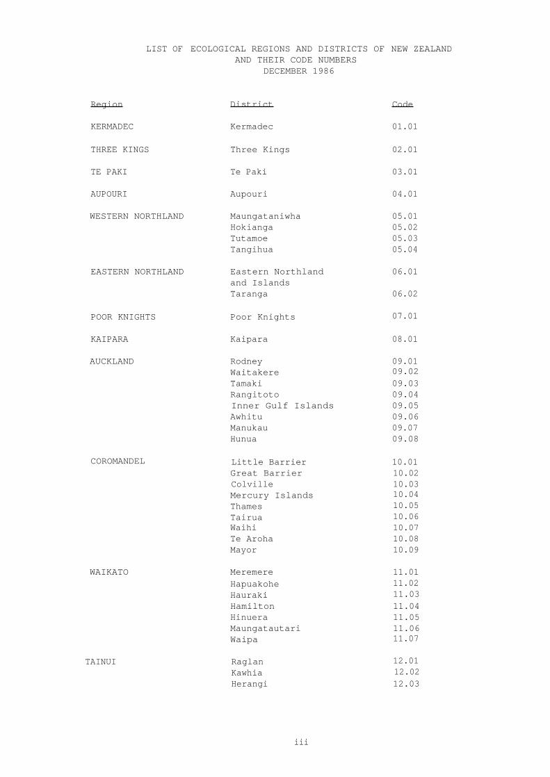
LIST OF ECOLOGICAL REGIONS AND DISTRICTS OFAND THEIR CODE NUMBERS
DECEMBER 1986
NEW ZEALAND
Region District Code
KERMADEC Kermadec 01.01
THREE KINGS Three Kings 02.01
TE PAKI Te Paki 03.01
AUPOURI Aupouri 04.01
WESTERN NORTHLAND Maungataniwha 05.01Hokianga 05.02Tutamoe 05.03Tangihua 05.04
EASTERN NORTHLAND Eastern Northland 06.01and IslandsTaranga 06.02
POOR KNIGHTS Poor Knights 07.01
KAIPARA Kaipara 08.01
AUCKLAND Rodney 09.01Waitakere 09.02Tamaki 09.03Rangitoto 09.04Inner Gulf Islands 09.05Awhitu 09.06Manukau 09.07Hunua 09.08
COROMANDEL Little Barrier 10.01Great Barrier 10.02Colville 10.03Mercury Islands 10.04Thames 10.05Tairua 10.06Waihi 10.07Te Aroha 10.08Mayor 10.09
WAIKATO Meremere 11.01Hapuakohe 11.02Hauraki 11.03Hamilton 11.04Hinuera 11.05Maungatautari 11.06Waipa 11.07
TAINUI Raglan 12.01Kawhia 12.02Herangi 12.03

iv
NORTHERN VOLCANIC PLATEAU MotitiTaurangaOtanewainukuRotorua
13.0113.0213.0313.04
White Island 13.05
WHAKATANE Te Teko 14.01Taneatua 14.02Opotiki 14.03
WESTERN VOLCANIC PLATEAU Ranginui 15.01Pureora 15.02Tokoroa 15.03
CENTRAL VOLCANIC PLATEAU Atiamuri 16.01Taupo 16.02
EASTERN VOLCANIC PLATEAU Kaingaroa 17.01Whirinaki 17.02
TONGARIRO Tongariro 18.01
RAUKUMARA Waioeka 19.01Motu 19.02
EAST CAPE Pukeamaru 20.01Waiapu 20.02Turanga 20.03
UREWERA Waimana 21.01Ikawhenua 21.02Waikaremoana 21.03
WAIROA Tiniroto 22.01Mahia 22.02Waihua 22.03
KING COUNTRY Waitomo 23.01Taumarunui 23.02
TARANAKI North Taranaki 24.01Matemateaonga 24.02
EGMONT Egmont 25.01
MOAWHANGO Moawhango 26.01
KAIMANAWA Kaimanawa 27.01
RUAHINE Ruahine 28.01
HAWKES BAY Maungaharuru 29.01Heretaunga 29.02
RANGITIKEI Rangitikei 30.01
MANAWATU Manawatu Plains 31.01Foxton 31.02

v
MANAWATU GORGE Manawatu Gorge North 32.01Manawatu Gorge South 32.02
PAHIATUA Woodville 33.01Puketoi 33.02
EASTERN HAWKES BAY Eastern Hawkes Bay 34.01
EASTERN WAIRARAPA Eastern Wairarapa 35.01
WAIRARAPA PLAINS Wairarapa Plains 36.01
AORANGI Aorangi 37.01
TARARUA Tararua 38.01
SOUNDS-WELLINGTON Wellington 39.01Cook Strait 39.02Sounds 39.03D'Urville 39.04
RICHMOND Pelorus 40.01Para 40.02
Fishtail 40.03
WAIRAU Blenheim 41.01Wither Hills 41.02Grassmere 41.03Flaxbourne 41.04
Hillersden 41.05
INLAND MARLBOROUGH Waihopai 42.01Medway 42.02Bounds 42.03George 42.04
MOLESWORTH Sedgemere 43.01Balaclava 43.02
Miromiro 43.03
CLARENCE Tapuaenuku 44.01
Dillon 44.02Manakau 44.03
KAIKOURA Kekerengu 45.01Aniseed 45.02
Kowhai 45.03
vi
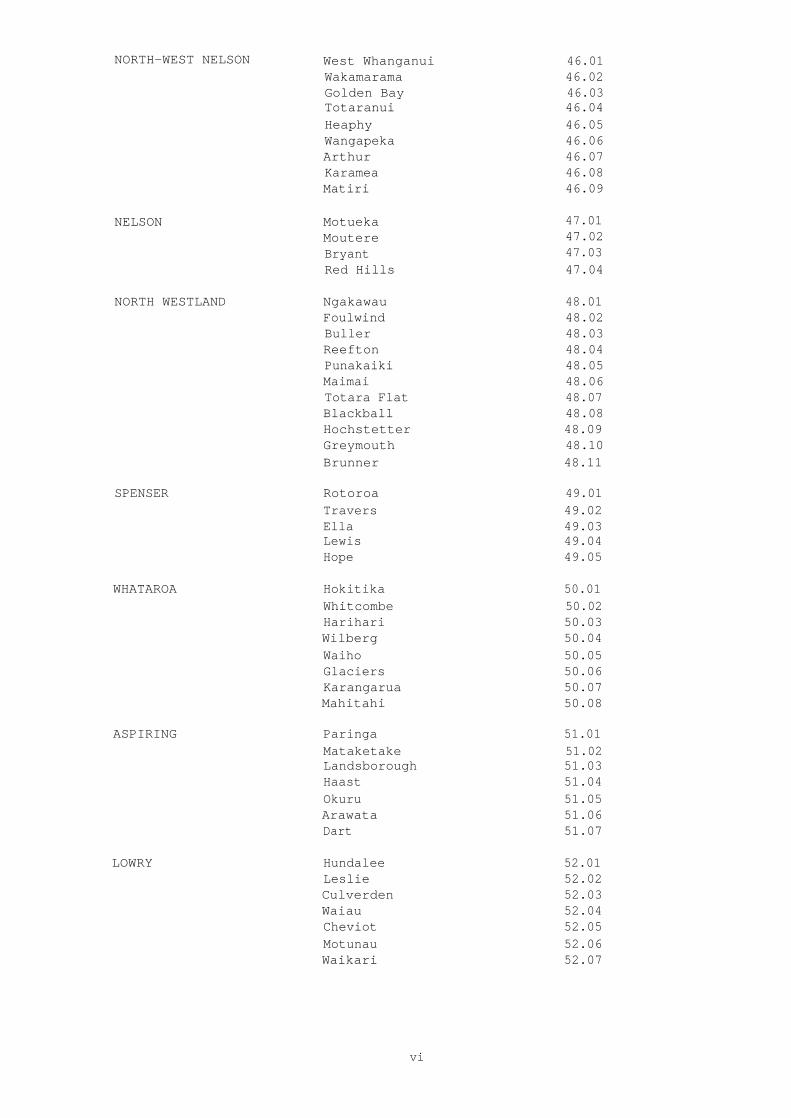
NORTH-WEST NELSON West Whanganui 46.01Wakamarama 46.02Golden Bay 46.03Totaranui 46.04Heaphy 46.05Wangapeka 46.06Arthur 46.07Karamea 46.08Matiri 46.09
NELSON Motueka 47.01Moutere 47.02Bryant 47.03Red Hills 47.04
NORTH WESTLAND Ngakawau 48.01Foulwind 48.02Buller 48.03Reefton 48.04Punakaiki 48.05Maimai 48.06Totara Flat 48.07Blackball 48.08Hochstetter 48.09Greymouth 48.10Brunner 48.11
SPENSER Rotoroa 49.01Travers 49.02Ella 49.03Lewis 49.04Hope 49.05
WHATAROA Hokitika 50.01Whitcombe 50.02Harihari 50.03Wilberg 50.04Waiho 50.05Glaciers 50.06Karangarua 50.07Mahitahi 50.08
ASPIRING Paringa 51.01Mataketake 51.02Landsborough 51.03Haast 51.04Okuru 51.05Arawata 51.06Dart 51.07
LOWRY Hundalee 52.01Leslie 52.02Culverden 52.03Waiau 52.04Cheviot 52.05Motunau 52.06Waikari 52.07

vii
HAWDON Minchin 53.01Arthur's Pass 53.02
PUKETERAKI Sumner 54.01Poulter 54.02Cass 54.03Torlesse 54.04Craigieburn 54.05Coleridge 54.06
CANTERBURY FOOTHILLS Ashley 55.01Oxford 55.02Whitecliffs 55.03
CANTERBURY PLAINS High Plains 56.01Low Plains 56.02Ellesmere 56.03
BANKS Port Hills 57.01Herbert 57.02Akaroa 57.03
D'ARCHIAC Browning 58.01Armoury 58.02Mt Cook 58.03
HERON Mathias 59.01Mt Mutt 59.02Arrowsmith 59.03Hakatere 59.04Two Thumb 59.05
TASMAN Godley 60.01Dobson 60.02
PAREORA Orari 61.01Fairlie 61.02Geraldine 61.03Hunters 61.04Waimate 61.05Hakataramea 61.06
WAINONO Makikihi 62.01Glenavy 62.02Oamaru 62.03
MACKENZIE Tekapo 63.01Pukaki 63.02Ben Ohau 63.03Grampians 63.04Ahuriri 63.05Omarama 63.06Benmore 63.07
WAITAKI Kirkliston 64.01St Mary 64.02Hawkdun 64.03St Bathans 64.04

viii
KAKANUI Duntroon 65.01Dansey 65.02Waianakarua 65.03
LAKES Huxley 66.01Wanaka 66.02Richardson 66.03Shotover 66.04Remarkables 66.05
CENTRAL OTAGO Lindis 67.01Pisa 67.02Dunstan 67.03Maniototo 67.04Old Man 67.05Manorburn 67.06Rock and Pillar 67.07
LAMMERLAW Macraes 68.01Waipori 68.02Tapanui 68.03Lawrence 68.04
OTAGO COAST Waikouaiti 69.01Dunedin 69.02Tokomairiro 69.03Balclutha 69.04
CATLINS Waipahi 70.01Tahakopa 70.02
OLIVINE Cascade 71.01Pyke 71.02
FIORD Darran 72.01Doubtful 72.02Te Anau 72.03Preservation 72.04
MAVORA Livingstone 73.01Eyre 73.02Upukerora 73.03
WAIKAIA Nokomai 74.01Umbrella 74.02
GORE Gore 75.01
SOUTHLAND HILLS Takitimu 76.01Taringatura 76.02Hokonui 76.03
TE WAE WAE Waitutu 77.01Tuatapere 77.02Longwood 77.03
MAKAREWA Southland Plains 78.01Waituna 78.02
ix
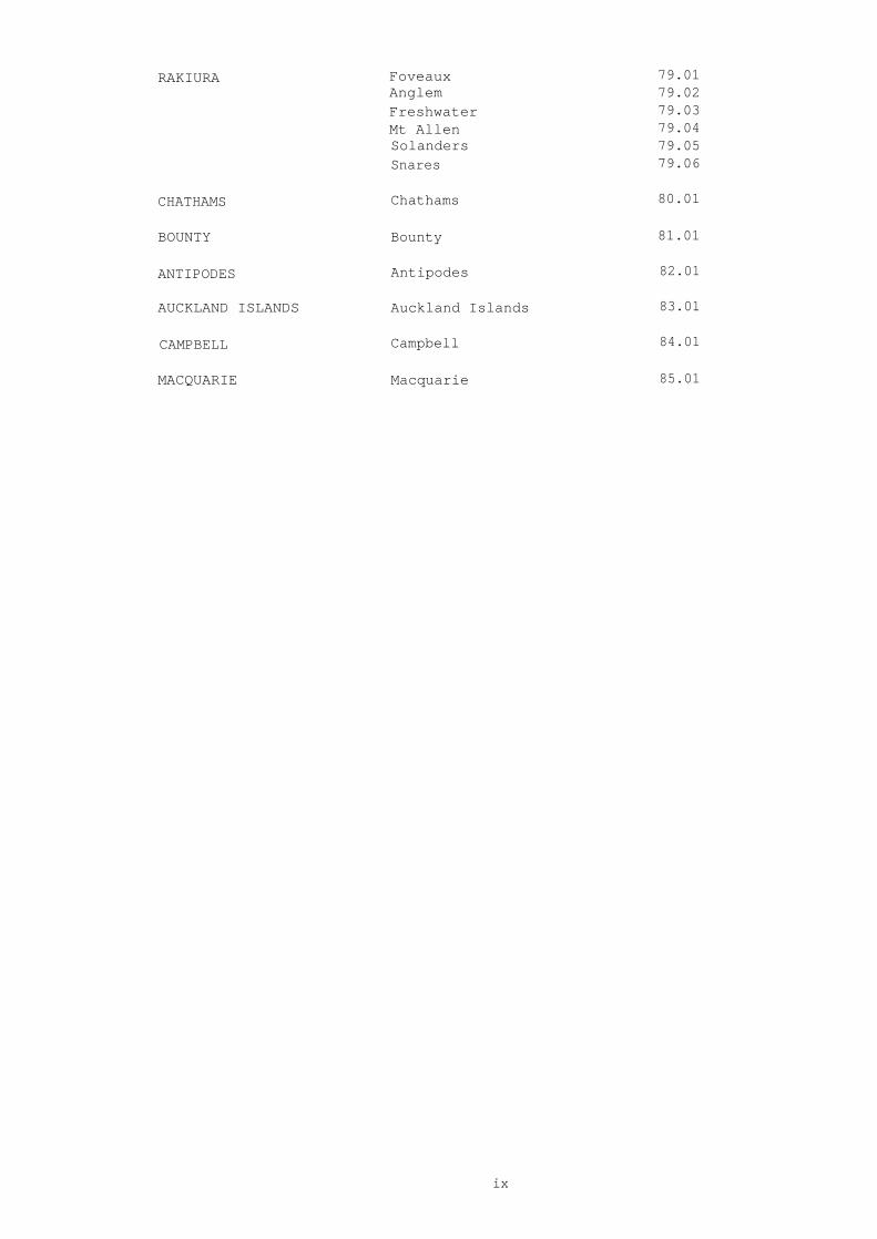
RAKIURA Foveaux 79.01Anglem 79.02Freshwater 79.03Mt Allen 79.04Solanders 79.05Snares 79.06
CHATHAMS Chathams 80.01
BOUNTY Bounty 81.01
ANTIPODES Antipodes 82.01
AUCKLAND ISLANDS Auckland Islands 83.01
CAMPBELL Campbell 84.01
MACQUARIE Macquarie 85.01

INTRODUCTION
"A sense of identity or place develops where an individual grows upwithin a particular province and learns to recognise its flora andfauna, to respond to its climatic regime, to become familiar with itslimits. Many serious land use blunders could have been avoided ifpeople had not tried to transplant land-use practices developed withinone biotic province to the differing ecological conditions ofanother."
Raymond Dasmann, 1976, Biogeographical Provinces, Understanding WholeSystems; the Co Evolution Quarterly.
Background
New Zealand's physical environment is extremely diverse and this diversityis reflected in the indigenous plant and animal communities (ecosystems).The concept of dividing New Zealand into a series of Ecological Regions andDistricts evolved because of the need for the establishment of arepresentative system of reserves which would encompass this ecologicaldiversity. One purpose of the Reserves Act 1977, is to ensure the
"preservation of representative samples of all classes of naturalecosystems and landscapes which in the aggregate originally gave NewZealand its own recognisable character."
(Section 3(1) (b))
Before this could be done a framework on which to define representativenesswas necessary. In the late 1970s Mr John Nicholls, then forest ecologistwith the New Zealand Forest Research Institute, Rotorua, pioneered the ideaof ecological districts grouped within an ecological region. He proposedthe division of a large area in North Westland (defined as the NORTHWESTLAND Ecological Region) into eleven smaller parts (EcologicalDistricts) as a framework for the selection of forest reserves (EcologicalAreas) by the Scientific Co-ordinating Committee. Each ecological districtis a unique unit with its own distinctive general pattern of ecosystemsand special features. Together they form an ecological region with its ownbroad ecological character, differing in many ways from those of itsneighbouring regions.
Definitions
Ecological District:
The definition of an ecological district depends on a thoroughconsideration of the topography, geology, climate, soils, vegetation andman-induced modifications of the area (Nicholls, 1979).
Thus anecological district is a local part of New Zealand where the topographical,geological, climatic, soil and biological features, including the broadcultural pattern, produce a characteristic landscape and range ofbiological communities (Park et al., 1983).
Ecological Region:
An aggregation of adjacent ecologicl districts with very closely relatedcharacteristics together form an ecological region. In some cases, asingle very distinctive ecological district is given the status ofecological region to emphasise its uniqueness (Park et al., 1983).
x

The Biological Resources Centre and the Ecological Regions and DistrictsProject
The concept of ecological regions and districts was embraced by the NewZealand Biological Resources Centre which co-ordinated the mapping ofthe country into over 260 districts in 1982. Many different scientistswere involved in this exercise, with DSIR Botany Division scientists,Dr Ian Atkinson and Dr Brian Molloy, overall convenors for the North andSouth Island respectively.
First edition maps of ecological regions and districts were produced andcirculated widely, together with a publication describing the concept andcalling for submissions (Simpson, 1982). Many of the suggested changeswere incorporated into second edition maps which were produced as anoverlay series (Biological Resources Centre, 1983). Since then furtherrefinements have been made to the region and district boundaries,particularly as a result of surveys made under the Protected Natural AreasProgramme, and these are shown in the present edition.
Other Uses of the Ecological Region and District Framework
a national scale of theprovince".
This concept has been widelyUnion for the Conservation of Nature andvaluble scientific tool for nature
Ecological regions and districts are refinements atconcept of the "biogeographicpromoted by the InternationalNatural Resources (IUCN) as aconservation planning.
The ecological regions and districts system is already in use, for example,in the Register of Protected Natural Areas (Department of Lands and Survey,1984), and in the Protected Natural Areas Programme (under the auspices ofthe National Parks and Reserves Authority). However the ecological regionsand districts framework has potential values which go well beyond itsoriginal purpose as a basis for designing a representative system ofprotected natural areas throughout New Zealand. For example the concepthelps to make people aware of the natural areas that make their owndistrict unique and can help to promote the feeling of local identity (asense of place), the awareness of landscape and the stewardship of localand national heritage values. It can also be used in many practical waysto organise, record and retrieve biological and other resource information;to aid in land use planning; and as an educational tool.
xi
There are four maps at 1:500,000 scale. The ecological region and districtboundaries have been printed on Department of Lands and Survey NZMS 242topographic maps.
Sheet 1
The northern North Island including ecological descriptions andprescriptions of 29 ecological districts: from KermadecE.D. and Three Kings E.D. in the north (not shown on map)to Mayor E.D. in the south.
Sheet 2
The central North Island including ecological descriptions andprescriptions of 55 ecological districts: from Meremere E.D. inthe north to Eastern Hawkes Bay E.D. in the south.
Sheet 3
Central New Zealand including ecological descriptions andprescriptions of 84 ecological districts: from Eastern WairarapaE.D. in the north to Akaroa E.D. in the south; also includesChathams E.D.
(not shown on map).
Sheet 4
The southern South Island including ecological descriptions andprescriptions of 100 ecological districts (plus parts ofCANTERBURY Low Plains and High Plains): from Browning E.D. inthe north to Snares E.D. in the south; also includes Bounty,Antipodes, Auckland Islands, Campbell and Macquarie E.D.'s (notshown on map).
xii
THE MAPS

Prescriptions
Brief prescriptions, summarising the ecological character of each of theecological districts, are printed on the map surface of each map.
Descriptions
Ecological descriptions of each district on Sheet 1 are included in thisbooklet.
They have been compiled giving a broad picture of thedistrict in terms of topography, geology, climate, soils, vegetation andmodifications; information about flora and fauna with special conservationor scientific value is included where this is known. Descriptions vary inlength depending on the district's size and complexity and the amount ofinformation which has been compiled. The descriptions are compiled under aseries of headings as follows:
Criteria: a statement at the beginning of each description lists thecriteria on which the district has been defined, in the order of importancewhere it is possible to determine this. Criteria consist of one or more ofthe features of the district which distinguish it from neighbouringdistricts.
GEOLOGY: the descriptions of geology were compiled using New ZealandGeological Survey (DSIR) geological maps (scale 1:250,000), and edited byregional geologists from the New Zealand Geological Survey.
CLIMATE:
for most districts the climate description is based on the NewZealand Meteorological Service map "New Zealand Climate Regions (scale1:2,000,000)"; temperatures (cool, warm etc.) generally refer to thelowlands in districts which include a wide altitudinal range. The rainfallranges are from the New Zealand Meteorological Service "Mean AnnualRainfall (1941-70)" maps (scale 1:500,000 ). Other climate information wasincluded when provided by ecologists with local knowledge.
SOILS: descriptions of soils for most districts (apart from some islanddistricts), were written by Mr Des Cowie, formerly of the New Zealand SoilBureau; they have been shortened for inclusion here. The descriptionsdeliberately avoid the use of descriptive soil names (e.g. yellow-brownearth) and instead attempt to describe the soils in ecological terms.
TOPOGRAPHY/VEGETATION: most of the information in these sections wasprovided by a large number of plant ecologists. In the north of the NorthIsland the main contributors were Mr John Nicholls (formerly F.R.I., NZForest Service) and Dr Bruce Clarkson (DSIR Botany Division, (BD) ). DrIan Atkinson (BD) was responsible for the south of the North Island as wellas the outlying and offshore islands off the North Island. Dr Brian Molloy(BD) was responsible for the north of the South Island with othercontributors including Dr Peter Williams (BD), Dr Philip Simpson(Commission for the Environment, now Department of Conservation), Dr GeoffPark (Biological Resources Centre, now DOC), and Dr Peter Wardle (BD). DrPeter Johnson (BD) was responsible for the south of the South Island withother contributors including Dr Ralph Allen (BD), Dr Collin Meurk (BD), andProfessor Alan Mark (Otago University). Other contributors include MrGeoff Kelly (BD), Mr Hugh Wilson, Mr Chris Jenkins (NZ Forest Service), MrRowly Taylor (DSIR Ecology Division), Mr Henk Stengs (NZ Forest Service),Dr Colin Burrows (Canterbury University), Mr Colin Ogle (NZ WildlifeService), Mr Willie Shaw (Forest Research Institute), Mr Mike Page (MOWD),Dr Niel Mitchell (Auckland University), Mr Geoff Rogers (VictoriaUniversity), Mr Ash Cunningham (NZ Forest Service), Mr Geoff Walls (BD), MrWarren Burke, Dr John Wardle (FRI), Ms Cathy Brumley, Dr Kathy Dickenson,Ms Maggie Bayfield, Mrs Margaret Bulfin (BD) and Mr Pat Burstall (WildlifeService).
xiii
MODIFICATIONS: include changes to indigenous ecosystems caused by farming,forestry, urban and other developments and by introduced plants andanimals. Land uses were taken from "The New Zealand Atlas" (GovernmentPrinter, 1976) and checked by local ecologists. Introduced mammals such asrodents, rabbits, mustelids, possums, and deer are widespread and notalways mentioned; their absence may be a more notable ecological featurethan their presence. In some cases modifications are described togetherwith the vegetation section.
FLORA: where contributors mentioned any special elements of the flora of adistrict these were included. In some cases flora is combined with thevegetation section.
FAUNA: most animal information is restricted to species considered to beimportant in terms of nature conservation. Information about indigenousanimals has come from a wide variety of sources.
MAMMALS: only bats and marine mammals are included. The short-tailed batbelongs to an endemic family Mystacinidae, and is classified as vulnerablein "The Red Data Book of New Zealand" (Nature Conservation Council, 1981 );It is mentioned where it has been positively identified in recent years.The long-tailed bat is an endemic species of a southern hemisphere familyand is widespread in suitable habitats; it is only mentioned in districtswhere the population is isolated. Dr Mike Daniel (DSIR Ecologuy Division)provided bat information (Daniel, M.J. and Williams, G.R. 1984 "A Survey ofthe Distribution, Seasonal Activity and Roost Site of New Zealand Bats,"New Zealand Journal of Ecology 7:9-25)Marine mammals are mentioned if they breed in the district or are presentin large numbers. Much of the information was provided by Mr Rowly Taylor(DSIR Ecology Division). Breeding localities of New Zealand fur seals wereobtained from Crawley, M.C. and Wilson G.J., 1976 "The Natural History andBehaviour of the New Zealand Fur Seal ( Arctocephalus forsteri )," Tuatara22:1.29.
Introduced mammals are mentioned in the MODIFICATIONS section.
BIRDS: only certain groups of birds are mentioned, including kiwi, seabird colonies, endemic ducks, falcon, crakes, large congregations ofwaders, kaka, parakeets, kea, Rock Wren, Yellowhead and Fernbird; otherbirds are mentioned where they occur close to the limits of their range,or show other peculiarities of distribution.
Mr Sandy Bartle (NationalMuseum) contributed much of the bird information, especially about theNorth Island and north of the South Island and Mr Tony Whitaker added birdinformation for the rest of the country. Bird distributions were obtainedfrom the Ornithological Society of New Zealand's "Atlas of BirdDistributions in New Zealand", the "New Guide to the Birds of New Zealand"(Collins), the "Complete book of New Zealand Birds" (Readers Digest),Notornis, 1976-86 and a variety of papers and reports. Additional birdinformation was received from Mr Paul Sagar and Mr Wynston Cooper (bothOrnithological Society of New Zealand) and Mr John Atkinson (Lands andSurvey).
REPTILES AND FROGS:
Mr Whitaker also provided information aboutindigenous reptiles and frogs. Reptiles considered to be widespread andcommon are only mentioned where they occur at the limits of their range,show other pecularities of distribution or are distinctive or peculiar inother ways. Information was obtained from the NZ Wildlife Service'samphibian and reptile distribution mapping scheme, a variety of papers (see
Reptiles in Glossary) and some personal observations by Mr Whitaker. DrBen Bell (Victoria Univeristy) provided additional frog information.
xiv
FISH:
information about fresh-water fish was obtained from Dr BobMcDowell (MAF, Fisheries Research Division).
Only indigenous fish listedin "The Red Data Book of New Zealand" (Nature Conservation Council, 1981)are included.
INVERTEBRATES: information was compiled by Ms Jojette Drost (whileemployed by the National Museum) from a large number of sources; furtherinformation was added by Ms Cath Walker (NZ Wildlife Service), Mr FrankClimo (National Museum) and Mr Graeme Ramsay (DSIR Entomology Division).
Acknowledgements
The Biological Resources Centre acknowledges the help of all thesecontributors and also others whose names may have been omittedinadvertently. Without the assistance of so many experts the task ofcompiling the descriptions of the 268 Ecological Districts would have takenmany years.
Special thanks are due to Mrs Karen Lewis who typed mostof the extensive manuscript and made the numerous corrections andalterations with unending patience.
Future Amendments
In such a large project there are certain to be errors both of omission andof fact or interpretation. If you know any corrections or additionalinformation which could be used to improve this work, please forward themto the Biological Resources Centre for inclusion in future editions of thismap series.
It is expected that further refinements to ecological region and districtboundaries will be made in future, especially in the course of surveys madeunder the Protected Natural Areas Programme.
xv

GLOSSARY AND EXPLANATION OF TERMS
General
Certain words have been used in the text to mean specific things:
"Original" refers to conditions prior to the arrival of Polynesian manin New Zealand; original conditions are only included when they are wellknown.
"Former" refers to conditions at the time of European settlement, about1840.
"Treeline" refers to the "timberline" of other authors, indicating theupper altitudinal limit of tree growth.
"Remnant" refers to vegetation or animal populations which are diminishedfrom their former size because of the influence of man.
"Scattered patches" refers to vegetation types which were once extensivebut are now reduced to small areas because of natural change, e.g. climatechange.
"Offshore islands" are within 50 km from the New Zealand mainland.
"Outlying islands" are further than 50 km from the New Zealandmainland.
"Pakihi" refers to dense low cover of sedges, umbrella fern, rushes and lowgrowing shrubs and herbs on level water-logged country.
"Endemic" refers to plants and animals which are restricted to a certainarea; in this case usually one or several Ecological Districts.
"Indigenous" means native.
"Exotic" means introduced, as opposed to indigenous, usually referring topine plantations.
Abbreviations
a.s.l.
above sea levelE.A.
Ecological AreaE.D.
Ecological DistrictE.R. Ecological RegionL.
LakeN, S, E and W etc.
North, South, East and West etc.p.a.
per annumR.
RiverS.F.
State ForestStm
Stream
xvi
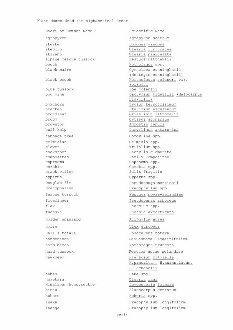
Plant Names Used (in alphabetical order)
Maori or Common Name Scientific Name
agropyron Agropyron scabrum
akeake Dodonea viscosa akepiro Olearia furfuracea akiraho Olearia paniculata alpine fescue tussock Festuca matthewsii beech Nothofagus spp. black maire Gymnelaea cunninghamii (Nestegis cunninghamii) black beech Northofagus solandri var. solandri blue tussock Poa colensoi bog pine Dacrydium bidwillii (Halocarpus bidwillii) boxthorn Lycium ferrocissimum bracken Pteridium esculentum broadleaf Griselinia littoralis broom Cytisus scoparius browntop Agrostis tenuis bull kelp Durvillaea antarctica
cabbage tree Cordyline spp.
celmisias Celmisia spp. clover Trifolium spp. cocksfoot Dactylis glomerata composites Family Compositae coprosma Coprosma spp. corokia Corokia spp. crack willow Salix fragilis cyperus Cyperus spp.
Douglas fir Pseudotsuga menziesii dracophyllum Dracophyllum spp.
fescue tussock Festuca novae-zelandiae
fivefinger Pseudopanax arboreus flax Phormium spp.
fuchsia Fuchsia excorticata
golden spaniard Aciphylla aurea
gorse Ulex europeus
Hall's totara Podocarpus totara
hangehange Geniostoma ligustrifolium
hard beech Nothofagus truncata
hard tussock Festuca novae zelandiae
hawkweed Hieracium pilosella H.pracaltum, H.aurantiacum, H.lachenalii
hebes Hebe spp. heketara Olearia rani Himalayan honeysuckle Leycesteria formosa hinau Elaeocarpus dentatus
hohere Hoheria spp.
inaka Dracophyllum longifolium
inanga Dracophyllum longifolium
xviii

kahikatea Podocarpus dacrydioides (Dacrycarpus dacrydioides) kaikawaka Libocedrus bidwillii kaikomako Pennantia corymbosa kamahi Weinmannia racemosa kanuka Leptospermum ericoides (Kunzea ericoides) karaka Corynocarpus laevigatus karamu Coprosma australis karo Pittosporum crassifolium kauri Agathis australis karaka Libocedrus plumosa kawakawa Macropiper exelsum Kermandec pohutukawa Metrosideros kermandecensis
kiekie Freycinetia banksii kohekohe Dysoxylum spectabile kohuhu Pittosporum tenuifolium koromiko Hebe spp.
kowhai Sophora spp.
lacebark Hoheria populnea
lancewood Pseudopanax crassifolius larch Larix decidua leatherwood Olearia spp.
lemonwood Pittosporum eugenioides
mahoe Melicytus ramiflorus maire Gymnelaea spp. (Nestegis spp.) mamaku Cyathea medullaris mangeao Litsea calicaris mangroves Avecinnia resinifera manuka Leptospermum scoparium mapau Myrsine australis marbleleaf Carpodetus serratus marram Ammophila arenaria matagouri Discaria toumatou matai Podocarpus spicatus microlaena Microlaena spp. mingimingi Coprosma propinqua miro Podocarpus ferrugineus mistletoe Family Loranthaceae mountain beech Nothofagus solandri var. solandri mountain flax Phormium cookianum mountain lacebark Hoheria glabrata
mountain toatoa Phyllocladus alpinus
narrow-leaved lacebark Hoheria angustifolia
narrow-leaved snow tussock Chionochloa rigida native broom Carmichaelia spp. ngaio Myoporum laetum nikau Rhopalostylis sapida niggerhead Carex secta
northern rata Metrosideros robusta
pate Schefflera digitata
pampas grass Cortaderia spp. pine Pinus spp. pigeonwood Hedycarya arborea pigmy pine Dacrydium laxifolium (Lepidothamnus laxifolius) pingao Desmoschoenus spiralis
pink pine Dacrydium biforme
xix

(Halocarpus biformis)
praire grass Bromus carthaticus pohuehue Meuhlenbeckia complexa pohutukawa Metrosideros excelsa pokaka Elaeocarpus hookerianus ponga Cyathea dealbata Poor Knights ngaio Myoporum laetum var. decumbenspukatea Laurelia novae-zelandiae puriri Vitex lucens
putaputaweta Carpodetus serratus
quintinia Quintinia spp.
rarekau Coprosma australis
rata Metrosideros spp. raupo Typha orientalis red beech Nothfagus fusca red tussock Chionochloa rubra restiad Family Restionaceae rewarewa Knightea excelsa ribbonwood Hoheria glabrata or Plagianthus betulinus rimu Dacrydium cupressinum rush Family Juncaceae
ryegrass Lolium spp.
scabweed Raoulia spp.
sedge Family Cyperaceae silver beech Nothofagus menziesii silver fern Cyathea dealbata silver pine Dacrydium colensoi (Lagarostrobos colensoi) silver tussock Poa laevis slim snow tussock Chionochloa macra sorrel Rumex spp.
southern rata Metrosideros umbrellata
snow totara Podocarpus nivalis snow tussock Chionochloa spp. spaniard Aciphylla spp. supplejack Ripogonum scandens swamp maire Eugenia maire (Syzygium maire) sweet brier Rosa rubiginosa
sweet vernal Anthoxanthum odoratum
tanekaha Phyllocladus trichomanoides
taraire Beilschmiedia tarairi tarata Pittosporum eugenioides tawa Beilschmiedia tawa tawari Ixerba brexioides tauhinu Cassinia leptophylla taupata Coprosma repens tawapou Planchonella novo-zelandica tawaroa Beilschmiedia tawaroa (ref. Wright 1984, NZ J.Bot.22(1)) thyme Thymus spp. titoki Alectryon excelsus toatoa Phyllocladus glaucus toetoe Cortaderia spp.
xx

toro Myrsine salicina totara Podocarpus totara towai Weinmannia silvicola tree lupin Lupinus arboreus tree mallow Lavatera arboria
tutu Coriaria spp.
umbrella fern Gleichenia spp.
whau Entelia arborescens
white maire Gymnelaea lanceolata (Nestegis lanceolata) wineberry Aristotelia serrata
wire rush Empodism minus
yellow silver pine Dacrydium intermedium
(Lepidothamnus intermedius)
Mammal Names Used (in alphabetical order) Common Name Scientific Name
bats Chalinobus tuberculatus or Mystacina tuberculata black rat Rattus rattus bush wallabies Macropus rufogriseus cattle Bos taurus cats Felis catus chamois Rupicapra rupicapra deer Cervus spp. etc. dolphins Family Delphinidae elephant seal Mirounga leonina fallow deer Dama dama ferret Mustela putorius fur seal Arctocephalus forsteri goats Capra hircus hares Lepus europaeus Hooker's sealion Phocarctos hookeri horses Equus caballus leopard seal Hydrurga leptonyx lesser short-tailed bat Mystacina tuberulata tuberculata
long-tailed bat Chalinobus tuberculatus mice Mus musculus mustelids Mustela spp. New Zealand fur seal Arctocephalus forsteri Norway rat Rattus norwegicus pigs Sus scrofa Polynesian rat Rattus exulans possums Trichosurus vulpecula rabbits Oryctolagus cuniculus rats Rattus spp.red deer Cervus elaphus sea leopard Hydrurga leptonyx short-tailed bat Mystacina tuberculata
stoats Mustela ermina
tahr Hemitragus jemlahicus wallabies Macrocopus spp. wapiti Cervus canadensis whales Cetaceans whitetail deer Odocoileus virginianus
xxi
Birds
Only common names have been used for birds. Scientific names can be foundin the "Annotated Checklist of the Birds of New Zealand" by the ChecklistCommittee (F.C. Kinsky, Convenor), Ornithological Society of N Z Inc.A.H. and A.W. Reed, 1970. Capital letters are used for full commonnames, e.g. Red-crowned Parakeet; small letters are used for generalisedcommon names, e.g. parakeets.Some commonly used abbreviations are followed e.g. SIPO for South IslandPied Oystercatcher.
Reptiles
Both common and scientific names have been used in the text. Nomenclaturefollows several authorities:
Hardy, G.S. 1977: The New Zealand Scincidae (Reptilia:Lacertilia); ataxonomic and zoogeographic study. New Zealand Journal of Zoology4:221-325
McCann, C. 1955: The lizards of New Zealand. Gekkonidae and Scincidae.Dominion Museum Bulletin No 17. 127p.
Robb, J. 1980: Three species of gekkonid lizards, genera HoplodactylusFitzinger and Heteropholis Fischer, from New Zealand. NationalMuseum of New Zealand records 1:305-310
Robb, J.; Rowlands, R.P.V. 1977: Reinstatement of Hoplodactylusmaculatus (Boulenger) with redescription of _H .
pacificus (Gray)(Reptilia:Squamata:Gekkonidae). Records of the Auckland Institute andMuseum 14:133-142
Robb, J.; Hitchmough, R.A. 1980:
Review of the genus Naultinus Gray(Reptilia:Gekkonidae). Records of the Auckland Institute and Museum16:189-200
Thomas, B.W. 1981: Hoplodactylus rakiurae n.sp. (Reptilia:Gekkonidae)from Stewart Island, New Zealand, and comments on the taxonomic statusof Heteropholis
nebulosus McCann. New Zealand Journal of Zoology8:33-47
Whitaker, A.H. 1984: Hoplodactylus kahutarae n.sp.(Reptilia:Gekkonidae) from the Seaward Kaikoura Range, Marlborough,New Zealand. New Zealand Journal of Zoology 11:259-270
Frogs
Both common and scientific names are given in the text.
Fish
Both common and scientific names are given in the text.
Invertebrates
Information about invertebrates is very varied. Mainly large conspicuousspecies are included; in particular large wetas, cicadas, beetles andland snails. Scientific names (where known) are given in the text.
N.B. Snails: refers to land snails only.
xxii

ECOLOGICAL DISTRICT DESCRIPTIONS
On the following pages are ecological descriptions of the 55 ecological districts from Meremere (11.01) to Eastern Hawkes Bay (34.01)
1

MEREMERE ECOLOGICAL DISTRICT
Criteria: topography, important wetland areas.
TOPOGRAPHY: well-defined interior basin with alluvial flats, swamps, including Whangamarino Swamp, several shallow lakes, plus wetlands bordering lower reaches of Waikato R.
GEOLOGY: mostly Holocene river and swamp deposits with some Pleistocene basalts near Pukekawa and Mercer; Miocene to Oligocene calcareous sandstone and siltstone form elevated ridges, particularly in the SW;
CLIMATE: warm humid summers with persistent westerly winds, mild winters; rainfall 1200-1400mm p.a.
SOILS: on flattish and rolling slopes soils mainly clayey textured but friable and well drained from old strongly weathered volcanic ash; more silty volcanic ash soils from younger, less weathered ashes in the S; on river flats and swamps poorly drained, gleyed alluvial and peaty soils occur; weakly to moderately leached soils from sedimentary rocks in small areas of hill country; limited areas of reddish volcanic loam soils from basaltic lava and scoria in the N.
VEGETATION: former forest of drier country reduced to very few small remnants; former kahikatea forest around wetlands also now rare remnants, greatly modified; sub-fossil kauri forest remains occur in swamps in the N; kauri quite common in forest remnants; taraire also common in remnants, especially near Onewhero, close to its southern limit in the W.
FLORA: Whangamarino Swamp important, much (7700 ha) remains undeveloped: supports several known threatened plants, Lycopodium serpentinum, Utricularia delicatula, 2 other Ultricularia spp., Corybas unguiculatus, C. fordhamii (C. carsei auct. N.Z.), Gratiola sexdentata. Other threatened plants of district include pingao (Port Waikato), king fern (Marattia salicina) (Colebaker Scenic Reserve), Sporodanthus (Opuataia Swamp).
BIRDS: at least 56 species of bird at Whangamarino Swamp including largest N.Z. breeding population of Australasian Bittern, high numbers of Fernbird and Spotless Crake, also Marsh Crake, Brown Teal (introduced), N.Z. Dabchick and Banded Rail. High population of Banded Rail also at Waikato Heads. N.Z. Shoveller and Grey Teal occur on lakes and in swampy areas along Waikato R.
FISH: include rare black mudfish (Neochanna diversus) and giant kokopu (Galaxias argenteus).
MODIFICATIONS: farms in the W (intensive sheep and cash crops), open cast coal mining.
2

HAPUAKOHE ECOLOGICAL DISTRICT 11.02
Criteria: topography, geology and soils.
TOPOGRAPHY: Hapuakohe Range reaching 535m a.s.l., the drier Hangawera Hills in the S, and low rolling country to the N.
GEOLOGY: includes Jurassic sandstone and siltstone hills; Miocene to Oligocene sandstones and siltstones with some andesitic volcanics and Quaternary sediments in the S and N; small areas of Oligocene claystone and mudstone with coal seams near Maramarua.
CLIMATE: warm,dry summers with persistent westerlies, mild winters; rainfall 1200-1600mm p.a., with winter maximum.
SOILS: dominantly clay textured podzolised soils with impeded drainage from strongly weathered sedimentary rocks under forest with high proportion of kauri on hilly and steep slopes; small areas of clayey but friable, well drained loam soils from old, strongly weathered ashes and well drained friable volcanic ash soils from younger volcanic ash on flattish to rolling land in the N.
VEGETATION: some unlogged forest remnants occur on higher parts of range, small remnants on lower country including regenerating forest in scrub, mixed podocarp-hardwood forest with local kauri, hard beech; rare taraire throughout strongly modified eastern margin of hill country. Sub-fossil kauri forest remains occur in swamps in the N.
BIRDS: kokako present in Hapuakohe Range.
MODIFICATIONS: much of the district farmed (intensive sheep grazing), exotic forest plantations in the NW.
3

HAURAKI ECOLOGICAL DISTRICT 11.03
Criteria: topography, geology.
TOPOGRAPHY/GEOLOGY: alluvial lowlands and swamplands of Hauraki Plains including Holocene swamp and peat deposits, fluviatile pumice deposits and extensive ash deposits; part of Hauraki Graben.
CLIMATE: warm humid summers, heavy frosts in winter; rainfall 1200mm p.a. with winter maximum.
SOILS: gley soils mainly clay textured with high water-tables, some areas subject to periodic flooding and accumulation of fresh alluvium, natural fertility high but heavy textures and waterlogging in winter limit intensive use; extensive areas of deep acid peaty soils in low-lying parts where water-table is high for most of year, raised peat bogs have developed; less acid peaty soils occur where there has been periodic admixture of river alluvium.
VEGETATION/MODIFICATIONS: originally kahikatea swamp forest, cabbage tree forests and swampland; mangroves around the Firth of Thames total 663 ha. Much of district now drained, intensive river control; largely farmed (intensive dairying, some with sheep or cattle grazing); many small kahikatea remnants, mostly very modified.
FLORA: district includes Kopuatai Peat Dome between Piako and Waitoa Rivers, a valuable wetland supporting one of three remaining stands of Sporadanthus traversii (the greater wire rush) and a valuable kahikatea forest remnant; also contains Lycopodium serpentinum and 3 species of Utricularia. King fern (Marattia salicina) occurs in Kaihere Scenic Reserve; Calochilus robertsonii in the Torehape peat mining area.
BIRDS: the W and S sides of the Firth of Thames are an important locality for wading birds (up to 30,000), including Wrybill and Arctic breeding migrants; main roosting areas are the coast between Kaiaua and Miranda, the mouth o£ Waitakaruru R., the Piako roosts; northernmost breeding locality of Black-billed Gull occurs in district; Fernbirds occur at Kopuatai.
FISH: black mudfish (Neochanna diversus) occur in mineralised swamp areas of Kopuatai.
4

5
HAMILTON ECOLOGICAL DISTRICT 11.04
Criteria: topography (low altitude) and geology.
TOPOGRAPHY/GEOLOGY: major inland basin: alluvial plains with extensive Holocene peatlands and minor lakes; Quaternary sedimentaries include pumiceous sand, silt and gravel with interbedded peat; part of the Hinuera surface - old alluviums carried down by ancestral Waikato R. from central volcanic plateau.
CLIMATE: warm humid summers, heavy frosts in winter; rainfall 1100-1400mm p.a. with winter maximum; little wind.
SOILS: volcanic ash soils formed largely from rewashed rhyolitic ash on terraces, natural drainage ranges from good to poor; poorly drained peaty soils in large swamps such as Rukuhia and Moana, generally acid but more yellow peats occur where there has been some admixture of alluvium; limited areas of clayey, but well structured, well drained soils from old, strongly leathered ashes on rolling and hilly slopes.
VEGETATION: formerly largely bogs, scrub and fernland, small areas of swamp forest; now many small remnants of kahikatea-dominant forest, some with totara.
FLORA: Moanatuatua bog is a remnant of restiad bog in which porodanthus :s a leading dominant; Corybas carsei auct. N.Z. also probably
BIRDS: include Dabchick on small lakes, also N.Z. Scaup.
REPTILES: speckled skink (Leiolopisma infrapunctatum) collected near Ngahinapouri (northern limit; only other North I. sites in Kaiangaroa, Eastern Hawkes Bay and Wairarapa Plains E.D.).
FISH: include black mudfish (Neochanna diversus), and giant kokopu (Galaxias argenteus).
MODIFICATIONS: almost entirely farmed (intensive dairying, some with sheep or cattle); some horticulture; includes Hamilton city.

HINUERA ECOLOGICAL DISTRICT 11.05
Criteria: topography, soils and land use.
TOPOGRAPHY/GEOLOGY: inland basin: mostly Pleistocene and undifferentiated alluvium and peat infilling southern part of Thames Valley; part of Hinuera Surface - old alluviums carried down by ancestral Waikato R. from central volcanic plateau.
CLIMATE: warm humid summers, moderate winters, colder in the S; rainfall 1000-1400mm p.a. with winter maximum.
SOILS: well drained, friable rhyolitic ash soils on rolling and hilly land, from airfall ash. On river flats the ash has been rewashed and poorly drained gleyed soils, often with peaty layers, predominate; brown granular clays on old andesitic cones (near Morrinsville); peat soils on margins of raised peat bogs.
VEGETATION/MODIFICATIONS: formerly mainly fernland and local swamps with rare pockets of forest; now almost entirely farmed (mostly intensive dairying, some with sheep or cattle; intensive sheep grazing and crops in the SE); a few small remnants of kahikatea forest exist, with young kahikatea and totara.
6

MAUNGATAUTARI ECOLOGICAL DISTRICT 11.06
Criteria: topography, geology
TOPOGRAPHY: block of low hills (highest point 381m a.s.l.), group of three rounded residual volcanic cones in the N (Te Tapu, Maungakawa, Maungatapu), about 500m; larger rugged residual cone Maungatautari, 797m, with lahar surround in the S; block cleft in the S by Waikato River gorge, dammed to form Lake Karapiro, and narrow Piarere Valley, a former course of the Waikato.
GEOLOGY: an upper Pleistocene ignimbrite plateau flanked along crest by Jurassic sandstones and siltstones, both formations finely dissected; fringing beds of lower Pleistocene sands, silts and pumiceous tuffs on the E, N and W; late Pliocene to early Pleistocene andesitic cones and lahars (Kiwitahi Volcanics).
CLIMATE: warm humid summers, relatively mild winters; rainfall 1200-1400mm p.a. with winter maximum.
SOILS: mainly friable, free-draining yellowish brown silty loam soils from weathered brown ashes over Hamilton ash and Tertiary sedimentary rocks on flattish rolling and hilly land. Strongly leached and weathered acid soils (some podzolised) occur on hilly and steep slopes in the NW from silicious sandstones etc. and small areas of well-drained stony, clayey steepland soils occur on steep and hilly slopes of andesitic volcanic cones in the S.
VEGETATION/FLORA: Maungatautari and upper slopes of other andesite cones in indigenous forest, much of it virgin: scattered podocarp with mixed tawa, pukatea, kohekohe, mangeao, rewarewa, hinau. Sub-montane forest on top of Maungatautari with tawari, kamahi, quintinia and scattered emergent Hall's totara, miro (floristically poor compared with other mountains in the Waikato).
BIRDS: although long isolated from Mamaku bush, district still has Whitehead, N.Z. Pigeon, Kaka, bellbird, tui.
MODIFICATIONS: lower parts of district mostly farmed (dairying, sheep and cattle) with scattered remnants of podocarp-tawa-mangeao forests.
7

WAIPA ECOLOGICAL DISTRICT 11.07
Criteria: topography, geology.
TOPOGRAPHY: inland basin, about 200m a.s.l., the southwards extension of the Waipa Graben.
GEOLOGY: mostly valley downlands of Pleistocene pumiceous alluvium and conglomerate with small areas of Holocene peat bogs and swamps compared with Hamilton district; several small eroded Pliocene andesite and basalt cones and low hills of Jurassic siltstone, sandstone and conglomerates; Tertiary sandstone, siltstone and limestone present in southernmost part of district.
CLIMATE: warm, humid summers, relatively mild winters; rainfall 1100-1500mm p.a. with winter maximum.
SOILS: volcanic ash soils on terrace, rolling and hilly lands and alluvial and peaty soils on river flats and swamps. Volcanic ash soils deep, silty and well drained, formed from weathered brown ash; on hilly slopes ash cover variable over sedimentary rocks; alluvial soils mainly poorly drained with peaty bands interlayered with alluvium.
VEGETATION/MODIFICATIONS:former vegetation mostly scrub and fernland with some kahikatea forest remnants; now almost entirely farmed (intensive dairying, some with sheep or cattle) with many small modified kahikatea remnants.
BIRDS: include Spotless Crake, N.Z. Falcon.
FISH: include black mudfish (Neochanna diversus).
8
RAGLAN ECOLOGICAL DISTRICT 12.01
Criteria: topography, geology (compared with WAIKATO region), vegetation (changes in common tree species between forests of AUCKLAND and further north, and the rest of the North Island).
TOPOGRAPHY: complex of small valleys, rolling to broken hill country and low ranges; drowned valley Raglan Harbour in the S, straight coast to the N of this.
GEOLOGY: includes Jurassic marine siltstone, mudstone and conglomerate forming low ranges; large area of Oligocene to Miocene sandstone, siltstone and limestone forming prominent bluffs along sides of steep valleys with minor tomos in some limestone areas; Pleistocene basalts outcropping in vicinity of Waikaretu Valley, on coast at Ngatutura and in the N at Onewhero; coastal belt of Pleistocene dune sands.
CLIMATE: relatively warm summers, regular summer droughts, mild winters; afternoon westerly winds; rainfall 1400-1600mm p.a.
SOILS: moderately leached clayey steepland soils from strongly weathered older sandstones etc. in the N and SE; sandy soils with well-developed profiles on coastal dune sands; moderately leached clayey soils on hilly land from Tertiary sedimentary rocks with podocarp-hardwood forest; very strongly leached and podzolised clayey textured soils with slightly impeded drainage (some podzolised) on hilly and steep land from weathered sedimentary rocks under mixed podocarp forest; clayey but well structured and well drained loams on old, strongly weathered volcanic ashes on rolling and hilly slopes S of Raglan Harbour; more silty volcanic loams on flattish and rolling land, from younger, less weathered ashes.
VEGETATION/FLORA: originally largely forested: forest remnants almost entirely podocarp-hardwood forest with very local taraire at low altitudes near Onewhero (at its southern limit in W), plus local kauri in NW, rare hard beech and kauri on flanks of Hakarimata Range in SE; puriri fades inland; kamahi becomes abundant from N to S; rare remnants of kahikatea, matai and totara forest on valley floors. Mangroves occur around Raglan Harbour (6 ha in total); the southernmost mangroves on the west coast.
BIRDS: kokako occur in high country forests; bellbird absent, tui common; sub-fossil bird remains on beaches. Raglan harbour is poor in waders but has a good population of Reef Herons.
FISH: include giant kokopu (Galaxias argenteus).
MODIFICATIONS: much of district farmed (semi-extensive sheep and cattle).
9

10
KAWHIA ECOLOGICAL DISTRICT 12.02
Criteria: topography, geology: the unique volcanic cones in an old sedimentary landscape.
TOPOGRAPHY/GEOLOGY: complex district including two eroded Pliocene basalt and andesite cones, (Pirongia, 962m a.s.l. and Karioi, 756m a.s.l.) with lava flows extending from them, surrounded by rolling to broken hill country and two drowned river valley harbours with estuarine inlets (Aotea and Kawhia Harbours).Geology mainly Jurassic siltstone, sandstone and conglomerate and Oligocene siltstone, sandstone and limestone; some prominent bluffs and steep valleys in limestone/sandstone country N of Hauturu; Pleistocene pumiceous alluvium and conglomerate occur near coast and in head of Kawhia Harbour; Holocene coastal sand dunes.
CLIMATE: relatively warm humid summers, mild winters, strong westerly influence; rainfall 1400-2500mm p.a.; thunderstorms common; fogs in winter.
SOILS: hill and steepland soils from Tertiary siltstones etc., basalt and andesite, mainly moderately deep, forming a mosaic of weakly to moderately leached soils dependent on vegetation; volcanic ash soils on easier country, deep, well drained, formed from a variably thick cover (dependent on slope) of weathered brown ashes; sand soils on coastal dunes, ranging from unweathered sands, largely bare of vegetation near the coast to those with well developed profiles in more consolidated dunes.
VEGETATION/FLORA: large areas of the district (particularly Mounts Pirongia and Karioi) are in podocarp-hardwood forest; much regenerating podocarp-hardwood forest around Kawhia Harbour; rare kauri occurs in Te Kauri Stm catchment. Wind-shorn montane low forest and scrub on Pirongia contains very few southern floristic elements in comparison with Coromandel Range: dominated by Quintinia and tawari with notable outliers of kaikawaka and Dracophyllum traversii. Pirongia and Karioi have low tree lines resulting from strong westerly winds off the coast.
BIRDS: kokako occur in high country forests on Pirongia, also Rifleman, Whitehead, Blue Duck - all close to northern limits on W coast of North Island; N.Z. Falcon and N.Z. Pigeon present (most of these species also occur in other forested areas in the district), bellbird in the S. Both species of parakeet and robin have disappeared from this area since the 1950s. District represents the northern limit of semi continuous N.I. Brown Kiwi distribution, S to Wanganui and E to Waikaremoana. Aotea and Kawhai Harbours support more species and larger numbers of shore birds than Raglan; Reef Herons are common here and Kawhai Harbour has been notable as a wintering ground for Black Stilt plus a wide range of Arctic breeding migrants and endemic migrant shore birds. Fernbirds occur around L. Taharoa and in low vegetation around the shores of both harbours. Southern limit of Northern Blue Penguins occurs here. The southern boundary of the district approximates the southern limit of breeding N.Z. Dotterel apart from those on Stewart Island.
FISH: include giant kokopu (Galaxias argenteus).
MODIFICATIONS: much of lower altitude parts of district farmed (semi-intensive sheep and cattle grazing); exotic forests on sands round harbour; iron bearing coastal sand country exploited.

HERANGI ECOLOGICAL DISTRICT 12.03
Criteria: topography, geology, vegetation.
TOPOGRAPHY: prominent low range to 805m a.s.l., mostly steep with very narrow valleys; drained W to coast and S via Awakino R. following strong fault aligned drainage pattern.
GEOLOGY: composed of Mesozoic siltstone, sandstone and conglomerate with some Miocene mudstone, tuffaceous sandstone on W coast S of Tirau Point, local volcanic outcrops (Whareorino etc.).
CLIMATE: relatively warm, humid summers, mild winters, strong westerly influence; rainfall 1600-2500mm p.a.
SOILS: mainly hill and steepland soils from sedimentary rocks, moderately leached and moderately deep except on steep sandstone on bluffs where soils are shallow; some scree, slip and gully erosion occur; volcanic ash loam soils on easier slopes formed from variably thick cover (dependent on slope) of weathered brown ashes, deep and well drained.
VEGETATION/ FLORA: much of district in indigenous forest: almost entirely podocarp-hardwood forest; puriri restricted to immediate coastal forest, kohekohe abundant on lower slopes facing coast, tawa dominant inland, then replaced at higher altitudes by Quintinia and kamahi; submontane scrub at high altitudes. Cliffs and broad exposed tops of range have local specialised vegetation: cliffs - mountain flax, Blechnum sp. 'black spot' and koromiko, Hebe stricta var stricta and H. macrocarpa var (H. corriganii); tops - Dracophyllum traversii, Quintinia serrata and manuka scrub, with notable outliers of kaikawaka forest and comb sedge - pigmy pine cushion bog.
BIRDS: include kokako.
MODIFICATIONS: goats cause serious deterioration of forest understorey and nontane scrub.
11
12
MOTITI ECOLOGICAL DISTRICT 13.01
Criteria: geology, isolation, good populations of tuatara and shearwaters on Karewa and Plate Islands.
TOPOGRAPHY: Motiti Island (approx. 685 ha) is plateau like and low lying, reaching only 57m a.s.l. with low coastal cliffs; Karewa I. is rugged (c. 3.6 ha), rising steeply from the rocky coastline to 93m, the S and W falling away more gently to the coast; Schooner Rocks and Plate (Motunau) I. are stacks.
GEOLOGY: Motiti is mainly Miocene andesite with fluviatile silts, sands, gravels and interbedded pumiceous tuffs; Karewa I. is Pleistocene rhyolite.
CLIMATE: sunny with very warm summers, mild winters, no frosts; receives high intensity rains at times from NE and N; rainfall approx. 1400mm p.a.
SOILS: Motiti I. has volcanic ash soils from weathered brown ashes with black sandy loam topsoils and brown friable sandy loam to silt loam subsoils; good drainage, soils suitable for intensive use. Deep, friable soil on S and W slopes of Karewa I.
VEGETATION/MODIFICATIONS: Motiti I. has a long history of Polynesian occupation; also extensively farmed and cropped for past 100 years. Remaining indigenous vegetation restricted to the bordering cliffs, predominantly pohutukawa. Rats present (species unknown).Karewa I. (a wildlife sanctuary) is dominated by coastal shrubland: taupata with Hymenanthera and emergent Pseudopanax lessonii; coastal rocks and faces have mats of Disphyma and Salicornia. Apparently free of introduced mammals. Plate I. has similar vegetation to Karewa. Apparently free of introduced mammals.
BIRDS: Karewa I: Flesh-footed Shearwater are the dominant species, the island being honeycombed by their burrows; Diving Petrel also breed here in good numbers.Plate I: also has Flesh-footed Shearwater and Diving Petrel breeding, together with a large population of Grey-faced Petrel.
REPTILES: tuatara (Sphenodon punctatus) abundant on Karewa and Motunau Islands. Duvaucel's gecko (Hoplodactylus duvauceli) on Motukana I. (near Motiti I.).
13
TAURANGA ECOLOGICAL DISTRICT 13.02
Criteria: topography, geology, original vegetation.
TOPOGRAPHY: low coastal plains, sand dunes and swamplands, long straight beaches, large shallow harbour with extensive estuary, smaller estuaries near Maketu, low hills, locally dissected and broken, with rounded interfluves.
GEOLOGY: Pleistocene siltstone, sandstone, conglomerates and pumiceous ignimbrites flank eastern Coromandel and Kaimai Range foothills, west of Tauranga Harbour; domes and lava flows of Pliocene rhyolite form numerous hills (e.g. Mt Maunganui, Kopukairoa, Kairua, Mt Minden and Bowentown); Miocene andesite-dacite lavas and breccias form the fault bounded Papamoa Hills; fluviatile terrace deposits of the last Glaciation W and S of Te Puke; Holocene alluvium, peat and fixed dunes along the coast, including Matakana Island; old volcanic ash beds are more significant than young beds.
CLIMATE: sunny, rather sheltered with strong maritime influence, receiving rains of very high intensity at times from NE and N; very warm summers, mild winters; rainfall 1400-1800mm p.a.
SOILS: volcanic ash soils on terrace, rolling and hilly lands: mainly deep silty soils from weathered brown ashes; composite soils with thin cover of more recent rhyolitic sandy and gravelly ashes (Taupo and Kaharoa), occur in the SE. Alluvial and organic soils on river flats form a complex pattern, many soils showing banding of peat, recent ashes (Kaharoa) and rhyolitic alluvium. Water-tables generally high, river flooding common. Sandy soils on coastal dunes show increasing profile development inland from bare sands near the coast to sand podzols further inland.
VEGETATION: much Polynesian forest clearance: formerly extensive flax swamps, fern, scrub with forest remnants on high country along southern boundary; dwarf mangroves occur in tidal inlets (total area of mangroves Tauranga Harbour 543 ha).
BIRDS: include Fernbirds in swampy areas N and S of harbour. Grey-faced Petrel breed on Mt Maunganui and the nearby Motuotau I., Diving Petrel breed on Motuotau I. Brown Teal (introduced) occur in large numbers on Matakana I. and Tauranga Harbour. Tauranga Harbour provides a large and important habitat for Arctic breeding migrant and internal migrant shore birds although not comparable with the northern harbours (5-10,000 waders Wrybill, Banded Rail and N.Z. Dotterel occur, also occasional rare waders small estuaries at Maketu and Little Waihi support N.Z. Dotterel and migrant waders.
REPTILES: one of the few mainland populations of moko skink (Leiolopisma moco) is at Papamoa.
FISH: include giant kokopu (Galaxias argenteus).
MODIFICATIONS: much of district farmed (intensive dairying, some with sheep or cattle); horticulture (especially kiwi fruit) increasing; exotic forest on Matakana Island and elsewhere.
14
OTANEWAINUKU ECOLOGICAL DISTRICT 13.03
Criteria: geology and topography.
TOPOGRAPHY/GEOLOGY: dissected ignimbrite plateaux mostly between 300 and 600m a.s.l., sloping eastwards and northwards; some topographic variations chiefly due to differing ages of ignimbrites, local andesite and minor rhyolitic flows; thick veneer of Rotoiti volcanic breccia (40,000 yr BP) north of Rotorua Lakes; main ignimbrite plateaux are the Whakamarama Plateau, forming the Kaimai Range with steep face and scarp on W, the oldest ignimbrite plateau in all volcanic regions, and the northern fall of the Mamaku Plateau, the youngest; old volcanic ash beds more significant than young beds except N of Rotorua Lakes district, overlying Rotoiti breccia.
CLIMATE: sunny, receiving rains of very high intensity at times from NE and N, rainfall 1600-3000mm p.a.; gales on Kaimai Range; warm summers, mild winters.
SOILS: mainly moderately to very strongly leached volcanic ash soils from airfall ash: in the NW from silty older brown ashes overlying ignimbrite on hilly and steep slopes; in central and western parts soils have a variable cover of sandy and gravelly rhyolitic ashes (Kaharoa and Taupo), leaching increasing with altitude and rainfall, some soils podzolised; in the SW soils have a mantle of basaltic Tarawera gravels up to 25cm thick.
VEGETATION/FLORA: forests almost all podocarp-hardwood (predominant species rimu, tawa, kamahi and tawari), with simple altitudinal gradation of forest types (stunted on exposed ridges of Kaimai Range - Whakamarama Plateau); hard beech common in gorges of Mamaku Plateau; one outlier of red, silver and hard beech on central highest part of Mamaku Plateau and extending down Mangorewa River; rare kauri as far E as spur of range between Tauranga and Te Puke and as far S as Kakahu Stream; rare kaikawaka on Kaimai Range (Te Weraiti Trig).
MAMMALS: the vulnerable lesser short-tailed bat has been recorded in Mamaku village to the S of this district and may be present.
BIRDS: include Red-crowned Parakeet in the N and extreme S; rifleman, kokako and few kaka; Blue Duck in gorges; northern mainland limit of North Island Robin; robin and Whitehead scarce in logged forests but abundant in mature pine plantations; N.I. Brown Kiwi in logged and unlogged native forest, absent from exotic forests.
REPTILES: include forest gecko (Hoplodactylus granulatus), common green gecko (Naultinus elegans) and copper skink (Cyclodina aenea).
FISH: include short jawed kokopu (Galaxias postvectis).
MODIFICATIONS: plateau forests widely logged for podocarps, tawa and red beech; exotic forest extensive on cleared logged areas; original upland forest north of Rotorua Lakes district mainly cleared for farming, local exotic forests only. Introduced mammals include ship and Norway rat, ferret, stoat, cat, pig, possum, red deer, fallow deer, goat.
15
ROTORUA ECOLOGICAL DISTRICT 13.04
Criteria: unique geology and landforms.
TOPOGRAPHY/GEOLOGY: comprises the catchments of the Rotorua lakes system: Lake Rotorua, at about 280m a.s.l., occupies the floor of a caldera formed by the eruption of Pleistocene Mamaku ignimbrite which forms a plateau around western side of lake; lake surrounded by late Pleistocene and Holocene lake terraces; within the caldera are one major Pleistocene rhyolite dome, Mt Ngongotaha, 757m a.s.l., and several minor ones, including Mokoia Island; the larger Okataina Volcanic Centre forms much of rest of district, largely occupied by young volcanic domes (including Mt Tarawera, the highest, 1111m a.s.l.) with lakes in damned valleys and former explosion craters; recent volcanic activity, geothermal areas and tephras are all very significant.
CLIMATE: sunny, little wind; rainfall 1200-2000mm p.a., generally evenly distributed but high intensity rains at times from NE and N; mild summers, cool winters, frequent ground frosts.
SOILS: in the E. volcanic ash soils from older brown ashes (Rotorua) with thin cover of young rhyolitic ash (Kaharoa, Taupo), ranging from moderately leached (at lower altitudes) to podzolised in higher areas of Mamaku plateau where podocarps extensive; recent soils from Tarawera ash and scoria and Rotomohana mud over older ashes extensive in central and eastern parts; small areas of moderately deep to shallow steepland soils from rhyolite or ignimbrite with a thin, variable cover of ash; recent soils from hydrothermal eruptive deposits.
VEGETATION/FLORA: substantial remnants of mainly logged podocarp-hardwood forests occur mainly on higher ground (predominantly rimu/tawa, kamahi, pukatea, mangeao); small areas of hard beech in gorges on edge of Mamaku plateau; remnant groves of kahikatea; inland pohutukawa and 12+ other reputedly coastal species round shores of lakes; specialised vegetation close to sites of geothermal activity, characterised by prostrate form of kanuka and frost tender ferns with tropical affinities. The 1886 eruption of Mt Tarawera resulted in much early successional vegetation, and on bare scoria field of mountain summit re-vegetation in very early stages is occurring.
MAMMALS: the vulnerable lesser short-tailed bat has been found at Mamaku village on the western border.
BIRDS: native forests include some rich bird faunas; wetlands and lakes support notable populations of N.S. Scaup, N.Z. Dabchick, Little and Little Black Shag, Grey Teal, N.Z. Shoveler and other waterfowl; breeding colonies of Black-billed Gull (500 pair in 1961) and unique inland colonies of Red-billed Gull; Spotless Crake and Fernbird also present; weka on Mokoia I.
MODIFICATIONS: lakes, rivers support major trout fisheries (introduced); some sheep and cattle farming, dairying, horticulture (orcharding); exotic forests on cleared logged former mature forest areas between Lake Rotoiti and Tarawera and former scrub just SE of Rotorua city.

16
WHITE ISLAND ECOLOGICAL DISTRICT 13.05
Criteria: active volcano, (White Island) isolation.
TOPOGRAPHY/GEOLOGY: an active andesite volcanic island plus a second volcanic island and several rocks north of Whakatane in the Bay of Plenty.
CLIMATE: sunny with very warm summers and mild winters; high intensity rains at times from the NE and N. SOILS: yellow-brown loams and brown granular loams.
VEGETATION/MODIFICATIONS: on White Island no vegetation within the crater; elsewhere pohutukawa forest or scrub and low grass and herbfield. Only 14 species of vascular plant were recorded on White Island in 1959. Kiore and Norway rats are present. On Whale Island (Motuhara) goats exterminated in 1970's; regeneration now occurring: manuka and pohutukawa forest with ngaio occur in spite of rabbits; Norway rats are present. Moutoki has no rodents; kiore have probably been eliminated from, Rurima (1986).
BIRDS: islands important for breeding sea birds e.g. Grey Ternlet on Voltner Rocks, gannet and Grey-faced Petrel on White Island, Grey-faced Petrel on Whale I.
FLORA: probable southern limit for Asplenium obtusatum ssp. northlandicum; also has Hypolepis dicksonioides, Psilotum nudum; Hymenanthera novae-zelandiae occurs on Rurima.
REPTILES: tuatara (Sphenodon punctatus) abundant on Moutoki I. in the Rurima Rocks group. The northern limit of speckled skink (Leiolopisma infrapunctatum) and the southern limit of moko skink (L. moco) is at Whale I.
17
TE TEKO ECOLOGICAL DISTRICT 14.01
Criterion: topography (flat plain).
TOPOGRAPHY/GEOLOGY: the Rangitaiki Plains, a recent alluvial floodplain of the Whakatane, Rangitaiki and Tarawera Rivers.
CLIMATE: mild with good rainfall (1200-1800mm p.a.) and high sunshine hours.
SOILS: includes alluvial soils mainly imperfectly and poorly drained and gleyed, from rewashed rhyolitic ash of Kaharoa shower; poorly drained peaty soils, many showing banding of airfall and alluvial pumice; sandy soils on coastal dunes showing increasing profile development and accretion of recent ash inland; free draining volcanic ash soils on terraces and rolling land from older brown sandy ashes with thin cover of younger and coarser rhyolitic ashes (Taupo, Kaharoa); most soils have thin cover of Tarawera ash and gravel, which thickens southwards, near Kawerau may be up to 25cm thick; many alluvial soils subject to flooding.
VEGETATION/MODIFICATIONS/FLORA: formerly a large wetland with minor forest; now almost completely drained and developed for intensive agriculture and horticulture; some of the remaining wetlands still have rare ferns: Cyclosorus interruptus, Thelypteris confluens.
MAMMALS: the vulnerable lesser short-tailed bat has been found in Whakatane.
FISH: include giant kokopu (Galaxias argenteus).

18
TANEATUA ECOLOGICAL DISTRICT 14.02
Criterion: topography (rolling hills).
TOPOGRAPHY: generally rolling hill country, northern foothills of the Urewera Ranges and undulating coastal ranges draining into Ohiwa Harbour. Also wide alluvial valleys of the Waimana and Whakatane Rivers.
GEOLOGY: mostly Pleistocene marine sandstone, some Urewera Greywacke comprising mainly sandstones and argillites.
CLIMATE: mild with good rainfall (1400-1600mm p.a.), high sunshine hours; inland valleys frost prone in winter.
SOILS: strongly leached steepland soils from thick deposits of brown ashes over greywacke and younger sedimentary rocks in steeper eastern and southern parts of district; mainly poorly drained, gleyed alluvial soils from greywacke and rewashed pumice on river flats; poorly drained peaty soils in swamps; deep well drained volcanic ash soils from older brown ashes with thin cover of more recent rhyolitic ash (Taupo, Kaharoa) on rolling and hilly land.
VEGETATION: originally forested, much Polynesian clearance; indigenous forest now largely restricted to foothills of Urewera Ranges in S, (rimu-rata/tawa-rewarewa-pukatea-kamahi forest and rata/tawa-kohekohe-kamahi forest) and generally small remnants elsewhere (kahikatea forest, rewarewa-kanuka-pohutukawa forest and pure pohutukawa forest).
FLORA: southern limit on east coast of mangrove communities (stunted) in Ohiwa Harbou (105 ha).
BIRDS: Ohiwa harbour is the most important feeding ground for shore birds in the Bay of Plenty after Tauranga Harbour; many rare Arctic breeding migrants have been recorded there; over 4000 waders in total.
FISH: include short jawed kokopu (Galaxias postvectis).
MODIFICATIONS: much evidence of Polynesian habitation and landscape modification, especially associated with Ohiwa Harbour; now mostly developed for agriculture, some horticulture; rapidly changing landscape with increasing areas of pine forest.
19
OPOTIKI ECOLOGICAL DISTRICT 14.03
Criterion: topography (coastal plains and adjacent plateaux).
TOPOGRAPHY/GEOLOGY: recent coastal alluvial plains and terraces and Pleistocene marine sandstone headlands in lower reaches of the Waiotahi, Waioeka, Otara Rivers and some smaller catchments E of Opotiki.
CLIMATE: mild with good rainfall (1400-1600mm p.a.), high sunshine hours; relatively frost free.
SOILS: mainly free-draining volcanic ash soils on terrace and rolling lands from silty brown ashes with a cover of more recent rhyolitic ashes (Taupo, Kaharoa) thickening to the W; alluvial soils with wide textural and drainage range on river flats from mixed greywacke and pumicious alluvium and peat; sandy soils on coastal dunes.
VEGETATION: originally forested with small areas of wetland in valley floors; much Polynesian clearance; indigenous vegetation now restricted to very limited remnants, mostly inland and in the E (rata/tawa-kohekohe_kamahi forest, rimu-rata/tawa-rewarewa-pukatea-kamahi forest, rimurata/tawa-kohekohe-kamahi-hard beech forest and narrow strips of coastal pohutukawa forest); coastal dune communities.
REPTILES: eastern limit of common green gecko (Naultinus e. elegans).
FROGS: Hochstetter's frog (Leiopelma hochstetteri) present in some catchments close to the coast E of Opotiki.
MODIFICATIONS: mostly developed for agriculture and horticulture.

20
RANGINUI ECOLOGICAL DISTRICT 15.01
Criteria: soils (volcanic ash), topography (extensive low country compared with Pureora district), vegetation (relatively minor podocarp element compared with Pureora).
TOPOGRAPHY/GEOLOGY: the small Rangitoto Range of Jurassic greywacke and argillite (highest point Mt Ranginui, 978m) projects from a sheet of upper Pleistocene ignimbrite forming the peripheral hills; drained mostly to NW into Waipa catchment; Waikato R. forms part of eastern boundary.
CLIMATE: generally mild in NW with westerly influence; cooler in SE with frequent frosts; rainfall 1500-2000mm p.a.
SOILS: in the NW volcanic ash soils formed from silty brown weathered ashes with thin and variable cover of younger rhyolitic ash (Taupo), moderately leached; southward younger ash thickens, soils more strongly leached, some podzolised; on hilly slopes, ash cover variable over indurated sedimentary rocks and ignimbrite; coarse textured pumice soils from thick deposits of pumiceous sands and gravels in river valleys.
VEGETATION: the range is largely in indigenous podocarp-hardwood forest: predominantly rimu/tawa-kamahi grading into Hall's totara/quintinia-kamahi forest on upper slopes and quintinia-Dracophyllum traversii scrub on range crest; local element of matai, totara and kahikatea in valley remnants.
BIRDS: include kokako, kaka, Yellow-crowned Parakeet, N.I. Brown Kiwi, N.Z. Falcon; good populations of N.I. Robin; N.Z. Scaup in Waikato R.; Blue Duck in the S; N.Z. Dabchick, Fernbird, Banded Rail, Spotless Crake.
FROGS: Hochstetter's frog (Leiopelma hochstetteri) occurs on the northern slopes of the Rangitoto Range at its southern limit.
MODIFICATIONS: much of original forest partially logged, some cleared; lower altitude areas in N and W farmed (semi-intensive sheep and cattle).

21
PUREORA ECOLOGICAL DISTRICT 15.02
CLIMATE: general mild in the W with westerly influences; rainfall 1600-2400mm p.a.; severe winter climates at higher altitudes with occasional snow on Mt Pureora.
SOILS: mainly strongly leached and podzolised volcanic ash soils from thick deposits of coarse textured rhyolitic ash (Taupo) over older brown silty ashes. On steeper slopes, ash cover is thinner and more variable over sedimentary rocks and ignimbrite. Coarse textured pumice soils from thick deposits of pumiceous sands and gravels occur in river valleys.
VEGETATION: originally dense podocarp forest on most of older ignimbrite surfaces, grading into moderately dense podocarp/tawa forest in the SW; montane podocarp/hardwood forest on andesitic cones and Hauhangaroa Range crest along the SE boundary; montane scrub above tree line on Mt Pureora; important unmodified peat bogs. Some virgin podocarp forest reserved.
MAMMALS: the vulnerable lesser short-tailed bat occurs near the Waimiha Stm. E of Bennydale.
BIRDS: include kokako, N.I. Brown Kiwi, kaka, Yellow-crowned Parakeet, N.Z. Falcon, Blue Duck, Fernbird; N.I. Robin common in places.
REPTILES: striped skink (Leiolopisma striatum) at Pureora.
INSECTS: include southern cicada, Kikihia subalpina at NW limit.
MODIFICATIONS: most forests logged except on highest ground; substantial areas cleared for farming and exotic forests; former scrub and fernland in NE now mainly farms and exotic forests.
Criteria: geology (predominantly ignimbrite country), vegetation (dense podocarps), soils (Taupo pumice tephra).
TOPOGRAPHY/GEOLOGY: Pleistocene ignimbrites (mostly 300-600m a.s.l.) abut against and have flowed around the topographically higher Hauhungaroa Range (an uplifted, tilted and dissected block of Jurassic greywacke and argillite) and two early Pleistocene andesite volcanoes (Pureora, 1165m a.s.l. and Titiraupenga, 1041.7m) rise above the basement block range on its NE; drained to the W and S via Ongarue R., and NW into Waikato R.
22
TOKOROA ECOLOGICAL DISTRICT 15.03
Criteria: geology, topography, original vegetation, present land use.
TOPOGRAPHY: western side of Mamaku Plateau and Tokoroa area bounded in W by Waikato R.: Mamaku Plateau crest flat to hummocky (altitude about 600m a.s.l.) with margin deeply incised by long gorges; lower country towards Waikato R. flat to rolling (altitude about 300m), locally broken along entrenched streams; drained mostly to the NW into Waihou and Waitoa Rivers, in the S into Waikato R.
GEOLOGY: Mamaku Plateau capped by 0.14 m.y. old Mamaku Ignimbrite, underlain by older ignimbrites; Whakamaru Ignimbrite forms the topographically lower surface W and S of the plateau, overlain by superficial fluvial and lacustrine beds along Waikato River valley system.
CLIMATE: mild summers, cool winters with frequent frosts; rainfall 1400-2000mm p.a.
SOILS: volcanic ash soils are dominant, formed from thin to thick cover of young rhyolitic ash (Taupo) over older brown silty and sandy ashes: in the N loam soils are deep, silty, well drained and moderately leached with only a thin cover of younger ash; southward coarser younger ash thickens and soils become more strongly leached with some podzolised as altitude and rainfall increases. On hilly and steep slopes ash mantle thickness is variable over ignimbrite. Coarse-textured pumice soils from thick deposits of pumice sands and gravels occur in valleys.
VEGETATION: formerly scrub and fernland around Tokoroa, rare forest remnants, larger about Waotu near Waikato R.; podocarp-hardwood forest on Mamaku Plateau (predominantly rimultawa-kamahi-tawari with increasing density of podocarps towards S; hard beech formerly common in gorges on plateau fringe; black beech rare).
MAMMALS: the vulnerable lesser short-tailed bat has been found in Mamaku village on the eastern border.
REPTILES: striped skink (Leiolopisma straitum) near Mamaku.
MODIFICATIONS: Mamaku forests extensively logged, large proportion cleared for exotic forests, some farming; Tokoroa-Putaruru lowland largely developed: exotic forests in S, farms in N.

23
ATIAMURI ECOLOGICAL DISTRICT 16.7
Criteria: unique geology and topography (landform), vegetation (forest transition).
TOPOGRAPHY/GEOLOGY: most of upper Waikato river catchment: complex relief, traversed by NNE trending, strongly faulted Rotorua-Taupo Graben; includes groups of rhyolite domes of the Maroa volcanic centre, up to 800m a.s.l., the Paeroa Range, a tilted Pliocene ignimbrite block, reaching 900m; dissected Pleistocene lacustrine beds forming rolling to rugged hill country; Pleistocene pumice tuffs and breccias and Holocene pumice alluvium on low-lying areas, 300-600m.
CLIMATE: warm summers, cool winters with frequent ground frosts and frequent fogs; rainfall 1200-1600mm p.a.
SOILS: coarse-textured volcanic ash soils from thick cover of young rhyolitic ash (Taupo) over older silty and sandy brown ashes; leaching ranges from moderate in lower rainfall areas to very strong in higher rainfall areas with podzolised soils and podzols where podocarps extensive; on steep slopes ash mantle variable, generally soils shallow over ignimbrite or rhyolite; coarse textured, droughty pumice soils from very thick deposits of pumice sands and gravels in river valley and on terraces; finer textured, more poorly drained soils, with small areas of associated peats in Reporoa basin.
VEGETATION: original forest now mainly confined to rhyolite domes and Paeroa Range with rare pockets elsewhere: forest showed transition, N to S, from rimu/tawa-kamahi-towai forest to dense mixed podocarp forest; sub-montane podocarp-hardwood forest on high ground; no beech; vegetation on lower ground formerly tussock, fern and scrub.
BIRDS: include kokako, N.Z. Brown Kiwi (in extreme Std), N.Z. Dabchick, Grey Teal, N.Z. Shoveler, N.7.. Scaup, Spotless Crake (at Reporoa).
MODIFICATIONS: forests now widely logged, much cleared; this land plus former open country are farmed (dairying, sheep and cattle) and in exotic forest; geothermal development in SE threatening rare plants; man-made wildlife environments on hydro lakes along Waikato R.

24
TAUPO ECOLOGICAL DISTRICT 16.02
Criteria: topography, geology (the area most influenced by the Taupo eruption).
TOPOGRAPHY/GEOLOGY: rolling to locally broken landscape centred on L. Taupo, mainly 300-600m a.s.l. formed from eroded upper Pleistocene pumice breccia fan with Holocene pumice alluvium in the NE, E and S, with small areas of rhyolite and dacite (Mt Tauhara 1091m a.s.l.), and more strongly dissected lower Pleistocene Whakamaru ignimbrite in the W and NW; both the Hauhungaroa Range in the W and lower slopes of the NW face of Kaimanawa Range in the S are greywacke and argillite.
CLIMATE: relatively warm summers, cool winters; heavy rains at times; rainfall 1200-2400mm p.a.
SOILS: coarse textured volcanic ash soils from a moderately to very thick cover of young, coarse textured rhyolitic ash (Taupo) over older brown silty and sandy ashes; in the S soils have thin cover of andesitic Ngaurahoe ash; leaching ranges from moderate in lower rainfall areas to very strong as rainfall increases with podzolised soils and podzols where podocarps extensive; on steep slopes, with thin ash mantle, soils are shallow over ignimbrite, greywacke or Tertiary sedimentary rocks; coarse-textured droughty pumice soils from thick deposits of pumice sands and gravels (including flow tephra) in river valleys and on terraces; small areas of peaty and alluvial soils, most extensive around southern shores of Lake Taupo.
VEGETATION: much Polynesian clearance of original forest: formerly scattered or sizeable remnants of dense podocarp forest on eastern fan and Tauhara, with localised red, silver, black and mountain beech - most of these areas logged and greatly reduced by clearing; below Kaimanawa Range, red beech - silver beech and podocarp forest tracts form a continuous belt along the dissected breccia fan; N and immediately W of L. Taupo formerly scrub and grassland with rare pockets of relic forest (including noteable black beech); further W on the broken, dissected rise of the ignimbrite plateau to the crest of the greywacke Hauhangaroa Range, is a unique belt of dense mixed podocarp forest, with rare tawa and silver beech - widely exploited and much cleared apart from Waihaha catchment; wetlands at south end of lake.
MAMMALS: the vulnerable lesser short-tailed bat has been found in dense podocarp forest in the Waimarino R. Valley SE of Turangi, near the KAIMANAWA E.R.
BIRDS: the lake and surrounds provide important wildlife habitats, especially for waterfowl (N.Z. Scaup, N.Z. Shoveler); some Fernbird swamps; Blue Duck have been observed near Waihaha R.; N.Z. Falcon, N.I. Brown Kiwi, Yellow-crowned and Red-crowned Parakeets (in Hauhangaroa forest), kaka also present.
REPTILES: Rangipo is close to the eastern limit of common green gecko (Naultinus e. elegans).Distinctive population of common skink (Leiolopisma nigriplantare) on Motutaiko I.; northern limit of L. nigriplantare near Tihoi.
FISH etc: the lake itself supports a freshwater ecosystem including introduced trout.

25
INSECTS: South Island cicada, Maoripsalta campbelli reaches its northern limit as an outlying population on Mt Tauhara.
SNAILS: land snail of genus Wainuia reaches its northern limit on Motutaiko Island in L. Taupo.
MODIFICATIONS: former scrublands largely coverted to exotic forests and sheep and cattle farms; much logged forest also converted, mainly to exotic forests.

26
KAINGAROA ECOLOGICAL DISTRICT 17.01
Criteria: topography, geology.
TOPOGRAPHY/GEOLOGY: largely undissected, late Pleistocene Kaingaroa Ignimbrite plateau; between 300 and 900m a.s.l. composed of several sheets, variously exposed, with overall northwards slope.
CLIMATE: sunny, rather sheltered in N with relatively warm summers, mild winters, but cooler in S with frequent heavy frosts, occasional snow falls in winter; rainfall 1200-2200mm p.a.
SOILS: dominantly coarse-textured volcanic ash soils from thick deposits of rhyolitic air-fall and flow tephra material from Waimahia, Taupo and Kaharoa eruptions over older sandy and silty brown ashes; in the N, soils have thin mantle of basaltic Tarawera gravels; in valleys mainly droughty soils from rewashed pumice sands and gravels but some with imperfect drainage; leaching ranges from moderate in lower rainfall areas to very strong where rainfall higher with podzolised soils and podzols where podocarps extensive.
VEGETATION/MODIFICATIONS: formerly largely lowland tall tussockland, scrub and fernland (vast tract of Dracophyllum subulatum and/or silver tussock), with very limited, rare relict pockets of podocarp dominated forest, and chain of wetlands; today largely exotic forest; high numbers of upland introduced game bird species (Californian quail, pheasant); some farms in Galatea alluvial basin in the NE and about the Rangitaiki headwaters in the S; few small remnants of Dracophyllum/ tussock scrub and wetlands.
BIRDS: include good population of Spotless Crake in Galatea area, N.I. Brown Kiwi, Blue Duck, N.Z. Scaup (Rangitaiki River Valley), Fernbird.
REPTILES: speckled skink (Leiolopisma infrapunctaum) known from Rerewhakaiatu-Murapara area (only other North I. sites in Hamilton, Eastern Hawkes Bay and Wairarapa Plains E.Ds.).

27
WHIRINAKI ECOLOGICAL DISTRICT 17.02
Criterion: vegetation (markedly different from the rest of Eastern Volcanic Plateau Region).
TOPOGRAPHY/GEOLOGY: catchment of north flowing Whirinaki River, formed largely of very early Pleistocene well dissected ignimbrite sheet (600-700m a.s.l.); minor open valley along middle reaches of river lined with greywacke and pumiceous alluvial terraces; western face of greywacke Ikawhenua Range on the E, a steep, dissected fault scarp, rising abruptly above general level of ignimbrite sheet to about 900m. Lies at eastern extremity of Taupo pumice tephra flow which is thin to absent on ridges, thick in valley and gully bottoms.
CLIMATE: warm summers, cold winters with frequent ground frosts; high rainfall along range, moderate elsewhere; 1400-2400mm p.a.
SOILS: dominantly strongly leached steepland soils from moderately thick to thick volcanic ash deposits consisting of sandy and gravelly rhyolitic Taupo and Kaharoa ash on older silty and sandy brown ashes overlying ignimbrite and sandstone; soils shallower and stony where ash mantle removed by erosion; coarse-textured and free-draining pumice soils occur on thick deposits of flow-tephra and rewashed pumice in valleys.
VEGETATION: originally all in indigenous forest: minor Polynesian clearing in Whirinaki Valley, scrub and tussockland near Whaeo R. - 'frost flat' vegetation here one of the few unmodified examples remaining in region; in central part of catchment are large stands of dense rimu dominant forest surrounding limited dense matai-kahikatea-totara stands on terraces and valley floors; in the N mixed podocarp/hardwood forest (rimu/tawa dominant); in the S scattered podocarp/kamahi forest culminating in sub-montane matai-Hall's totara/kamahi-broadleaf forest on highest ground; pockets of (mainly) red beech and silver beech, and rare black beech throughout southern belt; in the E podocarp dominant and podocarp/hardwood forest give way, on face of range, to red beech-podocarp forest and red beech-silver beech forest on crest; outlier of silver pine occurs at upper forest edge.
MAMMALS: the vulnerable lesser short-tailed bat has been found S of Murupara on the road to Te Whaiti and in Minginui.
BIRDS: include major concentrations of kaka and Yellow-crowned Parakeet, but no Kokako; N.I. Brown Kiwi, Blue Duck, N.Z. Falcon also present.
MODIFICATIONS: podocarp forests reduced in area due to logging, some subsequent clearing and conversion to exotic forest; salvage logging continues in minor areas; small areas farmed.

28
TONGARIRO ECOLOGICAL DISTRICT 18.01
Criteria: topography, geology, climate, vegetation.
TOPOGRAPHY/GEOLOGY: comprises both active and dormant Quarternary andesitic volcanoes in southern part of volcanic plateau, including highest mountain in North Island, Ruapehu, 2797m, surrounded by extensive lahars forming a ring plain.
CLIMATE: mountain climate, rainfall 1200-5b00mm p.a.; snow lies over much of district during winter.
SOILS: strongly leached steepland soils from variable cover of recent andesitic ash (Ngauruhoe), younger rhyolite ash (Taupo) and older brown silty andesitic ashes (Tongariro) over andesite on steep slopes of volcanic mountains; stony and shallow alpine soils on higher parts of mountains; recent soils from andesitic sand of Ngauruhoe ash on lower mountain flanks; strongly and moderately leached coarse volcanic ash soils from layered ashes (Ngauruhoe, Taupo and Tongariro) over laharic debris on ring-plain; and moderately to strongly leached silty volcanic ash loam soils from fine textured andesitic ashes (Tongariro) in the SW; coarse textured pumice soils from thick deposits of pumice sand and gravels (including flow tephras) in valleys.
VEGETATION/FLORA: an altitudinal sequence of vegetation: forests of rimu, kamahi, Hall's totara; extensive mountain beech forests some with rimu, silver pine and kaikawaka; forest of red and silver beech, mainly in the SW; scrub (manuka, mountain toatoa, inaka, pink pine); shrubland (including kanuka, manuka, mountain toatoa, mountain beech, black maire, toetoe, inaka, Gleichenia, wire rush, pygmy pine and snow totara); tussocklands (extensive areas of red tussock (Chionochloa rubra), small aread of hard tussock (Festuca novae-zelandiae) and blue tussock(Poa colensoi)); grasslands, fernlands (bracken, Gleichenia),sedgeland, rushland and, in subalpine and alpine zones, extensive areas of open communities (mossfield, sandfield, gravelfield etc.). Rare plants include Thismia rodwayi and Dactylanthus taylori.
MAMMALS: the vulnerable lesser short-tailed bat has been found in several locations in this district.
BIRDS: include N.I. Robin, Whitehead, Fernbird, N.Z. Falcon, Yellow-crowned Parakeet, some kaka, Black-backed Gull (nesting on Mt Ruapehu), Spotless Crake (L. Rotoaira), Blue Duck, N.I. Brown Kiwi.
REPTILES: high altitude populations of common skink (Leiolopisma nigriplantare) on Desert Road and on the mountains, e. g. Turoa ski-field; high altitude populations of common green gecko (Naultinus elegans) on Mt Tongariro.
INSECTS: include the grass moth, Orocrambus jansoni n.sp. at Waiouru.
MODIFICATIONS: introduced heather (Calluna vulgaris) forms extensive shrublands in the N; in some areas Pinus contorta has become established; widespread modification by deer, possums, hares, ship rats and stoats; more local modification by pigs and rabbits; long fire history.

29
WAIOEKA ECOLOGICAL DISTRICT 19.01
Criteria: vegetation (no coastal forest, less beech, no open tops compared with Motu; greater abundance of beech distinguishes Waioeka from Waimana), topography (wider valleys than Motu, steeper than Waimana).
TOPOGRAPHY: predominantly steep, rugged country, with major valleys, locally wide-floored; incorporates catchments of Waioeka River, and smaller Waiotahi River, draining N into eastern Bay of Plenty; mostly below 900m a.s.l. but reaches 1143m (Te Rangaakapua).
GEOLOGY: mainly Jurassic and early Cretaceous greywacke and argillite; some late Cretaceous calcareous mudstone, sandstone, conglomerate with bedded units of alternating sandstone and mudstone (0.01-1m thick beds) occurring between Waioeka and Waiotahi Rivers.
CLIMATE: wet, relatively mild, with cool winters at higher altitudes; lower areas sunny, rather sheltered; rainfall 2000-2800mm p.a. with high intensity rains leading to flash flooding.
SOILS: mainly hill and steepland soils from variable thickness of sandy and silty Taupo and older brown ashes overlying greywacke or younger sedimentary rocks; most soils strongly leached, those on hilly land in the SE under high rainfall, podzolised; natural fertility low; small areas of deeper and more fertile volcanic ash loam soils on easier slopes; poorly drained, gleyed alluvial soils in valleys.
VEGETATION: a sequence of forest types from extensive podocarp/taws forest with local hard beech admixtures, to mid altitude mixtures of podocarp/tawa and podocarp/red beech forest, to sub montane podocarp/red beech-silver beech forest, montane red beech-silver beech forest, silver beech forest, local subalpine scrub; rare mountain beech on the divide in the SW and local black beech throughout low altitude forest; an outlier of silver pine occurs on wide summit of Kahikatea Range towards western boundary.
MAMMALS: the vulnerable lesser short-tailed bat has been found S of Oponae on the Waioeka Gorge road.
BIRDS: include N.I. Brown Kiwi, Grey Teal (in the E), Fernbird.
FROGS: Hochstetter's frog (Leiopelma hochstetteri) present in some of the catchments draining to the N.
MODIFICATIONS: farmland in upper Motu valley and some clearing of lower Waioeka valley, minor exotic forest.

30
MOTU ECOLOGICAL DISTRICT 19.02
Criteria: topography (more broken, rugged country than Waioeka), vegetation (more beech forest, higher altitude forest and open tops compared with Waioeka, presence of coastal forest).
TOPOGRAPHY: Very steep rugged country, deeply and finely incised, with some precipitous peaks extending just above treeline: a series of wide spurs separating several large rivers, rises very rapidly from the coast to 1500m a.s.l. along the main divide; highest point Mt Hikurangi, 1754m; includes a narrow strip of coastal terraces.
GEOLOGY: mainly Jurassic to early Cretaceous greywacke and argillite with some late Cretaceous calcareous mudstone, sandstone and units of alternating sandstone and mudstone, (0.01-1m thick beds) and minor conglomerate and volcanic rocks.
CLIMATE: high rainfall, relatively mild, mountain climate with occasional snowfalls at higher altitudes; lower areas sunny and rather sheltered (significantly less turbulent weather than on western North Island coasts); rainfall varies from 1200mm at the coast to 4000mm + p.a. with high intensity rains leading to flash flooding.
SOILS: dominantly shallow and stony steepland soils from greywacke and argillite; deeper soils on easier slopes and in the SW where volcanic ash mantle thicker; soils at lower altitudes and rainfall moderately leached of plant nutrients but at high altitudes strongly leached and of low fertility; very shallow and stony alpine soils on mountain tops; small areas of deep, well drained and fertile volcanic ash loam soils on coastal terraces.
VEGETATION/FLORA: an altitudinal sequence of forest types occurs from coastal pohutukawa and puriri (with local taraire (southern limit) and tawaroa), through low altitude conifer-tawa-hard beech forest, rich in tanekaha, podocarp-red beech and silver beech forest, red beech and silver beech forest to silver beech forest; kaikawaka common in montane forest belt; mountain beech local; low alpine vegetation on the highest mountains. Coriaria pottsiana is endemic. Carmichaelia williamsii reaches its southern limit in district. About 40 species, mainly subalpine and alpine, reach their northern limit in the district.
BIRDS: include N.I. Brown Kiwi, N.I. Robin rare (Motu R. represents the eastern limit of Brown Kiwi and robin in the North Island), Blue Duck, N.Z. Falcon, kaka, Yellow-crowned Parakeet, weka; kokako very rare.
FROGS: Hochstetter's frog (Leiopelma hochstetteri) occurs in severalof the catchments draining to the Bay of Plenty.
FISH: include giant kokopu (Galaxias argenteus) and short jawed kokopu (G. Rostvectis).
MODIFICATIONS: areas of farmland and exotic forest near the coast.

31
PUKEAMARU ECOLOGICAL DISTRICT 20.01
Criteria: geology, topography, vegetation.
TOPOGRAPHY: diverse area, based on Pukeamaru Range (991m a.s.l.): mostly hills with some steep and wide, flat-bottomed river valleys and a series of narrow coastal terraces particularly in the W and N; rugged cliffed coastline drained to the W by Whangaparaoa River, to the N by Wharekahika and Awatere Rivers and to the E by Waiapu R.
GEOLOGY: varied: areas of basic igneous rocks (Matakaoa Volcanics), Tertiary sandstone, mudstone, conglomerate and breccia, locally pumiceous, and Quaternary alluvium and marine terraces.
CLIMATE: very warm summers; rainfall 1500-2800mm p.a.; moderate winter temperatures; very sunny.
SOILS: hill and steepland soils, weakly to moderately leached, formed under dominantly hardwood forest from indurated sandstone, mudstone (some bentonitic), argillite, shales and basic igneous rocks; thin and variable ash cover present in some areas; soils fertile but serious slipping, slumping and gullying occurs in many areas. Deep, well drained volcanic ash soils from weathered sandy rhyolitic ashes on terrace and rolling lands; alluvial soils, some gleyed, with range of texture and drainage on river flats; sandy soils on limited areas of coastal dunes.
VEGETATION/MODIFICATIONS: original forest cover fairly extensive; some logged, much simply cleared for farming; vegetation today a mosaic of pasture, scrub and indigenous forest; main forest is on Pukeamaru, in Whangaparao catchment and towards East Cape: mostly podocarp-hardwood-beech forest with black and hard beech at lower altitudes (mainly in Whangaparao and near East Cape) and red beech and silver beech high on Pukeamaru - black beech common in this climate (which is somewhat drier than Motu) in contrast with very little black beech in Motu; podocarp-hardwood forest with little beech on lower flanks of Pukeamaru and elsewhere. Tawa the main hardwood; mangeao common in small remnants on the northern coast; tawari and kamahi replace taws above about 600m; yellowsilver pine-pink pine forest on Pukeamaru; pohutukawa and puriri occur in coastal forest; a few stands of kahikatea dominant forest on alluvial terraces; sand dune and estuarine communities at Whangaparaoa Beach, Hicks Bay and Te Araroa Beach; only small remnants of highly modified freshwater wetlands.
FLORA: rare and endangered and vulnerable species: Plantago picta, Carmichaelia williamsii, Clianthus puniceus, Desmoschoenus spiralis, Marattia salicina, Mazus pumilio, Brachyglottis perdicioides.
MAMMALS: the vulnerable lesser short-tailed bat has been found near Hicks Bay.
BIRDS: include kokako, N.Z. Shoveler in (Waiapu R.), N.Z. Falcon, Spotless Crake (in upper Waiapu R.), Fernbird; East Island has Grey-faced Petrel and newly established colony of Black-winged Petrel and Flesh-footed Shearwater, gannet.
REPTILES: northern limit for common green gecko (Naultinua e. punctatus).
32
FROGS: Hochstetter's frog (Leiopelma hochstetteri) occurs at widespread sites in the northern end of the Raukumara Range.
FISH: include giant kokopu (Galaxias argenteus).
SNAILS: in biogeographic terms district may be important as northern limit of Pleistocene invasion of Powelliphanta snails from the South Island, now thought to be extinct. Includes a snail of the new genus 'cf elworthyi' n.sp. (Punctidae); has been found only between Tokomaru Bay and Hicks Bay (possibly threatened).

TOPOGRAPHY: coastal lowlands and hills E of Raukaumara Range: mostly below 600m a.s.l., some higher hills towards the range; coastline consists of alternating bays where small rivers and streams reach coast, and rugged promontories, often ringed with cliffs.
GEOLOGY: mostly late Cenozoic (Miocene-Pliocene) mudstone-sandstone hill country with unstable Eocene, Paleaocene and late Cretaceous indurated siltstone and bentonitic mudstone in upper Waipaoa catchment; small area of alluvial plains, marine and fluvial deposits in Tolaga Bay area and Cretaceous sedimentary rocks in Waitahaia catchment, north-westward to Raukumara Range crest.
CLIMATE: very warm summers; day temperatures occasionally exceed 320C with dry foehn NW wind; annual rainfall varies from 1200mm in the drier S to about 2400mm in the W on flanks of range; droughts may occur in spring and summer; moderate winter temperatures; very sunny.
SOILS: hill and steepland soils from Tertiary and Cretaceous sandstones, siltstones, bentonitic mudstones and argillites, mainly moderately leached and fertile but those in higher rainfall areas, or on sandstone more strongly leached, less fertile; moderate to severe soil erosion occurs on most soils but most serious on those from argillite with extensive gullying and slipping, and on bentonitic mudstones with deep-seating slumping. Volcanic ash soils occur on easier slopes from variable thickness of young rhyolitic ashes (Taupo, Waimahia) in older brown ashes overlying sedimentary rocks; mainly moderately leached but some podzolised where rainfall is high; alluvial soils (some gleyed), on river flats, show a range in drainage and texture; fertile and suitable for intensive use; small areas of sand soils on coastal dunes.
VEGETATION: original hill country forest probably mainly podocarp-hardwood, with some red beech and silver beech on highest land in W and local black beech on lower, mostly broken terrain; evidence of former extensive kahikatea dominated podocarp forest on alluvial flats; semi-coastal and coastal forest on lower country.
BIRDS: include Grey-faced Petrel on islands, which are their southernmost breeding sites off the E coast off N.Z.; weka; Rifleman and Whitehead at eastern limit.
REPTILES: S of here ornate skink (Cyclodina ornata) and copper skink (C. aenea) are present only as localised populations.
SNAILS: include a snail of the new genus 'cf elworthyi' n.sp. (Punctidae); found only between Tokamaru Bay and Hicks Bay (possibly
MODIFICATIONS: much of district farmed (semi-extensive sheep and cattle), with increasing areas of exotic forest on severely eroded, formerly farmed slopes; areas of Leptospermum scrubland on coastal hills; only rare indigenous forest remnants.
33
WAIAPU ECOLOGICAL DISTRICT 20.02
Criteria: geology, topography, climate (rainfall).
34
TURANGA ECOLOGICAL DISTRICT 20.03
Criteria: topography, geology, soils, climate (rainfall).
TOPOGRAPHY: small district of alluvial plains and low hills within Waipaoa R. catchment; coastline consists of a narrow strip of sands, behind which lies a saline, partially tidal wetland (now drained in part); also cliffs, Young Nicks Head the most prominent.
GEOLOGY: mostly Holocene stream alluvium: Miocene siltstones with sandstones and rhyolitic tuff bands form low hills.
CLIMATE: very warm summers; day temperatures occasionally exceed 320C with dry foehn NW wind; rainfall 1000-1200mm p.a., droughts common in spring-summer; moderate winter temperatures with infrequent, light frosts.
SOILS: steepland and hill soils from Tertiary siltstones and sandstones, deep to moderately deep and fertile but subject to moderate to severe slipping and slumping; volcanic ash soils from variable thicknesses of rhyolitic Taupo, Waimahia and older brown ashes over sedimentary rocks on easier slopes, deep, friable and well drained; alluvial soils (some gleyed), on flats of Waiapoa River, very fertile with a range of natural drainage and texture; some areas subject to river flooding; sandy soils on coastal dunes.
VEGETATION: formerly included coastal and lowland forest with kahikatea and other podocarps; pukatea, puriri; Leptospermum scrub and wetlands, both saline and freshwater.
BIRDS: include weka and possibly kaka at its eastern limit.
REPTILES: the northern limit of common skink (Leiolopisma nigriplantare) and the southern limit of shore skink (L. smithi) are on the east coast just S of Gisborne.
MODIFICATIONS: now almost entirely modified: hill country and narrow valleys in pasture, Gisborne Plains used for intensive horticulture, vineyards and cropping, some pasture.

Criterion: vegetation - limited beech forest compared with neighbouring Ikawhenuaand Waioeka districts.
TOPOGRAPHY: greater part of north draining catchments of Whakatane and Waimana Rivers: moderately to steeply dissected hill country with long narrow valleys.
GEOLOGY: greywacke, argillite and bedded alternating greywacke and argillite (0.01-1m thick beds) of Urewera Group (Jurassic-Early Cretaceous), minor conglomerate and volcanic rocks and small areas of EarlyLate Cretaceous sandstone and mudstone.
CLIMATE: generally mild climate but periods of heavy rain; rainfall 1600-2400mm p.a.; snow falls occasionally on inland ranges in winter.
SOILS: dominantly strongly leached steepland soils from moderately thick deposits of volcanic ashes consisting of sandy and gravelly Waimahia, Taupo and Kaharoa ashes over older silty and sandy brown ashes, overlying greywacke and argillite; ash mantle thickness variable, shallower soils occur where ash removed by erosion; small areas of alluvial soils in valleys.
VEGETATION: largely in indigenous forest: primarily rimu/tawa forest with other hardwoods, changing with altitude; localised red beech on ridges, silver beech forest in river headwaters; local occurrences of hard beech.
BIRDS: include second largest N.Z. populations of Blue Duck; kokako, kaka, N.I. Robin, N.I. Brown Kiwi, N.Z. Falcon and weka; important remnant populations of both Yellow- and Red-crowned Parakeet.
FROGS: Hochstetter's frog (Leiopelma hochstetteri) is present in the north-eastern part of the district.
MODIFICATIONS: little logging or large scale clearing but several river flats largely. cleared and adjacent hill forest modified by partial burning.
35
WAIMANA ECOLOGICAL DISTRICT 21.01

36
IKAWHENUA ECOLOGICAL DISTRICT 21.02
Criteria: topography (more dissected than remainder of UREWERA region).
TOPOGRAPHY/GEOLOGY: mainly steeply dissected Mesozoic greywacke and argillite ranges, following the structure of an ancient formerly continuous valley, now occupied by Horomanga R. and headwaters of Whakatane and Waiau Rivers, separated by low saddles; also extends across headwaters of Te Hoe R. to Hautapu divide; enclosed by ranges on all sides, 900-1300m a.s.l., except where rivers pass out through narrow valley necks; lowest valley bottoms about 450m in N.
CLIMATE: warm summers, cold winters; occasional snowfalls on crest of range; rainfall 1400-2400mm p.a.
SOILS: dominantly strongly leached steepland soils from moderately thick deposits of volcanic ashes consisting of sandy and gravelly Waimahia and Taupo ashes on older silty and sandy brown ashes overlying greywacke and argillite; coarse textured pumice soils in thick deposits of rewashed sands and gravels in valleys.
VEGETATION/MODIFICATIONS: includes minor areas of dense podocarp forest, formerly typical of central valley floor alluviums, now largely logged or cleared, with extensive mixed podocarp-beech forest well up flanks of ranges; beech common on highest ridges; broad belt of podocarp-hardwood forest continues down lower Waiau Valley, but forest in more mountainous southern half of district mainly red beech and silver beech, with minor podocarp element, up to 1150m a.s.l.; silver beech above this, with very local mountain beech plus pink pine etc.; no kaikawaka. The Hautapu divide marks a major change of forest types and pattern immediately southward.
MAMMALS: the vulnerable lesser short-tailed bat has been found in the Horomanga Stm Valley.
BIRDS: include Blue Duck, kokako (in N only), kaka, Yellow-crowned Parakeet in the S, N.I. Brown Kiwi and N.Z. Falcon.

37
WAIKAREMOANA ECOLOGICAL DISTRICT 21.03
Criteria: landforms and forest type pattern.
TOPOGRAPHY/GEOLOGY: inland tilted blocks of Miocene siltstone and sandstone with prominent scarp ridges and long dip slopes, drained by east flowing catchments of Hangaroa, Ruakituri and Waiau Rivers plus catchments of Lakes Waikareiti and Waikaremoana, drained by the Waikaretaheke River. Maximum altitude 1403m a.s.l. (Mt Manuoha).
CLIMATE: mild summers, cold wet winters, snow common on higher ranges; rainfall 1600-2500mm p.a.
SOILS: mainly strongly leached, low fertility steepland soils from variable thickness of young rhyolitic ashes (Taupo and Waimahia) and older brown ashes overlying Tertiary sandstone and siltstone; on easier hill country very strongly leached to podzolised volcanic ash soils from coarse textured rhyolitic ash on older brown silty and sandy ashes.
VEGETATION: largely in indigenous forest: pure silver beech above 1200m, with local mountain beech, kaikawaka and silver pine; mainly red beech and silver beech above 900m; below 900m extensive podocarp/beech forest including toatoa, quintinia, tawari and kamahi with local black beech, hard beech and tanekaha; also some podocarp/tawa forest.
MAMMALS: the vulnerable lesser short-tailed bat has been found at Aniwaniwa and in the upper Waiau R.Valley
BIRDS: the bird fauna is extremely important as the district encompasses the most diverse part of the largest remaining area of indigenous forest in the North Island and the largest area of essentially non-montane forest in N.Z. outside Westland and Southland. Perhaps for these reasons the last recorded sitings of several N.Z. endemic genera (feared extinct) have been made here: huia, bush wren, piopio. Other important relics are burrowing petrel populations. Petrels, believed to be Black Petrel, bred on many of the higher peaks including Panekiri (1180m) before 1930, and may still be present; Mottled Petrel bred in large numbers on Maungapohatu up till very recently and may still be present. The district is also important because it represents the eastern boundary of most forest bird species which are limited to large areas of forest, such as rifleman, whitehead (exceptions in Waiapu), pied tit (exception in Tiniroto), N.I. Robin, kokako, kakariki (important remnant populations of both Red- and Yellow-crowned Parakeet), kaka (exception in Turanga), Blue Duck (exception inland Tiniroto and Motu), N.I. Brown Kiwi, and the western limit of weka in this part of the country; N.Z. Falcon also present.
SNAILS: a charopid snail Basimocella hazelwoodi n.gen. and n.sp. occurs in the Onipoto rocky area at L.Waikaremoana (found between L. Waikaremoana and Tokomaru Bay). The northernmost population of Powelliphanta snails is thought still to persist on Mt Manuoha.
MODIFICATIONS: some indigenous forest on eastern fringe logged; some farmland along eastern fringe.

38
TINIROTO ECOLOGICAL DISTRICT 22.01
Criteria: topography, geology, climate.
TOPOGRAPHY/GEOLOGY: complex district of hill country: Oligocene muddy siltstone in the N; mostly Miocene silty sandstone and muddy siltstone; Pliocene siltstone and limestone in the lower hills NE and W of Wairoa.
CLIMATE: hill climate: cooler and wetter than Turanga district to the N or Waihua district to the S; very heavy rains at times from S or SE; rainfall mainly 1400-2800mm p.a.
SOILS: complex of steepland soils from Tertiary rocks on steep slopes, formed from siltstone and hard sandstone; those on siltstone moderately fertile, those on sandstone less fertile, subject to shallow slips which heal slowly; moderately to strongly leached and podzolised volcanic ash soils formed from young coarse-textured banded rhyolitic ashes (Taupo, Waimahia) on older brown silty and sandy ashes, on terrace, rolling and hilly land, ranging from moderately to very strongly leached and podzolised in higher rainfall areas where podocarps extensive.
VEGETATION: indigenous forest remnants mainly podocarp-hardwood (e.g. rimutawa) with local podocarp dominance (e.g. kahikatea, totara and matai along river°terraces), localised red beech and silver beech on highest ground in N, black beech on most broken, infertile lower country; closer to coast kohekohe, nikau and pukatea become prominent.
BIRDS: include N.I. Brown Kiwi (Mohaka area only), Blue Duck (inland at eastefn limit), N.Z. Dabchick (scattered), large numbers of N.Z. Shoveler, some N.Z. Scaup, N.Z. Falcon, weka, Spotless Crake (sympatric with weka); district represents the southern limit of weka in the North Island.
MODIFICATIONS: today mostly farmed (semi-extensive sheep and cattle); some exotic forests near coast.
39
Criteria: relative isolation and coastal influence.
TOPOGRAPHY/GEOLOGY: the Mahia Peninsula, once an island, consists of low hills in the S and W (highest point 403m a.s.l.) and a plateau in the NE, connected to the mainland by a narrow isthmus (tombolo) of Holocene fixed dunes. Mainly Miocene and Pliocene silty sandstone and mudstone.
CLIMATE: moderate coastal climate, very warm dry summers; day temperatures occasionally exceed 320C with dry foehn NW winds; rainfall 1000-1600mm p.a.
SOILS: steepland and hill soils from Tertiary rocks on hill country; volcanic ash soils on rolling and terrace lands from older brown sandy and silty brown ashes with thin cover of younger rhyolitic Taupo and Waimahia ashes; sand soils on coastal dunes; poorly drained, gleyed alluvial soils on flats.
VEGETATION: strong coastal influence on remnant indigenous vegetation: a large remnant of lowland coastal tawa-hardwood forest with podocarps is protected as a Scenic Reserve: main canopy species: tawa, rewarewa, nikau, houhere, kohekohe; rare emergent pukatea, hinau, matai, kahikatea, rimu; sub-canopy: tarata, karaka, mahoe, ponga, ngaio, heketara, cabbage-tree, lancewood.
BIRDS: Portland I. has important sea birds breeding including Black-winged Petrel, gannet; also in district are Grey Teal, N.Z. Shoveler, Spotless Crake
REPTILES: common skink (Leiolopisma nigriplantare) on Portland I.
MODIFICATIONS: largely farmed (semi-extensive sheep and cattle).
MAHIA ECOLOGICAL DISTRICT 22.02

40
WAIHUA ECOLOGICAL DISTRICT 22.03
CLIMATE: very warm dry summers with foehn northwesterlies; rainfall 1000-1500mm p.a.; moderate winter temperatures, maximum rainfall in winter.
SOILS: hill and steepland soils on hill country from mudstone and banded sandstone and conglomerate with thin, variable ash cover, moderately leached; volcanic ash soils on terrace and rolling land from young, sandy rhyolitic ashes (Taupo, Waimahia) over older brown sandy ashes, deep and well drained; alluvial soils on river flats, mainly with poor drainage; excessively drained sand soils on coastal dunes.
VEGETATION: former vegetation mostly fire-induced bracken fern and manuka with forest towards inland boundary: podocarp-hardwood including totara, rimu, tawa, hinau, maire, mahoe, kamahi and nikau; dense stands of podocarps (kahikatea and matai) occurred on Wairoa floodplain and locally elsewhere .
BIRDS: include Spotless Crake (throughout in suitable habitats), N.Z. Shoveler, N.7. Scaup, Grey Teal, Fernbird, N.Z. Dabchick (widespread).
MODIFICATIONS: today largely modified: pasture, some exotic forest areas, scattered scrub in places; little remaining indigenous forest.
Criteria: climate, topography.
TOPOGRAPHY/GEOLOGY: dry coastal hill country composed predominantly of Pleistocene, Pliocene and Miocene sandstone, mudstone and conglomerate and shelly limestone; in the N rivers reach the coast via alluvial flood plains; in the S they are deeply incised and emerge from the hills between coastal cliffs.
41
WAITOMO ECOLOGICAL DISTRICT 23.01
Criteria: a zone of transition including distinctive areas of limestone and karst topography.
TOPOGRAPHY/GEOLOGY: a complex transition zone from volcanic regions in the E to sedimentary hill terrain in the W: hill country of moderate altitude (mostly below 450m a.s.l.) dominated in the N and E by the Mairoa limestone plateau of Te Kuiti Group Oligocene limestone, siltstone and sandstone; frequent areas of karst landscape with associated cave systems; in the SE hill country with narrow valleys underlain by complex of mainly Miocene to Oligocene sedimentary rocks with some fingers of ignimbrite terrain; Triassic and Jurassic greywacke and siltstone outcrop in some areas, particularly in exposed, entrenched river courses.
CLIMATE: warm humid summers, mild winters; wet, especially on higher ground, rainfall 1500-2800mm p.a.
SOILS: complex of soils from sedimentary rocks: on steep slopes ash mantle thin or absent, soils from Tertiary siltstones, sandstones and limestones; mainly fertile, with some slip erosion; on easier slopes ash mantle thicker; on terrace and rolling lands deep, well drained volcanic ash soils from older brown silty ashes (Mairoa). Under lower rainfalls with hardwood forest soils moderately leached; at higher altitudes and rainfall with podocarps extensive, soils very strongly leached and podzolised.
VEGETATION: originally almost entirely podocarp-hardwood forest: substantial remnant areas of forested karst landscape remain, predominantly rimu/tawa with no beech; notable common mangaeo; remnant matai forest.
FLORA: Asplenium trichomanes and A. lyallii associated with limestone outcrops. In Tawarau S.F. "frost-flats" occur at 200-280m a.s.l. with Central North Island plants e.g. Clematis quadribracteolata, Uncinia rubra, Celmisia gracilenta var. etc.; probable southern limit of the fern Lygodium articulatum.
BIRDS: include N.I. Robin at northern limit on W side of island (Mahoenui S.F.); N.I. Brown Kiwi only known from southern edge of district; N.Z. Dabchick on lakes; Spotless Crake; Marsh Crake; Banded Rail; N.Z. Falcon. Important sub-fossil deposits of birds in limestone caves and potholes indicate richness of past fauna.
INSECTS: the weta, Deinacrida heteracantha occurs at Mahoenui.
SNAILS: over 80 subspecies of small land snails present.
MODIFICATIONS: about 50% of district now farmed (semi-intensive sheep and cattle); much original forest was cleared without logging; some logging and clearing for exotic forest establishment now occurring.
42
TAUMARUNUI ECOLOGICAL DISTRICT 23.02
Criteria: topography, vegetation (almost no beech).
TOPOGRAPHY/GEOLOGY: extensive hill country of upper Wanganui River system: generally steep, mostly over 300m a.s.l., frequently up to 600m; wide valleys floored with pumiceous alluvium; elsewhere Miocene to Oligocene mudstone, sandstone, limestone and tuff.
CLIMATE: warm humid summers, mild winters, wet, rainfall 1400-2000mm p.a.
SOILS: on steep slopes, soils moderately shallow over Tertiary sandstone, mudstone and limestone with thin, variable cover of banded ashes; on easier slopes ash cover thicker; on terrace and rolling lands volcanic ash soils formed from thick to thin cover of sandy rhyolitic ash (Taupo) over older brown silty andesitic ashes (Tongariro, Egmont); deep sandy and gravelly pumice soils from rewashed ash or flow tephra in valleys. Under lower rainfalls and hardwood forest soils moderately fertile; under higher rainfalls with podocarps extensive soils are very strongly leached to podzolised and less fertile.
VEGETATION/MODIFICATIONS: originally entirely podocarp-hardwood forest with podocarp dominance on valley floors:now mostly only small, scattered forest remnants, with a larger, but well-logged tract on rise up to Hauhungaroa Range in SE (up the Taringamotu and Pungapunga headwaters, and the Wanganui); today largely farmed (semi-intensive and semi-extensive sheep and cattle); small area of exotic forest, mainly in SE.
BIRDS: include N.I. Brown Kiwi, N.Z. Falcon (widespread), Fernbird, robin, kokako (in the N and in the Hauhangaroa forests), Spotless Crake.
REPTILES: northern limit of common skink (Leiolopisma nigriplantare) near Mangakahu. Striped skink (Leiolopisma striatum) at Bennydale, Tuhua and Kakahi.

43
Criteria: vegetation (importance of hard beech), topography and geology.
TOPOGRAPHY/GEOLOGY: mainly very finely dissected steep, broken Miocene sandstone and mudstone hill country with extensive mass movement, sloping generally westward, mostly below 300m a.s.l. (highest point 602m); minor areas of elevated undissected peneplain remnants (e.g. Waitaanga Plateau) and narrow valley floors near coast; drainage mostly directly to coast, or via Waitara R. in SE. A narrow zone of uplifted marine terraces of late quarternary age along the coastline; cliffs 30 to 60m high in many places; sandy estuaries, spits or sandflats on the N of river mouths. Coal seams (Taranaki coalfield) in Mokau Group sandstones in the N.
CLIMATE: warm humid summers, mild winters; wet, rainfall 1500-2500mm p.a.
SOILS: mainly steepland soils from hard sandstone with limited areas from mudstone and minor limestone; soils on hard sandstone shallower with lower fertility than those on finer textured rocks, generally not farmed; ash cover thickens on easier slopes: on rolling land deep silty, well drained volcanic ash soils from silty andesitic ash (Mairoa ash in the N, Egmont in the S) on hilly slopes soils from ash over weathered sedimentary rocks.
VEGETATION: much of district in indigenous forest: mainly podocarp-hardwood forest (mostly rimu-rata/tawa). The relative abundance of canopy associates such as pukatea, hinau, kamahi and rewarewa depends mainly on topography; kamahi replaces tawa as the canopy dominant on broader ridges carrying leached ash soils with other canopy components of northern rata, miro, Hall's totara and quintinia; and also in poorly drained areas. Hard beech or black beech is dominant on most broken land (though absent from Waitara R. catchment); tanekaha present in the extensive hard beech dominated tracts (compare Motu). Pockets of black beech occur as far N as the Mokau R.; where black and hard beech coincide hybrids occur. The rich alluvial valley bottoms and flats generally contain tall podocarp/hardwood forest, mostly kahikatea with frequent pukatea, black and white maires on richest sites; remnants of kahikatea forest also occur on high level Mt Damper plateau. Silver beech forest occurs in swampy depressions along the meandering Waitaanga Stm on the Waitaanga Plateau. District notable (for west coast North Island) for presence of coastal forest (including kohekohe, karaka, puriri, ngaio, pukatea and tawa) and cliff vegetation (including flax and the shrubs taupata and Hebe stricta var macroura with herbs (e.g. Samolus repens, Tetragonia trigyna, Disphyma australe) scattered throughout. Estuaries of the Mohakatino, Mokau and Awakino Rivers and a number of smaller streams have sandy flats with wetland species, e.g. at Mokau cabbage tree/manuka - Plagianthus divaricatus shrubland, at Mohakatino flax-raupo-Cyperus ustulatus swamp.
FLORA: Southern boundary marks transition from hard beech prominence to black beech further south and approximates the southern limit in North Island of several forest species e.g. tanekaha, quintinia. Other plants which reach their southern limit in this district include mangeao (380 59', Uruti SR) Metrosideros carminea (390, Uruti SR), Olearia albida (380 46', Kawau Pa), Dracophyllum latifolium (Mt Messenger), Myosotis "pansa" (M. petiolata var pansa) (Waipingau Stm),Olearia townsonii (Douglas),pohutukawa (near Pukearuhe), Lycopodium deuterodensum Uruti S.R.)Uncommon plants include a population of pingao (vulnerable species) at the mouth of the Waipingau Stm in the Whitecliffs area; the greatest populations of Hebe speciosa in the wild
NORTH TARANAKI ECOLOGICAL DISTRICT 24.01
44
occur along the coastal cliffs from Purearuhe to Mokau; Hebe townsonii is also reported from Whitecliffs; Pomaderris apetala is presently found naturally in N.Z. only in two colonies in North Taranaki, one protected in Tainui Scenic Reserve; King fern (Marattia salicina) is recorded in several places the district; Senecio turneri occurs in several places. The first record of toatoa from the W cost of the North Island was from Mt Duthie at 390.
MAMMALS: the vulnerable lesser short-tailed bat has been found on Waitaanga Plateau, possibly occurs elsewhere.
BIRDS: kokako reach their southern limit here; N.I. Brown Kiwi are locally common; Fernbird and Spotless Crake occur in several places; Blue Duck recorded in past in turbulent streams in northern part of Waitaanga S.F., no recent sightings; kaka in large forest tracts, uncommon; N.Z. Falcon, rare; Yellow-crowned Parakeet formerly in Tangarakau, no recent sightings.
REPTILES: goldstripe gecko (Hoplodactylus chrysosireticus) near Urenui (elsewhere known only in Egmont, Matemateaonga, Manawatu Plains and Cook Strait E.Ds.); striped skink (Leiolopisma striatum) near Uriti and Waitaanga.
FISH: include the giant kokopu (Galaxias argenteus) and short jawed kokopu (G. postvectis).
INSECTS: Tongaporutu marks the (so far known) southern limit of the Micropterigid moth, Sabatirica demissa Philpott; Mokau River mouth is the southern limit of S. lucillia Clarke; Mt Messenger (northern flanks) is the (so far known) southern limit of related moth "Sabatirica" zonodoxa Meyrick. The only known place where the bupestrid beetle, Neocuria eremita is abundant is in the Tainui S.R. at Mokau. Mt Messenger is the type locality for 2 species of osoriine beetle, Paratorchus hermes and P. micropthalamus; the former is recorded only from here, Bushy Park and NW Nelson; the latter is widespread in the South Island but occurs only in Taranaki in the North Island. Seven species of osoriine beetles occur in sympatry at Mt Messenger, more than at any other known locality. The scarab beetle, Odontrio velutina is only known from Mt Messenger. The beech forest butterfly occurs in the Mokau area and Waitaanga Plateau (only known elsewhere from beech forests at Wellington Harbour, Waitakere Ranges and Mt Ruapehu at 1200m). Waitaanga is also the only known North Island locality of a small apionine weevil which galls silver beech twigs. Paratrochus tubifer n.sp. is found in litter samples and humus beneath kamahi dominant mixed forest (Mt Messenger) and tawa dominant forest (Whangamomona Rd); altitudinal range: between 200m (Mt Messenger) and 250m (Whangamomona Rd).
MODIFICATIONS: much of the forest is unlogged; logging has occurred in the Wattaanga upland to the south, and N of this towards Mokau R. Most valley floors and easier, elevated land cleared for farming (sheep and cattle) and local exotic forestry.

45
MATEMATEAONGA ECOLOGICAL DISTRICT 24.02
Criteria: topography, vegetation (black beech not hard beech dominant).
TOPOGRAPHY/GEOLOGY: steep hills and narrow valleys of Pliocene sandstone and upper Miocene sediments, predominantly sandstone but with significant interbedded siltstone and mudstone; active mass movement; extensive Quaternary coastal terraces towards coast: in the N terrain grades into the more mixed topography of North Taranaki, but southward, a change to younger (Pliocene) sedimentary rocks is marked by appreciable areas of higher ground (mostly 300-600m a.s.l.; highest point 746m a.s.l. on Matemateaonga Range) and deeper valleys plunging to graded rivers; drained to the S by lower Wanganui-Waitotara-Patea river systems.
CLIMATE: in the N: warm, humid summers, generally mild winters, rainfall 1200-2000mm p.a., SW winds prevail; in the S: warm summers, mild winters, rainfall 900-1250mm p.a., W to NW winds prevail with relatively frequent gales.
SOILS: low fertility steepland soils from hard sandstone dominant with limited areas of more fertile soils from mudstone: on rolling land deep well drained volcanic ash soils from silty andesitic ash (Egmont, Tongariro); on hilly slopes ash mantle thinner and more variable with most sails from ash over weathered sedimentary rocks.
VEGETATION/FLORA: substantial areas still forested: podocarp-hardwood forests (kamahi and tawa with generally scattered rimu, miro and totara, some matai and local valley floor kahikatea stands; emergent northern rata; other species include toro, pukatea, hinau, white maire; rewarewa locally dominant; subcanopy includes mahoe, pigeonwood, fivefinger, hanghange, rangiora, heketara, marble leaf, Coprosma lucida, C. grandifolia, C. robusta, broadleaf; cabbage tree common in some areas; mamaku and silver fern treeferns conspicuous locally); black beech locally abundant on ridge crests in lower country but not on central high ground where Hall's totara-kamahi-rata forest occurs; there is a little hard and hard x black beech just south of railway line in the N and patches of red and silver beech in Manganui a Te Ao River catchment. The herb parataniwha (Elatostema) occurs on damp shaded banks and cliffs, also Parahebe catarractae subsp. diffusa. Gnaphalium keriense, G. subrigidum and small shrub taurepo (Rhabdothamnus).Several uncommon species present e.g. Lindsaea viridis, Psuedopanax laetus; Grammitis pseudociliata; also Astelia trinervia.
MAMMALS: the vulnerable lesser short-tailed bat has been found in dense podocarp forest in the Waimarino R.valley near the border with Taupo E.D., and E of the Desert Rd where the Waipakihi R flows into the Tongariro R.
BIRDS: include kaka, (locally common) N.I. Robin (common; reaches its southern limit in North Island here, as do other birds such as Blue Duck which have recently disappeared from Ruahine and Tararua Ranges); N.I. Brown Kiwi (common); Yellow-crowned Parakeet present; Rifleman and N.Z. Falcon widespread; large population of Blue Duck, still widespread and abundant. Fernbird in some swamps.
REPTILES: goldstripe gecko (Hoplodactylus chrysosireticus) near Ohangai and Meremere (elsewhere known only in Egmont, North Taranaki, Manwatu Plains and Cook Strait E.Ds.); striped skink (Leiolopisma striatum) at Douglas, Toko, Mangamingi and Huinga.
46
FISH: include giant kokopu (Galaxias argenteus).
SNAILS: subfossil and possibly live Powelliphanta snails in Waitotara valley may be most northerly location W of main mountains.
MODIFICATIONS: except in the NW very little logging has occurred or is occurring currently; extensive areas of abandoned cleared land and well advanced podocarp-hardwood regeneration exists on oldest cleared areas bounding Wanganui and Whangamoma Rivers; some farming in the W (extensive sheep and cattle) and S (intensive sheep and cash crops). Introduced mammals include goats, pigs and possums.

47
EGMONT ECOLOGICAL DISTRICT 25.01
Criteria: geology, topography, vegetation.
TOPOGRAPHY/GEOLOGY: includes the Pleistocene andesite volcanoes of Mt Taranaki (2518m a.s.l.), Pouakai and Kaitake and their surrounding tephra covered ring plains of lahar, debris flow and tephra deposits; also an area of uplifted marine terrace in the NE.
CLIMATE: varies: rainfall ranges from c1500mm p.a. near northern coast and c1200mm near southern coast to c6500mm at 1000m a.s.l. and 8000mm at 2000m on Mt Taranaki; N and W of mountain a wet climate of warm humid summers, mild winters (with maximum rain) and prevailing SW winds; S of mountain a gale-prone area with W to NW winds prevailing, warm summers, mild winters and evenly distributed annual rainfall; salt laden winds significant especially in coastal zone.
SOILS: mainly deep, friable, well drained volcanic ash soils from andesitic ashes, with significant areas of shallow and bouldery soils from laharic deposits, and poorly drained, gleyed soils where water-tables are high; limited areas of peat soils mainly near Eltham; well drained alluvial soils along rivers and streams, and sandy soils on dunes near coast. Soils from older ashes silty; those from younger, more recent ashes sandy or gravelly with many soils showing ash layering.In lower rainfall areas soils moderately leached with moderate natural fertility; as rainfall increases soils become strongly leached of plant nutrients and less fertile. Above treeline soils shallow and stony, large areas of bare rock or scree.
VEGETATION: a coastal zone of approx. 1 km; a semi-coastal zone to about 150m a.s.l. (the altitudinal limit of kohekohe); a lowland zone (in which tawa dominates forests) to 450m a.s.l. (350m on western flanks of Mt Taranaki because of recent debris flows). Above about 300m a.s.l. Mt Taranaki is in indigenous vegetation with an altitudinal sequence characterised by the absence of beech species: a continuation of the lowland forest zone to about 760m a.s.l. with scattered emergent rimu and northern rata (Metrosideros robusta) over smaller trees including kamahi, mahoe, wineberry, broadleaf, fuchsia and pate; above this an upland forest zone to treeline at about 1066m (1095m on Pouakai) of kamahi, Hall's totara and kaikawaka; above this subalpine scrub to about 1280m, red tussock grassland, moss-herbfield and the barren alpine zone. Around the mountain there are changes in vegetation patterns due to various factors including eruptions, debris flows and fire, e.g. in NW and ESE quadrants kaikawaka is absent following forest destruction by recent eruptions. A large montane mire occurs at Ahukawakawa.
FLORA: the southern limits of karo, puriri and pohutukawa occur in this district; the only North Island occurrence of some plants occurs here e.g. Hoheria lyallii, Gnaphalium hookeri; local endemics include Melicytus sp.(a) and varieties of Carmichaelia arborea (C. egmontiana), Celmisia gracilenta (C. major var. brevis), Forstera bidwillii (F. bidwillii var. densiflora) and Wahlenbergia albomarginata in Egmont National Park, plus a Crassula sp. (aff. Tillaea debilis), a Limosella sp. (Opu) and a variety of Craspedia minor confined to the coastal zone. Other rare species include Euphorbia lauca (restricted to small isolated colonies on sand dunes and rocky places in this region), Pimelea arenaria and Ranunculus recens (in coastal turf at one known locality), Cook's scurvy grass (Lepidium oleraceum) (present on Sugar Loaf Islands); forest species at risk include wood rose (Dactylanthus taylori),
48
Metrosideros carminea and king fern (Marratia salicina); many species which occur on the central North Island volcanic plateau are absent.
BIRDS: the depauperate bird fauna may reflect isolation of Egmont forests from those of the rest of the North Island or local extinction resulting from volcanic activity (although this is not evident on the central volcanic plateau). District notable for absence of many bird species, e.g. N.I. Brown Kiwi, N.Z. Dabchick, bittern, Grey Teal, Blue Duck, rail, including weka, Spur-winged Plover, parakeet, robin. Birds include Spotless Crake, Fernbird , N.Z. Shoveler, N.Z. Falcon, all with very limited distributions; Reef Heron breed along the coast. The most important colonies of breeding sea birds off the W coast of N.Z., north of the Open Bay Islands, are on the Sugar Loaf Islands. Grey-faced Petrel have their southernmost breeding locality in the Pacific here; the only colony of Diving Petrel off the W coast of N.Z. occurs here; gannet, Sooty Shearwater, Red-billed Gull, White-fronted Tern and Spotted Shag breed on these islands.
REPTILES: most populations of goldstripe gecko (Hoplodactylus chrysosireticus) occur in this district (elsewhere known only in North Taranaki, Matemateaonga, Manawatu Plains and Cook Strait E.Ds.). Northern limit of brown skink (Leiolopisma zelandicum) at Inglewood and of common skink (L. nigriplantare) near Stratford. S of here ornate skink (Cyclodina ornata) and copper skink (C. aenea) are present only in localised populations.
FISH: include the short-jawed kokopu (Galaxias postvectis) and giant kokopu (G. argenteus).
INSECTS: several endemic insects occur in Egmont National Park and this region is the only North Island locality of several others; cicada fauna lacks southern alpine species (e.g. Maoricicada cassiope) possibly because Mt Taranaki is a relatively young volcano.
MODIFICATIONS: the lowlands are largely modified for farming (mostly intensive dairying) with very few areas of indigenous vegetation remaining.
49
MOAWHANGO ECOLOGICAL DISTRICT 26.01
Criteria: geology, topography, climate and vegetation.
TOPOGRAPHY/GEOLOGY: montane Tertiary sandstone and limestone plateaux dipping SE and rimmed by steep sandstone/limestone escarpments, separated into blocks by deeply incised, wide river valleys, draining southward; Triassic greywacke steeplands in N; plateaux mantled by Holocene andesitic ash with Taupo pumice restricted to N; high altitude peat basins in E on Ngamatea and Mangaohane Plateaux.
CLIMATE: sub-continental climate, exaggerated by rain shadow of Ruapehu and surrounding ranges: rainfall 900-2400mm p.a.; seasonal temperature extremes; subhumid winds predominantly from W and E.
SOILS: mainly steepland soils from greywacke and Tertiary sandstone and limestone with variable cover of volcanic ash (Taupo and older brown showers), thickening northwards; sandy and gravelly soils from thick rewashed pumiceous deposits in valleys and depressions; and deep, friable, well drained volcanic ash soils from older brown andesitic ashes with variable cover of rhyolitic Taupo ash, on rolling and hilly slopes.
VEGETATION/FLORA: original kaikawaka/mountain beech and red beech forest mosaic now reduced by fire to relict enclaves within extensive Dracophyllum shrub-red tussocklands; kaikawaka in two distinct areas: Hihitahi and NW Ruahines; wetlands e.g. Makirikiri tarns, Reporoa bog, Ngamatea swamp, Uppper Moawhango R. basins - all contain floristically rich herbaceous plant communities and special disjunct biogeographic elements, e.g. Myosotis pygmea var. glauca, Ranunculus sp. (R. recens agg.), Epilobium glacilipes, Tetrachondra hamiltonii, Luzula "albocomans", Gnaphalium ensifer. Woody vegetation invading tussocklands on higher plateaux is Dracophyllum filifolium, toatoa and kaikawaka; manuka-kanuka shrublands on steeper valley slopes at lower altitudes; silver and hard tussockland predominates in colder valleys and degraded terraces; flax, broadleaf and cabbage trees on steep bluffs.
BIRDS: include N.Z. Falcon, Blue Duck (in the NW); no parakeet or kaka probably as result of lack of large continuous areas of forest.
SNAILS: include local colonies of Powelliphanta lochstetteri "marchanti" and Rhytida (Wainuia) urnula.
MODIFICATIONS: widespread Polynesian deforestation succeeded by repeated European burning of tussocklands; recent extensive conversion of tussock to pasture (sheep and cattle).

50
KAIMANAWA ECOLOGICAL DISTRICT 27.01
Criteria: topography, vegetation, climate.
TOPOGRAPHY: a series of high ridges - Pohukura between Hautapu and Waipunga Rivers, Ahimanawa between Waipunga and Mohaka, Kaweka between Kohaka and Ngaruroro, Island (Makorako, 1726m) between Ngaruroro and Rangitikei, and Kaimanawa (1708m) between Rangitikei and Tangariro Rivers part of North Island mountain axis with strong N-S alignment of main ridges; includes headwaters of several major rivers - Mohaka and Ngaruroro Rivers flowing to Hawkes Bay, Rangitikei R. to Manawatu coast.
GEOLOGY: includes Permian, Triassic and Jurassic sandstones, indurated on the W.
CLIMATE: driest sector of mountain axis although rainfall over mountains generally exceeds 3000mm p.a. (1600-4000mm).
SOILS: strongly leached volcanic ash soils on easier slopes from young rhyolitic ashes (Taupo, Waimahia) over older brown silty andesitic ashes (Tongariro); coarse textured pumice soils from rewashed ash in valleys.
VEGETATION/FLORA: large tract of indigenous forest not greatly reduced since European settlement in region, minor areas above tree line: predominantly beech forest - red and mountain on range flanks, extensive pure mountain beech at higher altitudes; belt of silver and red beech in r and local silver beech at tree line, otherwise silver beech rare and localised. Belts of podocarp dominated forest in E (Waipunga valley and near Te Haroto) and NW (Tongariro valley). Anomalous areas of montane podocarp-hardwood forest above altitudinal limit of red beech on Ahimanawa Range on E; no kaikawaka or silver pine (compare TONGARIRO and UREWERA Regions); mountain beech forests distinctive for common occurrence of mountain toatoa throughout. Mountain toatoa dominated montane scrub rare on open tops, vegetation (frequently burnt in past) is mainly low Celmisia, Dracophyllum, Gaultheria etc.
MAMMALS: the vulnerable lesser short-tailed bat has been found in dense podocarp forest in the Waimarino R. valley near the border with Taupo E.D., and E of the Desert Rd. where the Waipakihi R. flows into the Tongariro R.
BIRDS: KAIMANAWA and Maungaharuru represent the present day southern limits of N.I. Brown Kiwi in central and eastern parts of the North Island. District also represents southernmost continuous distribution of robin in central and eastern North Island and southern limit of Long-tailed Cuckoo N of the Tararuas, despite presence of Whitehead in RUAHINE. Other birds include N.Z. Falcon; Blue Duck; Fernbird probably widespread; Yellow-crowned Parakeet present; also kaka.
REPTILES: green geckos in the Kaweka Range are close to the western limit for Nau1tinus elegans- punctatus.
MODIFICATIONS: eastern forest area most heavily logged, part cleared for farming; western area mainly unlogged. Extensive sheep grazing earlier on tussocklands in lower Mohaka, head of Ripia, and Ngaruroro catchment, now largely abandoned; exotic forests in lower Waipunga and Ripia valleys - mainly on reverted grazing land (i.e. former tussockland gone to manuka etc.).
51
RUAHINE ECOLOGICAL DISTRICT 28.01
Criteria: climate, vegetation, geology and soils.
TOPOGRAPHY; steep rapidly rising mountain land: in the N a complex of fault blocks with rivers in deep gorges; southwards the main Ruahine and Wakarara Ranges arch in a SSW direction, reaching 1733 and 1013m a.s.l. respectively. Four subsidiary ranges (Mokai Patea, Hikurangi, Whanahuia and Ngamoko) run off obliquely from the central region, NW and SW from the main axis; valleys V-shaped, steep sided; drained by rivers flowing W and E.
GEOLOGY: underlain by Triassic-Jurassic greywacke, argillite and bedded alternating greywacke and argillite (0.01-1m thick beds); two prominent faults - Ruahine and Mohaka; Ruahine Range being uplifted about 4mm per year.
CLIMATE: cool, humid climate, high rainfall (1100 to over 4000mm p.a.), heavy rainfalls at times from S and SE; above 1100m snowfall contributes up to 10% of total precipitation, snow may lie from May-October; very high winds, predominantly from the NW.
SOILS: mainly strongly leached shallow steepland soils from greywacke but in the N variable cover of layered volcanic ash and soils somewhat deeper; small areas of deeper, more fertile hill soils from Tertiary sedimentary rocks; strongly leached volcanic ash soils from loess with fine-textured andesitic ash; and shallow stony soils in terrace and rolling land.
VEGETATION:range crests carry snowgrass (Chionochloa alb lens) and red tussock; above forest a subalpine scrub dominated by Olearia, Senecio or Dracophyllum species. Three important forest areas: in the N mountain beech is dominant, or alternates with red tussock; in the central area mountain beech with occasional kaikawaka is dominant above 1097m a.s.l., red beech below; in the western area kaikawaka is common above 1097m, red beech below; some black beech occurs on lower slopes, with podocarps and minor hardwoods (Weinmannia, Nestegis, Elaeocarpus). The Wakarara Range is dominated by fire induced scrub; sparce areas of beech forest.
FLORA: unusual occurrence of a few silver beech trees on W of range (Mokai Patea). Rare plants include Euphrasia disperma, Geum leiospermum, Senecio glaucophyllus subspecies discoideus. Endemic species: Myosotis eximia, Hebe colensoi var colensol, H. colensoi var hillii.
BIRDS: include Blue Duck, N.Z. Falcon, Yellow-crowned Parakeet, kaka (not widespread). The present southern limit of Blue Duck in North Island is reached in northern RUAHINE. They have disappeared from southern RUAHINE, MANAWATU GORGE and TARARUA in the last 20 years.
SNAILS: include populations of Powelliphanta marchanti.
MODIFICATIONS: fire induced Leptospermum scrub towards the N; introduced mammals include red deer, possums, rats, mice, hares, localised feral cattle, sheep; farms and exotic forests on both flanks and in Pohokura basin in the N; some pine, willow and tree lupin introduced to combat erosion.

52
MAUNGAHARURU ECOLOGICAL DISTRICT 29.01
CLIMATE: moist with heavy rain at times from S and SE; rainfall 1400-2000mm p.a.
BIRDS: with KAIMANAWA this district represents the present day southern limit of N.I. Brown Kiwi in the central and eastern parts of the North Island; Fernbird probably widespread - at southern limit of continuous distribution in central and eastern North Island; falcon absent.
MODIFICATIONS: vegetation largely modified: pasture with significant areas of scrub and exotic forest; little unmodified indigenous forest remains.
SOILS: all but steepest slopes have a mantle of tephra; volcanic ash soils, from young coarse textured rhyolitic ashes (Taupo, Waimahia) over older brown silty andesitic ashes (Tongariro) overlying Tertiary sedimentary rocks; ash mantle thinner and more variable on steep slopes, soils shallower and formed from underlying rocks; mostly moderately to strongly leached but podzolised soils occur in high rainfall areas where podocarps extensive; coarse-textured pumice soils from deep rewashed pumice in valleys.
Criteria: climate, topography, geology, vegetation, soils.
TOPOGRAPHY: a number of NE-SW trending ridges with steep scarps and long dip slopes, most prominent of these the Maungharuru Range: hill country comprising middle reaches of Mohaka and headwaters of Tuataekuri, Esk and Waikari Rivers; rivers deeply incised.
GEOLOGY: predominantly Pliocene and Upper Miocene sandstones and mudstones.
VEGETATION/FLORA: originally forested: podocarp-hardwood forest (mainly rimu, miro, matai, totara, kamahi, tawa, rewarewa, hinau, maire, broadleaf), with beech (mainly red beech) and beech-podocarp-hardwood forest at higher elevations on Maungaharuru range. Endemic unnamed Pimelea sp. on limestone outcrops.
53
Criteria: climate, soils.
TOPOGRAPHY/GEOLOGY: extensive broad plains, river terraces, low rolling downlands and hill country composed of Pleistocene and Holocene gravels and alluvium: much of hill country and terrace land mantled by loess; a number of aggrading rivers flow across the fertile Heretaunga and Ruataniwha plains.
CLIMATE: the driest area in the North Island with frequent summer droughts: rainfall 800-1000mm p.a.
SOILS: clayey textured soils with compact, pale coloured subsoils on higher terrace, rolling and hilly land from loess, alluvium and sedimentary rocks; droughty soils but winter drainage may be poor. In the N composite soils, upper part from volcanic ashes (Taupo, Waimahia, Tongariro); in higher rainfall areas in the W and SW subsoils browner, more friable and less droughty. Alluvial soils on river flats, fertile but range in texture from sands and gravels (some pumiceous) to clays, natural drainage excessive to poor; parts liable to flooding, saline areas around Ahuriri lagoon.
VEGETATION: formerly included podocarp-hardwood forest in the S on the western foothills (rimu-matai-totara); a few large areas of coastal forest (ngaio, titoki with totara and other podocarps in places); scrub, fern and short tussockland in the central and northern parts, largely fire-induced during the Polynesian era.
BIRDS: a much modified district which nevertheless still contains important wetlands, e.g. Ahuriri estuary, many swamps and a disproportionate representation of gravel riverbed habitats. These are essential for the breeding of birds which spend much of their time feeding elsewhere, e.g. pasture and coastline. Breeding Black-fronted Dotterel reach their peak of abundance in N.Z., Banded Dotterel and Pied Stilt are also very common. Both Marsh and Spotless Crake occur near Napier. L. Poukawa is a useful wetland and key reference site of palynology, ash showers and richest single site for sub-fossil birds in N.Z.
REPTILES: spotted skink (Leiolopisma lineoocellatum) occurs along the coast near Napier (northern limit) and at Haumoana; the closest populations are in Eastern Wairarapa E.D. near Flat Point.
MODIFICATIONS: very little indigenous vegetation remains: hill country and downland almost entirely in pasture, intensive horticulture and cropping on Heretaunga Plains.
HERETAUNGA ECOLOGICAL DISTRICT 29.02
54
RANGITIKEI ECOLOGICAL DISTRICT 30.01
Criteria: topography, geology (extensive areas of unstable mudstone hills), climate (areas of low rainfall).
TOPOGRAPHY:hills and valleys with rivers draining to the SW via the Rangitikei, Mangawhero, Whangaehu, Turakina and Pohangina; mostly 300-600m a.s.l.
GEOLOGY: rock types of the district, in sequence N to S, include: Pliocene fossiliferous siltstone with occasional sandstone beds; late Pliocene shelly limestone; Pleistocene marine fossiliferous sand, mud and thin limestone beds; Pleistocene gravel, sand and mud.
CLIMATE: W and NW winds prevail, relatively frequent gales; rainfall 900-1250mm p.a., reliable and evenly distributed; warm summers, mild winters.
SOILS: mainly hill and steepland soils from sedimentary rocks, most have moderate to high natural fertility, those on harder sandstones less fertile; moderate soil erosion occurs with severe gullying on unconsolidated sands in Pohangina district; soils in the SW droughty in summer. Volcanic ash soils on flattish rolling and hilly slopes in northern part of district from silty andesitic ash with thin cover of sandier Taupo ash, deep and well drained. Stony and droughty soils dominant on terraces although deeper soils, some with impeded drainage, also occur; alluvial soils on river flats.
VEGETATION:originally mostly podocarp and podocarp-hardwood forest:the few remnants include dense podocarp and podocarp/hardwood forest with and without tawa and with and without kamahi, and kowhai-houhere forest in drier areas; significant area of silver beech in the NW; ngaio and Olearia paniculata occur inland at least as far as Mangaweka.
FLORA: includes areas in rainshadow of Ruapehu with high sunshine hours, low rainfall, and highest concentration of divaricating shrub species in North Island e.g. Taihape-Mataroa-Moawhango (village) area; no rimu in this part. Only North Island occurrence of Coprosma obconica; some extremely local species e.g. Olearia hectori, Teucridium, Coprosma virescens, C. wallii, C. rubra, Hymenanthera angustifolia, Pseudopanax ferox.
BIRDS: a large and much modified district which previously had a large, diverse bird fauna. It is possible that rare species persist in small numbers in isolated localities; Spotless Crake (Ohingaiti, Whangaehu R., probably elsewhere), Marsh Crake (Moawhango, Pohangina and probably elsewhere), N.Z. Dabchick, N.Z. Shoveler, N.Z. Falcon (in the NW), are present.
REPTILES: ornate skink (Cyclodina ornata) present in bush remnants near Rata and Marton (uncommon and localised S of line Taranaki-Gisborne). Brown skink (Leiolopisma zelandicum) known from a few scattered sites; north-eastern limit at Taihape.
INSECTS: include northernmost records of South Island riverbed cicada, Maoricicada hamiltoni on Pohangina riverbed.
MODIFICATIONS: largely farmed (sheep and cattle, intensive cash crops in the S) with few remaining areas of indigenous vegetation.
55
Criteria: topography, geology,
TOPOGRAPHY/GEOLOGY: low altitude, predominantly undissected, loess covered plains and terraces of Holocene alluvium.
CLIMATE: W to NW winds prevail with relatively frequent gales; rainfall 800-1200mm p.a., reliable and evenly distributed; warm summers, mild winters.
SOILS: volcanic ash soils in northern and southern higher rainfall areas from andesitic ash or loess with ash; deep, friable, silty and well drained; gleyed clay soils from loess on higher terraces and hill country in lower rainfall areas, have compact clay texture and poor natural drainage; shallow stony soils on low terraces; alluvial soils range from well drained sandy and silty soils on river and stream levees to poorly drained clayey textured soils in backswamps; in very low-lying areas peaty soils with admixed alluvium; natural fertility high but in their natural state river flooding and poor drainage delayed development of some areas.
VEGETATION: formerly included semi-swamp forest dominated by kahikatea and pukatea on low-lying land near rivers; totara forest on free-draining soils and low-rainfall areas; mixed podocarp forest (rimu, matai, totara and kahikatea) on parts of the plains and terraces east of Manawatu R.; black beech forest at Aokautere; large areas of flax swamp surrounding the lower Manawatu; large areas of open land including grassland and shrubland. Small, isolated, important areas of flax swamp and forest remain, including locally characteristic totara forest, and some black
BIRDS: include N.Z. Dabchick on lakes adjacent to Foxton district; also Grey Teal, N.Z. Shoveler, Grey Duck.
REPTILES: goldstripe gecko (Hoplodactylus chrysosireticus) occurs S of Patea (elsewhere known only in Egmont, North Taranaki, Matemateaonga, and Cook Strait E.Ds.). Ornate skink (Cyclodina ornata) is known from bush remnants near Levin (uncommon and localised S of line Taranaki-Gisborne). Brown skink (Leiolopisma zelandtcum) known from a few scattered sites, Palmerston North is its eastern limit. Southern limit of common green gecko (Naultinus e. elegans) near Wanganui.
FISH: include short jawed kokopu (Galaxias postvectis); brown mudfish (Neochanna apoda) were formerly present.
SNAILS: relict Paryphanta populations in lowland bush remnants near Otaki and Levin.
MODIFICATIONS: largely cleared for farms (intensive sheep, beef and crops, some dairying), increasing areas of orchards and market gardens.
MANAWATU PLAINS DISTRICT 31.01

56
FOXTON ECOLOGICAL DISTRICT 31.02
Criteria: topography (most entensive sand-dune system in the country), vegetation.
TOPOGRAPHY/GEOLOGY: long belt of Holocene sand-dune country extending from Patea to Paekakariki; several estuaries, wetlands and lagoons.
CLIMATE: W to NW winds prevail with relatively frequent gales; rainfall 800-1000mm p.a. reliable and evenly distributed; warm summers, mild winters.
SOILS: mainly sandy soils in major coastal complex; range of soils related to age of dunes and topographic position: on coastal dunes unweathered sands with only very thin topsoil, droughty and unstable; on more inland dunes soils more weathered and stable with deep topsoils; on the interdune flats soils range from droughty soils of Himatangi district where water-table is low, through gleyed sands with high water-tables, to peaty soils in low-lying swamps; also small areas of poorly drained alluvial, gleyed soils bordering rivers and streams; salty soils in estuarine areas.
VEGETATION/MODIFICATIONS: includes very extensive sand-dunes, several estuaries, wetlands, dune lagoons and a few coastal swamp forest remnants containing nikau, pukatea and kahikatea. Dune vegetation greatly modified by planting of pine forests, introduction of marram grass and spread of weed species, particularly tree lupin, boxthorn and pampas grass; one area between Himatangi and Foxton remains less modified and still largely without lupin. Spartina x townsendii invading tidal rivers and streams. Isolated patches of the native sand grass pingao, with Pimelea arenaria and Coprosma acerosa occur throughout dunes; most existing populations of Cotula dispersa subspecies rupestris occur between Castlecliff and Hawera. Largely farmed, especially near Rangitikei and Manawatu Rivers (semi-intensive sheep and cattle).
BIRDS: N.Z. Dabchick abundant especially on dune lagoons; largest N.Z. population. Brown Teal introduced, N.Z. Scaup on some lakes, Grey Teal, N.Z. Shoveler and Grey Duck widespread. Bittern abundant; Spotless Crake widespread.
REPTILES: brown skink (Leiolopisma zelandicum) widespread in the district.
FISH: include giant kokopu (Galaxias argenteus) and short jawed kokopu (G. postvectis); brown mudfish (Neochanna apoda) were formerly present.
INSECTS: include coastal cicada, Rhodopsalta leptomera on seaward side of dunes.

57
NORTH MANAWATU GORGE ECOLOGICAL DISTRICT 32.01
Criteria: climate, topography, vegetation.
TOPOGRAPHY/GEOLOGY: hills and ranges, mainly Triassic-Jurassic greywacke, argillite, bedded alternating greywacke and argillite, (0.01-lm thick beds) and breccia. From Manawatu Gorge the southern Ruahine Range rises sharply to Wharite Peak (1000m), thence rising more slowly as far as Takapari (1233m); streams drain into Manawatu River.
CLIMATE: prolonged westerly gales and low persistent clouds typical; rainfall 1400-2500mm p.a., evenly spread throughout year; snowfalls in winter remain only a few days.
SOILS: dominantly shallow and stony steepland soils from greywacke with small area of hill and steepland soils from Tertiary siltstone, sandstone and limestone on foothills N of Manawatu Gorge: soils on easier slopes deeper, formed from silty Pleistocene drift material or loess; at lower altitudes moderately leached with good drainage but at higher altitudes and rainfall more strongly leached with impeded drainage and peaty topsoils. Steepland soils from greywacke mainly strongly and very strongly leached; serious soil erosion is occurring under deteriorating forest cover, this contributes large volumes of gravelly materials to neighbouring lowlands. Hill- and steepland soils from Tertiary rocks less leached and more fertile, have been cleared of forest for farming; localised areas of soil slipping occur.
VEGETATION: northern boundary at Pohangina River-Cattle Creek confluence approximates the northern limit of former rata-kamahi forest, now hardwood forest and scrub; montane and subalpine forests dominated by kaikawaka and pink pine with no beech; small areas of black beech occur in lower forests; very dense leatherwood (Olearia colensoi) occurs above treeline.
BIRDS: include N.Z. Falcon.
SNAILS: include Powelliphanta and Wainuia species.
MODIFICATIONS: forests cleared for grazing in Manawatu Gorge area; scattered pockets of podocarp/hardwood forest restricted to damp gullies.
58
SOUTH MANAWATU GORGE ECOLOGICAL DISTRICT 32.02
Criteria: climate (gales), topography, vegetation (absence of beech).
TOPOGRAPHY/GEOLOGY: hills and ranges, mainly Triassic-Jurassic greywacke, argillite, bedded alternating greywacke and argillite (0.01-lm thick beds) and breccia. S of Manawatu Gorge steep grass-covered hills grade into steeper, higher peaks of northern Tararua Range; streams drain into Manawatu and Ohau Rivers.
CLIMATE: prolonged westerly gales and low persistent clouds typical; rainfall range 1400-4000mm p.a., evenly spread throughout year; snowfalls in winter remain only a few days.
SOILS: mainly hill and steepland soils from greywacke with small areas from Plio-Pleistocene siltstone and sandstone; at lower altitudes and rainfall moderately leached and stable, used for pastoral farming or exotic forestry; at higher altitudes strongly to very strongly leached, still in indigenous forest; soils from loess or drift material on easier slopes deeper, at lower altitudes moderately leached with good drainage; at higher altitudes more strongly leached with impeded drainage and peaty topsoils; soils formed under limited area of beech near Forest Hill Road strongly leached and acid.
VEGETATION: much of area formerly covered by podocarp-hardwood forest which was destroyed by gales in 1936 - now scrub and hardwood forest; montane and subalpine scrub and forest dominated by pink pine and Olearia colensoi; Chionochloa pallens tussockland above, locally also C. rubra; small stands of hard beech and black beech present. Sphagnum bogs remain on farmed terraces in very high rainfall area of upper Mangatainoko R.
BIRDS: include N.Z. Falcon.
MODIFICATIONS: forests cleared for grazing in Manawatu Gorge area.
59
WOODVILLE ECOLOGICAL DISTRICT 33.01
Criteria: topography (extensive alluvial terraces), geology, climate.
TOPOGRAPHY: low lying inland district of low hills - less than 300m a.s.l., river terraces and valleys, traversed by several large NE-SW aligned rivers, which converge with the gravel bedded Manawatu R., branches of which drain the southern Ruahine and northern Tararua ranges.
GEOLOGY: hills underlain by Plio-Pleistocene limestone, coquina limestone, fossiliferous sandstone and mudstone; terraces flanking river valleys, plains and floodplains formed of Pleistocene and Holocene alluvial gravel, sand and silt.
CLIMATE: warm summers, mild winters, W to NW winds prevail with relatively frequent gales; rainfall mainly 1200-1600mm p.a., evenly distributed throughout the year.
SOILS: dominantly hill and steepland soils from Tertiary sandstone, mudstone and limestone; under higher rainfalls soils have friable to firm yellowish brown well structured subsoils with good drainage; under lower rainfall have more compact, poorer structured subsoils and show impeded drainage; most hill and steepland soils moderately fertile, used for pastoral farming, slight to moderate slipping and slumping occurs in high rainfall storms. Deep semi-volcanic ash soils on intermediate and higher terraces formed from loess containing some volcanic ash are deep and well drained, suitable for intensive use; shallow, stony soils on low terraces tend to be droughty and are less versatile; alluvial soils on river flats range from well drained silty and sandy soils on levees to poorly drained clayey soils in backswamps.
VEGETATION/MODIFICATIONS: original dense podocarp and podocarp-hardwood forest largely cleared for farming (mainly intensive dairying, some semi-intensive sheep and cattle). A few remnants of black beech were present originally (no significant areas of beech forest remain).
BIRDS: much modified, significant wildlife habitats mostly wetlands; N.Z. Dabchick in the N.
REPTILES: ornate skink (Cyclodina ornata) recorded near Woodville (uncommon and localised S of line Taranaki-Gisborne).
60
PUKETOI ECOLOGICAL DISTRICT 33.02
Criteria: topography, geology, climate.
TOPOGRAPHY: low ranges and dissected hills mostly over 300m a.s.l., highest point 803m; drained mostly to the W, ultimately via Manawatu River; in the S drained southwards via Ruamahanga R.
GEOLOGY: mainly underlain by Pliocene calcareous sandy mudstone, sandstone, alternating mudstone and sandstone, and shelly limestone which form long steep-sided ridges and bluffs, such as Puketoi Range; Pleistocene non-marine and marine gravel, sand and mudstone forms more subdued hills to the N where Holocene alluvium forms terraces; the Waewaepa Range, W of Makuri Stm consists of Jurassic-early Cretaceous greywacke and argillite.
CLIMATE: cool, wet hill climate with very heavy rains at times from S and SE; rainfall mainly 1200-2000mm p.a.
SOILS: hill and steepland soils from greywacke, argillite and Tertiary sandstone, mudstone and limestone; soils in higher rainfall areas have firm to friable yellowish brown subsoils, moderately to strongly leached; in lower rainfall areas soils generally more fertile, subsoils paler and more compact; moderate to severe erosion occurs in some areas.
VEGETATION/MODIFICATIONS: original rimu-rata/taws and rimu-rata/kamahi forest largely cleared for farming (mostly semi-extensive sheep and cattle); riparian black beech and red beech occurs very locally in northwestern corner; otherwise beech species absent.

61
EASTERN HAWKES BAY ECOLOGICAL DISTRICT 34.01
Criteria: topography, climate (drier than Puketoi District).
TOPOGRAPHY: low rounded hills mostly below 600m a.s.l. (highest point 646m), prominent river terraces; drained to Hawke Bay via Tukituki R. in the N, and to the E via Porangahau and Akitio Rivers; along the coast low rocky headlands and rolling hills separate elongated shallow bays with narrow coastal platforms; longitudinal sand-dune systems cover wave cut platforms.
GEOLOGY: mostly Tertiary sandstone and siltstone and late Cretaceous argillite, greywacke, conglomerate and 10-1000mm bedded alternating greywacke and argillite with some Pliocene shelly limestone in the N.
CLIMATE: very warm summers, day temperatures occasionally exceed 320C with dry foehn NW winds; droughts may occur in spring and summer; moderate winters; rainfall 1000-2000mm p.a. with winter maximum.
SOILS: mainly moderately deep to shallow hill and steepland soils from Tertiary sandstone, siltstone and limestone and more indurated Cretaceous argillites, greywacke and conglomerates, under a summer dry climate; natural fertility moderate to high; moderate to severe slipping and slumping occurs in some areas; soils on argillite and greywacke shallower, less fertile and more droughty; in higher rainfall areas, soils more leached, subsoils browner and more friable. Small areas of deep compact poorly drained soils from loess on rolling lands; alluvial soils, generally poorly drained on river flats; stony and shallower droughty soils on terraces; excessively drained sandy soils on coastal dunes.
VEGETATION: originally mixed hardwood-totara forest (tawa and kamahi largely absent) on rolling hills; tall podocarp forest (matai, kahikatea, totara) on terraces; one limestone area with higher rainfall, at approximately 600m at head of Maraetotara Valley has tawa dominated forest; black beech occurs in the S, little beech elsewhere.
BIRDS: much modified, unimportant for forest birds; main significance is the estuary at Porangahau (major estuary on east coast S of Ahuriri) and world's only mainland gannetry (also one of largest in world) at Cape Kidnappers. Tukituki R. in NE provides important riverbed habitat for Black-fronted Dotterel, comparable to Heretaunga E.D. N.Z. Dabchick widespread, also N.Z. Shoveler; N.Z. Scaup and Grey Teal in places. Small population of N.Z. Falcon near Cape Kidnappers.
REPTILES: speckled skink (Leiolopisma infrapunctatum) recorded from Waimarama (only other North I. populations in Hami ton, Kaiangaroa and Wairarapa Plains E.Ds.).
SNAILS: include New genus 1 segregata in family Charopidae, found as fresh dead and subfossil specimens: fresh dead specimens found in a sinkhole at Waimarama which may be the only habitat still containing living specimens of segregata; a geographically restricted species threatened by extinction. The landsnail New genus 2 'n.sp. cf accelerata Climo'(also in Charopidae) occurs in grasses in remnant Knightia grove at Cape Kidnappers (only 2 specimens found).
MODIFICATIONS: largely modified: much Polynesian clearance; now farmed (intensive sheep and cash crops in the N, semi-extensive sheep and cattle elsewhere); adventive plants severely modify coastal sand-dune communities.
MAP APPENDEX 11 WAIKATO 11.01 Meremere Interior basin: alluvial flats, swamps, shallow lakes, bordering lower Waikato R.; mostly river and swamp deposits, some basalts, calcareous sandstone and siltstone elevated ridges; warm, humid; range of well-drained clayey, friable volcanic ash, poorly drained alluvial and peaty and volcanic soils; originally forested, including kauri and swamp forest; Polynesian clearance, few small remnants; open cast coal mining; farming, orchards. 11.02 Hapuakohe Low range to 535m a.s.l., rolling country in N; sandstone and siltstones, some andesitic volcanics and sediments, with coalseams; warm, humid; dominantly clay textured podzolised soils with impeded drainage; forest remnants on range; small remnants elsewhere; local kauri, beech, also scrub; much is farmed, exotic forests in SE. 11.03 Hauraki Alluvial lowlands and swamplands; swamp, peat and fluviatile pumice deposits, extensive tephras; warm, humid; dominantly poorly drained gley soils from alluvial and estuarine deposits, also peats; originally swamp forest and wetlands; almost totally drained and farmed; Kopuatai Peat Dome. 11.04 Hamilton Inland basin: alluvial plains, extensive peatlands, some downlands; pumiceous sand, silt, gravel; warm, humid, dominantly volcanic ash soils, peat in swamps originally forested including much swamp and bog forest; Polynesian clearance: formerly bogs, scrub and fernland; now largely farmed, some horticulture. 11.05 Hinuera Inland basin: undifferentiated alluvium and peat infilling southern part Thames Valley; moist warm, humid; dominantly well drained, friable volcanic ash soils and poorly drained gleyed soils; originally forested including swamp forest; Polynesian clearance: formerly fernland and swamps; now almost entirely farms. 11.06 Maungatautari Low sedimentary ranges, mostly below 300m a.s.l.; several andesite cones, peripheral downlands, some lahar deposits in S; mild, humid; complex pattern of soils mainly silty loams; forest on Maungatautari (796m) and upper slopes of other cones floristically poor submontane forest on Maungatautari summit; lower parts farmed, man-made lake. 11.07 Waipa Inland basin, about 200m a.s.l.; mostly downlands of pumiceous alluvium and conglomerate, small areas peat, bog, swamp; several small volcanic cones and low sedimentary hills; mild, humid; volcanic ash soils on terrace, rolling and hilly lands, alluvial and peaty soils on river flats and swamps; originally forests; much Polynesian clearance: formerly scrub and fernland; now almost entirely farms. 12 TAINUI 12.01 Raglan
Complex of small valleys, rolling to broken hill country, low ranges, drowned valley Raglan Harbour, cliffed coast in N; mostly sedimentary rocks including limestones, some basalts, coastal dune sands; warm, humid; complex pattern of sandy, weakly leached to podzolised, and silty volcanic ash soils; formerly largely forested; remnants include local kauri, beech; small mangroves in harbour tidal inlets; much farmed. 12.02 Kawhia Two dissected basalt and andesite volcanic cones, lava flows, surrounded by rolling to broken old sedimentary hill country, some limestone, steep ,.valleys; two drowned valley harbours; strong westerly influence; hill and steepland soils, volcanic ash soils on easier country, sand soils on dunes; much forest; secondary forest around Kawhia harbour; rare kauri; submontane forest and scrub on Pirongia; lower altitude areas farmed, exotic forests on sands round harbour; iron-sands exploited. 12.03 Herangi Prominent low range to 805m a.s.l., steep, narrow valleys; mostly sedimentary, local volcanics; strong westerly influence; mainly hill and steepland soils, volcanic ash soils on easier slopes; mostly forested, coastal forest facing coast, submontane and scrub on top range, no beech. 13 NORTHERN VOLCANIC PLATEAU 13.01 Motiti One plateau-like main island and several stacks; Motiti I. mainly andesite, Karewa I. rhyolite; frost-free warm climate; volcanic ash soils from weathered brown ashes on Motiti; Motiti largely farmed, pohutukawa restricted to cliffs; Karewa and Plate Islands mainly taupata shrubland; good populations of tuatara and flesh-footed shearwaters on Karewa and Plate Islands. 13.02 Tauranga Low coastal plains, sand dunes, swamps, straight beaches, large shallow harbour, extensive estuaries, low hills; varied geology including sedimentary and volcanic rocks; sunny; volcanic ash oils; alluvial and organic soils, sandy soils on dunes; originally forested; Polynesian clearance, landscape modification; formerly extensive flax swamps, fern, scrub, forest remnants in S; mangroves in harbour inlets; now mostly farmed, horticulture, exotic forest on Matakana I. 13.03 Otanewainuku Dissected ignimbrite plateaux, c. 300-600m a.s.l., sloping E and N; mild, humid; mainly leached volcanic ash , soils formerly forest, local beech and kauri, widely logged and cleared, farming, exotic forest. 13.04 Rotorua Catchments of Rotorua lakes: includes L. Rotorua caldera, with lake terraces, several rhyolite domes, Okataina Volcanic Centre, with young volcanic domes e.g. Mt Tarawera, 1111m a. s. l., lakes in lava-dammed valleys and explosion craters; recent volcanic activity, geothermal areas and tephras all significant; mild; humid; volcanic ash , and recent soils from layered ash deposits including , older brown ashes, younger rhyolitic ashes, basaltic ashes, scoria, Rotomahana mud; originally forested; substantial forest remnants, mainly logged; elsewhere farms, orchards, exotic forests. 13.05 White Island Active volcano with limited area of pohutukawa forest and scrub on lower slopes; recently (1977/78) reduced by more than half by volcanic eruption ; only 7 species of vascular plants present; important seabird refuge including second largest group of gannet stations in N.Z.

14 WHAKATANE 14.01 Te Teko Recent alluvial floodplain of Whakatane, Rangitaiki, Tarawera Rivers; sunny; includes all alluvial soils, mainly poorly drained from rhyolitic ash, alluvium, peat soils, sandy soils and free draining pumice soils; former large wetland, drained, minor remnants; developed for farms and horticulture. 14.02 Taneatua Generally rolling country, some alluvial flats: northern foothills of greywacke Urewera Ranges and undulating sandstone coastal range; sunny; includes leached steepland pumice soils, alluvial soils and well drained sandy an silty soils from older ashes; originally forested; Polynesian clearance, landscape modification; forest largely restricted to Urewera foothills, generally small remnants elsewhere, mangroves in Ohiwa Harbour; mostly pastoral farming, some horticulture. 14.03 Opotiki Recent coastal alluvial plains, terraces, sandstone hills and headlands; sunny; mainly free-draining volcanic ash soils; originally forested; Polynesian clearance very limited remnants, inland and in E, dune communities; mostly farmed, abundant horticulture. 15 WESTERN VOLCANIC PLATEAU 15.01 Ranginui Rolling to hilly ignimbrite country to about 600m a.s.l.; rising steeply to sandstone Rangitoto Range (max. 978m); westerly influence, cool winters; volcanic ash soils ranging from moderately leached to podzolised; forest on range; much partially logged, some cleared, valley remnants; lower areas N and W farmed. 15.02 Pureora Ignimbrite sheets abut against and flow around NW face of greywacke Hauhangaroa Range, mostly 300-900m a.s.l.; 2 andesite volcanic cones rise above range in SE; cool winters; mainly strongly leached and podzolised volcanic ash soils, recent tephras significant; originally forested: some Polynesian clearing, lower altitude forests widely logged, montane forest on cones an range crest; lower country in NW formerly scrub, fernland; now farms, exotic forests. 15.03 Tokoroa Flat to hummocky, deeply incised west side of Mamaku ignimbrite plateau and lower, flat to rolling, locally broken Whakamaru Ignimbrite overlain by fluvial and lacustrine beds along Waikato R,; cool winters; dominantly volcanic ash soils, recent tephras significant; Mamaku Plateau originally forested, widely logged and cleared: exotic forests some farms; Polynesian clearance on lowland; former scrub, fernland, rare forest remnants; now exotic forests in S, farms in N; man-made lakes along Waikato R. 16 CENTRAL VOLCANIC PLATEAU 16.01 Atiamuri Upper Waikato catchment; complex relief, traversed by Rotorua-Taupo Graben, groups of rhyolite domes, tilted ignimbrite Paeroa Range (to 900m a..s.l.) pumice tuffs, breccias, alluviums on low lands; cool winters ; coarse textured volcanic ash soils, Taupo tephra very significant, geothermal areas; much Polynesian clearance, remnant forests on domes and range, now widely logged, cleared; formerly tussock, fern and scrub elsewhere; now much farming, exotic forests; man-made lakes along Waikato R.

16.02 Taupo Centred on L. Taupo: rolling to locally broken, eroded upper Pleistocene pumice breccia fan, pumice alluvium in NE, E and S, some rhyolite, dacite, some domes, cones, more dissected ignimbrite in W and NW, lower slopes of greywacke range in S, greywacke range in W; cool winters; coarse textured volcanic ash soils; originally forested, much Polynesian clearance, remaining forest on range flanks in S and E now widely logged, partly cleared; former scattered, sizeable forest remnants elsewhere mostly logged, cleared; now farms, scrub, exotic forests; wetlands in S and freshwater ecosystem of Lake Taupo. 17 EASTERN VOLCANIC PLATEAU 17.01 Kaingaroa Flat to rolling, ignimbrite marginally dissected plateau; sunny, cool winters in S; dominantly coarse textured volcanic ash soils; probably originally forested, Polynesian clearance; formerly tussockland, scrub, fernland rare relict forest pockets; now largely exotic forest, some farms in NE and S. 17.02 Whirinaki Whirinaki R. catchment, well dissected ignimbrite sheet and greywacke hills, 600-700m a.s.l.; face of greywacke range in W to 900m; cool winters; dominantly strongly leached steepland soils from volcanic ash deposits; extensive forest, including dense podocarps; minor Polynesian clearings, scrub, tussockland on W, some forest partly logged, some cleared, exotic forests; minor farmland. 18 TONGARIRO 18.01 Tongariro Andesitic volcanoes including highest North Island mountain Ruapehu, 2797m a.s.l., active Ngauruhoe strato-volcano and ring plain; cool to alpine climate; strongly leached steepland soils from variable cover of recent andesitic and rhyolitic tephras; altitudinal sequence of vegetation zones: mainly podocarp-hardwood forest, bog communities tussock -shrubland in the N, beech dominated forest elsewhere with tussock -shrubland and open al communities. 19 RAUKUMARA 19.01 Waioeka Steep rugged greywacke and argillite country reaching 1143m a.s,l., locally wide-floored major valleys; warm near coast, cool and wet inland; mainly hill and steepland soils from sandy and silty Taupo and older brown ashes; altitudinal sequence of forest types, semi-coastal to subalpine; limited subalpine scrub; extensive pastoral farming in S, limited exotic forest. 19.02 Motu Very steep rugged greywacke and argillite country reaching 1754m a.s.l., deeply an finely incised, some precipitous peaks just above treeline; high rainfall, dominantly shallow and stony steepland soils, deeper soils from thicker volcanic ash on easier slopes; extensive forest, least modified tract in North Island; altitudinal sequence of coastal, lowland and montane forests, subalpine scrub; cleared coastal areas, farms, horticulture, exotic forests. 20 EAST CAPE 20.01 Pukeamaru

Diverse: mostly hills, some steep, wide, flat-bottomed valleys, coastal terraces; geology includes igneous and sedimentary rocks; sunny; complex of hill and steepland soils from a range of sedimentary and basaltic rocks, plus volcanic ash, alluvial and sand soils, red, brown loams; originally forested, now mosaic of pasture, exotic forest, scrub, large remnants of indigenous f rest. 20.02 Waiapu Lowlands and hills, some unstable; mostly sedimentary, some alluvial plains; very warm, sunny, mainly hill and steepland soils plus volcanic ash, alluvial and small areas of sand soils; originally forested, now mostly farmed, exotic forests on eroded former farmland, minor scrub, rare indigenous forest remnants. 20.03 Turanga Alluvial plains, low hills, narrow strip of sand on coast with partially tidal wetland behind; very warm, sunny; mostly alluvial soils on flats, also volcanic ash soils, steepland and hill soils, sandy soils on dunes; originally coastal and lowland forests, wetlands, now mostly modified: farms, horticulture, vineyards, cropping, urban development. 21 UREWERA 21.01 Waimana Moderately to steeply dissected greywacke and argillite hill country with long narrow valleys draining north; cool winters; dominantly strongly leeched steepland soils from volcanic ashes; largely in indigenous forest; some riverflats cleared. 21.02 Ikawhenua Mainly steeply dissected rugged greywacke and argillite ranges 300-1300m high; cool winters; dominantly strongly leached steepland soils from volcanic ashes; largely in indigenous forest, limited subalpine scrub; former dense podocarp forest on valley floor alluviums largely logged or cleared, limited farming. 21.03 Waikaremoana Inland tilted blocks of siltstone and sandstone, reaching 1403m a.s.l., prominent scarps, long dip slopes; mountain climate; mainly strongly leached, low fertility steepland soils from volcanic ashes; largely in indigenous forest with altitudinal zonation, limited subalpine scrub; aquatic communities and mires; some farms in SE and NE. 22 WAIROA 22.01 Tiniroto Complex hill country of siltstones, sandstone, limestone; cooler and wetter than districts to N and S; complex of steepland soils, leached and podzolised volcanic ash soils; originally forested, now mostly farmed, exotic forest near coast; indigenous forest remnants. 22.02 Mahia Former island plus narrow isthmus of fixed dunes; low sedimentary hills S and W, to 403m a s l, plateu in N.E; coastal climate, warm dry summers; steepland and hill 'soils from siltstones on hill country volcanic ash soils on rolling and terrace land, sand soils on dunes, poorly drained alluvial soils on flats; remnant lowland coastal forest in NW; elsewhere farmed. 22.03 Waihua
Dry coastal, sedimentary hill country, alluvial floodplains in N, coastal cliffs in S; very warm; hill and steepland soils, soils from volcanic ash and alluvium and excessively drained sand soils; originally forested, formerly bracken, manuka with forest inland and on Wairoa floodplain; now pasture with scattered scrub. 23 KING COUNTRY 23.01 Waitomo Hill country mostly below 450m a.s.l:, dominated by limestone plateau in N and E with karst landscapes; warm, humid, complex of soils from sedimentary rocks with variable cover of old volcanic ash; originally forested, substantial forest remnants, some logged; about half district farmed, local exotic forests. 23.02 Taumarunui Extensive sedimentary hill country, generally steep, mostly over 300m a.s.l., wide valleys floored with pumice alluvium; cool winters in E; soils from sedimentary rocks with variable cover of banded ashes; originally forested; montane forest on Hauhungaroa Range, largely logged lowland forest on flank, remnants elsewhere; now largely farmed, some exotic forest in SE. 24 TARANAKI 24.01 North Taranaki Mainly finely dissected steep, broken sedimentary hill country , minor elevated peneplain remnants, mostly below 600m a.s.l ; mild, humid; soils from sedimentary rocks with variable cover of old volcanic ash, original forest intact on most broken terrain, valley floors and easy uplands cleared to farms, minor areas logged forest. 24.02 Matemateaonga Steep hills up to 730m a.s.l., narrow valleys, sandstone and mudstone, high old marine terraces in S; W to NW winds prevail; mainly moderately deep to shallow steepland soils from sandstone with volcanic ash soils on easier slopes; much unlogged indigenous forest; extensive scrub and regenerating forest on abandoned cleared areas; some farming in W and S. 25 EGMONT 25.01 Egmont Andesite volcanoes of Mt Taranaki (2518m a.s.l.), Pouakai and Kaitake with ring plain of lahar, debris flow and tephra deposits; climate varies with altitude and rain shadow effect of mountain; mainly deep, friable, well drained volcanic ash soils, also shallow and often poorly drained bouldery soils from lahar flows; above 300m Mt Taranaki is in indigenous vegetation mainly conifer - hardwood forest, with altitudinal zonation and volcanic effects apparent; lowlands largely farmed. 26 MOAWHANGO 26.01 Moawhango Montane subalpine sandstone and limestone block plateaux and greywacke steeplands with deeply incised rivers; subcontinental climate; mainly steepland soils from sedimentary rocks with variable cover of volcanic ash thickening northwards; original kaikawaka-beech forest reduced to remnants by fire; extensive shrub-tussockland much conversion to pasture.

27 KAIMANAWA 27.01 Kaimanawa Series of high N-S aligned, greywacke ranges, maximum altitude 1727m; alluvial pumice terraces line river valleys, driest sector of North Island mountain axis; strongly leached steepland soils from greywacke with variable cover of layered volcanic ashes; Polynesian and European clearance up major valleys and in S, now scrub, tussockland, some farming; logged conifer forest, scrub, exotic forest, farms, in NE. 28 RUAHINE 28.01 Ruahine Steep greywacke and argillite mountains; high rainfall; mainly strongly leached shallow steepland soils from greywacke, variable cover of layered volcanic ash in N; largely forested, tussock in N, also fire induced scrub; farming and exotic forests on E and N. 29 HAWKES BAY 29.01 Maungaharuru Moist sedimentary hill country; steep scarps long dip slopes, deeply incised rivers; moderate temperatures and rainfall; volcanic ash soils from young rhyolitic ashes over older andesitic ashes, shallower soils from underlying rocks on steep slopes; originally, largely forested; now very few modified remnants amongst pasture, scrub and exotic forests. 29.02 Heretaunga Extensive broad plains, river terraces, low rolling downlands and hills, loess mantle; driest area in North Island, frequent summer droughts; clayey soils with compact subsoils on higher terraces, downs and hills, stony soils on low terraces, fertile alluvial soils on river flats; originally forest on western foothills in S, swamps in E, some coastal forest in valleys; formerly fire induced scrub, fernland-tussockland elsewhere; now largely farmed cropping and horticulture on plains. 30 RANGITIKEI 30.01 Rangitikei Extensive unstable hills drained to SW via major rivers; various sedimentary rocks; some low rainfall areas; mainly hill and steepland soils from sedimentary rocks, volcanic ash soil on less steep slopes in the N; originally forested, now largely farmed, forest remnants, significant area of beech in NW. 31 MANAWATU 31.01 Manawatu Plains Low, loess covered, windy plains and terraces; range of soils from volcanic ash to gleyed clay soils, stony soils, alluvial and peaty soils; originally in forest and large wetlands; now small isolated forest and flax swamp remnants in a largely farmed landscape. 31 .02 Foxton Long belt of sand dune country, several estuaries, wetlands, dune lagoons; windy; mainly sandy soils in a major coastal dune complex; originally dune vegetation and coastal swamp forests; now few

unmodified dune areas, few forest remnants; dunes largely planted in marram, lupin and pine forests, inland areas farmed.