ecological impact assessment (ecia) for a foreshore
TRANSCRIPT

Ecological Impact Assessment (EcIA) for a Foreshore Licence Application for pre-installation survey and main lay for a fibre optic
cable with a landfall at Portrane, north Dublin for Deep Sea Fibre Networks Ltd.
05th March 2018
Prepared by:
Bryan Deegan MSc., BSc. (MCIEEM) of Altemar Ltd. On behalf of: McMahon Design & Management Ltd./ Deep Sea Fibre Networks Ltd.
Altemar Ltd., 50 Templecarrig Upper, Delgany, Co. Wicklow. 00-353-1-2010713. [email protected] Directors: Bryan Deegan and Sara Corcoran Company No.427560 VAT No. 9649832U
www.altemar.ie

ii
Document Control Sheet
Client McMahon Design & Management/ Deep Sea Fibre Networks Ltd
Project Ecological Impact Assessment (EcIA) for a Foreshore Licence Application for pre-installation survey and main lay for a fibre optic cable with a landfall at Portrane, north Dublin for Deep Sea Fibre Networks Ltd.
Report Natura Impact Statement
Date 05th March 2018
Project No: Document Reference: EcIAMDMFO05
Version Author Reviewed Date
Draft 01 Bryan Deegan SC/TMcM 28th February 2018
Draft 02 Bryan Deegan 05th March 2018

iii
CONTENTS
Introduction ............................................................................................................................................................................ 4
BACKGROUND ................................................................................................................................................. 4
STUDY OBJECTIVES ......................................................................................................................................... 4
Planning background to the application ..................................................................................................................... 4
1) Project description ......................................................................................................................................................... 5
1.1 BACKGROUND ........................................................................................................................................... 5
1.2 ROUTE ....................................................................................................................................................... 5
1.3 SUMMARY OF CABLE LAYING METHODOLOGY........................................................................................... 8
1.4 ALTERNATIVES ......................................................................................................................................... 8
Alternative Sites .............................................................................................................................................................. 8
Alternative Methodologies ............................................................................................................................................ 8
1.5 PHASING OF THE PROJECT ......................................................................................................................... 9 2) Ecological Assessment Methodology ........................................................................................................................... 10
2.1 DESK STUDY............................................................................................................................................ 10
2.2 FIELD SURVEY ......................................................................................................................................... 10
Survey Limitations ........................................................................................................................................................ 10
2.3 CONSULTATION ....................................................................................................................................... 10
2.4 SPATIAL SCOPE AND ZONE OF INFLUENCE .............................................................................................. 11
2.4 ECOLOGICAL EVALUATION CRITERIA ...................................................................................................... 11
2.5 IMPACT ASSESSMENT SIGNIFICANCE CRITERIA ........................................................................................ 11
3) Results ................................................................................................................................................................................ 14
3.1 PROXIMITY TO DESIGNATED CONSERVATION SITES ................................................................................. 14
3.1.1 Subtidal –Desk based ......................................................................................................................................... 20
3.1.2 Intertidal ............................................................................................................................................................... 27
Analysis of the Potential Impacts ....................................................................................................................................... 38
INTRODUCTION ............................................................................................................................................. 38
CONSTRUCTION IMPACTS .............................................................................................................................. 38 Habitats and Species .................................................................................................................................................... 38
Designated Conservation sites ................................................................................................................................... 41
POST LAY/OPERATIONAL IMPACTS ............................................................................................................... 41 END OF LIFE/DECOMMISSIONING IMPACTS .................................................................................................... 41
MITIGATION OF IMPACTS (as seen in NIS) ............................................................................................................. 44
G) MITIGATION MEASURES ..................................................................................................................... 44 Pre cable laying mitigation .......................................................................................................................................... 44
Timing of Cable Lay ........................................................................................................................................................ 44
Laying Procedure .............................................................................................................................................................. 44
Construction phase ...................................................................................................................................................... 45
Intertidal .......................................................................................................................................................................... 45
HDD Contingency Procedures .................................................................................................................................. 46
Subtidal .......................................................................................................................................................................... 47
POST-LAY MONITORING................................................................................................................................ 48 Ecological supervision ........................................................................................................................................................ 48
Residual Impacts and Conclusion ...................................................................................................................................... 49
i

4
INTRODUCTION
Background
Ecological Impact Assessment (EcIA) has been defined as ‘the process of identifying, quantifying and evaluating the potential impacts of defined actions on ecosystems or their components (Treweek, 1999). EcIA is a key component of Environmental Impact Assessments (EIAs), which are carried out to meet the requirements of Council Directive 85/337/EEC on the Assessment of the effects of certain public and private projects on the environment(CEC, 1985), as amended by Council Directive 97/11/EC (CEC, 1997). The purpose of EcIA is to provide decision-makers with clear and concise information about the likely ecological effects associated with a project and their significance both directly and in a wider context. Protecting and enhancing biodiversity and landscapes and maintaining natural processes depends upon input from ecologists and other specialists at all stages in the decision-making and planning process; from the early design of a project through implementation to its decommissioning (IEEM, 2010).
Study objectives
The objectives of this EcIA are to: 1. Outline the project and any alternatives assessed; 2. Undertake a baseline ecological feature, resource and function assessment of the inshore (<12nm)
and landfall route and evaluate the nature conservation importance of the route and zone of influence;
3. Assess and define significance of the direct, indirect and cumulative ecological impacts of the project during its construction, lifetime and decommissioning stages;
4. Refine, where necessary, the project and propose mitigation measures to remove or reduce impacts through sustainable design and ecological planning; and
5. Suggest monitoring measures to follow up the implementation and success of mitigation measures and ecological outcomes.
The following guidelines have been used in preparation of this EcIA:
• Guidelines on the information to be contained in Environmental Impact Statements (EPA 2002);
• Advice Notes on current practice in the preparation of EIS’s (EPA, 2003);
• Institute of Ecology and Environmental Management Guidelines for EIA (IEEM 2005).
• Institute of Ecology and Environmental Management Guidelines for EcIA- Britain and Ireland- Marine and Coastal (IEEM, 2010).
Planning background to the application
The process of bringing a fibre-optic cable ashore in Ireland involves the Foreshore Acts 1933-2011. It requires that “before the commencement of any works or activity (including the erection of any structures) on State-owned foreshore a licence or lease must be obtained from the Minister for Agriculture, Food and the Marine for works.” The foreshore is classed as the land and seabed between the high water of ordinary or medium tides (shown HWM on Ordnance Survey maps) and the twelve mile limit (12 nautical miles equals approximately 34.9 kilometres). As outlined by IEEM (2010) “where an application for consent is sought for which EIA is not required, EcIA can be used to guide the development brief and inform the management plan.” This EcIA forms part of such a consenting process. As part of an application for a foreshore licence, the Department of Environment, Community and Local Government (NPWS), in addition to requesting an Appropriate Assessment, have requested an EcIA to be carried out, to assess the potential impact of the pre installation burial assessment survey and main lay of a fibre-optic cable on habitats and species of conservation significance. This includes species and habitats of both National and international conservation importance. This EcIA forms a supplementary report to the Natura Impact Statement and concentrates on marine and landfall elements of the project. In order to reduce repetition, reference is made to the Natura Impact Statement where necessary. Terrestrial elements of the project from the beach manhole to Clonshagh, Co. Dublin will form part of a separate application. An ecological assessment of the terrestrial elements will be carried out as part of that process and the impacts of both the marine and terrestrial elements will be aggregated so as to provide a composite ecological assessment of the project as a whole.

5
1) PROJECT DESCRIPTION
1.1 Background
Deep Sea Fibre Networks Ltd. is planning to construct a sub-sea fibre optic cable extending from Portrane in north Dublin to Cleveleys in Lancashire (UK). In Ireland, the sub-sea cable will be linked via an on-shore cable to the cable hub at Clonshaugh and in the UK it will be linked with national networks with a specific link to Manchester. The general line of the sub-sea route is presented in Figure 1.
Figure 1. Schematic of the planned network. A detailed description of the main-lay procedure, post-lay inspection and cable characteristics are seen in the NIS. The following represent a high level summary:
1.2 Route
The overall length of the route is 229.7 kilometres. The line of the proposed route is presented in Figure 1 on an Admiralty Chart base and in Figure 2. The planned route extends in a north of easterly direction from a landfall at Portrane (Figure 3), proceeding north of Lambay Island and crossing the Frazer Bank at KP 6.25.After traversing the northern limits of the Frazer Bank, the route continues eastwards across the southern end of the Lambay Deep, parallel to the East West HVDC Interconnector (EWIC). At KP 22.5 the route turns northwards to cross the EWIC and the Ireland – Scotland Gas Interconnector 1 pipeline at approximately right angles. At KP 34.9, the route intersects the 12-mile limit. It continues eastwards until KP 51 where it crosses the Ireland Scotland Gas Interconnector 1 pipeline for a second time before turning north-easterly direction and then proceeding in a broad arc to pass approximately 13km south of the Isle of Man at KP 115.From here the route proceeds in an overall easterly heading, passing between the North and South Morecambe Gas Fields at KP 189. It then dips slightly south of east on the final approach to the planned landfall at Cleveleys on the Lancashire coast.

6
Figure 2. The proposed route passing through the Irish Territorial Waters, past the 12nm limit.

7
Figure 3. Landfall location at Portrane Beach, Co. Dublin.
8
1.3 Summary of cable laying methodology
As previously stated, this EcIA pertains to the subtidal and landfall elements of the fibre-optic cable within the Irish 12nm Limit and is a supporting document to the NIS as requested by the National Parks and Wildlife Service. Full details of the methodology for the laying of the fibre optic cable have been provided in the text of the NIS. However, a brief summary is provided for clarity. Route and landfall selection has been carried out through a lengthy site and route evaluation process involving the selection of optimal route and landfall, based on environmental and optimal cable installation parameters. The proposed route crosses the Irish Sea, and approaches the Irish coast 1.7km north of Lambay Island to make landfall at Portrane Beach, in north Co. Dublin. Prior to the cable laying an intertidal and marine survey will take place to confirm baseline data and fine-tune the route if necessary. As outlined in the NIS, this will involve an intertidal survey and a marine acoustic and sidescan survey. For the shore end operation the beach preparations will consist of a “drill and leave” Horizontal Direction Drill, 100m in length from the amenity grassland area to the west of the road at the back of Portrane Beach (Figure 3), which is located outside areas of conservation. It is estimated that the HDD drill will take 1 day to cover the 100m. A beach manhole is to be constructed onshore at the site of the HDD, to a depth of 2.5m approximately 1m below the level of final HDD duct, the end of which will be within the SAC, SPA and pNHA. The intertidal burial will be carried out by plough to a depth of 1.5m also within the SAC, SPA and pNHA In the subtidal element, prior to the laying of the cable, the route will be cleared of any sea-bed debris by way of a pre-lay grapnel run which has a width of less than 1 metre. Cable installation is achieved by a cable ship with a marine plough, stationing offshore near its minimum working depth. Based on initial assessments a marine plough will be used for the entire length of the cable, except in areas where other infrastructure are encountered and burial will be by ROV. The subtidal element of the project will commence in Rogerstown Estuary SPA and pass through Rockabill to Dalkey SAC.
1.4 Alternatives
Alternative Sites
The project has previously investigated a number of landfall sites on the east coast of Ireland. Following a desk based and visual review and a needs assessment, Portrane Beach was selected as the proposed landfall location.
Alternative Methodologies
Best Available Techniques (BAT) have been used in the planning and implementation stages of this project and they “represent a key measure for avoiding environmental impacts” (OSPAR, 2012). An assessment was carried out on BAT and the methodologies to be used in the fibre optic cable crossing. As outlined in OSAPR (2012) the possible mitigation measures to minimise or avoid environmental impacts of various anthropogenic pressures due to underwater cable laying and operation are seen in Table 1. Priority in this project to reduce the environmental impact was concentrated on route selection, construction times, burial technique, cable type and a reduction in potential sources of contamination during cable laying. The choice of using a HDD and plough at the landfall is that it ensures a rapid and minimally invasive technique to place the cable 1.5m below the sediment level, and the impacts would be expected to visually invisible within one to two tides, depending on the weather conditions.
It should be noted that due to the relatively short length of the cable, the proposed cable will not be powered and no electromagnetic fields would be expected. The target burial depth of the cable will be to 1.5m but in hard ground a minimum of 0.4m will be attained. This is considered a depth that would have no significant long term impact on the intertidal or subtidal benthos.

9
Table 1. Possible mitigation measures to minimise or avoid environmental impacts of various anthropogenic pressures due to underwater cable laying and operation (OSPAR,2012).
Mitigation Measures
Environmental impacts
Route selection
Construction times
Burial technique
Burial depth
Cable type
Removal
Disturbance x x x (x) (x)
Noise (x) (x) (x)
Heat emission1 (x) x x Electromagnetic fields1
x x
Contamination x (x) (x) x x
Cumulative effects* x x x x x
x: important measure; (x) less important measure; * knowledge insufficient
1.5 Phasing of the Project
Phasing of the project involved assessing and understanding the environmental impacts of the project, reviewing the sensitive species and habitats in the vicinity of the landfall area and the subtidal environment out to the 12nm limit. It also involved consultation with statutory authorities (National Parks and Wildlife Service & Inland Fisheries Ireland) and selecting a time of year that would have minimal impact on the species that are of conservation importance. The proposed timing of the main lay is summer 2019 (June-July), which will avoid disturbance of overwintering birds and breeding grey seals.

10
2) ECOLOGICAL ASSESSMENT METHODOLOGY
2.1 Desk study
A desk study was undertaken to gather and assess ecological data prior to undertaking fieldwork elements. Sources of datasets and information included:
• The National Parks and Wildlife Service • Geological Survey of Ireland (Bedrock) • National Biological Data Centre • Satellite, aerial and 6” map imagery • Inland Fisheries Ireland • INFOMAR (Lidar, backscatter and multibeam) (WMS data) • Marine Institute (WMS data) • Irish Whale and Dolphin Group • Bord Iascaigh Mhara • Teagasc Soil Area Maps • Environmental Protection Agency (Water Quality Data) • Biomar Project • Bing Maps (ArcGIS)
A provisional desk based assessment of the potential intertidal and subtidal habitats was carried out. This included a detailed assessment of INFOMAR data (backscatter, multibeam and LIDAR) in addition to Marine Strategy Framework Directive habitat mapping of the inshore and off-shore area, Admiralty charts and satellite imagery and NPWS Rare and Protected Species Data.
2.2 Field survey
A field survey was carried out by Altemar Ltd. on the 31st January 2018 following completion of the desk based assessment. The survey covered shallow subtidal, intertidal and terrestrial elements of the project up to the beach manhole, along with habitat mapping of areas in the vicinity of the cable. This was at a low/high water springs of 0.0m i.e. LAT. The purpose of the field survey was to identify habitat types according to the Fossitt (2000) / Habitats Directive habitats classification schemes and map their extent. In addition, more detailed information on the species composition and structure of habitats, conservation value, threats, and other data was gathered particularly in the immediate vicinity of the cable route. A habitat map was prepared in ArcMap 10.0 based on the Fossitt (2000) classification. Bird activity was monitored pre, during and post the LW walkover surveys. The species, species activity and habitats encountered during the fieldwork were recorded.
Survey Limitations
Intertidal field surveys were carried out in January 2018, during the over wintering bird season. In light of this, additional detail was gleaned from the desk based review including details of intertidal and subtidal surveys carried out by MERC in 2011 (MERC, 2012a & MERC, 2012b)
2.3 Consultation
The National Parks and Wildlife Service were consulted in relation to species and sites of conservation interest. ArcGIS shapefiles of rare and threatened species were acquired from Jochen Roller. Verbal consultation tool place with the Linda Patton and David Lyons (NPWS). The following were also consulted in relation to the project:
• Inland Fisheries Ireland (verbal communication with Ms Gretta Hannigan, Environmental Officer, Inland Fisheries Ireland.)
• Underwater Archaeology Unit

11
2.4 Spatial Scope and Zone of Influence
IEEM (2006) defined the zone of influence as “the areas/resources that may be affected by the biophysical changes caused by activities associated with a project”. In order to define the extent of the study area for ecological assessment, all elements of the project were assessed and reviewed in order to identify the spatial scale at which ecological features could be impacted. Due to the limited temporal and geographical scale of the project, conservatively it is not considered that the impacts of the proposed works would extend beyond 1km of the intertidal, primarily extended beyond the project footprint due to noise generation and 500 m of the subtidal elements of the project due to noise generation and potential disturbance of sediment. However, as outlined in IEEM (2010) “in the marine environment it is more difficult to define the geographical framework precisely and to accommodate all factors that should influence the definition of value, e.g. size or conservation status of populations or the quality of habitats.” As a result, “it is very unlikely that the impacts on integrity can be evaluated without considering functions and processes acting outside the site’s formal boundary.” In light of this and based on the localised nature of the cable survey and laying the Zone of Influence in the subtidal was extended to 2.5 km either side of the cable route. However, a search area of 15 km was used for the gathering of information for nationally and internationally designated sites and marine mammal species.
2.4 Ecological evaluation criteria
The ecological significance of the potential zone of influence was determined using the site evaluation scheme provided by the EPA EIAR Guidance, modified to include additional parameters outlined in IEEM EcIA guidelines for Marine and Coastal Waters (IEEM, 2010) (Table 2).
2.5 Impact assessment significance criteria
As outlined in IEEM (2010) “assessment of impacts should be undertaken in relation to the baseline conditions within the zone of influence of the proposed development.” Impacts during survey, site preparation, construction, occupation and decommissioning upon ecological receptors were quantified and characterised based on IEEM impact characterisation (IEEM, 2010) (Table 2) Following an evaluation of ecological receptors, the potential impact (positive, neutral or adverse) of the fibre-optic cable project on the terrestrial, intertidal and subtidal ecological receptors was carried out based on the criteria in an impact significance matrix (based on EPA, 2017)(Table 4). However, it should be noted that IEEM (2010) state that “an ecologically significant impact is an impact that has a negative, or positive, effect on the integrity of a site or ecosystem and/or the conservation objectives for habitats or species populations within a given geographical area.” In this way significant impacts are distinguished from other, lesser effects. Potential impacts of the project on species and habitats were assessed in the context of how the predicted baseline conditions within the zone of influence might change between the survey times in January 2018 and the start of project. Table 2. Site Evaluation Scheme (EPA, 2017) modifications to original IEEM guidance (2010)
a) Quality of Potential Impacts on Biodiversity
Impact Description
Negative /Adverse Impact
A change which reduces the quality of the environment (for example, lessening species diversity or diminishing the reproductive capacity of an ecosystem; or damaging health or property or by causing nuisance).
Neutral Impact
No effects or effects that are imperceptible, within normal bounds of variation or within the margin of forecasting error.
Positive Impact
A change which improves the quality of the environment (for example, by increasing species diversity; or the improving reproductive capacity of an ecosystem, or by removing nuisances or improving amenities).

12
b) Significance of Impacts
Significance of Impact Description of Potential Impact
Imperceptible An effect capable of measurement but without significant consequences.
Not significant An effect which causes noticeable changes in the character of the environment but without significant consequences.
Slight Effects An effect which causes noticeable changes in the character of the environment without affecting its sensitivities.
Moderate Effects An effect that alters the character of the environment in a manner that is consistent with existing and emerging baseline trends.
Significant Effects An effect which, by its character, magnitude, duration or intensity alters a sensitive aspect of the environment.
Very Significant An effect which, by its character, magnitude, duration or intensity significantly alters most of a sensitive aspect of the environment.
Profound An impact which obliterates sensitive characteristics.
c) Duration of Impact
Duration of Impact Description
Momentary Effects lasting from seconds to minutes Brief Effects lasting less than a day Temporary Effects lasting less than a year Short-term Effects lasting one to seven years. Medium-term Effects lasting seven to fifteen years. Long-term Effects lasting fifteen to sixty years. Permanent Effects lasting over sixty years
Reversible Effects that can be undone, for example through remediation or restoration
Rating Qualifying Criteria
A Internationally important Sites designated (or qualifying for designation) as SAC* or SPA* under the EU Habitats or Birds Directives. Undesignated sites containing good examples of Annex I priority habitats under the EU Habitats Directive. Major salmon river fisheries.
B Nationally important Sites or waters designated or proposed as an NHA* or statutory Nature Reserves. Undesignated sites containing good examples of Annex I habitats (EU Habitats Directive). Undesignated sites containing significant numbers of resident or regularly occurring populations of Annex II species under the EU Habitats Directive or Annex I species under the EU Birds Directive or species protected under the Wildlife (Amendment) Act 2000. Water bodies with major amenity fishery value.
C High value, locally important (Regional, County & River Basin District)
Sites containing semi‐natural habitat types with high biodiversity in a local context and a high degree of naturalness, or significant populations of locally rare species. Small water bodies with known salmonid populations or with good potential salmonid habitat. Sites containing any resident or regularly occurring populations of Annex II species under the EU Habitats Directive or Annex I species under the EU Birds Directive.
D Moderate value, locally important (Regional, County & River Basin District)
Sites containing some semi‐natural habitat or locally important for wildlife. Small water bodies with some coarse fisheries value or some potential salmonid habitat.
Any water body with unpolluted water (Q‐value rating 4‐5). E Low value, locally important (Regional, County & River Basin District)
Artificial or highly modified habitats with low species diversity and low wildlife value. Water bodies with no current fisheries value and no significant potential fisheries value.
*SAC = Special Area of Conservation SPA= Special Protection Area NHA= Natural Heritage Area

13
. Table 3: Impact Matrix Impact level Site Category A sites
Internationally important
B sites Nationally important
C Sites High value, Locally important
D sites Moderate value, locally important
E Sites Low value, locally important
Severe adverse
Any permanent impacts
Permanent impacts on a large part of a site
Major adverse
Temporary impacts on a large part of a site
Permanent impacts on a small part of a site
Permanent impacts on a large part of a site
Moderate adverse
Temporary impacts on a small part of a site
Temporary impacts on a large part of a site
Permanent impacts on a small part of a site
Permanent impacts on a large part of a site
Minor adverse
Temporary impacts on a small part of a site
Temporary impacts on a large part of a site
Permanent impacts on a small part of a site
Permanent impacts on a large part of a site
Negligible No impacts No impacts No impacts No impacts Permanent impacts on a small part of a site
Minor beneficial
Permanent beneficial impacts on a small part of a site
Permanent beneficial impacts on a large part of a site
Moderate beneficial
Permanent beneficial impacts on a small part of a site
Permanent beneficial impacts on a large part of a site
Major beneficial
Permanent beneficial impacts on a small part of a site
Permanent beneficial impacts on a large part of a site
14
3) RESULTS
3.1 Proximity to designated conservation sites
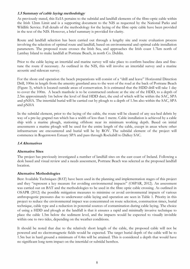
Designated conservation sites (National and international) within 15km of the proposed inshore elements (<12nautical miles) of the cable route were examined. Detailed imagery in relation to the boundaries of the conservation sites which the cable enters can be seen in Figure 4. As can be seen from this figure, the landfall area has three overlapping conservation designations SAC, SPA and pNHA. The SPA terminates at the OSI high tide limit and goes into the subtidal, while the SAC goes into the grassland area above the HWM and terminates at the LWM. Rogerstown Estuary pNHA mirrors the SAC but, Portrane Shore pNHA includes the intertidal reef area 50m to the south of the proposed cable route. The distance of travel of the cable within each of the conservation sites is as follows; SPA/pNHA (680m) and SAC (580m). The conservation sites within 15km of the in the vicinity of the proposed landfall are seen in Figures 5-8.The distance of the proposed cable route to conservation sites are seen in Table 4.
Figure 4. Designated conservation sites, LWM, and HWM in the vicinity of the proposed cable landfall at Portrane Beach, Co. Dublin.
SPA
SAC
pNHA

15
Figure 5. Special Areas of Conservation within 5km, 10km and 15 km of the proposed route and landfall.

16
Figure 6. Special Protection Areas within 5km, 10km and 15 km of the proposed route and landfall.

17
Figure 7. Natural Heritage Areas within 5km, 10km and 15 km of the proposed route and landfall.

18
Figure 8. RAMSAR Sites within 5km, of the proposed route and landfall.

19
Table 5. Conservation sites within 15km of the proposed route
Special Areas of Conservation (Natura 2000)
1 Rockabill to Dalkey Island SAC (proposed cable route and survey corridor pass through this SAC)
2 Rogerstown Estuary SAC (proposed cable route and survey corridor pass through this SAC)
3 Lambay Island SAC (1.79 km from cable route and survey corridor)
4 Malahide Estuary SAC (2.19km from cable route and survey corridor)
5 Baldoyle Bay SAC (8.3 km from cable route and survey corridor)
6 Ireland's Eye SAC (9.6 km from cable route and survey corridor)
7 North Dublin Bay SAC (11.7 km from cable route and survey corridor)
8 Howth Head SAC (12.1 km from cable route and survey corridor)
Special Protection Areas (Natura 2000)
1 Rogerstown Estuary SPA (proposed cable route and survey corridor pass through SPA)
2 Lambay Island SPA (1.7 km from cable route and survey corridor)
3 Rockabill SPA (3.5km from cable route and survey corridor)
4 Broadmeadow/Swords Estuary SPA (4.0 km from cable route and survey corridor)
5 Skerries Islands SPA (5.7 km from cable route and survey corridor)
6 Baldoyle Bay SPA (8.8 km from cable route and survey corridor)
7 Ireland's Eye SPA (9.1 km from cable route and survey corridor)
8 Howth Head Coast SPA(11.9 km from cable route and survey corridor)
9 North Bull Island SPA (12 km from cable route and survey corridor)
Natural Heritage Areas
1 Rockabill to Dalkey Island pNHA (proposed cable route and survey corridor pass through this pNHA)
2 Rogerstown Estuary pNHA (proposed cable route and survey corridor pass through this pNHA)
3 Portrane Shore pNHA (50m from cable route and but within survey corridor)
4 Lambay Island pNHA (1.79 km from cable route and survey corridor)
5 Malahide Estuary pNHA (2.19km from cable route and survey corridor)
6 Loughshinny Coast pNHA (5.0km from cable route and survey corridor)
7 Skerries Islands NHA (5.8km from cable route and survey corridor)
8 Rockabill Island pNHA (7.4km from cable route and survey corridor)
9 Sluice River Marsh pNHA (8.0 km from cable route and survey corridor)
10 Baldoyle Bay pNHA (8.3 km from cable route and survey corridor)
11 Feltrim Hill pNHA (8.3 km from cable route and survey corridor)
12 Ireland's Eye pNHA (9.6 km from cable route and survey corridor)
13 North Dublin Bay pNHA (11.7 km from cable route and survey corridor)
14 Knock Lake pNHA (11.9km from cable route and survey corridor)
15 Bog of Ring pNHA (12.0 km from cable route and survey corridor)
16 Howth Head pNHA (12.1 km from cable route and survey corridor)
17 Santry Demesne pNHA (12.1 km from cable route and survey corridor)
Ramsar Sites
1 Rogerstown Estuary (910m from cable route and survey corridor)
2 Broadmeadow/Swords Estuary (3.0 km from cable route and survey corridor)
3 Baldoyle Bay (8.3 km from cable route and survey corridor)
4 North Bull Island (12 km from cable route and survey corridor)

20
3.1.1 Subtidal –Desk based
As previously stated, despite the fact that the proposed Zone of Influence (ZoI) within the subtidal is expected to be extremely narrow it was conservatively extended to 2.5km either side of the cable, out to the 12nm limit as “it is very unlikely that the impacts on integrity can be evaluated without considering functions and processes acting outside the site’s formal boundary” (IEEM, 2010). The assessed ZoI is calculated as 170km2 (34km x.5km) out to the 12nm Limit (Figure 9) It should be noted however that the cable is only 38mm in diameter. The proposed fibre-optic cable route within the 12 nm limit is approximately 34km long and reaches a maximum water depth of approximately 90m within Irish Territorial waters. Habitats Infomar backscatter, multibeam in addition to satellite imagery, Admiralty Charts and BioMar data were assessed, where available and relevant, for the entire route within the 12nm. Backscatter and sidescan imagery are seen in Figure 10. Shallow subtidal areas were examined using Orthophotography (OSI-1995, 2000 and 2005) in addition to satellite imagery (Google (historic) & Bing). Such imagery has proved useful in the 2004-2010 NPWS sensitive subtidal benthic communities surveys project to highlight potential seagrass areas (Zostera marina ) and allow for confirmation by ground truthing. This shallow sublittoral area appears to be subject to mobile sand processes, as observed on satellite imagery (Plate 1). The shallow subtidal comprises of clean sand with no conspicuous dark patches that could indicate sea grass or kelp areas (Figure 4). During the site visit at a large spring tide (0.0m LAT) no Zostera sp. or Mytilus edulis were noted on the propose cable route or survey area.
Plate 1. Satellite imagery from 2nd June 2016. As can be seen from Figure 10, based on a desk top evaluation, habitats were distinguishable along sections of the cable route out to the 12nm limit. Along the cable route from the LWM (0.0m observed on fieldwork) clean sand is seen to continue until approximately 20m deep where, based on the backscatter image (Figure 11) a coarse sand and gravel (or Gravel & Shell based on Admiralty) field starts and extends out to the back of Lambay Island (confirmed by Figure 10). From here out to the 12nm limit the seabed type appears to be mainly medium to fine sand (Figures 10 & 11), with no obvious reef areas. It should be also noted that there are numerous cables and pipelines successfully buried within this area.
Sand Mobilised

21
Figure 9. Proposed cable route within the territorial waters (& 12nm limit), LWM, 10m contour (light green) and 50m contour.

22
Figure 10. Infomar habitat classification in the inshore and offshore areas in the vicinity of the cable route.

23
Figure 11. INFOMAR backscatter, sidescan of route and outline of morphotypes within the ZoI overlaid on Bing satellite imagery.

Fisheries Data from the inshore fisheries atlas was obtained and is shown in Figure 12. Fisheries based activity is carried out from the landfall area right up to the edge of the territorial waters. In the vicinity of the landfall Line Fishing (shore fishing and charter angling) is carried out, with hydraulic dredging for razor on the north side of Lambay Island. Trawling is carried out in waters deeper than 50m along the route out to the 12nm limit.
No fish species of conservation importance are recorded at this site based on NPWS data. Consultation was carried out with Inland Fisheries Ireland as part of the Natura Impact Assessment and EcIA in relation to the potential impact on Atlantic salmon, seatrout and the European eel. Portrane Beach is not seen as an important area for these species. Ballough (Stream) in Rogerstown Estuary is a seatrout watercourse but is not a salmon river. Other watercourses in the catchment are not considered to be significant producers of Salmonids (McGinnity et al. 2003).
Figure 12. Fisheries based activity from landfall to territorial waters (Inshore Fishing Atlas). Marine Mammals Cetaceans Figure 13 shows all cetacean species and Figure 14 shows monthly cetacean sighting trends in the area, as recorded by IWDG sightings scheme. Cetacean activity has been seen in the vicinity of the cable survey corridor and cable route. Species seen in the area and along the cable route include harbour porpoise (Phocoena phocoena), common dolphin (Delphinus delphis), minke whale (Balaenoptera acutorostrata), and a single humpback whale (Megaptera novaeangliae) being noted in 2011. During the months of proposed survey and cable laying harbour porpoise (Phocoena phocoena), common dolphin (Delphinus delphis) have been recorded. Grey seal distributions in addition to haul out sites are seen in Figure 15 (NPWS). Both seal species are distributed along the Dublin coast. However, Lambay Island is noted as a haul out area for Harbour and Grey seals and is a conservation interest of Lambay Island SAC.

Figure 13. Recorded Cetacean species sightings (Source IWDG Sightings Data) in the inshore.

Figure 14. Recorded Cetacean sightings (Source IWDG Sightings Data) in the inshore area recorded during the 12 months of the year within the 12nm limit.
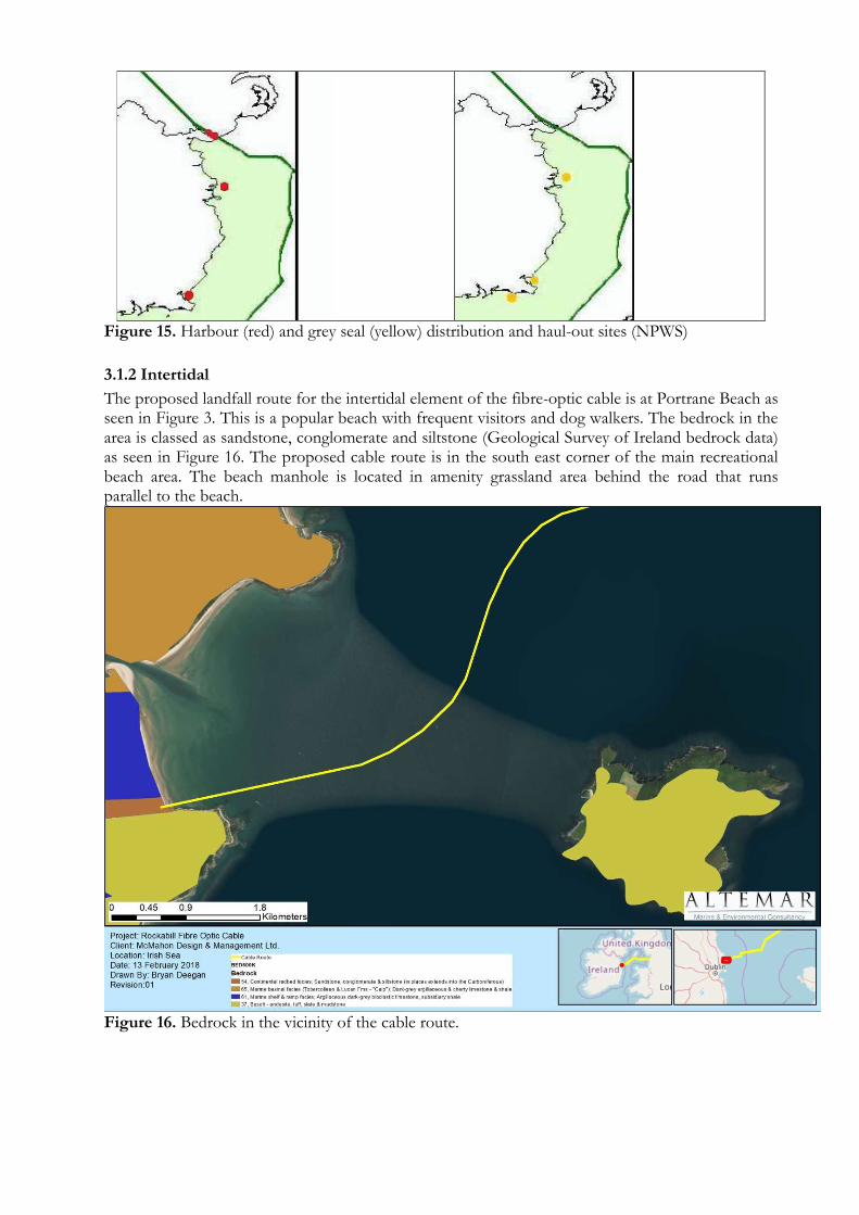
Figure 15. Harbour (red) and grey seal (yellow) distribution and haul-out sites (NPWS)
3.1.2 Intertidal
The proposed landfall route for the intertidal element of the fibre-optic cable is at Portrane Beach as seen in Figure 3. This is a popular beach with frequent visitors and dog walkers. The bedrock in the area is classed as sandstone, conglomerate and siltstone (Geological Survey of Ireland bedrock data) as seen in Figure 16. The proposed cable route is in the south east corner of the main recreational beach area. The beach manhole is located in amenity grassland area behind the road that runs parallel to the beach.
Figure 16. Bedrock in the vicinity of the cable route.

Habitats and Species on site- Fieldwork During fieldwork, habitats in the vicinity of the intertidal route were classified according to Fossitt (2000) (Figure 17). Observations on species were made on receding and incoming tides, as well as at Low Water. GA2-Amenity Grassland Amenity grassland was found in the vicinity of the HDD (Plate 2) and between the road and beach (Figure 17). This habitat is approximately 2m above the OSI high tide limit and is currently being eroded by the sea at. Species found in this area include Daisy (Bellis perennis), Dandelion (Taraxacum spp.), clovers (Trifolium spp.) and plantains (Plantago spp.) in addition to daffodil (Narcissus sp.)
Plate 2. Proposed position of the HDD on Amenity grassland. BL-Built Land Built land in the vicinity of the works include the roads and a building 50m to the north of the proposed landfall (Figures 3 & 17). These areas are of low biodiversity importance and will not be impacted by the proposed works. LR2 Moderately exposed rocky shores The southern end of Portrane Beach is dominated by an intertidal reef area. This area is at minimum 50m from the proposed cable route. Species were typical of rocky shore but it should be noted that as the fieldwork was in January, this is not within the optimum survey period for intertidal flora and fauna. However, species encountered included Fucus vesiculosus, Ulva intestinalis, Palmaria palmata, Chondrus crispus, Fucus serratus, Cladophora rupestris, Ascophyllum nodosum and at lower levels Laminaria digitata. Fauna included Patella vulgata. This area extended to the sublittoral i.e. SR2 Moderately exposed infralittoral rock, which was not surveyed. ED2-Spoil and bare ground Above the intertidal reef area, before the amenity grassland or road was an area of wind blown sand. No flora were located in this area.
HDD and beach manhole location

29
Figure 17. Habitats in the vicinity of the intertidal route classified according to Fossitt (2000).

30
LS2 Sand Shores The majority of the intertidal cable route consists of Littoral Sediment- Sand shores. Invasive investigations were not carried out. Casts of juvenile Arenicola marina were seen on beach in addition to Lanice conchilega on the lower shore. Numerous overwintering and resident bird species were noted on the shore including hooded crow (Corvus cornix), herring gull (Larus argentatus), great black-backed gull (Larus marinus), oystercatcher (Haematopus ostralegus), ringed plover (Charadrius hiaticula), redshank (Tringa tetanus), whimbrel (Numenius phaeopus), grey heron (Ardea cinerea), bar-tailed godwit (Limosa lapponica) and turnstone (Arenaria interpres). The upper shore possesses some small amounts of cobble and boulders with an incomplete drift line. This area extended to the sublittoral i.e. SS1 Infralittoral gravels and sands, outside the SAC but within the SPA, which was not surveyed. Satellite imagery did not reveal any habitats other than sand in the shallow sublittoral e.g. Zostera marina or Mytilus edulis beds.
Plate 3: Uppershore on Portrane Beach with the approximate location of the cable route
LR4 Mixed substrata shores Within the Sand Shore habitat was an area of gravel and cobble. Upon examination of historic satellite and Orthophotography imagery this area gets frequently covered by sand. At the time of the survey biodiversity was poor in the area, consisting of Ulva intestinalis on some of the cobble.
Plate 4: Mid-Lower shore on Portrane Beach with the approximate location of the cable route
HDD
Plough

31
Amphibians The common frog (Rana temporaria) was not observed in the amenity grassland or surrounding terrestrial areas. NPWS records of rare and threatened species in addition to the NBDC sightings records were investigated and showed no records in proximity of the landfall or beach area. No streams or drainage ditches were observed in the vicinity of Portrane Beach. No amphibians of conservation importance are recorded on NPWS data forms. Terrestrial Mammals No badger setts or evidence of terrestrial mammals of conservation importance were seen in the vicinity of the landfall area. Records of sightings of the badger, pine marten, otter and hedgehog were examined from the NBDC and NPWS rare and threatened species records showed no records in proximity of the landfall area. Birds The proposed landfall is an important area for overwintering birds. Please see main NIS document for information on the species of importance in this area, Habitats A range of habitats of conservation importance have been recorded and mapped in this area by NPWS. These include areas of saltmarsh habitats (Figure 18), dune (Figure 19) and marine communities (Figure 20). Estuaries and Tidal Mudflat & Sandflat habitat distribution are seen in Figures 21 and 22 respectively. The erosion of the grass area above the beach indicates that the area of Salcornia seen in Figure 23 has already been eroded from the Portrane Beach area in the vicinity of the landfall. The distribution map of saltmarsh areas within Rogerstown Estuary indicates that the nearest saltmarsh area is over 2km from the proposed cable route. However, the distribution seen on Figure 23 indicates that saltmarsh habitats are closer. Significant erosion has occurred since this study eliminating the habitat in the vicinity of the landfall. The proposed cable route is across Mudflats and Sandflats not covered at low tide and no other habitat of conservation importance was found.

32
Figure 18. Saltmarsh Habitat in the vicinity of the proposed cable route.
Landfall

33
Figure 19. Sand Dune Habitat in the vicinity of the proposed cable route.
Landfall

34
Figure 20. Marine Community Types in the vicinity of the proposed cable route.
Landfall

35
Figure 21. Estuaries Habitat in the vicinity of the proposed cable route.
Landfall

36
Figure 22. Tidal Mudflat and sandflat Habitat in the vicinity of the proposed cable route.

37
Figure 23. Coastal community types in the vicinity of the proposed cable route..
Landfall

38
ANALYSIS OF THE POTENTIAL IMPACTS
Introduction
The installation of a trans-Atlantic fibre-optic cable is a complex and challenging procedure. From the beginning of the planning stage to the final installation the cable, careful thought has gone into ensuring the longevity of the cable and uninterrupted service. This, in tandem with foreshore licencing and environmental legislation results in the placement of the cable in as stable an environment as possible that will have minimal impact on the environment and threat of anthropogenic disturbance. In summary, within the 12nm limit, the laying of the cable will involve ploughing in sediment, surface laying on hard substrate (if encountered) and elements of diver and ROV works in the shallow subtidal. The intertidal elements will involve plough burial, followed by back-blading. Even though there are two distinct elements to this project i.e. subtidal and intertidal both elements are inextricably linked are treated together for the analysis of potential impacts. Terrestrial elements of this project from the beach manhole are treated in a separate application process.
Construction Impacts
Ploughing will involve the disturbance of the seabed to 1.5m where possible. Immediate backfilling is a feature of the plough to be used. The process will involve a ship moving <1kn and generating acoustic noise akin to dredging activity. A plume of sediment will be generated. Disturbance of cetaceans may occur due to the presence of the vessel however, at the speeds involved injury to marine mammals is unlikely. There is only little information on potential noise impacts due to the installation (or removal) and operation of sub-sea cables (OSPAR 2008a). Sound emissions associated with the installation, removal or operation of submarine cables are considered as less harmful compared to activities such as seismic surveys, military activities or construction work involving pile driving. Generally, maximum sound pressure levels related to the installation or operation of cables are moderate to low (OSPAR, 2012). Though modern equipment and installation techniques can reduce the re-suspension of sediment during cable burial or removal, remaining suspended sediment may nonetheless - depending on percentage of silt fraction and background levels - obstruct the filtration mechanisms of some benthic and pelagic organisms at least temporarily (OSPAR 2009). It can also affect the growth of the macrobenthos and may have a lethal effect on some species. Contamination arising from seabed disturbance is only a risk in heavily contaminated locations (OSPAR 2009, COOPER et al. 2007a, 2007b). By surface laying over hard ground the cable will only create a narrow footprint on the seabed that may inhibit growth of marine flora and fauna due to the presence of the cable. No rock armour will be carried out in these areas. Some mobile benthic species (for example, crabs) are able to avoid most disturbance whereas sessile (bivalves, tubeworms etc.) and sensitive species (such as slower growing or fragile species) will be more impacted (OSPAR, 2012). The presence of machinery and personnel in the intertidal may temporally disturb wildlife. Disturbance of the sediments in the intertidal will occur due to ploughing. Construction of the beach manhole will be carried out in the grass area to the west of the road. The preparation of a beach manhole will also generate noise in the vicinity of the beach. Pollution generated from machinery/construction activities could potentially impact the intertidal habitat.
Habitats and Species
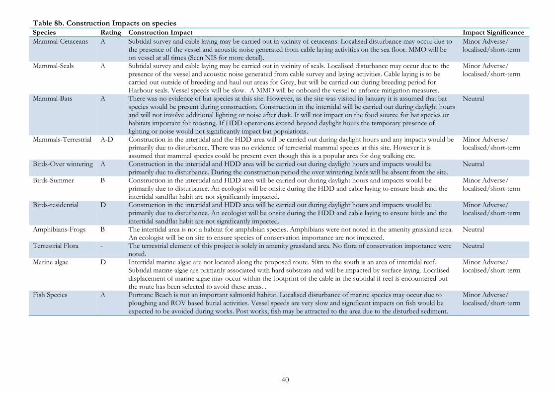
Potential impacts on habitats and species and the extent of these impacts that could potentially be encountered during the construction phase are seen in Table 8a (habitats) and 8b (species).

39
Table 8a. Construction Impacts on habitats Habitat Fossitt Habitats Directive Rating Construction Impact Impact Significance
Moderately Exposed Infralittoral Rock
SR2 “Reef - 1170” A Surface laying will not occur on this habitat. In areas of cobble ploughing may be carried out. No impact is foreseen on the structural integrity of this habitat. Temporary disturbance would occur due to cobbles, if present, being turned over.
Minor Adverse/ localised/short-term
Exposed Circalittoral Rock
SR4 “Reef - 1170” A Surface laying will not occur on this habitat. In areas of cobble ploughing may be carried out. No impact is foreseen on the structural integrity of this habitat. Temporary disturbance would occur due to cobbles, if present, being turned over.
Minor Adverse/ localised/short-term
Moderately Exposed Circalittoral Rock
SR5 “Reef - 1170” A Surface laying will not occur on this habitat. In areas of cobble ploughing may be carried out. No impact is foreseen on the structural integrity of this habitat. Temporary disturbance would occur due to cobbles, if present, being turned over.
Minor Adverse/ localised/short-term
Infralittoral gravels and Sands
SS1 D Ploughing will occur in this area. A temporary alteration in sediment layering would follow the ploughing process. Infauna may be damaged or displaced in the vicinity of the plough.
Minor Adverse/ localised/short-term
Infralittoral Mixed sediments
SS4 D Ploughing will occur in this area. A temporary alteration in sediment layering would follow the ploughing process. Infauna may be damaged or displaced in the vicinity of the plough.
Minor Adverse/ localised/short-term
Circalittoral gravels and Sands
SS5 D Ploughing will occur in this area. A temporary alteration in sediment layering would follow the ploughing process. Infauna may be damaged or displaced in the vicinity of the plough.
Minor Adverse/ localised/short-term
Circalittoral Mixed sediments
SS8 D Ploughing will occur in this area. A temporary alteration in sediment layering would follow the ploughing process. Infauna may be damaged or displaced in the vicinity of the plough.
Minor Adverse/ localised/short-term
Moderately exposed rocky shores
LR2 “Reef - 1170” “Estuaries – 1130”
A Ploughing in the sand and mixed sediment will occur to the north of the intertidal reef area. No impact is foreseen.
Neutral
Sand Shores LS2 “Estuaries – 1130”and “Mudflats and sandflats not covered by seawater at low tide-1140”
A These shores are not part of the estuary but Mudflats and sandflats not covered by seawater at low tide do form part of sites of conservation interest and are the feeding habitat of the over wintering birds of conservation importance. As a result this sandflat habitat is classed as internationally important. However species diversity in this area is poor and the area where ploughing will occur is not recognised as an important area within the conservation sites. Oystercatcher do feed on site and it is a roosting area. Temporary displacement may occur in the vicinity of the cable route. Works will be outside of overwintering period
Minor Adverse/ localised/short-term
Mixed substrata shore
LR4 Classed as “Mudflats and sandflats not covered by seawater at low tide-1140”
A This habitat is a mixture of gravel/cobble and sand. However species diversity in this area appears poor with Ulva intestinalis present on the cobble. Ploughing will occur in this habitat.
Minor Adverse/ localised/short-term
Fixed Dunes CD3 Fixed Dune A Ploughing and the HDD will be carried on the upper shore level into amenity grassland area away from the fixed dunes.
Neutral
Buildings and artificial surfaces
BL3 E All works will be away from BL3. The HDD will be under the road. Neutral
40
Table 8b. Construction Impacts on species Species Rating Construction Impact Impact Significance
Mammal-Cetaceans A Subtidal survey and cable laying may be carried out in vicinity of cetaceans. Localised disturbance may occur due to the presence of the vessel and acoustic noise generated from cable laying activities on the sea floor. MMO will be on vessel at all times (Seen NIS for more detail).
Minor Adverse/ localised/short-term
Mammal-Seals A Subtidal survey and cable laying may be carried out in vicinity of seals. Localised disturbance may occur due to the presence of the vessel and acoustic noise generated from cable survey and laying activities. Cable laying is to be carried out outside of breeding and haul out areas for Grey, but will be carried out during breeding period for Harbour seals. Vessel speeds will be slow. A MMO will be onboard the vessel to enforce mitigation measures.
Minor Adverse/ localised/short-term
Mammal-Bats A There was no evidence of bat species at this site. However, as the site was visited in January it is assumed that bat species would be present during construction. Construction in the intertidal will be carried out during daylight hours and will not involve additional lighting or noise after dusk. It will not impact on the food source for bat species or habitats important for roosting. If HDD operations extend beyond daylight hours the temporary presence of lighting or noise would not significantly impact bat populations.
Neutral
Mammals-Terrestrial A-D Construction in the intertidal and the HDD area will be carried out during daylight hours and any impacts would be primarily due to disturbance. There was no evidence of terrestrial mammal species at this site. However it is assumed that mammal species could be present even though this is a popular area for dog walking etc.
Minor Adverse/ localised/short-term
Birds-Over wintering A Construction in the intertidal and HDD area will be carried out during daylight hours and impacts would be primarily due to disturbance. During the construction period the over wintering birds will be absent from the site.
Neutral
Birds-Summer B Construction in the intertidal and HDD area will be carried out during daylight hours and impacts would be primarily due to disturbance. An ecologist will be onsite during the HDD and cable laying to ensure birds and the intertidal sandflat habit are not significantly impacted.
Minor Adverse/ localised/short-term
Birds-residential D Construction in the intertidal and HDD area will be carried out during daylight hours and impacts would be primarily due to disturbance. An ecologist will be onsite during the HDD and cable laying to ensure birds and the intertidal sandflat habit are not significantly impacted.
Minor Adverse/ localised/short-term
Amphibians-Frogs B The intertidal area is not a habitat for amphibian species. Amphibians were not noted in the amenity grassland area. An ecologist will be on site to ensure species of conservation importance are not impacted.
Neutral
Terrestrial Flora - The terrestrial element of this project is solely in amenity grassland area. No flora of conservation importance were noted.
Neutral
Marine algae D Intertidal marine algae are not located along the proposed route. 50m to the south is an area of intertidal reef. Subtidal marine algae are primarily associated with hard substrata and will be impacted by surface laying. Localised displacement of marine algae may occur within the footprint of the cable in the subtidal if reef is encountered but the route has been selected to avoid these areas. .
Minor Adverse/ localised/short-term
Fish Species A Portrane Beach is not an important salmonid habitat. Localised disturbance of marine species may occur due to ploughing and ROV based burial activities. Vessel speeds are very slow and significant impacts on fish would be expected to be avoided during works. Post works, fish may be attracted to the area due to the disturbed sediment.
Minor Adverse/ localised/short-term
41
Designated Conservation sites
The landfall for the cable is within a SPA, SAC and pNHA site. These are overlapping designations primarily for overwintering birds in addition to salt marsh and dune habitats. The noise generated from construction activities could cause disturbance in the vicinity of the cable route within these designated sites. However, construction will take place during summer, a time of high recreational activity at the beach, in the absence of over wintering birds, outside of dune and saltmarsh habitats. The impact on the sandflat would be seen to be localised and short term to the immediate vicinity of the cable route primarily due to compression by machinery along the route and laying by the plough for 680m.
Post lay/Operational Impacts
A fibre-optic cable on the seabed is passive with no moving parts and as a result there will be minimal operational impacts. Potential impacts on habitats and species and the extent of these impacts that could potentially be seen during the operational phase are seen in Table 9a (habitats) and 9b (species). The cable is not powered and electromagnetic field impacts will not arise. No servicing of the cable is foreseen unless in exceptional circumstances where damage to the cable has occurred due to anthropogenic such as trawling or anchor damage. In the event of a fault or break in the cable over its working lifespan, depending on its location, it would entail repair in situ by divers or the partial lifting of the cable to repair it on board a ship. Post lay burial of the cable may be necessary by ROV in the substrate, particularly in areas where the cable crosses existing subsea infrastructure.
End of life/decommissioning Impacts
The lifespan of the cable is 25-40 years and decommissioning will involve best practice at that time. This could involve leaving in situ, partial removal or complete removal. “Cable removal involves additional environmental impacts that roughly correspond to those during construction. Removal may not take place, or should be restricted, if it generates greater adverse environmental impacts than would be the case if the cable were left in the seafloor” (OSPAR, 2012). Removal and recycling of seabed cables is currently carried out worldwide.

42
Table 9a Operational Impacts on habitats. Habitat Fossitt Habitats Directive Rating Operational Impact Impact Significance
Moderately Exposed Infralittoral Rock
SR2 “Reef - 1170” A Reef areas are to be avoided. No heat or EMF emissions in to the marine environment are foreseen. The structural integrity of the habitat will not be impacted.
Neutral
Exposed Circalittoral Rock
SR4 “Reef - 1170” A Reef areas are to be avoided. No heat or EMF emissions in to the marine environment are foreseen. The structural integrity of the habitat will not be impacted.
Neutral
Moderately Exposed Circalittoral Rock
SR5 “Reef - 1170” A Reef areas are to be avoided. No heat or EMF emissions in to the marine environment are foreseen. The structural integrity of the habitat will not be impacted.
Neutral
Infralittoral gravels and Sands
SS1 D The cable will be buried in the marine sediment and no long term impacts are foreseen. Invertebrate biodiversity may be negatively impacted in the short term by ploughing.
Minor Adverse/ localised/short-term
Infralittoral Mixed sediments
SS4 D The cable will be buried in the marine sediment and no long term impacts are foreseen. Invertebrate biodiversity may be negatively impacted in the short term by ploughing.
Minor Adverse/ localised/short-term
Circalittoral gravels and Sands
SS5 D The cable will be buried in the marine sediment and no long term impacts are foreseen. Invertebrate biodiversity may be negatively impacted in the short term by ploughing..
Minor Adverse/ localised/short-term
Circalittoral Mixed sediments
SS8 D The cable will be buried in the marine sediment and no long term impacts are foreseen. Invertebrate biodiversity may be negatively impacted in the short term by ploughing..
Minor Adverse/ localised/short-term
Moderately exposed rocky shores
LR2 “Reef - 1170” A The cable is not in the vicinity of this habitat. Neutral-
Sand Shores LS2 A The cable will be buried in the marine sediment and no impacts are foreseen. Neutral
Mixed substrata shore
LR4 “Reef - 1170” A The cable will be buried in the marine sediment and no impacts are foreseen. Neutral
Fixed Dunes CD3 “grey dunes-2130” A The cable will be buried in the intertidal shore and no impacts are foreseen. Neutral
Buildings and artificial surfaces
BL3 E The cable will be located under built land i.e. road and no impact is foreseen. Neutral

43
Table 9b Operational Impacts on species. Species Rating Operational Impact Impact Significance
Mammal-Cetaceans A No acoustic noise is generated from the cable whilst in operation. Studies have shown that the danger of entanglement in modern cables is extremely remote due to the use of BAT in surface laying, burial and cable design.
Neutral
Mammal-Seals A No acoustic noise is generated from the cable whilst in operation. Studies have shown that the danger of entanglement in modern cables is extremely remote due to the use of BAT in surface laying, burial and cable design.
Neutral
Mammal-Bats A The cable will be buried beneath the intertidal and grassland area. No impact is foreseen on bat species. Neutral
Mammals-Terrestrial A-D The cable will be buried beneath the intertidal and grassland area. No impact is foreseen on terrestrial mammal species.
Neutral
Birds-Over wintering A The cable will be buried beneath the intertidal and subtidal areas. No impact is foreseen. Neutral
Birds-Summer B The cable will be buried beneath the intertidal and subtidal areas. No impact is foreseen. Neutral
Birds-residential D The cable will be buried beneath the intertidal and subtidal areas. No impact is foreseen. Neutral
Amphibians-Frogs B The cable will be buried beneath the intertidal and subtidal areas. No impact is foreseen. Neutral
Terrestrial Flora - The cable will be buried beneath the intertidal and subtidal areas. No impact is foreseen. Neutral
Marine algae D The cable will be buried beneath the intertidal and subtidal areas. No impact is foreseen. Neutral

44
MITIGATION OF IMPACTS (AS SEEN IN NIS)
G) Mitigation Measures
Minor short term impacts may result as a consequence of the construction phase of the project, but these are believed not to impact on the integrity of the Natura 2000 sites, species or the SSCO’s. Nevertheless, following the precautionary principle, substantial mitigation measures have been developed to minimise the ecological impacts of the project, not only in relation to Natura 2000 Annex habitats and species, but also additional species and habitats of conservation importance that have been recorded in the area.
Pre cable laying mitigation
Route Planning
A strict route selection process was carried out to assess the optimal route and landing site across the east coast, taking into account the lowest environmental impact, highest resource efficiency and wave exposure on the basis of sound and comparable data. This included addressing engineering issues as well as environmental concerns and assessing existing subsea infrastructure. The landfall location is within 2 overlapping sites of conservation significance (SAC & SPA). The conservation significance of the habitats and location of the important feeding grounds for overwintering birds was assessed. The route through the conservation sites was deemed to be the optimal route of satisfying minimal conservation significance (within the designated sites) based on the assessment of NPWS bird count data, the optimal from an engineering perspective and for the stability and longevity of the cable. All saltmarsh and sand dune habitats were avoided as part of the route selection process.
Timing of Cable Lay
The assessment of environmental factors within the landfall area was critical to the timing of the project and mitigation of impacts on species of conservation importance. The primary conservation interest of the conservation sites at the landfall is over-wintering birds. The cable lay is to be carried out in summer, after all over-wintering birds have left and prior to the arrival of species for the overwintering season. Lambay Island is an important area for grey seal. The cable route passes within 1.7km of Lambay Island. The timing of cable lay is outside of the main breeding periods, but potentially within the breeding period for common seal.
Laying Procedure
Subtidal burial of the cable will involve the use of a marine plough. Ploughing entails disturbing a wedge of seabed and the placing of the cable within the wedge in one pass. The seabed backfills over the laid cable. As outlined by OSPAR (2012) “As far as the burial technique is concerned, installation via jetting by means of sledge or ROV or use of a plough involves the lowest environmental impacts. Jetting fluidises the seabed using high power jets, and material may suspend to the water column for prolonged periods (a number of hours), and have the capacity to be transported over longer distances, increasing the number of potential receptors. Ploughing usually entails lifting a wedge of seabed and the seabed backfills over the laid cable. The level of sediment disturbance is, therefore, lower using ploughing compared to jetting techniques.”

45
Construction phase
Intertidal
As was seen during the fieldwork, the beach at which the intertidal ploughing is to be carried out on is moderately exposed, with evidence of wave activity. This can be seen by the evidence of erosion of upper beach, the subtidal sand plumes (plate 1) and presence of gravel/cobble on the beach. Infaunal populations from MERC (2012a) along the proposed route appeared poor. Even though the construction phase of the project is outside over-wintering bird season and during the summer when there is increased human visitor activity on the beach, disturbance of resident birds and summer visiting birds may occur and the integrity of these conservation sites and habitats must be maintained. As a result mitigation of impacts in the intertidal should concentrate on minimising the following: Disturbance The proposed route is within a popular beach which will have increased activity during summer months. As a result the presence of additional personnel on the shore during summer would not be thought to cause a significant additional disturbance. However, the presence of machinery and digging generated noise could cause a localised disturbance to bird populations. In order to minimise disturbance of the intertidal habitat and species the following mitigation measures would be carried out: 1. An ecologist would be onsite for the ploughing and back blading process in order to minimise
disturbance and ensure site integrity is maintained. If roosting birds are present on the shore, the cable lay should be postponed until the birds depart, without provocation.
2. Drift lines in close proximity to the proposed route would contain the highest proportion of potential food source for bird species. If present, these should be avoided by machinery and personnel.
3. Noise generated from machinery could cause a disturbance. The bucket of the digger used in gaining access to the HDD should have teeth, so as to minimize scraping of metal against the cobble or boulders (if present).
4. The cable route on the shore should be plough buried on a receding tide, as soon as practical to go
along the upper shore. This is to ensure all operations are done within one tide. Operations must be completed before an incoming tide when many of the birds return to feed. This should result in the cable route being imperceptible following a single or several tidal cycles.
5. The HDD operations in the intertidal will take one day and should commence under the intertidal
element, on a receding tide when the area above the HDD has no water and should be completed within one tidal cycle. HDD operations in the intertidal should not be carried out while the HDD is covered with water, so that any potential leak of bentonite can be easily seen, isolated and cleaned.
6. Any temporary access arrangements or structures that are put in place to allow machinery access to
the beach area should be prepared in consultation with an ecologist and the site should be fully reinstated post works.

46
HDD Contingency Procedures
The following will need to be provided or confirmed to the project ecologist prior to HDD commencement:
a) Frac-out Contingency Plan The HDD operators will be need to be equipped with a tracked hydraulic excavator, straw or hay bales, stakes to secure bails, silt fence, sand bags, shovels, pumps, and any other materials or equipment necessary to contain and clean up inadvertent releases. Ancillary items that will be readily available during drilling operations include: a light tower in case clean-up operations are needed after dark, a boat with relevant safety equipment in case a frac-out occurs during high tide.
b) Details of Fracture Detection methods The most obvious signs of a frac-out are the visible pooling of drilling mud on the surface, a sudden decease in mud volume returns during drilling operations, or loss in drilling mud pump pressure. Drilling personnel will observe the volume of drilling fluid return and immediately report reductions to the Engineer In Charge. The mud system operator will monitor actual drilling fluid volumes from the pumps and the return flow from the borehole. The operator will alert the on-site personnel if there is a significant variance. In the event of partial circulation loss, pumping of drilling fluid may be reduced to reduce pressure applied to native formation materials. c) Corrective Actions for an Inadvertent Release In the event of an inadvertent release to the surface, the following actions will be taken:
• If the release is large, mud circulation will cease immediately. If the spill is small to moderate, the contractor will continue circulation in order to maintain pressure in the hole.
• Maintaining circulation will also be necessary if the native material does not have the frictional characteristics necessary to maintain hole stability without the presence of mud provided under pressure.
In all cases, the contractor will also proceed as follows:
• Contain any drilling fluid that has surfaced.
• Notify all on-site representatives.
• Reduce circulation pressure and evaluate the circumstances leading to circulation loss to determine if the fracture can be sealed.
• Thicken the drilling fluid to attempt to seal off the location of the release as reasonably practical.
d) Containment of Drilling Fluid Release Immediately following the detection of any inadvertent drilling fluid release, containment and cleanup operations shall commence. For releases on land, Contractor shall use straw bales, silt fences, sand bags and earth berms to prevent fluid from migrating or flowing from the immediate area of the discharge. If the volume released is too small for containment measures or, if the release occurs in an environmentally sensitive area where release of containments can cause additional damage, the receiving area will be allowed to dry naturally. If there is a threat to a sensitive resource, or a threat to public safety, HDD activities will cease immediately until a plan to proceed is discussed. Other containment measures include the following:
• Additional berms may be constructed around the release area as directed by the Engineer In Charge to prevent release of materials.
• If the amount of fluid released is large enough to prevent practical collection, the affected area will be diluted with fresh water and allowed to dry. Measures will be implemented (berm, silt fence, and/or hay bale installation) to prevent silt laden water from flowing into the sea.
• If hand tools cannot contain a small on-land release, small collection sumps may be constructed to pump the released material into the mud processing system.
The decision to proceed with the drilling operation will be at the sole discretion of the Engineer In Charge after all practical methods to seal off the location of the discharge have been attempted. Underwater releases are not expected as HDD operations in the intertidal will be carried out in the dry.

47
e) Clean-up of Releases The clean-up shall commence after the release is contained. Clean-up shall include removal of all visible drilling fluid located in accessible areas. Removal methods will vary based on the volume of the release and the site specific conditions. Removal equipment may include vacuum trucks, loader and back hoe buckets, small pumps, shovels and buckets. After removal of the released drilling fluid, the release area will be reinstated as close to the original condition as possible. Pollution The presence of machinery on the intertidal could pose a threat of pollution. Toilet facilities will need to be provided on site. In order to minimise pollution the following should take place:
1) All machinery should only be fuelled on the hard stand area of a car park or road at least 10m from a drain or gulley.
2) All waste from the beach manhole operations should be removed from the site. 3) Any fluid leaks/spills should be cleaned up immediately.
Reinstatement Reinstatement of the intertidal habitat should be carried out to pre-construction conditions. Any concerns in relation to the trenching process or resulting reinstatement of the habitat to pre construction conditions will be raised with NPWS by the project ecologist prior to the removal of personnel from the site. A report on the ploughing and reinstatement of the intertidal habitat, with imagery, will be submitted by the project ecologist to NPWS within 1 week of the completion of works.
Subtidal
Mitigation impacts are primarily concerned with the construction phase of the project as minimal impacts are foreseen during the operation phase, with the exception of human intervention in relation to a break or fault in the cable. Impacts in a decommissioning stage are similar to those of the construction phase. Repairing the cable may involve several scenarios, from insitu repair with divers to the use of a grapnel to lift the cable on board so that repairs can be carried out at sea. As a result the following mitigation measures would be enforced during construction, repair and decommissioning.
1. Under no circumstance should seals hauled out in the area be disturbed such that they enter the water. This is unlikely, as this area is not recognised as a haul out area. Cable laying is to be carried out outside of breeding and haul out areas, but will be carried out during haul out period. A MMO will be onboard the vessel at all times in Irish waters to enforce mitigation measures. “Guidance to Manage the Risk to Marine Mammals from Man-made Sound Sources in Irish Waters” will be applied to ensure noise introduced into the marine environment have minimum effect.
2. No hydroacoustics are to be used during the cable lay so as to limit disturbance to cetaceans.
3. Additional permissions would be sought from NPWS in the case of repair/removal of the cable
etc. prior to carrying out works.
4. In order to ensure the integrity of Annex habitats and additional habitats and species of conservation importance are retained in the vicinity of the planned project a marine ecologist should be onsite during all intertidal works including the final making good of site, including back filling, beach manhole completion and removal of machinery. The ecologist should also ensure that birds of conservation importance roosting on the shore should not be disturbed during works.
5. Mitigation measures will include the presence of a MMO onboard the vessel. The purpose of the MMO is to ensure that there is no disturbance of seal /cetacean populations, to ensure that the vessel stays within 250m of the cable route and that vessel generated noise is restricted to engines and winches only.

48
6. On approaching the landfall area the cable ship should approach its closest point to shore at the lower end of an incoming tide. No discharges from the vessel including should be made from the ship 5km of landfall. The MMO/ecologist should ensure that mitigation measures are carried out. Sufficient resources should be made immediately available on the vessel to deal with accidental oil spills including hydraulic hoses bursting etc. and reported to the on board ecologist.
7. Laying of the cable should be carried out in calm weather to ensure that there is no risk of vessel grounding. The vessel should not carry out the landfall operations in strong northerly winds (>force 3) due to the presence of intertidal reef to the south.
8. The cable lay vessel should at all times be within 500m of the cable lay route in order to minimise disturbance of breeding birds in the surrounding SPA’s
Post-lay Monitoring
Given the location of the cable, buried in marine sediments or the small footprint it creates across reef areas, monitoring of the cable would pose more of an impact on the marine environment than just leaving the cable insitu unmonitored. Underwater cables by their nature are passive on/within the seabed. It is would not be expected that the cable will move, deteriorate or impact on marine/intertidal habitats over time, unless impacted by anthropogenic /storm influence. Problems, if they arise would be expected to result in a loss of signal and subsequent location of the break/damage and repair. Monitoring of the intertidal could take place to assess the levels of sediment cover over the cable across the intertidal. However, the plough method ensures effective burial and reinstatement within one or several tides depending on weather conditions.
Ecological supervision
In order to ensure the integrity of Annex habitats and additional habitats/species of importance are retained in the vicinity of the planned project, the following is recommended:
a) An ecologist should be onsite for the initial set up of HDD machinery and commencement of drill.
b) An aquatic ecologist should be onsite to observe the HDD drill operations to ensure that no bentonite escapes into the intertidal/marine environment.
c) An ecologist should be onsite to observe the making good of site, including back filling of drill pit and removal of machinery Images should be taken of the process and submitted to NPWS as part of an ecological report.
d) A MMO should be present during marine survey and ship cable laying to minimise any impact on marine mammals.
49
RESIDUAL IMPACTS AND CONCLUSION
Residual impacts are impacts that remain once mitigation has been implemented, or impacts that cannot be mitigated against. As previously outlined from the early stage of this project use of Best Available Techniques (BAT) have been used in the planning and implementation of the project as they “represent a key measure for avoiding environmental impacts” (OSPAR, 2012). This has included optimal site selection, methodologies of cable laying and phasing of the project outside key ecological times such as the over-wintering bird season, fish migration times and seal breeding times, in order to reduce the ecological impact of the project on, not only the designated sites at the landfall location, but also the additional habitats out to, and beyond the 12nm limit out to the Irish EEZ. The use of BAT will also help to ensure the longevity and stability of this important piece of infrastructure. However, despite the use of BAT in addition to the outlined mitigation measures, residual impacts will remain. The laying, operation and subsequent decommissioning of the cable, if required, will have no significant impact on the integrity of a conservation site or its site specific conservation objectives. Impacts are primarily related to short-term minor adverse impacts due to disturbance over the period of the HDD, 1 day cable burial on the beach and the ploughing by the vessel in the shallow subtidal. Mitigation measures have been proposed to minimise/eliminate negative impacts on species or habitats of conservation importance. Cable laying will be outside over-wintering bird season for which this site is designated as an SPA. The cable route is not located in a salt marsh or sand dune area. It does however pass through sandflat in the intertidal and the impacts in these areas are deemed to be minor adverse short-term.