earth’s structure 1
TRANSCRIPT

190
1
Chapter 6 Plate Tectonics
Earth’s StructureKey Concept Earth is composed of several layers. Thecontinents are part of the uppermost layer, and they moveslowly around Earth’s surface.
If you tried to dig to the center of Earth, what do you thinkyou would find? Would Earth be solid or hollow? Would it bemade of the same material throughout?
The Layers of EarthActually, Earth is made of several layers. The types of materi-
als that make up each layer vary from layer to layer. The materi-als in each layer have characteristic properties. Scientists thinkabout Earth’s layers in two ways—in terms of their chemicalcomposition and in terms of their physical properties.
The Compositional Layers of EarthFigure 1 shows how Earth is divided into three layers based
on chemical composition. In Earth’s center is the dense, metal-lic core,core, which is made up mainly of the metal iron. The dense,thick middle layer is the mantle.mantle. The mantle is made up largelyof silicon, oxygen, and magnesium. The surface layer, or crust,crust,is composed mostly of silicon, oxygen, and aluminum.
Describe Earth’s compositional layers. 6.1.b
What You Will Learn• Earth’s interior can be divided into
layers based on chemical composi-tion and physical properties.
• Scientists use seismic waves to studyEarth’s interior.
• Continents are drifting apart fromeach other now and have done soin the past.
Why It MattersThe way Earth’s layers interact causesmajor geologic events, such as earth-quakes and volcanoes, to happen.
Vocabulary• core• mantle• crust• lithosphere• asthenosphere• continental drift• sea-floor spreading
Graphic Organizer In your ScienceJournal, create a Process Chart thatdescribes the break-up of Pangaea.
6.1.a Students know evidence of plate tectonics isderived from the fi t of the continents; the location ofearthquakes, volcanoes, and midocean ridges; andthe distribution of fossils, rock types, and ancientclimatic zones.6.1.b Students know Earth is composed of severallayers: a cold, brittle lithosphere; a hot, convectingmantle; and a dense, metallic core.
Earth’s Compositional LayersFigure 1
The crust is less than1% of Earth’s mass andis 5 to 100 km thick.The mantle is 67%
of Earth’s mass andis 2,900 km thick.
The core is 33% ofEarth’s mass and hasa radius of 3,480 km.

Section 1 Inside the Earth 191
Continental and Oceanic CrustThere are two types of crust: continental and oceanic. Con-
tinental crust is thicker than oceanic crust. Both types are made mainly of the elements oxygen, silicon, and aluminum. But oceanic crust has almost twice as much iron, calcium, and magnesium as continental crust does. These three elements form minerals that are denser than the minerals in continental crust. These dense minerals make the thin, oceanic crust heavier than the thicker continental crust. But compared with Earth’s other layers, both types of crust are rocky, thin, and fractured.
The Physical Structure of EarthFigure 2 shows how Earth is divided into five layers based
on physical properties. Earth’s outer layer is the lithosphere, lithosphere,which is a cool, rigid layer that includes the crust and the upper part of the mantle. The lithosphere is divided into pieces called tectonic plates. Below the lithosphere is the asthenosphere,asthenosphere,which is a layer of the mantle that is made of very slow-flow-ing solid rock. This property of flow allows tectonic plates to move on top of the asthenosphere. Below the asthenosphere is the mesosphere, which is the lower part of the mantle. The mesosphere flows even more slowly than the asthenosphere.
Earth’s core has two layers. The outer core is a layer of liquid iron and nickel. At Earth’s center is the solid inner core. This layer is made mostly of iron and nickel. The inner core’s temperature is estimated to be between 4,000°C and 5,000°C. The inner core is very hot, but it is solid because it is under enormous pressure.
corecore (KAWR) the central part of Earth below the mantle
crustcrust (KRUHST) the thin and solid outermost layer of Earth above the mantle
mantlemantle (MAN tuhl) the layer of rock between Earth’s crust and core
lithospherelithosphere (LITH oh SFIR) the solid, outer layer of Earth that consists of the crust and the rigid upper part of the mantleWordwise The root lith- means “stone.”
asthenosphereasthenosphere (as THEN uh SFIR) the soft layer of the mantle on which the tectonic plates move
The Physical Structure of EarthFigure 2

Chapter 6 Plate Tectonics192
Mapping Earth’s InteriorHow do scientists know about the interior parts of Earth?
They have never even drilled through the crust, which is onlya thin skin on the surface of the planet. So, how do we knowabout Earth’s mantle and core?
Some of the answers to these questions come from earth-quakes. An earthquake produces vibrations called seismic waves.Seismic waves travel through Earth at various speeds. Machinescalled seismometers measure the time seismic waves take totravel various distances from an earthquake’s center. Scientistsuse these distances and times to calculate the density andthickness of Earth’s layers.
The speed of seismic waves is affected by the type of materialthat the waves are traveling through. For example, some typesof waves can travel through rock but not through liquids. Sci-entists have found that such waves do not reach seismometerson the side of Earth opposite the earthquake. So, part of Earth’sinterior must be liquid. This liquid layer is the outer core.Figure 3 shows how seismic waves travel through Earth.
How are seismic waves used to map Earth’s interior?
6.1.b
Figure 3 By measuringchanges in the speedof seismic waves thattravel through Earth’sinterior, scientists havelearned that Earth ismade up of severallayers. Shadow zones areplaces where no seismicwaves are detected. Eachearthquake has its ownshadow zone.
Earthquake
Path of seismic wave
Seismic waves
Shadow zone
Shadow zone
Seismic Wave Travel TimeSuppose that a seismic wavetravels through Earth’s mantleat an average velocity of8 km/s. If Earth’s mantle is2,900 km thick, exactly howmany seconds will the wavetake to pass through Earth’smantle? Record your work inyour Science Journal.

Section 1 Inside the Earth 193
Continental DriftHave you ever looked at a map of the world and noticed
how the coastlines of continents on opposite sides of the oceansappear to fit together like the pieces of a puzzle? Is it justcoincidence that the coastlines appear to fit together well?
Restless ContinentsAlfred Wegener (VAY guh nuhr), a scientist, studied these
puzzle pieces. In the early 1900s, he wrote about his hypoth-esis of continental drift. Continental driftContinental drift is the idea that a singlelarge landmass broke up into smaller landmasses to form thecontinents, which then drifted to their present locations. Thisidea explains how the continents seem to fit together.
Evidence for Continental DriftContinental drift also explained why fossils of the same
plant and animal species are found on continents that are farfrom each other. Many of these ancient species could not havecrossed an ocean. Figure 4 shows that continental drift explainssuch a pattern of fossil locations. The locations of mountainranges and of similar types of rock also show this pattern. Sci-entists have used rock and fossil evidence to reconstruct pastpatterns of climate regions. The distribution of these ancientclimatic zones supports the idea of continental drift, too.
List three lines of evidence for continental drift.
6.1.a
continental driftcontinental drift (KAHN tuh NENT uhlDRIFT) the hypothesis that states thatthe continents once formed a singlelandmass, broke up, and drifted totheir present locations
Figure 4 Fossils of organismssuch as Mesosaurus andGlossopteris were found in bothSouth America and westernAfrica. The map shows mountainchains of similar ages that existon separate continents that arefar from each other.

Chapter 6 Plate Tectonics194
The Breakup of PangaeaWegener made many observations before proposing that a
single large continent gave rise to today’s continents. He calledthis single large continent Pangaea (pan JEE uh), which is Greekfor “all Earth.”
By using many geological observations, scientists have deter-mined that Pangaea existed about 245 million years ago. Pangaeasplit into two continents—Laurasia and Gondwana—about 135million years ago. As shown in Figure 5, these two continentssplit again and formed the continents of today. The continentsslowly moved to their present positions. As the continentsdrifted, they collided with each other, which caused landformssuch as mountain ranges, volcanoes, ocean trenches, and mid-ocean ridges to form.
Briefly describe the movement of the continentsover the past 245 million years. 6.1.a
135 Million Years AgoGradually, Pangaea brokeinto two big pieces. Thenorthern piece is calledLaurasia. The southern pieceis called Gondwana.
65 Million Years AgoBy the time the dinosaursbecame extinct, Laurasiaand Gondwana had splitinto smaller pieces.
245 Million Years AgoPangaea existed when someof the earliest dinosaurs wereroaming Earth. The continentwas surrounded by a seacalled Panthalassa, whichmeans “all sea.”
The Drifting ContinentsFigure 5
PangaeaPanthalassa
Gondwana
Laurasia
Antarctica
Australia
AfricaSouthAmerica
EurasiaNorthAmerica
India

Quick Lab
Section 1 Inside the Earth 195
Making Magnets1. Slide one end of a bar
magnet down the sideof a 5-inch iron nail10 times. Alwaysslide the magnetin the samedirection.
2. Hold the nail overa small pile of steelpaperclips. Recordwhat happens.
3. Slide the bar magnetback and forth 10 timesdown the side of thenail. Repeat step 2.
4. What was the effect ofsliding the magnet alongthe nail in one direction?in two directions?
6.1.a
10 min
Sea-Floor SpreadingWhen Wegener put forth his hypothesis of continental drift,
many scientists would not accept his hypothesis. The calculatedstrength of rock made such movement of Earth’s crust seemimpossible. During Wegener’s life, no one was able to provehis hypothesis. Not until many years after Wegener’s death didscientists find evidence of forces that moved continents.
Mid-Ocean Ridges—a Magnetic MysteryA chain of submerged mountains runs through the center of
the Atlantic Ocean. This mountain chain is part of a worldwidesystem of mid-ocean ridges. Mid-ocean ridges are underwatermountain chains that run through Earth’s ocean floor.
In the 1960s, scientists who were studying the ocean floordiscovered a strange property of mid-ocean ridges. As part oftheir research, these scientists dragged a magnetic recorderthrough the water above a mid-ocean ridge. They discoveredpatterns of magnetism in the sea-floor rocks! The pattern theyobserved on one side of the ridge was a mirror image of thepattern on the other side of the ridge, as shown in Figure 6.Why were the rocks magnetized? What could have caused thispattern in the rocks? The scientists determined that the mag-netism of the rocks aligned with Earth’s magnetic field as itwas when the rocks formed.
Figure 6 Magnetic reversalsin the lithosphere are shown asbands of dark blue and lightblue. Dark blue bands indicaterocks whose magnetism matchestoday’s magnetic field. Lightblue bands indicate rocks whosemagnetism is opposite to today’smagnetic field.
Magma
Normalpolarity
Reversepolarity
North Pole
South Pole
North Pole
South Pole

Chapter 6 Plate Tectonics196
Magnetic Reversals—Mystery SolvedThroughout Earth’s history, the north and south magnetic
poles have changed places many times. The process by which Earth’s magnetic poles change places is called magnetic reversal. So, how does this process explain the magnetic patterns on the sea floor?
As rock forms from magma, or molten rock, minerals that contain iron form. Some of these minerals are magnetic and act like compasses. They form so that their magnetic fields align with the magnetic field of Earth. When the molten rock cools, these tiny compasses are locked in position in the rock. After Earth’s magnetic field reverses, new magnetic minerals that align in the opposite direction form.
Sea-Floor SpreadingAt a mid-ocean ridge, magma rises through fractures in
the sea floor. As the magma cools, it forms new rock. As this new rock forms, the older rock gets pulled away from the mid-ocean ridge. The process by which new sea floor forms as old sea floor is pulled away is called sea-floor spreading,sea-floor spreading, andis shown in Figure 7.
As it spreads away from a mid-ocean ridge, the sea floor carries with it a record of magnetic reversals. This record of magnetic reversals provides evidence that the continents are moving. Sea-floor spreading is now known to be a mechanism by which continents move.
sea-floor spreadingsea-floor spreading (SEE FLAWR SPRED ing) the process by which new oceanic lithosphere (sea floor) forms as magma rises to Earth’s surface and solidifies at a mid-ocean ridge
Mid-ocean ridge spreading center
Oceanic crust
Lithosphere
Older cr
ust
Younge
r cru
st
Younge
r cru
st
Older
crus
t
Asthenosphere
Magma
Sea-Floor SpreadingFigure 7
Internet Resources
197
For a variety of links related to thischapter, go to www.scilinks.org
Summary
Review
Topic: Composition of the Earth;Structure of the Earth
SciLinks code: HY70329; HY71468
7 Analyzing Explain the process by which newsea floor forms at mid-ocean ridges.
8 Summarizing Briefly explain how magneticreversals provide evidence for sea-floor spreading.
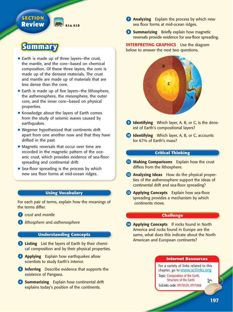
INTERPRETING GRAPHICS Use the diagrambelow to answer the next two questions.
B
C
A
9 Identifying Which layer, A, B, or C, is the dens-est of Earth’s compositional layers?
0 Identifying Which layer, A, B, or C, accountsfor 67% of Earth’s mass?
q Making Comparisons Explain how the crustdiffers from the lithosphere.
w Analyzing Ideas How do the physical proper-ties of the asthenosphere support the ideas ofcontinental drift and sea-floor spreading?
e Applying Concepts Explain how sea-floorspreading provides a mechanism by which continents move.
r Applying Concepts If rocks found in NorthAmerica and rocks found in Europe are thesame, what does this indicate about the NorthAmerican and European continents?
• Earth is made up of three layers—the crust,the mantle, and the core—based on chemicalcomposition. Of these three layers, the core ismade up of the densest materials. The crustand mantle are made up of materials that areless dense than the core.
• Earth is made up of five layers—the lithosphere,the asthenosphere, the mesosphere, the outercore, and the inner core—based on physicalproperties.
• Knowledge about the layers of Earth comesfrom the study of seismic waves caused byearthquakes.
• Wegener hypothesized that continents driftapart from one another now and that they havedrifted in the past.
• Magnetic reversals that occur over time arerecorded in the magnetic pattern of the oce-anic crust, which provides evidence of sea-floorspreading and continental drift.
• Sea-floor spreading is the process by whichnew sea floor forms at mid-ocean ridges.
For each pair of terms, explain how the meanings ofthe terms differ.
1 crust and mantle
2 lithosphere and asthenosphere
3 Listing List the layers of Earth by their chemi-cal composition and by their physical properties.
4 Applying Explain how earthquakes allowscientists to study Earth’s interior.
5 Inferring Describe evidence that supports theexistence of Pangaea.
6 Summarizing Explain how continental driftexplains today’s position of the continents.
6.1.a, 6.1.b