earthquakes - seattle.gov home0).pdf · causes earthquakes are caused when the strain accumulating...
TRANSCRIPT

Seattle Office of Emergency Management Seattle Hazard Identification and Vulnerability Analysis
Earthquakes
Key Points
Earthquakes are the most serious hazard facing Seattle. Unlike other potentially catastrophic hazards, Seattle has had and will experience powerful earthquakes.
The Seattle area experiences three earthquake types with three very different consequences.
o Crustal or Shallow Quakes occur in the North American plate at 0-30 km near the crust’s surface along faults. Intense shaking occurs near the epicenter but usually diminishes quickly with distance relative to the other earthquake types. Shallow quakes are the type expected on the Seattle Fault zone, which is the primary but not only source for shallow quakes in Seattle.
o Intraplate or Deep Quakes occur at depths of 30-70 km in oceanic crust as it dives under lighter continental crust. Because of the depth, even buildings located right above them are far enough away that ground motions are attentuated. The 2001 Nisqually Earthquake was a deep quake.
o Subduction Zone or Megathrust Quakes occur on the interface between the North American plate and the San Juan de Fuca plate, a small plate extending from northern California to British Columbia. These are the largest type of earthquakes in the world.
An earthquake on the Seattle Fault poses the greatest risk to Seattle.
o The Seattle Fault Zone extends east-west through the middle of the city.
o A Seattle Fault quake could be as large as magnitude 7.51, but less than 7.0Mm is more probable.
o The most recent Seattle Fault earthquake was about 1,100 years ago;
o The Seattle Fault has been active about three or four times in the past 3,000 years.
Deep quakes are the most common large earthquakes that occur in the Puget Sound region. Quakes larger than 6.0Mm occurred in 1909, 1939, 1946, 1949, 1965 and 2001.
Megathrust earthquakes are the greatest risk to the region as a whole. A megathrust earthquake could reach M 9.0+ and affect an area from Canada to northern California. Shaking in Seattle would be violent and prolonged, but not as intense as a Seattle Fault quake. This area has a megathrust earthquake about every 500 years.
About 15% of Seattle’s total area is soil that is prone to ground failure in earthquakes. The Duwamish Valley, Interbay and Rainier Valley are vulnerable to ground failure and shaking because of the liquefiable soils in these areas.
Seattle has an estimated 819 Seattle unreinforced masonry buildings that perform poorly in earthquakes. These older brick buildings tend to be concentrated in areas expected to experience the strongest ground motion during earthquakes. Other vulnerable building types exist, too.
Seattle is heavily dependent on its bridges. Damage to them would impair emergency services and the economy. The city has launched a multi-year effort to retrofit them to a life-safety standard so they won’t collapse. Despite the retrofits, many will not be usable after a strong earthquake. Most of the critical bridges were retrofitted by 2009.

Seattle Office of Emergency Management Seattle Hazard Identification and Vulnerability Analysis
Combined property damage for quakes in 1949 and 1965 in the region amounted to roughly $400 million (2010 dollars). The 2001 Nisqually Earthquake resulted in damage to City of Seattle buildings, infrastructure and response costs that exceeded $20 million. Adding in the costs of repairing arterial road structures, the figure topped $36 million.
Secondary impacts such as landslides, tsunami, fires, and hazardous materials releases could become disasters themselves. In many earthquakes more people die from fire than building collapse.
o 2013 research finds that Seattle is at risk of thousands of landslides following a strong (magnitude 7) Seattle Fault earthquake. Estimates range from 5,000 if soils are dry to 30,000 if soils at saturated.
o A large Seattle Fault earthquake could trigger a 16ft tsunami that would strike the Seattle shoreline within seconds of the earthquake and flood it within 5 minutes. Although megathrust and deep earthquakes will not directly cause tsunamis in Seattle these sources could initiate landslides that result in local tsunamis.
o A magnitude 7 Seattle Fault earthquake could cause dozens of fires. Suppressing the fires would be more difficult because damage to the water system would reduce water pressure in many parts of the city.
o Structural failure and fires would probably causes multiple hazardous materials releases. They could range from minor spills to major incidents.
Context
This section provides a very brief overview of the causes of earthquakes and the pattern of seismicity in the Pacific Northwest. Also included are explanations of the major metrics used to describe earthquake power and intensity.
Causes Earthquakes are caused when the strain accumulating in rock due to the movement of large parts of the earth’s crust called plates becomes greater than the strength of the rock or the pressure keeping it from slipping. Plate movement is primarily driven by very slow convection currents in a hot, dense, plastic rock layer of the Earth called the mantle. Just as hot air rises and cool air sinks, hot mantle material rises, cooling as it nears the surface. The cooler material then begins to slowly sink down, which creates a convection cell. Hot rising rock pushes plates across the surface of the earth. When plates collide, the thinner, denser ocean plate is usually forced under the thicker, lighter rock of the continent.
In the Pacific Northwest, the dense Pacific Plate is moving northwest and it rotating the small San Juan de Fuca plate clockwise under the lighter North American Plate. This process is known as subduction. It usually occurs in a jerky manner. Friction and pressure along the interface of the plates prevents the ocean plate from moving under the continent, locking them together for decades or centuries. When the strain is too great, the plates slip, suddenly causing a megathrust earthquake.

Seattle Office of Emergency Management Seattle Hazard Identification and Vulnerability Analysis
Figure 1. Convection in the Earth's Crust
Source: http://www.dstu.univ-montp2.fr/PERSO/bokelmann/research.html under “driven by mantle convection. Accessed 12/21/2009.
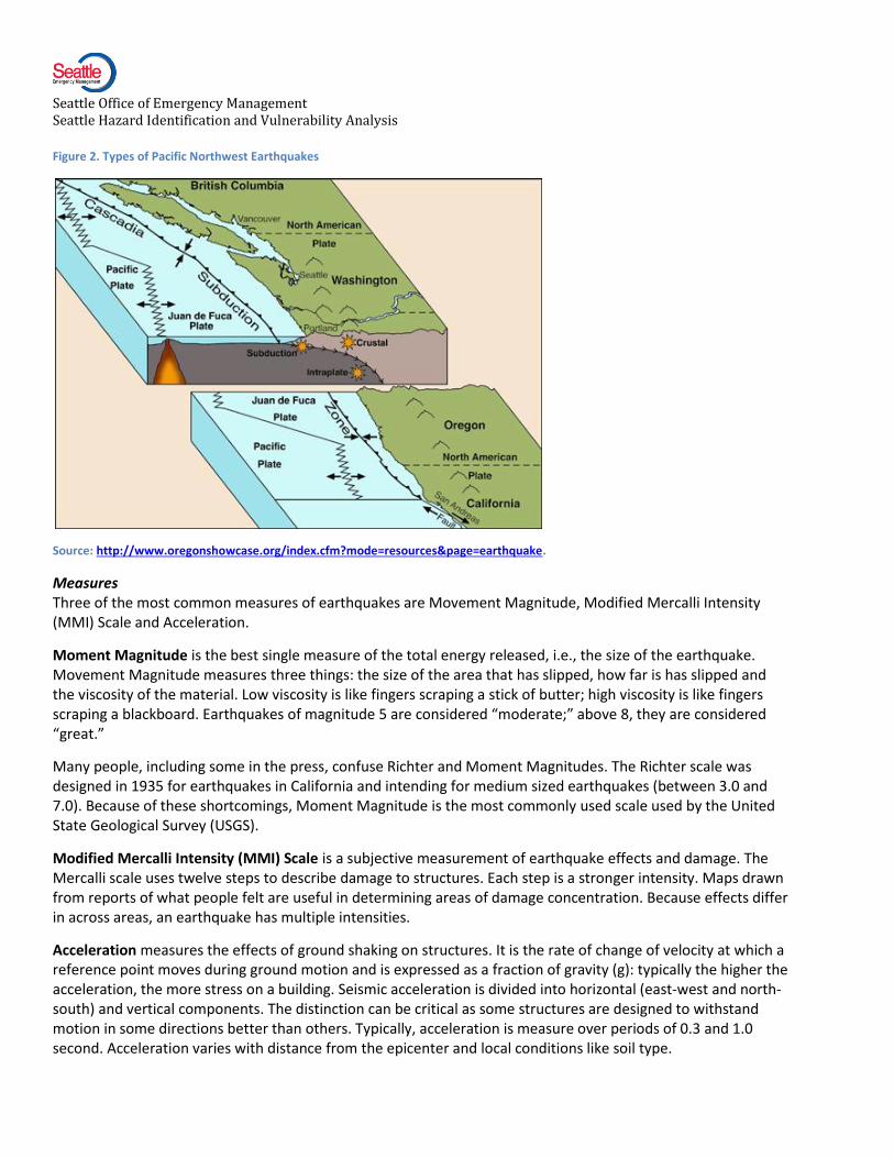
Types of Earthquake Pacific Northwest has a complex seismic profile, but ultimately all are driven by subduction. Quakes in this region fall into all three categories: shallow, deep and megathrust.
Crustal or Shallow earthquakes occur in the North American Plate as it adjusts to the build up of strain along the interface of the North American and San Juan de Fuca Places. Depths vary from 0 to 30km (about 21 miles). They are usually felt very intensely near their epicenter, but their effects usually diminish relatively quickly with distance. There is an active shallow fault system running through the middle of Seattle, the Seattle Fault Zone.
Intraplate or Deep earthquakes at depths between 35 and 70km (about 21 miles to 43 miles). Since they are farther from the surface, they are not felt as intensely, but are experienced over a wider area than shallow quakes. The 1949, 1965 and 2001 Western Washington earthquakes were deep earthquakes. They are the most common type of large earthquake in our region.
Megathrust or subduction earthquakes result when pressure at the interface between the San Juan plate and North American plates unlocks. They occur along a sloped plane from where the plates meet off the Washington coast to just under the coastal area. This fault is over 1,000 km (620 miles) long. Megathrust earthquakes are the largest type of quake, with magnitudes from 8.0 to over 9.0. They have occurred at about 500 year intervals ranging along the Pacific Coast2.
Seattle Office of Emergency Management Seattle Hazard Identification and Vulnerability Analysis
Figure 2. Types of Pacific Northwest Earthquakes
Source: http://www.oregonshowcase.org/index.cfm?mode=resources&page=earthquake.
Measures Three of the most common measures of earthquakes are Movement Magnitude, Modified Mercalli Intensity (MMI) Scale and Acceleration.
Moment Magnitude is the best single measure of the total energy released, i.e., the size of the earthquake. Movement Magnitude measures three things: the size of the area that has slipped, how far is has slipped and the viscosity of the material. Low viscosity is like fingers scraping a stick of butter; high viscosity is like fingers scraping a blackboard. Earthquakes of magnitude 5 are considered “moderate;” above 8, they are considered “great.”
Many people, including some in the press, confuse Richter and Moment Magnitudes. The Richter scale was designed in 1935 for earthquakes in California and intending for medium sized earthquakes (between 3.0 and 7.0). Because of these shortcomings, Moment Magnitude is the most commonly used scale used by the United State Geological Survey (USGS).
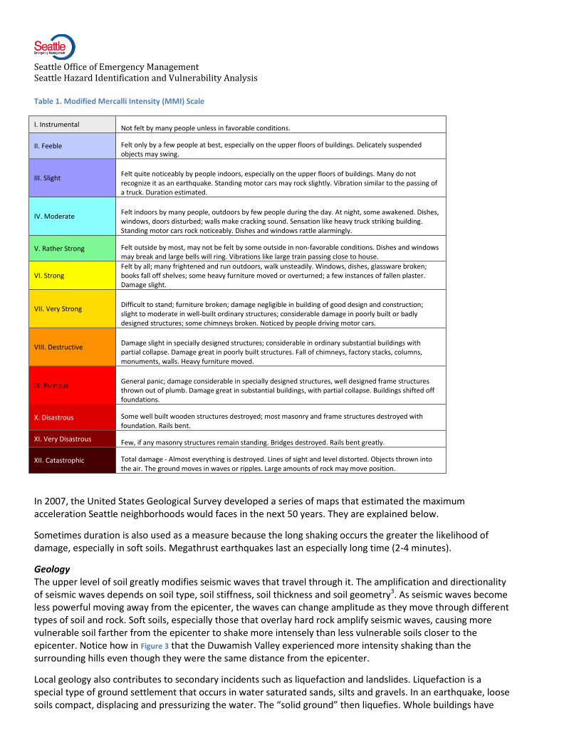
Modified Mercalli Intensity (MMI) Scale is a subjective measurement of earthquake effects and damage. The Mercalli scale uses twelve steps to describe damage to structures. Each step is a stronger intensity. Maps drawn from reports of what people felt are useful in determining areas of damage concentration. Because effects differ in across areas, an earthquake has multiple intensities.
Acceleration measures the effects of ground shaking on structures. It is the rate of change of velocity at which a reference point moves during ground motion and is expressed as a fraction of gravity (g): typically the higher the acceleration, the more stress on a building. Seismic acceleration is divided into horizontal (east-west and north-south) and vertical components. The distinction can be critical as some structures are designed to withstand motion in some directions better than others. Typically, acceleration is measure over periods of 0.3 and 1.0 second. Acceleration varies with distance from the epicenter and local conditions like soil type.
Seattle Office of Emergency Management Seattle Hazard Identification and Vulnerability Analysis
Table 1. Modified Mercalli Intensity (MMI) Scale
I. Instrumental Not felt by many people unless in favorable conditions.
II. Feeble Felt only by a few people at best, especially on the upper floors of buildings. Delicately suspended objects may swing.
III. Slight Felt quite noticeably by people indoors, especially on the upper floors of buildings. Many do not recognize it as an earthquake. Standing motor cars may rock slightly. Vibration similar to the passing of a truck. Duration estimated.
IV. Moderate Felt indoors by many people, outdoors by few people during the day. At night, some awakened. Dishes, windows, doors disturbed; walls make cracking sound. Sensation like heavy truck striking building. Standing motor cars rock noticeably. Dishes and windows rattle alarmingly.
V. Rather Strong Felt outside by most, may not be felt by some outside in non-favorable conditions. Dishes and windows may break and large bells will ring. Vibrations like large train passing close to house.
VI. Strong Felt by all; many frightened and run outdoors, walk unsteadily. Windows, dishes, glassware broken; books fall off shelves; some heavy furniture moved or overturned; a few instances of fallen plaster. Damage slight.
VII. Very Strong Difficult to stand; furniture broken; damage negligible in building of good design and construction; slight to moderate in well-built ordinary structures; considerable damage in poorly built or badly designed structures; some chimneys broken. Noticed by people driving motor cars.
VIII. Destructive Damage slight in specially designed structures; considerable in ordinary substantial buildings with partial collapse. Damage great in poorly built structures. Fall of chimneys, factory stacks, columns, monuments, walls. Heavy furniture moved.
IX. Ruinous General panic; damage considerable in specially designed structures, well designed frame structures thrown out of plumb. Damage great in substantial buildings, with partial collapse. Buildings shifted off foundations.
X. Disastrous Some well built wooden structures destroyed; most masonry and frame structures destroyed with foundation. Rails bent.
XI. Very Disastrous Few, if any masonry structures remain standing. Bridges destroyed. Rails bent greatly.
XII. Catastrophic Total damage - Almost everything is destroyed. Lines of sight and level distorted. Objects thrown into the air. The ground moves in waves or ripples. Large amounts of rock may move position.
In 2007, the United States Geological Survey developed a series of maps that estimated the maximum acceleration Seattle neighborhoods would faces in the next 50 years. They are explained below.
Sometimes duration is also used as a measure because the long shaking occurs the greater the likelihood of damage, especially in soft soils. Megathrust earthquakes last an especially long time (2-4 minutes).
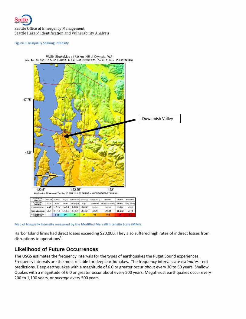
Geology The upper level of soil greatly modifies seismic waves that travel through it. The amplification and directionality of seismic waves depends on soil type, soil stiffness, soil thickness and soil geometry3. As seismic waves become less powerful moving away from the epicenter, the waves can change amplitude as they move through different types of soil and rock. Soft soils, especially those that overlay hard rock amplify seismic waves, causing more vulnerable soil farther from the epicenter to shake more intensely than less vulnerable soils closer to the epicenter. Notice how in Figure 3 that the Duwamish Valley experienced more intensity shaking than the surrounding hills even though they were the same distance from the epicenter.
Local geology also contributes to secondary incidents such as liquefaction and landslides. Liquefaction is a special type of ground settlement that occurs in water saturated sands, silts and gravels. In an earthquake, loose soils compact, displacing and pressurizing the water. The “solid ground” then liquefies. Whole buildings have
Seattle Office of Emergency Management Seattle Hazard Identification and Vulnerability Analysis
overturned when the underlying soils lose enough tensile strength to support the structure. More commonly, only part of a building sinks, causing uneven settling. Once liquefaction has occurred, the muddy soil will often flow laterally (laterally spreading) and cause severe structural damage.
Earthquakes can trigger landslides by shaking unstable or steep slopes. Wet conditions can exacerbate slide potential because waterlogged soils are less able to resist sheer pressures in slopes. A 2013 study by UW researcher Kate Allstadt examined the potential for shallow (less the 2.8 meters deep) landslides following a magnitude 7.3 Seattle Fault earthquake. The results were sobering. She found that the quake could cause 5,000 landslides in dry conditions and 30,000 in extremely wet conditions (i.e., like New Year’s 1997 when Seattle had 225 landslides without the help of an earthquake). The study did not model deep seated landslides which can cause whole hillsides to fail. More information about landslides can be found in the Error! Reference source not found. chapter.
History
The Puget Sound region has fewer earthquakes than California but they can be just as powerful. From the time record keeping began, the Puget Sound region has been the most seismically active area in Washington4. Of the earthquakes recorded, ten quakes of magnitude 4.9 or greater occurred in western Washington. Eight of these ten were centered in the Puget Sound region:
Around 900. Magnitude 7.5 Seattle Fault earthquake. It caused massive landslides and a tsunami. Whole hillsides slid into Lake Washington and Puget Sound. A tsunami estimated to be 16ft flooded mucho of the low lying area around the mouth of the Duwamish River. It is estimated that the Seattle has been active 3 – 4 times in the last 3,000 years. Glaciers covering the Puget Sound region probably destroyed any evidence for earthquakes over 15,000 years old5.
Jan. 1700. Magnitude 9.0 megathrust earthquake. One of the world’s largest earthquakes struck the Pacific Northwest coast. Coastal areas dropped 1.5 meters as the undersea thrust fault ruptured along 1000 km. It generated a tsunami that struck Japan.
Dec. 1872. Magnitude 6.8 shallow earthquake shook the North Cascades. It triggered a huge landslide that temporarily blocked the Columbia River.
Jan. 1909. Magnitude 6.0 deep earthquake centered in the San Juans.
Nov. 1939. Magnitude 5.75 deep earthquake centered near Olympia. Chimney and building facade damage near the epicenter. No damage reported in Seattle.
Apr. 1945. Magnitude 5.5 (no data on depth)centered under North Bend. Chimney and building façade damage near the epicenter. Boy hit by falling brick in Cle Elum. No damage reported in Seattle.
Feb. 1946. Magnitude 6.3 deep earthquake centered under mid- Puget Sound. Damage in Seattle mainly limited to the Duwamish Valley and structures built on pilings.
Apr. 1949. Magnitude 6.8 deep earthquake centered near Olympia. The earthquake had a peak lateral acceleration of .3g and produced type VIII MMI damage at its highest intensity. Eight people were killed, mostly from falling brick and the region suffered $314 million in damages (measured in 2010 dollars). In Seattle, the earthquake’s effects were felt mainly in the northern section of West Seattle and at the mouth of the Duwamish River.
Apr. 1965. Magnitude 6.5 deep earthquake with the epicenter closer to the city than the 1949 quake. The earthquake’s acceleration was lower, .2g. While it did cause type VIII MMI damage, most of its effects were

Seattle Office of Emergency Management Seattle Hazard Identification and Vulnerability Analysis
limited to type VII MMI. As in 1949, many ground failures occurred in the Alki and Harbor Island areas, but they were not as concentrated as in the 1949 quake. Six people were killed, mostly by falling debris. Damage was $104 million (2010 dollars). Based on these records, one report estimates that 6.5Mm events have a repeat rate of 35 years and 7.0Mm events have a repeat rate of 110 years6. However, these rates are highly speculative.
Jan. 1995. Magnitude 5.0 shallow quake, depth 11 miles. Centered under Robinson Point on Bainbridge Island. No damage reported.
May 1996. Magnitude 5.3. A shallow quake centered under Duvall. Some light damage reported, mainly objects falling from shelves. No damage reported in Seattle.
Jun. 1997. Magnitude 4.9. Another shallow quake centered under Bremerton. No damage reported in Seattle.
Feb. 2001. Magnitude 6.8. Large deep quake under South Puget Sound, the Nisqually Earthquake.
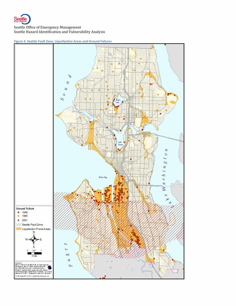
Figure 3 indicates the location of ground failures resulting from the 1949, 1965 and 2001 Puget Sound area earthquakes.
Effects of the Nisqually Earthquake Significant public and private damage occurred as a result of this deep quake. The northern end of the Boeing Field runway was closed for two weeks after the earthquake. As stated earlier, in Seattle the Nisqually Earthquake caused in excess of $20 million in response costs and repairs to city-owned facilities and systems, plus costs for damage to arterial roads and bridges.
The quake’s damage to structures serving vulnerable populations raised concerns. Seattle’s Office of Housing (OH) did a post-Nisqually assessment of 45 non-profit assisted housing properties serving low-income residents. Only properties that sustained notable damage appeared on the report. Among them were several buildings located in or near downtown. One structure serving the homeless, the Compass Center, was red tagged and its 75 male residents were forced to vacate. The building was repaired and seismically upgraded in 2005. Seattle Housing Authority buildings, which house low-income people, suffered damage to elevators.
The earthquake impacted many businesses. The National Federation of Independent Business sent a survey to randomly selected members in an effort to document the impact of the Nisqually Earthquake on small business owners7. The survey revealed three areas with the most identifiable, concentrated small business damage: Downtown Olympia, Seattle’s Pioneer Square and Seattle’s Harbor Island.
The largely industrial Harbor Island experienced the highest level of shaking in Seattle, similar to that experienced in heavily damaged areas in the 1994 Northridge, California earthquake. Nearly 40% of
Seattle Office of Emergency Management Seattle Hazard Identification and Vulnerability Analysis
Figure 3. Nisqually Shaking Intensity
Map of Nisqually Intensity measured by the Modified Mercalli Intensity Scale (MMI).
Harbor Island firms had direct losses exceeding $20,000. They also suffered high rates of indirect losses from disruptions to operations8.
Likelihood of Future Occurrences
The USGS estimates the frequency intervals for the types of earthquakes the Puget Sound experiences. Frequency intervals are the most reliable for deep earthquakes. The frequency intervals are estimates - not predictions. Deep earthquakes with a magnitude of 6.0 or greater occur about every 30 to 50 years. Shallow Quakes with a magnitude of 6.0 or greater occur about every 500 years. Megathrust earthquakes occur every 200 to 1,100 years, or average every 500 years.
Duwamish Valley
Seattle Office of Emergency Management Seattle Hazard Identification and Vulnerability Analysis
Figure 4. Seattle Fault Zone, Liquefaction Areas and Ground Failures

Seattle Office of Emergency Management Seattle Hazard Identification and Vulnerability Analysis
Table 2. Earthquake Type and Estimated Frequency
Type Size Estimated Frequency
Deep Earthquakes like Nisqually Over 6.0 Every 30 to 50 years
Megathrust Earthquakes 8.0 to 9.0+ Every 500 years on average
Seattle Fault Over 5.5 Every 100 years
Seattle Fault Over 6.5 Every 1000 years
Seattle Fault 7.5 (biggest quake possible) Every 5000 years
A megathrust earthquake occurred in 1700 and the Seattle Fault produced a powerful earthquake 1,100 years ago, but neither type has occurred in Seattle in modern times. With 3 -4 events in the past 3,000 years, the very rough estimate is that the Seattle Fault is active about every 1,000 years.
Based on the type of research described in this document and other seismological input, the USGS has produced a series of earthquake hazard maps for Seattle (Figure 6). These maps show the amount of earthquake-generated ground shaking that, over a specified period of time, is predicted to have a specified chance of being exceeded. Ground shaking caused by earthquakes is often expressed as a percentage of the force of gravity. For example, many earthquake hazard maps show contours of the percentage of the force of gravity that has a 10% chance of being exceeded in 50 years. Based on such a map, if you were living in the same house for 50 years, and that house was in a zone labeled "5% g", then there would be 1 chance in 10 that (at some point during those 50 years) an earthquake would shake your house at a level of at least 5% of the force of gravity.
To appreciate why these values of ground shaking are expressed as a percentage of the force of gravity, note that it requires more than 100% of the force of gravity to throw objects up in the air. In terms of felt effects and damage, ground motion at the level of several percent of gravity corresponds to the threshold of damage to buildings and houses (an earthquake intensity of approximately V on the Modified Mercalli scale). For comparison, reports of "dishes, windows and doors disturbed" corresponds to an intensity of about IV MMI, or about 1.4% – 4% of gravity. Reports of "some chimneys broken" correspond to an intensity of about VII MMI, or a range of 18% to 34% of gravity9.
Vulnerability
This section provides the specific physical and social vulnerabilities present in the Seattle community that are unique to or especially important for earthquakes.
General vulnerabilities described in the Community Profile section combine with earthquake-specific vulnerabilities that can be analyzed with geographic information systems (GIS). Generally speaking, the most vulnerable parts of the city are where fragile populations, soft soils and weak buildings come to together in areas that could be easily isolated due to breaks in the transportation network. These locations produce vulnerabilities for the whole city because of their social, political or economic importance.
The following sections breakout several earthquake specific vulnerabilities that can be overlaid to develop a composite picture of earthquake vulnerability in Seattle.
Seattle Office of Emergency Management Seattle Hazard Identification and Vulnerability Analysis
Ground Shaking Not all areas of the city are likely to experience the same level of ground shaking. The USGS has created seismic hazard maps (Figure 6) that show the probability of exceeding a defined level of shaking (shown as acceleration as defined above) within the next 50 years. For example, downtown Seattle has a 5% chance of experiencing shaking in the 70-90%g range within the next 50 years10.
These maps are valuable because they give us a nuanced view of the level of shaking each area of the city can expect to receive. One can see clearly that Seattle’s liquefaction and landslide-prone areas experience more severe ground motion than other areas. Southeast Seattle is likely to experience serious but comparatively less shaking than the rest of the city.
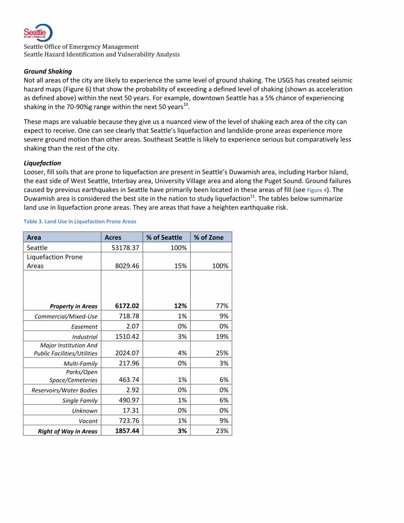
Liquefaction Looser, fill soils that are prone to liquefaction are present in Seattle’s Duwamish area, including Harbor Island, the east side of West Seattle, Interbay area, University Village area and along the Puget Sound. Ground failures caused by previous earthquakes in Seattle have primarily been located in these areas of fill (see Figure 4). The Duwamish area is considered the best site in the nation to study liquefaction11. The tables below summarize land use in liquefaction prone areas. They are areas that have a heighten earthquake risk.
Table 3. Land Use in Liquefaction Prone Areas
Area Acres % of Seattle % of Zone
Seattle 53178.37 100%
Liquefaction Prone Areas 8029.46 15% 100%
Property in Areas 6172.02 12% 77%
Commercial/Mixed-Use 718.78 1% 9%
Easement 2.07 0% 0%
Industrial 1510.42 3% 19% Major Institution And
Public Facilities/Utilities 2024.07 4% 25%
Multi-Family 217.96 0% 3% Parks/Open
Space/Cemeteries 463.74 1% 6%
Reservoirs/Water Bodies 2.92 0% 0%
Single Family 490.97 1% 6%
Unknown 17.31 0% 0%
Vacant 723.76 1% 9%
Right of Way in Areas 1857.44 3% 23%
Seattle Office of Emergency Management Seattle Hazard Identification and Vulnerability Analysis
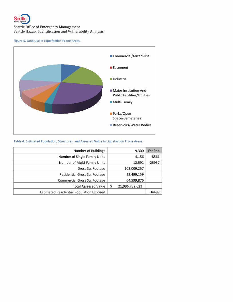
Figure 5. Land Use in Liquefaction Prone Areas.
Table 4. Estimated Population, Structures, and Assessed Value in Liquefaction Prone Areas.
Number of Buildings 9,300 Est Pop
Number of Single Family Units 4,156 8561
Number of Multi-Family Units 12,591 25937
Gross Sq. Footage 103,009,257
Residential Gross Sq. Footage 22,499,159
Commercial Gross Sq. Footage 64,599,876
Total Assessed Value $ 21,996,732,623
Estimated Residential Population Exposed 34499
Commercial/Mixed-Use
Easement
Industrial
Major Institution AndPublic Facilities/Utilities
Multi-Family
Parks/OpenSpace/Cemeteries
Reservoirs/Water Bodies

Seattle Office of Emergency Management Seattle Hazard Identification and Vulnerability Analysis
Table 5. Critical Facilities in Liquefaction Prone Areas.
Medical and Health Services 4
Government Function 6
Protective Function 12
Schools 2
Hazardous Materials Storage Sites 23
Bridges 42
Major Tunnels 1
Water 12
Waste Water 12
Communications 0
Energy 22
Human Services 9
High Population 4
Total 149
Table 6. Facilities with Concentrated Vulnerable Populations in Liquefaction Prone Areas
Adult Family Homes 4
Boarding House 3
Child Care Centers 17
Nursing Home 1
Intermediate Care Facility 0
Total 25

Seattle Office of Emergency Management Seattle Hazard Identification and Vulnerability Analysis
Table 7. Zoning in Liquefaction Prone Areas
Zoning Area Acres % of Seattle % of Zone
Seattle 53178.37 100%
Liquefaction Zones 8029.46 15% 100%
Property in Area 6172.02 12% 77%
Unzoned 0.13 0.00% 0.00%
Commercial - C1 121.90 0.23% 1.52%
Commercial - C2 142.57 0.27% 1.78%
Downtown Harborfront - DH1 31.29 0.06% 0.39%
Downtown Harborfront - DH2 10.87 0.02% 0.14%
Downtown Mixed Commercial - DMC 16.30 0.03% 0.20% Downtown Mixed Residential/Commercial -
DMR 2.43 0.00% 0.03%
Industrial Buffer - IB 82.79 0.16% 1.03%
Industrial Commercial - IC 243.83 0.46% 3.04%
Downtown,International District Mixed - IDM 16.33 0.03% 0.20% Downtown, International District Residential -
IDR 0.01 0.00% 0.00%
General Industrial - IG1 2187.77 4.11% 27.25%
General Industrial - IG2 1610.65 3.03% 20.06%
Lowrise - LR1 50.47 0.09% 0.63%
Lowrise - LR2 86.97 0.16% 1.08%
Lowrise - LR3 120.16 0.23% 1.50%
Major Institution - MIO 149.01 0.28% 1.86%
Multi-Family, Midrise - MR 15.53 0.03% 0.19%
Neighborhood Commercial - NC1 23.56 0.04% 0.29%
Neighborhood Commercial - NC2 55.45 0.10% 0.69%
Neighborhood Commercial - NC3 53.43 0.10% 0.67%
Downtown, Pike Place Market - PMM 0.84 0.00% 0.01%
Downtown, Pioneer Square - PSM 36.39 0.07% 0.45%
Single Family - SF 5000 541.63 1.02% 6.75%
Single Family - SF 7200 468.28 0.88% 5.83%
Single Family - SF 9600 85.06 0.16% 1.06%
Neighborhood Commercial, Seattle Mixed- SM 14.27 0.03% 0.18%
Neighborhood Commercial, Seattle Mixed - SMI 3.37 0.01% 0.04% Neighborhood Commercial, Seattle Mixed
Residential - SMR 0.75 0.00% 0.01%
Right of Way in Area 1857.44 3.49% 23.13%
Seattle Office of Emergency Management Seattle Hazard Identification and Vulnerability Analysis
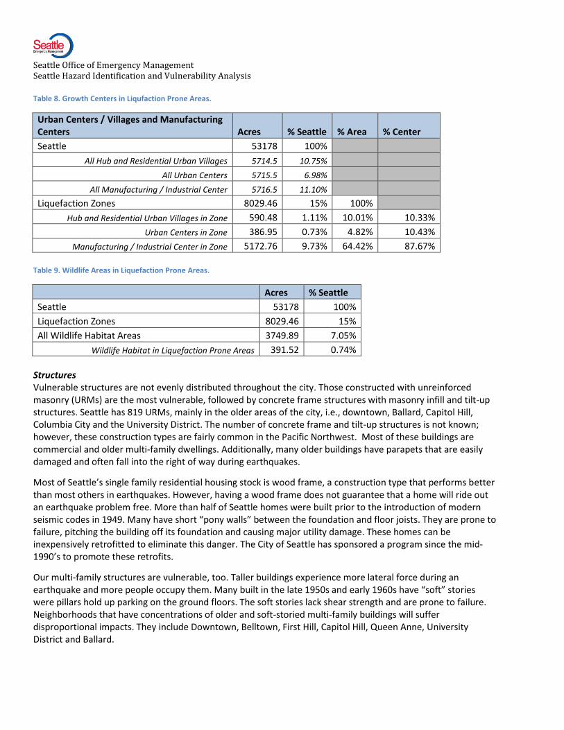
Table 8. Growth Centers in Liqufaction Prone Areas.
Urban Centers / Villages and Manufacturing Centers Acres % Seattle % Area % Center
Seattle 53178 100%
All Hub and Residential Urban Villages 5714.5 10.75%
All Urban Centers 5715.5 6.98%
All Manufacturing / Industrial Center 5716.5 11.10%
Liquefaction Zones 8029.46 15% 100%
Hub and Residential Urban Villages in Zone 590.48 1.11% 10.01% 10.33%
Urban Centers in Zone 386.95 0.73% 4.82% 10.43%
Manufacturing / Industrial Center in Zone 5172.76 9.73% 64.42% 87.67%
Table 9. Wildlife Areas in Liquefaction Prone Areas.
Acres % Seattle
Seattle 53178 100%
Liquefaction Zones 8029.46 15%
All Wildlife Habitat Areas 3749.89 7.05%
Wildlife Habitat in Liquefaction Prone Areas 391.52 0.74%
Structures Vulnerable structures are not evenly distributed throughout the city. Those constructed with unreinforced masonry (URMs) are the most vulnerable, followed by concrete frame structures with masonry infill and tilt-up structures. Seattle has 819 URMs, mainly in the older areas of the city, i.e., downtown, Ballard, Capitol Hill, Columbia City and the University District. The number of concrete frame and tilt-up structures is not known; however, these construction types are fairly common in the Pacific Northwest. Most of these buildings are commercial and older multi-family dwellings. Additionally, many older buildings have parapets that are easily damaged and often fall into the right of way during earthquakes.
Most of Seattle’s single family residential housing stock is wood frame, a construction type that performs better than most others in earthquakes. However, having a wood frame does not guarantee that a home will ride out an earthquake problem free. More than half of Seattle homes were built prior to the introduction of modern seismic codes in 1949. Many have short “pony walls” between the foundation and floor joists. They are prone to failure, pitching the building off its foundation and causing major utility damage. These homes can be inexpensively retrofitted to eliminate this danger. The City of Seattle has sponsored a program since the mid-1990’s to promote these retrofits.
Our multi-family structures are vulnerable, too. Taller buildings experience more lateral force during an earthquake and more people occupy them. Many built in the late 1950s and early 1960s have “soft” stories were pillars hold up parking on the ground floors. The soft stories lack shear strength and are prone to failure. Neighborhoods that have concentrations of older and soft-storied multi-family buildings will suffer disproportional impacts. They include Downtown, Belltown, First Hill, Capitol Hill, Queen Anne, University District and Ballard.

Seattle Office of Emergency Management Seattle Hazard Identification and Vulnerability Analysis
Figure 6. Probabilistic Ground Motions

Seattle Office of Emergency Management Seattle Hazard Identification and Vulnerability Analysis
Isolation Vulnerability One of Seattle’s major vulnerabilities is its dependence on its bridges. All the overland routes to and from North and West Seattle go over bridges. In 1992, the city began studying its bridges and found that 13 of the first 19 surveyed had a high probability of catastrophic failure12. By the end of 1999, all city-owned bridges were assessed; since that time, most have been upgraded. The improvements should save these bridges from catastrophic collapse, but many will not be useable after a strong Seattle Fault or megathrust earthquake.
Bridges maintained by the Washington State Department of Transportation include such critical bridges as the I-5 Ship Canal Bridge and the Aurora Bridge. The Loma Prieta, Northridge and Kobe quakes showed that even modern freeways and overpasses can collapse. Large parts of I-5 and I-90 rest on columns and run near slopes prone to failure. The Alaska Way Viaduct, which is similar to the one that collapsed in Oakland, is in a liquefaction zone and is at risk of failure in a major earthquake. The 2001 Nisqually earthquake damaged it enough that the public became motivated enough to replace it.
Breaks in the street and bridge network would impair the delivery of emergency services. The region’s largest trauma center and most of the city’s medical services are on First Hill or Capitol Hill. These medical centers would be difficult to reach if a major bridge or section of freeway collapsed. Police and fire stations are more decentralized, increasing the likelihood that at least some units could reach an emergency. However, moving police and fire vehicles from a lightly impacted area to a heavily impacted one could be very difficult if bridges fail.
Transportation Surface, marine and air elements of Seattle’s transportation system are exposed to earthquake hazards. Liquefaction is a common element to this exposure. Most of the Duwamish Valley is a liquefaction zone. Both of Seattle’s major north-south corridors, I-5 and SR99/SR509 run through it as well as key bridges and elevated structures, the Alaskan Way Viaduct, the West Seattle Bridge, the First Avenue South Bridge and approaches to the end of I90. The King County International Airport is completely in the liquefaction zone as are most of the city’s rail and marine terminals.
Utility Vulnerability Most earthquakes damage utility networks. Underground systems and older storage tanks are the most prone to trouble. The city’s water system was evaluated in 1990. Most parts have been given good marks, but there are still sections of the city with brittle cast iron pipes that will break with even moderate ground motion13. Seattle Public Utilities has been replacing this pipe with seismically resistant pipe when street repairs are made. In 2007, a vulnerable section of the three Cedar River pipelines, carriers of two-thirds of the City’s water supply, was retrofitted. Seismic retrofits are included as part of a comprehensive asset management program.
Power, sewer, and telephone systems have not been recently studied. Their vulnerability must be deduced from past performance and studies of other earthquakes. A Washington State report mentions that both the 1949 and 1965 quakes interrupted service in water, sewer, gas, and electric systems. The report does not describe any damage to the telephone network. A summary of the infrastructure damages from the 1989 Loma Prieta quake outlines the same problems. It adds that widespread utility outages were common, but most were less than a day long14. This performance is quite good, but the epicenters in these quakes were far from the areas studied. Puget Sound Energy has replaced most of its brittle cast iron pipe with more flexible plastic pipe.
As with transportation, liquefaction is a danger to most utilities. Seattle’s water supply lines cross liquefactions zones in the Rainier Valley and the University Village area. The Olympic BP Pipeline and sewer main lines cross the Duwamish liquefaction zone. City Lights South Service Center and two of its substations are in the liquefaction zone, but all sit on pilings. The biggest danger for these facilities is the potential loss of access due to transportation system damage.

Seattle Office of Emergency Management Seattle Hazard Identification and Vulnerability Analysis
Secondary Hazards Direct losses from ground motion are just one aspect of earthquake vulnerability. Secondary events can be even more disastrous than the initial earthquake. The most important are fires, landslides, hazardous materials releases, tsunamis, and seiches. Each of these hazards is described fully in its own chapter.
Fires Fires are the most dangerous of the secondary events. More people died in the 1995 Kobe earthquake than from building collapse. Most of the 28,000 buildings destroyed in the 1906 San Francisco earthquake were lost in the conflagration that followed it. Multiple ignitions are the most dangerous post-earthquake fire hazard. In 1992, the Council on Tall Buildings and Urban Habitat estimates the type of ground motion produced by a moderately large earthquake would produce approximately 5.4 serious ignitions per square kilometer, or about 450 ignitions in an area the size of Seattle. Some of these fires would be in crowded high-rise buildings. Under the same conditions, the Council estimates that each high rise has a 10% chance of ignition.
Normally, the city would call on neighboring cities for help, but in a Seattle Fault earthquake they will probably not be able to provide it. With Seattle’s fire-fighting resources spread thin, a conflagration becomes very likely, especially if the water system has been damaged and water pressure drops.
Hazardous Materials Incidents A serious secondary effect of ground shakings is the spilling of hazardous substances. Most of these spills will be small and contained within structures. They are serious hazard to people in these buildings. The Seattle School District implemented a non-structural mitigation program to limit post-earthquake release of hazardous chemicals. A small number of releases could escape into the atmosphere creating a widespread hazard.
Tsunami Tsunamis in Seattle are not likely, but should they occur they have the potential to be extremely dangerous. A megathrust zone or shallow Puget Sound fault could generate a tsunami. The most dangerous source is the Seattle Fault. Although there is no direct correlation between earthquake size and tsunami size, a rough estimate is that earthquakes usually have a magnitude of 7.0 or greater before they generate a tsunami15. In 2001, the National Atmospheric and Oceanic Administration (NOAA) modeled a Seattle Fault-generated tsunami. It is covered in full in the Tsunami section. The low-lying areas around the downtown sports stadiums, Harbor Island and Interbay are the most at risk from a tsunami. Because a tsunami generated inside Elliott Bay would strike within minutes of the most powerful earthquake Seattle has ever experienced, the only realistic escape option would be into the upper floors of buildings, many of which will be severely damaged. The waterfront is a popular and densely packed area, compounding this exposure.
Landslides Landslide prone areas are spread more evenly throughout the city. The land use in these areas is mostly open space or residential. North Seattle has less slide-prone areas than the central and southern areas. The major northern slide area is Golden Gardens in Ballard. In the middle of the city, Magnolia, Queen Anne, Madrona, West Seattle, and the northern end of Beacon Hill are all potential slide areas.
Consequences
Earthquakes have wide ranging consequences. They cause widespread physical damage across the whole city with higher damage rates on areas that were once valley bottoms or estuaries. The physical damage can cause in turn high casualties, transportation blockages, utility outages, hazardous materials accidents and fires. If the earthquake is powerful enough it can trigger landslides, tsunamis and seiches.
When calculating earthquake exposure in 2008, FEMA ranked Washington second to California. Among metropolitan areas, FEMA ranked Seattle fifth, behind four metropolitan areas in California. 16.
Seattle Office of Emergency Management Seattle Hazard Identification and Vulnerability Analysis
FEMA’s methodology involved producing series of estimated of annualized earthquake losses for the United States. They calculated the probability of future earthquakes for the entire U.S. along with the expected damage they would cause. FEMA then “annualized” the losses by dividing the total estimated losses by the number of years covered by the estimate: the bigger the number, the bigger the problem. The FEMA study provides a powerful first order indicator of the extent of our region’s exposure, but it is only a rough estimate. A more detailed analysis is required.
Seattle has not experienced a shallow Seattle Fault or a megathrust earthquake since its founding, but either could happen and would be more damaging than the deep Nisqually Earthquake. A megathrust earthquake would cause several times more damage than the Nisqually Earthquake. Damage locally would be just small fraction of that extending up and down the whole Pacific Northwest coast. A Seattle Fault earthquake would be a catastrophe for Seattle, but response and recovery resources would be easier to obtain because damage would be not extend as far as a megathrust earthquake.
In 2005, Earthquake Engineering Research Institute (EERI) worked with the region’s scientific and engineering community to model impacts of a 6.7 magnitude Seattle Fault earthquake. The EERI scenario predicts ground rupture of approximately 6 feet from Harbor Island to Issaquah. Ground motions would be two to five times that of the Nisqually Earthquake. This type of rupture on the Seattle Fault zone would severely disrupt north-south lifeline systems, including utilities and transportation routes17. Estimates are 1,600 dead regionally. Despite the enormity of the 2005 scenario, the Seattle Fault is capable of causing earthquakes up to magnitude 7.3, but earthquake of that size are probably much rarer.
An effective earthquake response begins with the transportation system and it would be severely impacted by either megathrust or Seattle Fault earthquakes. Due to its dependence on bridges, Seattle could face major difficulties responding if key structures go out of service. It would be difficult to move emergency personnel and resources to where they are needed or to get patients to hospitals.
If the region experiences a larger shallow/crustal or megathrust quake, most utility services would be severely impacted in large parts of the city. If trunk lines break or critical substations and transformers are broken, outages would occur over a wide area. If many lines are damaged, outages would persist for a long time. Another deep quake would probably cause only minor interruptions, but these impacts could be severe if the epicenter were closer to Seattle.
Fire suppression is critical after earthquakes. It is highly probable that Seattle’s water distribution system would be damaged, limiting the ability to fight post-earthquake fires. The danger has been mitigated by plans to reroute water, the ability to draw water from open water sources such as reservoirs, lakes and the Sound and the use of flexible overland piping.
The economic impacts of a large earthquake could be enormous. A successful recovery would depend on local, regional and national political and economic conditions. Locally, the city would have to be able to work well as a community to develop a set of shared goals. Recovery can be delayed for years if a community cannot achieve consensus about what it wants to be post-disaster. A recovery would also depend heavily on favorable economic conditions. Overall community and economic health status and trending at the time of an event can impact recovery.
Some specific issues worth mentioning are the impacts of structural damage to commercial buildings and the transportation infrastructure. Many of the city’s most vulnerable, unreinforced masonry structures house commercial uses. Seattle’s businesses are vulnerable to disruption in the transportation and telecommunications network. If these systems remain inoperable for a long period of time, Seattle enterprise could face a permanent loss of business, as Kobe did following the 1995 earthquake there.
Seattle Office of Emergency Management Seattle Hazard Identification and Vulnerability Analysis
The 2005 Seattle Fault earthquake scenario estimated that 46,000 households would be temporarily displaced. About half will be need short term shelter (less than 2 weeks) but the rest will need housing for months. 15% or 6900 of these would be displaced for over six months. Some of these households would find shelter with family, others would find rentals, but the government would have to assist with a large percentage of these households.
Earthquakes are natural events, but they can cause severe environmental damage. The last Seattle Fault earthquake triggered numerous landslides that sent whole hillsides into Lake Washington and Puget Sound. The trees that grew on these hillsides were still intact in Lake Washington and became navigational hazards for boats. Earthquakes are also expected to trigger hazardous materials releases when structures that house them are damaged or contaminated sediment in the Duwamish Waterway Superfund site is re-suspended.
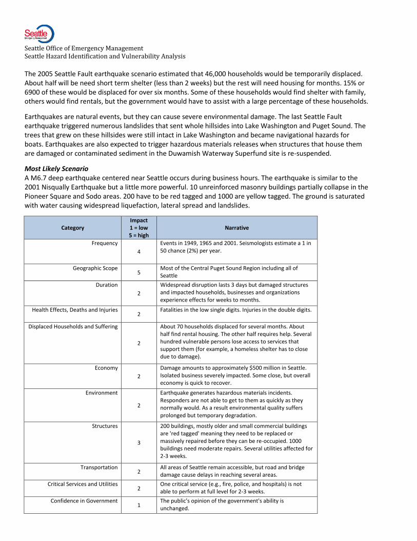
Most Likely Scenario A M6.7 deep earthquake centered near Seattle occurs during business hours. The earthquake is similar to the 2001 Nisqually Earthquake but a little more powerful. 10 unreinforced masonry buildings partially collapse in the Pioneer Square and Sodo areas. 200 have to be red tagged and 1000 are yellow tagged. The ground is saturated with water causing widespread liquefaction, lateral spread and landslides.
Category Impact 1 = low 5 = high
Narrative
Frequency
4
Events in 1949, 1965 and 2001. Seismologists estimate a 1 in 50 chance (2%) per year.
Geographic Scope 5
Most of the Central Puget Sound Region including all of Seattle
Duration
2
Widespread disruption lasts 3 days but damaged structures and impacted households, businesses and organizations experience effects for weeks to months.
Health Effects, Deaths and Injuries 2
Fatalities in the low single digits. Injuries in the double digits.
Displaced Households and Suffering
2
About 70 households displaced for several months. About half find rental housing. The other half requires help. Several hundred vulnerable persons lose access to services that support them (for example, a homeless shelter has to close due to damage).
Economy
2
Damage amounts to approximately $500 million in Seattle. Isolated business severely impacted. Some close, but overall economy is quick to recover.
Environment
2
Earthquake generates hazardous materials incidents. Responders are not able to get to them as quickly as they normally would. As a result environmental quality suffers prolonged but temporary degradation.
Structures
3
200 buildings, mostly older and small commercial buildings are 'red tagged' meaning they need to be replaced or massively repaired before they can be re-occupied. 1000 buildings need moderate repairs. Several utilities affected for 2-3 weeks.
Transportation 2
All areas of Seattle remain accessible, but road and bridge damage cause delays in reaching several areas.
Critical Services and Utilities 2
One critical service (e.g., fire, police, and hospitals) is not able to perform at full level for 2-3 weeks.
Confidence in Government 1
The public's opinion of the government's ability is unchanged.
Seattle Office of Emergency Management Seattle Hazard Identification and Vulnerability Analysis
Cascading Effects
4
The earthquake triggers several large secondary incidents. For example, improperly stored hazardous materials spill and catch fire. Due to complications from the earthquake the Fire Department is not able to bring the normal level of resources to bear. Several landsides have also been triggered destroying several homes and damaging 10-20 apartment buildings and businesses.
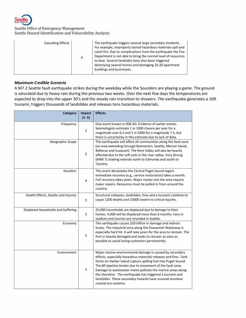
Maximum Credible Scenario A M7.2 Seattle fault earthquake strikes during the weekday while the Sounders are playing a game. The ground is saturated due to heavy rain during the previous two weeks. Over the next few days the temperatures are expected to drop into the upper 30’s and the steady rain transition to showers. The earthquake generates a 16ft tsunami, triggers thousands of landslides and releases tons hazardous materials.
Category Impact (1- 5)
Effects
Frequency
2
One event known in 900 AD. Evidence of earlier events. Seismologists estimate 1 in 1000 chance per year for a magnitude over 6.5 and 1 in 5000 for a magnitude 7.5, but there is uncertainty in this estimate due to lack of data.
Geographic Scope
5
This earthquake will affect all communities along the fault zone (an area extending through Bremerton, Seattle, Mercer Island, Bellevue and Issaquah). The Kent Valley will also be heavily affected due to the soft soils in the river valley. Very Strong (MMI 7) shaking extends north to Edmonds and south to Tacoma.
Duration
4
This event devastates the Central Puget Sound region. Immediate recovery (e.g., service restoration) takes a month. Full recovery takes years. Major routes into the area require major repairs. Resources must be pulled in from around the country.
Health Effects, Deaths and Injuries
5
Structural collapses, landslides, fires and a tsunami combine to cause 1200 deaths and 15000 severe to critical injuries.
Displaced Households and Suffering 5
25,000 households are displaced due to damage to their homes. 4,000 will be displaced more than 6 months. Fans in stadium and tourists are stranded in Seattle.
Economy
5
The earthquake causes $20 billion in damage and indirect losses. The industrial area along the Duwamish Waterway is especially hard hit. It will take years for the area to recover. The Port is heavily damaged and seeks to recover as soon as possible to avoid losing customers permanently.
Environment
5
Major marine environmental damage is caused by secondary effects, especially hazardous materials releases and fires. Tank farms on Harbor Island rupture spilling fuel into Puget Sound. The BP pipeline breaks due to movement of the fault zone. Damage to wastewater mains pollutes the marine areas along the shoreline. The earthquake has triggered a tsunami and landslides. These secondary hazards have scoured sensitive coastal eco-systems.

Seattle Office of Emergency Management Seattle Hazard Identification and Vulnerability Analysis
Category Impact
(1- 5) Effects
Structures
5
6,000 buildings are destroyed; 21,000 are severely damaged and unsafe to occupy and 80,000 are moderately damaged. Damage is heaviest south of the Ship Canal, but older sections of Ballard, Wallingford and the U-District also have concentrations of damage. Pioneer Square, the International District, Sodo and the northern area of West Seattle are especially hard hit.
Transportation
5
Damage to surface, air and marine transportation systems is extreme. All major surface routes into the city are damaged and impassible. Retrofitting of bridges ensure that critical bridges do not fail, but they suffer major damage and 12 will need to be replaced. 14 minor bridges and overpasses collapse. Both major airports have extensive damage to runways. SeaTac is able to use one runway. Port of Seattle facilities are located at the epicenter and are devastated.
Critical Services and Utilities
5
Large parts of the city lose water pressure, power and communications. Public safety responders are overwhelmed.
Confidence in Government
5
Recovery from the earthquake is slow and complex. The pace of recovery becomes a source of frustration which is directed at government.
Cascading Effects
5
The earthquake causes multiple secondary hazards each of which is a major disaster in its own right. It triggers a tsunami, numerous massive landslides, hazardous materials spills and over 80 large fires.
Alternate Scenario Because earthquakes are so complex, it is impossible to convey the earthquake hazard consequences without briefly mentioning megathrust earthquakes. A Cascadia megathrust earthquake could rank as one of the largest earthquakes ever recorded, but because Seattle is several hundred miles from the source seismic waves would weaken slightly before they reach Seattle. Shaking would be rated as ‘Very Strong’ (7 MMI) on the Modified Mercalli Intensity scale. Well engineered structures would survive with minimal damage, but poorly designed or maintained structures would suffer extensive damage or collapse. Average structures would have slight to moderate damage. A megathrust earthquake is also likely to generate a powerful seiche on Lake Union and possibly in other waterbodies as well. As bad as this earthquake would be for Seattle, it would be much worse on the coast where the shaking would be much stronger and where a tsunami would be triggered that could devastate the entire coastal area. Seattle would be in a position of having to help coastal communities even as it struggles with huge losses.
Conclusions
Earthquakes are both high probability and high impact events in Western Washington, making them the most likely cause of the most damaging disaster Seattle will face. A large earthquake could cause hundreds of deaths and lasting damage to the city’s economic base. Secondary impacts could include hazardous materials spills, landslides, conflagrations, seiches or even a tsunami. Each of these would cause additional damage and casualties. Response to and recovery from a large earthquake would be the largest challenge this community has confronted.

Seattle Office of Emergency Management Seattle Hazard Identification and Vulnerability Analysis
1 Vidale, 2013
2 Pacific Northwest Seismographic Network website.. http://www.pnsn.org/CascadiaEQs.pdf accessed 12/21/09
3 Weaver, 2003.
4 USGS, 1994.
5 Atwater, 2010
6 Rasmussen, 1974.
7 Meszaros and Fiegener, EDA 2002
8 Meszaros and Fiegener, EDA 2002
9 Pacific Northwest Seismic Network. http://www.pnsn.org/shake/about.html#intmaps. Accessed 3/3/2010.
10 United States Geological Survey. http://earthquake.usgs.gov/regional/pacnw/hazmap/seattle/. Accessed 3/3/2010.
11 Weaver, 2003.
12 Seattle Engineering Department, 1992
13 Cygna, 1990.
14 Bolin, 1989.
15 Byrant, 1991; Noson, 1988.
16 FEMA, 2008.
17 EERI, 2005