earth systems - apesrobertsenvironment.weebly.com/uploads/3/8/1/7/38176221/chapter_8.pdf · earth...
TRANSCRIPT

CHAPTER
8 Earth Systems
[Notes/Highlighting]

A lithium mine in Bolivia.
Are Hybrid Electric Vehicles as Environmentally
Friendly as We Think?
M any people in the environmental science community believe that hybrid electric
vehicles (HEV) and all-electric vehicles are some of the most exciting innovations of the

last decade. Cars that use electric power or a combination of electricity and gasoline are
much more efficient in their use of fuel than similarly sized internal
combustion (IC) automobiles. Depending on whether the car is a hybrid, a plug-in
HEV, or an all-electric vehicle, it may travel up to twice as far on a tank of gasoline as
an IC car or even use no gasoline at all.
Even though they reduce our consumption of liquid fossil
fuels, hybrid electric vehicles do come with
environmental trade-offs. Even though they reduce our consumption of liquid fossil fuels, hybrid electric vehicles
do come with environmental trade-offs. The construction of these vehicles uses scarce
metals, including neodymium, lithium, and lanthanum.Neodymium is needed to form
the magnets used in the electric motors, and lithium and lanthanum are used in the
cars’compact high-performance batteries. At present, there appears to be just enough
lanthanum available in the world to meet the demand of the Toyota Prius HEV, which
has a projected production of almost 1 million vehicles in 2011. Toyota obtains its
lanthanum from China. There are also supplies of lanthanum in various geologic
deposits in California, Australia, Bolivia, Canada, and elsewhere, but most of these
deposits have not yet been developed for mining. Until this happens, many scientists
believe that the production of HEVs and all-electric vehicles will be limited by the
availability of lanthanum.
A Toyota Prius hybrid electric vehicle.
In addition to the scarcity of these metals, we have to consider how we acquire them. A
typical Toyota Prius HEV uses approximately 1 kg (2.2 pounds) of neodymium and 10
kg (22 pounds) of lanthanum. Mining these elements involves pumping acids into deep
boreholes to dissolve the surrounding rock and then removing the resulting acid and
mineral slurry. Lithium is extracted from certain rocks, and lithium carbonate is
extracted from brine pools and mineral springs adjacent to or under salt flats. Both
extraction procedures are types of surface mining, which can have severe
environmental impacts. The holes, open pits, and ground disturbance created by the

mining of these minerals provide the opportunity for air and water to react with other
minerals in the rock, such as sulfur, to form an acidic slurry. As this acid mine drainage
flows over the land or underground toward rivers and streams, it dissolves metals and
other elements. As a result, water near surface mining operations is highly
acidic (sometimes with a pH of 2.5 or lower) and may contain harmful levels of
dissolved metals and minerals.
Wherever it occurs, mining has a number of environmental consequences,including the
creation of holes in the ground and road construction, both of which lead to
fragmentation and alteration of habitat, erosion, and contamination of water
supplies. So, while current HEV technology may reduce our dependence on certain
fossil fuels, it increases our dependence on other limited resources that must be
extracted from the ground.
Why are some of Earth’s mineral resources so limited? Why do certain elements occur
in some locations and not in others? What processes create minerals and other Earth
materials? Understanding the answers to these questions requires knowing more about
Earth systems—the topic of this chapter.
Sources: M. Armand and J.-M. Tarascon, Building better batteries, Nature 451 (2008): 652−657; K. Senior, Hybrid cars
threatened by rare-metal shortages, Frontiers in Ecology, October 7, 2009, p. 402.
KEY IDEAS
Almost all of the mineral resources on Earth accumulated when the planet formed 4.6
billion years ago. But Earth is a dynamic planet. Earth’s geologic processes form and
break down rocks and minerals, drive volcanic eruptions and earthquakes, determine
the distribution of scarce mineral resources, and create the soil in which plants
grow. Human extraction and use of these resources has environmental consequences.
After reading this chapter you should be able to
• describe the formation of Earth and the distribution of critical elements on Earth.
• define the theory of plate tectonics and discuss its importance in environmental
science.
• describe the rock cycle and discuss its importance in environmental science.
• explain how soil forms and describe its characteristics.
• explain how elements and minerals are extracted for human use.
8.1 The availability of Earth’s resources was
determined when the planet formed
[Notes/Highlighting]
Nearly all the elements found on Earth today are as old as the planet
itself.FIGURE 8.1 illustrates how Earth formed roughly 4.6 billion years ago from
cosmic dust in the solar system. The early Earth was a hot, molten sphere.For a period

of time, additional debris from the formation of the Sun bombarded Earth. As this
molten material slowly cooled, the elements within it separated into layers based on
their mass. Heavier elements such as iron sank toward Earth’s center, and lighter
elements such as silica floated toward its surface. Some gaseous elements left the solid
planet and became part of Earth’s atmosphere. Although asteroids occasionally strike
Earth today, the bombardment phase of planet formation has largely ceased, and the
elemental composition of Earth has stabilized. In other words, the elements and
minerals that were present when the planet formed are all that we have.
Figure 8.1 Formation of Earth and the solar system. The processes that formed Earth 4.6 billion
years ago determined the distribution and abundance of elements and minerals today.
These elements and minerals are distributed unevenly around the globe.Some
minerals, such as silicon dioxide—the primary component of sand and glass—are readily
available worldwide on beaches and in shallow marine and glacial

deposits. Others, such as diamonds, which are formed from carbon that has been
subjected to intense pressure, are found in relatively few isolated locations. Over the
course of human history, this uneven geographic distribution has driven many economic
and political conflicts.
Figure 8.2 Earth’s layers. (a) Earth is composed of concentric layers. (b) If we were to slice a wedge from Earth, it would cover the width of the United States.
Because Earth’s elements settled into place based on their mass, the planet is
characterized by distinct vertical zonation. If we could slice into Earth, as shown
in FIGURE 8.2, we would see concentric layers composed of various materials.The

innermost zone is the planet’s core, over 3,000 km (1,860 miles) below Earth’s
surface. The core is a dense mass largely made up of nickel and some iron. The inner
core is solid, and the outer core is liquid. Above the core is the mantle,containing
molten rock, or magma, that slowly circulates in convection cells, much as the
atmosphere does. The asthenosphere, located in the outer part of the mantle, is
composed of semi-molten, ductile (flexible) rock. The brittle outermost layer of the
planet, called thelithosphere (from the Greek word lithos, which means “rock”), is
approximately 100 km (60 miles)thick. It includes the solid upper mantle as well as
the crust, the chemically distinct outermost layer of the lithosphere. It is important to
recognize that these regions overlap: the lowest part of the lithosphere is also the
uppermost portion of the mantle.
The lithosphere is made up of several large and numerous smaller plates, which overlie
the convection cells within the asthenosphere. Over the crust lies the thin layer of soil
that allows life to exist on the planet. The crust and overlying soil provide most of the
chemical elements that comprise life.
Because Earth contains a finite supply of mineral resources, we cannot extract
resources from the planet indefinitely. In addition, once we have mined the deposits of
resources that are most easily obtained, we must use more energy to extract the
remaining resources. Both of these realities provide an incentive for us to minimize our
use of mineral resources and to reuse and recycle them when possible.
CHECKPOINT
• How did Earth form?
• What is the composition of each of Earth’s layers?
• What is the practical significance today of the way Earth’s resources were
distributed when the planet formed and cooled?
8.1 The availability of Earth’s resources was
determined when the planet formed
[Notes/Highlighting]
Nearly all the elements found on Earth today are as old as the planet
itself.FIGURE 8.1 illustrates how Earth formed roughly 4.6 billion years ago from
cosmic dust in the solar system. The early Earth was a hot, molten sphere.For a period
of time, additional debris from the formation of the Sun bombarded Earth. As this
molten material slowly cooled, the elements within it separated into layers based on
their mass. Heavier elements such as iron sank toward Earth’s center, and lighter
elements such as silica floated toward its surface. Some gaseous elements left the solid
planet and became part of Earth’s atmosphere. Although asteroids occasionally strike
Earth today, the bombardment phase of planet formation has largely ceased, and the

elemental composition of Earth has stabilized. In other words, the elements and
minerals that were present when the planet formed are all that we have.
Figure 8.1 Formation of Earth and the solar system. The processes that formed Earth 4.6 billion
years ago determined the distribution and abundance of elements and minerals today.
These elements and minerals are distributed unevenly around the globe.Some
minerals, such as silicon dioxide—the primary component of sand and glass—are readily
available worldwide on beaches and in shallow marine and glacial
deposits. Others, such as diamonds, which are formed from carbon that has been
subjected to intense pressure, are found in relatively few isolated locations. Over the
course of human history, this uneven geographic distribution has driven many economic
and political conflicts.

Figure 8.2 Earth’s layers. (a) Earth is composed of concentric layers. (b) If we were to slice a wedge from Earth, it would cover the width of the United States.
Because Earth’s elements settled into place based on their mass, the planet is
characterized by distinct vertical zonation. If we could slice into Earth, as shown
in FIGURE 8.2, we would see concentric layers composed of various materials.The
innermost zone is the planet’s core, over 3,000 km (1,860 miles) below Earth’s
surface. The core is a dense mass largely made up of nickel and some iron. The inner
core is solid, and the outer core is liquid. Above the core is the mantle,containing
molten rock, or magma, that slowly circulates in convection cells, much as the

atmosphere does. The asthenosphere, located in the outer part of the mantle, is
composed of semi-molten, ductile (flexible) rock. The brittle outermost layer of the
planet, called thelithosphere (from the Greek word lithos, which means “rock”), is
approximately 100 km (60 miles)thick. It includes the solid upper mantle as well as
the crust, the chemically distinct outermost layer of the lithosphere. It is important to
recognize that these regions overlap: the lowest part of the lithosphere is also the
uppermost portion of the mantle.
The lithosphere is made up of several large and numerous smaller plates, which overlie
the convection cells within the asthenosphere. Over the crust lies the thin layer of soil
that allows life to exist on the planet. The crust and overlying soil provide most of the
chemical elements that comprise life.
Because Earth contains a finite supply of mineral resources, we cannot extract
resources from the planet indefinitely. In addition, once we have mined the deposits of
resources that are most easily obtained, we must use more energy to extract the
remaining resources. Both of these realities provide an incentive for us to minimize our
use of mineral resources and to reuse and recycle them when possible.
CHECKPOINT
• How did Earth form?
• What is the composition of each of Earth’s layers?
• What is the practical significance today of the way Earth’s resources were
distributed when the planet formed and cooled?
• 8.
2
Earth is dynamic and constantly
changing
[Notes/Highlighting]
Earth’s geologic cycle consists of three major processes: the tectonic cycle,the rock
cycle, and soil formation. In the following sections, we’ll look at each of these processes
in turn.
8.2.1 Convection and Hot Spots
[Notes/Highlighting]
One of the critical consequences of Earth’s formation and elemental composition is that
the planet remains very hot at its center. The high temperature of Earth’s outer core
and mantle is thought to be a result of the radioactive decay of various isotopes of
elements such as potassium,uranium, and thorium, which releases heat. The heat
causes plumes of hot magma to well upward from the mantle. These plumes
produce hot spots:places where molten material from the mantle reaches the
lithosphere. As we shall see in the following pages, hot spots are an important

component of Earth dynamics. The heat from Earth’s core also creates convection cells
in the mantle similar to those described in Chapter 4 in our discussion of atmospheric
circulation (FIGURE 4.6 provides a good review). Mantle convection drives the
continuous change, creation, and renewal of Earth materials in the lithosphere.
8.2.2 Theory of Plate Tectonics
[Notes/Highlighting]
Prior to the 1900s, scientists believed that Earth’s major features—such as continents
and oceans—were fixed in place. In 1912, a German meteorologist named Alfred
Wegener published a revolutionary hypothesis proposing that the world’s continents
had once been joined in a single landmass, which he called
“Pangaea” (FIGURE 8.3). His evidence included observations of identical rock
formations on both sides of the Atlantic Ocean, as shown inFIGURE 8.3a. The positions
of these formations suggested that a single supercontinent may have broken up into
separate landmasses. Fossil evidence also suggested that a single large continent
existed in the past.Today, we can find fossils of the same species on different
continents that are separated by oceans; FIGURE 8.3b shows one example.

Figure 8.3 Evidence of drifting continents. Several lines of evidence show that the current
landmasses were once joined together in a single supercontinent. (a) Identical rock formations are
found on both sides of the Atlantic Ocean. (b) Fossils of the same species have been collected from
different continents.
For a long time, scientists resisted the idea that Earth’s lithosphere could move
laterally. Geologists in the early twentieth century went to great lengths to find
alternative explanations for Wegener’s observations. However,following the publication
of Wegener’s hypothesis, scientists found additional evidence that Earth’s landmasses
had existed in several different configurations over time. Eventually, a new idea was
proposed: the theory ofplate tectonics, which states that Earth’s lithosphere is divided
into plates, most of which are in constant motion. The tectonic cycle is the sum of the
processes that build up and break down the lithosphere.
We now know that the lithosphere is broken into a number of plates. Oceanic plates lie
primarily beneath the oceans, whereas continental plates lie beneath landmasses. The

crust of oceanic plates is dense and rich in iron. The crust of continental plates
generally contains more silicon dioxide, which is much less dense than iron. Thus the
continental plates are lighter and typically rise above the oceanic
plates. FIGURE 8.4 identifies Earth’s major plates.
Figure 8.4 Tectonic plates. Earth is covered with tectonic plates, most of which are in constant
motion. The arrows indicate the direction of plate movement. New lithosphere is added at spreading
zones and older lithosphere is recycled into the mantle at subduction zones.
Oceanic and continental plates “float” on top of the denser material beneath
them. Their slow movements are driven by convection cells in Earth’s mantle.As the
plates move, the continents slowly drift. As oceanic plates move apart,rising magma
forms new oceanic crust on the seafloor at the boundaries between those plates. This
process, called seafloor spreading, is shown inFIGURE 8.5. Where oceanic plates meet

continental plates, old oceanic crust is pulled downward, beneath the continental
lithosphere, and the heavier oceanic plate slides underneath the lighter continental
plate. This process of one plate passing under another, also shown in FIGURE 8.5, is
known assubduction.
Figure 8.5 Convection and plate movement. Convection in the mantle causes oceanic plates to
spread apart as new rock rises to the surface at spreading zones. Where oceanic and continental plate
margins come together, older oceanic crust is subducted.
8.2.3 Consequences of Plate Movement
[Notes/Highlighting]
Earth’s history is measured using the geologic time scale, shown inFIGURE 8.6. As the
continents drifted over Earth’s surface, their climates changed, geographic barriers
formed or were removed, and species evolved,adapted, or slowly or rapidly went
extinct. In some places, as the plates moved, a continent that straddled two plates
broke apart, creating two separate smaller continents or islands in different climatic
regions. Over time,species that existed on the single continent evolved into two
different species on the two separated islands (recall our discussion of allopatric
speciation from Chapter 4). The fossil record tells us how species adapted to the
changes that took place over geologic time. Climate scientists and ecologists can use
this knowledge to anticipate how species will adapt to the relatively rapid climate
changes happening on Earth today.

Figure 8.6 The geologic time scale.
Although the rate of plate movement is too slow for us to notice, geologic activity
provides vivid evidence that the plates are in motion. As a plate moves over a geologic
hot spot, heat from the rising mantle plume melts the crust, forming a volcano: a vent
in Earth’s surface that emits ash, gases,and molten lava. Volcanoes are a natural
source of atmospheric carbon dioxide, particulates, and metals. Over time, as the plate
moves past the hot spot, it can leave behind a trail of extinct volcanic islands, each with

the same chemical composition. The Hawaiian Islands, shown in FIGURE 8.7, are an
excellent example of this pattern.
Figure 8.7 Plate movement over a hot spot. The Hawaiian Islands were formed by volcanic
eruptions as the Pacific Plate traveled over a geologic hot spot. The chain of inactive volcanoes to the
northwest of Hawaii shows that those locations used to be over the hot spot. Numbers indicate how
long ago each area was located over the hot spot (in millions of years).
Previous Section |
8.2.4 Types of Plate Contact
[Notes/Highlighting]

Figure 8.8 Types of plate boundaries. (a) At divergent plate boundaries, plates move apart. (b)
At convergent plate boundaries, plates collide. (c) At transform fault boundaries, plates slide past each other.
Many other geologic events occur at the zones of contact resulting from the movements
of plates relative to one another. These zones of plate contact can be classified into
three types: divergent plate boundaries, convergent plate boundaries, and transform
fault boundaries (FIGURE 8.8).
Beneath the oceans, plates move away from each other atdivergent plate
boundaries, as illustrated inFIGURE 8.8a. At these boundaries, oceanic plates move
apart as if on a giant conveyer belt. As magma from the mantle reaches Earth’s surface
and pushes upward and outward, new rock is formed. This
phenomenon, calledseafloor spreading, creates new lithosphere and brings important
elements such as copper, lead, and silver to the surface of Earth. However, this new

rock is typically under the deep ocean. Over tens to hundreds of millions of years,as the
tectonic cycle continues, some of that material forms new land containing these
valuable resources.
Clearly, if tectonic plates are diverging, and if the surface of Earth has a finite area, the
plates must be moving together somewhere. Convergent plate boundaries form
where plates move toward one another and collide, as shown inFIGURE 8.8b. The
plates generate a great deal of pressure as they push against one another. If the
margin of an oceanic plate composed of dense, iron-rich rock collides with that of a
lighter continental plate, the oceanic plate margin, and the plate, will slide under the
continental crust,pushing up the lighter plate. This subduction of the heavier plate is
responsible for the formation of long, narrow coastal mountain ranges, such as the
Andes in South America. Because the subducted plate will melt, rising magma may be
the source of new volcano formation.
If two continental plates meet, both plate margins may be lifted, forming a
midcontinental mountain range such as the Himalayas in Asia. FIGURE 8.9 shows how
this process works.
Figure 8.9 Collision of two continental plates. (a) The Himalayan mountain range was formed
when the collision of two continental plates forced the margins of both plates upward. (b) A satellite
image of this mountain range, which includes the highest mountains on Earth.
When plates move sideways past each other, the result is a transform fault
boundary, as shown in FIGURE 8.8c.
Most plates and continents move at about the rate your fingernails grow:roughly 36
mm, or 1.4 inches, per year. While this movement is far too slow to notice on a daily
basis, the two plates underlying the Atlantic Ocean have spread apart and come

together twice over the past 500 million years,causing Europe and Africa to collide with
North America and South America and separate from them again. Do the Math “Plate
Movement” (on page 216)shows how we can calculate the time it takes for plates to
move.
8.2.5 Faults and Earthquakes
[Notes/Highlighting]
Although the plates are always in (slow) motion, their movement is not necessarily
smooth. A fault is a fracture in rock across which there is movement. Fault
zones, large expanses of rock where movement has occurred, form in the brittle upper
lithosphere where two plates meet. The rock near the plate margins becomes fractured
and deformed from the immense pressures exerted by plate movement. Imagine
rubbing two rough and jagged rocks past each other. The rocks would resist that
movement and get stuck together. The rock along a fault is jagged and thus resists
movement as the plates attempt to move. Eventually, however, the mounting pressure
overcomes the resistance, and the plates give way, slipping quickly.The result is
an earthquake.
Earthquakes occur when the rocks of the lithosphere rupture unexpectedly along a
fault. The plates can move up to several meters in just a few seconds. Earthquakes are
common in fault zones, which are also called areas of seismic
activity. FIGURE 8.10 shows one such area, the San Andreas Fault in
California, which is a transform fault. The epicenter of an earthquake is the exact point
on the surface of Earth directly above the location where the rock ruptures, as also
shown in FIGURE 8.10.
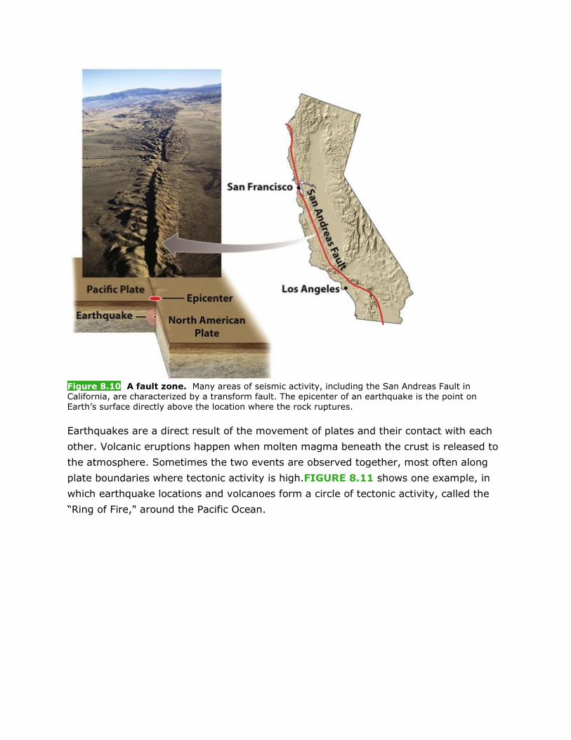
Figure 8.10 A fault zone. Many areas of seismic activity, including the San Andreas Fault in
California, are characterized by a transform fault. The epicenter of an earthquake is the point on
Earth’s surface directly above the location where the rock ruptures.
Earthquakes are a direct result of the movement of plates and their contact with each
other. Volcanic eruptions happen when molten magma beneath the crust is released to
the atmosphere. Sometimes the two events are observed together, most often along
plate boundaries where tectonic activity is high.FIGURE 8.11 shows one example, in
which earthquake locations and volcanoes form a circle of tectonic activity, called the
“Ring of Fire," around the Pacific Ocean.

Figure 8.11 Locations of earthquakes and volcanoes. A “Ring of Fire” circles the Pacific Ocean
along plate boundaries. Other zones of seismic and volcanic activity, including hot spots, are also
shown on this map.
8.2.6 The Environmental and Human Toll of Earthquakes and Volcanoes
[Notes/Highlighting]
Plate movements, volcanic eruptions, seafloor spreading, and other tectonic processes
bring molten rock from deep beneath Earth’s crust to the surface,and subduction sends
surface crust deep into the mantle. This tectonic cycle of surfacing and sinking is a
continuous Earth process. When humans live in close proximity to areas of seismic or
volcanic activity, however, the results can be dramatic and devastating.
Earthquakes occur many times a day throughout the world, but most are so small that
humans do not feel them. The magnitude of an earthquake is reported on the Richter
scale, a measure of the largest ground movement that occurs during an

earthquake. The Richter scale, like the pH scale described in Chapter 2, is
logarithmic. On a logarithmic scale, a value increases by a factor of 10 for each unit
increase. Thus a magnitude 7.0 earthquake, which causes serious damage, is 10 times
greater than a magnitude 6.0 earthquake and 1,000 (103) times greater than a
magnitude 4.0 earthquake, which only some people can feel or notice. Worldwide, there
may be as many as 800,000 small earthquakes of magnitude 2.0 or less per year, but
an earthquake of magnitude 8.0 occurs only approximately once every 10 years.
Even a moderate amount of Earth movement can be disastrous. Moderate
earthquakes (defined as magnitudes 5.0 to 5.9) lead to collapsed structures and
buildings, fires, contaminated water supplies, ruptured dams, and deaths. Loss of life is
more often a result of the proximity of large population centers to the epicenter than of
the magnitude of the earthquake. The quality of building construction in the affected
area is also an important factor in the amount of damage that occurs. In 2008, a
magnitude 7.9 earthquake in the southwestern region of Sichuan Province, China, killed
more than 69,000 people. The epicenter was near a populated area where many
buildings were probably not built to withstand a large earthquake. In 2010, a
magnitude 7.0 earthquake in Haiti killed more than 200,000 people. Many of the
victims were trapped under collapsed buildings (FIGURE 8.12).
Figure 8.12 Earthquake damage in Haiti. The 2010 earthquake in Haiti killed more than 200,000
people and destroyed most of the structures in the capital, Port-au-Prince.
DO THE MATH Plate Movement

If two cities lie on different tectonic plates, and those plates are moving so that the
cities are approaching each other, how many years will it take for the two cities to be
situated adjacent to each other?
Los Angeles is 630 km (380 miles) southeast of San Francisco. The plate under Los
Angeles is moving northward at about 36 mm per year relative to the plate under San
Francisco. Given this average rate of plate movement, how long will it take for Los
Angeles to be located next to San Francisco?
The distance traveled is 630 km, and the net distance moved is 36 mm per year. We
can use this formula to determine the answer:
630 km = 630,000 m = 630,000,000 mm
We could also put these dimensional relationships together as follows and then cancel
units that occur in both the numerator and denominator. We are left with an answer in
numbers of years:
It will take about 18 million years for Los Angeles to be located alongside San
Francisco.

Figure 8.13 A volcanic eruption. This 2001 explosive eruption from the Etna volcano in Italy threatened several nearby towns.
Extra safety precautions are needed when dangerous materials are used in areas of
seismic activity. Nuclear power plants are designed to withstand significant ground
movement and are programmed to shut down if movement above a certain threshold
occurs. The World Nuclear Association estimates that 20 percent of nuclear power
plants operate in areas of significant seismic activity.Between 2004 and 2009, in four
separate incidents, nuclear power plants in Japan shut down operation because of
ground movement that exceeded the threshold.
Volcanoes, when active, can be equally disruptive and harmful to human life. Active
volcanoes are not distributed randomly over Earth’s surface; 85 percent of them occur
along plate boundaries. As we have seen, volcanoes can also occur over hot
spots. Depending on the type of volcano, an eruption may eject
cinders, ash, dust, rock, or lava into the air (FIGURE 8.13). Volcanoes can result in
loss of life, habitat destruction and alteration, reduction in air quality, and many other
environmental consequences.
The world gained a new awareness of the impact of volcanoes when eruptions from a
volcano in Iceland disrupted air travel to and from Europe in April 2010. Ash from the

eruption entered the atmosphere in a large cloud and was spread over a wide area by
the prevailing winds.The ash contained small particles of silicon dioxide, which have the
potential to damage airplane engines. Air travel was suspended in many parts of
Europe, and millions of travelers were stranded. This may have been the greatest travel
disruption ever to have been caused by a volcano.
CHECKPOINT
• What is the theory of plate tectonics?
• What are some environmental consequences of the tectonic cycle?
• How do earthquakes and volcanoes occur?
• 8.
3
The rock cycle recycles scarce minerals
and elements
[Notes/Highlighting]
The second part of the geologic cycle is the rock cycle: the constant formation and
destruction of rock. The rock cycle is the slowest of all of Earth’s cycles. Environmental
scientists are most often concerned with the part of the rock cycle that occurs at or
near Earth’s surface.
Rock, the substance of the lithosphere, is composed of one or
moreminerals. Minerals are solid chemical substances with uniform (often
crystalline) structures that form under specific temperatures and pressures.They are
usually compounds, but may be composed of a single element such as silver or
gold. Some examples of common minerals are shown inFIGURE 8.14.
Figure 8.14 Some common minerals. (a) Pyrite (FeS2), also called “fool’s gold." (b) Graphite, a
form of carbon (C). (c) Halite, or table salt (NaCl).
8.3.1 Formation of Rocks and Minerals
[Notes/Highlighting]

FIGURE 8.15 shows the processes of the rock cycle. Rock forms when magma from
Earth’s interior reaches the surface, cools, and hardens. Once at Earth’s surface, rock
masses are broken up, moved, and deposited in new locations by processes such as
weathering and erosion. New rock may be formed from the deposited
material. Eventually, the rock is subducted into the mantle, where it melts and becomes
magma again. The rock cycle slowly but continuously breaks down rock and forms new
rock.
Figure 8.15 The rock cycle. The rock cycle slowly but continuously forms new rock and breaks
down old rock. Three types of rock are created in the rock cycle: igneous rock is formed from magma;
sedimentary rock is formed by the compression of sedimentary materials; and metamorphic rock is
created when rocks are subjected to high temperatures and pressures.
While magma is the original source of all rock, there are three major ways in which the
rocks we see at Earth’s surface can form: directly from molten magma, by compression
of sediments—materials deposited by wind, water,or glaciers—and by exposure of rocks
and other Earth materials to high temperatures and pressures. These three modes of

formation lead to three distinct rock types: igneous, sedimentary, and metamorphic
rock.
IGNEOUS ROCKS Igneous rocks are those that form directly from magma.They are
classified by their chemical composition as basaltic or granitic, and by their mode of
formation as intrusive or extrusive.
Basaltic rock is dark-colored rock that contains minerals with high concentrations of
iron, magnesium, and calcium. It is the dominant rock type in the crust of oceanic
plates. Granitic rock is lighter-colored rock made up of the minerals feldspar, mica, and
quartz, which contain elements such as silicon, aluminum, potassium, and calcium. It is
the dominant rock type in the crust of continental plates. When granitic rock breaks
down due to weathering, it forms sand. Soils that develop from granitic rock tend to be
more permeable than those that develop from basaltic rock, but both types of rock can
form fertile soil.
Intrusive igneous rocks form within Earth as magma rises up and cools in place
underground. Extrusive igneous rocks form when magma cools above Earth’s
surface, as when it is ejected from a volcano or released by seafloor
spreading. Extrusive rocks cool rapidly, so their minerals have little time to expand into
large individual crystals. The result is fine-grained,smooth rock types such as
obsidian. Both extrusive and intrusive rocks can be either granitic or basaltic in
composition.
The formation of igneous rock often brings to the surface rare elements and metals that
humans find economically valuable, such as the lanthanum described in this chapter’s
opening story. ?When rock cools, it is subject to stresses that cause it to break. Cracks
that occur in this way, known asfractures, can occur in any kind of rock. Water from
Earth’s surface running through fractures may dissolve valuable metals, which may
precipitate out in the fractures to form concentrated deposits called veins. These
deposits are important sources of gold and silver-bearing ores as well as rare metals
such as tantalum, which is used to manufacture electronic components of cell phones.
SEDIMENTARY ROCKS Sedimentary rocks form when sediments such as
muds, sands, or gravels are compressed by overlying sediments.Sedimentary rock
formation occurs over long periods when environments such as sand
dunes, mudflats, lake beds, or landslide-prone areas are buried and the overlying
materials create pressure on the materials below. The resulting rocks may be uniform
in composition, such as sandstones and mudstones that formed from ancient oceanic or
lake environments.Alternatively, they may be highly heterogeneous, such as
conglomerate rocks formed from mixed cobbles, gravels, and sands.

Sedimentary rocks hold the fossil record that provides a window into our past. When
layers of sediment containing plant or animal remains are compressed over eons, those
organic materials may be preserved, as described in Chapter 5.
METAMORPHIC ROCKS Metamorphic rocks form when sedimentary rocks, igneous
rocks, or other metamorphic rocks are subjected to high temperatures and
pressures. The pressures that form metamorphic rock cause profound physical and
chemical changes in the rock. These pressures can be exerted by overlying rock layers
or by tectonic processes such as continental collisions, which cause extreme horizontal
pressure and distortion. Metamorphic rocks include stones such as slate and marble as
well as anthracite, a type of coal. Metamorphic rocks have long been important building
materials in human civilizations because they are structurally strong and visually
attractive.
Previous Section | Nex
8.3.2 Weathering and Erosion
[Notes/Highlighting]
Most rock forms beneath Earth’s surface under intense heat, pressure, or both. When
rock is exposed at Earth’s surface, it begins to break down through the processes
of weathering and erosion. These processes are components of the rock cycle, returning
chemical elements and rock fragments to the crust by depositing them as sediments via
the hydrologic cycle. This physical breakdown and chemical alteration of rock begins the
cycle all over again, as shown in FIGURE 8.15. Without this part of the rock
cycle,elements would never be recycled.
WEATHERING Weathering occurs when rock is exposed to air, water,certain chemical
compounds, or biological agents such as plant roots, lichens,and burrowing
animals. There are two major categories of weathering—physical and chemical—that
work in combination to degrade rocks.
Physical weathering is the mechanical breakdown of rocks and
minerals(FIGURE 8.16). Physical weathering can be caused by water, wind, or
variations in temperature such as seasonal freeze-thaw cycles. When water works its
way into cracks or fissures in rock, it can remove loose material and widen the
cracks (FIGURE 8.16a). When water freezes in the cracks, the water expands, and the
pressure of its expansion can force rock to break.Different responses to temperature
can cause two minerals within a rock to expand and contract differently, which also
results in the splitting or cracking of rocks. Coarse-grained rock formed by slow cooling
or metamorphism tends to weather more quickly than fine-grained rock formed by
rapid cooling or metamorphism.

Figure 8.16 Physical weathering. (a) Water can work its way into cracks in rock, where it can
wash away loose material. When the water freezes and expands, it can widen the cracks. (b) Growing
plant roots can force rock sections apart.
Biological agents can also cause physical weathering. Plant roots can work their way
into small cracks in rocks and pry them apart (FIGURE 8.16b).Burrowing animals may
also contribute to the breakdown of rock material,although their contributions are
usually minor. However it occurs, physical weathering exposes more surface area and
makes rock more vulnerable to further degradation. By producing more surface area for
chemical weathering processes to act on, physical weathering increases the rate of
chemical weathering.
Chemical weathering is the breakdown of rocks and minerals by chemical
reactions, the dissolving of chemical elements from rocks, or both. It releases essential
nutrients from rocks, making them available for use by plants and other organisms.
Chemical weathering is most important on newly exposed minerals, known asprimary
minerals. It alters primary minerals to form secondary minerals and the ionic forms of
their constituent chemical elements. For example, when feldspar—a mineral found in
granitic rock—is exposed to natural acids in rain,it forms clay particles and releases ions
such as potassium, an essential nutrient for plants. Lichens can break down rock in a
similar way by producing weak acids. Their effects can commonly be seen on soft
gravestones and masonry. Rocks that contain compounds that dissolve easily, such as
calcium carbonate, tend to weather quickly. Rocks that contain compounds that do not
dissolve readily are often the most resistant to chemical weathering.

Figure 8.17 Chemical weathering. Water that contains carbonic acid wears away limestone, sometimes forming spectacular caves.
Recall from Chapter 2 that solutions can be basic or acidic. Depending on the starting
chemical composition of rock and the pH of the water that comes in contact with
it, hundreds of different chemical reactions can take place. For example, as we saw
in Chapter 2, carbon dioxide in the atmosphere dissolves in water vapor to create a
weak solution of carbonic acid. When waters containing carbonic acid flow into
limestone-rich geologic regions, they dissolve the limestone(which is composed of
calcium carbonate) and create spectacular cave systems (FIGURE 8.17).
Some chemical weathering is the result of human activities. For example, sulfur emitted
into the atmosphere as a result of fossil fuel combustion combines with oxygen to form
sulfur dioxide. That sulfur dioxide reacts with water vapor in the atmosphere to form
sulfuric acid, which then causes acid precipitation. Acid precipitation, also called acid
rain, is responsible for rapid degradation of old statues, gravestones,limestone, and
marble. When acid precipitation falls on soil, it can promote chemical weathering of
certain minerals in the soil, releasing elements that may then be taken up by plants or
leached from the soil into groundwater and streams.

Chemical weathering, either by natural processes or due to acid precipitation, can
contribute additional elements to an ecosystem. Understanding whether the rate of
weathering is fast or slow helps researchers assess how rapidly soil fertility can be
renewed in an ecosystem. In addition, because the chemical reactions involved in the
weathering of certain granitic rocks consume carbon dioxide from the
atmosphere, weathering can actually reduce atmospheric carbon dioxide
concentrations.
EROSION Whereas physical and chemical weathering result in the breakdown and
chemical alteration of rock, erosion is the physical removal of rock
fragments (sediment, soil, rock, and other particles) from a landscape or
ecosystem. Erosion is usually the result of two mechanisms. Wind, water,and ice
transport soil and other Earth materials by downslope creep under the force of
gravity. Living organisms, such as animals that burrow under the soil, also cause
erosion. After eroded material has traveled a certain distance from its source, it
accumulates. Deposition is the accumulation or depositing of eroded material such as
sediment, rock fragments, or soil.
Erosion is a natural process: streams, glaciers, and wind-borne sediments continually
carve, grind, and scour rock surfaces (FIGURE 8.18). In many
places, however, human land uses contribute substantially to the rate of erosion. Poor
land use practices such as deforestation, overgrazing,unmanaged construction
activity, and road building can create and accelerate erosion
problems. Furthermore, erosion usually leads to deposition of the eroded material
somewhere else, which may cause additional environmental problems. We discuss
human-caused erosion further in Chapter 10 andChapter 11.

Figure 8.18 Erosion. Some erosion, such as the erosion that created these formations in the
Badlands of South Dakota, occurs naturally as a result of the effects of water, glaciers, or wind. The
Badlands are the result of the erosion of softer sedimentary rock types, such as shales and clays.
Harder rocks, including many types of metamorphic and igneous rocks, are more resistant to erosion.
CHECKPOINT
• What is the rock cycle?
• What are the three basic rock types, and how is each formed?
• What is the difference between weathering and erosion? Why are both processes
important?
• 8.
4
Soil links the rock cycle and the
biosphere
[Notes/Highlighting]
So far, we have discussed two parts of the geologic cycle: the tectonic cycle and the
rock cycle. The third part of the geologic cycle—soil formation—takes place at Earth’s
surface. Soil is a mix of geologic and organic components.Soil forms a dynamic
membrane that covers much of Earth’s land surface,connecting the overlying biology to
the underlying geology.
As we can see in FIGURE 8.19, soil has a number of functions that benefit organisms
and ecosystems. Soil is a medium for plant growth. It also serves as the primary filter
of water as water moves from the atmosphere into rivers, streams, and
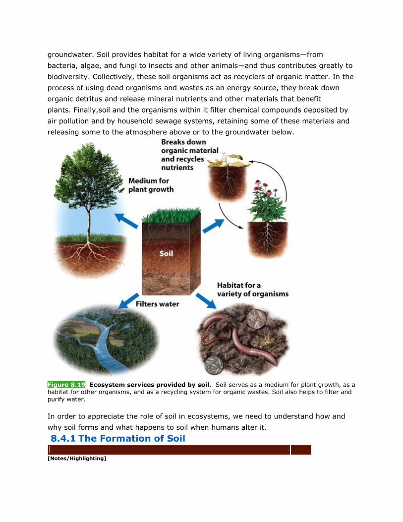
groundwater. Soil provides habitat for a wide variety of living organisms—from
bacteria, algae, and fungi to insects and other animals—and thus contributes greatly to
biodiversity. Collectively, these soil organisms act as recyclers of organic matter. In the
process of using dead organisms and wastes as an energy source, they break down
organic detritus and release mineral nutrients and other materials that benefit
plants. Finally,soil and the organisms within it filter chemical compounds deposited by
air pollution and by household sewage systems, retaining some of these materials and
releasing some to the atmosphere above or to the groundwater below.
Figure 8.19 Ecosystem services provided by soil. Soil serves as a medium for plant growth, as a
habitat for other organisms, and as a recycling system for organic wastes. Soil also helps to filter and
purify water.
In order to appreciate the role of soil in ecosystems, we need to understand how and
why soil forms and what happens to soil when humans alter it.
8.4.1 The Formation of Soil
[Notes/Highlighting]

It takes hundreds to thousands of years for soil to form. Soil is the result of physical
and chemical weathering of rocks and the gradual accumulation of detritus from the
biosphere. We can determine the specific properties of a soil if we know its parent rock
type, the amount of time during which it has been forming, and its associated biotic and
abiotic components.
The processes that form soil work in two directions simultaneously. The breakdown of
rocks and primary minerals by weathering provides the raw material for soil from
below. The deposition of organic matter from organisms and their wastes contributes to
soil formation from above. What we normally think of as “soil” is a mix of these mineral
and organic components. A poorly developed (or “young”) soil has substantially less
organic matter and fewer nutrients than a more developed (“mature”) soil. Very old
soils may also be nutrient poor because, over time, plants remove many of the
essential nutrients, while others are leached away by water. FIGURE 8.20 shows the
stages of soil development from rock to mature soil.
Figure 8.20 Soil formation. Soil is a mixture of organic and inorganic matter. The breakdown of
rock and primary minerals from the parent material provides the inorganic matter. The organic matter
comes from organisms and their wastes.
Five factors determine the properties of soils: parent material, climate, topography,
organisms, and time. None of these factors alone can determine soil properties. They

work simultaneously, and thus they must be considered together, rather than
individually.
PARENT MATERIAL A soil’s parent material is the rock material underlying it from
which its inorganic components are derived. Different soil types arise from different
parent materials. For example, a quartz sand (made up of silicon dioxide) parent
material will give rise to a soil that is nutrient poor,such as those along the Atlantic
coast of the United States. By contrast, a soil that has calcium carbonate as its parent
material will contain an abundant supply of calcium, have a high pH, and may also
support high agricultural productivity. Such soils are found in the area surrounding Lake
Champlain in northern New York and Vermont, and in many other locations.
CLIMATE The second factor influencing soil formation is climate. Soils do not develop
well when temperatures are below freezing because decomposition of organic matter
and water movement are both extremely slow in frozen or nearly frozen
soils. Therefore, soils at high latitudes of the Northern Hemisphere are composed
largely of organic material in an undecomposed state, as we saw in Chapter 4. In
contrast, soil development in the humid tropics is accelerated by the rapid weathering
of rock and soil minerals, the leaching of nutrients, and the decomposition of organic
detritus. Climate also has an indirect effect on soil formation through its influence on
the type of vegetation that develops, and thus on the type of detritus left after the
vegetation dies.
TOPOGRAPHY Topography, the surface slope and arrangement of a landscape, is the
third factor that influences soil formation. Soils that form on steep slopes are constantly
subjected to erosion and, on occasion, more drastic mass movements of material such
as landslides. In contrast, soils that form at the bottoms of steep slopes may
continually accumulate material from higher elevations and become quite deep.
ORGANISMS Many organisms influence soil formation. Plants remove nutrients from
soil and excrete organic acids that speed chemical weathering.Animals that tunnel or
burrow, such as earthworms, gophers, and voles, mix the soil, distributing organic and
mineral matter uniformly throughout.Humans have dramatic effects on soils, as we will
see below and inChapter 11 and Chapter 14.
TIME Finally, the amount of time a soil has spent developing is important in
determining its properties. As soils age, they develop a variety of characteristics. The
grassland soils that support much of the food crop and livestock feed production in the
United States are relatively old soils. Because they have had continual inputs of organic
matter for hundreds of thousands of years from the grassland and prairie vegetation
growing above them, they have become deep and fertile. Other soils that are equally
old, but with less productive communities above them and perhaps greater quantities of
water moving through them, can become relatively infertile.

8.4.2 Soil Horizons and Properties
[Notes/Highlighting]
The five factors that influence soil formation vary across the landscape, so they lead to
the formation of different soil types in different locations. Soils with different properties
serve different functions for humans. For example,some soil types are good for growing
crops, others for building a housing development. Therefore, to understand and classify
soil types, we need to understand both soil horizons and soil properties.
SOIL HORIZONS As soils form, they develop characteristic horizons, or layers, like
those visible in FIGURE 8.21. The specific composition of those horizons depends
largely on climate, vegetation, and parent material.
Figure 8.21 Soil horizons. All soils have horizons, or layers, which vary depending on soil-forming
factors such as climate, organisms, and parent material.
At the surface of many soils is a layer of organic detritus such as
leaves,needles, twigs, and even animal bodies, all in various stages of
decomposition. This horizon, called the O horizon, or organic horizon, is most
pronounced in forest soils and is also found in some grasslands.
In a soil that is mixed, either naturally or by human agricultural practices, the top layer
of soil is the A horizon, also known as topsoil. The A horizon is a zone of organic
material and minerals that have been mixed together.
In some acidic soils, an E horizon—a zone of leaching, or eluviation—forms under the
O horizon or, less often, the A horizon. When present, it always occurs above the B
horizon. When an E horizon is present, iron, aluminum,and dissolved organic acids from

the overlying horizons are transported through and removed from the E horizon and
then deposited in the B horizon, where they accumulate.
All soils have a B horizon. The B horizon, commonly known as subsoil, is composed
primarily of mineral material with very little organic matter. If there are nutrients in the
soil, they will be present in the B horizon.
The C horizon, the least weathered soil horizon, always occurs beneath the B
horizon. The C horizon is similar to the parent material.
Each of these horizons lends certain physical, chemical, and biological properties to the
soil within which it exists. These properties are extremely important in understanding
the role of soils in environmental science.
Figure 8.22 Soil properties. (a) Soils consist of a mixture of clay, silt, and sand. The relative
proportions of these particles determine the texture of the soil. (b) The relative sizes of sand, silt, and clay.
PHYSICAL PROPERTIES OF SOIL Sand, silt,and clay are mineral particles of different
sizes.The texture of a soil is determined by the percentages of sand, silt, and clay it

contains. We can plot those percentages on a triangle-shaped diagram like the one
in FIGURE 8.22 to identify and compare soil types. For each location on the
diagram, there are three determinants: the percentages of sand, silt, and clay. A point
in the middle of the “loam” category (approximately at the “a” in “loam”
in FIGURE 8.22) represents a soil that contains 40 percent sand, 40 percent silt,and
20 percent clay. We can determine this by following the lines from that point to the
scales on each of the three sides of the triangle in turn. If you are not certain which line
to follow from a given point, always follow the line that leads to the lower value. The
sum of sand plus silt plus clay will always be 100 percent. Conversely, in the
laboratory, a soil scientist can determine the percentage of each component in a soil
sample and then plot the results. This allows her to give a name to the soil, such as
“silty clay loam."
The permeability of soil—how quickly soil drains—depends on its
texture, as FIGURE 8.23 shows.Sand particles—the largest of the three components—
pack together loosely. Water can move easily between the particles, making sand quick
to drain and quick to dry out. Soils with a high proportion of sand are also easy for
roots to penetrate, making sandy soil somewhat advantageous for growing plants such
as carrots and potatoes. Clay particles—the smallest of the three components—pack
together much more tightly than sand particles. As a result, there is less pore space in
a clay-dominated soil, and water and roots cannot easily move through it. Silt particles
are intermediate in size and in their ability to drain or retain water.
Figure 8.23 Soil porosity. The porosity of soil depends on its texture. Sand, with its large, loosely
packed particles, drains quickly. Clay drains much more slowly.
The best agricultural soil is a mixture of sand, silt, and clay. This mixture promotes
balanced water drainage and retention. In natural ecosystems,however, various
herbaceous and woody plants have adapted to growing in wet, intermediate, and dry
environments, so there are plants that thrive in soils of virtually all textures.
Soil texture can have a strong influence on how the physical environment responds to
environmental pollution. For example, the groundwater of western Long Island in New

York State has been contaminated by toxic chemicals discharged from local
industries. One reason for the contamination is that Long Island is dominated by sandy
soils that readily allow surface water to drain into the groundwater. Soil usually serves
as a filter that removes pollutants from the water moving through it, but because sandy
soils are so porous, pollutants move through them quickly and therefore are not filtered
effectively.
Clay is particularly useful where a potential contaminant needs to be contained. Many
modern landfills are lined with clay, which helps keep the contaminants in solid waste
from leaching into the soil and groundwater beneath the landfill.
CHEMICAL PROPERTIES OF SOIL Chemical properties are also important in
determining how a soil functions. Clay particles contribute the most to the chemical
properties of a soil because of their ability to attract positively charged mineral
ions, referred to as cations. Because clay particles have a negative electrical
charge, cations are adsorbed—held on the surface—by the particles. The cations can be
subsequently released from the particles and used as nutrients by plants.
The ability of a particular soil to adsorb and release cations is called its cation
exchange capacity (CEC). CEC is sometimes referred to as the nutrient holding
capacity. The overall CEC of a soil is a function of the amount and types of clay particles
present. Soils with high CECs have the potential to provide essential cations to plants
and therefore are desirable for agriculture.If a soil is more than 20 percent
clay, however, its water retention becomes too great for most crops and many other
types of plants. In such waterlogged soils, plant roots are deprived of oxygen. Thus
there is a trade-off between CEC and permeability.
Another important chemical property of soil involves the relationship between soil bases
and soil acids. Calcium, magnesium, potassium, and sodium are collectively called soil
bases because they can neutralize or counteract soil acids such as aluminum and
hydrogen. Soil acids are generally detrimental to plant nutrition, while soil bases tend
to promote plant growth. With the exception of sodium, all the soil bases are essential
for plant nutrition. Base saturation is a measure of the proportion of soil bases to soil
acids,expressed as a percentage.

Figure 8.24 Soil organisms. Bacteria, fungi, and protozoans account for 80 to 90 percent of soil organisms. Also present are snails, slugs, insects, earthworms, and rodents.
Because of the way they affect nutrient availability to plants, CEC and base saturation
are important determinants of overall ecosystem productivity. If a soil has a high
CEC, it can retain and release plant nutrients. If it has a relatively high base
saturation, its clay particles will hold important plant nutrients such as
calcium, magnesium, and potassium. A soil with both high CEC and high base
saturation is likely to support high productivity.
BIOLOGICAL PROPERTIES OF SOIL As we have seen, a diverse group of organisms
populates the soil. FIGURE 8.24 shows a representative sample. Three groups of
organisms account for 80 to 90 percent of the biological activity in
soils: fungi, bacteria, and protozoans(certain single-celled organisms). Rodents and
earthworms contribute to soil mixing and the breakdown of large organic materials into
smaller pieces. Some soil organisms, such as snails and slugs, are herbivores that eat
plant roots as well as aboveground parts of plants. However, the majority of soil
organisms are detritivores, which consume dead plant and animal tissues and recycle
the nutrients they contain. Some soil bacteria also fix nitrogen, which, as we saw
in Chapter 3, is essential for plant growth.
8.4.3 Soil Degradation and Erosion
[Notes/Highlighting]

For centuries, the use and overuse of land for agriculture, forestry, and other human
activities has led to significant soil degradation: the loss of some or all of the ability of
soils to support plant growth. One of the major causes of soil degradation is soil
erosion, which occurs when topsoil is disturbed—for example, by plowing—or vegetation
is removed, allowing the soil to be eroded by water or wind (FIGURE 8.25). Topsoil
loss can happen rapidly, in as little as a single growing season, but it takes centuries for
the lost topsoil to be replaced. Compaction of soil by machines, humans, and livestock
can alter its properties and reduce its ability to retain moisture. Compaction and drying
of soil can, in turn, reduce the amount of vegetation that grows in the soil and thereby
increase erosion. Intensive agricultural use and irrigation can deplete soil nutrients, and
the application of agricultural pesticides can pollute the soil.
Figure 8.25 Erosion from human activity. Erosion in this cornfield is obvious after a brief
rainstorm.
8.5 The uneven distribution of mineral
resources has social and environmental
consequences
[Notes/Highlighting]
The tectonic cycle, the rock cycle, and soil formation and erosion all influence the
distribution of rocks and minerals on Earth. These resources, along with fossil
fuels, exist in finite quantities, but are vital to modern human life. In this section we will
discuss some important nonfuel mineral resources and how humans obtain them. (We

will discuss fuel resources in Chapter 12 andChapter 13.) Some of these resources
are abundant, whereas others are rare and extremely valuable.
Figure 8.26 Elemental composition of Earth’s crust. Oxygen is the most abundant element in the crust. Silicon, aluminum, and iron are the next three most abundant elements.
As we saw at the beginning of this chapter, early Earth cooled and differentiated into
distinct vertical zones. Heavy elements sank toward the core, and lighter elements rose
toward the crust. Crustal abundance is the average concentration of an element in
the crust. Looking at FIGURE 8.26, we can see that four elements—
oxygen, silicon,aluminum, and iron—constitute over 88 percent of the
crust. However, the chemical composition of the crust in any one location is highly
variable.
Environmental scientists and geologists study the distribution and types of mineral
resources around the planet in order to locate them and manage their extraction or
conservation. Ores are concentrated accumulations of minerals from which
economically valuable materials can be extracted.Ores are typically characterized by
the presence of valuable metals, but accumulations of other valuable materials, such as
salt or sand, can also be considered ores. Metals are elements with properties that
allow them to conduct electricity and heat energy and perform other important
functions. Copper, nickel, and aluminum are common examples of metals. In rock, they
exist in varying concentrations, usually in association with elements such as
sulfur, oxygen, and silicon. Some metals,such as gold, exist naturally in a pure form.
Ores are formed by a variety of geologic processes. Some ores form when magma
comes into contact with water, heating the water and creating a solution from which
metals precipitate. Other ores form after the deposition of igneous rock. Some ores
occur in relatively small areas of high concentration, such as

veins. Others, called disseminated deposits, occur in much larger areas of rock, often in
lower concentrations. Still others, such as copper, can be deposited throughout a large
area as well as in veins.Nonmetallic mineral resources, such as
clay, sand, salt, limestone, and phosphate, typically occur in concentrated
deposits. These deposits occur as a result of their chemical or physical separation from
other materials by water, in conjunction with the tectonic and rock cycles. Some
ores, such asbauxite, the ore in which aluminum is most commonly found, are formed
by intense chemical weathering in tropical regions.
The global supply of mineral resources is difficult to quantify. Because private
companies hold the rights to extract certain mineral resources, information about the
exact quantities of resources is not always made public. The publicly known estimate of
how much of a particular resource is available is based on its reserve: the known
quantity of the resource that can be economically recovered. TABLE 8.1 lists the
estimated number of years of remaining supply of some of the most important metal
resources commonly used in the United States, assuming that rates of use do not
change. Some important metals, such as tantalum, have never existed in the United
States.The United States has used up all of its reserves of some other metals, such as
nickel, and must now import those metals from other countries.
8.5.1 Types of Mining
[Notes/Highlighting]
Mineral resources are extracted from Earth by mining the ore and separating any other
minerals, elements, or residual rock away from the sought-after element or
mineral. Two kinds of mining take place on land: surface miningand subsurface

mining (FIGURE 8.27). Each method has environmental,human, and social benefits
and costs.
Figure 8.27 Surface and subsurface mining. Surface mining methods include strip, open pit,
mountaintop removal, and placer mining.
SURFACE MINING A variety of surface mining techniques can be used to remove a
mineral or ore deposit that is close to Earth’s surface. Strip mining, the removal of
“strips” of soil and rock to expose ore, is used when the desired ore is relatively close to
Earth’s surface and runs parallel to it, as is often the case for deposits of sedimentary
materials such as coal and sand. In these situations, miners remove a large volume of
material, extract the resource, and return the unwanted waste material, called mining
spoilsor tailings, to the hole created during the mining. A variety of strategies can be
used to restore the affected area to something close to its condition before mining
began.
Open-pit mining, the creation of a large pit or hole in the ground that is visible from
Earth’s surface, is used when the resource is close to the surface but extends beneath
the surface both horizontally and vertically. Copper mines are usually open-pit
mines. One of the largest open-pit mines in the world is the Kennecott Bingham Canyon

mine near Salt Lake City, Utah. This copper mine is 4.4 km (2.7 miles) across and 1.1
km (0.7 miles) deep.
In mountaintop removal, miners remove the entire top of a mountain with
explosives. Large earthmoving equipment removes the resource and deposits the
tailings in lower-elevation regions nearby, often in or near rivers and streams.
Placer mining is the process of looking for metals and precious stones in river
sediments. Miners use the river water to separate heavier items, such as
diamonds, tantalum, and gold, from lighter items, such as sand and mud.The
prospectors in the California gold rush were placer miners, and the technique is still
used today.
SUBSURFACE MINING Surface mining techniques are ineffective when the desired
resource is more than 100 m (328 feet) below Earth’s surface. In such cases, miners
must turn to subsurface mining. Typically, a subsurface mine begins with a horizontal
tunnel dug into the side of a mountain or other feature containing the resource. From
this horizontal tunnel, vertical shafts are drilled, and elevators are used to bring miners
down to the resource and back to the surface. The deepest mines on Earth are up to
3.5 km (2.2 miles)deep. Coal, diamonds, and gold are some of the resources removed
by subsurface mining.
8.5.2 Mining, Safety, and the Environment
[Notes/Highlighting]
The extraction of mineral resources from Earth’s crust has a variety of environmental
impacts and human health consequences. Virtually all mining requires the construction
of roads, which can result in soil erosion, damage to waterways, and habitat
fragmentation. In addition, all types of mining produce tailings. Some tailings
contaminate land and water with acids and metals (TABLE 8.2).

In mountaintop removal, the mining spoils are typically deposited in the adjacent
valleys, sometimes blocking or changing the flow of rivers.Mountaintop removal is used
primarily in coal mining and is safer for workers than subsurface coal mining. In terms
of environmental damage, mining companies do sometimes make efforts to restore the
mountain to its original shape. However, there is considerable disagreement about
whether these reclamation efforts are effective. Damage to streams and nearby
groundwater during mountaintop removal cannot be completely rectified by the
reclamation process.
Placer mining can also contaminate large portions of rivers, and the areas adjacent to
the rivers, with sediment and chemicals. In certain parts of the world, the toxic metal
mercury is used in placer mining of gold and silver.Mercury is a
highly volatile metal; that is, it moves easily among air, soil, and water. Mercury is
harmful to plants and animals and can damage the central nervous system in
humans; children are especially sensitive to its effects.
The environmental impacts of subsurface mining may be less apparent than the visible
scars left behind by surface mining. One of these impacts is acid mine drainage. To
keep underground mines from flooding, water must be continually pumped out. Water
from mining operations can have an extremely low pH. This acid mine drainage lowers
the pH of nearby soils and streams,causing severe damage to the ecosystem.
Subsurface mining is a dangerous occupation. Hazards to miners include accidental
burial, explosions, and fires. In addition, the inhalation of gases and particles over long
periods can lead to a number of occupational respiratory diseases, including black lung
disease and asbestosis, a form of lung cancer. In the United States, between 1900 and

2006, more than 11,000 coal miners died in underground coal mine explosions and
fires. A much larger number died from respiratory diseases. Today, there are relatively
few deaths per year in coal mines in the United States, in part because of improved
work safety standards and in part because there is much less subsurface mining in the
country today. In other countries,especially China, mining accidents remain fairly
common.
As human populations grow and developing nations continue to industrialize,the
demand for mineral resources continues to increase. But as the most easily mined
mineral resources are depleted, extraction efforts become more expensive and
environmentally destructive. The ores that are easiest to reach and least expensive to
remove are always recovered first. When those sources are exhausted, mining
companies turn to deposits that are more difficult to reach. These extraction efforts
result in greater amounts of mining spoils and more of the environmental problems we
have already noted.Therefore, an important part of living sustainably will be learning to
use and reuse limited mineral resources more efficiently.
8.5.3 Mining Legislation
[Notes/Highlighting]
Governments have sought to regulate the mining process for many years.Early mining
legislation was primarily focused on promoting economic development, but later
legislation became concerned with worker safety as well as environmental
protection. The effectiveness of these mining laws has varied.
The Mining Law of 1872 was passed by the U.S. Congress to regulate the mining of
silver, copper, and gold ore as well as fuels, including natural gas and oil, on federal
lands. This law, also known as the General Mining Act,allowed individuals and
companies to recover ores or fuels from federal lands.The law was written primarily to
encourage development and settlement in the western United States and, as a
result, contains very few environmental protection provisions.
The Surface Mining Control and Reclamation Act of 1977 regulates surface mining of
coal and the surface effects of subsurface coal mining. The act mandates that land be
minimally disturbed during the mining process and reclaimed after mining is
completed. Mining legislation does not regulate all of the mining practices that can have
harmful effects on air, water, and land,however. In later chapters we will learn about
other U.S. legislation that does,to some extent, address these issues, including the
Clean Air Act, Clean Water Act, and Superfund Act.
CHECKPOINT
• Why are economically valuable mineral resources distributed unevenly on the
planet?

• Describe the various types of surface mining operations.
• What are the consequences of surface mining versus subsurface mining, and
how has mining legislation tried to reduce those impacts?
WORKING TOWARD SUSTAINABILITY Mine Reclamation and Biodiversity
O ne of the environmental impacts of surface mining is the amount of land surface it
disturbs. Once a mining operation is finished, the mining company can either leave the
land disturbed or try to restore it to its original condition. In the United States, the
Surface Mining Control and Reclamation Act of 1977 requires coal mining companies to
restore the lands they have mined. Regulations also require other types of mining
operations to do some level of restoration.
A disturbed ecosystem can return to a state similar to its original condition only if the
original physical, chemical, and biological properties of the land are
recreated. Therefore, reclamation after mining involves several steps. First,the mining
company must fill in the hole or depression it has created in the landscape. Second, the
fill material must be shaped to follow the contours of the land that existed before
mining began.
Usually, the mining company has scraped off the topsoil that was on the land and put it
aside. This topsoil must be returned and spread over the landscape. Finally, the land
must be replanted. In order to recreate the communities of organisms that inhabited
the area before mining, the vegetation planted on the site must be native to the area
and foster the process of natural succession. Properly completed reclamation makes the
soil physically stable so that erosion does not occur and water infiltration and retention
can proceed as they did before mining. The reclaimed material must be relatively free
of metals, acids, and other compounds that could potentially leach into nearby bodies of
water.
Many former mining areas, for one reason or another, have not been reclaimed
properly. However, there are an increasing number of stories of reclamation efforts that
have achieved conditions equal to those that existed prior to the mining operation. The
Trapper Mine in Craig, Colorado, and other mines like it, illustrate reclamation success
stories (FIGURE 8.28).

Figure 8.28 Mining and reclamation. At a strip mine operation in Colorado, not far from the
Trapper Mine: (a) active mining underway; (b) restored native habitat after reclamation.
The Trapper Mine produces about 2 million tons of coal per year, which is sold to a
nearby electricity generation plant. Although all coal mining operations are required to
save excavated rock and topsoil, managers at the Trapper Mine have stated that they
are meticulous about saving all the topsoil they remove. The rock they save is used to
fill the lower portions of excavated holes. Workers then install drainage pipes and other
devices to ensure proper drainage of water. The topsoil that has been set aside is
spread over the top of the restored ground and contoured as it was before
mining.Trapper Mine reclamation staff then replant the site with a variety of native
species of grasses and shrubs, including the native sagebrush commonly found in the
high plateaus of northwestern Colorado.
Whereas government officials, and even the Colorado branch of the Sierra Club, have
expressed approval of the Trapper Mine reclamation process,perhaps the strongest
evidence of its success is the wildlife that now inhabits the formerly mined areas. The
Columbian sharp-tailed grouse (Tympanuchus phasianellus columbianus), a threatened
bird species, has had higher annual survival and fertility rates on the reclaimed mine
land than on native habitat in other parts of Colorado. Populations of elk, mule
deer, and antelope have all increased on reclaimed mine property.
Reclamation issues must be addressed for each particular area where mining occurs. As
we have seen, subsurface and surface water runoff in certain locations can contain high
concentrations of toxic metals and acids. In other situations, although certain native
species may increase in abundance after reclamation, other native species may
decrease. Nevertheless, with supervision, skill, and enough money to pay for the proper

reclamation techniques, a reclaimed mining area can become a satisfactory or even an
improved habitat for many species. References
Department of the Interior, Office of Surface Mining Reclamation and
Enforcement.http://www.osmre.gov/.
Raabe, S. 2002. Nature’s comeback: Trapper Mine reclamation attracts wildlife,wins
praise. Denver Post, November 12, p. C01.
KEY IDEAS REVISITED • Describe the formation of Earth and the distribution of critical elements
on Earth.
Earth formed from cosmic dust in the solar system. As it cooled, heavier elements, such
as iron, sank toward the core, while lighter elements, such as silica, floated toward the
surface. These processes have led to an uneven distribution of elements and minerals
throughout the planet. • Define the theory of plate tectonics and discuss its importance in environmental science.
Earth is overlain by a series of plates that move at rates of a few millimeters per
year. Plates can move away from each other, move toward each other, or slide past
each other. One plate can be subducted under another. These tectonic processes create
mountains, earthquakes, and volcanoes. • Describe the rock cycle and discuss its importance in environmental science.
Rocks are made up of minerals, which are formed from the various chemical elements
in Earth’s crust. The processes of the rock cycle lead to the formation, breakdown, and
recycling of rocks. Weathering and erosion break down and move rock
material, releasing chemical elements and contributing to soil formation. • Explain how soil forms and describe its characteristics.
Soil forms as the result of physical and chemical weathering of rocks and the gradual
accumulation of organic detritus from the biosphere. The factors that determine soil
properties are parent material, climate,topography, soil organisms, and time. The
relative abundances of sand,silt, and clay in a soil determine its texture. • Explain how elements and minerals are extracted for human use.
Concentrated accumulations of minerals from which economically valuable materials
can be extracted are called ores. Ores are removed by surface or subsurface mining
operations. Surface mining generally results in more environmental impacts, whereas
subsurface mining is more dangerous to miners. With the exception of coal
mining, legislation directly related to mining does not address most environmental
considerations.

PREPARING FOR THE AP EXAM
MULTIPLE-CHOICE QUESTIONS
[Notes/Highlighting]
1. As Earth slowly cooled,
• (a) lighter elements sank to the core and heavier elements moved to the
surface.
• (b) lighter elements mixed with heavier elements and sank to the core.
• (c) lighter elements mixed with heavier elements and moved to the surface.
• (d) lighter elements moved to the surface and heavier elements sank to the
core.
• (e) lighter and heavier elements dispersed evenly from the core to the surface. [Answer Field]
2. The correct vertical zonation of Earth above the core is
• (a) asthenosphere-mantle-soil-lithosphere.
• (b) asthenosphere-lithosphere-mantle-soil.
• (c) mantle-asthenosphere-lithosphere-soil.
• (d) mantle-lithosphere-soil-asthenosphere.
• (e) soil-mantle-lithosphere-asthenosphere. [Answer Field]
3. Evidence for the theory of plate tectonics includes
• I large deposits of copper ore.
• II identical rock formations on both sides of the Atlantic.
• III fossils of the same species on distant continents.
• (a) I only
• (b) I and III only
• (c) II and III only
• (d) I and II only
• (e) I, II, and III [Answer Field]
4. Which type of mining is usually most directly harmful to miners?
• (a) Mountaintop removal
• (b) Open-pit mining
• (c) Placer mining
• (d) Strip mining
• (e) Subsurface mining [Answer Field]

5. Measured on the Richter scale, an earthquake with a magnitude of 7.0 is ____ times
greater than an earthquake with a magnitude of 2.0.
• (a) 10
• (b) 100
• (c) 1,000
• (d) 10,000
• (e) 100,000
For questions 6 to 9, select from the following choices:
• (a) Seismic activity center
• (b) Divergent plate boundary
• (c) Convergent plate boundary
• (d) Transform fault boundary
• (e) Epicenter [Answer Field]
6. At which type of boundary do tectonic plates move sideways past each other? [Answer Field]
7. At which type of boundary does subduction occur? [Answer Field]
8. At which type of boundary does seafloor spreading occur? [Answer Field]
9. Which term refers to the point on Earth’s surface directly above an earthquake? [Answer Field]
10. Fossil records are found in
• (a) intrusive rock.
• (b) extrusive rock.
• (c) igneous rock.
• (d) metamorphic rock.
• (e) sedimentary rock. [Answer Field]
11. Which of the following statements about soil is not correct?
• (a) Soil always filters out pollutants that pass through it.
• (b) Soil is the medium for plant growth.
• (c) Soil is a primary filter of water.
• (d) A wide variety of organisms live in soil.
• (e) Soil plays an important role in biogeochemical cycles. [Answer Field]
12. The soil horizon commonly known as subsoil is the
• (a) A horizon.
• (b) O horizon.
• (c) B horizon.

• (d) C horizon.
• (e) E horizon.
FREE-RESPONSE QUESTIONS
[Notes/Highlighting]
1. The rock cycle plays an important role in the recycling of Earth’s limited amounts of
mineral resources.
• (a) The mineral composition of rock depends on how it is formed. Name
the three distinct rock types, explain how each rock type is formed, and
give one specific example of a rock of each type. (6 points)
• (b) Explain either the physical or the chemical weathering process that leads to
the breakdown of rocks. (2 points)
• (c) Describe the natural processes that can lead to the formation of soil,and
discuss how human activities can accelerate the loss of soil. (2 points) [Answer Field]
2. Read the following article that appeared on the Web site of the organization
“Eatwild," at http://www.eatwild.com/environment.html, and answer the questions that
follow.
Grassfarming Benefits the Environment
Grazing better for the soil than growing grain
Six Minnesota pasture-based ranchers asked researchers to compare the health of their
soil with soil from neighboring farms that produced corn,soybean, oats, or hay. At the
end of four years of monitoring, researchers concluded that the carefully managed
grazed land had
• 53% greater soil stability
• 131% more earthworms
• Substantially more organic matter
• Less nitrate pollution of groundwater
• Improved stream quality
• Better habitat for grassland birds and other wildlife
Depending on the way that cattle are managed, they can either devastate a landscape
or greatly improve the health of the soil. [“Managed Grazing as an Alternative Manure
Management Strategy," Jay Dorsey, Jodi Dansingburg,Richard Ness, USDA-ARS, Land
Stewardship Project.]
Pasture reduces topsoil erosion by 93 percent
Currently, the United States is losing three billion tons of nutrient-rich topsoil each
year. Growing corn and soy for animal feed using conventional methods causes a

significant amount of this soil loss. Compared with row crops,pasture reduces soil loss
by as much as 93 percent. [Ontario Ministry of Agriculture and Food, Robert P. Stone
and Neil Moore, Fact Sheet 95−089.]
• (a) Explain the consequences of the observations in the studies described and
comment on the long-term sustainability of each agricultural practice.
o (i) What roles do earthworms play in maintaining soil stability? (1 point)
o (ii) How does the presence of organic matter benefit the soil? (1 point)
o (iii) Suggest why there is less nitrate contamination of groundwater from
the permanent pastures. (1 point)
o (iv) In what ways could the stream quality have improved? (1 point)
• (b) Discuss one negative consequence of grazing cattle on pastureland instead of
feeding them on grain. (3 points)
• (c) Describe one potential negative effect on rivers and streams of grazing cattle
on pastureland. (3 points)
MEASURING YOUR IMPACT
[Notes/Highlighting]
1. What is the impact of your diet on soil dynamics? In the landmark 1997 report
“Livestock Production: Energy Inputs and the Environment," Cornell University ecologist
David Pimentel wrote that feeding grain to cattle consumes more resources than it

yields, accelerates soil erosion, and reduces the supply of food for the world’s
people. Some highlights of the report include the following:
• Each year, an estimated 41 million tons of plant protein is fed to U.S.livestock to
produce an estimated 7 million tons of animal protein for human
consumption. About 26 million tons of the livestock feed comes from grains and 15
million tons from forage crops. For every kilogram of high-quality animal protein
produced, livestock are fed nearly 6 kg of plant protein. The 7 billion animals
consume five times as much grain as the entire U.S. human population.
• Every kilogram of beef produced takes 100,000 liters of water. Some 900 liters
of water go into producing a kilogram of wheat. Potatoes are even less “thirsty," at
500 liters per kilogram.
• About 90 percent of U.S. cropland is losing soil to erosion at 13 times the rate of
soil formation. Soil loss is most severe in some of the richest farming
areas: Iowa, for example, loses topsoil at 30 times the rate of soil formation. Iowa
has lost one-half of its topsoil in 150 years of farming.That soil took thousands of
years to form. [Answer Field]
2. Over the course of 1 week, make a daily record of what you eat and drink.At the end
of the week, answer the following questions:
• (a) Evaluate the components of your diet for the week. How many portions of
animal protein did you eat each day?
• (b) Most agricultural fields receive inputs of phosphorus, calcium, and
magnesium, which are usually obtained by mining rocks containing those
elements, grinding them up, and adding them to fertilizers. Assess the likely impact
of this practice on the demand for certain rocks and on soil dynamics.
• (c) Describe changes you could make to your diet to minimize the impacts you
cited above.
• (d) How do you think your diet would compare to that of a person in a
developing country? How would their ecological footprint compare to
yours? Hint: You may have to draw upon previous chapters you have read as well
as this chapter to answer this question.
