earth observing system - nasa · 2013-08-30 · the earth observing system (eos) is the centerpiece...
TRANSCRIPT

EarthObservingSystem
_:_!_!_iit_i_i_i_i_iiiiiiiiiiiiiiiii_i_!_!_]_i_i_i_ii_!_i!i!!ii_iii_i_ii!!iiiiiiiii_i_ii!_i!!i_i_i_i_i_i_i_!_i_i_!_i_i_iii_iiiii_iii_iii_iii!ii!_!_i!i!i!!!i_!!i_!i_i_i!i!i!iiiii!iiiii_iiiiiiiii!iii_i_i!_ii!i!_!iii!!i!iiiiiii_ii_i_!iii_iii_i_i_i_i_i_iiii!_!_ii!ii_i_!iii!i!ii!!!_i!_ii_ii_
iiiiiiiiiiiiiii i iiiiiii iiiiilililli i i_i!!_!ii_ii_!i_i!iiiiiiiiii_ii!ii_ii_ii_i_;_ii_iii_iiii_i_ii_iiif_i_i_i_!_i_i_i_i_i!_i_i_ii!_i_i_!ii_i_i_i_iiiii_iii_iii_iii_i_!!_i_!_!!_!ii_i_i_ii!_i_i_iii_i_i_i_!_i_i_!_i_i_iii_f_iiiiiii_iii_!_i_i_f_i_i_i_!_iii_i!i_i_i!i_i_iii_i_i_iii_ii_ii_ii_ii_i!ii_ii!!i';'i'ii'i';'!'!'!'!' :'X '!'!'!'!'!:!+!'!'!:!:!:::::!::::':'.:'.:::f::::::::::::::7::::::2:':':':':':":':':'Z':':':':':?:?7:':':':'Z'? :iltZ':ii':' :':::_:::7.":::::::::::':::::::::i:i::::?:":".':':':':i:i:i':::':':':::::::i::::::::: %:::::.:::,:::::.:-:-:.:-:.:.:-i-
:_i!i::ii::ii::i:,i::_i:::,_:':i_;_i'i_i_i!i_',i'i_i_i:,i_i_i:_iiiiiiiiiiiiiiiiiiii!iiiiii;iiiiiiii!iiliiiiiii_,i_,iiiiii!iiiiili!!',ilil!!i}i',il!iili:,!if_i'!':!ii!_,i_,i_:i',f,iii',iiiiiiiiliiiiiiiiiiiiiiii_i',!iii;ili!:,iiiiii::,i;,iii!!i:i',!!!_:i_i::ii:!_i:_!ii_:i_!i__,i_i::_::i_i_i_:iii_i_i_i'_i'_i':ii!iiii_:!ii_:i_i
1989
Reference Handbook
(NAS A-TM- 1049_8) EARTH1989 REFERENCE HANDBOOK
OBSERVING SYSTEM:
(NASA) 68 IDCSCL 22B
G3/18
N91-Z2353
Unc]as
0008554
N/_ANational Aeronautics and
Space Administration
Goddard Space Flight Center
https://ntrs.nasa.gov/search.jsp?R=19910013040 2020-06-06T06:59:23+00:00Z


CONTENTS
Mission To Planet Earth -- The Earth Observing System 2
Major Milestones3
Mission Objectives4
Science Goals 5
Eos Data And Information System 6
NASA Polar Orbiting Platforms
Eos Fact Sheet 10
Facility Instruments And Teams11
Instrument Investigations 27
Interdisciplinary Investigations 53
This handbook is meant to serve as a reference giving
names, acronyms, and numbers of which there are somany. This is the second printing of the Handbook, tomeet strong demand for information concerning Eos-B.Due to tight printing deadlines, only typographical errorsand minor edit changes were possible. Morecomprehensive changes to text and diagrams will becompleted before the final printing in Summer 1989.
May 1989

MISSION TO PLANET EARTH -- THE EARTHOBSERVING SYSTEM
NASA is studying a coordinated effort called Mission ToPlanet Earth to study and understand global change.The goals are to understand the Earth as a system, andto determine those processes that contribute to ourenvironmental balance, as well as those that may resultin change. We strive towards developing the capabilityto make reliable predictions.
We have a good deal of evidence of change, due bothto natural variability and from the results of humantechnological activity. It becomes important todetermine the extent of these changes and theirprocesses. Since some global resources may be understress, there is a degree of urgency to our work.Science is now capable of dealing with the Issue: weare beginnlng to understand the importance of theinterdisciplinary aspects, we have many of the advancedtools needed for making the observations, and we havethe technology to handle the vast quantities of dataneeded for constructing the models necessary forunderstanding the processes.
The heterogeneity and restless character of the Earthand the rate of change of its processes require thatmany measurements can be made only by synopticobservations over a long period of time. The complexityof the problem requires the combined efforts ofscientists of many disciplines and from many nations.
The Earth Observing System (Eos) is the centerpiece ofthe program. It is an international, coordinated effortthat combines the observational instrumentation with thescientific power to produce a significant part of thedatabase underlying Misslon to Planet Earth. The ideasfor Eos have heritage in other work, other studies, andother missions by NASA, NOAA, and other nationsbesides the United States.
Eos cannot do everything, but it will be the mostsignificant unifying effort of its time to understand theEarth as a planet.
2

MAJOR MILESTONES
1989
1990
1991
1995
1997
1998
1998
2000
June 5-16
June 15
February
March
September
January
January
December
January
March
December
Non-Advocacy Review (NAR)
Initiation of Investigations (Start of Definition-PhaseContracts)
Instrument Execution-Phase Conceptual Design andCost Reviews
Interdisciplinary Investigation Performance Reviews
Final Selection of Instruments for First NASA-SuppliedPlatform Payload; Confirmation of All Other Definition-Phase Selections
Initiation of Payload Execution Phase
Delivery of Instruments to NASA for Integration on FirstNASA-Supplied Polar Platform
Earliest Possible Launch of First NASA-SuppliedPlatform
Delivery of Instruments to NASA for Integration onSecond NASA-Supplied Platform
Launch of ESA-Supplied Platform A
Launch of Instruments as Attached Payloads on theManned Space Station
Eadiest Possible Launch of Second NASA-SuppliedPlatform
Launch of Japanese-Supplied Platform
Launch of ESA Supplied Platform B
3

MISSION OBJECTIVES
Eos Is a science mission whose goal is toadvance the understanding of the entire Earthsystem on the global scale through developing adeeper understanding of the components of thatsystem, the interactions among them, and howthe Earth system is changing. The Eos missionwill create an Integrated scientific observing
system that will enable multidlsclplinary study ofthe Earth Including the atmosphere, oceans, landsurface, polar regions, and solid Earth. In orderto quantify changes in the Earth system, Eos willbe a long-term mission providing systematic,continuing observations from low Earth orbit.
More specific mission objectives are:
(t) To develop a comprehensive data andinformation system Including a dataretrieval and processing system to servethe needs of scientists performing anIntegrated multidiscipllnary study of planetEarth.
(2) To acquire and assemble a global database emphasizing remote sensingmeasurements from space over a decadeor more to enable definitive andconclusive studies of aspects of Earthsystem science Including:
The global distribution of energyinput to and energy output fromthe Earth;
The structure, state variables,composition, and dynamics of theatmosphere from the ground tothe mesopause;
The physical and biologicalstructure, state, composition, and
dynamics of the land surface, includingterrestrial and inland water ecosystems;
The rates, Important sources and sinks,and key components and processes ofthe Earth's biogeochemical cycles;
The circulation, surface temperature,wind stress and sea state, and thebiological activity of the oceans;
The extent, type, state, elevation,roughness, and dynamics of glaciers,Ice sheets, snow, and sea ice and theliquid water equivalent of snow;
The global rates, amounts, anddistribution of precipitation;
The dynamic motions of the Earth as awhole, including both rotationaldynamics and the kinematic motions ofthe tectonic plates.
4

SCIENCE GOALS
The fundamental processes which govern andintegrate the Earth system are the hydrologiccycle, the biogeochemical cycles, climatologicaland geophysical processes. Each of theseincludes physical, chemical, and biologicalphenomena. As an example of the need for aninterdisciplinary approach, there is the potentialfor climate change related to the Increase inatmospheric carbon dioxide and the increasedrelease of ozone-destroying gases, which can alsoaffect climate. Atmospheric responses toconsequent changes in global heating can bereflected as changes in the global hydrologiccycle. All of these changes will impact on thebiosphere.
Thus, Eos recognizes the need to advance man'sknowledge in each of the fundamental processes.To support this requirement for knowledge of thefundamental processes, Eos will undertake space-supported investigations of the atmosphere,biosphere, hydrosphere, cryosphere, and the solidEarth. These Investigations will includedevelopment and operation of remote-sensinginstruments and the conduct of interdisciplinaryInvestigations using data from these Instruments.
Just a few examples of potential Eos researchareas are given below.
Hydrologic Cycle:
Determine the effects of sea and land iceupon the global hydrologic cycle.
Quantify the interactions between thevegetation, soil, and topographiccharacteristics of the land surface andthe components of the hydrologic cycle.
Biogeochemical Cycles:
Determine the gtobal distrfbution ofbiomass and what controls both itsheterogeneous distribution in space andits change over time.
Quantify the global distribution andtransport of tropospheric gases andaerosols and determine the strengths oftheir sources and sinks in the ocean,land surface, coastal and inland waters,and upper atmosphere.
Climatological Processes:
Quantify the modes of large-scale andlow-frequency variability of meteorologicalvariables such as wind, pressure,temperature, cloudiness, and precipitation.
Determine the role of land biota assources and/or sinks of carbon dioxideand other radiatively Important tracegases.
Geophysical Processes:
Understand the interaction of physical andbiological processes in the ocean,including the effects of horizontal andvertical variability.
Understand how episodic processessuch as rainfall, runoff, dust storms,earthquakes, and volcanism modify thesurface of the Earth.

Eos DATA ANDTNFORHATIONSYSTEM
The Eos Data and Information System (EosDIS)will provide access to data from the EosInstruments and to the scientific results ofresearch using these data. The EosDIS is to be
a complete research information system thatincorporates traditional mission data systemfacilities, but includes on-line electronic access toEos data for all Earth science researchers.
Key functional objectives for the overall EosDISsystem Include:
Providing a unified and simplified meansfor obtaining Earth science data
Providing prompt access to all levels ofdata and documentation concerning theprocessing algorithms and validation ofthe data, and to data sets anddocumentation that result from researchand analyses conducted using the dataprovided by Eos
Enabling a distributed community of Earthscientists to interact with data sources
and mission operations from their ownlabs
Providing a retrieval system and scienceuser interface that is responsive to userneeds
Providing a capability for evolution andgrowth and for adaptation to newsources of data and new data systemtechnologies.
EosDIS operations responsibilities fall into twogeneral categories: Eos flight operations and Eosscience data operatlons. Eos flight operationsfunctions include command and control of theEos payloads as well as monitoring their healthand safety.
There will be an onboard data system to collectdata from the Instrument/space element systemsand package the data for transmission to ground.
The Eos science data operations functions Includeprocessing, archiving, distributing, and managingall Eos-generated data including maintainingdirectories, catalogs, inventories, and otherinformation about Eos and ancillary data.
The EosDIS will provide three classes of data: 1)processed instrument data, 2) relevant in situdata and other data used for algorithmdevelopment and calibration, and 3) output dataresulting from EosDIS studies.
EosDIS Acronym List
ANCCDACMDSD/LDADSDHCDIFEosEMOCEosDISFDFGPSICCIICF
Ancillary DataCommand and Data AcquisitionCommandsDownlinkData Archive and Distribution SystemData Handling CenterData Interface FacilityEarth Observing SystemEos Mission Operations CenterEos Data Information SystemFlight Dynamics FacilityGlobal Positioning SystemInstrument Control CenterInterdisciplinary Investigator ComputingFacility
ISTsLMMOCNCCP/SP/FPICFPSCRICCTDRSS
TGTTMCFU/L
Instrument Support TerminalsData LevelMultimission Operations CenterNetwork Control CenterPlanning/SchedulingPlatformPrincipal Investigator Computing FacilityPlatform Support CenterRemote Instrument Control CenterTracking and Data Relay SatelliteSystemTDRS Ground TerminalTeam Member Computing FacilityUplink
6

m
a
I---
LU0Z0
0 t,o,
J_
d
_r
• o
o
Q.
,_!
(
i
z0
s_z0(3
]_ Fh F
/
7

NASA POLARORBZTZNGPLATFORHEos-A(NPOP-1)
This is one design concept for Eos-A, which willutilize the polar platform of the Space StationFreedom Program. The platform is shown withthe boom mounted TDRSS antenna and theasymmetric solar panel configuration. Theplatform will carry an Instrument complementconsisting of Principal Investigator selectedinstruments, facility instruments, and Internationalcontributions together with certain spacecraft-unique equipment. Shown in the picture is a testcase instrument complement.
The large structure shown mounted on thevelocity end is AMSR (Advanced MicrowaveScanning Radiometer), a proposed contributionfrom Japan. Also mounted on the forward end isa conventional six stick scatterometer. A TOPEX
class altimeter antenna is shown at the oppositeend of the payload mounting surface together withHIRIS (High Resolution Imaging Spectrometer).Instruments such as MODIS (Moderate ResolutionImaging Spectrometer), CR (CorrelationRadiometer), IR-rad (Infrared Radiometer), MPD(Magnetospheric Particle Detectors), and otherrepresentative Principal Investigator Instrumentsare distributed on the payload mounting area.The polar platform will be approximately 55 ft. (16m) long and 15 ft. (4 m) wide and will weigh30,000 Ibs. (13,600 kg). The platform(s) will fly ina sun-synchronous orbit at approximately 705 km(LANDSAT orbit) and will be phased with the Eos-B observatory to provide synergisticmeasurements between HIRIS and SAR.
8

NASA POLAR ORBITINGPLATFORHEos-B(NPOP-2)
Z
This is a preliminary design concept for Eos-B.This platform carries a Synthetic Aperture Radar(SAR), three upper atmospheric instruments (MLS,SAFIRE, and SWIRLS), one troposphericinstrument (TES), and a collection of particles andfields experiments (GOS, IPEI, SEM, and XlE).Also located on Eos-B is the GGI, which will beused as a preclslon orbit determination system.SAR is the large, four-panelled antenna mountedon the forward part of the spacecraft, where it canbe rotated to view either to the right or to the left
of the spacecraft ground track. The atmosphericinstruments are located on the nadir face. Thetwo booms extending from the spacecraft carrythe particles and fields experiments: the lowerboom a magnetometer, the upper boom a largefraction of the remaining instruments. TheTracking and Data Relay System (TDRS) antennacan also be seen, although it is partially hidden bythe solar array, which extends to the right. Forreference, x is the velocity vector, z is nadir.
9

Eos FACT SHEET
Spacecraft Orbits
Polar platform(s) will be in sun-synchronous orbitsat 705 km: Eos-I-NASA has a 1:30 p.m. equatorcrossing time, ascending node; Eos-ESA has a
10:00 a.m. equator crossing time, descendingnode. Space Station has a 28.5" inclination orbitat 335 to 460 kin.
NASA Polar Platform Parameters
Payload MassPower (average to payload)Data Relay via TDRSSData Recording RateOnboard Date Storage CapacityPlayback Data RateDirect Downlink MaximumData Rate
Command Uplink RatePointing AccuracyPointing KnowledgePointing Stability
3500 kg3.2 kW300 Mbps maximum data rate300oMbps maximum10 '= bits300 Mbps maximum
100 Mbps100 kbps270 arcsec90 arcsec10 arcsec/sec
ESA Polar Platform Parameters
Payload MassPower (average to payload)Data Links for Payload
- TDRS Link or- EDRS Link and- simultaneously
X-Bank Direct LinkData Recording RateOnboard Data Storage CapacityPlayback Data RateOnboard Local Area NetCapacity
Command Uplink RatePointing StabilityPointing KnowledgeGround Track Stability
2500 to 2600 kg4.0 kW (daylight)300 Mbps maximum data rate300 Mbps maximum500 Mbps maximum
200 Mbps10 Mbp_s3 x 10 " bits50 Mbps
1 Mbps individual instrument, 5 Mbps totalpayload complement100 kbps0.07 ° In 270 sec time window0.03"
,1 km (crosstrack)
10

FACILITY INSTRUMENTSAND TEAMS
MODIS-T/-NAIRS
HIRIS
SAR
GLRS
LAWS
AMSU-A
AMSU-B
ALT
ITIR
AMSR
MERIS
HRIS
ATLID
11

Facility Instruments and Teams Moderate-Resolution ImagingSpectrometer-T/-N
MODIS-T is an imaging spectrometer for themeasurement of biological and physical processeson a 1 km x 1 km scale with emphasis on thestudy of ocean primary productivity. It is ascanning instrument covering an 1,500 km swathcentered at nadir, with a _50° tilt capability forsun-glint avoidance and the examination of thebidirectional reflectance distribution function
(BRDF) of large homogeneous targets. It has aspectral range of 0.4 to 1.04 #m divided into 64bands.
MODIS-T has a mass of approximately 100 kg, adata rate of 9 Mbps, and requires 200 watts ofpower. MODIS-T is baselined for the Eos-A polarplatform.
MODIS-N is a companion instrument to MODIS-Tand is an imaging spectrometer used for themeasurement of biological and physical processeswhich do not require off-nadir, fore and aftpointing. It has pixel sizes of 214 m, 428 m, and856 m. It is a scanning instrument with a swathwidth of 2,300 km. It samples the spectral ranges
of 0.4 to 1.5 _m using 40 bands, 31 of which areconsidered baseline, the balance being non-baseline.
MODIS-N has a mass of 200 kg, data rate of 8.3Mbps, and requires 500 watts of power. MODIS-Nis baselined for the Eos-A polar platform.
12

MODIS-T/-N
Team Leader
Vincent Salomonson has over 25 years experiencein the fields of meteorology, agriculturalengineering, atmospheric science, and hydrology.He was awarded a Ph.D. degree in atmosphericscience from Colorado State in 1968, the year hejoined Goddard Space Flight Center. He wasrecently appointed Deputy Director for EarthSciences within the Space and Earth SciencesDirectorate.
Dr. Salomonson brings substantial experience tohis role as Team Leader of MODIS. He hasfunctioned on an ad-hoc basis as the MODISTeam Leader for the past three years. He alsohas over a dozen years experience as the Landsat4 and 5 Project Scientist including the leadershipand management of the Landsat Image DataQuality and Analysis (LIDQA) Investigator Teamand Thematic Mapper Research in the Earth
Vincent V. Salomonson
Sciences Investigator Team. Additional experienceincludes over 14 years as a line manager ofresearch groups at Goddard Space Flight Centerand the leadership of the NASA Water ResourcesSub-Discipline Panel and Program for severalyears in the 1970s. He has published researchmaterials directly relevant to the investigation andhas over 100 refereed publications, conferenceproceedings, and NASA reports to his credit.
Dr. Salomonson has been cited on numerousoccasions for his outstanding research andscientific achievement. He is the recipient of sevenNASA awards for exceptional achievement,service, and performance; of the DistinguishedAchievement Award of the IEEE Geoscience andRemote Sensing Society; and of the William T.Pecora Award.
Team Members
Mark R. Abbott, Oregon State Universitylan Barton, CSIROOtis B. Brown, University of MiamiKendall L. Carder, University of South
FloridaDennis K. Clark, NOAA/NESDISWayne Esaias, Goddard Space Flight CenterRobert H. Evans, University of MiamiHoward R. Gordon, University of MiamiFrank E. Hoge, Wallops Flight CenterAlfredo R. Huete, University of ArizonaChristopher O. Justice, University of
MarylandYoram J. Kaufman, Science Systems and
Applications, inc.
Michael D. King, Goddard Space FlightCenter
Paul Menzel, NOAA/NESDISJan-Peter Muller, University College
LondonJohn Parslow, CSIROSteven W. Running, University of MontanaPhilip N. Slater, University of ArizonaAlan H. Strahler, Boston UniversityJoel Susskind, Goddard Space Flight CenterDidier Tanre, University des Sciences et
Techniques de LilleVern Vanderbilt, Ames Research CenterZhengming Wan, Institute of Remote Sensing
Application
13

Facility InslnJments and Teams Atmospheric Infrared Sounder
| !
P !
AIRS is an infrared sounder of atmospherictemperature and other properties. AIRS will havean IFOV of 50 km for most of its channels with anIFOV of 15 km for some selected channels andwill be capable of scanning cross-track to ±49°.It will provide continuous atmospheric soundingover this entire swath. AIRS will includemeasurements with a v/dv of 1,200 in 115
spectral bands in the 3 to 5 #m and 8 to 17 _mspectral regions. The temperature retrievalsobtained with AIRS will be accurate to 1 kmthroughout the vertical extent of the troposphere.
AIRS has a mass of 80 kg, data rate of 1.7 Mbps,and requires 300 watts of power. AIRS isbaselined for the Eos-1 platform.
14

AIRS
Team Leader Moustafa Chahine
Moustafa Chahine was awarded his Ph.D. degreein fluid physics from the University of California atBerkeley in 1960. He is Chief Scientist at the JetPropulsion Laboratory, where he has beenaffiliated for nearly 30 years. From 1978 to 1984,he was Manager of the Division of Earth andSpace Sciences at JPL; as such he wasresponsible for establishing the Division andmanaging the diverse activities of its 400researchers.
For 20 years, Dr. Chahine has been directlyinvolved in remote sensing theory andexperiments. His resume reflects roles asPrincipal Investigator, designer and developer,and analyst in remote sensing experiments. Hedeveloped the Physical Relaxation Method forretrieving atmospheric profiles from radianceobservations. Subsequently, he formulated amultispectral approach using Infrared andmicrowave data for remote sensing in the
presence of clouds. These data analysistechniques were successfully applied in 1980 toproduce the first global distribution of the Earthsurface temperature using the HIRS/MSUsounders data. Dr. Chahine was integrallyinvolved in the design study of AMTS, theprecursor to the current AIRS spectrometer aswell. Dr. Chahine served as a member of theNASA Earth System Sciences Committee (ESSC),which developed the program leading to Eos andcurrently is Chairman of the Science SteeringGroup of a closely-related effort, the WorldMeteorological Organization's Global Energy andWater Cycle Experiment (GEWEX).
Dr. Chahine is a Fellow of the American PhysicalSociety and the British Meteorological Society. In1969, he was awarded the NASA Medal forExceptional Scientific Achievements and, in 1984,the NASA Outstanding Leadership Medal.
Team Members
Hartmut H. Aumann, Jet PropulsionLaboratory
Alan Chedin, CNRS/CNES/LMDHenry E. Fleming, NOAA/NESDISCatherine Gautier, Scripps Institution of
OceanographyJohn Francis LeMarshall, Bureau of
Meteorology Research Centrelarry M. McMillin, U.S. Department of
CommerceRalph Alvin Petersen, NOAA/NWS/NMC
Henry E. Revercomb, University ofWisconsin
Rolando Rizzi, Universita di BolognaPhilip Rosenkranz, Massachusetts
Institute of TechnologyWilliam L. Smith, University of WisconsinDavid H. Staelin, Massachusetts Institute
of TechnologyL. larrabee Strow, University of MarylandJoel Susskind, Goddard Space Flight Center
15

Facility Insb'un'_nts and Teams High-Resolution ImagingSpectrometer
HIRIS is an Imaging spectrometer providing highlyprogrammable localized measurements ofgeological, biological, and physical processes withan IFOV of 30 m over a swath width of 30 km. Itis pointable 60° up-track, 30° down-track, and±24° cross-track. The instrument covers thespectral ranges of 0.4 to 1.0 #m and 1.0 to 2.5#m, with 9.7 and 11.7 nm resolution, respectively,yielding almost 200 spectral bands. The
instrument has an on-board spectral andradiometric calibrator.
HIRIS has a mass of 987 kg, data rate of up to280 Mbps, and requires 300 watts of power.Because of its high data rate and fine spatialresolution, HIRIS is planned to be operated 15%of the time. HIRIS is baselined for the Eos-A polarplatform.
16

HIRIS
Team Leader
Alexander Goetz holds degrees in physics,geology, and planetary science from the CaliforniaInstitute of Technology; from 1970 to 1985, Dr.Goetz was affiliated with that institution's JetPropulsion Laboratory. Presently, he is aProfessor in the Department of GeologicalSciences and Director of the Center for the Studyof Earth from Space/CIRES at the University ofColorado. His current scientific interests Includeapplying remote sensing techniques to a widerange of scientific disciplines, including geology,hydrology, ecology, and atmospheric science. Healso develops new instrumentation for fieldapplication of remote sensing techniques.
Dr. Goetz has spent over 20 years as a PrincipalInvestigator for flight instruments and dataanalysis projects in various NASA programsincluding Apollo, Landsat 1, and Skytab. Heserved as Imaging Spectrometer ProgramManager for JPL for two years and, as such,
Alexander Goetz
developed the concepts for the airborne andspacebome imaging spectrometers. He was thePrincipal Investigator for the Shuttle ImagingSpectrometer Experiment, which, although it didnot fly, formed the basis for the HIRIS concept.From 1984 to 1987, he chaired the ImagingSpectrometer Science Advisory Group, whichdeveloped the requirements for SlSEX and HIRIS.
Dr. Goetz's other activities mirror these interests.In addition to being well-published in the currentliterature, he serves on several advisory boards forthe National Research Council; has consulted withprivate industry here and abroad; has taught anindependent short course in advanced remotesensing for geologists and geophysicists; holdsfour spectral instrument patents; is AssociateEditor for two journals; and has receivednumerous performance and special achievementawards.
Team Members
John Aber, University of New HampshireKendall L. Carder, University of South
FloridaRoger Nelson Clark, U.S. Geological SurveyCurtiss O. Davis, Jet Propulsion
LaboratoryJeff Dozier, University of California,
Santa BarbaraSiegfried Gerstl, Los Alamos National
Laboratory
Hugh H. Kieffer, U.S. Geological SurveyDavid A. Landgrebe, Purdue UniversityJohn M. Melack, University of California,
Santa BarbaraLawrence C. Rowan, U.S. Geological SurveySusan L. Ustin, University of California,
DavisRonald Welch, South Dakota School of Mines
& TechnologyCarol A. Wessman, University of Colorado
17

Facility Instruments and Teams Synthetic Aperture Radar
\\
SAR is an imaging radar for all-weather studies ofsurface processes for land, vegetation, ice, andoceans. The SAR is a three-frequency, L-, C-, andX-band, multipolarization Instrument providing HHand W plus cross-polarization measurements forthe C- and L-bands and HH and W polarizationfor the X-band. The instrument uses electronicbeam steering in the cross-track direction toacquire Images at selectable incidence anglesfrom 15 to 55°. The antenna can be rotated toview either side of the ground track. The SAR hasa varying spatial resolution and swath-widthcapability in three distinct modes as follows: 20 to30 m resolution with a swath width of 30 to 50 km,50 to 100 m resolution with a swath width of 100
to 200 km, and 200 to 500 m resolution with aswath width of up to 700 km. (The X-band portionof the instrument is to be provided by the FederalRepublic of Germany with the collaboration ofItaly.)
SAR has a mass of 1,940 kg peak, data rate of upto 280 Mbps, 20 Mbps average data rate, andrequires an average of 3,380 watts of power withan 8 kilowatt peak for short periods of time.Because of its high data rate and high powerrequirements, SAR is planned to be operated 60%of the time. SAR is baselined for the Eos-B polarplatform.
18

SAR
Team Leader Charles Elachi
Charles Elachi received his undergraduate degreein physics from the University of Grenoble inFrance in 1968 and went on to earn graduatedegrees in electrical sciences from the CaliforniaInstitute of Technology. He holds a second M.S.degree in geology from the University of SouthernCalifornia and an M.B.A. from the University ofCalifornia. He has been affiliated with the JetPropulsion Laboratory and the California Instituteof Technology since 1971 and, in addition tolecturing at CIT, is at present JPL's Assistant LabDirector for Space Science and Instruments.
Dr. Elachi has concentrated his research on theuse of spaceborne active microwave Instrumentsand remote sensing of planetary surfaces,atmospheres, and subsurfaces. He has served asPrincipal Investigator for over a dozen NASAresearch studies dating back to Apollo 17 onthrough SIR-A, the first scientific payload carried
on the Space Shuttle; he has also beenresponsible for or participated in a number ofmission/sensors development studies. He is theauthor of nearly 200 publications and twotextbooks related to these interests and holds fourpatents in the fields of interpretation of activemicrowave remote sensing data, wavepropagation and scattering, electromagnetictheory, lasers, and integrated optics.
Among his other professional activities areparticipation on numerous committees,commissions, working groups, and advisoryboards; most relevant in this context was his roleas Co-Chairman of the Eos Science SAR Panelfrom 1985 to 1987. Dr. Elachi was recently invitedto join the National Academy of Engineering.Among his numerous awards are the NASAExceptional Scientific Achievement Medal and theWilliam T. Pecora Award.
Team Members
Frank Carsey, Jet Propulsion LaboratoryJoBea Cimino, Jet Propulsion LaboratoryEdwin Engman, USDA/Agricultural Research
ServiceDiane Evans, Jet Propulsion LaboratoryJohnny Johannessen, Nansen Remote Sensing
CenterEric Kasischke, Environmental Research
Institute of Michigan
William J. Plant, Woods Hole OceanographicInstitutiOn
K. Jon Ranson, Goddard Space Flight CenterGerald G. Schaber, U.S. Geological SurveyHerman Shugart, University of VirginiaFawwaz T. Ulaby, University of MichiganHoward A. Zebker, Jet Propulsion Laboratory
19

F-_I_y In_rumerds and Toams Geoscience Laser RangingSystem
GLRS is a laser ranging system for the study ofcrustal movements in tectonically active regionsand across tectonic boundaries using arrays ofretroreflecting targets acquired by the satellitesystem. In addition, the GLRS has the capacityfor high-resolution, decimeter precision, altimetricprofiling of ice sheets, land, and cloud topsurfaces. The system consists of three majorsubsystems: a dual-mode laser ranging/altimetrysubsystem, a high-speed, high-accuracy opticaltracking subsystem, and a navigation and altitudedetermination subsystem. The system uses a
frequency-doubled and tripled, mode-lockedNd:YAG laser with energy levels of 120 mJ (1,064nm), 50 mJ (531 nm), and 20 mJ (354 rim),respectively. Pulse repetition rate is variable from10 to 40 pps. Beam divergence is approximately0.1 mrad for a spot size of 80 to 290 m.
GLRS has a mass of 445 kg, data rate of 800kbps, and requires 800 watts of power. GLRS willhave a 15% duty cycle. GLRS is baselined for theEos-A polar platform.
2O

GLRS
Team Leader Steven Cohen
Steven Cohen earned academic degrees inphysics (Ph.D. University of Maryland, 1973) andhas been affiliated with Goddard Space FlightCenter for over 20 years; since 1976 he has beenwith the Geodynamics Branch as a ResearchGeophysicist. During this time he has conductedbasic geophysics research on the scientific issuesto be addressed by GLRS including earthquake-related crustal deformations, tectonic platemotions, and plate interactions. In his earlierposition with GSFC's Laser Technology Branch,he became familiar with laser operation,requirements, and technical issues and publisheda vadety of journal papers and reports on bothlasers and laser detectors. He was formerly amember of the technology group that conductsGoddard's laser development activities and hasworked with the engineers Involved in GLRSdevelopment for a number of years.
Dr. Cohen was the sole geodynamicsrepresentative to Eos's LASA (Lidar AtmosphericSounder and Altimeter) Panel; subsequently, heformed a science/engineering committee thatcompleted the conceptual design of GLRS andwas appointed GLRS Acting Team Leader whenthe system was assigned to Goddard fordevelopment.
Dr. Cohen has published some 75 technicalarticles, and co-authored the NASA report onspace technology geodesy and its application tocrustal dynamics, which became the basis for thecurrent Geodynamics Program and CrustalDynamics Project. At present he is Editor of anAmerican Geophysical Union monograph ondeformation and transmission of stress in theEarth.
Team Members
Charles R. Bentley, University ofWisconsin
Michael G. Bevis, North Carolina StateUniversity
Jack L. Bufton, Goddard Space FlightCenter
Thomas A. Herring, Harvard UniversityKim A. Kastens, Lamont-Doherty Geological
ObservatoryJean-Bernard Minster, Scripps Institution
of Oceanography
William H. Prescott, U.S. GeologicalSurvey
Robert E. Reilinger, MassachusettsInstitute of Technology
Bob E. Schutz, University of Texas, AustinJames D. Spinhirne, Goddard Space Flight
CenterRobert H. Thomas, Joint Oceanographic
Institution, Inc.H. Jay Zwally, Goddard Space Flight Center
21

Fac W Team, Laser Atmospheric Wind Sounder
I
LAWS is a Doppler lidar system for directtropospheric wind measurements. The instrumentconsists of a pulsed, frequency-stable CO laser
• 2 ,transmitter, a conbnuously scanning transmst/receive telescope (1.5 m diameter), a heterodynedetector, and a signal processing subsystem. Thelaser operates at approximately 10 J and 10 Hzpulse repetition rate. The telescope conicallyscans the subsatellite area and provides coverage
of wind profiles through the troposphere, with agrid spacing on the order of 100 km at a heightresolution of 1 km and with an accuracy of 1 to 5m//s.
LAWS has a mass of 875 kg, data rate of 1.5Mbps, and requires 2,500 watts of power. LAWSwill have a continuous duty cycle. LAWS isbaselined for the Japanese polar platform.
22

LAWS
Team Leader
Wayman Baker is Deputy Chief of theDevelopment Division at the NationalMeteorological Center of the NOAA. Blendingacademic skills in mathematics and theatmospheric sciences (Ph.D. University ofMissouri, 1978) and professional experience as ameteorologist, he has focused his scientificresearch on atmospheric dynamics, generalcirculation, and numerical weather prediction.
Dr. Baker is thoroughly familiar with the LAWSinstrument. In 1985 he organized and co-chairedthe NASA Symposium and Workshop on GlobalWind Measurements, in which more than 100meteorologists and instrument technologistsparticipated. The recommendations whichresulted from the workshop contributedsignificantly to the selection of the LAWSinstrument as one of the NASA Research Facilityinstruments and helped put the development of
Wayman Baker
the necessary technology on a well-defined path.Since then he has continued his involvement in awide range of activities relevant to the LAWSinstrument. These include: refining the sciencerequirements through participation in the LAWSWorking Group, collaborating with scientistsparticipating in related experiments; and exploringvarious hardware options and data-producingcapabilities.
In addition to his work with LAWS, Dr. Baker hascontributed often to refereed publications andmany technical reports and papers; and frequentlyserves as a reviewer of proposals for NSF, NASA,and NOAA. Dr. Baker has received severalcitations and awards including a NASA SpecialAchievement Award in 1983, the NASA/GoddardLaboratory for Atmospheres Scientific ResearchAward In 1986, and a NOAA Performance Awardin 1989.
Team Members
John R. Anderson, University of WisconsinRobert M. Atlas, Goddard Space Flight
CenterGeorge Emmitt, Simpson Weather
Associates, Inc.R. Michael Hardesty, NOAARobert W. Lee, Lassen ResearchAndrew Lorenc, Meteorological OfficeRobert Menzies, Jet Propulsion Laboratory
-Timothy L Miller, Marshall Space FlightCenter
Madison Post, NOAA/ERL/WPLRobert A. Brown, University of WashingtonJohn Molinari, State University of New
YorkJan Paegle, University of Utah
Associate Members
David Bowdle, University of AlabamaDan Fitzjarrald, Marshall Space Flight Center
23

Facility Instruments and Teams Japanese/European ResearchFacility Instruments
Japanese Research Facility Instruments (NASDA)
i=1!
Intermediate Thermal Infrared Radiometer(ITIR)
ITIR is a radiometer for the global observation ofland surface under high resolution for themonitoring of nonrenewable resources. It willhave a pointable pushbroom scan systemcovering the spectral ranges of 0.85 to 0.92, 1.60to 2.26, and 3.53 to 11.7 #m. The IFOV is 15 m Inthe near- and short-wavelength IR and 60 m in thethermal IR region.
Advanced Microwave Scanning Radiometer(AMSR)
AMSR is a microwave radiometer for the globalobservation of atmospheric water vapor, seasurface temperature, and sea surface wind. TheAMSR will measure dual-polarized microwaveradiation at frequencies of 6.6, 10.65, 18.7, 23.8,and 31.55 GHz. Its spatial resolution varies from9 to 50 km. Its swath width is 1,200 kin.Temperature resolution will be better than 1 K.
24

ITIR, AMSR, MERIS, HRIS, ATLID
United States Endorsements To NASDA
ITIR
Anne B. KahlePhilip N. SlaterRonald Welch
AMSR
Robert F. AdlerJohn C. AlishouseDonald J. CavalleriJosefino C. ComisoRoy SpencerFrank J. WentzThomas Wilheit
European Space Agency ResearchFacility Instruments
Medium-Resolution Imaging Spectrometer(MERIS)
MERIS is an imaging spectrometer primarily forglobal ocean color monitoring In 9 bandsselectable from a total of 60 bands in the spectralrange of 0.4 to 1.04 _m, with a resolution of 10nm (5 nm goal). The IFOV is 500 m, with aninstrument cross-track scan of 1,000 to 1,500 km.The instrument has a ±20° tilt capability for sunglint avoidance.
High-Resolution Imaging Spectrometer (HRIS)
HRIS is an imaging spectrometer for land andcoastal applications, e.g., geobotanical andvegetation species mapping, geology, agriculture,and forest resources. The spectral range is from0.4 to 2.5 _m, with a spectral resolution of < 20nm. There are 10 bands, selectable from 100; theswath width is 20 to 60 km; and the IFOV is 20 to50 m.
Atmospheric Lidar (ATLID)
ATLID is a lidar instrument foratmospheric research and pre-operational meteorology. It measurescloud top height, atmosphericdiscontinuities, and aerosol layersdistribution. It uses a neodymium YAGlaser at 0.5 to 1 J level, at 10 Hzrepetition rate. The spatial resolution is10 to 50 kin, horizontal; 100 to 500 m,vertical.
25

Mission-Unique Instruments
Advanced Microwave Sounding Unit (A and B)(AMSU-A and -B)
AMSU Is a microwave radiometer providingmeasurements of atmospheric temperature andhumidity. It is a 20-channel instrument dividedinto AMSU-A and AMSU-B subsystems. AMSU-Aprimarily provides atmospheric temperaturemeasurements from the surface up to 40 km in 15channels, i.e., 23.8 GHz, 31.4 GHz, 12 channelsbetween 50.3 to 57.3 GHz and 89 GHz. Coverageis approximately 50° on both sides of the
I I II II
suborbital track, with an IFOV of 50 km.Temperature resolution is equivalent to 0.25 to1.3 K.
AMSU-B primarily provides atmospheric watervapor profile measurements in five channels at 89GHz, 166 GHz, and 183 GHz (3). Coverage is thesame as AMSU-A, with an IFOV of 15 km and atemperature resolution of 1.0 to 1.2 K.
Altimeter(ALT)
The altimeter is a nadir-looking radar measuringthe sea surface topography for studies of oceancirculation, tides, marine geophysical processes,and polar ice sheets. Additionally, altimeter returnpulse also provides measurements of ocean windspeed and waveheight for studies of sea state andair-sea interactions. The altimeter is a dualfrequency radar operating at 13.6 GHz (Ku-band)and 5.3 GHz (C-band). The Ku-band is theprimary channel for altitude measurement. The C-band is used for correction for the pulse delay inthe Ionosphere. The Instrument preclsion foraltitude measurement is 2 cm. The footprint ofthe instrument varies from 2 to 10 km dependingon ocean waveheight.
26

INSTRUMENTINVESTIGATIONS
Barkstrom, Bruce R.Barnett, JohnBeer, Reinhard
Christian, HughDiner, David J.Drummond, J.R.
Evenson, PaulFreilich, Michael H.Gille, John C.Heelis, R.A.Kahle, Anne B.
Langel, Robert A.
Mauk, Barry H.McCleese, Daniel J.McCormick, M. Patrick
Melbourne, William G.
Parks, GeorgeReichle, Jr., Henry G.
Rottman, Gary J.Russell, III, James M.
Spencer, RoyTravis, Larry D.Waters, Joe W.
Willson, Richard C.
27

CERES
Bruce Barkstrom
The instruments of the Clouds and the Earth'sRadiant Energy System (CERES) Investigation willprovide Eos with an accurate and consistentdatabase of radiation. Thus, these Instrumentswill continue the long-term measurement ofEarth's radiation budget. In addition, CERES willprovide global measurements of atmosphericradiation from the top of the atmosphere to thesurface. This work will deepen understanding ofthe climate system and of atmospheric andoceanic energetics. It will also support extendedrange numerical weather prediction. The CERES
Clouds And The Earth's Radiant
Energy System
Instruments are a pair of broadband, scanningradiometers based on the Earth Radiation BudgetExperiment (ERBE) scanners. This designprovides them with a space-flight-proven heritageand excellent calibration traceability and stability.CERES will provide radiation data as fluxes at thetop of the Earth's atmosphere, at the Earth'ssurface, and as flux divergences within theatmosphere. CERES also will provide such clouddata as areal coverage, altitude, condensed-waterdensity, and shortwave and Iongwave opticaldepths.
BASELINE CERES SCANNER
• Two broadband scanningradiometers: one cross-track mode,one rotating plane -- similar to ERBE
• Each has three channels: total radiance
(0.2 to >100 micrometers), shortwave(0.2 to 3.5 micrometers), and Iongwave(6 to 25 micrometers)
• Thermister bolometer detector:
spectral separation through variousfilter
Bruce Barkstrom received a B.S. degree inphysics from the University of Illinois. He receivedhis MS. and Ph.D. degrees in astronomy fromNorthwestern University. Following a position asResearch Associate with the National Center forAtmospheric Research, he had a five-yearteaching assignment with George WashingtonUniversity. In 1979, Dr. Barkstrom joined NASA at
the Langley Research Center. He serves as theERBE Experiment Scientist and Science TeamLeader. As such, he is directly responsible for theERBE instrument design and calibration, as wellas the ERBE data interpretation. He is alsoresponsible for science project management of ateam of 17 Principal and 40 Co-Investigators.
28

DLS
John Barnett
Middle-atmospheric research needs temperatureand constituent measurements at a much higherresolution than present or planned sounders willprovide, measurements that are essential toobtaining a fundamental understanding ofdynamical processes and their interaction withatmospheric chemistry. The Dynamics LimbSounder (DLS) will measure infrared emissionfrom the stratosphere and mesosphere, andobtain these high-resolution fields of tracechemicals and temperature from which motionsand important derived quantities such as potential
Dynamics Limb Sounder
vorticity may be obtained. The instrument, whichhas a long heritage extending back to the 1970launch of Nimbus-4, will obtain profiles over theentire globe--including the poles--by day andnight, using a steerable view directed along thesatellite velocity vector and up to 24° on eitherside. The observation sequence will beprogrammable in a flexible manner and theinstrument will use cooled 8-element detectorarrays, in conjunction with a rapid elevation scanwhich encompasses the entire middleatmosphere.
DLS SIDE VIEW
• Fourteen-channel infrared limb-scanning radiometer
• Observes global distribution of upper tropospheric, stratospheric, and mesospherictemperatures and concentrations of 03, N20, CH4,CFC11, CFC12, and H20
• Spectral range is from 7.04 to 17.06 micrometers
• Resolution is 200 to 400 km east-west and north-south; 3.0 km vertical
Dr. Barnett received his B.A. and M.A. in naturalsciences, with first class honors, from CambridgeUniversity and his Ph.D. in atmospheric physicsfrom Oxford University. He is currently a SeniorResearch Officer for the Department ofAtmospheric, Oceanic, and Planetary Physics atOxford. Dr. Barnett served as a member of dataprocessing teams for the suite of Nimbus
instruments, as Co-Investigator for ImprovedStratospheric and Mesospheric Sounder (ISAMS),and as co-chairman of the COSPAR task groupon the Reference Middle Atmosphere. He is therecipient of the COSPAR William Nordberg Awardand the Royal Meteorological Society L. F.Richardson Award.
29

TES
Reinhard Beer
TES is a passive, high-spectral-resolution,cryogenic, infrared, imaging Fourier transformspectrometer with sufficient spectral coverage topermit the near-simultaneous measurement ofmost infrared-active minor constituents of thetroposphere and lower stratosphere. It is capableof determining the horizontal and verticaldistribution of a wide variety of naturally-occurringand man-made chemical species on a globalbasis. The Instrument has two operating modes:
TROPOSPHERICEMISSION
SPECTROMETER (TES)
Tropospheric Emission Spectrometer
nadir mode offering good horizontal spatialresolution and a limb-viewing mode offeringenhanced sensitivity for trace constituents withgood vertical resolution but limited horizontalresolution. Combined results from these twomodes permit three-dimensional concentrationmaps of crucial tropospheric species to begenerated and, in turn, become inputs to physicaland chemical models of the lower atmospherefrom which the state of the troposphere can beassessed.
Downlooking and limb-viewingcryogenic-imaging Fouriertransform spectrometer
Infrared emission
measurements of troposphericmolecules
• Detector assemblies cooled to
65 K by four stirling-cyclecoolers; interferometer andforeoptics cooled to 150 K bytwo additional stirling-cyclecoolers
Dr. Beer received his B.Sc. and Ph.D. degrees inphysics from the University of Manchester, UnitedKingdom. He has been associated with the JetPropulsion Laboratory since 1963; his currentposition Is that of Senior Research Scientist andSupervisor of the Atmospheric Radiation Group,Atmospheric and Oceanographic SciencesSection. Dr. Beer was chairman of the NASA
Infrared Experiments Working Group and nowserves as Co-Investigator on the Spacelab ATMOSexperiment and the proposed Cassini ProbeInfrared Laser Spectrometer. He has beenawarded the NASA Exceptional ScientificAchievement Medal and numerous NASA groupachievement awards and certificates ofrecognition.
30

LIS
Hugh Christian
The calibrated optical Lightning Imaging Sensor(LIS), will acquire and investigate the distributionand variability of lightning over the Earth. LIS isconceptually a simple device, consisting of astaring imager optimized to detect and locateboth intracloud and cloud-to-ground lightning withstorm-scale resolution over a large region of theEarth's surface, mark the time of occurrence, andmeasure the radiant energy. It will monitor
Lightning Imaging Sensor
individual storms within the field-of-view longenough to estimate the lightning flashing rate.The investigations will contribute to severalimportant Eos mission objectives. Lightningactivity is closely coupled to storm convection,dynamics, and microphysics, and can becorrelated to the global rates, amounts, anddistribution of precipitation and to the release andtransport of latent heat.
i,-,---
L1
L2 L3
L4
LIS - LIGHTNING IMAGING SENSOR
• Staring telescope/filter imaging system
• 90% detection efficiency under both day and night conditions using backgroundremover and event processor
° Storm-scale (10 km) spatial resolution; 1 ms temporal resolution
Hugh Christian is a graduate of the University ofAlaska and received his M.S. and Ph.D. degrees inspace physics and astronomy from RiceUniversity. He has served in various government,private industry, and academic capacities,primarily within his area of expertise:thunderstorms, atmospheric electricity, lightning
data acquisition systems, and airborneInstrumentation. Since 1980 Dr. Christian hasbeen a Space Scientist at the Marshall SpaceFlight Center; in conjunction with his research hehas published numerous articles, has served aspresenter at related conferences, and served onmany scientific committees.
31

MISR
David J. Diner
The MISR experiment addresses the effects ofgeophysical processes and human activities onthe Earth's ecology and climate. Scientificobjectives include study of the climatic andenvironmental impacts of atmospheric aerosols;characterization of heterogeneous cloud fields andtheir impact on the shortwave radiation budget;and investigation of biosphere-atmosphereinteractions and ecosystem change.Measurement objectives Include top-of-
Multi-angle Imaging Spectro-Radiometer
atmosphere, cloud and surface angularreflectances and hemispherical albedos; aerosolopacity, absorptivity, and loading; vegetationcanopy distribution and architecture; andestimates of phytoplankton pigment concentrationin the tropical oceans. MISR will also providedata necessary to validate marine aerosolretrievals from MODIS and to correct HIRIS andMODIS Images for atmospheric effects.
THE MISR INSTRUMENT
• Eight identical CCD-based pushbroomcameras at four viewing angles 28.5 ° ,45.6 °, 600 , and 72.5 ° , fore and aft
• Continuous simultaneous imaging infour narrow spectral bands from 440nm to 860 nm
• Spatial resolution of 1.73 km and 216 m(local mode) are available
• Global coverage every 16 days
David J. Diner received his B.S. degree in physicswith honors from the State University of New Yorkat Stony Brook and his M.S. and Ph.D. degrees inplanetary science from the California Institute ofTechnology. He joined the Jet PropulsionLaboratory as a National Research CouncilResident Research Associate in 1978 and iscurrently a Technical Group Supervisor in the
Atmospheric and Cometary Sciences Section. Hehas been involved in numerous NASA planetaryand Earth remote-sensing investigations, asPrincipal- and Co-Investigator. He presentlyprovides science support to the HiRIS project andis a member of the NASA Land Aircraft ScienceManagement Operations Working Group.
32

MOPITT
James Drummond
Measurements of Pollution in the Troposphere(MOPITI') will measure carbon monoxide (CO)concentrations in the troposphere with the primaryobjective of enhancing knowledge of the loweratmosphere system and particularly how itinteracts with the surface, ocean, and blomasssystems. The investigation uses a radiometerInstrument which operates by sensing upwelling
Measurements Of Pollution In The
Troposphere
infrared radiation in several bands of CO. As wellas measuring the total amount of CO, profiles witha resolution of 25 km horizontally, 3 km verticallyand with an accuracy of 10% will be obtainedthroughout the troposphere. 3-D global maps willbe constructed and used in a parallel modelingeffort to advance understanding of globaltropospheric chemistry.
I
MOPI'n" INSTRUMENTCONCEPT
• Four-channel correlation spectrometer
• Measures upwelling radiance in the COfundamental band around 2,140 cm -_
• Uses pressure modulation and lengthmodulation cells to obtain CO concen-
trations in 3 km layer
• Cross-track scanning
James Drummond has taught in the PhysicsDepartment of the University of Toronto since1979, as Associate Professor since 1984. Hestudied at Oxford University where he obtained hisB.A. and D.Phil. degrees in physics. He was aVisiting Scientist in the Atmospheric ChemistryDivision of NCAR in 1987. His research interests
are in the field of atmospheric measurements andmodeling and he has participated in severalballoon and spacecraft experiments. Dr.Drummond has presented research papers atinternational meetings and symposia, and inrefereed journals.
33

POEMS
Paul A. Evenson
POEMS (POsitron Electron Magnet Spectrometer)is an Investigation designed to take advantage ofthe unique opportunity presented by the Eos polarplatform(s) to fill a basic need in the area ofparticle astrophysics and at the same time studythe nature and the temporal variation of thecharged particle radiation in near Earth space.POEMS will measure the critical positron (e+) andelectron (e-) components of the cosmic radiationand utilize this information to trace processes
POEMS MOUNTED ONZENITH SURFACE OFEOS POLAR PLATFORM
POsitron Electron MagnetSpectrometer
occurring in solar flares, in the heliosphere, withinour geospace environment, and elsewhere in thegalaxy. POEMS data will allow investigation of theprimary or secondary origin of galactic positrons;the study of the charge sign dependence of solarmodulation over a large fraction of a solar cycle;measurement of the e÷ fraction, and the neutralemission from solar flares; and the monitoring ofthe temporal variations of the charged particleintensities and energy spectra in the Eos orbit.
Magnet spectrometer with 6cm 2 Sr collection power
Flux-return permanentmagnet; solid-stripe, solid-state detector
Measures positrons andelectrons in 5 MeV
to 5 GeV range; proton andhelium fluxes in 30 MeV to
20 GeV range
Provides spectra of protons,helium, and heavier nuclei in
30 MeV to 10 MeV range
Paul Evenson recelved his B.A., M.A., and Ph.D.degrees in physics from the University of Chicago,where he also served as Research Associate andSenior Research Associate in the Enrico FermiInstitute. He has been honored as a NationalSclence Foundation Graduate Fellow, a NATO
Fellow at the Danish Space Research Institute,Guest Scientist at the Max-Planck Institute forExtraterrestrial Studies, and as recipient of theNASA Group Achievement award. Currently, Dr.Evenson Is Associate Professor at the Universityof Delaware Bartol Research Institute.
34

SCANSCAT
Michael H. Freilich
SCANSCAT is an advanced, scanning pencil-beam scatterometer capable of acquiringaccurate, high-resolution (25 km), all-weathermeasurements of surface wind speed anddirection over the tropical oceans. Becausetropical surface wind speeds are low and variableon time scales as short as one day, accurate andfrequent measurements of tropical wind velocity
Advanced Scatterometer For Studies
In Meteorology And Oceanography
are necessary, yet difficult to obtain usingconventional or planned remote-sensingtechniques. SCANSCAT, based on Seasat andNSCAT heritage, provides design enhancementsthat will result in high accuracy at low windspeeds. Data products from SCANSCAT includesurface wind, wind stress, and wind divergence.
SCANSCAT ANTENNA
SUBSYSTEM
Dual-scanning pencil-beamscatterometer at 13.995 GHz
Measures ocean-surface wind
speed and direction
Wind speed accuracies of 20% atless than 3 m/s and 10% for 3 to30 m/s
Directional accuracy 20%
25 km spatial resolution andcoverage over a 1,100 km swath
Two 1.9 m offset-feed parabolicantennas
Michael Freilich received degrees In Physics(Honors) and Chemistry from Haverford Collegeand a Ph.D. in Oceanography from ScrippsInstitution of Oceanography. From 1982-83 hewas Assistant Professor of Oceanography at theMarine Sciences Research Center, SUNY. Hejoined Jet Propulsion Laboratory in 1983 as amember of the Oceanography Group studying
scatterometry and surface wave dynamics. He isa Principal Investigator and CoordinatingInvestigator on the ESA ERS-1 Science WorkingTeam and, since 1983, has been Project Scientistfor the NASA Scatterometer (NSCAT) Project. Hechairs the NSCAT Science Definition Team and isresponsible for all science-related aspects of theNSCAT Project.
35

HIRRLS
John Gille
HIRRLS is an infrared limb scanning radiometerdesigned to sound the upper troposphere,stratosphere, and mesosphere to determine thetemperature and concentrations of 0 , H20, CH4,
__ 3 tcN20 , NO2, HNO 3, and aeJ_osols.The goats are 0make observations with horizontal and verticalresolution superior to that obtained before, toobserve the lower stratosphere with improvedsensitivity and accuracy, and to use these data toimprove understanding of atmospheric processesthrough data analysis, diagnostics and use with 2-and 3-dimensional models. High horizontal
IIBI
High Resolution Research LimbSounder
resolution is obtained by a commandable azimuthscan mirror. High vertical resolution Is obtainedby 1 km fields-of-view, improved optics andelectronic filtering, and an option for slower scanrates. Observations of the lower stratosphere areimproved by the choice of more-transparentspectral channels. The instrument iscommandable, thus a large number of pre-planned observing strategies can be used, and itcan be adapted in flight to observe unexpectedgeophysical events.
CUTAWAY VIEW OF THEHIRRLS INSTRUMENT
Twelve-channel infrared limb-scanningradiometer
Observes global distribution of uppertropospheric, stratospheric,mesospheric temperatures andconcentrations of 03, H20, OH4, N20,
NO2, HNO 3, and aerosols
Spectral region from 6.08 to 17.99micrometers
Resolution 5° longitude x 5° latitude x2.5 km vertical
John Gille received his B.S. In physics, magnacum laude, from Yale University; his M.A. inphysics from Cambridge University; and the Ph.D.in geophysics from MIT. Since 1977 he hasserved as Head of the Global Observations,Modeling, and Optical Techniques Section ofNCAR. Dr. Gille was Co-Sensor Scientist onLIMS, launched on Nimbus-7 in 1978; and wasPrincipal Investigator on LRIR, which flew onNimbus-6 in 1975. He has been Involved In
CLAES collaboration since 1982, with NOAA'sdevelopment of GOMR, and on severalinvestigations analyzing satellite data. He is aFellow of the American Meteorological Societyand the American Association for theAdvancement of Science, and was the recipient ofthe NCAR Technology Advancement Award in1978 and the NASA Exceptional ScientificAchievement Medal in 1982.
36

IPEI
Roderick Heelis
The Ionospheric Plasma and ElectrodynamicsInstrument (IPEI) will measure the thermal iontemperature, composition, and dynamics in theionosphere. These measurements serve asremote sensors of the electric fields generated inthe lower atmosphere by motions of the chargedand neutral particles and electric fields generatedby the interaction of the Earth with theinterplanetary environment. The measurementswill also monitor the energy transport andconversion processes that take place as a resultof interactions with the lower atmosphere and the
Ionospheric Plasma AndElectrodynamlcs Instrument
upper atmosphere. When used in conjunctionwith energetic particle and magnetometer data,the energy Input to the lower atmosphere can beexpressed as a Poynting flux. Questionspertaining to thermal ion supply to themagnetosphere, the characteristics of the high-latitude electric field and associated frictionalheating, the roles of neutral atmosphere motionsnear 120 km altitude, and the effects of"propagating gravity waves will also be addressedwith data from IPEI.
IPEI INSTRUMENT
• Retarding mass analyzer (RPMA) andion drift meter (IDM)
Determines thermal energy distributionand thermal ion arrival angle with
respect to spacecraft velocity
• Also determines relative abundance of
ionospheric constituents H+, He+, O+
• Ion drift is measured in the range of 10to 5,000 m/s in 3 directions;concentrations are measured in the
range of 1-5 x 10 6 cm -3
Academically trained in applied mathematics,Roderick Heelis has concentrated his professionalcareer in planetary ionospheres, andmagnetospheres; and the physical phenomenacoupling these regions. He has been affiliatedwith the University of Texas at Dallas, Center forSpace Sciences for the last 16 years; since 1986he has served as Associate Director. He is amember of the Dynamics Explorer Flight Team
and has served as member or Chair of numerouscommittees concerned with space physics. He iswell-published in the field and, in addition, is apast Associate Editor of the Journal of_eophvsical Research and the recipient of thatJournal's Citation for Excellence in Refereeing.Dr. Heelis is also listed in American Men andWomen of Science.
37

TIGER
Anne B. Kahle
TIGER will make quantitative spectralmeasurements of the emitted radiation from theEarth's surface at spatial and spectral resolutionsappropriate for geologlcal, climatic, hydrological,and agricultural studies. The instrument utilizes aThermal Infrared Mapping Spectrometer (TIMS),which will have a total of 14 channels. Earth'sthermal infrared spectral region contains a wealthof surface compositional information for a widerange of geologically important materials that aredifficult or impossible to distinguish using visibleor near-IR observations. Thus TIGER data,
Thermal Infrared Ground EmissionRadiometer
coupled with highly complementary solar-reflectance data acquired by HIRIS, provides theopportunity to measure and map the compositionof continental rock units on a regional and globalbasis. The science team will undertakecomparative global studies related to paleoclimateand proposes to develop techniques for surfacetemperature retrieval and to apply these data toagricultural and climatological problems. TheTIGER team also will build a database of digitalspectral radiance images of a large fraction of theland surface of the Earth.
TIGER FOCALPLANE ARRAYS
Thermal infrared
imaging spectrometerfor surface
compositional mappingfor geology andvolcanology
Provides spectralimage measurementsof global irradiances inthe 3 to 5 micrometerand 8 to 13 micrometer
atmospheric windows
IFOV of 90 m and aswath of 30.2 km
_.,1_ HI FOREOPTIC
PROFILER SL_R IMAGER SPE
[_1 PROFILER SPECTROMETER
m IMAGER SPECTROMETER
Anne Kahle received a B.S. degree In physics andthe M.S. in geophysics from the University ofAlaska, and her Ph.D. In meteorology from UCLA.Following a 13-year tenure as Physical Scientistwith the Rand Corporation, she joined the JetPropulsion Laboratory in 1974 and is currentlyManager of the Land Processes Program and
Supervisor for the Geologic Remote SensingGroup. Dr. Kahle is integrally involved in state-of-the-art remote senslng, with emphasis on geologicapplications; as such she has directed orparticipated In many related Investigations andstudy groups.
38

GOS
Robe# Lange_
The magnetic field of the Earth will be measuredby a three-axis fluxgate and a scalar heliummagnetometer. Measurement accuracy goals are2.0 nT root sum square (rss) for the scalarmagnitude and 5.0 nT, rss, for each component.The magnetometers, together with non-magneticstar trackers, wlll be mounted on an opticalplatform at the end of a boom. The data will beused both to study the Earth's interior and theelectrodynamic ionosphere-magnetospherecoupling. The team proposes specifically to:
Geomagnetic Observing System
1) accurately model the magnetic field and itstemporal change; 2) study core fluid dynamics; 3)study correlation with length-of-day changes; 4)study mantle conductivity; 5) measurecharacteristics and generation mechanisms offield-aligned and Ionospheric currents; 6)Investigate dynamics and energetics of the high-latitude ionosphere; and 7) together with otherspacecraft, do a multi-point investigation of thelarge-scale structure and dynamics of the auroralregions.
GOS VECTORMAGNETOMETERSENSOR
• Boom-mounted vector fluxgate magnetometer;scalar-helium magnetometer
• Obtains absolute scalar fields at +1 nanoteslas
accuracy; vector fields at +3 nanoteslas per axis, rss
• Two orthogonal scalar magnetometers/tri-axialvector magnetometer mounted at end of 50 m boom
• Three star trackers provide pointing knowledge
Dr. Langel has studied the Earth's magnetic fieldsince the mid-1960s. He has pioneered in thedevelopment of modeling methods and haswritten a definitive work on main-field modeling.His Ph.D. degree is in physics and he has beenassociated with Goddard Space Flight Centersince 1963, from 1975 with the GeophysicsBranch, Laboratory for Terrestrial Physics. He
was part of the magnetometer team for the POGOspacecraft, was project scientist for Magsat, andIs NASA study scientist for MFE/Magnolia. Hewas recipient of the NASA Exceptional ScientificAchievement Medal, was Visiting Scholar atCambridge University in 1983-84, and is a recentlyelected fellow of the American Geophysical Union.
39
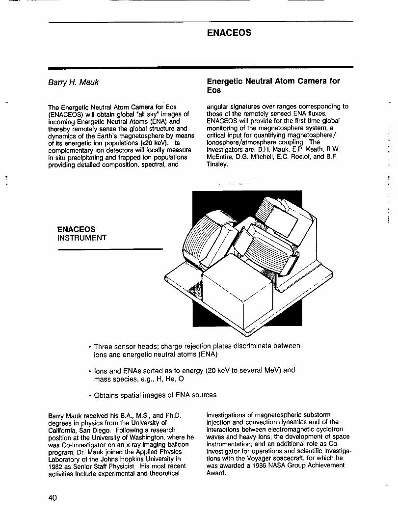
ENACEOS
Barry H. Mauk
The Energetic Neutral Atom Camera for Eos(ENACEOS) will obtain global "all sky" images ofincoming Energetic Neutral Atoms (ENA) andthereby remotely sense the global structure anddynamics of the Earth's magnetosphere by meansof its energetic ion populations (->20keV). Itscomplementary ion detectors will locally measureIn situ preclpitating and trapped ion populationsproviding detailed composition, spectral, and
Energetic Neutral Atom Camera forEos
angular signatures over ranges corresponding tothose of the remotely sensed ENA fluxes.ENACEOS will provide for the first time globalmonitoring of the magnetosphere system, acritical input for quantifying magnetosphere/ionosphere/atmosphere coupling. Theinvestigators are: B.H. Mauk, E.P. Keath, R.W.McEntire, D.G. Mitchell, E.C. Roelof, and B.F.Tinsley.
ENACEOSINSTRUMENT
• Three sensor heads; charge rejection plates discriminate betweenions and energetic neutral atoms (ENA)
• Ions and ENAs sorted as to energy (20 keY to several MeV) and
mass species, e.g., H, He, O
• Obtains spatial images of ENA sources
Barry Mauk received his B.A., M.S., and Ph.D.degrees in physics from the University ofCalifornia, San Diego. Following a researchposition at the University of Washington, where hewas Co-Investigator on an x-ray Imaging balloonprogram, Dr. Mauk joined the Applied PhysicsLaboratory of the Johns Hopkins University in1982 as Senior Staff Physicist. His most recentactivities include experimental and theoretical
investigations of magnetospheric substorminjection and convection dynamics and of theInteractions between electromagnetic cyclotronwaves and heavy ions; the development of spaceinstrumentation; and an additional role as Co-Investigator for operations and scientific Investiga-tions with the Voyager spacecraft, for which hewas awarded a 1986 NASA Group AchievementAward.
4O

SWIRLS
Daniel J. McCleese
The SWIRLS investigation will describestratospheric structure, dynamics, and transportprocesses, and study their influences on naturaland anthropogenically forced stratosphericchange. Direct measurements of wind arenecessary to understand the physical mechanismsthat determine the structure and dynamics of thestratosphere, and the transport of chemicallyactive species, including ozone. Satellitetemperature measurements have proved to be
Stratospheric Wind Infrared LimbSounder
Inadequate for this purpose. SWIRLS offers directmeasurements on both the day and night sides ofthe Earth by observing the Doppler shift instratospheric emission using a powerful new gas-correlation technique that employs electro-opticphase modulation (EOPM). EOPM gas-correlationradiometry provides the high spectraldiscrimination required to measure winds withnecessary spatial resolution and accuracy.
/
'iI
SWIRLS MECHANICALCONFIGURATION
• Gas correlation and filter infraredradiometer
• Observes atmospheric infrared emissionsin the 7.6 i_m to 17.2 I_m range
• Obtains continuous vertical profiles ofhorizontal wind vectors, temperatures,and pressures; and mixing ratios ofozone and nitrous oxide
• Wind velocities are determined from
wind-induced Doppler shifts in the N20emission spectrum
• 3 km vertical resolution in a 20 km to 60
km altitude range on both the day andnight sides of the Earth
Daniel McCleese was a Fulbright Scholar atOxford University and earned his D.Phil. degree inatmospheric physics from that institution in 1976.He joined Jet Propulsion Laboratory that sameyear and is presently the Manager of the Earthand Space Sciences Division. Dr. McCleese hasbeen or is currently Principal Investigator onseveral SWIRLS-related investigations including
Mars Observer, Pressure Modulator InfraredRadiometer, Cassini Stratospheric Sounder, andthe Infrared Experiment Definition Program. He iswell published in the literature and has beenhonored as a Fellow in the Royal MeteorologicalSociety and with NASA recognition and groupachievement awards.
41

SAGE III
M. Patrick McCormick
The Stratospheric Aerosol and GAS Experiment Ill(SAGE Ill) will measure profiles of aerosols,ozone, nitrogen dioxide, water vapor, and alrdensity between cloud tops and the uppermesosphere. The Instrument is a natural andimproved extenslon of the successful SAM II,SAGE I, and SAGE II experiments which willinclude additional wavelengths to accomplish thefollowing: (1) improve the aerosol
SAGE III SENSORASSEMBLY
• Earth-limb scanning gratingspectrometer
Stratospheric Aerosol And GasExperiment III
characterization; (2) improve the gaseousretrievals of 03, H20, NO2; (3) extend the verticalrange of measurement; and (4) provideindependence from any external data needed forretrieval. SAGE III will provide aerosol and clouddata essential for the calibration and interpretationof data from other remote sensors on the Eosplatforms.
• Obtains global profiles ofaerosols, 03, H 20, NO2,clouds, and air density in themesosphere, stratosphere, andtroposphere
• 1 to 2 km vertical resolution
M. Patrick McCormick received his M.A. and Ph.D.degrees in physics from the College of William &Mary. He has been with NASA/Langley ResearchCenter since 1967 and Is presently Head of theAerosol Research Branch. Dr. McCormick isPrincipal Investigator on SAM II, SAGE I, andSAGE II spaceflight experiments as well asnumerous other atmospheric remote sensingInstruments and data analysis experiments. Hereceived the Arthur S. Flemmlng Award forOutstanding Young People in Federal Service in
1979, the NASA Exceptional ScientificAchievement Medal in 1981 and numerous NASAGroup or Special Achievement Awards. Hereceived an Honorary Doctor of Science degreefrom the Washington & Jefferson College tn 1981where he presently serves on the Board ofTrustees. Dr. McCormick is a member of theInternational Radiation Commission and Chairsthe International Coordination Group on LaserAtmospheric Studies.
42

GGI
William G. Melbourne
GGI is a high-performance Global PositioningSystem (GPS) receiver-processor. It will include18 dual-frequency satellite channels and threedistributed GPS antennas. The antennas will bedistributed and oriented to provide full skycoverage down to the limb of the earth andinformation for three-dimensional attitudedetermination. GGI will serve four principalscience objectives: centimeter-level global
GPS Geosclence Instrument
geodesy; high-precision atmospheric temperatureprofiling; Ionospheric gravity wave detection andtomographic mapping; and precise position andattitude determination in support of other scienceinstruments. The flight instrument is derived fromthe GPS flight receiver developed for Topex-Poseidon, the US/French oceanographic missionto be launched in 1991.
STRAWMAN GGICONFIGURATION FOR POLAR
PLATFORM
• GPS flight receiver-processor; mayinclude up to 18 dual-frequency satellitechannels
• Three hemispherical pattern antennason the polar platform and network of10 GPS ground receivers
• Allows real-time platform position andattitude accuracy to 1 m and 20 arc sec,post-processing accuracy to 3 cm and 5arc sec
• Contributes to developing centimeter-level global geodesy, high-precisionatmospheric temperature profiling,ionospheric gravity wave detection, and3-D ionospheric tomography
William Melbourne received his A.B. degree withhighest honors in Astronomy-Physics from theUniversity of California, Los Angeles, in 1954, andhis Ph.D. degree in Astronomy from the CaliforniaInstitute of Technology in 1959. He joined JetPropulsion Laboratory In 1956 and during the1960s and 70s either served as major architectfor, or directed the development of, numerousnavigation and radio science systems andpioneered their application to geodynamics. Overthe past nine years, he has led NASA's
program at JPL to develop a sub-decimeter-accuracy GPS-based tracking system for Earth-orbiting missions and a GPS-based geodeticsystem for centimeter accuracy crustaldeformation measurements. He is currentlyAssistant Division Manager for Metric Tracking inthe Telecommunications Science and EngineeringDivision. He is also the Geodynamics ProgramManager for the Office of Space Science andInstruments.
43

XIE
George K. Parks
The objectives of the X-Ray Imaging Experimentand the optional particle detectors are to detectand determine the total particulate energy that Isprecipitated into the Earth's atmosphere. The x-ray Instrument system consists of a proportionalgas-filled counter for detecting 3 to 20 keV x-raysand an Anger camera for detecting and Imaging20 to 200 keV x-rays. The optional particledetector system consists of electrostatic analyzersand solid-state telescopes \-vhich will detectelectrons from a few eV to several hundred keVand protons from a few eV to several hundredMeV. This combined package will provideinformation on: 1) the total x-ray fluxes impinging
X-ray Imaging Experiment
on the Earth's atmosphere; 2) energy spectra ofthese x-rays; 3) presence of different energyspectral components, Including the hard x-raycomponents that reach the lower atmospherenear the tropopause; 4) Images of x-rays, whichprovide space and time information on theirsources; and 5) primary electron and iondistribution functions, from which macroscopicparameters such as density, convective velocities,and temperatures are obtained. These data willpermit comprehensive modeling studies ofthermodynamic, chemical, electrical, andmeteorological effects on Earth due to thedeposition of particle energy.
XIE - X-RAY IMAGINGEXPERIMENT
X-ray pinhole "anger" cameraswith Nal (T1) and PM detectorsfor > 20 keV x-rays proportionalgas-filled counter for 3-20 keVx-rays
Optional particle package,electrostatic analyziers (forelectrons and protons from a feweV to 30 keV) and solid-statetelescopes for electrons (20-450keV) and protons (20 keV to tensof MeV)
Field of view +56 ° (x-rays), +90 °(particles)
George K. Parks received his B.A. and Ph.D. inPhysics from the University of California, Berkeley.Dr. Parks spent three years as a ResearchAssociate at the Physics Department of theUniversity of Minnesota after earning his Ph.D.degree and was Professeur Associe at theUniversity of Toulouse, France, before he Jolnedthe faculty at the University of Washington,
Seattle, in 1971. He Is currently Professor in theGeophysics Program and Adjunct Professor in theAtmospheric Sciences and Physics Departmentsat that institution. Dr. Parks has worked onseveral past NASA missions, ATS-6 and ISEE, andis currently a Co-Investigator on the GGS/ISTPProgram.
44

TRACER
Henry G. Reichle, Jr.
TRACER is designed to measure the globaldistribution of CO at multiple levels in thetroposphere and thus provide a global data basefor modeling studies that will Increaseunderstanding of global tropospheric chemistryand transport processes, as well as CO mixingratios and geographical distribution within layersversus time. The instrument is a nadir-viewing gas-filter radiometer operating in the 2.3 _m and
Tropospheric Radiometer ForAtmospheric Chemistry AndEnvironmental Research
4.6 _m spectral regions using a technique similarin principle to the MAPS (Measurement of AirPollution from Satellites) instrument first flown onthe space shuttle in November 1981. TRACERImplements the gas-filter technique differently bytaking advantage of the latest advances in digitalelectronic technology, thereby reducing opticalcomplexity.
TRACEROPTICALSCHEMATIC
• Two-channel gas-filter correlation radiometer
• Nine separate filters contained in rotating gas-cell chopper
• 2.3 micrometer radiance of CO and CH 4
• 4.6 micrometer radiance of CO and N20
Henry Reichle was educated at the University ofMichigan, receiving degrees in aeronauticalengineering (B.S.), Instrumentation engineering(M.S.), meteorology (M.S.), and aeronomy (Ph.D.).Dr. Reichle has been affiliated with LangleyResearch Center since 1962 and currently servesas a Senior Research Scientist. He has beenactive In research on the remote measurement of
atmospheric properties for nearly 25 years; hisefforts have concentrated on the development ofnadir-viewing techniques using the middle-infraredportion of the spectrum for the measurement ofthe properties of the troposphere. As Principalinvestigator, he directed the development of theMAPS experiment, which was flown on the spaceshuttle during 1981 and again in 1984.
45

SOLSTICE
Gary Rottman
SOLSTICE provides precise daily measurementsof the full disk solar ultraviolet Irradiance between4 to 440 nmo (Two solar spectral resolutions arerequired to fully determine and understand theenergy input into the different layers of Earth'satmosphere.) Bright early-type stars will be usedfor very stable, in-flight calibrations, assuring an
Solar Stellar irradiance ComparisonExperiment
accuracy better than 1% throughout the entireEos mission. The SOLSTICE instrument consistsof a four-channel spectrometer together with therequired gimbal drive to point SOLSTICE at thesun and stellar targets and is similar to the UARSSOLSTICE instrument, scheduled to launch in1991.
THE SOLSTICE INSTRUMENT
• Four-channel UV spectrometer (two-axis solar track)
• Daily measurement of full disk solar irradiance, with calibration
maintained by comparison to bright, early-type stars (1% accuracy)
• Range of 115 to 440 nm
• Three-channel spectral resolution to 0.2 nm; one channel to 0.0015 nm
Gary Rottman, who holds his M.S. and Ph.D.degrees In physics from The Johns HopkinsUniversity, has concentrated his professionalcareer at the University of Colorado. He ispresently Senior Research Associate in theinstitution's Laboratory for Atmospheric and
Space Physics. His space research Includes rolesas Principal or Co-Investigator on numerous solar-mesosphere investigations, including Solar-Mesosphere Explorer, SOLSTICE/UARS Program,and Solar EUV SPARTAN and Rocket Programs.
46

SAFIRE
James M. Russell Ill
The goal of the Spectroscopy of the Atmosphereusing Far Infrared Emission (SAFIRE) experimentis to achieve a major improvement in ourunderstanding of the middle atmosphere ozonedistribution by conducting global-scalemeasurements of the important chemical,radiative, and dynamical processes whichinfluence ozone changes. SAFIRE is a passivelimb emission, multi-channel spectrometer-radiometer that combines the advantages of aseven-channel far-IR Fourier transformspectrometer (0.004 cm "1 spectral resolution) anda space-proven seven-channel mid-IR broadband-
Spectroscopy Of The AtmosphereUslng Far Infrared Emission
type radiometer. The instrument brings together,for the first time, simultaneous observations byone Instrument of key HOy, NOy, ClOy, and BrOygases, coupled with dynamical tracermeasurements. Some important applications ofthe data include study of: (1) major processes Inthe main chemical families; (2) polar nightchemistry; (3) non-local thermodynamicequilibrium; (4) diurnal changes in key gases; (5)dynamics and transport processes; (6) chemistryand dynamics coupling; and (7) lowerstratospheric phenomena.
SAFIRE INSTRUMENTMOCK-UP
• Seven-channel far-IR Fouriertransform spectrometer (0.004cm q spectral resolution)
• Seven-channel mid-IR
broadband LIMS-type radiometer
• Covers spectral ranges 80-160,310-390, and 630-1,560 cm q
• Sensor modules optically coupledthrough common telescope
• LIMS-type adaptive CO2 horizonsensing used for primary attitudereference; fore and aft viewingprovides nearly complete globalcoverage (86 N to 86 S)
Dr. Russell received his Ph.D. in Aeronomy fromthe University of Michigan. He presently serves asHead of the Theoretical Studies Branch,Atmospheric Sciences Division at the LangleyResearch Center. Since 1970, he hasconcentrated on atmospheric science and remotesensing research. He served as Co-Team Leaderof LIMS, launched on Nimbus-7 In 1978; Co-Investigator on Spacelab 3 ATMOS experiment,
launched on Shuttle in 1985; and he is PrincipalInvestigator on HALOE and Co-Investigator onISAMS scheduled to fly on UARS in 1991. He hasbeen a Visiting Scientist at NCAR, is listed Inseveral blographical periodicals which recognizeachievement in science, has received the NASAMedal for Exceptional Scientific Achievement, andholds two U.S. patents.
47

HIMSS
Roy W. Spencer
The High-resolution Microwave SpectrometerSounder (HIMSS) will be used for the retrieval ofnumerous atmospheric and oceanic parameters,Including precipitation rates over both land andocean in multiple layers, oceanic cloud water andwater vapor content, wind speed and sea surfacetemperatures, atmospheric temperature profile,snow cover depth and water equivalent, andpossibly vegetation. This Instrument will buildupon the successful heritage of the Special
High-Resolution MicrowaveSpectrometer Sounder
Sensor Microwave/Imager (SSM/I), with specialemphasis on Instrument design that provides: (1)an accurate and stable calibration design to allowmeaningful monitoring of Earth and atmosphericprocesses on time scales of many years, (2)swath width improved over current microwaveradiometers, (3) order-of-magnitude Improvementin footprint areal resolution, (4) high radiometrlcsensitivity, and (5) co-located footprints.
HIMSS VIEWING
GEOMETRY, POLARPLATFORM
\ \
• High-resolution microwave spectrometer
• Frequencies between 6.6 and 90GHz
• Measures precipitation rate, cloud water,water vapor, temperature profiles, seasurface roughness, SST ice, and snow
• Resolution varies from 5 km at 90 GHz to50 km at 6.6 GHz
• 2 m parabolic antenna and rotating drum(30 rpm)
• Heritage SSM/I instrument
Roy W. Spencer received his B.S. degree inatmospheric science from the University ofMichigan, and both the M.S. and Ph.D. degrees inmeteorology from the University of Wisconsin.Currently, Dr. Spencer Is a Space Scientist at theMarshall Space Flight Center, where he directs aprogram of satellite passive microwave dataanalysis from the DMSP SSM/I, the Nimbus-7SMMR, and the M05-1 MSR; and the
development and flight of a high-altitude aircraftfive-frequency scanning microwave radiometer.Dr. Spencer has been a member eft several NASA-sponsored committees, including the TropJcalRainfall Measuring Mission Science SteeringGroup, the Earth Science Geostationary PlatformCommittee, and the Earth System ScienceSubcommittee on Winds and Precipitation.
48

EOSP
Larry D. Travis
The Earth Observing Scanning Polarimeter(EOSP) Is a high-precision, multi-channel,scanning photopolarlmeter designed to obtainglobal maps of the radiance and degree of linearpolarization for 12 spectral bands in the visibleand near-infrared in order to: (1) determine cloudproperties Including optical thickness, particlesize, liquid/ice phase, and cloudtop pressure; (2)
Earth Observing Scanning Polarimeter
determine global distribution of the troposphericand stratospheric aerosols; (3) provideatmospheric correction information for ocean andland observation; and (4) Investigate the potentialfor providing information on vegetation and landcharacteristics. These scientific objectivescomplement and support a number of theprincipal objectives of the MODIS experiment.
CUTAWAY VIEWOF EOSP
• Cross-track scanning polarimeter
• Simultaneously measures radiances and degree of polarization in 12
spectral channels from 410 to 2,250 nm
• 10 km IFOV
• Provides cloud properties such as optical thickness and phase, and
global aerosol distribution
Larry D. Travis received his Ph.D. in 1971 from thePennsylvania State University. He is currently theAssociate Chief at the NASA Goddard Institute forSpace Studies. His research interests includeradiative transfer in planetary and stellaratmospheres, convective energy transport, singleand multiple scattering theory, theoreticalinterpretation of planetary polarization; satellite
platform measurements of planetary polarization,and spin-scan Imaging and analysis of planetarycloud systems. Dr. Travis serves as PrincipalInvestigator for the Pioneer Venus CloudPhotopolarimeter Experiment and as a Co-Investigator for the Galileo PhotopolarimeterRadiometer Experiment.
49

MLS
Joe W. Waters
The objective of the Microwave Limb Sounder(MLS) Investigatlon is to study and monitorprocesses which govern stratospheric andmesospherlc ozone, with emphasis on potentialozone depletion by mankind's Increasing Industrialactivities. Molecules in all ozone destructioncycles.are to be measured, Including all radicalsnow thought to control the rate at which upperstratospheric ozone Is destroyed. Scientificinformation from the measurements will includetrend detection, chemlstry, dynamics, and
Microwave Limb Sounder
climatology of the stratosphere and mesosphere,and will be used in a variety of ways to constrainand test models of stratospheric and mesosphericphotochemistry and dynamics, The Eos MLSinstrument--an enhanced verslon of the UARSMLS--measures molecular thermal emissionspectra at millimeter and submiiiimeterwavelengths as its field-of-view is verticallyscanned through the atmospheric limb in the orbitplane. All measurements are performedsimultaneously and continuously.
THE MLSINSTRUMENT
• Passive microwave limb-soundingradiometer
• Obtains vertical profiles of all moleculesand radicals believed to be involved in
the ozone destruction cycle
• Measurements in three spectral bands:637, 560, and 205 GHz
• Spatial resolution 100 km x 3 km x 6 km
• Gimbaled antenna
Dr. Waters has led the development of microwavelimb sounding for 15 years. He originated thetechnique in 1973 and, since then, has beenPrincipal Investigator on aircraft, balloon, andUARS MLS experiments. His Ph.D. degree is fromthe Massachusetts Institute of Technology
Electrical Engineering Department, where he wasa Co-Investigator on Nimbus-5 and Nimbus-6microwave spectrometer experiments. He hasauthored 28 papers In refereed scientific Journals,most on microwave remote sensing of Earth'satmosphere.
5O

ACRIM
Richard C. Willson
The Active Cavity Radiometer Irradiance Monitor(ACRIM) experiment is designed to implement an"overlap strategy" with earlier ACRIM experimentsand within the Eos mission itself, that is requiredto sustain the NASA long-term solar luminositydatabase throughout the Eos mission timeframe.The primary objective of ACRIM is to monitor the
Active Cavity Radiometer IrradianceMonitor
variability of total solar irracliance with state-of-the-art accuracy and precision thereby extending thehigh-precision database compiled for NASA since1980 by other ACRIM experiments as part of theearth radiation budget "principal thrust" in theNational Climate Program.
THE ACRIMINSTRUMENT
• Three total irradiance detectors
• One sensor monitors solar
irradiance fulltime; two sensorscalibrate optical degradation offirst sensor
• SI uncertainty of 0.1%, long-termprecision of 5 ppm per year
• Sensor assembly mounted ontwo-axis tracker to observe solar
disk during each orbit
Richard C. Willson holds the doctoral degree inatmospheric sciences from the University ofCalifornia, Los Angeles and B.S. and M.S. Inphysics from the University of Colorado. He is amember of the technical staff and Supervisor ofthe Solar Irradiance Monitoring Group,Atmospheric and Cometary Sciences Section,Earth and Space Sciences Division at JPL. Hiscareer, which began at JPL in 1963, has been
involved primarily witl_ development of state-of-the-art Active Cavity Radiometer pyrheliometry foruse In solar total irradiance observations onballoon, sounding rocket, space shuttle, andsatellite platforms. He has been the PrincipalInvestigator for the Solar Maximum MissionACRIM 1, space shuttle Spacelab 1, ATLAS I andATLAS II/ACR, and Upper Atmosphere ResearchSatellite ACRIM II experiments.
51


INTERDISCIPLINARYINVESTIGATIONS
Abbott, Mark R.Barron, Eric J.Bates, J. RayBatista, Getulio T.Brewer, Peter G.Cihlar, JosefDickinson, RobertDozier, JeffGrose, William L.Gurney, Robert J.Hansen, JamesHarris, Graham P.Hartmann, Dennis L.Isacks, Bryan L.Kerr, Yann H.Liu, W. TimothyMcNutt, LynMoore, BerrienMouginis-Mark, PeterMurakami, MasatoPyle, John AdrianRothrock, DrewSchimel, David M.Schoeberl, Mark R.Sellers, PiersSrokosz, Meric A.
Tapley, ByronWielicki, Bruce
PRECEDING PAGE BLANK NOT FILMED 53

nterdisc_pJirlaryInvestigations
Mark Abbott
Dr. Abbott's study concerns dynamics of theSouthern Ocean--its circulation, biology, andinteraction with the atmosphere--and proposeslarge-scale studies including atmospheric forcing,ocean circulation, and primary production. Inaddition, techniques will be explored to cope withstrong eddy activity In the Southern Ocean, andto incorporate inherently nonlinear biologicalprocesses into physical models. There are twomain goals: First, it will be possible to understandthe processes that regulate atmospheric andoceanic heat and momentum flux in the SouthernOcean and how they vary in time and space.Second, it will be possible to understand thetemporal and spatial patterns of primaryproduction and how they are regulated byphysical forclng, and how these patterns arecoupled with fluxes of biogenic carbon.
Coupled Atmosphere/OceanProcesses And Primary Production InThe Southern Ocean
Dr. Abbott has been involved in the fields ofoceanography and ecology for 11 years. Hereceived his undergraduate degree In theconservation of natural resources from theUniversity of California at Berkeley and the Ph.D.degree in ecology from UC, Davis. He has beenaffiliated with Oregon State University since 1988,currently as Associate Professor In the College ofOceanography. Dr. Abbott has served onnumerous Eos-related committees, including theEos Science Steering Committee, the ModerateResolution Imaging Spectrometer Panel, theImaging Spectrometer Science Advisory Group,and the NASA/NOAA Convergence Panel. Dr.Abbott has aTso been selected as a MODIS TeamMember.
Eric J. Barron Global Water Cycle: Extension AcrossThe Earth Sciences
This study focuses on the global water cycle todetermine the scope of its interactions with allcomponents of the Earth system and tounderstand how it stimulates and regulateschange on both global and regional scales. Dr.Barron plans to effect the conversion of patternsobserved from space into know_edge of theprocesses that, linked together, determine theevolution of water in the Earth system. Researchstrategy involves developing a hierarchy ofsimulation models that assimilate Eosobservations and produce information on physicaland biological variables and process rates. Themodels will be tested with field studies that yieldcalibration and verification and, over the definitionphase, will provide a methodology for resolvingthe presently unknown sources, sinks, and fluxrates of the global water cycle. These will then beused to document significant aspects of the water
cycle and to develop the knowledge necessary tounderstand past variations and predict them in thefuture.
Dr. Barron received M.S. and Ph.D. degrees inoceanography and climatology from the Universityof Miami and was a postdoctoral fellow at NCAR.Dr. Barron joined Penn State as the Director ofthe Earth System Science Center and AssociateProfessor of Geosciences in 1986. His researchinterests focus generally on global change andmore specifically on numerical models of theclimate system and the study of changethroughout history. He is a member of numerousworking groups related to these interests and, inaddition, serves as Editor-in-Chief ofPalaeoqeoqraphy, Palaeoclimatolo_qy andPalaeoecoloqy, and as Editor of GIo.J;)alPlanetaryChanae.
54

InterdisciplinaryInvestigations
J. Ray Bates The Development And Use Of A Four-Dimensional Atmospheric/Ocean/Land Data Assimilation System ForEos
Dr. Bates plans to develop and maintain a high-resolution, four-dimensional atmosphere/ocean/land data assimilation system for the EarthObserving System. The project will involveresearch on all aspects of four-dimensional dataassimilation (satellite retrievals, data qualitycontrol, objective analysis, Initialization, andatmosphere/oceanic/land surface models), withdual objectives of extracting the maximum amountof information and understanding possible fromEos data and building the foundation for a future"Earth System Model." Diagnostic studies will becarried out with the data produced by thisassimilation system, emphasizing globalhydrological cycle and low-frequency atmosphericand oceanic variability. At the start of the Eosexecution phase, the researchers hope theassimilation system will be capable of becomingthe main vehicle for the delayed-mode production
by EosDIS of integrated atmosphere/ocean/landdata sets in the horizontal scale of several tens ofkilometers.
J. Ray Bates has over 25 years experience inmeteorological research. A native of Ireland, Dr.Bates began his career with the IrishMeteorological Service and, after obtaining hisPh.D. degree at MIT in 1969, returned to thatService's Research Division. He has workedabroad on leave of absence on numerousoccasions and since 1987 has served as SeniorResearch Associate in the Department ofMeteorology at the University of Maryland. Dr.Bates was awarded the Napier Shaw MemorialPrize of the Royal Meteorological Society in 1971and was elected to membership of the Royal IrishAcademy in 1986.
Getulio T. Batista Long-Term Monitoring Of The AmazonEcosystems Through The Eos: FromPatterns To Processes
Amazonla Is unique among terrestrial ecosystemsfor its spatial extent, the intimate interaction withthe largest river on our planet, and the rate ofchange caused by human activity. Dr. Batista'sprogram now combined with the proposalsubmitted by Dr. Jeffrey Richey from theUniversity of Washington, "The Regional AmazonModel: Synoptic Scale Hydrological andBiogeochemical Cycles from Eos," will attempt todescribe the routing of water and its chemicalload from precipitation to the main channel andocean through the drainage system underconditions of changing land use in the Amazon.Dr. Batista's team will model, for a large basin, therelationship between deforestation rates and thehydrological water cycle on a yearly basis. Theywill also model eutrophication processes andsediment transport for selected tributaries andreservoirs
with differential land-use pressures employing Eosdata.
With degrees in agronomy and remote sensing(Ph.D. 1981, Purdue University), Dr. Batista hasfocused his research in the areas of cropidentification and conditions assessment, yieldprediction modeling, scene characterlstics andclassification accuracy, and crop field radiometry.Since 1971 he has been affiliated with theBrazilian Institute for Space Research (INPE). Hewas the Head of the Remote Sensing Departmentfrom 1982 to 1987, Deputy Director of thelrRemote Sensing Directorate from 1985 to 1987,and recently was the Princlpal Investigator ofPEPS Program of the SPOT satellite for tropicalagriculture.
55

InterdisciplinaryInvestigations
Peter G. Brewer
Dr. Brewer proposes to investigate the fate ofsolar radiation incident on the oceans with itspronounced chemical, physical, and biologicalconsequences, and the feedback of the gaseousproducts of these interactions through the agencyof wind, waves, and circulation to the marineatmosphere. The topics involved include oceanicphotochemistry, pigments, ocean biologicalprocesses, surface slicks and chemicalmodification of surfaces, surface waves andmomentum transfer, and biogenic gas fluxes andtheir linkage through models. The overarchingtheme is to derive Earth-scale constraints in theseimportant processes through the combination oflocal data sets with satellite imagery. A furtherbenefit will be the construction of global-scaleviews of critical processes from the complexinterplay of field data and satellite observables.Cooperation with major field programs such asJHOFS and WOCE will be involved.
Biogeochemical Fluxes At TheOcean/Atmosphere Interface
Dr. Brewer received his undergraduate and Ph.D.degrees from Liverpool University and has over 20years experience in oceanography and marinechemistry. Since 1967 he has been affiliated withthe Woods Hole Oceanographic Institution,presently as Senior Scientist and is author, or co-author, of more than 70 scientific papers. From1981 to 1983 he also was Program Director ofMarine Chemistry at the National ScienceFoundation and, in addition to teaching duties atW.H.O.I., has chaired or served on numerouscommittees concerning marine research andglobal studies, as well as serving as editor orassociate editor of related journals. Dr. Brewer'scurrent research focuses on the global carboncycle. He serves as Chairman of the U.S. GlobalOcean Flux Study, and Vice Chairman of theInternational Joint Global Ocean Flux Study. Heis a Fellow of the American Geophysical Union.
Josef Cihlar
Addressing Issues related to the role of terrestrialvegetation at mid and high latitudes, thisInvestigation builds on work accomplished orplanned in Canada. It will carry out the research,development, and demonstration of a VegetationChange Information System (VCIS) to routinelymonitor terrestrial vegetation from space. Initialmodel development, algorithm development, andoutput generation (e.g., a vegetation map ofCanada) will be done prior to Eos launch. Eosdata will be optimized and applied over theCanadian landmass using the VCIS, andvegetation growth models will be developed toproduce digital maps of net change in carbonstorage for two different years after Eos launch.Also to be developed are one or more successionmodels and digital maps of future vegetation
T
Quantifying The Vegetation OfCanada: Carbon Budget AndSuccession Models
distribution over Canada, based on observed orpostulated changes in environmental conditions.
Dr. Cihlar holds degrees in soil science andphysical geography and remote sensing (Ph.D.University of Kansas, 1975), and has concentratedhis research Interests on renewable resources anddata acquisition and analysis for land applications.He joined the Canada Centre for Remote Sensing(CCRS) in 1975 as Environmental Scientist. Since1979, he has been responsible for applicationsdevelopment at CCRS. Dr. Cihlar Is presentlyInvolved in planning the use of space observationsfor global change studies. He leads the RemoteSensing Technical Group reporting to the RoyalSociety of Canada, and is a member of the IGBPWorking Group on Data and Information Systems.
56

InterdisciplinaryInvestigations
Robert Dickinson NCAR Project To Interface ModelingOn Global And Regional Scales WithEarth Observing System Observations
Dr. Dickinson's proposed study Involves modeling,data analysis, data systems, and archiving, alldirected toward improvements of global andmesoscale climate models at the National Centerfor Atmospheric Research. Sensitivity studies ofthe application of Eos data to model improvementwill be carried out for several focused areasincluding the land-surface component of themodels in a gTobal and regional context; the sea-ice component; the role of clouds; andatmospheric profiles of latent-heat release. Alsoproposed are long-term monitoring ofatmospheric properties from operational satellitedata, links between Eos sensor systems andmodel-generated fields, data visualization andarchiving in the context of model requirements,application of surface remote-sensing technologyto image processing of the required satellite data,maintenance of an Eos data archive, andexploration of new methodologies for organizingand archiving global data sets.
Dr. Dickinson has been affiliated with the NationalCenter for Atmospheric Research since 1968;presently he is Deputy Director of the Climate andGlobal Dynamics Division. He has served asVisiting Professor or Guest Lecturer at severalwestern state universities, serves as PrincipalInvestigator on studies supported by USGS andNASA concerned with climate modeling, and is amember of the U.S. National Academy ofSciences and is active In efforts of the NationalResearch Council, the American GeophysicalUnion, the International Geosphere BiosphereProgramme, the World Climate ResearchProgramme, and the American MeteorologicalSociety. He has over 150 refereed publications tohis credit. Finally, he is a Fellow of the AmericanAssociation for the Advancement of Science, theAmerican Geophysical Union, and the AmericanMeteorological Society, and was awarded theAMS Jule G. Charney Award in 1988.
Jeff Dozier Hydrology, Hydrochemical Modelingand Remote Sensing In Seasonally
Snow-Covered Alpine Drainage Basins
The snow hydrology of alpine areas is animportant component of the global hydrologiccycle because of the large volumes of waterstored in these reservoirs in the winter season, thesensitivity of the winter snowpack to climaticchange, and the complex role of snow processesin acidic deposition. The overall objective andanticipated result of Dr. Dozier's investigation is adetailed understanding of the patterns andprocesses of the water balance and chemical andnutrient balances of seasonally snow-coveredalpine watersheds. Image data from several Eosfacility instruments will be used to monitorhydrologic conditions in selected watersheds andto drive hydrologic models. Hydrological andchemical sampling will be done In the field, anddata will also be collected from other governmentprograms currently investigating the effects ofatmospheric pollutants on high-elevationwatersheds. Results will be extended spatiallythrough combination with hydrologicmeasurements.
With undergraduate and doctoral degrees ingeography (Ph.D. University of Michigan, 1973),Dr. Dozier has concentrated his research on snowhydrology and related studies in radiative transferand remote sensing, especially on interpretation ofsnow properties from the Landsat TM. Since 1974he has taught at the University of California, SantaBarbara, where he is now the Professor ofGeography. For the past two years he has held ajoint appointment as a Senior Member ofTechnical Staff at JPL. He is Project Scientist forJPL's HIRIS, was selected as a HIRIS TeamMember, and chairs the EosDIS Data AdvisoryPanel. He served on the Eos Committee onHMMR, and he is a NASA Principal Investigator onthe first ISLSCP field experiment and on theShuttle Imaging Radar-C, as well as on theCalifornia Air Resources Board's IntegratedWatershed Study. He also chairs the NationalAcademy of Science's Committee on Glaciologyand the AGU's Committee on Snow, Ice, andPermafrost, and he is the Associate Editor ofWater Resources Research.
57

InterdisciplinaryInvestigations
William Grose
Dr. Grose's team will focus on providing increasedunderstanding of the radiative, chemical, anddynamical processes which determine thecirculation, thermal structure, and distribution ofconstituents of the Earth's atmosphere. Emphasiswill be placed on examining interactive couplingamong these processes. The Investigation will beconducted through observational analysis anddiagnostic interpretation of meteorological andconstituent data from Eos instruments, inconjunction with satellite, balloon, ground-based,and alrcraft data. Also, atmospherlc simulationstudies will be conducted with a hierarchy ofmodels Incorporating radiative, chemical, anddynamical processes to varying degrees ofcomplexity for the troposphere, stratosphere, andmesosphere.
Observational And Modeling StudiesOf Radiative, Chemical and DynamicalInteractions In The Earth's
Atmosphere
William Grose received his M.S. degree in physicsfrom the College of William and Mary and thePh.D. degree in Aerospace Engineering fromVirginia Polytechnic Institute and State University.He is Senior Research Scientist and AssistantHead of the Theoretical Studies Branch,Atmospheric Sciences Division at the LangleyResearch Center. He has participated in thedevelopment of several 3-D models for studies ofatmospheric dynamics and transport. He isPrincipal Investigator for a current NASA modelingand observational analysis study, as well asPrincipal Investigator and member of the UARSstudy team. Dr. Grose was a Visiting Scientistwith the United Kingdom Universities' AtmosphericModeling Group and the University of Reading,England. He was recipient of the NASA Medal forExceptional Scientific Achievement in 1986.
Robert James Gurney
Dr. Gurney's research objective is to use Eos andother data to estimate global water balances fordays to seasons, and to examine their variabilityover decades with various external forcings.Several complementary models for estimatingcomponents of the daily and long-term waterbudget will be implemented or calibrated usingEos data, and new combined models--that can beapplied globally for the first time--will bedeveloped. Estimates of monthly water balancesfor continental-scale areas will be produced.These estimates will be checked in selected areasthrough conventional data.
Estimation Of The Global Water
Budget
Robert Gurney has concentrated his researchexperience in hydrological modeling. Afterreceiving his Ph.D. degree from the University ofBristol, he was affiliated with the Institute ofHydrology in Wallingford, England. Since 1981 hehas worked with NASA's Goddard Space FlightCenter, within the Hydrological Sciences Branch,and is currently Head of that Branch. Dr. Gurneyhas served as Principal Investigator on numerousNASA and European Space Agency projects, andwas a Deputy Study Scientist for Eos and memberof the Eos Science Steering Committee. He hasalso served as Editor for a book series on remotesensing and is an Associate Editor of WaterResources Research.
58

Interdisciplinary Investigations
James E. Hansen
Dr. Hansen's team will investigate the interannualvariability of key global parameters and processesin the global carbon cycle and the global thermalenergy cycle. They will develop, analyze, andmake available global geophyslcal data setsderived from pre-Eos and Eos observations incombination with models. Developing data setswill involve use of observations in combinationwith global models that are already developed orunder development. Analysis will Involve studies ofseveral specific interdisciplinary problems, eachfocused on Interactions among components of theEarth system. Expected near-term products are1) knowledge of certain Earth system processeswhich can be investigated via large-scaleinterannual variability of a number of observedparameters, 2) a mini Eos-type collection of datasets available in convenient form to other
Interannual Variability Of The GlobalCarbon and Energy Cycles
Investigators, and 3) Improved definition of globalmeasurement and data set needs for Eos.
Dr. Hansen heads the Goddard Institute for SpaceStudies. A student of astronomy and physics(Ph.D. University of Iowa, 1967), he has focusedhis research primarily on radiative transfer inplanetary atmospheres and related interpretationof remote sounding, development of simplifiedclimate models and 3-D global models, and thestudy of climate mechanisms. He has beenInvolved on several photopolarimeter experimentssuch as AEROPOL, Voyager, Pioneer, and Galileo,and, in addition to his research and administrativeduties, he serves as Adjunct Professor atColumbia University. Dr. Hansen Is a well-knownexpert witness on current climate trends and hasbeen Instrumental in heightening awareness ofman's impact on climate (the greenhouse effect).
Graham Paul Harris
This interdisciplinary investigation concerns abreadth of activities going all the way from basicto applied research, all of which are concernedwith interannual variability in climate, biologicalprocesses, ocean-atmosphere interactions, andthe marine fisheries resources. Dr. Harris plans tostudy the links between these processes InAustralasian waters and fisheries. There is animportant set of interactions to be examinedbetween climatic El Nino/Southern Oscillationevents and ocean processes as well as a need forstudies of oceanic productivity In tropical watersand the subtropical convergence region south ofAustralia and New Zealand. Further examinationis suggested of these interactions using existingsatellite data, data from new sensors, and Eospolar platform data. Suitable algorithms shouldbe developed at all stages to measurephytoplankton biomass and productivity fromspace. At longer time scales, there Is animportant feedback between ocean productivityand global change, because the subtropical
Interdisciplinary Studies Of TheRelationships Between Climate, OceanCirculation, Biological Processes, andRenewable Marine Resources
convergence region of the Southern Hemisphereis one of the most important sites of "new"production in the world ocean.
With academic preparation in biology and ecology(Ph.D. Imperial College, London, 1969), GrahamHarris has dedicated his career to the interactionof physical and biologlcal processes and theireffect on aquatic resources. He worked in theGreat Lakes (Canada) from 1969 to 1983 andbegan his remote sensing career with the ERTS-1simulation missions. Since 1984 he has beenaffiliated with Australia's CSIRO Divisions ofFisheries Research and Oceanography, first asProgramme Leader and now Head of the FisheriesRemote Sensing Group. Dr. Harris chairs theAustralian National Committee for OceanSciences; is Chair or member of numerousadvisory committees and working groups onoceans remote sensing, Including the AustralianPolar Platform Planning Committee; and ismember of editorial boards of publications onmarine ecology and oceanography.
59

InterdisciplinaryInvestigations
Dennis L. Hartmann
The goal of Dr. Hartmann's investigation is to usedata from various satellite Instruments, data fromother sources, and models to construct anintegrated view of the atmospherlc climate overthe oceans. The physical processes consideredwill include boundary layer dynamics and resultingfluxes, cloud-scale and mesoscale dynamics, andcloud physics, interactions between clouds andradiative fluxes and interactions between scales ofmotion from the scale of boundary layerturbulence to the large_! scales of planetarymotion. An understan_ng of the climate whichincorporates the interactions among all of theseprocesses and scales is necessary to predictfuture changes in the climate. Simultaneousmeasurements of a variety of physical variablesthat can be derived from Eos measurements willbe utilized to better understand the atmosphere
Climate Processes Over The Oceans
portion of the climate system and its interactionswith the ocean.
Dennis Hartmann received his Ph.D. degree ingeophysical fluid dynamics from PrincetonUniversity In 1975. He has been on the faculty ofatmospheric sciences at the University ofWashington since 1977, attaining the rank ofProfessor in 1988. His main research interests arein the areas of global climate, large-scaledynamics, and the radiative energy balance of theEarth; he has published extensively on the topicsof low-frequency variability in the atmosphere. Dr.Hartmann served as Principal Investigator In theEarth Radiatlon Budget Experiment (ERBE) andthe Airborne Antarctic Ozone Experiment (AAOE).He currently is a member of the Committee onEarth Sciences of the Space Science Board of theNational Research Council.
Bryan L. Isacks
Dr. Isacks plans to focus on the Andean Orogenand examine the interplay of climate, weathering,mountain building, and rapid plate boundaryinteraction. Data generated from satellite imageryand refined by Eos Altimetry, plus HIRIS, MODIS,and SAR images, will be entered into acomprehensive Morphotectonic InformationSystem. The system allows retrieval of allgeocoded spatial data and site-specificinformation with an advanced computer graphicsinterface; digital elevation models will beconstructed using these data as well. The resultscould be a fundamentally new approach togeologic research Including a new kind ofsystems science that integrates continental crustalevolution, magmatism, tectonics, and climaticgeomorphology as a complete geologicdescription of an active orogen.
Tectonic/Climatic Dynamics AndCrustal Evolution In The Andean
Orogen
Bryan L. Isacks has 27 years experience in thefields of geology and geophyslcs with specialconcentration on seismology and tectonics. Heearned both undergraduate and doctoral degreesin geology from Columbia College and University.Followlng tenure as a Research Geophysiclst atLamont Geological Laboratory, Dr. Isacks JoinedCornell University in 1971 where he is currentlythe William and Katherine Snee Professor ofGeological Sciences. He has sewed as Chairmanof the Geophysical Division of the GeologicalSociety of America, on the Board of Directors ofthe Selsmologlcal Society of America, and asAssociate Editor of the Journal of GeoDhvsica!Research.
6O

InterdisciplinaryInvestigations
Yann H. Kerr
Recent droughts In the Sahellan regions of Africaand Nordeste Brazil, and tropical raindeforestation emphasize the urgency of anaccurate monitoring of natural oranthropogenically-induced changes In land-surface parameters and of improving theunderstanding of the Earth/atmosphere responseto changes in land surface characteristics. Dr.Kerr's Investigation relies on several sensors onthe polar platform to derive hydrologic cycleparameters over arid and semi-arid lands. Thethrust of his research is to define a global data setand to develop algorithms/models giving actualgeophysical parameters. These parameters--which would actually be used to monitor seasonaland year-to-year changes--include surfacetemperature, roughness, moisture, vegetationcharacteristics, evapotranspiration, rainfall, short-wave incoming flux, and albedo. Soil/vegetationinteractions and hydrological feedbackmechanisms will also be studied.
Hydrologic Cycle - Semi-Arid Areas -Climatologic Processes
Dr. Kerr received an Engineering Degree from theEcole Nationale Superleure de I'Aeronautique etde rEspace (ENSAE, Toulouse, France), and theM.Sc. degree from Glasgow University (Glasgow,UK), and a Ph.D. from the Universite P. Sabatier(Toulouse, France, Summer 1989). From 1980 to1985 he was with the Centre National d'EtudesSpatlates (Toulouse, France). In 1985 he joinedthe LERTS as a research scientist. From May1987 to December 1988 he worked (on leave ofabsence) at Jet Propulsion Laboratory. He hasworked mainly with NOAA/AVHRR, METEOSAT,and Nimbus-7/SMMR data on the use of thermalinfrared and passive microwaves for thedetermination of hydrological cycle parameters.He has been Involved with several fieldexperiments in Africa, as well as the 1987 EosSimultaneity experiment, ISLSCP; and is.aPrincipal Investigator for ERS-1 and MOP-1EMDUP.
W. Timothy Liu
Dr. Liu's proposal is built upon ongoing studies Inunderstanding climate changes as related to thehydrological and energy balances of the coupledocean-atmosphere system. Using the newcapabilities of Eos sensors, synoptic-time-scalesurface moisture, momentum, and heat fluxesover the global ocean will be computed. He andhis team will examine the variabilities of variousterms in the atmospheric energy and waterbudgets and examine the interaction betweendifferent scales of atmospheric processes overoceans. The surface fluxes derived will be usedto develop diagnostic models of the thermal andbuoyancy forcing on ocean circulation. Eddy-resolving ocean general circulation modelsincluding thermodynamics with capabilities for
The Role Of Air-Sea Exchanges AndOcean Circulation In Climate
Variability
assimilating Eos data will be developed to providethree-dimensional views of ocean circulation andheat storage.
W. Timothy Liu has been the Principal Investigatoron studies concerning air-sea Interaction andsatellite remote sensing since he joined JetPropulsion Laboratory in 1979. He holds M.S.and Ph.D. degrees in atmospheric sciences fromthe University of Washington. Dr. Liu has servedon numerous science working groups for NASA,TOGA, WOCE, and JSC/CCCO and is a PrincipalInvestigator on both the NSCAT and TOPEXScience Investigation Teams. He has participatedIn many multi-national field experiments.
61

Interdisciplinary'Investigations
Lyn McNutt
No one agency or country can collect andanalyze the information necessary to develop andvalidate global change models. The CRYSYSGroup proposes to delineate specific datacollection sites in the Canadian North and toidentify and access critical data bases as part of aglobal effort to monitor and evaluate the utility ofremote sensing observations of cryosphericvariables for observing the effects of globalchange. Objectives Include: continuing todevelop and implement the algorithms necessaryto extract geophysical information related to thecryosphere; accessing information from otherrelated data bases, especially in Canada, so that acomplete record of information on cryosphericprocesses can be obtained; and using informationfrom these sources in models to examine theeffects of global change as manifested bycryospheric processes.
Use Of A Cryospheric System(CRYSYS) To Monitor Global ChangeIn Canada
Lyn McNutt has been with the Canada Centre forRemote Sensing since 1984, first with theRADARSAT Project, and presently as the IceApplications Coordinator. She received her B.A.and M.A. from the University of California, LosAngeles and a Ph.C. degree from the University ofWashington. Previous research scientist positionsInclude work at JPL on SEASAT, at NOAA/PMELin the Marine Meteorological Group, and at theSchool of Oceanography, University ofWashington. Ms. McNutt is also the Co-Coordinating Investigator for the Program forInternational Polar Ocean Research (PIPOR) and amember of the Arctic Working Group and theRemote Sensing sub-group for the CanadianIGBP.
Berrien Moore, III
The long-term goal of this research is tounderstand the primary biogeochemical cycles ofthe planet. Professor Moore's strategy is to studyhow element cycles function: 1) in quasi-steadystate systems in the absence of human-inducedperturbations, and 2) in the transient state inducedby human-Induced activity. The team proposed todevelop global, geographically-specific,mathematical models and databases. These willdescribe ecosystem distribution and condition, thebiological processes that determine the exchangeof CO 2 and trace gases with the atmosphere, andthe fluxes of carbon and nutrients to aquaticecosystems. This suite of models will rest withinan interactive information system that will integratea geographic Information system, a remotesensing system, a data base management system,a graphics package, and a modern interface shell.
Changes in Biogeochemical Cycles
Professor Moore earned his Ph.D. in mathematicsfrom the University of Virginia in 1969. He is bestknown internationally for his computer modelingof the global carbon cycle. Professor Moore'sspecific research interests include the applicationof geographic information systems and remotesensing in modeling ecosystem dynamicsglobally. He is well published in ecosystemsliterature and in studies of the role of the ocean inthe carbon cycle. He is involved In numerousrelated studies for NASA, the National ScienceFoundation, the Environmental Protection Agency,and the Department of Energy. Presently,Professor Moore is Director of the Institute for theStudy of Earth, Oceans, and Space at theUniversity of New Hampshire and is a VisitingSenior Scientist with the Laboratoire de Physiqueet Chimie Marines at the Universite de Paris.
62

InterdisciplinaryInvestigations
Peter Mouginis-Mark
Dr. Mouginis-Mark's investigation objectives are tounderstand the physical processes associatedwith volcanic eruptions, to assess the rate ofinjection and global dispersal of sulfur dioxide intothe stratosphere, and to help define and developmethods for Identifying volcanic hazards as aprecursor to an operational satellite eruption-monitoring system. The investigation will drawupon many of the Eos sensors and will contributesignificantly to the development of a near-real-timeresponse capability for the Eos data set with theproduction and distribution of algorithms suitablefor automatically searching large data sets. Higherorder data sets documenting each observederuption will be the primary archival products,which will be transferred to the Central DataHandling Facility and will also be maintained
A Global Assessment Of Active
Volcanism, Volcanic Hazards, andVolcanic Inputs To The AtmosphereFrom The Earth Observing System
locally for access by the volcanology communityat large.
Academically trained in environmental sciences(Ph.D. Lancaster University, England, 1977), Dr.Mouginis-Mark has concentrated his researchexperience on volcanic phenomena, planetarygeology, and remote sensing. He has beenassociated with the University of Hawaii since1982 and presently serves as both Chairman ofthe Planetary Geosclences Division and asAssociate Professor In the Department of Geologyand Geosciences. He has been actively Involvedin NASA planetary and Earth-orbital missions,study groups, and working committees within hisfield of research and, in addition, serves asAssociate Editor of Geoloav and as Editor of thePlanetology Section of EOS.
Masato Murakami
Dr. Murakami's Investigation provides a mixtureof climate and meteorological modeling with anoperational emphasis. He plans to focus on threecomponents: (1) developing algorithms for theobjective identification of cloud types and thequantitative measurement of precipitation by theuse of space-borne observational data; (2)monitoring climatic changes of the sea surfacetemperature, sea level, and surface winds by theuse of satellite observations. Resulting data setscan be Incorporated in the ocean modeling studyof seasonal and interannual variations of thePacific and in the study of mid-latitudinal eddies;and (3) performlng analyses of the spatial andtemporal behavior of land surface boundaryconditions and a numerical experiment on theimpact of anomalous ground surface conditions
Investigation Of The Atmosphere/
Ocean/Land System Related ToClimatic Processes
on atmospheric circulation. Each projectcomponent will include observational andmodeling studies,and will exchange results anddata with other project components to ensureoverall understanding of the Earth system.
Dr. Murakaml was academically trained ingeophysics and meteorology at the University ofTokyo, and earned his D.Sc. degree from thatInstitution in 1974. Except for a two-year positionat Rorida State University, Dr. Murakami has beenaffiliated with the Meteorological ResearchInstitute for his entire professional career.Presently he Is Chief of Laboratory, the TyphoonResearch Division. His research interests includetropical, monsoon, and satellite meteorology.
63

InterdisciplinaryInvestigations
John Adrian Pyle
The objective of Dr. Pyle's research is to improvethe understanding of the atmospheric dynamical,chemical, and radiation interactions and hence theability to predict and detect long-term atmospherictrends In the Earth's climatic and chemicalenvironment. He proposes a combined modelingand data analysis study by an Interdisciplinaryteam of theoreticians to look at a varlety ofproblems in the middle atmosphere andthermosphere. Specific topics will include theunderstanding of the circulation and internally-generated variability of the atmosphere;interactions between chemical, dynamical, andradiative processes; and horizontal and verticalcoupling mechanisms. The study will be a two-pronged theoretical assault using--both separatelyand together--Eos data and sophisticated,numerical dynamical/radiative/photochemical
III II I
Chemical, Dynamical, And RadiativeInteractions Through The MiddleAtmosphere And Thermosphere
models of the troposphere, stratosphere, andmesosphere now being developed in the UnitedKingdom.
Dr. Pyle holds the D.Phil. degree in AtmosphericPhysics from the University of Oxford. Since 1985he has been a University Lecturer in PhysicalChemistry at the University of Cambridge. Hisresearch interests lie in the area of modeling anddata analysis; currently he serves as PrincipalInvestigator in the U.K. Universities GlobalAtmospheric Modeling Project supported byNERC. He is Chairman of the U.K. StratosphericOzone Review Group and has served as aconsultant to the European Space Agency on thefuture of middle atmospheric studies from space;in 1985 he was recipient of the Eurotrac award ofthe Remote Sensing Society.
Drew Rothrock
Dr. Rothrock proposes an interdisciplinaryprogram in the observation and scientificutilization of surface fluxes and conditions of boththe ice-covered and ice-free polar oceans.Scientific research will focus on understanding thedynamics of the upper ocean and Ice cover,which control the formation of the Intermediateand deep water masses of the World Ocean; ondetermining the atmospheric and oceanicprocesses which control the mass and momentumbalance and extent of the sea ice cover; onunderstanding the feedback by which variations Inice extent affect atmospheric and oceaniccirculation; and on understanding primaryproduction In polar seas and its relation to sea Iceand oceanic conditions. The program will requiredeveloping several models and algorithms, and
Polar Ocean Surface Fluxes: The
Interaction Of Oceans, Ice,
Atmosphere, And The MarineBiosphere
combining them into a single model of the upperocean, ice cover (where present), andatmospheric boundary layer.
Dr. Rothrock was graduated summa cum laudefrom Princeton University in 1964 and eamed hisPh.D. degree from the University of Cambridge in1968. Since 1970 he has been affiliated with theUniversity of Washington, since 1978 as SeniorResearch Scientist at that institution's AppliedPhysics Laboratory. He has concentrated hisresearch entirely on sea ice dynamics andmeasurement, most specifically on the use ofpassive and active microwave observations. He Iswell represented in the current literature andcurrently serves as Associate Editor of theJournal of Geophysical Research.
64

Interdisciplinary Investigations
David Schimel
Vegetation response to climate occurs throughchanging species composition and alteredphysiology. Dr. Schimel plans to couple a simpleecosystem model (SEM) with spectral data fromseveral Eos sensors to monitor changing patternsof physiology and ecosystem function In responseto climate variability and directional change. Theinvestigation's primary objective will be to developand evaluate a simulation model of ecosystemcontrols over the water, energy, and carboncycles within global grasslands. He also willdevelop analytical techniques to separate theremotely-sensed grassland canopy signal from"background" signal; and also plans to exploreecological scaling through evaluation of plot-levelparameters at regional extrapolation in parallel
Using Multi-sensor Data To ModelFactors Limiting Carbon Balance InGlobal Grasslands
with analysis of leaf, canopy, and regional-scalespectral measurements.
David Schimel received his Ph.D. in 1982 and hasbeen on the Senior Staff of the Natural ResourcesEcology Laboratory since 1983; his researchaddresses basic questions in biogeochemicalcycling and the development of techniques forextrapolating rates of processes to landscape andregional scales. He is currently an NRC SeniorFellow at NASA/Ames Research Center. Dr.Schimel is involved with program of theInternational Geosphere-Biosphere program in theareas of trace gas exchange and globalecosystem modeling.
Mark R. Schoeberl
Dr. Schoeberl proposes a two-component effort tocharacterize both the short- and long-termstratospheric changes which have occurred andwill occur over the period beglnnlng with Nimbus-7 observations in late 1978, continuing with UARS,and on through the Eos observing period. Histeam will link and extend ongoing GSFC efforts bygenerating high-precision, validated -climatologicaldata sets for ozone, temperature, and trace gases.These data sets will be used to Investigate thephysics and chemistry of the stratosphere. Inparticular, Dr. Schoeberl is interested in beingable to separate natural and anthropogenicchanges in the stratosphere In order to betterassess the exact magnitude of anthropogenicchanges and to understand the natural
Investigate The Chemical And
Dynamical Changes In TheStratosphere Up To And During TheEos Observing Period
chemical/dynamical/radiative interaction andfeedback processes within the stratosphere.
Mark Schoeberl received his M.S. and Ph.D.degrees from the University of Illinois; he has 13years research experience in atmosphericdynamics, stratospheric physics, and numericalmodeling. Since 1983 Dr. Schoeberl has beenaffiliated with the NASA/Goddard Space FlightCenter and Is presently with the AtmosphericChemistry and Dynamics Branch. Within his fieldof research, Dr. Schoeberl has chairedconferences and committees or sewed in aneditorial capacity on numerous occasions. He isa recipient of the NRL Publication Award and aNASA Technical Achievement Award.
65

Interdisciplinary Investigations
Piers John Sellers
Dr. Sellers' research will focus on the interactionbetween the land surface and the atmosphere,stressing the biospheric exchanges of energy,water, and carbon. The scope of the Investigationwill be global and will combine an extended timeseries of remote sensing data with interpretivemodels and a realistic combined model of theterrestrial biosphere and the global atmosphere.Related work will focus on terrestrial ecosystemprocesses, particulady the use of models drivenby satellite data. In carrying out this research, histeam hopes to achieve broader goals as well: Inaddition to Improving the understanding of thecritical components of the Earth system, theresearch will yield new and improved products ofderived surface and atmospheric parameters, andwill be directly useful in developlng methodologies
Biosphere-Atmosphere Interactions
to extract maximum benefit from the EarthObserving System.
Piers Sellers Is an honors graduate of EdinburghUniversity and received his Ph.D. degree fromLeeds University in 1981; he has around 10 yearsof experience In the fields of natural andenvironmental resources, computer systemsanalysis, computer simulation, atmosphere/biosphere interactions and remote sensing, andmeteorology. Dr. Sellers Is presently a FacultyResearch Scientist in the Department ofMeteorology at the University of Maryland. Hehas been extensively involved with theInternational Satellite Land Surface ClimatologyProject (ISLSCP), serving as Staff Scientist for theFirst ISLSCP Field Experiment.
Meric A. Srokosz
Much effort is presently being expended ondetermining the long-term and large-scale meansand trends in the structure of the oceans.Stressing the Importance of understandingvariability as well, Dr. Srokosz proposes to buildon on-going and planned field work to examinethe spatial and temporal variability of the easternNorth Atlantic and Southern Oceans. MAHLOVSwill make significant use of the microwave, visible,and infrared sensors to investigate the variabilityof the atmospheric forcing of the oceans, theconsequent effect on the oceanic response, andthe resulting effect on the oceans' biologicalproductivity. These data will be combined in asynergistic manner and assimilated into an oceanmodel; the result will be statistical descriptions ofthe temporal and spatial variability of theatmosphere-ocean-biology system and their
Middle And High Latitudes OceanicVariability Study (MAHLOVS)
Interrelationships on space scales ranging from 1to 1,000 km and time scales of days to years.
Meric A. Srokosz has 10 years experience in thefields of applied mathematics, remote sensing ofoceans, and radar altimetry. He holds bothundergraduate and doctoral degrees inmathematics from Bristol University. Currently heserves on the NERC Remote Sensing ApplicationsDevelopment Unit of the British National SpaceCenter where he is responsible for coordination ofUnited Kingdom activities in remote sensing of theoceans, and development of applications andresearch on remote sensing of the oceans. Dr.Srokosz is a Principal Investigator for the ERS-1Mission and Co-Investigator on theTOPEX/Poseidon and SIR-C Missions.
66

InterdisciplinaryInvestigations
Byron Tapley
The objective of the Investigation is to developappropriate system models and to use Eos datafrom multiple sensors In combination with othersatellite and in situ data, to refine understandingof the relationship between the atmosphere,oceans, and solid Earth, and the exchange ofenergy and angular momentum between thesecomponents of the Earth's dynamic system.Specific studies Include understanding thecontribution of air, water, and atmospheric motionto Earth rotation variations and related angularmomentum exchange; and establishing aConventional Terrestrial Reference System forover 100 station locations for monitoring change,including tectonic and global sea level changeover multiple decades.
Earth System Dynamics: TheDeterminaUon And Interpretation OfThe Global Angular MomentumBudget Using The Earth ObservingSystem
Dr. Tapley earned undergraduate and doctoraldegrees at the University of Texas at Austin, andhas over 30 years experience In aerospaceengineering. He began teaching at his almamater in 1958; since 1984 he has held the ClareCocktail Williams Centennial Chair in theDepartment of Aerospace Engineering andEngineering Mechanics. In addition to academicactivities, Dr. Tapley is Director of the Center forSpace Research at that institution. Beyond thetopic of his planned Eos interdisciplinaryInvestigation, his research interests focus on theapplication of non-linear parameter estimationmethods to determination of crustal motion, Earthrotation, Earth's geopotential and oceancirculation.
Bruce A. Wielicki
Dr. Wielicki's Investigation will provide the EarthObserving System with a consistent data base ofaccurately known fields of radiation and of cloudproperties. The radiation will be provided asfluxes at the top of the Earth's atmosphere, at theEarth's surface, and as flux divergences within theatmosphere. Cloud properties will be provided asmeasured areal coverage, cloud altitude,shortwave and Iongwave optical depths, cloudparticle size, and condensed-water density. Thisresearch will allow the determination of theinteraction of clouds with the Earth's climate andfurther understanding regarding the climaticeffects of man's changes to the Earth's surface.The data products will also be fundamental fordetermining trends inclear sky and cloudy fluxes,as well as experiments in long-range weatherforecasting and climate prediction.
An Interdisciplinary Investigation OfClouds And Earth's Radiant EnergySystem: Analysis (CERES-A)
Dr. Wielicki was awarded his Ph.D. degree inphysical oceanography from the ScrippsInstitution of Oceanography in 1980. He hasfocused primarily on atmospheric researchconcerning cloud properties, cloud retrieval, andthe Earth radiation budget. Following a three-yearassignment with NCAR, Dr. Wielicki joined NASA'sLangley Research Center in 1980 as ResearchScientist. Them, he served as principalinvestigator on the Landsat Thematic Mapperscience team; on-going Investigations includework as Co-Investigator on the Earth RadiationBudget Experiment (ERBE) and a role as ProjectScientist and Principal Investigator for the FirstISCCP Regional Experiment (FIRE).
67
