earth observation satellites – dawn of application
TRANSCRIPT
Earth Observation Satellites – Dawn of Application Specific Satellite Data
Date: 26 July 2017

Introducing a World of New Possibilities • Satellite imagery is a critical
fountain of information on al levels of the economy – linking scientific facts with visual proof
• Satellite ownership is not a far
fetched dream but a realistic instrument that ensures operational independence, security and privacy in a country
• Space technology grows
exponentially through products derived from imaging
satellites orbiting our earth

• Satellites play a substantial role in the economical development, policy making and informed decision making needed to productively manage a country’s recourses
• Complex decision making : • Economic Growth
• Urban Planning, Infrastructure Management • Environmental Management
• Agriculture, Mining, Forestry • Security
• Food, Borders, Regional / National • Disaster Management
• Fire, Storms, Floods
Facts
Satellites Easy to Task, Quick to Respond, Cover Large Areas, Daily and Frequent Revisits Without Any Restrictions

vs Photography • Spatial Resolution – Level of Information Contained in a Image
• The higher the resolution the more information captured • Aircraft and now Drones flying at low altitudes - image resolution is
higher typically sub meter to within 1 to 2 centimetres • Compromise on the size, Aircraft mainly providing a micro level
management tool – small swath • Satellites have lower resolution but can collect exponentially more
ground in much quicker time – including thousands of square kilometres in a single image - macro management
• Satellite imagery can be grouped into three levels of resolution:
• Medium Resolution • 30m – 100m
• High Resolution • 1.5m – 5m
• Very High Resolution • 0.30cm – 1.0m

Baseline – Imagery Types
Multispectral - Hyperspectral
Panchromatic
Pan-sharpened - Colour
Synthetic Aperture Radar

Basic Imagery Products
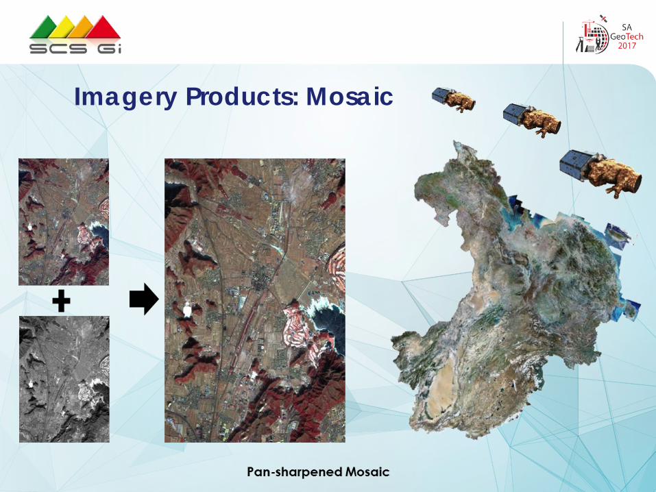
Imagery Products: Mosaic

Imagery Products: Digital Elevation Models

Applications • An affordable source of information for analysing, monitoring,
forecasting and managing resources and human activities on the planet
• True decision-support tools for a range of applications such as: • Agriculture • Forestry • Energy • Environmental • Intelligence • Mapping • Maritime • Mining • Transportation • Urban and Rural Development • Disaster Management

Applications: Agriculture • Crop Identification / Type
• Crop Health • Crop Yield • Crop Insurance Assessments • Drought Assessments • Grazing Management • Livestock Stocking Rate, Grass
Availability, Overstocking Risks • Statistic accuracy > 95%
• NDVI (Normalised Differential Vegetation Index)
Precision Farming
Chlorophyll volume changes as crop’s mature and if the crop undergoes any stress related to nutrition, water or pests

Applications: Forestry
• Forestry industry uses satellite imagery to monitor forests at stand level across the African Continent…
• Fire Prevention/management • Identification and Monitoring • Forest Health and Risks • Forest Management • Timber Inventory • Deforestation

Applications: Disaster Management
• Natural disasters increasing in number and frequency, and affect most countries in Africa
• Droughts • Floods • Wildfires • Wind
• Satellite imagery provides a set of unique resources to detect, monitor and assist in managing natural and man-made disasters.

Disaster Management: Fire Fighting • Satellite imagery and GIS maps support fire and emergency
personnel responding to emergency situations, hazardous fuels reduction, community assistance, firefighting, rehabilitation, and restoration.
Rehabilitation
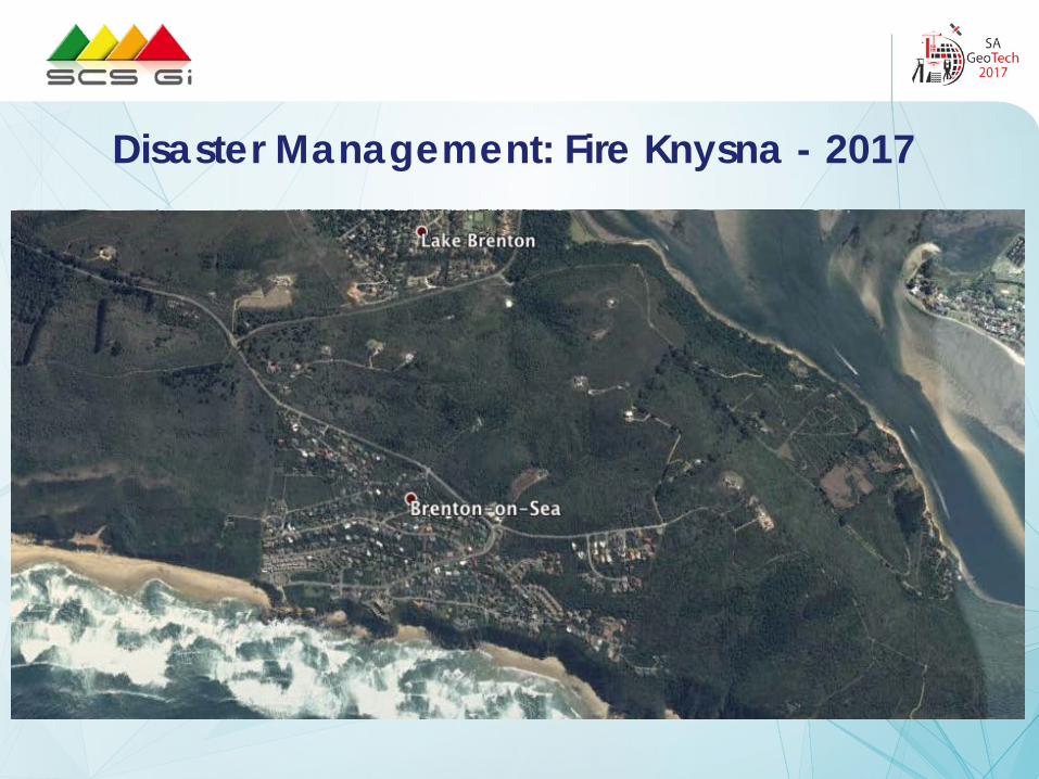
Disaster Management: Fire Knysna - 2017

Applications: Environment The African Continent faces many challenges and suffers from some serious
environmental problems, which have been worsened by the advent of climate change… Remote sensing and development of different sensors for environmental and natural resources mapping and data acquisition are critical in managing the threats to the environment…
• Land Use and Land Cover • Impervious Surface • Water • Soil Erosion

Urban Growth
• Cities grow exponentially, ever increasing the demand on public services and increasing the demand on disaster planning
• De-vegetation and soil sealing increase flood risk
• With regular satellite imagery change detection urban growth can be managed in conjunction with flood models, digital elevation models, precipitation models, catchment area maps.
• Data overlaid with census and population growth models.
Environment: Land Cover and Land Use

DEIMOS-1 Satellite Imagery
Environment: Water Quality
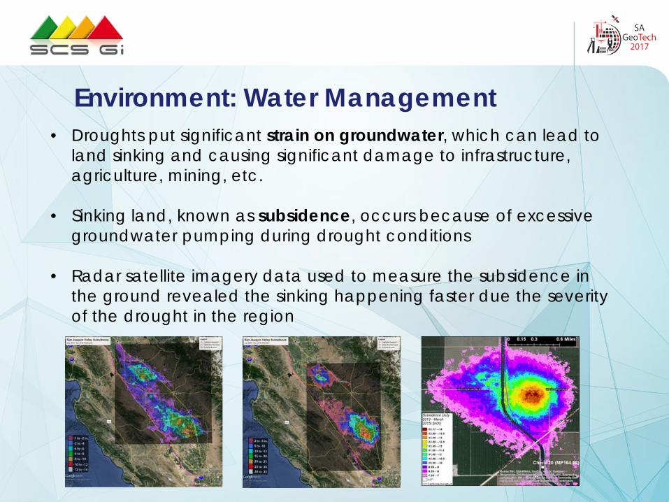
• Droughts put significant strain on groundwater, which can lead to land sinking and causing significant damage to infrastructure, agriculture, mining, etc.
• Sinking land, known as subsidence, occurs because of excessive
groundwater pumping during drought conditions • Radar satellite imagery data used to measure the subsidence in
the ground revealed the sinking happening faster due the severity of the drought in the region
Environment: Water Management

Mining: Management and Operations Satellite imagery used to manage day-to-day operations of mines, mineral extraction and maintenance of infrastructure…
• Find an optimal venue for the drilling according to the location of infrastructure objects as buildings, roads, pipelines, water and utilities.
• Control the process of compliance with environmental standards for
planning and realization measures to control air pollution, soil and water.
• Assess the extent of
the impact of work on the environment and the progress of work on land reclamation in accordance with state standards

Application: Maritime

Company Confidential
EEZ Monitoring • Satellites only resource capable of conducting broad ocean surveillance of
the continents EEZ’s to fully understand the threats to regional economic security…
• Satellites capable of: • Monitoring ship traffic along coastlines and in open oceans • Combating illegal fishing, piracy, human trafficking,
smuggling and terrorism • Supporting operational requirements such as search
and rescue and salvage and recovery • Each vessel detected reported by:
• Type (Optical Data) • Geographical Location (Latitude/Longitude) • Vessel Dimensions • Heading • Speed
• By combining the satellite based information with other available sources such as AIS, non-reporting and noncompliant vessels highlighted, monitored and reported to the appropriate authorities
30m Multispectral Landsat-8 Satellite Imagery

Environmental Protection • Environmental protection and enforcement supported by both
synthetic aperture radar and optical satellites • Port and Harbor Monitoring • Law Enforcement - Piracy • Oil Spills

Cadastral Mapping
• Cadastral mapping requires the use of very high resolution satellite imagery to create an accurate base map of each country… • Satellite imagery is used to develop the foundation of
a national cadastre and title registry system • Image processing • Ortho-rectification • Feature extraction • Land cover • Change detection
Application: Mapping

• Satellites used to generate high resolution building models from stereo imagery, which is the basis of creating 3D Smart Cities…
• Urban Planning and Analysis • Economic Development • Transportation • Flood Modeling • Line-of-Sight
3D City Mapping

Application: Defense and Intelligence Unrestricted access to targets only provided by commercial satellites to address needs of defense and intelligence organizations…
• Installation Classification • Indications and Warning • Terrain Analysis • Mission Planning and Rehearsal • Camouflage, Concealment
and Deception • Mapping, Charting & Geodesy • Intelligence, Surveillance
and Reconnaissance

SCS Gi in association with its suppliers are offering nSight1
Africa Satellite Constellation with Unparalleled Response to Users Needs

SCS Aerospace Group of company’s provide commercial satellite solutions
• The opportunity to implement application specific satellites • Custom developed for business specific application • Cost effective compact satellite solution
• nSight1 is a shoebox size satellite with:
• 30m resolution • RGB technology • 60 x 30 km snapshot
• Applications • Food security • Water management • Forestry • Environment
• Be sure to attend our press conference later this morning • Hendrik Burger CEO SCS-AG will be available for questions
Application specific satellite option
nSight1 -First image over SA

Dewald Lloyd
SCS Global Information
www.scsgi.com
Mob: +27 (0)72 909 8704 [email protected]
RGB
Auto Classification
Edge Extraction