earth and planetary science letters - uc santa …bodo/pdf/amidon13_mk_moraines.pdf · earth and...
TRANSCRIPT
Earth and Planetary Science Letters 381 (2013) 210–221
Contents lists available at ScienceDirect
Earth and Planetary Science Letters
www.elsevier.com/locate/epsl
Late Pleistocene glacial advances in the western Tibet interior
William H. Amidon a,!, Bodo Bookhagen b, Jean-Philippe Avouac c, Taylor Smith b,Dylan Rood d
a Geology Department, Middlebury College, Middlebury, VT 05753, United Statesb Geography Department, University of California Santa Barbara, Santa Barbara, CA 93106, United Statesc Department of Geological and Planetary Sciences, California Institute of Technology, Pasadena, CA 91125, United Statesd Scottish Universities Environmental Research Center, Glasgow, Scotland, G12 8QQ, United Kingdom
a r t i c l e i n f o a b s t r a c t
Article history:Received 28 May 2013Received in revised form 16 August 2013Accepted 17 August 2013Available online xxxxEditor: T.M. Harrison
Keywords:cosmogenic10Be21NeTibetclimateglacier
It has long been observed that the timing of glacial advances is asynchronous across the Himalaya–Karakoram–Tibet Plateau (HKTP) but the climatic implications, if any, remain unclear. Resolving thisquestion requires additional glacial chronologies from unique spatial and climatic regimes as well asan analysis of how glaciers within different regimes are likely to have responded to past climate changes.This study presents a 10Be–21Ne chronology from the Mawang Kangri range of western Tibet ("34#N,80#E); an arid high-elevation site. We identify advances at "123, 83, and 56 kyr, which agree reasonablywell with sites in the immediate vicinity, but are asynchronous relative to sites across the entire HKTP,and relative to sites in the western HKTP. To evaluate HKTP-wide asynchroneity, we compile dated glacialchronologies and classify them by the approximate timing of their maximum recent advance. This resultshows a strong spatial clustering of young (MIS 1–2) relative to older (MIS 3–5) maximum advances.Further comparison with modern precipitation, temperature, and topographic data show that the patternof HKTP-wide asynchroneity is broadly independent of topography and can potentially be explained bylocal responses to changes in temperature at either very warm-wet or cold-dry sites. Sites that receiveintermediate amounts of precipitation are more ambiguous, although spatial clustering of MIS 1–2 vs.MIS 3–5 advances is suggestive of past variations in precipitation at these sites. In western Tibet, nospatial or climatic correlation is observed with the timing of maximum glacial advances. We suggest thiscould arise from mis-interpretation of disparate boulder ages generated by a prolonged MIS-3/4 glacialadvance in the western HKTP.
! 2013 Elsevier B.V. All rights reserved.
1. Introduction
Glaciers on the Himalaya–Karakoram–Tibet Plateau (HKTP) spana wide range of climatic conditions, from temperate maritimeglaciers in the south and east, to dry-cold continental glaciers inthe north and west. This variability is due to topography and to theclimatic influences of the East Asian and Indian Monsoons in theeast and south, and the mid-latitude westerlies, and Siberian high-pressure systems to the west and north (Benn and Owen, 1998;Rupper et al., 2009; Scherler et al., 2010; Seong et al., 2007).Because glacial chronologies are the most ubiquitous and easilyaccessible climate proxy on the HKTP, they hold a potentially use-ful record of how these climate systems changed over time. Cos-mogenic nuclide dating of moraines has recently expanded thenumber of well-dated moraine sequences available on the HKTP,revealing that glacial advances throughout the HKTP are asyn-chronous (Chevalier et al., 2011; Heyman et al., 2011a; Owen et
* Corresponding author. Tel.: +1 802 443 5988.E-mail address: [email protected] (W.H. Amidon).
al., 2010, 2012). For example, many glaciers in the HKTP inte-rior experienced maximum advances during Marine Isotope Stage(MIS) 3 or 4 ("73–28 ka), whereas many glaciers on the HKTPmargins peaked during MIS-2 ("28–12 ka). The paleoclimatic in-terpretation of this asynchroneity remains unclear. Recent stud-ies have proposed a range of explanations, calling upon changesin the strength of climatic systems (e.g. Benn and Owen, 1998;Owen et al., 2005), temperature variations (e.g. Rupper et al., 2009;Shi, 2002), topographic/hypsometric differences between neighbor-ing catchments (Derbyshire, 1996; Owen et al., 2005), or a combi-nation of several climatic parameters acting at different timescales(Scherler et al., 2010).
An alternative explanation for regional asynchroneity in someparts of the HKTP is incorrect interpretation of cosmogenic boul-der ages. Most MIS-3/4 moraines in arid parts of the HKTP yieldwide-ranging cosmogenic boulder ages, making it di!cult to assigna mean age to each moraine (e.g. Chevalier et al., 2011; Hedricket al., 2011). Variability in boulder ages is often attributed topost-depositional moraine degradation, implying that older boul-der ages are more likely to record the timing of maximum glacial
0012-821X/$ – see front matter ! 2013 Elsevier B.V. All rights reserved.http://dx.doi.org/10.1016/j.epsl.2013.08.041

W.H. Amidon et al. / Earth and Planetary Science Letters 381 (2013) 210–221 211
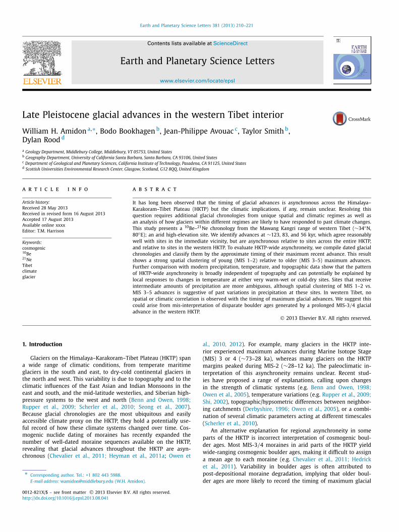
Fig. 1. Shaded-relief digital elevation model (DEM) of the Mawang Kangri range. Right panel shows close-up of Mawang Kangri (MK) ice cap and outlet glaciers on a SPOT-5satellite image. The three-dated moraines are shown with 1! age uncertainties. The highest moraine (M4) is the presumed, but yet undated, MIS-1/2 moraine near theglacier terminus.
advance (Heyman et al., 2011b; Putkonen and Swanson, 2003). Insome cases, large age spreads may be related to glacial dynamics,such as the slow retreat of glacier termini in arid regions (Zechet al., 2005b). Thus, although testing asynchroneity requires robustmoraine ages, it is possible that the quality of ages may be directlyrelated to the climatic setting and mass balance response time ofthe glacier. Determining whether asynchroneity on the HKTP arisesfrom paleoclimatic variations or poorly interpreted data is a dif-ficult problem requiring additional well-dated moraine sequencesand comparison with modern climatic data.
In this study we use in-situ cosmogenic 10Be and 21Ne dat-ing of moraine boulders to develop a glacial chronology from theMawang Kangri (MK) range in western Tibet (Fig. 1). Although thetiming of advances ("123, 83, and 56 kyr) agrees well with somenearby sites, they do not match advances elsewhere in the west-ern HKTP, suggesting asynchroneity. This may be partially becausethe MK site is one of the highest, coldest, driest, and most interiorsites yet dated on the HKTP (glacial terminus at 5445 m asl). Tounderstand the apparent asynchroneity, we perform a spatiotem-poral analysis of maximum glacial advances on the entire HKTP.We explore two spatiotemporal cases of asynchroneity. First, weconfirm the HKTP-wide asynchroneity mentioned above by show-ing maximum advances at interior and western sites occurred dur-ing MIS-3–5, earlier than maximum MIS 1/2 advances at manysites along the margin of the HKTP (Owen et al., 2005, 2002). Sec-ond, a western-HKTP asynchroneity is shown by the disagreementbetween the timing of MIS-3/4 advances at sites within the west-ern HKTP. We explore the spatiotemporal dynamics causing thesetwo cases by extracting modern precipitation, temperature, and to-pography data at well-dated glacial sites. We interpret the datain the context of two end-member hypotheses. First, does asyn-chroneity reflect unique local responses to broad-scale systematicchanges in climatic forcing (e.g., temperature) across the entireHKTP? Alternatively, is asynchroneity caused by changes in thespatial pattern of precipitation or temperature over time? Our fourmain findings are: (1) the HKTP-wide asynchroneity can be ex-plained by local responses to a systematic drop in temperature at
end-member warm-wet and cold-dry sites; (2) advances at inter-mediate precipitation sites may reflect changes in spatial patternsof precipitation during MIS-1/2; (3) apparent western HKTP asyn-chroneity cannot be explained by either hypothesis, and may arisefrom the effects of prolonged glacial advances on moraine stabil-ity; and (4) topography does not exert a first order control on thetiming of maximum glacial advances on the HKTP.
2. Geographic and climatic setting
2.1. Mawang Kangri (MK) field site
The MK mountain range sits in the far western interior ofthe Tibetan Plateau, consisting of several "6400 m high peaksprotruding above a small ice cap, which feeds multiple incisedglacial valleys (Figs. 1 and 2). This study focuses on an un-named valley near 34.3#N and 80.1#E, with a drainage area of"44 km2, and "916 m of relief between the modern glacial ter-minus at 5445 m and the highest peak at 6368 m. The accu-mulation zone is dominated by firn basins, with a mean slopeof "15# . The current glacier has an ELA of "6090 m, based onevaluation of the snow line in satellite imagery from August andSeptember 2004, 2009, and 2010 (SPOT and WorldView imageryaccessed via Google Earth). The oldest moraine (M1) is a semi-circular piedmont moraine crest, reaching a minimum elevationof "5300 m and sparsely adorned with large (>1.5 m) moraineboulders. The intermediate moraine (M2) is a terminal morainefragment "380 m upstream from M1, reaching "5285 m eleva-tion and adorned with smaller, "0.5 m dimension boulders. Theyoungest dated hummocky moraine (M3) covers "0.2 km2, de-fined by a sharp southern edge, giving way to a low-relief surfacewith several hummocky crests. We interpret this deposit as hav-ing formed during a period of glacial stagnation, characterizedby minor retreats and advances, and deposition of a large sed-iment load. A younger, undated terminal moraine (M4) is found"3.5 km upstream from M3, "0.58 km from the toe of the mod-ern glacier.

212 W.H. Amidon et al. / Earth and Planetary Science Letters 381 (2013) 210–221
Fig. 2. Mean annual precipitation from 1998–2007 based on APHRODITE data (Yatagai et al., 2012). Dots represent glacial valleys classified by the timing of their maximumadvance based on published work summarized in Heyman et al. (2011b). Sites have been grouped into regions based on geographic proximity and timing. The MawangKangri (MK) site is denoted by a white star. Graphs show probability density functions (PDFs) of 1! filtered moraine ages (not boulder ages) found within each region fromthe dataset of Heyman et al. (2011b). PDF colors mimic the precipitation color-scale: ochre PDFs denote arid regions (<300 mm/yr), purple denotes high-precipitation regions(>900 mm/yr), and beige denotes intermediate regions. Grey and white bars denote Marine Isotope Stages 1–5e (Shackleton, 2000). Regions are abbreviated as: TS: TienShan, PAM: Pamir, EP: East Pamir, SW: Swat, NP: Nanga Parbat, KK: Karakoram, NI: Northern India, WT: Western Tibet, KU: Kunlun, CN: Central Nepal, EN: Eastern Nepal,CT: Central Tibet, ET: Eastern Tibet, QI: Qilian Shan Region, EH: Eastern Himalaya. (For interpretation of the references to color in this figure legend, the reader is referred tothe web version of this article.)
2.2. Regional modern and paleoclimatic conditions
Mean annual temperatures at glacial termini across the HKTPare largely controlled by elevation and proximity to the ocean,ranging from "$11 to 11 #C (Rodell et al., 2004). The monthlymean annual temperature at the terminus of the paleo-MK glacier(5305 m) is $11 #C, with mean temperature exceeding 0 #C onlyin July and August (Rodell et al., 2004). Temperatures during theglobal last glacial maximum (LGM) were likely "4–9 #C cooler inthe Tibetan interior (Bush, 2004; Shi, 2002; Shin et al., 2003),whereas Indian Ocean sea surface temperatures were probablyonly "2 #C cooler (De Deckker et al., 2003; Shin et al., 2003).
Topographic barriers create a wide range of precipitation ("50to 3000 mm/yr) on the HKTP, including desert conditions acrossmuch of the interior (Figs. 2 and 3). The MK site receives"79 mm/yr of precipitation: "80% in summer (JJAS), "11% inwinter (JFMA), and "2% in fall (OND) (Yatagai et al., 2012), simi-lar to other high-elevation sites on the Tibetan Plateau (Bookhagenand Burbank, 2010).
Precipitation across the HKTP is generated by three climaticsystems, which play different roles depending on the season(Fig. 3). During the summer, onshore monsoonal winds createintense rain and snowfall in the “monsoon-influenced” south-ern and eastern regions of the HKTP, whereas summer west-erlies bring little precipitation to the HKTP (Benn and Owen,1998). During winter, the situation reverses as cold dry mon-soon winds flow off the plateau, creating arid winters acrossmuch of the central, eastern, and southern HKTP. Winter west-erlies trend further south in winter, delivering snowfall to the
western regions of the HKTP. Winters in the northeastern HKTPare influenced by the Siberian high-pressure system, which en-croaches on warm air masses in southern China, generating snow-fall along the northeastern flank of the HKTP (Gong and Ho, 2002;Zhang et al., 2009).
Numerical modeling and proxy data give insight into how thefour major climatic systems differed during the late Pleistocene.First, the east Asian monsoon system was driven by changes ininsolation, with maxima at "34 (MIS-3) and "11 kyr (MIS-1) cor-responding to wet periods in monsoon-influenced HKTP, and theinsolation minimum at "22 kyr (LGM) associated with drier con-ditions (Fang, 1991; Herzschuh, 2006; Prell and Kutzbach, 1992;Wang et al., 2008). However, several models predict that LGMmonsoon precipitation may have increased in the southeast Hi-malaya due to the interaction of stronger south-westerly windswith northward flow generated by enhanced low-level convergenceover Indonesia (Bush, 2004; Kim et al., 2008).
Second, although little observational data exists regardingpast behavior of the westerlies, models predict southward de-flection and increasing interaction with the HKTP (Bush, 2004;Ono and Irino, 2004). However, because global temperatures werecolder during MIS-2, lower evaporative fluxes from Eurasia proba-bly caused lower moisture contents in westerly air masses. Climateproxies from Aksayqin and Qarhan lakes in the western HKTP,show that MIS-2 was mostly dry, sandwiched between periodswith high wetness in late MIS-3 and early MIS-1. Likewise, oxy-gen isotopes from the Guliya ice cap (western HKTP), suggest thatMIS-1 and -3 were warm (and thus wet) intervals (Thompson etal., 1997).

W.H. Amidon et al. / Earth and Planetary Science Letters 381 (2013) 210–221 213
Fig. 3. Precipitation for northern hemisphere winter (top panel), summer (middlepanel), and summer temperatures (bottom) based on APHRODITE and GLDAS re-spectively (Rodell et al., 2004; Yatagai et al., 2012). Bold arrows denote schematicatmospheric circulation patterns at "3000 m elevation and dashed arrows representcirculation at "500 m. “L” denotes Tibetan low-pressure center, and “H” denotes thesouthern edge of the Siberian high-pressure system.
Third, climate models suggest the Siberian high pressure system(Fig. 3; top panel) was strengthened during MIS-2, causing inten-sified frontal interactions along the northeastern HKTP. This mayhave pushed the desert margin of the Loess plateau (Fig. 2) fur-ther to the southeast, and increased moisture in the Qilian/Qinghairegion during MIS-2 (Bush, 2004; Ding et al., 1999).
Changes in the relative strength of precipitation as a function ofinsolation are often invoked to explain the observed asynchrone-ity of glacial advances on the HKTP. Specifically, stronger summerinsolation enhances seasonal heating over the HKTP, generatinglow air pressure and strengthening monsoon circulation (Kutzbach,1981). For example, large MIS-1/2 advances along the margins ofthe HKTP are often attributed to a strengthened monsoon nearthe 11-kyr insolation peak. Likewise, a weak interior advanceduring the global LGM has been attributed to drier conditionsnear the 22-kyr insolation minima (Lehmkuhl and Owen, 2005;Owen et al., 2005). A large MIS-3 advance in the interior is thoughtto be driven by a prolonged monsoon associated with high sum-mer insolation from "60 to 35 kyr (Shi et al., 2001). However,several studies have pointed to the importance of temperature incontrolling glacial advances on the HKTP. Shi (2002) suggest thatsevere cold and associated lack of precipitation during LGM time(early MIS-2) precluded large advances in the interior. Likewise,model results suggest that large MIS-1/2 advances along the mar-gins of the Himalaya were largely driven by a drop in temperature
due to enhanced cloud cover and reduced radiative forcing (Rupperet al., 2009).
3. Geochronology at the Mawang Kangri (MK) site
3.1. Geochronology methods
We sampled 21 granodiorite boulders for cosmogenic 10Be and21Ne dating (Fig. 1; Table DR1). 2–3 cm thick samples were col-lected with a hammer and chisel, from which quartz was purifiedfollowing standard laboratory procedures (Kohl and Nishiizumi,1992). Purity of quartz was verified by ICPMS measurements ofAl, which yielded concentrations of <100 ppm in all samples.10Be extraction was performed following published procedures inBodo Bookhagen’s lab at UCSB (Bookhagen, 2012; Bookhagen andStrecker, 2012). 10Be measurements were made at Lawrence Liv-ermore National Laboratory, following published procedures (Roodet al., 2010). 21Ne measurements were made at Caltech, follow-ing identical procedures to those described in Amidon and Far-ley (2012). For reference, the same analytical techniques and in-strument calibration yielded a cosmogenic 21Ne concentration of338 ± 10 Mat/g on the CRONUS-A quartz standard, in excellentagreement with the reported value of 333 ± 3 Mat/g (Balco andShuster, 2009).
3.2. Geochronology results
Measured 21Ne and 10Be are in reasonable agreement withthe ratio predicted by their production rates (Fig. DR2; Table 1,DR2, and DR3). Measured neon is generally a two-componentmixture of air and spallation derived neon (Fig. DR1). Air com-ponents are large, with low 21Ne/20Ne ratios between "0.0035and 0.009, accounting for 30–85% of measured 21Ne. 21Ne con-centrations in excess of air (21Nex) are high, ranging from 25 to60 Mat/g, with generally higher concentrations measured in sam-ples from stratigraphically older moraines. Measured 10Be ratiosrange from 1.4 % 10$11 to 7 % 10$12, corresponding to concentra-tions of 2.4–11.6 Mat/g. Analytical uncertainties range from "0.5to 1.5% (Rood et al., 2013) and the 10Be laboratory blank (n = 3)for these samples had a 10Be/9Be ratio of 2.8 % 10$14.
Co-hosted 10Be and 21Ne concentrations allow cross-validationof the measurements and comparison with published production-rate ratios. Given that the moraine boulders have young (<150 kyr)simple exposure histories, we compare measured 10Be/21Ne ratiosdirectly with production-rate ratios, neglecting the loss of 10Beby decay, which should be less than a 5% effect. A weighted to-tal least-squares regression (Fig. DR2) and a separate numericalmean of our data yield 10Be/21Ne of 0.19 ± 0.08 and 0.20 ± 0.03respectively. This ratio is lower than two global calibrations ofthe 10Be/21Ne production-rate ratio, which both yielded "0.23(Goethals et al., 2009; Kober et al., 2011). It is also below themean 10Be/21Ne of 0.27 ± 0.04 reported from "4000 m in theeastern HKTP (Strasky et al., 2009). In contrast, our 10Be/21Neratio matches mean ratios recomputed from two high-elevationsites on the central HKTP: 0.20 ± 0.07 from "4100 m (Schaferet al., 2008), and 0.19 ± 0.04 from "5000 m (Strobl et al.,2012). These results suggest that the 10Be/21Ne production-rateratio at high elevation in west-central HKTP is lower than theglobal average, consistent with unexpectedly low 10Be/3He ra-tios observed in the central Himalaya (Amidon et al., 2008;Gayer et al., 2004).
We adopt a 10Be production rate calibrated for New Zealand(De = 3.88 ± 0.08 and Lm = 3.75 ± 0.08 at/g/yr), because this isthe closest high-quality calibration site (Putnam et al., 2010). Wethen use the weighted mean 10Be/21Ne ratio of our own sam-ples combined with the nearby results of Schafer et al. (2008),

214 W.H. Amidon et al. / Earth and Planetary Science Letters 381 (2013) 210–221
Fig. 4. Cosmogenic 21Ne and 10Be ages of boulders on three moraines (M1, M2 andM3) from the Mawang Kangri site shown with 1! uncertainties. Ages are scaledusing the Lal/Stone time-variable model with SLHL reference production rates of3.75 and 18.7 at/g/yr for 10Be and 21Ne, respectively. Shielding and erosion areneglected.
(10Be/21Nemean = 0.201 ± 0.011) to compute 21Ne productionrates (De = 19.35 ± 1.1 and Lm = 18.7 ± 1.1 at/g/yr). This choiceof production rates satisfies our observed 10Be/21Ne ratio, andmatches recently published results (Kober et al., 2011). 10Be agesin Table 1 are reported using the Cronus online calculator v.2.2(Balco et al., 2008), using the calibration dataset of Putnam et al.(2010). 21Ne ages in Table 1 are computed using scaling factorsderived from the Cronus calculator (Table 1), combined with theproduction rates stated above. As shown in Table 1, the Desilets(De), Dunai (Du), and Lifton (Li) scaling models agree to within 4%in western Tibet, whereas scaling factors from the Lal/Stone timevariable model (Lm) are "15% lower for older ages. All cosmogenicages are discussed in terms of the Lal/Stone time-variable model(Lm).
21Ne exposure ages from the older moraines M1 and M2 showtightly clustered ages (Table 1 and Fig. 4). Three ages from the old-est M1 moraine cluster at 123 ± 5 kyr (all uncertainties are 1! ).The mean of four samples from M2 cluster at 83 ± 5 kyr. In con-trast, ages from the M3 hummocky surface scatter from 32 to108 kyr, with a cluster of ages between 50–60 kyr. We assign anage of "56 ± 3 kyr to M3 based on the mean of 7 samples clus-tered between 50–60 kyr, whose error bars overlap one another. Insummary, we argue that the largest recent advances all occurred ator before "56 kyr, whereas younger MIS-1/2 advances (presum-ably recorded by moraine M4) were confined close to the modernice margin. This is consistent with the limited LGM advance at thenearby Guliya ice cap (Fig. 2), whose terminal moraine dated at15.3 kyr sits only 50 m from the current ice margin (Yao et al.,1992).
4. Spatial analysis methods and results
4.1. Establishing timing of maximum glacial advances
To understand the cause of asynchroneity between MK andother sites on the HKTP, we compared its climatic and topographiccharacteristics with other well-dated glacial chronologies. We usedthe dataset of rescaled cosmogenic ages published by Heymanet al. (2011b), and added data from six additional chronologies(Damm, 2006; Owen et al., 2012; Richards et al., 2000a, 2000b;Taylor and Mitchell, 2000; Tsukamoto et al., 2002). We first esti-mate the age of each moraine by discarding 1! outliers from themean age, and then re-computing the mean age (1! filtered mean Ta
ble
1Sa
mpl
eag
es.
#10
Be(M
at/g
)1! (M
at/g
)
21N
e(M
at/g
)1! (M
at/g
)Sc
alin
gfa
ctor
sD
eLm
De
Lm
StD
eD
uLi
Lm21
Ne
age
(kyr
)1! (k
yr)
21N
eag
e(k
yr)
1! (kyr
)
10Be
age
(kyr
)1! (k
yr)
10Be
age
(kyr
)1! (k
yr)
12.
40
14.5
2.6
22.5
26.8
26.7
25.3
2429
332
.33
230.
526
0.6
2–
–24
.61
21.9
30.1
30.8
28.5
25.7
445
51.2
5–
––
–3
6 .4
0.1
25.8
0.5
22.5
31.4
32.4
3025
.944
553
.35
541.
466
1.8
45 .
50.
126
.81.
722
.330
.531
.328
.926
.247
554
.76
451.1
561.
35
5 .5
0.1
27.6
1.4
22.1
30.3
3128
.726
495
56.8
645
1.2
561.
56
––
27.7
0.9
22.5
31.3
32.1
29.8
26.1
475
56.8
6–
––
–7
––
28.0
0.6
22.2
3131
.929
.525
.848
558
.06
––
––
86 .
40.
128
.01
22.2
3132
29.7
25.6
485
58.5
654
1.3
671.
69
4 .7
0.1
31.5
0.5
22.4
29.5
30.2
27.9
2657
664
.87
401.
048
1.2
10–
–32
.80.
622
30.5
31.8
29.6
25.3
587
69.3
7–
––
–11
8 .4
0.1
38.3
4.5
22.5
30.7
31.7
29.5
2667
878
.88
711.
888
2.2
12–
–47
.50.
622
.130
.531
.729
.325
.583
999
.610
––
––
13–
–49
.90.
522
.130
.631
.829
.425
.587
1010
4 .6
11–
––
–14
––
51.4
1.2
22.1
30.6
31.8
29.3
25.5
9010
107 .
811
––
––
16–
–37
.70.
321
.929
.830
.828
.725
.368
879
.78
––
––
17–
–37
.80.
721
.729
.830
.728
.525
.175
880
.59
––
––
188 .
10.
141
.31
22.3
30.5
31.6
29.4
25.8
728
85.6
970
1.7
862.
119
8 .1
0.1
41.9
2.8
2230
.131
.129
25.4
758
88.2
970
1.6
872.
0
21–
–57
.91.
421
.830
.131
.429
25.6
103
1212
0 .9
13–
––
–22
11.5
0.1
58.1
0.5
2230
.431
.729
.325
.710
212
120.
913
972.
211
82.
723
––
60.0
0.9
21.5
29.7
30.9
28.5
25.4
108
1212
6 .3
13–
––
–

W.H. Amidon et al. / Earth and Planetary Science Letters 381 (2013) 210–221 215
in appendix Table 3). Although this approach does not give prefer-ence to older ages (e.g. Heyman et al., 2011b), it is the most robustmethod to compare moraines across a wide range of ages and cli-matic regimes, without risk of mis-categorizing a moraine basedon a single erroneous boulder age. Because resultant moraine agesvary widely, we assign them broadly to marine isotope stages(MIS): MIS-3/4 (73–28 kyr), MIS-2 (28–12 kyr), or MIS-1 (<12 kyr)(Shackleton, 2000). After assigning an MIS stage to each morainein a given valley, we then classified each valley based on whenthe maximum glacial advance occurred (Table DR4). This classi-fication was undertaken based on the maps and written analysispresented in each of the published papers, supplemented by vi-sual inspection of geomorphic relationships using satellite imageryin Google Earth. Each valley in the dataset meets three basic cri-teria: (1) multiple documented moraines in the valley, (2) at leastone well-dated moraine per valley, and (3) evidence that the au-thors looked carefully for other moraines and assigned absolute orrelative ages to all moraines present. Finally, each site is assigneda confidence criteria reflecting the degree of confidence in classifi-cation at each site (Table DR4).
The main strength of this approach is that it capitalizes ona large number of recent studies that have expanded the spatialextent and temporal resolution of glacial chronologies. Althoughsome classifications are uncertain, the large dataset reveals mean-ingful first-order trends. By focusing on the relative sizes of recentadvances in each valley, our approach avoids the complex processof computing equilibrium line altitudes for past advances. Instead,the approach effectively normalizes for the complicating factor oftopography, which can be assumed constant (to the first order)over the last 150 kyr, thereby amplifying the signal of regionalchanges in precipitation and temperature over time.
One weakness of this approach is the possibility that authorsmissed evidence of specific advances. However because most stud-ies involve detailed field observation and mapping we considermoraine omission to be a minor source of uncertainty. A secondweakness is the issue of low moraine preservation potential inrapidly eroding valleys, particularly along the temperate Himalayanfront where erosion rates are high (Owen et al., 2005). For exam-ple, highly eroded glacial remnants are briefly mentioned but notdated at certain sites in northern India and central Nepal (Owenet al., 2001; Pratt-Sitaula, 2004). However, other sites in the tem-perate frontal Himalaya show well preserved MIS-3/4 moraines(Abramowski, 2004; Kong et al., 2009). Although preservation is-sues are worthy of further study, they are unlikely to underminethe results presented here due to the large number of diverse sitesincluded in the dataset.
The most striking result of our analysis of maximum advancesis the strong spatial clustering of MIS-3+ vs. MIS-1/2 advances,which we divide into 14 regions based on spatial proximity andtiming of advance (Fig. 2). The observed “HKTP-wide asynchrone-ity” is consistent with previous observations: maximum MIS-1/2glaciations occur mostly near the margins of the HKTP, whereas in-terior and western regions are devoid of strong MIS-1/2 advances(Owen et al., 2002). The MK site is grouped together with othersites in the “western Tibet” region, all of which show maximumadvances during MIS-3+.
4.2. Precipitation and temperature analysis
Monthly precipitation data from 1998–2007 were extracted at0.25# resolution from the Aphrodite V1003R1 data set (Yatagaiet al., 2012). The relatively short time window encompassed bythese data trades off against excellent spatial resolution and im-proved reliability over remote areas with sparse land-based mea-surements. Because remotely-sensed snowfall data are subject tohigh uncertainties, we use mean spring (MAMJ) snow cover as a
proxy for winter snowfall instead. We chose these four months as awindow when snow cover would be most sensitive to accumulatedwinter snow pack and less sensitive to peak summer tempera-tures. Snow cover data from 2000–2012 was extracted from theMODIS/Terra L3 8-day snow cover product (MOD10C2) by averag-ing nine 0.05 degree pixels at each site (Hall et al., 2012). Monthlymean temperature from 2000–2012 was extracted at 0.25# reso-lution from the Global Land Data Assimilation (GLDAS) version 1dataset (Rodell et al., 2004). Temperatures at different elevationswithin the watershed were computed by applying a 5.5 #C/kmlapse rate relative to the elevation and temperature assigned to themodel cell in the GLDAS data. This number recognizes that typicalsummer lapse rates on the HKTP are "5.5 #C/km, with generallylower rates in winter months, and higher rates in summer (Feng etal., 2011; Joshi and Ganju, 2010). Positive degree months (pdm) arecomputed by first calculating the monthly average temperatures atthe moraine terminus for the period 2000–2012, then summingthe total degrees above zero across the 12 months (excluding neg-ative mean temperatures). For example, if July and August havemean temperatures of 4 and 6 #C, and are the only monthly meansabove zero, then the pdm is 10 #C/yr.
A major result of our climatic analysis is that sites within eachregion share similar annual precipitation values but differ widelyin temperature (Fig. 5). Importantly, all arid sites (<300 mm/yr inFig. 5) experienced maximum MIS-3+ advances regardless of tem-perature, suggesting that precipitation is the most important forc-ing factor at these sites. In contrast temperature appears to be themost important variable at high-precipitation sites (>900 mm/yr)because most warm high-precipitation sites show MIS-1/2 ad-vances, whereas many cold high-precipitation sites show MIS-3+advances. Regions of moderate precipitation show a more com-plex behavior with a random mix of MIS-2 and MIS-3+ maximumadvances and no clear dependence on either precipitation or tem-perature.
We further discriminate regions based on seasonality of precip-itation by plotting summer (JJA) precipitation against spring snowcover. Many sites on the western HKTP, and all sites on the east-ern HKTP receive weak winter snowfall, expressed as low springsnow-cover (Fig. 6). In contrast, the MK site and sites in the Pamirand western Karakoram have high snow cover due to high eleva-tion and capture of eastward moisture transport. Northern Indiais a unique region that receives both strong winter snowfall andmoderate summer monsoon precipitation.
4.3. Topographic analysis
Elevation distributions were extracted from void-filled SRTM90-m DEM (http://www.viewfinderpanoramas.org), using water-sheds defined relative to the lowest elevation dated moraine ineach valley. Minimum, median and maximum elevation were com-puted, along with mean 5-km relief and mean slope above themedian elevation. Normalized hypsometries and two different hyp-sometric metrics were also computed: (1) the hypsometric integral(HI) reflects the area under the curve and is lower in watershedswhose surface area is skewed towards lower elevations by intenseglacial erosion (Brocklehurst and Whipple, 2004), and (2) the hyp-sokyrtome (Hkr) is the normalized elevation at which the slopeof the hypsometric line first exceeds a reference slope (1.5 in thiscase). Larger Hkr values reflect that the watershed has been moreintensely modified by glaciation, driving it towards a “u-shaped”rather than “v-shaped” morphology (Sternai et al., 2011).
Hypsometric and topographic data show no relationship withthe timing of maximum advances (Fig. 7 and DR3). For example,the Karakoram, western Tibet, and northern India regions havenearly identical hypsometric properties (HKr and HI), but showcompletely different maximum advances (Fig. 7). Likewise no cor-

216 W.H. Amidon et al. / Earth and Planetary Science Letters 381 (2013) 210–221
Fig. 5. Positive degree months (PDM) plotted against mean annual precipitation. Positive degree months are computed at the paleo-glacier terminus from the GLDAS/NOAHv1 dataset using a lapse rate of 5.5 #C/km. PDM are computed by first calculating the monthly average temperatures at the moraine terminus for the period 2000–2012,then summing the total degrees above zero across the 12 months (excluding negative mean temperatures). The log–log scale masks two orders of magnitude variation inboth precipitation and temperature, which are arbitrarily divided into warm and cold regions based on the distribution of data. The geographic regions denoted in Fig. 2 areoutlined where possible.
Fig. 6. Summer monsoon precipitation (June to August) plotted against spring snow cover (March to June) as determined from the MODIS 8-day snow cover productMOD10C2. Winter precipitation as expressed in percent snow-cover area is most significant in northern India and adjacent regions of the western Karakoram, whereasmonsoon precipitation is most important in southern and eastern HKTP.
relation is observed between the timing of maximum advance and(1) the mean slope of the accumulation zone, or (2) mean 5-kmrelief of the accumulation zone (Fig. DR3b). For example, sites innorthern India that all experienced maximum MIS-2/1 advances(AP–AU, AB–AD) span a large range of mean slopes (21–31#) andmean relief (1150–2050 m).
Considered spatially, our hypsometric results show that sitesin the eastern HKTP have experienced more long-term ("3 Myr)glacial landscape modification than sites in the western HKTP. Forexample, 6 of the 7 highest hypsokyrtomes (HKr) occur in theeastern half of the study area, as do 3 of the 4 lowest hypsomet-ric integrals (Fig. 7). The MK site exhibits an intermediate degreeof glacial landscape modification (HI = 0.53; Hkr = 0.13) relative
to the entire dataset (Fig. 7). However, MK stands out as stronglymodified site when compared to nearby sites in the western HKTP(e.g., Karakoram and western Tibet).
5. Discussion
5.1. Evaluating HKTP-wide asynchroneity
The first finding of our analysis is that HKTP-wide asynchrone-ity can potentially be explained by locally variable responses to asystematic drop in temperature during MIS-1/2. We identify twoend-member climatic regimes, which predict the timing of max-imum advance (Figs. 2, 4, and 7). The first group includes cold-

W.H. Amidon et al. / Earth and Planetary Science Letters 381 (2013) 210–221 217
Fig. 7. Hypsometric integrals (HI) and hypsokyrtomes (HKr) are plotted for each region. Additionally, mean peak and terminus elevations (Zmax and Zmin) and mean hypso-metric integrals are shown for each region. Data were extracted from void filled SRTM-90 m data. Blue lines denote sites with MIS-3–5 maximum advances, red lines denoteMIS-1/2 maximum advances. (For interpretation of the references to color in this figure legend, the reader is referred to the web version of this article.)
dry interior sites, which are generally precipitation limited andshow exclusively MIS-3+ maximum advances (Karakoram, Pamir,Western, Central, and Eastern Tibet). These sites likely experiencednegative mass balances stemming from 6–8 #C cooler temperaturesand associated summer snowfall reductions during MIS-2. The sec-ond group includes wet-warm sites on the margins of the HKTP,which are generally ablation limited and show mostly MIS-1/2 ad-vances (central Nepal, sites DR and DS in eastern Nepal, and sitesCZ–DE in eastern Himalaya). These sites likely experienced positivemass balances from a drop in temperature during MIS-2 througha reduction in melt-dominated ablation and increased summersnowfall. The different local responses to a drop in temperatureduring MIS-2 were likely magnified by the much larger tempera-ture decrease at interior sites relative to marginal sites, which werebuffered by warmer maritime air masses. Colder interior temper-atures would strongly suppress precipitation at cold-dry interiorsites, without greatly reducing sublimation-dominated ablation.
Further evidence that maximum advances in warm-wet re-gions were driven by a drop in temperature comes from sitesin Nepal. Sites BM–BQ in eastern Nepal overlap geographicallywith sites in central Nepal (AX–BJ), and receive similar high-precipitation, yet they do not show maximum MIS-1/2 advances.These weak MIS-1/2 advances in eastern Nepal were generally re-stricted to cold high-elevation sites (BM–BQ) (Finkel et al., 2003;Schafer et al., 2008), where colder temperatures limited the bene-fit of an MIS-2 temperature drop. Thus, it appears that the timingof maximum advance in the wettest parts of the HKTP may becontrolled by temperature, consistent with the findings of Rupperet al. (2009) and Scherler et al. (2010).
A second finding of our analysis is the possibility that patternsof precipitation during MIS-1/2 may have differed from today. Thisarises from considering a third group of intermediate precipita-tion sites (300–900 mm/yr and <40 pdm), which cannot easilybe defined as precipitation or ablation limited. This intermediate
group includes sites in five regions, which share similar modernclimatic characteristics: (1) certain sites in the eastern Himalaya(CW–CX, DC), (2) Qilian Shan (CP–CU), (3) northern India (AC–AF and AP–AU), (4) eastern Tibet (CD–CO), and (5) central Tibet(BU–CC) (Figs. 2–4). Although more detailed study is required topredict exactly how these regions should have responded to coolerMIS-2 temperatures, they should have responded in broadly sim-ilar ways due to their climatic similarities. Instead, strong spatialclustering of maximum MIS-1/2 or MIS-3+ advances seems todominate the signal, suggesting these advances were controlled bya spatially heterogeneous forcing. Given that patterns of precipita-tion are more likely to have changed in a heterogeneous way thantemperature, we briefly speculate on possible paleo-precipitationscenarios.
First, strong MIS-2 advances at sites DC–DE, CW–CX, BZ–CAnear the eastern Himalaya could be explained by strengthenedsummer monsoon precipitation in the southeast Himalaya duringMIS-2, consistent with recent model results (Bush, 2002, 2004).Second, maximum MIS-2 advances in the Qilian Shan region mayresult from its unique location on the northeastern edge of theHKTP, where it would have benefited from low-level convergencecreated by a strengthened Siberian high-pressure system. This ex-planation is consistent with model results and observations sug-gesting the northeast desert margin of the Loess plateau was wet-ter during MIS-2 (Bush, 2004; Ding et al., 1999). Moreover, la-custrine records from this region show rapid warming and highprecipitation during late MIS-2 (Colman et al., 2007; Herzschuh etal., 2006, 2005).
Third, northern India is unique because glaciers rely heavilyon winter accumulation (Fig. 6). Because most sites experiencedmaximum MIS-1/2 advances independent of temperature, a sourceof enhanced precipitation is a plausible candidate for the strongMIS-1/2 advance. We speculate that maximum MIS-1/2 advancesin northern India are driven by high winter snowfall sustained by

218 W.H. Amidon et al. / Earth and Planetary Science Letters 381 (2013) 210–221
more frequent western disturbances during MIS-2. Western dis-turbances are synoptic surface low-pressure systems that move(north)eastward across the northern India region, often associ-ated with a southward shift of the Asian jet stream and en-hanced northward winds (Dimri, 2006; Yadav et al., 2006; Yadav,2009). Given these conditions are thought to have characterizedthe southwest HKTP during MIS-2 (Bush, 2004), it seems plausiblethat western disturbances and thus winter snowfall was strength-ened during MIS-2. This is further supported by lacustrine paleo-climatic archives from this region that indicate higher amounts ofmoisture flux with a western source region (Demske et al., 2009;Wünnemann et al., 2010).
5.2. Evaluating the western HKTP asynchroneity
Timing of advances at MK match the closest neighboring sites,but are apparently asynchronous with sites elsewhere in the west-ern HKTP. For example, sites T–Y in the Ladakh range (Owen et al.,2006a), site Z in northern Zanskar (Hedrick et al., 2011), and sitesAI–AH in the Ayliari range (Chevalier et al., 2011) all show strongdiscrete MIS-5e advances around 112–130 kyr (Table DR4). Like-wise, the Ladakh range (T–Y) shows advances at "80–85 kyr, andsites in Zanskar show advances near "55 and 52 kyr (AA and Z).Fig. 8 shows that the timing of these advances are coincident withperiods of elevated Indian monsoon activity, global warm periodsrecorded in the NGRIP ice core, and local warm periods recorded inthe Guliya ice cap (Clemens and Prell, 2003; NGRIP Project, 2004;Thompson et al., 1997). This suggests that cold-dry interior glaciersrespond positively to warmer and wetter conditions in the region.However, these advances are not perfectly in-phase with any ofthe proxies, and several optimal wet-warm periods, such as earlyMIS-1, are not recorded by an advance.
One explanation for the western HKTP asynchroneity duringMIS-3/4 is past variations in climatic conditions across the re-gion. We consider two end-member hypotheses related to climate:(1) do MIS 3/4 advances in the western HKTP reflect past spa-tial variations in patterns of precipitation or temperature, or (2) dothey reflect locally modulated responses to broad systematic cli-mate changes? To test these ideas we correlated the 1! -filteredmoraine ages with geographic location, climatic, and topographicparameters. The lack of spatial clustering of MIS-3/4 moraine ages(Fig. DR5) argues against the first hypothesis that MIS-3/4 ad-vances were controlled by past spatial variations in climate. Thelack of correlation with local precipitation, temperature, or hyp-sometry (Fig. DR4) argues against the second hypothesis that largeadvances are controlled by locally modulated responses to a sys-tematic shift in climate conditions.
A second possible explanation for the western HKTP asyn-chroneity during MIS-3/4 is that low ice flux through cold-dryglaciers of the western HKTP leads to very slow glacial responsetimes. The timing of max advances thus reflects climate changesmodulated by local conditions superposed upon the time-averagedmemory of past responses at that location (Rupper and Roe, 2008).Such conditions would create different phase shifts between op-timal forcing conditions and the timing of maximum advance ateach site, preventing simple correlation in geographic and climaticspace. Long lag times are consistent with the very minor advanceobserved at MK and the nearby Guliya ice cap during mate MIS-2and early MIS-1 (Yao et al., 1992). This may be explained by therelatively short time window during which optimum temperaturesexisted ("14–8 kyr), which was less than the response time ofthese arid interior glaciers. A simple test of this explanation canbe made using the linear model for glacier length fluctuations (e.g.Roe and O’Neal, 2009). We adopt a melt factor of 3.45 mm/(#C day)and lapse rate of 4.5 #C/km reported for glaciers in nearby re-gions of western Tibet (Zhang et al., 2006), as well as measured
Fig. 8. Compilation of climate proxies compared with the timing of advances atMawang Kangri (arrows with M1–M3), and marine isotope stages (shaded bands).The bottom three panels show probability density functions of 1! -filtered moraineages (not boulder ages) from the eastern HKTP (QI, ET, CT, and ETH), the westernHKTP (TS, PAM, EP, KK, NP, WT, and NI), and the entire HKTP. The "18O recordsfrom the Guliya and NGRIP ice cores are taken as proxies for temperature atMawang Kangri and in the northern hemisphere, respectively (NGRIP Project, 2004;Thompson et al., 1997). The Arabian Sea summer monsoon stack is taken as a proxyfor the Indian monsoon intensity (Clemens and Prell, 2003). June insolation at 30#Nis provided for Ref. Berger and Loutre (1991).
parameters for the Mawang Kangri glacier (slope = 0.04, width =0.96 km, height = 0.235 km, area = 18.6 km2, and ELA = 6090 m).These parameters yield an e-folding relaxation time (the time re-quired for a glacier to return to its equilibrium state following aperturbation) of "140 yr. Although this timescale is "20 timeslonger than reported for temperate glaciers on temperate glacierssuch as Mt. Baker (Roe, 2011), it is not long enough to account forlag times of several thousand years.
A third possible explanation for the western-HKTP asynchrone-ity is incorrect interpretation of pseudo-random moraine boulderages resulting from a prolonged glacial advance across the re-gion from "35–60 kyr (Fig. 8). In this case, glaciers would haveoscillated near their maximum extents for 20–30 kyr, reworkingmoraine surfaces and creating the high volume, multi-lobed, hum-mocky moraines observed at Mawang Kangri and elsewhere in thewestern HKTP (Zech et al., 2005b). This interpretation is consistentwith the wide range of cosmogenic ages obtained from MIS-3/4moraines in the western HKTP and underscores the relationshipbetween local climate, mass-balance dynamics, and the distribu-tion of boulder ages. Relatively rapid and short lived glacial ad-

W.H. Amidon et al. / Earth and Planetary Science Letters 381 (2013) 210–221 219
vances may be a pre-requisite for successful cosmogenic dating ofmoraines.
5.3. Interpreting hypsometry and topographic parameters
Although topography plays a role in defining the length of iceadvance under a given set of climatic conditions (cf. Lehmkuhland Owen, 2005), it does not exert a first order control on thetiming of maximum advance on the HKTP. This observation is con-sistent with recent studies, which show that glacier geometry doesnot exert a strong control on regional variations in glacier lengthchanges (Huybers and Roe, 2009). By contrast, our hypsometric re-sults clearly show that sites in the eastern HKTP have experiencedmore glacial landscape modification than sites in the western HKTP(Fig. 7). This first-order spatial relationship probably reflects thelong-term importance of monsoon precipitation in driving high icefluxes and intense glacial erosion. However, sites in the eastern-half of the HKTP do not show a direct correlation between pre-cipitation and glacial modification. Instead, moderate precipitationsites in eastern and central Tibet show some of the most glaciallymodified landscapes. We interpret this to reflect the importance oftectonic uplift in dropping base level and accelerating river incisionin landscapes along the margins of the HKTP (e.g., central Nepal).In such places the time integrated effects of fluvial incision sculptthe landscape more effectively than the periodic advances of largevalley glaciers. The lack of correlation with drainage area suggeststhat these observations are not scale-dependent, and that they at-test to the long-term stability of monsoon precipitation patternson the HKTP.
6. Conclusions
We have developed a cosmogenic 10Be and 21Ne chronology ofglacial advances at Mawang Kangri (MK) – one of the highest, cold-est, and driest sites yet dated in the Tibetan interior. We estimatea 10Be/21Ne production ratio of 0.20 ± 0.07, slightly lower thanthe global average, but similar to previous high-elevation studieson the Himalaya–Karakoram–Tibet Plateau (HKTP). Good clusteringof moraine ages shows discrete advances at "123, 83, and a pro-longed advance near 56 kyr, with only minor advances occurringduring MIS-1/2. Large MIS-3+ advances at MK are probably drivenby optimal combinations of warmth and monsoon intensity.
Our spatiotemporal analysis of glacial advances on the HKTP re-veals two tiers of asynchroneity. First, “plateau-wide” asynchrone-ity is reflected by MIS-3+ advances at MK and other western/in-terior sites, relative to maximum MIS-1/2 along the margin ofthe HKTP. Second, a “western HKTP” asynchroneity is apparentbetween the "56-kyr advance at MK and the timing of otherMIS-3/4 maximum advances in the western HKTP. Our analysissuggests that the first order plateau-wide asynchroneity can be ex-plained by locally variable responses to systematic cooling duringMIS-2, particularly for the end-member regimes of either precip-itation or ablation-limited glaciers. To the second order, variableMIS-1/2 advances in regions of intermediate precipitation sug-gest that past spatial variations in precipitation may be importantin northern India, the eastern Himalaya, and the Qilian Shan re-gion. The western-HKTP asynchroneity cannot be easily explainedby past spatial variations in climate or local topography. Instead,we argue that apparent asynchroneity of MIS-3/4 advances mayarise from widely distributed moraine ages generated by prolongedglacial advances during MIS-3/4.
Finally, our results suggest that although topography plays arole in defining the length of ice advance under a given set of cli-matic conditions, it does not influence the timing of regional iceadvance and retreat on the HKTP. Sites with more intense monsoonprecipitation show higher degrees of glacial erosion, suggesting
that ice flux is the primary control on hypsometry and that theobserved patterns of precipitation on the HKTP have not changeddramatically over the Pleistocene.
Acknowledgements
Thanks to Jing Liu for help with logistical arrangements, KenFarley for use of his laboratory, and to Ed Amidon for field assis-tance. Reviews by Ben Laabs and an anonymous reviewer greatlyimproved the manuscript. Partial funding was provided by the Cal-tech Tectonics Observatory.
Appendix A. Supplementary material
Supplementary material related to this article can be found on-line at http://dx.doi.org/10.1016/j.epsl.2013.08.041.
References
Abramowski, U., 2004. The use of 10Be surface exposure dating of erratic bouldersin the reconstruction of the Late Pleistocene glaciation history of mountainousregions, with examples from Nepal and Central Asia. PhD thesis. University ofBayreuth, Bayreuth.
Amidon, W.H., Farley, K.A., 2012. Cosmogenic 3He and 21Ne dating of biotite andhornblende. Earth Planet. Sci. Lett. 313–314, 86–94.
Amidon, W., Farley, K.A., Burbank, D.W., Pratt-Sitaula, B., 2008. Anomalous cosmo-genic 3He production and elevation scaling in the high Himalaya. Earth Planet.Sci. Lett. 265, 287–301.
Balco, G., Shuster, D.L., 2009. Production rate of cosmogenic Ne-21 in quartz esti-mated from Be-10, Al-26, and Ne-21 concentrations in slowly eroding Antarcticbedrock surfaces. Earth Planet. Sci. Lett. 281, 48–58.
Balco, G., Stone, J.O., Lifton, N.A., Dunai, T.J., 2008. A complete and easily accessiblemeans of calculating surface exposure ages or erosion rates from 10Be and 26Almeasurements. Quat. Geochronol. 3, 174–195.
Benn, D.I., Owen, L.A., 1998. The role of the Indian summer monsoon and the mid-latitude westerlies in Himalayan glaciation: Review and speculative discussion.J. Geol. Soc. 155, 353–363.
Berger, A., Loutre, M.F., 1991. Insolation values for the climate of the last 10 millionyears. Quat. Sci. Rev. 10, 297–317.
Bookhagen, B., 2012. http://www.geog.ucsb.edu/~bodo/pdf/bookhagen_chemSeparation_UCSB.pdf.
Bookhagen, B., Burbank, D.W., 2010. Toward a complete Himalayan hydrologicalbudget: Spatiotemporal distribution of snowmelt and rainfall and their impacton river discharge. J. Geophys. Res., Earth Surface 115 (F3).
Bookhagen, B., Strecker, M.R., 2012. Spatiotemporal trends in erosion rates across apronounced rainfall gradient: Examples from the southern Central Andes. EarthPlanet. Sci. Lett. 327–328, 97–110.
Brocklehurst, S.H., Whipple, K.X., 2004. Hypsometry of glaciated landscapes. EarthSurf. Process. Landf. 29, 907–926.
Bush, A.B.G., 2002. A comparison of simulated monsoon circulations and snow ac-cumulation in Asia during the mid-Holocene and at the Last Glacial Maximum.Glob. Planet. Change 32, 331–347.
Bush, A.B.G., 2004. Modelling of late Quaternary climate over Asia: a synthesis.Boreas 33, 155–163.
Chevalier, M.L., Hilley, G., Tapponnier, P., Van der Woerd, J., Jing, L.Z., Finkel, R.C., Ry-erson, F.J., Li, H.B., Liu, X.H., 2011. Constraints on the late Quaternary glaciationsin Tibet from cosmogenic exposure ages of moraine surfaces. Quat. Sci. Rev. 30,528–554.
Clemens, S.C., Prell, W.L., 2003. A 350,000 year summer-monsoon multi-proxy stackfrom the Owen ridge, Northern Arabian Sea. Mar. Geol. 201, 35–51.
Colman, S.M., Yu, S.Y., An, Z., Shen, J., Henderson, A., 2007. Late Cenozoic climatechanges in China’s western interior: A review of research on Lake Qinghai andcomparison with other records. Quat. Sci. Rev. 26, 2281–2300.
Damm, B., 2006. Late Quaternary glacier advances in the upper catchment area ofthe Indus River (Ladakh and Western Tibet). Quat. Int. 154, 87–99.
De Deckker, P., Tapper, N.J., van der Kaars, S., 2003. The status of the Indo-PacificWarm Pool and adjacent land at the Last Glacial Maximum. Glob. Planet.Change 35, 25–35.
Demske, D., Tarasov, P.E., Wünnemann, B., Riedel, F., 2009. Late glacial and Holocenevegetation, Indian monsoon and westerly circulation in the Trans-Himalayarecorded in the lacustrine pollen sequence from Tso Kar, Ladakh, NW India.Palaeogeogr. Palaeoclimatol. Palaeoecol. 279, 172–185.
Derbyshire, E., 1996. Quaternary glacial sediments, glaciation style, climate and up-lift in the Karakoram and Northwest Himalaya; review and speculations. Palaeo-geogr. Palaeoclimatol. Palaeoecol. 120, 147–157.
Dimri, A.P., 2006. Surface and upper air fields during extreme winter precipitationover the western Himalayas. Pure Appl. Geophys. 163, 1679–1698.

220 W.H. Amidon et al. / Earth and Planetary Science Letters 381 (2013) 210–221
Ding, Z., Sun, J., Rutter, N.W., Rokosh, D., Liu, T., 1999. Changes in sand content ofloess deposits along a north–south transect of the Chinese Loess Plateau andthe implications for desert variations. Quat. Res. 52, 56–62.
Fang, J., 1991. Lake evolution during the past 30,000 years in China and its implica-tions for environmental change. Quat. Res. 36, 37–60.
Feng, S., Fu, Y.F., Xiao, Q.N., 2011. Is the tropopause higher over the Tibetan Plateau?Observational evidence from Constellation Observing System for Meteorology,Ionosphere, and Climate (COSMIC) data. J. Geophys. Res., Atmos. 116.
Finkel, R.C., Owen, L.A., Barnard, P.L., Caffee, M.W., 2003. Beryllium-10 dating ofMount Everest moraines indicates a strong monsoon influence and glacial syn-chroneity throughout the Himalaya. Geology 31, 561–564.
Gayer, E., Pik, R., Lave, J., France-Lanord, C., Bourles, D., Marty, B., 2004. Cosmogenic3He in Himalayan garnets indicating an altitude dependence of the 3He/10Beproduction ratio. Earth Planet. Sci. Lett. 229, 91–101.
Goethals, M.M., Hetzel, R., Niedermann, S., Wittmann, H., Fenton, C.R., Kubik, P.W.,Christl, M., von Blanckenburg, F., 2009. An improved experimental determina-tion of cosmogenic 10Be/21Ne and 26Al/21Ne production ratios in quartz. EarthPlanet. Sci. Lett. 284, 187–198.
Gong, D.Y., Ho, C.H., 2002. The Siberian High and climate change over middle tohigh latitude, Asia. Theor. Appl. Climatol. 72, 1–9.
Hall, D., Riggs, G., Salomonson, V., 2012. MODIS/Terra snow cover 8-day L3 global0.05 deg CMG V005, 2000–2012. National Snow and Ice Data Center, Boulder,Colorado.
Hedrick, K.A., Seong, Y.B., Owen, L.A., Caffee, M.W., Dietsch, C., 2011. Towardsdefining the transition in style and timing of Quaternary glaciation betweenthe monsoon-influenced Greater Himalaya and the semi-arid Transhimalaya ofNorthern India. Quat. Int. 236, 21–33.
Herzschuh, U., 2006. Palaeo-moisture evolution in monsoonal Central Asia duringthe last 50,000 years. Quat. Sci. Rev. 25, 163–178.
Herzschuh, U., Zhang, C.J., Mischke, S., Herzschuh, R., Mohammadi, F., Mingram,B., Kurschner, H., Riedel, F., 2005. A late Quaternary lake record from the Qil-ian Mountains (NW China): evolution of the primary production and the waterdepth reconstructed from macrofossil, pollen, biomarker, and isotope data. Glob.Planet. Change 46, 361–379.
Herzschuh, U., Kurschner, H., Mischke, S., 2006. Temperature variability and verticalvegetation belt shifts during the last "50,000 yr in the Qilian Mountains (NEmargin of the Tibetan Plateau, China). Quat. Res. 66, 133–146.
Heyman, J., Stroeven, A.P., Caffee, M.W., Haettestrand, C., Harbor, J.M., Li, Y., Alexan-derson, H., Zhou, L., Hubbard, A., 2011a. Palaeoglaciology of Bayan Har Shan,NE Tibetan Plateau; exposure ages reveal a missing LGM expansion. Quat. Sci.Rev. 30, 1988–2001.
Heyman, J., Stroeven, A.P., Harbor, J.M., Caffee, M.W., 2011b. Too young or too old:Evaluating cosmogenic exposure dating based on an analysis of compiled boul-der exposure ages. Earth Planet. Sci. Lett. 302, 71–80.
Huybers, K., Roe, G.H., 2009. Spatial patterns of glaciers in response to spatial pat-terns in regional climate. J. Climate 22, 4606–4620.
Joshi, J.C., Ganju, A., 2010. Use of objective analysis to estimate winter temperatureand precipitation at different stations over western Himalaya. J. Earth Syst. Sci.Educ. 119, 597–602.
Kim, S.J., Crowley, T.J., Erickson, D.J., Govindasamy, B., Duffy, P.B., Lee, B.Y., 2008.High-resolution climate simulation of the last glacial maximum. Clim. Dyn. 31,1–16.
Kober, F., A"inov, V., Ivy-Ochs, S., Kubik, P.W., Wieler, R., 2011. The cosmogenic 21Neproduction rate in quartz evaluated on a large set of existing 21Ne–10Be data.Earth Planet. Sci. Lett. 302, 163–171.
Kohl, C.P., Nishiizumi, K., 1992. Chemical isolation of quartz for measurement of insitu-produced cosmogenic nuclides. Geochim. Cosmochim. Acta 56, 3583–3587.
Kong, P., Na, C., Fink, D., Zhao, X., Xiao, W., 2009. Moraine dam related to late Qua-ternary glaciation in the Yulong Mountains, southwest China, and impacts onthe Jinsha River. Quat. Sci. Rev. 28, 3224–3235.
Kutzbach, J.E., 1981. Monsoon climate of the early Holocene: Climate experimentwith the earth’s orbital parameters for 9000 years ago. Science 214, 59–61.
Lehmkuhl, F., Owen, L.A., 2005. Late Quaternary glaciation of Tibet and the border-ing mountains: a review. Boreas 34, 87–100.
NGRIP Project, 2004. North Greenland ice core project oxygen isotope data, Program,N.N.P. IGBP PAGES/World Data Center for Paleoclimatology, Boulder.
Ono, Y., Irino, T., 2004. Southern migration of westerlies in the Northern HemispherePEP II transect during the Last Glacial Maximum. Quat. Int. 118–119, 13–22.
Owen, L.A., Gualtieri, L., Finkel, R.C., Caffee, M.W., Benn, D.I., Sharma, M.C., 2001.Cosmogenic radionuclide dating of glacial landforms in the Lahul Himalaya,northern India; defining the timing of late Quaternary glaciation. J. Quat. Sci.16, 555–563.
Owen, L.A., Finkel, R.C., Caffee, M.W., 2002. A note on the extent of glaciationthroughout the Himalaya during the global last glacial maximum. Quat. Sci.Rev. 21, 147–157.
Owen, L.A., Finkel, R.C., Barnard, P.L., Ma, H., Asahi, K., Caffee, M.W., Derbyshire, E.,2005. Climatic and topographic controls on the style and timing of late Quater-nary glaciation throughout Tibet and the Himalaya defined by 10Be cosmogenicradionuclide surface exposure dating. Quat. Sci. Rev. 24, 1391–1411.
Owen, L.A., Caffee, M.W., Bovard, K.R., Finkel, R.C., Sharma, M.C., 2006a. Terrestrialcosmogenic nuclide surface exposure dating of the oldest glacial successions in
the Himalayan orogen: Ladakh Range, northern India. Geol. Soc. Am. Bull. 118,383–392.
Owen, L.A., Chaolu, Y., Finkel, R.C., Davis, N.K., 2010. Quaternary glaciation of GurlaMandhata (Naimon’anyi). Quat. Sci. Rev. 29, 1817–1830.
Owen, L.A., Chen, J., Hedrick, K.A., Caffee, M.W., Robinson, A.C., Schoenbohm, L.M.,Yuan, Z., Li, W., Imrecke, D.B., Liu, J., 2012. Quaternary glaciation of the Tashkur-gan Valley, Southeast Pamir. Quat. Sci. Rev. 47, 56–72.
Pratt-Sitaula, B., 2004. Glaciers, climate, and topography in the Nepalese Himalaya.PhD thesis. UC Santa Barbara, Santa Barbara.
Prell, W.L., Kutzbach, J.E., 1992. Sensitivity of the Indian Monsoon to forcing param-eters and implications for its evolution. Nature 360, 647–652.
Putkonen, J., Swanson, T., 2003. Accuracy of cosmogenic ages for moraines. Quat.Res. 59, 255–261.
Putnam, A.E., Schaefer, J., Barrell, D.J.A., Vendergoes, M., Denton, G.H., Kaplan, M.R.,Finkel, R.C., Schwartz, R., Goehring, B., Kelley, S.E., 2010. In situ cosmogenic10Be production-rate calibration from the Southern Alps, New Zealand. Quat.Geochronol. 5 (4), 392–409.
Richards, B.W., Owen, L.A., Rhodes, E.J., 2000a. Timing of late Quaternary glaciationsin the Himalayas of northern Pakistan. J. Quat. Sci. 15, 283–297.
Richards, B.W.M., Benn, D.I., Owen, L.A., Rhodes, E.J., Spencer, J.Q., 2000b. Timingof late Quaternary glaciations south of Mount Everest in the Khumbu Himal,Nepal. Geol. Soc. Am. Bull. 112, 1621–1632.
Rodell, M., Houser, P.R., Jambor, U., Gottschalck, J., Mitchell, K., Meng, C.J., Arsenault,K., Cosgrove, B., Radakovich, J., Bosilovich, M., Entin, J.K., Walker, J.P., Lohmann,D., Toll, D., 2004. The global land data assimilation system. Bull. Am. Meteorol.Soc. 85, 381–389.
Roe, G.H., 2011. What do glaciers tell us about climate variability and climatechange? J. Glaciol. 57, 567–578.
Roe, G.H., O’Neal, M.A., 2009. The response of glaciers to intrinsic climate variability:Observations and models of late-Holocene variations in the Pacific northwest.J. Glaciol. 55, 839–854.
Rood, D.H., Hall, S., Guilderson, T.P., Finkel, R.C., Brown, T.A., 2010. Challenges andopportunities in high-precision Be-10 measurements at CAMS. Nucl. Instrum.Methods Phys. Res., Sect. B, Beam Interact. Mater. Atoms 268, 730–732.
Rood, D.H., Brown, T.A., Finkel, R.C., Guilderson, T.P., 2013. Poisson and non-Poissonuncertainty estimations of 10Be/9Be measurements at LLNL-CAMS. Nucl. In-strum. Methods Phys. Res., Sect. B, Beam Interact. Mater. Atoms 294, 426–429.
Rupper, S., Roe, G., 2008. Glacier changes and regional climate: A mass and energybalance approach. J. Climate 21, 5384–5401.
Rupper, S., Roe, G., Gillespie, A., 2009. Spatial patterns of Holocene glacier advanceand retreat in Central Asia. Quat. Res. 72, 337–346.
Schafer, J.M., Oberholzer, P., Zhao, Z., Ivy-Ochs, S., Wieler, R., Baur, H., Kubik,P.W., Schluchter, C., 2008. Cosmogenic beryllium-10 and neon-21 dating of latePleistocene glaciations in Nyalam, monsoonal Himalayas. Quat. Sci. Rev. 27,295–311.
Scherler, D., Bookhagen, B., Strecker, M.R., von Blanckenburg F, Rood, D., 2010.Timing and extent of late Quaternary glaciation in the western Himalaya con-strained by 10Be moraine dating in Garhwal, India. Quat. Sci. Rev. 29, 815–831.
Seong, Y.B., Owen, L.A., Bishop, M.P., Bush, A., Clendon, P., Copland, L., Finkel, R.C.,Kamp, U., Shroder Jr., J.F., 2007. Quaternary glacial history of the central Karako-ram. Quat. Sci. Rev. 26, 3384–3405.
Shackleton, N.J., 2000. The 100,000-year ice-age cycle identified and found to lagtemperature, carbon dioxide, and orbital eccentricity. Science 289, 1897–1902.
Shi, Y., 2002. Characteristics of late Quaternary monsoonal glaciation on the TibetanPlateau and in East Asia. Quat. Int. 97–98, 79–91.
Shi, Y., Yu, G., Liu, X., Li, B., Yao, T., 2001. Reconstruction of the 30–40 ka BP en-hanced Indian monsoon climate based on geological records from the TibetanPlateau. Palaeogeogr. Palaeoclimatol. Palaeoecol. 169, 69–83.
Shin, S., Liu, L., Otto-Bliesner, O.-B., Brady, B., Kutzbach, K., Harrison, H., 2003.A simulation of the last glacial maximum climate using the NCAR-CCSM. Clim.Dyn. 20, 127–151.
Sternai, P., Herman, F., Fox, M.R., Castelltort, S., 2011. Hypsometric analysis toidentify spatially variable glacial erosion. J. Geophys. Res. 116, F03001, http://dx.doi.org/10.1029/2010JF001823.
Strasky, S., Graf, A.A., Zhao, Z., Kubik, P.W., Baur, H., Schlüchter, C., Wieler, R., 2009.Late-glacial ice advances in southeast Tibet. J. Asian Earth Sci. 34, 458–465.
Strobl, M., Hetzel, R., Niedermann, S., Ding, L., Zhang, L., 2012. Landscape evolutionof a bedrock peneplain on the southern Tibetan Plateau revealed by in situ-produced cosmogenic 10Be and 21Ne. Geomorphology 153–154, 192–204.
Taylor, P.J., Mitchell, W.A., 2000. The Quaternary glacial history of the Zanskar Range,north–west Indian Himalaya. Quat. Int. 65–66, 81–99.
Thompson, L.G., Yao, T., Davis, M.E., Henderson, K.A., Mosley-Thompson, E., Lin, P.N.,Beer, J., Synal, H.A., Cole-Dai, J., Bolzan, J.F., 1997. Tropical climate instability:The last glacial cycle from a Qinghai–Tibetan ice core. Science 276, 1821–1825.
Tsukamoto, S., Asahi, K., Watanabe, T., Rink, W.J., 2002. Timing of past glaciations inKanchenjunga Himal, Nepal by optically stimulated luminescence dating of tills.Quat. Int. 97–98, 57–67.
Wang, Y.J., Cheng, H., Edwards, R.L., Kong, X.G., Shao, X.H., Chen, S.T., Wu, J.Y., Jiang,X.Y., Wang, X.F., An, Z.S., 2008. Millennial- and orbital-scale changes in the EastAsian monsoon over the past 224,000 years. Nature 451, 1090–1093.

W.H. Amidon et al. / Earth and Planetary Science Letters 381 (2013) 210–221 221
Wünnemann, B., Demske, D., Tarasov, P., Kotlia, B.S., Reinhardt, C., Bloemendal, J.,Diekmann, B., Hartmann, K., Krois, J., Riedel, F., Arya, N., 2010. Hydrological evo-lution during the last 15 kyr in the Tso Kar lake basin (Ladakh, India), derivedfrom geomorphological, sedimentological and palynological records. Quat. Sci.Rev. 29, 1138–1155.
Yadav, R.K., 2009. Role of equatorial central Pacific and northwest of North Atlantic2-metre surface temperatures in modulating Indian summer monsoon variabil-ity. Clim. Dyn. 32, 549–563.
Yadav, D.N., Chauhan, M.S., Sarin, M.M., 2006. Geochemical and pollen proxy recordsfrom northeastern Madhya Pradesh: An appraisal of late-Quaternary vegetationand climate change. J. Geol. Soc. India 68, 95–102.
Yao, T., Jiao, J., Zhang, X., 1992. Glacial study on the Guliya Ice Cap. J. Glaciol.Geocryol. 14, 233–241.
Yatagai, A., Kamiguchi, K., Arakawa, O., Hamada, A., Yasutomi, N., Kitoh, A., 2012.APHRODITE: Constructing a Long-term Daily Gridded Precipitation Dataset forAsia based on a Dense Network of Rain Gauges. Bull. Am. Meteorol. Soc. 93,1401–1415.
Zech, R., Glaser, B., Sosin, P., Kubik, P.W., Zech, W., 2005b. Evidence for long-lasting landform surface instability on hummocky moraines in the Pamir Moun-tains (Tajikistan) from (super 10)Be surface exposure dating. Earth Planet. Sci.Lett. 237, 453–461.
Zhang, Y., Liu, S., Ding, Y., 2006. Observed degree-day factors and their spatial vari-ation on glaciers in western China. Ann. Glaciol. 43, 301–306.
Zhang, Z., Gong, D., Hu, M., Guo, D., He, X., Lei, Y., 2009. Anomalous winter temper-ature and precipitation events in southern China. J. Geogr. Sci. 19, 471–488.
Further reading
Abramowski, U., Bergau, A., Seebach, D., Zech, R., Glaser, B., Sosin, P., Kubik, P.W.,Zech, W., 2006. Pleistocene glaciations of Central Asia; results from 10Be surfaceexposure ages of erratic boulders from the Pamir (Tajikistan), and the Alay–Turkestan Range (Kyrgyzstan). Quat. Sci. Rev. 25, 1080–1096.
Barnard, P.L., Owen, L.A., Finkel, R.C., 2004a. Style and timing of glacial andparaglacial sedimentation in a monsoon-influenced high Himalayan environ-ment, the upper Bhagirathi Valley, Garhwal Himalaya. Sediment. Geol. 165,199–221.
Barnard, P.L., Owen, L.A., Sharma, M.C., Finkel, R.C., 2004b. Late Quaternary(Holocene) landscape evolution of a monsoon-influenced high Himalayan val-ley, Gori Ganga, Nanda Devi, NE Garhwal. Geomorphology 61, 91–110.
Dortch, J.M., Owen, L.A., Caffee, M.W., 2010. Quaternary glaciation in the Nubra andShyok valley confluence, northernmost Ladakh, India. Quat. Res. 74, 132–144.
Lasserre, C., Gaudemer, Y., Tapponnier, P., Meriaux, A.S., van der Woerd, J., Ryerson,F.J., Finkel, R.C., Caffee, M.W., 2002. Fast late Pleistocene slip rate on the LengLong Ling Segment of the Haiyuan Fault, Qinghai, China. J. Geophys. Res. 107,15.
Meriaux, A.S., Ryerson, F.J., Tapponnier, P., van der Woerd, J., Finkel, R.C., Xu, X.c.,Xu, Z.d., Caffee, M.W., 2004. Rapid slip along the central Altyn Tagh Fault;morphochronologic evidence from Cherchen He and Sulamu Tagh. J. Geophys.Res. 109, 23.
Nishiizumi, K., Imamura, M., Caffee, M., Southon, J.R., Finkel, R.C., McAninch, J.,2007. Absolute calibration of 10Be AMS standards. Nucl. Instrum. Methods Phys.Res. B258, 403–413.
Owen, L.A., Derbyshire, E., Spencer, J.Q., Barnard, P.L., Finkel, R.C., Caffee, M.W.,2003a. The timing and style of late Quaternary glaciation in the La Ji Moun-tains, NE Tibet; evidence for restricted glaciation during the latter part ofthe last glacial. Zeitschrift fuer Geomorphologie. Supplementband, vol. 130.Gebrueder Borntraeger, Federal Republic of Germany (DEU), Berlin–Stuttgart,pp. 263–276.
Owen, L.A., Finkel, R.C., Haizhou, M., Spencer, J.Q., Derbyshire, E., Barnard, P.L., Caf-fee, M.W., 2003b. Timing and style of Late Quaternary glaciation in northeasternTibet. Geol. Soc. Am. Bull. 115, 1356–1364.
Owen, L.A., Finkel, R.C., Haizhou, M., Barnard, P.L., 2006b. Late Quaternary land-scape evolution in the Kunlun Mountains and Qaidam Basin, Northern Tibet: Aframework for examining the links between glaciation, lake level changes andalluvial fan formation. Quat. Int. 154, 73–86.
Owen, L.A., Robinson, R., Benn, D.I., Finkel, R.C., Davis, N.K., Yi, C., Putkonen, J., Li, D.,Murray, A.S., 2009. Quaternary glaciation of Mount Everest. Quat. Sci. Rev. 28,1412–1433.
Phillips, W.M., Sloan, V.F., Shroder, J.F., Sharma, P., Clarke, M.L., Rendell, H.M., 2000.Asynchronous glaciation at Nanga Parbat, northwestern Himalaya Mountains,Pakistan. Geology 28, 431–434.
Schafer, J.M., Tschudi, S., Zhao, Z., Wu, X., Ivy-Ochs, S., Wieler, R., Baur, H., Kubik,P.W., Schluchter, C., 2002. The limited influence of glaciations in Tibet on globalclimate over the past 170 000 yr. Earth Planet. Sci. Lett. 194, 287–297.
Seong, Y.B., Owen, L.A., Yi, C.L., Finkel, R.C., 2009. Quaternary glaciation of MuztagAta and Kongur Shan: Evidence for glacier response to rapid climate changesthroughout the Late Glacial and Holocene in westernmost Tibet. Geol. Soc. Am.Bull. 121, 348–365.
Zech, R., Abramowski, U., Glaser, B., Sosin, P., Kubik, P.W., Zech, W., 2005a. LateQuaternary glacial and climate history of the Pamir Mountains derived fromcosmogenic 10Be exposure ages. Quat. Res. 64, 212–220.