earth and planetary science letters - bucknell university et al., 2011.pdf · alaska by late...
TRANSCRIPT

Earth and Planetary Science Letters xxx (2011) xxx–xxx
EPSL-10760; No of Pages 13
Contents lists available at ScienceDirect
Earth and Planetary Science Letters
j ourna l homepage: www.e lsev ie r.com/ locate /eps l
Upper plate proxies for flat-slab subduction processes in southern Alaska
Emily S. Finzel a,⁎, Jeffrey M. Trop b, Kenneth D. Ridgway a, Eva Enkelmann c
a Dept. of Earth and Atmospheric Sciences, Purdue University, West Lafayette, IN 47907, USAb Dept. of Geology, Bucknell University, Moore Avenue, Lewisburg, PA 17837, USAc Universität Tübingen-Institut für Geowissenschaften, Wilhelmstr. 56, 72074, Tübingen, Germany
⁎ Corresponding author. Now at ExxonMobil ExplorUSA. Tel.: +1 765 490 9055; fax: +1 765 496 1210.
E-mail address: [email protected] (E.S
0012-821X/$ – see front matter © 2011 Elsevier B.V. Adoi:10.1016/j.epsl.2011.01.014
Please cite this article as: Finzel, E.S., et al.,(2011), doi:10.1016/j.epsl.2011.01.014
a b s t r a c t
a r t i c l e i n f oArticle history:Received 19 June 2010Received in revised form 12 January 2011Accepted 13 January 2011Available online xxxx
Editor: T.M. Harrison
Keywords:Alaskaflat-slab subductiongeochronologythermochronologyprovenancesedimentary basin
The timing of initiation of flat-slab subduction beneath southern Alaska and the upper plate record of thisprocess are not well understood. We explore the record of flat-slab subduction in southern Alaska byintegrating stratigraphic, provenance, geochronologic, and thermochronologic data from the region directlyabove and around the perimeter of ongoing flat-slab subduction. These datasets document a change fromregional Paleocene–Oligocene subduction-related magmatism and basin development to an absence ofmagmatism and initiation of rock exhumation that continues to today. We infer that initiation of flat-slabsubduction prompted crustal shortening, exhumation, inversion of sedimentary basins, and cessation ofmagmatism above and around the area of ongoing flat-slab subduction. Surface uplift and erosion above theflat slab resulted in deposition of thick, clastic wedges in sedimentary basins located along the western andnorthern perimeters of the flat-slab region. Along the eastern perimeter, northwestward-propagatingOligocene–Quaternary slab-edge volcanism and transtensional basin development along dextral strike-slipfaults record progressive northwestward insertion of a shallow slab against the curved continental margin ofeastern Alaska. Collectively, these geologic data indicate that flat-slab subduction was shaping southernAlaska by late Eocene–early Oligocene time, much earlier than previous models infer. Upper plate processesrelated to subduction of a flat slab in Alaska are similar to those documented in othermodern flat-slab regions.These processes include: 1) shortening and exhumation of the upper plate several hundred kilometersinboard from the plate margin, 2) cessation of subduction-related magmatism within ten million years ofthe onset of shallow subduction, 3) shoaling or inversion of sedimentary basins above the flat-slab region,4) deformation and/or erosion of the accretionary prism during flat-slab subduction, and 5) in some settings,reestablishment of sedimentation in the accretionary prism after the shallow slab has migrated laterally.Unlike other flat-slab margins, strike-slip-related volcanism and basin development characterizes one edge ofthe flat-slab region in Alaska, a consequence of oblique insertion of the flat slab into the corner of a curvedcontinental margin.
ation Co., Houston, TX 77060,
. Finzel).
ll rights reserved.
Upper plate proxies for flat-slab subduction p
© 2011 Elsevier B.V. All rights reserved.
1. Introduction
The upper plate geologic record of flat-slab subduction is a topic ofconsiderable discussion for both modern and ancient convergentmargins (e.g., Dickinson and Snyder, 1979; Espurt et al., 2008;Hampel, 2002; Jordan and Allmendinger, 1986). Studies based onseismicity and associated crustal deformation suggest that flat-slabsubduction results in zones of broad, diffuse deformation atconvergent plate margins as it increases the transfer of compressivestresses inboard and upward to the overriding plate (Gutscher et al.,2000; Lallemand et al., 2005). The southern margin of Alaska ischaracterized by an east-to-west transition from transform tectonicsto flat-slab subduction to normal subduction (Figs. 1 and 2). On theupper plate, the eastern region is marked by active volcanism in the
Wrangell volcanic belt, active dextral displacement along the Denali–Totschunda fault system, and shallow seismicity (b50 km; Figs. 1 and3A). The central region is distinguished by relatively high topography,a lack of active volcanism, and a shallowly-dipping Wadati–Benioffzone produced by the Yakutat microplate that extends nearlyhorizontally for ~250 km northwestward beneath Alaska beforereaching a depth of 150 km more than ~600 km inboard of theAleutian trench (Figs. 2 and 3B). In the western region, subduction ofthe Pacific oceanic plate produces a more steeply dipping Wadati–Benioff zone that reaches depths of 100–150 km within ~400 km ofthe trench (Figs. 2 and 3C) and active volcanism in the Aleutian arc(AVA on Figs. 1 and 3C).
Cenozoic deformation in southern Alaska associated with subduc-tion of the Yakutatmicroplatewasfirst proposed by Plafker et al. (1978)and expanded on by Plafker (1987) and Plafker et al. (1994). In theseprevious models, normal oceanic crust of the northwestern part of theYakutatmicroplatewas subducted beneath Alaska from early Oligocene(ca. 30 Ma) tomiddle Miocene time; the onset of subductionwas based
rocesses in southern Alaska, Earth Planet. Sci. Lett.

Fig. 1. Tectonic framework of southern Alaska, including faults with known or suspected Neogene and younger displacement (modified from Plafker et al., 1994), Holocene volcanoes(red triangles; modified from Cameron, 2005), plate motion vectors relative to North America (DeMets et al., 1994; Leonard et al., 2007), exposed (light yellow) and interpretedsubducted extent of the Yakutat microplate (region within bold dashed line), locations of exhumation studies discussed in Section 2.1 (yellow circles) and Section 4.2 (orangecircles), and locations of U-Pb detrital samples discussed in Section 3.1 (blue rectangles). The flat-slab region is the area within the solid red line. Edges of the subducted Yakutatmicroplate are loosely constrained (modified from Eberhart-Philips et al., 2006 and Fuis et al., 2008). Width of the Neogene accretionary prism shown in gray shaded polygon(modified from vonHuene et al., 1999). Sedimentary basins: CI, Cook Inlet; TB—Tanana, CB—Colorado Creek, MB—Matanuska, SB—Susitna, CR—Copper River. AVA—Alaska Peninsula-Aleutian volcanic arc; MD-Mount Drum; MC-Mount Churchill; KP—Kenai Peninsula; PWS—Prince William Sound; WAR—western Alaska Range; CAR—central Alaska Range; EAR—eastern Alaska Range; BM, Buzzard Creek maar; WVB—Wrangell volcanic belt; CMF—Castle Mountain fault; CSEF—Chugach-St. Elias fault; DRF-Duke River fault; QC-FF.—Queen-Charlotte-Fairweather fault; TF—Totschunda fault.
2 E.S. Finzel et al. / Earth and Planetary Science Letters xxx (2011) xxx–xxx
on the age of the oldest lavas in the Wrangell volcanic belt (WVB onFig. 1). These previous models infer that beginning in middle Miocenetime,more buoyant continentalized crust of the southeastern part of theYakutat microplate was subducted at a shallow angle beneath thecontinental margin of south-central Alaska based on the Neogene age ofa N5-km-thick succession of siliciclastic strata (i.e., the YakatagaFormation) deposited upon the unsubducted part of the Yakutatmicroplate (Plafker et al., 1994).
Recent geophysical studies, however, have shown that the entireYakutat microplate (both the subducted and unsubducted parts)consists of thick, buoyant crust (Christeson et al., 2010; Eberhart-Philips et al., 2006; Ferris et al., 2003; Lowe et al., 2008). Thesubducted Yakutat slab is imaged as a low-velocity zone with a highratio of P-wave to S-wave velocities, consistent with the typicalseismic character of thick oceanic crust. Compilation of these recentstudies shows that the crust of the subducted northwestern portion ofthe Yakutat microplate is 11–22-km-thick and the crust of theunsubducted southeastern portion is 20–25 km thick. Contemporarystudies have focused on the timing for initiation of subduction of thethicker southeastern portion of the microplate. These studies supporta middle–late Miocene timing for initiation of flat-slab subductionbased on the creation of high topographic relief in the modern
Please cite this article as: Finzel, E.S., et al., Upper plate proxies for flat-(2011), doi:10.1016/j.epsl.2011.01.014
Chugach, St. Elias, and TalkeetnaMountains (Hoffman and Armstrong,2006; O'Sullivan and Currie, 1996; Parry et al., 2001), and the imagedlength of the subducted portion of the Yakutat microplate comparedto present-day plate motions (Koons et al., 2010). In all these models,flat-slab subduction in southern Alaska represents a relatively youngevent that initiated since middle Miocene time, an interpretation thathas been propagated through the literature (i.e., Gulick et al., 2007;Pavlis et al., 2004; Rondenay et al., 2010).
In light of the new geophysical findings indicating that the entireYakutat slab has thick crust, our study reviews previously publishedgeologic data and presents new provenance data from the upper plateof southern Alaska. All these datasets are evaluated in the context offlat-slab processes. In particular, our documentation of magmatism,exhumation, basin development, and provenance provides anintegrated record of upper plate responses to flat-slab subductionand evidence that flat-slab subduction began as early as late Eocene–early Oligocene time.
2. Processes above flat-slab region
The area above the present-day flat-slab subduction in southernAlaska is characterized by large-magnitude earthquakes, Oligocene or
slab subduction processes in southern Alaska, Earth Planet. Sci. Lett.

Fig. 2. Map of southern Alaska illustrating slab seismicity (N50 km depth; Alaska Earthquake Information Center catalog) and locations of transects shown in Fig. 3. Additionalsymbols are the same as in Fig. 1. Note the northeastward increase in the gap between slab seismicity and the trench as well as the paucity of seismicity deeper than 50 km along thenortheastern edge of the slab.
3E.S. Finzel et al. / Earth and Planetary Science Letters xxx (2011) xxx–xxx
older bedrock exposures, no Quaternary volcanoes, and transpressivedeformation evidenced by folds, reverse faults, and dextral strike-slipfaults. The flat-slab region is defined as the area of the upper platepresently above the shallow part of the subducted Yakutat slab(b50 km deep; region within solid red line on Fig. 1). Integration of
Fig. 3. Cross-sections showing changes in seismicity (within ~50 km of each transect)between eastern, central, and western transects across southern Alaska (AlaskaEarthquake Information Center catalog). Locations of transects shown on Fig. 2. Notethat seismicity from all depths is shown and transects are aligned parallel with present-day plate motions. DF—Denali fault; TR—Transition fault; see Fig. 1 for additionalabbreviations. Default depths of 10 km and 33 km are assigned for events with poorlyconstrained depths in oceanic and continental areas, respectively.
Please cite this article as: Finzel, E.S., et al., Upper plate proxies for flat-(2011), doi:10.1016/j.epsl.2011.01.014
new and recently published geochronologic, thermochronologic,and stratigraphic data help to constrain the timing of magmatism,exhumation, and basin development in the flat-slab region.
2.1. Geochronology
2.1.1. DataAlthough previous workers document the presence of a modern
volcanic gapabove the subductingflat-slab (Nye, 1999; Fuis et al., 2008),the timing of regional cessation of magmatism has not been reported inthe literature. Our new compilation of all published Cenozoic crystal-lization ages from plutonic and volcanic rocks exposed in south-centralAlaska indicates cessation of subduction-relatedmagmatism in the flat-slab region during late Paleogene time (Fig. 4). The publications fromwhich the datawere collected range from1966 to2007 and include databetween 140°W–156°W longitude and 60°W–63°W latitude (regionwithin dotted box on Fig. 1). The compilation includes 505 ages frombedrock samples analyzed using various techniques and phases (seeSupplementary material for details). Ages that the original authorsdeemedquestionableor reset anddatesonair-fallmaterialwereexcluded.Geochronologic data were not recalibrated using modern standards.
Subduction-related magmatism in southern Alaska is attributed tovarious episodes of volcanic arc activity, as well as subduction of aspreading ridge between ca. 61 and 50 Ma that created a slab-windowthat allowed for mantle upwelling to the upper plate (see Referencesin Supplementary material). Magmatism was regionally extensiveacross south-central Alaska during early Paleogene time (ca. 65.5–44 Ma), but ceased east of ~148°W by ca. 43 Ma and west of ~148°Wby ca. 32 Ma based on the published age data.
2.1.2. InterpretationThe cessation of magmatism east of 148° was concurrent with
major plate reorganization when relative plate convergence between
slab subduction processes in southern Alaska, Earth Planet. Sci. Lett.

Fig. 4. Plot comparing published igneous ages of plutonic and volcanic rocks versus longitude in south-central Alaska in area outlined by dotted box on Fig. 1. Dashed line denotespresent region above flat-slab subduction. Each circle represents a calculated age that does not depict errors. Note cessation of magmatism throughout the flat-slab region east of~148°W by ca. 43 Ma and west of ~148°W by ca. 32 Ma. See Data Repository for age data and references.
4 E.S. Finzel et al. / Earth and Planetary Science Letters xxx (2011) xxx–xxx
the subducting oceanic plate and North America shifted from N–NE tomore NW-directed motion ca. 46–43 Ma (Doubrovine and Tarduno,2008; Engebretson et al., 1985; Stock and Molnar, 1988). This shift inplate motion would be expected to prevent subduction-relatedmagmatism east of ~148°W because that region would have beenlocated inboard (east) of the new transform boundary developed as aconsequence of the change in plate motions and therefore would nothave a slab actively subducting beneath that part of the plate margin.Plafker (1987) proposed that the transform boundary originallycoincided with the Transition fault (Fig. 1) and consequently shiftedinboard (east) ca. 30 Ma, presumably to its present-day position alongthe Queen Charlotte–Fairweather fault system (Fig. 1), prior to theYakutat microplate moving northward and subducting beneathAlaska. We agree that the paleo-transform boundary likely coincidedwith the present-day Transition fault that separates the Pacific andYakutat plates, but we infer that its initiation occurred sometimebetween ca. 46 and 32 Ma.
We interpret cessation of magmatism west of ~148°W as theproduct of shallow northwestward subduction of the Yakutat slab andassociated compressive crustal stresses in the flat-slab region thatwould have inhibited the rise and eruption of magmas generated fromheating and dehydration of the subducted slab (e.g., McNamara andPasyanos, 2002; Nye et al., 2002; Qi et al., 2007). Subduction of oceaniclithosphere with thick crust (aseismic ridges, oceanic plateaus orseamount chains) typically coincides spatially and temporally with theabsence of arc volcanism (e.g., McGeary et al., 1985; van Hunen et al.,2002). Localized conduits did permit isolated small-volume eruption ofmagmas along the leading Yakutat slab edge. For example, smallHolocenemaars in the foothills north of the Alaska Range (BM on Fig. 1)record eruption of subduction-related magmas far inboard along thenorthern edge of the subducted Yakutat slab (Nye et al., 2002).
Fig. 5. Histogram of cooling ages from bedrock and detrital samples collected in theSt. Elias Mountains (1a, 1b on Fig. 1) in the southern part of the flat-slab region. Fissiontrack ages are from detrital zircons collected inmodern rivers that drain source terranesin the upper plate as well as accreted lower plate material. The bulk of zircon fissiontrack (FT) ages that range from ca. 40 to 5 Ma (late Eocene–early Pliocene) are fromrivers with source terranes on the upper plate. These ages suggest exhumation began inthe southern part of the flat-slab region by late Eocene time. The Pliocene (b5 Ma)peaks in the bedrock apatite (U-Th)/He and detrital zircon FT cooling ages are fromsamples located on the south side of the St. Elias Mountains (1b on Fig. 1), whereaccretion of the Yakutat sedimentary cover is ongoing. Zircon FT cooling ages older thanca. 90 Ma are from samples located north of location 1a on Fig. 1. This study provides anew interpretation for these age data; see Berger and Spotila (2008), Berger et al.(2008), Enkelmann et al. (2008, 2009, 2010), and Spotila et al. (2004) for detailedexplanations of sample collection and analyses.
2.2. Thermochronology
2.2.1. DataCompilation of all published low-temperature thermochronologic
data from above the subducting Yakutat slab provides a record of theonset of rock exhumation in the upper plate. The publications fromwhich the datawere collected range from 1989 to 2010 and include allavailable thermochronologic data younger than 43 Ma from withinthe area above the subducted Yakutat slab (black dashed line onFig. 1). Our analysis focuses on thermochronologic data that recordexhumation after 43 Ma.
Please cite this article as: Finzel, E.S., et al., Upper plate proxies for flat-(2011), doi:10.1016/j.epsl.2011.01.014
On the upper plate in the northern St. Elias Mountains, apatite andzircon fission track (FT) analyses record middle Eocene (ca. 43 Ma)initiation of rapid exhumation with distinct pulses of exhumationduring late Eocene through Pliocene time (ca. 40–5 Ma), and peakexhumation ca. 35–20 Ma (1a on Fig. 1; Fig. 5; Enkelmann et al., 2008,2010; O'Sullivan and Currie, 1996). In the Prince William Sound regionto the west, apatite FT and (U-Th)/He ages reflect exhumation betweenca. 35 and 3 Ma (2 on Fig. 1; Arkle et al., 2009). Farther northwest(~300 km) in the northern Chugach Mountains, detrital zircon FT datafrom near the Knik, Matanuska, and Tazlina glaciers record significantexhumation events at 40, 36, and 28 and 3.1 Ma, respectively (3a, 3b,and 3c on Fig. 1; Sendziak et al., 2009). In the same region, apatite FTages suggest exhumation between ca. 24 and 17 Ma (4 on Fig. 1; Littleand Naeser, 1989). North of the Chugach Mountains (U-Th)/He ages
slab subduction processes in southern Alaska, Earth Planet. Sci. Lett.

5E.S. Finzel et al. / Earth and Planetary Science Letters xxx (2011) xxx–xxx
record exhumation in the Talkeetna Mountains (5 on Fig. 1) ca. 20–15 Ma (Hoffman and Armstrong, 2006). In the eastern Alaska Range,~50 km north of the flat-slab region (6 on Fig. 1), apatite FT ages rangefrom 15 Ma to 1 Ma and (U-Th)/He cooling ages range from 4 Ma to1 Ma (Benowitz et al., in press). Combined with higher-temperaturethermochronologic ages from K-feldspar and biotite, the available dataindicate rapid exhumation in the eastern Alaska Range from 22Ma topresent (Benowitz et al., in press). Apatite FT ages fromMt. McKinley inthe central Alaska Range, located even farther north of the flat-slabregion (~200 km; 7 on Fig. 1), indicate a sharp increase in exhumationca. 6–5 Ma (Fitzgerald et al., 1995).
The youngest apatite and zircon cooling ages found inAlaska today arelocated in the southern and central St. Elias Mountains in lower platematerial that has been accreted to the upper plate. In this region, ongoingYakutat subduction causes rapid rock uplift of the accretedmaterial that isthen efficiently eroded bymassive glaciers (1b on Fig. 1; Fig. 5; Berger andSpotila, 2008; Berger et al., 2008; Enkelmann et al., 2009, 2010).
2.2.2. InterpretationThe distinct episodes of exhumation in the upper plate described
above were attributed by the original authors to changes in platemotions (ca. 43, 20, and 5 Ma), underplating of subducted Yakutatmaterial (ca. 15 Ma), and collision of the thicker, southeastern part ofthe Yakutat microplate with southern Alaska (between ca. 25 and10 Ma). While more low-temperature thermochronologic data areneeded in southern Alaska to fully understand the spatial pattern ofCenozoic rock uplift, integration of the existing datasets clearly showssignificant upper plate exhumation beginning in late Eocene time andcontinuing through Neogene time, as well as a potential generalnorthwestward younging pattern of rock uplift and exhumation.Exhumation in the upper plate of the flat-slab region broadlyoverlapped with cessation of magmatism recorded by geochronome-try (Fig. 4).
2.3. Stratigraphy
2.3.1. DataStratigraphic data document a well-defined depositional hiatus
across most of the flat-slab region during Miocene–Holocene time.Remnant sedimentary basins in the flat-slab region stopped accumu-lating clastic strata and were deformed by reverse faults and folds. Forexample, folded middle to late(?) Oligocene and older sedimentarybasin strata in the Matanuska Valley region are unconformablyoverlain by Quaternary surficial deposits (Figs. 1, 6A and 7; Trop et al.,2003). North of the flat-slab region (~130 km), early Oligocene andolder sedimentary strata along the south flank of the Alaska Range areunconformably overlain by Quaternary surficial deposits (CB on Figs. 1and 7; Fig. 6B; Trop et al., 2004).
2.3.2. InterpretationWe interpret this regional stratigraphic hiatus to represent late
Oligocene and younger basin inversion associated with flat-slabsubduction beneath Alaska. Folds and reverse faults regionally deformthese Oligocene and older sedimentary strata (Kortyna et al., 2009;Pavlis and Roeske, 2007; Trop et al., 2004), consistent with Neogenecontractile deformation coeval with basin inversion. Neogene short-ening and inversion of basinal strata in the upper plate of the flat-slabregion began shortly after cessation of magmatism recorded bygeochronometry (Fig. 4) and rock uplift and erosion recorded bythermochronometry (Fig. 5).
3. Processes around flat-slab perimeter
Sedimentary basins located along the western and northernperimeter of the flat-slab region record accumulation of thick, clasticwedges coeval with exhumation and basin inversion above the flat slab.
Please cite this article as: Finzel, E.S., et al., Upper plate proxies for flat-(2011), doi:10.1016/j.epsl.2011.01.014
Integration of published stratigraphic and compositional data with newprovenance data help link the depositional history of the perimeterbasins to exhumationof the upper plate in theflat-slab region.Along theeastern perimeter, volcanic strata are the product of transtensionaltectonics and partial melting of the eastern edge of the flat slab.
3.1. Western perimeter
The Cook Inlet basin is located along the western perimeter of theflat-slab region (Fig. 1), where Cenozoic nonmarine depositionalenvironments deposited up to 10 km of strata in parts of the basin(Flores et al., 2004). Paleogene strata (an unnamed unit, WestForeland and Hemlock Formations) reach a maximum combinedthickness of ~2.5 km, whereas mainly Neogene strata (Tyonek,Beluga, and Sterling Formations) are much thicker (up to 7.5 km)and contain coal seams up to 15 m thick (Figs. 7 and 8A–B). Sedimentaccumulation rates increased beginning in late Oligocene timecontinuing through Pliocene time (Fig. 9).
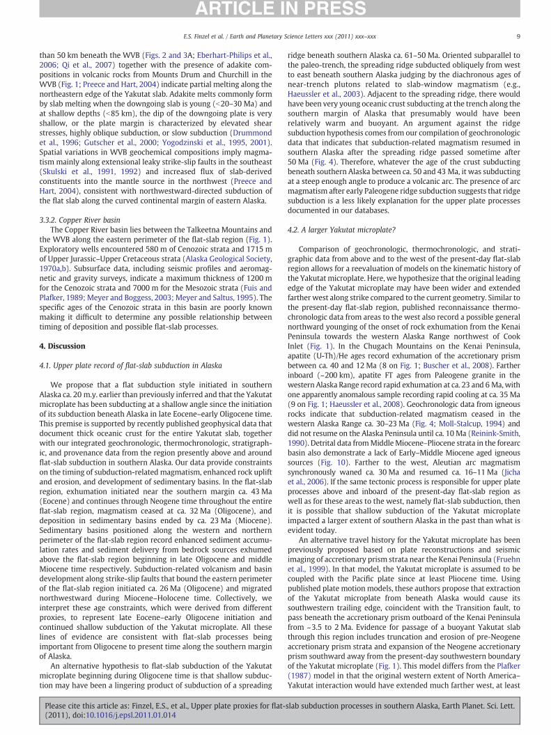
Interpretation of new provenance data suggests that Cook Inletdetritus was derived predominantly from source terranes locatednortheast of the basin above the flat-slab region and areas to the northin the central Alaska Range during Eocene through Pliocene time. TheU-Pb ages of 590 detrital zircons from Eocene through Pliocene strataof the Cook Inlet basin contain significant middle Cretaceous (ca. 94–111 Ma) and Late Cretaceous–Paleogene (ca. 47–72 Ma) age popula-tions (Fig. 10). The low ratios of uranium–thorium (b10) in most ofthe grains (~98%; Fig. 10) suggest that they were derived fromigneous rather than metamorphic source areas. The Late Cretaceous–Paleogene detrital ages match the age of plutons exposed in thewestern and central Alaska Range and the Talkeetna Mountains(Wilson et al., 1998; 2009). The greater regional thickness of the lateOligocene–early Miocene and late Miocene–Pliocene strata relative tothe rest of the Cenozoic units, as well as the documentation of coevalexhumation events in the western and central Alaska Range, haspreviously been inferred to reflect regional exhumation and increasedsediment influx from the central and western Alaska Range duringthese times (Fitzgerald et al., 1995; Haeussler, 2008; Kirschner andLyon, 1973; Plafker et al., 1992). Comprising a conspicuously smallpopulation in our detrital data, however, are 30–45 Ma detrital zirconages (gray bar on Fig. 10) that would match the ages of plutons thatare common in the western Alaska Range (Moll-Stalcup, 1994;Wilsonet al., 2009), precluding that region as a dominant sediment source.The dominant peak of Middle Cretaceous detrital zircon ages (Fig. 10)closely matches the ages of plutons that are widespread in the centralAlaska Range and the Talkeetna Mountains, both located above theflat-slab region; similar age plutons are very sparsely scattered in thewestern Alaska Range (Wilson et al., 2009). The detrital populationsalso contain several distinct ages (such as ca. 210, 194, 156–176, 104–143, 80, and 66–52 Ma in Fig. 10) that are interpreted to best reflectsediment input from source rocks in the flat-slab region. Key potentialsource areas for these populations in the flat-slab region include theTalkeetna arc and Alaska–Talkeetna Range belt in the TalkeetnaMountains, aswell as the Chitina and Chisana arcs. Plutons representingtheMesozoic Chitina and Chisana arc systems are located in the easternAlaska Range and eastern ChugachMountains in the eastern part of theflat-slab region (Fig. 1;Miller, 1994; Nokleberg et al., 1994; Plafker et al.,1989; Roeske et al., 2003; Short et al., 2005; Snyder and Hart, 2005,2007). Additional possible sources located above the flat-slab regionthat have ages that overlapwith age populations in our samples includeaccretionary prism strata of the Valdez Group in the western ChugachMountains (Bradley et al., 2009), and exhumed Cretaceous–Paleogenestrata in the Matanuska Valley (Fig. 1; Kortyna et al., 2010; Trop, 2008).For more details on the ages and distribution of potential sources forCenozoic sediment of the Cook Inlet basin see Finzel (2010).
We suggest the existence of two major sediment pathways derivedfrom above the flat-slab region based on our provenance data. One
slab subduction processes in southern Alaska, Earth Planet. Sci. Lett.

Fig. 6. Photos of Eocene–Oligocene sedimentary strata that record basin inversion and crustal shortening above the flat-slab region during Miocene–Holocene time. Black tadpolesymbols denote bedding. A) Eocene fluvial-lacustrine strata (Arkose Ridge Formation) deformed by asymmetric folds and reverse faults in the southern Talkeetna Mountains in theremnant Matanuska basin (MB on Fig. 1). Height of outcrop is N150 m. B) Oligocene fluvial-lacustrine strata (Oc) exposed in a footwall syncline adjacent to a reverse fault along thesouth flank of the central Alaska Range in the remnant Colorado Creek basin (CB on Fig. 1). Jurassic–Cretaceous marine strata (KJk) are exposed in the hanging wall of the reversefault. Height of outcrop with Oligocene strata is N200 m. Snow covered peak in upper left side of photo is Mt. McKinley (elevation 20, 320 ft.); the Yakutat slab is located ~150 kmbeneath this mountain based on geophysical imaging.
6 E.S. Finzel et al. / Earth and Planetary Science Letters xxx (2011) xxx–xxx
pathway predominantly drained source areas exposed north andnortheast of the basin, including the central Alaska Range (Fig. 1).Another key pathway derived sediment from eastern and northeastern
Fig. 7. Late Eocene–Quaternary stratigraphy of sedimentary basins in south-central Alaska (12007). Note lack of sedimentary strata deposited after Oligocene time in the region above fl
basins located along western and northern perimeter of flat-slab subduction. Also note noderived from abundant geochronologic and palynological data (black vertical lines). QuaterGeissman (2009).
Please cite this article as: Finzel, E.S., et al., Upper plate proxies for flat-(2011), doi:10.1016/j.epsl.2011.01.014
source regions, including theTalkeetnaMountains (Fig. 1).We infer thatexhumation of the flat-slab region resulted in relative subsidence in theCook Inlet basin, created prolific sediment sources to the east and
—Flores et al., 2004; 2–4—Trop and Ridgway, 2007; 5—Richter et al., 1990 and Trop et al.,at-slab subduction and increase in thicknesses of post-Oligocene sedimentary strata inrthwestward younging of volcanism and sedimentation in the Wrangell volcanic beltnary strata in the Cook Inlet and Tanana basins are unnamed. Time scale of Walker and
slab subduction processes in southern Alaska, Earth Planet. Sci. Lett.

Fig. 8. Photos of Neogene sedimentary strata that record enhanced sediment accumulation along the perimeter of the flat-slab region. A) and B) Strata deposited in the Cook Inletbasin located along the western perimeter of the flat-slab region (CB on Fig. 1). A) Miocene fluvial sandstone, mudstone, and coal (Beluga Formation). Person circled for scale.B) Pliocene fluvial sandstone and mudstone (Sterling Formation). Note the thick channel complex between the white dashed lines. Arrow points to person for scale. C), D), andE) Strata deposited in the Tanana transpressional foreland basin located along the northern margin of the flat-slab region (TB on Fig. 1). C) Miocene coal, sandstone, and mudstone(Usibelli Group) deposited in fluvial channels and floodplain mires. Coal beds are up to 20 m thick. Spruce forest at bottom of photo for scale. D) Miocene lacustrine mudstone withseasonal varves (Usibelli Group) deposited in floodplain lakes. Person (lower right) for scale. E) Pliocene conglomerate and sandstone (Nenana Gravel) deposited in alluvial fans.Person (lower right) for scale. F) Miocene strata deposited in transtensional basins along the eastern margin of the flat-slab region in the Wrangell volcanic belt (WVB on Fig. 1).Miocene alluvial-lacustrine conglomerate, mudstone, tuff, and lava flows (Mf-Frederika Formation) are overlain by lava flows and volcanic breccia (Mw-Wrangell Lava). Height ofoutcrop is N700 m. Black tadpole symbols denote bedding. G) Mount Wrangell, a 4317-m (14,163 ft)-high andesite shield volcano in the Wrangell Mountains with documentedhistorical activity. View is to the northeast. Photograph by B. Cella, U.S. National Park Service, 1987.
7E.S. Finzel et al. / Earth and Planetary Science Letters xxx (2011) xxx–xxx
northeast of the basin, and led to southwestward progradation of a largeclasticwedge away fromthe regionpresently aboveflat-slab subductionand into the basin (Finzel, 2010; Finzel et al., 2007).
An interpreted northern extension of the Cook Inlet basin, theSusitna basin (Fig. 1; Haeussler, 1998; Haeussler et al., 2002), alsoappears to contain a thick section of Cenozoic strata. Very little isknown about the age and stratigraphy of the basin, but based on threedrill holes and gravity data there may be as much as 4 km ofPaleocene–Miocene nonmarine clastic strata (Merritt, 1986; Meyerand Boggess, 2003). Much more data is needed, but we tentativelyinterpret the Paleocene–Miocene strata of the Susitna basin to be partof the large clastic wedge along the western perimeter of flat-slabsubduction.
Please cite this article as: Finzel, E.S., et al., Upper plate proxies for flat-(2011), doi:10.1016/j.epsl.2011.01.014
3.2. Northern perimeter
The Tanana basin is positioned directly north of the flat-slab region(Fig. 1). Along the southern margin of the basin, Cenozoic strata are2–3 km thick and have been exhumed by thrust faults that form thefoothills along the north side of the Alaska Range (Ridgway et al.,2002, 2007). Recent studies clearly show that the foothills are part ofan active northward-propagating thrust belt that is deformingNeogene strata of the Tanana foreland basin (Bemis and Wallace,2007; Lesh and Ridgway, 2007). The Usibelli Group consists of 970 mof mainly middle and upper Miocene strata that were deposited influvial, lacustrine, and peat bog environments (Fig. 7). In one part ofthe Tanana basin, the Rex Creek area, the oldest part of the Usibelli
slab subduction processes in southern Alaska, Earth Planet. Sci. Lett.
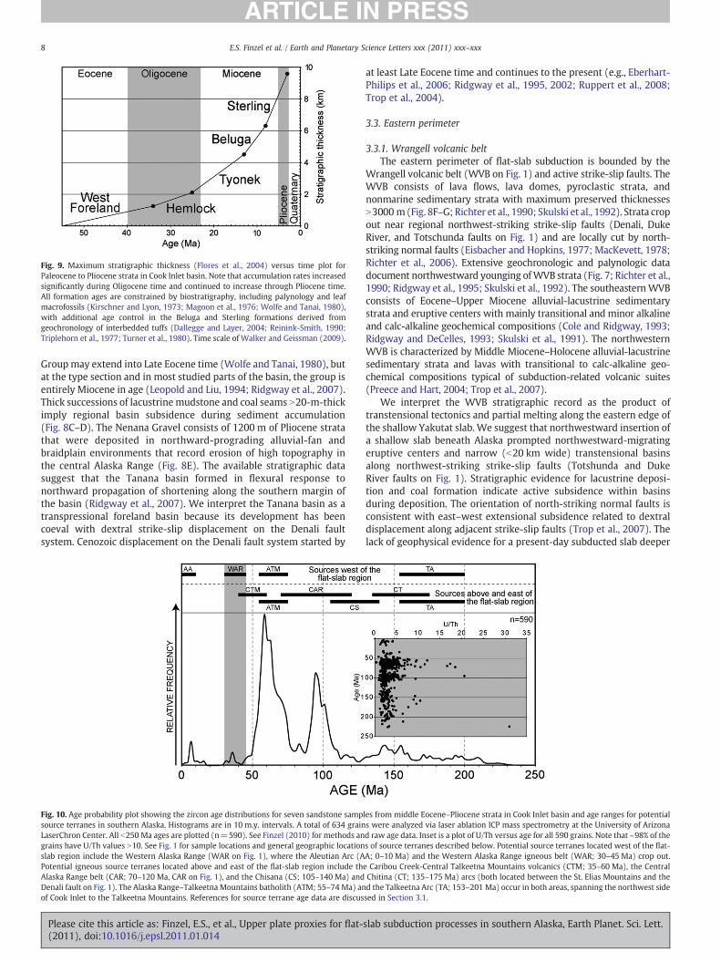
Fig. 9. Maximum stratigraphic thickness (Flores et al., 2004) versus time plot forPaleocene to Pliocene strata in Cook Inlet basin. Note that accumulation rates increasedsignificantly during Oligocene time and continued to increase through Pliocene time.All formation ages are constrained by biostratigraphy, including palynology and leafmacrofossils (Kirschner and Lyon, 1973; Magoon et al., 1976; Wolfe and Tanai, 1980),with additional age control in the Beluga and Sterling formations derived fromgeochronology of interbedded tuffs (Dallegge and Layer, 2004; Reinink-Smith, 1990;Triplehorn et al., 1977; Turner et al., 1980). Time scale of Walker and Geissman (2009).
8 E.S. Finzel et al. / Earth and Planetary Science Letters xxx (2011) xxx–xxx
Groupmay extend into Late Eocene time (Wolfe and Tanai, 1980), butat the type section and in most studied parts of the basin, the group isentirely Miocene in age (Leopold and Liu, 1994; Ridgway et al., 2007).Thick successions of lacustrinemudstone and coal seams N20-m-thickimply regional basin subsidence during sediment accumulation(Fig. 8C–D). The Nenana Gravel consists of 1200 m of Pliocene stratathat were deposited in northward-prograding alluvial-fan andbraidplain environments that record erosion of high topography inthe central Alaska Range (Fig. 8E). The available stratigraphic datasuggest that the Tanana basin formed in flexural response tonorthward propagation of shortening along the southern margin ofthe basin (Ridgway et al., 2007). We interpret the Tanana basin as atranspressional foreland basin because its development has beencoeval with dextral strike-slip displacement on the Denali faultsystem. Cenozoic displacement on the Denali fault system started by
Fig. 10. Age probability plot showing the zircon age distributions for seven sandstone sampsource terranes in southern Alaska. Histograms are in 10 m.y. intervals. A total of 634 grainLaserChron Center. All b250 Ma ages are plotted (n=590). See Finzel (2010) for methods angrains have U/Th values N10. See Fig. 1 for sample locations and general geographic locationslab region include the Western Alaska Range (WAR on Fig. 1), where the Aleutian Arc (APotential igneous source terranes located above and east of the flat-slab region include thAlaska Range belt (CAR; 70–120 Ma, CAR on Fig. 1), and the Chisana (CS; 105–140 Ma) andDenali fault on Fig. 1). The Alaska Range–Talkeetna Mountains batholith (ATM; 55–74 Ma) anof Cook Inlet to the Talkeetna Mountains. References for source terrane age data are discus
Please cite this article as: Finzel, E.S., et al., Upper plate proxies for flat-(2011), doi:10.1016/j.epsl.2011.01.014
at least Late Eocene time and continues to the present (e.g., Eberhart-Philips et al., 2006; Ridgway et al., 1995, 2002; Ruppert et al., 2008;Trop et al., 2004).
3.3. Eastern perimeter
3.3.1. Wrangell volcanic beltThe eastern perimeter of flat-slab subduction is bounded by the
Wrangell volcanic belt (WVB on Fig. 1) and active strike-slip faults. TheWVB consists of lava flows, lava domes, pyroclastic strata, andnonmarine sedimentary strata with maximum preserved thicknessesN3000 m (Fig. 8F–G; Richter et al., 1990; Skulski et al., 1992). Strata cropout near regional northwest-striking strike-slip faults (Denali, DukeRiver, and Totschunda faults on Fig. 1) and are locally cut by north-striking normal faults (Eisbacher and Hopkins, 1977; MacKevett, 1978;Richter et al., 2006). Extensive geochronologic and palynologic datadocument northwestward younging ofWVB strata (Fig. 7; Richter et al.,1990; Ridgway et al., 1995; Skulski et al., 1992). The southeasternWVBconsists of Eocene–Upper Miocene alluvial-lacustrine sedimentarystrata and eruptive centers with mainly transitional and minor alkalineand calc-alkaline geochemical compositions (Cole and Ridgway, 1993;Ridgway and DeCelles, 1993; Skulski et al., 1991). The northwesternWVB is characterized by Middle Miocene–Holocene alluvial-lacustrinesedimentary strata and lavas with transitional to calc-alkaline geo-chemical compositions typical of subduction-related volcanic suites(Preece and Hart, 2004; Trop et al., 2007).
We interpret the WVB stratigraphic record as the product oftranstensional tectonics and partial melting along the eastern edge ofthe shallow Yakutat slab. We suggest that northwestward insertion ofa shallow slab beneath Alaska prompted northwestward-migratingeruptive centers and narrow (b20 km wide) transtensional basinsalong northwest-striking strike-slip faults (Totshunda and DukeRiver faults on Fig. 1). Stratigraphic evidence for lacustrine deposi-tion and coal formation indicate active subsidence within basinsduring deposition. The orientation of north-striking normal faults isconsistent with east–west extensional subsidence related to dextraldisplacement along adjacent strike-slip faults (Trop et al., 2007). Thelack of geophysical evidence for a present-day subducted slab deeper
les from middle Eocene–Pliocene strata in Cook Inlet basin and age ranges for potentials were analyzed via laser ablation ICP mass spectrometry at the University of Arizonad raw age data. Inset is a plot of U/Th versus age for all 590 grains. Note that ~98% of thes of source terranes described below. Potential source terranes located west of the flat-A; 0–10 Ma) and the Western Alaska Range igneous belt (WAR; 30–45 Ma) crop out.e Caribou Creek-Central Talkeetna Mountains volcanics (CTM; 35–60 Ma), the CentralChitina (CT; 135–175 Ma) arcs (both located between the St. Elias Mountains and thed the Talkeetna Arc (TA; 153–201 Ma) occur in both areas, spanning the northwest sidesed in Section 3.1.
slab subduction processes in southern Alaska, Earth Planet. Sci. Lett.
9E.S. Finzel et al. / Earth and Planetary Science Letters xxx (2011) xxx–xxx
than 50 km beneath the WVB (Figs. 2 and 3A; Eberhart-Philips et al.,2006; Qi et al., 2007) together with the presence of adakite com-positions in volcanic rocks from Mounts Drum and Churchill in theWVB (Fig. 1; Preece and Hart, 2004) indicate partial melting along thenortheastern edge of the Yakutat slab. Adakite melts commonly formby slab melting when the downgoing slab is young (b20–30 Ma) andat shallow depths (b85 km), the dip of the downgoing plate is veryshallow, or the plate margin is characterized by elevated shearstresses, highly oblique subduction, or slow subduction (Drummondet al., 1996; Gutscher et al., 2000; Yogodzinski et al., 1995, 2001).Spatial variations in WVB geochemical compositions imply magma-tism mainly along extensional leaky strike-slip faults in the southeast(Skulski et al., 1991, 1992) and increased flux of slab-derivedconstituents into the mantle source in the northwest (Preece andHart, 2004), consistent with northwestward-directed subduction ofthe flat slab along the curved continental margin of eastern Alaska.
3.3.2. Copper River basinThe Copper River basin lies between the Talkeetna Mountains and
the WVB along the eastern perimeter of the flat-slab region (Fig. 1).Exploratory wells encountered 580 m of Cenozoic strata and 1715 mof Upper Jurassic–Upper Cretaceous strata (Alaska Geological Society,1970a,b). Subsurface data, including seismic profiles and aeromag-netic and gravity surveys, indicate a maximum thickness of 1200 mfor the Cenozoic strata and 7000 m for the Mesozoic strata (Fuis andPlafker, 1989; Meyer and Boggess, 2003; Meyer and Saltus, 1995). Thespecific ages of the Cenozoic strata in this basin are poorly knownmaking it difficult to determine any possible relationship betweentiming of deposition and possible flat-slab processes.
4. Discussion
4.1. Upper plate record of flat-slab subduction in Alaska
We propose that a flat subduction style initiated in southernAlaska ca. 20 m.y. earlier than previously inferred and that the Yakutatmicroplate has been subducting at a shallow angle since the initiationof its subduction beneath Alaska in late Eocene–early Oligocene time.This premise is supported by recently published geophysical data thatdocument thick oceanic crust for the entire Yakutat slab, togetherwith our integrated geochronologic, thermochronologic, stratigraph-ic, and provenance data from the region presently above and aroundflat-slab subduction in southern Alaska. Our data provide constraintson the timing of subduction-related magmatism, enhanced rock upliftand erosion, and development of sedimentary basins. In the flat-slabregion, exhumation initiated near the southern margin ca. 43 Ma(Eocene) and continues through Neogene time throughout the entireflat-slab region, magmatism ceased at ca. 32 Ma (Oligocene), anddeposition in sedimentary basins ended by ca. 23 Ma (Miocene).Sedimentary basins positioned along the western and northernperimeter of the flat-slab region record enhanced sediment accumu-lation rates and sediment delivery from bedrock sources exhumedabove the flat-slab region beginning in late Oligocene and middleMiocene time respectively. Subduction-related volcanism and basindevelopment along strike-slip faults that bound the eastern perimeterof the flat-slab region initiated ca. 26 Ma (Oligocene) and migratednorthwestward during Miocene–Holocene time. Collectively, weinterpret these age constraints, which were derived from differentproxies, to represent late Eocene–early Oligocene initiation andcontinued shallow subduction of the Yakutat microplate. All theselines of evidence are consistent with flat-slab processes beingimportant from Oligocene to present time along the southern marginof Alaska.
An alternative hypothesis to flat-slab subduction of the Yakutatmicroplate beginning during Oligocene time is that shallow subduc-tion may have been a lingering product of subduction of a spreading
Please cite this article as: Finzel, E.S., et al., Upper plate proxies for flat-(2011), doi:10.1016/j.epsl.2011.01.014
ridge beneath southern Alaska ca. 61–50 Ma. Oriented subparallel tothe paleo-trench, the spreading ridge subducted obliquely from westto east beneath southern Alaska judging by the diachronous ages ofnear-trench plutons related to slab-window magmatism (e.g.,Haeussler et al., 2003). Adjacent to the spreading ridge, there wouldhave been very young oceanic crust subducting at the trench along thesouthern margin of Alaska that presumably would have beenrelatively warm and buoyant. An argument against the ridgesubduction hypothesis comes from our compilation of geochronologicdata that indicates that subduction-related magmatism resumed insouthern Alaska after the spreading ridge passed sometime after50 Ma (Fig. 4). Therefore, whatever the age of the crust subductingbeneath southern Alaska between ca. 50 and 43 Ma, it was subductingat a steep enough angle to produce a volcanic arc. The presence of arcmagmatism after early Paleogene ridge subduction suggests that ridgesubduction is a less likely explanation for the upper plate processesdocumented in our databases.
4.2. A larger Yakutat microplate?
Comparison of geochronologic, thermochronologic, and strati-graphic data from above and to the west of the present-day flat-slabregion allows for a reevaluation of models on the kinematic history ofthe Yakutat microplate. Here, we hypothesize that the original leadingedge of the Yakutat microplate may have been wider and extendedfarther west along strike compared to the current geometry. Similar tothe present-day flat-slab region, published reconnaissance thermo-chronologic data from areas to the west also record a possible generalnorthward younging of the onset of rock exhumation from the KenaiPeninsula towards the western Alaska Range northwest of CookInlet (Fig. 1). In the Chugach Mountains on the Kenai Peninsula,apatite (U-Th)/He ages record exhumation of the accretionary prismbetween ca. 40 and 12 Ma (8 on Fig. 1; Buscher et al., 2008). Fartherinboard (~200 km), apatite FT ages from Paleogene granite in thewestern Alaska Range record rapid exhumation at ca. 23 and 6 Ma,withone apparently anomalous sample recording rapid cooling at ca. 35 Ma(9 on Fig. 1; Haeussler et al., 2008). Geochronologic data from igneousrocks indicate that subduction-related magmatism ceased in thewestern Alaska Range ca. 30–23 Ma (Fig. 4; Moll-Stalcup, 1994) anddid not resume on the Alaska Peninsula until ca. 10 Ma (Reinink-Smith,1990). Detrital data fromMiddleMiocene–Pliocene strata in the forearcbasin also demonstrate a lack of Early–Middle Miocene aged igneoussources (Fig. 10). Farther to the west, Aleutian arc magmatismsynchronously waned ca. 30 Ma and resumed ca. 16–11Ma (Jichaet al., 2006). If the same tectonic process is responsible for upper plateprocesses above and inboard of the present-day flat-slab region aswell as for these areas to the west, namely flat-slab subduction, thenit is possible that shallow subduction of the Yakutat microplateimpacted a larger extent of southern Alaska in the past than what isevident today.
An alternative travel history for the Yakutat microplate has beenpreviously proposed based on plate reconstructions and seismicimaging of accretionary prism strata near the Kenai Peninsula (Fruehnet al., 1999). In that model, the Yakutat microplate is assumed to becoupled with the Pacific plate since at least Pliocene time. Usingpublished plate motion models, these authors propose that extractionof the Yakutat microplate from beneath Alaska would cause itssouthwestern trailing edge, coincident with the Transition fault, topass beneath the accretionary prism outboard of the Kenai Peninsulafrom ~3.5 to 2 Ma. Evidence for passage of a buoyant Yakutat slabthrough this region includes truncation and erosion of pre-Neogeneaccretionary prism strata and expansion of the Neogene accretionaryprism southward away from the present-day southwestern boundaryof the Yakutat microplate (Fig. 1). This model differs from the Plafker(1987) model in that the original western extent of North America–Yakutat interaction would have extended much farther west, at least
slab subduction processes in southern Alaska, Earth Planet. Sci. Lett.

10 E.S. Finzel et al. / Earth and Planetary Science Letters xxx (2011) xxx–xxx
to the southern end of the Kenai Peninsula, the flat Yakutat slab wouldhave potentially passed beneath much of the Cook Inlet forearc basinduring middle to late Cenozoic time, and the Yakutat microplatewould not necessarily have been located adjacent to the westernNorth American margin while it traveled north toward Alaska.
Recent studies support the proposal by Plafker (1987) that thesoutheastern unsubducted portion of the Yakutat microplate waspositioned along the western continental margin of North Americasince Eocene time. For example, stratigraphic and detrital provenancestudies from Eocene and younger sedimentary strata exposed on themicroplate document deltaic-shallow marine deposystems that weresourced from continental margin source terranes in southeasternAlaska or western Canada (Landis, 2007; Perry et al., 2009). Similarly,age data and geochemical compositions from igneous rocks in boththe microplate and adjacent portions of Alaska are attributable toslab-window magmatism associated with subduction of a spreadingridge beneath the continental margin during Eocene time, requiringjuxtaposition of the microplate with southeastern Alaska or westernCanada (Bradley et al., 2003; Davis and Plafker, 1986; Haeussler et al.,2003).
We suggest a scenario that accounts for uplift and truncation of theaccretionary prism strata in the Kenai Peninsula region while keepingthe eastern, unsubducted portion of the slab adjacent to the NorthAmerican continental margin. We postulate that the original width ofthe subducting slab may have been greater than the width presentlyindicated by the unsubducted portion or the geophysically imagedsubducted slab. Published geophysical images have only looselyconstrained the nature of the boundary between the Pacific andYakutat plates at shallow depths (Eberhart-Philips et al., 2006). Thus,the subducted portion of the slab could have beenwider and thereforeinteracted with a broader extent of the southern Alaska margin in thepast. Alternatively, the Yakutat slab may not have been wider butinstead stresses transmitted inboard from the flat-slab region mayhave contributed to the deformation to the west. The eastwarddecrease in the width of the accretionary prism towards the present-day flat-slab region (Fig. 1), however, suggests thatwhatever perturbedthe depositional system outside the present-day flat-slab regiontraveled from west to east along the southern margin of Alaska.Presumably, as the disturbance migrated to the northeast, sedimenta-tion resumed in the accretionary prism, leading to the present-daygeometry of the prism as described above. In summary, the possibilityexists that the original width of the Yakutat microplate may have beenwider than its presently imaged dimensions, but much more data isneeded to test this hypothesis.
4.3. Comparison with other modern flat-slab margins
The widely distributed, diffuse deformation and the transpres-sional tectonic regime documented in southern Alaska are commoncharacteristics of regions undergoing oblique subduction of shallowslabs. Insertion of a shallow slab into a subduction margin commonlycauses regional shortening and exhumation of the upper plate as aresult of the inboard propagation of plate boundary compressivestresses and isostatic adjustments (Espurt et al., 2007, 2008; Gutscher,2002). Earthquake focal mechanisms demonstrate that transpressivestress regimes dominate many modern flat-slab margins, includingsouthern Alaska, New Guinea, northern Columbia, Japan, andsegments of the Andean margin (Gutscher et al., 2000; Haeussler,2008). The transpressive nature and broad distribution of deformationseveral hundred kilometers inboard from the plate margin in theseregions is attributable to coupling of the subducted flat slab to theupper plate and oblique convergence between the slab and the upperplate. This is consistent with enhanced contact between the twoplates and the cooler temperature due to lack of an asthenosphericwedge (e.g., Gutscher, 2002). Transpressive shortening of the upperplate prompts regional exhumation, a process that may be accom-
Please cite this article as: Finzel, E.S., et al., Upper plate proxies for flat-(2011), doi:10.1016/j.epsl.2011.01.014
modated by discrete pre-existing structures or zones of weakness(Espurt et al., 2007, 2008; Gutscher, 2002). Strong interplate couplingin regions experiencing both flat-slab subduction and obliqueconvergence may also lead to strain partitioning far inboard of thesubduction zone (Chemenda et al., 2000; Pabellier and Cobbold, 1996;Pinet and Cobbold, 1992). For example, along the northwesternAndean margin and in southwestern Japan, major strike-slip faultsoccur ~300–400 km inboard of the trench. In southern Alaska, theCastle Mountain fault accommodates ~3 mm/yr of dextral-obliquestrike-slip displacement ~250 km inboard of the trench (Willis et al.,2007). Even farther inboard, the Denali fault accommodates ~10 mm/yrof dextral-oblique strike-slip motion ~400 km inboard of the platemargin (Fig. 1; Haeussler, 2008).
Flat-slab subduction occurs when relatively buoyant oceanic crustenters a subduction zone and causes the slab to progressively flatten(Espurt et al., 2008; Gutscher et al., 2000). Buoyant oceanic crustresults from two main characteristics: a moderate to young age of thesubducting crust (b50 m.y.) in combination with crust thicker than~15 km. Thick oceanic crust often characterizes aseismic ridges andoceanic plateaus. Two well-documented modern examples of thickoceanic crust subducting beneath continental margins are theaseismic Nazca Ridge in South America and the Ontong Java Plateauin the south Pacific (Cowley et al., 2004; Espurt et al., 2007, 2008;Hampel, 2002; Knesel et al., 2008; Mann and Taira, 2004; Phinneyet al., 2004; Taira et al., 2004; vonHuene et al., 1999). In these regions,as well as in southern Alaska, flat-slab subduction of thick oceaniccrust has resulted in upper plate shortening and exhumation abovethe flattened slab, cessation of magmatism within a few million yearsof the onset of shallow subduction, and erosion and subsequent re-establishment of the accretionary prism during and after lateralmigration of the shallow slab.
The trench parallel widths and crustal thicknesses of the NazcaRidge and Yakutat microplate are comparable, and although the NazcaRidge has been subducting for only ca. 11–12 Ma compared to ca.35 Ma for the Yakutat microplate inferred from this study, a higherconvergence rate in South America has led to similar amounts ofsubductedmaterial in the two regions. Bothmargins are characterizedby oblique convergence, which, in South America, has resulted in thesouthward migration of the Nazca Ridge along the South Americantrench (Hampel, 2002). In Alaska and South America, exhumation anddeformation in the forearc region was coincident with the arrival ofthick crust at the trench, magmatism ceased above the subducting flatslab ca. 3–8 m.y. later, strong interplate coupling led to deformationwithin the upper plate that extended hundreds of kilometers inboard,and accretionary prism sedimentation resumed along strike after theflat slab migrated laterally (Espurt et al., 2008; Hampel, 2002;vonHuene et al., 1999). In South America, stratigraphic data recorduplift of forearc depocenters coincident with passage of the NazcaRidge.
The Ontong Java Plateau is the world's largest oceanic plateau,covering about 1.9 million km2, with an average crustal thickness of~30–35 km (Knesel et al., 2008; Mann and Taira, 2004). Approxi-mately 1000 km of the trench parallel width of the plateau is currentlysubducting along the North Solomon trench. The Ontong Java Plateauhas only been subducting for ca. 4–6 Ma, resulting in a total subductedslab length of ~200–300 km (Cowley et al., 2004; Mann and Taira,2004; Phinney et al., 2004; Taira et al., 2004). Prior to arrival of theplateau at the subduction zone, Miocene and Pliocene arc volcanismwas prevalent in the Solomon Islands region. After the plateau arrivedat the trench ca. 4–6 Ma, arc magmatism began to wane and is lesscommon today than it was prior to Pliocene time, major folding anduplift occurred in the accretionary prism, and intra-arc normal faultswere reactivated as thrust faults. Presently, convergence between thePacific plate and Australian plate is accommodated at both the NorthSolomon trench and a young northeast-dipping subduction zone thathas developed in the backarc region.
slab subduction processes in southern Alaska, Earth Planet. Sci. Lett.

11E.S. Finzel et al. / Earth and Planetary Science Letters xxx (2011) xxx–xxx
Several important characteristics are shared among the Alaska,South American, and south Pacific flat-slab settings. First, shallowsubduction of buoyant oceanic crust led to increased plate coupling,which resulted in upper plate shortening, rock uplift and exhumationabove the flat-slab region. Second, subduction-related magmatismwaned or ceased b10 m.y. after the onset of shallow subduction.Third, shoaling or inversion of basins above the flat-slab region led toan increase in coarser sedimentation and/or a lack of deposition.Fourth, the accretionary prism was deformed or eroded above the flatslab, and in the case of Alaska and South America, sedimentationwithin the prism was reestablished after the shallow slab passedlaterally along the margin. The most distinct difference betweenAlaska and these other regions is that the northeastern boundary ofthe Yakutat microplate is a strike-slip margin. The effect on the upperplate of this boundary has been the propagation of transtensionaltectonics along the northeastern edge of the subducting slab. This isreflected in the northwestward younging of slab-edge volcanism andbasin development along the Denali–Duke River strike-slip faultsystem in the WVB (Figs. 1 and 7).
5. Conclusions
Integration of thermochronologic, geochronologic, stratigraphic,and provenance data from the upper plate area above and around flat-slab subduction of the Yakutat microplate in southern Alaska providesevidence that flat-slab processes have been occurring since lateEocene–early Oligocene time. Above the flat slab, regional exhuma-tion initiated ca. 43 Ma, magmatism ceased ca. 32 Ma, and depositionin sedimentary basins ended ca. 23 Ma. Along the western andnorthern perimeter of the flat-slab region, sedimentary basinsexperienced enhanced subsidence and sediment delivery from theflat-slab region beginning in late Oligocene and middle Miocene time,respectively. In theWrangell volcanic belt along the eastern margin ofthe flat-slab region, volcanism and basin development along dextralstrike-slip faults initiated ca. 26 Ma (Oligocene) and migratednorthwestward during Miocene–Holocene time. We propose thatthese data support shallow subduction of the buoyant Yakutatmicroplate starting in late Eocene–early Oligocene time. Furthermore,stratigraphic and thermochronologic data from the Kenai Peninsulaand western Alaska Range, west of the present-day flat-slab region,indicate flat-slab processes may have been active in those regionspreviously. Consequently, we postulate that the subducted portion ofthe Yakutat microplate may have extended farther west along strikeand affected a larger region of southern Alaska than the widthpresently indicated by the unsubducted portion of the Yakutatmicroplate or the geophysically imaged subducted slab. Modernconvergentmargins influenced by flat subduction styles are shaped byprocesses similar to those observed in southern Alaska, includingregional exhumation, cessation of magmatism, shoaling or inversionof sedimentary basins, and deformation or erosion of the accretionaryprism above the flat-slab region.
Supplementarymaterials related to this article can be found onlineat doi:10.1016/j.epsl.2011.01.014.
Acknowledgements
Primary funding was provided by the National Science Foundation,Donors of the Petroleum Research Fund administered by theAmerican Chemical Society, and the Bucknell University Program forUndergraduate Research. Reviewers S. Roeske, P. Haeussler, and R.Dorsey offered constructive reviews that helped us improve themanuscript. We thank A. Till, W. Wallace, and B. McNulty for reviewsof an earlier version of the manuscript. We also thank BucknellUniversity undergraduate students E. Bauer, R. Delaney, C. Kortyna, R.Tidmore, and J. Witmer for field assistance and thesis research.
Please cite this article as: Finzel, E.S., et al., Upper plate proxies for flat-(2011), doi:10.1016/j.epsl.2011.01.014
References
Alaska Geological Society, 1970a. Copper River basin stratigraphic correlation section;Tawawe Lake to Moose Creek, Copper River basin, Alaska, 1 sheet.
Alaska Geological Society, 1970b. Copper River basin stratigraphic correlation section;Eureka to Rainbow, 1 sheet.
Arkle, J.C., Armstrong, P.A., Haeussler, P.J., 2009. The western Chugach Mountains andnorthern Prince William Sound (Alaska): locus of subduction-related exhumation?Geol. Soc. Am. Abstr. Programs 41, 290.
Bemis, S.P., Wallace, W.K., 2007. Neotectonic framework of the north-central AlaskaRange foothills. In: Ridgway, K.D., Trop, J.M., Glen, J.M.G., O'Neill, J.M. (Eds.),Tectonic Growth of a Collisional Margin: Crustal Evolution of Southern Alaska:Geological Society of America Special Paper, 431, pp. 549–572.
Benowitz, J.A., Layer, P., Armstrong, P., Perry, S., Haeussler, P., Fitzgerald, P., in press.VanLaningham, S. Spatial variations in focused exhumation along a continental-scale strike-slip fault: the Denali fault of the eastern Alaska Range. Geosphere. Manuscript GS589R2.
Berger, A.L., Spotila, J.A., 2008. Denudation and deformation in a glaciated orogenicwedge: the St. Elias orogen, Alaska. Geology 36, 523–526.
Berger, A.L., Spotila, J.A., Chapman, J.B., Pavlis, T.L., Enkelmann, E., Ruppert, N.A.,Buscher, J.T., 2008. Architecture, kinematics, and exhumation of a convergentorogenic wedge: a thermochronological investigation of tectonic-climatic interac-tions within the central St. Elias orogen, Alaska. Earth Planet. Sci. Lett. 270, 13–24.
Bradley, D., Kusky, T., Haeussler, P., Goldfarb, R., Miller, M., Dumoulin, J., Nelson, S.W.,Karl, S., 2003. Geologic signature of early Tertiary ridge subduction in Alaska. In:Sisson, V.B., Roeske, S.M., Pavlis, T.L. (Eds.), Geology of a Transpressional OrogenDeveloped During Ridge-trench Interaction Along the North Pacific Margin:Geological Society of America Special Paper, 371, pp. 19–49.
Bradley, D.C., Haeussler, P.J., O'Sullivan, P., Friedman, R., Till, A.B., Bradley, D., Trop, J.M.,2009. Detrital zircon geochronology of Cretaceous and Paleogene strata across thesouth-central Alaskan convergent margin. U.S. Geological Survey Professional Paper1760-F. 36 pp.
Buscher, J.T., Berger, A.L., Spotila, J.A., 2008. Exhumation in the Chugach-KenaiMountains belt above the Aleutian subduction zone, southern Alaska. In:Freymueller, J.T., Haeussler, P.J., Wesson, R.J., Ekstrom, G. (Eds.), Active Tectonicsand Seismic Potential of Alaska: Geophysical Monograph Series, 179, pp. 151–166.
Cameron, C.E., 2005. Latitudes and Longitudes of Volcanoes in Alaska. Alaska Division ofGeological & Geophysical Surveys Raw Data File RDF 2005-3, 1 CD-ROM.
Chemenda, A., Lallemand, S., Bokun, A., 2000. Strain partitioning and interplate frictionin oblique subduction zones: constraints provided by experimental modeling.J. Geophys. Res. Solid Earth 105, 5567–5581.
Christeson, G.L., Gulick, S.P.S., van Avendonk, H.J.A., Worthington, L.L., Reece, R.S., Pavlis,T.L., 2010. The Yakutat terrane: dramatic change in crustal thickness across theTransition fault, Alaska. Geology 38, 895–898.
Cole, R.B., Ridgway, K.D., 1993. The influence of volcanism on fluvial depositionalsystems in a Cenozoic strike-slip basin, Denali fault system, Yukon Territory,Canada. J. Sed. Petrol. 63, 152–166.
Cowley, S., Mann, P., Coffin, M.F., Shipley, T.H., 2004. Oligocene to recent tectonichistory of the Central Solomon intra-arc basin as determined from marine seismicreflection data and compilation of onland geology. Tectonophysics 389, 267–307.
Dallegge, T.A., Layer, P.W., 2004. Revised chronostratigraphy of the Kenai Group from40Ar/39Ar dating of low-potassium bearing minerals, Cook Inlet Basin, Alaska. Can.J. Earth Sci. 41, 1159–1179.
Davis, A.S., Plafker, G., 1986. Eocene basalts from the Yakutat Terrane—evidence for theorigin of an accreting terrane in southern Alaska. Geology 14, 963–966.
Demets, C., Gordon, R.G., Argus, D.F., Stein, S., 1994. Effect of recent revisions to thegeomagnetic reversal time-scale on estimates of current plate motions. Geophys.Res. Lett. 21, 2191–2194.
Dickinson, W.R., Snyder, W.S., 1979. Geometry of subducted slabs related to San-Andreas transform. J. Geol. 87, 609–627.
Doubrovine, P.V., Tarduno, J.A., 2008. A revised kinematic model for the relativemotion between Pacific oceanic plates and North America since Late Cretaceous.J. Geophys. Res. Solid Earth 113. doi:10.1029/2008JB005585.
Drummond, M.S., Defant, M.J., Kepezhinskas, P.K., 1996. Petrogenesis of slab-derivedtrondhjemite-tonalite-dacite/adakite magmas. Trans. R. Soc. Edinb. Earth Environ.Sci. 87, 205–215.
Eberhart-Philips, D., Christensen, D.H., Brocher, T.M., Hansen, R., Ruppert, N.A.,Haeussler, P.J., Abers, G.A., 2006. Imaging the transition from Aleutian subductionto Yakutat collision in central Alaska, with local earthquakes and active source data.J. Geophys. Res. Solid Earth 111. doi:10.1029/2005JB004240.
Eisbacher, G.H., Hopkins, S.L., 1977. Mid-Cenozoic paleogeomorphology and tectonicsetting of the St. Elias Mountains, Yukon Territory. Report of Activities, GeologicalSurvey of Canada paper 77-1B, pp. 319–335.
Engebretson, D.C., Cox, R.G., Gordon, R.G., 1985. Relative Motions Between Oceanic andContinental Plates in the Pacific Basin. Geological Society of America Special Paper,206. 59 pp.
Enkelmann, E., Garver, J.I., Pavlis, T.L., 2008. Rapid exhumation of ice-covered rocks ofthe Chugach-St. Elias orogen, Southeast Alaska. Geology 36, 915–918.
Enkelmann, E., Zeitler, P.K., Pavlis, T.L., Garver, J.I., Ridgway, K.D., 2009. Intenselocalized rock uplift and erosion in the St Elias orogen of Alaska. Nat. Geosci. 2,360–363.
Enkelmann, E., Zeitler, P.K., Garver, J.I., Pavlis, T.L., Hooks, B.P., 2010. The thermochronologicalrecord of tectonic and surface process interaction at the Yakutat–North American collisionzone in southeast Alaska. Am. J. Sci. 310, 231–260.
Espurt, N., Baby, P., Brusset, S., Roddaz, M., Hermoza, W., Regard, V., Antoine, P.O., Salas-Gismondi, R., Bolanos, R., 2007. How does the Nazca Ridge subduction influence themodern Amazonian foreland basin? Geology 35, 515–518.
slab subduction processes in southern Alaska, Earth Planet. Sci. Lett.
12 E.S. Finzel et al. / Earth and Planetary Science Letters xxx (2011) xxx–xxx
Espurt, N., Funiciello, F., Martinod, J., Guillaume, B., Regard, V., Faccenna, C., Brusset, S.,2008. Flat subduction dynamics and deformation of the South American plate:insights from analog modeling. Tectonics 27. doi:10.1029/2007TC002175.
Ferris, A., Abers, G.A., Christensen, D.H., Veenstra, E., 2003. High resolution image of thesubducted Pacific (?) plate beneath central Alaska, 50–150 km depth. Earth Planet.Sci. Lett. 214, 575–588.
Finzel, E.S., 2010. Geodynamics of flat-slab subduction, sedimentary basin development,and hydrocarbon systems along the southern Alaska convergent plate margin. [Ph.D.]Purdue University, 411 pp.
Finzel, E.S., Ridgway, K.D., Brennan, P.R.K., Landis, P., 2007. Miocene and Pliocenesedimentary footprint of flat-slab subduction of the Yakutat terrane. Geol. Soc. Am.Abstr. Programs 39, 491.
Fitzgerald, P.G., Sorkhabi, R.B., Redfield, T.F., Stump, E., 1995. Uplift and denudation ofthe central Alaska Range—a case-study in the use of apatite fission-trackthermochronology to determine absolute uplift parameters. J. Geophys. Res. SolidEarth 100, 20175–20191.
Flores, R.M., Stricker, G.D., Kinney, S.A., 2004. Alaska Coal Geology, Resources, andCoalbed Methane Potential. U.S. Geological Survey DDS-77. 125 pp., 3 sheets.
Fruehn, J., vonHuene, R., Fisher, M.A., 1999. Accretion in the wake of terrane collision: theNeogene accretionary wedge off Kenai Peninsula, Alaska. Tectonics 18, 263–277.
Fuis, G.S., Plafker, G., 1989. Evolution of deep structure along the Trans-Alaska CrustalTransect, Chugach Mountains and Copper River basin, southern Alaska. J. Geophys.Res. 96, 4229–4253.
Fuis, G.S., Moore, T.E., Plafker, G., Brocher, T.M., Fisher, M.A., Mooney, W.D., Nokleberg,W.J., Page, R.A., Beaudoin, B.C., Christensen, N.I., Levander, A.R., Lutter, W.J., Saltus,R.W., Ruppert, N.A., 2008. Trans-Alaska Crustal Transect and continental evolutioninvolving subduction underplating and synchronous foreland thrusting. Geology36, 267–270.
Gulick, S., Lowe, L., Pavlis, T., Gardner, J., Mayer, L., 2007. Geophysical insights into theTransition fault debate: propagating strike slip response to stalling Yakutat blocksubduction in the Gulf of Alaska. Geology 35, 763–766.
Gutscher, M.A., 2002. Andean subduction styles and their effect on thermal structureand interplate coupling. J. S. Am. Earth Sci. 15, 3–10.
Gutscher, M.A., Spakman, W., Bijwaard, H., Engdahl, E.R., 2000. Geodynamics of flatsubduction: seismicity and tomographic constraints from the Andean margin.Tectonics 19, 814–833.
Haeussler, P.J., 1998. Surficial Geologic Map Along the Castle Mountain Fault BetweenHouston andHatcher Pass Road, Alaska. U.S. Geological SurveyOpen-File Report 98–480.
Haeussler, P.J., 2008. An overview of the neotectonics of interior Alaska: far-fielddeformation from the Yakutat microplate collision. In: Freymueller, J.T., Haeussler,P.J., Wesson, R.J., Ekstrom, G. (Eds.), Active Tectonics and Seismic Potential ofAlaska: Geophysical Monograph Series, 179, pp. 269–285.
Haeussler, P.J., Best, T.C., Waythomas, C.F., 2002. Paleoseismology at high latitudes:seismic disturbance of Late Quaternary deposits along the Castle Mountain faultnear Houston, Alaska. Geol. Soc. Am. Bull. 114, 1296–1310. doi:10.1130/0016-7606(2002) 114, 1296: PAHLSD.2.0.CO;2.
Haeussler, P.J., Bradley, D.C., Wells, R.E., Miller, M.L., 2003. Life and death of theResurrection plate: evidence for its existence and subduction in the northeasternPacific in Paleocene–Eocene time. Geol. Soc. Am. Bull. 115, 867–880.
Haeussler, P.J., O'Sullivan, P., Berger, A.L., Spotila, J.A., 2008. Neogene exhumation of theTordrillo Mountains, Alaska, and correlations with Denali (Mount McKinley). In:Freymueller, J.T., Haeussler, P.J., Wesson, R.J., Ekstrom, G. (Eds.), Active Tectonicsand Seismic Potential of Alaska: Geophysical Monograph Series, 179, pp. 269–285.
Hampel, A., 2002. The migration history of the Nazca Ridge along the Peruvian activemargin: a re-evaluation. Earth Planet. Sci. Lett. 203, 665–679.
Hoffman, M.D., Armstrong, P.A., 2006. Miocene exhumation of the southern TalkeetnaMountains, south central Alaska, based on apatite (U-Th)/He thermochronology.Geol. Soc. Am. Abstr. Programs 38, 9.
Jicha, B.R., Scholl, D.W., Singer, B.S., Yogodzinski, G.M., Kay, S.M., 2006. Revised age of AleutianIsland Arc formation imples high rate of magma production. Geology 38, 661–664.
Jordan, T.E., Allmendinger, R.W., 1986. The Sierras Pampeanas of Argentina—a modernanalog of Rocky-Mountain foreland deformation. Am. J. Sci. 286, 737–764.
Kirschner, C.E., Lyon, C.A., 1973. Stratigraphic and tectonic development of Cook Inletpetroleum province. AAPG Bull. Mem. 19, 396–407.
Knesel, K.M., Cohen, B.E., Vasconcelos, P.M., Thiede, D.S., 2008. Rapid change in drift of theAustralian plate records collision with Ontong Java plateau. Nature 454, 754–758.
Koons, P.O., Hooks, B.P., Pavlis, T., Upton, P., Barker, A.D., 2010. Three-dimensionalmechanics of Yakutat convergence in the southern Alaskan plate corner. Tectonics29. doi:10.1029/2009TC002463.
Kortyna, C.D., Trop, J.M., Lecomte, A.A., Bauer, E.M., Kassab, C.M., Ridgway, K.D.,Sunderlin, D., 2009. Sedimentology, paleontology, and structural framework of thecentral Arkose Ridge Formation, Talkeetna Mountains, Alaska. Geol. Soc. Am. Abstr.Programs 41, 304.
Kortyna, C.D., Trop, J.M., Idleman, B., Kassab, C.M., Ridgway, K.D., Gehrels, G., 2010.Provenance signature of a forearc basin modified by spreading ridge subduction:detrital zircon geochronology and detrital modes from the Paleogene Arkose RidgeFormation, southern Alaska. Geol. Soc. Am. Abstr. Programs 42, 54.
Lallemand, S., Heuret, A., Boutelier, D., 2005. On the relationships between slab dip,back-arc stress, upper plate absolute motion, and crustal nature in subductionzones. Geochem. Geophys. Geosyst. 6. doi:10.1029/2005GC000917.
Landis, P.S., 2007. Stratigraphic framework andprovenanceof the Eocene–OligoceneKulthiethFormation, Alaska: implications for paleogeography and tectonics of the early Cenozoiccontinental margin of northwestern North America. [M.S.] Purdue University, 200 pp.
Leonard, L.J., Hyndman, R.D., Mazzotti, S., Nykolaishen, L., Schmidt, M., Hippchen, S.,2007. Current deformation in the northern Canadian Cordillera inferred from GPSmeasurements. J. Geophys. Res. Solid Earth 112. doi:10.1029/2007JB005061.
Please cite this article as: Finzel, E.S., et al., Upper plate proxies for flat-(2011), doi:10.1016/j.epsl.2011.01.014
Leopold, E.B., Liu, G., 1994. A long pollen sequence of Neogene age: Alaska Range.Quatern. Int. 22 (23), 103–140.
Lesh, M.E., Ridgway, K.D., 2007. Geomorphic evidence of active transpressionaldeformation in the Tanana foreland basin, south-central Alaska. In: Ridgway, K.D.,Trop, J.M., Glen, J.M.G., O'Neill, J.M. (Eds.), Tectonic Growth of a Collisional Margin:Crustal Evolution of SouthernAlaska:Geological Society of America Special Paper, 431,pp. 573–592.
Little, T.A., Naeser, C.W., 1989. Tertiary tectonics of the Border Ranges fault system,Chugach Mountains, Alaska—deformation and uplift in a fore-arc setting. J. Geophys.Res. Solid Earth Planet. 94, 4333–4359.
Lowe, L.A., Gulick, S.P., Christeson, G.L., van Avendonk, H., Reece, R., Elmore, R., Pavlis, T.,2008. Crustal structure and deformation of the Yakutat microplate: new insightsfrom STEEP marine seismic reflection data. EOS Trans. Am. Geophys. Union 89, 53Fall Meeting Supplement, Abstract T53B-1941.
MacKevett, E.M., 1978, Geologic map of the McCarthy quadrangle, Alaska. U.S. GeologicalSurvey Miscellaneous Investigation Series I-1032, 1:250, 000.
Magoon, L. B., Adkinson,W. L., and Egbert, R. M., 1976.Map showing geology, wildcat wells,Tertiary plant fossil localities, K–Ar age dates, and petroleum operations, Cook Inlet area,Alaska. U.S. Geological Survey Miscellaneous Investigations Series Map I-1019, scale1:250,000.
Mann, P., Taira, A., 2004. Global tectonic significance of the Solomon Islands and OntongJava Plateau convergent zone. Tectonophysics 389, 137–190.
McGeary, S., Nur, A., Ben-Avraham, Z., 1985. Spacial gaps in arc volcanism: the effect ofcollision or subduction of oceanic plateaus. Tectonophysics 119, 195–221.
McNamara, D.E., Pasyanos, M.E., 2002. Seismological evidence for a sub-volcanic arcmantle wedge beneath the Denali volcanic gap, Alaska. Geophys. Res. Lett. 29.doi:10.1029/2001GL014088.
Merritt, R.D., 1986. Paleoenvironmental and tectonic controls in major coal basins ofAlaska. In: Lyons, P.C., Rice, C.L. (Eds.), Paleoenvironmental and Tectonic Controls inCoal-Forming Basins in the United States: Geological Society of America SpecialPaper, 210, pp. 173–200.
Meyer, J.F., Boggess, P.L., 2003. Principle Facts for Gravity Data Collected in the SusitnaBasin Area, South Central Alaska. Alaska Division of Geological and GeophysicalSurveys, Preliminary Investigative Report 2003–3. 13 pp.
Meyer, J.F., Jr., and Saltus, R.W., 1995. Merged aeromagnetic map of interior Alaska. U.S.Geological Survey Map GP-1014, scale 1:500, 000, 2 sheets.
Miller, T.P., 1994. Pre-Cenozoic plutonic rocks in mainland Alaska. In: Plafker, G., Berg,H.C. (Eds.), The Geology of Alaska: Geological Society of America, The Geology ofNorth America, pp. 535–554.
Moll-Stalcup, E.J., 1994. Latest Cretaceous and Cenozoic magmatism in mainlandAlaska. In: Plafker, G., Berg, H.C. (Eds.), Geol. Soc. Am. The Geol. N. Am. 589–619.
Nokleberg, W.J., Plafker, G., Wilson, F.H., 1994. Geology of the south-central Alaska. In:Plafker, G., Berg, H.C. (Eds.), The Geology of Alaska: Geological Society of America,The Geology of North America, pp. 311–366.
Nye, C.J., 1999. Magmatism at the eastern end of the Aleutian Arc: implications for thewestern Alaska Range volcanic gap. In: Severin, B., Anderson, P.M. (Eds.), Science inthe north: 50 years of change: Arctic Science Conference, 50, Program andAbstracts, Denali National Park and Preserve, AK, Sept 19–22, 1999, pp. 178–180.
Nye, C., Wyss, M., Ratchkovski, N., Fletcher, H., 2002. Magmatism in the Denali VolcanicGap, southern Alaska. EOS Trans. Am. Geophys. Union 83 (47) Fall MeetingSupplement, Abstract V12C-06.
O'Sullivan, P.B., Currie, L.D., 1996. Thermotectonic history of Mt. Logan, Yukon Territory,Canada: implications of multiple episodes of middle to late Cenozoic denudation.Earth Planet. Sci. Lett. 144, 251–261.
Pabellier, M., Cobbold, P.R., 1996. Analogue models for the transpressional docking ofvolcanic arcs in the Western Pacific. Tectonophysics 253, 33–52.
Parry, W.T., Bunds, M.P., Bruhn, R.L., Hall, C.M., Murphy, J.M., 2001. Mineralogy, 40Ar/39Ar dating and apatite fission track dating of rocks along the Castle Mountainfault, Alaska. Tectonophysics 337, 149–172.
Pavlis, T.L., Roeske, S.M., 2007. The Border Ranges Fault System, southern Alaska. In:Ridgway, K.D., Trop, J.M., Glen, J.M.G., O'Neill, J.M. (Eds.), Tectonic Growth of aCollisional Margin: Crustal Evolution of Southern Alaska: Geologic Society ofAmerica Special Paper, 431, pp. 95–128.
Pavlis, T.L., Picornell, C., Serpa, L., Bruhn, R.L., Plafker, G., 2004. Tectonic processes duringoblique convergence: insights from the St. Elias Orogen, northern North AmericanCordillera. Tectonics 23. doi:10.1029/2003TC001557.
Perry, S.E., Garver, J.I., Ridgway, K.D., 2009. Transport of the Yakutat terrane, southernAlaska: evidence from sediment petrology and detrital zircon fission-track and U/Pbdouble dating. J. Geol. 117, 156–173.
Phinney, E.J., Mann, P., Coffin, M.F., Shipley, T.H., 2004. Sequence stratigraphy, structuralstyle, and age of deformation of the Malaita accretionary prism (Solomon Arc-Ontong Java Plateau convergent zone). Tectonophysics 389, 221–246.
Pinet, N., Cobbold, P.R., 1992. Experimental insights into the partitioning of motionwithin zones of oblique subduction. Tectonophysics 206, 371–388.
Plafker, G., 1987. Regional geology and petroleum potential of the northern Gulf of Alaskacontinental margin. In: Scholl, D.W., Grantz, A., Vedder, J.G. (Eds.), Geology andResource Potential of the ContinentalMargin ofWestern North America and AdjacentOcean Basins-Beaufort Sea to Baja California: Earth Science Series, pp. 229–268.
Plafker, G., Hudson, T., Bruns, T., Rubin,M., 1978. LateQuaternaryoffsets along Fairweatherfault and crustal plate interactions in southern Alaska. Can. J. Earth Sci. 15, 805–816.
Plafker, G., Nokleberg, W.J., Lull, J.S., 1989. Bedrock geology and tectonic evolution ofthe Wrangellia, Peninsular, and Chugach terranes along the Trans-Alaska CrustalTransect in the Chugach mountains and southern Copper River Basin, Alaska. J.Geophys. Res. Solid Earth Planet. 94, 4255–4295.
Plafker, G., Naeser, C.W., Zimmerman, R.A., Lull, J.S., Hudson, T., 1992. Cenozoic uplifthistory of theMountMcKinley area in the central Alaska Range based on fission-track
slab subduction processes in southern Alaska, Earth Planet. Sci. Lett.

13E.S. Finzel et al. / Earth and Planetary Science Letters xxx (2011) xxx–xxx
dating. In: Bradley, D.C., Dusel-Bacon, C. (Eds.), Geologic Studies in Alaska by the U.S.Geological Survey, 1991: U.S. Geological Survey Bulletin, 2041, pp. 202–212.
Plafker, G., Gilpin, L.M., Lahr, J.C., 1994. Neotectonic map of Alaska, in: Plafker, H., Berg, H.C.(Eds.), The Geology of Alaska, The Geology of North America, v. G1. Geological Societyof America, Plate 12, scale 1:2,500,000.
Preece, S.J., Hart, W.K., 2004. Geochemical variations in the b5 Ma Wrangell VolcanicField, Alaska: implications for the magmatic and tectonic development of acomplex continental arc system. Tectonophysics 392, 165–191.
Qi, C., Zhao, D.P., Chen, Y., 2007. Search for deep slab segments under Alaska. Phys. EarthPlanet. Inter. 165, 68–82.
Reinink-Smith, L.M., 1990. Relative frequency of Neogene volcanic events as recordedin coal partings from the Kenai lowland, Alaska: a comparison with deep-sea coredata. Geol. Soc. Am. Bull. 102, 830–840.
Richter,D.H., Smith, J.G., Lanphere,M.A., Dalrymple,G.B., Reed, B.L., Shew,N., 1990.Age andprogression of volcanism, Wrangell volcanic field, Alaska. Bull. Volcanol. 53, 29–44.
Richter, D.H., Preller, C.C., Labay, K.A., Shew, N.B., 2006. Geologic map of the WrangellSt. Elias Park and Preserve, Alaska. U.S. Geological Survey Scientific Investigations,Map 2877, 1:350, 000.
Ridgway, K.D., DeCelles, P.G., 1993. Stream-dominated alluvial-fan and lacustrinedepositional systems in Cenozoic strike-slip basins, Denali fault system, Yukon-Territory, Canada. Sedimentology 40, 645–666.
Ridgway, K.D., Sweet, A.R., Cameron, A.R., 1995. Climatically induced floristic changesacross the Eocene–Oligocene transition in the northern high-latitudes, Yukon-Territory, Canada. Geol. Soc. Am. Bull. 107, 676–696.
Ridgway, K.D., Trop, J.M., Nokleberg, W.J., Davidson, C.M., Eastham, K.R., 2002. Mesozoicand Cenozoic tectonics of the eastern and central Alaska Range: progressive basindevelopment and deformation in a suture zone. Geol. Soc. Am. Bull. 114, 1480–1504.
Ridgway, K.D., Thoms, E.E., Layer, P.W., Lesh, M.E., White, J.M., Smith, S.V., 2007.Neogene transpressional foreland basin development on the north side of thecentral Alaska Range, Usibelli Group and Nenana Gravel, Tanana basin. In: Ridgway,K.D., Trop, J.M., Glen, J.M.G., O'Neill, J.M. (Eds.), Tectonic Growth of a CollisionalMargin: Crustal Evolution of Southern Alaska: Geological Society of America SpecialPaper, 431, pp. 507–547.
Roeske, S.M., Snee, L.W., Pavlis, T.L., 2003. Dextral-slip reactivation of an arc-forearcboundary during Late Cretaceous–Early Eocene oblique convergence in thenorthern Cordillera. In: Sisson, V.B., Roeske, S.M., Pavlis, T.L. (Eds.), Geology of aTranspressional Orogen Developed During Ridge-trench Interaction Along theNorth Pacific Margin: Geologic Society of America Special Paper, 371, pp. 141–169.
Rondenay, S., Montesi, L.G., Abers, G.A., 2010. New geophysical insight into the origin ofthe Denali volcanic gap. Geophys. J. Int. 182, 613–630.
Ruppert, N.A., Ridgway, K.D., Freymueller, J.T., Cross, R.S., Hansen, R.A., 2008. Activetectonics of interior Alaska: a synthesis of seismic, GPS and geomorphic studies. In:Freymueller, J.T., Haeussler, P.J., Wesson, R.J., Ekstrom, G. (Eds.), Active Tectonicsand Seismic Potential of Alaska: Geophysical Monograph Series, 179, pp. 109–133.
Sendziak, K., Armstrong, P.A., Haeussler, P.J., 2009. Constraints on exhumation of thewestern Chugach Mountains (Alaska) based on zircon fission-track analysis ofmodern glacial outwash. Geol. Soc. Am. Abstr. Programs 41, 290.
Short, E., Snyder, D.C., Trop, J.M., Hart, W.K., Layer, P.W., 2005. New findings on EarlyCretaceous volcanism within the allochthonous Wrangellia terrane, south-centralAlaska: stratigraphic, geochronologic, and geochemical data from the ChisanaFormation, Nutzotin Mountains. Geol. Soc. Am. Abstr. Programs 37, 81.
Skulski, T., Francis, D., Ludden, J., 1991. Arc-transform magmatism in the Wrangellvolcanic belt. Geology 19, 11–14.
Skulski, T., Francis, D., Ludden, J., 1992. Volcanism in an arc-transform transition zone—the stratigraphy of the St. Clare Creek volcanic field, Wrangell volcanic belt, Yukon,Canada. Can. J. Earth Sci. 29, 446–461.
Snyder, D.E., Hart, W.K., 2005. Isotopic constraints on source reservoirs for Cretaceousmagmatism within the Wrangellia terrane. Geol. Soc. Am. Abstr. Programs 37, 81.
Snyder, D.C., Hart, W.K., 2007. The White Mountains Granitoid Suite: isotopic constraintson source reservoirs for Cretaceous magmatism within the Wrangellia Terrane. In:
Please cite this article as: Finzel, E.S., et al., Upper plate proxies for flat-(2011), doi:10.1016/j.epsl.2011.01.014
Ridgway, K.D., Trop, J.M., Glen, J.M.G., O'Neill, J.M. (Eds.), Tectonic Growth of aCollisional Margin: Crustal Evolution of Southern Alaska: Geologic Society of AmericaSpecial Paper, 431, pp. 379–400.
Spotila, J.A., Buscher, J.T.,Meigs, A.J., Reiners, P.W., 2004. Long-termglacial erosion of activemountain belts: example of the Chugach St. Elias Range, Alaska. Geology 32, 501–504.
Stock, J., Molnar, P., 1988. Uncertainties and implications of the Late Cretaceous andtertiary position of North America relative to the Farallon, Kula, and Pacific plate.Tectonics 7, 1339–1384.
Taira, A., Mann, P., Rahardiawan, R., 2004. Incipient subduction of the Ontong JavaPlateau along the North Solomon trench. Tectonophysics 389, 247–266.
Triplehorn, D.M., Turner, D.L., Naeser, C.W., 1977. K–Ar and fission-track dating of ashpartings in coal beds from the Kenai Peninsula, Alaska: a revised age for theHomerian Stage–Clamgulchian Stage boundary. Geol. Soc. Am. Bull. 88, 1156–1160.
Trop, J.M., 2008. Latest Cretaceous forearc basin development along an accretionaryconvergent margin: south-central Alaska. Geol. Soc. Am. Bull. 120, 207–224.
Trop, J.M., Ridgway, K.D., 2007. Mesozoic and Cenozoic tectonic growth of southernAlaska: a sedimentary basin perspective. In: Ridgway, K.D., Trop, J.M., Glen, J.M.G., O'Neill, J.M. (Eds.), Tectonic Growth of a Collisional Margin: CrustalEvolution of Southern Alaska: Geological Society of America Special Paper,431, pp. 55–94.
Trop, J.M., Ridgway, K.D., Spell, T.L., 2003. Synorogenic sedimentation and forearcbasin development along a transpressional plate boundary, Matanuska valley–Talkeetna Mountains, southern Alaska. In: Sisson, V.B., Roeske, S., Pavlis, T.L.(Eds.), Geology of a Transpressional Orogen Developed During Ridge–trenchInteraction Along the North Pacific Margin: Geological Society of America SpecialPaper, 371, pp. 89–118.
Trop, J.M., Ridgway, K.D., Sweet, A.R., 2004. Stratigraphy, palynology, and provenance ofthe Colorado Creek basin, Alaska, USA: oligocene transpressional tectonics alongthe central Denali fault system. Can. J. Earth Sci. 41, 457–480.
Trop, J.M., Snyder, D.C., Hart, W.K., Idleman, B., Delaney, M.R., 2007. Miocene intra-arcbasin development within the Wrangell volcanic field, Frederika Formation andLower Wrangell Lava, eastern Wrangell Mountains, Alaska. Geol. Soc. Am. Abstr.Programs 38, 491.
Turner, D.L., Triplehorn, D.M., Naeser, C.W., Wolfe, J.A., 1980. Radiometric dating of ashpartings in Alaskan coal beds and upper Tertiary paleobotanical stages. Geology 8,92–96.
van Hunen, J., van den Berg, A.P., Vlaar, N.J., 2002. On the role of subducting oceanicplateaus in thedevelopment of shallowflat subduction. Tectonophysics 352, 317–333.
vonHuene, R., Klaeschen, D., Fruehn, J., 1999. Relation between the subducting plateand seismicity associated with the Great 1964 Alaska Earthquake. Pure Appl.Geophys. 154, 575–591.
Walker, J.D., Geissman, J.W., 2009. Geologic Time Scale. Geological Society of America.doi:10.1130/2009.CTS004R2C.
Willis, J.B., Haeussler, P.J., Bruhn, R.L., Willis, G.C., 2007. Holocene slip rate for thewestern segment of the Castle Mountain fault, Alaska. Bull. Seismol. Soc. Am. 97,1019–1024.
Wilson, F.H., Dover, J.H., Bradley, D.C., Weber, F.R., Bundtzen, T.K., Haeussler, P.J., 1998.Geologic Map of Central (Interior) Alaska. U.S. Geological Survey Open-File Report98-133-A.
Wilson, F.H., Hults, C.P., Schmoll, H.R., Haeussler, P.J., Schmidt, J.M., Yehle, L.A., Labay, K.A.,2009. Preliminary Geologic Map of the Cook Inlet Region, Alaska. U.S. GeologicalSurvey Open-File Report 2009-1108.
Wolfe, J.A., Tanai, T., 1980. The Miocene Seldovia Point flora from the Kenai Group,Alaska. U.S. Geological Survey Professional Paper 1105. 52 pp.
Yogodzinski, G.M., Kay, R.W., Volynets, O.N., Klolskov, A.V., Kay, S.M., 1995. Magnesianandesite in the western Aleutian Komandorsky region: implications for slabmelting and processes in the mantle wedge. Geol. Soc. Am. Bull. 107, 505–519.
Yogodzinski, G.M., Lees, J.M., Churikova, T.G., Dorendorf, F., Wöerner, G., Volynets, O.N.,2001. Geochemical evidence for the melting of subducting oceanic lithosphere atplate edges. Nature 409, 500–504.
slab subduction processes in southern Alaska, Earth Planet. Sci. Lett.