early scoping summary report - soundtransit.org · scoping started the public planning and...
TRANSCRIPT
Early Scoping Summary Report
April 2018
West Seattle and Ballard Link Extensions
Page ii | AE 0036-17 | Early Scoping Summary Report April 2018
Summary
Purpose Sound Transit conducted early scoping for the West Seattle and Ballard Link Extensions (WSBLE) Project in Seattle, Washington, from February 2 through March 5, 2018. The early scoping started the public planning and environmental processes for the project. This report describes how Sound Transit conducted early scoping and summarizes the comments received from local and regulatory agencies, tribes, and the public during the early scoping period. This information will be considered by Sound Transit as it identifies and studies alternatives for the WSBLE Project.
The Early Scoping Process Sound Transit published an early scoping notice in the Washington State Environmental Policy Act (SEPA) register on February 2, 2018, which initiated early scoping and started the 30-day comment period. Additional public notification was provided with mailed postcards, print and online advertisements, and social media notices. Three public open houses and an agency meeting were held during this comment period, as well as an online open house from February 12 to March 5, 2018. Sound Transit requested comments on the purpose and need, the Representative Project, other potential alternatives, and potential community benefits and impacts. Comments were accepted by mail, email, online comment forms, and on comment boards and maps at the open houses (both in person and online).
Agency Early Scoping Thirty-four federal, state, regional, and local agencies received letters notifying them of early scoping and inviting them to the agency early scoping meeting. Seven agencies attended the meeting on February 21, 2018, and seven agencies and the University of Washington submitted written comments, which focused on the following topics:
• Suggestions for alternatives to the Representative Project
• Freight mobility and infrastructure
• Local and regional mobility
• Integration with transit and impacts on other transit facilities
• Transit-oriented development (TOD) and urban design
• Hazardous materials and contaminated sites
• Air quality
• Utilities
• Trails
• Vibration
• Electromagnetic interference
West Seattle and Ballard Link Extensions
Page iii | AE 0036-17 | Early Scoping Summary Report April 2018
Tribal Consultation During Early Scoping The Federal Transit Administration (FTA) initiated government-to-government consultation with six federally recognized tribes in February 2018. Sound Transit distributed agency early scoping meeting invitations to these tribes, as well as two tribes that are not federally recognized. The tribes were also invited to participate in public open houses. The Muckleshoot Indian Tribe attended the agency early scoping meeting, and the Snoqualmie Indian Tribe provided comments on potential archaeological resources.
Public Early Scoping Over 700 people attended the three public open houses, and Sound Transit received over 2,800 individual comments in various formats. Most comments focused on elevated alignments in West Seattle and Interbay-Ballard, with many suggesting a variety of alternatives to these elevated alignments.
In West Seattle, most of the comments suggested a tunnel from at least the western edge of the Delridge valley to the Alaska Junction (the intersection of California Avenue SW and SW Alaska Street), with an underground station within a few blocks of the junction. Several comments requested an alignment through the West Seattle Golf Course, while others requested alignments farther north. Many comments suggested removing the Avalon Station or consolidating it with the Alaska Junction Station in a more central location. Several other comments requested keeping the Avalon Station as an important bus transfer location. Most comments about the Delridge Station suggested moving it farther south. Many comments also requested consideration of future extensions to the south on Fauntleroy Way SW, 35th Avenue SW, or Delridge Way SW. Several others also called for providing service farther south to Westwood Village or White Center now, while others suggested just improving bus service if a tunnel could not be built.
In the south of downtown (SODO) area, most comments were concerned with transferring between light rail lines at the SODO Station and providing reliable service in this area. Several comments suggested fully grade-separating both the new and existing tracks in this area. Some comments requested having a Stadium Station on both lines.
Most comments on the Downtown Seattle area focused on providing easy access to stations and easy transfers between the two tunnels, especially at the Westlake and Chinatown/International District Stations. Many comments on the Midtown Station requested moving it east of Interstate 5 (I-5) to First Hill. Several comments suggested consolidating the Denny and South Lake Union Stations into one station, or spreading them farther apart. The need for good transit integration at these stations, particularly from the north and east, was also noted often. Comments on the Seattle Center Station generally suggested locations north or south of the Representative Project station location.
In the Interbay-Ballard area, most of the comments suggested a tunnel under Salmon Bay to avoid service interruptions that could occur with a movable bridge. Some of these comments also suggested a higher, fixed bridge, for the same reason. Incorporating pedestrian and bike access into this crossing was also suggested. Many comments expressed concern with traffic congestion on 15th Avenue W and requested study of alternatives to the west, with most comments specifically referencing 20th Avenue W. Many comments requesting that alignment also suggested a tunnel under Salmon Bay aligned with 20th or 22nd Avenue W, with an
West Seattle and Ballard Link Extensions
Page iv | AE 0036-17 | Early Scoping Summary Report April 2018
underground Ballard Station in the vicinity of 20th Avenue NW and NW Market Street. Most of the comments about the Ballard Station requested moving it farther west, closer to the commercial core of Ballard.
Comments that were not specific to a geography included those generally supporting the project, the project schedule, the project purpose and need, station design and TOD, station access for all modes, impacts on environmental resources, and operational reliability.
In addition to comments from the general public, seven community organizations and seven businesses or business groups submitted comments. These comments generally repeated themes heard from the public, primarily in the West Seattle and Interbay-Ballard areas.
Next Steps Following early scoping, Sound Transit will develop an intial list of alternatives, including alternatives that emerge as a result of public and agency early scoping comments. Next, Sound Transit will evaluate the alternatives based on the alternatives’ ability to satisfy the project’s Purpose and Need and how well they perform relative to other alternatives, using criteria such as transportation benefits, technical feasibility, modal integration, cost, ridership, communities and populations served, land use benefits, and environmental impacts. Following this evaluation, Sound Transit and FTA are expected to issue a Notice of Intent to prepare an Environmental Impact Statement (EIS), begin environmental scoping, and invite public, agency, and tribe comments on the updated draft Purpose and Need, alternatives to study in the EIS, and potential impacts and benefits. The Sound Transit Board (Board) will then identify a Preferred Alternative based on the evaluation results, public and agency scoping comments, and input from the Stakeholder Advisory Group and Elected Leadership Group. The Board will also identify other alternatives to study in the EIS. This will be followed by further engineering, environmental analysis, and public involvement, leading to final decisions about the project to be built and operated in the project area.
West Seattle and Ballard Link Extensions
Page v | AE 0036-17 | Early Scoping Summary Report April 2018
Table of Contents SUMMARY .............................................................................................................................. ii
Purpose ........................................................................................................................ii The Early Scoping Process ...........................................................................................ii Agency Early Scoping ...................................................................................................ii Tribal Consultation During Early Scoping ...................................................................... iii
Public Early Scoping .................................................................................................... iii Next Steps ...................................................................................................................iv
1 INTRODUCTION ....................................................................................................... 1-1
1.1 Overview ....................................................................................................... 1-1
1.2 Purpose of Report.......................................................................................... 1-1
1.3 Document Organization.................................................................................. 1-3
2 THE EARLY SCOPING PROCESS ............................................................................. 2-1
2.1 Purpose of Early Scoping ............................................................................... 2-1
2.2 Public Notice in the SEPA Register ................................................................ 2-1
2.3 Opportunities for the Public, Agencies, and Tribes to Comment ...................... 2-2
3 AGENCY EARLY SCOPING ...................................................................................... 3-1
3.1 Agency Early Scoping Meeting ....................................................................... 3-1
3.2 Summary of Comments from Public Agencies, Jurisdictions and Institutions ... 3-1
4 TRIBAL CONSULTATION DURING EARLY SCOPING ............................................... 4-1
4.1 Tribe Early Scoping Meeting .......................................................................... 4-1
4.2 Summary of Comments from Tribes ............................................................... 4-1
5 PUBLIC EARLY SCOPING ........................................................................................ 5-1
5.1 Meeting Notification ....................................................................................... 5-1
5.2 Public Outreach to Minority, Low‐Income, and Limited‐English-Proficiency Populations.................................................................................................... 5-2
5.3 Public Scoping Meeting Format ...................................................................... 5-3
5.4 Summary of Public Comments ....................................................................... 5-3 5.4.1 General Project .................................................................................. 5-3 5.4.2 West Seattle/Duwamish Segment ....................................................... 5-5 5.4.3 SODO Segment.................................................................................. 5-8 5.4.4 Downtown Segment.......................................................................... 5-10

West Seattle and Ballard Link Extensions
Page vi | AE 0036-17 | Early Scoping Summary Report April 2018
5.4.5 Interbay/Ballard Segment.................................................................. 5-11 5.4.6 Environmental Concerns................................................................... 5-14 5.4.7 Operations........................................................................................ 5-17 5.4.8 Station Design, Urban Form, and Transit-Oriented Development ....... 5-17 5.4.9 Organizations ................................................................................... 5-18 5.4.10 Businesses ....................................................................................... 5-20
6 NEXT STEPS ............................................................................................................ 6-1
Figures Figure 1-1 West Seattle and Ballard Link Extensions ....................................................... 1-2
Tables Table 3-1 Agencies Invited to Early Scoping Meeting ..................................................... 3-2
Table 3-2 Summary of Agency Comments ..................................................................... 3-3
Table 5-1 Media Advertising (2018) ............................................................................... 5-1
Table 5-2 Summary of Public Comments Related to West Seattle/Duwamish Segment .. 5-5
Table 5-3 Summary of Public Comments Related to SODO Segment ............................. 5-9
Table 5-4 Summary of Public Comments Related to Downtown Segment ..................... 5-10
Table 5-5 Summary of Public Comments Related to Interbay/Ballard Segment ............. 5-12
Table 5-6 Summary of Environmental Concerns........................................................... 5-15
Table 5-7 Summary of Organization Comments ........................................................... 5-18
Table 5-8 Summary of Business Comments................................................................. 5-20
West Seattle and Ballard Link Extensions
Page vii | AE 0036-17 | Early Scoping Summary Report April 2018
Appendices Appendix A SEPA Register Notice
Appendix B Early Scoping Information Report
Appendix C Meeting Advertisements
Appendix D Agency Comment Letters
Appendix E Tribe Comment Letters
Appendix F Public Comments
West Seattle and Ballard Link Extensions
Page viii | AE 0036-17 | Early Scoping Summary Report April 2018
Acronyms and Abbreviations Board Sound Transit Board Ecology Washington State Department of Ecology EIS Environmental Impact Statement FTA Federal Transit Administration ILWU International Longshore and Warehouse Union I-5 Interstate 5 JuNO Junction Neighborhood Organization SEPA State Environmental Policy Act SODO south of downtown [Seattle] ST3 Sound Transit 3 Plan TOD transit-oriented development UW University of Washington WSBLE West Seattle and Ballard Link Extensions WTD Wastewater Treatment Division
West Seattle and Ballard Link Extensions
Page 1-1 | AE 0036-17 | Early Scoping Summary Report April 2018
1 INTRODUCTION
1.1 Overview Sound Transit is advancing the West Seattle and Ballard Link Extensions (WSBLE) Project through the Alternatives Development phase. During Alternatives Development, Sound Transit will assess the “representative project” included in the Sound Transit 3 Plan (ST3) and further refine the specific route, station locations and other project elements based on additional public engagement and technical analysis. The ST3 Representative Project itself is the result of extensive, years-long planning and public involvement work, including high-capacity transit studies, the process to update the agency’s long-range plan, and the work that developed the ST3 Plan approved by voters in 2016. Sound Transit will engage the public and agencies in an intensive external engagement process that will lead to the Sound Transit Board identifying a Preferred Alternative, as well as other alternatives to evaluate in an Environmental Impact Statement (EIS).
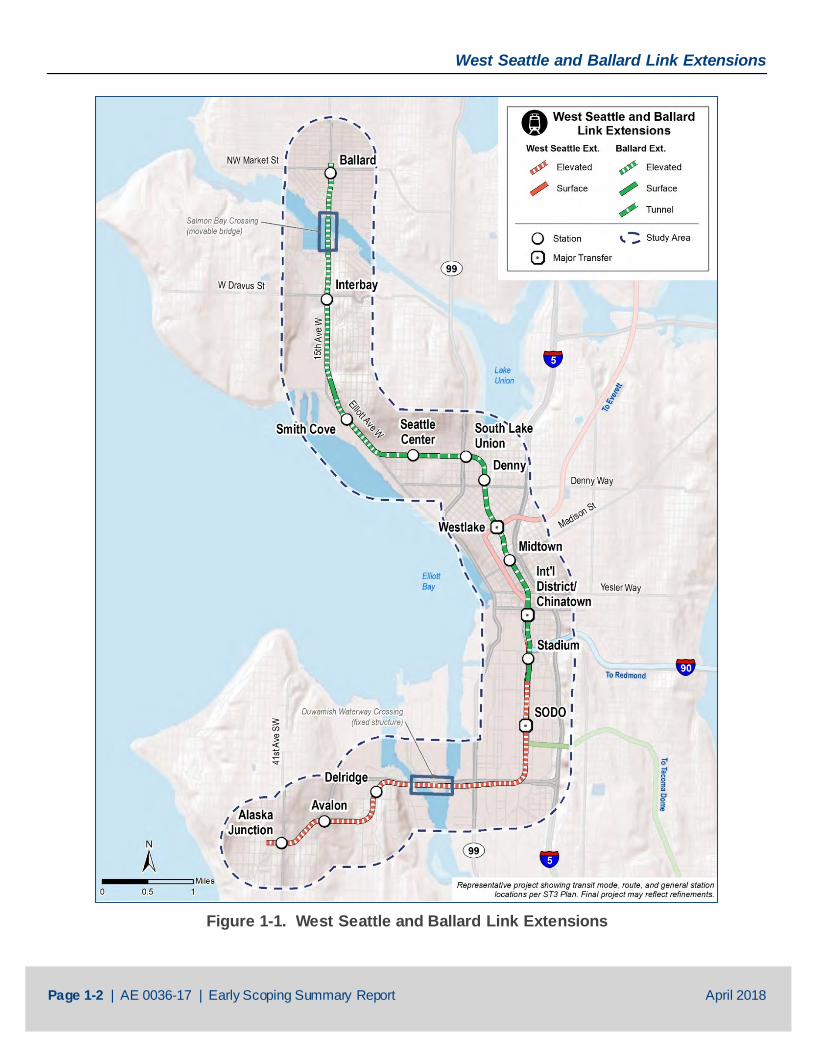
The WSBLE Project would provide fast, reliable light rail connections to dense residential and job centers throughout the region and add a new downtown Seattle light rail tunnel to provide efficient operating capacity for the entire regional system. The ST3 Representative Project for the extension to West Seattle would operate on a 4.7-mile elevated guideway from downtown Seattle to West Seattle’s Alaska Junction neighborhood and include a new rail-only fixed span across the Duwamish River. The ST3 Representative Project for the West Seattle extension would serve one at-grade station in the stadium area and four elevated stations in the SODO, Delridge, Avalon, and Alaska Junction areas.
The ST3 Representative Project for the Ballard extension would operate 7.1 miles from downtown Seattle to Ballard’s Market Street area and include a new 3.3-mile rail-only tunnel from the Chinatown/International District to South Lake Union and Seattle Center/Uptown. The ST3 Representative Project would include an elevated guideway along 15th Avenue West and Elliott Avenue West and a rail-only movable bridge over Salmon Bay. The ST3 Representative Project for the Ballard extension would serve three elevated stations in Ballard, Interbay and near Smith Cove, and six tunnel stations at Seattle Center, South Lake Union, Denny, Westlake, midtown and Chinatown/International District areas.
A map of both extensions for the ST3 Representative Project is shown on Figure 1-1 (West Seattle and Ballard Link Extensions).
1.2 Purpose of Report Sound Transit conducted early scoping from February 2 through March 5, 2018. The purpose of early scoping was to start the alternatives development process for the WSBLE Project. This report describes how Sound Transit conducted early scoping and summarizes the comments received from local and regulatory agencies, tribes, and the public during the early scoping period. This information will be considered by Sound Transit as it identifies and studies alternatives for the WSBLE Project.
West Seattle and Ballard Link Extensions
Page 1-2 | AE 0036-17 | Early Scoping Summary Report April 2018
Figure 1-1. West Seattle and Ballard Link Extensions

West Seattle and Ballard Link Extensions
Page 1-3 | AE 0036-17 | Early Scoping Summary Report April 2018
1.3 Document Organization This report is organized into six sections and six appendices:
• Section 1 (Introduction) introduces the project and provides the purpose of this report.
• Section 2 (Early Scoping Process) describes the early scoping process.
• Section 3 (Agency Early Scoping) provides an overview of agency early scoping activities and summarized the early scoping comments from agencies.
• Section 4 (Tribe Early Scoping) provides an overview of tribal early scoping activities and summarizes the early scoping comments from tribes.
• Section 5 (Public Early Scoping) provides an overview of public early scoping activities and summarizes the early scoping comments from the public.
• Section 6 (Next Steps) states the next steps in the project development process.
• Appendix A (SEPA Register Notice)
• Appendix B (Early Scoping Information Report)
• Appendix C (Meeting Advertisements)
• Appendix D (Agency Comment Letters)
• Appendix E (Tribe Comment Letters)
• Appendix F (Public Comments)
West Seattle and Ballard Link Extensions
Page 2-1 | AE 0036-17 | Early Scoping Summary Report April 2018
2 THE EARLY SCOPING PROCESS
2.1 Purpose of Early Scoping Early scoping initiated the alternatives development phase of the WSBLE Project. Alternatives development is when an agency evaluates the cost, benefits, and impacts of a range of alternatives to identify a preferred alternative and additional alternatives to study in an EIS.
Early scoping is an initial step in collaborating with agencies, tribes, and the community to further define the project. Early scoping provided the first opportunity for the public to learn about the project and submit their comments on the project as it begins. During early scoping, Sound Transit asked for comments on:
• Draft project Purpose and Need • Representative Project included in the ST3 System Plan • Other potential alternatives • Transportation and community impacts and benefits to consider in developing alternatives
Early scoping for the WSBLE Project was conducted under the Washington State Environmental Policy Act (SEPA) rules regarding expanded scoping (Washington Administrative Code 197-11-410). Sound Transit is the lead agency under SEPA.
Sound Transit will comply with relevant Federal Transit Administration (FTA) requirements related to planning and project development, as outlined by Moving Ahead for Progress in the 21st Century Act and the Fixing America’s Surface Transportation Act, to help it analyze and screen alternatives in the National Environmental Policy Act process.
Feedback from the early scoping process will be used to update the Purpose and Need, develop alternatives for screening, and develop evaluation criteria for evaluating alternatives.
2.2 Public Notice in the SEPA Register Sound Transit published an early scoping notice in the SEPA register on February 2, 2018, which initiated early scoping and started the 30-day comment period. The early scoping notice provided:
• Information about the WSBLE Project
• Dates and times of the public early scoping open houses as well as the agency and tribe early scoping meeting
• How to learn about the project
• How to provide comments during the comment period
A copy of the SEPA register notice is provided in Appendix A (SEPA Register Notice).
What is a Purpose and Need Statement? A Purpose and Need Statement defines the objectives that project alternatives must meet. Sound Transit w ill use the Purpose and Need Statement to develop and evaluate project alternatives for analysis during environmental review .
West Seattle and Ballard Link Extensions
Page 2-2 | AE 0036-17 | Early Scoping Summary Report April 2018
In addition, Sound Transit prepared an Early Scoping Information Report to provide details on the early scoping period, project background, ways to provide comments, and the draft Purpose and Need. It also discussed next steps in the project timeline and the environmental process. A copy of the Early Scoping Information Report can be found in Appendix B (Early Scoping Information Report).
2.3 Opportunities for the Public, Agencies, and Tribes to Comment Early scoping included a 30-day public comment period from February 2 to March 5, 2018. Sound Transit accepted comments by U.S. mail to West Seattle and Ballard Link Extensions, c/o Lauren Swift, Sound Transit, 401 S Jackson Street, Seattle, WA 98104-2826; by email to [email protected], by an online comment form at https://wsblink.participate.online/, and in a variety of forms at the public early scoping meetings. Sound Transit hosted an early scoping meeting for agencies and tribes on Wednesday, February 21, 2018, and public early scoping meetings on the following dates:
• Tuesday, February 13, 2018, in West Seattle
• Thursday, February 15, 2018, in Ballard
• Tuesday, February 20, 2018, in Downtown Seattle
• Monday, February 12 to Monday, March 5, 2018, online open house at https://wsblink.participate.online
Meeting advertisement samples are provided in Appendix C (Meeting Advertisements). Copies of agency scoping comments are provided in Appendix D (Agency Comment Letters), copies of tribe scoping comments are provided in Appendix E (Tribe Comment Letters), and copies of public scoping comments are provided in Appendix F (Public Comments).
West Seattle and Ballard Link Extensions
Page 3-1 | AE 0036-17 | Early Scoping Summary Report April 2018
3 AGENCY EARLY SCOPING
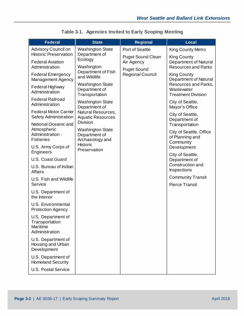
3.1 Agency Early Scoping Meeting Sound Transit hosted an early scoping meeting for federal, state, regional, and local governments on Wednesday, February 21, 2018, from 1:30 to 3:30 p.m. at the Sound Transit Union Station office in Seattle. Sound Transit distributed meeting invitations to 32 agency representatives. Table 3-1 (Agencies Invited to Early Scoping Meeting) lists the agencies that were invited.
Twelve people attended the meeting, from the following seven agencies:
• FTA
• King County Metro
• City of Seattle
• U.S. Army Corps of Engineers (via WebEx)
• U.S. Postal Service (via WebEx)
• U.S. Coast Guard (via WebEx)
• Washington State Department of Ecology (via WebEX)
During the meeting, Sound Transit provided a presentation that included an overview of previous planning efforts, the Representative Project, a description of the alternatives development process, opportunities to provide input, and environmental considerations. Display boards that were also used for public open houses were available for review in the meeting room. Roll plot maps showing the representative alignment were also provided on tables for review. There were no questions from attendees via WebEx. FTA discussed the representative alignment with project staff using the roll plot maps following the presentation.
3.2 Summary of Comments from Public Agencies, Jurisdictions and Institutions
Table 3-2 (Summary of Agency Comments) lists the agencies that provided comments during early scoping and summarizes the major themes in their comments. Comments from the University of Washington (UW) are included here as well since it is a government entity. Copies of the comment letters are provided in Appendix D (Agency Comment Letters).
West Seattle and Ballard Link Extensions
Page 3-2 | AE 0036-17 | Early Scoping Summary Report April 2018
Table 3-1. Agencies Invited to Early Scoping Meeting
Federal State Regional Local Advisory Council on Historic Preservation
Federal Aviation Administration Federal Emergency Management Agency Federal Highway Administration Federal Railroad Administration Federal Motor Carrier Safety Administration National Oceanic and Atmospheric Administration -Fisheries U.S. Army Corps of Engineers U.S. Coast Guard U.S. Bureau of Indian Affairs U.S. Fish and Wildlife Service
U.S. Department of the Interior U.S. Environmental Protection Agency U.S. Department of Transportation Maritime Administration
U.S. Department of Housing and Urban Development
U.S. Department of Homeland Security U.S. Postal Service
Washington State Department of Ecology Washington Department of Fish and Wildlife Washington State Department of Transportation Washington State Department of Natural Resources, Aquatic Resources Division Washington State Department of Archaeology and Historic Preservation
Port of Seattle Puget Sound Clean Air Agency Puget Sound Regional Council
King County Metro King County Department of Natural Resources and Parks King County Department of Natural Resources and Parks, Wastewater Treatment Division City of Seattle, Mayor’s Office City of Seattle, Department of Transportation City of Seattle, Office of Planning and Community Development City of Seattle, Department of Construction and Inspections Community Transit Pierce Transit
West Seattle and Ballard Link Extensions
Page 3-3 | AE 0036-17 | Early Scoping Summary Report April 2018
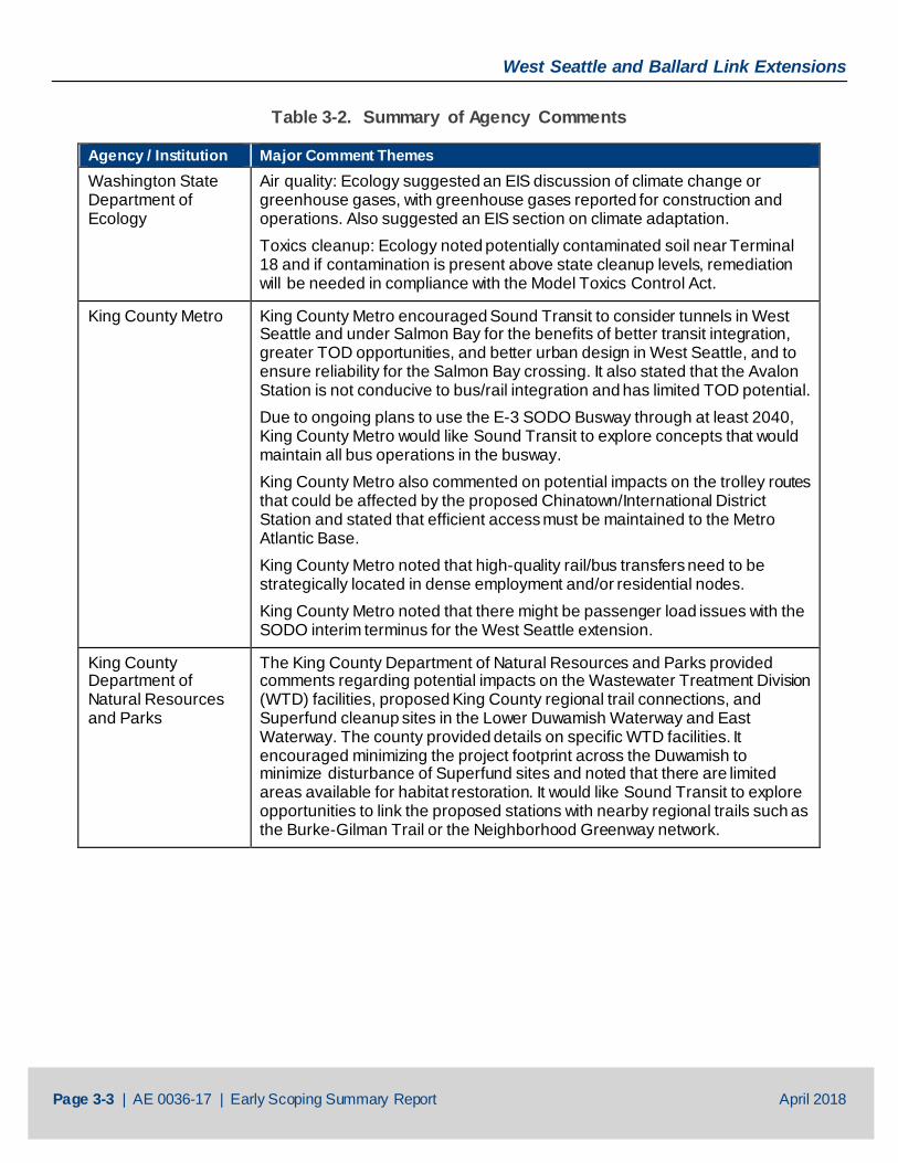
Table 3-2. Summary of Agency Comments
Agency / Institution Major Comment Themes Washington State Department of Ecology
Air quality: Ecology suggested an EIS discussion of climate change or greenhouse gases, with greenhouse gases reported for construction and operations. Also suggested an EIS section on climate adaptation. Toxics cleanup: Ecology noted potentially contaminated soil near Terminal 18 and if contamination is present above state cleanup levels, remediation will be needed in compliance with the Model Toxics Control Act.
King County Metro King County Metro encouraged Sound Transit to consider tunnels in West Seattle and under Salmon Bay for the benefits of better transit integration, greater TOD opportunities, and better urban design in West Seattle, and to ensure reliability for the Salmon Bay crossing. It also stated that the Avalon Station is not conducive to bus/rail integration and has limited TOD potential. Due to ongoing plans to use the E-3 SODO Busway through at least 2040, King County Metro would like Sound Transit to explore concepts that would maintain all bus operations in the busway. King County Metro also commented on potential impacts on the trolley routes that could be affected by the proposed Chinatown/International District Station and stated that efficient access must be maintained to the Metro Atlantic Base. King County Metro noted that high-quality rail/bus transfers need to be strategically located in dense employment and/or residential nodes. King County Metro noted that there might be passenger load issues with the SODO interim terminus for the West Seattle extension.
King County Department of Natural Resources and Parks
The King County Department of Natural Resources and Parks provided comments regarding potential impacts on the Wastewater Treatment Division (WTD) facilities, proposed King County regional trail connections, and Superfund cleanup sites in the Lower Duwamish Waterway and East Waterway. The county provided details on specific WTD facilities. It encouraged minimizing the project footprint across the Duwamish to minimize disturbance of Superfund sites and noted that there are limited areas available for habitat restoration. It would like Sound Transit to explore opportunities to link the proposed stations with nearby regional trails such as the Burke-Gilman Trail or the Neighborhood Greenway network.
West Seattle and Ballard Link Extensions
Page 3-4 | AE 0036-17 | Early Scoping Summary Report April 2018
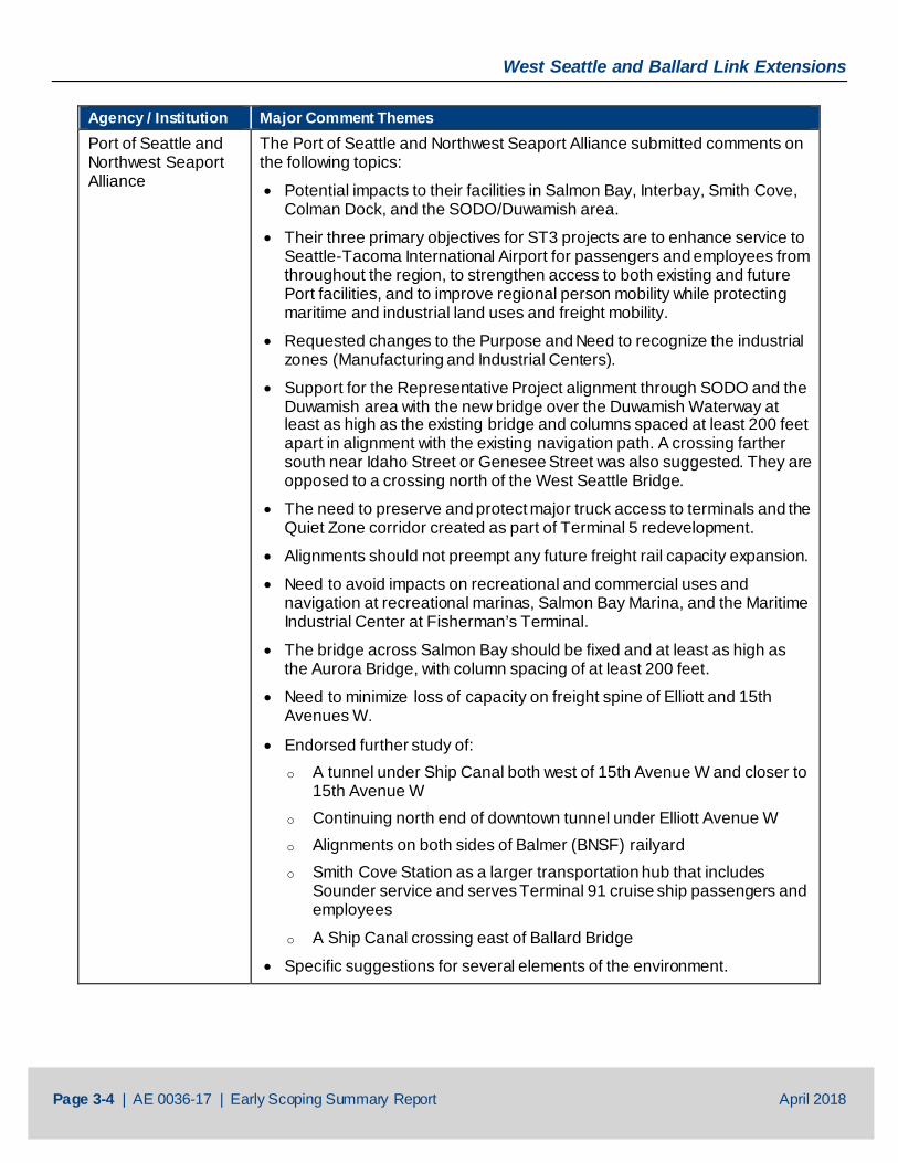
Agency / Institution Major Comment Themes Port of Seattle and Northwest Seaport Alliance
The Port of Seattle and Northwest Seaport Alliance submitted comments on the following topics:
• Potential impacts to their facilities in Salmon Bay, Interbay, Smith Cove, Colman Dock, and the SODO/Duwamish area.
• Their three primary objectives for ST3 projects are to enhance service to Seattle-Tacoma International Airport for passengers and employees from throughout the region, to strengthen access to both existing and future Port facilities, and to improve regional person mobility while protecting maritime and industrial land uses and freight mobility.
• Requested changes to the Purpose and Need to recognize the industrial zones (Manufacturing and Industrial Centers).
• Support for the Representative Project alignment through SODO and the Duwamish area with the new bridge over the Duwamish Waterway at least as high as the existing bridge and columns spaced at least 200 feet apart in alignment with the existing navigation path. A crossing farther south near Idaho Street or Genesee Street was also suggested. They are opposed to a crossing north of the West Seattle Bridge.
• The need to preserve and protect major truck access to terminals and the Quiet Zone corridor created as part of Terminal 5 redevelopment.
• Alignments should not preempt any future freight rail capacity expansion.
• Need to avoid impacts on recreational and commercial uses and navigation at recreational marinas, Salmon Bay Marina, and the Maritime Industrial Center at Fisherman’s Terminal.
• The bridge across Salmon Bay should be fixed and at least as high as the Aurora Bridge, with column spacing of at least 200 feet.
• Need to minimize loss of capacity on freight spine of Elliott and 15th Avenues W.
• Endorsed further study of: o A tunnel under Ship Canal both west of 15th Avenue W and closer to
15th Avenue W o Continuing north end of downtown tunnel under Elliott Avenue W o Alignments on both sides of Balmer (BNSF) railyard o Smith Cove Station as a larger transportation hub that includes
Sounder service and serves Terminal 91 cruise ship passengers and employees
o A Ship Canal crossing east of Ballard Bridge
• Specific suggestions for several elements of the environment.
West Seattle and Ballard Link Extensions
Page 3-5 | AE 0036-17 | Early Scoping Summary Report April 2018
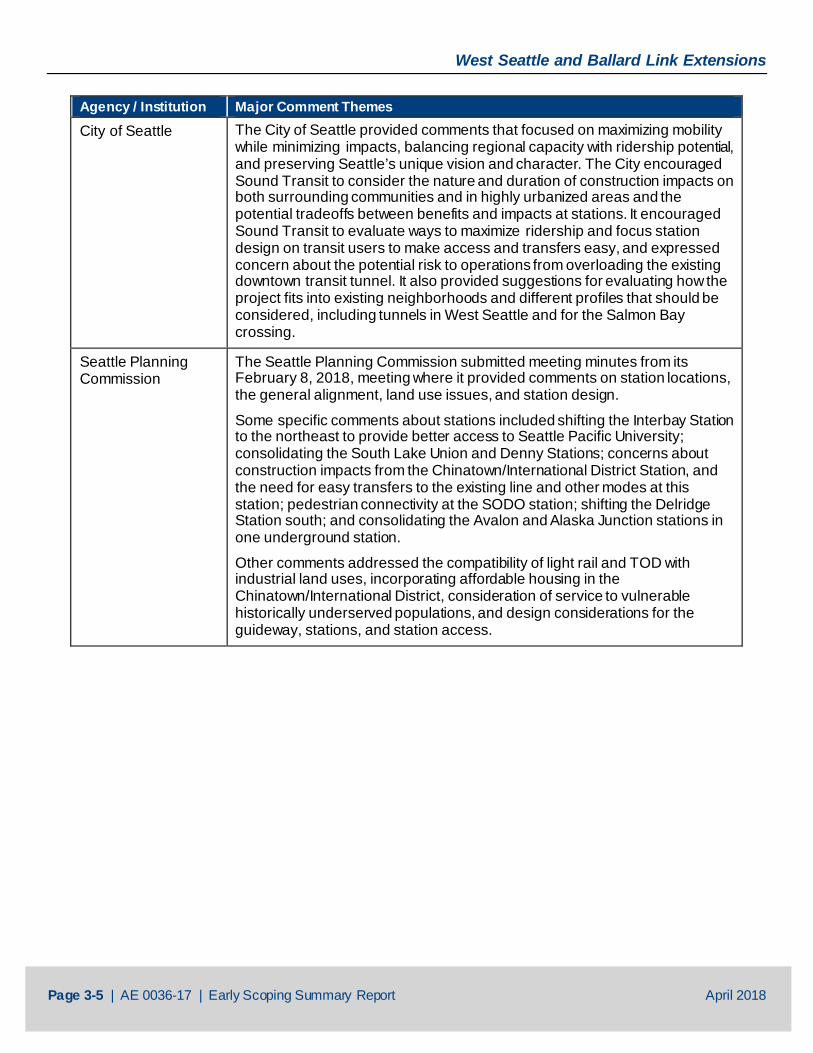
Agency / Institution Major Comment Themes City of Seattle The City of Seattle provided comments that focused on maximizing mobility
while minimizing impacts, balancing regional capacity with ridership potential, and preserving Seattle’s unique vision and character. The City encouraged Sound Transit to consider the nature and duration of construction impacts on both surrounding communities and in highly urbanized areas and the potential tradeoffs between benefits and impacts at stations. It encouraged Sound Transit to evaluate ways to maximize ridership and focus station design on transit users to make access and transfers easy, and expressed concern about the potential risk to operations from overloading the existing downtown transit tunnel. It also provided suggestions for evaluating how the project fits into existing neighborhoods and different profiles that should be considered, including tunnels in West Seattle and for the Salmon Bay crossing.
Seattle Planning Commission
The Seattle Planning Commission submitted meeting minutes from its February 8, 2018, meeting where it provided comments on station locations, the general alignment, land use issues, and station design.
Some specific comments about stations included shifting the Interbay Station to the northeast to provide better access to Seattle Pacific University; consolidating the South Lake Union and Denny Stations; concerns about construction impacts from the Chinatown/International District Station, and the need for easy transfers to the existing line and other modes at this station; pedestrian connectivity at the SODO station; shifting the Delridge Station south; and consolidating the Avalon and Alaska Junction stations in one underground station.
Other comments addressed the compatibility of light rail and TOD with industrial land uses, incorporating affordable housing in the Chinatown/International District, consideration of service to vulnerable historically underserved populations, and design considerations for the guideway, stations, and station access.
West Seattle and Ballard Link Extensions
Page 3-6 | AE 0036-17 | Early Scoping Summary Report April 2018
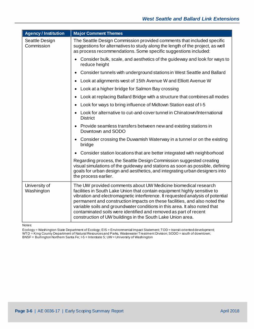
Agency / Institution Major Comment Themes Seattle Design Commission
The Seattle Design Commission provided comments that included specific suggestions for alternatives to study along the length of the project, as well as process recommendations. Some specific suggestions included:
• Consider bulk, scale, and aesthetics of the guideway and look for ways to reduce height
• Consider tunnels with underground stations in West Seattle and Ballard
• Look at alignments west of 15th Avenue W and Elliott Avenue W
• Look at a higher bridge for Salmon Bay crossing
• Look at replacing Ballard Bridge with a structure that combines all modes
• Look for ways to bring influence of Midtown Station east of I-5
• Look for alternative to cut-and-cover tunnel in Chinatown/International District
• Provide seamless transfers between new and existing stations in Downtown and SODO
• Consider crossing the Duwamish Waterway in a tunnel or on the existing bridge
• Consider station locations that are better integrated with neighborhood Regarding process, the Seattle Design Commission suggested creating visual simulations of the guideway and stations as soon as possible, defining goals for urban design and aesthetics, and integrating urban designers into the process earlier.
University of Washington
The UW provided comments about UW Medicine biomedical research facilities in South Lake Union that contain equipment highly sensitive to vibration and electromagnetic interference. It requested analysis of potential permanent and construction impacts on these facilities, and also noted the variable soils and groundwater conditions in this area. It also noted that contaminated soils were identified and removed as part of recent construction of UW buildings in the South Lake Union area.
Notes: Ecology = Washington State Department of Ecology; EIS = Environmental Impact Statement; TOD = transit-oriented development; WTD = King County Department of Natural Resources and Parks, Wastewater Treatment Division; SODO = south of downtown; BNSF = Burlington Northern Santa Fe; I-5 = Interstate 5; UW = University of Washington
West Seattle and Ballard Link Extensions
Page 4-1 | AE 0036-17 | Early Scoping Summary Report April 2018
4 TRIBAL CONSULTATION DURING EARLY SCOPING
4.1 Tribe Early Scoping Meeting Sound Transit invited tribes to attend the agency early scoping meeting on Wednesday, February 21, 2018, from 1:30 to 3:30 p.m. at the Sound Transit Union Station office in Seattle. Tribes were also invited to attend public early scoping meetings and the online open house.
FTA initiated government-to-government consultation with the following tribes via letters sent on February 5, 2018:
• Confederated Tribes and Bands of the Yakama Nation
• Muckleshoot Indian Tribe
• Snoqualmie Indian Tribe
• Stillaguamish Tribe of Indians of Washington
• Suquamish Indian Tribe of the Port Madison Reservation
• Tulalip Tribes of Washington
Sound Transit distributed meeting invitations to the above tribes, as well as the Duwamish Tribe and the Snohomish Tribe, which are not federally recognized treaty tribes.
One person attended the meeting, from the Muckleshoot Indian Tribe. A description of this meeting is provided in Section 3.1 (Agency Early Scoping Meeting).
4.2 Summary of Comments from Tribes The Snoqualmie Indian Tribes Department of Archaeology and Historic Preservation submitted comments noting concerns about cultural resources and requesting that a cultural resources survey be completed in ground-disturbing areas of potential effect. A copy of this letter is provided in Appendix E (Tribe Comment Letters). No other comments from tribes were received.
West Seattle and Ballard Link Extensions
Page 5-1 | AE 0036-17 | Early Scoping Summary Report April 2018
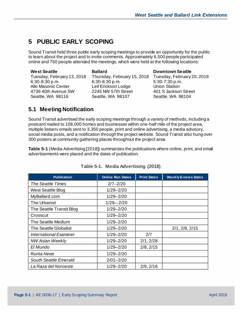
5 PUBLIC EARLY SCOPING Sound Transit held three public early scoping meetings to provide an opportunity for the public to learn about the project and to invite comments. Approximately 6,500 people participated online and 750 people attended the meetings, which were held at the following locations:
West Seattle Tuesday, February 13, 2018 6:30-8:30 p.m. Alki Masonic Center 4736 40th Avenue SW Seattle, WA 98116
Ballard Thursday, February 15, 2018 6:30-8:30 p.m. Leif Erickson Lodge 2245 NW 57th Street Seattle, WA 98107
Downtown Seattle Tuesday, February 20, 2018 5:30-7:30 p.m. Union Station 401 S Jackson Street Seattle, WA 98104
5.1 Meeting Notification Sound Transit advertised the early scoping meetings through a variety of methods, including a postcard mailed to 108,000 homes and businesses within one-half mile of the project area, multiple listserv emails sent to 3,350 people, print and online advertising, a media advisory, social media posts, and a notification through the project website. Sound Transit also hung over 300 posters at community gathering places throughout the project area.
Table 5-1 (Media Advertising [2018]) summarizes the publications where online, print, and email advertisements were placed and the dates of publication.
Table 5-1. Media Advertising (2018)
Publication Online Run Dates Print Dates Weekly E-news Dates
The Seattle Times 2/7–2/20
West Seattle Blog 1/29–2/20
MyBallard.com 1/29–2/20
The Urbanist 1/29–-2/20
The Seattle Transit Blog 1/29–2/20
Crosscut 1/29–2/20
The Seattle Medium 1/29–2/20
The Seattle Globalist 1/29–2/20
2/1, 2/8, 2/15 International Examiner 1/29–2/20 2/7
NW Asian Weekly 1/29–2/20 2/1, 2/28
El Mundo 1/29–2/20 2/8, 2/15
Runta News 1/29–2/20
South Seattle Emerald 2/01–2/20
La Raza del Noroeste 1/29–2/20 2/9, 2/16
West Seattle and Ballard Link Extensions
Page 5-2 | AE 0036-17 | Early Scoping Summary Report April 2018
Notices of the public early scoping meetings were also posted on the following online community calendars:
• City of Seattle
• The Seattle Times
• The Stranger
• Seattle Met
• King5
• Seattle Globalist
• Q13Fox
• KUOW
• KNKX
• Seattle Networking Guide
Samples of meeting advertisements are provided in Appendix C (Meeting Advertisements).
5.2 Public Outreach to Minority, Low‐Income, and Limited‐English-Proficiency Populations
Sound Transit is committed to equal engagement opportunities for all interested members of the public. In addition to Sound Transit community engagement procedures, Executive Order 12898, U.S. Department of Transportation Order 5610.2(a), and FTA Circular C 4703.1 require Sound Transit to provide meaningful opportunities for these groups to engage in the planning process. Title VI of the Civil Rights Act of 1964 prohibits discrimination based on race, color, or national origin. These directives make environmental justice a part of the decision-making process by identifying and addressing disproportionately high and adverse human health and environmental effects of Sound Transit’s programs, policies, and activities on minority and low-income populations.
Sound Transit conducted a preliminary demographic analysis to identify low-income, minority, and limited-English-proficiency populations. Based on this analysis, Sound Transit used the following strategies to engage these populations during early scoping:
• Provided translated text on posters
• Provided translated meeting guide handouts
• Publicized events online and in print with ethnic newspapers and community calendars
• Provided translators at the Downtown open house
• Provided translated text on the online open house web pages, as well as the embedded Google Translate tool
As the project moves forward, Sound Transit will conduct interviews with community leaders, jurisdictions, and social service providers to identify additional ways to reach these populations.
West Seattle and Ballard Link Extensions
Page 5-3 | AE 0036-17 | Early Scoping Summary Report April 2018
5.3 Public Scoping Meeting Format Sound Transit asked public scoping meeting attendees to sign in as they arrived. Staff members working at the welcome table explained the meeting purpose and format. Each attendee received a meeting guide and a comment form. Copies of a project fact sheet, the Early Scoping Information Report, and the Purpose and Need statement were also available. Meeting guides and comment forms were translated into Spanish, Simplified Chinese, Korean, and Amharic. Interpreters were available for Mandarin and Vietnamese.
The meetings were conducted as an open house with a short presentation approximately 15 minutes after the meeting began. As part of the open houses, participants were invited to review displays and discuss the project with Sound Transit staff and members of the consultant team. Display boards provided information about Sound Transit, the project history, the project Purpose and Need, opportunities for public involvement, and the project schedule.
Attendees were invited to provide comments through three interactive exercises:
• Display boards inviting attendees to write down what they like about their neighborhood
• Display boards inviting attendees to write down the potential benefits or impacts of the project
• Roll plot maps showing the Representative Project. Attendees were provided Post-it® notes to add comments about their ideas or questions to the roll plot maps
The open houses also had a station with comment cards for handwritten comments, as well as laptops that allowed viewing of the online open house and submittal of typed comments.
5.4 Summary of Public Comments Public comments were accepted in a variety of ways, including:
• By email
• Using the online open house (comments could be provided on the Purpose and Need, the potential benefits and impacts, and the Representative Project)
• By comment forms, available at the public open houses
• By mail
In addition, feedback was received at the online open house using the three interactive exercises described in Section 5.3 (Public Scoping Meeting Format) where visitors were asked the same questions as were on the display boards and could provide responses.
The following subsections summarize what Sound Transit heard through all methods of commenting, and are organized by general comment topics.
5.4.1 General Project
Major comment themes that applied to the entire project included the following:
• General support for the project (over 100 comments)
West Seattle and Ballard Link Extensions
Page 5-4 | AE 0036-17 | Early Scoping Summary Report April 2018
• Build it sooner
• Provide good access for all modes to the stations
• Make sure that bus schedules and routes are modified to provide well integrated service
• Provide access for each station from multiple street corners to avoid pedestrians needing to cross busy streets
When asked about the benefits of the project, the most common themes for both the West Seattle and Ballard Extensions were:
• Faster and consistent travel time
• Improved mobility
• Benefit to environment
• Less reliance on cars
When asked about the potential impacts of the project, the most common themes for the West Seattle Extension were:
• Could displace the water taxi
• Impacts to community from elevated guideway
• Noise and vibration
• Parking
When asked about the potential impacts of the project, the most common themes for the Ballard Extension were:
• Traffic impacts on 15th Avenue W
• Potential for service disruptions with movable bridge
• Potential impact of elevated guideway on neighborhoods
About 60 comments were received related to the project Purpose and Need. Major themes included:
• Agreement with proposed Purpose and Need statement
• Build it faster
• A purpose should be to make communities better
• Incorporate safety into statement
• Quality connections/transfers are important
• Racial and social equity should be clearly incorporated
• A movable bridge in Ballard would not meet the purpose of providing reliable transit
• Make sure small businesses benefit from economic development
West Seattle and Ballard Link Extensions
Page 5-5 | AE 0036-17 | Early Scoping Summary Report April 2018
Photographs of comments received on display boards at the West Seattle, Ballard, and Downtown open houses are provided in Appendix F (Public Comments). A transcript of comments received on roll plot maps is also included in Appendix F (Public Comments).
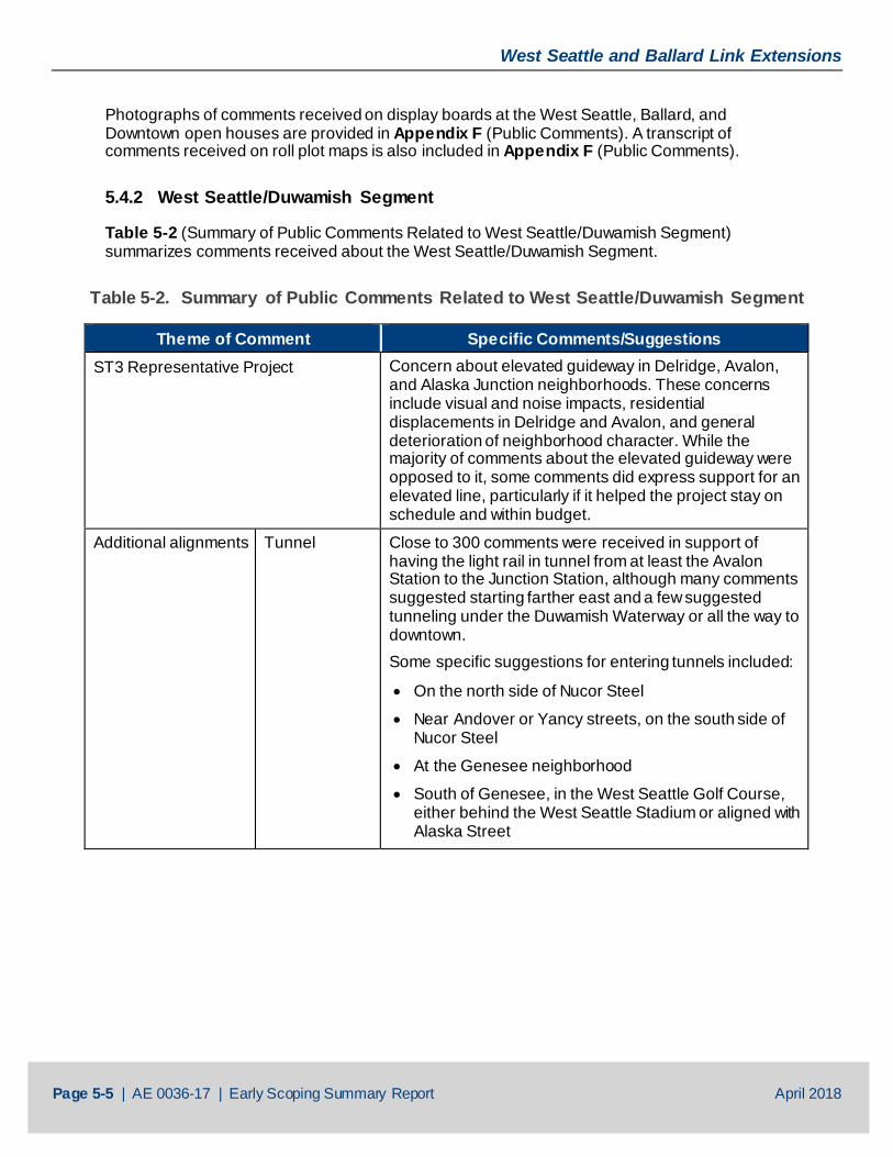
5.4.2 West Seattle/Duwamish Segment
Table 5-2 (Summary of Public Comments Related to West Seattle/Duwamish Segment) summarizes comments received about the West Seattle/Duwamish Segment.
Table 5-2. Summary of Public Comments Related to West Seattle/Duwamish Segment
Theme of Comment Specific Comments/Suggestions ST3 Representative Project Concern about elevated guideway in Delridge, Avalon,
and Alaska Junction neighborhoods. These concerns include visual and noise impacts, residential displacements in Delridge and Avalon, and general deterioration of neighborhood character. While the majority of comments about the elevated guideway were opposed to it, some comments did express support for an elevated line, particularly if it helped the project stay on schedule and within budget.
Additional alignments Tunnel Close to 300 comments were received in support of having the light rail in tunnel from at least the Avalon Station to the Junction Station, although many comments suggested starting farther east and a few suggested tunneling under the Duwamish Waterway or all the way to downtown. Some specific suggestions for entering tunnels included:
• On the north side of Nucor Steel
• Near Andover or Yancy streets, on the south side of Nucor Steel
• At the Genesee neighborhood
• South of Genesee, in the West Seattle Golf Course, either behind the West Seattle Stadium or aligned with Alaska Street
West Seattle and Ballard Link Extensions
Page 5-6 | AE 0036-17 | Early Scoping Summary Report April 2018
Theme of Comment Specific Comments/Suggestions Other Alignments
About 80 comments advocated for an alignment south of SW Genesee Street, across the West Seattle Golf Course. Some suggested crossing closer to the West Seattle Stadium, while others suggested farther south, aligned with SW Alaska Street. Most suggestions assumed entering a tunnel on the west side of the golf course. Other alignments suggested include:
• Follow West Seattle Bridge to Fauntleroy Way SW
• Go on the north side of West Seattle Bridge
• Terminate the line on Fauntleroy Way SW
• Turn south on 35th Avenue SW
• Cross the Duwamish farther south of the West Seattle Bridge, such as near Diagonal Street or Idaho Street
• Make sure the end of the line is oriented to the south to allow for future extensions south
• Terminate at Delridge and provide bus service to Avalon and Alaska Junction. One comment suggested a gondola from this terminus to Avalon
• Bypass Delridge
Other Destinations
About 50 comments advocated redirecting the line south on Delridge Way SW or 35th Avenue SW to provide service to Westwood Village, White Center, and points along and south of those routes. Other destinations beyond Alaska Junction suggested include:
• Continue down Fauntleroy Way SW to the ferry terminal
• Provide service north to Admiral and Alki
• Provide service south to Morgan Junction
Other modes If a tunnel cannot be built now because of funding, then improve bus service to SODO until a tunnel can be funded. Provide streetcar service from other areas of West Seattle to stations. End at West Seattle Golf Course and use gondola to get to Avalon.
Integrate with/provide service to water taxi. Share the new bridge with buses or buses and vehicles.
West Seattle and Ballard Link Extensions
Page 5-7 | AE 0036-17 | Early Scoping Summary Report April 2018
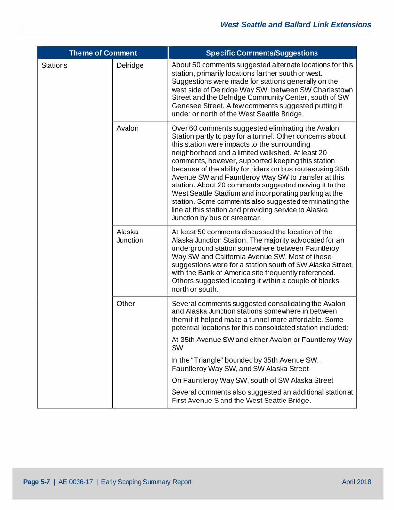
Theme of Comment Specific Comments/Suggestions Stations Delridge About 50 comments suggested alternate locations for this
station, primarily locations farther south or west. Suggestions were made for stations generally on the west side of Delridge Way SW, between SW Charlestown Street and the Delridge Community Center, south of SW Genesee Street. A few comments suggested putting it under or north of the West Seattle Bridge.
Avalon Over 60 comments suggested eliminating the Avalon Station partly to pay for a tunnel. Other concerns about this station were impacts to the surrounding neighborhood and a limited walkshed. At least 20 comments, however, supported keeping this station because of the ability for riders on bus routes using 35th Avenue SW and Fauntleroy Way SW to transfer at this station. About 20 comments suggested moving it to the West Seattle Stadium and incorporating parking at the station. Some comments also suggested terminating the line at this station and providing service to Alaska Junction by bus or streetcar.
Alaska Junction
At least 50 comments discussed the location of the Alaska Junction Station. The majority advocated for an underground station somewhere between Fauntleroy Way SW and California Avenue SW. Most of these suggestions were for a station south of SW Alaska Street, with the Bank of America site frequently referenced. Others suggested locating it within a couple of blocks north or south.
Other Several comments suggested consolidating the Avalon and Alaska Junction stations somewhere in between them if it helped make a tunnel more affordable. Some potential locations for this consolidated station included: At 35th Avenue SW and either Avalon or Fauntleroy Way SW
In the “Triangle” bounded by 35th Avenue SW, Fauntleroy Way SW, and SW Alaska Street On Fauntleroy Way SW, south of SW Alaska Street Several comments also suggested an additional station at First Avenue S and the West Seattle Bridge.
West Seattle and Ballard Link Extensions
Page 5-8 | AE 0036-17 | Early Scoping Summary Report April 2018
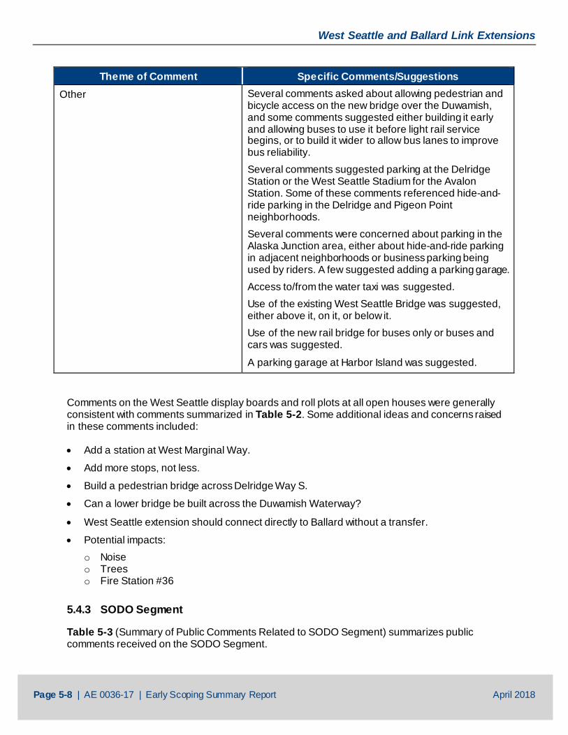
Theme of Comment Specific Comments/Suggestions Other Several comments asked about allowing pedestrian and
bicycle access on the new bridge over the Duwamish, and some comments suggested either building it early and allowing buses to use it before light rail service begins, or to build it wider to allow bus lanes to improve bus reliability. Several comments suggested parking at the Delridge Station or the West Seattle Stadium for the Avalon Station. Some of these comments referenced hide-and-ride parking in the Delridge and Pigeon Point neighborhoods. Several comments were concerned about parking in the Alaska Junction area, either about hide-and-ride parking in adjacent neighborhoods or business parking being used by riders. A few suggested adding a parking garage. Access to/from the water taxi was suggested. Use of the existing West Seattle Bridge was suggested, either above it, on it, or below it. Use of the new rail bridge for buses only or buses and cars was suggested.
A parking garage at Harbor Island was suggested.
Comments on the West Seattle display boards and roll plots at all open houses were generally consistent with comments summarized in Table 5-2. Some additional ideas and concerns raised in these comments included:
• Add a station at West Marginal Way.
• Add more stops, not less.
• Build a pedestrian bridge across Delridge Way S.
• Can a lower bridge be built across the Duwamish Waterway?
• West Seattle extension should connect directly to Ballard without a transfer.
• Potential impacts: o Noise o Trees o Fire Station #36
5.4.3 SODO Segment
Table 5-3 (Summary of Public Comments Related to SODO Segment) summarizes public comments received on the SODO Segment.
West Seattle and Ballard Link Extensions
Page 5-9 | AE 0036-17 | Early Scoping Summary Report April 2018
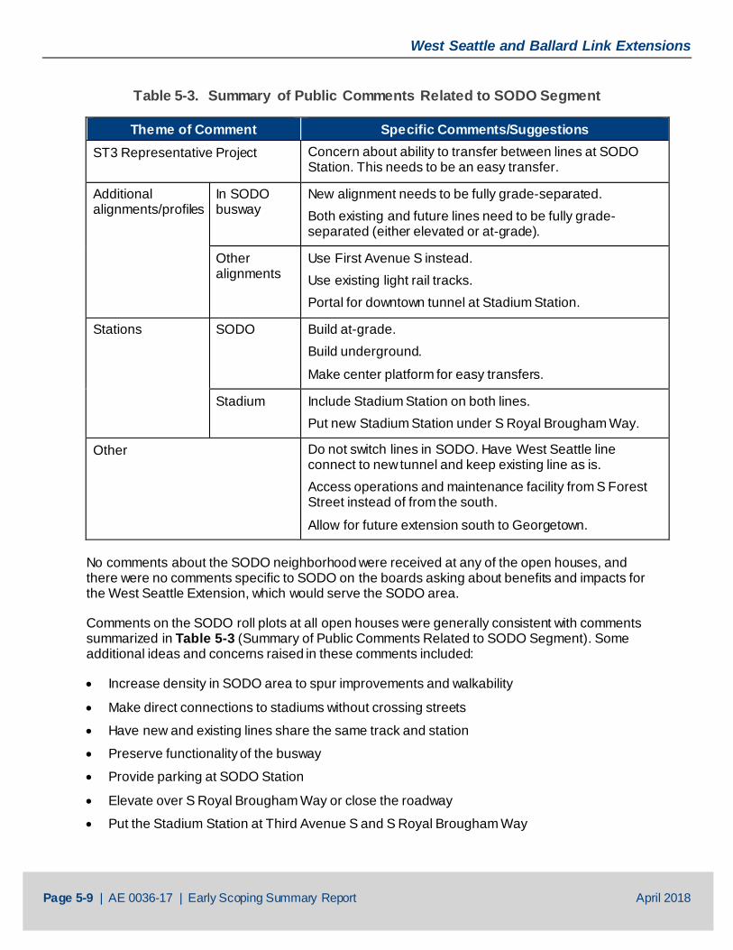
Table 5-3. Summary of Public Comments Related to SODO Segment
Theme of Comment Specific Comments/Suggestions ST3 Representative Project Concern about ability to transfer between lines at SODO
Station. This needs to be an easy transfer.
Additional alignments/profiles
In SODO busway
New alignment needs to be fully grade-separated. Both existing and future lines need to be fully grade-separated (either elevated or at-grade).
Other alignments
Use First Avenue S instead. Use existing light rail tracks. Portal for downtown tunnel at Stadium Station.
Stations SODO Build at-grade. Build underground.
Make center platform for easy transfers.
Stadium Include Stadium Station on both lines. Put new Stadium Station under S Royal Brougham Way.
Other Do not switch lines in SODO. Have West Seattle line connect to new tunnel and keep existing line as is. Access operations and maintenance facility from S Forest Street instead of from the south.
Allow for future extension south to Georgetown. No comments about the SODO neighborhood were received at any of the open houses, and there were no comments specific to SODO on the boards asking about benefits and impacts for the West Seattle Extension, which would serve the SODO area.
Comments on the SODO roll plots at all open houses were generally consistent with comments summarized in Table 5-3 (Summary of Public Comments Related to SODO Segment). Some additional ideas and concerns raised in these comments included:
• Increase density in SODO area to spur improvements and walkability
• Make direct connections to stadiums without crossing streets
• Have new and existing lines share the same track and station
• Preserve functionality of the busway
• Provide parking at SODO Station
• Elevate over S Royal Brougham Way or close the roadway
• Put the Stadium Station at Third Avenue S and S Royal Brougham Way
West Seattle and Ballard Link Extensions
Page 5-10 | AE 0036-17 | Early Scoping Summary Report April 2018
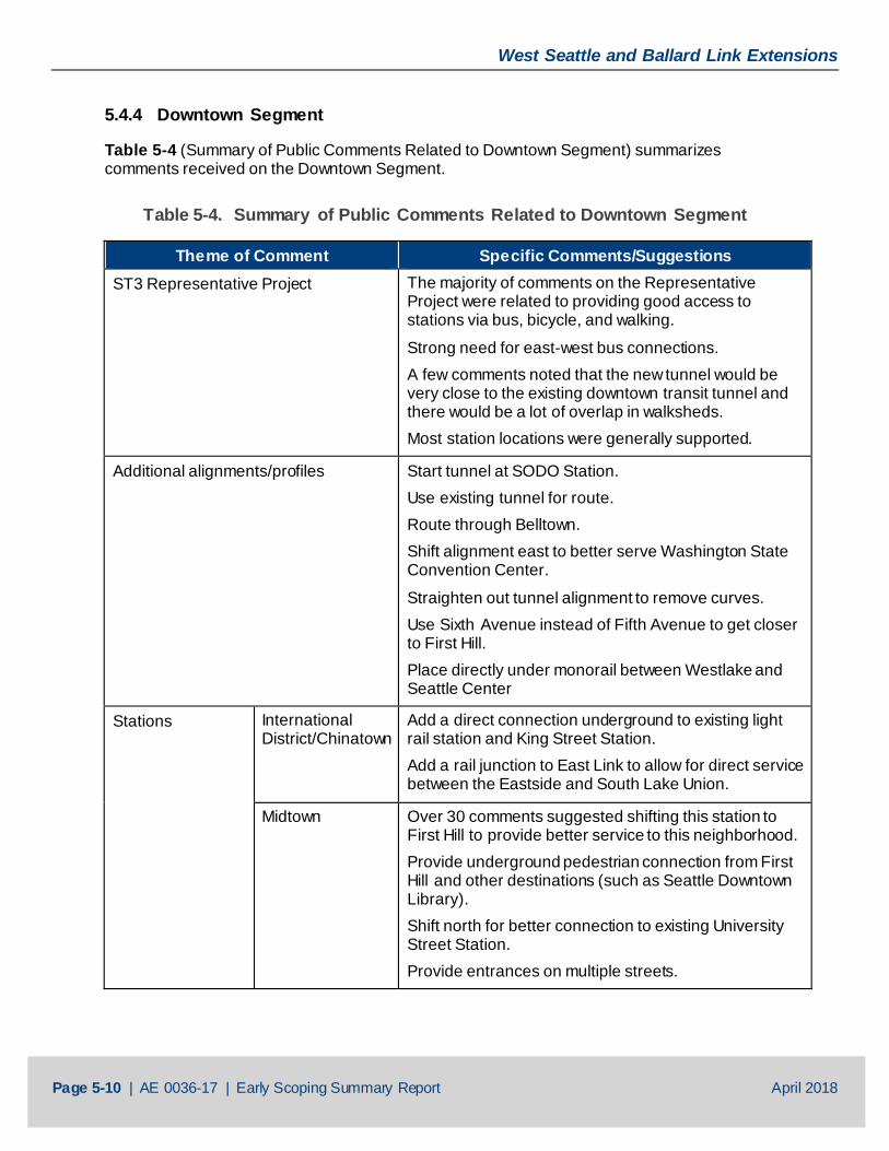
5.4.4 Downtown Segment
Table 5-4 (Summary of Public Comments Related to Downtown Segment) summarizes comments received on the Downtown Segment.
Table 5-4. Summary of Public Comments Related to Downtown Segment
Theme of Comment Specific Comments/Suggestions ST3 Representative Project The majority of comments on the Representative
Project were related to providing good access to stations via bus, bicycle, and walking.
Strong need for east-west bus connections. A few comments noted that the new tunnel would be very close to the existing downtown transit tunnel and there would be a lot of overlap in walksheds. Most station locations were generally supported.
Additional alignments/profiles Start tunnel at SODO Station. Use existing tunnel for route. Route through Belltown. Shift alignment east to better serve Washington State Convention Center.
Straighten out tunnel alignment to remove curves. Use Sixth Avenue instead of Fifth Avenue to get closer to First Hill. Place directly under monorail between Westlake and Seattle Center
Stations International District/Chinatown
Add a direct connection underground to existing light rail station and King Street Station. Add a rail junction to East Link to allow for direct service between the Eastside and South Lake Union.
Midtown Over 30 comments suggested shifting this station to First Hill to provide better service to this neighborhood. Provide underground pedestrian connection from First Hill and other destinations (such as Seattle Downtown Library). Shift north for better connection to existing University Street Station. Provide entrances on multiple streets.
West Seattle and Ballard Link Extensions
Page 5-11 | AE 0036-17 | Early Scoping Summary Report April 2018
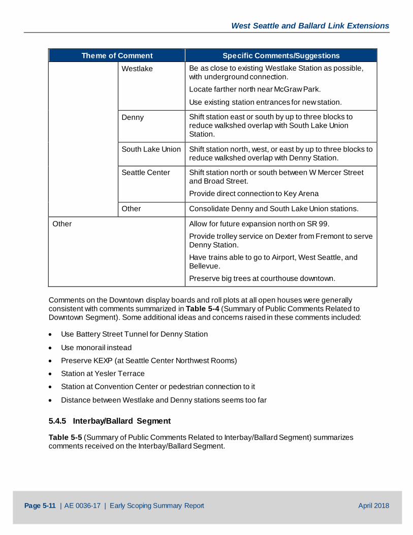
Theme of Comment Specific Comments/Suggestions Westlake Be as close to existing Westlake Station as possible,
with underground connection. Locate farther north near McGraw Park.
Use existing station entrances for new station.
Denny Shift station east or south by up to three blocks to reduce walkshed overlap with South Lake Union Station.
South Lake Union Shift station north, west, or east by up to three blocks to reduce walkshed overlap with Denny Station.
Seattle Center Shift station north or south between W Mercer Street and Broad Street. Provide direct connection to Key Arena
Other Consolidate Denny and South Lake Union stations.
Other Allow for future expansion north on SR 99. Provide trolley service on Dexter from Fremont to serve Denny Station. Have trains able to go to Airport, West Seattle, and Bellevue. Preserve big trees at courthouse downtown.
Comments on the Downtown display boards and roll plots at all open houses were generally consistent with comments summarized in Table 5-4 (Summary of Public Comments Related to Downtown Segment). Some additional ideas and concerns raised in these comments included:
• Use Battery Street Tunnel for Denny Station
• Use monorail instead
• Preserve KEXP (at Seattle Center Northwest Rooms)
• Station at Yesler Terrace
• Station at Convention Center or pedestrian connection to it
• Distance between Westlake and Denny stations seems too far
5.4.5 Interbay/Ballard Segment
Table 5-5 (Summary of Public Comments Related to Interbay/Ballard Segment) summarizes comments received on the Interbay/Ballard Segment.
West Seattle and Ballard Link Extensions
Page 5-12 | AE 0036-17 | Early Scoping Summary Report April 2018
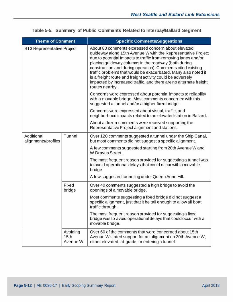
Table 5-5. Summary of Public Comments Related to Interbay/Ballard Segment
Theme of Comment Specific Comments/Suggestions ST3 Representative Project About 80 comments expressed concern about elevated
guideway along 15th Avenue W with the Representative Project due to potential impacts to traffic from removing lanes and/or placing guideway columns in the roadway (both during construction and during operation). Comments cited existing traffic problems that would be exacerbated. Many also noted it is a freight route and freight activity could be adversely impacted by increased traffic, and there are no alternate freight routes nearby. Concerns were expressed about potential impacts to reliability with a movable bridge. Most comments concerned with this suggested a tunnel and/or a higher fixed bridge. Concerns were expressed about visual, traffic, and neighborhood impacts related to an elevated station in Ballard. About a dozen comments were received supporting the Representative Project alignment and stations.
Additional alignments/profiles
Tunnel Over 120 comments suggested a tunnel under the Ship Canal, but most comments did not suggest a specific alignment. A few comments suggested starting from 20th Avenue W and W Dravus Street. The most frequent reason provided for suggesting a tunnel was to avoid operational delays that could occur with a movable bridge. A few suggested tunneling under Queen Anne Hill.
Fixed bridge
Over 40 comments suggested a high bridge to avoid the openings of a movable bridge. Most comments suggesting a fixed bridge did not suggest a specific alignment, just that it be tall enough to allow all boat traffic through. The most frequent reason provided for suggesting a fixed bridge was to avoid operational delays that could occur with a movable bridge.
Avoiding 15th Avenue W
Over 60 of the comments that were concerned about 15th Avenue W stated support for an alignment on 20th Avenue W, either elevated, at-grade, or entering a tunnel.

West Seattle and Ballard Link Extensions
Page 5-13 | AE 0036-17 | Early Scoping Summary Report April 2018
Theme of Comment Specific Comments/Suggestions Other alignments
Several comments requested extending the project farther north, such as to NW 65th Street, NW 85th Street, Holman Road NW, or Northgate. Some suggested making this a loop with the existing light rail line, while others also suggested going as far north as N 155th Street. Use 24th Avenue NW or 14th Avenue NW in Ballard instead of 15th Avenue NW. A few comments requested providing service to Fremont. Cross the Ship Canal with a bridge near/under Aurora Bridge.
Tunnel the full length of the alignment. Another suggested alignment was across the Magnolia Bridge to Thorndyke, and then continuing north from there. Span over 15th Avenue W, follow Armory Road to the west side of Interbay golf course, and follow the eastern edge of the railroad tracks.
Stations Smith Cove General support for current location. Shift it north closer to Galer Street for cruise ship passengers/Terminal 91.
Shift it north of the Magnolia Bridge. Shift it south. Delay construction of this station until more development occurs in this area.
Defer or eliminate due to lack of density in this area. Need good pedestrian and bicycle access to this station, including potential staircase to upper Queen Anne. Need more TOD in this area.
Interbay 20th Avenue W and W Dravus Street. 16th Avenue W and W Dravus Street. West of golf course and south of W Dravus Street.
At-grade station at W Dravus Street. Delay construction of this station until more development occurs in this area. Locate closer to Terminal 91. Locate across from Whole Foods.
Defer or eliminate due to lack of density in this area. Closer to Seattle Pacific University. Provide bike and pedestrian improvements on Dravus Street.
West Seattle and Ballard Link Extensions
Page 5-14 | AE 0036-17 | Early Scoping Summary Report April 2018
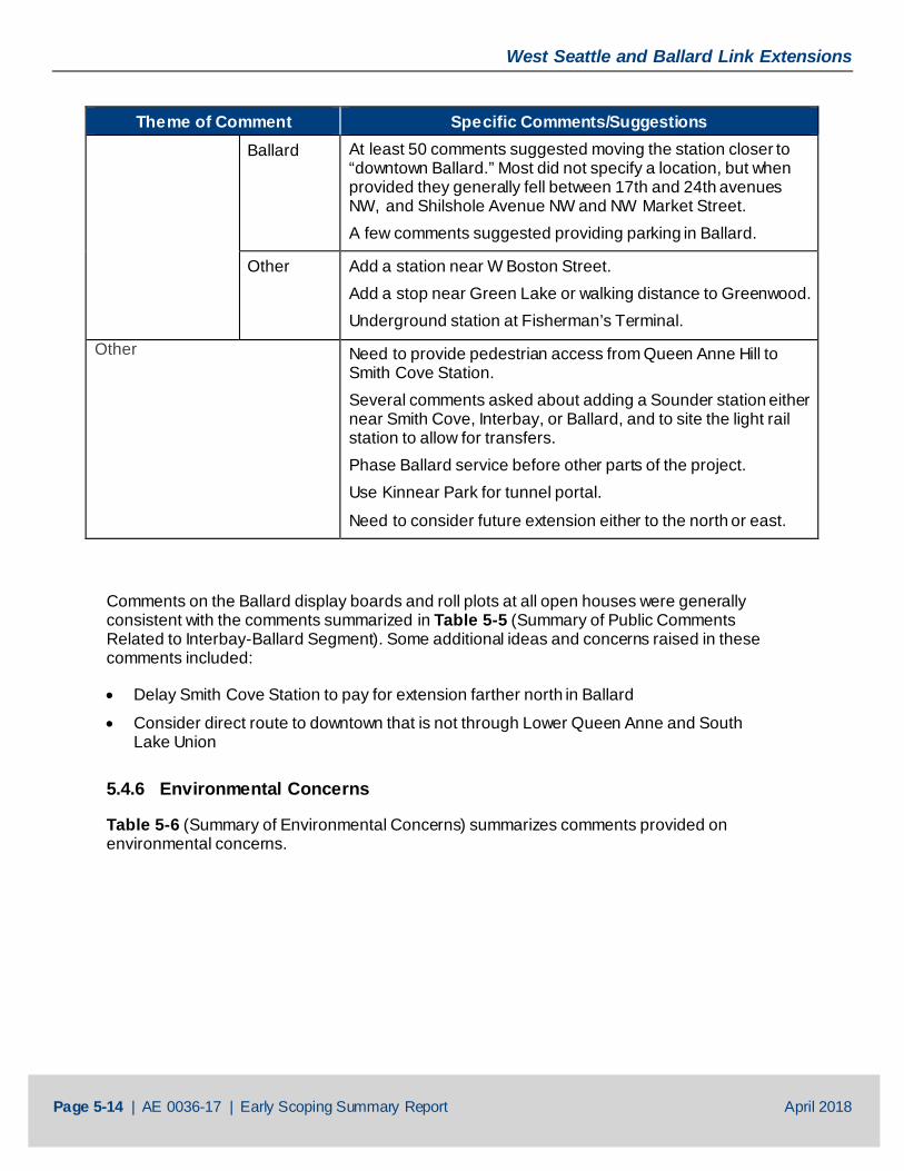
Theme of Comment Specific Comments/Suggestions Ballard At least 50 comments suggested moving the station closer to
“downtown Ballard.” Most did not specify a location, but when provided they generally fell between 17th and 24th avenues NW, and Shilshole Avenue NW and NW Market Street. A few comments suggested providing parking in Ballard.
Other Add a station near W Boston Street. Add a stop near Green Lake or walking distance to Greenwood. Underground station at Fisherman’s Terminal.
Other Need to provide pedestrian access from Queen Anne Hill to Smith Cove Station. Several comments asked about adding a Sounder station either near Smith Cove, Interbay, or Ballard, and to site the light rail station to allow for transfers. Phase Ballard service before other parts of the project. Use Kinnear Park for tunnel portal.
Need to consider future extension either to the north or east.
Comments on the Ballard display boards and roll plots at all open houses were generally consistent with the comments summarized in Table 5-5 (Summary of Public Comments Related to Interbay-Ballard Segment). Some additional ideas and concerns raised in these comments included:
• Delay Smith Cove Station to pay for extension farther north in Ballard
• Consider direct route to downtown that is not through Lower Queen Anne and South Lake Union
5.4.6 Environmental Concerns
Table 5-6 (Summary of Environmental Concerns) summarizes comments provided on environmental concerns.
West Seattle and Ballard Link Extensions
Page 5-15 | AE 0036-17 | Early Scoping Summary Report April 2018
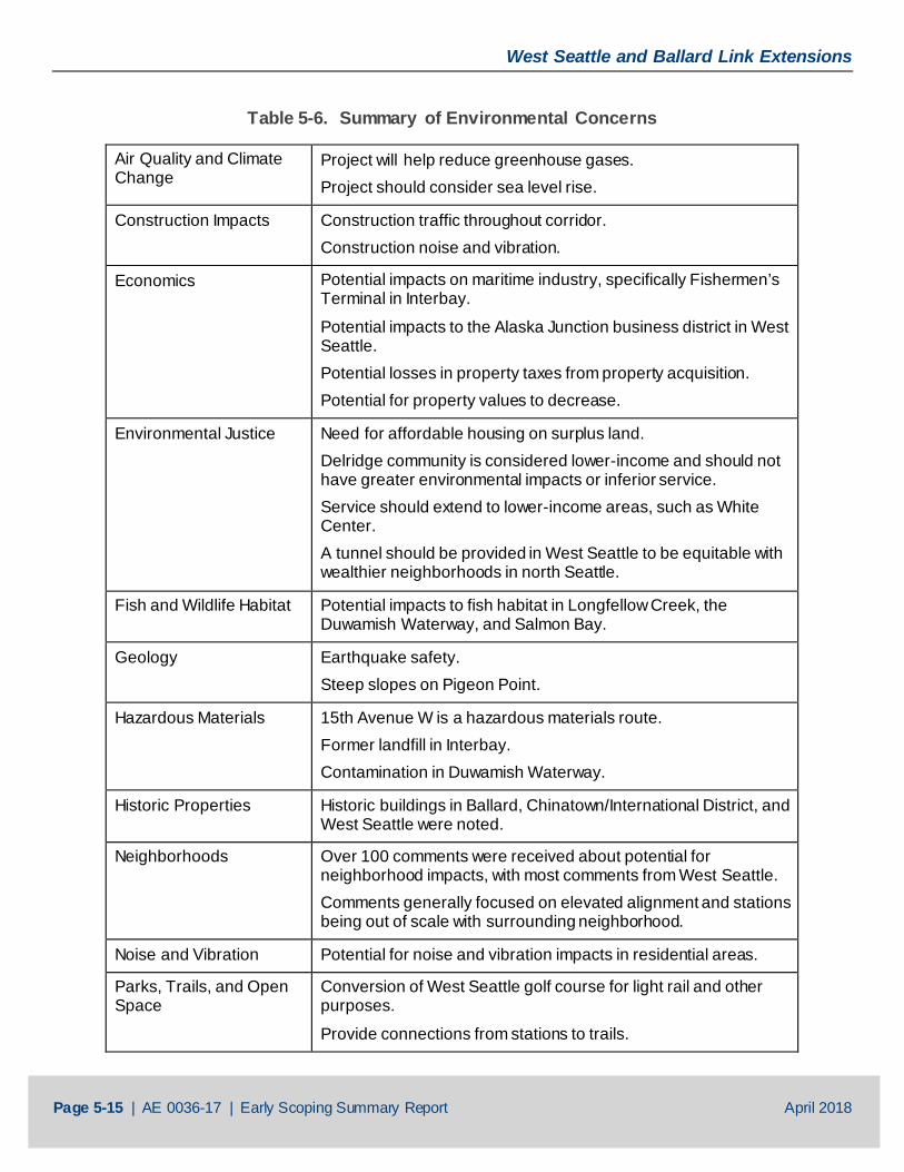
Table 5-6. Summary of Environmental Concerns
Air Quality and Climate Change
Project will help reduce greenhouse gases. Project should consider sea level rise.
Construction Impacts Construction traffic throughout corridor. Construction noise and vibration.
Economics Potential impacts on maritime industry, specifically Fishermen’s Terminal in Interbay.
Potential impacts to the Alaska Junction business district in West Seattle. Potential losses in property taxes from property acquisition. Potential for property values to decrease.
Environmental Justice Need for affordable housing on surplus land. Delridge community is considered lower-income and should not have greater environmental impacts or inferior service. Service should extend to lower-income areas, such as White Center. A tunnel should be provided in West Seattle to be equitable with wealthier neighborhoods in north Seattle.
Fish and Wildlife Habitat Potential impacts to fish habitat in Longfellow Creek, the Duwamish Waterway, and Salmon Bay.
Geology Earthquake safety. Steep slopes on Pigeon Point.
Hazardous Materials 15th Avenue W is a hazardous materials route. Former landfill in Interbay. Contamination in Duwamish Waterway.
Historic Properties Historic buildings in Ballard, Chinatown/International District, and West Seattle were noted.
Neighborhoods Over 100 comments were received about potential for neighborhood impacts, with most comments from West Seattle. Comments generally focused on elevated alignment and stations being out of scale with surrounding neighborhood.
Noise and Vibration Potential for noise and vibration impacts in residential areas.
Parks, Trails, and Open Space
Conversion of West Seattle golf course for light rail and other purposes.
Provide connections from stations to trails.
West Seattle and Ballard Link Extensions
Page 5-16 | AE 0036-17 | Early Scoping Summary Report April 2018
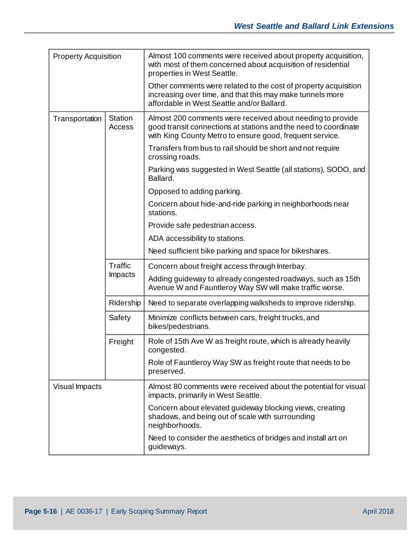
Property Acquisition Almost 100 comments were received about property acquisition, with most of them concerned about acquisition of residential properties in West Seattle. Other comments were related to the cost of property acquisition increasing over time, and that this may make tunnels more affordable in West Seattle and/or Ballard.
Transportation Station Access
Almost 200 comments were received about needing to provide good transit connections at stations and the need to coordinate with King County Metro to ensure good, frequent service. Transfers from bus to rail should be short and not require crossing roads. Parking was suggested in West Seattle (all stations), SODO, and Ballard.
Opposed to adding parking. Concern about hide-and-ride parking in neighborhoods near stations. Provide safe pedestrian access.
ADA accessibility to stations. Need sufficient bike parking and space for bikeshares.
Traffic Impacts
Concern about freight access through Interbay. Adding guideway to already congested roadways, such as 15th Avenue W and Fauntleroy Way SW will make traffic worse.
Ridership Need to separate overlapping walksheds to improve ridership.
Safety Minimize conflicts between cars, freight trucks, and bikes/pedestrians.
Freight Role of 15th Ave W as freight route, which is already heavily congested. Role of Fauntleroy Way SW as freight route that needs to be preserved.
Visual Impacts Almost 80 comments were received about the potential for visual impacts, primarily in West Seattle. Concern about elevated guideway blocking views, creating shadows, and being out of scale with surrounding neighborhoods. Need to consider the aesthetics of bridges and install art on guideways.
West Seattle and Ballard Link Extensions
Page 5-17 | AE 0036-17 | Early Scoping Summary Report April 2018
5.4.7 Operations
Almost 100 comments were received about operations, with the majority related to the movable bridge over Salmon Bay. Comments expressed concern about reliability and travel times with a movable bridge, and the impacts this could have on the entire system. Comments were also received about at-grade crossings in SODO and the potential for delays from interactions with cars in this area. Many comments encouraged Sound Transit to make all road crossings of both the existing and new line grade-separated.
Almost 200 comments requested planning for future extensions during the planning of this project. The following future extensions were supported:
• South to White Center and Burien from West Seattle
• South to Georgetown from SODO
• East to Madison Valley from Midtown
• North on Aurora Avenue N from South Lake Union
• North to Crown Hill or beyond from Ballard
• East to the UW from Ballard
5.4.8 Station Design, Urban Form, and Transit-Oriented Development
Over 400 comments discussed station locations and amenities, with most of these comments suggesting revised or new station locations. They are summarized by geographic segment above in Section 5.4.2 to Section 5.4.5. Over 60 additional comments discussed urban design and TOD.
People were generally in favor of increasing density, building TOD, and creating affordable housing near or on top of stations. Some people asked for commercial hubs or mixed-use development at stations, while others suggested including public open space at stations.
Several comments were concerned with access/egress at stations and referenced overcrowding issues at the Capitol Hill and University of Washington stations. Suggestions included having several sets of stairs and/or escalators, having wider station platforms or center platforms, and including several exits. Several comments also suggested creating access from stations to all four corners of an intersection was beneficial for pedestrians. Specific station design suggestions included:
• Provide lit, covered, and monitored bike parking
• Provide large glass elevators
• Build solar-powered stations
• Prioritize the customer experience instead of minimizing impacts
• Make multimodal connections as easy as possible
• Design stations with enough room for bus layovers and drop-off areas
• Provide adequate maintenance budget to keep new downtown stations clean
West Seattle and Ballard Link Extensions
Page 5-18 | AE 0036-17 | Early Scoping Summary Report April 2018
5.4.9 Organizations
Table 5-7 (Summary of Organization Comments) summarizes the comments submitted on behalf of community organizations during early scoping. Copies of these letters are available in Appendix F (Public Comments).
Table 5-7. Summary of Organization Comments
Organization Comments Ballard Alliance The Ballard Alliance provided comments expressing concern about
the Representative Project related to traffic impacts, mobility and capacity on 15th Avenue W, and impacts to aquatic habitat from a new bridge over Salmon Bay. It recommended analysis of a tunnel alternative for better reliability and avoiding impacts to aquatic habitat. It also recommended evaluation of construction and permanent impacts on traffic, potential for future extensions, and the impact of stations on businesses and infrastructure.
Junction Neighborhood Organization (JuNO)
JuNO submitted comments requesting a tunnel for the portion of the project alignment in Alaska Junction, suggesting an underground station at SW Alaska Street between 40th and 41st avenues SW with space for bus transfer and vehicle drop-off as well as public open space, and removing the Avalon Station. It also suggested making SW Alaska Street a pedestrian street, encouraged density at the “Triangle” and construction of a private parking garage, and suggested station entrances on the east side of Fauntleroy Way SW. It felt this would allow the City of Seattle to move forward with planned improvements to Fauntleroy Way SW and would be more consistent with the neighborhood plan policies and goals. It included a presentation that provided additional information and graphics on these concepts, including three suggested locations for tunnel entrances from either SW Genesee Street or within the West Seattle Golf Course.
Northwest Seattle Coalition The Northwest Seattle Coalition provided comments requesting Sound Transit prioritize long-term reliability and future expansion, and minimize impacts to other modes of transportation when studying alternatives. It advocated for an alignment through Interbay on 20th Avenue W with a below-grade station at W Dravus Street, and then tunneling under the Ship Canal with a below-grade station under NW Market Street (ST 3 Candidate Project C-01c). It expressed concern about the Representative Project related to system reliability with a movable bridge and traffic impacts on freight, transit, and vehicles on 15th Avenue W.
West Seattle and Ballard Link Extensions
Page 5-19 | AE 0036-17 | Early Scoping Summary Report April 2018
Organization Comments Queen Anne Community Council
The Queen Anne Community Council submitted comments supporting an alignment through Interbay on 20th Avenue W before entering a tunnel under Salmon Bay near 22nd Avenue W (ST 3 Candidate Project C-01c). It supports this alignment because it is concerned about loss of capacity on 15th Avenue W and the related potential traffic impacts as well as impacts on Fishermen’s Terminal.
Seattle Subway Seattle Subway, a nonprofit organization supporting transit in Seattle, submitted comments regarding:
• Reliability in Ballard and SODO
• Future expandability north from the Ballard and South Lake Union stations, east from Midtown Station, and south from the SODO and Alaska Junction stations
• Accessibility for pedestrians, bikes, and bus transfers
Transit Access Stakeholders The Transit Access Stakeholders provided comments requesting Sound Transit to consider:
• Maximizing opportunities for equitable TOD and density
• Prioritizing alignments that increase opportunities for affordable housing
• Maximizing reliability
• Using a race and social justice lens in decision making
• Using authentic, early, and robust community engagement with diverse communities (in addition to the Stakeholder Advisory Group)
• Minimizing displacement and ensuring equitable relocation
• Planning for the future
West Seattle Junction Association
The West Seattle Junction Association submitted comments supporting the comments provided by JuNO. Its primary concerns were related to impacts to nearby residents, businesses, pedestrians, and the overall neighborhood feel. It also advocated for aligning the terminus south for future extension, and it sees the tunnel station as an opportunity for additional open space. The need for each station to be served by transit, with direct bus-to-rail transfers (no street crossings) was also emphasized. While it prefers a tunnel, the comments stated that if the station must be above-grade, a location within a block of the center of the Junction would be preferred instead of farther away on Fauntleroy Way SW.
West Seattle and Ballard Link Extensions
Page 5-20 | AE 0036-17 | Early Scoping Summary Report April 2018
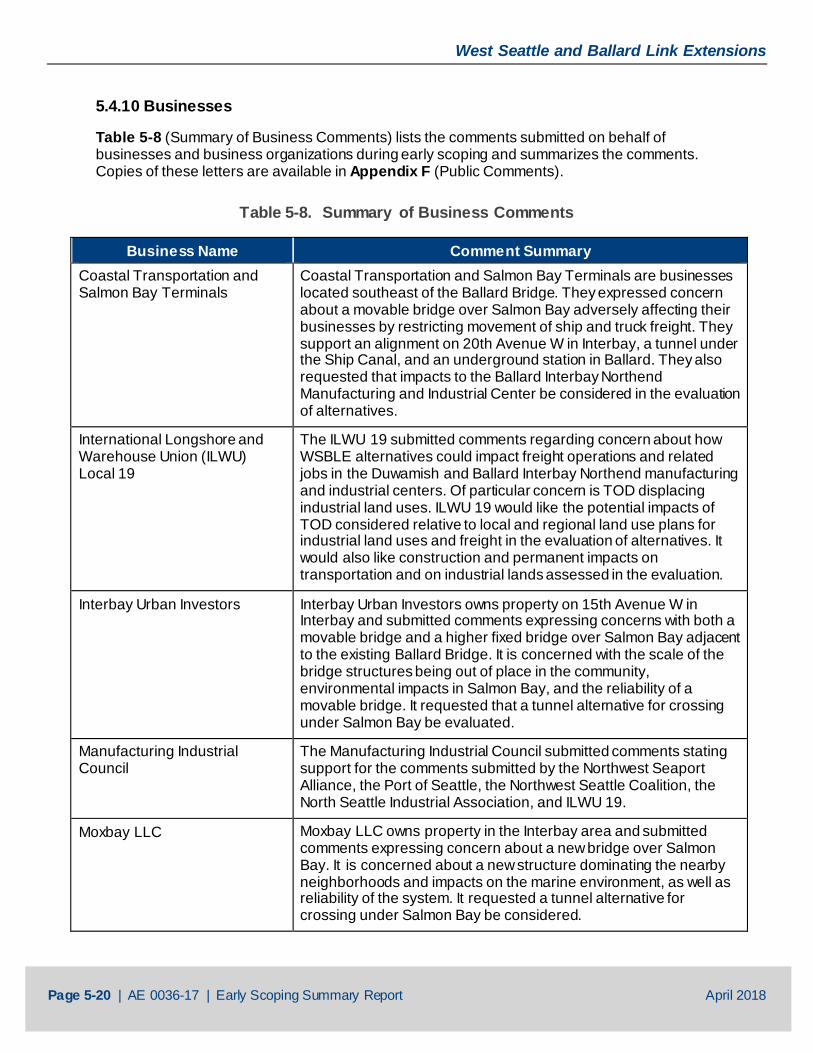
5.4.10 Businesses
Table 5-8 (Summary of Business Comments) lists the comments submitted on behalf of businesses and business organizations during early scoping and summarizes the comments. Copies of these letters are available in Appendix F (Public Comments).
Table 5-8. Summary of Business Comments
Business Name Comment Summary Coastal Transportation and Salmon Bay Terminals
Coastal Transportation and Salmon Bay Terminals are businesses located southeast of the Ballard Bridge. They expressed concern about a movable bridge over Salmon Bay adversely affecting their businesses by restricting movement of ship and truck freight. They support an alignment on 20th Avenue W in Interbay, a tunnel under the Ship Canal, and an underground station in Ballard. They also requested that impacts to the Ballard Interbay Northend Manufacturing and Industrial Center be considered in the evaluation of alternatives.
International Longshore and Warehouse Union (ILWU) Local 19
The ILWU 19 submitted comments regarding concern about how WSBLE alternatives could impact freight operations and related jobs in the Duwamish and Ballard Interbay Northend manufacturing and industrial centers. Of particular concern is TOD displacing industrial land uses. ILWU 19 would like the potential impacts of TOD considered relative to local and regional land use plans for industrial land uses and freight in the evaluation of alternatives. It would also like construction and permanent impacts on transportation and on industrial lands assessed in the evaluation.
Interbay Urban Investors Interbay Urban Investors owns property on 15th Avenue W in Interbay and submitted comments expressing concerns with both a movable bridge and a higher fixed bridge over Salmon Bay adjacent to the existing Ballard Bridge. It is concerned with the scale of the bridge structures being out of place in the community, environmental impacts in Salmon Bay, and the reliability of a movable bridge. It requested that a tunnel alternative for crossing under Salmon Bay be evaluated.
Manufacturing Industrial Council
The Manufacturing Industrial Council submitted comments stating support for the comments submitted by the Northwest Seaport Alliance, the Port of Seattle, the Northwest Seattle Coalition, the North Seattle Industrial Association, and ILWU 19.
Moxbay LLC Moxbay LLC owns property in the Interbay area and submitted comments expressing concern about a new bridge over Salmon Bay. It is concerned about a new structure dominating the nearby neighborhoods and impacts on the marine environment, as well as reliability of the system. It requested a tunnel alternative for crossing under Salmon Bay be considered.
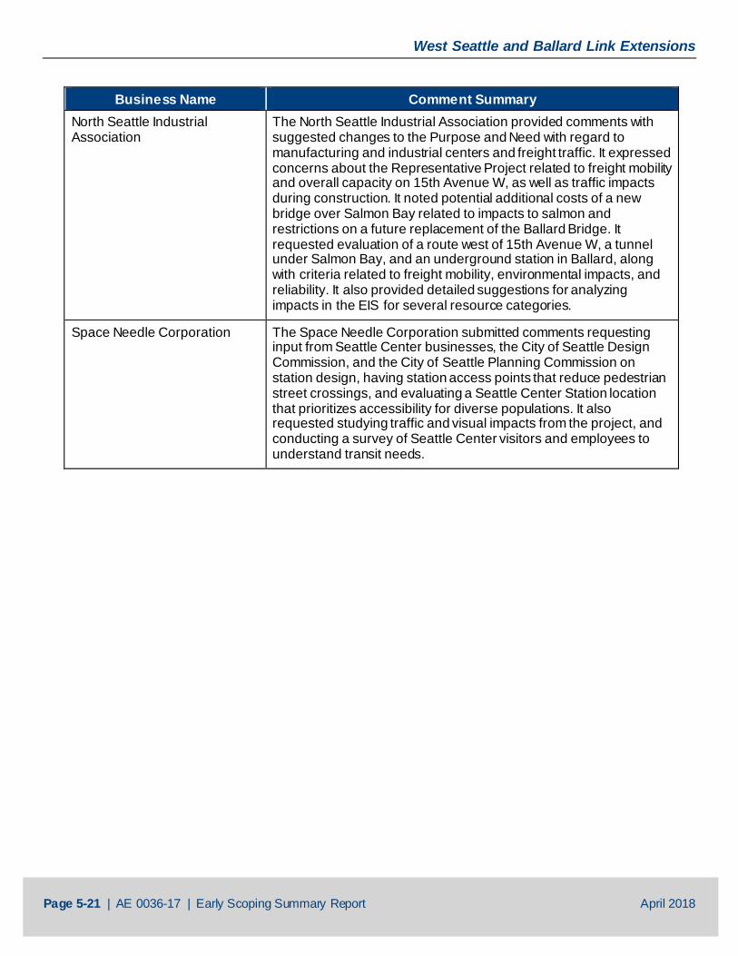
West Seattle and Ballard Link Extensions
Page 5-21 | AE 0036-17 | Early Scoping Summary Report April 2018
Business Name Comment Summary North Seattle Industrial Association
The North Seattle Industrial Association provided comments with suggested changes to the Purpose and Need with regard to manufacturing and industrial centers and freight traffic. It expressed concerns about the Representative Project related to freight mobility and overall capacity on 15th Avenue W, as well as traffic impacts during construction. It noted potential additional costs of a new bridge over Salmon Bay related to impacts to salmon and restrictions on a future replacement of the Ballard Bridge. It requested evaluation of a route west of 15th Avenue W, a tunnel under Salmon Bay, and an underground station in Ballard, along with criteria related to freight mobility, environmental impacts, and reliability. It also provided detailed suggestions for analyzing impacts in the EIS for several resource categories.
Space Needle Corporation The Space Needle Corporation submitted comments requesting input from Seattle Center businesses, the City of Seattle Design Commission, and the City of Seattle Planning Commission on station design, having station access points that reduce pedestrian street crossings, and evaluating a Seattle Center Station location that prioritizes accessibility for diverse populations. It also requested studying traffic and visual impacts from the project, and conducting a survey of Seattle Center visitors and employees to understand transit needs.
West Seattle and Ballard Link Extensions
Page 6-1 | AE 0036-17 | Early Scoping Summary Report April 2018
6 NEXT STEPS Following early scoping, Sound Transit will develop an initial list of alternatives, including alternatives that emerge as a result of public and agency early scoping comments. Next, Sound Transit will evaluate the alternatives based on their ability to satisfy the project’s Purpose and Need and how well they perform relative to other alternatives, using criteria such as transportation benefits, technical feasibility, modal integration, cost, ridership, communities and populations served, land use benefits, and environmental impacts. Following this evaluation, Sound Transit and FTA are expected to issue a Notice of Intent to prepare an EIS and initiate environmental scoping to solicit public, agency, and tribe comments on the updated Purpose and Need, alternatives to evaluate in the EIS, and potential impacts and benefits of alternatives. The Sound Transit Board will then identify a Preferred Alternative based on the evaluation results, public and agency scoping comments, and input from the Stakeholder Advisory Group and Elected Leadership Group. They will also identify other alternatives to study in the EIS. This will be followed by further engineering, environmental analysis, and public involvement work on the project, leading to final decisions about the project to be built and operated in the project area.
AE 0036-17 | Early Scoping Summary Report
April 2018
APPENDIX A
SEPA Register Notice
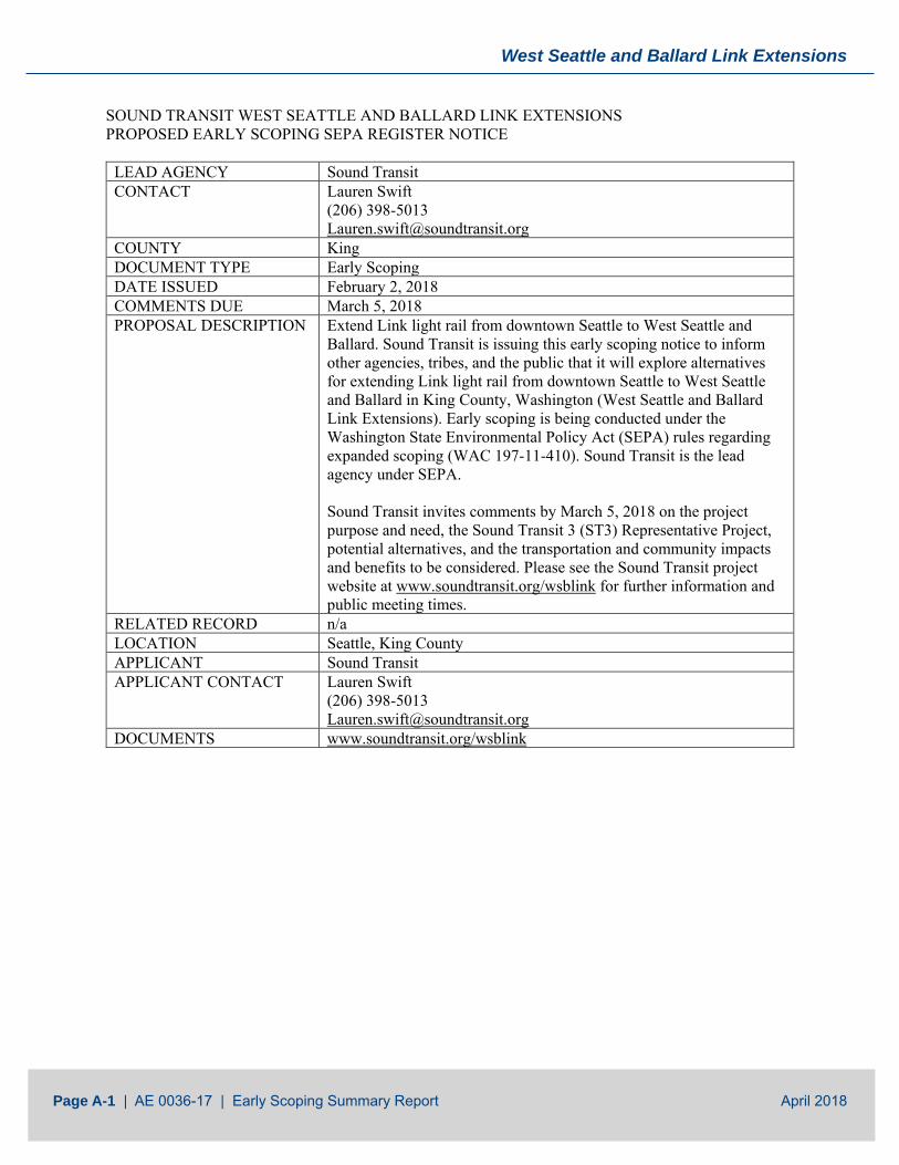
West Seattle and Ballard Link Extensions
Page A-1 | AE 0036-17 | Early Scoping Summary Report April 2018
SOUND TRANSIT WEST SEATTLE AND BALLARD LINK EXTENSIONS PROPOSED EARLY SCOPING SEPA REGISTER NOTICE
LEAD AGENCY Sound Transit CONTACT Lauren Swift
(206) 398-5013 [email protected]
COUNTY King DOCUMENT TYPE Early Scoping DATE ISSUED February 2, 2018 COMMENTS DUE March 5, 2018 PROPOSAL DESCRIPTION Extend Link light rail from downtown Seattle to West Seattle and
Ballard. Sound Transit is issuing this early scoping notice to inform other agencies, tribes, and the public that it will explore alternatives for extending Link light rail from downtown Seattle to West Seattle and Ballard in King County, Washington (West Seattle and Ballard Link Extensions). Early scoping is being conducted under the Washington State Environmental Policy Act (SEPA) rules regarding expanded scoping (WAC 197-11-410). Sound Transit is the lead agency under SEPA. Sound Transit invites comments by March 5, 2018 on the project purpose and need, the Sound Transit 3 (ST3) Representative Project, potential alternatives, and the transportation and community impacts and benefits to be considered. Please see the Sound Transit project website at www.soundtransit.org/wsblink for further information and public meeting times.
RELATED RECORD n/a LOCATION Seattle, King County APPLICANT Sound Transit APPLICANT CONTACT Lauren Swift
(206) 398-5013 [email protected]
DOCUMENTS www.soundtransit.org/wsblink
AE 0036-17 | Early Scoping Summary Report
April 2018
APPENDIX B
Early Scoping Information Report
Link Extensions
West Seattle and Ballard
Early Scoping Information Report
February 2018
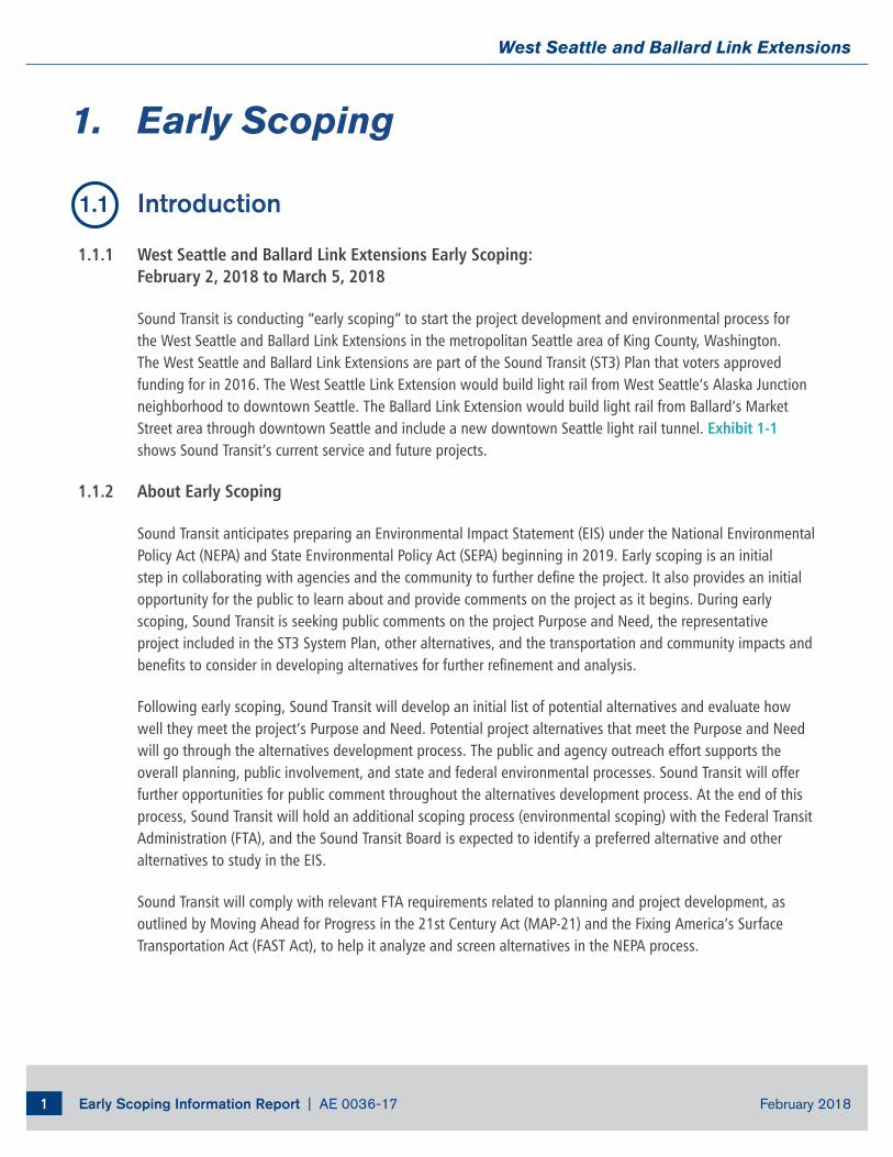
Early Scoping Information Report | AE 0036-17 February 20181
West Seattle and Ballard Link Extensions
1. Early Scoping
1.1 Introduction
1.1.1 West Seattle and Ballard Link Extensions Early Scoping: February 2, 2018 to March 5, 2018
Sound Transit is conducting “early scoping” to start the project development and environmental process for the West Seattle and Ballard Link Extensions in the metropolitan Seattle area of King County, Washington. The West Seattle and Ballard Link Extensions are part of the Sound Transit (ST3) Plan that voters approved funding for in 2016. The West Seattle Link Extension would build light rail from West Seattle’s Alaska Junction neighborhood to downtown Seattle. The Ballard Link Extension would build light rail from Ballard’s Market Street area through downtown Seattle and include a new downtown Seattle light rail tunnel. Exhibit 1-1 shows Sound Transit’s current service and future projects.
1.1.2 About Early Scoping
Sound Transit anticipates preparing an Environmental Impact Statement (EIS) under the National Environmental Policy Act (NEPA) and State Environmental Policy Act (SEPA) beginning in 2019. Early scoping is an initial step in collaborating with agencies and the community to further define the project. It also provides an initial opportunity for the public to learn about and provide comments on the project as it begins. During early scoping, Sound Transit is seeking public comments on the project Purpose and Need, the representative project included in the ST3 System Plan, other alternatives, and the transportation and community impacts and benefits to consider in developing alternatives for further refinement and analysis.
Following early scoping, Sound Transit will develop an initial list of potential alternatives and evaluate how well they meet the project’s Purpose and Need. Potential project alternatives that meet the Purpose and Need will go through the alternatives development process. The public and agency outreach effort supports the overall planning, public involvement, and state and federal environmental processes. Sound Transit will offer further opportunities for public comment throughout the alternatives development process. At the end of this process, Sound Transit will hold an additional scoping process (environmental scoping) with the Federal Transit Administration (FTA), and the Sound Transit Board is expected to identify a preferred alternative and other alternatives to study in the EIS.
Sound Transit will comply with relevant FTA requirements related to planning and project development, as outlined by Moving Ahead for Progress in the 21st Century Act (MAP-21) and the Fixing America’s Surface Transportation Act (FAST Act), to help it analyze and screen alternatives in the NEPA process.
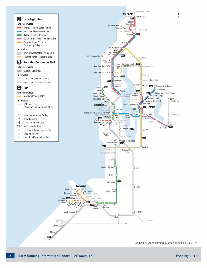
Early Scoping Information Report | AE 0036-17 February 20182
West Seattle and Ballard Link Extensions
Kingsgate/Totem Lake
South Everett
Downtown Everett
NE 85th
Brickyard
Canyon Park
Woodinville
Bonney LakeSouth Hill
LakewoodTowne Center
NE 44th
South Renton
IssaquahHighlands
SouthSammamish
NorthSammamish
Burien
WestwoodVillage
Kirkland
EvergreenPoint
LakeForest
Park
Kenmore Bothell
Edmonds
Mukilteo
Tukwila
Puyallup
Sumner
Kent
Auburn
Tillicum
DuPont
South Tacoma
Lakewood
& King StreetInternational District/Chinatown
SeaTac/Airport
Angle Lake
University ofWashington
Capitol Hill
MountBaker
Columbia City
Rainier Beach
Othello
Tukwila/International
Blvd
BeaconHill
Westlake
Pioneer SquareUniversity Street
Stadium
SODO
Convention CenterTheater District
Union StationS 25th
Roosevelt
Shoreline North/185th
Shoreline South/145th
NE 130th
Northgate
U District
Bellevue Downtown
Midtown
MountlakeTerrace
SE Redmond
Downtown Redmond
Spring District/120th
Overlake Village
S Graham St
S Boeing Access Rd
Lakemont
Redmond Technology Center
S 4thOld City Hall
S 272nd
Kent/DesMoines
Federal Way
SouthFederal Way
Stadium District
6th AvenueHilltop District
St Jos
eph
Tacoma General
TacomaDome
EastTacomaSp
rague
Ainswor
th
Steve
nsUnio
n
Ballard
Interbay
Smith CoveSeattle CenterSouth Lake Union
TacomaCommunity
College
Mariner
SW EverettIndustrial Center
SR 99/Airport Rd
West Alderwood
LynnwoodCity Center
MercerIsland
JudkinsPark
AlaskaJunction
Avalon
Delridg
e
Denny
East Main
Wilburton
SouthBellevue
Bel-Red/130th
Eastgate
Richards Rd
SR 526/Evergreen
SouthKirkland
Ash Way
FifePearl
Issaquah
EverettEverett
BellevueSeattle
Tacoma
2021
2036
2024
2024
2023
2035
2031
2036
2031
2024
2041
2030
2031
2041
2039
2036
2024
2024
2030
2022
2024
2024
Link Light RailFuture service:
Everett–Seattle–West SeattleRedmond–Seattle–MarinerBallard–Seattle–TacomaIssaquah–Bellevue–South KirklandTacoma Dome–TacomaCommunity College
In service:Univ. of Washington–Angle LakeTacoma Dome–Theater District
Sounder Commuter RailFuture service:
DuPont–Lakewood
In service:North Line (Everett–Seattle)South Line (Lakewood–Seattle)
BusFuture service:
Bus Rapid Transit (BRT)
In service:ST Express bus(service re-evaluated annually)
New station or bus facilityAdded parkingStation improvementsMajor transfer hubExisting station or bus facilityExisting parkingProvisional light rail station
Exhibit 1-1: Sound Transit current service and future projects
Early Scoping Information Report | AE 0036-17 February 20183
West Seattle and Ballard Link Extensions
1.1.3 Public and Agency Early Scoping Meetings
Early scoping includes a public comment period that is open until March 5, 2018 with three public meetings as well as an online open house option. The public meetings will be held at the following locations and times:
West Seattle: Tuesday, February 13, 2018, 6:30-8:30 p.m. — Alki Masonic Center, 4736 40th Ave. S.W.
Ballard: Thursday, February 15, 2018, 6:30-8:30 p.m. — Leif Erikson Lodge, 2245 N.W. 57th St.
Downtown Seattle: Tuesday, February 20, 2018, 5:30-7:30 p.m. — Union Station, 401 S. Jackson St.
Online open house: February 12–March 5, 2018 — wsblink.participate.online
A separate early scoping meeting will also be conducted with agencies and tribes to present project information and receive comments. Invitations to the agency scoping meeting and public scoping meetings will be sent to the appropriate federal, tribal, state, and local governments.
1.1.4 Ways to Provide Comments
Written scoping comments are requested by March 5, 2018 and can be sent or emailed to the addresses below, submitted at the public meetings, or provided via the online comment form available at wsblink.participate.online.
Mailing Address: West Seattle and Ballard Link Extensions (c/o Lauren Swift) Sound Transit, 401 S. Jackson Street, Seattle, WA 98104-2826
Email: [email protected]
1.2 The West Seattle and Ballard Link Extensions and the Regional Transit System
1.2.1 Representative Project
Based on years of previous planning studies (see Section 1.4.1 below), the representative project for the West Seattle and Ballard Link Extensions identified the mode, corridor, and station areas for the project. It also informed the project’s cost, schedule, and operating needs. Exhibit 1-2 shows the ST3 representative project for the West Seattle and Ballard Link Extensions.
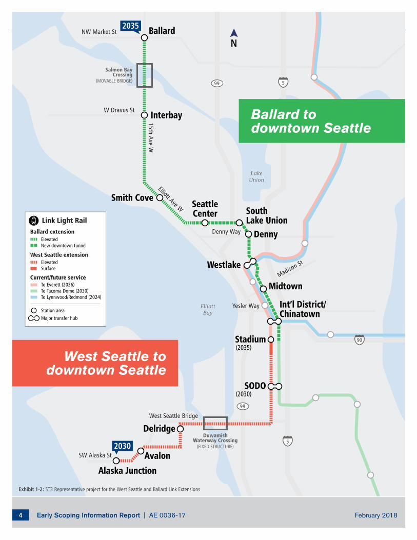
Early Scoping Information Report | AE 0036-17 February 20184
West Seattle and Ballard Link Extensions
LakeUnion
ElliottBay
West Seattle Bridge
Denny Way
Yesler Way
SW Alaska St
W Dravus St
15th Ave WElliott Ave W
Madison St
NW Market St
Ballard todowntown Seattle
West Seattle todowntown Seattle
2030
2035
Salmon BayCrossing
(MOVABLE BRIDGE)
DuwamishWaterway Crossing
(FIXED STRUCTURE)
Stadium
SODO
Delridge
Avalon
Alaska Junction
SouthLake Union
Int’l District/Chinatown
Westlake
Denny
Midtown
SeattleCenter
Smith Cove
Interbay
Ballard
(2035)
(2030)
ElevatedNew downtown tunnel
ElevatedSurface
To Everett (2036)To Tacoma Dome (2030)To Lynnwood/Redmond (2024)
Ballard extension
Link Light Rail
West Seattle extension
Current/future service
Station areaMajor transfer hub
Exhibit 1-2: ST3 Representative project for the West Seattle and Ballard Link Extensions
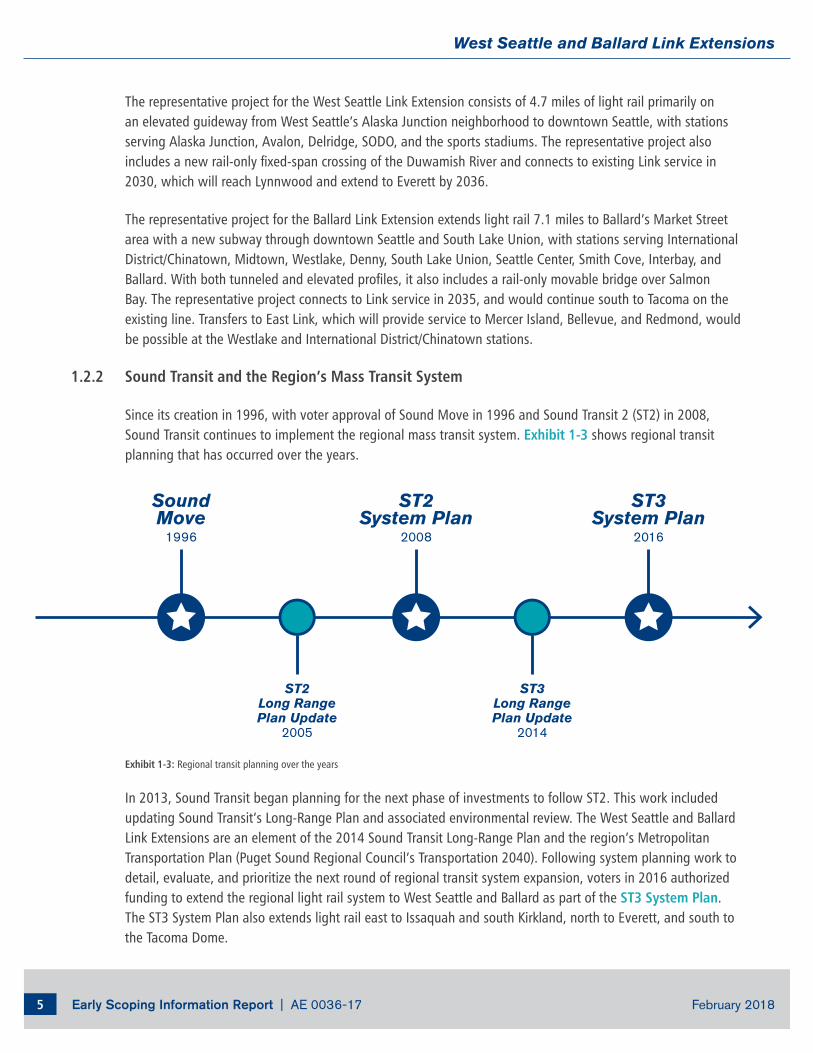
Early Scoping Information Report | AE 0036-17 February 20185
West Seattle and Ballard Link Extensions
ST2Long RangePlan Update
2005
ST3Long RangePlan Update
2014
SoundMove
1996
ST2System Plan
2008
ST3System Plan
2016
Sound Transit 3System Planning
2015–2016
Ballard to DowntownHCT Study
2013–2014
Seattle MonorailProject
2005
South King CountyHCT Study
2013–2014
The representative project for the West Seattle Link Extension consists of 4.7 miles of light rail primarily on an elevated guideway from West Seattle’s Alaska Junction neighborhood to downtown Seattle, with stations serving Alaska Junction, Avalon, Delridge, SODO, and the sports stadiums. The representative project also includes a new rail-only fixed-span crossing of the Duwamish River and connects to existing Link service in 2030, which will reach Lynnwood and extend to Everett by 2036.
The representative project for the Ballard Link Extension extends light rail 7.1 miles to Ballard’s Market Street area with a new subway through downtown Seattle and South Lake Union, with stations serving International District/Chinatown, Midtown, Westlake, Denny, South Lake Union, Seattle Center, Smith Cove, Interbay, and Ballard. With both tunneled and elevated profiles, it also includes a rail-only movable bridge over Salmon Bay. The representative project connects to Link service in 2035, and would continue south to Tacoma on the existing line. Transfers to East Link, which will provide service to Mercer Island, Bellevue, and Redmond, would be possible at the Westlake and International District/Chinatown stations.
1.2.2 Sound Transit and the Region’s Mass Transit System
Since its creation in 1996, with voter approval of Sound Move in 1996 and Sound Transit 2 (ST2) in 2008, Sound Transit continues to implement the regional mass transit system. Exhibit 1-3 shows regional transit planning that has occurred over the years.
Exhibit 1-3: Regional transit planning over the years
In 2013, Sound Transit began planning for the next phase of investments to follow ST2. This work included updating Sound Transit’s Long-Range Plan and associated environmental review. The West Seattle and Ballard Link Extensions are an element of the 2014 Sound Transit Long-Range Plan and the region’s Metropolitan Transportation Plan (Puget Sound Regional Council’s Transportation 2040). Following system planning work to detail, evaluate, and prioritize the next round of regional transit system expansion, voters in 2016 authorized funding to extend the regional light rail system to West Seattle and Ballard as part of the ST3 System Plan. The ST3 System Plan also extends light rail east to Issaquah and south Kirkland, north to Everett, and south to the Tacoma Dome.
Early Scoping Information Report | AE 0036-17 February 20186
West Seattle and Ballard Link Extensions
Mass Transit and the Region’s Plans for Managing Growth
The Puget Sound region, which includes urbanized King, Pierce, Snohomish, and Kitsap counties, has coordinated regional, county, and local plans that guide how the region manages growth. Puget Sound Regional Council’s Vision 2040 and Transportation 2040, which reflect Sound Transit’s Long-Range Plan (2014), have policies that focus growth in urban centers and assume the regional mass transit system will link the urban centers. County and city comprehensive plan policies reinforce the need for mass transit investments to support new population and employment growth in concentrated centers.
1.3 Developing the “Purpose and Need”
To guide decision making during the alternatives development and to support the project’s state and federal environmental reviews, Sound Transit has developed a draft statement of why this project is being proposed. This is known as the “Purpose and Need.” This statement and criteria derived from this statement are used to evaluate alternatives, leading to the identification of the alternatives to study further during the environmental review process. The Purpose and Need statement will continue to be developed and refined to reflect public and agency comments as the project moves forward.
1.3.1 Purpose and Need of the West Seattle and Ballard Link Extensions
The purpose of the West Seattle and Ballard Link Extensions is to expand the Link light rail system from downtown Seattle to West Seattle and Ballard and to increase capacity and connectivity for regional connections in order to:
• Provide high quality rapid, reliable, and efficient peak and off-peak light rail transit service to communities in the West Seattle and Ballard corridors.
• Improve regional mobility by increasing connectivity and capacity through downtown Seattle to meet projected transit demand.
• Connect regional growth centers as described in adopted regional and local land use, transportation, and economic development plans and Sound Transit’s Regional Transit Long-Range Plan (Sound Transit, 2014).
• Implement a system that is consistent with the Sound Transit 3 (ST3) Plan (Sound Transit, 2016) that established transit mode, corridor, and station locations and that is technically feasible and financially sustainable to build, operate, and maintain.
• Expand mobility for the corridor and region’s residents, which include transit dependent, low income, and minority populations.
• Encourage equitable and sustainable urban growth in station areas through support of transit-oriented development, station access, and modal integration in a manner that is consistent with local land use plans.
Early Scoping Information Report | AE 0036-17 February 20187
West Seattle and Ballard Link Extensions
• Preserve and promote a healthy environment by minimizing adverse impacts on the natural and built environments through sustainable practices.
The project is needed because:
• Increasing roadway congestion on transit routes between downtown Seattle, West Seattle, and Ballard will continue to degrade transit performance and reliability.
• Regional population and employment growth will increase operational demands on the downtown Seattle transit tunnel.
• Regional and local plans call for high capacity transit (HCT) in the corridor consistent with Puget Sound Regional Council’s (PSRC’s) VISION 2040 (PSRC, 2009) and Sound Transit’s Regional Transit Long-Range Plan (Sound Transit, 2014).
• The region’s citizens and communities, including travel-disadvantaged residents and low income and minority population, need long-term regional mobility and multimodal connectivity.
• Regional and local plans call for increased residential and employment density at and around HCT stations, and increased options for multi-modal access.
• Environmental and sustainability goals of the state and region include reducing total vehicles miles traveled and greenhouse gas emissions.
1.4 Potential Alternatives
1.4.1 Previous Planning Studies
Years of previous planning studies resulted in the representative project for the West Seattle and Ballard Link Extensions included in the ST3 System Plan. The Summary of Previous Studies and Plans describes key studies in greater detail. Key studies include:
Seattle Monorail Project: The Seattle Popular Monorail Authority studied a 14-mile corridor that would extend monorail from Ballard through downtown Seattle to West Seattle in an EIS published in 2005. The EIS examined various alignment options, including a West Alternative, East Alternative, and other options/linkages.
South King County — HCT Corridor Study: Sound Transit conducted a high-capacity transit (HCT) study in 2013-2014. The study evaluated multiple corridors and modes for extending HCT from downtown Seattle to West Seattle, Burien, Tukwila, and Renton.
Ballard to Downtown — Transit Expansion Study: This HCT study, supporting both the Seattle Master Plan and Sound Transit long range planning, was performed in 2013-2014 in partnership between the City of Seattle and Sound Transit. The study looked at multiple corridors for expanding HCT.
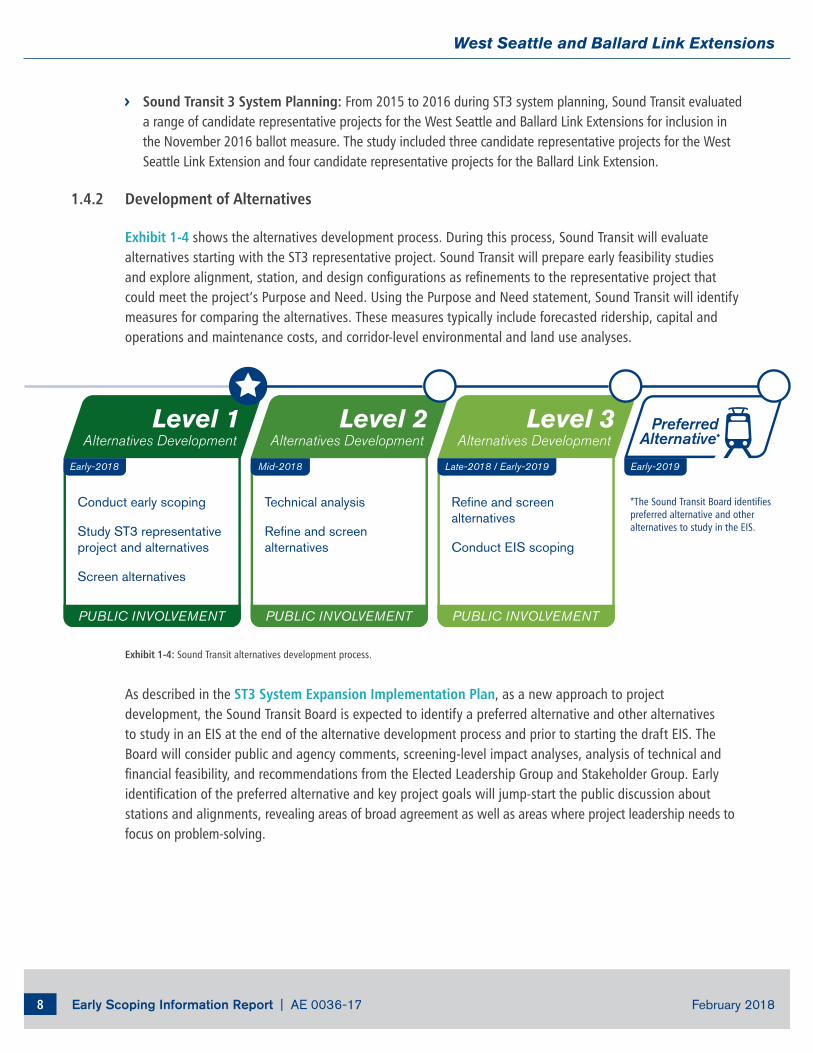
Early Scoping Information Report | AE 0036-17 February 20188
West Seattle and Ballard Link Extensions
Mid-2018
PUBLIC INVOLVEMENT
Late-2018 / Early-2019
PUBLIC INVOLVEMENT
Preferred Alternative*
Early-2019Early-2018
Conduct early scoping
Study ST3 representative project and alternatives
Screen alternatives
Technical analysis
Refine and screen alternatives
Refine and screen alternatives
Conduct EIS scoping
Level 1Alternatives Development
Level 2Alternatives Development
Level 3Alternatives Development
PUBLIC INVOLVEMENT
*The Sound Transit Board identifies preferred alternative and other alternatives to study in the EIS.
Sound Transit 3 System Planning: From 2015 to 2016 during ST3 system planning, Sound Transit evaluated a range of candidate representative projects for the West Seattle and Ballard Link Extensions for inclusion in the November 2016 ballot measure. The study included three candidate representative projects for the West Seattle Link Extension and four candidate representative projects for the Ballard Link Extension.
1.4.2 Development of Alternatives
Exhibit 1-4 shows the alternatives development process. During this process, Sound Transit will evaluate alternatives starting with the ST3 representative project. Sound Transit will prepare early feasibility studies and explore alignment, station, and design configurations as refinements to the representative project that could meet the project’s Purpose and Need. Using the Purpose and Need statement, Sound Transit will identify measures for comparing the alternatives. These measures typically include forecasted ridership, capital and operations and maintenance costs, and corridor-level environmental and land use analyses.
Exhibit 1-4: Sound Transit alternatives development process.
As described in the ST3 System Expansion Implementation Plan, as a new approach to project development, the Sound Transit Board is expected to identify a preferred alternative and other alternatives to study in an EIS at the end of the alternative development process and prior to starting the draft EIS. The Board will consider public and agency comments, screening-level impact analyses, analysis of technical and financial feasibility, and recommendations from the Elected Leadership Group and Stakeholder Group. Early identification of the preferred alternative and key project goals will jump-start the public discussion about stations and alignments, revealing areas of broad agreement as well as areas where project leadership needs to focus on problem-solving.
Early Scoping Information Report | AE 0036-17 February 20189
West Seattle and Ballard Link Extensions
1.5 Project Timeline and Next Steps
Following early scoping, Sound Transit will summarize the early scoping process and comments in an Early Scoping Summary Report. Sound Transit will also develop an initial list of potential alternatives that emerge as a result of early scoping comments and evaluate how well they meet the project’s Purpose and Need. Additional screening evaluation for alternatives found to meet the Purpose and Need will include additional design; analysis of environmental impacts; coordination with the Elected Leadership Group, Stakeholder Group, and Interagency Group; and additional opportunities for public input.
Elected Leadership Group
The Elected Leadership Group is composed of Sound Transit Board members and other local elected officials in the corridor. Its purpose is to build consensus around key decisions and work through project issues as needed.
Stakeholder Advisory Group
The Stakeholder Advisory Group is composed of transit riders, residents, business owners, major institutional representatives, community organizations and other members of the public. Its purpose is to build consensus around key project decisions and work through project issues as needed. The Stakeholder Advisory Group provides valuable input to elected leaders as they make project decisions. Some members have been appointed by the Elected Leadership Group and others selected through an application process.
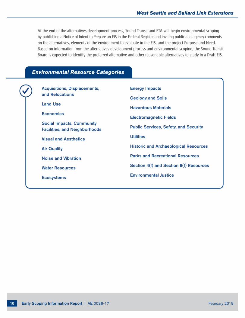
Early Scoping Information Report | AE 0036-17 February 201810
West Seattle and Ballard Link Extensions
At the end of the alternatives development process, Sound Transit and FTA will begin environmental scoping by publishing a Notice of Intent to Prepare an EIS in the Federal Register and inviting public and agency comments on the alternatives, elements of the environment to evaluate in the EIS, and the project Purpose and Need. Based on information from the alternatives development process and environmental scoping, the Sound Transit Board is expected to identify the preferred alternative and other reasonable alternatives to study in a Draft EIS.
Acquisitions, Displacements, and Relocations
Land Use
Economics
Social Impacts, Community Facilities, and Neighborhoods
Visual and Aesthetics
Air Quality
Noise and Vibration
Water Resources
Ecosystems
Energy Impacts
Geology and Soils
Hazardous Materials
Electromagnetic Fields
Public Services, Safety, and Security
Utilities
Historic and Archaeological Resources
Parks and Recreational Resources
Section 4(f) and Section 6(f) Resources
Environmental Justice
Environmental Resource Categories
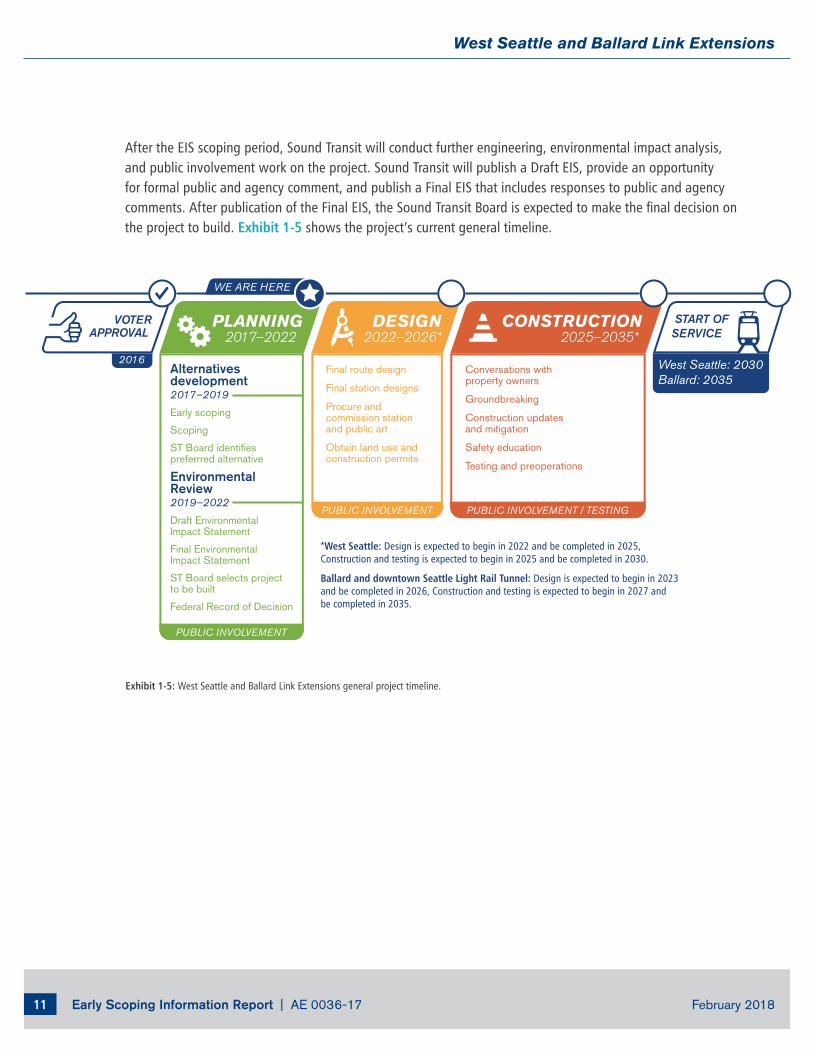
Early Scoping Information Report | AE 0036-17 February 201811
West Seattle and Ballard Link Extensions
Exhibit 1-5: West Seattle and Ballard Link Extensions general project timeline.
After the EIS scoping period, Sound Transit will conduct further engineering, environmental impact analysis, and public involvement work on the project. Sound Transit will publish a Draft EIS, provide an opportunity for formal public and agency comment, and publish a Final EIS that includes responses to public and agency comments. After publication of the Final EIS, the Sound Transit Board is expected to make the final decision on the project to build. Exhibit 1-5 shows the project’s current general timeline.
START OFSERVICE
West Seattle: 2030Ballard: 2035
PUBLIC INVOLVEMENT / TESTING
Conversations withproperty owners
Groundbreaking
Construction updatesand mitigation
Safety education
Testing and preoperations
CONSTRUCTION2025–2035*
PUBLIC INVOLVEMENT
Final route design
Final station designs
Procure and commission station and public art
Obtain land use andconstruction permits
DESIGN2022–2026*
PUBLIC INVOLVEMENT
Alternatives development2017–2019
Early scoping
Scoping
ST Board identifies preferrred alternative
EnvironmentalReview2019–2022
Draft EnvironmentalImpact Statement
Final EnvironmentalImpact Statement
ST Board selects projectto be built
Federal Record of Decision
PLANNING2017–2022
VOTERAPPROVAL
2016
*West Seattle: Design is expected to begin in 2022 and be completed in 2025,Construction and testing is expected to begin in 2025 and be completed in 2030.
Ballard and downtown Seattle Light Rail Tunnel: Design is expected to begin in 2023and be completed in 2026, Construction and testing is expected to begin in 2027 andbe completed in 2035.
WE ARE HERE
Sound Transit plans, builds, and operates regional transit systems and services to improve mobility for Central Puget Sound.401 S. Jackson St. l Seattle, WA 98104-2826 l 1-800-201-4900 / TTY Relay: 711 l [email protected] | soundtransit.org
soundtransit.org/[email protected]
206-903-7229
West Seattle and Ballard Link Extensions
AE 0036-17 | Early Scoping Summary Report
APPENDIX C
Meeting Advertising Samples
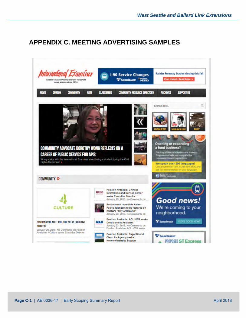
West Seattle and Ballard Link Extensions
Page C-1 | AE 0036-17 | Early Scoping Summary Report April 2018
APPENDIX C. MEETING ADVERTISING SAMPLES
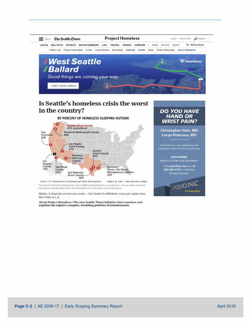
Page C-2 | AE 0036-17 | Early Scoping Summary Report April 2018
AE 0036-17 | Early Scoping Summary Report
APPENDIX D
Agency Comment Letters

West Seattle and Ballard Link Extensions
Page D-1 | AE 0036-17 | Early Scoping Summary Report April 2018
APPENDIX D. AGENCY COMMENT LETTERS Sound Transit received eight agency comment letters and emails on the West Seattle and Ballard Link Extensions project during early scoping. An index to the letters is presented below.
Organization Type and Name State Agencies
Washington State Department of Ecology
University of Washington (UW Medicine)
Regional Agencies
King County Department of Transportation (King County Metro)
King County Department of Natural Resources and Parks
Port of Seattle/Northwest Seaport Alliance
Local Jurisdictions
City of Seattle
Seattle Planning Commission
Seattle Design Commission
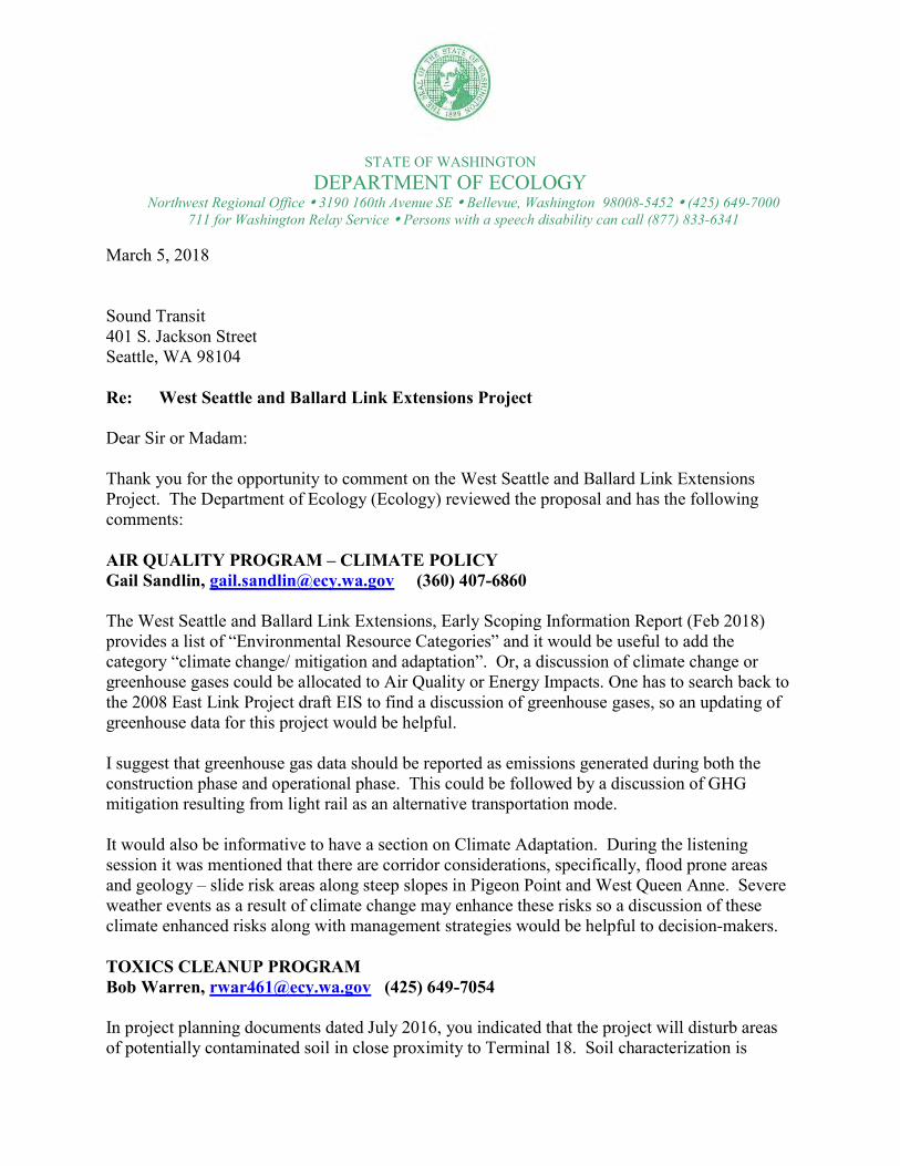
STATE OF WASHINGTONDEPARTMENT OF ECOLOGY
Northwest Regional Office 3190 160th Avenue SE Bellevue, Washington 98008-5452 (425) 649-7000711 for Washington Relay Service Persons with a speech disability can call (877) 833-6341
March 5, 2018
Sound Transit401 S. Jackson StreetSeattle, WA 98104
Re: West Seattle and Ballard Link Extensions Project
Dear Sir or Madam:
Thank you for the opportunity to comment on the West Seattle and Ballard Link Extensions Project. The Department of Ecology (Ecology) reviewed the proposal and has the following comments:
AIR QUALITY PROGRAM – CLIMATE POLICYGail Sandlin, [email protected] (360) 407-6860
The West Seattle and Ballard Link Extensions, Early Scoping Information Report (Feb 2018) provides a list of “Environmental Resource Categories” and it would be useful to add the category “climate change/ mitigation and adaptation”. Or, a discussion of climate change or greenhouse gases could be allocated to Air Quality or Energy Impacts. One has to search back to the 2008 East Link Project draft EIS to find a discussion of greenhouse gases, so an updating of greenhouse data for this project would be helpful.
I suggest that greenhouse gas data should be reported as emissions generated during both the construction phase and operational phase. This could be followed by a discussion of GHG mitigation resulting from light rail as an alternative transportation mode.
It would also be informative to have a section on Climate Adaptation. During the listening session it was mentioned that there are corridor considerations, specifically, flood prone areas and geology – slide risk areas along steep slopes in Pigeon Point and West Queen Anne. Severe weather events as a result of climate change may enhance these risks so a discussion of these climate enhanced risks along with management strategies would be helpful to decision-makers.
TOXICS CLEANUP PROGRAMBob Warren, [email protected] (425) 649-7054
In project planning documents dated July 2016, you indicated that the project will disturb areas of potentially contaminated soil in close proximity to Terminal 18. Soil characterization is
Sound TransitMarch 5, 2018Page 2
required in these areas to confirm if contamination is present. If contamination is present above state cleanup levels, you will need to comply with the Model Toxics Control Act (Chapter 70.105D RCW) and conduct appropriate remediation activities. Please contact us when the project moves into final stages of design. We are available to consult on the most appropriate path forward if contamination is discovered or if you need guidance on environmental sampling.
Thank you for considering these comments from Ecology. If you have any questions or would like to respond to these comments, please contact the commenter listed above.
Sincerely,
Tom BurokerRegional Director
Sent by email: Sound Transit, [email protected]
ecc: Gail Sandlin, EcologyBob Warren, Ecology

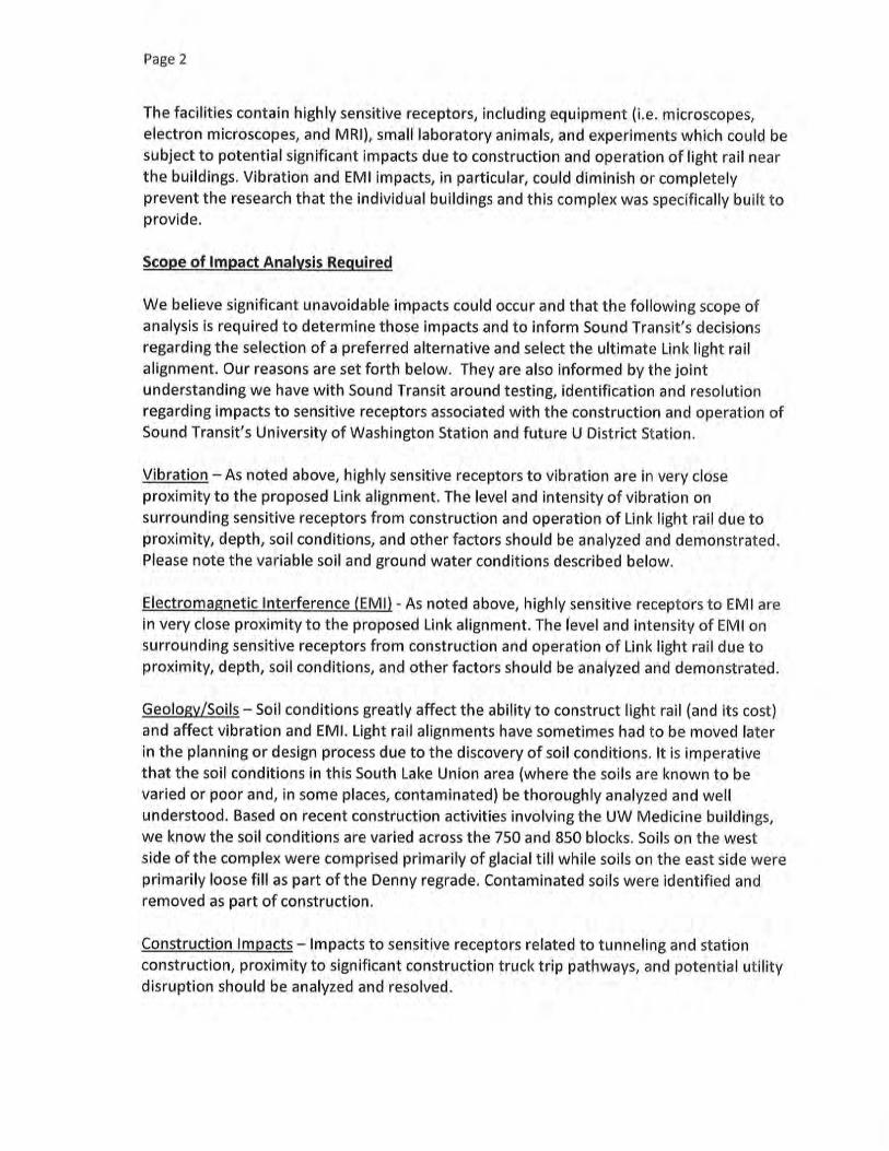
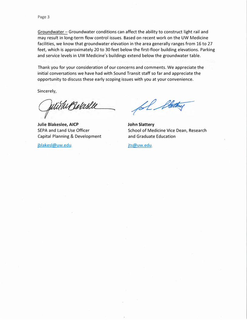
Page 3
Groundwater- Groundwater conditions can affect the ability to construct light rail and
may result in long-term flow control issues. Based on recent work on the UW Medicine
facilities, we know that groundwater elevation in the area generally ranges from 16 to 27
feet, which is approximately 20 to 30 feet below the first-floor building elevations. Parking
and service levels in UW Medicine's buildings extend below the groundwater table.
Thank you for your consideration of our concerns and comments. We appreciate the
initial conversations we have had with Sound Transit staff so far and appreciate the
opportunity to discuss these early scoping issues with you at your convenience.
Sincerely,
Julie Blakeslee, AICP
SEPA and Land Use Officer
Capital Planning & Development
John Slattery
School of Medicine Vice Dean, Research
and Graduate Education
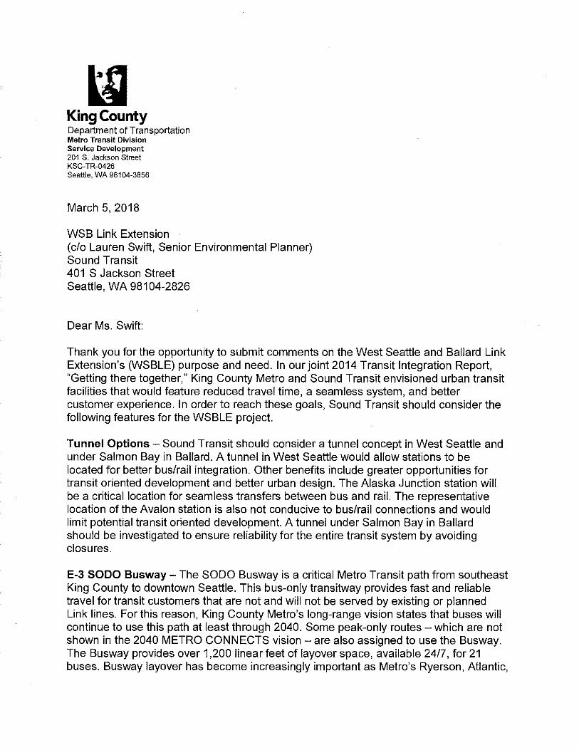

March 5, 2018
Board Chair Dave Somers West Seattle and Ballard Link Extensions Sound Transit 401 S. Jackson Street Seattle, WA 98104
VIA EMAIL: [email protected]
Re: West Seattle and Ballard Link Extensions Early Scoping
Dear Board Chair Somers,
Thank you for the opportunity to provide early scoping comments to start the project development and environmental process for the West Seattle and Ballard Link Extensions. The nexus between Port of Seattle and Northwest Seaport Alliance operations and the project’s representative alignment is significant, thus we look forward to being a close partner on this critical new infrastructure. Through construction and subsequent operations, this project has the potential of impacting many port facilities:
• Fishermen’s Terminal • Interbay/Magnolia cruise and fishing terminals (Terminals 90 and 91) • Terminals 5 (adjacent to West Seattle) • Terminal 18 (Harbor Island) • Salmon Bay Marina (adjacent to Fishermen’s Terminal) • Old Tsubota Steel site (near Magnolia Bridge) • Grain terminal (Terminal 86) • Terminal 46 (near Coleman Dock) • Terminals 30 and 25 (south of T-46 and north of Spokane St) • Terminals 102, 104 and 106
In 1911, King County citizens created the public Port of Seattle – ensuring that harbor facilities were managed for the benefit of all citizens not just a privileged few. Today that responsibility extends from Fishermen’s Terminal to Sea-Tac Airport and includes the Northwest Seaport Alliance, a marine-cargo operating partnership of the Port of Seattle and Port of Tacoma.
We are responsible for creating good jobs across the state by advancing trade and commerce, promoting manufacturing and maritime growth and stimulating economic development. To be successful in that mission, it is critical that other jurisdictions and government agencies like Sound Transit recognize the complicated nature of our operations and collaborate closely when major projects might impact our assets.
Over the past two decades, the Port has invested almost $500 million our region’s transportation system supporting partners’ projects such as Sound Transit. Our collaboration with Sound Transit included construction (and the extension) of Link Light Rail at Sea-Tac Airport. We strategized for the Sounder rail start-up and ensured the Eastside Rail Corridor remained in public ownership. Overall, we fundamentally support high capacity transit ridership to reduce transportation congestion.
As we have shared in previous letters to Sound Transit, we have three primary objectives for Sound Transit 3 projects: 1. Enhance service to Sea-Tac Airport for passengers and employees, from a web of cities throughout the region; 2. Strengthen access to Port facilities, both existing and future developments; and 3. Improve regional transportation for personal mobility, while protecting maritime and industrial land uses and
freight mobility.
With respect to the West Seattle and Ballard Extensions, those second two objectives are critical. We appreciate Sound Transit’s new approach to project development and broader stakeholder engagement. However, given the route of the current representative alignment, we are concerned about the possible significant impacts to the region’s maritime and industrial sectors because of this project. Moving forward, we look forward to integral involvement in defining the project’s preferred alignment and appreciate Sound Transit staff work to-date in that regard since the project kicked off in early January with the first meeting of the Elected Leadership Group (ELG).
As the ELG’s sole representative of the Port of Seattle and Northwest Seaport Alliance, I hope that Sound Transit will appreciate the extensive process behind communicating our perspective, concerns and comments about the project. In my role as a Port Commissioner and NWSA Managing Member, I am focused on ensuring that the economic activity created by our organizations is beneficial and accessible to every community we serve. My approach to planning efforts around the West Seattle and Ballard Extensions project will be no different.
An integrated and robust transportation system is essential to maintaining Puget Sound’s economic competitiveness and quality of life. We look forward to continuing our successful work with Sound Transit toward a system expansion that complements our ongoing economic development work for the region and toward new regional transportation solutions with respect to this project and other Sound Transit 3 extensions.
Please find detailed early scoping comments attached. Thank you for your consideration.
Sincerely,
Commissioner Stephanie Bowman Port of Seattle Commission
Northwest Seaport Alliance Managing Member
Cc: Sound Transit CEO Peter Rogoff Port of Seattle Commission Port of Tacoma Commission Port of Seattle Executive Director Steve Metruck Northwest Seaport Alliance CEO John Wolfe
Port of Seattle and Northwest Seaport Alliance West Seattle and Ballard Link Early Scoping, Staff Comments March 5, 2018 Thank you for the opportunity to supply these early scoping comments. We look forward to integral involvement in defining the West Seattle and Ballard Link (WSBLink) Extensions’ preferred alignment, and appreciate our inclusion in both the Elected Leadership Group and the interagency team. While we believe that these extensions could significantly improve transportation in our region, there is great risk to multiple stakeholders in overlooking key issues identified in the document. Staff contacts:
• Geri Poor, Regional Transportation Manager, [email protected] • Lindsay Wolpa, Regional Government Affairs Manager, [email protected]
Our comments follow the general outline requested in your Early Scoping Information Report:
I. Purpose & Need II. Representative Alignment – issues, concerns, areas of agreement
A. W Seattle Link Extension B. Ballard Link Extension C. Downtown Segment
III. Potential alternatives A. W Seattle Link Extension B. Ballard Link Extension
IV. Elements of environment
I. Purpose & Need
We generally support the Purpose and Need statement. However, we are concerned that the statement lacks recognition that the project crosses two of the region’s largest and most productive industrial zones (Manufacturing and Industrial Centers [MICs]) and respectfully request that that fact is explicitly acknowledged in the official documentation of the project. The Port of Seattle’s Century Agenda and Long-Range Plan focus on this importance of close proximity to industrial lands within our goal to “Anchor the Puget Sound urban-industrial land use to prevent sprawl in less developed areas.” We firmly believe that as the Link extensions pass through the MICs, planning must respect the vitality and economic contributions of the maritime and industrial sectors of our economies with a pragmatic balance. In turn, those sectors closely rely on the symbiotic land uses and transportation systems supporting freight access and mobility. Increased transit passenger mobility must be balanced with existing and future industrial capacity and capability in these centers. In this context, it is essential to note that:
Port of Seattle and Northwest Seaport Alliance West Seattle and Ballard Link Early Scoping, Staff Comments March 5, 2018 Page 2
• Existing freight mobility for all modes of transportation must be maintained, and the project
designed in a way that does not pre-empt future extension of freight infrastructure. • MIC employment densities are lower than those in other Centers; • Traditional TOD approaches, which typically include housing, are inappropriate; and
Purpose The current Purpose includes seven bullet points, which are all important. In keeping with our comments above, we suggest adding the following bullet as well:
• “Preserve and enhance the jobs and economic contributions of the Duwamish and Ballard-Interbay MICs to the region’s economy by protecting freight infrastructure and right-of-way along the corridor.”
We suggest the following underlined addition to the third bullet:
• Connect regional growth centers and manufacturing/industrial centers as described in adopted regional and local land use… plans and Sound Transit’s Regional Transit Long-Range Plan (Sound Transit, 2014).
We believe that the sixth bullet should acknowledge that station area development may be different in stations located in the Manufacturing and Industrial Centers (MICs), as traditional transit-oriented development (TOD) of high-density residential uses would not be allowed. The Port is particularly concerned with potential diminution of essential industrial zoned area, area built and committed to industrial and marine industrial use. These areas require improvement, not fractured change to non-industrial uses and activities. Please consider the following amendments:
• Encourage equitable and sustainable urban growth in station areas through support of
transit-oriented development, station access, and modal integration in a manner that is consistent with local land use plans policies and code requirements.
Bullets two, five and seven’s focus on “regional mobility for all” and “a healthy environment” are also critical, recognizing that the SeaTac/Airport station has carried the highest station ridership for nearly the first decade that Link has served our region. We affirm that this system expansion will expand access to and from Sea-Tac Airport for regional travelers, visitors, and employees supporting the airport area. Similarly, there are other Port of Seattle facilities in these corridors which will provide opportunities for new Link riders, as noted throughout our following comments, but especially including our cruise terminals and Fishermen’s Terminal.
Port of Seattle and Northwest Seaport Alliance West Seattle and Ballard Link Early Scoping, Staff Comments March 5, 2018 Page 3
Need The current Need includes six bullet points, with the first bullet as perhaps the most significant. Similarly to the discussion under Purpose, the Need bullets should reflect that difference for station areas in the MICs. Please consider the following underlined addition to bullet five:
• Regional and local plans call for increased residential and employment density at and
around many HCT stations, and increased options for multi-modal access. Finally, we believe that Sound Transit will need to develop these extensions in a cooperative working relationship among multiple agencies with individual public missions. We will support development of the light rail extensions, while stewarding our public mission and assets and working to find the best mutually beneficial coincident outcomes with our fellow agencies.
II. Representative Alignment – issues, concerns, and areas of agreement
The Port of Seattle and Northwest Seaport Alliance support the Link Light Rail system, and the extensions to West Seattle and Ballard. We recognize the years of planning described in the Early Scoping Information Report that have helped get us to this point. We are pleased that the Alternatives Analysis is now funded, so that the project team and stakeholders can understand our issues and concerns with the Representative Alignment, many of which we have identified in prior comment letters. We urge Sound Transit to integrate amenities or services that would improve HCT access to Sea-Tac and other regionally designated centers. Air passenger ridership on Link has unique characteristics including infrequent trips, carrying luggage, discomfort with the airport/Link station walk, or early/late travel times. We ask that all new vehicles accommodate space for passenger luggage, an important feature not well incorporated into existing lines. By adding new connections to the regional link system, WSBLink extensions come within the greater Sound Transit 3 program, which included other region-wide programs for system access, innovation and technology. We expect that some of these funds could be used on the WSBLink extensions, at the home or business end of the airport trip, to overcome some of the barriers to transit ridership to the airport. Similarly, airport employees’ shifts frequently start or end at times that Link does not currently operate. While Link Light Rail has more reliable travel times, it is a longer trip time at off-peak hours, again a detriment to air passenger ridership.
A. West Seattle Link Extension
The Port of Seattle and Northwest Seaport Alliance (NWSA) support the extension to West Seattle, albeit with significant concerns regarding our port terminals and facilities, as well as the
Port of Seattle and Northwest Seaport Alliance West Seattle and Ballard Link Early Scoping, Staff Comments March 5, 2018 Page 4
supporting freight infrastructure for modes, and the potential for impacts to the vibrancy of the Duwamish MIC. We have met with staff and shared Port ownership maps. The Port and NWSA own and operate many facilities in the Duwamish, especially water-dependent uses on the shoreline. We support the representative alignment through SODO near the E-3 busway, over the Spokane St Viaduct, and paralleling the southern side of the Spokane St right of way. We endorse this location for limiting the direct impacts on the Terminals 46, 30 and 25 (T-46, T-30 and T-25) and the Port’s maintenance shop at T-25 S Horton St. Access to T-25/30, T-18 (and all Harbor Island port and non-port facilities), and T-5 must be evaluated and potential negative effects avoided and minimized. Soil conditions should be given considerable review at all sites. The aerial Link extension must preserve and protect the major truck access to our Terminals 5 and 18, the BNSF rail, T-104 and access to the Port of Seattle’s Harbor Marine Center (T-102) on Harbor Island – east-west mobility in the Spokane Street corridor is congested and complex. As you may know, NWSA formed in 2015 to jointly operate the nation’s fourth largest gateway for international containers and some maritime industrial properties of the Port of Seattle and Port of Tacoma. The light rail expansion through SODO to West Seattle and the Sounder expansion must be cognizant of potential impacts to the nation’s international trade flows, and must protect, preserve or enhance those facilities and operations. The port’s role as an economic engine prompted the creation of a state Growth Management Act requirement for Comprehensive Plan Container Port Element, which in turn required the inclusion the concept within the Seattle Comprehensive Plan. This was finalized by the City of Seattle in 2012. See in particular Policy CP 1.6 about preserving freight access to the terminals and Policy CP 1.2 about protecting land near the port with zoning for port-related activities. The “Terminal 5 (T-5) Wharf Rehabilitation, Bertha Deepening and Improvements Project” is projected to be fully operational by the time the West Seattle Link goes into construction in 2025. As a permit condition for the T-5 redevelopment, the NWSA is to install an approved Federal Rail Administration Quiet Zone (QZ) corridor between the T-5 gate and the West Duwamish rail bridge. The foundations and columns for the proposed alignment of the West Seattle Link bridge would need to be placed in a manner that will preserve and protect the Quiet Zone corridor and the at-grade crossing access to the businesses. Note that NWSA is providing more than $5 million in funding and working with Seattle Department of Transportation (SDOT) and BNSF to establish the QZ. The QZ will eliminate uncontrolled at-grade crossings in the corridor. The main, and ultimately (by the time construction for the West Seattle Link bridge begins in 2025) the only, rail crossing providing access to the business on the east side of the railroad between T-5 and the Duwamish rail bridge will be located between Spokane St and the West Seattle Bridge.
Port of Seattle and Northwest Seaport Alliance West Seattle and Ballard Link Early Scoping, Staff Comments March 5, 2018 Page 5
Both rail and vehicle access to and from T-5 and T-18 must be protected and preserved without limiting the freight movement in the international supply chain. The BNSF rail tracks, which also run south of Spokane Street, provide critical access to Harbor Island and T-5, so avoidance of those tracks is critical for piers, footings, and any construction impacts. The alignment must not pre-empt any future freight rail capacity expansion, at the railyards and terminals, or along the Spokane Street corridor. The Port’s Harbor Marina Corporate Center (T-102) already has limited access (also on Harbor Island, south of Spokane St). SSA Marine (T-18’s marine terminal operator), maintains offices at T-102 that provide critical support for their operations on the other end of Harbor Island. Also, the Port’s T-104 lies between East Marginal Way and the East Waterway, west of the East Marginal Way Grade Separation. Further design work will also require close coordination with us regarding facilities access, impacts of construction, aerial guideway column placement and light rail operations. For the Link bridge over the commercial waterway:
• Air draft should be at least as high as the West Seattle Freeway; • Column spacing within the waterway should be at least 200’and in alignment with the
existing navigation path beneath the Swing Bridge and the BNSF trestle. During construction, the Duwamish waterway must not be restricted from navigation of barges up to 105’ beam by 420’ length, and air draft currently available. In SODO, our understanding is that this alignment does not use public street rights of way, such as 1st or 4th Avenues S. Beneficially, this means no direct capacity loss in the SODO public rights of way, yet we need to understand if existing buses on the busway would be displaced to city streets. The arterials in SODO are already constrained and certainly congested during peak commute hours; further traffic volumes risk interfering with freight mobility in this over-burdened section of the Duwamish MIC. Impacts to avoid or mitigate include: loss of lanes, loss of turning or freight parking/loading capacity due to dedicated transit-ways or aerial guideway columns; construction activity of guideway or stations’ and increased at-grade rail crossings in industrial areas. In summary, project planning and development must focus on limiting and/or mitigating any impacts to freight access and mobility.
B. Ballard Link Extension: The Port of Seattle supports the extension to Ballard, again with significant concerns regarding our port terminals and facilities and potential for impacts to the vibrancy of the Ballard-Interbay Northend Manufacturing/Industrial Center (BINMIC). The Ballard Link Extension corridor is in the center of the 615-acre BINMIC, anchored by Fishermen’s Terminal and Terminal 91, both essential water-dependent marine industrial assets, with related effects on other adjacent industrial uses and activities. Here also, we have met with Sound Transit staff and shared Port
Port of Seattle and Northwest Seaport Alliance West Seattle and Ballard Link Early Scoping, Staff Comments March 5, 2018 Page 6
ownership maps. As with the West Seattle extensions, all sites must receive considerable review of soil conditions. BINMIC is headquarters to industrial, maritime and fishing, and manufacturing activities. The light rail expansion to the northwest to Ballard must be sited with regard to the maritime and BINMIC operations. Many vessels from the North Pacific fishing fleet homeport at facilities on the Lake Washington Ship Canal, Salmon Bay, and Terminal 91 (T-91), especially including Fishermen’s Terminal. Fishermen’s Terminal is critical to Seattle’s maritime economy (please see further information below). Terminal 91 is our 200-acre facility which serves multiple customers, which is the homeport for the commercial fishing fleet, and Smith Cove Cruise Terminal our two berth facility. Along with the Bell St Pier Cruise Terminal, these berths have led to recent growth in Seattle’s tourism industry, driven by the burgeoning cruise ship industry. The Port also operates recreational marinas, the Maritime Industrial Center, and recently agreed to acquire the Salmon Bay Marina, 2100 West Commodore Way (final possession later in 2018). Additionally, T-91 includes significant acreage for which the Port has considered redevelopment options, and is currently considering industrial and/or commercial redevelopment. The Maritime Industrial Center, at 2700 W Commodore Way, offers short-term and daily moorage for vessels up to 250’ in length, concrete dock space for loading and repair/maintenance work, short-term gear storage and staging, and office and shop space. The economic impact of Port of Seattle Related Fishing at T-91, Fishermen’s Terminal and the Maritime Industrial Center is 16,000 direct/indirect jobs, $1.3 billion annual payroll, $1 billion annual business revenue, and 120 million annual local taxes (p. 34, Endnote 1). If the proposed alignment remains elevated, the Link bridge over the Lake Washington Ship Canal, air draft should be at least as high as the Aurora Bridge. Column spacing within the waterway should be at least 200’ and in alignment with the existing navigation path beneath the Ballard Bridge. During construction, the Ship Canal should not be restricted from navigation of vessels up to 78’ beam by 400’ length, and air draft currently available under the Aurora Bridge. We advocate that a Ship Canal crossing should be a fixed structure, not a bascule or other “opening” span, so that marine traffic and light rail are completely independent of one another. Specifically, we have documented many times, in many comment letters, our concerns over the impacts of the representative alignment on the west side of the Ballard Bridge. Fishermen’s Terminal is the vibrant home of the North Pacific Fishing Fleet. It is a living landmark, as well as an active industrial site that is home to the core of the current and evolving fishing industry. Fishermen’s Terminal (established in 1919), is the largest single-built, committed fishing industry support site in King County encompassing 76 acres. Fishermen’s Terminal offers a full complement of services for commercial fishing and workboats. Additionally, there is year-round and seasonal freshwater recreational moorage. Landside businesses at Fishermen’s Terminal include a wide range of businesses, from support services for fishing and commercial maritime activities, to retailers, restaurants and offices. We recently completed a strategic plan for
Port of Seattle and Northwest Seaport Alliance West Seattle and Ballard Link Early Scoping, Staff Comments March 5, 2018 Page 7
Fishermen’s Terminal which calls for expanding the on-site roster of suppliers that serve the fishing fleets. Private sector actors in the fishing cluster are bullish as well. Note that the 2016 report “Modernization of the North Pacific Fishing Fleet Economic Opportunity Analysis” (Endnote 2) probes an emerging trend for new-build fishing vessels in Washington State shipyards. On Fishermen’s Terminal (FT), along the eastern-most side, Fishing Vessel Owners (FVO) and their two marine ways are situated directly west of the bridge. FVO operation is profoundly vital to the local maritime industry: losing the operation would have significant domino impacts to other marine and fishing related businesses. FVO is one of the Port of Seattle’s oldest tenants, providing services from their current location since 1919. The two FVO rail systems (300-ton and 500-ton) haul approximately 50 vessels per year for repair on land and FVO works on about 50 vessels per year in the water. If the columns for the light rail aerial structure touch down on the areas leased to FVO, the impacts to the piers, above ground and in water rails, landside structures and operations would be very significant. Studied during the monorail studies in 2003-5, relocation of their service and function was found to be infeasible. This likely would result in FVO moving their operation out of Seattle or closing all together, and the loss of about 30 family wage union jobs and Port revenue, as well as impacts to vendors and subcontractor jobs. Having the convenience of a trusted shipyard is a large factor in many of the vessels staying at FT and paying higher rents. Another trickle-down effect would be lower occupancy on the docks and fewer people supporting the upland businesses at FT. We have grave concerns that piers and footings of a new bridge would create new navigational constraints in the area west of the Ballard Bridge, where access, turning and maneuvering for larger vessels, especially the fishing fleet needs to be taken into consideration (both in the final design and during construction). Other impacts to Fishermen’s Terminal would potentially be reduced storage and laydown space, reduced parking, and reduced moorage slips. While we will propose alternative alignments in the next section, we support the representative alignment being aerial, rather than at-grade, in the Elliott/15th Ave W corridor: this is already a congested city arterial which also serves as the freight spine through Seattle, connecting the two MICs and also the major access route to the Pier 91 cruise terminal. Planning must focus on minimizing loss of capacity on the freight spine. Impacts to avoid or mitigate include: loss of lanes, loss of turning or freight parking/loading capacity due to dedicated transit-ways or aerial guideway columns; construction activity of guideway or stations, and increased at-grade rail crossings in industrial areas. The Elliott/15th Ave W corridor has no proximate parallel routes that could accommodate vehicles or truck-turn maneuvering both in final operations and during construction and so such functions must be incorporated into the corridor design. In summary, project planning and development must focus on limiting and/or mitigating any impacts on freight access and mobility, and other users in the corridor such as the
Port of Seattle and Northwest Seaport Alliance West Seattle and Ballard Link Early Scoping, Staff Comments March 5, 2018 Page 8
cruise industry. For this reason, we recommend consideration of alternatives to the representative alignment in the next section. Station location: We look forward to further station area analysis for the Smith Cove stop, to consider how best to capture the T-91 employees (fishing, industrial and cruise) and cruise terminal passengers. We support the stops providing access to Seattle Center, especially for the redevelopment at Key Arena.
C. Downtown Segment We support the 5th Avenue tunnel, over other alternatives considered such as an at grade alignment in 1st Avenue. A chief issue of a 1st Avenue alignment is the potential loss of vehicle capacity through downtown, as well as farther south in SODO and the Duwamish.
III. Potential alternative alignments The Port and NWSA believes that there is significant work to do on alternative alignments. The public and a wide range of stakeholders need a better understanding of benefits and constraints in order to be able to make trade off decisions. Please address the following in your analysis of alternatives, in keeping with our more detailed comments above.
A. West Seattle Link Extension 1) Southerly single river crossing of Duwamish farther south than Spokane St Corridor
(Idaho/Genesee): The Port would support such an analysis to remove impacts from the highly subscribed Spokane St Corridor which currently carries multiple levels of automobile traffic, active rail lines, and river traffic. Light rail in this alternative must be situated carefully to minimize impacts to Port terminals south of the Spokane St Corridor: T-102, T-103, 104, 106, and 115. T-105 and T-107 are public open space and shoreline access sites.
2) Negative effects are unacceptable for an alignment north of the Spokane St Bridge, especially if unable to accommodate access needs to T-5, T-18 and other Harbor Island businesses.
3) The rail corridor along the Spokane Street corridor was designed with the potential for an additional rail track. That right-of-way must be protected, as well as the rail yards.
4) Any crossing of the West Duwamish Waterway must be designed to not impede commercial traffic on the waterway.
5) During construction, it will be important to maintain freight mobility and access to our terminals, as well as other freight trip generators, for all modes of transportation.
B. Ballard Link Extension As mentioned above in comments regarding the preferred alignment, Elliott/15th Ave W is already a congested city arterial, the spine for freight travel through Seattle, and the primary route to the Smith Cove Cruise Terminal and industrial land at T-91. Fishermen’s Terminal, one of the Port’s oldest active facilities, stands to lose a significant tenant under the representative alignment
Port of Seattle and Northwest Seaport Alliance West Seattle and Ballard Link Early Scoping, Staff Comments March 5, 2018 Page 9
(reference significant details above on FT). Seattle’s cruise homeport serves over one million annual passengers, and Smith Cove Cruise Terminal has 2 of Seattle’s 3 berths. Good access to the public transit system for maritime and industrial employees and cruise passengers reaps benefits. We endorse further study of alternative designs to resolve these issues, and suggest the following: 1) Tunnel under Ship Canal as in Alignment C-01(c): We believe that a tunnel under the Lake
Washington Ship Canal (Ship Canal) will contribute to system reliability at a scale to justify that investment. It will also eliminate conflicts with the Port’s Fishermen’s Terminal that were well documented and never resolved in high capacity planning proposals including the monorail project. (Please reference FT information on page 6 of this letter). The Representative Alignment considered for a new Ship Canal Bridge is west of the existing Ballard Bridge, which would likely require acquisition and relocation of the Fishing Vessel Owners (FVO) facility, an active operation providing unique capabilities to the maritime industry. Additionally, this would relieve new navigational constraints in the area west of the Ballard Bridge due to piers of a new bridge, for access, turning and maneuvering for larger vessels. We need detailed design and construction evaluations of these alternatives. However, in pursuing such a tunnel, we have a concern related to our new property, Salmon Bay Marina. Sound Transit staff has noted that a vertical tunnel access shaft would be part of tunnel construction and that this marina is being considered for the site of the shaft. The property currently contains City, state and federal approvals for improving the site, and the Port is beginning plans for upland improvements. This could also be impacted by the vertical tunnel access. Again, this is prime waterfront industrial land, and we urge Sound Transit to explore alternative locations. However, our significant concerns can only be clarified with detailed design and construction evaluations. The entire BINMIC and ship canal area will be impacted by this decision and would be adversely affected by poor planning and design. We anticipate that study of a tunnel under the ship canal may relieve impacts on the maritime industry and family-wage jobs dependent on the ship canal location.
2) Tunnel under ship canal closer to 15th: While a tunnel was proposed farther west in the studies for the ST3 System Plan, we would also request study of a tunnel under the ship canal at 15th Ave W, to improve system reliability (compared to a ship canal bridge) and reduce impacts on the BINMIC and Fishermen’s Terminal.
3) Tunnel under Elliott: Traffic is already very congested in the Elliott/15th Corridor. Construction and support columns for the aerial alignment would only exacerbate the poor traffic in the area and restrict traffic movement. It would be very difficult to mitigate these impacts by acquiring properties and add lanes(s) to improve traffic flow. An underground option is very expensive but construction, long-term environmental, and traffic impacts must be carefully assessed. Having
Port of Seattle and Northwest Seaport Alliance West Seattle and Ballard Link Early Scoping, Staff Comments March 5, 2018 Page 10
this segment of the Ballard extension underground would offer an opportunity for a shorter or straighter alignment between the Seattle Center and Smith Cove stations.
4) Adjacent to Balmer Yard a) West side: C-01c – Aerial via Interbay West
This alternative would better serve new development, jobs and economic activity in the Interbay sector of BINMIC. The opportunities for ridership from the new Expedia campus, cruise ship terminal, fishing and industry no T-91, and potential new development of T-91 uplands make this segment critical for partnerships in transportation improvements. Further design work would require close coordination with Port of Seattle regarding our facilities, access and impacts of construction, and light rail design. It is important to protect the numerous industrial operations at T-91, as well as the integrity of operations throughout T-91 and in the light industrial buildings adjacent to the tracks. Similarly, impacts to the regional bike path connecting NW Seattle to downtown must be identified and mitigated. Planning is underway for redevelopment of the northern lands of T-91 and that access should be considered as part of Sound Transit’s studies.
b) East of Balmer Yard: C-01c – aerial via Interbay East
We also request that Sound Transit consider alternate routing for C-01c that follows the east edge rather than the west edge of the BNSF Balmer railyard. Proceeding south from the Ship Canal tunnel, the rail would tunnel south under the BNSF Balmer Yard to the easterly side and proceed south to connect with the current proposal. In favor of this alignment proposal is the opportunity to access the properties east of Balmer, and the lack of abutting residential lots as compared with the 20th Ave W segment north of Thorndyke Ave W. Issues with the C-01c alignment in the west edge of the Balmer yard are the critical access road for the 120-acre T-91 Port property and the regional bike path. As such, the light rail design would have to preserve access to the numerous light industrial operations currently in this section of T-91, and address the bicycle path.
Overall, as you evaluate these alternatives, please determine impacts to Port-owned property at 1617 – 15th Ave W (known as the former Tsubota Steel site). The property is irregular in shape and the most logical redevelopment scenario would be focused on the south edge where Route Option C-01c was proposed. Acquisition of a portion of this property would affect the value and could render the entire property unviable for redevelopment.
5) Please work with us to consider how the Smith Cove station could better serve the fishing and
industry employees at T-91 and especially the hundreds of thousands of cruise passengers and employees at Smith Cove Cruise Terminal. This could also include an opportunity for a Transportation Hub in the Smith Cove area which could provide opportunities to connect passengers from Sounder train service and Link Light Rail.
Port of Seattle and Northwest Seaport Alliance West Seattle and Ballard Link Early Scoping, Staff Comments March 5, 2018 Page 11
6) East side of Ballard Bridge: While we firmly believe we must protect existing maritime and industrial business, a thorough study would also review a Ship Canal Crossing on the East side of the Ballard Bridge.
IV. Elements of the Environment Transportation: Please consider transportation access to all Port properties and facilities, port-related businesses, and impacts to freight mobility across the city, including to, from and between the two MICs. Consider road, water and rail transportation, including rail yards. The benefits or impacts to freight mobility should be key comparison of project alternatives. Please identify how exactly the alignments correspond with the Seattle Freight Master Plan. This plan was created over several years with significant input from the Port and other relevant stakeholders. Its implementation is barely underway. Acquisitions, Displacements and Relocations: We have provided many details about the potential impacts to Fishermen’s Terminal and specifically the critical FVO shipyard uses and activities at the eastern end of the site. We are concerned about property impacts, but also resultant implications for direct and related Fishermen’s Terminal businesses. Analysis should include the interdependency of industrial businesses and the dependency of industrial businesses on a working waterfront. Land Use: As discussed in our Section I comments on the Purpose and Need, please provide analysis of impacts as the extensions pass through the city’s two MICs, and potential to protect and improve access conditions for these industrial areas. The Port is particularly concerned with loss of essential industrial zoned area, that is, area built and committed to industrial and marine industrial use. We would not want to see non-compatible land use changes resulting from new high capacity transit stations, nor would be want a poorly designed transportation system to degrade access and lead to erosion of industrial capacity and capability, most noteworthy being heavy transportation access. Impacts could include gentrification or potential to attract land uses that are incompatible with existing zoning for industrial uses. More specifically, Sound Transit should avoid incompatibilities with industrial development that could arise from siting stations adjacent to industrial zoned land that may result in pressure for high density non-industrial development, or any type of residential use in the MICs. The Port is particularly concerned with potential diminution of essential industrial zoned area, area built and committed to industrial and marine industrial use. These areas require improvement, not fractured change to non-industrial uses and activities. Please consider the following Economy: We have significant concerns about economic impact resulting from unmitigated impacts to businesses which could also affect supporting or related businesses in the maritime, fishing, cruise or industrial economic sectors. Analysis should include the potential for impacts on industrial lands or businesses to induce acquisitions, displacements, and relocations on interdependent businesses and land.
Port of Seattle and Northwest Seaport Alliance West Seattle and Ballard Link Early Scoping, Staff Comments March 5, 2018 Page 12
Social, community facilities and neighborhoods: address transportation effects on Duwamish and BINMIC business community. Visual/Aesthetics: Please address aerial structure in existing traffic corridor, visual leading to fundamental safety and circulation liability. Noise/Vibration: Please address construction and operational effects as well. Water resources: Please include potential for contaminated soils affecting groundwater conditions. Air Quality: Please translate freight transportation changes into impacts to air quality, such as potential emissions impacts of increased truck idling from increased congestion throughout the system or at-grade crossings. Geology/Soils: As acknowledged earlier in our comments, the area is comprised of landfill in historic shallow intertidal aquatic area sediments, with shallow ground-water conditions. It is very complex and will require detailed evaluations. Hazardous Material: Due to previous industrial land uses, contamination along the corridor is highly likely. Public Services, safety and security: Please address where at grade Link service might interfere with emergency access. Also how would Link light rail potential impact secured Port facilities? Energy Impacts and Utilities: Please ensure there is sufficient capacity in existing utilities, and ensure that there is room for increased capacity to accommodate expected growth in addition to the Link Extension’s needs. Please address this concern with power capacity and the need to upgrade infrastructure. Parks and Recreational Resources/Section 4f & section 6f: The Port operates several recreational marinas, and 42 public access points. Many of these are located along the Duwamish River and should be acknowledged if there would be Link impacts. Environmental Justice: Please evaluate environmental and social justice impacts to industrial jobs. Construction Impacts: Please evaluate all elements of the environment for impacts during construction, particularly as noted here. Cumulative Impacts: Please evaluate all elements of the environment for cumulative impacts from direct and indirect development.
Port of Seattle and Northwest Seaport Alliance West Seattle and Ballard Link Early Scoping, Staff Comments March 5, 2018 Page 13
In summary, the Port believes that improved regional transportation for personal mobility, freight mobility and maritime/industrial land protections can and must co-exist in order to maintain Puget Sound’s economic competitiveness and quality of life. We look forward to partnering with you to expand the Link Light Rail to Ballard and West Seattle. Endnotes:
1. https://www.portseattle.org/Supporting-Our-Community/Economic-Development/Documents/2014_economic_impact_report_martin.pdf
2. https://www.portseattle.org/Supporting-Our-Community/Economic-Development/Documents/Fleet%20Modernization%20Final%2011_11.pdf
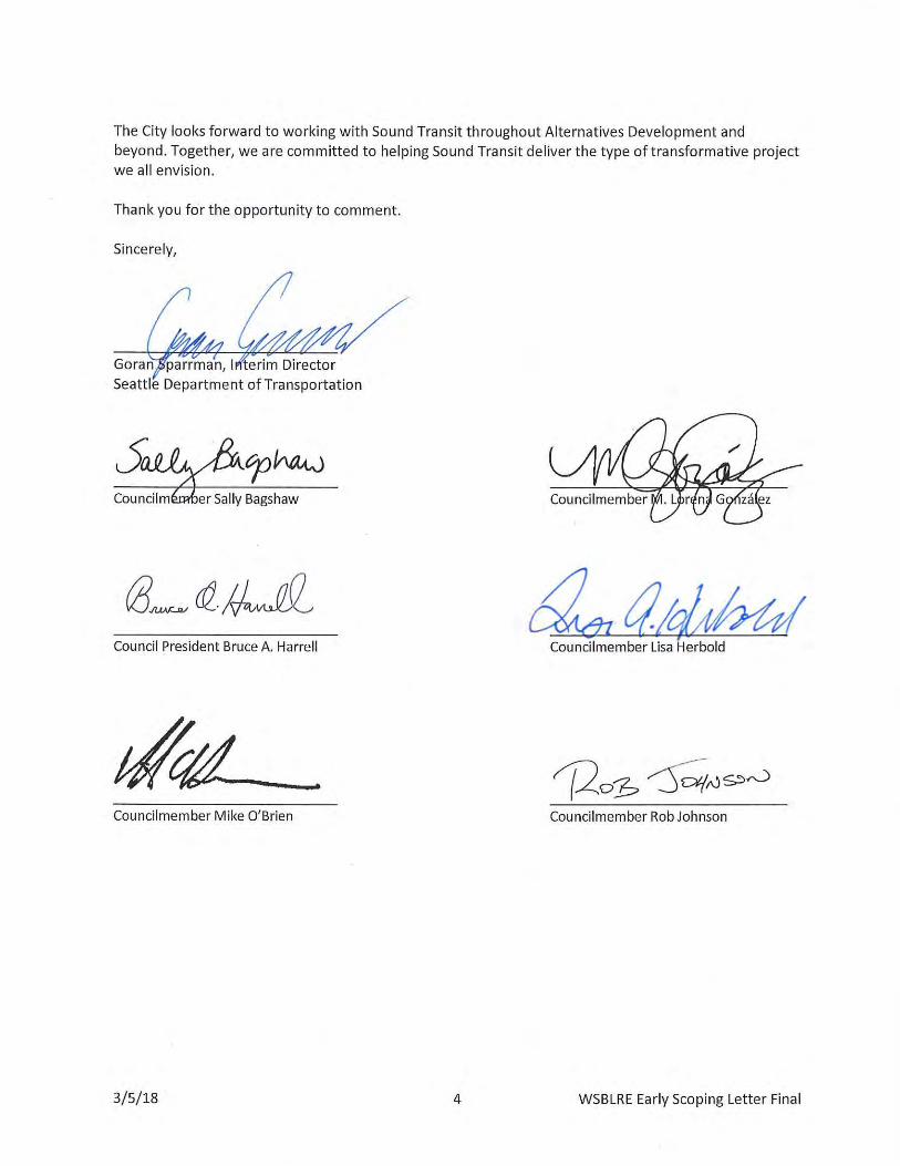
Seattle Planning Commission, 600 4th Avenue, Floor 5; PO Box 34788 Seattle, WA. 98124-7088 Tel: (206) 684-8694, TDD: (206) 684-8118
www.seattle.gov/planningcommission
City of Seattle Seattle Planning Commission
Tim Parham, Chair Vanessa Murdock, Executive Director
SEATTLE PLANNING COMMISSION
Thursday, February 08, 2018
Approved Meeting Minutes - Excerpt
Briefing and Discussion: Sound Transit 3 West Seattle to Ballard Link Light Rail Representative
Alignment
Jenifer Chao, Seattle Department of Neighborhoods; Colin Drake, Seattle Department of Transportation;
Lyle Bicknell and Vera Giampietro, Office of Planning and Community Development; Carrie Avila-Mooney
and Ron Endlich, Sound Transit
If you would like to view the presentations from Sound Transit and the Seattle Office of Planning and
Community Development, they are included in the supporting documents found in the minutes
section of our website, http://www.seattle.gov/planningcommission/when-we-meet/minutes-and-
agendas
Ron Endlich, Sound Transit Design Project Director, provided an overview of the West Seattle to Ballard
Link light rail extensions, including the following three segments: West Seattle, Ballard, and a new
Downtown Transit Tunnel. He highlighted a new approach to project development. Sound Transit is
hoping to identify a preferred alternative earlier in the environmental review process. The planning
phase includes a Level 1, 2, and 3 screening phases that will lead to an identified preferred alternative.
Mr. Endlich highlighted Sound Transit’s community engagement and collaboration plans. A
Stakeholder Advisory Group and an Elected Leadership Group will provide input throughout the
planning process. The Early Scoping process is an opportunity for the public to weigh in on station
locations and the route alignment to study further. The Early Scoping comment period is open until
March 5. Sound Transit will be holding three open house meetings on February 13, 15, and 20.
Jenifer Chao from the Department of Neighborhoods highlighted some considerations for the
representative alignment’s potential impacts on the Chinatown/International District and Delridge
neighborhoods. She encouraged Sound Transit to consider the potential for impacts to people of color
and historically underrepresented communities. Colin Drake from the Seattle Department of
Transportation summarized the partnership agreement between the City and Sound Transit. This
agreement includes the involvement of designated representatives from each City department, a
station area planning team, and ongoing community engagement.
Lyle Bicknell from the Office of Planning and Community Development provided an overview of the
representative alignment and stations. He identified some potential challenges and issues to consider
for each of the station areas.
Commission Discussion
Clarifying Questions
• Commissioners asked for more information about connectivity between the existing and new
tunnel stations at Westlake.
2/8/2018 Meeting Minutes Excerpt Page 4
• Commissioners asked for more information on the location of the new Chinatown/International
District station and the relationship between the existing and new stations at this location.
• Commissioners asked whether there will there be two stations (the existing and a new station) at
SODO. Mr. Bicknell replied that a new elevated station is proposed at this location. Commissioners
inquired whether this new station will have an impact on freight mobility in the vicinity.
• Commissioners asked about the height of the proposed Delridge station. Mr. Endlich replied that
he did not have specific information on the height, but stated that topography is a significant
challenge at this location. Jenifer Chao stated that the Delridge community has concerns about the
height of the guideway and station.
• Commissioners asked whether operational costs are paid for through ridership or Sound Transit 3
package funding, as it does not appear that the preliminary alignment and station locations are
prioritizing maximizing ridership.
Station-Specific Comments
1. Market
a) Consider the impacts of an elevated bridge over Salmon Bay on marine traffic and industry, and
consider if this justifies tunnel construction instead.
2. Dravus
a) Consider the larger picture of industrial lands in this area, such as potential impacts to freight
corridors and how to encourage industrial workers to use transit.
b) Consider moving this alignment to capture more people.
c) Consider moving the station to the northeast to provide greater access to Seattle Pacific
University students and residential areas.
3. Interbay stations
a) Significant concern about the impacts of the representative alignment on long-term viability of
industrial lands. Consider a guiding policy on how to minimize impacts of the alignment and
stations in these areas.
b) Consider moving the alignment away from industrial areas.
c) Consider using the BNSF rail corridor.
d) Include any lessons learned from the location and use of the existing SODO station in
determining how to best locate stations in industrial areas and what transit-oriented
development looks like in those locations.
e) The Prospect/Smith Cove station has a limited catchment area. This location is significantly
dependent on future Expedia campus employees.
4. Seventh (SR 99) and Denny stations
a) The two proposed station locations are close together. Consider consolidating these to one
location to serve a combined catchment area and build exits that serve both sides of this
catchment area.
b) A station in the vicinity of SR 99 or somewhere between the two proposed locations is more
desirable.
c) A seamless connection between Republican and Harrison is needed.
2/8/2018 Meeting Minutes Excerpt Page 4
5. Chinatown ID
a) Concern about construction impacts of this station, especially on small businesses. The
community is already experiencing impacts from past large infrastructure projects - the first bus
tunnel and I-5. Additionally, there are approximately 150 planned and ongoing capital projects
in the neighborhood, including the Charles Street project with Seattle City Light. Design and
construction activities should consider impacts on local cultural groups and activities. More
extensive outreach may be necessary in this community.
b) Cut-and-cover tunnel construction will be catastrophic for local businesses and residents.
Consider an alternative to cut-and-cover construction to reduce surface level impacts.
c) Acknowledge that many changes are already happening in this neighborhood. This location
requires a significant community engagement effort. Consider including cultural institutions
such as the Wing Luke Museum and other community groups in the process.
d) The goal should be a new station that is part of the neighborhood, rather than forced on the
community. This is a potential opportunity for creating a multi-modal station area and adding
urban space that is authentic and contributes to the community.
e) This area is already a significant transportation hub. Many transit agencies already operate
here. A new tunnel will add further regional transit connections, and should function elegantly
and efficiently as Seattle’s largest transit hub.
f) Consider spacing the new station and the existing station closer together to reduce the impacts
and establish connectivity.
g) The area lacks urban design cohesion. This is a great opportunity for station area planning and
placemaking. Create public spaces that connect Pioneer Square and the I.D.
h) How to incorporate affordable housing and align/integrate with new transit investments in a
way that causes the least impact? Perhaps incorporate housing above the tunnel station.
i) This station may require a response that includes a very innovative strategy to address all of the
potential impacts.
6. SODO
a) Concern about the pedestrian connectivity between the existing at-grade station and the
proposed elevated station. Consider co-locating the existing and new stations on top of each
other. Many cities have examples of multiple transit lines going through single stations.
b) How is the station location and alignment responsive to the City’s industrial lands policy
recommendations?
7. Avalon and Delridge stations
a) Consider shifting the proposed Delridge station location to the south to take advantage of a
broader variety of community assets and a larger population catchment area.
b) Consider consolidating these two stations into one and building an underground station in the
hillside.
General comments
8. Elevated vs. at-grade
a) Other considerations besides cost, including service to a vulnerable and historically
underserved population, should inform the decision to have an elevated, surface, or
underground alignment.
2/8/2018 Meeting Minutes Excerpt Page 4
b) If the alignment is elevated, a significantly higher level of station and rail design should be
considered.
c) Beautiful design should be incorporated as a mitigating factor for elevated stations. Consider
this to be not only an engineering project, but an architectural opportunity as well. There are a
lot of great examples around the world of beautiful bridges. For example, the Berlin S-Bahn
stations create a sense of community, rather than bisecting communities.
d) Other uses and placemaking opportunities should be studied in elevated station areas.
9. Station entrances
a) Allow multiple entries to serve both ends of stations, especially in areas with different grades.
b) Facilitate connectivity between existing and new tunnel stations by limiting the distance
between them and establishing pedestrian-scale interactions.
10. Design the alignment to support future station areas as integrated, vital community assets.
11. Incorporate lessons learned from previous station design and station area planning to better
include and serve affected communities and businesses.
Commissioners Present: Michael Austin, Eileen Canola, David Goldberg, Grace Kim, Tim Parham,
Marj Press, Julio Sanchez, Lauren Squires, Jamie Stroble, Patti Wilma
Commissioners Absent: Sandra Fried, Ellen Lohe
Commission Staff: Vanessa Murdock, Executive Director; John Hoey, Senior Policy
Analyst; Katy Haima, Planning Analyst
AE 0036-17 | Early Scoping Summary Report
APPENDIX E
Tribe Comment Letters
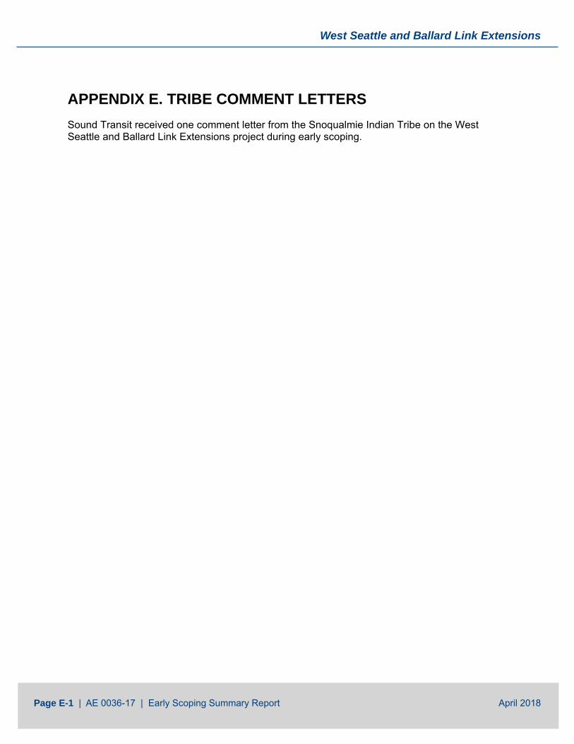
West Seattle and Ballard Link Extensions
Page E-1 | AE 0036-17 | Early Scoping Summary Report April 2018
APPENDIX E. TRIBE COMMENT LETTERS Sound Transit received one comment letter from the Snoqualmie Indian Tribe on the West Seattle and Ballard Link Extensions project during early scoping.
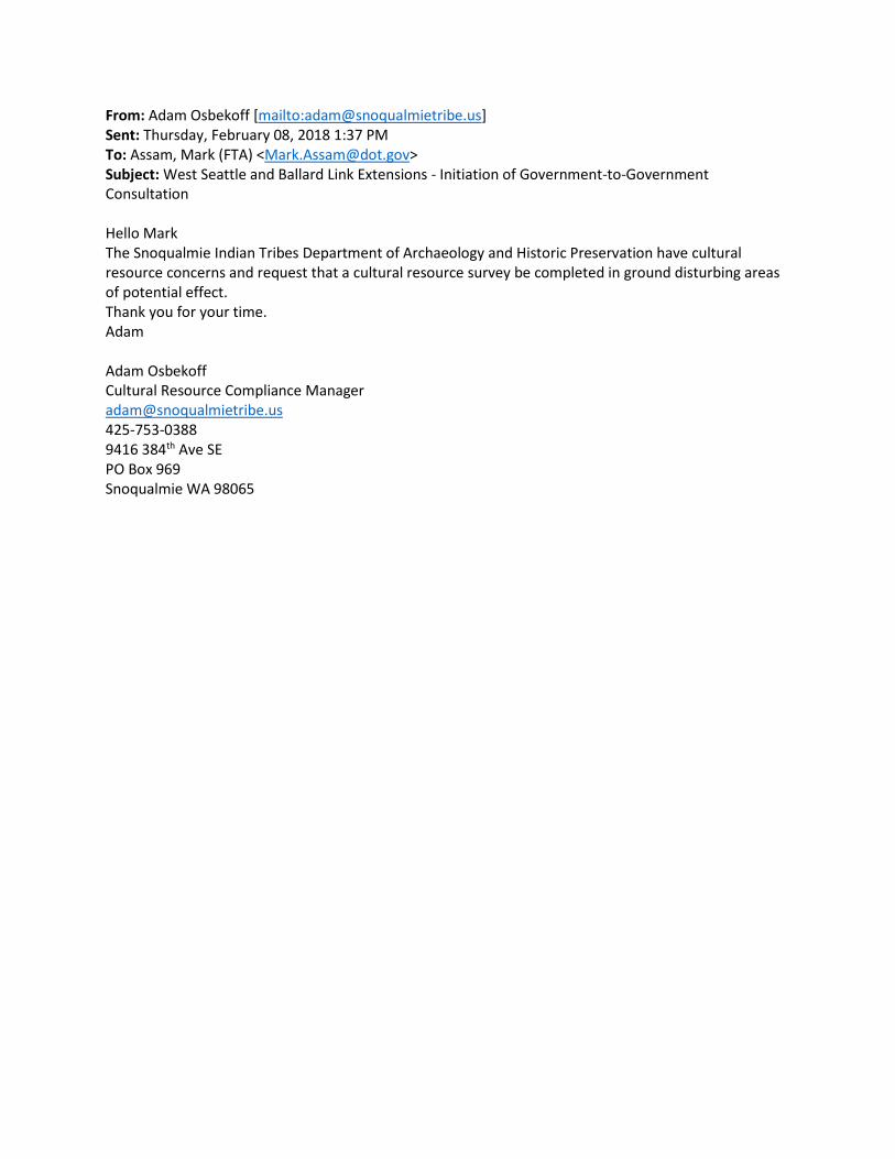
From: Adam Osbekoff [mailto:[email protected]] Sent: Thursday, February 08, 2018 1:37 PM To: Assam, Mark (FTA) <[email protected]> Subject: West Seattle and Ballard Link Extensions - Initiation of Government-to-Government Consultation Hello Mark The Snoqualmie Indian Tribes Department of Archaeology and Historic Preservation have cultural resource concerns and request that a cultural resource survey be completed in ground disturbing areas of potential effect. Thank you for your time. Adam Adam Osbekoff Cultural Resource Compliance Manager [email protected] 425-753-0388 9416 384th Ave SE PO Box 969 Snoqualmie WA 98065
AE 0036-17 | Early Scoping Summary Report
APPENDIX F
Public Comments
West Seattle and Ballard Link Extensions
Page F-1 | AE 0036-17 | Early Scoping Summary Report April 2018
APPENDIX F. PUBLIC COMMENTS Sound Transit received over 2,100 public comments on the West Seattle and Ballard Link Extensions project during early scoping. An index to the letters from businesses and organizations is presented below.
Organization Type and Name Businesses
Coastal Transportation and Salmon Bay Terminal
International Longshore and Warehouse Union Local 19 (ILWU 19)
Interbay Urban Investors
Manufacturing Industrial Council
Moxbay LLC
North Seattle Industrial Association
The Space Needle
Community Organizations
Ballard Alliance
Junction Neighborhood Organization (JuNO)
Northwest Seattle Coalition
Queen Anne Community Council
Seattle Subway
Transit Access Stakeholders
West Seattle Junction Association
Copies of comments from individuals are available on the project website or on CD by request. Those comments are grouped by submittal type, as follows:
• Mailed comment forms
• Emails
• Comment forms from open houses
• Online map comments
• Online comments: Purpose and Need
• Online comments: Benefits and Impacts
• Online comments: General
Page F-2 | AE 0036-17 | Early Scoping Summary Report April 2018
Approximately another 700 public comments were provided to Sound Transit on display boards and roll plot maps at the three open houses. Those comments are captured in the photos that follow the comment letters.
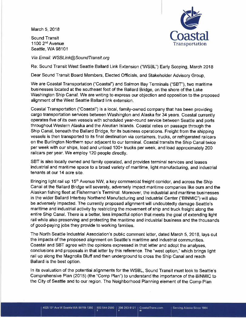
March 5, 2018
West Seattle and Ballard Link Extensions (c/o Lauren Swift) Sound Transit, 401 S. Jackson Street, Seattle, WA 98104-2826 Sent by Email: [email protected]
Dear Lauren Swift,
The following are our remarks for the Early Scoping EIS comment period for the West Seattle and Ballard Sound Transit Link Extensions.
The International Longshore and Warehouse Union Local 19 (ILWU 19) represents maritime workers who handle the loading and unloading of vessel cargo throughout the Port of Seattle. Our work on the Port terminals terminals 18, 25, 30, 46, 86, 105, and a soon to be revitalized Terminal 5 near West Seattle include: the movement, storage, and inventorying of cargo; on dock cargo rail operations; and delivering and taking cargo deliveries from over the road truck drivers (who in turn, service the rail gateways in Seattle, as well as destinations throughout the region via I-90, I-5, SR 99, SR 509, SR 599, and routes in Seattle designated by the Seattle Freight Master Plan.) Our members are also employed to work the Port of Seattle’s seasonal cruise vessels at Terminals 66, 90, and 91 (on board and dock operations). Our workforce has been dispatched to this work for many generations since 1934 through a full referral dispatch hall.
This activity is tied strongly to the existing topographic elements and built environment and cannot be relocated, whereas cargo itself can be easily rerouted. Discovering the impacts of and possible disruptions by ST3 is of
serious concern to us, so that we can preserve and enhance our members’ job security. Providing reliable labor and service to the global shipping lines that call on our marine terminals, as well as the tourism and customer driven cruise lines, is a key factor in retaining this business and growing employment opportunities for our members.
Our members’ livelihoods are dependent upon the viability of the freight supply chain within our region, the preservation of land uses that facilitate and support marine cargo and related manufacturing activity in Seattle, and the recognition by your agency of the crucial role of this economic activity within our $38bn statewide maritime economy. As our region experiences continued growth that ST3 is designed to accommodate, we must consider the impacts of this growth on the efficiency and viability of the local and regional cargo supply chain, including impacts from the construction and operation of ST3’s West Seattle and Ballard Link Extensions.
In particular, how Transit Oriented Development is designed, planned, and implemented in crucial near-Port “first-last” mile freight corridors should correspond and support (not displace) industrial land use designations and the related jobs within the Duwamish and Ballard-Interbay Manufacturing Industrial Centers (particularly in SoDo), and play a role in the future of the viability of our Port and the livelihoods of our members and generations to come.
We would like to call attention to ST’s Early Scoping Information Report (February 2018), under 1.3.1 (“Purpose and Need”) decision making policy criteria:
Under “Purpose”:
“Connect regional growth centers as described in adopted regional and local land use, transportation, and economic development plans and Sound Transit’s Regional Transit Long-Range Plan (Sound Transit, 2014).”
“Encourage equitable and sustainable urban growth in station areas through support of transit-oriented development, station access, and modal integration in a manner that is consistent with local land use plans.”
“Preserve and promote a healthy environment by minimizing adverse impacts on the natural and built environments through sustainable practices.”
Under “Need”:
“Increasing roadway congestion on transit routes between downtown Seattle, West Seattle, and Ballard will continue to degrade transit performance and reliability. “
“Regional and local plans call for increased residential and employment density at and around HCT stations, and increased options for multi-modal access.”
Given these directives, the scoping for the Sound Transit Link Extensions West Seattle and Ballard EIS should include data to account for and mitigate/eliminate all impacts of the following factors:
• Policy and practical impacts of Transit Oriented Development, and possible changes to the Seattle Comprehensive Plan, in relation to the Port Container Element mandated by the WA Growth Management Act;
• Policy and practical impacts of Transit Oriented Development, and possible changes to the City of Seattle’s Freight Master Plan;
• Policy and practical impacts of Transit Oriented Development, and possible changes to the Manufacturing Industrial Center (DMIC, BIMIC) designations;
• Policy and practical impacts of Transit Oriented Development, and possible changes to the City of Seattle’s industrial zoning (IG1, IG2, IC, IB) and land use codes and/or Comprehensive Plan elements supporting the preservation of these uses;
• Policy and practical impacts of Transit Oriented Development, and changes to the Puget Sound Regional Council’s Vision 2040 policies as
they relate to Manufacturing Industrial Centers and freight mobility (Ballard-Interbay, North Tukwila);
• Policy and practical impacts of Transit Oriented Development, and possible changes to the WA state Freight Master Plan and other policy issues governed by FMSIB for the impacted areas;
• Policy and practical impacts of Transit Oriented Development, and possible changes to the King County Comprehensive Plan relating to urban industrial land use and freight mobility;
• Policy consideration of the contradictions between the following directives in the Early Scoping Information Report, and resolution on the basis of minimal impacts to the current land use and freight mobility policies referenced above:
“Encourage equitable and sustainable urban growth in station areas through support of transit-oriented development, station access, and modal integration in a manner that is consistent with local land use plans.” [emphasis ours],
and (vs.):
“Regional and local plans call for increased residential and employment density at and around HCT stations, and increased options for multi-modal access.”;
• Construction and permanent impacts and displacement of all current marine, manufacturing, warehouse, and logistics economic activity within areas designated for Transit Oriented Development;
• Construction and permanent impacts and displacement of all current marine, manufacturing, warehouse, and logistics economic activity within 1/2 mile outside of any Transit Oriented Development;
• Construction and permanent impacts concerning displacement of all current marine, manufacturing, warehouse, and logistics economic

activity in areas between port/marine/rail terminals, and zones designated for Transit Oriented Development;
• Construction and permanent impacts for major freight corridors, including but not limited to Spokane Street, West Marginal Way, East Marginal Way, 1st Ave S., 4th Ave S., S Lander St., Holgate St., S. Royal Brougham Way, 6th Ave S., Airport Way S., Horton St., I-5, I-90, SR99, SR 509, and corresponding intersections/interchanges (including elements Phase 1 and proposed Phase 2 of the heavy haul corridor network);
• Construction and permanent impacts on parking on Spokane St., between 1st Ave S., and West Seattle Trail Fishing Dock under the Spokane St. viaduct (relating to current uses at 3440 East Marginal Way, parking for job dispatch), including the potential for “hide and ride”;
• Construction and permanent impacts on parking on East Marginal Way under SR 99, between Spokane St. and Horton St. (relating to current uses at 3440 East Marginal Way, parking for job dispatch), including the potential for “hide and ride”;
• Construction and permanent impacts for ingress/egress to Terminals 18 and 5, assuming peak capacity utilization for each, including streets leading to and from all gates at each terminal and Spokane St.,
• Construction and permanent impacts on ingress/egress to the BNSF SIG yards;
• Construction and permanent impacts to operations and access to Terminal 86 (Louis-Dreyfus);
• Construction and permanent impacts to cruise ship operations at Terminals 90/91 with regard to freight (stores) delivery, and passenger/luggage transport to and from SeaTac International Airport, including Elliot/15th Ave W, currently utilized parking lots, and all practicable routes linking these, between the hours of 4am and 4pm;
• Construction and permanent impacts to cruise ship operations at Terminal 66, with regard to practicable routes linking freight (stores) delivery, and passenger/luggage transport to and from SeaTac International Airport;
• Permanent impacts to and risk assessment of the displacement of maritime, manufacturing, warehouse, and logistics land use activity within the DMIC and BINMIC, and risks of loss of Port marine tenants at Terminals 18, 25, 30, 46, 90, and 91 (including terminal 90/91 “uplands”) resulting from such displacements;
• Permanent impacts on logistics supply chains within a three mile radius from dock side on all modes (truck and rail) from Terminals 5, 18, 25, 30, 46, and 105;
• Potential of industrial sprawl in suburban, exurban, and rural areas which may occur as a result of any displacement of industrial and logistics activity within the DMIC and BINMIC.
Thank you for the opportunity to provide comment on this important and beneficial transportation project for the region.
Best,
John PersakPuget Sound District Council,ILWU [email protected]
JEFFREY J. HUMMEL ARCHITECTS, P.C. ARCHITECTS, P.C.
HUMMEL ARCHITECTS, p.c.
ARCHITECTURE DESIGN PLANNING
4 4 0 V i r g i n i a S t r ee t S e a t t l e , W as h i n g t o n , U . S . A . 9 8 1 0 1 - 1 0 1 8 1 3 9 4 2 T o a d H o l l e r P l N E B a i n b r i d g e I s l a n d , W A , U . S . A . 9 8 1 1 0
TEL. 206.728.2067 CELL. 206.550.6070 [email protected]
March 5, 2018 West Seattle and Ballard Link Extensions Sound Transit 401 S. Jackson St. Seattle, WA 98104-2826 Attn: Lauren Swift Re: West Seattle/Ballard Link Extension Early Scoping, March 2018 Dear Ms. Swift, I am writing on behalf of our real estate investment group, Interbay Urban Investors, LLC (IUI) whom I represent and who has multiple property holdings in the Interbay neighborhood around Armory Way. IUI has a particular interest in the WSBL plans for this area. From what we understand of the Early Scoping process, ST is developing “alternatives” that will be used to inform the upcoming Environmental Impact Statement (EIS) due to proceed this year. The representative projects to be studied in the alternatives include a High Elevated Fixed Bridge crossing from Interbay to Ballard over Salmon Bay and an at-grade alignment with a moveable bridge to cross Salmon Bay to Ballard. Both of these alternatives cross in proximity to the existing Ballard Bridge vehicle crossing. Both of these alternatives have real problems that in our view that cannot be overlooked. Besides the detrimental construction impacts these two above-grade alternatives will have on mobility through this highly trafficked corridor (63,800 Annualized Weekday Crossings) from the start of construction through the several years to complete it, both alternatives compromise the goals of this enormous investment in our regional transportation system. The Elevated Fixed Bridge Alternative requires a long low slope grade to make the high climb over the Bay, then a long descent on the other side making for a very large very tall structure with intrusive abutments to support it. We view this alternative infeasible due to the dominating scale of the structure, the abutments to support it and the transitions at both ends. The At-Grade Movable Bridge is also problematic in that it is required by Federal Law to not impede marine vessel movement in the Ship Canal. Consequently, the bridge, the light rail and all the passengers are at the mercy of the unpredictable marine vessel movements through the canal. The bridge must open whether it's a single sailboat of a fleet of fishing vessels. In the Summer months alone, the Ballard Bridge opens as much as 400 times for an average of five minutes per opening…that’s 2,000 unpredictable minutes to try to accommodate in a transit schedule. The primary purpose of this new transportation service is rapid, reliable and efficient peak and off-peak rail transit service and this alternative compromises that purpose. In addition, the scale of such a structure and the supporting elements will overshadow the area, perhaps not as much as the Elevated Fixed Bridge Alternative would, but its still too much structure for the location.
In light of these two above-grade alternative shortcomings, the WSBL EIS must include a below-grade alternative that runs beneath Salmon Bay or beneath the Ship Canal west of Salmon Bay. This will undoubtedly have the less environmental impact then the above-grade alternatives by avoiding the potential ecological and shorelines issues those two alternatives will create. We believe this alternative represents the best alternative for ST to meet its priority of reliable, high-ridership, low-impact, high quality rapid transit that all of us in Seattle can be proud of. Thank you for the opportunity to provide comments. With kind regards,
Jeffrey J. Hummel, Architect NCARB Jeffrey J. Hummel Architects, P.C.
March 5, 2018 West Seattle and Ballard Link Extensions (c/o Lauren Swift) Sound Transit 401 S. Jackson Street Seattle, WA. 9814-2826 Sent by Email: [email protected] Dear Lauren Swift:
The Manufacturing Industrial Council represents industrial employers throughout the City of Seattle. As shown by our leadership roster on the left, the MIC represents some of the largest and smallest industrial firms in our state. We support the Northwest Seaport Alliance, the Port of Seattle, the Northwest Seattle Coalition, the North Seattle Industrial Association and the International Longshore and Warehouse Union Local 19 in their detailed comments for the Early Scoping EIS comment period for the West Seattle and Ballard South Transit Link Extensions. Several of our members engaged with Sound Transit when the original light rail lines, stations and maintenance base were built in SODO. Mistakes made and avoided in the original development phase should help all us do a better job this time around. Thanks for initiating the new engagement process and for appointing the MIC to serve on the Links Extension Stakeholder Advisory Group. Sincerely,
Dave Gering, Executive Director MIC
MIC Executive
Committee
Johnny Bianchi H-E Parts International
Co-chair
Kathleen Goodman AMEC Geomatrix
Co-chair
Warren Aakervik Ballard Oil
Scott Anderson
CSR Marine
Marc Doan GM Nameplate
Johan Hellman
BNSF
David Huchthausen Somerset Properties
Mike Kelly
ASKO Processing
Matt Lyons NUCOR Steel
Sara Nelson
Fremont Brewing
John Odland
MacMillan-Piper
Jordan Royer Pacific Merchant
Shipping Association
Larry Ward Pacific Fishermen
Shipyard
Richard White The Boeing Company
Lindsay Wolpa
Port of Seattle
Manufacturing Industrial Council | (206)-762-2470 | PO Box 81063 Seattle WA, 98108 | www.seattleindustry.org
Page | 1 North Seattle Industrial Association ST3 Ballard Link Extension Scoping Comments
March 5, 2018 Sound Transit c/o Lauren Swift 401 S. Jackson St. Seattle, WA 98104 Email to: [email protected] Subject: Sound Transit Ballard Link Extension Early Scoping, March 2018 Stakeholder Advisory Group, Elected Leadership Group, and Sound Transit Board Members: The North Seattle Industrial Association (NSIA) appreciates the early scoping provided by Sound Transit. We understand that Sound Transit is requesting comments on the West Seattle and Ballard Link Extensions; Purpose and Need, alternatives development, the ST3 representative project, and impacts or benefits seen under elements of an Environmental Impact Statement (EIS). The Ballard Link Extension enters the heart of one of Seattle’s major industrial centers that supports approximately 73,000 jobs, contributes 24% of B&O taxes and 32% of taxable sales. Industrial lands must be protected in order to maintain this important segment of the economy. The maritime industry, industrial sector and the Port of Seattle are dependent on an efficient transportation system. The movement of freight is a vital component of transportation and the economy. Industrial lands, freight movement, truck mobility, and safety for all modes requires that the unique characteristics of an industrial environment and unique characteristics of freight movement and truck mobility be addressed through all elements of project development. Our comments are provided below relative to the Purpose and Need, the ST3 Representative Project Ballard Extension, alternatives development, and elements of an EIS. Purpose and Need The current Project purpose and need statement is entirely focused on regional need for alternative modal travel. https://wsblink.participate.online/purpose-need We support the purpose of the project to provide regional mobility and carry the increasing travel demand by light rail to reduce future traffic demand on city streets. However, a major infrastructure project with local funding must also be consistent with adopted plans and programs. We offer the following additions to the Purpose and Need due to the proximity of the Ballard Interbay Northend Manufacturing and Industrial Center (BINMIC) and industrial lands within the project area. Purpose: Modify the third bullet to include manufacturing/industrial centers as follows:
• Connect regional growth centers and manufacturing/industrial centers as described in adopted regional & local land use, transportation, and economic development plans and Sound Transit’s Regional Transit Long-Range Plan
Page | 2 North Seattle Industrial Association ST3 Ballard Link Extension Scoping Comments
Please add the following bullet to the Purpose & Need statement: • Preserve and protect the industrial economy by protecting local and regional mobility for
freight and truck traffic. Protect freight routes to ensure safe operations, improved travel time and reliability of goods movement to, within and between Seattle’s MICs and urban villages.
Need:
• Minimize conflict between truck and nonmotorized modes to protect public safety. ST3 Representative Project – Ballard Extension The Elliott Avenue W and 15th Avenue W/NW corridor, the aorta of our community, has 63,800 vehicles crossing the Ballard Bridge (https://data.seattle.gov/Transportation/Traffic-Counts/3dfs-acmc/data), over double the traffic of Martin Luther King Way South. Truck volume on 15th Avenue W/NW is approximately 5,000 per day south of the Ballard Bridge and 2,500 per day north of the Bridge. (City of Seattle Freight Master Plan, 2014) The corridor has become congested on a daily basis and is becoming more so. The Interbay neighborhood is projected to grow similarly. North-south corridors are limited in Seattle and the Ballard Bridge is limited in capacity to carry traffic while open and further restricts traffic during maritime closings. Our concerns with the representative project are listed below.
1. An at-grade alignment within the 15th Avenue W/NW corridor will severely limit local mobility for freight and truck movement to and from industrial lands both during construction and permanently. A reduction in mobility, with increasing traffic congestion due to planned growth, is intolerable.
2. Bridge piers in an elevated section are either closely spaced, and therefore limit surface street mobility and restrict turn lanes, or have longer spacing which greatly increases the size and cost of the super structure. Taller elevated segments result in longer elevated segments. There can be no assumptions about the impacts or cost of elevated segments without real design work.
3. Traffic impacts during construction, within the 15th Avenue W/NW corridor, will occur for multiple years. The impacts to the industrial economy could reach devastating consequences. There are no parallel corridors to serve freight movement.
4. A reduction in capacity on the Elliott Avenue W and 15th Avenue W/NW arterials is unacceptable to the industrial, maritime, and freight community.
5. There are no comparable north-south routes that provide the same level of utility for the BINMIC and transportation needs between the MICs, the regional economy, the national economy, and the maritime industry. Therefore all surface street capacity and mobility must be maintained.
6. We are concerned that the real costs of a bridge alternative over the Lake Washington Ship Canals are unknown. Numerous design and construction constrains must be considered including but not limited to; salmon habitat and migration, the ultimate location with dimensions of a reconstructed Ballard Bridge, at-grade touch down points and aerial distance before touch down, and the resulting pier placements. A structure adjacent to the Ballard Bridge could limit access for future repairs or replacement of the Ballard Bridge.
Page | 3 North Seattle Industrial Association ST3 Ballard Link Extension Scoping Comments
Alternatives Development The NSIA recommends development of alternative alignments that would deliver much more reliable, rapid transit service at comparable cost. Alternatives should consider a corridor to the west of 15th Avenue W/NW; crossing the ship canal by means of a tunnel; and construction an underground station in Ballard.
1. The final route must enhance, and not diminish, the current and potential future traffic and truck carrying capacity of the entire 15th Avenue W/NW corridor, both during and after construction,
2. Truck mobility must be maintained, or improved, for truck trips within, to, and from, the BINMIC. Access by trucks to industrial areas must not be restricted,
3. Station location alternatives should be developed to minimize conflict with truck movements.
4. The benefits or impacts to freight and truck mobility should be a key comparison of project alternatives.
5. A tunnel alternative should be considered to minimize impacts during and after construction. The length of time of construction should be a key consideration of traffic and congestion impacts.
6. A bridge alternative should be developed that fully accounts for environmental impacts and mitigation and maximum reliability (minimize bridge openings) in order to fully account for costs of an elevated option.
7. Examine the reliability of Link service and the reliability of the Elliott Avenue W and 15th Avenue W/NW corridor for freight movement in the analysis of benefits and impacts and compare alternatives.
Elements of an Environmental Impact Statement Transportation
1. Plans and Policies a) Evaluate relevant plans and policies from Seattle’s Comprehensive Plan relevant to
the BINMIC and industrial land uses across alternatives. b) Evaluate relevant plans and policies from Seattle’s Transportation plan relevant to the
BINMIC and industrial land uses. c) Present and summarize Seattle’s Freight Master Plan, present the freight network, and
truck streets, over-legal routes, and connections to routes for hazardous materials transport. 15th Avenue W/NW provides connection to Alaskan Way the only north-south route for hazardous materials through Seattle.
d) Identify spot and corridor freight improvements in the Freight Master Plan within the project area, in particular on 15th Avenue W/NW. Ensure that these projects can be completed with the project alternative.
2. Arterials and Local Streets a) All changes in geometrics or channelization and redistribution of traffic and truck
volumes that occur with the project alternatives should include an analysis of impacts to truck mobility (circulation, geometrics, capacity, traffic volume by time of day, and increase in travel time for truck movements).
Page | 4 North Seattle Industrial Association ST3 Ballard Link Extension Scoping Comments
3. Freight Mobility and Access a) Document truck street classifications; 15th Avenue W/NW is a major truck street, a
seaport highway connector, and one of two north-south over-legal routes through Seattle.
b) Document truck volumes on streets within the study area. c) Provide truck volume data by time of day for all approaches to study intersections and
all intersections that could be affected by the project alternative. d) Prepare level of service analysis for the peak hour of truck volume for all
intersections with classified truck streets. e) Ensure that intersection level of service analysis accounts for future bus volumes, bus
priority signalization and pedestrian volumes. f) For arterials with an increase in traffic volume, provide an estimate of the increase in
truck travel delay during the AM and PM peak hours, and the peak hour of truck traffic.
g) Evaluate and compare for each alternative the hours of the day with LOS F congestion on the facilities that cross the Lake Washington Ship Canal and include estimates of delay with bridge openings.
h) Identify all changes to truck access at driveways, and including any turn restrictions that alter access to industrial areas.
i) Show street and arterial design for elevated and at-grade segments. Ensure that modifications to 15th Avenue W/NW integrate improvements in the Freight Master Plan.
j) Document the existing rail line across the Lake Washington Ship Canal and evaluate any potential impacts with project alternatives.
k) Document the Fishing Vessel Operator (FVO) and their two marine ways that are directly west of the bridge. These two rail systems (300 ton and 500 ton) haul, about 50 vessels/year for repair on land, and FVO works on about 50 vessels/year in the water. The proposed light rail bridge should be designed to a level that will disclose if the columns for the light rail aerial structure touch down on the areas leased to FVO and impacts avoided through design.
4. Safety
a) Identify intersection and driveway conflict points at locations used by trucks and non-motorized vehicles.
b) Evaluate sight distance at locations identified above. c) Collect truck volume data by time of day at locations identified above and forecast
truck volumes. Estimate nonmotorized volume at locations identified above. d) Identify any increase in risk to safety as in conflict with Seattle’s Vision Zero plan.
5. Construction Impacts
a) Given the length of time of construction; and the economic sensitivity of industrial lands to traffic, congestion, and mobility; prepare the above analysis for impacts during construction.
b) Prepare and present construction constraints and the resulting construction time and phasing for the proposed bridge over the Lake Washington Ship Canal. Use ecosystem data and information of fish habitat and fish migration, and pre-design of
Page | 5 North Seattle Industrial Association ST3 Ballard Link Extension Scoping Comments
the bridge structure to determine a feasible construction plan given the construction complexity and constraints.
6. Indirect and Cumulative Impacts
a) Include freight travel and truck mobility in the analysis of indirect and cumulative impacts.
7. Mitigation
a) Identify mitigation for identified decrease in truck mobility. b) Evaluate potential impacts of mitigation measures to truck mobility.
Acquisitions, Displacements, and Relocations
1. Analysis should include the interdependency of industrial businesses and the dependency of industrial businesses on a working waterfront. The loss of one business may create a subsequent loss of interdependent businesses.
2. Analysis should include the potential for economic impacts on industrial lands to induce acquisitions, displacements, and relocations.
Land Use
1. Clearly present the geographic area of the BINMIC. 2. Clearly present the interdependent industrial land uses between the BINMIC and all other
industrial areas in Seattle and regionally. 3. Clearly present the interdependent industrial land uses, their dependency on the Seattle’s
freight corridors and a working waterfront. 4. Clearly present the freight network, truck volumes, and explain how freight movement on
the freight network relates to the industrial land uses. 5. Identify how any impacts to truck mobility caused by the project impacts the BINMIC
industrial land uses. 6. Present City of Seattle Comprehensive Plan policies relevant to the BINMIC and
industrial land uses. For example, LU 10.16 that states, “Prohibit uses that attract large numbers of people to the industrial area for nonindustrial purposes, in order to keep the focus on industrial activity and to minimize potential conflicts from the noise, nighttime activity, and truck movement that accompanies industrial activity.”
7. Evaluate the potential for station locations to open up the industrial areas to non-industrial uses which we oppose.
8. Evaluate and present the City of Seattle neighborhood plan and policies for the Ballard/Interbay Northend Manufacturing & Industrial Center (BINMIC). The policies are quite thorough and provide clear policy direction to provide truck and freight mobility through and within the BINMIC.
9. BINMIC is headquarters to the North Pacific fishing fleet with vessels homeport at facilities on the Lake Washington Ship Canal and including Fishermen’s Terminal. Northwest Seaport plans for Fishermen’s Terminal should be considered with each alternative. The plans include expanding the on-site roster of suppliers that serve the fishing fleets. Transportation, economic, and all other relevant elements of and EIS should be evaluated with any impacts to Fishermen’s Terminal an connecting transportation facilities (roadway, water, rail).
Page | 6 North Seattle Industrial Association ST3 Ballard Link Extension Scoping Comments
Economics
1. Provide relevant economic data for the BINMIC including the quantity of industrial lands, types of industry, number of jobs and level of pay, and contribution to the regional economy.
2. Provide relevant economic data for the maritime industry, which is of regional and national importance.
3. Evaluate economic impacts on industrial lands and the maritime industry due to; acquisitions, displacements, and relocations, and whether or not these impacts can be mitigated.
4. Evaluate economic impacts of decreased truck mobility and additional travel time impacts locally and regionally.
Social Impacts, Community Facilities, and Neighborhoods
1. Present and evaluate City of Seattle Comprehensive Plan policies relevant to protecting industrial jobs.
2. Evaluate the impacts of job loss due to economic and land use impact to industrial lands. 3. Evaluate the importance of the industrial community to the Ballard neighborhood.
Air Quality
1. Evaluate changes in local truck movement due to project alternatives and the potential increase truck travel and idle time on the street network and at intersections.
2. Evaluate increase in truck travel time for regional movements due to reduction in capacity along alternative routes, and include this analysis in air quality analysis.
3. Evaluate impacts described above for the peak of truck travel.
Ecosystems 1. Prepare analysis to present fish habitat and migration information and data in and through
the Lake Washington Ship Canal. Prepare adequate level of design for the proposed bridge over the Lake Washington Ship Canal to understand and disclose the length and phases of construction needed to avoid impacts to fish habitat and migration.
Energy Impacts
1. Include the factors described above for Air Quality to identify the increased energy consumption of increased truck travel, truck delay, and truck idling.
Hazardous Materials
1. Identify the existing movement of hazardous materials from industrial land uses. 2. Identify the effect of mobility impacts, locally and regionally, on the movement of
hazardous materials. 3. Identify alternative movement of hazardous materials due to any restrictions to hazardous
materials resulting from the project; including local constraints and reduction in capacity within alternative corridors.
4. Identify reasonable mitigation of any Acquisitions, Displacements, and Relocations of industrial land uses with movement of hazardous materials.
Page | 7 North Seattle Industrial Association ST3 Ballard Link Extension Scoping Comments
Environmental Justice 1. Evaluate environmental and social justice impacts to industrial jobs.
In summary, we request that freight movement and truck mobility be considered throughout the alternatives develop and analysis of the proposed project due to the significant industrial and maritime land use in the project area. The economic value of these lands and industrial jobs warrants protection while evaluating alternatives for the Link light rail extension to Ballard. Sincerely,
Mr. Eugene Wasserman, President North Seattle Industrial Association 3500 1st NW Seattle, WA 98107 Attachments: City of Seattle Freight Master Plan, SDOT 2014: Figure 2-2 Manufacturing and Industrial Centers, Figure 2-13 2014 Average Daily Truck Volumes on Seattle’s Roadway Network, Figure 18 Freight Network. Copies: Mayor Jenny Durkan, City of Seattle
Seattle City Council Members: Bruce Harrell, Lisa Herbold. Kshama Sawant, Rob Johnson, Debora Juarez, Mike O'Brien, Sally Bagshaw, Teresa Mosqueda, Lorena González
Seattle Freight Advisory Board via Chris Eaves, SDOT Advisory Board Liaison
1
March 5, 2018 VIA: Electronic Sound Transit [email protected] 1100 2nd Avenue Seattle, WA 98101 RE: Sound Transit West Seattle and Ballard Link Extensions - Early Scoping Dear Stakeholder Advisory Group, Elected Leadership Group, and Sound Transit Board Members: The Space Needle appreciates the early scoping opportunity for the West Seattle and Ballard Link Extensions (WSBL) provided by Sound Transit. This WSBL Early Scoping process is a part of Sound Transit's "alternatives development" phase, which will be used to inform preparation of the forthcoming environmental impact statement (EIS). Sound Transit has identified a "representative project'' and will develop other EIS alternatives in 2018. The Space Needle, developed as part of the 1962 World’s Fair, has long been considered the icon of Seattle. Privately owned and operated, the Space Needle is currently undergoing a $100MM renovation to ensure we’re relevant for the next 50 years. We’re proud to be a part of the renewed energy and development on and near the Seattle Center campus that continues to create additional family-wage jobs and supports the close to 500 Team Members we currently employ. In support of a vibrant employment, housing and quality of life environment in and around the Seattle Center we ask that Sound Transit fully evaluate the following as part of its EIS process:
• Ensure above and below ground stations are of high-quality, forward-looking design and with input from Seattle Center businesses and organizations, City of Seattle Design Commission, Planning Commission and in accord with neighborhood design guidelines and plans.
• Complete updated traffic studies that evaluate vehicle, transit, pedestrian and bicycle circulation and volumes around each station location in the Lower Queen Anne / Uptown / South Lake Union area and take into account data from other impacting projects. This includes, but is not limited to, Key Arena redevelopment, Memorial Stadium, KCTS building site, new multifamily developments, etc. Studies should also evaluate overall WSBL construction impact on Seattle Center and the neighborhood.
• While access to Key Arena is important, Sound Transit should evaluate a Seattle Center station location that prioritizes making the Center fully accessible to diverse populations.
2
• Fully evaluate view protections and view corridors of the Space Needle from public parks and public open spaces
• Evaluate if underground station locations can surface on both sides of major streets to reduce pedestrian crossings across major streets.
• Consider a visitor / employee study of use of public transit for the Seattle Center and surrounding neighborhoods.
In conclusion, the Space Needle respectfully requests that when evaluating the WSBL project development, due consideration be given to the existing businesses and residents that make the Uptown community the vibrant neighborhood it is today. The economic and cultural value of this neighborhood should be a key consideration in evaluating how light rail transit integrates into the community. Sincerely, Ron Sevart Chief Executive Officer, Space Needle, LLC
1 | P a g e - B a l l a r d A l l i a n c e E a r l y S c o p i n g 3 . 5 . 1 8
March 5, 2018 VIA: Electronic Sound Transit [email protected] 1100 2nd Avenue Seattle, WA 98101 RE: Sound Transit Ballard Link Extension Early Scoping Dear Stakeholder Advisory Group, Elected Leadership Group, and Sound Transit Board Members: The Ballard Alliance appreciates the early scoping provided by Sound Transit. We understand that Sound Transit is requesting comments on the Ballard Link Extensions; Purpose and Need, alternatives development, the ST3 representative project, and impacts or benefits seen under elements of an Environmental Impact Statement (EIS). The Ballard Alliance is a business and community development organization that works to ensure the Ballard neighborhood remains a unique and economically vital community for its visitors, residents, businesses and property owners. The organization provides programs and services critical to ensuring that Ballard is a vibrant place to live, shop, work, eat and play. More specifically, the Ballard Alliance focuses on four key programmatic areas: 1). urban design and transportation; 2). economic development and business retention; 3). marketing and promotions; and 4). ensuring that Ballard is a clean, healthy and safe neighborhood. The Ballard Link Extension (the “Project”) will connect one of Seattle’s major neighborhoods with the surrounding region. The Ballard neighborhood contains thousands of residents, scores of independent businesses and a unique character. The neighborhood also contains a strong economy with a dynamic manufacturing and industrial district including maritime businesses, local craft makers, and a growing brewery community. In order to protect and enhance the unique characteristics that make Ballard the vibrant neighborhood it is today, the Ballard Alliance strongly recommends consideration of a tunnel under the ship canal as an alternative to the elevated or at-grade track. As will be discussed below, a tunnel will deliver much more reliable and efficient transit at a comparable cost to an at-grade alternative. The Ballard Alliance fully supports facilitating improved public transit to Ballard. However, the Project is a 100-year investment for the future, and thus all aspects, including the existing economy, residents, and businesses, should be considered during the Project development.
2 | P a g e - B a l l a r d A l l i a n c e E a r l y S c o p i n g 3 . 5 . 1 8
Below are the Ballard Alliance’s comments pertaining to the Purpose and Need, the ST3 Representative Project Ballard Extension, alternatives development, and the elements of an EIS. Purpose and Need The current Project purpose and need statement is entirely focused on regional need for alternative modal travel. https://wsblink.participate.online/purpose-need. The Ballard Alliance supports the purpose of the project to improve regional mobility and address the increasing demand for public transportation infrastructure. However, these purposes should be put into context with the existing plans and programs. Due to the proximity of the Project to the Ballard Urban Center, and the Ballard Interbay Northend Manufacturing and Industrial Center (BINMIC), the Ballard Alliance offers the following addition to the Purpose and Need Section:
• Purpose: Enhance the Ballard Urban Center and BINMIC by preserving and promoting the unique characteristics of Ballard and protecting the industrial economy that is vital to our region.
• Need: Increase reliable and efficient access to the Ballard Urban Center by enhancing multimodal transit in and out of Ballard.
ST3 Representative Project – Ballard Extension There is only a single north-south corridor that services the Ballard neighborhood. This corridor sees 63,800 vehicles utilizing the corridor (https://data.seattle.gov/Transportation/Traffic-Counts/3dfs-acmc/data). Truck volume on 15th Avenue West is approximately 5,000 per day south of the Ballard Bridge and 2,500 per day north of the Bridge. (City of Seattle Freight Master Plan, 2014). The neighborhoods along this corridor, including Ballard, Interbay, Magnolia, and Fremont are all growing, which adds further congestion to the already clogged corridor. The Ballard Bridge is the only access point for Seattle residents trying to move north or south along 15th Avenue West, and the Bridge is limited in capacity. Placing an at-grade alignment or an elevated alignment is not a viable option for a number of reasons. The first is that it would hinder access to the neighborhood not only during construction, but permanently as well, as it would reduce the total capacity of the corridor. Additionally, the expense of an elevated alignment would be too costly because the supporting structures placed closely would restrict surface street mobility, while longer spacing would greatly increase the size and subsequently the cost of the structure. Finally, a train-only bridge would need to address the potentially significant impacts to the local salmon and aquatic habitat that may be caused by a stand-alone bridge. Alternatives Development The Ballard Alliance recommends development of a tunnel as an alternative alignment that would deliver much more reliable, rapid transit service at comparable cost and with less impact on the existing aquatic habitat. Additionally, several other considerations should also be made regarding the impact the Project will have on the local neighborhood community. These include:
3 | P a g e - B a l l a r d A l l i a n c e E a r l y S c o p i n g 3 . 5 . 1 8
1. The length of time of construction should be a key consideration of traffic and congestion impacts;
2. The final route must enhance, and not diminish, the current and potential future mobility and access for both industrial and commercial purposes along the entire 15th Avenue West corridor;
3. Station location alternatives should be developed to minimize conflict with local businesses and infrastructure;
4. A bridge alternative should be developed that fully accounts for environmental impacts and mitigation and maximum reliability (minimizing bridge openings) in order to fully account for costs of an elevated option; and
5. A tunnel alternative should be considered in the context of reducing the environmental impact on the fragile aquatic habitat of Salmon Bay.
6. At the Ballard terminus, consideration for future lines of service that may connect east to the University of Washington, as well as north.
7. The Ballard terminus location should be sited in the area near Market St. with the highest current and future population density. When taking into consideration population densities, this could be closer to 17th Ave NW or 20th Ave NW, rather than the 15th Ave NW location noted in the representative alignment.
8. A bridge proposal should fully consider potential negative impacts of a movable structure over Salmon Bay with respect to overall system reliability once completed and with future expansion in mind.
Elements of an Environmental Impact Statement The Ballard Alliance asks that Sound Transit complete a full review of all the elements and issues related to the environment as is required under the State Environmental Policy Act (“SEPA”), RCW 43.21C. The full scope of elements that the Ballard Alliance would like to have addressed in an environmental impact statement is listed in Attachment A. In conclusion, the Ballard Alliance respectfully requests that due consideration be given to the existing businesses and residents that make Ballard the vibrant neighborhood it is today when evaluating the Project development. The economic and cultural value of this neighborhood should be a key consideration in evaluating alternatives for the Ballard Link light rail extension. Sincerely,
Mike Stewart, Executive Director Ballard Alliance 5306 Ballard Avenue, Suite 216 Seattle, WA 98107
4 | P a g e - B a l l a r d A l l i a n c e E a r l y S c o p i n g 3 . 5 . 1 8
Attachment A Elements of an Environmental Impact Statement Transportation
1. Plans and Policies a) Evaluate relevant plans and policies from Ballard’s Urban Design and Transportation
Framework, Ballard’s Neighborhood Plan and Seattle’s Comprehensive Plan. b) Evaluate relevant plans and policies from Seattle’s Transportation plan relevant to the
Ballard Urban Center and industrial land uses. 2. Arterials and Local Streets
a) Any redistribution of traffic that occurs with the project alternatives should include an analysis of the impacts to commercial access to business and parking.
b) All changes in geometrics or channelization and redistribution of traffic and truck volumes that occur with the project alternatives should include an analysis of impacts to truck mobility (circulation, geometrics, capacity, traffic volume by time of day, and increase in travel time for truck movements).
3. Traffic Mobility and Access a) Ensure that intersection level of service analysis accounts for future bus volumes, bus
priority signalization and pedestrian volumes. b) For arterials with an increase in traffic volume, provide an estimate of the increase in
truck travel delay during the AM and PM peak hours, and the peak hour of truck traffic. c) Identify all changes to truck access at driveways and including any turn restrictions that
alter access to industrial areas. d) Show street and arterial design for elevated and at-grade segments. Ensure that
modifications to 15th Avenue NW integrate improvements in the Freight Master Plan. 4. Safety
a) Identify intersection and driveway conflict points at locations used by trucks and non-motorized vehicles.
b) Evaluate sight distance at locations identified above. c) Identify any increase in risk to safety as in conflict with Seattle’s Vision Zero plan.
5. Construction Impacts a) Analyze the impacts to traffic, and mobility, during the entire length of construction, on
Ballard’s commercial businesses. Acquisitions, Displacements, and Relocations
1. Analysis should include the interdependency of commercial and industrial businesses. The loss of one business may create a subsequent loss of interdependent businesses.
2. Analysis should include the potential for economic impacts on commercial and industrial properties to induce acquisitions, displacements, and relocations.
Land Use 1. Clearly present the commercial and retail core of Ballard. 2. Clearly present the interdependent industrial land uses between the BINMIC and all other
industrial areas in Seattle and regionally. 3. Clearly present the interdependent of commercial, industrial, and residential land uses. 4. Identify how any impacts to traffic and truck mobility caused by the project impacts the
existing land uses. 5. Present City of Seattle Comprehensive Plan policies relevant to the commercial
neighborhood uses and BINMIC industrial uses.
5 | P a g e - B a l l a r d A l l i a n c e E a r l y S c o p i n g 3 . 5 . 1 8
6. Evaluate and present the City of Seattle’s Crown Hill/Ballard Neighborhood Plan and Policies and discuss how the Project development is relevant to the pertinent policies and goals.
7. Evaluate and present the Ballard Urban Design and Transportation Framework and discuss how the Project development is relevant to the pertinent policies and goals.
8. Evaluate and present the City of Seattle’s neighborhood plan and policies for the Ballard/Interbay Northend Manufacturing & Industrial Center (BINMIC) and how the Project development is relevant to the pertinent policies and plans.
Economics 1. Provide relevant economic data for the existing commercial and industrial economies,
including the quantity of jobs, the types of jobs, and the contribution to the regional economy, that may be impacted by the Project development.
Social Impacts, Community Facilities, and Neighborhoods 1. Present and evaluate City of Seattle Comprehensive Plan policies relevant to protecting
existing jobs. 2. Evaluate the impacts of job loss due to economic and land use impact from the Project. 3. Evaluate the importance of the cultural and economic communities to the Ballard
neighborhood and any impact the Project will have on those communities. Ecosystems
1. Evaluate the impact of project alternatives on the aquatic habitat, including animals in the aquatic habitat such as salmon.
2. During construction, noise, vibration, and sediment movement could affect marine habitat and organisms due to the proximity to Salmon Bay. Determine and evaluate these impacts.
Visual and Aesthetics 1. Determine and evaluate impacts the Project and alternatives will have on the visual and
aesthetic characteristics of the Ballard neighborhood. 2. Determine and evaluate the impact of the Project and alternatives will have on any views
protected by the Seattle City Code. Historic and Archaeological Resources
1. Determine impacts of project alternatives on historic and archaeological resources. Hazardous Materials
1. Contaminated materials may be present in the Project area, and could pose a risk to the environment or work health and safety. Evaluate and explain how contaminated materials will be managed during the Project.
Air Quality 1. Evaluate changes in local traffic movement due to project alternatives and the potential to
increase traffic time and idle time on the existing street networking, including intersections. 2. Evaluate increase in truck travel time for regional movements due to reduction in capacity
along alternative routes and include this analysis in air quality analysis. Energy Impacts
1. Include the factors described above for Air Quality to identify the increased energy consumption of increased traffic, traffic delay, and traffic idling due to construction of the Project and any permanent effects from the Project once it is finalized.
Environmental Justice 1. Evaluate environmental and social justice impacts to jobs loss or displacement due Project
development and compare Project Alternatives.
6 | P a g e - B a l l a r d A l l i a n c e E a r l y S c o p i n g 3 . 5 . 1 8
Water Resources 1. Evaluate the impact of construction, ground disturbance and other activities effect on water
quality. There is concern that these activities could cause high turbidity and suspended sediment concentrations in Salmon Bay. Compare these impacts with the Project Alternatives.
2. Evaluate the possibility of spills or leaks of toxic materials or solid waste into Salmon Bay and compare the same impacts with Project Alternatives.
Noise and Vibration 1. Account for and evaluate the impacts from construction-related noise and vibrations as well
as the potential for operational noise level impacts based on changed traffic patterns.
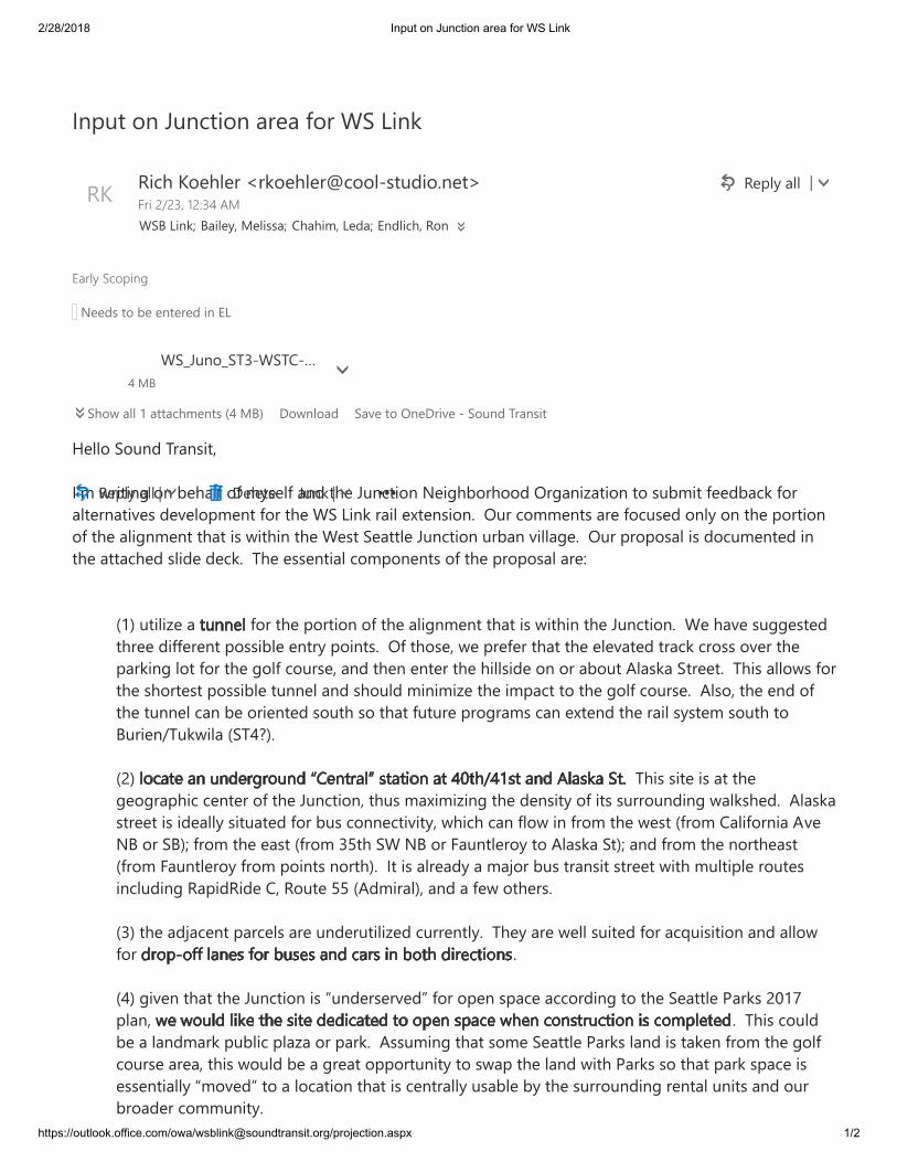
��������� ������� ����������������������
���������������������������������� ���!��������"����#���������$ ���
%&''(�)(*+,�-./+0123�456�7.121+8�(+�9&:/';�(;�6<0&';�/+,�2:&�=*+>21(+�?&18:9(.:((,�@.8/+1A/21(+�2(�0*9612�;&&,9/>B�;(./'2&.+/21C&0�,&C&'(D6&+2�;(.�2:&�E)�F1+B�./1'�&G2&+01(+H��@*.�>(66&+20�/.&�;(>*0&,�(+'<�(+�2:&�D(.21(+(;�2:&�/'18+6&+2�2:/2�10�712:1+�2:&�E&02�)&/22'&�=*+>21(+�*.9/+�C1''/8&H��@*.�D.(D(0/'�10�,(>*6&+2&,�1+2:&�/22/>:&,�0'1,&�,&>BH��-:&�&00&+21/'�>(6D(+&+20�(;�2:&�D.(D(0/'�/.&IJKL�*21'1A&�/� �;(.�2:&�D(.21(+�(;�2:&�/'18+6&+2�2:/2�10�712:1+�2:&�=*+>21(+H��E&�:/C&�0*88&02&,2:.&&�,1;;&.&+2�D(0019'&�&+2.<�D(1+20H��@;�2:(0&3�7&�D.&;&.�2:/2�2:&�&'&C/2&,�2./>B�>.(00�(C&.�2:&D/.B1+8�'(2�;(.�2:&�8(';�>(*.0&3�/+,�2:&+�&+2&.�2:&�:1''01,&�(+�(.�/9(*2�M'/0B/�)2.&&2H��-:10�/''(70�;(.2:&�0:(.2&02�D(0019'&�2*++&'�/+,�0:(*',�61+161A&�2:&�16D/>2�2(�2:&�8(';�>(*.0&H��M'0(3�2:&�&+,�(;2:&�2*++&'�>/+�9&�(.1&+2&,�0(*2:�0(�2:/2�;*2*.&�D.(8./60�>/+�&G2&+,�2:&�./1'�0<02&6�0(*2:�2(N*.1&+O-*B71'/�J)-PQLHJRL� �-:10�012&�10�/2�2:&8&(8./D:1>�>&+2&.�(;�2:&�=*+>21(+3�2:*0�6/G161A1+8�2:&�,&+012<�(;�120�0*..(*+,1+8�7/'B0:&,H��M'/0B/02.&&2�10�1,&/''<�012*/2&,�;(.�9*0�>(++&>21C12<3�7:1>:�>/+�;'(7�1+�;.(6�2:&�7&02�J;.(6�S/'1;(.+1/�MC&?N�(.�)NLT�;.(6�2:&�&/02�J;.(6�UV2:�)E�?N�(.�W/*+2'&.(<�2(�M'/0B/�)2LT�/+,�;.(6�2:&�+(.2:&/02J;.(6�W/*+2'&.(<�;.(6�D(1+20�+(.2:LH��42�10�/'.&/,<�/�6/X(.�9*0�2./+012�02.&&2�712:�6*'21D'&�.(*2&01+>'*,1+8�Y/D1,Y1,&�S3�Y(*2&�VV�JM,61./'L3�/+,�/�;&7�(2:&.0HJUL�2:&�/,X/>&+2�D/.>&'0�/.&�*+,&.*21'1A&,�>*..&+2'<H��-:&<�/.&�7&''�0*12&,�;(.�/>Z*10121(+�/+,�/''(7;(.� HJPL�81C&+�2:/2�2:&�=*+>21(+�10�[*+,&.0&.C&,\�;(.�(D&+�0D/>&�/>>(.,1+8�2(�2:&�)&/22'&�]/.B0�R̂K_D'/+3� H��-:10�>(*',9&�/�'/+,6/.B�D*9'1>�D'/A/�(.�D/.BH��M00*61+8�2:/2�0(6&�)&/22'&�]/.B0�'/+,�10�2/B&+�;.(6�2:&�8(';>(*.0&�/.&/3�2:10�7(*',�9&�/�8.&/2�(DD(.2*+12<�2(�07/D�2:&�'/+,�712:�]/.B0�0(�2:/2�D/.B�0D/>&�10&00&+21/''<�[6(C&,\�2(�/�'(>/21(+�2:/2�10�>&+2./''<�*0/9'&�9<�2:&�0*..(*+,1+8�.&+2/'�*+120�/+,�(*.9.(/,&.�>(66*+12<H
4+D*2�(+�=*+>21(+�/.&/�;(.�E)�F1+B � Y&D'<�/''̀abcdef�ghijklmYn Y1>:�n(&:'&.�o.B(&:'&.p>(('q02*,1(H+&2r stdk�uvuwx�yuzw{�|}E)N�F1+BTN/1'&<3�~&'100/TS:/:163�F&,/T�+,'1>:3�Y(+�?&&,0�2(�9&�&+2&.&,�1+��F a�):(7�/''�K�/22/>:6&+20�JP�~NL��(7+'(/, �)/C&�2(�@+&�.1C&�q�)(*+,�-./+012P�~N�E)�=*+(�)-UqE)-Sq�Y&D'<�/''̀as �&'&2&� =*+B̀a �
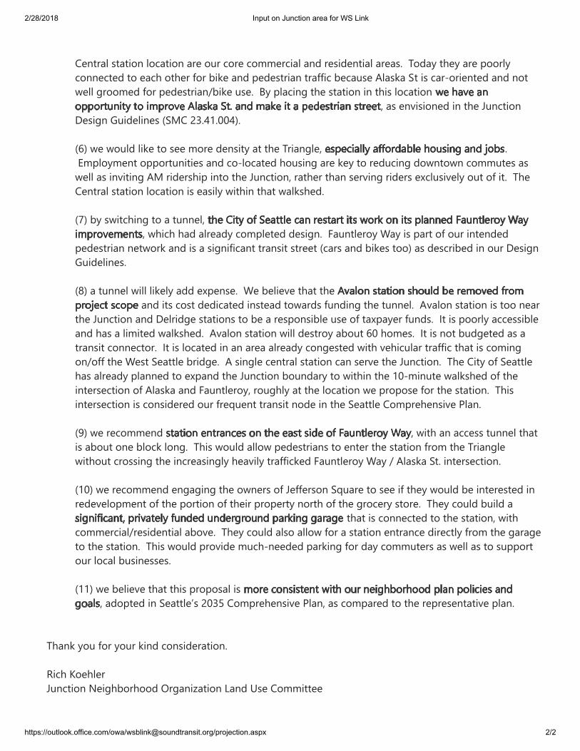
��������� ������� ����������������������
���������������������������������� ���!��������"����#���������$ ���
%&'�()*�+,*+-�./�()*�0123(4.2�(.�()*�455*64+(*�7*-(�%8+94/.,24+�:;*'�+26�*+-(�%()*�<,4+2=9*'�./�()*8*2(,+9�-(+(4.2�9.3+(4.2�+,*�.1,�3.,*�3.55*,34+9�+26�,*-46*2(4+9�+,*+->��<.6+?�()*?�+,*�@..,9?3.22*3(*6�(.�*+3)�.()*,�/.,�A4B*�+26�@*6*-(,4+2�(,+//43�A*3+1-*�:9+-B+�C(�4-�3+,D.,4*2(*6�+26�2.(7*99�=,..5*6�/.,�@*6*-(,4+2EA4B*�1-*>��F?�@9+342=�()*�-(+(4.2�42�()4-�9.3+(4.2�G�+-�*2;4-4.2*6�42�()*�0123(4.2H*-4=2�I146*942*-�%CJ8�KL>MN>OOM'>%P'�7*�7.196�94B*�(.�-**�5.,*�6*2-4(?�+(�()*�<,4+2=9*G >�Q5@9.?5*2(�.@@.,(124(4*-�+26�3.D9.3+(*6�).1-42=�+,*�B*?�(.�,*61342=�6.72(.72�3.551(*-�+-7*99�+-�42;4(42=�:J�,46*,-)4@�42(.�()*�0123(4.2G�,+()*,�()+2�-*,;42=�,46*,-�*R391-4;*9?�.1(�./�4(>��<)*8*2(,+9�-(+(4.2�9.3+(4.2�4-�*+-49?�74()42�()+(�7+9B-)*6>��%S'�A?�-74(3)42=�(.�+�(122*9G�G�7)43)�)+6�+9,*+6?�3.5@9*(*6�6*-4=2>��T+12(9*,.?�U+?�4-�@+,(�./�.1,�42(*26*6@*6*-(,4+2�2*(7.,B�+26�4-�+�-4=24/43+2(�(,+2-4(�-(,**(�%3+,-�+26�A4B*-�(..'�+-�6*-3,4A*6�42�.1,�H*-4=2I146*942*->%V'�+�(122*9�7499�94B*9?�+66�*R@*2-*>��U*�A*94*;*�()+(�()*�+26�4(-�3.-(�6*643+(*6�42-(*+6�(.7+,6-�/12642=�()*�(122*9>��:;+9.2�-(+(4.2�4-�(..�2*+,()*�0123(4.2�+26�H*9,46=*�-(+(4.2-�(.�A*�+�,*[email protected]*�1-*�./�(+R@+?*,�/126->��W(�4-�@..,9?�+33*--4A9*+26�)+-�+�9454(*6�7+9B-)*6>��:;+9.2�-(+(4.2�7499�6*-(,.?�+A.1(�PO�).5*->��W(�4-�2.(�A16=*(*6�+-�+(,+2-4(�3.22*3(.,>��W(�4-�9.3+(*6�42�+2�+,*+�+9,*+6?�3.2=*-(*6�74()�;*)4319+,�(,+//43�()+(�4-�3.542=.2E.//�()*�U*-(�C*+((9*�A,46=*>��:�-42=9*�3*2(,+9�-(+(4.2�3+2�-*,;*�()*�0123(4.2>��<)*�84(?�./�C*+((9*)+-�+9,*+6?�@9+22*6�(.�*R@+26�()*�0123(4.2�A.126+,?�(.�74()42�()*�NOD5421(*�7+9B-)*6�./�()*42(*,-*3(4.2�./�:9+-B+�+26�T+12(9*,.?G�,.1=)9?�+(�()*�9.3+(4.2�7*�@,[email protected]*�/.,�()*�-(+(4.2>��<)4-42(*,-*3(4.2�4-�3.2-46*,*6�.1,�/,*X1*2(�(,+2-4(�2.6*�42�()*�C*+((9*�8.5@,*)*2-4;*�Y9+2>%Z'�7*�,*3.55*26� G�74()�+2�+33*--�(122*9�()+(4-�+A.1(�.2*�A9.3B�9.2=>��<)4-�7.196�+99.7�@*6*-(,4+2-�(.�*2(*,�()*�-(+(4.2�/,.5�()*�<,4+2=9*74().1(�3,.--42=�()*�423,*+-42=9?�)*+;49?�(,+//43B*6�T+12(9*,.?�U+?�E�:9+-B+�C(>�42(*,-*3(4.2>%NO'�7*�,*3.55*26�*2=+=42=�()*�.72*,-�./�0*//*,-.2�CX1+,*�(.�-**�4/�()*?�7.196�A*�42(*,*-(*6�42,*6*;*9.@5*2(�./�()*�@.,(4.2�./�()*4,�@,.@*,(?�2.,()�./�()*�=,.3*,?�-(.,*>��<)*?�3.196�A1496�+�()+(�4-�3.22*3(*6�(.�()*�-(+(4.2G�74()3.55*,34+9E,*-46*2(4+9�+A.;*>��<)*?�3.196�+9-.�+99.7�/.,�+�-(+(4.2�*2(,+23*�64,*3(9?�/,.5�()*�=+,+=*(.�()*�-(+(4.2>��<)4-�7.196�@,.;46*�513)D2**6*6�@+,B42=�/.,�6+?�3.551(*,-�+-�7*99�+-�(.�-1@@.,(.1,�9.3+9�A1-42*--*->%NN'�7*�A*94*;*�()+(�()4-�@,[email protected]+9�4-�G�+6.@(*6�42�C*+((9*[-�KOL&�8.5@,*)*2-4;*�Y9+2G�+-�3.5@+,*6�(.�()*�,*@,*-*2(+(4;*�@9+2><)+2B�?.1�/.,�?.1,�B426�3.2-46*,+(4.2>\43)�].*)9*,0123(4.2�̂*4=)A.,)..6�_,=+24̀+(4.2�a+26�b-*�8.554((**
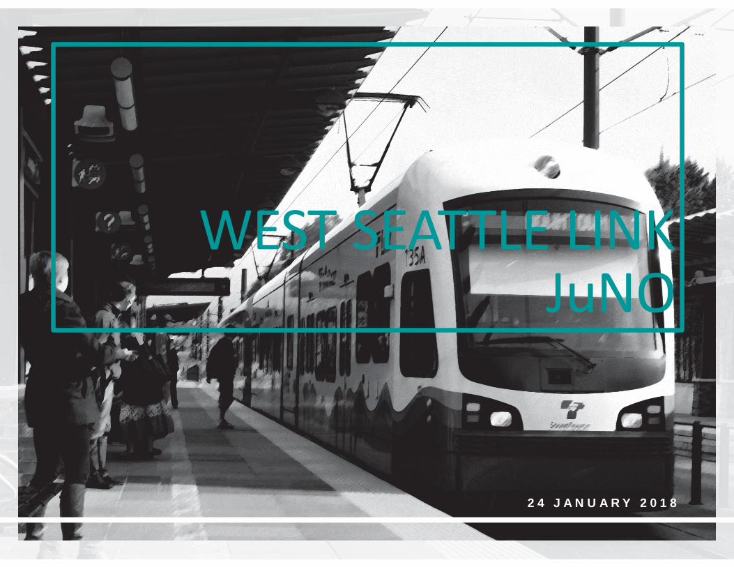
2 4 J A N U A R Y 2 0 1 8
WEST SEATTLE LINKJuNO
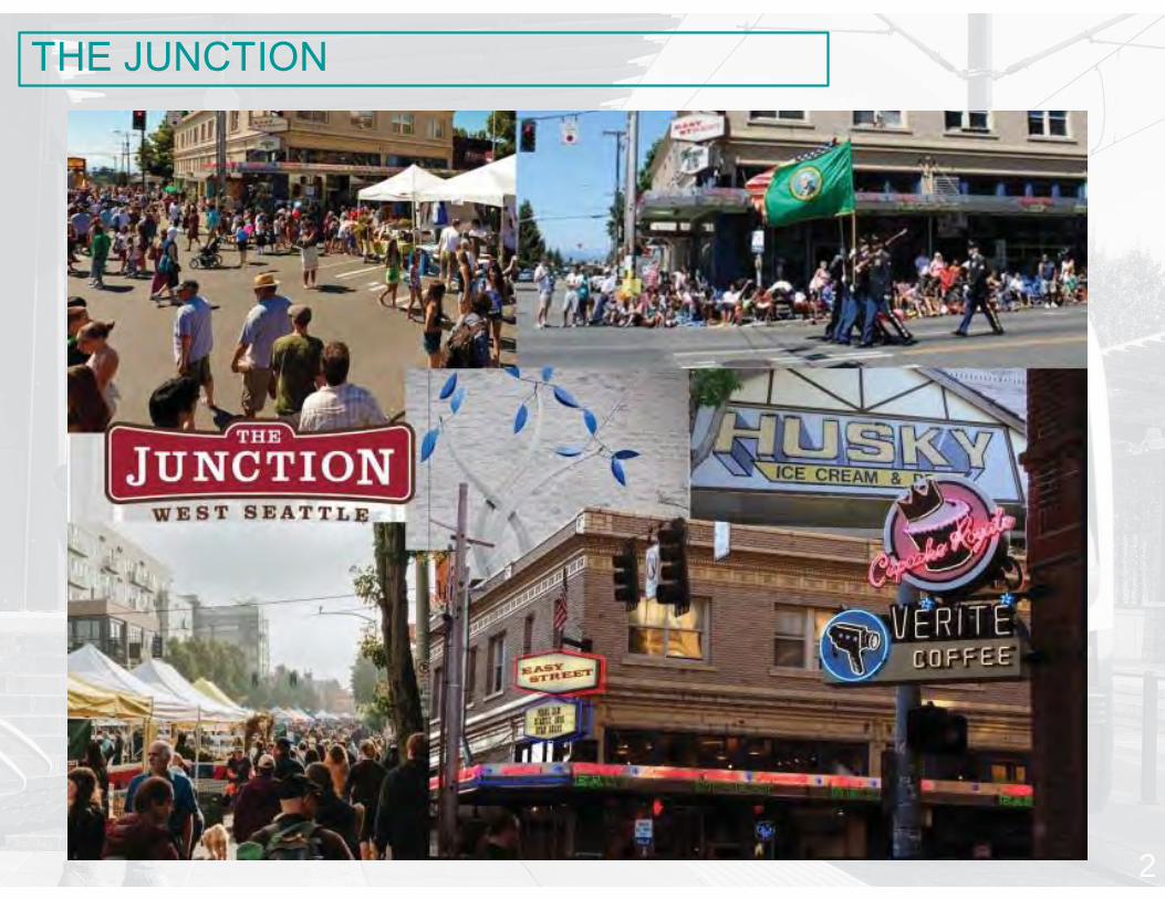
2
THE JUNCTION
u Streetcar junction in 1920’su Hub Urban Village since 1990’su Walkable urban neighborhoodu 4,000+ householdsu 226 acresu 204’ of elevation change Avalon-to-California
BACKGROUND
3
u Set forth in SMC 23.41.004u Defines the commercial coreu Specifies pedestrian-orientation and
architectural standardsu Priorities include walkability and connectivity
through commercial zones and open spaces
DESIGN GUIDELINES
4
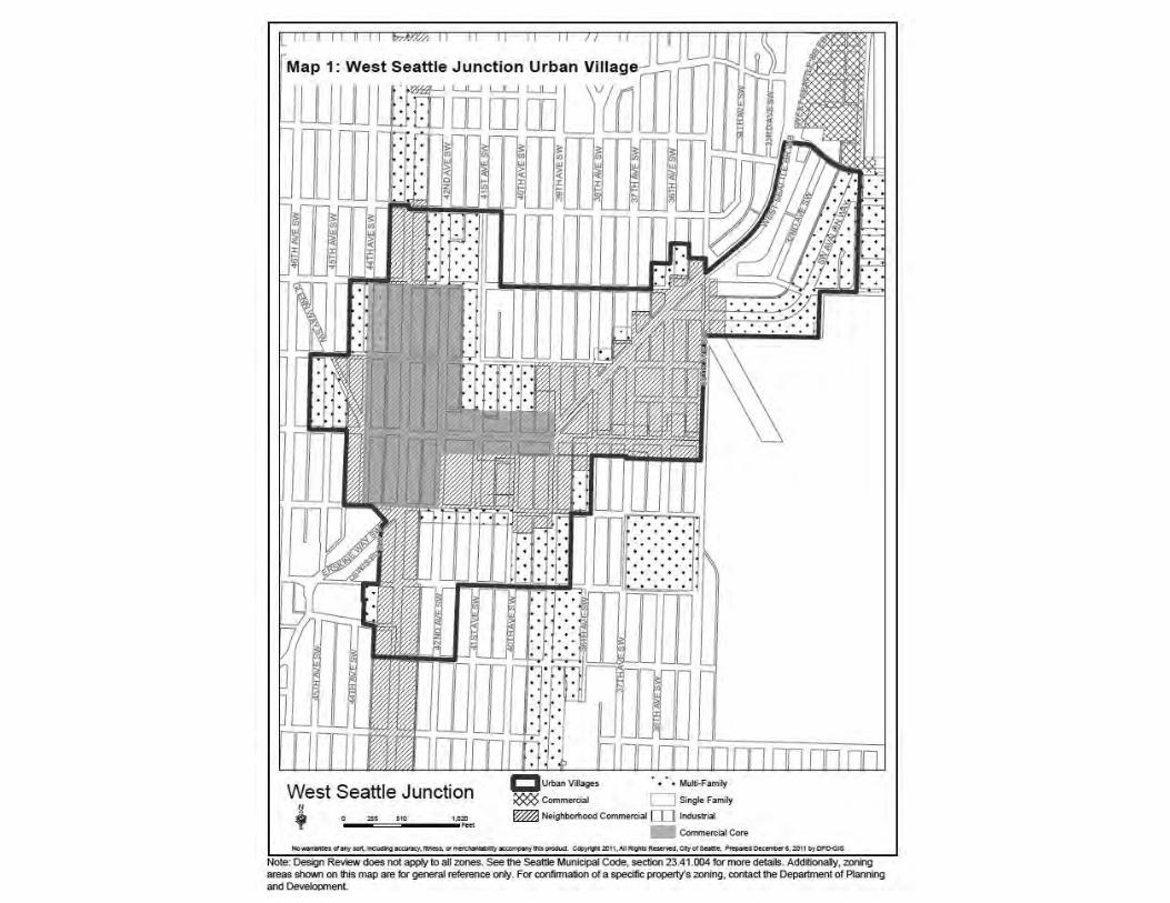
5
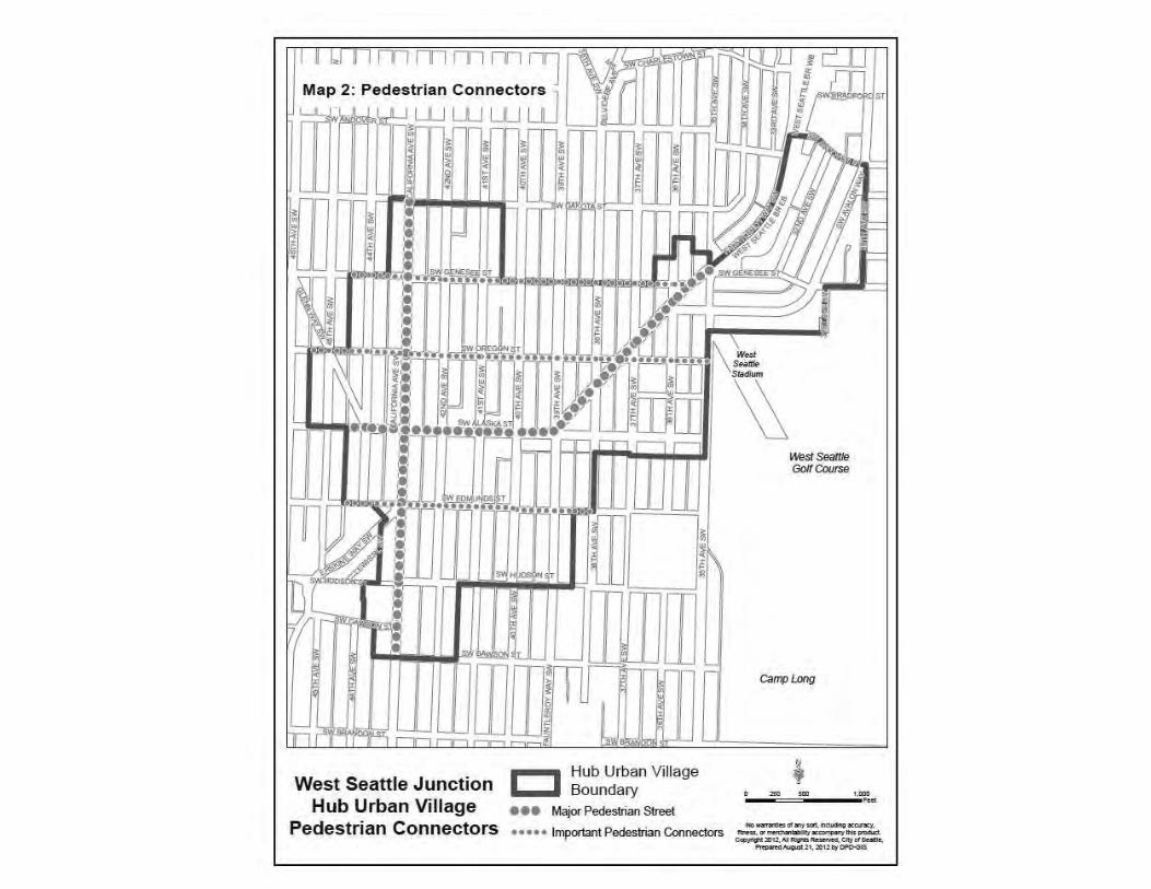
6
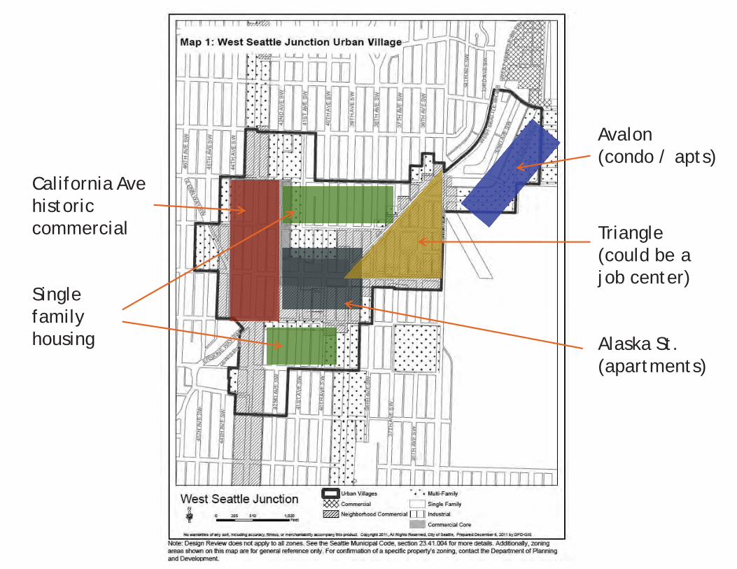
7
Avalon(condo / apts)
Triangle(could be a job center)
Alaska St.(apartments)
California Avehistoriccommercial
Single family housing
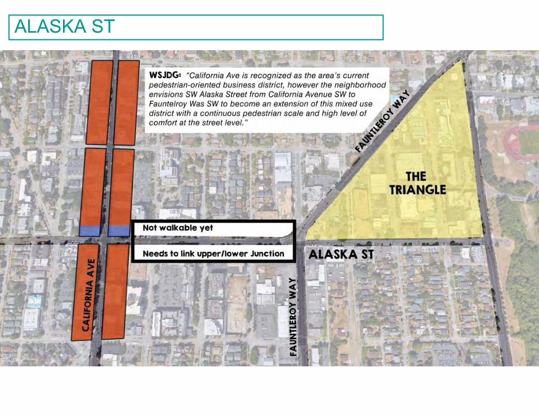
8
ALASKA ST
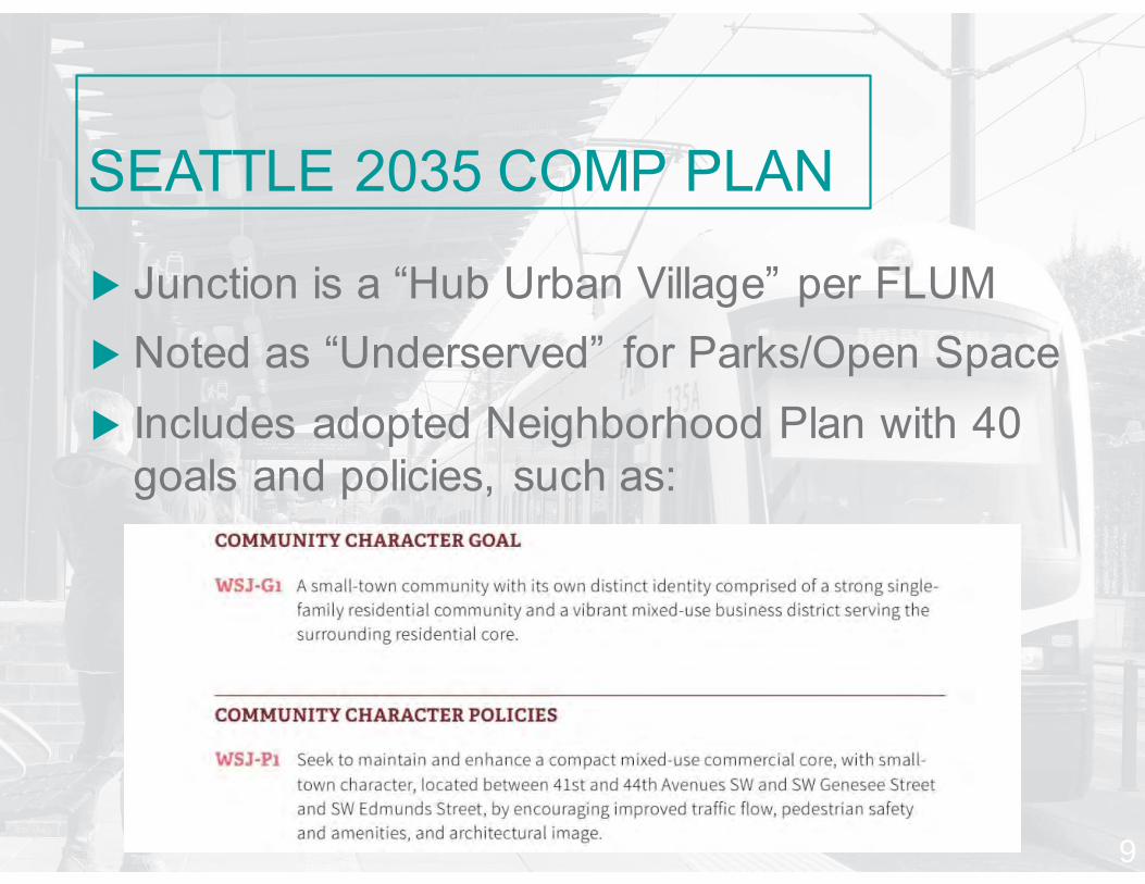
u Junction is a “Hub Urban Village” per FLUMu Noted as “Underserved” for Parks/Open Spaceu Includes adopted Neighborhood Plan with 40
goals and policies, such as:
SEATTLE 2035 COMP PLAN
9
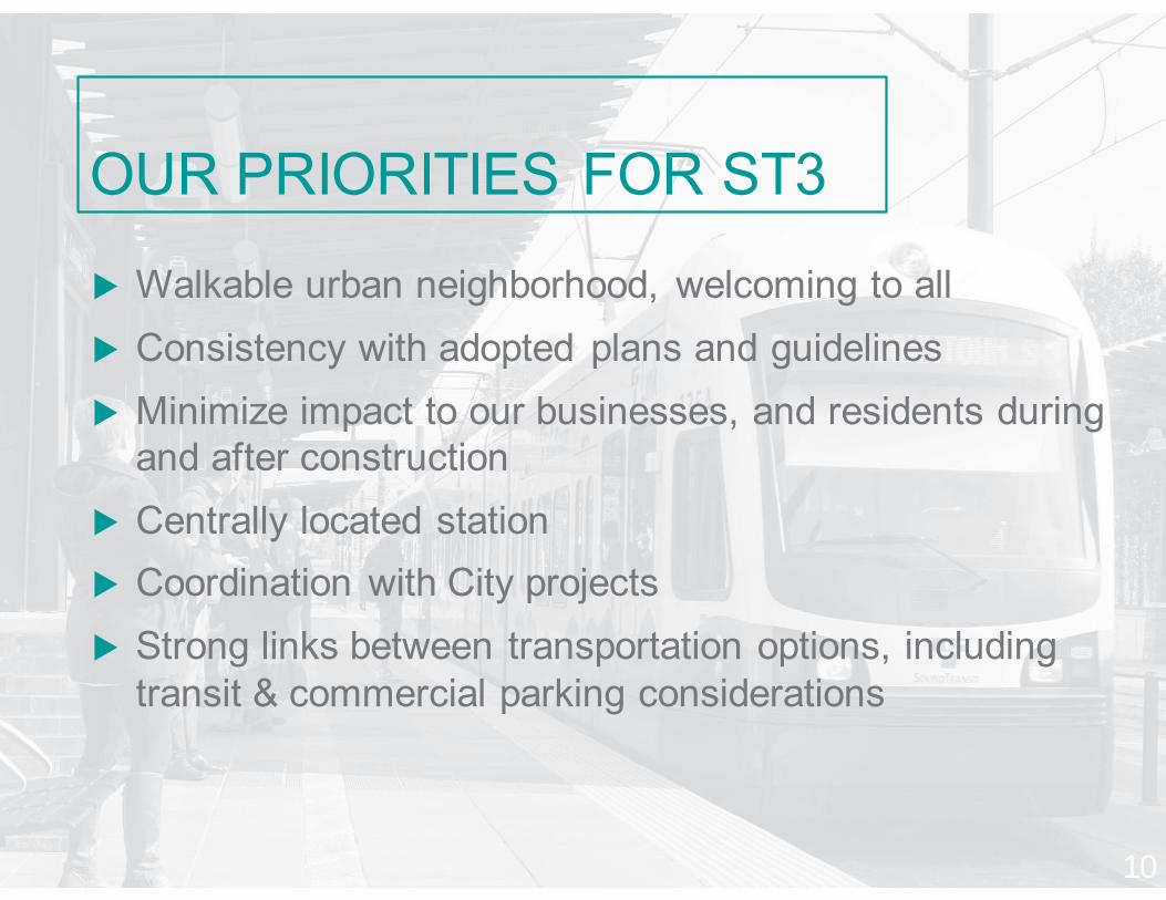
u Walkable urban neighborhood, welcoming to allu Consistency with adopted plans and guidelinesu Minimize impact to our businesses, and residents during
and after constructionu Centrally located stationu Coordination with City projectsu Strong links between transportation options, including
transit & commercial parking considerations
OUR PRIORITIES FOR ST3
10
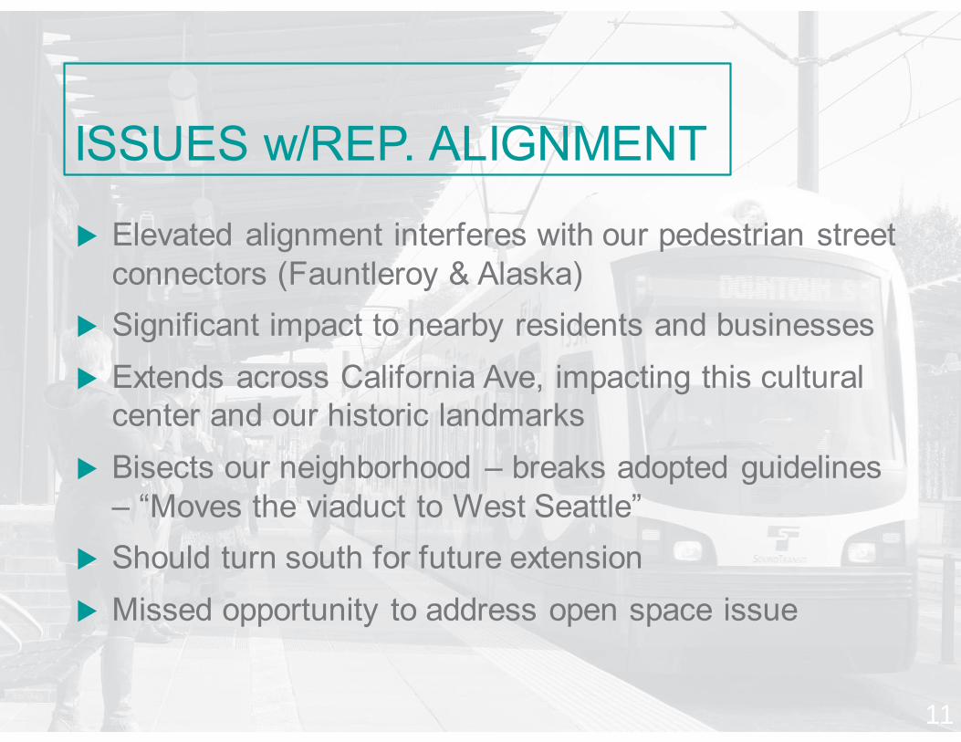
u Elevated alignment interferes with our pedestrian street connectors (Fauntleroy & Alaska)
u Significant impact to nearby residents and businessesu Extends across California Ave, impacting this cultural
center and our historic landmarksu Bisects our neighborhood – breaks adopted guidelines
– “Moves the viaduct to West Seattle”u Should turn south for future extensionu Missed opportunity to address open space issue
ISSUES w/REP. ALIGNMENT
11

ELEVATED VISUALS
12
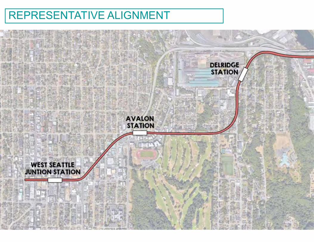
13
REPRESENTATIVE ALIGNMENT
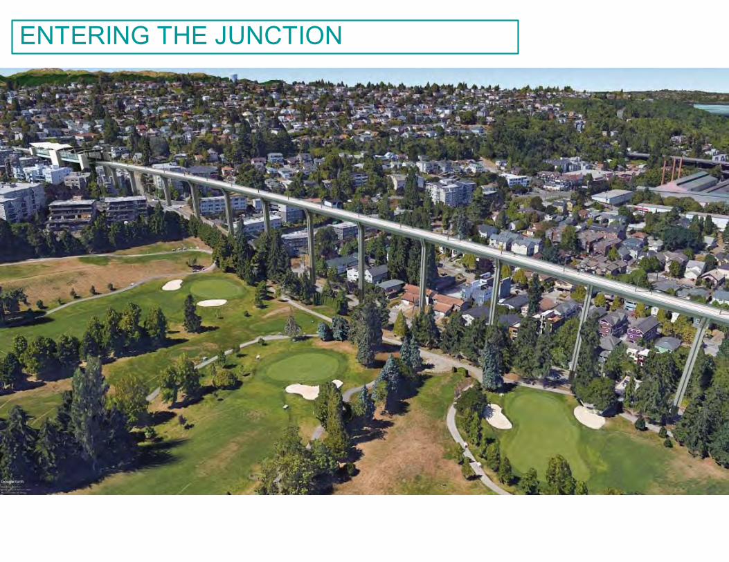
14
ENTERING THE JUNCTION
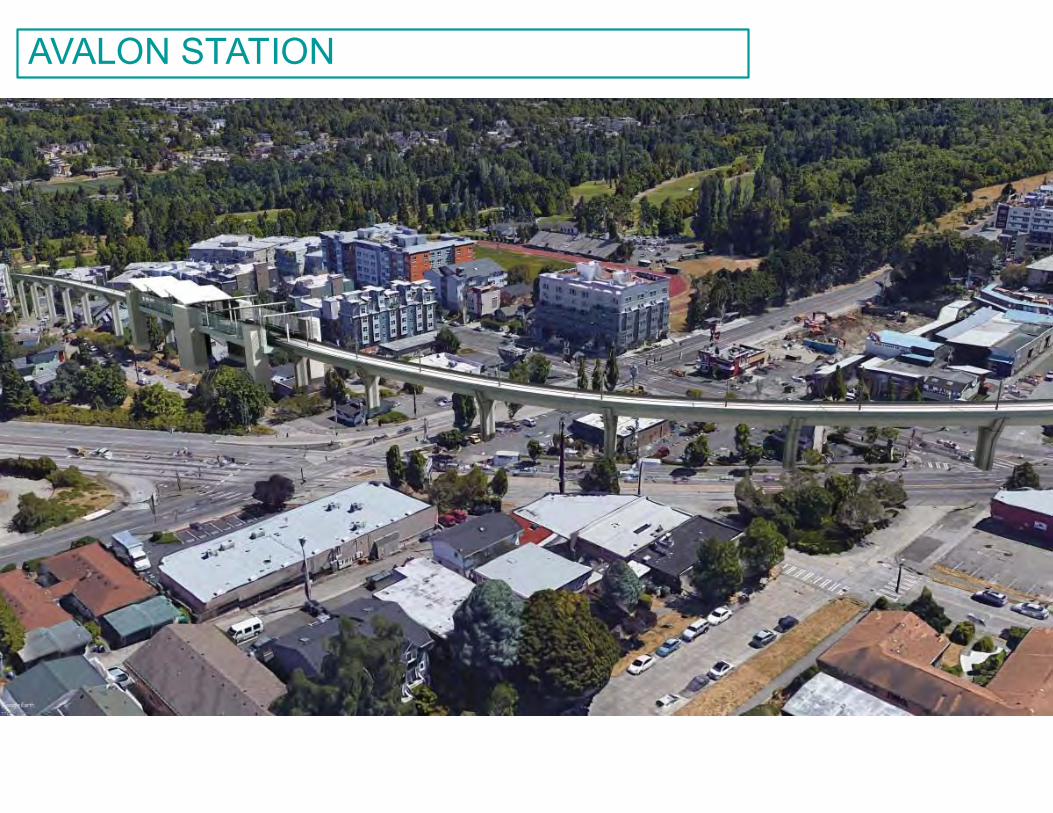
15
AVALON STATION
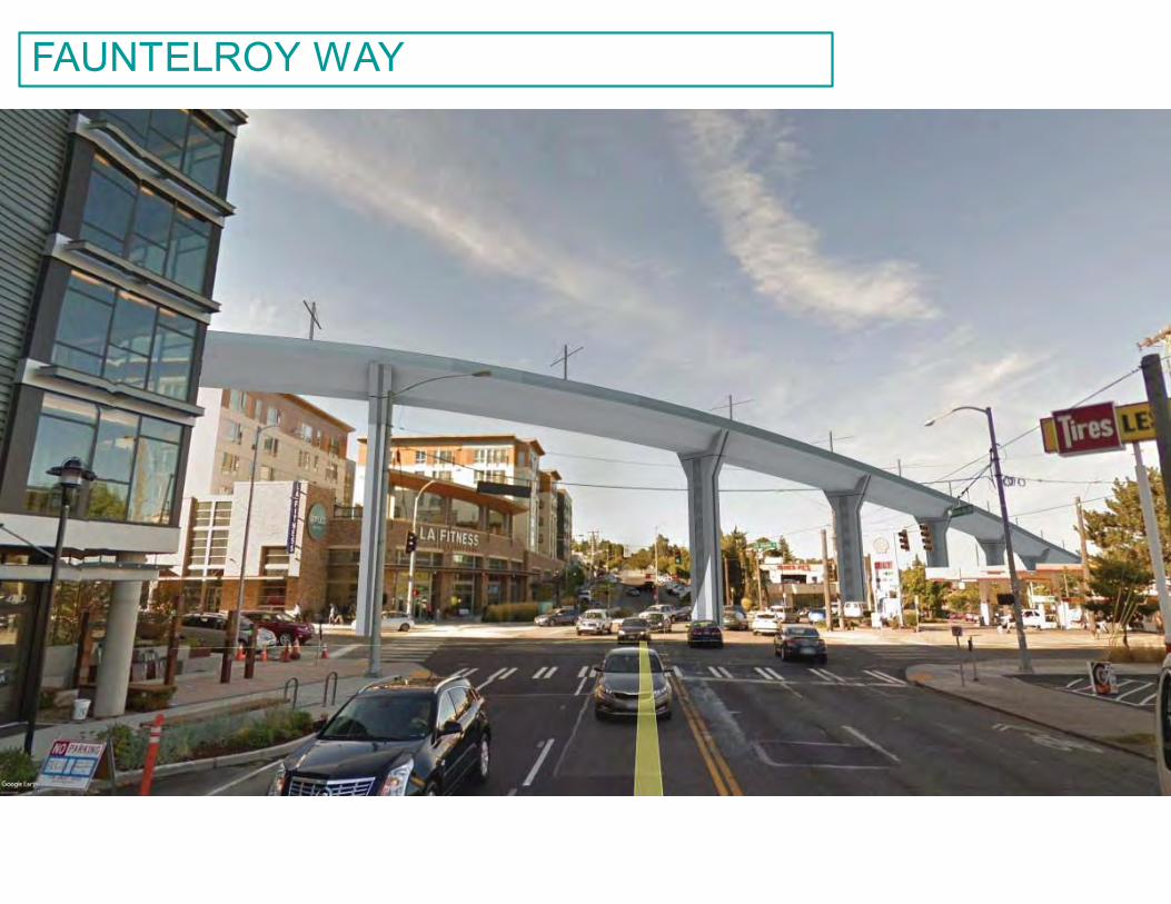
16
FAUNTELROY WAY
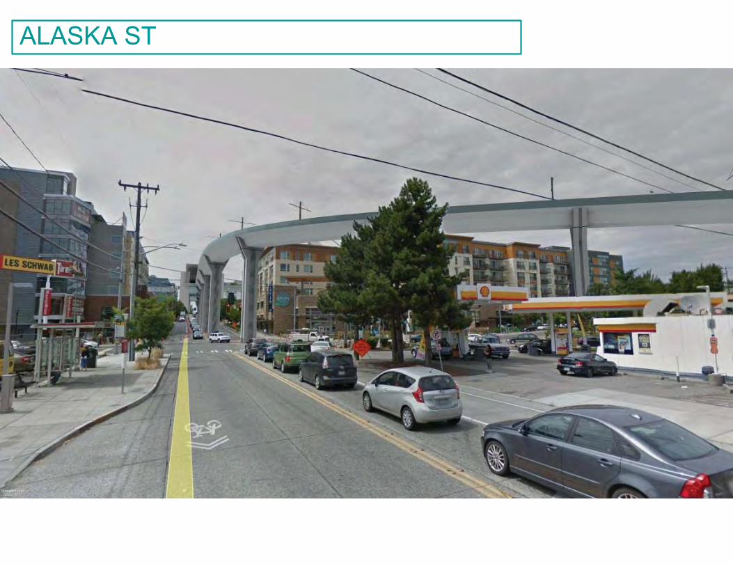
17
ALASKA ST
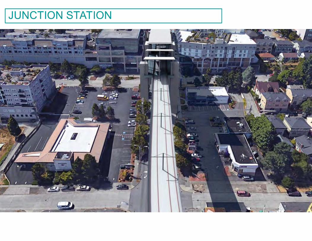
18
JUNCTION STATION
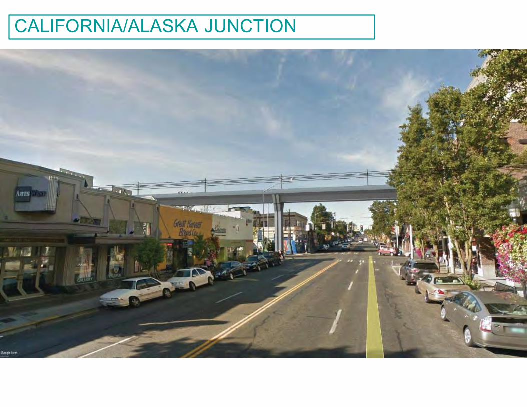
19
CALIFORNIA/ALASKA JUNCTION
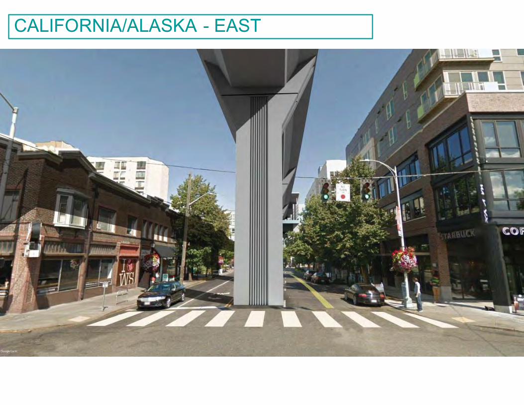
20
CALIFORNIA/ALASKA - EAST
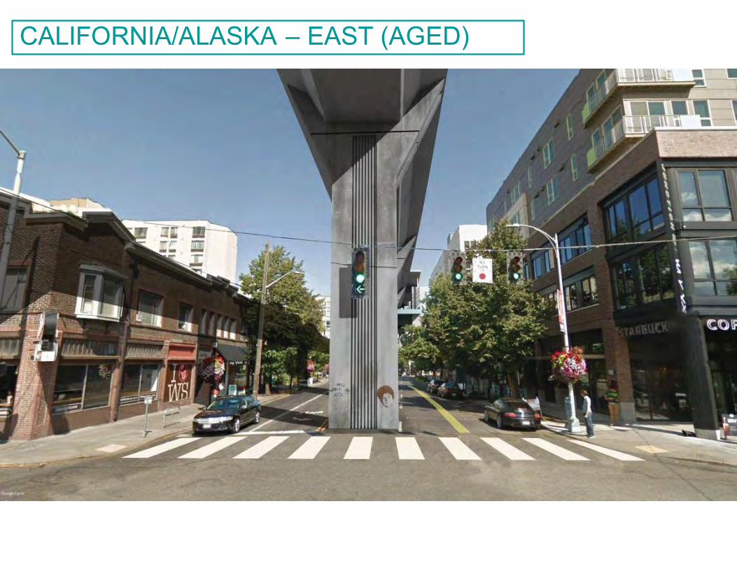
21
CALIFORNIA/ALASKA – EAST (AGED)
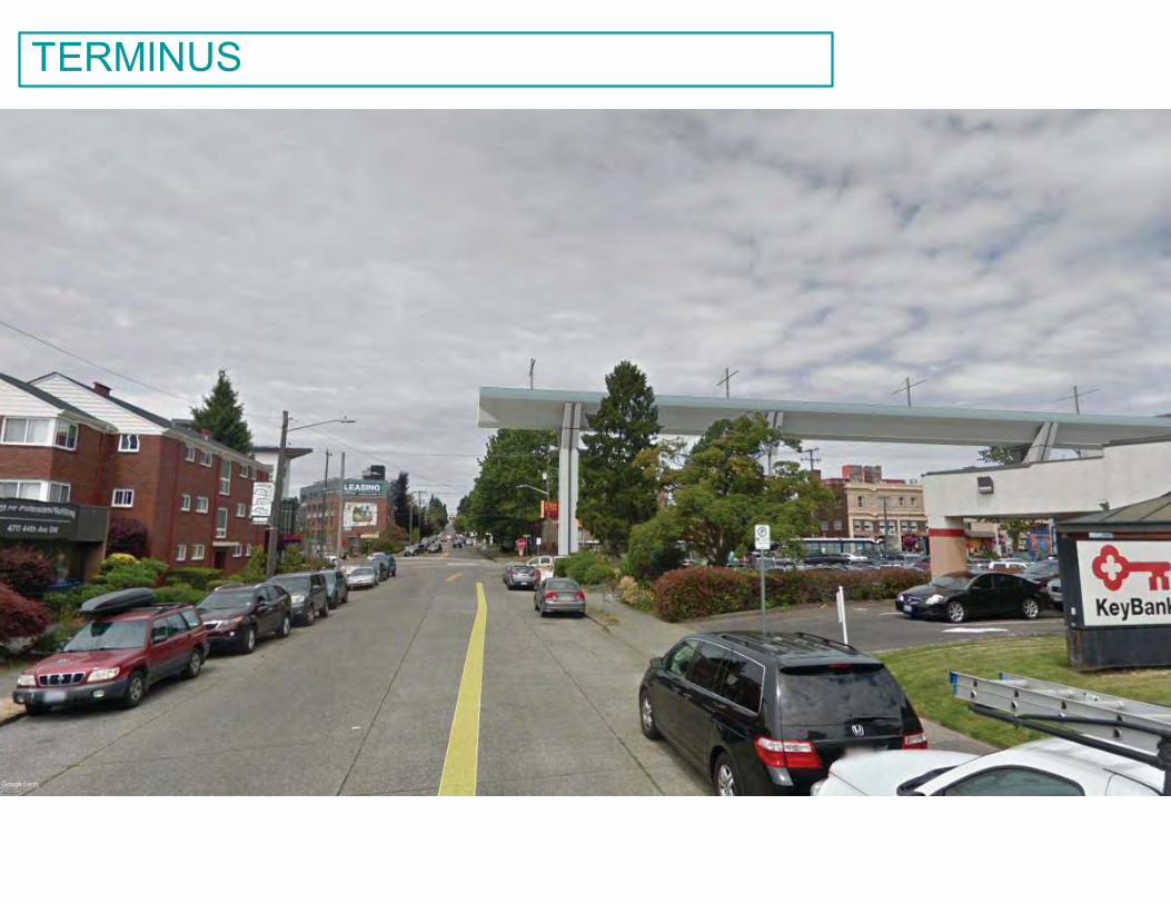
22
TERMINUS
TUNNEL / CENTRAL STATION ALTERNATIVE
23
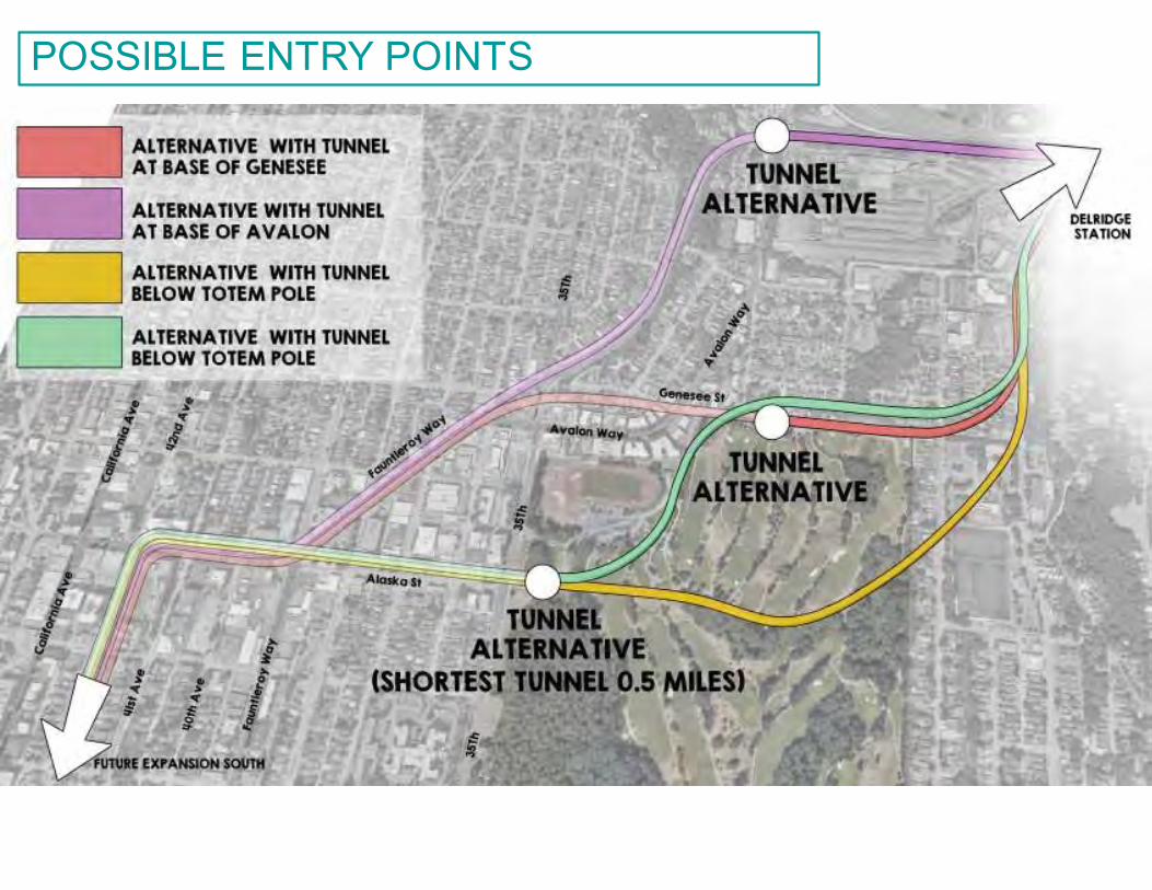
24
POSSIBLE ENTRY POINTS
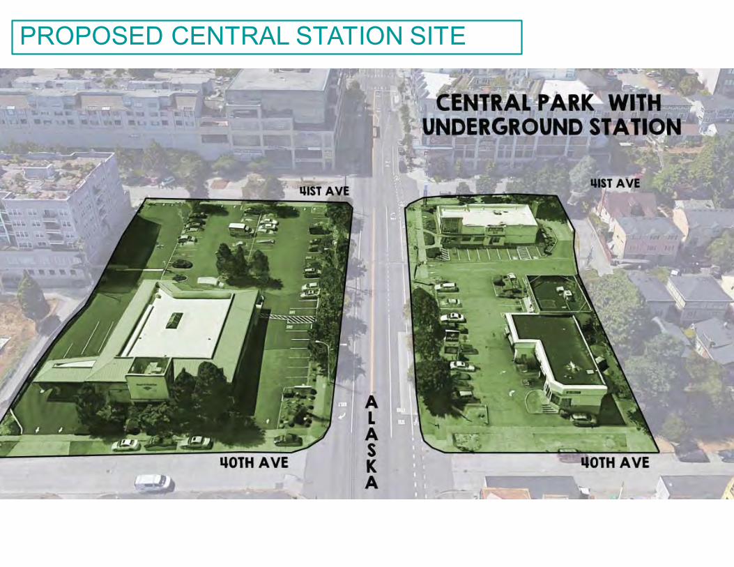
25
PROPOSED CENTRAL STATION SITE
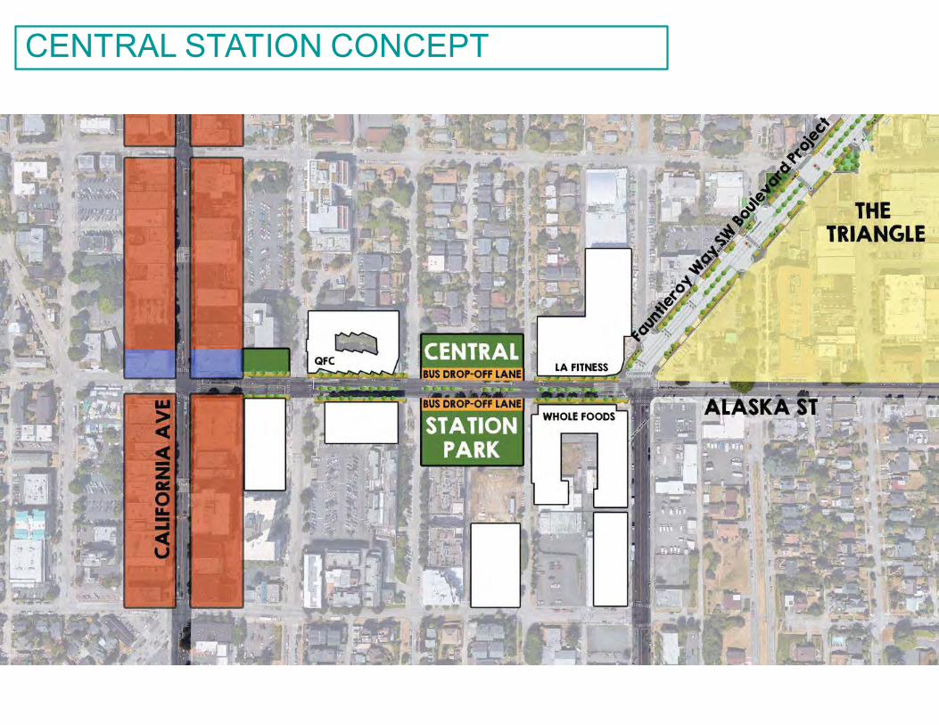
26
CENTRAL STATION CONCEPT
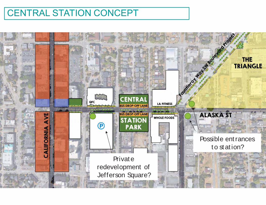
27
CENTRAL STATION CONCEPT
Possible entrances to station?
Private redevelopment of Jefferson Square?
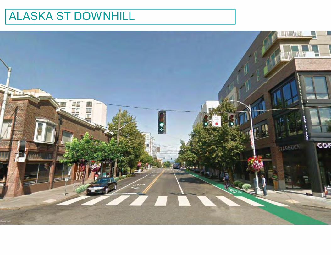
28
ALASKA ST DOWNHILL
u Solve open space issueu Complete planned greenway and pedestrian
connectorsu Create central gathering placeu Integrate with existing park acquisition spaceu Do a land swap? Trade some space at the
stadium / golf course area for new central park
WHY?
29
u Use tunnel to minimize property acquisition, environmental impact, and legal issues
u De-scope Avalon station and invest savings in tunnel
u Add additional ST funding sources?u Possible mixed-use zoning incentives at the
Triangle with impact fees?
HOW TO PAY FOR IT?
30
u Small walkshedu Not designated in ST3 as a transit connectoru Difficult to access—steep slopesu Ped access is bisected by major arterial streetsu Junction station is 4 blocks awayu Saves 60+ homes from demolition
WHY TRADE AVALON STATION?
31
u Current proposal is out of step with established area plans.
u Recommendations:o #1: TUNNELo #2: ONE CENTRAL STATIONo #3: ADD OPEN SPACEo #4: FOLLOW DESIGN GUIDELINESo #5: PEDESTRIAN/BIKE CONNECTORS
CONCLUSION
32
u Deadline for suggestions for this or other alternatives is March 5th !
u [email protected] https://wsblink.participate.online
NEXT STEPS
33
ADDITIONAL SLIDES
34
35
STATIONS ARE CLOSE TOGETHER – WHY SPEND THE $?
Compare distances
36
STATION AREAS OVERLAP
37
AVALON STATION IS NOT NEEDED
Park area
Served by Delridge
Served by Junction
WS Bridge (barrier)
Avalon Station only adds this
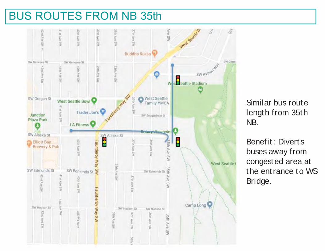
38
BUS ROUTES FROM NB 35th
Similar bus route length from 35th NB.
Benefit: Diverts buses away from congested area at the entrance to WS Bridge.
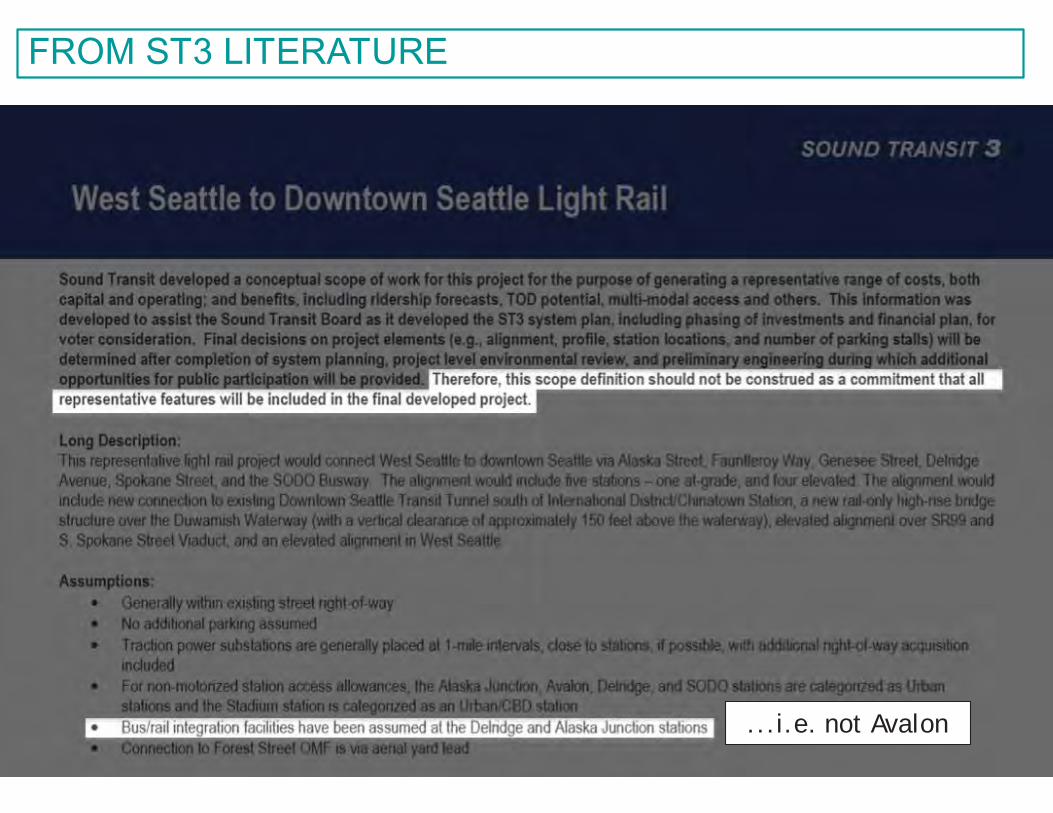
39
FROM ST3 LITERATURE
...i.e. not Avalon
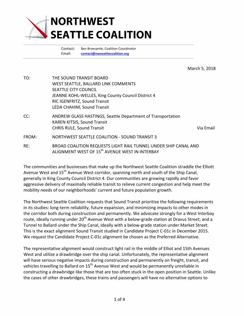
NORTHWEST SEATTLE COALITION
Contact: BenBroesamle,CoalitionCoordinatorEmail: [email protected]
1of4
March5,2018
TO: THESOUNDTRANSITBOARDWESTSEATTLE,BALLARDLINKCOMMENTSSEATTLECITYCOUNCILJEANNEKOHL-WELLES,KingCountyCouncilDistrict4RICIGENFRITZ,SoundTransitLEDACHAHIM,SoundTransit
CC: ANDREWGLASSHASTINGS,SeattleDepartmentofTransportationKARENKITSIS,SoundTransitCHRISRULE,SoundTransit ViaEmail
FROM: NORTHWESTSEATTLECOALITION-SOUNDTRANSIT3
RE: BROADCOALITIONREQUESTSLIGHTRAILTUNNELUNDERSHIPCANALANDALIGNMENTWESTOF15thAVENUEWESTININTERBAY
ThecommunitiesandbusinessesthatmakeuptheNorthwestSeattleCoalitionstraddletheElliottAvenueWestand15thAvenueWestcorridor,spanningnorthandsouthoftheShipCanal,generallyinKingCountyCouncilDistrict4.Ourcommunitiesaregrowingrapidlyandfavoraggressivedeliveryofmaximallyreliabletransittorelievecurrentcongestionandhelpmeetthemobilityneedsofourneighborhoods’currentandfuturepopulationgrowth.TheNorthwestSeattleCoalitionrequeststhatSoundTransitprioritizethefollowingrequirementsinitsstudies:long-termreliability,futureexpansion,andminimizingimpactstoothermodesinthecorridorbothduringconstructionandpermanently.WeadvocatestronglyforaWestInterbayroute,ideallyrunningunder20thAvenueWestwithabelow-gradestationatDravusStreet;andaTunneltoBallardundertheShipCanal,ideallywithabelow-gradestationunderMarketStreet.ThisistheexactalignmentSoundTransitstudiedinCandidateProjectC-01cinDecember2015.WerequesttheCandidateProjectC-01calignmentbechosenasthePreferredAlternative.TherepresentativealignmentwouldconstructlightrailinthemiddleofElliotand15thAvenuesWestandutilizeadrawbridgeovertheshipcanal.Unfortunately,therepresentativealignmentwillhaveseriousnegativeimpactsduringconstructionandpermanentlyonfreight,transit,andvehiclestravellingtoBallardon15thAvenueWestandwouldbepermanentlyunreliableinconstructingadrawbridgelikethosethataretoooftenstuckintheopenpositioninSeattle.Unlikethecasesofotherdrawbridges,thesetrainsandpassengerswillhavenoalternativeoptionsto
2of4
leaveBallard.Giventheenormousinvestmentofconstructiontimeandpublicfunds,wecannotallowtheSoundTransit3corridortobeasubparinvestmentinourfuturemobility.TheElliottAvenueand15thAvenueWestcorridor,theaortaofourcommunities,had54,500vehiclescrossingtheBallardBridgedailyin2014(perSDOT),overdoublethetrafficofMartinLutherKingWaySouth.Thiscorridorisbecomingincreasinglycongestedandtherearenosignsofimprovement.Ballardhasgrownbyabout2,000privateparkingspacesinrecentyears.TheInterbayneighborhoodisprojectedtogrowsimilarly.Expediaproposestoadd2,000parkingspacestoitscampus,whichwillopenin2019.TheElliott/15thcorridoroperateslikeasectionofplumbingpipewithcontrolvalvesattheBallardBridgeandwherethecorridormeetsdowntownatDennyWay.Whenthecontrolvalvesarestuck,nothingmoves.Tothismix,ST3proposestoremovecarcapacityonElliotAvenueand15thAvenueWestwithelevatedrailpylonsandtoperpetuatethecurrent“controlvalve”impedimentbyusingadrawbridgetocrosstheshipcanal.ThefinalPreferredAlternativemustenhance,andnotdiminishthecurrentandpotentialfuturecarryingcapacityoftheentire15thAvenueWestCorridor,bothduringandafterconstruction,allwithoutblockingresidents,workers,andpatronsfromutilizingbothsidesof15thAvenueWest.Ourcoalitioncontinuestorecommendadvancingalternativesthatdelivermuchmorereliable,rapidtransitservicewithfewernegativeimpactstotravelinthecorridor.Thesealternatives,whichinvolve:usingacorridortothewestof15thAvenueWest;crossingtheshipcanalbymeansofatunnel;andconstructinganundergroundstationinInterbay,andinBallardwhichwouldofferthebestoptionsforfuturenorthandeastexpansions.ThealignmentisidentifiedinSoundTransitplanningdocumentsasCandidateProjectC-01c.OurcontinuingadvocacyisbasedonourprioritiesofmaximizingreliabilityandpotentialforfutureexpansiontobothCrownHillandtheUniversityDistrict,whileminimizingnegativeimpactstoothermodesoftravelinthecorridor.Inadditiontomaximallyreliableservice,weneeditmuchsoonerthan2035.WebelievethatSoundTransit’sprioritiesmustbefirsttodeliverthemaximallyreliableShipCanaltunnelcrossingtothisahighridershipcorridor,andsecondtoensurethefastestdeliveryschedulepossible.GettingST3rightisessentialforourneighborhoods’futuremobility.ThankyouforconsideringourcommentsandtheTunneltoBallardasthelocallyPreferredAlternative.PleasedirectquestionsaboutourlettertoBenBroesamle,thecontactandcoordinatorfortheCoalitionandChairoftheTransportationCommitteeoftheMagnoliaCommunityCouncil.Hecanbereachedbycellphoneat(310)562-2759andbyemailatcontact@nwseattlecoalition.org.TheNorthwestSeattleCoalitionissendingthisletteronbehalfofitsmemberorganizationslistedonthefollowingpage.TheCoalitioncontinuestogrowasadditionalorganizationsjoinourcoalitionandendorseouradvocacy.
Verytrulyyours,
TheNorthwestSeattleCoalition
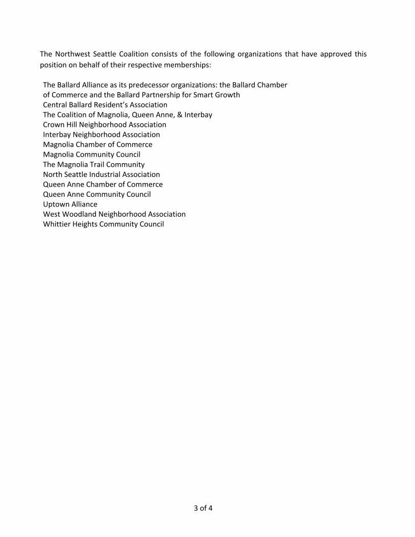
3of4
TheNorthwest SeattleCoalition consists of the followingorganizations that have approved thispositiononbehalfoftheirrespectivememberships:
TheBallardAllianceasitspredecessororganizations:theBallardChamberofCommerceandtheBallardPartnershipforSmartGrowthCentralBallardResident’sAssociationTheCoalitionofMagnolia,QueenAnne,&InterbayCrownHillNeighborhoodAssociationInterbayNeighborhoodAssociationMagnoliaChamberofCommerceMagnoliaCommunityCouncilTheMagnoliaTrailCommunityNorthSeattleIndustrialAssociationQueenAnneChamberofCommerceQueenAnneCommunityCouncilUptownAllianceWestWoodlandNeighborhoodAssociationWhittierHeightsCommunityCouncil
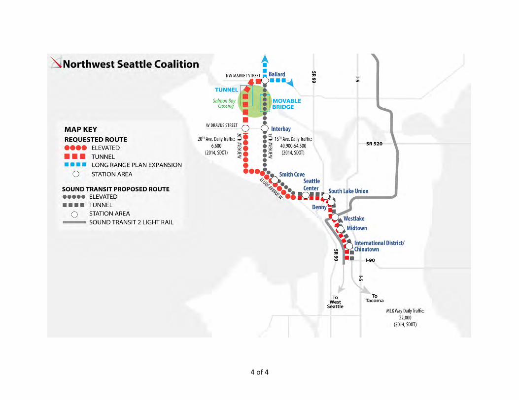
4of4
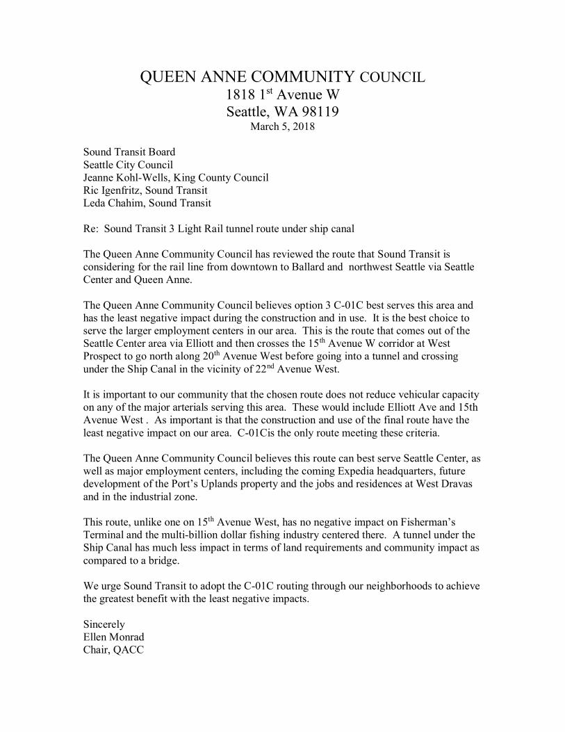
QUEEN ANNE COMMUNITY COUNCIL 1818 1st Avenue W Seattle, WA 98119
March 5, 2018
Sound Transit Board Seattle City Council Jeanne Kohl-Wells, King County Council Ric Igenfritz, Sound Transit Leda Chahim, Sound Transit Re: Sound Transit 3 Light Rail tunnel route under ship canal The Queen Anne Community Council has reviewed the route that Sound Transit is considering for the rail line from downtown to Ballard and northwest Seattle via Seattle Center and Queen Anne. The Queen Anne Community Council believes option 3 C-01C best serves this area and has the least negative impact during the construction and in use. It is the best choice to serve the larger employment centers in our area. This is the route that comes out of the Seattle Center area via Elliott and then crosses the 15th Avenue W corridor at West Prospect to go north along 20th Avenue West before going into a tunnel and crossing under the Ship Canal in the vicinity of 22nd Avenue West. It is important to our community that the chosen route does not reduce vehicular capacity on any of the major arterials serving this area. These would include Elliott Ave and 15th Avenue West . As important is that the construction and use of the final route have the least negative impact on our area. C-01Cis the only route meeting these criteria. The Queen Anne Community Council believes this route can best serve Seattle Center, as well as major employment centers, including the coming Expedia headquarters, future development of the Port’s Uplands property and the jobs and residences at West Dravas and in the industrial zone. This route, unlike one on 15th Avenue West, has no negative impact on Fisherman’s Terminal and the multi-billion dollar fishing industry centered there. A tunnel under the Ship Canal has much less impact in terms of land requirements and community impact as compared to a bridge. We urge Sound Transit to adopt the C-01C routing through our neighborhoods to achieve the greatest benefit with the least negative impacts. Sincerely Ellen Monrad Chair, QACC
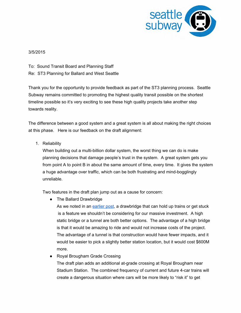
3/5/2015 To: Sound Transit Board and Planning Staff Re: ST3 Planning for Ballard and West Seattle Thank you for the opportunity to provide feedback as part of the ST3 planning process. Seattle Subway remains committed to promoting the highest quality transit possible on the shortest timeline possible so it’s very exciting to see these high quality projects take another step towards reality. The difference between a good system and a great system is all about making the right choices at this phase. Here is our feedback on the draft alignment:
1. Reliability When building out a multi-billion dollar system, the worst thing we can do is make planning decisions that damage people’s trust in the system. A great system gets you from point A to point B in about the same amount of time, every time. It gives the system a huge advantage over traffic, which can be both frustrating and mind-bogglingly unreliable.
Two features in the draft plan jump out as a cause for concern:
● The Ballard Drawbridge As we noted in an earlier post, a drawbridge that can hold up trains or get stuck is a feature we shouldn’t be considering for our massive investment. A high static bridge or a tunnel are both better options. The advantage of a high bridge is that it would be amazing to ride and would not increase costs of the project. The advantage of a tunnel is that construction would have fewer impacts, and it would be easier to pick a slightly better station location, but it would cost $600M more.
● Royal Brougham Grade Crossing The draft plan adds an additional at-grade crossing at Royal Brougham near Stadium Station. The combined frequency of current and future 4-car trains will create a dangerous situation where cars will be more likely to “risk it” to get
through the intersection. Crashes will potentially shut down the entire system for hours at a time. Either Royal Brougham needs to be vacated for auto traffic or Link needs to be elevated at that point. This needs to be decided in advance.
1. Expandability
ST3 is a fantastic expansion of our regional system, but will not be the end of rail expansion in Seattle. As the Seattle Transit Blog Editorial Board wrote last week, ST3 must be built for the future. The Sound Transit lines have to be designed so that future expansion can happen without high cost re-work or disruptions in service.
There are four areas that Sound Transit needs to future-proof for, and this feature has to be explicit in the plan.
● South Lake Union Either the South Lake Union or Denny Triangle Station must be designed
with future expansion to the east (Metro 8 line) and North (Aurora Line) in mind ● Madison
A future extension from the Madison Station to the east must be built into the station design. This will allow a subway extension into First Hill, the densest residential neighborhood West of Chicago and north of San Francisco. The future extension could also connect the Central District, Madison Valley, and a future 520 corridor extension.
● Ballard Ballard Station must be built with expansion to both the north (Crown Hill/Greenwood/Lake City) and east (Ballard/UW) in mind.
● West Seattle The West Seattle Line must be built with future expansion to the South (White Center/Burien) in mind.
● Sodo The new Sodo station must be build with future expansion to the south
(Georgetown, South Park Sea-Tac, Renton) in mind.
1. Accessibility A system is only as good as people’s ability to get to it. Integration with buses needs to be considered as critical to station location and design. Mt. Baker and Husky Stadium Stations show us what happens when too many compromises are made on rider experience. Pedestrian access and bike storage facilities need to be designed with safety and security as non-negotiable features at every station.
Areas we’re focusing on for bus transfers:
● West Seattle Every West Seattle station will act as a bus transfer station and needs to be designed for direct (no street crossings) bus-to-rail transfers. The integration of each station into the bus network means the difference between a transit upgrade and a revolutionary change in transit service and accessibility for the peninsula.
● South Lake Union The station in SLU at Harrison presents a potentially incredible bus intercept for Aurora buses like the E line and the 5. Riders who use those buses daily know that the most painful part of the commute is often just getting out of downtown. Rail-to-bus transfers there could add a lot of resiliency against mega-traffic days and reliability for riders.
● Ballard Ballard station will be a critical bus intercept. The extent to which routes like the D line and 40 are re-configured after ST3 is implemented is still unclear, but it’s obvious that there will be a huge demand for transfers at this station due to the speed and reliability offered by the new line. The station must be designed for easy transfers.
March 5, 2018 TO: West Seattle and Ballard Link Extension Stakeholder Advisory Group
Elected Leadership Group Sound Transit Board of Directors
FROM: Transit Access Stakeholders: Transportation Choices Coalition, Sierra Club, Futurewise, Transit Riders Union, and Cascade Bicycle Club
Dear West Seattle and Ballard Link Extension Decision Makers, Thank you for the opportunity to comment on the West Seattle and Ballard Link Extension Early Scoping. The Transit Access Stakeholder group is a growing coalition of organizations that strongly supports connecting the Puget Sound region through affordable, reliable, and sustainable transit. Together, we represent environmental, land use, active transportation, social justice, affordable housing, and transit stakeholders, with thousands of members in the central Puget Sound region. As the region put together the draft Sound Transit 3 plan, and ultimately the package that went to voters, we have appreciated the Sound Transit’s Board of Directors’ consideration of our joint values and policy goals in shaping these plans and policies. Now that the plan has passed, the work has just begun. Implementation is a critical piece of ensuring we reach the regional goals for these projects. As you help develop project alternatives for further study in the environmental review phase of the project, and identify specific issues and trade-offs in the relevant corridors, we urge you to consider the following:
Maximize opportunities for equitable Transit Oriented Development and density: ● We strongly believe Sound Transit should prioritize alignments that maximize
potential for equitable transit-oriented development (TOD) and increased density. Recent studies show that people are more likely to take transit to work if their job and housing is located near transit. Studies also reveal that people of middle to lower income are more likely to take transit than those with higher incomes. Promoting a mix of jobs, services, and affordable housing around transit stations and hubs is, therefore, critical to increasing ridership as well as to ensuring everyone has access to opportunity. Prioritizing equitable TOD also decreases reliance on travel by car, reducing single occupancy vehicles and greenhouse gas emissions (GHG). Recent studies have found, moreover, that availability of affordable housing near transit more effectively increases ridership than market-rate housing. Sound Transit should maximize potential for equitable TOD means by:
○ Selecting alignments and investing in station locations that can support mixed development.
○ Connecting areas with an existing mix of development. ○ Supporting equitable TOD through land purchases that are the right size for
future development and have early conversations with potential partners to ensure land can be developed and ready when stations are done or soon after completion.
○ Considering access costs when evaluating alignments. Placing stations in dense neighborhoods with strong transit, bike, and pedestrian networks will require less costly access investments to get people easily and safely to light rail.
● Sound Transit can best provide reliable transit service that connects the most users with the most destinations if it focuses on reaching and connecting dense urban areas across the region. Sound Transit should focus on serving transit centers, as well as schools, hospitals, and large employment centers with high ridership potential.
● Sound Transit should develop prioritization frameworks to guide corridor conversations that incentivize such policies at the local level and reward jurisdictions that have planned for equitable transit communities. Specifically, we recommend that Sound Transit compare the potential number of jobs and housing units within one quarter mile of stations, in selecting alignments and station locations.
Prioritize alignments that increase opportunities for affordable housing: ● By supporting and prioritizing affordable housing, Sound Transit can play a critical role in
promoting equitable development in high opportunity transit-connected areas, stimulating red evelopment, in creasing ridership, and building much needed affordable homes.
● Planning for and acquiring sites that can be used effectively to promote future TOD, and align land purchasing decisions with affordable housing actors when possible.
● Updating disposition policies and increase staff development expertise to better enable nonprofit housing providers to purchase developable land in and around stations prior to cost increases.
● Maximizing affordable housing potential by ensuring disposition sites are large and regularly shaped.
Maximize opportunities for efficient station access and multimodal connectivity: ● We support an increase in investments for local transit, walking and biking access
to high capacity transit. Investments in transit, walking, and biking access are an affordable, effective, and sustainable way to attract riders. Research shows that encouraging riders to access transit on foot or by bike can be a lower-cost way to increase ridership, and that in some locations, local bus service has the potential to bring the most riders to stations.
● We think Sound Transit should plan for and build less parking for each project, increasing parking only when the need for parking is demonstrated . When parking demand is assessed, it should be modeled assuming market rate pricing. This approach allows for changes in density that will occur around station areas as land use zoning and development changes over time before light rail arrives and as the network is built out. We believe that excessive spending on parking disproportionately benefits white people and higher-income populations: low-income and people of color in Washington are still much less likely to own a car. Parking management can help reduce and spread passenger demand across the day, thus lowering operating costs by requiring fewer vehicles and drivers during peak periods.
● We urge Sound Transit to find ways to use existing parking capacity before building new capacity . For example, in the South corridor, approximately 9,000 new stalls are included in the draft project list, yet average utilization for Park & Rides in the South district is often under 70 percent. Sound Transit should look at opportunities to lease parking from partner agencies, jurisdictions, or nearby businesses, rather than building new structures, wherever possible. This approach is typically cheaper than construction, and makes it easier to reduce parking when supply exceeds demand or station areas transform with dense, walkable residential and commercial development.
● We urge Sound Transit to explore opportunities to add multimodal connectivity beyond station access. For example, should a bridge option be pursued for a Ballard alignment, the possibility of including a pedestrian and bicycle path—to fill a key active transportation gap—should be explored.
Maximize reliability:
● Sound Transit should prioritize alignments with exclusive right-of-way, and are grade separated wherever possible. This ensures that light rail will remain a competitive mode of transportation even as the region grows and congestion increases. For example, we strongly support the construction of a new transit tunnel in Downtown Seattle, which will provide the opportunity for increased train frequency and capacity for higher ridership while avoiding congested downtown roads.
● Sound Transit should prioritize alignments that maximizes speed and reliability through water crossings. We recognize that more than any other high capacity transit project that is being planned, the West Seattle and Ballard alignment is particularly
complicated given the urban area and unique geography (and water crossings) and diverse industries along this corridor.
Use a race and social justice lens in decision making: ● Sound Transit should make an extra effort to bring reliable, high-frequency, and
accessible service to low-income households and communities of color, both of which are disproportionately transit-dependent, underserved, and negatively impacted by displacements which can result from transit investments. This may mean providing light rail service in these areas, or it may mean creating alignments with access investments that ensure smooth system integration with local bus service. Improving access to and from these communities can increase opportunities for employment and affordable housing, and can improve health, economic, and social outcomes for the communities historically left behind. Because access to reliable transportation is the single most important factor in escaping poverty, Sound Transit has the opportunity to significantly improve quality of life for communities throughout the Puget Sound.
● Use the City of Seattle’s Race and Social Justice Initiative toolkit as a framework for your engagement process.
The stakeholder group is one part of — but does not take the place of — authentic, early, robust community engagement with diverse communities:
● Sound Transit should, in the corridor alternatives development process (as in other places) use a community engagement and outcomes strategy that expands engagement with low-income communities, people of color, immigrants and refugees earlier in and throughout the process. Achieving equity outcomes — and optimizing ridership — will succeed only by providing diverse communities with equal opportunities to participate in and influence the planning process. Key to this process will be laying out steps to create and sustain meaningful relationships with community leaders and social services organizations, which will help Sound Transit staff understand language and cultural differences that may shape the way that the agency engages with communities and conducts planning outreach.
Minimize displacement and ensure equitable relocation:
● Actively work to prevent residential and commercial displacement, especially in lower-income, communities of color, immigrants and refugees.
Plan for the future: Sound Transit should develop the system plan in a way that will best serve our growing region in the future by:
● Designing alignments and stations that make it easy to expand lines and create new junctions.
● Making cost-effective investments that will allow Sound Transit to do more with the money they have, accommodating more growth in the region over time.
● Locating in dense areas with the best potential for TOD in order to connect the most people with the most jobs, reducing GHGs, and helping meet long-term climate and growth management goals.
Thank you for your consideration. Sincerely,
Hester Serebrin Transportation Choices Coalition
Tim Gould Sierra Club Committee on Land Use and Transportation
Kelsey Mesher Cascade Bicycle Club
Bryce Yadon Futurewise
Beau Morton Transit Riders Union
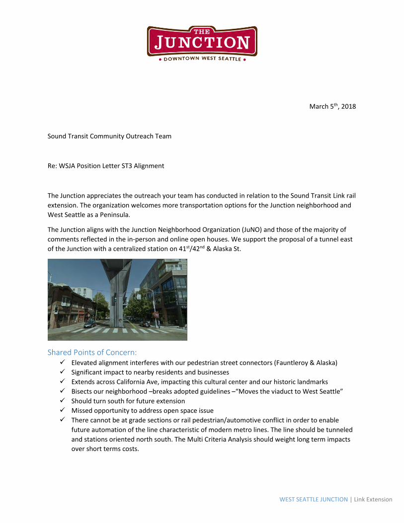
WEST SEATTLE JUNCTION | Link Extension
March 5th, 2018
Sound Transit Community Outreach Team
Re: WSJA Position Letter ST3 Alignment
The Junction appreciates the outreach your team has conducted in relation to the Sound Transit Link rail
extension. The organization welcomes more transportation options for the Junction neighborhood and
West Seattle as a Peninsula.
The Junction aligns with the Junction Neighborhood Organization (JuNO) and those of the majority of
comments reflected in the in-person and online open houses. We support the proposal of a tunnel east
of the Junction with a centralized station on 41st/42nd & Alaska St.
Shared Points of Concern: Elevated alignment interferes with our pedestrian street connectors (Fauntleroy & Alaska)
Significant impact to nearby residents and businesses
Extends across California Ave, impacting this cultural center and our historic landmarks
Bisects our neighborhood –breaks adopted guidelines –“Moves the viaduct to West Seattle”
Should turn south for future extension
Missed opportunity to address open space issue
There cannot be at grade sections or rail pedestrian/automotive conflict in order to enable
future automation of the line characteristic of modern metro lines. The line should be tunneled
and stations oriented north south. The Multi Criteria Analysis should weight long term impacts
over short terms costs.
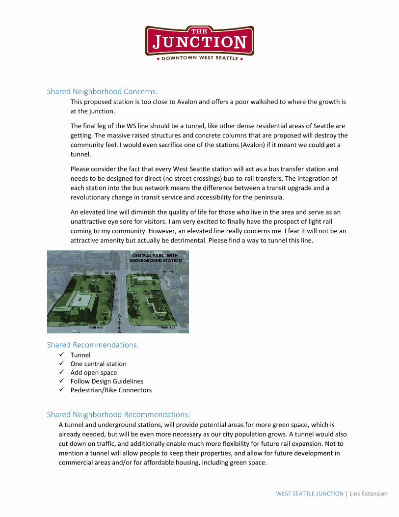
WEST SEATTLE JUNCTION | Link Extension
Shared Neighborhood Concerns: This proposed station is too close to Avalon and offers a poor walkshed to where the growth is
at the junction.
The final leg of the WS line should be a tunnel, like other dense residential areas of Seattle are
getting. The massive raised structures and concrete columns that are proposed will destroy the
community feel. I would even sacrifice one of the stations (Avalon) if it meant we could get a
tunnel.
Please consider the fact that every West Seattle station will act as a bus transfer station and
needs to be designed for direct (no street crossings) bus-to-rail transfers. The integration of
each station into the bus network means the difference between a transit upgrade and a
revolutionary change in transit service and accessibility for the peninsula.
An elevated line will diminish the quality of life for those who live in the area and serve as an
unattractive eye sore for visitors. I am very excited to finally have the prospect of light rail
coming to my community. However, an elevated line really concerns me. I fear it will not be an
attractive amenity but actually be detrimental. Please find a way to tunnel this line.
Shared Recommendations: Tunnel One central station Add open space Follow Design Guidelines Pedestrian/Bike Connectors
Shared Neighborhood Recommendations: A tunnel and underground stations, will provide potential areas for more green space, which is
already needed, but will be even more necessary as our city population grows. A tunnel would also
cut down on traffic, and additionally enable much more flexibility for future rail expansion. Not to
mention a tunnel will allow people to keep their properties, and allow for future development in
commercial areas and/or for affordable housing, including green space.
WEST SEATTLE JUNCTION | Link Extension
With the density and "sense of place" which already exists in this vital Seattle neighborhood, it
makes no sense to build elevated light rail through this urban center. Why elevated rail was
considered for Alaska Junction when neighborhoods in central & north Seattle were protected via
tunneling is incredibly inconsistent. The zoning of this neighborhood has already been increased and
likely to be go higher. Please build the Alaska Junction Station underground and tunnel to/from this
station.
Having the station close to the Alaska Junction retail district will help ensure the continuing vitality
and growth of this unique and vibrant neighborhood for many decades to come. As many comments
have pointed out, an underground station should be the first choice for Alaska Junction if at all
possible to preserve the existing character of this historic intersection. But if the station must be
above grade, better it be within a block of Alaska & California than down the hill at Fauntleroy.
This would be a great intersection for the Junction station. There's a huge swath of land where the
Bank of America is, and limited buildings on the north side of the street as well, still walkable from
the Alaska/California intersection, where the bus connections are, so transfers would be kept close,
as well as the new Greenway which would terminate at 42nd and Alaska. This part of Alaska is in
desperate need of pedestrian infrastructure, what better time to do it as part of a new station.
A plan that aligns with the neighborhood recommendations while supporting the expansion of public
transportation, will be the configuration the Junction will stand behind.
Thank you for your consideration,
Lora Swift
West Seattle Junction Executive Director
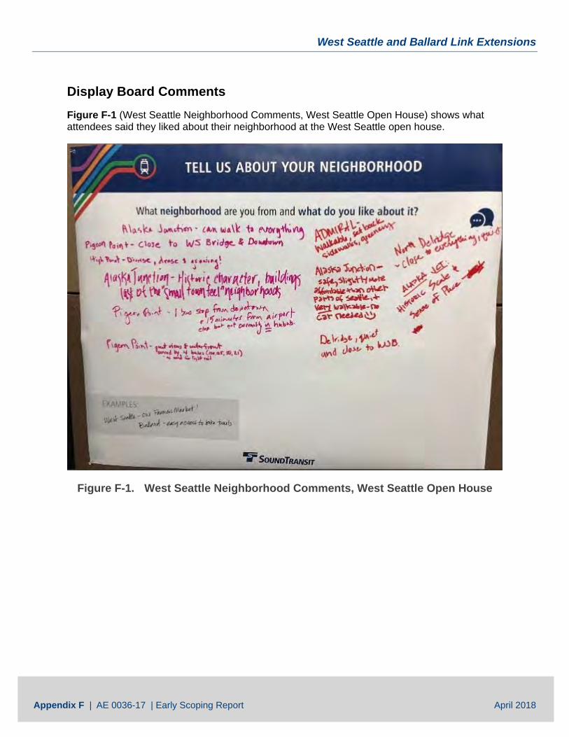
West Seattle and Ballard Link Extensions
Appendix F | AE 0036-17 | Early Scoping Report April 2018
Display Board Comments Figure F-1 (West Seattle Neighborhood Comments, West Seattle Open House) shows what attendees said they liked about their neighborhood at the West Seattle open house.
Figure F-1. West Seattle Neighborhood Comments, West Seattle Open House
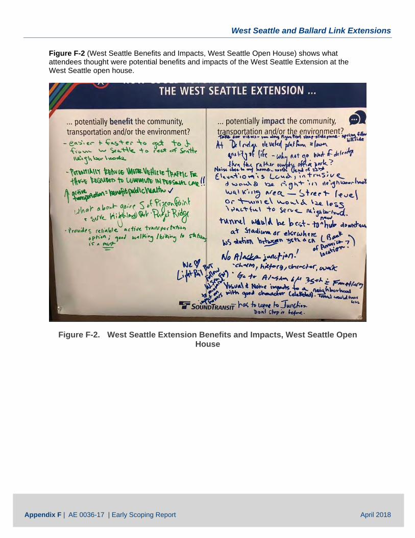
West Seattle and Ballard Link Extensions
Appendix F | AE 0036-17 | Early Scoping Report April 2018
Figure F-2 (West Seattle Benefits and Impacts, West Seattle Open House) shows what attendees thought were potential benefits and impacts of the West Seattle Extension at the West Seattle open house.
Figure F-2. West Seattle Extension Benefits and Impacts, West Seattle Open House
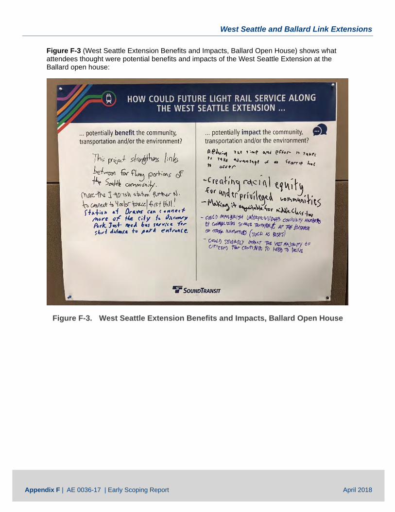
West Seattle and Ballard Link Extensions
Appendix F | AE 0036-17 | Early Scoping Report April 2018
Figure F-3 (West Seattle Extension Benefits and Impacts, Ballard Open House) shows what attendees thought were potential benefits and impacts of the West Seattle Extension at the Ballard open house:
Figure F-3. West Seattle Extension Benefits and Impacts, Ballard Open House
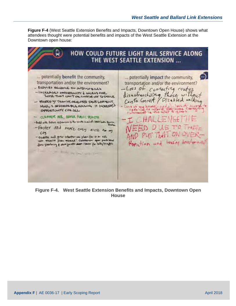
West Seattle and Ballard Link Extensions
Appendix F | AE 0036-17 | Early Scoping Report April 2018
Figure F-4 (West Seattle Extension Benefits and Impacts, Downtown Open House) shows what attendees thought were potential benefits and impacts of the West Seattle Extension at the Downtown open house:
Figure F-4. West Seattle Extension Benefits and Impacts, Downtown Open House
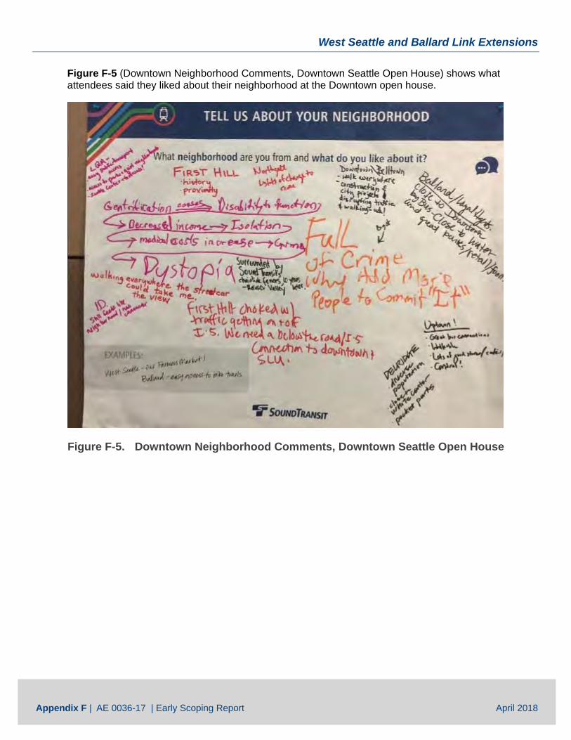
West Seattle and Ballard Link Extensions
Appendix F | AE 0036-17 | Early Scoping Report April 2018
Figure F-5 (Downtown Neighborhood Comments, Downtown Seattle Open House) shows what attendees said they liked about their neighborhood at the Downtown open house.
Figure F-5. Downtown Neighborhood Comments, Downtown Seattle Open House
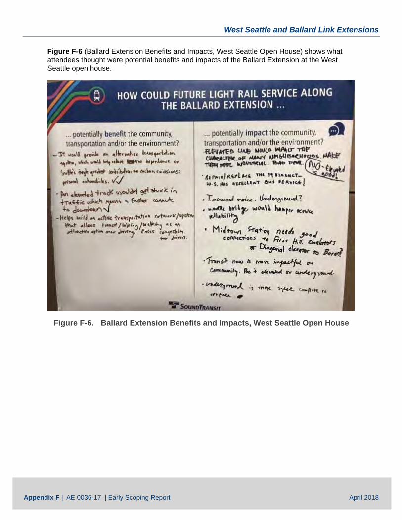
West Seattle and Ballard Link Extensions
Appendix F | AE 0036-17 | Early Scoping Report April 2018
Figure F-6 (Ballard Extension Benefits and Impacts, West Seattle Open House) shows what attendees thought were potential benefits and impacts of the Ballard Extension at the West Seattle open house.
Figure F-6. Ballard Extension Benefits and Impacts, West Seattle Open House
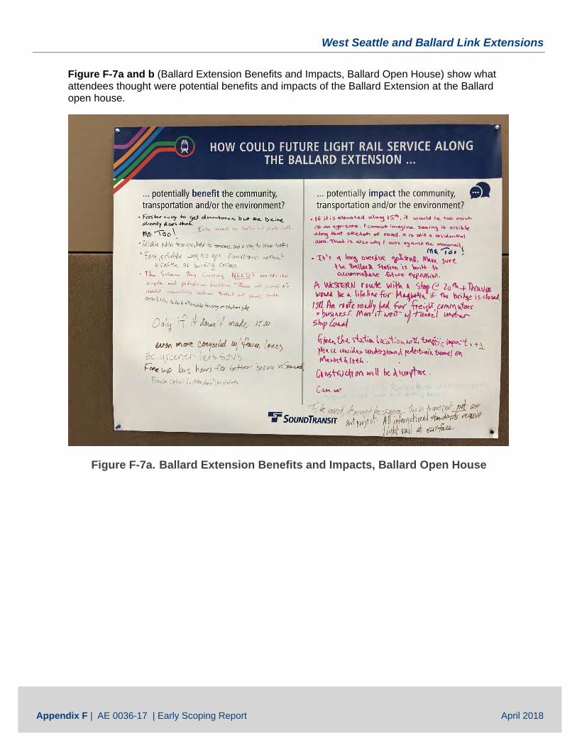
West Seattle and Ballard Link Extensions
Appendix F | AE 0036-17 | Early Scoping Report April 2018
Figure F-7a and b (Ballard Extension Benefits and Impacts, Ballard Open House) show what attendees thought were potential benefits and impacts of the Ballard Extension at the Ballard open house.
Figure F-7a. Ballard Extension Benefits and Impacts, Ballard Open House
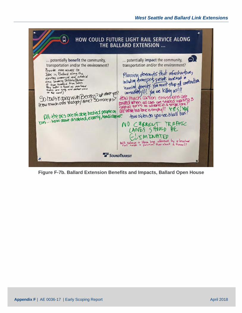
West Seattle and Ballard Link Extensions
Appendix F | AE 0036-17 | Early Scoping Report April 2018
Figure F-7b. Ballard Extension Benefits and Impacts, Ballard Open House
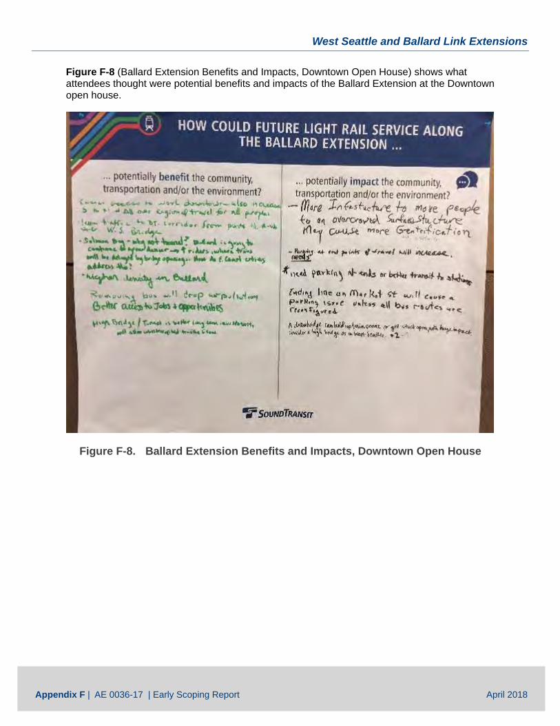
West Seattle and Ballard Link Extensions
Appendix F | AE 0036-17 | Early Scoping Report April 2018
Figure F-8 (Ballard Extension Benefits and Impacts, Downtown Open House) shows what attendees thought were potential benefits and impacts of the Ballard Extension at the Downtown open house.
Figure F-8. Ballard Extension Benefits and Impacts, Downtown Open House
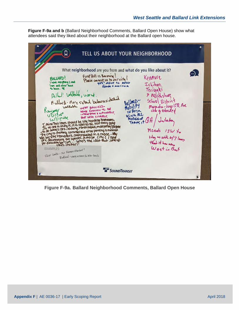
West Seattle and Ballard Link Extensions
Appendix F | AE 0036-17 | Early Scoping Report April 2018
Figure F-9a and b (Ballard Neighborhood Comments, Ballard Open House) show what attendees said they liked about their neighborhood at the Ballard open house.
Figure F-9a. Ballard Neighborhood Comments, Ballard Open House
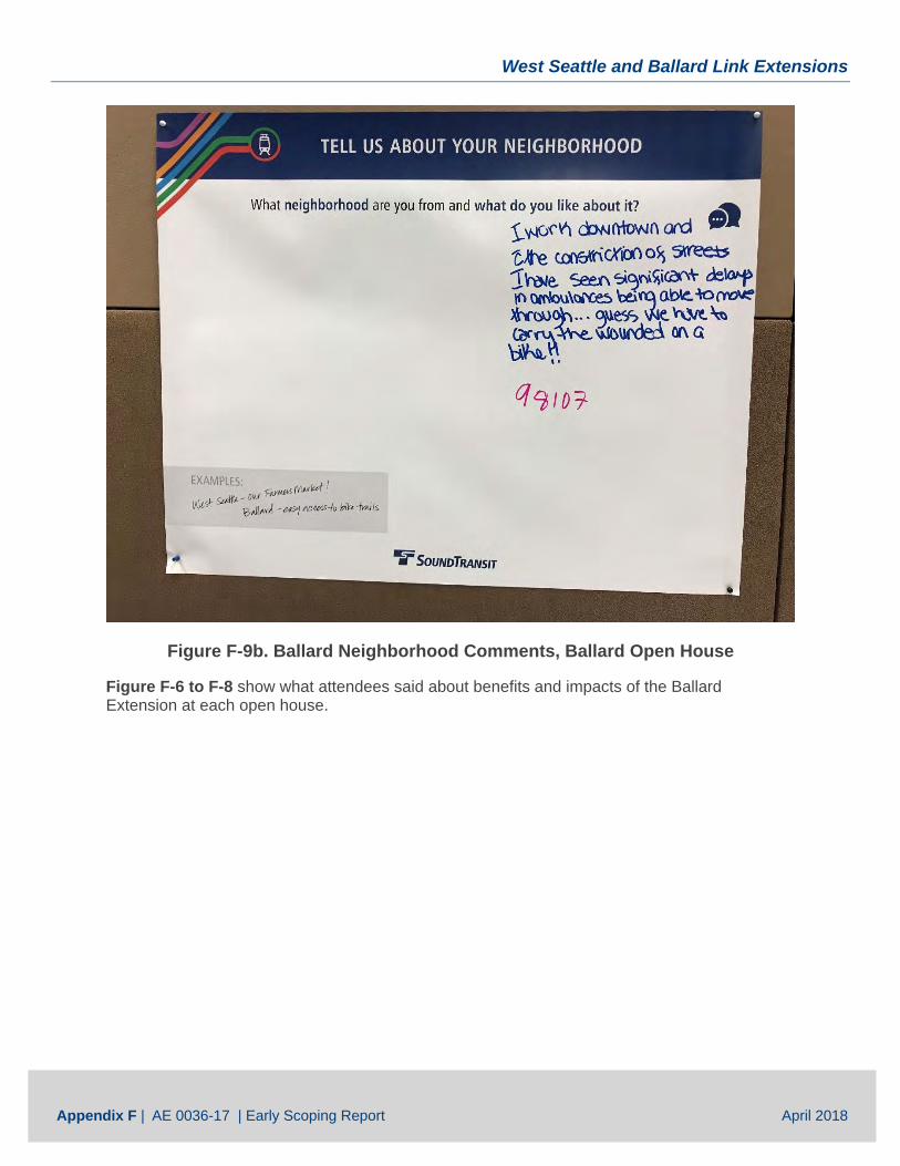
West Seattle and Ballard Link Extensions
Appendix F | AE 0036-17 | Early Scoping Report April 2018
Figure F-9b. Ballard Neighborhood Comments, Ballard Open House
Figure F-6 to F-8 show what attendees said about benefits and impacts of the Ballard Extension at each open house.
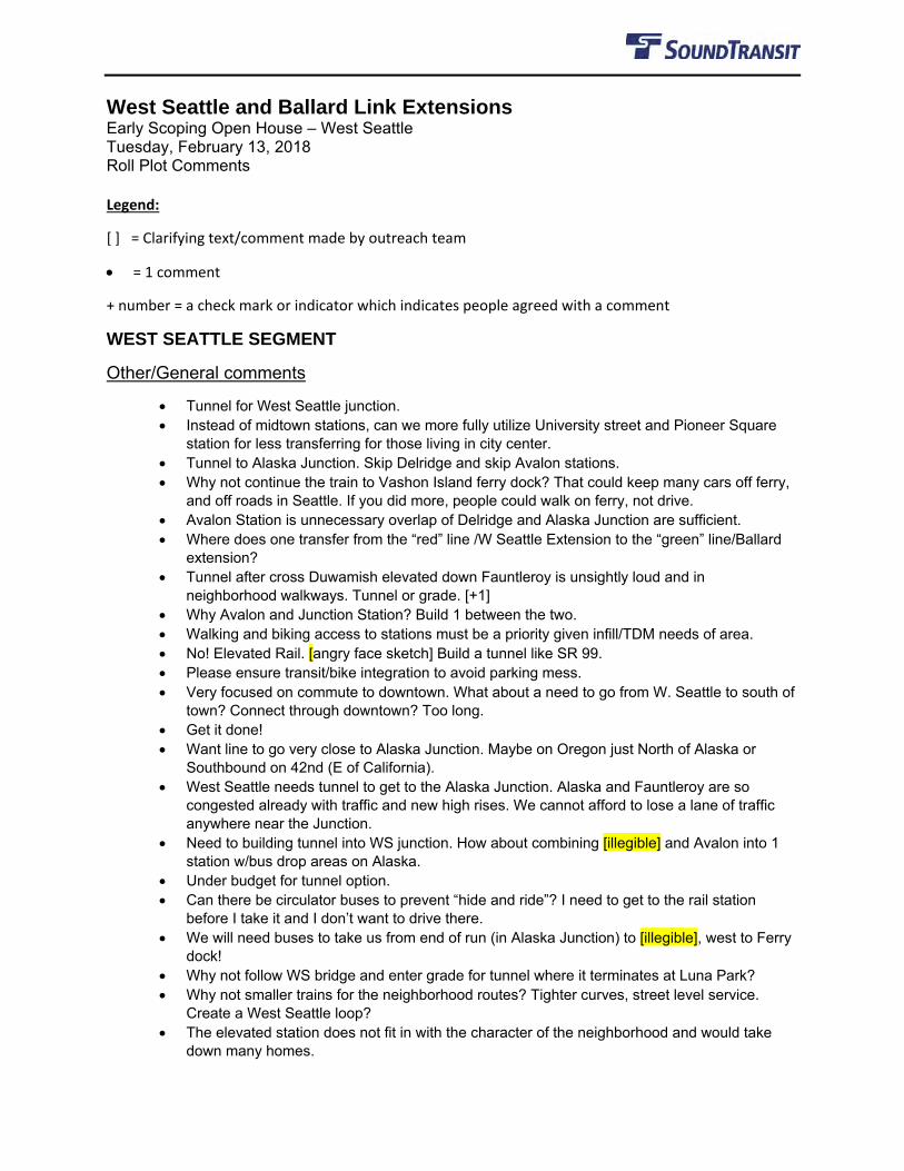
West Seattle and Ballard Link Extensions Early Scoping Open House – West Seattle Tuesday, February 13, 2018 Roll Plot Comments Legend:
[ ] = Clarifying text/comment made by outreach team
• = 1 comment
+ number = a check mark or indicator which indicates people agreed with a comment
WEST SEATTLE SEGMENT
Other/General comments
• Tunnel for West Seattle junction. • Instead of midtown stations, can we more fully utilize University street and Pioneer Square
station for less transferring for those living in city center. • Tunnel to Alaska Junction. Skip Delridge and skip Avalon stations. • Why not continue the train to Vashon Island ferry dock? That could keep many cars off ferry,
and off roads in Seattle. If you did more, people could walk on ferry, not drive. • Avalon Station is unnecessary overlap of Delridge and Alaska Junction are sufficient. • Where does one transfer from the “red” line /W Seattle Extension to the “green” line/Ballard
extension? • Tunnel after cross Duwamish elevated down Fauntleroy is unsightly loud and in
neighborhood walkways. Tunnel or grade. [+1] • Why Avalon and Junction Station? Build 1 between the two. • Walking and biking access to stations must be a priority given infill/TDM needs of area. • No! Elevated Rail. [angry face sketch] Build a tunnel like SR 99. • Please ensure transit/bike integration to avoid parking mess. • Very focused on commute to downtown. What about a need to go from W. Seattle to south of
town? Connect through downtown? Too long. • Get it done! • Want line to go very close to Alaska Junction. Maybe on Oregon just North of Alaska or
Southbound on 42nd (E of California). • West Seattle needs tunnel to get to the Alaska Junction. Alaska and Fauntleroy are so
congested already with traffic and new high rises. We cannot afford to lose a lane of traffic anywhere near the Junction.
• Need to building tunnel into WS junction. How about combining [illegible] and Avalon into 1 station w/bus drop areas on Alaska.
• Under budget for tunnel option. • Can there be circulator buses to prevent “hide and ride”? I need to get to the rail station
before I take it and I don’t want to drive there. • We will need buses to take us from end of run (in Alaska Junction) to [illegible], west to Ferry
dock! • Why not follow WS bridge and enter grade for tunnel where it terminates at Luna Park? • Why not smaller trains for the neighborhood routes? Tighter curves, street level service.
Create a West Seattle loop? • The elevated station does not fit in with the character of the neighborhood and would take
down many homes.
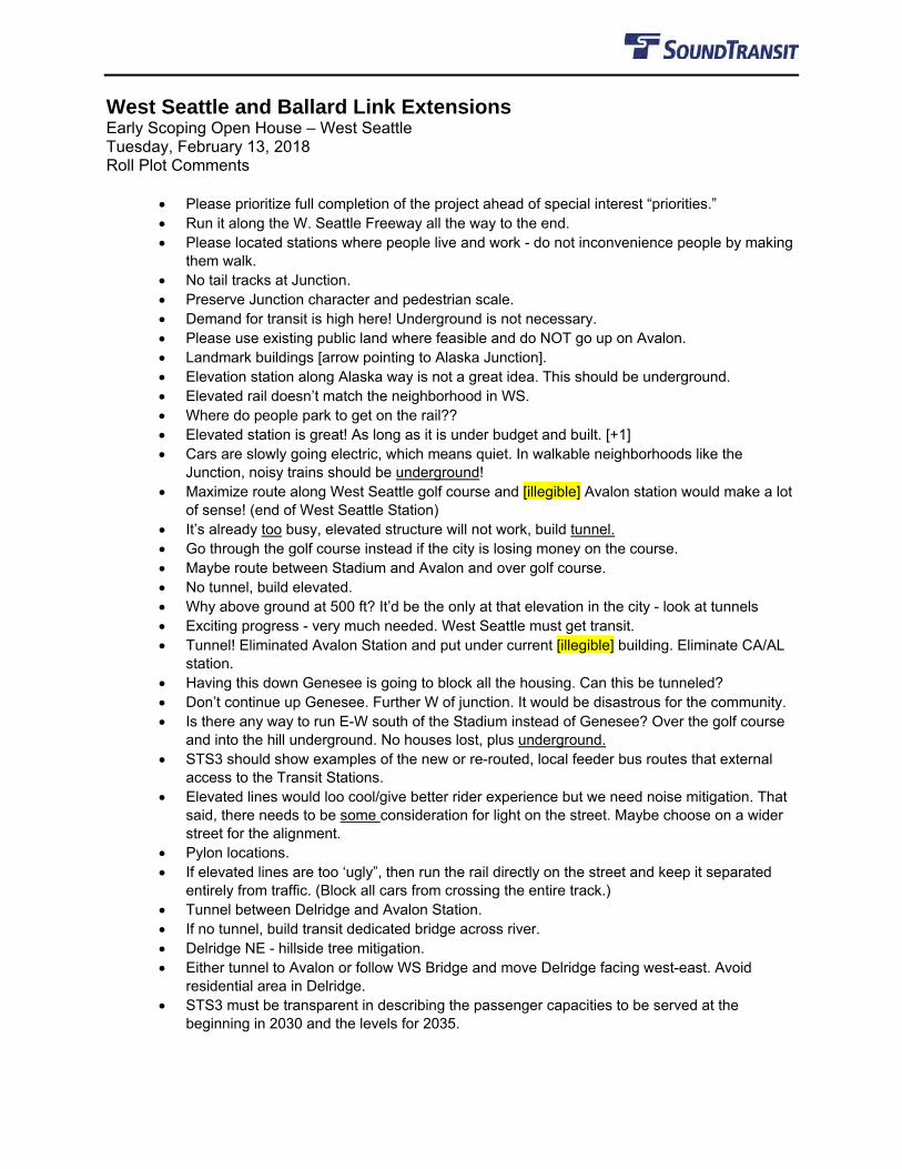
West Seattle and Ballard Link Extensions Early Scoping Open House – West Seattle Tuesday, February 13, 2018 Roll Plot Comments
• Please prioritize full completion of the project ahead of special interest “priorities.” • Run it along the W. Seattle Freeway all the way to the end. • Please located stations where people live and work - do not inconvenience people by making
them walk. • No tail tracks at Junction. • Preserve Junction character and pedestrian scale. • Demand for transit is high here! Underground is not necessary. • Please use existing public land where feasible and do NOT go up on Avalon. • Landmark buildings [arrow pointing to Alaska Junction]. • Elevation station along Alaska way is not a great idea. This should be underground. • Elevated rail doesn’t match the neighborhood in WS. • Where do people park to get on the rail?? • Elevated station is great! As long as it is under budget and built. [+1] • Cars are slowly going electric, which means quiet. In walkable neighborhoods like the
Junction, noisy trains should be underground! • Maximize route along West Seattle golf course and [illegible] Avalon station would make a lot
of sense! (end of West Seattle Station) • It’s already too busy, elevated structure will not work, build tunnel. • Go through the golf course instead if the city is losing money on the course. • Maybe route between Stadium and Avalon and over golf course. • No tunnel, build elevated. • Why above ground at 500 ft? It’d be the only at that elevation in the city - look at tunnels • Exciting progress - very much needed. West Seattle must get transit. • Tunnel! Eliminated Avalon Station and put under current [illegible] building. Eliminate CA/AL
station. • Having this down Genesee is going to block all the housing. Can this be tunneled? • Don’t continue up Genesee. Further W of junction. It would be disastrous for the community. • Is there any way to run E-W south of the Stadium instead of Genesee? Over the golf course
and into the hill underground. No houses lost, plus underground. • STS3 should show examples of the new or re-routed, local feeder bus routes that external
access to the Transit Stations. • Elevated lines would loo cool/give better rider experience but we need noise mitigation. That
said, there needs to be some consideration for light on the street. Maybe choose on a wider street for the alignment.
• Pylon locations. • If elevated lines are too ‘ugly”, then run the rail directly on the street and keep it separated
entirely from traffic. (Block all cars from crossing the entire track.) • Tunnel between Delridge and Avalon Station. • If no tunnel, build transit dedicated bridge across river. • Delridge NE - hillside tree mitigation. • Either tunnel to Avalon or follow WS Bridge and move Delridge facing west-east. Avoid
residential area in Delridge. • STS3 must be transparent in describing the passenger capacities to be served at the
beginning in 2030 and the levels for 2035.
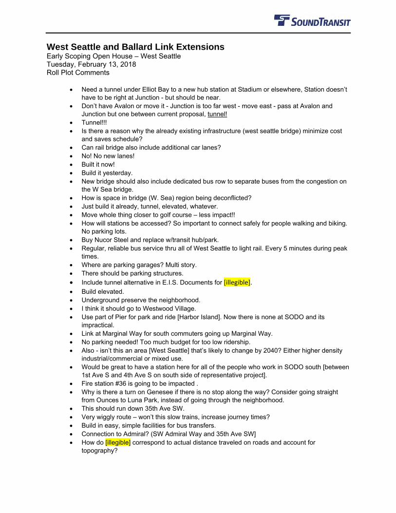
West Seattle and Ballard Link Extensions Early Scoping Open House – West Seattle Tuesday, February 13, 2018 Roll Plot Comments
• Need a tunnel under Elliot Bay to a new hub station at Stadium or elsewhere, Station doesn’t have to be right at Junction - but should be near.
• Don’t have Avalon or move it - Junction is too far west - move east - pass at Avalon and Junction but one between current proposal, tunnel!
• Tunnel!!! • Is there a reason why the already existing infrastructure (west seattle bridge) minimize cost
and saves schedule? • Can rail bridge also include additional car lanes? • No! No new lanes! • Built it now! • Build it yesterday. • New bridge should also include dedicated bus row to separate buses from the congestion on
the W Sea bridge. • How is space in bridge (W. Sea) region being deconflicted? • Just build it already, tunnel, elevated, whatever. • Move whole thing closer to golf course – less impact!! • How will stations be accessed? So important to connect safely for people walking and biking.
No parking lots. • Buy Nucor Steel and replace w/transit hub/park. • Regular, reliable bus service thru all of West Seattle to light rail. Every 5 minutes during peak
times. • Where are parking garages? Multi story. • There should be parking structures. • Include tunnel alternative in E.I.S. Documents for [illegible]. • Build elevated. • Underground preserve the neighborhood. • I think it should go to Westwood Village. • Use part of Pier for park and ride [Harbor Island]. Now there is none at SODO and its
impractical. • Link at Marginal Way for south commuters going up Marginal Way. • No parking needed! Too much budget for too low ridership. • Also - isn’t this an area [West Seattle] that’s likely to change by 2040? Either higher density
industrial/commercial or mixed use. • Would be great to have a station here for all of the people who work in SODO south [between
1st Ave S and 4th Ave S on south side of representative project]. • Fire station #36 is going to be impacted . • Why is there a turn on Genesee if there is no stop along the way? Consider going straight
from Ounces to Luna Park, instead of going through the neighborhood. • This should run down 35th Ave SW. • Very wiggly route – won’t this slow trains, increase journey times? • Build in easy, simple facilities for bus transfers. • Connection to Admiral? (SW Admiral Way and 35th Ave SW] • How do [illegible] correspond to actual distance traveled on roads and account for
topography?
West Seattle and Ballard Link Extensions Early Scoping Open House – West Seattle Tuesday, February 13, 2018 Roll Plot Comments
• Consider a transfer point for people who currently ride the 21 to keep buses and cars off the bridge.
• How to access these stops? No parking currently, must plan for bus/path access. • Need more stops, not fewer. Going underground would be quieter and easier to add stops
later vs elevated plan. Looking at transit systems w/high adoption, need frequent, convenient stops. Can run express trains which bypass but must have MORE stops.
• Should service the 35th/Delridge corridor all the way to Burien. • You’ll support a low of families – many with kids, by going around Pigeon Pt. to Genesee and
up to Avalon. Please find industrial property and leave our houses alone.
Station specific comments
Alaska:
• Alaska – consider shifting station to west. • Station here will not work, too busy, landmark building. • Station MUST go to the heart of Alaska Junction - not 3-4 blocks away. • Please put a station in the heart of the junction where people live. • Station here is perfect! For density and usage. • Don’t make station a park and ride. This is an urban area. • Tunnel yes!!! [line drawn from Alaska Junction to Delridge] • No Alaska Junction rail station between 35th and Fauntleroy. Feasibility, cost, time,
community lose charm, history. • No tail tracks at Alaska Junction • There is not enough space in the Junction! • Really ugly (underground station in Junction!) • Junction station should be at Alaska and Fauntleroy. • Need underground thru the West Seattle Junction. • Put apartments on top of underground station around 41st. Could even be low/mixed income
housing. Add transit. • Bus station/plaza? Create public space (could be used for farmer’s market). • Please consider how transit/bike networks will integrate to avoid parking mess. • Does this alignment allow for future extension south? • Create circulator buses to help people get to the Junction station and prevent hide and ride.
Avalon:
• Avalon - How much noise for turns? Will you mitigate for trees? • Move Avalon station to golf course. • We don’t need Avalon station. Save $$, bury line. • Underground tunnel @Avalon station. • Avalon Station is the busiest bus stop in West Seattle, needs rail!! • Relocate Avalon station to locate near West Seattle Stadium. • Underground (SW Avalon Way). • Go underground before Avalon station.
West Seattle and Ballard Link Extensions Early Scoping Open House – West Seattle Tuesday, February 13, 2018 Roll Plot Comments
• Move line to come up Avalon Blvd. • Do the project so it remains underground in West Seattle on top of the hill, west of 33rd SW. • Keep going straight and turn up Avalon, rather than through N. Delridge. • Could a parking garage be built by the stadium? Where will people park to catch the light rail? • Why so high [in elevation] above the gold course? • Because golf balls go high! 😊😊 • Please consider tunneling from Avalon to Alaska Junction. Concerned that this will disrupt the
heart of West Seattle. • If we tunnel at Fauntleroy we don’t have to delay the previously planned road updates.
Delridge Station
• Move Delridge Station just west of Delridge. Current route will clog traffic and destroy quality of life for Pilgrim Point.
• Delridge - is this (after the station) in existing right of way? • Pedestrian bridge across Delridge so Pigeon Point neighborhood has quicker access across
this busy roadway (like the one near the Delridge Playfield). • Tunnel from Duwamish or Delridge to one station between current Avalon and Alaska
Junction avoiding climbing last hill to end of Junction. • White Center Delridge will drive to Delridge Link. • Position Delridge station between Avalon and Delridge to have easy access to Alki Trail and
still serve Delridge. • Prefer a route that would cross the bridge on the NORTH side. Maybe you wouldn’t impact us
negatively as much. We’re next to the Pigeon Pt green belt. The slope slides filled with springs and very steep. We need to increase the good bus service north and south on Delridge to White Center – RapidRide on Delridge will be terrific!
• What projected population numbers do the Delridge and Avalon stations serve? Given that half the catchment circle of Delridge is low – use industrial and 1/3 of Avalon catchment is a (low use) of golf course.
• Long Fellow Creek (underground).
SODO SEGMENT
Other/General comments
• Consider mobility hub to transfer between modes of transit. • Please construct the SODO station to facilitate the easiest transfers between downtown and
the green line going south. Having the two lines in different levels will already be challenging. • Construct SODO station with future expansions in the South (Georgetown, South Park, etc)
in mind. • Add cross platform transfer potential at SODO [see sketch in Appendix A]. • Use this opportunity to grade separate existing line (Lander, Holgate, Royal Brougham)].
Station specific comments
Stadium:
West Seattle and Ballard Link Extensions Early Scoping Open House – West Seattle Tuesday, February 13, 2018 Roll Plot Comments
• It seems like a waste to tear down the Stadium Station. If the goal is to join the West Seattle tracks with the existing tracks, why not do that between stations? That would save time and materials.
DOWNTOWN SEGMENT
Other/General comments
• Use Bank of America lot @Westlake/6th for entrance (streetcar connection). • Construct Denny or SLU stations to allow for future expansion to east (Metro 8 line) and north
(Aurora line). • Use a stacked station to enable Aurora line with shared downtown segment [+1]. • Poor future planning cannot continue. • Is the Ballard tunneled rail line going to bisect the Bill and Melinda Gates Foundation HQs?
Station specific comments
South Lake Union:
• Please build this SLU station with lots of bus transfers in mind! (Aurora buses take E line and route 5).
BALLARD SEGMENT
Other/General comments
• Crucial to have elevated grade separation all the way. Do not stop for boat traffic. • Please a fixed bridge or tunnel. Don’t stop train for boats. • 100%! Imagine a train being delayed 10-20 minutes! Unacceptable! • Please do all you can to upgrade this to a fixed bridge or tunnel. Having system delays from
bridge openings will cause the system to lose credibility in people’s eyes right away, and that will be the dominate takeaway from this project, not the mobility it will provide for everyone and the amazing overall engineering feat that it is. High fixed bridge! [+1]
• If not a fixed bridge, let’s approve a boat tax for opening this bridge. Build it as high as you can.
• Make this crossing a fixed bridge! If not, when this opens in the 2030s, people will not be able to comprehend why the system was built with this deficiency knowingly included. (Even if there was good engineering reason!)
Station specific comments
Ballard:
• Design Ballard station to interact extremely well with bus transfers. • Provisions for North and East extensions (w/transfer).
West Seattle and Ballard Link Extensions Early Scoping Open House – West Seattle Tuesday, February 13, 2018 Roll Plot Comments
• Please construct Ballard Station such that expansions can be constructed north and east. Save money by building this for future expansion.
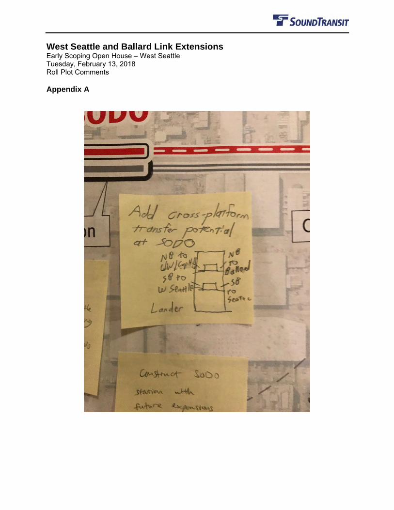
West Seattle and Ballard Link Extensions Early Scoping Open House – West Seattle Tuesday, February 13, 2018 Roll Plot Comments Appendix A
West Seattle and Ballard Link Extensions Early Scoping Open House – Downtown Tuesday, February 20. 2018 Roll Plot Comments
Page 1 of 8
Legend:
[ ] = Clarifying text/comment made by outreach team
• = 1 comment
+ number = a check mark or indicator which indicates people agreed with a comment
BALLARD SEGMENT
Other/General comments:
• Rethink this alignment connect high opportunity neighs [neighborhoods] that can take housing (Fremont, QA [Queen Anne] via [highway] 99) not industrial lands and golf courses.
• For Interbay and Smith Cove Stations, please be in discussion with City of Seattle to upzone to ensure transit has supportive uses!
• The Ballard and SLU [South Lake Union] line will not have enough capacity at 800 people every 6 minutes. SLU will be the major employment hub of the region.
• As a ounce in a generation opportunity we have to consider the long term impact. Tunnel versus elevated right of way is far better for noise, view and impact above ground.
Station specific comments
Smith Cove:
• Is the only reason for this station Expedia? Can't build much housing here due to topography and industrial land.
• Add a Sounder station close to here. OR AT INTERBAY STA [Station]. • A staircase up the hill [Commenter drew a drawing of a stick figure exiting a bus and heading
towards a staircase]. • Connect this station to upper Queen Anne.
Interbay:
• Need to provide the pros and cons of 15th Ave alignment during and after construction on freight route.
• Turn the golf center into housing. • An alignment @ [at] the west edge of Interbay would allow for direct transfer @ [at] a
Sounder Station. • This also shifts the alignment for Salmon Bay tunnel that serves the heart of Ballard. • As part of EIS please study a Ship Canal tunnel. Need to know the reliability vs. cost balance. • Canal crossing funds should cover better ped [pedestrian] / bike access even if the LInk
crossing is a tunnel. ST [Sound Transit] should fund as an access improvement. • [Commenter drew a dashed line from Smith Cove station along 20th Ave W to Fishermen's
Terminal and wrote "Sounder Connection here to tunnel here."] • Can't build much housing here due to topo [topography] and RR [RapidRide transit]. This
station should serve SPUniversity [Seattle Pacific University].
West Seattle and Ballard Link Extensions Early Scoping Open House – Downtown Tuesday, February 20. 2018 Roll Plot Comments
Page 2 of 8
Ballard:
• A drawbridge could break down or hold up trains while open. It intrudes[,] too much unreliability. Build a high bridge instead!
• Present renderings of the bridge so citizens understand the impacts of the approaches. • Consider a high bridge or a tunnel over canal to Ballard. Drawbridge can break down, cause
delays when open. Please don't sacrifice long-term quality for cost savings. +1 • Can either a high fixed bridge or tunnel prevent service disruptions? • Moveable bridge will not work[.] We simply have too much boat traffic. +1 • Discuss, define, and show what the approaches to the Salmon Bay Bridge look like a (a wall
between Interbay and QA [Queen Anne]). • Add pedestrian and bike lanes on train bridge – existing Ballard Bridge lanes are AWFUL! • Planning for future U.W. [University of Washington] / Wallingford / Fremont – route is critical
(highest potential ridership). • Where to from here? Should the line go west more @ [at] bridge and hit center of Ballard,
then N [North]? • Stations must be built with future expansion in mind – here, both to the North and East. • Build for future E-W [East-West] connection. Design for a great pedestrian connection to
Ballard. • Move closer to downtown Ballard.
WEST SEATTLE SEGMENT
Other/General comments:
• Straighten out unnecessary curves to increase speed and decrease project cost. [Commenter is referring to curves along light rail service between California Ave & Fauntleroy Way, 35th Ave W & 26th Ave SW, and between Delridge Way SW & W Marginal Way.]
• All stations should be effectively TODs, even if not formal TODs. Use station for placemaking rather than making them monuments to a single purpose (see all current stations). [TOD = Transit-oriented development]
• I think it will be very important that the Ballard line has a connection with Sounder Commuter Rail North. It will boost ridership for both lines! Thank you!
• Does the Duwamish crossing really need to be as tall as the existing bridge? Is it cheaper to build any lower?
• Consider the implications [of] climate change and rising sea levels will have on harbour [correct spelling: Harbor] Island to prevent project delays.
• West Seattle should have trains running to Ballard to maximize the capacity of the new 5th Ave tunnel. This should be in addition to the already planned West Seattle-Everett line.
Station specific comments:
Alaska Junction:
• Stations should be built with future expansion in mind, in both us and Ballard. +1 • Will the line turn to follow California Ave like the C line?
West Seattle and Ballard Link Extensions Early Scoping Open House – Downtown Tuesday, February 20. 2018 Roll Plot Comments
Page 3 of 8
• Terminus of WS line needs to turn south for future connection – whether elevated or underground.
• Will routes 50 or 22 or 21 go by this station? • An elevated Alaska Junction station would be a disaster. Dig a tunnel so you could continue
the line south (in STA) to Burien/White Center without destroying the aesthetic and walkability of a dense, great neighborhood.
• The Bank of America lot is some of the least utilized property in the Junction. As usual, BoA is squatting with a suburban mentality on an urban site. Acquiring their site for a station would have the least adverse impact to the 'hood.
• Study a tunnel alignment to the Junction, with perhaps one less station (no Avalon?). • Need Avalon!! But, agree with "Terrible …" that proposed Avalon station is isolated from
pedestrians by busy roads. • Please study junction here to permit future possibility for a future Duwamis[h] bypass for
Tacoma express service. [Commenter is referring “here” as the area around 4th Ave S to Everett.]
Delridge:
• These streets – Genesee, Fauntleroy + Alaska – are not wide enough for roads [word hard to read, roads is an educated guess], sidewalks and visually inoffensive elevated track.
• Delridge station would be closest to Alki Beach – How can this station better direct visitors (bikers, pedestrians) to Alki?
• Will there be parking at the Delridge station. There is already a problem with people driving to Delridge/Andover and parking in Pigeon point to catch the bus 120/125. If no additional parking for Link – this may become a much worse situation.
• Position the curve in such a way that it allows the possibility of a T-juncture in the future. • Look to Tilikum Crossing in Portland for an effective multi-modal over water crossing.
Avalon:
• Terrible ped. [pedestrian] access to Avalon station from north. Move to Taco Time Triangle. +1
• Turn the golf course into housing with parks. • Reroute through W. [West] Seattle Golf Course! • We could pattern after Beacon Hill and have a tiny footprint!! Tunnels don't impact what's on
the surface! • Too high + too steep. Just dig a tunnel into the hill – you'll feel better. [Comment was
regarding the Avalon light rail service being ~160 ft above ground.] • Maybe not too steep, but so many existing buildings. Tunnel into the hill would be a good
idea. (Never a better time to tackle a large project than a boom time like now). [Comment was about the Avalon light rail service being ~160 ft above ground.]
DOWNTOWN SEGMENT
Other/General comments:
• More underground project to 1st Hill [/] Capitol Hill. • Study a First Hill station option.
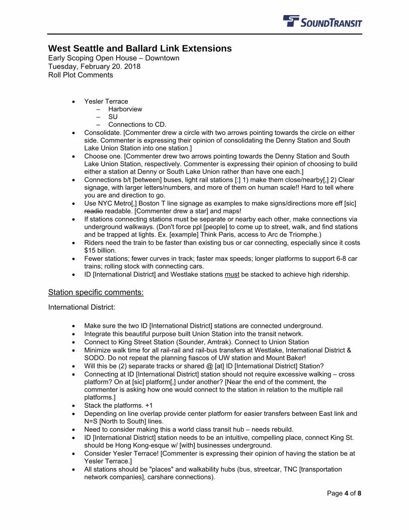
West Seattle and Ballard Link Extensions Early Scoping Open House – Downtown Tuesday, February 20. 2018 Roll Plot Comments
Page 4 of 8
• Yesler Terrace – Harborview – SU – Connections to CD.
• Consolidate. [Commenter drew a circle with two arrows pointing towards the circle on either side. Commenter is expressing their opinion of consolidating the Denny Station and South Lake Union Station into one station.]
• Choose one. [Commenter drew two arrows pointing towards the Denny Station and South Lake Union Station, respectively. Commenter is expressing their opinion of choosing to build either a station at Denny or South Lake Union rather than have one each.]
• Connections b/t [between] buses, light rail stations [:] 1) make them close/nearby[,] 2) Clear signage, with larger letters/numbers, and more of them on human scale!! Hard to tell where you are and direction to go.
• Use NYC Metro[,] Boston T line signage as examples to make signs/directions more eff [sic] readio readable. [Commenter drew a star] and maps!
• If stations connecting stations must be separate or nearby each other, make connections via underground walkways. (Don't force ppl [people] to come up to street, walk, and find stations and be trapped at lights. Ex. [example] Think Paris, access to Arc de Triomphe.)
• Riders need the train to be faster than existing bus or car connecting, especially since it costs $15 billion.
• Fewer stations; fewer curves in track; faster max speeds; longer platforms to support 6-8 car trains; rolling stock with connecting cars.
• ID [International District] and Westlake stations must be stacked to achieve high ridership.
Station specific comments:
International District:
• Make sure the two ID [International District] stations are connected underground. • Integrate this beautiful purpose built Union Station into the transit network. • Connect to King Street Station (Sounder, Amtrak). Connect to Union Station • Minimize walk time for all rail-rail and rail-bus transfers at Westlake, International District &
SODO. Do not repeat the planning fiascos of UW station and Mount Baker! • Will this be (2) separate tracks or shared @ [at] ID [International District] Station? • Connecting at ID [International District] station should not require excessive walking – cross
platform? On at [sic] platform[,] under another? [Near the end of the comment, the commenter is asking how one would connect to the station in relation to the multiple rail platforms.]
• Stack the platforms. +1 • Depending on line overlap provide center platform for easier transfers between East link and
N=S [North to South] lines. • Need to consider making this a world class transit hub – needs rebuild. • ID [International District] station needs to be an intuitive, compelling place, connect King St.
should be Hong Kong-esque w/ [with] businesses underground. • Consider Yesler Terrace! [Commenter is expressing their opinion of having the station be at
Yesler Terrace.] • All stations should be "places" and walkability hubs (bus, streetcar, TNC [transportation
network companies], carshare connections).
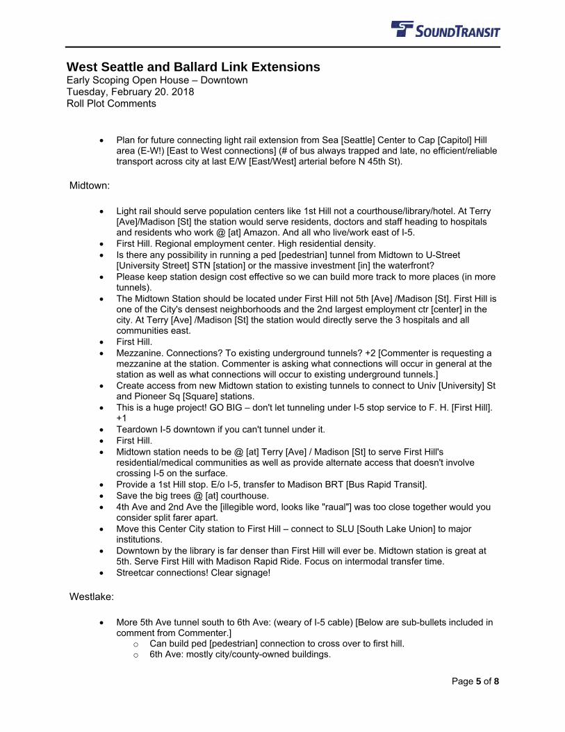
West Seattle and Ballard Link Extensions Early Scoping Open House – Downtown Tuesday, February 20. 2018 Roll Plot Comments
Page 5 of 8
• Plan for future connecting light rail extension from Sea [Seattle] Center to Cap [Capitol] Hill area (E-W!) [East to West connections] (# of bus always trapped and late, no efficient/reliable transport across city at last E/W [East/West] arterial before N 45th St).
Midtown:
• Light rail should serve population centers like 1st Hill not a courthouse/library/hotel. At Terry [Ave]/Madison [St] the station would serve residents, doctors and staff heading to hospitals and residents who work @ [at] Amazon. And all who live/work east of I-5.
• First Hill. Regional employment center. High residential density. • Is there any possibility in running a ped [pedestrian] tunnel from Midtown to U-Street
[University Street] STN [station] or the massive investment [in] the waterfront? • Please keep station design cost effective so we can build more track to more places (in more
tunnels). • The Midtown Station should be located under First Hill not 5th [Ave] /Madison [St]. First Hill is
one of the City's densest neighborhoods and the 2nd largest employment ctr [center] in the city. At Terry [Ave] /Madison [St] the station would directly serve the 3 hospitals and all communities east.
• First Hill. • Mezzanine. Connections? To existing underground tunnels? +2 [Commenter is requesting a
mezzanine at the station. Commenter is asking what connections will occur in general at the station as well as what connections will occur to existing underground tunnels.]
• Create access from new Midtown station to existing tunnels to connect to Univ [University] St and Pioneer Sq [Square] stations.
• This is a huge project! GO BIG – don't let tunneling under I-5 stop service to F. H. [First Hill]. +1
• Teardown I-5 downtown if you can't tunnel under it. • First Hill. • Midtown station needs to be @ [at] Terry [Ave] / Madison [St] to serve First Hill's
residential/medical communities as well as provide alternate access that doesn't involve crossing I-5 on the surface.
• Provide a 1st Hill stop. E/o I-5, transfer to Madison BRT [Bus Rapid Transit]. • Save the big trees @ [at] courthouse. • 4th Ave and 2nd Ave the [illegible word, looks like "raual"] was too close together would you
consider split farer apart. • Move this Center City station to First Hill – connect to SLU [South Lake Union] to major
institutions. • Downtown by the library is far denser than First Hill will ever be. Midtown station is great at
5th. Serve First Hill with Madison Rapid Ride. Focus on intermodal transfer time. • Streetcar connections! Clear signage!
Westlake:
• More 5th Ave tunnel south to 6th Ave: (weary of I-5 cable) [Below are sub-bullets included in comment from Commenter.]
o Can build ped [pedestrian] connection to cross over to first hill. o 6th Ave: mostly city/county-owned buildings.
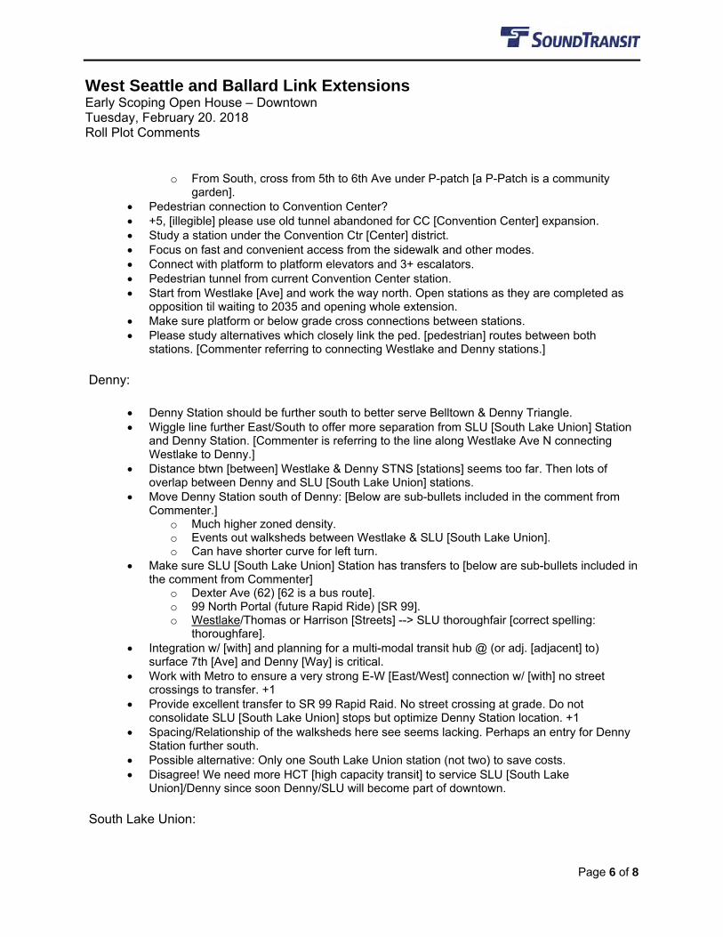
West Seattle and Ballard Link Extensions Early Scoping Open House – Downtown Tuesday, February 20. 2018 Roll Plot Comments
Page 6 of 8
o From South, cross from 5th to 6th Ave under P-patch [a P-Patch is a community garden].
• Pedestrian connection to Convention Center? • +5, [illegible] please use old tunnel abandoned for CC [Convention Center] expansion. • Study a station under the Convention Ctr [Center] district. • Focus on fast and convenient access from the sidewalk and other modes. • Connect with platform to platform elevators and 3+ escalators. • Pedestrian tunnel from current Convention Center station. • Start from Westlake [Ave] and work the way north. Open stations as they are completed as
opposition til waiting to 2035 and opening whole extension. • Make sure platform or below grade cross connections between stations. • Please study alternatives which closely link the ped. [pedestrian] routes between both
stations. [Commenter referring to connecting Westlake and Denny stations.]
Denny:
• Denny Station should be further south to better serve Belltown & Denny Triangle. • Wiggle line further East/South to offer more separation from SLU [South Lake Union] Station
and Denny Station. [Commenter is referring to the line along Westlake Ave N connecting Westlake to Denny.]
• Distance btwn [between] Westlake & Denny STNS [stations] seems too far. Then lots of overlap between Denny and SLU [South Lake Union] stations.
• Move Denny Station south of Denny: [Below are sub-bullets included in the comment from Commenter.]
o Much higher zoned density. o Events out walksheds between Westlake & SLU [South Lake Union]. o Can have shorter curve for left turn.
• Make sure SLU [South Lake Union] Station has transfers to [below are sub-bullets included in the comment from Commenter]
o Dexter Ave (62) [62 is a bus route]. o 99 North Portal (future Rapid Ride) [SR 99]. o Westlake/Thomas or Harrison [Streets] --> SLU thoroughfair [correct spelling:
thoroughfare]. • Integration w/ [with] and planning for a multi-modal transit hub @ (or adj. [adjacent] to)
surface 7th [Ave] and Denny [Way] is critical. • Work with Metro to ensure a very strong E-W [East/West] connection w/ [with] no street
crossings to transfer. +1 • Provide excellent transfer to SR 99 Rapid Raid. No street crossing at grade. Do not
consolidate SLU [South Lake Union] stops but optimize Denny Station location. +1 • Spacing/Relationship of the walksheds here see seems lacking. Perhaps an entry for Denny
Station further south. • Possible alternative: Only one South Lake Union station (not two) to save costs. • Disagree! We need more HCT [high capacity transit] to service SLU [South Lake
Union]/Denny since soon Denny/SLU will become part of downtown.
South Lake Union:
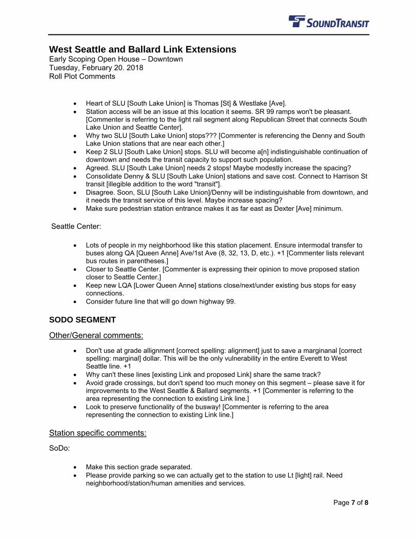
West Seattle and Ballard Link Extensions Early Scoping Open House – Downtown Tuesday, February 20. 2018 Roll Plot Comments
Page 7 of 8
• Heart of SLU [South Lake Union] is Thomas [St] & Westlake [Ave]. • Station access will be an issue at this location it seems. SR 99 ramps won't be pleasant.
[Commenter is referring to the light rail segment along Republican Street that connects South Lake Union and Seattle Center].
• Why two SLU [South Lake Union] stops??? [Commenter is referencing the Denny and South Lake Union stations that are near each other.]
• Keep 2 SLU [South Lake Union] stops. SLU will become a[n] indistinguishable continuation of downtown and needs the transit capacity to support such population.
• Agreed. SLU [South Lake Union] needs 2 stops! Maybe modestly increase the spacing? • Consolidate Denny & SLU [South Lake Union] stations and save cost. Connect to Harrison St
transit [illegible addition to the word "transit"]. • Disagree. Soon, SLU [South Lake Union]/Denny will be indistinguishable from downtown, and
it needs the transit service of this level. Maybe increase spacing? • Make sure pedestrian station entrance makes it as far east as Dexter [Ave] minimum.
Seattle Center:
• Lots of people in my neighborhood like this station placement. Ensure intermodal transfer to buses along QA [Queen Anne] Ave/1st Ave (8, 32, 13, D, etc.). +1 [Commenter lists relevant bus routes in parentheses.]
• Closer to Seattle Center. [Commenter is expressing their opinion to move proposed station closer to Seattle Center.]
• Keep new LQA [Lower Queen Anne] stations close/next/under existing bus stops for easy connections.
• Consider future line that will go down highway 99.
SODO SEGMENT
Other/General comments:
• Don't use at grade allignment [correct spelling: alignment] just to save a marginanal [correct spelling: marginal] dollar. This will be the only vulnerability in the entire Everett to West Seattle line. +1
• Why can't these lines [existing Link and proposed Link] share the same track? • Avoid grade crossings, but don't spend too much money on this segment – please save it for
improvements to the West Seattle & Ballard segments. +1 [Commenter is referring to the area representing the connection to existing Link line.]
• Look to preserve functionality of the busway! [Commenter is referring to the area representing the connection to existing Link line.]
Station specific comments:
SoDo:
• Make this section grade separated. • Please provide parking so we can actually get to the station to use Lt [light] rail. Need
neighborhood/station/human amenities and services.
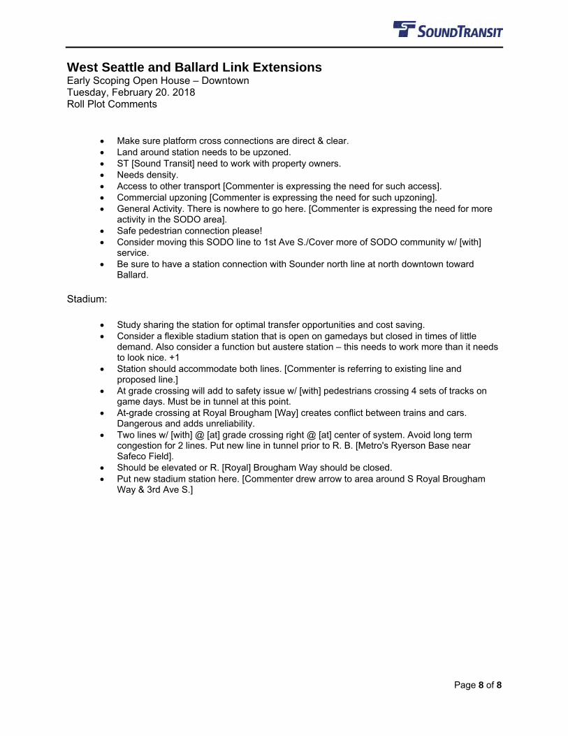
West Seattle and Ballard Link Extensions Early Scoping Open House – Downtown Tuesday, February 20. 2018 Roll Plot Comments
Page 8 of 8
• Make sure platform cross connections are direct & clear. • Land around station needs to be upzoned. • ST [Sound Transit] need to work with property owners. • Needs density. • Access to other transport [Commenter is expressing the need for such access]. • Commercial upzoning [Commenter is expressing the need for such upzoning]. • General Activity. There is nowhere to go here. [Commenter is expressing the need for more
activity in the SODO area]. • Safe pedestrian connection please! • Consider moving this SODO line to 1st Ave S./Cover more of SODO community w/ [with]
service. • Be sure to have a station connection with Sounder north line at north downtown toward
Ballard.
Stadium:
• Study sharing the station for optimal transfer opportunities and cost saving. • Consider a flexible stadium station that is open on gamedays but closed in times of little
demand. Also consider a function but austere station – this needs to work more than it needs to look nice. +1
• Station should accommodate both lines. [Commenter is referring to existing line and proposed line.]
• At grade crossing will add to safety issue w/ [with] pedestrians crossing 4 sets of tracks on game days. Must be in tunnel at this point.
• At-grade crossing at Royal Brougham [Way] creates conflict between trains and cars. Dangerous and adds unreliability.
• Two lines w/ [with] @ [at] grade crossing right @ [at] center of system. Avoid long term congestion for 2 lines. Put new line in tunnel prior to R. B. [Metro's Ryerson Base near Safeco Field].
• Should be elevated or R. [Royal] Brougham Way should be closed. • Put new stadium station here. [Commenter drew arrow to area around S Royal Brougham
Way & 3rd Ave S.]
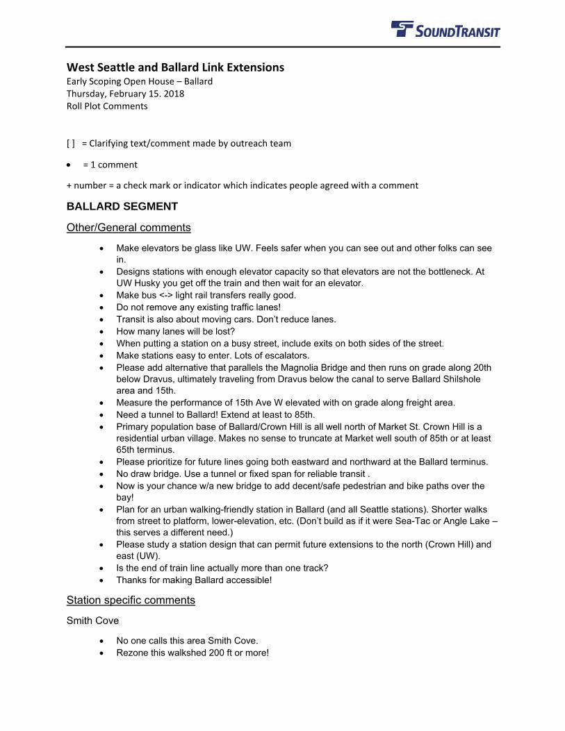
West Seattle and Ballard Link Extensions Early Scoping Open House – Ballard Thursday, February 15. 2018 Roll Plot Comments [ ] = Clarifying text/comment made by outreach team
• = 1 comment
+ number = a check mark or indicator which indicates people agreed with a comment
BALLARD SEGMENT
Other/General comments
• Make elevators be glass like UW. Feels safer when you can see out and other folks can see in.
• Designs stations with enough elevator capacity so that elevators are not the bottleneck. At UW Husky you get off the train and then wait for an elevator.
• Make bus <-> light rail transfers really good. • Do not remove any existing traffic lanes! • Transit is also about moving cars. Don’t reduce lanes. • How many lanes will be lost? • When putting a station on a busy street, include exits on both sides of the street. • Make stations easy to enter. Lots of escalators. • Please add alternative that parallels the Magnolia Bridge and then runs on grade along 20th
below Dravus, ultimately traveling from Dravus below the canal to serve Ballard Shilshole area and 15th.
• Measure the performance of 15th Ave W elevated with on grade along freight area. • Need a tunnel to Ballard! Extend at least to 85th. • Primary population base of Ballard/Crown Hill is all well north of Market St. Crown Hill is a
residential urban village. Makes no sense to truncate at Market well south of 85th or at least 65th terminus.
• Please prioritize for future lines going both eastward and northward at the Ballard terminus. • No draw bridge. Use a tunnel or fixed span for reliable transit . • Now is your chance w/a new bridge to add decent/safe pedestrian and bike paths over the
bay! • Plan for an urban walking-friendly station in Ballard (and all Seattle stations). Shorter walks
from street to platform, lower-elevation, etc. (Don’t build as if it were Sea-Tac or Angle Lake – this serves a different need.)
• Please study a station design that can permit future extensions to the north (Crown Hill) and east (UW).
• Is the end of train line actually more than one track? • Thanks for making Ballard accessible!
Station specific comments
Smith Cove
• No one calls this area Smith Cove. • Rezone this walkshed 200 ft or more!
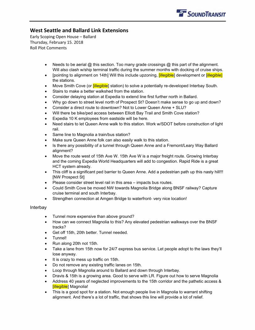
West Seattle and Ballard Link Extensions Early Scoping Open House – Ballard Thursday, February 15. 2018 Roll Plot Comments
• Needs to be aerial @ this section. Too many grade crossings @ this part of the alignment. Will also clash w/ship terminal traffic during the summer months with docking of cruise ships.
• [pointing to alignment on 14th] Will this include upzoning, [illegible] development or [illegible] the stations.
• Move Smith Cove (or [illegible] station) to solve a potentially re-developed Interbay South. • Stairs to make a better walkshed from the station. • Consider delaying station at Expedia to extend line first further north in Ballard. • Why go down to street level north of Prospect St? Doesn’t make sense to go up and down? • Consider a direct route to downtown? Not to Lower Queen Anne + SLU? • Will there be bike/ped access between Elliott Bay Trail and Smith Cove station? • Expedia 10 K employees from eastside will be here. • Need stairs to let Queen Anne walk to this station. Work w/SDOT before construction of light
rail. • Same line to Magnolia a train/bus station? • Make sure Queen Anne folk can also easily walk to this station. • Is there any possibility of a tunnel through Queen Anne and a Fremont/Leary Way Ballard
alignment? • Move the route west of 15th Ave W. 15th Ave W is a major freight route. Growing Interbay
and the coming Expedia World Headquarters will add to congestion. Rapid Ride is a great HCT system already.
• This cliff is a significant ped barrier to Queen Anne. Add a pedestrian path up this nasty hill!!! [NW Prospect St]
• Please consider street level rail in this area – impacts bus routes. • Could Smith Cove be moved NW towards Magnolia Bridge along BNSF railway? Capture
cruise terminal and south Interbay. • Strengthen connection at Amgen Bridge to waterfront- very nice location!
Interbay
• Tunnel more expensive than above ground? • How can we connect Magnolia to this? Any elevated pedestrian walkways over the BNSF
tracks? • Get off 15th, 20th better. Tunnel needed. • Tunnel! • Run along 20th not 15th. • Take a lane from 15th now for 24/7 express bus service. Let people adopt to the laws they’ll
lose anyway. • It is crazy to mess up traffic on 15th. • Do not remove any existing traffic lanes on 15th. • Loop through Magnolia around to Ballard and down through Interbay. • Dravis & 15th is a growing area. Good to serve with LR. Figure out how to serve Magnolia • Address 40 years of neglected improvements to the 15th corridor and the pathetic access &
[illegible] Magnolia! • This is a good spot for a station. Not enough people live in Magnolia to warrant shifting
alignment. And there’s a lot of traffic, that shows this line will provide a lot of relief.
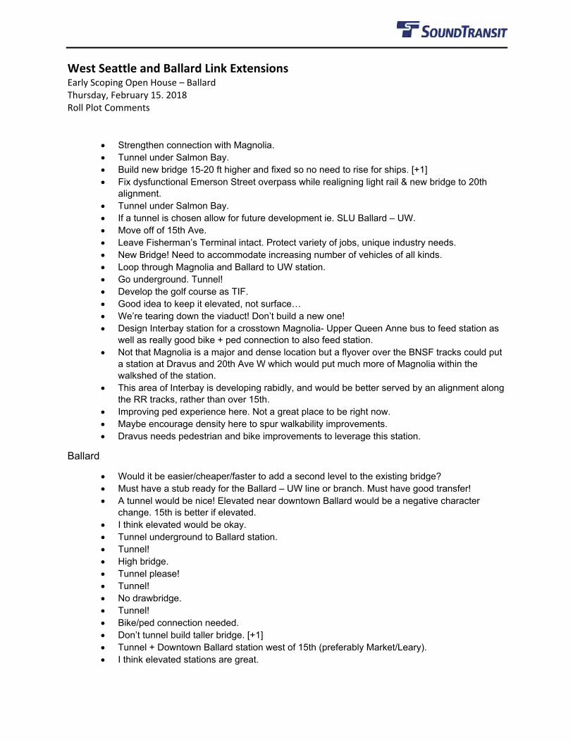
West Seattle and Ballard Link Extensions Early Scoping Open House – Ballard Thursday, February 15. 2018 Roll Plot Comments
• Strengthen connection with Magnolia. • Tunnel under Salmon Bay. • Build new bridge 15-20 ft higher and fixed so no need to rise for ships. [+1] • Fix dysfunctional Emerson Street overpass while realigning light rail & new bridge to 20th
alignment. • Tunnel under Salmon Bay. • If a tunnel is chosen allow for future development ie. SLU Ballard – UW. • Move off of 15th Ave. • Leave Fisherman’s Terminal intact. Protect variety of jobs, unique industry needs. • New Bridge! Need to accommodate increasing number of vehicles of all kinds. • Loop through Magnolia and Ballard to UW station. • Go underground. Tunnel! • Develop the golf course as TIF. • Good idea to keep it elevated, not surface… • We’re tearing down the viaduct! Don’t build a new one! • Design Interbay station for a crosstown Magnolia- Upper Queen Anne bus to feed station as
well as really good bike + ped connection to also feed station. • Not that Magnolia is a major and dense location but a flyover over the BNSF tracks could put
a station at Dravus and 20th Ave W which would put much more of Magnolia within the walkshed of the station.
• This area of Interbay is developing rabidly, and would be better served by an alignment along the RR tracks, rather than over 15th.
• Improving ped experience here. Not a great place to be right now. • Maybe encourage density here to spur walkability improvements. • Dravus needs pedestrian and bike improvements to leverage this station.
Ballard
• Would it be easier/cheaper/faster to add a second level to the existing bridge? • Must have a stub ready for the Ballard – UW line or branch. Must have good transfer! • A tunnel would be nice! Elevated near downtown Ballard would be a negative character
change. 15th is better if elevated. • I think elevated would be okay. • Tunnel underground to Ballard station. • Tunnel! • High bridge. • Tunnel please! • Tunnel! • No drawbridge. • Tunnel! • Bike/ped connection needed. • Don’t tunnel build taller bridge. [+1] • Tunnel + Downtown Ballard station west of 15th (preferably Market/Leary). • I think elevated stations are great.
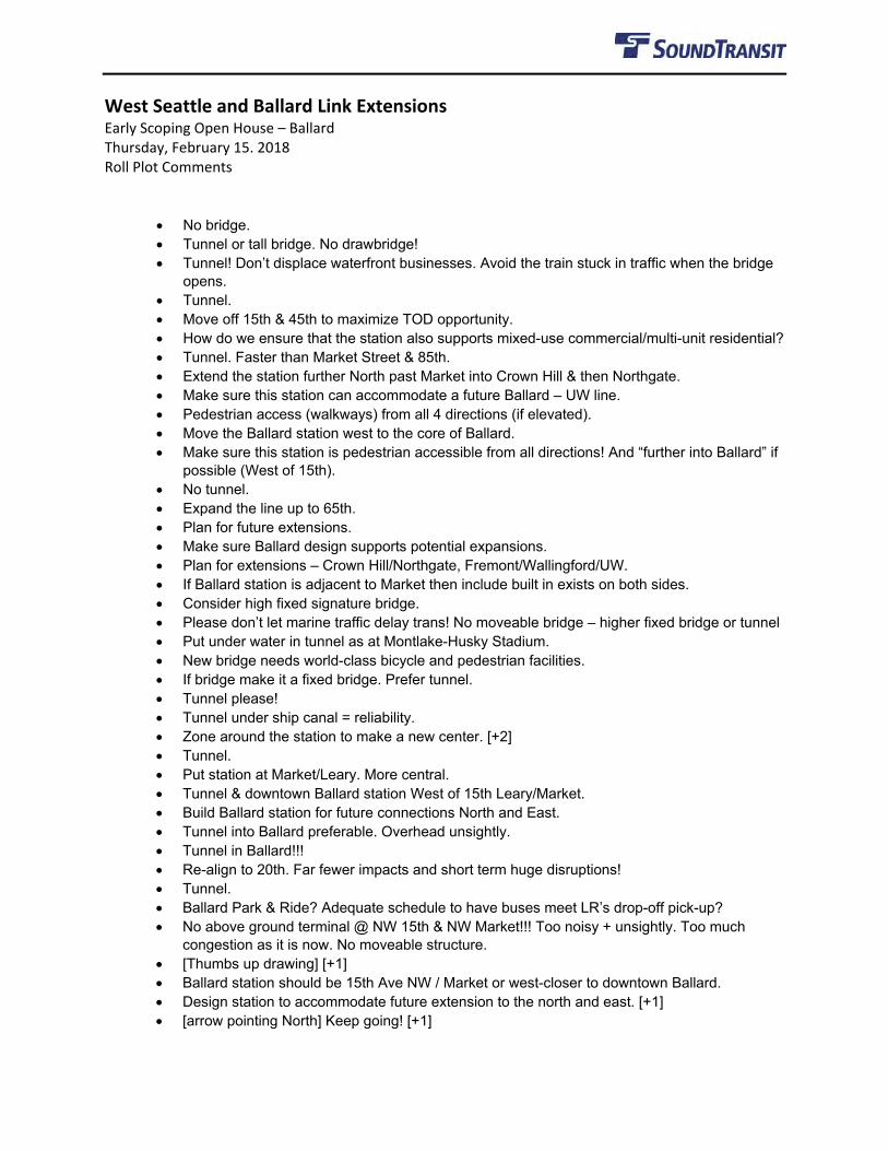
West Seattle and Ballard Link Extensions Early Scoping Open House – Ballard Thursday, February 15. 2018 Roll Plot Comments
• No bridge. • Tunnel or tall bridge. No drawbridge! • Tunnel! Don’t displace waterfront businesses. Avoid the train stuck in traffic when the bridge
opens. • Tunnel. • Move off 15th & 45th to maximize TOD opportunity. • How do we ensure that the station also supports mixed-use commercial/multi-unit residential? • Tunnel. Faster than Market Street & 85th. • Extend the station further North past Market into Crown Hill & then Northgate. • Make sure this station can accommodate a future Ballard – UW line. • Pedestrian access (walkways) from all 4 directions (if elevated). • Move the Ballard station west to the core of Ballard. • Make sure this station is pedestrian accessible from all directions! And “further into Ballard” if
possible (West of 15th). • No tunnel. • Expand the line up to 65th. • Plan for future extensions. • Make sure Ballard design supports potential expansions. • Plan for extensions – Crown Hill/Northgate, Fremont/Wallingford/UW. • If Ballard station is adjacent to Market then include built in exists on both sides. • Consider high fixed signature bridge. • Please don’t let marine traffic delay trans! No moveable bridge – higher fixed bridge or tunnel • Put under water in tunnel as at Montlake-Husky Stadium. • New bridge needs world-class bicycle and pedestrian facilities. • If bridge make it a fixed bridge. Prefer tunnel. • Tunnel please! • Tunnel under ship canal = reliability. • Zone around the station to make a new center. [+2] • Tunnel. • Put station at Market/Leary. More central. • Tunnel & downtown Ballard station West of 15th Leary/Market. • Build Ballard station for future connections North and East. • Tunnel into Ballard preferable. Overhead unsightly. • Tunnel in Ballard!!! • Re-align to 20th. Far fewer impacts and short term huge disruptions! • Tunnel. • Ballard Park & Ride? Adequate schedule to have buses meet LR’s drop-off pick-up? • No above ground terminal @ NW 15th & NW Market!!! Too noisy + unsightly. Too much
congestion as it is now. No moveable structure. • [Thumbs up drawing] [+1] • Ballard station should be 15th Ave NW / Market or west-closer to downtown Ballard. • Design station to accommodate future extension to the north and east. [+1] • [arrow pointing North] Keep going! [+1]
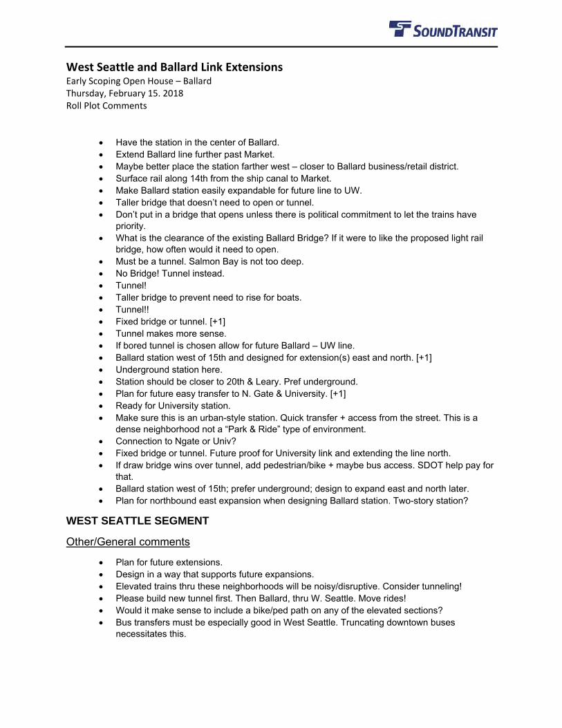
West Seattle and Ballard Link Extensions Early Scoping Open House – Ballard Thursday, February 15. 2018 Roll Plot Comments
• Have the station in the center of Ballard. • Extend Ballard line further past Market. • Maybe better place the station farther west – closer to Ballard business/retail district. • Surface rail along 14th from the ship canal to Market. • Make Ballard station easily expandable for future line to UW. • Taller bridge that doesn’t need to open or tunnel. • Don’t put in a bridge that opens unless there is political commitment to let the trains have
priority. • What is the clearance of the existing Ballard Bridge? If it were to like the proposed light rail
bridge, how often would it need to open. • Must be a tunnel. Salmon Bay is not too deep. • No Bridge! Tunnel instead. • Tunnel! • Taller bridge to prevent need to rise for boats. • Tunnel!! • Fixed bridge or tunnel. [+1] • Tunnel makes more sense. • If bored tunnel is chosen allow for future Ballard – UW line. • Ballard station west of 15th and designed for extension(s) east and north. [+1] • Underground station here. • Station should be closer to 20th & Leary. Pref underground. • Plan for future easy transfer to N. Gate & University. [+1] • Ready for University station. • Make sure this is an urban-style station. Quick transfer + access from the street. This is a
dense neighborhood not a “Park & Ride” type of environment. • Connection to Ngate or Univ? • Fixed bridge or tunnel. Future proof for University link and extending the line north. • If draw bridge wins over tunnel, add pedestrian/bike + maybe bus access. SDOT help pay for
that. • Ballard station west of 15th; prefer underground; design to expand east and north later. • Plan for northbound east expansion when designing Ballard station. Two-story station?
WEST SEATTLE SEGMENT
Other/General comments
• Plan for future extensions. • Design in a way that supports future expansions. • Elevated trains thru these neighborhoods will be noisy/disruptive. Consider tunneling! • Please build new tunnel first. Then Ballard, thru W. Seattle. Move rides! • Would it make sense to include a bike/ped path on any of the elevated sections? • Bus transfers must be especially good in West Seattle. Truncating downtown buses
necessitates this.
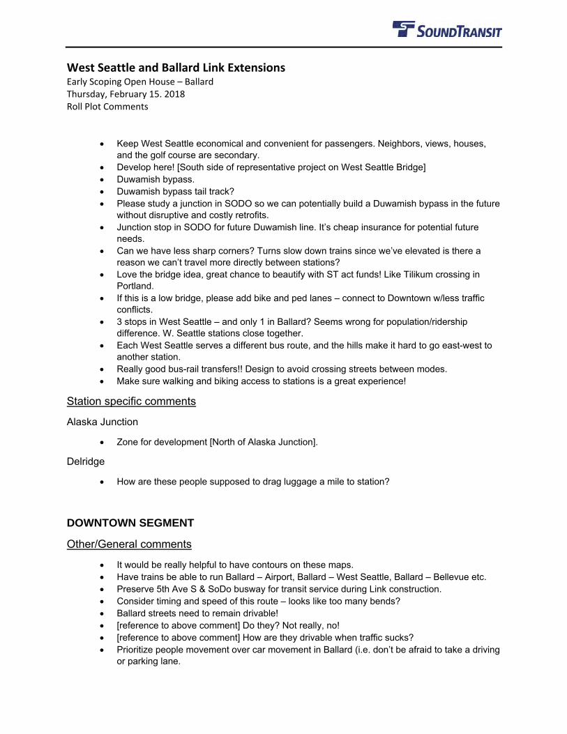
West Seattle and Ballard Link Extensions Early Scoping Open House – Ballard Thursday, February 15. 2018 Roll Plot Comments
• Keep West Seattle economical and convenient for passengers. Neighbors, views, houses, and the golf course are secondary.
• Develop here! [South side of representative project on West Seattle Bridge] • Duwamish bypass. • Duwamish bypass tail track? • Please study a junction in SODO so we can potentially build a Duwamish bypass in the future
without disruptive and costly retrofits. • Junction stop in SODO for future Duwamish line. It’s cheap insurance for potential future
needs. • Can we have less sharp corners? Turns slow down trains since we’ve elevated is there a
reason we can’t travel more directly between stations? • Love the bridge idea, great chance to beautify with ST act funds! Like Tilikum crossing in
Portland. • If this is a low bridge, please add bike and ped lanes – connect to Downtown w/less traffic
conflicts. • 3 stops in West Seattle – and only 1 in Ballard? Seems wrong for population/ridership
difference. W. Seattle stations close together. • Each West Seattle serves a different bus route, and the hills make it hard to go east-west to
another station. • Really good bus-rail transfers!! Design to avoid crossing streets between modes. • Make sure walking and biking access to stations is a great experience!
Station specific comments
Alaska Junction
• Zone for development [North of Alaska Junction].
Delridge
• How are these people supposed to drag luggage a mile to station?
DOWNTOWN SEGMENT
Other/General comments
• It would be really helpful to have contours on these maps. • Have trains be able to run Ballard – Airport, Ballard – West Seattle, Ballard – Bellevue etc. • Preserve 5th Ave S & SoDo busway for transit service during Link construction. • Consider timing and speed of this route – looks like too many bends? • Ballard streets need to remain drivable! • [reference to above comment] Do they? Not really, no! • [reference to above comment] How are they drivable when traffic sucks? • Prioritize people movement over car movement in Ballard (i.e. don’t be afraid to take a driving
or parking lane.
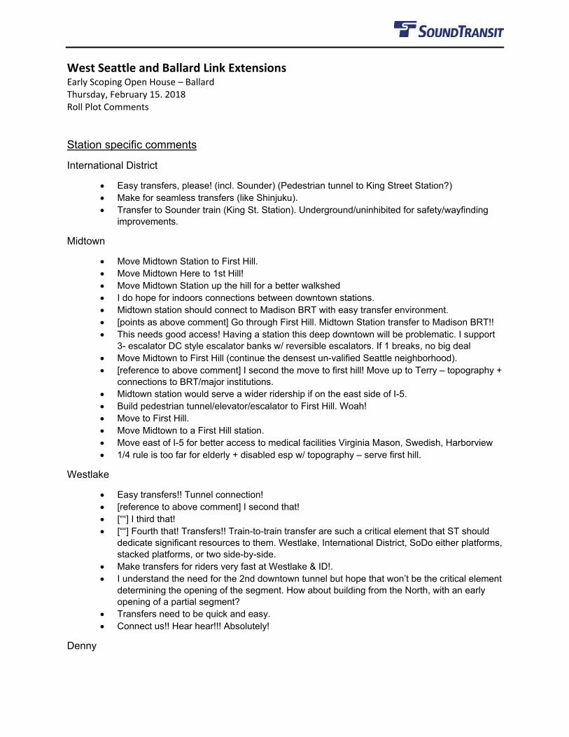
West Seattle and Ballard Link Extensions Early Scoping Open House – Ballard Thursday, February 15. 2018 Roll Plot Comments Station specific comments
International District
• Easy transfers, please! (incl. Sounder) (Pedestrian tunnel to King Street Station?) • Make for seamless transfers (like Shinjuku). • Transfer to Sounder train (King St. Station). Underground/uninhibited for safety/wayfinding
improvements.
Midtown
• Move Midtown Station to First Hill. • Move Midtown Here to 1st Hill! • Move Midtown Station up the hill for a better walkshed • I do hope for indoors connections between downtown stations. • Midtown station should connect to Madison BRT with easy transfer environment. • [points as above comment] Go through First Hill. Midtown Station transfer to Madison BRT!! • This needs good access! Having a station this deep downtown will be problematic. I support
3- escalator DC style escalator banks w/ reversible escalators. If 1 breaks, no big deal • Move Midtown to First Hill (continue the densest un-valified Seattle neighborhood). • [reference to above comment] I second the move to first hill! Move up to Terry – topography +
connections to BRT/major institutions. • Midtown station would serve a wider ridership if on the east side of I-5. • Build pedestrian tunnel/elevator/escalator to First Hill. Woah! • Move to First Hill. • Move Midtown to a First Hill station. • Move east of I-5 for better access to medical facilities Virginia Mason, Swedish, Harborview • 1/4 rule is too far for elderly + disabled esp w/ topography – serve first hill.
Westlake
• Easy transfers!! Tunnel connection! • [reference to above comment] I second that! • [““] I third that! • [““] Fourth that! Transfers!! Train-to-train transfer are such a critical element that ST should
dedicate significant resources to them. Westlake, International District, SoDo either platforms, stacked platforms, or two side-by-side.
• Make transfers for riders very fast at Westlake & ID!. • I understand the need for the 2nd downtown tunnel but hope that won’t be the critical element
determining the opening of the segment. How about building from the North, with an early opening of a partial segment?
• Transfers need to be quick and easy. • Connect us!! Hear hear!!! Absolutely!
Denny
West Seattle and Ballard Link Extensions Early Scoping Open House – Ballard Thursday, February 15. 2018 Roll Plot Comments
• Use Battery Street tunnel for station. Get rid of Denny Station. • Move Denny Station South – big gap between Westlake & Denny. Denny & SLU stations are
close together. [+1] • Stacked platforms for future expansion north up 99. [+2] • Combine the ‘Denny’ + ‘South Lake Union’ Stations into 1 station. • Need quality transfers between Link and E-line! • Also transfers to 62, 5, 26, 28. • Monorail. • Too much station overlap between Denny & SLU and too much of a gap between Westlake &
Denny as shown now. Move Denny Station south or Westlake 2 station 1/2 block north • Would moving Denny east improve ridership? • Why are these stations so close to each other (Denny/SLU). • Allow for future develop with Aurora line mirroring current E line. • This overlap is awesome. • Walk circles even gaps .
South Lake Union
• Serve South Lake Union w/ buses and street car – co can have 1 light rail station use $ to build a station at 65th or 70th.
• No access from station to this area.
Seattle Center
• Save KEXP. • Build a Dick’s drive in walk up window at this station. [+8] • Save KEXP. • Keep KEXP, knock down post office and build pit there. • Design new station with easy, convenient bus-rail-transfers. Avoid pedestrian street
crossings. Put stations under the street with entries on both sides of major streets. • International students require light rail at surface! But I’m you know something no one else
does. • The purpose of this system includes travel to airport. Can you (or families, elders, or
students) pull luggage 1/2 + 1 mile?
SODO SEGMENT
Station specific comments
SoDo
• Must have convenient transfer for West Seattle to Kent or Bellevue trips. • Please make transfers seamless. • Consider moving this section closer to the waterfront. Serve a larger area. [+1] • Stadium station on 1st Ave S. SoDo Station on 1st Ave. S. Lots of people work here!
West Seattle and Ballard Link Extensions Early Scoping Open House – Ballard Thursday, February 15. 2018 Roll Plot Comments
• Instead of a complete duplicate line in this area – route second line on 1st Ave S to better serve Starbucks HQ and Stadium, then connect in at International District.
Stadium
• I wish trains could still go from UW to SeaTac. Please consider keeping current alignment. • Easy transfer between lines – center platform. • Walking from Stadium to other places is pretty unpleasant. Can we increase density here to
spur improvements & walkability. • Connect station to stadium (w/o crossing streets? w/o feeling unsafe at night). • Eliminate crossings with street traffic to improve reliability. • Please don’t have at grade road crossings. Currently it seems like ped/car/train interactions
are the #1 cause of train reliability issues. • If a new tunnel is put in where a current at grade crossing exists would it be possible to move
to existing crossing underground too? • If you’re tunneling back there, why not follow a different alignment? (service wider coverage
area)