early pueblo responses to climate variability: … · mesa verde (emv) area, responded to climatic...
TRANSCRIPT

EARLY PUEBLO RESPONSES TO CLIMATE VARIABILITY:FARMING TRADITIONS, LAND TENURE, AND SOCIAL POWER
IN THE EASTERN MESA VERDE REGION
Benjamin A. Bellorado and Kirk C. Anderson
Abstract
Maize agriculture is dependent on two primary environmental factors, precipi-
tation and temperature. Throughout the Eastern Mesa Verde region, fluctuations
of these factors dramatically influenced demographic shifts, land use patterns, and
social and religious transformations of farming populations during several key
points in prehistory. While many studies have looked at the influence climate
played in the depopulation of the northern Southwest after A.D. 1000, the role
that climate played in the late Basketmaker III through the Pueblo I period
remains unclear. This article demonstrates how fluctuations in precipitation pat-
terns interlaced with micro- and macro- regional temperature fluctuations may
have pushed and pulled human settlement and subsistence patterns across the
region. Specifically, we infer that preferences for certain types of farmlands dic-
tated whether a community used alluvial fan verses dryland farming practices,
with the variable success of each type determined by shifting climate patterns.
We further investigate how dramatic responses to environmental stress, such as
migration and massacres, may be the result of inherited social structures of
land tenure and leadership, and that such responses persist in the Eastern Mesa
Verde area throughout the Pueblo I period.
Resumen
La agricultura de maíz depende de dos factores ambientales primarios: precipitación y
temperatura. A lo largo de la región oriental de Mesa Verde las fluctuaciones de estos fac-
tores influyeron dramáticamente en cambios demográficos, patrones de uso de la tierra así
como transformaciones sociales y religiosas en las poblaciones agrícolas durante varios
momentos clave en la prehistoria. Mientras que varios estudios han tratado la influencia
que tuvo el clima en el despoblamiento del norte del Suroeste después de 1000 D.C., el rol
que el clima jugó en la parte tardía de Basketmaker III y a lo largo del periodo Pueblo I
permanece poco claro. Este artículo demuestra cómo las fluctuaciones en los patrones de
precipitación entrelazadas con fluctuaciones micro- y macro-regionales de temperatura
pudieron haber afectado asentamientos humanos y patrones de subsistencia a lo largo
de la región. Específicamente, inferimos que las preferencias por cierto tipo de tierras de
cultivo definieron si una comunidad usaba prácticas de abanico aluvial en oposición a
prácticas de cultivo en tierra seca. Además, investigamos como respuestas dramáticas a
KIVA: The Journal of Southwestern Anthropology and History, Vol. 78, No. 4 (Summer 2013), pp. 377–416.Copyright © 2013 Arizona Archaeological and Historical Society. All rights reserved. 377DOI 10.1179/0023194013Z.0000000007

estrés ambiental, tales como migraciones y masacres, pudieron haber sido el resultado de
estructuras sociales heredadas respecto a la tenencia de la tierra y liderazgo, y que tales
respuestas persistieron en el área oriental de Mesa verde a lo largo de periodo Pueblo I
INTRODUCTION
In this paper, we investigate how early Puebloan cultures in the Upperand Middle San Juan drainages, hereafter referred to as the Eastern
Mesa Verde (EMV) area, responded to climatic variability based largely on thehistorical foundations of their communities. Specifically we evaluate how agri-cultural adaptations and social organization may have influenced decision-making responses to climatic stress. The responses to the challenges presentedby climatic variability seem to depend on the cultural filter of each groupstudied. It appears that whatever the response of the individual society, it lefttraces on the cultural landscape of modern Puebloan societies in the northernSouthwest. These traces, illustrated through ethnographic comparisons, alsoinform our interpretations. We focus our lens primarily on the controlling par-ameters of agricultural adaptations to investigate the dynamics of demographicshifts between the late seventh through middle ninth centuries. In an area wherepatchy moisture regimes and shifting temperature marginality define the ecosys-tem, what were the limits that farmers would accept before they were compelledto make a drastic reaction—including migration, adaptation, or violence? Inaddition, what landscape characteristics were people looking for when theymoved into a new area? We investigate how changes in temperature anddrought severity significantly influenced movements of farming societies(Figure 1a), to better understand some of the complex social processes thatuniquely shaped Ancestral Puebloan cultures through time.
The EMV area is divided into the Upper and Middle San Juan regions. TheUpper San Juan area includes the upper Animas, Pine, Piedra, and San Juanrivers, and Largo and Gobernador washes (Figure 1a) (also see Bellorado, thisissue). The Middle San Juan area includes the lower reaches of these samerivers centered around the modern town of Farmington, New Mexico. Early agri-culturalists moved up and down elevational gradients in response to tempera-ture and precipitation in search of suitable locations to reliably grow theircrops. This appears to be a long-standing and fairly reliable subsistence strategyfrom Basketmaker II (400 B.C.–A.D.400) times onward (Bellorado 2011b; Berry1982; Hovezak and Sesler 2006) into the late Pueblo I period (Bellorado 2007;Toll and Wilson 2000).
Our premise throughout this paper is that climate and ancient Pueblopeoples interacted most intimately on the landscape through their farming prac-tices. Therefore, we first discuss the context of agricultural systems used in theEMV area, specifically alluvial fan verses dryland farming, to provide a
Benjamin A. Bellorado and Kirk C. Anderson378

FIGURE 1. (A) TheUpper and MiddleSan Juan portions ofthe Eastern MesaVerde area with thelocations of sites andareas mentioned intext; and (B) generallocations of the sub-regional climatictree-ring chronolo-gies used to recon-struct the PalmerDrought SeverityIndices (PDSI)stations used in ouranalyses in relation tothe cultural areas ofthe northern South-west discussed intext.
EARLY PUEBLO RESPONSES TO CLIMATE VARIABILITY 379

framework for our investigations. We next briefly discuss several ethnographicexamples that inform our understanding of how some Puebloan groups mayhave responded to climatically induced stress and conflict. We then presenthow we use the paleoclimate data, dividing it into important time periods ofthe archaeological record in the EMV region. Finally, we attempt to integratethe complexly related entities of climate-land-people into some semblance ofa cultural history of responses to climate fluctuations for the EMV. We begin,however, with a few assumptions.
A CONTEXT FOR EARLY AGRICULTURAL SYSTEMS: ASSUMPTIONSABOUT AGRICULTURAL LIFEWAYS IN PREHISTORY
To begin our analysis, we needed to address several basic assumptions about thenature of Ancestral Puebloan lifeways, particularly as they relate to agricultureand maize farming. First, we assume the production and processing of maizeyields were the central focus of energy expended by many Ancestral Puebloangroups. Coltrain et al. (2006, 2007) documented that maize likely providedup to 80 percent of annual diets in the northern Southwest since the Basket-maker II period. This long dependence on maize farming shaped the nature ofagricultural strategies and crop varieties, and had profound influences on theways Ancestral Puebloans’ interpreted the world around them. As is commonworldwide, secular life was inextricably tied to religious life, resulting in religiousceremonies and behavior focused on controlling weather conditions to aid theproduction of maize (Bunzel 1992; Ford 1972; Malotki 2000; Parsons 1966a,1966b; Tyler 1964).
Second, we assume that prehistoric peoples had an extensive knowledge ofboth local and regional ecological zones and processes (Charles et al. 2006;Sesler and Hovezak 2002). That said, there were many ways to farm, and thenuances of agricultural production in particular regions varied greatly. Forexample, some Ancestral Puebloan groups focused on floodwater farming onalluvial fans or floodplains while others focused on dryland farming ofuplands in deep loess soils and sand dunes. So while farmers in the northernSouthwest undoubtedly shared many basic agricultural techniques, individualfarming communities developed their own character of agricultural lifewaysaccording to their particular ecological and social requirements. Crop varietieswere developed to specific environmental niches over time with the result ofenhancing the productivity of particular varieties and efficacy of specific sets ofagricultural technologies, creating a dependence on these particular farmingsystems and crop varieties. Thus, the spatial variation of specific suites of agricul-tural technologies (e.g. floodplain verses dryland) should be viewed as anaccumulation of culturally specific traits adapted to specific suites of environ-mental conditions. Tracking the temporal and spatial extent of suites of
Benjamin A. Bellorado and Kirk C. Anderson380

agricultural technologies may be as useful to the studies of ancient identities andethnicities as tracking the spatial and temporal distributions of other artifact andfeature classes in the archaeological record.
Indeed, agricultural investments into landscapes represent humanresponses to the affects that specific environmental and climatic conditionshad on their primary subsistence base. That is, the interaction of environmentand climate with the at times limited parameters of social landscapes and mobi-lity patterns, provides researchers with attributes of agricultural technologies toshed light on adaptive behaviors. Thus agricultural investments are identitymarkers and likely took a prominent role in shaping the identities of individualcommunities and their social interaction spheres. This idea, that the interactionof climate, landscape, and culture determines and forges agricultural technol-ogies, while at the same time the limits of these agricultural technologies inturn determine societal responses to stress, forms the basis of our interpretations.
Finally, we assume that interaction among groups of people in the north-ern Southwest was extensive and continuous through time, and that people gen-erally knew how much better or worse neighboring farming communities werefairing at any given time, much as Toll (2008) outlines for the Totah area specifi-cally. Among historic Pueblo groups the perception of relative prosperity(or adversity) of a community was based on historically and religiouslyrooted mechanisms for viewing human’s place in the world (Ford 1972, 1992;Titiev 1943).
LANDUSE BEFORE PUEBLO I
Groups that moved into the uplands of the EMV (Upper San Juan) could haveoriginated from a variety of places including the La Plata Valley, the CentralMesa Verde area, Southern Utah, the Middle San Juan, and possibly Chaco/Cibola and the Chuska Slope areas (Dykeman 2004; Hovezak and Sesler2006; Kearns et al. 2000; Reed 2000; Reed and Wilcox 2000). People whomoved into the upper Animas River weren’t carrying matching sets of culturaltool kits. For example, each group had its own ideas of how to design andbuild pithouses (Chuipka and Potter 2007; Potter and Yoder 2008), had differ-ent access to traded commodities such as red wares (Alison 2008), and main-tained specific ethnicities, identities, and languages (Potter 2010c, 2010d).People from different areas also brought knowledge of specialized subsistencestrategies including different agricultural practices (floodplain verses drylandfarming), crop varieties, and differing religious traditions.
Toll andWilson (2000, 2009) identify the Basketmaker III communities ofthe lower La Plata Valley as one of the primary donor populations to the PuebloI people of the upper La Plata and Animas Valleys, based primarily on simi-larities in ceramic technologies and pithouse construction layout. Indeed,
EARLY PUEBLO RESPONSES TO CLIMATE VARIABILITY 381
there is a link between the types of environments used by the Basketmaker IIIcommunities in the lower La Plata Valley and the Durango area, namelyfarming of large alluvial fans. Alternatively, recent research in the Durangoarea documented a small but established Basketmaker III population (Bellorado2007: 34; Charles 2011) with ties to the Fruitland area on the Colorado/NewMexico border (Sesler and Hovezak 2002). The material culture of these ‘local’upper Animas Basketmaker III populations suggests they were descendants ofthe earlier Basketmaker II populations (Bellorado 2011a, 2011b; Charles2011; Matson 2006; Sesler and Hovezak 2002). Sesler and Hovezak (2002),Charles et al. (2006), and Bellorado (2007) suggest that in the Upper SanJuan, Basketmaker III people utilized landscapes in largely the same ways andintensities that their Basketmaker II ancestors had, but perhaps relocatingmore frequently and on larger tracks of the landscape.
THE ETHNOGRAPHIC RECORD AND A CAUSAL VIEW OFHUMAN-NATURE INTERACTIONS
Technological innovations and mobility were not the only tools the ancientPuebloans had to influence success or failure. Ancient peoples relied extensivelyon religious practices, and perhaps other more direct ways to set things right, justas many modern Puebloan groups today. The ethnographic record is rife withexamples of how Pueblo peoples responded to both short- and long-term cli-matic and ecosystem changes historically. In many cases climate change onsmall and large scales were viewed causally. That is to say, changes in climateare caused primarily by direct intervention on the part of animals andhumans, and ultimately ritual specialists within Pueblo communities have theability to control many aspects of the natural world.
This causal view often conflicts with the views of the scientific community.For example, Malotki (2000) describes the Hopi association with maahu, thecicada (Family Cicadidae) and its power to control heat, especially during thelate summer when agricultural crops need increased heat to facilitate the devel-opment and maturation of fruiting bodies. Malotki (2000: 65) notes that fromthe viewpoint of modern western entomology, the frequency of sound pro-duction by cicadas are directly related to temperature, as mature cicadas areespecially vocal on hot days. However, “in the eyes of the Hopi, this causalrelationship works exactly in the other way around: It is the insect’s music thatis held responsible for hot weather” (Malotki 2000: 65). Thus the cicadas’sound production causes the climate to get warmer, as opposed to the westernscientific view that the increasing warmth of summer facilitates cicada growthcycles and vocalization behaviors.
For many Puebloan societies, this type of causal view of climate changeand interactions in nature hold true and form the basis through which the
Benjamin A. Bellorado and Kirk C. Anderson382

natural world, and human being’s place within it, are viewed. Richard Ford notesthat:
San Juan [Pueblo] inhabitants do not passively witness the unfolding of natural
events in chronological succession throughout the year. Instead, they believe
that their actions can influence the rhythm of nature, both beneficially and
adversely. They are philosophical about this; they have expectation as to what
the best natural events are; and they have certain persons who can control
certain natural forces. (1992: 144)
Throughout this article we use ethnographic examples like these as analo-gies for how prehistoric people may have viewed their role in the face of chan-ging climates and ecosystems. We compare these analogies from theethnographic record to models of climate change, settlement patterns, anddemographic shifts in the prehistoric record of the Eastern Mesa Verde area tofurther our understanding of how and why people lived where they did.Having set the foundations for our discussion of the human-landscapesystems, we now turn our attention towards the climate record.
FINE-GRAINED DROUGHT SEVERITY INDICES AND TEMPERATUREPROXIES FOR THE NORTHERN SOUTHWEST
Following Richard Ford’s ethnoecological models of the San Juan Pueblo, wehave chosen to use fine-grained annual Palmer Drought Severity Index (PDSI)(Laboratory of Tree-ring Research 2008) and temperature (Salzer and Kipfmuel-ler 2005) reconstructions to compare 150-year periods between the describedsubregions, bracketing key periods of demographic change. Anderson (2008a,2008b) has shown how regional PDSI and drought severity indices can maskimportant fine-grained climatic changes that affect cultural processes, processesthat can be more specifically depicted in reconstructions for the subregions. Forthis article, we evaluate the various ways that Ancestral Puebloan culturesresponded to climatic shifts for the overlapping 150 year periods: A.D.700–850 and A.D. 800–950.
Overall, we approach Ancestral Puebloan responses to climatic changemirroring what Richard Ford discussed for San Juan Pueblo: “For each puebloavailable moisture from precipitation and irrigation fluctuates unpredictably.The system must adapt to these extreme conditions and not to the deceptivemean values which are usually presented” (Ford 1972: 5). He later adds that“if we continue to merely describe the environment in terms of mean climaticfactors and neglect their extremes and other vicissitudes…wemiss the functionsof many cultural institutions at different levels that a thorough ecological studycan reveal” (Ford 1972: 17). Further, Ford also suggests that:
EARLY PUEBLO RESPONSES TO CLIMATE VARIABILITY 383

One cannot understand San Juan’s social organization if one merely examines the
mean of each environmental factor; that is, the mean date of the first frost and last
frost, the mean daily temperatures or the mean annual rainfall. These are mean-
ingless for the people. It is the ranges and oscillations that are important. (Ford
1992: 154)
Consequently we use regional paleoclimatic reconstructions and highresolution, fine-grained annual data, and five-year moving-averages. Thisapproach allows us to keep from missing the extremes that greater smoothingcan obscure, as well as including coarse-grained smoothing for broader regionaltrends.
Many researchers have discussed modes of depopulation utilizing variousclimatic reconstructions to address questions of population movements, oftenusing tree-ring indices that may suggest megadroughts (Benson and Berry2009), increased climatic variability (McVickar 2004), changes in precipitationpatterns (Cordell et al. 2007), arroyo down cutting (Force 2004; Force et al.2002: Vivian et al. 2006), increased soil salination (Benson and Berry 2009),and game depletion (Potter 2009; Potter and Edwards 2008) as factors thatcaused Ancestal Puebloan peoples to move to other areas.
We draw upon Palmer Drought Severity Index (PDSI) data for several sub-regions of the northern Southwest, specifically for the Durango, Gobernador,Mesa Verde, and Chaco areas (Figure 1b). The PDSI values were calculated bythe Southwest Regional Paleoclimate Project and provided by Jeff Dean (Labora-tory of Tree-Ring Research 2008). We look primarily at PDSI reconstructions forthe Durango and Gobernador areas compared to the Mesa Verde and Chacosubregions. We have converted PDSI values into z-scores to standardize thereconstructed values within shorter datasets of 150 year periods from A.D.700–950. In these reconstructions, the 5-year moving averages of the PDSIz-scores that approach one standard deviation from the mean translate into sig-nificant impacts on the agricultural cycle; however, even smaller shifts in moist-ure levels could have had significant affects on both subsistence practices andcultural processes.
We also draw upon Salzer and Kipfmueller’s (2005) temperature recon-structions from living bristlecone pine trees in the San Francisco Peaks of north-ern Arizona as a proxy for temperatures on the larger Colorado Plateau. We havestandardized these reconstructed values by converting them into z-scores suchthat fluctuations of 0.5 to 1.0 standard deviation from the 150-year mean rep-resent significant changes in the climate that would have influenced agriculturalproduction (Salzer and Kipfmueller 2004). In these reconstructions, tempera-tures scores greater than one standard deviation from the 150-year mean markextreme departures from normal temperatures and likely significantly affectedagricultural production in the EMV.
Benjamin A. Bellorado and Kirk C. Anderson384

ALLUVIAL FAN FARMING: THE CONTEXT OF LOCAL SUBSISTENCESTRATEGIES FOR EARLY FARMERS IN THE EASTERN MESA VERDE
REGION
Leading up to the eighth century, a diversity of agricultural systems used duringthe Basketmaker III period likely developed throughout the northern Southwestout of a general focus on floodwater farming-based systems widespread since theBasketmaker II era (Bellorado 2011a, 2011b; Matson 1991, 2006; Vierra 2008).In the uplands of the EMV area, farming populations appear to have adapted to aspecific type of floodwater farming system (similar to ak’chin farming systems),namely focusing on floodwater farming of the alluvial fans found extensivelythroughout the region (Bellorado 2011b). In contrast, in the Western MesaVerde (WMV) region we see evidence that farming practices were focused ondifferent portions of the landscape by the Basketmaker II period, with the useof dryland agriculture on mesa tops (Matson 1991; Varien 2009). Varien andothers have argued that by the Basketmaker III period, populations from theWMV area moved into the Central Mesa Verde (CMV) area (Kohler et al.2008; Varien 2008), bringing dryland farming techniques and corn varietieswith them. In the CMV and WMV regions, farmers adapted and improved agri-cultural systems on mesa tops over the centuries leading up to the mid-700s,while in the Chaco area contemporaneous farmers were primarily using flood-water farming of alluvial fans and floodplains in the Chaco Wash drainagearea (Vivian et al. 2006).
Elsewhere Bellorado (2007: 61, 2009, 2011a, 2011b) has documentedthat the alluvial fan focused maize farming systems in use in the uplands ofthe EMV (Upper San Juan) region had been developed over time to be highlyadapted to the precise conditions of these environments and that the use ofthese specific types of agricultural landscapes could have promoted bothregional cultural isolation and the development of specific social identities ofpeoples in these areas. Generally speaking, in the EMV area there appears tobe a pattern of demographic shifts from the Basketmaker II through thePueblo I periods, where populations moved to higher elevations during warmdry periods and to lower elevations during cooler periods (Bellorado 2011b;Sesler and Hovezak 2002). While this pattern appears focused on the distri-bution of alluvial fans in the EMV area, the periods in which different portionsof the region would have been farmable presents a similar situation as Petersen(1988) projected for the dry farming belt, which extended across the Central andWestern Mesa Verde regions. Therefore, we can surmise that dryland farmers inthe WMV and CMV regions were more susceptible to changing climatic con-ditions that affected upland locations, whereas alluvial fan farmers in the EMVregion would have been more susceptible to changing climatic conditions affect-ing alluvial fan agriculture. We discuss this in more detail below.
EARLY PUEBLO RESPONSES TO CLIMATE VARIABILITY 385

DURANGO’S CLIMATIC REFUGIA IN THE EARLY A.D. 700s
At the end of the A.D. 600s, Basketmaker peoples lived in a variety of locations inthe northern Southwest. Basketmaker III populations in these diverse areas livedin communities ranging from single family hamlets to small proto-villages(Kearns et al. 2000; Reed and Wilcox 2000; Toll and Wilson 2000). Dependencyon maize agriculture was widespread among all of these groups and their abilityto maintain adequate subsistence levels depended directly on climatic con-ditions in their respective homelands. Beginning in the end of the 600s, temp-eratures began to fluctuate at higher frequencies then they had previously anddid not stabilize until after A.D. 740. However, there were brief stints whenthe Durango area and other locations in the uplands of the EMV area wouldhave been favorable to farming populations followed by extremely poorperiods. Indeed, the area would have been favorable for farming betweenroughly A.D. 710–725 during a warm and wet spell followed by 10 to 15years during which the region experienced the second most severe cold spell(a wet one) in the A.D. 700–850 period. During this time, observations of thefive-year moving averages of PDSI levels suggest regional precipitation levelsoscillated through similar patterns of mild drought to incipient wet spells inall of the Mesa Verde, Chaco, Durango, and the Gobernador subregions.Looking at the climatic reconstructions more closely (Figure 2) we see that inthe early 700s the Durango area, and by extension the uplands of the largerEMV, were consistently one of the wettest in the northern Southwest evenduring the driest periods, while the lowland areas of the Gobernador andChaco areas were often the driest. However, in the early half of the 740s regionaltemperatures increased and stabilized above the one hundred and fifty yearmean until about the mid 780s. The 740s also marked a mild but pervasivedrought period seen in all of the subregions of the larger Mesa Verde regionduring which time the uplands around what is now Durango remained wetterthan the surrounding areas.
These dramatic swings in the climate in the late 600s and early 700s appearto have spurred a major demographic shift of peoples throughout the northernSouthwest and pushed peoples out of areas that had been occupied for hundredsof years. These demographic shifts are evident throughout the northern South-west but are seen in the EMV region most discernibly by the occupationhiatus between the densely occupied communities of Basketmaker III andPueblo II period occupations of the lower La Plata River valley when thepeople of the area likely moved into the uplands above 6,000 ft (Wilsonand Toll 2009). Indeed, throughout the northern Southwest, beginningin the early to middle 700s, populations moved into several areas that hadlittle or no previous occupation prior to the early Pueblo I period (Wilshusen1995).
Benjamin A. Bellorado and Kirk C. Anderson386

In the late 600s and early 700s the upper reaches of the Animas River drai-nage became a refugia for Ancestral Puebloan peoples during a region-widedrought in much the way that Berry (1982) has suggested. Bellorado (2007,2011b) and Hovezak and Sesler (2006) have demonstrated that initially thepeoples who moved into these areas maintained a similar type of settlementselection criteria as they had used in their homelands for generations previousto their movement into the Durango area. Thus, the basic layout of each habi-tation unit appears little changed from the earlier Basketmaker II period, withfamilies living in single household residential units centering on one to two pit-houses with an assortment of small surface storage features. That being said, thepopulation levels of the migrants of people into the Durango area took place ona scale previously unknown in both the uplands of the EMV area and within thelarger northern Southwest. So while individual families set up hamlets in thesame way they had in their previous homelands, they did so in larger
FIGURE 2. Paleoclimatic reconstructions for the A.D. 700–850 period and date ranges for selectsites in Eastern and Central Mesa Verde and Chaco Subregions.
EARLY PUEBLO RESPONSES TO CLIMATE VARIABILITY 387

numbers, clustering single-family household settlements in the patchy agricul-tural zones of the upland environments of the EMV region.
THE EARLIEST VILLAGES IN THE EASTERN MESA VERDE AND THEBASIS OF LEADERSHIP AND LAND TENURE IN THE DURANGO AREA
The initial arrivals to a place often establish what Potter (2010d) calls a primoc-racy, where the first pioneers into an area maintain a certain prestige and controlof natural resources around a community. As other groups join, they areassigned certain roles in the society and access to resources, but the firstcomers maintain the control of the most sought after resources:
As other groups came to settle in the village, the kikmongwi assigned them farm-
lands, in return for which they contributed a ceremony or some ceremonial func-
tion that benefited the village as a whole. The earliest arrivals received some of the
best lands and also “owned” the most important ceremonies. The last arrivals
received no land at all; nor were their contributions to the ceremonial cycle
very great. If tradition reflects reality, the rank of any given clan ought to be
based both on the quality of the land and on the ceremony it controlled. (Levy
1992: 33)
In the Durango area, it appears that some of the first comers who migratedinto the area in the mid-700s may have derived from a local stock of peoples fam-iliar with the best wild plant and animal resource areas and farmlands, and withthe knowledge of the settlement patterns appropriate to the local area (Bellorado2007, 2011b). Indeed, some of these groups may have been the descendants ofthe local Los Pinos and Sambrito phase Basketmaker II and III (see Bellorado,this issue Table 1) farming populations that had moved in and out of theDurango and the Upper and Middle San Juan areas for over a millennia (Seslerand Hovezak 2002, 2009, 2011). Continuities in house layout and constructiontechnique (Potter 2010c; Potter and Yoder 2008), proximity to earlier Basket-maker II farmsteads (Potter and Chuipka 2007), sandal constructions style(Webster 2009), and site selection criteria for specific agricultural settings (Bellor-ado 2007: 261, 2009, 2011a, 2011b); suggest that at least some of the first peoplesto migrate into the larger Durango area in the mid-700s identified, asserted, andmaintained themselves as the peoples “local” to the larger Durango area. Thisallowed them to assert a tenured, historically rooted claim to the control of theprime agricultural lands and other resources through an ancestral tie to theplace. Indeed, Potter and Yoder note that:
One of the most effective ways to legitimize one’s claim to a landscape and create
an identity that is rooted in tradition is to reference the remote past through
Benjamin A. Bellorado and Kirk C. Anderson388

architectural style, effectively signaling a historical connection—whether real or
fictive—to place. (Potter and Yoder 2008: 29)
Ridges Basin and Hidden Valley are two important sites in the Durangoarea that feature prominently in our discussions (Figure 1a). At both RidgesBasin (Figure 3) and Hidden Valley the earliest Ancestral Puebloan occupationsoccurred at several Basketmaker II habitation sites (Charles et al. 2006; Fuller1988; Potter 2010a) set on ridges or in alcoves above large alluvial fans(Figure 1a). Potter (2010b) notes that the earliest Pueblo I constructions inRidges Basin likely occurred between A.D. 700–750 at Sacred Ridge and5LP185, in the North-Central cluster. Within this 50-year span, climatic datasuggests that the decade surrounding the 730s would have been the most favor-able for maize farming. This brief wet and warm period likely pulled occupantsinto these favorable settings (Figure 2).
The migrants who staked their claim to the land around the North-Centralsite cluster in Ridges Basin (Figure 3b) settled on one of the large alluvial fans
FIGURE 3. The Ridges Basin study area in relation to (A) all habitation, field house, and fieldtending sites within 2 km catchment buffers identified by Bellorado (2007); (B) Habitation clustersmentioned in text; (C) Primary (highest ranked) alluvial fan agricultural zones and cold-air poolextent; (D) habitation clusters in relation to prime alluvial fan agricultural zones and cold-airpool extent.
EARLY PUEBLO RESPONSES TO CLIMATE VARIABILITY 389

that had been the focus of earlier Basketmaker II sites, apparently establishingthemselves as the descendants of these earlier groups. On the other side ofRidges Basin, early constructions on the Sacred Ridge hill top dating betweenA.D. 700–750 (Potter and Chuipka 2007) were not as old as the BasketmakerII sites near the North-Central cluster. Nonetheless, these early Pueblo I habi-tations appear to have provided the post-A.D. 760 occupants of Sacred Ridgewith a sufficiently legitimate claim to stake a controlling share of the variousresources available in Ridges Basin. Thus, the first comer status associated withthese earliest constructions in Ridges Basin likely formed the basis for theprimocracy that appears to have allowed the residents of Sacred Ridge and theNorth-Central cluster to enjoy some status in their control of the best agriculturallands (Bellorado 2007: 243, 2011b; Potter 2010d). At the same time severalmiles to the north in Hidden Valley (Figure 1a), another cluster of pithouseswas built in close proximity to earlier Basketmaker II sites (at the Falls CreekRock Shelters and Talus Village) and Basketmaker III sites (Bellorado 2007,2009, 2011a, 2011b) laying claim to similar expanses of large alluvial fans asfound in Ridges Basin. Indeed, throughout the larger Durango area it appearsthat many of the most productive agricultural zones were settled at this timeby family or kin groups who settled in small clusters of roughly 6–8 pit structures(Bellorado 2007: 241–245, Chuipka 2008a; Potter 2010d). Wilshusen et al.(2000) have demonstrated that contemporaneously, early Rosa Phase (seeBellorado, this issue Table 1) populations throughout the uplands of the EMVsettled in ecological niches similar to those selected by occupants of theDurango area and similar to locations occupied by Los Pinos Phase BasketmakerII peoples several centuries earlier. It is difficult to understand what made theupland valleys of the Animas River drainage any better than other uplandareas of the EMV area. For example, the Gobernador area had a nearly identicalclimate during this time. But concurrently throughout the uplands of the largerregion, other Rosa Phase peoples settled (or resettled if they were local to theEMV region) in similar ecological zones, though in fewer numbers (Hovezakand Sesler 2006).
Levy (1992) documents that for the Hopi, ownership of the most consist-ently productive lands by specific lineages, kin groups, or ethnic groups didmore than provide its occupants with a secure access to sufficient quantities offood. It also allowed them a foothold by which they could attain socialstatus by controlling both the access to economic resources as well as byattaining position in the ceremonial ranking of the community. Levy continuesby suggesting that “the quality of the land controlled by a clan was shown tobe positively associated with the number of ceremonies and offices itcontrolled, making it possible to define the social strata in ceremonial ratherthan economic life (Levy 1992: 156). Further, Lyons (2003) adds that for thepeople of Orayvi:
Benjamin A. Bellorado and Kirk C. Anderson390

At the risk of over simplification, the best agricultural lands (with access to suffi-
cient water for agriculture) and clan ceremonial knowledge and paraphernalia are
controlled by a single household in the prime lineage of a clan. Clans also have
differential access to resources based on political power rooted in or symbolized
by ceremonial rank and putative order of arrival. (Lyons 2003: 95)
In the case of the occupants of the loosely scattered North-Central clusterin Ridges Basin, site selection criteria was directed at locating places wherealluvial fan maize farming, a system that had been used reliably for a millenia(Bellorado 2011a, 2011b) could be implemented (Figure 3d). Berdan (2008)notes that the use of common technologies, such as the knowledge of how tofarm alluvial fans and to utilize the locally adapted seeds, is a potentialmarker of common ethnicity within a group. Recent experimental maizefarming research has shown that these agricultural zones were the best inRidges Basin for maize farming with regard to available moisture, soil texture,nutrient recharge, growing season length, and available heat throughout thegrowing season of corn (Anderson 2008a, 2008b; Anderson and Bellorado2009; Bellorado 2007: 209, 2009).
The single aggregated village and largest site in Ridges Basin, the SacredRidge cluster (Figure 3b), is situated to take advantage of a great number ofnatural resources (Chuipka 2008a), including some of the most prime agricul-tural lands (Bellorado 2007: 242–247, 2009) (Figure 3d) and other wild plantresource communities (Adams and Reeder 2009). Chuipka (2008a, 2008b)also notes that villages throughout the Mesa Verde Region appear situated tomake claims on major resources. However, the agricultural lands situatednearest to the Sacred Ridge cluster are more susceptible to short growingseasons and are near to the cold-air drainage pool at the center of the basin(Bellorado 2007: 245, 2009). Evidence of the relative success of the inhabitantsof the Sacred Ridge village and amassing of prestige within the larger RidgesBasin community is evident in their relatively better access to faunal resources,the construction of the ridge top complex that housed a tower and largestorage facilities, and the oversized pit structures found throughout the site(Potter and Chuipka 2007).
While Bellorado (2007: Table 7.1, 2009) notes the large amount of agricul-tural lands in Ridges Basin would have provided even peak momentary popu-lation estimates with enough land to subsist, this is assuming that theresource was shared somewhat equally amongst the larger Ridges Basin popu-lation. It seems likely that the residents of Sacred Ridge and the North-CentralCluster would have been in a somewhat competitive relationship regardingaccess to the prime agricultural lands (Figure 3d), as both clusters appear tohighly value the large alluvial fans. The Eastern Cluster, however, was situatedon the worst farm lands in Ridges Basin (Anderson 2008a, 2008b; Bellorado
EARLY PUEBLO RESPONSES TO CLIMATE VARIABILITY 391

2007: 242–247, 2009) and likely would have forced these residents to obtainsufficient quantities of agricultural products through other methods. This com-petition over agricultural lands could be one of the issues of contention thatdeveloped between the different ethnic groups represented by the different siteclusters in Ridges Basin. It is likely that the different ethnic groups in the clustershad differential access to the farmlands and crop yields, based on their rankwithin the primocracy.
The climatic data for the period clearly shows a major downturn in theearly A.D. 800s that was significant in terms of both temperature and precipi-tation departures (Figure 2). For early villagers, particularly those with limitedstorage potential (Anderson, 2008b), these events would have been devastatingto the local economy and by extension the social structure of the community.Particularly during these times of stress, social pressure would have beenplaced on the leaders and ritual specialists of the community in all its facetsand among all of the larger community’s various segments. Potter andChuipka (2010) document ethnic conflict as the primary motivator of a mas-sacre that occurred at the Sacred Ridge site in the early 800s. They note thatthis massacre, or Extreme Processing (EP) event was likely the culminatingevent in historically rooted patterns of ethnic strife. It is interesting that thisevent occurred during this major climatic downturn.
Further, Potter and Chuipka (2010) suggest that ethnic conflict culminatedin the massacre where a small village-sized population, likely the inhabitants ofthe Sacred Ridge were brutally killed, mutilated, buried in a pithouse, and thenburned. We must ask why these people were the target of this attack and not theresidents of another of the site clusters in the basin? The answer likely lies in thevisible hierarchy and relative wealth established by the residents of Sacred Ridgeand the likelihood that large community integrating rituals and communalstorage occurred there (Potter et al. 2012).
Research has shown that throughout the pueblo sequence, peoples of UpperSan Juan descent routinely reject various types of social change from outside theregion (Bellorado, this issue; Borck 2012; Chuipka and Fetterman, this issue;L. Reed 2006, 2009). In the EMV, the type of social hierarchy that developed atSacred Ridge had never been witnessed previously. At least some of the ritualspecialists at the peak of the political hierarchy in Ridges Basin appear to havelived at the Sacred Ridge site. Potter (2010d) suggests that a unique ritual hierarchy,and even a specific ritual, appear to have developed at Sacred Ridge that involvedthe use of a multistoried tower and an oversized (possibly communal) storagestructure. Larger pit structures were also constructed around a central monumentalcore and indicate that an intricate ritual system was in place in Ridges Basin beforethe community splintered, and before the Durango area became depopulated.
The ethnographic record in the American Southwest is strewn with refer-ences to the idea that control of the weather was one of the primary foci of
Benjamin A. Bellorado and Kirk C. Anderson392

ritual systems (Ford 1972, 1992; Levy 1992; Lyons 2003; Parsons 1966a, 1966b;Titiev 1943). Ritual specialists were often the leaders of Ancestral Puebloan com-munities (Judge and Cordell 2006), and their social and political power wereinfluenced by their ability to effectively control environmental and climaticfactors for the benefit of the people of their community. The ability of thesespecialists to convince their communities of their power and ritual prowessdepended on their ability to negotiate the social institutions of their time(Potter and Perry 2000).
EMERGING IDENTITIES IN THE FACE OF CONTACT ANDCOMPETITION: RIDGES BASIN AFTER A.D. 775
Potter and Yoder (2008: 29) note that, right around A.D. 780, pit structuresthroughout Ridges Basin were “smaller, more variable [in layout], and mostlyunburned at abandonment,” but that after about A.D. 780, “many of thesesmaller, more diverse structures were abandoned” and replaced with largerand more uniform houses that, “emulated the style of larger pit structures atthe Sacred Ridge site.” This reformatting of the social landscape, as Potter andYoder (2008) call it, indicates that the village of Sacred Ridge had become theprimary focal point of the early Pueblo I community in Ridges Basin. This basin-wide change was accompanied by the construction of communal architecture atthe site of Sacred Ridge (Potter and Chuipka 2007; Potter and Yoder 2008)(Figure 3b). These efforts may have been an attempt to usurp, enhance, or legit-imize the Sacred Ridge occupants claim to primary agricultural lands withinRidges Basin and possibly resources beyond the boundaries of the basin. Itappears that these efforts were successful.
This move to secure power at Sacred Ridge may have been spurred by aresponse to a decade and a half long dry spell that stretched from the late760s to about 780 and affected the Durango and Gobernador areas mostseverely (Figure 2). Given the high rank of the people in the North-Centralcluster of Ridges Basin on the best agricultural lands, it seems likely that thesepeople also enjoyed higher ceremonial status. If the assumption is correct thatthe people occupying the North-Central cluster were indeed perceived as“local” to the Upper San Juan area (as discussed above), then we can assumethat the rituals they controlled were also seen as “local” and were likelyfocused on creating and maintaining the climatic, agricultural, and overallgood living conditions that were best suited for agricultural lifeways in theUpper San Juan. Contrastingly, the groups inhabiting the Sacred Ridge siteappear to have had ties to populations further to the west (Alison 2008;Potter 2010c), and thus their ceremonies may have been structured somewhatdifferently from those local to the Upper San Juan. This situation may havecreated competition in the ritual cycle in Ridges Basin when the Durango area
EARLY PUEBLO RESPONSES TO CLIMATE VARIABILITY 393

became relatively worse to farm than it was in neighboring subregions(especially those to the west). The people of the larger Ridges Basin communitymay have felt that the ceremonial rank afforded to their “local” minorityhad been misplaced. Possibly then, the competing ritual specialists and/orleaders at Sacred Ridge took advantage of this political situation to seizecontrol of land tenure and ritual systems in Ridges Basin. Climatic ameliorationin the late A.D. 770s may have stabilized and reinforced the correctness of theSacred Ridge community’s power grab in the eyes of the inhabitants of RidgesBasin and possibly the larger Durango area. Indeed, Potter and Yoder(2008: 30) suggest that, “during this later phase, structures thus became morestandardized in appearance as each house cluster signaled its shared identitywith Sacred Ridge by building houses of a more formal style.”
While agricultural yields during the first two decades would likely haveranged between adequate and good, around A.D. 785 we see a downturn inthe climate of the region when temperatures cooled gradually. A very coldyear in A.D. 804 marked the beginning of 25 years of climatic downturn inoverall temperatures. During the general downturn in regional temperaturesthere is a sharp downturn in the PDSI levels in the mid-A.D. 790s (Figure 2).The uplands of the EMV, via the Durango area, as well as the Chaco areawould have been much drier than other portions of this study area. Eddy(1968: 57) noted that this period was also concurrent with a shift to asummer dominate rainfall regime in the Upper San Juan that brought short-lived, but violent, thunderstorms and flash floods, all factors that negativelyaffected alluvial fan farming. At the same time though, the Gobernador andMesa Verde areas would have been wetter and remained so into the firstdecade of the A.D. 800s.
There is a suggestion of alternative leadership and land tenurestrategies from communities close to Ridges Basin, namely at Blue Mesa andGrandview Mesa (Figure 4a), that provide a conflicting perspective on cause andeffect. The general cooling, drying, and flooding period appears to coincide withbuilding episodes on Blue Mesa (Chuipka and Potter 2007) and GrandviewMesa (Chuipka 2008b) around A.D. 775. The primary agricultural soils inthese areas would have supported farming in both dryland and alluvial fan set-tings, thus expanding farmable areas beyond the alluvial fan focused systemonly.
Dryland agricultural systems were probably not developed in the Durangoarea, even though local Basketmaker III populations might have experimentedwith dryland farming strategies to a limited extent (Sesler and Hovezak 2002).However, some of the groups of migrants that entered the area after A.D. 760appear to have brought a suite of dryland maize farming practices and poten-tially new corn varieties to the Durango area. While this may seem an innocuousact, it would have a lasting influence on Ancestral Puebloan lifeways ever after.
Benjamin A. Bellorado and Kirk C. Anderson394

THE EXPANSION OF DRYLAND FARMING AND ITS AFFECTS ONLEADERSHIP AND LAND TENURE IN THE DURANGO AREA
Analysis of potential agricultural landscapes in relation to known BasketmakerIII and Pueblo I settlements in the larger Durango area by Bellorado (2007:Figure 7.5) outlined the character of potential alluvial fan and dryland farmlandsin the uplands of the EMV region (Figure 5a and b). This research suggests thatthe use of dryland adapted agricultural techniques and maize varieties wouldhave opened up new portions of the landscape for use as farmlands.
Dryland farming would have been available on the low mesa tops andbenches along the Animas and Florida Rivers throughout the Durango area(Figure 4b). These areas offered access to deep well-drained soils that wouldhave been less susceptible to cold-air drainage and flash-flooding (Figure 5b).These newly available farmlands would have been less susceptible to the peri-odic declines in annual temperatures than in the perched basins of HiddenValley and Ridges Basin (Figure 4). However, the dryland fields were watered
FIGURE 4. (A) Community clusters of six or more habitations and (B) prime (highest ranked) allu-vial fan and dryland agricultural zones within 2 km catchments in the larger Durango area definedby Bellorado (2007, 2009) and mentioned in text.
EARLY PUEBLO RESPONSES TO CLIMATE VARIABILITY 395

solely through direct precipitation making them more susceptible to droughtconditions (Figure 5b).
The incorporation of the dryland fields expanded the farming base outsideof the traditionally used alluvial fan focused farming systems (Figure 3d) andmay have provided an alternative to the emerging stratified power structurerising at Sacred Ridge (Figure 4a). Looking again to Sacred Ridge, Chuipka(2009) suggests that a political hierarchy was likely developing that was morenetwork oriented, and likely used a visible leadership strategy with a moreentrenched/institutionalized stratification of the leadership.
The early Pueblo I village on Blue Mesa was one of the largest in theDurango area, dating between A.D. 760–810. Like Ridges Basin it likely devel-oped quickly and reached its largest population in the 790s (Potter andChuipka 2007) (Figure 2 and 4a). Chuipka (2009) suggests that unlike SacredRidge, the layout of the community at Blue Mesa suggests residents were morecorporate oriented, less likely to have used a visible leadership strategy, andhad a much less entrenched/institutionalized stratification of the leadership
FIGURE 5. Idealized cross-sections of the types of landforms that support alluvial fan and strictdryland agricultural systems described in text. (A) Displays an idealized cross-section of an alluvialfan focused farming system. (B) Displays an idealized cross-section of a strict dryland farmingsystem. Note that the alluvial fan systems receive more moisture but are prone to cold-airdrainage and cold-air pooling problems, while strict dryland farming systems have access toless moisture but are not affected by cold-air drainage and pooling.
Benjamin A. Bellorado and Kirk C. Anderson396

over the larger mesa top community. Bellorado (2007: 251) notes that many ofthe Pueblo I sites in the larger Durango area that date between A.D 775–810were situated to take advantage of both dryland and alluvial fan maize farm-lands, including the Blue Mesa South, Grandview Mesa, and Upper FloridaRiver communities (Figure 4a and b).
There is little evidence of investment in building field modifications suchas check dams, diversion dams, or irrigation throughout the Durango area, andregionally in the Pueblo I period (Bellorado 2007: 99). However, sometimeduring the Pueblo I occupation, field house sites begin to be built and used“to make a statement about ownership or land tenure” and that “it would beexpected that they would be most common when ownership might be con-tested” (Chuipka 2008b: 7–23). Many field house sites occur throughout theDurango area (Bellorado 2007: 148), and it appears likely that they were estab-lished to visually create a means by which specific farmers or groups could marktheir claims to specific tracts of “owned” farmlands in much the same way asEarle (1997) documented for the contested agricultural landscapes among pre-contact Hawaiian populations.
While the landscapes outside of Ridges Basin were being claimed byvarious social groups after about A.D. 780, major social changes were alsotaking place within the basin on a landscape scale. Potter and Yoder (2008)documented a reformatting of the social landscape that appears to have estab-lished the larger Ridges Basin community as a single, cohesive, and possibly inti-midating community among the larger areas populations. Outside of the SacredRidge village this occurred with the destruction and burning of several of themore variable style of pithouse construction layouts, several violent deaths,and the construction of several new pithouses which followed a moreuniform layout (Potter and Chuipka 2007). Within Sacred Ridge, several newoversized and standardized pithouses were built around the base of the hilltop complex. This series of events that began around A.D. 775 also appear tohave had the affect of reformatting the land tenure and religious systems inthe basin, indicating that Sacred Ridge had taken a more direct control overthe Ridges Basin communities’ economic and social resources.
THE FAILURE OF SACRED RIDGE
In the Durango villages, the cultural mechanisms in place to negotiate times ofclimatic stress in the large, newly formed communities appear to have failed nearA.D. 810, conspicuously concurrent with the Sacred Ridge massacre (Potter andChuipka 2007; Potter and Yoder 2008). Within a few years almost the entireDurango area was abandoned (Bellorado 2007: 158, 264; Chuipka and Potter2007: 237; Potter and Yoder 2008: 39). So the questions need to be asked:Did the failure of the Sacred Ridge community, and the collapse of Ridges
EARLY PUEBLO RESPONSES TO CLIMATE VARIABILITY 397

Basin society, herald a new era in the importance of land tenure and social hier-archy? Can we really attribute this to changes brought about by agricultural strat-egies: e.g. floodwater verses dryland farming?
Here we may see some of the ways Puebloans perceived and reacted torandom changes in the climate, and how at times people sought desperatelyto influence these conditions. Again Ford (1992: 144) noted that historicallythe inhabitants of San Juan Pueblo believed that their “actions can influencethe rhythm of nature, both beneficially and adversely,” and that ritual specialists“can control certain natural forces.” So, when climatic conditions favorable foralluvial fan agriculture declined drastically, those who ceremonially controlledthese “natural forces,” might have been perceived to have failed. Indeed, Titievnotes that, “even the highest officers in a pueblo may be accused of witchcraft,sometimes for no better reason than they hold positions of such extraordinaryimportance.” In other cases “village chiefs may be accused of being two-hearted[witches] whenever anything goes wrong” (1943: 553).
The concurrent timing of the Sacred Ridge massacre, the collapse of theearly Pueblo I communities throughout the Durango area, and one of thelongest cold periods on record, may also inform us about the nature of the cer-emonial structure in use in Ridges Basin (centered on Sacred Ridge) and those inuse in the dryland farming focused communities along the Animas River corri-dor (Figure 4a and b). By looking at the conditions in which these systems failedwe can better gauge what they were originally designed to produce. Bellorado(2007: Table 6.5) has shown that in Ridges Basin, the prime agricultural landsand agricultural focus were on the large alluvial fans that were most limitedby growing season lengths and the accumulation of sufficient heat to bringcrops to maturity—due to cold-air drainage patterns and the limiting affects ofhigh elevation farming. The ritual and social hierarchy, whatever its complexity,developed directly in association with these limiting conditions and were likelygeared around bringing and maintaining the warmth of summer during themaize growing season. Based on the inferred social structure that Chuipka(2009) and Potter (2010d) have argued for the Sacred Ridge village and largerRidges Basin community, it is also likely that the power these ritual specialistsheld over the surrounding communities, and their control over the prime agri-cultural lands and their harvests, lay in the specialists ability to maintain favor-able conditions for farming.
The communities that focused on dryland farming situations outside ofRidges Basin and Hidden Valley (Figure 4a and b), however, would have hadless need of ritual systems focused on bringing sufficient heat in favor of ritesdesigned around bringing sufficient moisture to bring crops to maturity. There-fore, there may have been competition of the various ritual systems that held theearly Pueblo I villages together in the Durango area. People farming in areas thatfocused on alluvial fan farmlands needed the climate to produce a specific set of
Benjamin A. Bellorado and Kirk C. Anderson398

results whereas the farmers of the dryland field needed a different set of out-comes over the development of each growing season. Consequently, when con-ditions a ritual specialist was seeking occurred, that specialist was deemed morefavorably than when conditions did not. This also afforded the lineage andethnic group associated with that ritual specialist greater (or lesser) prestige asthe climate waxed and waned. Further, if the causal view of the world and itsoccurrences was already imbedded in Puebloan mentalities by the earlyPueblo I period, a ritual specialist would have also been held responsible if cli-matic conditions became too dire.
Ethnographic accounts of pueblo peoples have documented how EasternPuebloan groups thought about climate change and what factors in their sociallandscapes caused these changes. Often, the leaders of a community wereblamed for nearly all types of bad luck, especially concerning small- andlarge-scale climatic changes. Commonly, the changes that affect the agriculturalcycle and ultimately interferences in the pursuit of obtaining sufficient cornsupplies, such as droughts, wind storms, hail storms, flash floods, late or earlyfrosts, insect infestations, early snows, and cold snaps were blamed on theritual specialist and political leaders of a community.
The annual cycle of works by the Made People [community leaders and ritual
specialists] influences and brings forth specific events in nature, e.g., bringing
the leaves to life. Destructive frosts, floods, and other events are attributed to
the improper performance of these works. Similarly, if the Summer Headman
eats fresh food before the Early Harvest, he threatens the bell-being of the
society because grasshoppers will eat the crops. Individuals who do not follow
the customs are threatened by the loss of crops through insect or flood damage
while their ritually correct neighbors are not. (Ford 1992: 146)
Worldwide, ritual specialists are particularly susceptible to being distrustedwithin their communities. Mair (1969) suggests that with their ability to affectthe world for good, these specialists also posses the ability to affect the worldin less favorable ways. Titiev adds that “because of the close connectionbetween sorcery and curing all medicine men are regarded with a mixture ofrespect and fear” (1943: 552).
Out of the ordinary occurrences and events are often blamed on ritualspecialists and community leaders, which can be seen as the effect of ritual prac-titioners working intentionally to cause harm, being solely incompetent, oracting in socially unacceptable ways, and the resulting social consequencesand backlash could be dire. Often, the more powerful a ritual specialist was per-ceived to be, the more they were mistrusted. Thus, a deep mistrust of ritualspecialists likely existed, particularly between ethnic groups within a particularcommunity. In extreme cases, community members and/or competing ritual
EARLY PUEBLO RESPONSES TO CLIMATE VARIABILITY 399

specialists accuse individuals of misusing their power, of being witches or two-hearteds (Ford 1972; Ortiz 1969; Parsons 1966a, 1966b; Simmons 1974; Titiev1943). These individuals are then subject to justice, often through some kind oftrial. If they are found guilty by the community then death may result (Triadan2006). Titiev adds that, “Successful shamans… are well paid, and are very cleverin taking advantage of Hopi beliefs by blaming their failures on the work ofpowerful witches over whom they have no control” (1943: 553).
These ethnographic accounts, combined with the paleoclimatic and settle-ment patterns in Ridges Basin; indicate that in the face of ever worsening con-ditions for farming, the ritual specialists and leaders (and their lineages orethnic groups) who controlled the village of Sacred Ridge and exerted itstenured claim to restricted resources and the best agricultural lands in RidgesBasin, was no longer legitimate. This may have led ultimately to the large mas-sacre event at Sacred Ridge around A.D. 810 (Potter and Yoder 2008: 38).Indeed, it is possible that these individuals were assigned the blame for the hard-ships in Ridges Basin and possibly Durango area as a whole. Whatever the cause,this extreme social breakdown at Sacred Ridge appears to have made the remain-ing early Pueblo I occupants in the eastern uplands consider other options, inother parts of the region and with other social structures. The newly developingalternative leadership and community organization strategies that the villagescentered on Blue Mesa, Florida Mesa, and Grandview Mesa, may have provideda model by which the migrants out of the Durango area could use in these newareas. The new organization may have been along the vain of Berry’s (1982)assertion that forced contact between diverse cultural groups in upland refugiashaped cultural transformations and presaged the development of new integra-tive mechanisms in these newly forged societies. Following the depopulation ofthe Durango area in the early 800s, we see several more shifts of people fromlowlands to uplands and back within the EMV, each time their movements mir-roring the pattern established in the Early Pueblo I. However, the Durango areaspecifically was never intensively populated again by Puebloan groups (Bellor-ado 2007: 182; Potter and Yoder 2008: 38).
POST-DURANGO VILLAGES IN THE EAST: CLIMATE, SOCIALORGANIZATION, AND CULTURAL RESPONSES OF CLIMATE SHIFTS
The collapse of the early Pueblo I villages in the Durango area appears to haveprompted a large scale demographic shift throughout the Upper San Juanarea, particularly in the Durango area. These occurred on only a slightlysmaller scale than the population migrations into the upper Animas that hadinitially spawned the formation of the early Pueblo I villages in Durango.When these peoples left the upper Animas they carried social identities thathad grown and developed in the specific social and atmospheric climate of
Benjamin A. Bellorado and Kirk C. Anderson400

the Durango area. Consequently a unique set of cultural baggage likely guidedtheir site selection criteria in their target destinations, particularly their uniquelyUpper San Juan style of alluvial fan focused agricultural systems recently infusedwith the knowledge and technologies of dryland farming systems.
During the extended cold period in the early A.D. 800s (Figure 6), it seemslikely that migrants from the Durango area would have been looking for areasthat allowed for a more dryland farming focused subsistence or a hybrid ofboth alluvial fan and dryland farming systems. The destinations of thesemigrating populations has been suggested by several researchers (Bellorado2007: 282; Chuipka 2007; Potter 2010d; Potter et al. 2012; Wilshusen 2009).
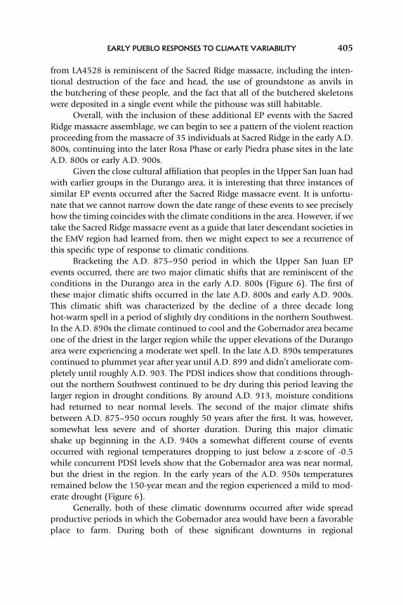
FIGURE 6. Paleoclimatic reconstructions for the A.D. 800–950 period and date ranges for selectsites in Eastern and Central Mesa Verde and Chaco Subregions.
EARLY PUEBLO RESPONSES TO CLIMATE VARIABILITY 401

Target areas were likely generally warmer than the uplands of Durango in areaswhere cold-air pooling and drainage was minimized. Throughout this time ofoverall cooling, upland valleys of the larger EMV would have been too cold tofarm, and we see a shift of new settlements to areas with primarily drylandfarming settings, for example at Grass Mesa Village in the Dolores area (Wilshu-sen and Ortman 1999), the Ute Tribal Park on the mesa tops above MancosCanyon (Wilshusen and Blinman 1992), and Frances Mesa in New Mexico(Potter et al. 2012; Wilshusen et al. 2000) (Figure 1a). Importantly, in thesenew settlements people were choosing almost strictly dryland farming situationson the landscape.
By and large, these various ideas propose that the eastern highlands of theUpper San Juan east of the Animas drainage were the immediate target for thesepeoples, based on similarities in material culture remains, community layout,and patterns of resource use. Additionally, Wilshusen and Ortman (1999)have suggested that some of the early settlers in the Grass Mesa Village commu-nity in the Dolores area were of Upper San Juan descent based on similarities incommunity layout and material culture. More importantly, however, these arestrictly dryland farming areas that dominated Puebloan cultural landscapes inthe EMV between about A.D. 820–850.
After the region emerged from a very cold spell at the beginning of the800s, annual temperatures ameliorated briefly in the mid-A.D. 820s andincreased until around A.D. 840. In this situation the dryland farmland areassought after the migration out of Durango, would have become increasinglystable in terms of both precipitation and temperature and allowed farmers toplant at higher elevation fields and in valleys where the extents of cold-air drai-nage may have subsided. The overall conditions would have allowed farmers toexpand onto previously unusable agricultural zones around their villages(Figure 6).
Around A.D. 850 there is another steep downturn in temperatures until the870s followed by a dramatic increase in temperatures into the 890s and agradual 20-year decrease until just before when the region would have beenvery cold for about a decade. Simultaneously PDSI indices show that theentire northern Southwest, including the Gobernador area, were getting wetteras well, while the Durango area remained the driest in the region until theA.D. 860s. In this situation, farmlands at the upland/lowland border(midland elevations) would have likely faired the best in the EMV region asthe uplands were again too cold to farm and the lowlands may have been toodry. Interestingly, between A.D. 840–880 Wilshusen notes that numerous vil-lages were established in the CMV area, and several in the EMV area (1995:Figure 6.10) that were “typically in upland settings between 2000 m (6560 ft.)and 2200 m (7380 ft.) in elevation” (1995: 73). In the east, Eddy (1974)suggests that populations may have moved upstream along the San Juan River
Benjamin A. Bellorado and Kirk C. Anderson402

between A.D. 800–900, farming on terraces and alluvial fans where they couldgain an adequate mix of sufficient moisture and heat for their crops.
During this downturn in temperatures we see a shift of populations tolower elevations where lower annual temperatures would have had a smallerinfluence on maize farming. This shift occurred in the Dolores and Chacoareas and in the Navajo Reservoir district. Lower elevation settings during thisperiod would have been favorable throughout the region as temperatures yetagain would have made upland areas too cold for agricultural production. Intri-guingly, after temperatures returned to near and just above the mean in the lateA.D. 860s we do see several of the Martin sites on the McElmo dome (Wilshusenet al. 2012) and sites on Mesa Verde proper (Dean 1974) being occupied. Wealso see large increases in the populations of the Dolores areas (Schlanger andWilshusen 1993). Overall, tree-ring dates for the period indicate several largeconstruction episodes after the A.D. 860s that appear to coincide with thegradual increase in regional temperatures (Figure 6).
Concurrent, with the relative increase in regional temperatures to near twostandard deviations from the mean around A.D. 880, another demographic shiftculminated in the establishment of new settlements such as Bancos Village andother Navajo Reservoir sites, at Cedar Hill, and in the Dove Creek areas(Figure 1a), population increased in the Dolores area and peaked in the A.D.870s, and Mesa Verde populations burgeoned; all areas that appear to provideimmediate access to both farmlands and an array of wild resource procurementareas at the upland/lowland boundary. In all of these new sites, the primary agri-cultural landscapes appear to be tied to the combination of both drylandfarming and alluvial fan focused landscapes.
There are clear connections between the early Pueblo I settlements in theuplands of the Durango area and those of the late Pueblo I in the Gobernadorarea in terms of ceramics, architecture, village layout, and settlement selectioncriteria (Bellorado 2007; Chuipka and Fetterman, this issue; Chuipka 2009;Potter et al. 2012; Wilshusen 1995; Wilshusen et al. 2000). Intriguingly, patternsof ritual violence in response to climate change appear to also connect these vil-lages in the east with the earlier peoples of the Durango area. While the evidenceis far from clear, it appears that the ritualized violence documented at SacredRidge (Potter 2010d; Potter and Chuipka 2010) was but the first in a series ofsimilar events that occurred later in the Navajo Reservoir district.
Potentially, at least three other possible EP (Extreme Processing) events inthe EMV area also occurred at Late Rosa Phase and Piedra Phase communities inthe Navajo Reservoir district (see Bellorado, this issue Table 1), although Eddy(1966: 493) and Flynn et al. (1976: 315) suggested that these events werelikely the result of cannibalism. The first of these potential EP events occurredat Sambrito Village (LA4195) (Figure 1a) where disarticulated and fragmentedskeletons from at least 15 individuals were recovered from the fill of two
EARLY PUEBLO RESPONSES TO CLIMATE VARIABILITY 403

burned pithouses (Pit House 6: 3 individuals; Pit House 25: at least 12 individ-uals) dating to the Piedra Phase between A.D. 875–950 (Eddy 1966: 493). Itshould be noted that a larger number of individuals may have been interredbut the structure was only trenched and not fully excavated. The remainsshowed some similarities to the Sacred Ridge massacre as reported byPotter and Chuipka (2010) and Potter et al. (2010, 2012), including extensivefacial and cranial trauma, potential relatedness of the group members,evidence of a single EP event, and no evidence of grave offerings. Flynn et al.determined that these remains were the result of starvation cannibalismbecause the remains were “characterized by long bones split lengthwise whilestill fresh, some with impact percussion scars, and shattered skulls. Unlikenormal burials, however, these two [burials in pithouse deposits] containedno offerings, were incomplete, and many bones evidenced burning”(1976: 315).
The second, a more poorly documented and potentially smaller scale EPevent, occurred at Bancos Village (LA4830) (Figure 1a), where the remains ofbadly charred and fragmented human skeletons were found incinerated onthe floor of two pithouses (Pit House 3: Burial 1 and Pit House 5: Burial 2).The pithouses contained the remains of a total of seven individuals, includingat least one infant, a child, and an adolescent. Unfortunately, no direct dateswere reported for these structures and thus these events can only be dated tosometime between A.D. 875–950 (Eddy 1966).
While the individual structures containing these large burials are poorlydated, the larger sites of both Sambrito and Bancos Villages are well dated tothe late A.D. 800s and early 900s (Eddy 1966). Recently, Sesler and Hovezak(2002: 176) have suggested extending the Rosa Phase into the A.D. 880s forFrances Mesa not far to the south of Bancos and Sambrito Villages (Figure 1a,and see Bellorado, this issue Table 1), potentially suggesting that both of theseevents might have occured later in time. These events are nonetheless compar-able in style to the large massacre at the village of Sacred Ridge in nearDurango in the early A.D. 800s.
The third, and best documented mass inhumation comes from LA4528, amultiple habitation site with three pit structures on Burnt Mesa (Figure 1a), alsoin the Navajo Reservoir district and dating to roughly A.D. 900–950 (Flynn et al.1976). The mass inhumation at this site was found in a single pithouse (PitHouse 1) and contained 11 disarticulated individuals. As at Sacred Ridge, thedemographic make-up of these individuals included infants, children, sub-adults, and adults. The burial population at LA4528 also consisted of individualsof both sexes. Additional characteristics indicate the “skeletal destruction is thatof dismemberment, crushing of long bone shafts, facial mutilation, scatteringand loss of elements of the trunk (ribs, vertebrae, and pelves), and the loss ofthe hands and feet” (Flynn et al. 1976: 313). The mass burial assemblage
Benjamin A. Bellorado and Kirk C. Anderson404
from LA4528 is reminiscent of the Sacred Ridge massacre, including the inten-tional destruction of the face and head, the use of groundstone as anvils inthe butchering of these people, and the fact that all of the butchered skeletonswere deposited in a single event while the pithouse was still habitable.
Overall, with the inclusion of these additional EP events with the SacredRidge massacre assemblage, we can begin to see a pattern of the violent reactionproceeding from the massacre of 35 individuals at Sacred Ridge in the early A.D.800s, continuing into the later Rosa Phase or early Piedra phase sites in the lateA.D. 800s or early A.D. 900s.
Given the close cultural affiliation that peoples in the Upper San Juan hadwith earlier groups in the Durango area, it is interesting that three instances ofsimilar EP events occurred after the Sacred Ridge massacre event. It is unfortu-nate that we cannot narrow down the date range of these events to see preciselyhow the timing coincides with the climate conditions in the area. However, if wetake the Sacred Ridge massacre event as a guide that later descendant societies inthe EMV region had learned from, then we might expect to see a recurrence ofthis specific type of response to climatic conditions.
Bracketing the A.D. 875–950 period in which the Upper San Juan EPevents occurred, there are two major climatic shifts that are reminiscent of theconditions in the Durango area in the early A.D. 800s (Figure 6). The first ofthese major climatic shifts occurred in the late A.D. 800s and early A.D. 900s.This climatic shift was characterized by the decline of a three decade longhot-warm spell in a period of slightly dry conditions in the northern Southwest.In the A.D. 890s the climate continued to cool and the Gobernador area becameone of the driest in the larger region while the upper elevations of the Durangoarea were experiencing a moderate wet spell. In the late A.D. 890s temperaturescontinued to plummet year after year until A.D. 899 and didn’t ameliorate com-pletely until roughly A.D. 903. The PDSI indices show that conditions through-out the northern Southwest continued to be dry during this period leaving thelarger region in drought conditions. By around A.D. 913, moisture conditionshad returned to near normal levels. The second of the major climate shiftsbetween A.D. 875–950 occurs roughly 50 years after the first. It was, however,somewhat less severe and of shorter duration. During this major climaticshake up beginning in the A.D. 940s a somewhat different course of eventsoccurred with regional temperatures dropping to just below a z-score of -0.5while concurrent PDSI levels show that the Gobernador area was near normal,but the driest in the region. In the early years of the A.D. 950s temperaturesremained below the 150-year mean and the region experienced a mild to mod-erate drought (Figure 6).
Generally, both of these climatic downturns occurred after wide spreadproductive periods in which the Gobernador area would have been a favorableplace to farm. During both of these significant downturns in regional
EARLY PUEBLO RESPONSES TO CLIMATE VARIABILITY 405

temperatures, the Gobernador area was likely never the worst place in the north-ern Southwest to eek-out an agricultural existence. In both of these cases, theGobernador area remains relatively drier compared to the rest of the regionand recovered relatively quickly from drought conditions. However, if we arelooking for climatic downturn events as the initiating devices for social upheavalin the contexts of the EMV uplands, these are the two most likely suspect periodsfor potential EP events to have occurred between A.D. 875–950. Further, if Wil-shusen and Van Dyke (2006) are correct that much of the Central and EasternMesa Verde areas were depopulated relatively quickly at the end of the ninthcentury, and that many of the villages occupied in the late A.D. 800s werevery short lived, then the dramatic downturn in the late A.D. 880s was themost likely to be the climatic culprit.
The Sacred Ridge massacre was clearly an unprecedented event. Potter andChuipka (2010) suggest that if it was associated with witch destruction then itwas of a scale not seen in the ethnographic literature. Although earlier as yetundiscovered episodes may yet be found, we suggest that for events like this,people needed no precedence. These data suggest that not only were a largesegment of the Gobernador area populations descendant from the earlyPueblo I villages in the Durango area, but that the overall mentality that seg-ments of those populations could be held responsible for climatic downturnswas remembered and continued to hold a place in the minds of the latePueblo I era villagers. In this section we have shown that there is a pattern inthe way peoples of the EMV area responded to dramatic shifts in climate andother environmental factors during the Pueblo I period and how early villagersdeveloped unique mechanisms for explaining and responding to climaticchanges in the area. These responses, though socially motivated, were ultimatelytied to the dedicated use of alluvial fan farming systems in the EMV area.
CONCLUSIONS
Throughout the Ancestral Puebloan occupation of the EMV region, changes intemperature regimes appear to have been the most significant influence ondemographic movements of farming societies at several key points in time. Rela-tive drought severity within the subregions of the northern Southwest alsoplayed an important role in ancient farmers’ decisions to stay in an area ormove to another location that was perceived to have the potential to befarmed with greater success. This pattern demonstrates that farmers in theEMV area had long-standing, reliable, and probably quite formal subsistencestrategies that included periodic movements from lowland to uplands(and back) in response to climatic changes. In the EMV region (Figure 1a) thispattern is notable from Basketmaker II times through the end of the Pueblo Iperiod, and probably into the later Pueblo II and III periods. In these strategies,
Benjamin A. Bellorado and Kirk C. Anderson406

people moved to upland areas during warm drought periods and to the low-lands during cold periods, regardless of precipitation patterns. Occasionally,farmers in the region may have moved to midland elevation areas to take advan-tage of mesa top dryland farmlands away from the affects of cold-air drainage,particularly during cold and wet spells.
It appears that during the mid- to late A.D. 700s there was an introductionof strict dryland farming systems in the eastern upland areas of the EMV region.This occurred during a period of mixing, rediscovering, and redefining of socialand ethnic identities in the early Pueblo I period with the introduction of groupsfrom outside the region. After this era of unprecedented demographic aggrega-tion, people in the EMV continued to prefer alluvial fan and runoff based agri-cultural systems over dryland systems, but included dryland farming as a bufferagainst crop loss caused by cold temperature regimes. Further, this study hasestablished that peoples in the EMV developed intimate knowledge of thecycles of climatic shifts and cold-air drainage patterns in the areas they inhabited.
We have also documented several instances between A.D. 700–950 wherefarming peoples’ knowledge of the unique landscapes on which they lived andfarmed allowed segments of the population to amass prestige, political andritual power, and followers through their control of available farmlands andagricultural surpluses. At the same time, other segments of these populationsappear to have used these in-depth understandings of the ecology of agriculturallandscapes to form alternative leadership, ritual, and social organizations tocounter or resist pressures of the ruling society, sometimes to violent ends.
Also of great importance is that, even at this early date, ritual specialistsand leaders of communities apparently gained and lost prestige, power, andinfluence over their communities frequently, largely due to their perceived abil-ities to control weather conditions for the benefit of their people (and theircrops) through the control of esoteric and ritual knowledge. What we have tounderstand is that when these ritual specialists gained power they were doingso within a politically charged landscape and their rule was tentative at best.Between the early Basketmaker II and late Pueblo I periods in the EMV area,rules of conduct and expectations of service were made and remade over centu-ries depending on the political and atmospheric climates of the time. If the localpopulations lost confidence in the method of leadership, community, and ritualorganization there could be disastrous consequences not only for the ritualspecialist or leader, but for their entire family, kin, or ethnic group.
Finally, we have documented how the use of fine-grained (high frequency)climatic reconstructions can inform archaeologists about the nature of human-climate interactions with a clarity that is lost when using smoothed 50, 100, oreven 200-year reconstructions as presented by Benson and Berry (2009), Cordellet al. (2007), and Wright (2010). So, while megadroughts and long regional wetperiods inevitably affected Ancestral Puebloan farmers throughout the Colorado
EARLY PUEBLO RESPONSES TO CLIMATE VARIABILITY 407

Plateau, we have to ask ourselves, could the farmers actually see these broadchanges or were they more often preoccupied with the shorter term, fine-grainedchanges to their agricultural and social landscapes? We suggest the latter, thatfarming peoples responded more often to short-term and dramatic changes inthe climatic factors that directly affected their livelihood. In the northern South-west, archaeologists are blessed with the luxury of having both fine-grainedpaleoclimatic reconstructions and tight dating resolution of sites from tree-ringand ceramic chronologies. In the future, archaeologists should focus efforts tocombine these chronologies at fine-grained levels. Or as Ford has suggested:
The Pueblo Indian [farmer] has to deal with a variety of factors that are neither
regular in their occurrence nor equally pervasive in their effect … it is precisely
to these unpredictable environmental fluctuations that individual pueblos must
adapt. (Richard Ford 1972: 6)
Further, Puebloan peoples have viewed climatic changes through the lensof their society. As we have demonstrated, in the collective consciousness ofthese peoples, climatic changes and fluctuations happened for a reason.Anyone, especially ritual specialists and community leaders, through theircorrect or incorrect actions could be directly responsible for the relative prosper-ity of their societies, at least in the eyes of the communities that supported (oroccasionally withdrew their support of) these people. In the face of climateand other environmental changes, peoples who lived in the EMV region routi-nely looked for causes for stresses on agricultural production. Beginning atleast with the early Pueblo I villages in the Durango area, and again in the Gober-nador area in the late A.D. 800s, ancient Puebloan peoples appear to haveformed shifting alliances and experimented with different power structuresduring periods of climate flux to legitimate or corroborate their claims to avariety of resources. These resources could include areas of the landscape,control over segments of the population and ritual systems, and even humanlives through the vein of a causal view of human-climate interactions andresponses. In this article, we have departed from a simple view of “the climatemade me do it,” to looking at the complex social interactions that ancientfarmers had with each other and their agricultural landscapes, and how theseinteractions shaped their worldviews and the perceptions of events thatunfolded in the natural world over time.
We hope that this research has shed light on the interplay among climate,culture, and agricultural mechanisms, which influenced site selection throughtime in the Eastern Mesa Verde region and beyond. We also hope that thisarticle has illuminated new methods of identifying potential low visibilitytraces of social identities, ethnicities, and land tenure systems across ancient agri-cultural landscapes and of identifying the ways farming societies responded to
Benjamin A. Bellorado and Kirk C. Anderson408

new environments, social structures, and shifting climatic regimes in the north-ern Southwest.
AKNOWLEDGEMENTS
Many thanks are due to our colleagues in the Upper andMiddle San Juan regionswho have contributed such a huge body of research over many years. WinstonHurst, Mark Varien, and Ruth Van Dyke contributed helpful comments on ourinitial SAA presentation as discussants, which guided the direction of thelarger study presented here. Tim Kohler and an anonymous reviewer providedmany helpful comments on earlier versions of this article. James Potter, RichWilshusen, and Jason Chuipka’s recent work in the Eastern Mesa Verde Regionhas contributed greatly to the body of knowledge we draw upon here. Potter’ssupport of our initial research in the Durango area 10 years ago gave us thevantage point from which to see into the greater San Juan Basin. Scott Ortmanalso deserves special thanks for pushing us to look beyond warm/dry andwet/cold to look at Ancestral Puebloan cultural responses to climatic changeon a larger social level.
REFERENCES
Adams, Karen R. and Trent Reeder2009 Chapter 8: Catchment Analysis—A Quantitative Evaluation of Wild Plant
Food Potential Surrounding Three Pueblo I Settlement Clusters. In Animas-LaPlata Project: Volume XIII-Special Studies, edited by James M. Potter, pp. 248–295.SWCA Anthropological Paper Number 10. SWCA Environmental Consultants,Phoenix.
Alison, James2008 Exchanging Identities: Early Pueblo I Red ware Exchange and Identity North of the
San Juan River. In The Social Construction of Communities: Agency, Structure, andIdentity in the Prehispanic Southwest, edited by Mark D. Varien and James M. Potter,pp. 41–67. Alta Mira Press, Boulder.
Anderson, Kirk C.2008a Chapter 2: Ridges Basin Soil Fertility–Implications for Prehistoric Agriculture. In
Animas—La Plata Project: Environmental Studies, edited by James M. Potter, pp.63–80. SWCA Anthropological Paper Number 10, SWCA EnvironmentalConsultants, Phoenix.
2008b Chapter 3: The Early Pueblo I Climate of Ridges Basin-Inferences fromDendroclimatic Reconstructions. In Animas-La Plata Project: Volume X-EnvironmentalStudies, edited by James M. Potter, pp. 235–248. SWCA Anthropological PaperNumber 10. SWCA Environmental Consultants, Phoenix.
Anderson, Kirk C. and Benjamin A. Bellorado2009 Chapter 7: Selected Data and Interpretations from Weather Stations in Ridges Basin.
In Animas-La Plata Project: Volume XIII-Special Studies, edited by James M. Potter,pp. 235–248. SWCA Anthropological Paper Number 10. SWCA EnvironmentalConsultants, Phoenix.
EARLY PUEBLO RESPONSES TO CLIMATE VARIABILITY 409

Bellorado, Benjamin A.2007 Breaking Down the Models: Reconstructing Prehistoric Subsistence Agriculture in the
Durango District of Southwestern Colorado. Unpublished Master’s Thesis,Department of Anthropology, Northern Arizona University, Flagstaff.
2009 Chapter 6: A Reconstruction of Prehistoric Subsistence Agriculture in Ridges Basin. InAnimas-La Plata Project: Volume XIII-Special Studies, edited by James M. Potter,pp. 215–233. SWCA Anthropological Paper Number 10. SWCA EnvironmentalConsultants, Phoenix.
2011a Landscape Use, Corn Ecology, and Identity in the Upper San Juan. In Social Identity inthe Northern San Juan, edited by Paul F. Reed. Archaeology Southwest 24(3): 7.
2011b Pushing the Limits and Tormenting Corn Seeds: Cultural Adaptations and ClimaticChange in the Upper San Juan during the Basketmaker II Period and Beyond.Southwestern Lore 77(2 and 3): 33–47.
Benson, Larry V. and Michael S. Berry2009 Climate Change and Cultural Response in the Prehistoric American Southwest. Kiva
75(1): 89–119.Berdan, Frances F.2008 Concepts of Ethnicity and Class in Aztec-Period Mexico. In Ethnic Identity in Nahua
Mesoamerica: The View from Archaeology, Art History, Ethnohistory, and ContemporaryEthnography, edited by Frances F. Berdan, John K. Chance, Alan R. Sandstrom,Barbra L. Stark, James M. Taggart, and Emily Umberger, pp. 105–132. University ofUtah Press, Salt Lake City.
Berry, Michael S.1982 Time, Space, and Transition in Anasazi Prehistory. University of Utah Press, Salt Lake
City.Borck, Lewis2012 Patterns of Resistance: Violence, Migration, and Trade in the Gallina Heartland.
Unpublished Master’s Thesis, School of Anthropology, University of Arizona, Tucson.Bunzel, Ruth L.1992 Zuni Ceremonialism. University of New Mexico Press edition. University of New
Mexico Press, Albuquerque.Charles, Mona C., Leslie M. Sesler, and Timothy D. Hovezak2006 Understanding Eastern Basketmaker II Chronology and Migrations. Kiva 72(2):
217–238.Charles, Mona C.2011 Refining the Chronology of the Durango Basketmakers. Southwestern Lore 72(2 and 3):
21–31.Chuipka, Jason P.2008a Exploring Village Organization in the Northern San Juan Region of the American
Southwest, A.D. 750-840. Unpublished Master’s Thesis, Department ofAnthropology, University of Colorado at Boulder, Boulder.
2008b The Grandview Archaeological Project: Final Report for Investigations Conducted onGrandview Ridge, La Plata County, Colorado. BLM Project No. SJ08018. WoodsCanyon Archaeological Consultants, Inc. Yellow Jacket, Colorado
2009 Chapter 3: Exploring Ethnic Diversity and Sociopolitical Strategies of Early Pueblo IVillages in the Northern San Juan Region, A.D. 750-840. In Animas-La Plata Project:Volume XIII-Special Studies, edited by James M. Potter, pp. 43–83. SWCAAnthropological Paper Number 10. SWCA Environmental Consultants, Phoenix.
Chuipka, Jason P. and James M. Potter2007 Chapter 9: Summary. In Animas-La Plata Project: Volume III-Blue Mesa Excavations,
Benjamin A. Bellorado and Kirk C. Anderson410

edited by Jason P. Chuipka and James M. Potter, pp. 213–243, SWCA EnvironmentalConsultants, Phoenix.
Coltrain, Joan Brenner, Joel C. Janetski, and Shawn W. Carlyle2006 The Stable- and Radio-Isotope Chemistry of Eastern Basketmaker and Pueblo Groups
in the Four Corners Region of the American Southwest: Implications for AnasaziDiets, Origins, and Abandonments in Southwestern Colorado. In Histories of Maize,edited by John E. Staller, Robert H. Tykot, and Bruce F. Benz, pp. 275–287.Academic Press, New York
2007 The Stable- and Radio-Isotope Chemistry of Western Basketmaker Burials:Implications for Early Puebloan Diets and Origins. American Antiquity 72: 301–321.
Cordell, Linda S., Carla R. Van West, Jeffery S. Dean, and Deborah A. Muenchrath2007 Mesa Verde Settlement History and Relocation: Climate change, Social Networks, and
Ancestral Pueblo Migration. Kiva 72(4): 391–417.Dean, Jeffery1974 Tree-Ring Dates from Colorado V: Mesa Verde Area. Laboratory of Tree-Ring Research.
The University of Arizona, Tucson.Dykeman, Douglas D.2004 Chuskan Community in the Anasazi World. In Anasazi Archaeology at the Millennium:
Proceedings of the Sixth Occasional Anasazi Symposium, edited by Paul F. Reed.pp. 89–96, Center for Desert Archaeology, Tucson.
Earle, Timothy1997 How Chiefs Come to Power: The Political Economy in Prehistory. Stanford University Press,
Stanford.Eddy, Frank W.1966 Prehistory in the Navajo Reservoir District, Northern NewMexico. Museumof NewMexico
Papers in Anthropology No. 15, Parts I and II. Santa Fe.1968 Cultural Ecology and the Prehistory of the Navajo Reservoir District. Unpublished
Ph.D. dissertation, University of Colorado, Boulder.1974 Population Dislocation in the Navaho Reservoir District, New Mexico and Colorado.
American Antiquity 39: 75–84.Flynn, Lynn, IIChristy G. Turner, and Alan Brew1976 Additional Evidence for Cannibalism in the Southwest: The Case of LA 4528.
American Antiquity 41(3): 308–318.Force, Eric R.2004 Late Holocene Behavior of Chaco and McElmo Canyon Drainages (Southwest U.S.):
A Comparison Based on Archaeological Age Counts. Geoarchaeology: An InternationalJournal 19(6): 583–609.
Force, E. R., R.G. Vivian, T.C. Windes, and J.D. Dean (editors)2002 Relation of “Bonito” Paleo-channels and Base-Level Variations to Anasazi Occupation, Chaco
Canyon, New Mexico. Archaeological Series 194. Tucson: Arizona State Museum,University of Arizona Press
Ford, Richard I.1972 An Ecological Perspective on the Eastern Pueblos. School of American Research.
University of New Mexico Press, Albuquerque.1992 An Ecological Analysis Involving the Population of San Juan Pueblo, New Mexico. Garland
Publishing, Inc., New York.Fuller, Steven L.1988 Archaeological Investigations in the Bodo Canyon Area La Plata County, Colorado. UMTRA
Archaeological Report 25. Complete Archaeological Service Associates, Cortez.
EARLY PUEBLO RESPONSES TO CLIMATE VARIABILITY 411

Hovezak, Timothy D. and Leslie M. Sesler2006 New Data on Northwest New Mexico’s Los Pinos Phase: A Classic Basketmaker II
Occupation? Kiva 72(2): 239–258.Judge, W. James and Linda S. Cordell2006 Society and Polity. In The Archaeology of Chaco Canyon: An Eleventh-Century Pueblo
Regional Center, edited by Stephen H. Lekson, pp. 189–210. School of AmericanResearch Press, Santa Fe.
Kearns, Timothy M., Janet L. McVickar, and Lori Stevens Reed2000 The Early to Late Basketmaker III Transition in Tohatchi Flats, New Mexico. In
Foundations of Anasazi Culture: The Basketmaker-Pueblo Transition, edited by PaulReed, pp. 115–142. University of Utah Press, Salt Lake City.
Kohler, Timothy A., Matt Pier Glaude, Jean-Pierre Bocquet-Appel, and Brian M. Kemp2008 The Neolithic Demographic Transition in the U.S. Southwest. American Antiquity 72
(4): 645–669.Laboratory of Tree-Ring Research2008 Southwest Paleoclimate Project, Palmer Drought Severity Indices (PDSI) annual data
for the Durango and Mesa Verde, Colorado and Gobernador and Chaco areas.Electronic documents on file, Laboratory of Tree-Ring Research at the University ofArizona, Tucson.
Levy, Jerrold E.1992 Orayvi Revisited: Social Stratification in an “Egalitarian” Society. School of American
Research Press, Santa Fe.Lyons, Patrick D.2003 Ancestral Hopi Migrations. Anthropological Papers of the University of Arizona
Number 68. University of Arizona Press, Tucson.Mair, Lucy1969 Witchcraft. World University Library, McGraw-Hill, New York.
Malotki, Ekkehart2000 Kokopelli: The Making of an Icon. University of Nebraska Press, Lincoln.
Matson, R. G.1991 The Origins of Southwestern Agriculture. The University of Arizona Press, Tucson.2006 What is Basketmaker II? Kiva 72(2): 149–166.
McVickar, Janet L.2004 Prehistoric Occupation Discontinuities Revisited: Recent Survey Results from Natural
Bridges National Monument, Southeastern Utah. In Anasazi Archaeology at theMillennium: Proceedings of the Sixth Occasional Anasazi Symposium, edited by PaulReed, pp. 229–236. Center for Desert Archaeology, Tucson.
Ortiz, Alfonso1969 The Tewa World: Space, Time, and Becoming in a Pueblo Society. University of
Chicago Press, Chicago.Parsons, Else Clews1966a Pueblo Indian Religion Volume 1. Bison Books Edition. University of Nebraska Press,
Lincoln.1966b Pueblo Indian Religion Volume 2. Bison Books Edition. University of Nebraska Press,
Lincoln.Petersen, Kenneth Lee1988 Climate and the Dolores River Anasazi. Anthropological Papers Number 113. University
of Utah Press, Salt Lake City.Potter, James M.2009 Chapter 5: Hunting and Early Pueblo Cuisine—Faunal Patterns Among Early Villages
Benjamin A. Bellorado and Kirk C. Anderson412

in the Northern Southwest. In Animas-La Plata Project: Volume XIII-Special Studies,edited by James M. Potter, pp. 191–214. SWCA Anthropological Paper Number 10.SWCA Environmental Consultants, Phoenix.
2010a Chapter 4: Basketmaker II Sites. In Animas-La Plata Project: Volume XVI-Final SyntheticReport, edited by James M. Potter, pp. 51–74. SWCA Anthropological Paper Number10. SWCA Environmental Consultants, Phoenix.
2010b Chapter 8: Pueblo I Chronology and Population. Animas-La Plata Project: VolumeXVI-Final Synthetic Report, edited by James M. Potter, pp. 114–128. SWCAAnthropological Paper Number 10. SWCA Environmental Consultants, Phoenix.
2010c Chapter 12: Settlement Cluster Variation. In Animas-La Plata Project: Volume XVI-FinalSynthetic Report, edited by James M. Potter, pp. 209–226. SWCA AnthropologicalPaper Number 10. SWCA Environmental Consultants, Phoenix.
2010d Chapter 15: Ritual, Social Power, and Identity. In Animas-La Plata Project: VolumeXVI-Final Synthetic Report, edited by James M. Potter, pp. 281–299. SWCAAnthropological Paper Number 10. SWCA Environmental Consultants, Phoenix.
Potter, James M. and Jason P. Chuipka2007 Early Pueblo Communities and Cultural Diversity in the Durango Area: Preliminary
Results from the Animas-La Plata Project. Kiva 72(4): 407–430.2010 Perimortem Mutilation of Human Remains in an Early Village in the American
Southwest: A Case for Ethnic Violence. Journal of Anthropological Archaeology 29(4):507–523.
Potter, James M., Jason P. Chuipka, and Jerry Fetterman2012 The Eastern Mesa Verde Region: Migrants, Cultural Diversity, and Violence in the
East. In Crucible of Pueblos: The Early Pueblo Period in the Northern Southwest, editedby Richard H. Wilshusen, Gregson Schachner, and James R. Alison, pp. 53–71.Costen Institute of Archaeology Press, Monograph 71. University of California, LosAngeles.
Potter, James M., Jason P. Chuipka, John A. McClelland, and Ann L. W. Stodder2010 Chapter 16: Paleodemography, Health, and Violence in Ridges Basin. In Animas-La
Plata Project: Volume XVI-Final Synthetic Report, edited by James M. Potter, pp.301–326. SWCA Anthropological Paper Number 10. SWCA EnvironmentalConsultants, Phoenix.
Potter, James M. and Joshua S. Edwards2008 Chapter 12: Vertebrate Faunal Studies. In Animas-La Plata Project: Volume
X-Environmental Studies, edited by James M. Potter, pp. 243–285. SWCAAnthropological Paper Number 10. SWCA Environmental Consultants, Phoenix.
Potter, James M. and Elizabeth M. Perry2000 Ritual as a Power Resource in the American Southwest. In Alternative Leadership
Strategies in the Prehispanic Southwest, edited by Barbara J. Mills, pp. 60–78. TheUniversity of Arizona Press, Tucson.
Potter, James M. and Thomas D. Yoder2008 Space, Houses, and Bodies: Identity Construction and Destruction in an Early Pueblo
Community. In The Social Construction of Communities: Agency, Structure, and Identity inthe Prehispanic Southwest, edited by James M. Potter and Mark D. Varien, pp. 21–39.Alta Mira Press, Boulder.
Reed, Lori Stephens2006 Middle San Juan Typological and Chronological Perspective. In Thirty-Five Years of
Archaeological Research at Salmon Ruins, New Mexico, vol.2: Ceramic Studies, edited byPaul F. Reed, pp. 593–633. Center for Desert Archaeology, Tucson, and SalmonRuins Museum, Bloomfield, New Mexico.
EARLY PUEBLO RESPONSES TO CLIMATE VARIABILITY 413

2009 Connecting the Dots: A Discussion of Ceramic Technology and Design in the Middleand Upper San Juan Regions. Presentation presented at the 74th annual meeting ofthe Society of American Archaeology, Atlanta, Georgia, April 2009.
Reed, Paul F. (editor)2000 Foundations of Anasazi Culture: The Basketmaker-Pueblo Transition. The University of
Utah Press, Salt Lake City.Reed, Paul F. and Scott Wilcox2000 Distinctive and Defensive: Basketmaker III to Early Pueblo I Occupation of
Cove-Redrock Valley, Northeastern Arizona. In The Foundations of Anasazi Culture:Recent Research into the Basketmaker III Period in the Northern Southwest, edited byPaul F. Reed, pp. 69–93. University of Utah Press, Salt Lake City.
Salzer, Matthew W. and Kurt F. Kipfmueller2005 Southern Colorado Plateau Temperature and Precipitation Reconstructions. IGBP
PAGES/World Data Center for Paleoclimatology. Data Contribution Series #2005-066. NOAA/NCDC Paleoclimatology Program, Boulder.
Schlanger, Sarah H. and Richard Wilshusen1993 Local Abandonments and Regional Conditions in the North American Southwest. In
Abandonment of Settlements and Regions: Ethnoarchaeological and ArchaeologicalApproaches, edited by Catherine M. Cameron and Steve A. Tonka, pp. 85–98.Cambridge University Press, Cambridge.
Sesler, Leslie M. and Timothy D. Hovezak2002 Synthesis: Cultural and Adaptational Diversity in the Fruitland Study Area. In
Archaeological Investigations in the Fruitland Project Area: Late Archaic, Basketmaker,Pueblo I, and Navajo Sites in Northwestern New Mexico, Vol. 1 Introductory Chaptersand Synthesis, edited by Tim D. Hovezak, Leslie M. Sesler, and Steven L. Fuller,pp. 109–240. LAC Research Papers No.4 La Plata Archaeological Consultants,Dolores, Colorado.
2009 Farming at the Edge of Paradise: Tracking Changes in Early Agricultural Settlement.Presentation presented at the 74th annual meeting of the Society of AmericanArchaeology, Atlanta, Georgia, April 2009.
2011 Farming at the Edge of Paradise: Basketmaker II Emergence in NewMexico’s San JuanBasin. Southwestern Lore 77(2 and 3): 9–19.
Simmons, Marc1974 Witchcraft in the Southwest: Spanish and Indian Supernaturalism on the Rio Grande.
University of Nebraska Press, Lincoln.Titiev, Mischa1943 Notes on Hopi Witchcraft. Michigan Academy of Science, Arts, and Letters. Vol 28:
549–557.Toll, H. Wolcott2008 The La Plata, the Totah, and the Chaco: Variations on a Theme. In Chaco’s Northern
Prodigies: Salmon, Aztec, and the Ascendancy of the Middle San Juan Region after A.D.1100, edited by Paul F. Reed, pp. 309–333. University of Utah Press, Salt Lake City.
Toll, H. Wolcott and C. Dean Wilson2000 Locational, Architectural, and Ceramic Trends in the Basketmaker III Occupation of
the La Plata Valley, New Mexico, by H. W. Toll and C. D. Wilson. In TheFoundations of Anasazi Culture: Recent Research into the Basketmaker III Period in theNorthern Southwest, edited by Paul F. Reed, pp. 19–43. University of Utah Press,Salt Lake City.
Triadan, Daniela2006 Scene 6 Dancing Gods: Ritual, Performance, and Political Organization in the
Benjamin A. Bellorado and Kirk C. Anderson414

Prehistoric Southwest. In Archaeology of Performance: Theatres of Power, Community, andPolitics, edited by Takeshi Inomata and Lawrence S. Coben, pp. 159–186. Alta MiraPress, Lanham.
Tyler, Hamilton A.1964 Pueblo Gods and Myths. University of Oklahoma Press, Norman.
Varien, Mark D.2008 Early Agriculture in the Northern San Juan Region: The Basketmaker II-III Transition.
Paper presented in the 73rd Annual Meeting of the Society for American Archaeology,Vancouver, BC, Canada.
2009 Discussant Presentation. Presentation presented at the 74th annual meeting of theSociety of American Archaeology, Atlanta, Georgia, April 2009.
Vierra, Bradley J.2008 Early Agriculture on the Southwestern Periphery of the Colorado Plateau. In
Archaeology Without Borders: Contact, Commerce, and Change in the U.S. Southwest andNorthwestern Mexico, pp. 71–88. University Press of Colorado, Boulder.
Vivian, R. Gwinn, Carla R. Van West, Jeffery S. Dean, Nancy J. Akins, Mollie S. Toll, and ThomasC. Windes2006 Ecology and Economy. In The Archaeology of Chaco Canyon: An Eleventh-Century Pueblo
Regional Center, edited by Stephen H. Lekson, pp. 45–65. School for AdvancedResearch Press, Santa Fe, New Mexico.
Webster, Laurie D.2009 Chapter 4: Pueblo I Perishable Artifacts. In Animas-La Plata Project: Volume XIII-Special
Studies, edited by James M. Potter, pp. 85–190. SWCA Anthropological PaperNumber 10. SWCA Environmental Consultants, Phoenix.
Wilshusen, Richard H.1995 The Cedar Hill Special Treatment Project: Late Pueblo I, Early Navajo, and Historic
Occupations in Northwestern New Mexico. Research Paper No. 1. La PlataArchaeological Consultants, Dolores.
2009 Chapter 2: Late Basketmaker and Early Pueblo Landscapes in the Eastern Mesa VerdeRegion-Archaeological Work and Settlement Patterning and a Comparison with theCentral Mesa Verde Region. In Animas-La Plata Project: Volume XIII-Special Studies,edited by James M. Potter, pp. 5–42. SWCA Anthropological Paper Number 10.SWCA Environmental Consultants, Phoenix.
Wilshusen, Richard H. and Eric Blinman1992 Pueblo I Village Formation: A Reevaluation of Sites Recorded by Earl Morris on Ute
Mountain Ute Tribal Lands. Kiva 57(3): 251–269.Wilshusen, Richard H. and Scott G. Ortman1999 Rethinking the Pueblo I Period in the Northern Southwest: Aggregation, Migration,
and Cultural Diversity. Kiva 64(3): 369–399.Wilshusen, Richard H., Leslie M. Sesler, and Timothy D. Hovezak2000 Understanding Variation in Pueblo I Sites Across the San Juan Region: Frances Mesa
Compared with Navajo Reservoir, Dolores, Mesa Verde, and Cedar Hill. In FrancesMesa Special Treatment Project: New Interpretations of the Ancestral Pueblo and NavajoReservoir Area, compiled by R. H. Wilshusen. La Plata Archaeological Consultants,Research Paper No. 3 Dolores, Colorado.
Wilshusen, Richard H. and Ruth Van Dyke2006 Chaco’s Beginnings. In The Archaeology of Chaco Canyon: An Eleventh-Century Regional
Center, edited by S. H. Lekson, pp. 211–259. School of American Research Press,Santa Fe.
EARLY PUEBLO RESPONSES TO CLIMATE VARIABILITY 415

Wilshusen, Richard H., Scott G. Ortman, Shanna Deiderichs, Donna M. Glowacki, and GrantCoffey2012 Heartland of the Early Pueblos: The Central Mesa Verde. In Crucible of Pueblos: The
Early Pueblo Period in the Northern Southwest, edited by Richard H. Wilshusen,Gregson Schachner, and James R. Alison, pp. 14–34. Costen Institute ofArchaeology Press, Monograph 71. University of California, Los Angeles.
Wilson, C. Dean and H. Wolcott Toll2009 Eden Itself? Pueblo Occupation of the La Plata Valley. Presentation presented at the
74th annual meeting of the Society of American Archaeology, Atlanta, Georgia, April2009.
Wright, Aaron M.2010 The Climate of the Depopulation of the Northern Southwest. In Leaving Mesa Verde:
Peril and Change in the Thirteenth-Century Southwest, edited by Timothy A. Kohler, MarkD. Varien, and Aaron M. Wright, pp. 75–101. Amerind Studies in Archaeology,University of Arizona Press, Tucson.
Benjamin A. BelloradoSchool of AnthropologyUniversity of ArizonaP.O. Box 210030
Tucson, AZ [email protected]
Kirk C. AndersonMuseum of Northern Arizona
3101 N. Fort Valley Rd.Flagstaff, AZ 86001
Benjamin A. Bellorado and Kirk C. Anderson416