early archaeology on the western edge of alta california: malcolm
TRANSCRIPT
EARLY ARCHAEOLOGY ON THE WESTERN EDGE OF ALTA
CALIFORNIA: MALCOLM ROGERS’ SAN NICOLAS ISLAND
COLLECTIONS
_______________
A Thesis
Presented to the
Faculty of
San Diego State University
_______________
In Partial Fulfillment
of the Requirements for the Degree
Master of Arts
in
Anthropology
_______________
by
Cassandra E. Krum
Spring 2014


iii
Copyright © 2014
by
Cassandra E. Krum
All Rights Reserved

iv
DEDICATION
For my parents.
v
ABSTRACT OF THE THESIS
Early Archaeology on the Western Edge of Alta California:
Malcolm Rogers’ San Nicolas Island Collections
by
Cassandra E. Krum
Master of Arts in Anthropology
San Diego State University, 2014
Museum collections are often overlooked by archaeologists for the more exciting
work of excavating “new” information. However, museum collections can provide a wealth
of information on the ancient history of sites, landscapes, or regions. Malcolm Rogers
excavated and collected artifacts from thirty-two sites on San Nicolas Island in 1930 that are
now curated at the San Diego Museum of Man. This project cataloged the collection as well
as correlated artifact locations to known sites on the island and Malcolm Rogers’ field notes.
An in-depth look at settlement patterns, prehistoric material culture, and historical artifacts
highlights the research potential of this extensive collection for current researchers.
vi
TABLE OF CONTENTS
PAGE
ABSTRACT ...............................................................................................................................v
LIST OF TABLES ................................................................................................................... ix
LIST OF FIGURES ................................................................................................................ xii
ACKNOWLEDGEMENTS ................................................................................................... xiv
CHAPTER
1 INTRODUCTION .........................................................................................................1
2 ENVIRONMENTAL BACKGROUND ........................................................................4
3 CULTURAL BACKGROUND ...................................................................................16
4 HISTORY OF ARCHAEOLOGICAL RESEARCH ..................................................25
Archaeological Research on San Nicolas ..............................................................26
Malcolm Jennings Rogers: A Brief Biography ......................................................33
5 THEORETICAL BACKGROUND .............................................................................37
Malcolm Rogers’ Culture History .........................................................................37
Theoretical Approaches .........................................................................................40
6 METHODS ..................................................................................................................43
Importance of Museum Collections .......................................................................43
Field Procedures.....................................................................................................44
Analytical Procedures ............................................................................................48
Creating the Catalog ..............................................................................................50
The Collection Today ............................................................................................54
7 RESULTS: SITE DESCRIPTIONS AND CATALOG ...............................................55
MoM Collection .....................................................................................................55
Site Descriptions ....................................................................................................55
SN-1 (SNI-7) ..........................................................................................................56
SN-1A (SNI-119) ...................................................................................................57
SN-2 (SNI-5) ..........................................................................................................59
SN-3 .......................................................................................................................61
vii
SN-4 (SNI-3) ..........................................................................................................62
SN-5 (SNI-137) ......................................................................................................63
SN-6 (SNI-1, SNI-325, SNI-326, SNI-327) ..........................................................64
SN-6/SN-7..............................................................................................................65
SN-7 (SNI-54) ........................................................................................................66
SN-7A (SNI-318) ...................................................................................................66
SN-8 (SNI-150, SNI-319, SNI-320, SNI-322) ......................................................68
SN-9 (SNI-145, SNI-149) ......................................................................................68
SN-10(SNI-9, SNI-146, SNI-233) .........................................................................70
SN-11(SNI-10) .......................................................................................................73
SN-12(SNI-11) .......................................................................................................73
SN-13(SNI-12) .......................................................................................................74
SN-14(SNI-25), SN-14 Cremation ........................................................................75
SN-15(SNI-21) .......................................................................................................77
SN-16(SNI-16) .......................................................................................................78
SN-17(SNI-14, SNI-200) .......................................................................................82
SN-18(SNI-15, SNI-16) .........................................................................................83
SN-19 (SNI-151, SNI-152, SNI-158) ....................................................................84
SN-20 (SNI-56) ......................................................................................................84
SN-21 (SNI-19, SNI-40, SNI-162, SNI-163, SNI-172) .........................................86
SN-21A (SNI-55, SNI-119, SNI-164, SNI-170): SN-21A Cemetery 1
(SNI-157), SN-21A Cemetery 2, SN-21A Cemetery 3 (SNI-171), SN-21A
Cemetery 4 (SNI-160), SN-21A Cemetery 5 (SNI-160), SN-21A
Cemetery 6 (SNI-161), SN-21A Cremation 1 (SNI-159) ......................................89
SN-22(SNI-173, SNI-177) ...................................................................................101
SN-23(SNI-41) .....................................................................................................101
SN-24(SNI-20) .....................................................................................................103
SN-25 ...................................................................................................................105
SN-26(SNI-29, SNI-30, SNI-79, SNI-80, SNI-97)..............................................107
SN-27(SNI-42, SNI-43, SNI-52, SNI-204, SNI-207, SNI-209, SNI-211,
SNI-213) ..............................................................................................................107
SN-28(SNI-45, SNI-189, SNI-214) .....................................................................107
SN-29(SNI-103, SNI-104) ...................................................................................110
viii
SN-30 (SNI-349) ..................................................................................................110
SN-31 ...................................................................................................................111
SN-32 ...................................................................................................................112
8 DISCUSSION AND CONCLUSIONS .....................................................................113
Determining Chronology .....................................................................................113
Site Function and Settlement Patterns .................................................................116
Rogers’ Collection Methods ................................................................................122
Burial and Cremation Practices ...........................................................................122
Effigies .................................................................................................................126
Native American Graves Protection and Repatriation Act (NAGPRA)
Implications..........................................................................................................128
Historical Artifacts ...............................................................................................129
Conclusions ..........................................................................................................130
REFERENCES ......................................................................................................................132
ix
LIST OF TABLES
PAGE
Table 1. Cultural Chronologies for the California Channel Islands ........................................17
Table 2. Summary of Radiocarbon Data..................................................................................31
Table 3. Rogers’ Site Numbers Correlated to Known Trinomial Sites ...................................51
Table 4. Artifacts from SN-1 ...................................................................................................58
Table 5. Artifacts from SN-1A ................................................................................................59
Table 6. Artifacts from SN-2 ...................................................................................................61
Table 7. Artifacts from SN-3 ...................................................................................................62
Table 8. Artifacts from SN-4 ...................................................................................................63
Table 9. Artifacts from SN-5 ...................................................................................................64
Table 10. Artifacts from SN-6 .................................................................................................65
Table 11. Artifacts from SN-6/SN-7 ........................................................................................66
Table 12. Artifacts from SN-7 .................................................................................................67
Table 13. Artifacts from SN-7A ..............................................................................................67
Table 14. Artifacts from SN-8 .................................................................................................68
Table 15. Artifacts from SN-9 .................................................................................................69
Table 16. Artifacts from the Upper Stratum at SN-9 ...............................................................69
Table 17. Artifacts from SN-9 Stratum 3.................................................................................69
Table 18. Artifacts from the Bottom Stratum at SN-9 .............................................................70
Table 19. Artifacts from the Human Burial East of SN-9 .......................................................70
Table 20. Artifacts from SN-10 ...............................................................................................72
Table 21. Artifacts from SN-11 ...............................................................................................74
Table 22. Artifacts from SN-12 ...............................................................................................76
Table 23. Artifacts from SN-13 ...............................................................................................78
Table 24. Artifacts from SN-14 ...............................................................................................79
Table 25. Artifacts from SN-14 Cremation .............................................................................79
Table 26. Artifacts from SN-15 ...............................................................................................80
Table 27. Artifacts from SN-16 ...............................................................................................82
x
Table 28. Artifacts from SN-17 ...............................................................................................83
Table 29. Artifacts from SN-18 ...............................................................................................85
Table 30. Artifacts from SN-19 ...............................................................................................87
Table 31. Artifacts from SN-20 ...............................................................................................90
Table 32. Artifacts from SN-21 ...............................................................................................92
Table 33. Artifacts from SN-21A Cemetery 1 .........................................................................93
Table 34. Artifacts from SN-21A ............................................................................................99
Table 35. Artifacts from SN-21B...........................................................................................101
Table 36. Artifacts from SN-21C...........................................................................................101
Table 37. Artifacts from SN-22 .............................................................................................102
Table 38. Artifacts from SN-23 .............................................................................................103
Table 39. Artifacts from SN-23 Cremation 1 ........................................................................104
Table 40. Artifacts from SN-23 Cemetery 1 ..........................................................................104
Table 41. Artifacts from SN-24 .............................................................................................105
Table 42. Artifacts from SN-25 .............................................................................................106
Table 43. Artifacts from SN-26 .............................................................................................108
Table 44. Artifacts from SN-26 Cache 3 ...............................................................................108
Table 45. Artifacts from SN-26A ..........................................................................................109
Table 46. Artifacts from SN-26AW.......................................................................................109
Table 47. Artifacts from SN-27 .............................................................................................109
Table 48. Artifacts from SN-28 .............................................................................................109
Table 49. Artifacts from SN-29 .............................................................................................110
Table 50. Artifacts from SN-30 .............................................................................................111
Table 51. Artifacts from SN-31 .............................................................................................112
Table 52. Artifacts from SN-31A ..........................................................................................112
Table 53. Artifacts from SN-32 .............................................................................................112
Table 54. Rogers Chronology for San Nicolas Island Compared to a Current
Chronology ................................................................................................................114
Table 55. Site Function Indicated by Artifact and Organized by Topographic Area ............119
Table 56. Features Organized by Topographic Areas ...........................................................120
Table 57. Malcolm Rogers’ Field Methods and Excavation Strategies.................................123
Table 58. Burial and Cremation Data ....................................................................................124

xi
Table 59. Location and Description of Effigies from the Rogers’ Collection at MoM .........127
Table 60. Historical Artifacts in the Malcolm Rogers Collection .........................................129
xii
LIST OF FIGURES
PAGE
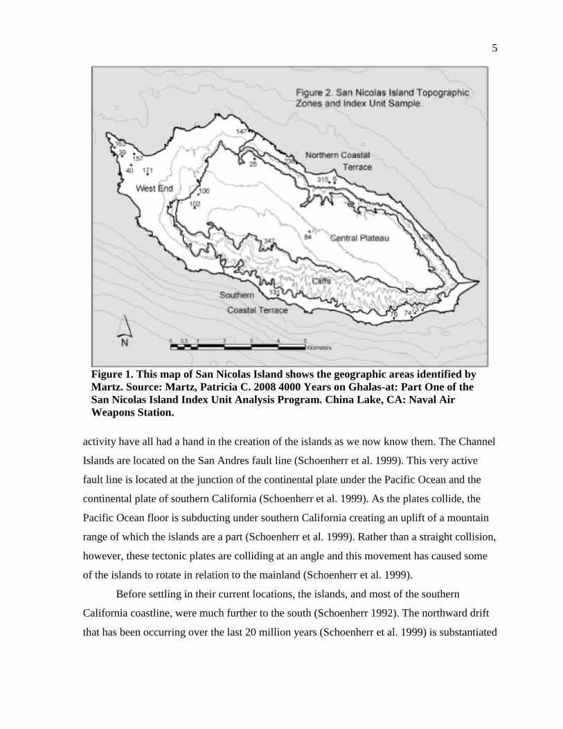
Figure 1. This map of San Nicolas Island shows the geographic areas identified by
Martz. .............................................................................................................................5
Figure 2. A page from Malcolm Rogers’ notes on San Nicolas Island. ..................................49
Figure 3. A charmstone from SN-4. This photograph is named SN.4.8. .................................53
Figure 4. Rogers’ sketch profile of the excavation at SN-1A. .................................................59
Figure 5. Rogers’ drawing of the stratigraphy at SN-7A. ........................................................68
Figure 6. Rogers’ drawing of SN-9 stratigraphy. ....................................................................71
Figure 7. Rogers’ drawing of the stratigraphy at SN-10. .........................................................72
Figure 8. The two sea mammal gaming bones found at SN-11. ..............................................75
Figure 9. Brown war jar fragment from SN-12. This indicates a historical component
to SN-12. ......................................................................................................................77
Figure 10. Olivella Grooved Rectangle beads associated with Sk-1. ......................................81
Figure 11. Rogers drawing of the infant burial at SN-16. .......................................................81
Figure 12. Unusual artifacts found in SN-18. ..........................................................................84
Figure 13. Rogers’ drawing of the human burial and stratigraphic profile at SN-19. .............86
Figure 14. Burial beads and pendant associated with the human internment at SN-20. ..........88
Figure 15. Steatite boat (two views) and a small sandstone bowl associated with
looted burials at SN-20. ...............................................................................................88
Figure 16. Unusual spool artifact found at SN-20. ..................................................................89
Figure 17. Rogers’ sketch of the stratigraphic sequence at SN-20. .........................................91
Figure 18. Rogers’ sketch of the stratigraphy at SN-21A. .......................................................93
Figure 19. Pismo and steatite beads on a necklace with the latter in the center of the
chain. ............................................................................................................................94
Figure 20. Red ochre associated with SK-5 at SN-21A. Note: the ochre was kept in
the bag during photographing due to preservation concerns. ......................................95
Figure 21. Rogers’ sketch of SK-4 burial position. .................................................................96
Figure 22. “Sacrificed mortar,” artifact number 17591, associated with the human
cremation burials at SN-21A. ......................................................................................97
Figure 23. Rogers’ sketch of SK-7 from SN-21A. ..................................................................98

xiii
Figure 24. Bone tool from SN-23 with fragments of wood still attached..............................104
Figure 25. Rogers’ sketch of the stratigraphy from SN-24. ...................................................106
Figure 26. Sweathouse located at SN-30 ...............................................................................111
Figure 27. San Nicolas topographic zones. ............................................................................117
Figure 28. Malcolm Rogers’ site locations. ...........................................................................118
Figure 29. A selection of effigies. ..........................................................................................127
Figure 30. A bone toggling harpoon and eccentric shell fishhook with Aleut
characteristics. ............................................................................................................130
xiv
ACKNOWLEDGEMENTS
Foremost I would like to thank my thesis advisor, Todd Braje, for his continuous
support. Without your patience and dedication, I would never have finished grad school, let
alone this project. Your love of teaching shines through in your support of all of your
students.
I would also like to thank the other members of my committee, Seth Mallios and
Steven Colston for advising, editing, and waiting for this final product.
I never would have made it to this point without my fellow lab mates, Breana Campbell and
Linda Bentz. Without your constant editing and cheerleading I would have given up long
ago.
The information provided to me by René Vellanoweth and the extensive support and
information from Steven Schwartz made this project possible. Steven Schwartz provided
access to site information as well as invaluable research direction.
I can never thank the staff and volunteers at the San Diego Museum of Man enough.
Karen Lacy, Megan Clancy, Rosa Longacre, Devin McClain, Meylia Pflaum, and Rex
Garniewicz opened doors, answered questions, and assisted me along the way.
Direct help with my artifact catalog came from Ellen Waddell, Linda Bentz, and
Breana Campbell. For the suggestion and loan of the light box, I would like to thank Brenda
Wills.
I would like to thank my entire grad school cohort for editing and emotional support.
Happy hour conversations kept this project afloat. I would especially like to thank Annika
Adamson, Keshia Montifolca, David Hyde, and Olea Morris for extensive editing.
Finally, I would like to thank my parents, Wally and Janelle Krum, and my partner in
life, Garrett Hanson. Your emotional (and financial) support has meant everything. Thank
you for your patience!
1
CHAPTER 1
INTRODUCTION
Archaeology has long been a discipline of explorers and hard working excavators.
But, Indiana Jones aside, all archaeologists must also spend a considerable amount of time
organizing and analyzing the data that they excavate. Often, this part of archaeology has been
ignored or deemed less important (and exciting) than fieldwork. Museums often bring to
mind dimly lit labs, endless rows of boxes, and dusty shelves of artifacts from the past, but
are rarely thought of as untapped resources. Most museums are full of collections that were
gathered in the past but no longer used for active research. Forgotten by all but a few
researchers, these collections offer a unique addition to current archaeological questions. The
people who originally stored these artifacts are gone and the purpose behind their research is
no longer known. Many of these artifacts have become so disconnected from provenience
information that they may never be useful for current archaeology projects. Some, however,
can still be connected back to their original, fading, handwritten documentation. These
collections are especially useful to the modern archaeologist as they provide access to rare
classes of artifacts, otherwise unavailable.
Although better kept than most, The San Diego Museum of Man collections
department has some of these relatively unstudied artifacts handed down to them from
previous curators. In the 1930s, Malcolm Jennings Rogers, acting as a staff archaeologist for
the San Diego Museum of Man, traveled out to the Channel Islands to excavate
archaeological sites (Hanna 1982; Rogers 1930, 1993). This expedition was designed by
Rogers to explore “the first occupation of the island by man” and was funded partly by the
Smithsonian Institution (Rogers 1993:6). During this expedition he collected over 10,000
individual artifacts and ecofacts that are still housed at the Museum of Man. Although
Rogers did submit a brief unpublished report to the Bureau of American Ethnology (Rogers
1993), he never published a comprehensive study of the artifacts collected from this
expedition and this report was published in 1993 by Steven Schwartz (Rogers 1993). This
2
collection has remained unpublished and inaccessible to most researchers for over eighty
years.
Only a few years after Malcolm Rogers’ (1993) expedition to San Nicolas Island, the
US Navy acquired control of the island and access to it became more restricted (Schwartz
1994). This restriction, as well as San Nicolas’ considerable distance from the mainland, has
led to comparatively few archaeological projects, especially when compared to the extensive
research on the Northern Channel Islands and the adjacent mainland southern California
Coast. Study of San Nicolas sites has also been hindered by the ecological changes
associated with human impacts. Sheep herding from 1857 until 1943 led to a decrease in
vegetation cover and an increase in wind and water erosion, this environmental degradation
has destabilized and created massive erosion at many important archaeological deposits
(Schwartz 1994). Malcolm Rogers’ 1930 collection offers a glimpse of the archaeology of
San Nicolas in the 1930s before some of this erosion took place and analysis of this existing
collection will provide a unique insight into the archaeology of the island.
For my thesis, I offer the first systematic study of Rogers’ San Nicolas Island
collection in over 80 years. While other researchers have described and analyzed portions of
the collection or referenced it in their studies (e.g. Girod 2010; Glenn 2012), no one (until
now) has systematically cataloged the collection, analyzed field notes, or engaged in a
holistic study of the curated artifacts and ecofacts. My study uncovered fascinating insights
on prehistoric settlement patterns and yielded important data on material culture rarely found
in modern excavations. As I will demonstrate, Rogers’ excavation techniques, focused on
large-scale exhumations of prehistoric cemeteries, produced a set of well-preserved and
unique material culture. His field methods, however, are not employed by modern
archaeologists as they violate a number of state and federal laws that now protect Native
American graves and cultural resources. Museum collections, then, can offer unique
perspectives on the local prehistory of a region unavailable from modern excavations.
Finally, one of the significant challenges of conducting museum collections research
has to do with the process of discovery by the researcher. Most modern research archaeology
is problem-based and an archaeologist sets out to answer one or more research questions by
conducting field and, then, laboratory research. In many ways, this process is reversed with
collections-based research. The significant research questions addressed in my thesis were
3
“discovered” after I had analyzed both Rogers’ Museum of Man collections and his field
notes. It was only by carefully documenting, cataloging, and analyzing the artifacts and
ecofacts that I was able to answer important questions regarding the prehistory and history of
San Nicolas Island (See Chapter 7-8). Initially, my research was guided by a few simple
questions: What is the research potential of the Rogers’ San Nicolas Island Collection housed
at San Diego’s Museum of Man?; What artifacts and ecofacts are included in the
collections?; From where on the island were these collections recovered and using what field
methodologies?; and What (if any) are the conclusions that can be drawn about the island
inhabitants from an initial cataloging and analysis of this collection? Surprisingly, these
simple questions resulted in some exciting results concerning prehistoric island settlement
patterns, ancient burial practices, and commercial exploitation by historical visitors from
thousands of miles afield.

4
CHAPTER 2
ENVIRONMENTAL BACKGROUND
Los Angeles and San Diego are home to millions of people who have flocked to the
warm weather and beaches of southern California. In the process, these populations have
created housing developments, freeways, shopping malls, and urban sprawl. Although there
is some awareness of southern California’s precious archaeological resources, development
still has destroyed many important sites. Off the coast and isolated from the population crush
of southern California, lie the California Channel Islands. These islands remained largely free
from the development that has destroyed much of the archaeology of the mainland region. In
comparison, mainland southern California contains a wealth of undisturbed archaeology
resources.
The California Channel Islands are located in the Pacific Ocean off the southern
California Coast from Point Conception in the north to San Diego in the south (Rick et al.
2005). The islands range in size from about 2.6 km² to 249 km² (Schoenherr et al. 1999).
They are traditionally divided between northern and the southern island groups (Figure 1).
The Northern Channel Islands of San Miguel Island, Santa Rosa Island, Santa Cruz Island
and Anacapa Island are grouped together geologically, as they are part of an arm of the Santa
Monica Mountains that extend out into the Santa Barbara Channel (Rick et al. 2005; Weaver
1969). The northern islands share environmental similarities because of their geologic past
and are often grouped together archaeologically as well, because they were all historically
inhabited by the Chumash Indians. The Southern Channel Islands are Santa Catalina, San
Clemente, Santa Barbara, and San Nicolas. The southern islands are separated from each
other and the mainland by larger water gaps leading to greater differences in the environment
and cultures on the southern islands when compared to the parallels of the northern islands
(Weaver 1969).
The geologic origin of the California Channel islands is due, in large part, to their
location on the Ring of Fire, one of the most geologically active areas of the world.
Continental plate tectonics including shifting plates, continental fault lines, and volcanic
5
Figure 1. This map of San Nicolas Island shows the geographic areas identified by
Martz. Source: Martz, Patricia C. 2008 4000 Years on Ghalas-at: Part One of the
San Nicolas Island Index Unit Analysis Program. China Lake, CA: Naval Air
Weapons Station.
activity have all had a hand in the creation of the islands as we now know them. The Channel
Islands are located on the San Andres fault line (Schoenherr et al. 1999). This very active
fault line is located at the junction of the continental plate under the Pacific Ocean and the
continental plate of southern California (Schoenherr et al. 1999). As the plates collide, the
Pacific Ocean floor is subducting under southern California creating an uplift of a mountain
range of which the islands are a part (Schoenherr et al. 1999). Rather than a straight collision,
however, these tectonic plates are colliding at an angle and this movement has caused some
of the islands to rotate in relation to the mainland (Schoenherr et al. 1999).
Before settling in their current locations, the islands, and most of the southern
California coastline, were much further to the south (Schoenherr 1992). The northward drift
that has been occurring over the last 20 million years (Schoenherr et al. 1999) is substantiated
6
by many geologic features, including a distinctive conglomerate rock from Poway Creek,
currently flowing in San Diego, on San Miguel Island, Santa Rosa Island, and San Nicolas
Island (Schoenherr 1992). At some time in the past, Poway Creek must have flowed into the
ocean in such a way as to deposit conglomerate rock onto these islands. The current location
of these islands make the deposit of these rocks impossible without some northern movement
of the islands, leading researchers to conclude that these islands were once positioned much
further to the south (Schoenherr et al. 1999).
At the height of the last glacial period, during the Late Pleistocene and Early
Holocene, the sea levels were low enough that the Northern Channel Islands were connected
as one large island termed Santarosae (Braje 2010). During this time, the southern islands
were also larger and closer to the mainland, but the basins between them are deep enough
that they were never connected by land (Braje 2010). Compared to other continental shelves,
the slope of the sea floor around the Channel Islands is steep meaning that shorelines did not
change as much as other places in the world (Braje 2010). However, some shorelines have
shifted by as much as 15-20km (Braje 2010; Kinlan et al. 2005). The ensuing warming and
melting of ice caps caused the land bridges to flood and the northern islands to gradually
separate and the coastlines on the southern islands to shrink to their current size.
The composition of the islands has played a hand in shaping the materials obtainable
for prehistoric use. Metavolcanic and sandstone rocks are available and used on all of the
islands and can be found along modern beaches, ancient terraces, and other outcrops (Braje
2010). These materials were often used for production of common tools and ground stone
vessels (Conlee 2000). Asphaltum seeps are also found near all of the islands and washed up
asphaltum was used for glue and sealant for boats, baskets, and other goods (Braje et al.
2005).
Freshwater sources on the Channel Islands are limited, especially on the smaller
islands. Typically, the most reliable sources of fresh water are found on the northern coasts
(Braje 2010). Many of these springs and seeps only flow during the wettest season and
current water availability may be linked to the vegetation found on the islands. The
interaction between vegetation and freshwater has changed due to historical overgrazing,
however, negatively impacting the availability of freshwater seeps and springs by increasing
erosion (Braje 2010). After the removal of livestock, the vegetation on the islands has
7
recovered and studies suggest that some of the islands’ freshwater aquifers are recovering to
their pre-contact abundance (Braje et al. 2005).
The collection used in this project was excavated from San Nicolas Island, one of the
Southern Channel Islands. Of all the Channel Islands, San Nicolas is the furthest from the
mainland and the most isolated. It is located about 120 km (74.6 miles) southwest of Los
Angeles and 98 km (60.9 miles) from the mainland (Schwartz and Martz 1995; Vellanoweth
et al. 2002). In relation to the other islands, San Nicolas Island is relatively small at 5.6 km
(3.5 miles) wide and 13 km (8.1 miles) long with 35.4 km (22 miles) of coastline and a
maximum elevation of 910 ft. (Schoenherr et al. 1999:333; Vellanoweth et al. 2002). While
the Northern Islands are a part of Santa Barbara County, San Nicolas Island is a part of
Ventura County, California (Schoenherr et al. 1999).
Like the other southernmost island, San Clemente, San Nicolas Island consists mostly
of Miocene volcanic materials (Schoenherr et al. 1999). Around the outside of the island,
however, sedimentary rocks have eroded into terraces (Schoenherr et al. 1999). The island
consists of shale and sandstone with several raised marine terraces (Meighan and Eberhart
1953). The island topography is dominated by sand dunes, grassy slopes, and a terraced
plateau (Schoenherr et al. 1999). There are only 12 freshwater springs on the island and
terrestrial vegetation would have been sparse even in the prehistoric period prior to
overgrazing. This lack of water, and the vegetation associated with it, indicates that
carbohydrates and potable water would have been limiting factors for prehistoric populations
(Vellanoweth et al. 2002).
Today, all of the islands experience a relatively mild climate with cool wet winters
and warm dry summers (Braje 2010; Rick et al. 2005). The relatively protected Santa
Barbara Channel area is much safer from strong ocean storms than the rest of the California
coast. Instead of currents and coastline running north to south, the Channel’s currents and
coastline run east to west and offer protection from winter ocean storms and sheltered
beaches (Braje 2010; Schoenherr et al. 1999). The Channel area is located in a transitional
place between climates, with the cooler and wetter climate to the north and the warmer dryer
climate to the south (Braje 2010; Schoenherr et al. 1999). This mix allows a diversity of plant
and animal life to thrive.

8
As the outermost of the Channel Islands, San Nicolas Island is often subjected to
more extreme weather than the other islands. On a typical day, the weather usually consists
of low clouds and fog. Although the island’s weather often involves cloud cover, it does not
receive much rain with an annual rainfall of only 6.61in (16.8 cm) and a westerly wind that
often reaches 35-50 mph (Schoenherr et al. 1999). Much of the island is covered with sand
dunes and the strong winds have a substantial effect on the island typography and on
archaeological sites (Vellanoweth et al. 2002). This extreme weather no doubt was a concern
in prehistoric eras and wind shelters were probably critically important for survival on this
isolated island.
The mixing of the cooler waters from the north and the warmer waters from the south
creates an island environment ideal for increased biodiversity of marine animals balancing
the lack of terrestrial plants and animals. The waters surrounding the islands are very
productive as a function of nutrient rich upwelling that occurs in the southern California
Bight and the mix of warm southern and cold northern currents that converge along the
Channel (Schoenherr et al. 1999). Northern waters flowing south cool the northern shores of
the islands, while southern waters flowing north warm the southern shores of the islands
(Braje 2010; Schoenherr et al. 1999). The differing temperatures allow both cool and warm
weather animals and plants to thrive. Marine upwelling also occurs in the Santa Barbara
Channel creating places where high levels of nutrients come to the surface (Braje 2010). This
upwelling leads to high levels of plankton which feed the larger animals that populate the
waters surrounding the Channel Islands.
Both the upwelling and the water temperature provides the ideal environment for the
extensive kelp forests along the Channel Islands that are home to an array of fishes,
pinnipeds, shellfish, and cetaceans. The kelp forests are constantly changing, but in recent
years they have experienced a reduction in size. This reduction can lead to many negative
effects, including loss of beaches since kelp no longer softens the waves as they come into
shore and loss of the variety of plants and animals that thrive in the kelp (Schoenherr et al.
1999). The decrease in kelp forests has been traced back to rising sea temperatures, in part
because of ENSO fluctuations, but probably also because of a general rise in global
temperature (Schoenherr et al. 1999). The giant kelps (Macrocystis spp.) cannot live in water
warmer than 58°F and water during an ENSO event can reach 70°F (Schoenherr et al. 1999).
9
Sea urchins (Strongylocentrotus ssp.) also feed on the kelp forests by stripping the kelp away
from the ocean floor (Schoenherr et al. 1999). This feeding has increased in recent years and
in conjunction with ENSO events, has slowed the regrowth of this crucial habitat. Sea urchin
numbers have increased in recent years due to predation on their natural predators, the sea
otters (Enhydra lutris ssp.) and lobsters by humans. Sea otters have been all but eliminated
from the Channel Islands and lobsters are heavily exploited by the commercial fishery
(Schoenherr et al. 1999). However, human predation on sea urchins for their commercial
value has also helped to keep their numbers in check, providing some relief to kelp forest.
These rich marine resources were the focus of subsistence systems by prehistoric populations
for millennia (Rick et al. 2005).
Like the area surrounding the Channel Islands, the islands themselves also have
distinct flora and fauna. The Channel Islands maintain much fewer species of plants and
animals than the mainland (Rick et al. 2005; Schoenherr et al. 1999). Many island species are
subject to island dwarfism, where they evolve a smaller size than their mainland cousins
because of the scarcity of resources. There is a scarcity of land mammals on the islands, with
a few notable exceptions. The island fox (Urocyon littoralis) is found on all of the islands
except Anacapa and Santa Barbara (Rick et al. 2005; Schoenherr et al. 1999). The island
spotted skunk (Spilogale gracilis) is found on Santa Rosa and Santa Cruz and is about the
size of a house cat (Braje 2010). The only indigenous rodent on all of the islands is the island
deer mouse (Peromyscus maniculatus). Because they lack burrowing rodents that cause
bioturbation at many mainland archaeological sites, the islands boast a more complete
stratigraphic record (Rick et al. 2005).
Although animal diversity was never as great as on the mainland, there have been a
number of island species that once lived on the islands. During the Pleistocene, Santarosae
was home to a pygmy mammoth (Mammuthus exilis). This dwarf cousin of mainland
Columbian mammoths (Mammuthus columbi) went extinct about the 13,000 years ago when
sea levels were rising and lowland landforms were being flooded, possibly because of the
decreased land area available to them (Schoenherr et al. 1999). The earliest human
occupation of Santarosae dates to this same time, however, suggesting humans may have
played some role in the extinction. As opposed to the pygmy version of the mammoth, both
the Anacapa mouse (Peromyscus anyapahensis), and the giant island mouse, (Peromyscus
10
nesodytes), got larger than their mainland cousins (Braje 2010; Schoenherr et al. 1999). In
addition, a large, flightless sea duck (Chendytes lawi) seems to have been hunted to
extinction about 2,400 years ago (Jones et al. 2008; Rick et al. 2005).
Among the flora and fauna varieties specific to San Nicolas Island is the stink beetle
(Eleodopsis subvestitus) (Schoenherr et al. 1999). There are also endemic terrestrial
mammals of the San Nicolas Island deer mouse (Peromyscus maniculatus exterus) and the
San Nicolas Island fox (Urocyon littoralis dickey) (Schoenherr et al. 1999). Similar to the
other Channel Islands, the island fox on San Nicolas is smaller than its mainland cousin. This
species originated from populations on San Clemente Island, but the San Nicolas Island fox
has developed a slightly larger size and reddish-black hair color in contrast with the island
foxes on other islands (Schoenherr et al. 1999).
In addition to the endemic terrestrial species on San Nicolas Island, there are a
number of other animals. The reptiles found on San Nicolas include the island night lizard
(Xantusia riversiana), the side-blotched lizard (Uta stansburiana), and the southern alligator
lizard (Elgaria multicarinatus) (Schoenherr et al. 1999). It appears that both the side-
blotched lizard and the southern alligator lizard are more recently introduced to the island
(Schoenherr et al. 1999). The southern alligator lizard was not mentioned in earlier works,
leading to a study of the lizards’ mitochondrial DNA. This study has deduced that these
lizards appear to be from populations at Point Mugu and Port Hueneme Naval bases
(Schoenherr et al. 1999). From this evidence it appears lizards have been recent introductions
to the island as hitchhikers on Navy shipments.
Although less common than their marine cousins, a number of land birds still reside
on San Nicolas Island. The only species endemic to the Southern Channel Islands is the
house finch (Carpodacus mexicanus clementis). Both the white-crowned sparrow
(Zonotrichia leucophrys) and brewer’s blackbird (Euphagus cyanocephalus) are mainland
birds that breed on San Nicolas Island, but not on any of the others (Schoenherr et al. 1999).
Other land birds include the common raven (Corvus corax), mourning dove (Zenaida
macroura), horned lark (Eremophila alpestris) and the rock wren (Salpinctes obsoletus)
(Schoenherr et al. 1999).
While terrestrial mammals on the islands are limited, the bird populations are
expansive, including gulls (Larus spp.), cormorants (Phalacrocorax spp.), osprey (Pandion
11
haliaetus), eagles, (Accipitridae), auklets (Alcidae), brown pelicans (Pelecanus occidental),
among others (Braje 2010; Schoenherr et al. 1999). Although birds make up a smaller portion
of bone in archaeological sites, they are still used in many bone tools including gorges, pins,
and awls (Rick et al. 2005).
Marine animal populations are also abundant. The offshore kelp forests support over
900 fish species and many of them can be found both today and in the archaeological record
(Braje 2010; Love 1996). The most abundant fish species in the archaeological record are
sculpins (Cottidae), surfperch (Embiotocidae), greenlings (Hexagrammidae), California
sheephead (Semicossyphus pulcher), señoritas (Labridae), and rockfishes (Sebastes spp.)
(Braje 2010).
Pinniped (seals and sea lions) and cetaceans (dolphins, whales, etc.) are abundant in
the waters around the Channel Islands and their remains have been found in many
archaeological sites on the islands (Porcasi and Fujita 2000). Prehistorically, Guadalupe fur
seals (Archtocephalus townseni) were often utilized for food (Braje and Rick 2011). The
heavy exploitation of fur seals as well as harbor seals (Phoca vitulina) and sea otters can be
attributed to the fact that they were available for most of the year on the Channel Islands
(Braje and Rick 2011). However, Guadalupe fur seals also breed and feed their young on
shore making them easier to hunt than other species, this could have contributed to the higher
density of Guadalupe fur seals in the archaeological record of the Channel Islands (Braje and
Rick 2011). It is also curious that northern elephant seals (Mirounga angustirostris), which
are often found on the islands today, are rarely found in the archaeological record (Braje and
Rick 2011). This can be attributed to many possibilities, but was most likely due to early
intensive predation that drove the northern elephant seals away from islands that were
inhabited by humans (Braje and Rick 2011). Between Vizcaino Point and Seal Beach on the
southwest shore of San Nicolas Island, California sea lions (Zalophus californianus) can be
found in large herds as well as elephant seals, harbor seals, and northern sea lions
(Eumetopias jubatus) (Schoenherr et al. 1999).
The sea otter was once abundant in southern California waters but was hunted to
extinction during the historical period (Ogden 1933; Schoenherr et al. 1999). In the
nineteenth century, sea otters were extensively hunted by the Russians, Spanish and Euro-
Americans for the fur trade (Ogden 1933; Jones et al. 2011). Between 1801 and 1819, almost
12
80% of the California sea otters were captured for their fur (Jones et al. 2011). It has been
estimated that the California sea otter population before commercial exploitation was more
than 20,000 (Jones et al. 2011). After they had been extensively hunted it has been estimated
that only 30-50 California sea otters remained (Jones et al. 2011). However, efforts to
increase the sea otter population in California have been successful, primarily in central
California.
California sea otters have been reestablished on San Nicolas Island, but have not been
reintroduced to the other Channel Islands because their staple food, shellfish, is fished
commercially by humans (Braje 2010). However, prehistoric hunters have been shown to
have extensively hunted sea otters for their meat, fat, oil, fur, and bones (Braje 2010; King
1990). The sea otter was re-introduced to San Nicolas Island in an attempt to create a second
habitation of sea otters to protect against their extermination in the event of an oil spill or
other disaster (Schoenherr et al. 1999). This program ran from 1987 to 1990 and 139 sea
otters were taken out to the island (Schoenherr et al. 1999). However, the sea otters were in
direct competition with commercial fisherman for abalone, sea urchins, and other shellfish
(Jones et al. 2011). To appease the fisherman it was decided that San Nicolas would be the
only island where the sea otter was reintroduced. Even more detrimental to the reintroduction
of sea otters to San Nicolas, however, was the fact that many of the animals returned to the
places from were relocated (Schoenherr et al. 1999). As of 1995, only about fifteen sea otters
remained on the island, but they were reproducing and it appears the reintroduction of sea
otters was successful (Schoenherr et al. 1999). Sea otter populations in California have been
increasing steadily each year, with the population in 2007 recorded as 3,026 (Jones et al.
2011).
Shellfish were an important part of prehistoric diets and manufacturing industries.
The Channel Islands boast an abundance of shellfish, but those from the rocky intertidal
habitats appear to be the most productive in relation to human subsistence during prehistoric
times (Braje 2010). Species found in archaeological middens include California and platform
mussels (Mytilus californianus and Septifer bifurcates), black and red abalone (Haliotis
cracherodii and H. rufescens), owl limpets (Lottia gigantean), black and brown turbans
(Tegula funebralis and T. brunnea), sea, and small gastropods and chitons (Braje 2010).
Those species important for making beads and other ornamentation include: Olivella

13
biplicata (purple olive snail), red abalone, California mussel, giant keyhole limpets
(Megathua crenulata), and others (Braje 2010). Although sandy beach shellfish are present in
some sites, they are relatively rare.
Much of mainland southern California is covered with coastal sage, scrub, coastal oak
woodland, chaparral and grassland (Braje 2010; Schoenherr 1992). Many important plant
materials from the mainland were traded with the people living on the islands. These
included acorns, pine nuts and chia seeds (Braje 2010). This is because terrestrial vegetation
on the islands tends to be relatively limited. Currently on the Channel Islands, plant
communities consist of coastal bluff scrub, coastal sage scrub, coastal march, island
chaparral, valley and foothill grassland, oak woodland, pine forest, southern riparian
woodland, and southern beach and dune (Braje 2010; Philbrick and Haller 1977). Island plant
communities are erratic and each island is variable in its plant communities. Although some
tree patches are present on the larger islands, such as Santa Cruz, Santa Rosa and Catalina
islands, they lack acorn and other staples of the prehistoric mainland peoples’ diet (Braje
2010). It is supposed that islanders supplemented their diet with trade for these goods from
the mainland. The Channel Islands once consisted of a larger range of vegetal communities;
however, years of historical grazing have depleted their resources (Schoenherr et al. 1999;
Schwartz and Rossbach 1993). The islands have now become overrun with introduced
grasses that have replaced native vegetation (Rick et al. 2005).
The vegetation of San Nicolas today is much different from what it must have once
been before European contact. The first botanist did not visit the island until 1897
(Schoenherr et al. 1999), well after sheep grazing had begun on the island and the local
vegetation had been decimated. Today the island is home to mainly grasses and some shrubs.
A few introduced California Fan Palms (Washington filitera) can be found in the ravine
where the Thousand Springs freshwater spring is located (Schoenherr et al. 1999). In an
attempt to control erosion created by sheep overgrazing, the Navy dispersed seed and
fertilizer across the island introducing the grassland that now covers the island (Schoenherr et
al. 1999). The current vegetation is very different from what existed pre-contact. On his trips
to search for the Lone Woman, Captain George Nidever described the island as partly
covered with trees and brush (Schoenherr et al. 1999). These plants no longer exist on the
island and all that remains are their sandstone root casts. Erosion due to the lack of
14
vegetation is an on-going problem and hundreds of ravines have resulted from the legacy of
historical overgrazing (Schoenherr et al. 1999).
About half of the 270 plant and animal species found on San Nicolas Island are
introduced, which is the largest portion of nonnative species on any of the Channel Islands
(Schoenherr et al. 1999). San Nicolas is also the least diverse of the islands, both in habitats
and plant species (Schoenherr et al. 1999). This can be attributed to the smaller size of the
island, as well as its distant location from the mainland and exposure to ocean storms
(Schoenherr et al. 1999). Most of the island is covered with coastal bluff scrub. The majority
of plants found on San Nicolas fall into the species of coyote bush (Baccharis pilularis),
giant coreopsis (Coreopsis gigantea), box thorn (Lycium californicum), coastal prickly-pear
(Opuntia littoralis), coastal cholla (Opuntia prolifera), California saltbrush (Atriplex
californica), yarrow (Achillea millefolium), and bright green dudleya or green live-forever
(Dudleya virens).
Among the species on San Nicolas Island are ones that are endemic to all of the
Channel Islands. These include the island bird’s foot trefoil (Lotus argophyllus var.
argenteus) as well as trask’s milkvetch (Astragalus traskie) and the San Nicolas Island
lomatium (Lomatium insulare) (Schoenherr et al. 1999). There are only two species found
exclusively on San Nicolas Island. The first is the San Nicolas Island buckwheat (Eriogonum
grande), found on the sea cliffs of San Nicolas Island and the second is the San Nicolas
Island leafy malacothrix (Malacothrix foliosa subspecies polycephala) (Schoenherr et al.
1999). The San Nicolas Island leafy malacothrix has only recently been discovered and
appears very much like a pale yellow dandelion (Schoenherr et al. 1999). It can be found on
the clay slopes of the island near the west end at the elevation of 200 ft. (Schoenherr et al.
1999).
A number of natural climatic changes have affected island plant and animal
communities and native populations in the Santa Barbara Channel. The Santa Barbara
Channel area has a long, relatively clear history of climate change recorded in stratified
sediments from the Santa Barbara Basin as well as tree-ring sequences, sea level curves and
bathymetry profiles, and stable isotope analysis of shellfish (Braje 2010; Kennett 2005;
Kennett and Kennett 2000). These proxy record changes in sea surface temperatures and
marine productivity, allowing archaeologists to distinguish between general climate change

15
and the effect prehistoric human populations had on the environment (Braje 2010). Some
general climate changes include droughts, El Niño-Southern Oscillation (ENSO) events, and
winter storms (Braje 2010).
ENSO events happen when the usually westward flowing wind stops and warm
waters flow eastward and up the California coast for a period of time (Braje 2010). The
increase in warm water stops the upwelling and decreases productivity (Braje 2010). For
example, in 1982-1983, and ENSO event combined with a severe winter storm killed off
large portions of kelp forest which in turn affected the reproduction and survival of
pinnipeds, fishes, and shellfishes (Ambrose et al. 1993; Braje 2010:20). For the last sixty
years, ENSO events have occurred every seven to nineteen years (Kennett 2005). Rises in sea
surface temperature have been thought to have affected prehistoric populations as well, with
decreases in marine resources in prehistoric diets being attributed to them (Braje 2010;
Colton and Arnold 1998).
Disruption to climate and sea surface temperatures can also be longer than ENSO
events. During the Medieval Climatic Anomaly, AD 800 to 1400, while the rest of the world
was experiencing extreme weather, the southern California coastline was also experiencing
extreme weather in the form of droughts (Raab and Larson 1997). These changing weather
patterns affected the cultures of southern California as they struggled to deal with the
extreme weather changes. They brought about many shifts in habitation locations,
subsistence strategies, and cultural frameworks as people had to rapidly adjust to changes in
resource availability (Kennett and Kennett 2000; Raab and Larson 1997).
The California Channel Islands’ geology, climate, flora and fauna all created a unique
environment that was occupied by humans prehistorically. They were never connected to the
mainland in the Quaternary, and therefore have their own unique flora and fauna as well as a
distinct archaeological record (Rick et al. 2005). The species located on the islands today
may not be the same as they once were, but they can provide clues to how prehistoric
environments affect the lives of the people living on the Channel Islands. Today, their
isolation has created a reserve of archaeological sites that have experienced relatively little
impact from the massive population expansion along the mainland coast, making them an
ideal laboratory for archaeologists to study ancient populations.
16
CHAPTER 3
CULTURAL BACKGROUND
The California Channel Islands’ unique geologic and environmental histories have
combined to create the setting for cultural developments that played out over the last 13,000
years. The California Channel Islands cultural history is intrinsically connected to that of
mainland California, but because of the physical distance of each island from one another
and the mainland, they have distinct cultural histories. At the time of first Spanish contact,
island peoples were living complex, interconnected lives. Because there are no written
histories prior to early Spanish travel logs, archaeological studies have become important in
the discovery of how these cultures survived in relatively isolated island settings. The
archaeological record can help unravel the complex cultural changes that took place from
initial human colonization to the socio-politically complex lifeways recorded at European
contact.
Derived from a long history of archaeological investigation, several chronological
schemes have been developed for the Chumash region of southern California (e.g. Chartkoff
and Chartkoff 1984; Erlandson 1994; King 1990; Olson 1930; Orr 1968; Rogers 1929).
These schemes reference a similar set of cultural changes, identified in the archaeological
record, and, many times, relate to regional environmental changes. King’s (1990) chronology
is the most detailed and widely used for the Chumash area (see Table 1 with data from
Bennyhoff and Huges 1987; King 1990; Rogers 1930). Based on the seriation of shell beads,
pendants, and other decorative and functional artifacts from burials, King (1990) defined the
Early, Middle, and Late Periods in Santa Barbara Channel prehistory, with each period
divided into phases. Although this seriation is useful in this study for comparison purposes, it
is not directly applicable to the Nicoleño (Tongva) culture group of San Nicolas Island. Other
researchers have expanded this chronology in an attempt to make it more useful, especially
Arnold (1992), but it still does not explicitly include the Southern Channel Islands. The most
useful chronology was devised by Erlandson (1988) and Erlandson and Colton (1991). This
separates the history of the Channel Islands following geological and cultural time markers,
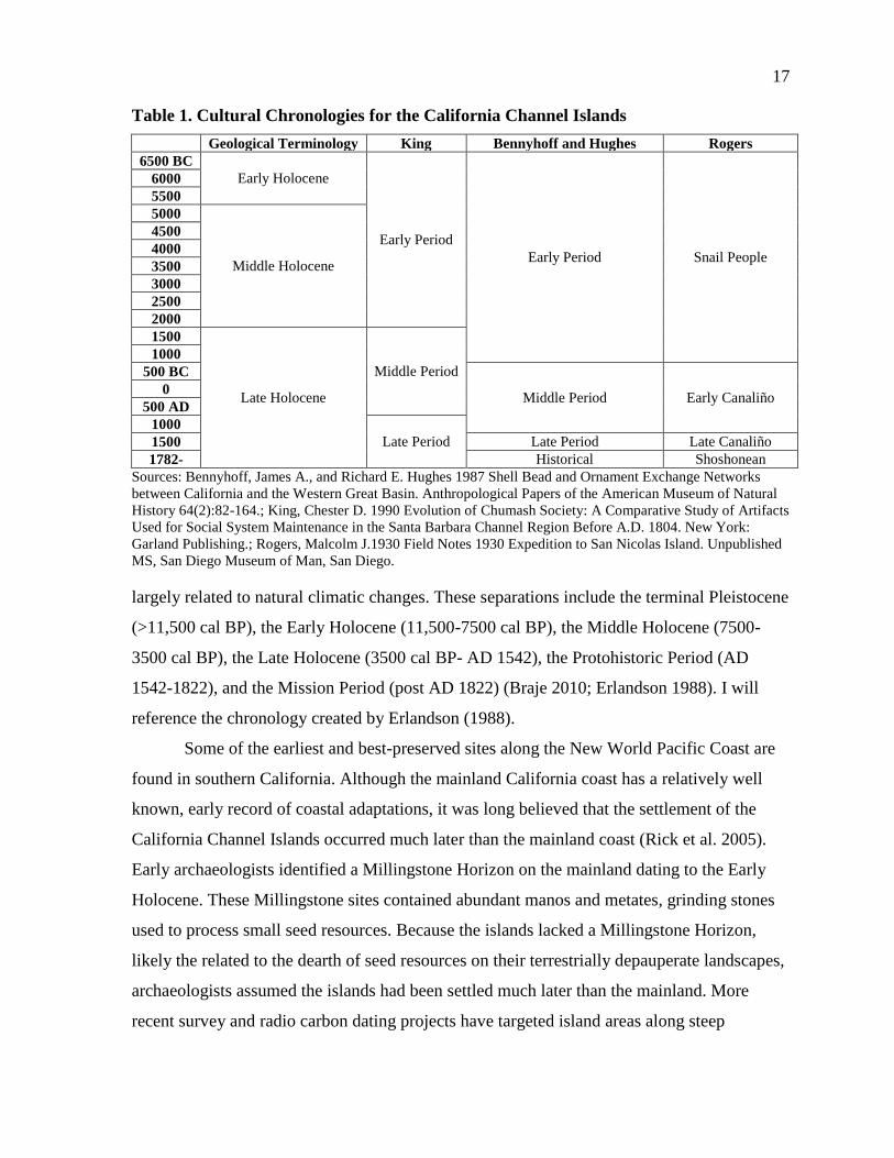
17
Table 1. Cultural Chronologies for the California Channel Islands
Geological Terminology King Bennyhoff and Hughes Rogers
6500 BC
Early Holocene
Early Period
Early Period Snail People
6000
5500
5000
Middle Holocene
4500
4000
3500
3000
2500
2000
1500
Late Holocene
Middle Period
1000
500 BC
Middle Period Early Canaliño 0
500 AD
1000
Late Period 1500 Late Period Late Canaliño
1782- Historical Shoshonean
Sources: Bennyhoff, James A., and Richard E. Hughes 1987 Shell Bead and Ornament Exchange Networks
between California and the Western Great Basin. Anthropological Papers of the American Museum of Natural
History 64(2):82-164.; King, Chester D. 1990 Evolution of Chumash Society: A Comparative Study of Artifacts
Used for Social System Maintenance in the Santa Barbara Channel Region Before A.D. 1804. New York:
Garland Publishing.; Rogers, Malcolm J.1930 Field Notes 1930 Expedition to San Nicolas Island. Unpublished
MS, San Diego Museum of Man, San Diego.
largely related to natural climatic changes. These separations include the terminal Pleistocene
(>11,500 cal BP), the Early Holocene (11,500-7500 cal BP), the Middle Holocene (7500-
3500 cal BP), the Late Holocene (3500 cal BP- AD 1542), the Protohistoric Period (AD
1542-1822), and the Mission Period (post AD 1822) (Braje 2010; Erlandson 1988). I will
reference the chronology created by Erlandson (1988).
Some of the earliest and best-preserved sites along the New World Pacific Coast are
found in southern California. Although the mainland California coast has a relatively well
known, early record of coastal adaptations, it was long believed that the settlement of the
California Channel Islands occurred much later than the mainland coast (Rick et al. 2005).
Early archaeologists identified a Millingstone Horizon on the mainland dating to the Early
Holocene. These Millingstone sites contained abundant manos and metates, grinding stones
used to process small seed resources. Because the islands lacked a Millingstone Horizon,
likely the related to the dearth of seed resources on their terrestrially depauperate landscapes,
archaeologists assumed the islands had been settled much later than the mainland. More
recent survey and radio carbon dating projects have targeted island areas along steep

18
coastlines, freshwater springs, or caves, which may have attracted early settlement or contain
sites that have not been flooded by rising sea levels after the last glacial maximum. Even
with all of the challenges of finding terminal Pleistocene sites, over 50 sites have been
recorded on the Channel Islands that date between 13,00 and 7500 years ago, demonstrating
that a sizeable population likely lived on the islands during the terminal Pleistocene and the
Early Holocene (Erlandson et al. 2013; Rick et al. 2005).
Support for terminal Pleistocene occupation on the southern islands is relatively
scarce compared to the northern islands. This may be reflective of the settlement history on
the islands and the more isolated geography of the southern islands, but it may also stem
from the fact that more archaeological research has been completed on the northern islands.
The earliest human occupation of the Southern Channel Islands began at least 8500 years
before present (Rick et al. 2005; Schwartz and Martz 1992), but the recovery of at least one
chipped stone crescent (Davis et al. 2011) - a diagnostic terminal Pleistocene and Early
Holocene technology- suggests an even earlier occupation.
The best documented early site on the southern islands is Eel Point on the central-
western shore of San Clemente (Cassidy et al. 2004; Rick et al. 2005). The archaeological
record at Eel Point ranges from 8500 cal BP to European contact (Cassidy et al. 2004),
making Eel Point one of the most complete and continuous records of ancient populations on
the Channel Islands. The site has two separate loci dated to the Early Holocene and
interpreted as sedentism (Raab et al. 2002; Rick et al. 2005), a pattern that is unusual for the
islands where indications of sedentism are generally not seen until the Middle Holocene (see
Kennett 2005). Given the proximity to San Nicolas, it is likely the Eel Point inhabitants were
also using San Nicolas Island as a way point for fishing expeditions or more permanent
settlement. Although people were almost certainly using San Nicolas Island for hunting sea
mammals, many of these early sites may have been lost to terminal Pleistocene sea level
changes. San Nicolas lost almost one third of its land mass to eutastic, or worldwide, sea
level rise (Bickel 1978; Martz 2005).
The evidence for terminal Pleistocene and Early Holocene occupation on San Nicolas
Island is limited, however, and clear occupation of the island is not until the Middle
Holocene (Vellanoweth et al. 2002). Archaeological evidence from a large shell midden on
southeastern San Nicolas Island (CA-SNI-339) suggests that the earliest island occupation
19
occurred at least 7000 years ago (Martz 2005; Rick et al. 2005; Schwartz and Martz 1992). A
mussel shell from the base of this large southern coastal terrace site yielded a radiocarbon
date of 8505 cal BP, however, the only dates that are even close to this are about 1000 years
later (Martz 2005). This early date on the southern coast supports the hypothesis that the
earliest settlements on San Nicolas were on the south part of the island, and may have been
lost to the high incidence of erosion in that area (Martz 2005). Typical Middle Holocene sites
on the Channel Islands are temporary campsites or shellfish processing sites and data from
this time period show intermittent use which could indicate seasonal migrations to the island
from the mainland or migration between islands (Rick et al. 2005; Vellanoweth et al. 2002).
The transition to the Middle Holocene marked a move of populations toward
increased sedentism, intensified subsistence systems, and long distance exchange (Rick et al.
2005). A cultural division between the Northern and Southern Channel Islands began during
the Middle Holocene (Rick et al. 2005). All of these changes were probably aided, in some
part, by slowing of previously rising sea levels and an abundance of marine foods (Rick et al.
2005). It is thought that the Middle Holocene provided an optimal environment for the
exploitation of littoral resources, resulting in intertidal resource intensification with little
associated technological change (Rick et al. 2005). This period is seen as a transitional time
between the populations of the Early Holocene and the complexity of the Late Holocene.
Linguistic studies have provided additional context for decoding the prehistory of San
Nicolas. The only record of the Nicoleño language is from accounts of the Lone Woman or
Juana Maria, and this record is fragmentary at best (Munro 1999). However, from the few
words we know, the Nicoleño language was likely part of the Takic language group of Uto-
Aztecan speakers and probably related to the Gabrieliño (Bean and Smith 1978; Munro
1999). These speakers came from the interior into Coastal Southern California and drove a
wedge of Uto-Aztecan speakers through the existing languages in the area about 4000-3000
years ago (Bean and Smith 1978; Hopkins 1965; Johnston 1962; Wallace 1962).
Archaeologically, it is unclear when exactly this migration occurred, but by estimating the
time it takes languages to split, we know that the Gabrieliño probably differentiated by about
1500 cal BP (Johnston 1962).
On San Nicolas, most sites from the Middle Holocene are located along productive
coastlines with easy access to the ocean (Martz 2005; Rick et al. 2005). The Middle
20
Holocene site of Celery Creek (CA-SNI-351) is an exception to this rule as it is located on
the central plateau of San Nicolas Island. It is, however, located within clear view of the
ocean and near a freshwater source (Rick et al. 2005). The Middle Holocene is also when the
island fox arrived on the islands, with the earliest evidence of them on San Nicolas dating to
5200 cal BP (Rick et al. 2005; Vellanoweth 2001). Humans transported these animals from
the Northern Channel Islands and their arrival indicates intensified use of the islands and
increased trade between the islands. The Bird Blind site (CA-SNI-161) on San Nicolas Island
is a typical example of Middle Holocene resource intensification with an intensive
exploitation of shellfish and fish, but with little technological change (Rick et al. 2005). The
site also contains Santa Catalina trade items (Vellanoweth and Erlandson 1999). Another site
that indicates a transitional subsistence economy is the Thousand Springs site (CA-SNI-11)
which shows an increase in sea mammal hunting and intensified fishing practices (Rick et al.
2005).
The Late Holocene, the period from which most of the Rogers artifacts date, brought
an increase in sedentism, trade, and social and political hierarchies (Rick et al. 2005). More is
known about the Late Holocene, than earlier periods, because of this increased sedentism as
well as the availability of ethnohistoric accounts beginning at Spanish contact. Across both
the Northern and Southern Channel Islands, large, complex, permanent coastal villages and a
variety of other site types were common (Rick et al. 2005). Bead production and other trade
item production increased, likely aided by the increased use of the tomol or tiat, a sewn
redwood plank canoe invented at about 1500 years ago (Gamble 2002, 2005; Rick et al.
2005). Although Channel Islanders certainly had utilized ocean-faring craft before (since
none of the Channel Islands were attached to the mainland during the Quaternary), the tomol
provided a more trustworthy craft to make trade excursions to the mainland and between the
islands. Tomols could also carry large numbers of passengers (10-12 individuals) and more
cargo (Rick et al. 2005). Although a variety of other tools began to appear in the Late
Holocene, some of the most important included the single-piece shell fishhook with the
earliest date from CA-SNI-161 on San Nicolas Island at ca. 3000 years ago (Vellanoweth and
Erlandson 1999) and the bow and arrow around 1500 years ago which changed both hunting
strategies and increased interpersonal violence (Kennett 2005).
21
Artifacts that indicate interisland trade and wealth increase in number and complexity
in the Late Holocene (King 1990; Rick et al. 2005). Many of these artifacts are Olivella shell
beads (Rick et al. 2005). Although many of the production sites for these beads are found on
the Northern Channel Islands (Arnold 2001; Kennett 2005), bead production locations have
also been found on San Nicolas Island (Vellanoweth et al. 2002). There is some indication
that ground stone was also produced on San Nicolas for interisland trade (Vellanoweth et al.
2002). Some of the most interesting artifacts that are indicative of interisland trade are the
steatite effigies found on San Nicolas. Steatite is a trade item, most likely from Santa
Catalina, and the intricate carving of the rare material indicate that these artifacts were used
in ritual activities (Hoover 1974).
On San Nicolas, Late Holocene people used all parts of the island, expanding their
Early and Middle Holocene distribution on the northwest coast to include a diversity of site
locations and types (Martz 2005; Rick et al. 2005). Human populations spiked about 1000
years ago until contact with Europeans in the seventeenth century (Vellanoweth et al. 2002).
Work at CA-SNI-25, a Late Holocene village, reveals a diverse array of features and artifacts
indicating increased socio-political complexity (Rick et al. 2005). In general, Late Holocene
sites on San Nicolas Island are mostly located on the plateau away from the coast, possibly to
accommodate large groups (Martz 2005). There are fewer radiocarbon dates during the AD
1150-1295 drought that affected all of southern California, and it is likely that the population
of San Nicolas Island dropped during this time (Martz 2005).
In the Late Holocene, a shift from a focus on shellfish to an increase in the
importance of fish occurred in the Late Holocene and may have been accelerated by the
development of new technologies like the single piece fish hook and the plank canoe but was
probably most closely tied to population increases (Rick et al. 2005). An increase in the
diversity of shellfish used also occurred in this period (Rick et al. 2005). Contrary to this
trend, birds were exploited less in the Late Holocene (Porcasi 1999). On the Northern
Channel Islands, a decrease in the diversity of types of food used and an increase in fishing
as well as a general population growth led to a decrease in overall health indicators (Lambert
1993). However, this decline in health has not been identified on the Southern Channel
Islands (Ezzo 2001).
22
Along with changing subsistence and settlement patterns, the rise of cultural
complexity during the Late Holocene has been an important research topic for Channel
Islands archaeologists. Increases in trade and the development of a shell bead currency
indicate increasing social complexity. Much of the research done on social complexity has
drawn from cemetery and burial excavations during Rogers’ era of archaeology and subject
to many of the same limitations as this study (Rick et al. 2005). Much of this research has
been conducted on the Northern Channel Islands, with less attention to the south islands and
San Nicolas.
The historical record of the Channel Islands began in AD 1542 when the Spanish first
entered the Santa Barbara Channel region (Dartt-Newton and Erlandson 2006; Eisen 1904;
Johnston 1962). At contact, the northern islands were occupied by the Chumash and the
southern islands by the Gabrieliño. First contact with the Gabrieliño occurred in 1542 when
Juan Rodriguez Cabrillo visited Santa Catalina and again in 1602 when the Vizcaino party
stopped by the islands on exploration and trading expeditions (Johnston 1962). San Nicolas
was first seen by Sebastian Vizcaino in 1602, no earlier expeditions mention San Nicolas and
there are no historical accounts of the island before this time (Schoenherr et al. 1999).
Although the island was known to the Spanish, there is a dearth of Spanish-American
artifacts found on the island, indicating very little contact and trade with the Spanish
(Schoenherr et al. 1999).
While proto-historic disease and “crisis cults,” extreme religious reactions to contact,
likely resulted from these initial contacts, Gabrieliño and Nicoleño islanders were not
permanently affected by the European intrusion until otter hunters came to the islands
beginning in the nineteenth century (Heizer 1941). San Nicolas Island was especially altered
by this intrusion. Aleut Eskimos were dropped off on the island in AD 1811 by Russian
commercial interests to hunt otters and collect their furs. In AD 1815 a Russian commercial
fur trader, Boris Tarasov, was arrested for bringing Aleut hunters to San Nicolas, territory
that was controlled by the Spanish (Schwartz and Rossbach 1993). These hunters spent seven
months living and hunting on the island (Ogden 1933). Many Aleut artifacts have been found
on the island already and some have been mentioned as being included in the Rogers
collection at the MoM (Meighan and Eberhart 1953). The Aleut otter hunters are alleged to
23
have massacred the men of San Nicolas and confiscated their wives and children (Johnston
1962).
Excessive violence and the introduction of Old World diseases resulted in decimated
Islander populations and a Franciscan funded expedition was launched in AD 1835 to
remove the surviving population (Heizer and Elsasser 1966; Olivera 2011). It is possible that
the remaining Native Americans on San Nicolas were convinced to leave the island in part by
an earthquake with an epicenter near Santa Cruz Island that shook the California coast in
1812 (Schoenherr et al. 1999). This expedition brought about 20 survivors to San Pedro in
1835 (Heizer and Elsasser 1966; Johnston 1962), however, one woman was left behind, the
lone woman of San Nicolas island, who fell into legend until 1853 when an expedition to San
Nicolas discovered that she had been living by herself on the island for eighteen years
(Olivera 2011). After her removal, she lived with her rescuer, George Nidever, in Santa
Barbara; however, she became ill and only survived for a few months (Heizer and Elsasser
1966; Olivera 2011). Before she was buried in the Santa Barbara Mission Cemetery by
Franciscan friars, she was baptized as Juana Maria (Heizer and Elsasser 1966; Olivera 2011).
She is often referred to as Juana Maria in the literature because there is no record of her name
before her Franciscan baptism. No one could understand the language she spoke and no
members of the original group taken off the island could be found. However, a few of her
words were recorded and Kroeber (1907) later analyzed them and determined she spoke a
language in the Shoshonean family (Hudson 1981; Johnston 1962).
Soon after the Lone Woman was removed from San Nicolas, sheep were introduced
in to the island, in about AD 1857 (Schwartz and Rossbach 1993). It appears that, at its peak,
the sheep herd may have numbered some 40,000 animals, decimating the island’s vegetation
communities and causing widespread starvation. As a result, in AD 1919, when the herding
interest was sold, sheep numbered only around 11,000 (Schwartz and Rossbach 1993). The
original sheep ranching practices allowed the sheep to wander free, leaving no part of the
island unexposed to the effects of ranching (Schwartz and Rossbach 1993). This extensive
ranching not only cleared massive amounts of vegetation, it also stripped archaeological sites
exposing them to the elements and increasing erosion.
Another industry that made its way to San Nicolas in the mid to late nineteenth
century was abalone fishing. Because of the extensive overfishing of their natural predators,

24
the sea otter, and the removal of Gabrieliño fishers from the islands, the abalone populations
were booming by the mid nineteenth century (Braje et al. 2009). This opened an ideal fishing
area for immigrant Chinese abalone fisherman, who exploited intertidal black abalone
populations along the mainland and the islands (Braje et al. 2009). Although Chinese abalone
fishermen were reported along the Channel Islands as early as AD 1857, they probably came
to San Nicolas as early as AD 1870 (Schwartz and Rossbach 1993). The earliest documented
use of the island was by an American fisherman, who obtained the fishing rights for San
Nicolas Island from AD 1902-1907 and placed fisherman on the island (Schwartz and
Rossbach 1993).
Official control of San Nicolas Island was given to the US Navy in AD 1933 by an
executive order from President Hoover and a weather station was established (Schwartz and
Rossbach 1993). An airstrip was built for the Navy outpost by AD 1938 (Schwartz and
Rossbach 1993). The island changed ownership again in AD 1942, when the Army was given
temporary control (Schwartz and Rossbach 1933). The military constructed many buildings,
improved the airstrip, and used the west end of the island as a range to test bombs
transforming the island landscape. In AD 1947, the island was given back to the Navy when
the Naval Air Station, Point Mugu, began to administer it and in AD 1959 the current Navy
structure was built (Schwartz and Rossbach 1993). The Navy still uses San Nicolas today to
test weapons and for military training (Schwartz and Rossbach 1993). Because of this, much
of the archaeological research conducted on the island has been either by or working with
Navy archaeologists.
25
CHAPTER 4
HISTORY OF ARCHAEOLOGICAL RESEARCH
Archaeological research in North America stemmed from a history of antiquarianism
from Europe. At the time of Malcolm Rogers’ (1930) work on San Nicolas Island, the
archaeological theories available in the United States had incorporated Boasian traditions but
were barely past the antiquarian stage of artifact collection with little to no understanding of
context. Archaeological theory underwent extreme shifts during the course of Malcolm
Rogers’ life and the theories and techniques that he was using in the 1930s have become
outdated. However, understanding the history of the field, the archaeology on San Nicolas
Island, and the personal history of Malcolm Rogers will help provide context for the
collection into its own context and allow for a richer modern interpretation.
Although early interest in the prehistory of the United States was active,
“archaeologists” of the 19th century were not conducting archaeology as we understand it
today. They were more interested in collecting artifacts that could be sold to museums for
display than in answering anthropological, historical and archaeological questions. Their
artifact driven collection techniques gutted many archaeological sites and disassociated
artifacts from their original context. However, they also set the basis for cataloging and
categorizing artifacts as well as building seriations (Trigger 2006). Because their primary
purpose in discovering prehistoric sites was to sell the artifacts, little to no attention was paid
to the context of discovery. Many archaeological sites suffered from these early collection
techniques, but they also served the purpose of exposing Channel Island archaeology to the
academic community. The extent that sites were destroyed by early collection cannot be
conclusively determined but by early newspaper accounts we do know that it was probably
extensive (Martz 2002).
As the influence of Franz Boas began to affect archaeology, a shift away from artifact
serration to a geographical culture focus occurred. In 1887, Boas suggested that
archaeological collections should be displayed by culture groups rather than in the arbitrary
sequences archeologists had placed them in (Trigger 2006). This focus on culture groups
26
redefined how archaeologists viewed artifacts and opened new research agendas. This
interest in regional archaeology also allowed for regional traditions that affected the history
of the field. Rogers learned much of what he knew from Southwestern archaeologists, thus
the theory and methods used in his archaeology projects were similar to those used in the
American Southwest.
As much as Malcolm Rogers’ methods had changed from those of the antiquarians
that came before him on the island, our techniques have changed from the 1930s to the
present. Malcolm Rogers took detailed notes, but often only sketch outlines of sites. Detailed
stratigraphic analysis was lacking and although his artifacts were very organized by the
standards of his era, today we see the lack of provenience in his collection. It is unclear
where many of the artifacts in his collection came from and, for many of the collected
artifacts and ecofacts, we only have site numbers with no stratigraphic information. Brief
sketches without detailed measurements make up most of the stratigraphic information
associated with this collection. However, this information combined with our knowledge of
both the theories Rogers was using, as well as the archaeology completed on the island since,
can flesh out his notes.
ARCHAEOLOGICAL RESEARCH ON SAN NICOLAS
Interest in San Nicolas Island archaeology began in the 1870s with antiquarians like
Paul Schumacher, Leon de Cessac, and Stephen Bowers making trips out to the island to
collect artifacts for museums around the world (Johnston 1962; Meighan and Eberhart 1953;
Reichlen and Heizer 1964; Schwartz and Martz 1992). These early explorers can be credited
for creating an interest in the ancient occupations of the Channel Islands, even if their field
techniques were often destructive and unscientific. Interest in southern California and the
Channel Islands region continued as professional archaeology developed into a rigorous
scientific discipline and turned away from artifact collecting. Early archaeologists like Phil
Orr, Arthur Woodward, and Malcolm Rogers conducted more scientific fieldwork on San
Nicolas Island and throughout the Santa Barbara Channel region (Johnston 1962; Meighan
and Eberhart 1953; Schwartz and Martz 1992). Even in this early phase of scientific
archaeology, however, much of the research was conducted using protocols that would be
considered substandard today. Many artifacts were collected on San Nicolas Island, for
27
example, but accurate provenience information was rarely recorded and professional
publications and field reports were seldom completed. Many excavations from this time
period have been lost to the years as notebooks went forgotten and information about
collections went unpublished. This intensive collection of rare and valuable artifacts has
removed an incredible amount of material on the island as they targeted burials and large
village sites (Martz 2005). This kind of large material collection is impossible today due to
laws protecting sites from the wholesale destruction that collecting of this type does to
archaeological sites. Previous to the 1950s, the archaeology of San Nicolas generally
followed that of the United States with many archaeologists simply collecting artifacts with
little to no documentation involved.
Malcolm Rogers came to San Nicolas Island in the 1930s in an attempt to answer
general questions about the prehistoric archaeology of all of southern California. Although he
was interested in seeking answers to research questions about past lifeways, the lack of
specificity in his research design led to large data collection with little attention to
provenience. Instead, he explored the island, collecting artifacts by targeting the richest
archaeological deposits. He did take detailed notes on what he discovered, but his excavation
notes are often fragmentary and unclear. Even with the lack of clear notes, the rare nature of
the artifacts as well as their consistent curation makes them noteworthy and useful.
In his 1928-1930 projects and especially in the San Nicolas Island project, Malcolm
Rogers appears to be more likely to utilize test trenches than both earlier and later in his
career (Hanna 1982). He often discusses the use of excavation in his field notes for San
Nicolas Island (Rogers 1930). Discussion of his techniques, however, is lacking. There is
often no way to know where the trenches were placed, their sizes, or how they were
excavated. In some cases, excavations are recorded in strata, indicating that they were
excavated along natural strata, rather than arbitrary levels. Although his reasons for
excavating are not always clear, he seemed to prefer to excavate at protected sites where
clearly stratified deposits were found. However, on the Channel Islands, he often excavated
sites that were exposed and speaks about the destruction that erosion had been causing to the
archaeological sites (Rogers 1930).
This cultural history approach began to change for San Nicolas archaeology in the
1950’s when Meighan and Eberhart (1953) published a paper documenting the shift toward a
28
more scientific, problem-solving, and research question driven archaeology, part of the larger
“processual archaeology” paradigm. Their study was an attempt to pull together both
previous research on San Nicolas as well as new surveys to answer questions about
settlement patterns. Their pedestrian survey separated the entire island into three different
archaeological zones, but they did not systematically cover the entire island and some
included sites were only “seen from a distance” (Meighan and Eberhart 1953:114). During
this survey, 68 sites were recorded and they determined that settlement patterns related to
access to beaches, fresh water, and good vantage points (Meighan and Eberhart 1953). These
68 sites were the first to be recorded on the island and they are still listed as CA-SNI-1
through CA-SNI-68 (Martz 2002).
The beginning of Fred Reinman’s work on San Nicolas marked the start of a
partnership between the US Navy and archaeologists at the University of California Los
Angeles that continues today (Schwartz and Martz 1992). Reinman undertook archaeological
projects in an attempt to answer specific questions about settlement patterns, accurate
population numbers and maritime adaptations (Reinman 1962, 1964; Reinman and
Townsend 1960). In 1962, Reinman recorded CA-SNI-69 through CA-SNI-118 and was one
of the first people to publish on the history of human occupations on San Nicolas Island.
Although his survey methods are not recorded, based on the locations of recorded sites, it
appears that he focused on the plateau region of the island (Martz 2002; Reinman 1962). He
revised earlier assumptions about the length of occupation based on shallow middens and
relatively few known sites (Reinman 1962). After radiocarbon dates were available for San
Nicolas Island, Reinman (1962) determined that the island was inhabited for at least 4000
years. Reinman also started projects to answer specific archaeological research questions. For
example, his 1964 excavations were completed on the plateau so he could compare these
sites to those on the coast (Reinman 1964).
In 1978, in order to provide information about the location and condition status of
archaeological sites for the Master Plan for the Pacific Missile Test Center, WESTEC
conducted a systematic survey of San Nicolas Island (Martz 2002). During this 30 meter
wide transect pedestrian survey, sites CA-SNI-119 through CA-SNI-149 were recorded
(Martz 2002). The 30 meter transects were determined to be sufficient to find all sites that
were already recorded on the island as well as discover any new sites (Martz 2002).
29
However, this survey did not include areas of the island that were considered to be of low
potential for prehistoric sites. These excluded areas consisted of regions that were difficult to
access, like steep cliffs. Areas considered unsuitable for habitation, such as sand dunes, sea
lion caves, and gull nesting regions were also excluded from the survey (Martz 2002). Even
with the limitations of the survey area, this project located 91 previously recorded sites as
well as 30 new sites (Martz 2002). All of the sites were assessed and ranked based on their
condition as well as their “archaeological sensitivity,” a determination based on the presence
of burials and the size of the midden deposit (Martz 2002:9).
Reinman continued his work on San Nicolas Island during this time and in 1983-
1984, he, along with Gloria Arden Lauter completed excavations and a survey with 15-20
meter transects of the entire island (Reinman and Lauter 1984; Schwartz and Martz 1992).
Reinman and Lauter’s team reassessed sites CA-SNI-1 through CA-SNI-149 as well as
recorded new sites CA-SNI-150 through CA-SNI-358. They discovered that three of the
previously recorded sites had been re-recorded and mistakenly given new site numbers
during the 1962 survey, SNI-27/86, SNI-30/81, and SNI-31/82 (Martz 2002). In instances
where cultural scatter was continuous, the entire scatter was recorded as a single site (Martz
2002; Reinman and Lauter 1984). If there was a break of more than 30 meters, a separate site
was recorded, unless it could be determined that the break was due to recent erosion, then the
site was recorded as continuous (Martz 2002; Reinman and Lauter 1984). Not only were
these sites assessed to determine those with the highest research potential, but those that had
already been recorded were assessed for any change in condition (Martz 2002). The majority
of sites were found to be Destroyed/Poor/Marginal/Moderate (75%), with only 25% of sites
listed as Good/Very Good/Excellent (Reinman and Lauter 1984; see Table 1). By separating
the sites by site density and topography, Reinman and Lauter (1984) divided the island into
the central plateau, the coastal terrace, and the southeast coastal terrace and discovered that
sites were clustered on the west end, where there were fresh water springs and a gentler
topography allowed for ready access to marine resources (Martz 2002).
During the 1980s and 1990s, archaeological research on the Channel increased as
archaeological interest in the United States increased (Rick et al. 2005). This was reflected in
the increase of university research and encouraged more collaboration between universities
and the Navy (Rick et al. 2005). This increased interest brought Channel Island archaeology

30
to the attention of many researchers and the need for more complete, inclusive studies was
realized. This lead to many complete archaeological surveys of islands and an increase in
comprehensive catalogs that can be used to more effectively address archaeological research
questions on the islands.
Twenty years ago, Schwartz and Martz (1992) reported that of the 500 known sites on
San Nicolas, only 10 were excavated, and only a few of these studies had been published.
Recently, however, archaeological interest in San Nicolas has increased leading to fresh
publications and an improved understanding of human use and occupation of the island.
Some recent archaeological projects have concentrated on using collections that were already
excavated. For example, Ezzo (2001) consolidated all known human skeletal collections
from San Nicolas Island and compared them to skeletal collections from the Northern
Channel Islands. Differences between the collections include more dental carries in the San
Nicolas collection, indications of an isolated population, and a heavy dependence on marine
resources (Ezzo 2001).
Between 1996 and 1998, the San Nicolas Island Prehistoric Archaeological Sites
Mapping and Recordation Project relocated, or located, mapped and created detailed records
of all the archaeological sites on San Nicolas Island (Martz 2002). This project was
sponsored by the Environmental Division, Naval Air Weapons Station (NAWS) (Martz
2002).The project was completed in three phases with phase one relocating and reassessing
problematic sites from Reinman and Lauter’s 1984 survey, phase two mapping and recording
half of the previously recorded sites and any new sites encountered, and phase three mapping
and recording of the remaining sites (Martz 2002). The majority of sites that were previously
recorded were shell middens (Martz 2002). Martz (2002) noted that Reinman and Lauter’s
(1984) criteria for archaeological significance had favored larger sites and she recommended
that a variety of habitation sites be studied. The 1996-1998 survey, then, attempted to place
the sites into site types (Martz 2002). These categories included substantial habitation, camp,
lithic manufacture and shell processing location, shell processing location, flaked stone
reduction, deflated hearths and destroyed sites (Martz 2002). Most of the sites radiocarbon
dated from this project date to the Late Holocene (35 sites), however 19 sites were occupied
during the Middle Holocene, and three during the Early Holocene (Martz 2002; see Table 2).
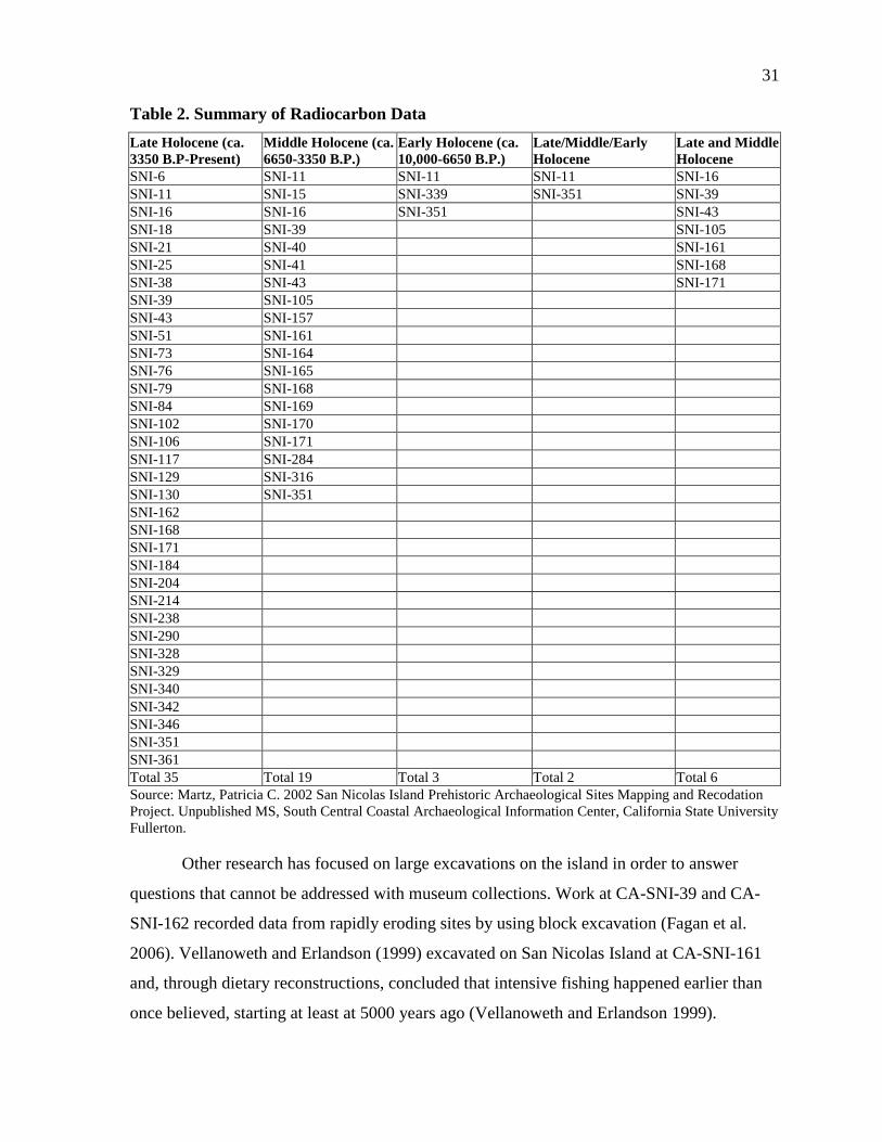
31
Table 2. Summary of Radiocarbon Data
Late Holocene (ca.
3350 B.P-Present)
Middle Holocene (ca.
6650-3350 B.P.)
Early Holocene (ca.
10,000-6650 B.P.)
Late/Middle/Early
Holocene
Late and Middle
Holocene
SNI-6 SNI-11 SNI-11 SNI-11 SNI-16
SNI-11 SNI-15 SNI-339 SNI-351 SNI-39
SNI-16 SNI-16 SNI-351 SNI-43
SNI-18 SNI-39 SNI-105
SNI-21 SNI-40 SNI-161
SNI-25 SNI-41 SNI-168
SNI-38 SNI-43 SNI-171
SNI-39 SNI-105
SNI-43 SNI-157
SNI-51 SNI-161
SNI-73 SNI-164
SNI-76 SNI-165
SNI-79 SNI-168
SNI-84 SNI-169
SNI-102 SNI-170
SNI-106 SNI-171
SNI-117 SNI-284
SNI-129 SNI-316
SNI-130 SNI-351
SNI-162
SNI-168
SNI-171
SNI-184
SNI-204
SNI-214
SNI-238
SNI-290
SNI-328
SNI-329
SNI-340
SNI-342
SNI-346
SNI-351
SNI-361
Total 35 Total 19 Total 3 Total 2 Total 6
Source: Martz, Patricia C. 2002 San Nicolas Island Prehistoric Archaeological Sites Mapping and Recodation
Project. Unpublished MS, South Central Coastal Archaeological Information Center, California State University
Fullerton.
Other research has focused on large excavations on the island in order to answer
questions that cannot be addressed with museum collections. Work at CA-SNI-39 and CA-
SNI-162 recorded data from rapidly eroding sites by using block excavation (Fagan et al.
2006). Vellanoweth and Erlandson (1999) excavated on San Nicolas Island at CA-SNI-161
and, through dietary reconstructions, concluded that intensive fishing happened earlier than
once believed, starting at least at 5000 years ago (Vellanoweth and Erlandson 1999).
32
Vellanoweth (2001) also argued that humans were responsible for the introduction of the
island fox to San Nicolas Island and its continued genetic variability.
In 2005, Martz completed a comprehensive mapping project of known sites on San
Nicolas Island to update the information using GIS and GPS (Martz 2005). In order to
complete this project, she drew upon the sites known from Reinman and Lauter’s (1984)
study, as well as some discovered by her projects, for a total of 535 sites (Martz 2005). With
a more accessible digital layout of the sites on the island, Martz (2005)conducted a
sophisticated settlement analysis as well as correlated her study with radiocarbon dates from
excavated sites. From these data, Martz (2005) determined that more sites were present in the
Late Holocene as well as more utilization of the different island environments and an
expansion in “special activity sites” (76-78). These data fall within the general pattern of the
Channel Islands discussed above.
In 2008, Martz completed an index unit project on San Nicolas Island. This study
built upon the survey complete in 1996-1998 (Martz 2002) and, in some cases, refined the
previously assigned site categories. By organizing the sites into environmental categories,
Martz (2008) was able to discuss general settlement patterns on San Nicolas Island (see
Figure 1). In the West End Topographic Zone, two residential sites dated to the Middle
Holocene and two residential sites and a fishing camp dated to the Late Holocene (Martz
2008). In the Central Plateau Topographic Zone, all of the sites besides a Middle Holocene
shell processing site dated to the Late Holocene (Martz 2008). On the Southern Coastal
Terrace, one fishing site dated to the protohistoric while the others dated to both the Middle
and Late Holocene (Martz 2008). In the Northern Coastal Terrace Topographic Zone, sites
dated to the Late Holocene (Martz 2008). Early settlement in the Middle Holocene appears to
be mainly located on the west end of the island, with expansion of residential sites to other
portions of the island during the Late Holocene (Martz 2008).
Archaeological research on the Channel Islands and on San Nicolas Island in
particular, has come a long way from the early explorers who were only interested in
collecting artifacts for sale to museums and personal collectors. We now have a much better
understanding of the time depth and the lifeways of people living on the islands. New
techniques like radiocarbon dating, skeletal analysis, ground penetrating radar, GIS, and trace
analyses have all opened many areas of research and increased the kinds of research
33
conducted on all of the islands. All of these new projects, whether with already excavated
data or with new excavations, are adding to our understanding of the history of San Nicolas
Island and the larger Santa Barbara Channel Region.
MALCOLM JENNINGS ROGERS: A BRIEF BIOGRAPHY
As one of the early archaeologists to work on San Nicolas Island, Malcolm Jennings
Rogers was influenced by both the era in which he worked as well as his life experiences. His
family and schooling focused his education in engineering and mining and opened doors for
Rogers as an archaeologist that may not have otherwise been opened. Rogers lived during a
time of transition in archaeology and his life story paved the way for his archaeological work.
Malcolm Jennings Rogers was born September 7, 1890 (Hanna 1982). His parents,
Frederick and Nellie Jennings Rogers lived in Fulton, New York, at that time (Hanna 1982).
His father was one of the founders of the Rogers Machine Company of Rochester, New York
(Leonard 1925). Frederick Rogers also held a patent to the Rogers Variable Speed Changer,
which reflected his engineering career (Leonard 1925). The Rogers’ family history in
engineering helped create their family fortune in the railroad industry (Hanna 1982).
This history of successful family engineers surely directed Malcolm Rogers’ early
life. During his childhood he attended Jenner’s Preparatory School and, then, he attended
college at Syracuse University, eventually studying mining geology (Ezell 1961; Hanna
1982). Although he attended university for six years, he never completed his degree,
indicating an early lack of interest in the field (Ezell 1961). Raphael Pumpelly, a family
friend who was known as a renaissance man, seems to also have had a considerable influence
on Rogers (Ezell 1961). Pumpelly was a mining geologist with an interest in archaeology and
may have sparked Rogers’ early interest in the field (Hanna 1982). This strong connection
with Pumpelly may help explain why Malcolm Rogers switched careers to archeology soon
after quitting his studies in geology. Rogers’ association with Pumpelly almost certainly
impacted his knowledge of archaeological field methods as Pumpelly was utilizing arbitrary
excavation levels in the early 1900s (Hanna 1982).
After his years in school, Rogers moved to Washington State to work as a miner from
1917-1918 (Hanna 1982). He left his position in Washington in order to join the Marine
Corps for less than a year in 1918 (Hanna 1982). After his short stint in the military, Rogers
34
moved to Escondido, California, with his father, who was his close companion and
photographer on many archaeological expeditions (Hanna 1982). This transition marked the
end of his mining career and the beginning of his career in archaeology (Hanna 1982;
Hayden 1961). After their move to the West Coast, Rogers began to read extensively on
archaeology and survey near his home in Escondido (Hanna 1982). Much of Rogers’
knowledge of archaeology was self-taught and his reading was aided by participation on the
Escondido City Library Board (Hanna 1982). This self-taught approach meant that Rogers
did not have much contact with professional archaeologists in his formative archaeological
years (Hanna 1982).
In 1920, Rogers discovered his first large site, the Harris site, by the San Dieguito
River (Hanna 1982; Rogers et al. 1966; Warren 1966). By 1920, he had gone as far as
Colorado on his archaeological explorations but it was not until 1926, that Rogers spent time
working with a professional archaeologist in New Mexico for the School of American
Research (Hanna 1982). During this time, he worked on both surveys and excavations and, in
1927, Rogers worked in Arizona for the Museum of Arizona resulting in a publication on his
archaeological survey of the area (Hanna 1982). During these first two years of working with
professional archaeologists, Rogers learned what professional archaeology entailed and by
the end of his tenure, the Arizona Museum considered him to be an Associate Archaeologist.
These two years also resulted in a publication on ceramic typology, A Question of Scumming
(Hanna 1982; Rogers 1928). In this publication, Rogers reviews the way that others have
typed ceramics in the Southwest and suggests that slip differences are due to firing rather
than stylistic choices. Within this work we can see his continued scholarship in archaeology,
both in his review of others’ work and in the application of contemporary theory to his own
archaeological analysis (Hanna 1982; Rogers 1928). The questions that Rogers addressed in
his southwest archaeology work were both a widening of his previous research in California
as well as a precursor to his interest in large culture circles of the western United States.
Building upon his previous friendships with the Museum of Man (MoM) and his
interest in southern California, Rogers began a formal position as a field archaeologist at the
MoM from 1928-1930 (Hanna 1982). It appears that this position was given to him in part
because of his reputation as a careful note taker and an organized collector (Hanna 1982).
The fact that he was one of the few people interested in local San Diego County archaeology
35
may have also aided in his hire by the museum. This position seems to have led to the two
later positions as staff archaeologist (1930-1932) and curator of anthropology (1930-1945)
(Hanna 1982).
As Rogers became more involved in the MoM, his interest in southern California and
his careful notes were a major boon to the museum. At the beginning of his professional
archaeological career, he started to fill notebooks with his continuously accumulating
knowledge. His notebooks include Ethnological, Anthropological and Archaeological Data
of Malcolm J. Rogers Gathered Between 1919 and 1945, Miscellaneous Ethnographic and
Archaeological Notes Compiled by Malcolm J. Rogers, and other notebooks that are
organized in a daily log format by site. His notebooks cover his early work in the Southwest
and along the California Coast. Through his notebooks, we can be see how his early work in
the southwest United States informed and shaped the methods and theories he used in later
excavations (Hanna 1982).
During the time that Rogers was transitioning to staff archaeologist, the MoM put
together a project to survey the prehistory of southern California in an effort to “save”
disappearing archaeological sites (Hanna 1982). A series of 1929 letters back and forth from
the MoM to the Smithsonian Institution documents their attempt to secure funding. It appears
that the museum put together this project based on their own finances, with the idea that they
would be able to get funds from other sources to continue the research (Hanna 1982). The
Smithsonian suggested that the museum apply for a grant from the Smithsonian (Hanna
1982). The correspondence also indicates that during this time, Rogers was completing small
projects as well as formulating a plan for a larger archaeological study (Hanna 1982). They
were also interested in collecting artifacts in an attempt to discern past ethnic divisions,
especially around San Diego and this project was a perfect opportunity to record the
chronology of San Diego by collecting artifacts and mapping their change throughout the
area (Hanna 1982; Rogers 1993).
It was likely that as a part of this project Malcolm Rogers (1930) first traveled to San
Nicolas Island, where he excavated and recorded 32 sites. Rogers’ San Nicolas Island
notebook and one brief unpublished paper were all that he wrote about his work on the island
(Rogers 1930, 1993). The extensive artifact and ecofact collection that Rogers curated at the
36
MoM from this work has never been completely cataloged, and the wealth of information
that could be gained from these artifacts has not been fully explored.
Rogers left Wilmington, California, with his crew on Monday July 7, 1930 aboard the
ship the Dreamer (Rogers 1930). They reached Crescent Bay on July 9 at which point,
Sanger, the captain of the Dreamer, stayed on the island for a day to loot archaeological sites,
much to Rogers’ chagrin, with the help of sheep herders that lived on the island (Rogers
1930). In an attempt to reach the archaeological sites before the looters, Rogers had his crew
work toward the ends of the island on the north side (Rogers 1930). Beginning on Friday,
July 11 Rogers and his crew recorded 32 sites on San Nicolas. In his notes about the sites,
Rogers often noted that many sites have been “dug out” or looted (Rogers 1930). Many of
the collections that were made were surface collections, but some sites were also excavated.
Rogers’ excavations often targeted human burials or known settlement structures (Rogers
1930).
The expedition and research on San Nicolas Island, and the Channel Islands area in
general, can be seen as an expansion of Rogers’ interest into greater southern California
archaeology. He gained expertise and built up his reputation by working in the American
Southwest and came back to California with the hope of synthesizing archaeological research
of the area. This period was one of professional expansion in Malcolm Rogers’ life, but his
excavation techniques and theories were already taking shape before this time, during his
years in the Southwest United States.
Old collections like Malcolm Rogers’ San Nicolas collection are some of the best
preserved artifacts in the world. They have been cared for by specialists for years while the
sites they came from have been subjected to wind and water erosion and, sometimes,
historical development. These artifacts are often from the largest archaeological sites and
early archaeologists often targeted the rarest artifacts that may be very difficult to find today.
Many of these collections come from sites where archaeologists struggle to get access, either
over logistical or Native American concerns. In many instances, analysis of these collections
is key to a richer understanding of human cultural and subsistence systems.
37
CHAPTER 5
THEORETICAL BACKGROUND
Discussion of theory for this thesis must be two fold. Both the theories used by
Malcolm Rogers’ original project as well as the ones used in the current archaeological
analysis must be explored in order to make sense of both how and why the artifacts were
excavated and how they were interpreted in this project. Rogers excavated these artifacts in
the 1930s, during a time when culture-historical theory was popular and prior to the advent of
radiocarbon and other chronometric dating techniques that paved the way for many of the
deep temporal analyses used today (Trigger 2006). Describing the theoretical context of
Rogers’ project allows a deeper understanding of the areas he excavated, the artifacts he
collected, and the history of theory in southern California. Because of the kind of information
recorded about this collection and more applicably, not recorded during excavation, some
current analysis may not be suitable or even possible. A careful consideration of the
theoretical underpinnings involved both in the excavation as well as in the analysis can help
illuminate new research questions and breathe interpretive life into Rogers’ San Nicolas
collection. In true post-processual manner, this project recognizes that Rogers’ data as well
as my own are colored by the era as well as the theories we ascribe to. This project will come
from a lens of cultural materialism as I work to understand the Nicoleño as well as a broader
understanding of how this information fits within the greater cultural context of southern
California.
MALCOLM ROGERS’ CULTURE HISTORY
The theory that Malcolm Rogers was exposed to in the early 1900’s formed the basis
of his own archaeological projects. He spent many years working with prominent
archaeologists in the Southwestern United States. This exposed him to culture history in one
of the regions where it was first developed. The primary concern of culture history is to
define archaeological cultures by lists of traits or types of artifacts in the archaeological
38
record. In addition, Rogers also used Kroeber’s definition of linguistic and cultural divisions
(Rogers 1929).
Culture history was the dominant theoretical framework at the time. This was the
beginning of archaeology as a scientific field and was greatly influenced by the social and
political climate of the time. Archaeologists have only in the last 50 years, developed into a
professional field based on the scientific method. Rogers, however, was not simply an
antiquarian, collecting artifacts for museums. He was trying to discover more about the
people who once lived on San Nicholas Island. Antiquarians are interested in the objects of
the archaeological record, culture historians and archaeologists are interested in the people
who made those objects. In fact, Rogers bemoaned the looters who were on the island at the
same time as him, as well as those who had come before and decimated many of the obvious
sites (Rogers 1930). Although his recording methods leave something to be desired, he did
attempt to sketch stratigraphic outlines where he saw them and made an effort to record what
was done at each site.
Rogers was heavily influenced by his family and his choice to earn a degree in the
geological sciences. This helped him develop a deeper understanding of geological
stratigraphy in a period where archaeologists often ignored stratigraphic associations. Rogers
did not, however, develop the academic connections that other archaeologists acquired
during their college years. Rogers was notably self-taught and developed an understanding of
archaeology almost completely by himself. Combined with his reputed distrust of others,
Rogers struggled to keep professional collaborators (Hanna 1982). During his time working
in the Southwest, Rogers did acquire some professional connections that surely helped
influence his career. Rogers’ known professional relationships include his professional
colleagues that he met during his work in the Southwest and continued correspondence with.
These include archaeologists Emil W. Haury and Harold S. Gladwin, who both
corresponded with Rogers about both Rogers projects and their own (Hanna 1982). During
his time in the Southwest he also developed relationships with Charles Amsden from the
Southwest Museum and geologist Ernts Antevs (Hanna 1982). He also developed a long time
professional and personal friendship with southwestern archaeologist Julian Hayden, (Hanna
1982). He also had meetings with iconic socio-cultural anthropologists M. R. Harrington and
A. L. Kroeber, although his interactions with them seem more limited (Hanna 1982). While
39
these professional contacts may have played a role in shaping Rogers’ archaeological theory,
he was known to be reclosing and secretive with his data, often refusing to share knowledge
with others (Hanna 1982).
In the Southwest United States pueblo culture areas, archaeologists were discovering
the benefit of working both with historians and ethnologists. Rogers brought these methods
back to California with him and combined them with Kroeber’s idea of culture areas to create
his working theory used on San Nicolas Island (Buckley 1989). The fact that he worked in
the Southwest United States helps explain his ability to discover site locations based on
techniques often used in the American Southwest, mainly looking for their remnants on the
surface (Rogers 1930). There was no way for Rogers to realistically discover sub-surface
sites with no indication on the surface of their existence. Malcolm Rogers was working in a
period before radiocarbon dating, so he utilized the techniques of his time to understand the
archaeological chronology of southern California. In his work, he was attempting to separate
archaeological sites into time periods by using sets of characteristics and stratigraphy (Rogers
1929, 1930, 1993). Although this is still a technique used today, it is more often used in
conjunction with radiocarbon dating in order to avoid falling into the culture history trap of
assuming that a change in technology means a change in populations.
To this end, Rogers made lists of cultural traits that separated cultures in the
archaeological record without trying to interpret why these variations occurred. Rogers
identified the Early Period (Snail Period) by stratigraphic lenses of roasted land snails with
no human remains or artifacts (Rogers 1993). Rogers Middle Period (Early Canalino) was
identified by him by a high percentage of Red Abalone (haliotis rufescens) and butterfly
shells (cryptochiton stelleri), as well as little cultural material, with only some whalebone
tools, flakes, house structures, and no found human remains (Rogers 1993). He notes that he
does not fully understand this culture and it could be previous to the Canalino or Chumash
culture or it could be “transitional in nature” (Rogers 1993:8). The Late Period (Canalino
Culture) is identified by Rogers by the artifacts that are easily recognizable as similar to the
Chumash culture. The Late Period was identified by Rogers by large community houses,
imported materials, a greater variety of shell types and fishbone in the middens, fishhooks,
and dog burials (Rogers 1993). The Historic Period (Shoshonean) was identified by
cremations, metates, obsidian projectile points, and the sweathouse (Rogers 1993).
40
In a paper written about Western San Diego County in 1929, directly before his field
season on San Nicolas Island, Rogers wrote about different cultural traditions identified in
the archaeological record. Although he admits that his knowledge about the deep stratigraphy
of the region is superficial and incomplete (Rogers 1929), he infers that extensive, old, shell
middens indicate an older cultural tradition. He also identifies a mid-level culture which he
named “Scraper-Makers” (Rogers 1929:457). The name “Scraper-Makers” comes from the
large amount of “scraper-planes” produced, almost to the exclusion of any other artifact
associated with these sites (Rogers 1929:459). Rogers reveals his knowledge of archaeology
here by comparing the scrapers to those found in the Paleolithic Aurignacian Period in
Europe and assumes that they were used for the similar purpose of dressing hides (Rogers
1929). This is not to say that Rogers was not reaching for higher-level analysis. He compares
the size of scrapers by site as well as attempting to discover why and how these scrapers
were made. He also compares the artifacts from the mainland briefly to those of the Channel
Islands and discusses the idea that the different strata (cultures) may have grown from one
another (Rogers 1929).
THEORETICAL APPROACHES
Archaeologists today have embraced the changing theoretical perspectives of the last
eighty-four years since Rogers’ San Nicolas Island excavations. There has been a shift from
the era of listing cultural traits, to one of the application of scientific inquiry (processual
archaeology), and into the post-processual and postmodern, focused on questions of identity
and agency (among others). It is generally accepted that a mixture of both “middle” and
“high” level theories need to be used in order build strong archaeological inquiry (Trigger
2006:21-24). Low-level theories can be considered typologies of artifacts and the
identification of cultures by repeatedly observing certain artifacts (Trigger 2006). Although
many of the techniques in this study employ low level theories, or empirical research with
generalizations (Trigger 2006), the conclusions drawn from them extend into the middle and
high levels of theory. Middle-level theories are the generalizations that can be made when
similarities between two sets of data are found and include those theories that try and bridge
the gap between the archaeological record and human behavior (Trigger 2006). Finally, high-

41
level theories attempt to understand general cultural trends rather than the individual
experience.
Many different useful theoretical approaches to archaeological research have been
used successfully in recent years. Each one takes a slightly different approach and has its
own set of benefits and drawbacks. Rather than strictly subscribing to a theoretical approach,
a more useful way of looking at theory has been “theoretical plurality” (VanPool and
VanPool 2003:2) or using a “multitheoretical approach” (Rick 2007:5). This approach allows
a more open theoretical standpoint that incorporates multiple viewpoints and provides a more
complete view of a society. Although many theoretical approaches including practice theory
and agency theory are touched upon, the main theoretical lens of this project is cultural
materialism.
Practice and agency theory, or a focus on the everyday practice of individuals, is
useful in the abstract for this project. It is useful to think in terms everyday practices of
individuals when trying to understand how people organize their settlements and daily
activities, produce and consume technologies, and exploit local resources. I use practice
theory in this project to discuss the aspects of everyday life like subsistence and resource
location that eventually lead to settlement patterns and patterns of exchange.
Archaeological research on burials including location, burial goods, and skeletal
studies has proven useful to understanding cultural change through time as well as the health
of the Chumash. Gamble et al. (2001) correlated a cemetery of burials with ethnographic
knowledge of the site as well as with archaeological knowledge of the region to discuss a
change in complexity. Lambert and Walker (1991) use skeletal remains to discuss social
complexity. In this study I use burials to discuss social complexity. Individual status can
often be ascertained from burial data and can inform on changing social hierarchies and
complexity. These studies in changes of complexity can be supplemented by gender studies
and Marxist analysis that looks at resource control, craft specialization, and even responses to
environmental shifts (Rick 2007).
Cultural materialism was first introduced and explored in depth by Marvin Harris
(1979). Cultural materialists argue that technological and economic aspects play primary
roles in shaping a society and culture. Largely an expansion of Marxist theory, cultural
materialism views economic and demographic facts as important forcing elements in

42
structuring society (Harris 1979). Moreover, its interest in how the environment helps to
shape culture is relevant to archaeological research on the island environment of San Nicolas.
Subsistence, settlement, and even social aspects of the culture were all influenced by
environmental factors. Cultural materialism also has direct implications on ecological
studies. For example, speciation of bird effigies or analyzing shell midden placement may
allow a clearer picture of prehistoric land and seascapes.
43
CHAPTER 6
METHODS
IMPORTANCE OF MUSEUM COLLECTIONS
The basis for this study is the revitalization of museum collections for modern
archaeological inquiry. As archaeological methodological techniques, theories, and standards
evolve, additional information regarding ancient populations can be gleaned from museum
collections. The utility of museum collections, however, is entirely dependent on the
availability of the data. Due to the vast scope of archaeological interest in the Channel
Islands, there are many museum collections that could potentially be used to supplement
current archaeological fieldwork on the islands and adjacent mainland. On San Clemente
Island, for example, Spencer Rogers excavated a series of archaeological sites in 1950 but
never published his results. Thirty years later, San Diego State graduate student Anna Noah
(1987) worked with a collection of Spencer Rogers’ from San Clemente Island to analyze
ground stone artifacts discussing their production and use. University of Oregon graduate
student Tracy Garcia (2010) completed a thesis project on the life and archaeological
investigations of Paul Schumacher, an antiquarian who worked extensively on the Channel
Islands. Garcia (2010) connected original letters and documentation to museum collections.
Her work with the original documents of Schumacher illuminated not only the culture that
Schumacher was working in, but also that of the indigenous people he was in contact with
(Garcia 2010). Projects like these make information from past archaeological collections
available to archaeologists trying to synthesize information from various sites or regions.
Although archaeologists are still interested in rare artifacts, there has been a
diversification of the kinds of artifacts and data that are currently targeted. Rather than
burials that may contain rare artifacts, most archaeologists excavate middens and data
analysis includes ecological and settlement analysis. Archaeological field methods and
targeted areas have changed for this reason as well as due to considerations for Native
American tribes. In Malcolm Rogers’ time, ancient cemeteries and human burials were
targeted, since they were most likely to contain the highest density of unbroken artifacts.
44
Decades after Rogers, Native American remains were treated differently from Caucasian
remains and over 18,000 Native American skeletal fragments were located in the
Smithsonian alone in 1989 (Cryne 2010). Many museums were not actively studying the
remains, but storing them indefinitely. In response to this cultural affront, Native American
tribes lobbied for legislation that would protect the treatment of their dead. Today, the Native
American Graves Protection and Reparation Act (NAGPRA) legislation has restricted
excavations of burials that do not have the consent of tribal groups. This change in legislation
has limited the availability of new burial and skeletal information, increasing the value of
museum collections.
San Nicolas Island is a prime example of the usefulness of historically excavated
collections because of its uninterrupted conservation at the MoM. The island is subject to
erosion and difficulties of access making museum collections an important non-invasive tool
to answer a number of interesting questions about the history of the island and, larger,
southern California. While very little research has been conducted on these collections,
archaeologists recognize its potential to expand our understanding of the Nicoleño (Schwartz
and Martz 1992). By correlating known sites on San Nicolas to Malcolm Rogers’ collection
housed at the MoM, a unique picture of the Nicoleño can be constructed.
FIELD PROCEDURES
On July 7, 1930, Malcolm Rogers and his crew began their trip to San Nicolas Island.
His crew consisted of his father F.S. Rogers as staff photographer, George Carter as his field
assistant, and two laborers H. Sharo and S. Rodriguez (Rogers 1993). Although they left
from Wilmington, California that night, they were not able to land on San Nicolas at Brooks
Landing until July ninth due to storms (Rogers 1930, 1993). The first few days of the trip
were spent exploring the island and setting up camp for the crew. The base camp was
originally set up at Brooks Landing, located at the midpoint on the North side of the island
(Rogers 1993).
The team ran into some difficulties with the crew of the ship that brought them to the
island and Rogers complained about Captain Sanger looting archaeological sites with the
help of herders who lived on the island before his team even had a chance to record anything
(Rogers 1930). In fact, Rogers remarks many times on the general looting which had already
45
taken place before he got there (Rogers 1930, 1993). He comments that all of the late
cemeteries had been looted and that San Nicolas seemed to have been looted more than the
other Channel Islands because of its “small size and lack of protection” (Rogers 1993:4).
As Rogers and his crew began their work seriously, they worked out from Crescent
Bay both east and west so that they covered the entirety of the north coast (Rogers 1930).
They quickly gained a general understanding of the middens on the north shore of San
Nicolas Island, finding that most middens started on sand dunes that had previously existed,
and only a few on a sand stone base (Rogers 1930).
Burials were a large part of what Rogers and his team excavated (Rogers 1993).
Although they found many heavily looted late burials, with their locations readily seen by the
heaps of broken burial goods and exposed skeletons, they also found a fair amount of
undisturbed burials (Rogers 1993). These mostly included isolated burials and cemeteries
from an earlier time (Rogers 1993). These earlier cemeteries were left intact because they
lacked markers and often do not include the burial goods that looters were ultimately after
(Rogers 1993). Many of the intact burials were stumbled upon by Rogers’ team by
happenstance and often they perused cuts and cliff facings to discover eroding burials and
Roger remarked that many burials were exposed from wind and water erosion (Rogers 1993).
Rogers observed that while large, late cemeteries are placed at the top of middens and burials
are crowded together, the earlier cemeteries are placed between middens and the interments
are more spread apart (Rogers 1993).
Rogers observed that different cultural material and food complexes were present in
different strata across the island their observation matched what they observed on the
mainland (Rogers 1993). On July 13, 1930, Rogers divided his crew and sent two of them
west to record sites while he and the rest of the crew went east (Rogers 1930). The western
team recorded sites SN-10, SN-11, SN-12, SN-13, SN-14, and SN-15, while the eastern team
along with Rogers recorded sites SN-5, SN-6, SN-7, and SN-8 (Rogers 1930). As a result of
this split and the fact that no notes from the other members of the crew have been recovered,
there are very minimal notes associated with the sites that Rogers was not recording. On July
14, 1930, Rogers split his team again and sent two of them to cover the plateau on the east
side of the island; they found SN-25, while the rest of the crew continued along the coast
(Rogers 1930).
46
As their excavations took them farther from their base camp, Rogers and his team
moved base camp to the west end of the island where the majority of artifacts were
discovered (Rogers 1993). Both archaeological finds and the party’s equipment had to be
carried around the island by the people and no vehicles or pack animals were used.
Consequently, they ended up using much of their time to move their materials around the
island. This left the team unable to complete the work they originally had planned as they
had set a date and time with the Coast Guard to pick them up. On August 10, 1930, when
Rogers and his team left the island, they brought “45 cases of archaeological material” with
them, but left many unanswered questions, according to Rogers (Rogers 1993:3).
On August 2, 1930, Rogers and two of the crew started moving supplies back to the
base camp at Crescent Harbor (Rogers 1930). Then on the third, they moved the rest of the
crew and the supplies back to the base camp to prepare to be taken off the island (Rogers
1930). On August 10, the Tamora picked up Rogers, his crew, and all of their gear and
artifacts (Rogers 1930). The Tamora dropped the crew off at San Pedro and then brought
their materials and equipment to San Diego, while the crew drove from San Pedro to San
Diego (Rogers 1930).
Very few photographs were taken during the expedition because they only had “three
days of sunshine” (Rogers 1993:3). In general, Rogers found that black abalone was the most
abundant on the east end and red abalone was the most abundant on the west end (Rogers
1930). Although most of the artifacts in MoM’s collection are from Rogers’ first trip out to
the island in 1930, he did make notes of his two subsequent trips, one in 1934, and one in
1938 that included other Channel Islands (Rogers 1930).
Rogers was interested in collecting artifacts in an attempt to recreate ethnic divisions
of the past as well as to understand how the ancient occupants of San Diego lived (Hanna
1982). The San Nicolas Island project was originally undertaken in an attempt to record the
chronology of San Diego by collecting lists of artifacts, distinguishing their traits, and
tracking changes through time (Hanna 1982; Rogers 1993). These goals were some of the
primary goals of the culture historians of the early to mid twentieth century (see Chapter 5).
Rogers’ project was funded and sanctioned by the MoM (Hanna 1982; Rogers 1993). Even
on the island, the places that Rogers chose to excavate were influenced by his previous work
as well as the year in which he was working. While Rogers specifically targeted burials, only
47
the most obvious artifacts were collected. Many ecofacts or small and broken artifacts which
may have been important for reconstructing subsistence activities and other daily activities
were not collected.
Malcolm Rogers excavated these artifacts during a time when the ethical standards of
and field techniques were vastly different than those of today. Moreover, the attention to note
taking and field procedures were much more lax. Malcolm Rogers’ notes, for example, are
unclear about exactly how he excavated. Fortunately, Rogers did record some basic notes and
the MoM has maintained these records for nearly 85 years. In a time before Global
Positioning Systems and exact mapping standards, Rogers’ attempt to record stratigraphy and
site locations with sketch maps and brief descriptions was novel, and in many ways, ahead of
his time. Based on his field notes all 32 sites underwent at least a preliminary surface
collection (Rogers 1930). During this surface collection, Rogers often had his crew looking
specifically for burials as they “have been the zones most productive of culture material”
(Rogers 1930:3). Because the shell middens were so thin in some points “a more
comprehensive knowledge of the midden content was gained by surface collecting than
trenching” (Rogers 1993:5). At sites they determined to have two or more strata, Rogers
excavated subsurface trenches (Rogers 1930). At the eight sites which had no natural strata
exposed, Rogers (1930) excavated test trenches, often in burials or house pits. His excavation
procedures are not explicitly discussed in his notes, but it can be assumed that in most cases
he dug down to sterile soil recording the stratigraphy only after complete excavation. It
appears that only large, formal artifacts were kept from excavations. At eroding sites on sea
cliffs or where a gully cut through the deposits and exposed the stratigraphic sequence,
Rogers mapped out strata and excavated artifacts from the exposed area in lieu of trenching
(Rogers 1930).
As was typical of the time, Rogers and his crew paid little attention to detailed notes
during excavations or surface collections. Very few details on the provenience or context of
collected artifacts were recorded, including critical information for answering many modern
archaeological questions. Rogers did try to record certain details; however, he sketched
stratigraphy where he thought it was important and there are a few hand drawn pictures of in
situ artifact caches or burials (Rogers 1930). To the modern archaeologist, however, his notes

48
leave much to be desired. There are no detailed explanations of where and how artifacts were
excavated and much of the context of these artifacts has been lost over time.
After transporting the material back to the museum, Rogers cleaned and cataloged the
collection (Rogers 1930). Almost all of the artifacts have carefully penned site numbers on
them in what looks like Rogers’ handwriting. Unfortunately, Rogers’ original catalog has
been lost or it is possible that there was never a complete catalog of the collection (Karen
Lacy, personal communication, February 1, 2013). According to Roger’s notes, 33 skeletal
interments were brought back to the MoM (Roger 1930). As of July of 2013, these skeletons
were no longer correlated with their site numbers and had lost all of their original
provenience. Museum records indicate only seven nearly complete skeletons and 102 partial
remains. It is probable that skeletal remains were not lost, but rather than the partial remains
belong to the missing 26 skeletons.
When this project began, in November 2012, the Rogers collection was housed in the
curation department at the MoM with limited description and documentation. The collection
was housed in Lab Two in wooden drawers and in Lab Five in cardboard boxes. The artifacts
in most drawers were separated by site, although many drawers contained more than one site.
Each drawer contained archival quality bags housing artifacts by general artifact category.
Categories included lithic-modified, lithic-unmodified, bone-modified, bone-unmodified,
shell-modified, shell-unmodified, wood, basketry, asphaltum, soil, glass, and charcoal. The
artifacts located in Lab Five were generally large ground stone and were housed in cardboard
boxes with site numbers recorded on the outside of the box. Lab Five has seen less
revitalization than Lab Two because, in general, the artifacts are not as delicate. The summer
previous to my research, a general catalog was begun in Excel by Ellen Waddell, a museum
volunteer, who recorded the site number, general artifact category, number of artifacts, and
drawer location of each site. This catalog was the basis of my work and was expanded to
include detailed artifact categorization, modifications, and speciation/material when it was
possible for me to identify, as well as a photographic catalog of every item.
ANALYTICAL PROCEDURES
The MoM houses copies of Malcolm Rogers’ original field notes copied from his
original notebooks (Figure 2). They are handwritten and contain his drawings, sketches,
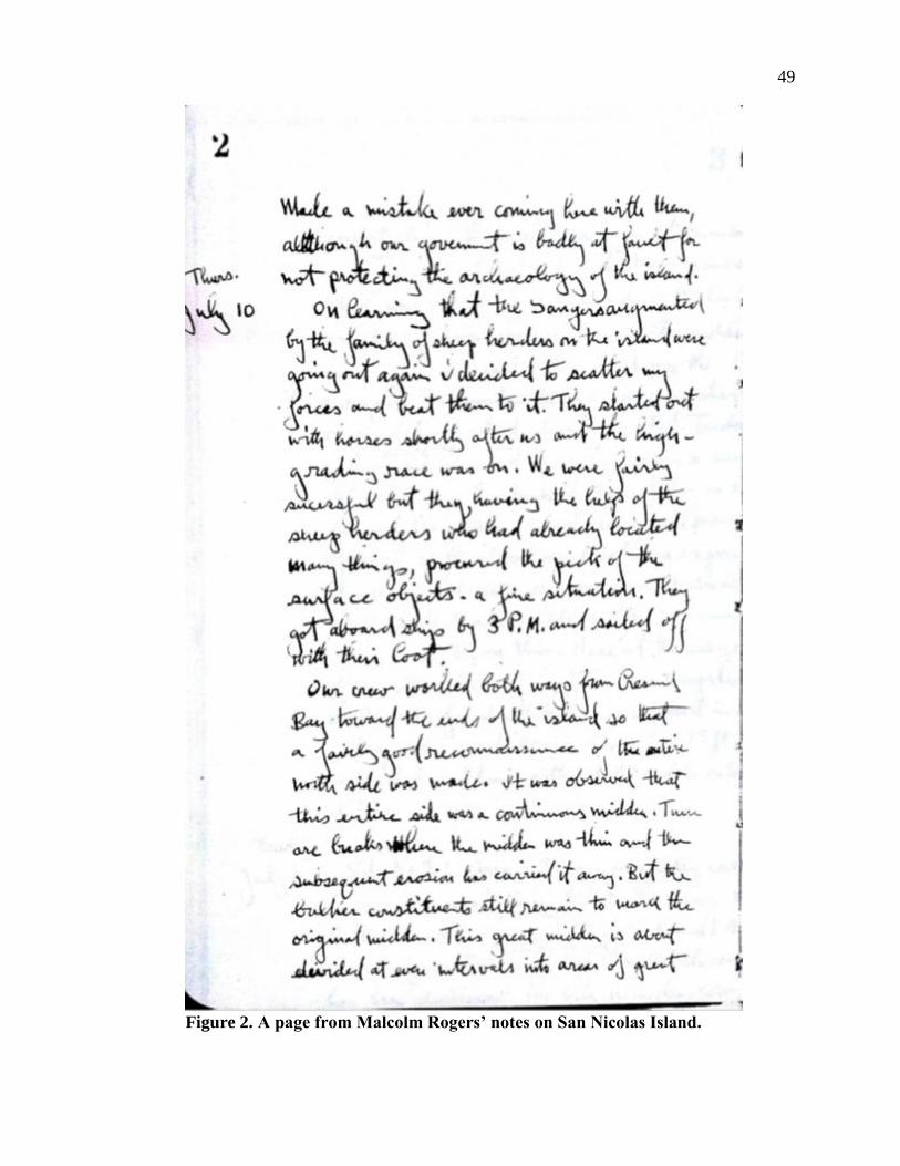
49
Figure 2. A page from Malcolm Rogers’ notes on San Nicolas Island.
50
and revisions. They also house maps of San Nicolas Island from Malcolm Rogers’ project
and three photographs assumed to be from Roger’s trip to the island. The photographs have
been attached to display cards. I read Rogers’ notebook carefully for both his thoughts on the
island and information that can be used to connect artifacts back to their original
provenience. These include sketch maps, lists of artifacts, and descriptions of sites (Rogers
1930). There is also one published document by Malcolm Rogers summarizing his trip to the
island (Rogers 1993). It was originally sent to the Bureau of American Ethnology, but was
published for a wider audience in 1993 in Pacific Coast Archaeological Society Quarterly by
Steven Schwartz (Rogers 1993).
Rogers was working before our current trinomial system of archaeological site
number designation was used in southern California. Rogers used temporary site numbers to
designate site locations, which now must be correlated to contemporary site designations.
This was first accomplished by US Navy archaeologist Steven Schwartz and a table of
correlated numbers is included in Table 3. Because Rogers often combined multiple sites into
one large site, these locations are often correlated to more than one current site. I found it
more helpful to talk about them in areas rather than individual sites. For example, Rogers’
largest site, SN-21, is actually a group of sixteen sites including site numbers CA-SNI-18,
CA-SNI-19, CA-SNI-39, CA-SNI-40, CA-SNI-55, CA-SNI-119, CA-SNI-157, CA-SNI-159,
CA-SNI-160, CA-SNI-161, CA-SNI-162, CA-SNI-163, CA-SNI-164, CA-SNI-170, CA-
SNI-171, and CA-SNI-172. Grouping the sites in this way generalizes the data, but also gives
a more realistic picture of where Rogers excavated.
CREATING THE CATALOG
Artifacts are located in two separate labs at the Museum of Man. The majority of
artifacts are in Lab Two in wooden storage drawers where they have been organized by site
number and material type. Large stone artifacts are housed in Lab Five in cardboard boxes.
As artifacts were already mostly separated by site within each drawer, the catalog begins at
the first drawer with Rogers’ site number SN-1. The catalog for Lab Five artifacts has been
kept separate at the request of the collections manager, Karen Lacy, but has been included in
my analysis. Artifact housing and placement was not changed in this process in order to
respect the wishes of the museum. Where an artifact was not located with the other artifacts
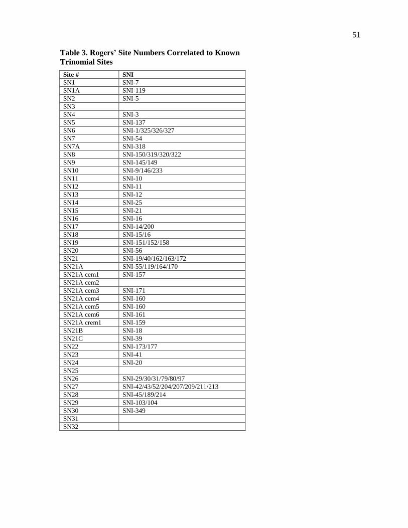
51
Table 3. Rogers’ Site Numbers Correlated to Known
Trinomial Sites
Site # SNI
SN1 SNI-7
SN1A SNI-119
SN2 SNI-5
SN3
SN4 SNI-3
SN5 SNI-137
SN6 SNI-1/325/326/327
SN7 SNI-54
SN7A SNI-318
SN8 SNI-150/319/320/322
SN9 SNI-145/149
SN10 SNI-9/146/233
SN11 SNI-10
SN12 SNI-11
SN13 SNI-12
SN14 SNI-25
SN15 SNI-21
SN16 SNI-16
SN17 SNI-14/200
SN18 SNI-15/16
SN19 SNI-151/152/158
SN20 SNI-56
SN21 SNI-19/40/162/163/172
SN21A SNI-55/119/164/170
SN21A cem1 SNI-157
SN21A cem2
SN21A cem3 SNI-171
SN21A cem4 SNI-160
SN21A cem5 SNI-160
SN21A cem6 SNI-161
SN21A crem1 SNI-159
SN21B SNI-18
SN21C SNI-39
SN22 SNI-173/177
SN23 SNI-41
SN24 SNI-20
SN25
SN26 SNI-29/30/31/79/80/97
SN27 SNI-42/43/52/204/207/209/211/213
SN28 SNI-45/189/214
SN29 SNI-103/104
SN30 SNI-349
SN31
SN32
52
of the same site, it was rehoused in an archival quality bag, labeled, and noted in the catalog,
but not moved from its location.
Artifact descriptions were kept within the previously set museum organizational
system which had separated the artifacts by material. In this system, all artifacts had been
classified by museum staff, first by material type (ex: lithic, bone, shell, etc), and then by
whether the artifact had been modified intentionally (ex: modified, unmodified). While the
system used by museum staff was useful as a starting point, it was too general to allow
researchers to see what was available in this large collection.
In this project, artifacts were described when possible following standard procedures
described by Channel Island archaeologists (e.g., Arnold 2001; Braje 2010; Rick 2007; Rick
et al. 2005). All material types were identified to the greatest detail possible following
descriptions by Arnold (1987), Erlandson (1994), Glassow (1996), Pletka (2001), Rick
(2004), and Wake (2001). Bone and shell artifacts were described and documented in detail
following methods described by Arnold and Graesch (2001), King (1990), Rick (2004), and
Wake (2001). Most artifacts were identified to the greatest detail possible based on
comparisons to Hudson and Blackburn’s (1979) five volume ethnographic and archaeological
encyclopedias, Material Culture of the Chumash Interaction Sphere. Since the function and
classification of some artifacts is still in question (see “Weight” in Hudson and Blackburn
1979:247-251) an attempt was made towards general terms in the artifact description with
more specific attributes noted in the comments section of the catalog. Artifacts were
separated by artifact description, rather than the original general artifact category (ex: Flake
rather than Lithic-Modified). Shell and non-human bone was speciated to the most specific
taxonomic level possible.
Rare artifacts like effigies and charmstones are not seen as often in the archaeological
record today because they are usually found in graves and cemeteries that are not often
excavated because of changing attitudes toward human remains. Because of their rarity,
effigies and charmstones were recorded in more detail, following the work of Cameron
(2000) and Van Bueren and Wiberg (2011). For effigies, and charmstones, weight and
dimensions were taken as well as detailed descriptions.
The comparison of collections to ethnographic data is known as the direct historical
approach (Binford 1962). This assumes that ethnographic use of tools would be the same as
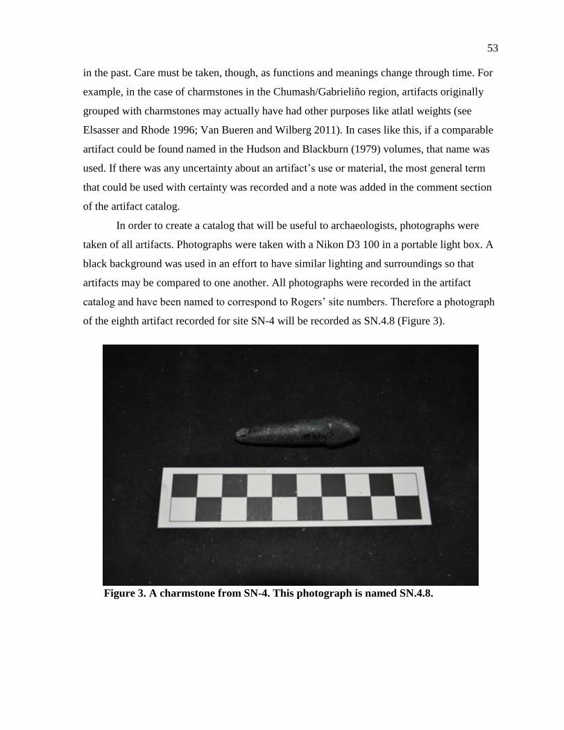
53
in the past. Care must be taken, though, as functions and meanings change through time. For
example, in the case of charmstones in the Chumash/Gabrieliño region, artifacts originally
grouped with charmstones may actually have had other purposes like atlatl weights (see
Elsasser and Rhode 1996; Van Bueren and Wilberg 2011). In cases like this, if a comparable
artifact could be found named in the Hudson and Blackburn (1979) volumes, that name was
used. If there was any uncertainty about an artifact’s use or material, the most general term
that could be used with certainty was recorded and a note was added in the comment section
of the artifact catalog.
In order to create a catalog that will be useful to archaeologists, photographs were
taken of all artifacts. Photographs were taken with a Nikon D3 100 in a portable light box. A
black background was used in an effort to have similar lighting and surroundings so that
artifacts may be compared to one another. All photographs were recorded in the artifact
catalog and have been named to correspond to Rogers’ site numbers. Therefore a photograph
of the eighth artifact recorded for site SN-4 will be recorded as SN.4.8 (Figure 3).
Figure 3. A charmstone from SN-4. This photograph is named SN.4.8.

54
THE COLLECTION TODAY
All records created with this project were digitized in order to allow the information
to be easily shared by the MoM. The photographs and copies of the catalog have been given
to the museum to aid in future research with this collection. This collection is in the process
of being revitalized by the MoM and while access is limited due to budget constraints, I hope
that the digital records that I was able to create may offer researchers a more effective way to
study these artifacts.
55
CHAPTER 7
RESULTS: SITE DESCRIPTIONS AND CATALOG
MOM COLLECTION
Although Rogers wrote about many artifacts in his notes, he did not cover all of the
artifacts that are stored at the museum and his original artifact catalog has been lost. Many of
these artifacts have been labeled in ink in what appears to be Malcolm Rogers’ handwriting
and the museum does not have any record of the collection being rearranged after Rogers’
death. This project was completed working under the assumption that the provenience listed
on these artifacts is the correct provenience from Rogers’ trip to San Nicolas Island.
Much of the detailed provenience of the collection has been lost along with the
original artifact catalog. This has left most artifacts with no provenience other than a site
number that corresponds to one of Rogers’ original tract numbers described above. Some
artifacts, however, can be correlated to more specific information by matching them with
their physical descriptions in Rogers’ notes. For example, although there are many bead
necklaces in SN-21, specific ones can be matched with burials by their qualitative
descriptions (e.g. flat beads with steatite). These have been noted in the artifact catalog and
interesting correlations are discussed in the next chapter.
Some of the language used in Rogers’ notes is difficult to understand, or references
colloquialisms that are unfamiliar. In some places, Rogers’ exact wording is referenced as
well as what it is assumed that he meant. Especially in shell types, colloquialisms were
changed to reflect what it is assumed Rogers was referencing. For example Rogers uses
“butterfly shells” in reference to what has been determined to be chitons and “tent shells” in
reference to a member of the Trochidae family, or commonly named top shells.
SITE DESCRIPTIONS
There are 31 sites listed in Rogers’ notes where he collected artifacts in 1930.
Although site 32 is listed in Rogers’ notes, it was excavated later in 1934 during a subsequent
trip. However, since the artifacts from the 1930, 1934, and the 1938 field seasons have been
56
stored together and there is no way to distinguish between them, they are considered together
in this project. The only clear provenience left to separate the artifacts is the corresponding
site numbers that Rogers assigned. Rogers found the island to be what he considered “one
great continuous village” (Rogers 1993:2). Rather than individual sites, Rogers separated the
island into numbered tracts based on the topography as well as the archaeology (Rogers
1993). This does little to help distinguish living areas of prehistoric people, but it is the only
remaining identification still associated with the artifacts. Therefore, I have separated each
section by Rogers’ original classification system.
Rogers’ site numbers have been aligned with their corresponding current site numbers
by Navy archaeologist Steven Schwartz. These associations have been made through a
careful reading of Rogers’ notes as well as Schwartz’s topographic and archaeological
knowledge of the island. Site numbers are referenced by both Rogers’ field numbers (SN-) as
well as the current numbers in parenthesis for easy reference to archaeological sites on San
Nicolas (SNI-). For each numbered tract Rogers’ notes on location, features, excavation
methods, artifacts, and chronology will be discussed, as well as the artifacts in the MoM
collection and any other relevant research.
SN-1 (SNI-7)
Rogers’ first site was recorded on July 11, 1930; the day after the team arrived on the
island. SN-1 is located on the central north coast of San Nicolas Island, very near the East
side of Crescent Bay (Rogers 1930; Schwartz, personal communication, November 13,
2012). The site was determined to be about three acres wide and 16 inches deep, although
Rogers hypothesized that it may have been about two feet deep previously (Rogers 1930). An
acre on an adjoining hill to the rear was labeled as “1-A” and had a depth of about eight
inches (Rogers 1930:3).
Among the features mentioned in Rogers’ notes were three different kinds of hearths,
“a basin type in the fossil dune, the square shaped pavement of sandstone slabs and a single
slab horizontally supported on cobbles” (Rogers 1930:5). He also found a burial of three
dogs, one of them pregnant, about fourteen inches under the midden, with no evidence of
violence (Rogers 1930). In a washed out cemetery, they found parts of a skeleton that was
badly damaged by erosion (Rogers 1930). Rogers estimated the composition of many of the
57
middens around the island and in site SN-1 he estimated a 10% composition of fishbone and
terrestrial bone and 90% shell composed mostly of mussel, abalone, and land snail with sea
urchins, sea snail, chitons and red abalone present (Rogers 1930).
Although Rogers does not specifically mention what if any excavation he completed
at this site, it is obvious from his notes that at the very least he did some surface collecting as
well as some excavation to uncover both the human and canine burials listed in his notes.
The artifacts from SN-1 that are housed in the MoM collection are varied (Table 4).
Many of the decorative artifacts like shell beads and stone and shell ornaments were likely
found in the cemetery area, although there is no clear provenience linking them with burials.
There are also artifacts that indicate domestic production (awl and stone flakes) as well as
fishing practices (one fishhook and a possible fishing net weight).
Rogers dated this site as mostly Middle Period with some Late Period midden. His
only proof for a Late Period occupation was the presence of fishhooks and a smashed
sandstone bowl with a squared off rim (Rogers 1930). He found that SN-1 was “started
directly on an indurated dune” although he also stated that it was possible that Late Period
culture was not seen because of erosion and that the Early Period shows on the point (Rogers
1930:5).
SN-1A (SNI-119)
Rogers labeled SN-1A as a subset of SN-1 because of its location on a hill behind
SN-1 and the similarities between their midden deposits (Rogers 1930). SN-1A has a depth
of about eight inches (Rogers 1930). Among the features that Rogers found at this site were
community houses, quartz working, a dog burial and a human burial. Rogers found SN-1A to
be less eroded than SN-1 allowing him to find at least one, and possibly two, large
community houses outlined on the top of the site (Rogers 1930). The community house that
was definitely visible measured north to south 39 feet and east to west 35 feet (Rogers 1930).
Upon reworking SN-1A, Rogers excavated a trench through another large community house
that measured 34 feet in order to find the floor. His sketch of the community house
(Figure 4) located a shell layer with a sandstone hearth in its center within the excavated
trench (Rogers 1930). He also found “much quartz working” and that the shell ratio followed
about the same as site SN-1 but without patches of sea urchins (Rogers 1930:6).

58
Table 4. Artifacts from SN-1
Artifact Number Modification Material
Abalone
Fragment 9 Ground
Red Abalone, Black Abalone
Asphaltum 15
Asphaltum
Awl 2 Chipped Unidentified Stone
Biface 21 Chipped Quartz, Quartzite, Chert, Slate, Unidentified Stone
Blank 27 Ground, Chipped Red Abalone
Bone Point 10 Ground Unidentified Bone
Choppers 3 Pecked Unidentified Stone
Core 6 Chipped Unidentified Stone
Dog Burial 3
Dog Bone
Donut Stone 11 Ground Sandstone, Steatite, Soapstone
Drill 14 Ground Concretion
Flake 14 Chipped Unidentified Stone
Fishhook 19 Ground Red Abalone
Limpet Ornament 11 Ground Limpet
Mano 3 Ground, Pecked Sandstone, Unidentified Stone
Mixing Dish 1 Ground Sandstone, Asphaltum
Mortar 1 Ground Sandstone
Needle 4
Drilled, Ground,
Burnt
Unidentified Bone
Pendant 1 Ground Serpentine
Pestle 5 Ground, Pecked Sandstone
Point 1 Ground, Incised Steatite
Pry Bar 6 Ground Unidentified Bone
Red Ochre 4
Red Ochre
Scraper 7 Chipped Sandstone, Unidentified Stone
Shell Bead 130 Ground, Punched Olivella, Unidentified Shell
Shell Pendant 7 Drilled, Ground Cowry, Cardium, Unidentified Shell
Stone Bead 7 Ground Serpentine
Unidentified
Bone 13
Ground, Incised,
Drilled
Unidentified Bone
Unidentified
Shell 23 Ground, Chipped
Unidentified Shell
Unidentified
Stone 10 Ground
Sandstone, Soapstone, Unidentified Stone
Unidentified
Wood 1
Wood
Unmodified Bone 136 Burnt Bird, Sheephead, Dog, Unidentified Bone
Unmodified Shell 27
Astrea, Snail, Mussel, Clam, Unidentified Shell
Weight 2 Ground Sandstone
Whistle 3 Drilled, Incised Bird, Unidentified Bone
One human burial was found at SN-1A by accidentally finding the top of a skull
exposed near the side of a house pit (Rogers 1930). SK-1, as Rogers labeled it, was a female
with no mortuary offerings (Rogers 1930). Rogers noted that livestock had broken a hole
through the right parietal bone which could enable a researcher with access to the skeletal
collections at the MoM to identify this particular burial (Rogers 1930). Her body was found
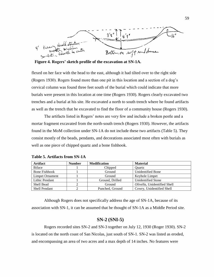
59
Figure 4. Rogers’ sketch profile of the excavation at SN-1A.
flexed on her face with the head to the east, although it had tilted over to the right side
(Rogers 1930). Rogers found more than one pit in this location and a section of a dog’s
cervical column was found three feet south of the burial which could indicate that more
burials were present in this location at one time (Rogers 1930). Rogers clearly excavated two
trenches and a burial at his site. He excavated a north to south trench where he found artifacts
as well as the trench that he excavated to find the floor of a community house (Rogers 1930).
The artifacts listed in Rogers’ notes are very few and include a broken pestle and a
mortar fragment excavated from the north-south trench (Rogers 1930). However, the artifacts
found in the MoM collection under SN-1A do not include these two artifacts (Table 5). They
consist mostly of the beads, pendants, and decorations associated most often with burials as
well as one piece of chipped quartz and a bone fishhook.
Table 5. Artifacts from SN-1A
Artifact Number Modification Material
Biface 1 Chipped Quartz
Bone Fishhook 1 Ground Unidentified Bone
Limpet Ornament 1 Ground Keyhole Limpet
Lithic Pendant 1 Ground, Drilled Unidentified Stone
Shell Bead 2 Ground Olivella, Unidentified Shell
Shell Pendant 2 Punched, Ground Cowry, Unidentified Shell
Although Rogers does not specifically address the age of SN-1A, because of its
association with SN-1, it can be assumed that he thought of SN-1A as a Middle Period site.
SN-2 (SNI-5)
Rogers recorded sites SN-2 and SN-3 together on July 12, 1930 (Roger 1930). SN-2
is located on the north coast of San Nicolas, just south of SN-1. SN-2 was listed as eroded,
and encompassing an area of two acres and a max depth of 14 inches. No features were
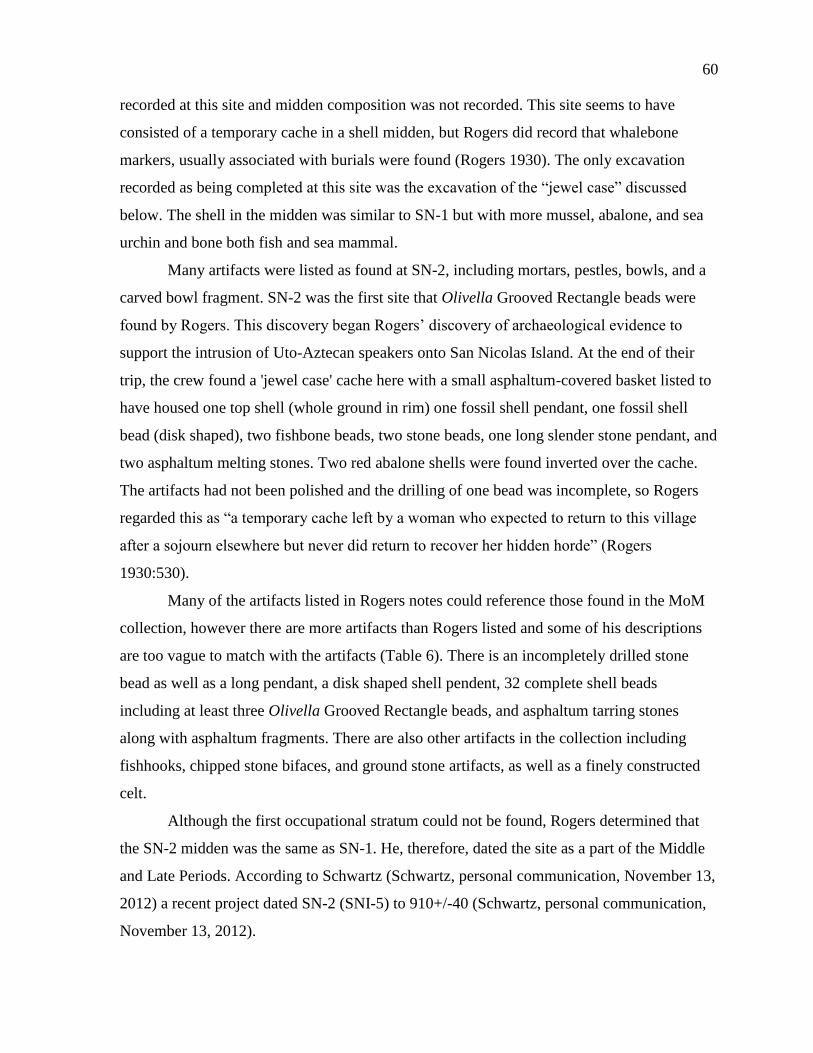
60
recorded at this site and midden composition was not recorded. This site seems to have
consisted of a temporary cache in a shell midden, but Rogers did record that whalebone
markers, usually associated with burials were found (Rogers 1930). The only excavation
recorded as being completed at this site was the excavation of the “jewel case” discussed
below. The shell in the midden was similar to SN-1 but with more mussel, abalone, and sea
urchin and bone both fish and sea mammal.
Many artifacts were listed as found at SN-2, including mortars, pestles, bowls, and a
carved bowl fragment. SN-2 was the first site that Olivella Grooved Rectangle beads were
found by Rogers. This discovery began Rogers’ discovery of archaeological evidence to
support the intrusion of Uto-Aztecan speakers onto San Nicolas Island. At the end of their
trip, the crew found a 'jewel case' cache here with a small asphaltum-covered basket listed to
have housed one top shell (whole ground in rim) one fossil shell pendant, one fossil shell
bead (disk shaped), two fishbone beads, two stone beads, one long slender stone pendant, and
two asphaltum melting stones. Two red abalone shells were found inverted over the cache.
The artifacts had not been polished and the drilling of one bead was incomplete, so Rogers
regarded this as “a temporary cache left by a woman who expected to return to this village
after a sojourn elsewhere but never did return to recover her hidden horde” (Rogers
1930:530).
Many of the artifacts listed in Rogers notes could reference those found in the MoM
collection, however there are more artifacts than Rogers listed and some of his descriptions
are too vague to match with the artifacts (Table 6). There is an incompletely drilled stone
bead as well as a long pendant, a disk shaped shell pendent, 32 complete shell beads
including at least three Olivella Grooved Rectangle beads, and asphaltum tarring stones
along with asphaltum fragments. There are also other artifacts in the collection including
fishhooks, chipped stone bifaces, and ground stone artifacts, as well as a finely constructed
celt.
Although the first occupational stratum could not be found, Rogers determined that
the SN-2 midden was the same as SN-1. He, therefore, dated the site as a part of the Middle
and Late Periods. According to Schwartz (Schwartz, personal communication, November 13,
2012) a recent project dated SN-2 (SNI-5) to 910+/-40 (Schwartz, personal communication,
November 13, 2012).
61
Table 6. Artifacts from SN-2
Artifact Number Modification Material
Asphaltum 9
Asphaltum with Stones
Biface 6 Chipped Unidentified Stone
Blank 4 Ground Red Abalone, Unidentified Shell
Bone Beads-Possibly Floats 2 Drilled, Ground Unidentified Bone
Bone Point 2 Ground Unidentified Bone
Celt 1 Ground Unidentified Stone
Donut Stone 4 Ground Sandstone
Hook 7 Burnt, Ground Abalone
Limpet Ornament 2 Ground Limpet
Lithic Pendant 1 Drilled, Ground Steatite
Mano 2 Ground Unidentified Stone
Pestle 3 Ground Sandstone
Shell Bead 32 Drilled, Ground Olivella, Unidentified Shell
Shell Disks 2 Ground Unidentified Shell
Shell Pendant 5 Drilled Cowry, Unidentified Shell
Stone Bead 4 Drilled, Ground Steatite, Unidentified Stone
Unidentified Bone 2 Ground Unidentified Bone
Unmodified Bone 4
Sheephead Bone
Unmodified Shell 2
Red Abalone, Snail
Unmodified Shell 2
Clam, Unidentified Shell
Weight 1 Ground Sandstone
SN-3
SN-3 is on the north coast of San Nicolas Island, just to the southeast of SN-2 and
northwest of SN-4. SN-3 has not been associated with a current site located on San Nicolas
Island and is likely an extension of SN-2(SNI-5). Rogers recorded SN-3 as badly eroded, but
still with an area of three acres. The features were not specifically recorded at SN-3, but were
instead listed as the same as those at SN-2 including midden composition, occupational
strata, cemeteries, and artifacts. It is unclear the specific strategy that Rogers used to study
SN-3, but it is clear that a combination of surface collection and at least a minimal amount of
excavation was completed.
At SN-3, Rogers also found a cache of fishhook blanks along with manufacturing
tools associated with fishhook manufacture including two reamers, bone awls, and rhizo-
concretion grinders about 14 inches deep (Rogers 1930; see Table 7). The fishing artifacts
are present in the artifact catalog from MoM as well as bone and groundstone tools, beads,
and a fragmented soapstone effigy. A large monolith is noted at this site that was 40 inches
long and had been worked (Rogers 1930). Due to similarities with SN-2, Rogers placed SN-3
in the same age categories of Middle and Late Periods.

62
Table 7. Artifacts from SN-3
Artifact Number Modification Material
Awl 1 Ground Deer Bone
Biface 3 Chipped Unidentified Stone
Blank 11 Chipped, Ground Red Abalone
Bone Point 5 Ground Unidentified Bone
Core 2 Chipped Unidentified Stone
Donut Stone 2 Ground Sandstone, Steatite
Double Ended Bone
Point 4 Ground
Unidentified Bone
Drill 2 Ground Concretion
Effigy 1 Ground Soapstone
Fishhook 6 Ground Abalone
Flake 2 Chipped Unidentified Stone
Hafted Tool 2 Ground, Stained Unidentified Bone
Limpet Ornament 4 Ground Keyhole Limpet
Lithic Pendant 1 Drilled, Ground Unidentified Stone
Mano 1 Ground Sandstone
Mortar 2 Ground Sandstone
Mortar 1 Ground Sandstone
Pestle 1 Ground Sandstone
Pestle Fragment 1 Ground Sandstone
Pry Bar 5 Ground Unidentified Bone
Red Ochre 4
Red Ochre
Root Cast 4
Sandstone
Shell Bead 26 Ground, Punched Olivella, Unidentified Shell
Shell Pendant 2
Drilled, Ground,
Punched
Olivella, Mussel, Limpet, Unidentified Shell
Unidentified Bone 2 Ground Unidentified Bone
Unidentified Shell 7 Ground, Chipped Unidentified Shell
Unidentified Stone 1 Ground Unidentified Stone
Unmodified Bone 3
Sheephead, Unidentified Bone
Unmodified Shell 5
Bowl Limpet, Pectin, Tegula, Unidentified
Shell
Weight 1 Ground Sandstone
SN-4 (SNI-3)
SN-4 is located on the north coastline of San Nicolas Island to the southeast of SN-3
and northwest of SN-5. Rogers describes this site as having two mounded shell middens with
an arroyo between them (Rogers 1930). He estimated the size to be about three acres with a
maximum depth of about 15 inches, but assumes an original depth of about a foot, but more
had probably been warn away due to erosion (Rogers 1930). There is very little recorded
about SN-4 and nothing on exactly what Rogers did or collected there. The MoM collection
houses a variety of artifacts that are similar to most of the sites in the Rogers’ collection with
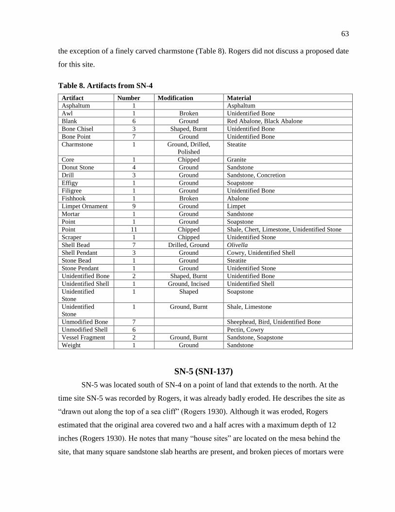
63
the exception of a finely carved charmstone (Table 8). Rogers did not discuss a proposed date
for this site.
Table 8. Artifacts from SN-4
Artifact Number Modification Material
Asphaltum 1 Asphaltum
Awl 1 Broken Unidentified Bone
Blank 6 Ground Red Abalone, Black Abalone
Bone Chisel 3 Shaped, Burnt Unidentified Bone
Bone Point 7 Ground Unidentified Bone
Charmstone 1 Ground, Drilled,
Polished
Steatite
Core 1 Chipped Granite
Donut Stone 4 Ground Sandstone
Drill 3 Ground Sandstone, Concretion
Effigy 1 Ground Soapstone
Filigree 1 Ground Unidentified Bone
Fishhook 1 Broken Abalone
Limpet Ornament 9 Ground Limpet
Mortar 1 Ground Sandstone
Point 1 Ground Soapstone
Point 11 Chipped Shale, Chert, Limestone, Unidentified Stone
Scraper 1 Chipped Unidentified Stone
Shell Bead 7 Drilled, Ground Olivella
Shell Pendant 3 Ground Cowry, Unidentified Shell
Stone Bead 1 Ground Steatite
Stone Pendant 1 Ground Unidentified Stone
Unidentified Bone 2 Shaped, Burnt Unidentified Bone
Unidentified Shell 1 Ground, Incised Unidentified Shell
Unidentified
Stone
1 Shaped Soapstone
Unidentified
Stone
1 Ground, Burnt Shale, Limestone
Unmodified Bone 7 Sheephead, Bird, Unidentified Bone
Unmodified Shell 6 Pectin, Cowry
Vessel Fragment 2 Ground, Burnt Sandstone, Soapstone
Weight 1 Ground Sandstone
SN-5 (SNI-137)
SN-5 was located south of SN-4 on a point of land that extends to the north. At the
time site SN-5 was recorded by Rogers, it was already badly eroded. He describes the site as
“drawn out along the top of a sea cliff” (Rogers 1930). Although it was eroded, Rogers
estimated that the original area covered two and a half acres with a maximum depth of 12
inches (Rogers 1930). He notes that many “house sites” are located on the mesa behind the
site, that many square sandstone slab hearths are present, and broken pieces of mortars were
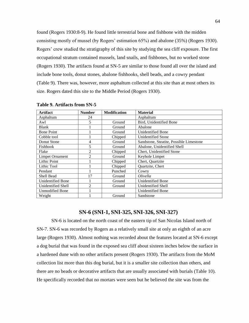
64
found (Rogers 1930:8-9). He found little terrestrial bone and fishbone with the midden
consisting mostly of mussel (by Rogers’ estimation 65%) and abalone (35%) (Rogers 1930).
Rogers’ crew studied the stratigraphy of this site by studying the sea cliff exposure. The first
occupational stratum contained mussels, land snails, and fishbones, but no worked stone
(Rogers 1930). The artifacts found at SN-5 are similar to those found all over the island and
include bone tools, donut stones, abalone fishhooks, shell beads, and a cowry pendant
(Table 9). There was, however, more asphaltum collected at this site than at most others its
size. Rogers dated this site to the Middle Period (Rogers 1930).
Table 9. Artifacts from SN-5
Artifact Number Modification Material
Asphaltum 24 Asphaltum
Awl 5 Ground Bird, Unidentified Bone
Blank 1 Ground Abalone
Bone Point 1 Ground Unidentified Bone
Cobble tool 1 Chipped Unidentified Stone
Donut Stone 4 Ground Sandstone, Steatite, Possible Limestone
Fishhook 5 Ground Abalone, Unidentified Shell
Flake 2 Chipped Chert, Unidentified Stone
Limpet Ornament 2 Ground Keyhole Limpet
Lithic Point 1 Chipped Chert, Quartzite
Lithic Tool 1 Chipped Quartzite, Chert
Pendant 1 Punched Cowry
Shell Bead 17 Ground Olivella
Unidentified Bone 1 Ground Unidentified Bone
Unidentified Shell 2 Ground Unidentified Shell
Unmodified Bone 1 Unidentified Bone
Weight 1 Ground Sandstone
SN-6 (SNI-1, SNI-325, SNI-326, SNI-327)
SN-6 is located on the north coast of the eastern tip of San Nicolas Island north of
SN-7. SN-6 was recorded by Rogers as a relatively small site at only an eighth of an acre
large (Rogers 1930). Almost nothing was recorded about the features located at SN-6 except
a dog burial that was found in the exposed sea cliff about sixteen inches below the surface in
a hardened dune with no other artifacts present (Rogers 1930). The artifacts from the MoM
collection list more than this dog burial, but it is a smaller site collection than others, and
there are no beads or decorative artifacts that are usually associated with burials (Table 10).
He specifically recorded that no mortars were seen but he believed the site was from the
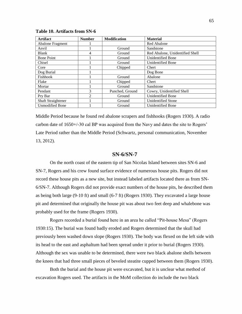
65
Table 10. Artifacts from SN-6
Artifact Number Modification Material
Abalone Fragment 1 Red Abalone
Anvil 1 Ground Sandstone
Blank 4 Ground Red Abalone, Unidentified Shell
Bone Point 1 Ground Unidentified Bone
Chisel 1 Ground Unidentified Bone
Core 1 Chipped Chert
Dog Burial 1 Dog Bone
Fishhook 1 Ground Abalone
Flake 1 Chipped Chert
Mortar 1 Ground Sandstone
Pendant 3 Punched, Ground Cowry, Unidentified Shell
Pry Bar 2 Ground Unidentified Bone
Shaft Straightener 1 Ground Unidentified Stone
Unmodified Bone 1 Ground Unidentified Bone
Middle Period because he found red abalone scrapers and fishhooks (Rogers 1930). A radio
carbon date of 1650+/-30 cal BP was acquired from the Navy and dates the site to Rogers’
Late Period rather than the Middle Period (Schwartz, personal communication, November
13, 2012).
SN-6/SN-7
On the north coast of the eastern tip of San Nicolas Island between sites SN-6 and
SN-7, Rogers and his crew found surface evidence of numerous house pits. Rogers did not
record these house pits as a new site, but instead labeled artifacts located there as from SN-
6/SN-7. Although Rogers did not provide exact numbers of the house pits, he described them
as being both large (9-10 ft) and small (6-7 ft) (Rogers 1930). They excavated a large house
pit and determined that originally the house pit was about two feet deep and whalebone was
probably used for the frame (Rogers 1930).
Rogers recorded a burial found here in an area he called “Pit-house Mesa” (Rogers
1930:15). The burial was found badly eroded and Rogers determined that the skull had
previously been washed down slope (Rogers 1930). The body was flexed on the left side with
its head to the east and asphaltum had been spread under it prior to burial (Rogers 1930).
Although the sex was unable to be determined, there were two black abalone shells between
the knees that had three small pieces of beveled steatite cupped between them (Rogers 1930).
Both the burial and the house pit were excavated, but it is unclear what method of
excavation Rogers used. The artifacts in the MoM collection do include the two black
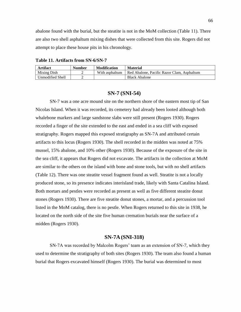
66
abalone found with the burial, but the steatite is not in the MoM collection (Table 11). There
are also two shell asphaltum mixing dishes that were collected from this site. Rogers did not
attempt to place these house pits in his chronology.
Table 11. Artifacts from SN-6/SN-7
Artifact Number Modification Material
Mixing Dish 2 With asphaltum Red Abalone, Pacific Razor Clam, Asphaltum
Unmodified Shell 2 Black Abalone
SN-7 (SNI-54)
SN-7 was a one acre mound site on the northern shore of the eastern most tip of San
Nicolas Island. When it was recorded, its cemetery had already been looted although both
whalebone markers and large sandstone slabs were still present (Rogers 1930). Rogers
recorded a finger of the site extended to the east and ended in a sea cliff with exposed
stratigraphy. Rogers mapped this exposed stratigraphy as SN-7A and attributed certain
artifacts to this locus (Rogers 1930). The shell recorded in the midden was noted at 75%
mussel, 15% abalone, and 10% other (Rogers 1930). Because of the exposure of the site in
the sea cliff, it appears that Rogers did not excavate. The artifacts in the collection at MoM
are similar to the others on the island with bone and stone tools, but with no shell artifacts
(Table 12). There was one steatite vessel fragment found as well. Steatite is not a locally
produced stone, so its presence indicates interisland trade, likely with Santa Catalina Island.
Both mortars and pestles were recorded as present as well as five different steatite donut
stones (Rogers 1930). There are five steatite donut stones, a mortar, and a percussion tool
listed in the MoM catalog, there is no pestle. When Rogers returned to this site in 1938, he
located on the north side of the site five human cremation burials near the surface of a
midden (Rogers 1930).
SN-7A (SNI-318)
SN-7A was recorded by Malcolm Rogers’ team as an extension of SN-7, which they
used to determine the stratigraphy of both sites (Rogers 1930). The team also found a human
burial that Rogers excavated himself (Rogers 1930). The burial was determined to most
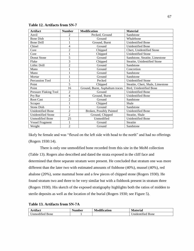
67
Table 12. Artifacts from SN-7
Artifact Number Modification Material
Anvil 2 Pecked, Ground Sandstone
Bone Dish 1 Ground Whalebone
Bone Drill 1 Ground, Burnt Unidentified Bone
Chisel 4 Ground Unidentified Bone
Core 2 Chipped Chert, Unidentified Stone
Core 1 Chipped Unidentified Stone
Donut Stone 5 Ground Sandstone, Steatite, Limestone
Flake 3 Chipped Steatite, Unidentified Stone
Lithic Drill 2 Ground Sandstone
Mano 1 Ground Concretion
Mano 1 Ground Sandstone
Mortar 1 Ground Sandstone
Percussion Tool 1 Pecked Unidentified Stone
Point 5 Chipped Steatite, Chert, Shale, Limestone
Point 16 Ground, Burnt, Asphaltum traces Bird, Unidentified Bone
Pressure Flaking Tool 2 Ground Unidentified Bone
Pry Bar 4 Ground, Burnt Unidentified Bone
Root Cast 2 Ground Sandstone
Scraper 1 Chipped Shale
Stone Dish 1 Ground Sandstone
Unidentified Bone 2 Broken, Possibly Painted Unidentified Bone
Unidentified Stone 2 Ground, Chipped Steatite, Shale
Unmodified Bone 25 Unmodified Unidentified Bone
Vessel Fragment 1 Ground Steatite
Weight 2 Ground Sandstone
likely be female and was “flexed on the left side with head to the north” and had no offerings
(Rogers 1930:14).
There is only one unmodified bone recorded from this site in the MoM collection
(Table 13). Rogers also described and dated the strata exposed in the cliff face and
determined that three separate stratum were present. He concluded that stratum one was more
different than the later two with estimated amounts of fishbone (40%), mussel (40%), red
abalone (20%), some mammal bone and a few pieces of chipped stone (Rogers 1930). He
found stratum two and three to be very similar but with a fishhook present in stratum three
(Rogers 1930). His sketch of the exposed stratigraphy highlights both the ratios of midden to
sterile deposits as well as the location of the burial (Rogers 1930; see Figure 5).
Table 13. Artifacts from SN-7A
Artifact Number Modification Material
Unmodified Bone 1 Unidentified Bone
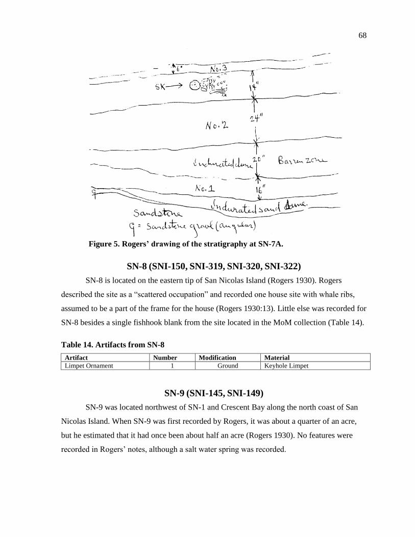
68
Figure 5. Rogers’ drawing of the stratigraphy at SN-7A.
SN-8 (SNI-150, SNI-319, SNI-320, SNI-322)
SN-8 is located on the eastern tip of San Nicolas Island (Rogers 1930). Rogers
described the site as a “scattered occupation” and recorded one house site with whale ribs,
assumed to be a part of the frame for the house (Rogers 1930:13). Little else was recorded for
SN-8 besides a single fishhook blank from the site located in the MoM collection (Table 14).
Table 14. Artifacts from SN-8
Artifact Number Modification Material
Limpet Ornament 1 Ground Keyhole Limpet
SN-9 (SNI-145, SNI-149)
SN-9 was located northwest of SN-1 and Crescent Bay along the north coast of San
Nicolas Island. When SN-9 was first recorded by Rogers, it was about a quarter of an acre,
but he estimated that it had once been about half an acre (Rogers 1930). No features were
recorded in Rogers’ notes, although a salt water spring was recorded.
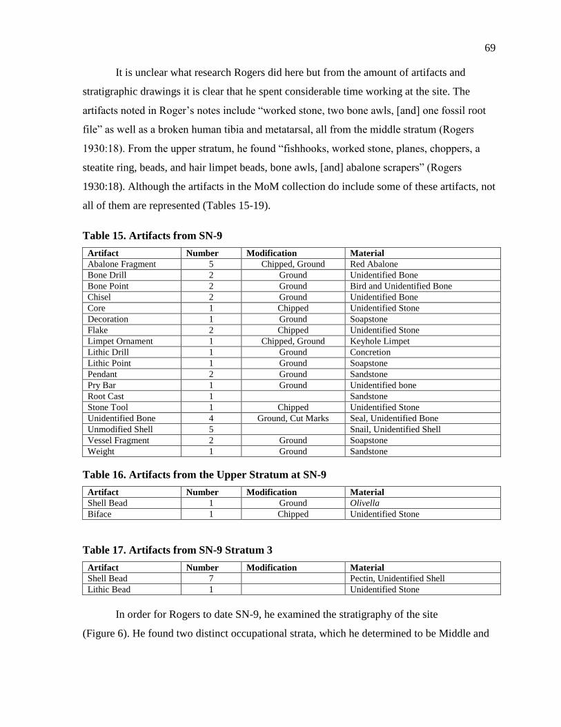
69
It is unclear what research Rogers did here but from the amount of artifacts and
stratigraphic drawings it is clear that he spent considerable time working at the site. The
artifacts noted in Roger’s notes include “worked stone, two bone awls, [and] one fossil root
file” as well as a broken human tibia and metatarsal, all from the middle stratum (Rogers
1930:18). From the upper stratum, he found “fishhooks, worked stone, planes, choppers, a
steatite ring, beads, and hair limpet beads, bone awls, [and] abalone scrapers” (Rogers
1930:18). Although the artifacts in the MoM collection do include some of these artifacts, not
all of them are represented (Tables 15-19).
Table 15. Artifacts from SN-9
Artifact Number Modification Material
Abalone Fragment 5 Chipped, Ground Red Abalone
Bone Drill 2 Ground Unidentified Bone
Bone Point 2 Ground Bird and Unidentified Bone
Chisel 2 Ground Unidentified Bone
Core 1 Chipped Unidentified Stone
Decoration 1 Ground Soapstone
Flake 2 Chipped Unidentified Stone
Limpet Ornament 1 Chipped, Ground Keyhole Limpet
Lithic Drill 1 Ground Concretion
Lithic Point 1 Ground Soapstone
Pendant 2 Ground Sandstone
Pry Bar 1 Ground Unidentified bone
Root Cast 1 Sandstone
Stone Tool 1 Chipped Unidentified Stone
Unidentified Bone 4 Ground, Cut Marks Seal, Unidentified Bone
Unmodified Shell 5 Snail, Unidentified Shell
Vessel Fragment 2 Ground Soapstone
Weight 1 Ground Sandstone
Table 16. Artifacts from the Upper Stratum at SN-9
Artifact Number Modification Material
Shell Bead 1 Ground Olivella
Biface 1 Chipped Unidentified Stone
Table 17. Artifacts from SN-9 Stratum 3
Artifact Number Modification Material
Shell Bead 7 Pectin, Unidentified Shell
Lithic Bead 1 Unidentified Stone
In order for Rogers to date SN-9, he examined the stratigraphy of the site
(Figure 6). He found two distinct occupational strata, which he determined to be Middle and

70
Table 18. Artifacts from the Bottom Stratum at SN-9
Artifact Number Modification Material
Unmodified Bone 19 Unidentified Bone
Unidentified Shell 2 Broken Unidentified Shell
Table 19. Artifacts from the Human Burial East of SN-9
Artifact Number Modification Material
Fishhook 2 Ground Abalone
Limpet Ornament 2 Ground Limpet
Pendant 1 Drilled, Ground Unidentified Shell
Shell Bead 16 Ground, Drilled Olivella, Unidentified Shell
Late Periods. He did find another layer visible in an exposed cliff that may have been from
the Early Period as it included many land snail shells but no formal artifacts (Rogers 1930).
The Middle Period stratum was about 14 inches thick with the majority being fishbone (40%)
and sea urchin (40%) and the rest made up of mussel (15%), abalone, and some land snail
(Rogers 1930). The upper stratum, 12 inches thick, consisted of mostly of sea urchins (30%),
black abalone (20%), astrea (20%), land snail, sea snail, chiton shells and more fishbone than
in the middle stratum.
SN-10(SNI-9, SNI-146, SNI-233)
SN-10 was located to the northwest of SN-9 and to the south of SN-11 on the north
coast of San Nicolas Island. Rogers’ team members discovered SN-10 and made surface
collections before Rogers saw the site and made notes himself (Rogers 1930). Then, as they
were moving camp locations, Rogers recorded this site as a two acre late site with a
previously excavated cemetery (Rogers 1930). He recorded the shell ratios of SN-10 as
mostly urchin, mussel, and abalone with snail and top shell present but in lesser densities
(Rogers 1930). He also recorded “plentiful” fishbone in localized places (Rogers 1930:20).
This site was not trenched but the stratigraphy was recorded from a western cliff and
included in his notes with the drawing in Figure 7 (Rogers 1930). No artifacts were recorded
in Rogers’ notes for this site, but the MoM collection has many artifacts including gaming
bones, beads, and pipe fragments (Table 20). Rogers dated SN-10 as a late site with
underlying midden that may be from an earlier period.

71
Figure 6. Rogers’ drawing of SN-9 stratigraphy.
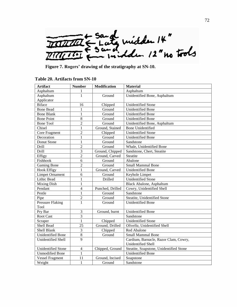
72
Figure 7. Rogers’ drawing of the stratigraphy at SN-10.
Table 20. Artifacts from SN-10
Artifact Number Modification Material
Asphaltum 1 Asphaltum
Asphaltum
Applicator
1 Ground Unidentified Bone, Asphaltum
Biface 16 Chipped Unidentified Stone
Bone Bead 1 Ground Unidentified Bone
Bone Blank 1 Ground Unidentified Bone
Bone Point 8 Ground Unidentified Bone
Bone Tool 2 Ground Unidentified Bone, Asphaltum
Chisel 1 Ground, Stained Bone Unidentified
Core Fragment 2 Chipped Unidentified Stone
Decoration 1 Ground Unidentified Bone
Donut Stone 1 Ground Sandstone
Drill 2 Ground Whale, Unidentified Bone
Drill 3 Ground, Chipped Sandstone, Chert, Steatite
Effigy 2 Ground, Carved Steatite
Fishhook 6 Ground Abalone
Gaming Bone 2 Ground Small Mammal Bone
Hook Effigy 1 Ground, Carved Unidentified Bone
Limpet Ornament 6 Ground Keyhole Limpet
Lithic Bead 1 Drilled Unidentified Stone
Mixing Dish 1 Black Abalone, Asphaltum
Pendant 4 Punched, Drilled Cowry, Unidentified Shell
Pestle 1 Ground Sandstone
Pipe 2 Ground Steatite, Unidentified Stone
Pressure Flaking
Tool
1 Ground Unidentified Bone
Pry Bar 3 Ground, burnt Unidentified Bone
Root Cast 3 Sandstone
Scraper 1 Chipped Unidentified Stone
Shell Bead 25 Ground, Drilled Olivella, Unidentified Shell
Shell Blank 3 Chipped Red Abalone
Unidentified Bone 8 Ground Small Mammal Bone
Unidentified Shell 9 Cardium, Barnacle, Razor Clam, Cowry,
Unidentified Shell
Unidentified Stone 4 Chipped, Ground Steatite, Soapstone, Unidentified Stone
Unmodified Bone 1 Unidentified Bone
Vessel Fragment 11 Ground, Incised Soapstone
Weight 1 Ground Sandstone
73
SN-11(SNI-10)
SN-11 is located on the north coast of San Nicolas Island northwest of SN-10 and
southeast of SN-12. Site SN-11 was in the group of sites that Rogers’ team originally
discovered on the north coast of the island. Like many of the other sites on the island, SN-11
is composed of shell midden mounds but SN-11 was heavily eroded. Although he wondered
why the people were living on such a steep slope, it seems probable that the site was eroded
down slope out of primary context (Rogers 1930). The only features noted at this site were
shell middens that were composed of mussel, abalone, urchin, and land snail shell with a few
areas of fishbone (Rogers 1930). He also noted many manos and other grinding implements,
although in the MoM collection there are only two manos (Rogers 1930; see Table 21). Two
of the most interesting artifacts in the MoM collection are two sea mammal bones that have
both been circularly incised and match descriptions of gaming bones listed in Hudson and
Blackburn’s (1979) volumes (see Figure 8). Rogers (1930) described SN-11 as being a Late
Period site based on its artifacts.
SN-12(SNI-11)
SN-12 was on the west end of the north coast just northwest of SN-11. SN-12 was
one of the sites that the Sanger party investigated before Rogers and their looting of the
cemetery was apparent to Rogers (Rogers 1930). The site was about two and a half acres.
The shell midden composition was similar to SN-11, only with more land snail and fewer
urchins (Rogers 1930). Although Rogers did not trench at this site, he did note that an Early
Period midden was visible in eroding exposures (Rogers 1930). He also noted that one Late
Period human male was collected along with the first steatite donut stone of their trip (Rogers
1930). On their way back to base camp at the end of the trip, Rogers and his crew also found
a washed out human male skull at SN-12 with the dentition still intact but the facial bones
missing (Rogers 1930). The artifacts in the MoM collection include some interesting pieces
including a small obsidian flake, and a steatite donut stone that may be the one that Rogers
notes (Table 22). The collection also includes two fragments of a brown ware jar with a
brown drip glaze (Figure 9). The fragments have been glued back together. Although this
brown ware jar is almost certainly of historical origin and probably belonged to historical
74
Table 21. Artifacts from SN-11
Artifact Number Modification Material
Abalone Fragment 1 Ground Red Abalone
Anvil 1 Ground, Drilled/Pecked Sandstone
Asphaltum 1 Asphaltum
Awl 1 Ground Unidentified Bone
Biface 2 Chipped Unidentified Stone
Blank 4 Ground Red Abalone, Unidentified Shell
Bone Pendant 1 Ground, Drilled Unidentified Bone
Bone Point 3 Ground Unidentified Bone
Chisel 1 Ground Unidentified Bone
Core 3 Chipped Unidentified Stone
Core Fragment 1 Chipped Unidentified Stone
Donut Stone 3 Ground Sandstone, Steatite, Unidentified Stone
Drill 5 Ground, Chipped Concretion, Steatite, Unidentified Stone
Gaming Bone 2 Incised Sea Mammal Bone
Large Flake 1 Chipped Unidentified Stone
Limpet Ornament 1 Ground Keyhole Limpet
Mano 2 Ground Sandstone
Needle 1 Ground Unidentified Bone
Pestle 5 Ground Sandstone
Pipe Fragment 3 Ground Steatite
Pry Bar 1 Ground Unidentified Bone
Scraper 4 Chipped Steatite, Unidentified Stone
Shell Pendant 1 Punched Cowry
Stone Pendant 1 Ground, Drilled Steatite
Tool Fragment 2 Ground, Asphaltum traces Unidentified Bone
Unidentified Bone 2 Ground Small Mammal Bone
Unidentified Shell 3 Ground, Chipped Pectin, Unidentified Shell
Unidentified Stone 3 Chipped, Ground Limestone, Shale
Unmodified Bone 8 One Burnt Sheephead, Pinniped, Unidentified Bone
Unmodified Bone 1 Cut Marks Unidentified Bone
Unmodified Shell 5 Olivella, Limpet, Unidentified Shell
Vessel Fragment 1 Ground Unidentified Stone
Weight 3 Ground Sandstone
Chinese fishermen, Rogers only dated the site to the Late Period. It is possible that he did not
recognize the historical component of the site or that he did not think it noteworthy.
SN-13(SNI-12)
SN-13 was located on the north tip of the west end of San Nicolas Island just to the
north of SN-16. SN-13 was recorded by Rogers as being a four acre Late Period site (Rogers
1930). Although the site was mostly made up of shell midden, Rogers does note whalebone
houses as a visible feature (Rogers 1930). It is unclear how he determined the stratigraphy of
the site. It is highly probable that he excavated a trench, however, since he discussed a sea
otter skull about 18 inches below the shell midden surface (Rogers 1930). He also notes that

75
Figure 8. The two sea mammal gaming bones found at SN-11.
fishhooks were found associated with deposits of fishbone (Rogers 1930). Three fishhooks
were located in the MoM collection in association with this site. Rogers determined SN-13’s
Late Period date based on the presence of a keyhole limpet used for hair ornaments as well as
beads (Rogers 1930). There is only one bead and one Limpet Ornament in the MoM
collection (Table 23). Rogers only discusses this site as a Late Period site, he does indicate a
lower stratum with hardened sterile sand in between it and the upper stratum.
SN-14(SNI-25), SN-14 CREMATION
SN-14 was located on the northwest portion of San Nicolas Island on the northern
edge of the central plateau. The four acre site had midden composed of mussel, abalone,
limpet, fishbone, and land snail (Rogers 1930). Of the four cemeteries found at SN-14, three
of them had been extensively looted and the fourth was partially exposed due to erosion
(Rogers 1930). In the eroded cemetery, Rogers’ team excavated a human male, possibly in
his thirties, who was flexed on his right side, folded with his arms and legs bent in front of
him and his cheek against his legs below the knees (Rogers 1930). Rogers notes that he had a
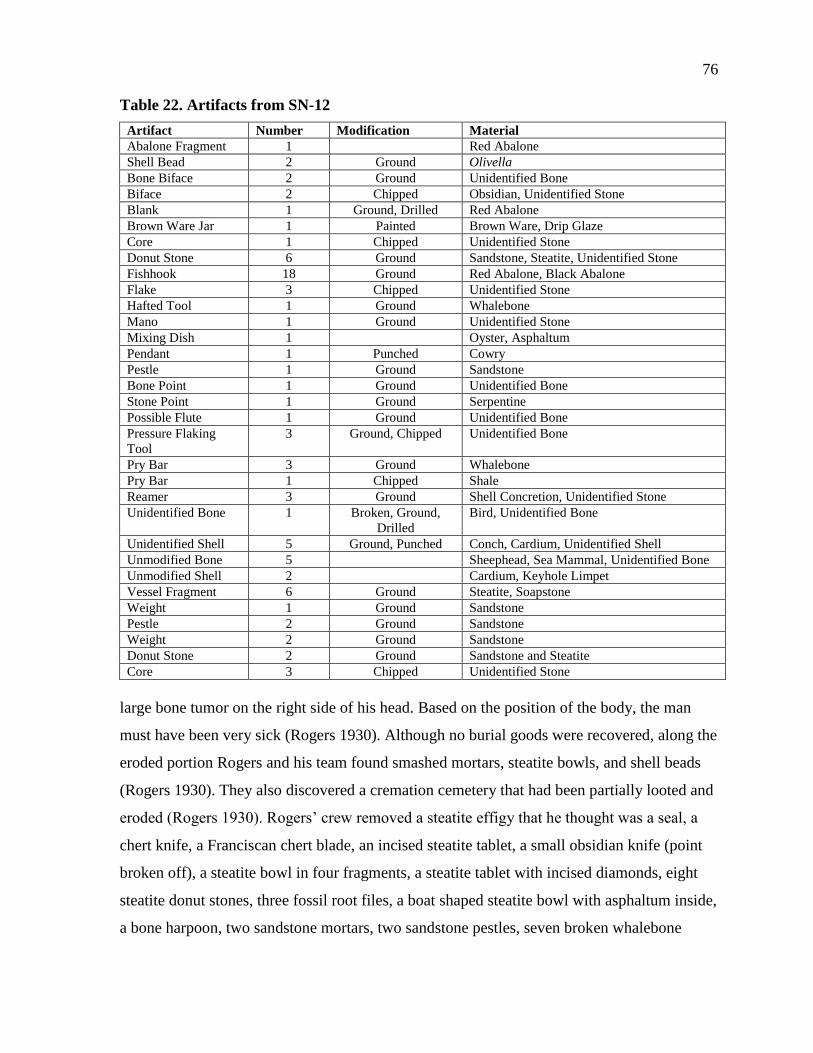
76
Table 22. Artifacts from SN-12
Artifact Number Modification Material
Abalone Fragment 1 Red Abalone
Shell Bead 2 Ground Olivella
Bone Biface 2 Ground Unidentified Bone
Biface 2 Chipped Obsidian, Unidentified Stone
Blank 1 Ground, Drilled Red Abalone
Brown Ware Jar 1 Painted Brown Ware, Drip Glaze
Core 1 Chipped Unidentified Stone
Donut Stone 6 Ground Sandstone, Steatite, Unidentified Stone
Fishhook 18 Ground Red Abalone, Black Abalone
Flake 3 Chipped Unidentified Stone
Hafted Tool 1 Ground Whalebone
Mano 1 Ground Unidentified Stone
Mixing Dish 1 Oyster, Asphaltum
Pendant 1 Punched Cowry
Pestle 1 Ground Sandstone
Bone Point 1 Ground Unidentified Bone
Stone Point 1 Ground Serpentine
Possible Flute 1 Ground Unidentified Bone
Pressure Flaking
Tool
3 Ground, Chipped Unidentified Bone
Pry Bar 3 Ground Whalebone
Pry Bar 1 Chipped Shale
Reamer 3 Ground Shell Concretion, Unidentified Stone
Unidentified Bone 1 Broken, Ground,
Drilled
Bird, Unidentified Bone
Unidentified Shell 5 Ground, Punched Conch, Cardium, Unidentified Shell
Unmodified Bone 5 Sheephead, Sea Mammal, Unidentified Bone
Unmodified Shell 2 Cardium, Keyhole Limpet
Vessel Fragment 6 Ground Steatite, Soapstone
Weight 1 Ground Sandstone
Pestle 2 Ground Sandstone
Weight 2 Ground Sandstone
Donut Stone 2 Ground Sandstone and Steatite
Core 3 Chipped Unidentified Stone
large bone tumor on the right side of his head. Based on the position of the body, the man
must have been very sick (Rogers 1930). Although no burial goods were recovered, along the
eroded portion Rogers and his team found smashed mortars, steatite bowls, and shell beads
(Rogers 1930). They also discovered a cremation cemetery that had been partially looted and
eroded (Rogers 1930). Rogers’ crew removed a steatite effigy that he thought was a seal, a
chert knife, a Franciscan chert blade, an incised steatite tablet, a small obsidian knife (point
broken off), a steatite bowl in four fragments, a steatite tablet with incised diamonds, eight
steatite donut stones, three fossil root files, a boat shaped steatite bowl with asphaltum inside,
a bone harpoon, two sandstone mortars, two sandstone pestles, seven broken whalebone
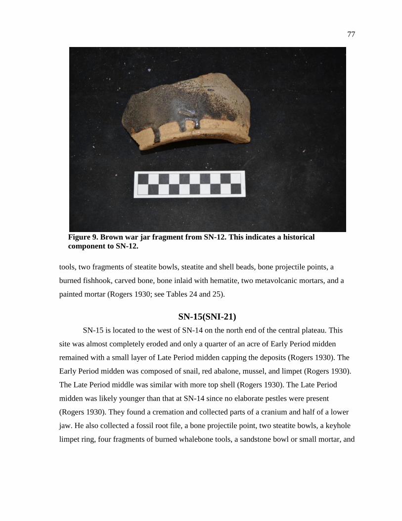
77
Figure 9. Brown war jar fragment from SN-12. This indicates a historical
component to SN-12.
tools, two fragments of steatite bowls, steatite and shell beads, bone projectile points, a
burned fishhook, carved bone, bone inlaid with hematite, two metavolcanic mortars, and a
painted mortar (Rogers 1930; see Tables 24 and 25).
SN-15(SNI-21)
SN-15 is located to the west of SN-14 on the north end of the central plateau. This
site was almost completely eroded and only a quarter of an acre of Early Period midden
remained with a small layer of Late Period midden capping the deposits (Rogers 1930). The
Early Period midden was composed of snail, red abalone, mussel, and limpet (Rogers 1930).
The Late Period middle was similar with more top shell (Rogers 1930). The Late Period
midden was likely younger than that at SN-14 since no elaborate pestles were present
(Rogers 1930). They found a cremation and collected parts of a cranium and half of a lower
jaw. He also collected a fossil root file, a bone projectile point, two steatite bowls, a keyhole
limpet ring, four fragments of burned whalebone tools, a sandstone bowl or small mortar, and
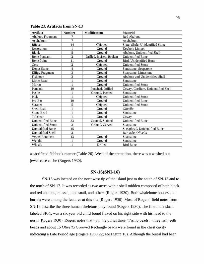
78
Table 23. Artifacts from SN-13
Artifact Number Modification Material
Abalone Fragment 7 Red Abalone
Asphaltum 7 Asphaltum
Biface 14 Chipped Slate, Shale, Unidentified Stone
Decoration 1 Ground Keyhole Limpet
Blank 5 Ground Abalone, Unidentified Shell
Bone Pendant 2 Drilled, Incised, Broken Unidentified Bone
Bone Point 11 Ground Bird, Unidentified Bone
Core 2 Chipped Unidentified Stone
Donut Stone 4 Ground Sandstone, Soapstone
Effigy Fragment 3 Ground Soapstone, Limestone
Fishhook 3 Ground Abalone and Unidentified Shell
Lithic Bead 1 Ground Sandstone
Mortar 1 Ground Unidentified Stone
Pendant 10 Punched, Drilled Cowry, Cardium, Unidentified Shell
Pestle 1 Ground, Pecked Sandstone
Pick 1 Chipped Unidentified Stone
Pry Bar 10 Ground Unidentified Bone
Scraper 5 Chipped Unidentified Stone
Shell Bead 1 Ground Olivella
Stone Bead 1 Ground Sandstone
Talisman 1 Ground Cowry
Unidentified Bone 33 Ground, Stained Unidentified Bone
Unidentified Stone 2 Ground, Carved Soapstone
Unmodified Bone 15 Sheephead, Unidentified Bone
Unmodified Shell 2 Barnacle, Olivella
Vessel Fragment 13 Ground Soapstone
Weight 1 Ground Sandstone
Whistle 1 Drilled Bird Bone
a sacrificed fishhook reamer (Table 26). West of the cremation, there was a washed out
jewel-case cache (Rogers 1930).
SN-16(SNI-16)
SN-16 was located on the northwest tip of the island just to the south of SN-13 and to
the north of SN-17. It was recorded as two acres with a shell midden composed of both black
and red abalone, mussel, land snail, and others (Rogers 1930). Both whalebone houses and
burials were among the features at this site (Rogers 1930). Most of Rogers’ field notes from
SN-16 describe the three human skeletons they found (Rogers 1930). The first individual,
labeled SK-1, was a six year old child found flexed on his right side with his head to the
north (Rogers 1930). Rogers notes that with the burial three “Pismo beads,” three fish teeth
beads and about 15 Olivella Grooved Rectangle beads were found in the chest cavity
indicating a Late Period age (Rogers 1930:22; see Figure 10). Although the burial had been
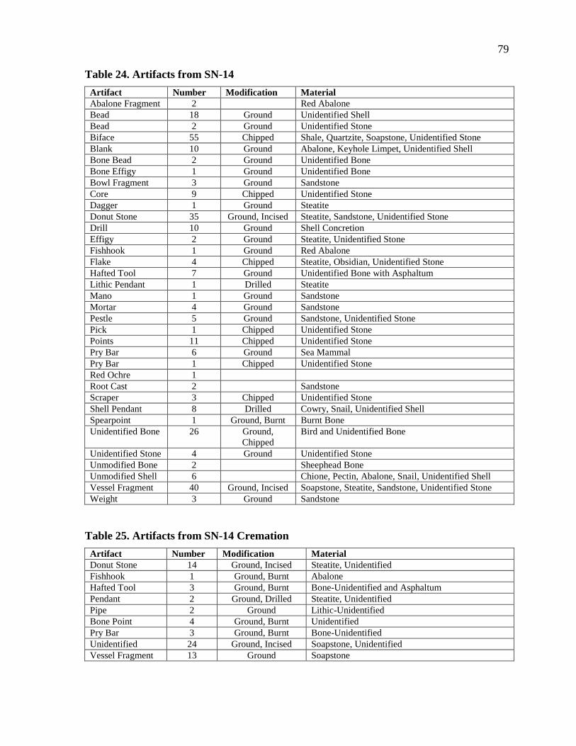
79
Table 24. Artifacts from SN-14
Artifact Number Modification Material
Abalone Fragment 2 Red Abalone
Bead 18 Ground Unidentified Shell
Bead 2 Ground Unidentified Stone
Biface 55 Chipped Shale, Quartzite, Soapstone, Unidentified Stone
Blank 10 Ground Abalone, Keyhole Limpet, Unidentified Shell
Bone Bead 2 Ground Unidentified Bone
Bone Effigy 1 Ground Unidentified Bone
Bowl Fragment 3 Ground Sandstone
Core 9 Chipped Unidentified Stone
Dagger 1 Ground Steatite
Donut Stone 35 Ground, Incised Steatite, Sandstone, Unidentified Stone
Drill 10 Ground Shell Concretion
Effigy 2 Ground Steatite, Unidentified Stone
Fishhook 1 Ground Red Abalone
Flake 4 Chipped Steatite, Obsidian, Unidentified Stone
Hafted Tool 7 Ground Unidentified Bone with Asphaltum
Lithic Pendant 1 Drilled Steatite
Mano 1 Ground Sandstone
Mortar 4 Ground Sandstone
Pestle 5 Ground Sandstone, Unidentified Stone
Pick 1 Chipped Unidentified Stone
Points 11 Chipped Unidentified Stone
Pry Bar 6 Ground Sea Mammal
Pry Bar 1 Chipped Unidentified Stone
Red Ochre 1
Root Cast 2 Sandstone
Scraper 3 Chipped Unidentified Stone
Shell Pendant 8 Drilled Cowry, Snail, Unidentified Shell
Spearpoint 1 Ground, Burnt Burnt Bone
Unidentified Bone 26 Ground,
Chipped
Bird and Unidentified Bone
Unidentified Stone 4 Ground Unidentified Stone
Unmodified Bone 2 Sheephead Bone
Unmodified Shell 6 Chione, Pectin, Abalone, Snail, Unidentified Shell
Vessel Fragment 40 Ground, Incised Soapstone, Steatite, Sandstone, Unidentified Stone
Weight 3 Ground Sandstone
Table 25. Artifacts from SN-14 Cremation
Artifact Number Modification Material
Donut Stone 14 Ground, Incised Steatite, Unidentified
Fishhook 1 Ground, Burnt Abalone
Hafted Tool 3 Ground, Burnt Bone-Unidentified and Asphaltum
Pendant 2 Ground, Drilled Steatite, Unidentified
Pipe 2 Ground Lithic-Unidentified
Bone Point 4 Ground, Burnt Unidentified
Pry Bar 3 Ground, Burnt Bone-Unidentified
Unidentified 24 Ground, Incised Soapstone, Unidentified
Vessel Fragment 13 Ground Soapstone
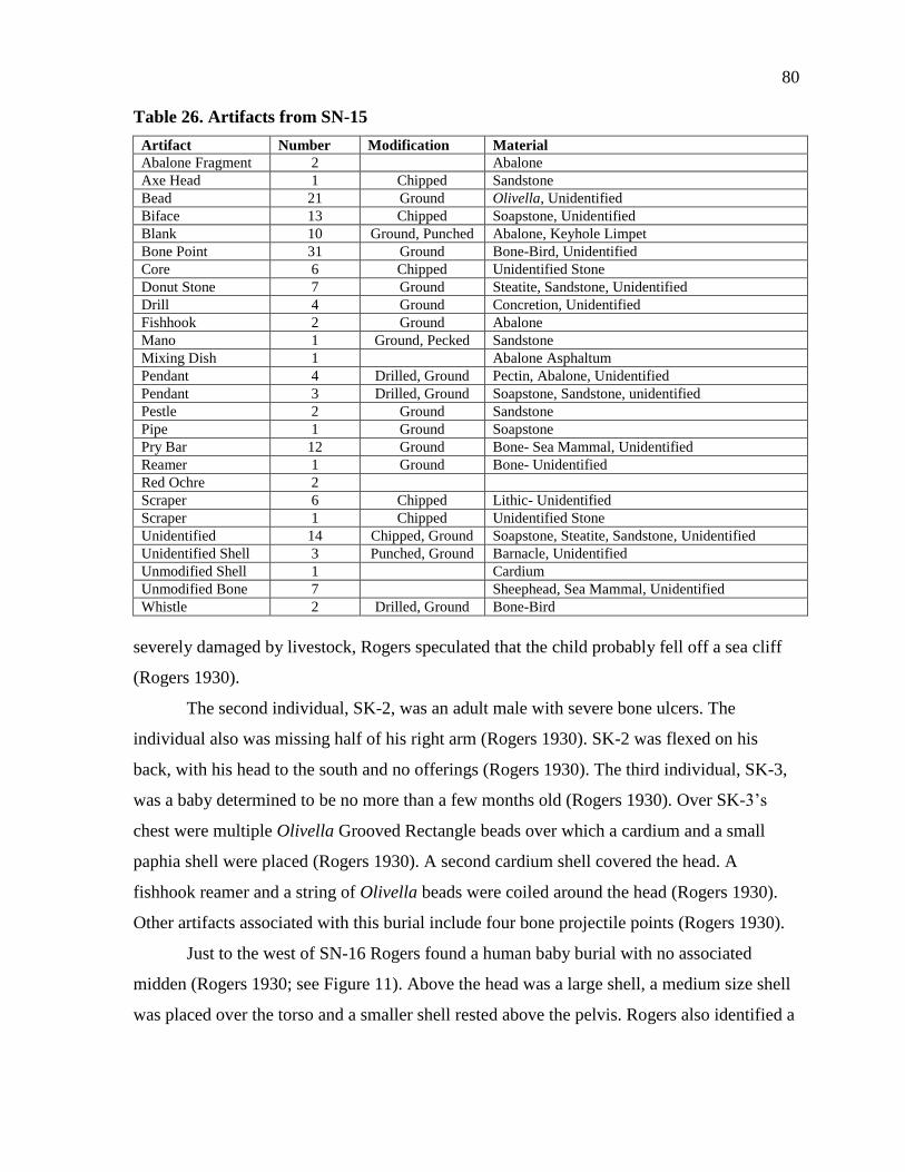
80
Table 26. Artifacts from SN-15
Artifact Number Modification Material
Abalone Fragment 2 Abalone
Axe Head 1 Chipped Sandstone
Bead 21 Ground Olivella, Unidentified
Biface 13 Chipped Soapstone, Unidentified
Blank 10 Ground, Punched Abalone, Keyhole Limpet
Bone Point 31 Ground Bone-Bird, Unidentified
Core 6 Chipped Unidentified Stone
Donut Stone 7 Ground Steatite, Sandstone, Unidentified
Drill 4 Ground Concretion, Unidentified
Fishhook 2 Ground Abalone
Mano 1 Ground, Pecked Sandstone
Mixing Dish 1 Abalone Asphaltum
Pendant 4 Drilled, Ground Pectin, Abalone, Unidentified
Pendant 3 Drilled, Ground Soapstone, Sandstone, unidentified
Pestle 2 Ground Sandstone
Pipe 1 Ground Soapstone
Pry Bar 12 Ground Bone- Sea Mammal, Unidentified
Reamer 1 Ground Bone- Unidentified
Red Ochre 2
Scraper 6 Chipped Lithic- Unidentified
Scraper 1 Chipped Unidentified Stone
Unidentified 14 Chipped, Ground Soapstone, Steatite, Sandstone, Unidentified
Unidentified Shell 3 Punched, Ground Barnacle, Unidentified
Unmodified Shell 1 Cardium
Unmodified Bone 7 Sheephead, Sea Mammal, Unidentified
Whistle 2 Drilled, Ground Bone-Bird
severely damaged by livestock, Rogers speculated that the child probably fell off a sea cliff
(Rogers 1930).
The second individual, SK-2, was an adult male with severe bone ulcers. The
individual also was missing half of his right arm (Rogers 1930). SK-2 was flexed on his
back, with his head to the south and no offerings (Rogers 1930). The third individual, SK-3,
was a baby determined to be no more than a few months old (Rogers 1930). Over SK-3’s
chest were multiple Olivella Grooved Rectangle beads over which a cardium and a small
paphia shell were placed (Rogers 1930). A second cardium shell covered the head. A
fishhook reamer and a string of Olivella beads were coiled around the head (Rogers 1930).
Other artifacts associated with this burial include four bone projectile points (Rogers 1930).
Just to the west of SN-16 Rogers found a human baby burial with no associated
midden (Rogers 1930; see Figure 11). Above the head was a large shell, a medium size shell
was placed over the torso and a smaller shell rested above the pelvis. Rogers also identified a
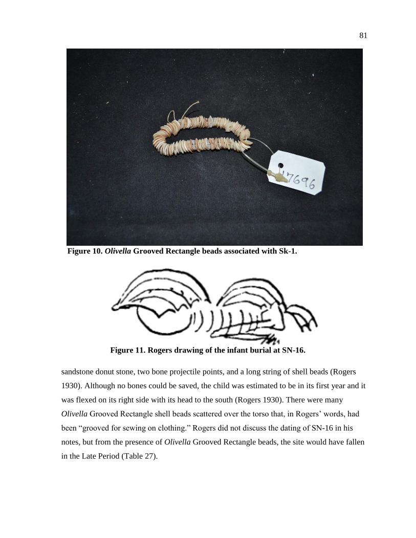
81
Figure 10. Olivella Grooved Rectangle beads associated with Sk-1.
Figure 11. Rogers drawing of the infant burial at SN-16.
sandstone donut stone, two bone projectile points, and a long string of shell beads (Rogers
1930). Although no bones could be saved, the child was estimated to be in its first year and it
was flexed on its right side with its head to the south (Rogers 1930). There were many
Olivella Grooved Rectangle shell beads scattered over the torso that, in Rogers’ words, had
been “grooved for sewing on clothing.” Rogers did not discuss the dating of SN-16 in his
notes, but from the presence of Olivella Grooved Rectangle beads, the site would have fallen
in the Late Period (Table 27).
82
Table 27. Artifacts from SN-16
Artifact Number Modification Material
Basket Imprint 1 Asphaltum
Biface 27 Chipped Shale, Limestone, Unidentified
Blank 8 Chipped, Ground, Drilled Abalone
Bone Pendant 1 Ground, Drilled Unidentified Bone
Core 1 Chipped Unidentified
Donut Stone 7 Ground Steatite, Sandstone, Soapstone,
Unidentified
Drill 1 Ground Concretion
Fishhook 2 Ground Abalone
Gaming Bone 1 Incised Unidentified Bone
Hafted Tool 7 Ground, Burnt, Stained Sea Mammal, Unidentified Bone
Harpoon 1 Ground Unidentified Bone
Pelican Effigy 1 Ground, Incised Steatite
Pestle 1 Ground, Pecked Sandstone
Pestle 1 Ground Sandstone
Pipe 3 Ground, Broken Steatite, Serpentine
Point 10 Ground Bird, Unidentified
Pry Bar 9 Ground Unidentified Bone, Sea Mammal
Reamer 1 Ground Concretion
Shell Bead 540 Ground, Punched, Drilled,
Burnt
Olivella, Unidentified
Shell Pendant 16 Punched, Ground, Drilled Cowry, Abalone, Mussel, Unidentified
Shell
Stone Bead 5 Ground, Drilled Serpentine, Unidentified
Unidentified 1 Quartz
Unidentified
Stone
4 Ground Soapstone, Unidentified
Unmodified
Bone
3 Unidentified Teeth
Unmodified
Shell
1 Unidentified Shell
Unmodified
Shell
3 Chiton, Unidentified
Unmodified
Shell
7
Pectin, Chione, Unidentified Shell
Weight 1 Ground Sandstone
SN-17(SNI-14, SNI-200)
SN-17 was located on the west end of San Nicolas Island, with SN-16 just to the
northeast and SN-18 to the southwest. SN-17 was a four acre site with two large shell midden
mounds (Rogers 1930). He found two human burials, and evidence of whalebone houses
(Rogers 1930). Rogers found the midden composed of sea snail, land snail, urchins, abalone,
and limpets with fishbone only in the top stratum (Rogers 1930). Rogers dated the large
83
mounds to the Late Period but found no exposures of the Early Period (Rogers 1930; see
Table 28).
Table 28. Artifacts from SN-17
Artifact Number Modification Material
Biface 5 Chipped Unidentified
Blank 2 Keyhole Limpet
Bone Point 15 Ground, Shaped Bird, Sea Mammal, Unidentified
Bone Pry Bar 9 Ground Sea Mammal, Unidentified
Bowl Fragment 1 Ground Sandstone
Core 1 Chipped Unidentified
Donut Stone 2 Ground Sandstone, Steatite
Hafted Tool 4 Ground, Stained Unidentified
Lithic Pendant 2 Drilled Steatite, Serpentine
Mortar 1 Ground Sandstone
Pestle 1 Ground Sandstone
Shell Pendant 3 Punched Cowry, Unidentified
Unidentified 2 Chipped Soapstone, Unidentified
Unmodified Bone 4 Sheephead, Fish, Sea Mammal, Unidentified
SN-18(SNI-15, SNI-16)
SN-18 was located on the west end of San Nicolas Island on a point that juts out into
the ocean. SN-17 was just to the northeast and SN-19 just to the southwest. Rogers recorded
SN-18 as an area of about eight acres with three of the acres on detached knolls (Rogers
1930). He notes that the erosion between the knolls probably is what caused the separation
(Rogers 1930). Whalebone houses were also present here (Rogers 1930). He notes that all of
the three cemeteries in this site were exposed by erosion, although only two showed evidence
of looting (Rogers 1930). He noted that all the cemeteries had beads present and two of them
had sacrificed mortars (Rogers 1930). Rogers recorded shell ratios to be similar to other sites
on the island (abalone, sea snail, land snail, limpets, and mussel), but he also noted that there
is more red abalone at this site (Rogers 1930:24). It appears that some patches of shells were
only one kind of shell as if they were targeting certain species (Rogers 1930). Interesting
artifacts found at this site include a drilled bone artifact (Figure 12), an unusually shaped
soapstone needle (Figure 12) and 714 shell beads (Table 29).
He found all three periods at this large site (Rogers 1930). The cemetery that had not
been looted was late Middle Period rather than Late Period as there were no sacrificed
mortars, but there were two steatite beads and a lot of Olivella beads (Rogers 1930). The two
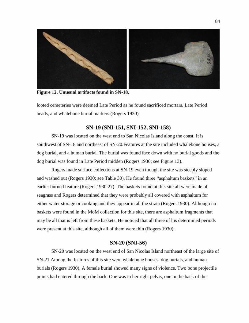
84
Figure 12. Unusual artifacts found in SN-18.
looted cemeteries were deemed Late Period as he found sacrificed mortars, Late Period
beads, and whalebone burial markers (Rogers 1930).
SN-19 (SNI-151, SNI-152, SNI-158)
SN-19 was located on the west end to San Nicolas Island along the coast. It is
southwest of SN-18 and northeast of SN-20.Features at the site included whalebone houses, a
dog burial, and a human burial. The burial was found face down with no burial goods and the
dog burial was found in Late Period midden (Rogers 1930; see Figure 13).
Rogers made surface collections at SN-19 even though the site was steeply sloped
and washed out (Rogers 1930; see Table 30). He found three “asphaltum baskets” in an
earlier burned feature (Rogers 1930:27). The baskets found at this site all were made of
seagrass and Rogers determined that they were probably all covered with asphaltum for
either water storage or cooking and they appear in all the strata (Rogers 1930). Although no
baskets were found in the MoM collection for this site, there are asphaltum fragments that
may be all that is left from these baskets. He noticed that all three of his determined periods
were present at this site, although all of them were thin (Rogers 1930).
SN-20 (SNI-56)
SN-20 was located on the west end of San Nicolas Island northeast of the large site of
SN-21.Among the features of this site were whalebone houses, dog burials, and human
burials (Rogers 1930). A female burial showed many signs of violence. Two bone projectile
points had entered through the back. One was in her right pelvis, one in the back of the
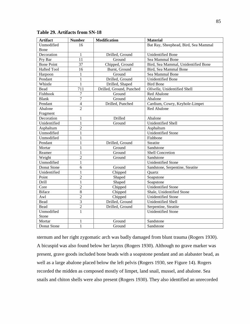
85
Table 29. Artifacts from SN-18
Artifact Number Modification Material
Unmodified
Bone
16 Bat Ray, Sheephead, Bird, Sea Mammal
Decoration 1 Drilled, Ground Unidentified Bone
Pry Bar 11 Ground Sea Mammal Bone
Bone Point 37 Chipped, Ground Bird, Sea Mammal, Unidentified Bone
Hafted Tool 16 Burnt, Ground Bird, Sea Mammal Bone
Harpoon 1 Ground Sea Mammal Bone
Pendant 1 Drilled, Ground Unidentified Bone
Whistle 1 Drilled, Shaped Bird Bone
Bead 711 Drilled, Ground, Punched Olivella, Unidentified Shell
Fishhook 7 Ground Red Abalone
Blank 7 Ground Abalone
Pendant 4 Drilled, Punched Cardium, Cowry, Keyhole-Limpet
Abalone
Fragment
2 Red Abalone
Decoration 1 Drilled Abalone
Unidentified 1 Ground Unidentified Shell
Asphaltum 2 Asphaltum
Unmodified 1 Unidentified Stone
Unmodified 1 Fishbone
Pendant 1 Drilled, Ground Steatite
Mortar 1 Ground Sandstone
Reamer 1 Ground Shell Concretion
Weight 2 Ground Sandstone
Unmodified 1 Unidentified Stone
Donut Stone 6 Ground Sandstone, Serpentine, Steatite
Unidentified 1 Chipped Quartz
Point 2 Shaped Soapstone
Drill 1 Shaped Soapstone
Core 2 Chipped Unidentified Stone
Biface 8 Chipped Shale, Unidentified Stone
Awl 2 Chipped Unidentified Stone
Bead 3 Drilled, Ground Unidentified Shell
Bead 2 Drilled, Ground Serpentine, Steatite
Unmodified
Stone
1 Unidentified Stone
Mortar 1 Ground Sandstone
Donut Stone 1 Ground Sandstone
sternum and her right zygomatic arch was badly damaged from blunt trauma (Rogers 1930).
A bicuspid was also found below her larynx (Rogers 1930). Although no grave marker was
present, grave goods included bone beads with a soapstone pendant and an alabaster bead, as
well as a large abalone placed below the left pelvis (Rogers 1930, see Figure 14). Rogers
recorded the midden as composed mostly of limpet, land snail, mussel, and abalone. Sea
snails and chiton shells were also present (Rogers 1930). They also identified an unrecorded
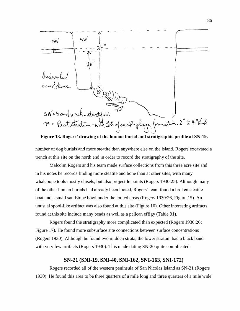
86
Figure 13. Rogers’ drawing of the human burial and stratigraphic profile at SN-19.
number of dog burials and more steatite than anywhere else on the island. Rogers excavated a
trench at this site on the north end in order to record the stratigraphy of the site.
Malcolm Rogers and his team made surface collections from this three acre site and
in his notes he records finding more steatite and bone than at other sites, with many
whalebone tools mostly chisels, but also projectile points (Rogers 1930:25). Although many
of the other human burials had already been looted, Rogers’ team found a broken steatite
boat and a small sandstone bowl under the looted areas (Rogers 1930:26, Figure 15). An
unusual spool-like artifact was also found at this site (Figure 16). Other interesting artifacts
found at this site include many beads as well as a pelican effigy (Table 31).
Rogers found the stratigraphy more complicated than expected (Rogers 1930:26;
Figure 17). He found more subsurface site connections between surface concentrations
(Rogers 1930). Although he found two midden strata, the lower stratum had a black band
with very few artifacts (Rogers 1930). This made dating SN-20 quite complicated.
SN-21 (SNI-19, SNI-40, SNI-162, SNI-163, SNI-172)
Rogers recorded all of the western peninsula of San Nicolas Island as SN-21 (Rogers
1930). He found this area to be three quarters of a mile long and three quarters of a mile wide
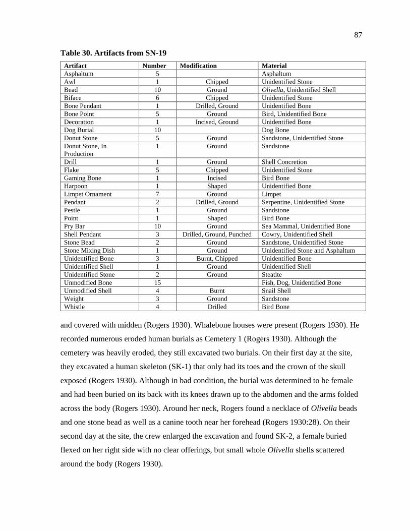
87
Table 30. Artifacts from SN-19
Artifact Number Modification Material
Asphaltum 5 Asphaltum
Awl 1 Chipped Unidentified Stone
Bead 10 Ground Olivella, Unidentified Shell
Biface 6 Chipped Unidentified Stone
Bone Pendant 1 Drilled, Ground Unidentified Bone
Bone Point 5 Ground Bird, Unidentified Bone
Decoration 1 Incised, Ground Unidentified Bone
Dog Burial 10 Dog Bone
Donut Stone 5 Ground Sandstone, Unidentified Stone
Donut Stone, In
Production
1 Ground Sandstone
Drill 1 Ground Shell Concretion
Flake 5 Chipped Unidentified Stone
Gaming Bone 1 Incised Bird Bone
Harpoon 1 Shaped Unidentified Bone
Limpet Ornament 7 Ground Limpet
Pendant 2 Drilled, Ground Serpentine, Unidentified Stone
Pestle 1 Ground Sandstone
Point 1 Shaped Bird Bone
Pry Bar 10 Ground Sea Mammal, Unidentified Bone
Shell Pendant 3 Drilled, Ground, Punched Cowry, Unidentified Shell
Stone Bead 2 Ground Sandstone, Unidentified Stone
Stone Mixing Dish 1 Ground Unidentified Stone and Asphaltum
Unidentified Bone 3 Burnt, Chipped Unidentified Bone
Unidentified Shell 1 Ground Unidentified Shell
Unidentified Stone 2 Ground Steatite
Unmodified Bone 15 Fish, Dog, Unidentified Bone
Unmodified Shell 4 Burnt Snail Shell
Weight 3 Ground Sandstone
Whistle 4 Drilled Bird Bone
and covered with midden (Rogers 1930). Whalebone houses were present (Rogers 1930). He
recorded numerous eroded human burials as Cemetery 1 (Rogers 1930). Although the
cemetery was heavily eroded, they still excavated two burials. On their first day at the site,
they excavated a human skeleton (SK-1) that only had its toes and the crown of the skull
exposed (Rogers 1930). Although in bad condition, the burial was determined to be female
and had been buried on its back with its knees drawn up to the abdomen and the arms folded
across the body (Rogers 1930). Around her neck, Rogers found a necklace of Olivella beads
and one stone bead as well as a canine tooth near her forehead (Rogers 1930:28). On their
second day at the site, the crew enlarged the excavation and found SK-2, a female buried
flexed on her right side with no clear offerings, but small whole Olivella shells scattered
around the body (Rogers 1930).
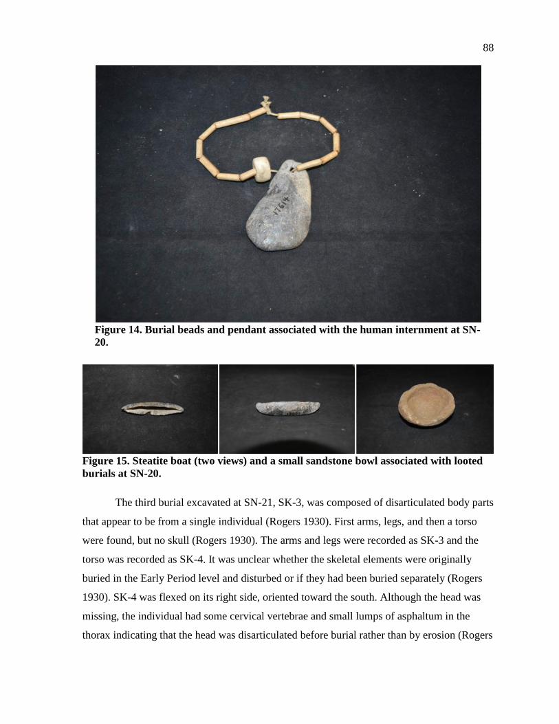
88
Figure 14. Burial beads and pendant associated with the human internment at SN-
20.
Figure 15. Steatite boat (two views) and a small sandstone bowl associated with looted
burials at SN-20.
The third burial excavated at SN-21, SK-3, was composed of disarticulated body parts
that appear to be from a single individual (Rogers 1930). First arms, legs, and then a torso
were found, but no skull (Rogers 1930). The arms and legs were recorded as SK-3 and the
torso was recorded as SK-4. It was unclear whether the skeletal elements were originally
buried in the Early Period level and disturbed or if they had been buried separately (Rogers
1930). SK-4 was flexed on its right side, oriented toward the south. Although the head was
missing, the individual had some cervical vertebrae and small lumps of asphaltum in the
thorax indicating that the head was disarticulated before burial rather than by erosion (Rogers

89
Figure 16. Unusual spool artifact found at SN-20.
1930). In the same area as the burials, Rogers found evidence for abundant bead
manufacture, including bead blanks and steatite beads and pendants (Rogers 1930). Many
artifacts were collected at SN-21 including more shell beads than at any other site (Table 32).
The entire surface of the midden was identified as Late Period (Rogers 1930).
SN-21A (SNI-55, SNI-119, SNI-164, SNI-170): SN-21A
CEMETERY 1 (SNI-157), SN-21A CEMETERY 2, SN-21A
CEMETERY 3 (SNI-171), SN-21A CEMETERY 4 (SNI-
160), SN-21A CEMETERY 5 (SNI-160), SN-21A
CEMETERY 6 (SNI-161), SN-21A CREMATION 1
(SNI-159)
Within SN-21, Rogers grouped clusters of dense midden and recognizable cemeteries
into separate loci (Rogers 1930). The exact location of SN-21A is unclear from Rogers’
descriptions, but it appears that many loci, including six cemeteries and a cremation area
were included under this designation. Most of the recorded features of SN-21A are
cemeteries and burials (Figure 18).
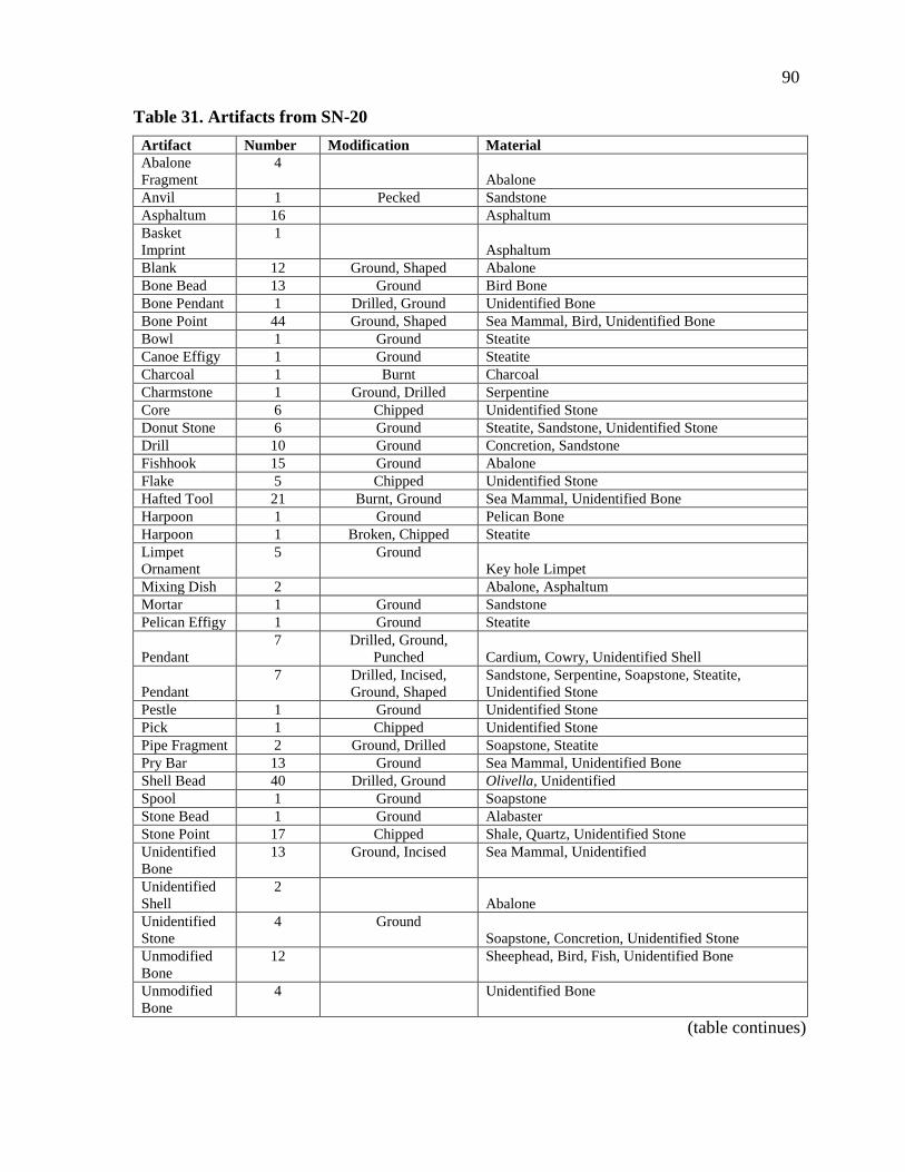
90
Table 31. Artifacts from SN-20
Artifact Number Modification Material
Abalone
Fragment
4
Abalone
Anvil 1 Pecked Sandstone
Asphaltum 16 Asphaltum
Basket
Imprint
1
Asphaltum
Blank 12 Ground, Shaped Abalone
Bone Bead 13 Ground Bird Bone
Bone Pendant 1 Drilled, Ground Unidentified Bone
Bone Point 44 Ground, Shaped Sea Mammal, Bird, Unidentified Bone
Bowl 1 Ground Steatite
Canoe Effigy 1 Ground Steatite
Charcoal 1 Burnt Charcoal
Charmstone 1 Ground, Drilled Serpentine
Core 6 Chipped Unidentified Stone
Donut Stone 6 Ground Steatite, Sandstone, Unidentified Stone
Drill 10 Ground Concretion, Sandstone
Fishhook 15 Ground Abalone
Flake 5 Chipped Unidentified Stone
Hafted Tool 21 Burnt, Ground Sea Mammal, Unidentified Bone
Harpoon 1 Ground Pelican Bone
Harpoon 1 Broken, Chipped Steatite
Limpet
Ornament
5 Ground
Key hole Limpet
Mixing Dish 2 Abalone, Asphaltum
Mortar 1 Ground Sandstone
Pelican Effigy 1 Ground Steatite
Pendant
7 Drilled, Ground,
Punched Cardium, Cowry, Unidentified Shell
Pendant
7 Drilled, Incised,
Ground, Shaped
Sandstone, Serpentine, Soapstone, Steatite,
Unidentified Stone
Pestle 1 Ground Unidentified Stone
Pick 1 Chipped Unidentified Stone
Pipe Fragment 2 Ground, Drilled Soapstone, Steatite
Pry Bar 13 Ground Sea Mammal, Unidentified Bone
Shell Bead 40 Drilled, Ground Olivella, Unidentified
Spool 1 Ground Soapstone
Stone Bead 1 Ground Alabaster
Stone Point 17 Chipped Shale, Quartz, Unidentified Stone
Unidentified
Bone
13 Ground, Incised Sea Mammal, Unidentified
Unidentified
Shell
2
Abalone
Unidentified
Stone
4 Ground
Soapstone, Concretion, Unidentified Stone
Unmodified
Bone
12 Sheephead, Bird, Fish, Unidentified Bone
Unmodified
Bone
4 Unidentified Bone
(table continues)
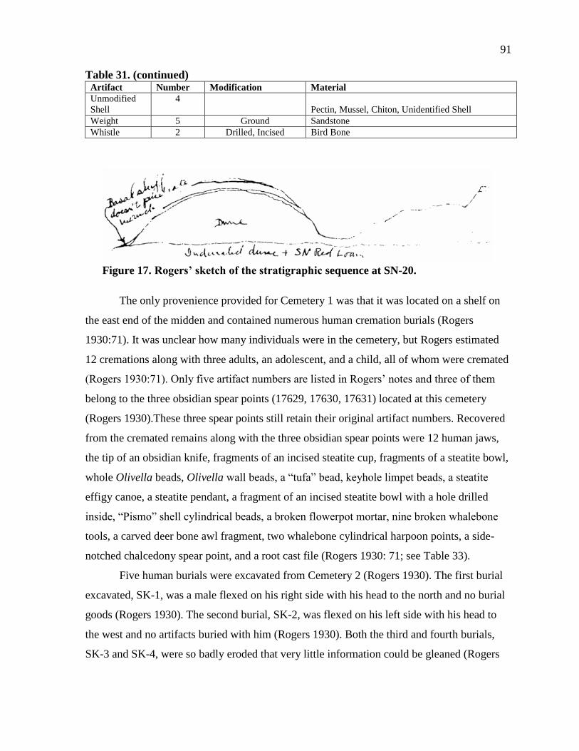
91
Table 31. (continued) Artifact Number Modification Material
Unmodified
Shell
4
Pectin, Mussel, Chiton, Unidentified Shell
Weight 5 Ground Sandstone
Whistle 2 Drilled, Incised Bird Bone
Figure 17. Rogers’ sketch of the stratigraphic sequence at SN-20.
The only provenience provided for Cemetery 1 was that it was located on a shelf on
the east end of the midden and contained numerous human cremation burials (Rogers
1930:71). It was unclear how many individuals were in the cemetery, but Rogers estimated
12 cremations along with three adults, an adolescent, and a child, all of whom were cremated
(Rogers 1930:71). Only five artifact numbers are listed in Rogers’ notes and three of them
belong to the three obsidian spear points (17629, 17630, 17631) located at this cemetery
(Rogers 1930).These three spear points still retain their original artifact numbers. Recovered
from the cremated remains along with the three obsidian spear points were 12 human jaws,
the tip of an obsidian knife, fragments of an incised steatite cup, fragments of a steatite bowl,
whole Olivella beads, Olivella wall beads, a “tufa” bead, keyhole limpet beads, a steatite
effigy canoe, a steatite pendant, a fragment of an incised steatite bowl with a hole drilled
inside, “Pismo” shell cylindrical beads, a broken flowerpot mortar, nine broken whalebone
tools, a carved deer bone awl fragment, two whalebone cylindrical harpoon points, a side-
notched chalcedony spear point, and a root cast file (Rogers 1930: 71; see Table 33).
Five human burials were excavated from Cemetery 2 (Rogers 1930). The first burial
excavated, SK-1, was a male flexed on his right side with his head to the north and no burial
goods (Rogers 1930). The second burial, SK-2, was flexed on his left side with his head to
the west and no artifacts buried with him (Rogers 1930). Both the third and fourth burials,
SK-3 and SK-4, were so badly eroded that very little information could be gleaned (Rogers
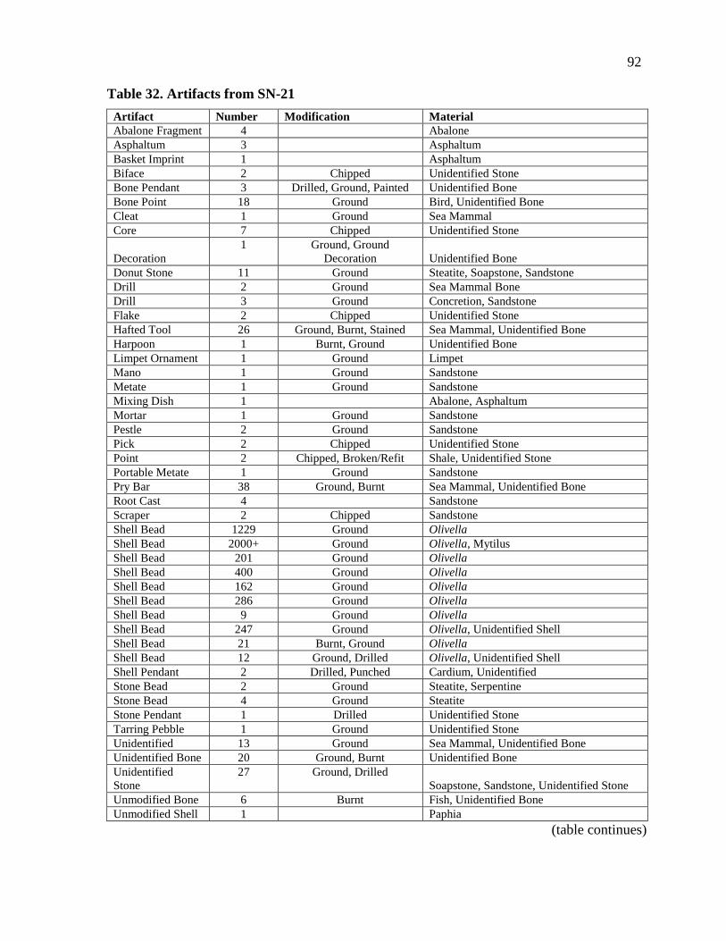
92
Table 32. Artifacts from SN-21
Artifact Number Modification Material
Abalone Fragment 4 Abalone
Asphaltum 3 Asphaltum
Basket Imprint 1 Asphaltum
Biface 2 Chipped Unidentified Stone
Bone Pendant 3 Drilled, Ground, Painted Unidentified Bone
Bone Point 18 Ground Bird, Unidentified Bone
Cleat 1 Ground Sea Mammal
Core 7 Chipped Unidentified Stone
Decoration
1 Ground, Ground
Decoration Unidentified Bone
Donut Stone 11 Ground Steatite, Soapstone, Sandstone
Drill 2 Ground Sea Mammal Bone
Drill 3 Ground Concretion, Sandstone
Flake 2 Chipped Unidentified Stone
Hafted Tool 26 Ground, Burnt, Stained Sea Mammal, Unidentified Bone
Harpoon 1 Burnt, Ground Unidentified Bone
Limpet Ornament 1 Ground Limpet
Mano 1 Ground Sandstone
Metate 1 Ground Sandstone
Mixing Dish 1 Abalone, Asphaltum
Mortar 1 Ground Sandstone
Pestle 2 Ground Sandstone
Pick 2 Chipped Unidentified Stone
Point 2 Chipped, Broken/Refit Shale, Unidentified Stone
Portable Metate 1 Ground Sandstone
Pry Bar 38 Ground, Burnt Sea Mammal, Unidentified Bone
Root Cast 4 Sandstone
Scraper 2 Chipped Sandstone
Shell Bead 1229 Ground Olivella
Shell Bead 2000+ Ground Olivella, Mytilus
Shell Bead 201 Ground Olivella
Shell Bead 400 Ground Olivella
Shell Bead 162 Ground Olivella
Shell Bead 286 Ground Olivella
Shell Bead 9 Ground Olivella
Shell Bead 247 Ground Olivella, Unidentified Shell
Shell Bead 21 Burnt, Ground Olivella
Shell Bead 12 Ground, Drilled Olivella, Unidentified Shell
Shell Pendant 2 Drilled, Punched Cardium, Unidentified
Stone Bead 2 Ground Steatite, Serpentine
Stone Bead 4 Ground Steatite
Stone Pendant 1 Drilled Unidentified Stone
Tarring Pebble 1 Ground Unidentified Stone
Unidentified 13 Ground Sea Mammal, Unidentified Bone
Unidentified Bone 20 Ground, Burnt Unidentified Bone
Unidentified
Stone
27 Ground, Drilled
Soapstone, Sandstone, Unidentified Stone
Unmodified Bone 6 Burnt Fish, Unidentified Bone
Unmodified Shell 1 Paphia
(table continues)

93
Table 32. (continued) Artifact Number Modification Material
Vessel Fragment 8 Ground, incised Soapstone
Weight 5 Ground Sandstone
Whistle 4 Drilled, Ground Bird Bone
Yellow Ochre 1 Yellow Ochre
Figure 18. Rogers’ sketch of the stratigraphy at SN-21A.
Table 33. Artifacts from SN-21A Cemetery 1
Artifact Number Modification Material
Bead Blank 662 Shaped Olivella, Mytilus, Abalone
Blank 18 Ground Black Abalone, Red Abalone
Limpet Ornament 11 Ground Limpet
Shell Bead 22 Ground, Drilled Olivella, Unidentified Shell
Shell Pendant 19 Drilled, Ground, Punched Cardium, Cowry, Unidentified Shell
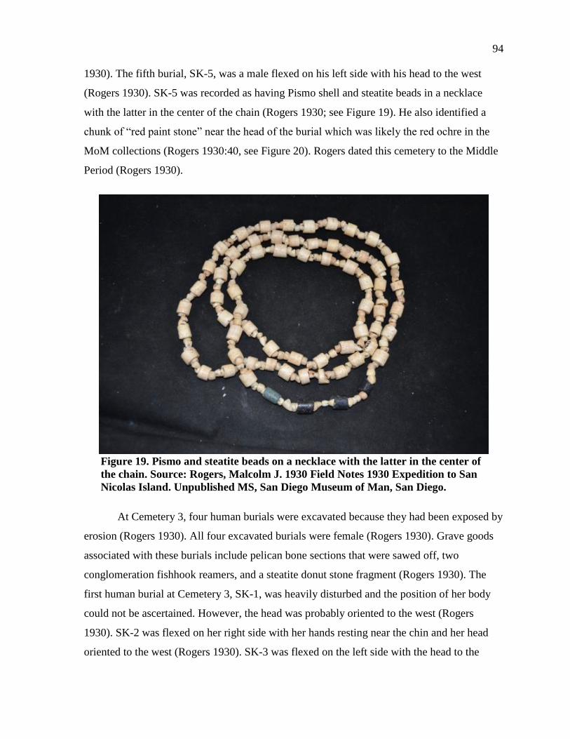
94
1930). The fifth burial, SK-5, was a male flexed on his left side with his head to the west
(Rogers 1930). SK-5 was recorded as having Pismo shell and steatite beads in a necklace
with the latter in the center of the chain (Rogers 1930; see Figure 19). He also identified a
chunk of “red paint stone” near the head of the burial which was likely the red ochre in the
MoM collections (Rogers 1930:40, see Figure 20). Rogers dated this cemetery to the Middle
Period (Rogers 1930).
Figure 19. Pismo and steatite beads on a necklace with the latter in the center of
the chain. Source: Rogers, Malcolm J. 1930 Field Notes 1930 Expedition to San
Nicolas Island. Unpublished MS, San Diego Museum of Man, San Diego.
At Cemetery 3, four human burials were excavated because they had been exposed by
erosion (Rogers 1930). All four excavated burials were female (Rogers 1930). Grave goods
associated with these burials include pelican bone sections that were sawed off, two
conglomeration fishhook reamers, and a steatite donut stone fragment (Rogers 1930). The
first human burial at Cemetery 3, SK-1, was heavily disturbed and the position of her body
could not be ascertained. However, the head was probably oriented to the west (Rogers
1930). SK-2 was flexed on her right side with her hands resting near the chin and her head
oriented to the west (Rogers 1930). SK-3 was flexed on the left side with the head to the

95
Figure 20. Red ochre associated with SK-5 at SN-21A. Note: the ochre was kept in
the bag during photographing due to preservation concerns.
north and her hands near her face. SK-1, SK-2, and SK-3 were all intrusive into the lower
midden, but SK-4 did not exhibit any indications of being from a later burial (Rogers 1930).
SK-4 was exposed and eroding (Rogers 1930, see Figure 21). She was extended on her back
with legs bent at the knees “back under the thighs” and her torso was twisted to the right
(Rogers 1930:38). More burials were seen washed out by erosion on the west end of the site
and, based on examination of the femurs, Rogers determined that at least one female and two
males were present (Rogers 1930). The shell ratio in this part of the site was mostly land
snail with smaller amounts of mussel and abalone (Rogers 1930). Rogers (1930) also
identified two broken sandstone mortars. Finally, Rogers identified at least one and possibly
two human cremation burials, labeled Cremation 2. Associated with this feature, Rogers
identified two sacrificed pestles (museum numbers 17591, 17592) and a red hued steatite
bowl with some green steatite fragments. Like the obsidian spear points from Cemetery 1, the
artifact numbers of the two sacrificed pestles were listed in Rogers’ notes. However, only one
of the sacrificed pestles was located in the MoM collection (see Figure 22).
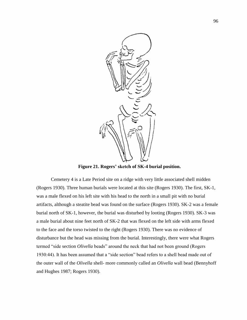
96
Figure 21. Rogers’ sketch of SK-4 burial position.
Cemetery 4 is a Late Period site on a ridge with very little associated shell midden
(Rogers 1930). Three human burials were located at this site (Rogers 1930). The first, SK-1,
was a male flexed on his left site with his head to the north in a small pit with no burial
artifacts, although a steatite bead was found on the surface (Rogers 1930). SK-2 was a female
burial north of SK-1, however, the burial was disturbed by looting (Rogers 1930). SK-3 was
a male burial about nine feet north of SK-2 that was flexed on the left side with arms flexed
to the face and the torso twisted to the right (Rogers 1930). There was no evidence of
disturbance but the head was missing from the burial. Interestingly, there were what Rogers
termed “side section Olivella beads” around the neck that had not been ground (Rogers
1930:44). It has been assumed that a “side section” bead refers to a shell bead made out of
the outer wall of the Olivella shell- more commonly called an Olivella wall bead (Bennyhoff
and Hughes 1987; Rogers 1930).

97
Figure 22. “Sacrificed mortar,” artifact number 17591, associated with the
human cremation burials at SN-21A.
Placed in the early Middle Period, Cemetery 5 was found between two shell middens
and about 100 feet north of Cemetery 4 (Rogers 1930). All the burials were at this cemetery
were exposed by erosion (Rogers 1930). Burials 5, 6, and 7 were buried in a cemented matrix
making them difficult to excavate (Rogers 1930). SK-1 was completely eroded from its
primary context and, although the individual was adult, they could not be confidently sexed
(Rogers 1930). SK-2 and SK-3 were male and adult, and buried with no artifacts (Rogers
1930). SK-4 was an older woman who had lost her teeth (Rogers 1930). SK-5 was also
female, flexed on her right side with her head to the south and hands near her face. She had
two bone ulcers and one Olivella bead was found under the right cheek, although the bone
was poorly preserved and Rogers did not collect the remains (Rogers 1930). SK-7 was a male
burial extended on his back with his head oriented to the northwest and tilted on his left
cheek (Rogers 1930; see Figure 23).
Cemetery 6 was the largest cemetery on the western peninsula. Rogers describes its
location on a hillside at the western part of SN-21A. Unfortunately, antiquarians and looters
had disturbed the cemetery before Rogers was on the island (Rogers 1930). Because of this
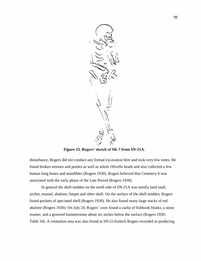
98
Figure 23. Rogers’ sketch of SK-7 from SN-21A.
disturbance, Rogers did not conduct any formal excavation here and took very few notes. He
found broken mortars and pestles as well as whole Olivella beads and also collected a few
human long bones and mandibles (Rogers 1930). Rogers believed that Cemetery 6 was
associated with the early phase of the Late Period (Rogers 1930).
In general the shell midden on the north side of SN-21A was mostly land snail,
urchin, mussel, abalone, limpet and other shell. On the surface of the shell midden, Rogers
found pockets of speciated shell (Rogers 1930). He also found many large stacks of red
abalone (Rogers 1930). On July 24, Rogers’ crew found a cache of fishhook blanks, a stone
reamer, and a grooved hammerstone about six inches below the surface (Rogers 1930;
Table 34). A cremation area was also found at SN-21Awhich Rogers recorded as producing

99
Table 34. Artifacts from SN-21A
Artifact Number Modification Material
Abalone
Fragment
9
Abalone
Asphaltum 3 Asphaltum
Asphaltum
Melting Pebble
1
Quartzite
Basket
Fragments
2
Vegetal, Asphaltum
Biface
43 Chipped Obsidian, Shale, Soapstone, Steatite, Unidentified
Stone
Blank 47 Burnt, Ground Abalone
Bone Bead 1 Drilled, Ground Sea Mammal
Bone
Decorative
Point
1 Ground
Unidentified Bone
Bone Pendant 1 Drilled Unidentified Bone
Bone Point 109 Ground Sea Mammal, Bird, Unidentified Bone
Bone Reamer 1 Burnt, Ground Unidentified Bone
Bone
Spearpoint
1 Burnt
Whalebone
Canoe Effigy 1 Ground Soapstone
Charcoal
Hearth
1+
Ash
Cleat 3 Ground Unidentified Bone
Core 4 Chipped Unidentified Stone
Decoration
1 Ground, Ground
Decoration Unidentified Bone
Decoration 1 Ground, Incised Unidentified Stone
Decoration-
Button
1 Drilled
Abalone
Donut Stone 18 Ground Sandstone, Soapstone, Unidentified Stone
Drill 12 Ground Shell Concretion, Sandstone
Fishhook 41 Ground Black Abalone, Red Abalone
Flake 3 Chipped Unidentified Stone
Hafted Tool
19 Ground, Burnt,
Stained Sea Mammal, Unidentified Bone
Harpoon
(Aleut)
4 Ground
Unidentified Bone
Harpoon Points 5 Ground Sea Mammal
Limpet
Ornament
21 Burnt, Ground
Limpet
Mano 1 Ground Unidentified Stone
Mixing Dish 1 Black Abalone, Asphaltum
Mortar
4 Ground,
Patinated Sandstone
Pipe 2 Ground Steatite, Unidentified Stone
Point 16 Chipped Unidentified Stone
Pressure Flaker 1 Ground Deer Antler
Pry Bar 15 Ground Sea Mammal, Unidentified Bone
Reamer 2 Ground Shell Concretion
(table continues)
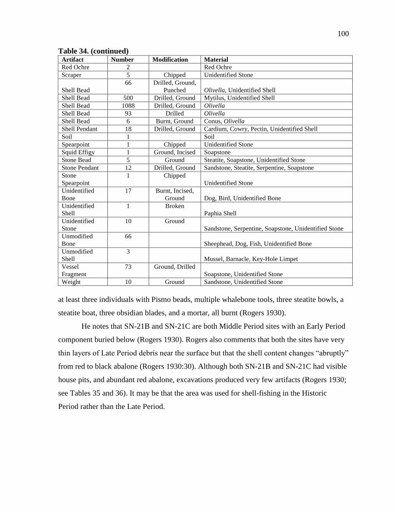
100
Table 34. (continued) Artifact Number Modification Material
Red Ochre 2 Red Ochre
Scraper 5 Chipped Unidentified Stone
Shell Bead
66 Drilled, Ground,
Punched Olivella, Unidentified Shell
Shell Bead 500 Drilled, Ground Mytilus, Unidentified Shell
Shell Bead 1088 Drilled, Ground Olivella
Shell Bead 93 Drilled Olivella
Shell Bead 6 Burnt, Ground Conus, Olivella
Shell Pendant 18 Drilled, Ground Cardium, Cowry, Pectin, Unidentified Shell
Soil 1 Soil
Spearpoint 1 Chipped Unidentified Stone
Squid Effigy 1 Ground, Incised Soapstone
Stone Bead 5 Ground Steatite, Soapstone, Unidentified Stone
Stone Pendant 12 Drilled, Ground Sandstone, Steatite, Serpentine, Soapstone
Stone
Spearpoint
1 Chipped
Unidentified Stone
Unidentified
Bone
17 Burnt, Incised,
Ground Dog, Bird, Unidentified Bone
Unidentified
Shell
1 Broken
Paphia Shell
Unidentified
Stone
10 Ground
Sandstone, Serpentine, Soapstone, Unidentified Stone
Unmodified
Bone
66
Sheephead, Dog, Fish, Unidentified Bone
Unmodified
Shell
3
Mussel, Barnacle, Key-Hole Limpet
Vessel
Fragment
73 Ground, Drilled
Soapstone, Unidentified Stone
Weight 10 Ground Sandstone, Unidentified Stone
at least three individuals with Pismo beads, multiple whalebone tools, three steatite bowls, a
steatite boat, three obsidian blades, and a mortar, all burnt (Rogers 1930).
He notes that SN-21B and SN-21C are both Middle Period sites with an Early Period
component buried below (Rogers 1930). Rogers also comments that both the sites have very
thin layers of Late Period debris near the surface but that the shell content changes “abruptly”
from red to black abalone (Rogers 1930:30). Although both SN-21B and SN-21C had visible
house pits, and abundant red abalone, excavations produced very few artifacts (Rogers 1930;
see Tables 35 and 36). It may be that the area was used for shell-fishing in the Historic
Period rather than the Late Period.
101
Table 35. Artifacts from SN-21B
Artifact Number Modification Material
Awl 1 Ground Unidentified Bone
Bone Point 1 Ground Unidentified Bone
Unmodified Bone 1 Dog Bone
Unidentified Bone 1 Unidentified Bone
Table 36. Artifacts from SN-21C
Artifact Number Modification Material
Pry Bar 1 Ground Sea Mammal
Unidentified Bone 1 Ground Sea Mammal
SN-22(SNI-173, SNI-177)
Rogers recorded SN-22 to be about 200 meters by 500 meters wide. The shell midden
deposits consisted of sea urchins, mussels, and black abalone (Rogers 1930). No trenching
was done at this site, but Rogers noted abundant snail midden exposed in the eroded points
between the shell midden mounds (Rogers 1930). Mortars and an eroded human cremation
were observed, along with minimal amounts of donut stones and fishbones (Rogers 1930; see
Table 37). In total, the site contained six mounds of Late Period shell midden with Early
Period deposits underlying (Rogers 1930).
SN-23(SNI-41)
SN-23 was located on the west end of San Nicolas to the south of SN-21 and SN-22.
This site was determined to be about two miles long (Rogers 1930; see Table 38). The shell
midden was mostly of land snail, abalone, mussel, and limpet. In the basal deposits of one of
the mounds, a human burial was found extended on its back, face up (Rogers 1930). Near the
burial Rogers found a bone tool with fragments of the wood hafted along one of its margins
(Rogers 1930, see Figure 24). They also found a human cremation burial associated with a
sacrificed knife, a steatite bowl, Olivella beads, and a dog burial (Rogers 1930; Table 39).
Rogers' crew recorded this site as a Late Period mound site with some smaller amounts of
Early Period deposits (Rogers 1930).
This is the last area on the southwestern shore of the island that was recorded by
Rogers and his crew because, according to Rogers, there were no other large sites past this
point due to the steep terrain of the south shore (Rogers 1930). A human cremation feature,
102
Table 37. Artifacts from SN-22
Artifact Number Modification Material
Abalone Fragment 2 Abalone
Anvil 1 Ground Sandstone
Awl 1 Ground Sea Mammal Bone
Blank 1 Punched Black Abalone
Bone Point 7 Ground Bird, Sea Mammal Bone
Bowl 1 Ground Sandstone
Core 13 Chipped Unidentified Stone
Decoration 1 Ground Soapstone
Decoration 1 Ground, Incised Soapstone
Donut Stone 14 Ground Sandstone, Steatite, Soapstone
Drill 1 Ground Shell Concretion
Flake 1 Chipped Unidentified Stone
Hafted Tool 9 Ground, Stained Sea Mammal, Unidentified Bone
Mano 3 Ground Sandstone, Unidentified Stone
Mortar 6 Ground Sandstone
Pendant 10 Drilled, Punched Cowry, Chione, Unidentified Shell
Pestle 10 Ground Sandstone
Pipe Fragments 3 Ground Steatite
Point 22 Chipped Shale, Unidentified Stone
Pry Bar 14 Ground Sea Mammal Bone
Scraper 4 Chipped Unidentified Stone
Shell Bead 2 Drilled, Ground Unidentified Shell
Stone Pendant 3 Drilled Steatite, Unidentified Stone
Stone Tube 1 Ground Soapstone
Unidentified Bone 11 Ground Bird, Sea Mammal Bone
Unidentified Shell 1 Ground Unidentified Shell
Unidentified Stone 9 Ground, Incised Unidentified Stone
Unidentified Stone 1 Ground Serpentine
Unmodified Bone 9 Dog, Fish, Unidentified Bone
Unmodified Shell 4 Snail, Unidentified Shell
Weight 7 Ground Sandstone
containing an unidentified number of burials, was located at the top of a large shell midden.
Associated with the burial were a flint spear point, abundant whole Olivella shell beads, a
bone projectile point, numerous Olivella bead shell blanks, a keyhole limpet bead, small flat
steatite bead, several Olivella beads, a steatite donut stone, a steatite cup, five fragmentary
whalebone tools, burnt dog bones, a flowerpot sandstone mortar, a steatite pendant, and a
whalebone flaker (Rogers 1930). Only some of these artifacts remain identifiable in the MoM
collection (Table 40).

103
Table 38. Artifacts from SN-23
Artifact Number Modification Material
Abalone
Fragment
3
Abalone
Awl 1 Ground Sea Mammal Bone
Blank 27 Ground Red Abalone, Black Abalone
Bone Harpoon 1 Ground Unidentified Bone
Bone Point 55 Ground Bird, Sea Mammal, Unidentified Bone
Core 3 Chipped Unidentified Stone
Decoration 2 Incised, Ground Sea Mammal Bone
Donut Stone 8 Ground Steatite, Sandstone, Unidentified Stone
Fishhook 6 Ground Red Abalone
Hafted Tool 27 Ground Sea Mammal, Asphaltum, Unidentified Bone
Limpet Ornament 2 Ground Limpet
Metate 1 Ground Sandstone
Pendant 1 Drilled, Ground Unidentified Bone
Pestle 5 Ground Sandstone
Pry Bar 18 Ground Sea Mammal, Unidentified Bone
Shell Pendant 7 Punched, Burnt Cowry, Unidentified Shell
Unidentified Bone 2 Ground Bird, Unidentified Bone
Unidentified Shell 4 Ground Unidentified Shell
Unmodified Bone 2 Dog Bone, Unidentified Bone
Unmodified Shell 28 Sea Urchin Spines
Unmodified Shell 1 Cardium
Weight 1
Whistle 5 Drilled Bird, Unidentified Bone
SN-24(SNI-20)
SN-24 is a Late Period site measuring 900 feet by 200 feet that was looted by Sanger
and his team before Rogers’ crew record the location (Rogers 1930). Sanger gathered and left
the human remains he excavated from two cemeteries and Rogers estimated that they
represented between seven and 15 individuals, although the remains may have been from
more than one site (Rogers 1930). On the west end of the site along a flat mesa, three human
cremation burials were found with a large amount of broken steatite, two broken obsidian
spears, two manos, and numerous dog burials (Rogers 1930; see Table 41).
Rogers and his crew excavated a trench through the shell midden, identifying three
distinct components (Rogers 1930; see Figure 25). They also found two human cremation
burials at the top of the site, about 15 feet apart and located in two possible house depressions
(Rogers 1930). Cremation 1 was on the highest part of the shell midden at the west end and
contained a Franciscan flint spear point broken in three pieces, cranium fragments, steatite
bowl fragments, and a steatite donut stone broken into two fragments (Rogers 1930).
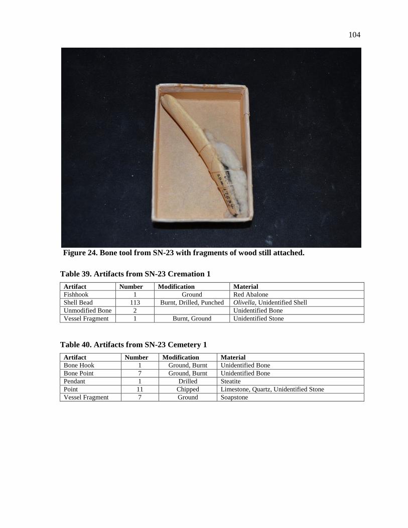
104
Figure 24. Bone tool from SN-23 with fragments of wood still attached.
Table 39. Artifacts from SN-23 Cremation 1
Artifact Number Modification Material
Fishhook 1 Ground Red Abalone
Shell Bead 113 Burnt, Drilled, Punched Olivella, Unidentified Shell
Unmodified Bone 2 Unidentified Bone
Vessel Fragment 1 Burnt, Ground Unidentified Stone
Table 40. Artifacts from SN-23 Cemetery 1
Artifact Number Modification Material
Bone Hook 1 Ground, Burnt Unidentified Bone
Bone Point 7 Ground, Burnt Unidentified Bone
Pendant 1 Drilled Steatite
Point 11 Chipped Limestone, Quartz, Unidentified Stone
Vessel Fragment 7 Ground Soapstone
105
Table 41. Artifacts from SN-24
Artifact Number Modification Material
Pry Bar 6 Ground, Burnt Sea Mammal Bone
Hafted Tool 10 Ground, Burnt, Stained Unidentified Bone
Point 24 Ground, Burnt Unidentified Bone
Pendant 1 Drilled, Ground Unidentified Bone
Whistle 2 Drilled Bird Bone
Unidentified Bone 2 Burnt, Ground Unidentified Bone
Button Decoration 1 Drilled, Ground Abalone
Pendant 8 Drilled, Ground Cardium, Pectin, Snail, Unidentified
Bead 21 Drilled, Ground Abalone, Olivella
Limpet Ornament 4 Ground Limpet
Blank 3 Ground Abalone, Unidentified
Unidentified Shell 4 Ground Unidentified Shell
Red Ochre 1 Red Ochre
Drill 6 Ground Concretion, Sandstone, Unidentified
Donut Stone 9 Ground Steatite, Sandstone, Unidentified
Weight 7 Ground Sandstone
Mano 1 Ground Sandstone
Pipe 1 Ground Sandstone
Vessel Fragment 7 Ground Soapstone
Unidentified Stone 9 Ground Steatite, Concretion, Unidentified
Whale Effigy 1 Ground Steatite
Root Cast 1 Sandstone
Pipe Fragments 2 Drilled, Ground Unidentified Stone
Stone Bead 3 Ground Steatite, Unidentified
Pendant 1 Drilled Unidentified Stone
Unidentified Stone 5 Soapstone, Quartz, Unidentified Stone
Scraper 2 Chipped Unidentified Stone
Biface 8 Chipped Unidentified Stone
Point 9 Chipped Soapstone, Shale, Quartz, Unidentified Stone
Pelican Effigy 1 Ground Steatite
Unmodified 1 Dog Bone
Pestle 1 Ground Sandstone
Weight 1 Ground Sandstone
Cremation 2 was 15 feet north of Cremation 1 and disturbed by looters. Still, Rogers
identified cranium fragments, steatite fragments, half of a steatite donut stone, two burnt and
broken whalebone tools, and a burnt bone projectile point (Rogers 1930).
SN-25
SN-25 is located on the south side of the central plateau to the south of SN-26 and the
east of SN-30. This site was first recorded by part of Rogers' crew when they were sent to
investigate the plateau on the east half of the island (Rogers 1930). They found a large site,
about a half a mile long by a quarter of a mile wide and eight inches deep, at the head of the
drainage that flows down to Crescent Bay (Rogers 1930). Rogers identified SN-25 as a Late
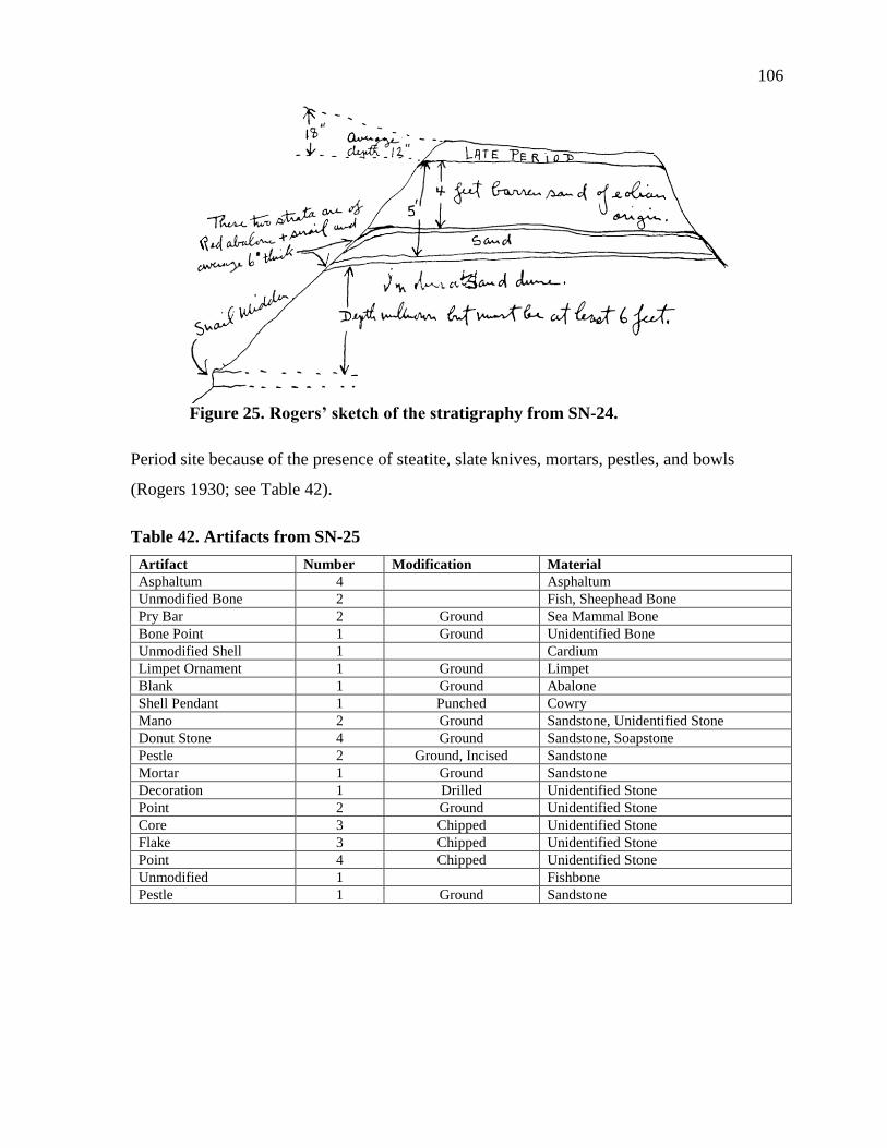
106
Figure 25. Rogers’ sketch of the stratigraphy from SN-24.
Period site because of the presence of steatite, slate knives, mortars, pestles, and bowls
(Rogers 1930; see Table 42).
Table 42. Artifacts from SN-25
Artifact Number Modification Material
Asphaltum 4 Asphaltum
Unmodified Bone 2 Fish, Sheephead Bone
Pry Bar 2 Ground Sea Mammal Bone
Bone Point 1 Ground Unidentified Bone
Unmodified Shell 1 Cardium
Limpet Ornament 1 Ground Limpet
Blank 1 Ground Abalone
Shell Pendant 1 Punched Cowry
Mano 2 Ground Sandstone, Unidentified Stone
Donut Stone 4 Ground Sandstone, Soapstone
Pestle 2 Ground, Incised Sandstone
Mortar 1 Ground Sandstone
Decoration 1 Drilled Unidentified Stone
Point 2 Ground Unidentified Stone
Core 3 Chipped Unidentified Stone
Flake 3 Chipped Unidentified Stone
Point 4 Chipped Unidentified Stone
Unmodified 1 Fishbone
Pestle 1 Ground Sandstone
107
SN-26(SNI-29, SNI-30, SNI-79, SNI-80, SNI-97)
SN-26 is located on the central plateau to the north of SN-25 and south of SN-2
(Table 43). Among the features found at the site was a cache on the second terrace that
contained a steatite effigy, two ground abalone rims, two bone gorgets, a bone whistle, and
seal bones, mostly flipper bones (Rogers 1930). A second cache was exposed by erosion and
contained a red abalone shell, two chunks of low grade obsidian, four flat serpentine beads,
and a steatite cylindrical bead (Rogers 1930). A third cache was discovered eroded from the
top stratum of the site with a red abalone pendent, a cardium pendant with two drill holes,
three beads, and a flat knife of yellow chert (Rogers 1930; see Table 44).
When Rogers revisited this site in 1934, he found five human cremation burials in a
shell midden dominated by mussel shells on the west end of the site. Each of the burials
contained steatite artifacts as well as sandstone mortars and pestles (Rogers 1930). He did not
excavate these cremations, however (Rogers 1930; see Tables 45 and 46).
SN-27(SNI-42, SNI-43, SNI-52, SNI-204, SNI-207,
SNI-209, SNI-211, SNI-213)
Very little is recorded in Rogers' notes about SN-27. It is located on the west end of
the island near SN-25, but farther inland. Rogers did note that an unknown number of human
cremation burials were seen eroding from a midden, but little other details were recorded
(Rogers 1930). Based on the relatively small number of artifacts from this locality in the
MoM collections, it is safe to assume that Rogers did not conduct formal excavations
(Table 47). However, Rogers did collect a steatite pelican effigy, which may have eroded
from the deposits on the surface of the site.
SN-28(SNI-45, SNI-189, SNI-214)
Nothing is recorded in Rogers' notes about SN-28. Using Rogers’ maps, Schwartz
(personal communication, November 13, 2013) was able to determine that SN-28 was
located on the west side of the central plateau. Interesting artifacts from the MoM collection
that are attributed to this site include a steatite effigy, four donut stones, and an un-worked
quartz fragment (Table 48).
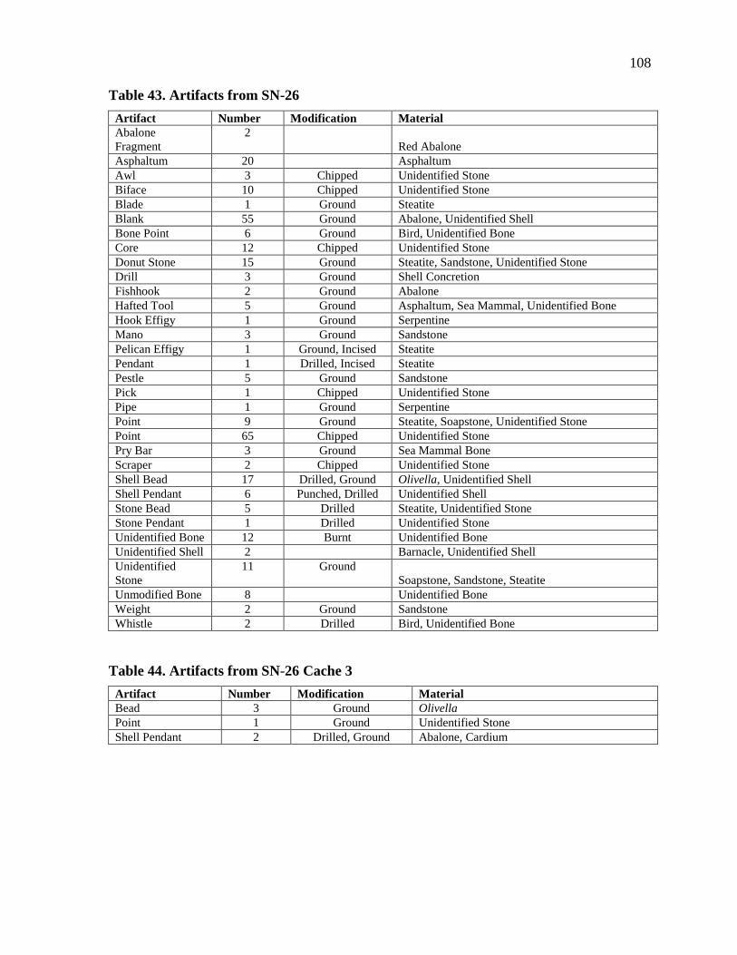
108
Table 43. Artifacts from SN-26
Artifact Number Modification Material
Abalone
Fragment
2
Red Abalone
Asphaltum 20 Asphaltum
Awl 3 Chipped Unidentified Stone
Biface 10 Chipped Unidentified Stone
Blade 1 Ground Steatite
Blank 55 Ground Abalone, Unidentified Shell
Bone Point 6 Ground Bird, Unidentified Bone
Core 12 Chipped Unidentified Stone
Donut Stone 15 Ground Steatite, Sandstone, Unidentified Stone
Drill 3 Ground Shell Concretion
Fishhook 2 Ground Abalone
Hafted Tool 5 Ground Asphaltum, Sea Mammal, Unidentified Bone
Hook Effigy 1 Ground Serpentine
Mano 3 Ground Sandstone
Pelican Effigy 1 Ground, Incised Steatite
Pendant 1 Drilled, Incised Steatite
Pestle 5 Ground Sandstone
Pick 1 Chipped Unidentified Stone
Pipe 1 Ground Serpentine
Point 9 Ground Steatite, Soapstone, Unidentified Stone
Point 65 Chipped Unidentified Stone
Pry Bar 3 Ground Sea Mammal Bone
Scraper 2 Chipped Unidentified Stone
Shell Bead 17 Drilled, Ground Olivella, Unidentified Shell
Shell Pendant 6 Punched, Drilled Unidentified Shell
Stone Bead 5 Drilled Steatite, Unidentified Stone
Stone Pendant 1 Drilled Unidentified Stone
Unidentified Bone 12 Burnt Unidentified Bone
Unidentified Shell 2 Barnacle, Unidentified Shell
Unidentified
Stone
11 Ground
Soapstone, Sandstone, Steatite
Unmodified Bone 8 Unidentified Bone
Weight 2 Ground Sandstone
Whistle 2 Drilled Bird, Unidentified Bone
Table 44. Artifacts from SN-26 Cache 3
Artifact Number Modification Material
Bead 3 Ground Olivella
Point 1 Ground Unidentified Stone
Shell Pendant 2 Drilled, Ground Abalone, Cardium
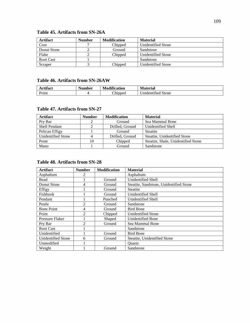
109
Table 45. Artifacts from SN-26A
Artifact Number Modification Material
Core 7 Chipped Unidentified Stone
Donut Stone 2 Ground Sandstone
Flake 2 Chipped Unidentified Stone
Root Cast 1 Sandstone
Scraper 3 Chipped Unidentified Stone
Table 46. Artifacts from SN-26AW
Artifact Number Modification Material
Point 4 Chipped Unidentified Stone
Table 47. Artifacts from SN-27
Artifact Number Modification Material
Pry Bar 2 Ground Sea Mammal Bone
Shell Pendant 2 Drilled, Ground Unidentified Shell
Pelican Effigy 1 Ground Steatite
Unidentified Stone 4 Drilled, Ground Steatite, Unidentified Stone
Point 10 Chipped Steatite, Shale, Unidentified Stone
Mano 1 Ground Sandstone
Table 48. Artifacts from SN-28
Artifact Number Modification Material
Asphaltum 2 Asphaltum
Bead 1 Ground Unidentified Shell
Donut Stone 4 Ground Steatite, Sandstone, Unidentified Stone
Effigy 1 Ground Steatite
Fishhook 1 Ground Unidentified Shell
Pendant 1 Punched Unidentified Shell
Pestle 2 Ground Sandstone
Bone Point 4 Ground Bird Bone
Point 2 Chipped Unidentified Stone
Pressure Flaker 1 Shaped Unidentified Bone
Pry Bar 2 Ground Sea Mammal Bone
Root Cast 1 Sandstone
Unidentified 1 Ground Bird Bone
Unidentified Stone 6 Ground Steatite, Unidentified Stone
Unmodified 1 Quartz
Weight 1 Ground Sandstone
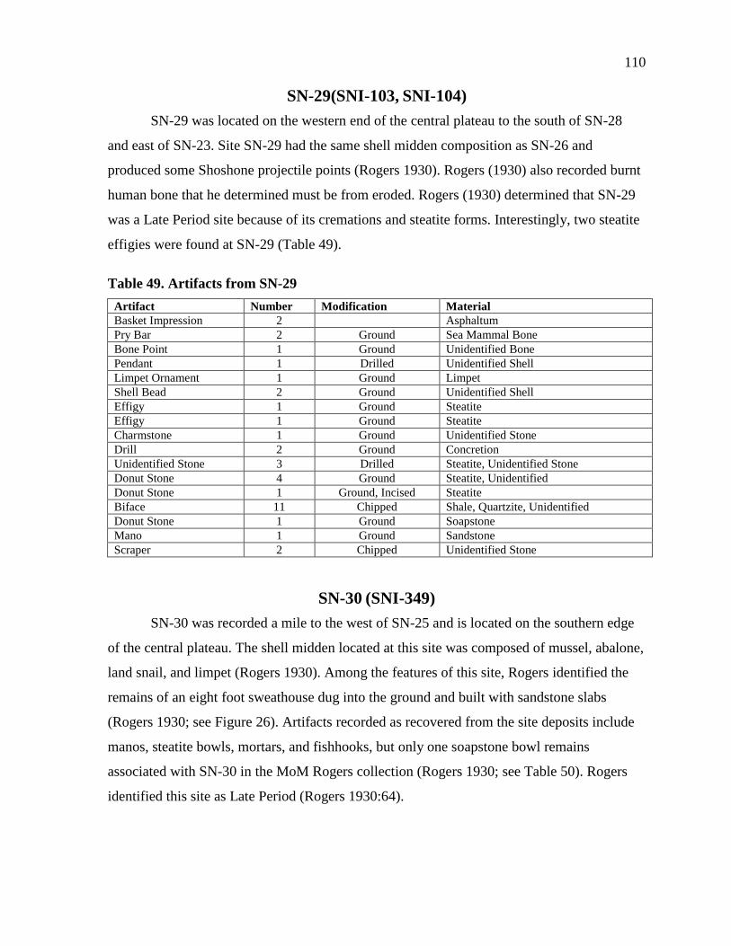
110
SN-29(SNI-103, SNI-104)
SN-29 was located on the western end of the central plateau to the south of SN-28
and east of SN-23. Site SN-29 had the same shell midden composition as SN-26 and
produced some Shoshone projectile points (Rogers 1930). Rogers (1930) also recorded burnt
human bone that he determined must be from eroded. Rogers (1930) determined that SN-29
was a Late Period site because of its cremations and steatite forms. Interestingly, two steatite
effigies were found at SN-29 (Table 49).
Table 49. Artifacts from SN-29
Artifact Number Modification Material
Basket Impression 2 Asphaltum
Pry Bar 2 Ground Sea Mammal Bone
Bone Point 1 Ground Unidentified Bone
Pendant 1 Drilled Unidentified Shell
Limpet Ornament 1 Ground Limpet
Shell Bead 2 Ground Unidentified Shell
Effigy 1 Ground Steatite
Effigy 1 Ground Steatite
Charmstone 1 Ground Unidentified Stone
Drill 2 Ground Concretion
Unidentified Stone 3 Drilled Steatite, Unidentified Stone
Donut Stone 4 Ground Steatite, Unidentified
Donut Stone 1 Ground, Incised Steatite
Biface 11 Chipped Shale, Quartzite, Unidentified
Donut Stone 1 Ground Soapstone
Mano 1 Ground Sandstone
Scraper 2 Chipped Unidentified Stone
SN-30 (SNI-349)
SN-30 was recorded a mile to the west of SN-25 and is located on the southern edge
of the central plateau. The shell midden located at this site was composed of mussel, abalone,
land snail, and limpet (Rogers 1930). Among the features of this site, Rogers identified the
remains of an eight foot sweathouse dug into the ground and built with sandstone slabs
(Rogers 1930; see Figure 26). Artifacts recorded as recovered from the site deposits include
manos, steatite bowls, mortars, and fishhooks, but only one soapstone bowl remains
associated with SN-30 in the MoM Rogers collection (Rogers 1930; see Table 50). Rogers
identified this site as Late Period (Rogers 1930:64).
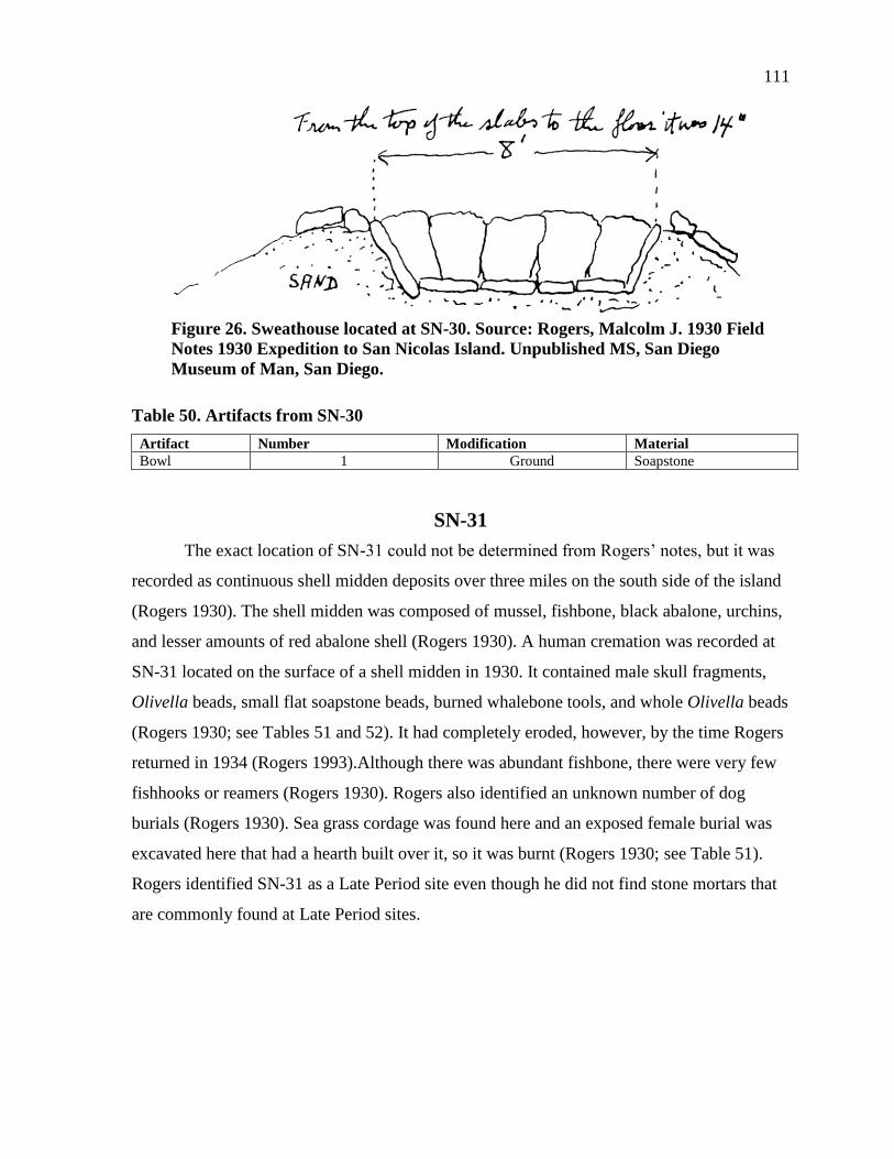
111
Figure 26. Sweathouse located at SN-30. Source: Rogers, Malcolm J. 1930 Field
Notes 1930 Expedition to San Nicolas Island. Unpublished MS, San Diego
Museum of Man, San Diego.
Table 50. Artifacts from SN-30
Artifact Number Modification Material
Bowl 1 Ground Soapstone
SN-31
The exact location of SN-31 could not be determined from Rogers’ notes, but it was
recorded as continuous shell midden deposits over three miles on the south side of the island
(Rogers 1930). The shell midden was composed of mussel, fishbone, black abalone, urchins,
and lesser amounts of red abalone shell (Rogers 1930). A human cremation was recorded at
SN-31 located on the surface of a shell midden in 1930. It contained male skull fragments,
Olivella beads, small flat soapstone beads, burned whalebone tools, and whole Olivella beads
(Rogers 1930; see Tables 51 and 52). It had completely eroded, however, by the time Rogers
returned in 1934 (Rogers 1993).Although there was abundant fishbone, there were very few
fishhooks or reamers (Rogers 1930). Rogers also identified an unknown number of dog
burials (Rogers 1930). Sea grass cordage was found here and an exposed female burial was
excavated here that had a hearth built over it, so it was burnt (Rogers 1930; see Table 51).
Rogers identified SN-31 as a Late Period site even though he did not find stone mortars that
are commonly found at Late Period sites.
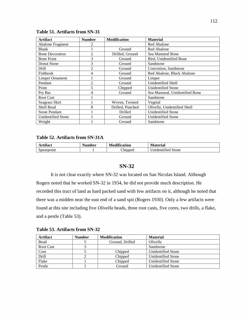
112
Table 51. Artifacts from SN-31
Artifact Number Modification Material
Abalone Fragment 2 Red Abalone
Blank 1 Ground Red Abalone
Bone Decoration 2 Drilled, Ground Sea Mammal Bone
Bone Point 3 Ground Bird, Unidentified Bone
Donut Stone 3 Ground Sandstone
Drill 2 Ground Concretion, Sandstone
Fishhook 4 Ground Red Abalone, Black Abalone
Limpet Ornament 1 Ground Limpet
Pendant 2 Ground Unidentified Shell
Point 5 Chipped Unidentified Stone
Pry Bar 4 Ground Sea Mammal, Unidentified Bone
Root Cast 1 Sandstone
Seagrass Skirt 1 Woven, Twisted Vegetal
Shell Bead 8 Drilled, Punched Olivella, Unidentified Shell
Stone Pendant 1 Drilled Unidentified Stone
Unidentified Stone 1 Ground Unidentified Stone
Weight 1 Ground Sandstone
Table 52. Artifacts from SN-31A
Artifact Number Modification Material
Spearpoint 1 Chipped Unidentified Stone
SN-32
It is not clear exactly where SN-32 was located on San Nicolas Island. Although
Rogers noted that he worked SN-32 in 1934, he did not provide much description. He
recorded this tract of land as hard packed sand with few artifacts on it, although he noted that
there was a midden near the east end of a sand spit (Rogers 1930). Only a few artifacts were
found at this site including five Olivella beads, three root casts, five cores, two drills, a flake,
and a pestle (Table 53).
Table 53. Artifacts from SN-32
Artifact Number Modification Material
Bead 5 Ground, Drilled Olivella
Root Cast 3 Sandstone
Core 5 Chipped Unidentified Stone
Drill 2 Chipped Unidentified Stone
Flake 1 Chipped Unidentified Stone
Pestle 1 Ground Unidentified Stone

113
CHAPTER 8
DISCUSSION AND CONCLUSIONS
The purpose of this study was to provide a better framework so that other researchers
can use this extensive collection in their own research. In doing this many interesting topics
have been briefly touched upon. A brief discussion of a few of these topics is provided
below, but this is in no way an exhaustive use of the Malcolm Rogers MoM collection. In
studies like Glenn’s (2012) discussion of dog burials from this collection, small parts of this
collection have been published. However, there are many other artifacts that offer important
avenues of future research. This extensive collection still remains largely unpublished and
can provide useful reference material for archaeologists working on San Nicolas Island.
Malcolm Rogers never finished his work on San Nicolas Island, but he did make
some preliminary conclusions. Some of these are still supported today, while others have not
stood the test of time. Although Rogers touched on many topics, he did not address some of
the most interesting artifacts in the MoM collection. In his brief conclusions paper, Rogers
discusses the environmental degradation of San Nicolas Island, the settlement patterns of the
Nicoleño, and a chronology of the sites, as well as a short discussion of the burial goods he
collected. He did not, however, recognize the Aleut artifacts included in his artifact collection
nor did he address some of the more rare artifacts he collected.
DETERMINING CHRONOLOGY
Rogers’ collection at the MoM could be used to create a refined chronology of
prehistoric occupation on San Nicolas Island. Conclusive dates for the Rogers collection at
the MoM will only be obtained after radiocarbon dating, which was not allowed at the time
of this project. By comparing artifacts to other dated sites, however, we can place them
generally within the current chronology. The various burial goods in the Rogers collection
are especially useful for dating sites because we can assume that the artifacts were all placed
in the ground on a single occasion, rather than deposited unevenly over time like a midden.
At the very least a terminus date for a site can be reached by using this dating technique.
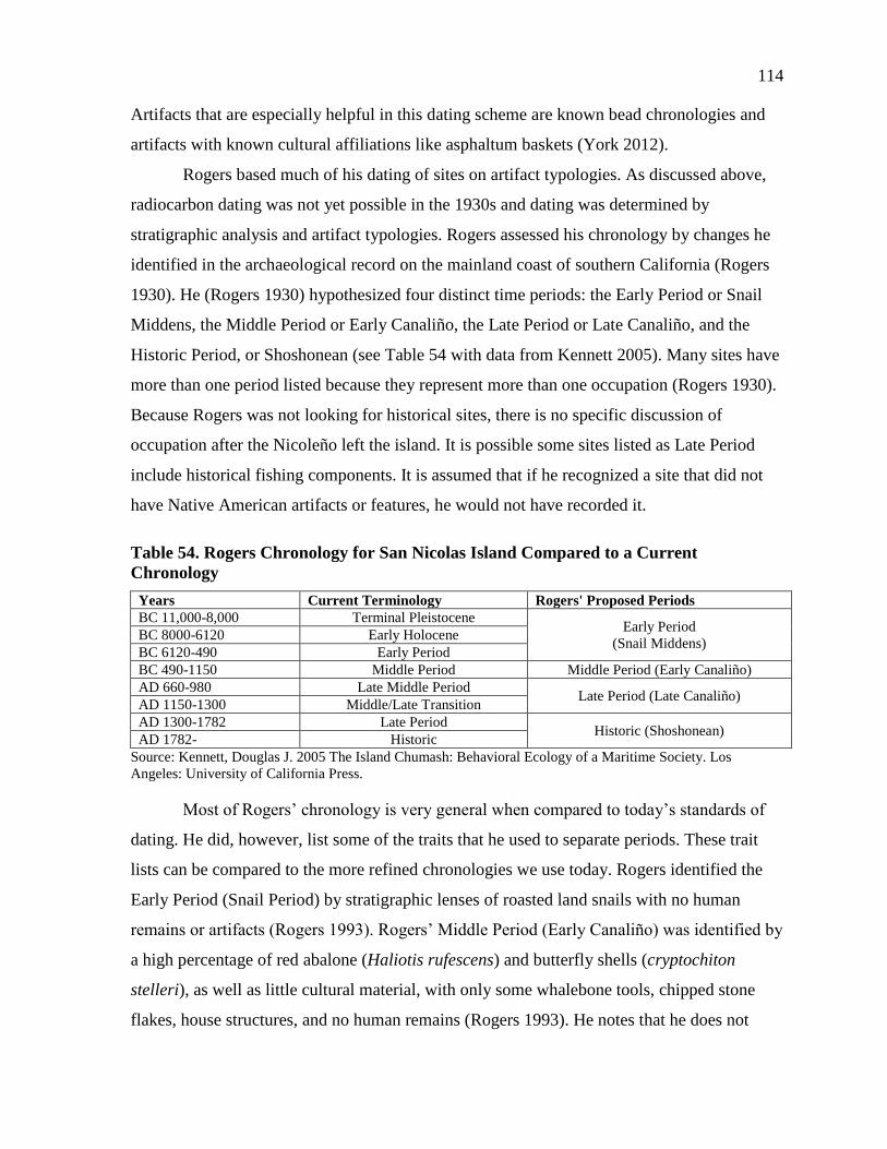
114
Artifacts that are especially helpful in this dating scheme are known bead chronologies and
artifacts with known cultural affiliations like asphaltum baskets (York 2012).
Rogers based much of his dating of sites on artifact typologies. As discussed above,
radiocarbon dating was not yet possible in the 1930s and dating was determined by
stratigraphic analysis and artifact typologies. Rogers assessed his chronology by changes he
identified in the archaeological record on the mainland coast of southern California (Rogers
1930). He (Rogers 1930) hypothesized four distinct time periods: the Early Period or Snail
Middens, the Middle Period or Early Canaliño, the Late Period or Late Canaliño, and the
Historic Period, or Shoshonean (see Table 54 with data from Kennett 2005). Many sites have
more than one period listed because they represent more than one occupation (Rogers 1930).
Because Rogers was not looking for historical sites, there is no specific discussion of
occupation after the Nicoleño left the island. It is possible some sites listed as Late Period
include historical fishing components. It is assumed that if he recognized a site that did not
have Native American artifacts or features, he would not have recorded it.
Table 54. Rogers Chronology for San Nicolas Island Compared to a Current
Chronology
Years Current Terminology Rogers' Proposed Periods
BC 11,000-8,000 Terminal Pleistocene Early Period
(Snail Middens) BC 8000-6120 Early Holocene
BC 6120-490 Early Period
BC 490-1150 Middle Period Middle Period (Early Canaliño)
AD 660-980 Late Middle Period Late Period (Late Canaliño)
AD 1150-1300 Middle/Late Transition
AD 1300-1782 Late Period Historic (Shoshonean)
AD 1782- Historic
Source: Kennett, Douglas J. 2005 The Island Chumash: Behavioral Ecology of a Maritime Society. Los
Angeles: University of California Press.
Most of Rogers’ chronology is very general when compared to today’s standards of
dating. He did, however, list some of the traits that he used to separate periods. These trait
lists can be compared to the more refined chronologies we use today. Rogers identified the
Early Period (Snail Period) by stratigraphic lenses of roasted land snails with no human
remains or artifacts (Rogers 1993). Rogers’ Middle Period (Early Canaliño) was identified by
a high percentage of red abalone (Haliotis rufescens) and butterfly shells (cryptochiton
stelleri), as well as little cultural material, with only some whalebone tools, chipped stone
flakes, house structures, and no human remains (Rogers 1993). He notes that he does not
115
fully understand this culture and it could be previous to the Canaliño or Chumash culture or it
could be “transitional in nature” (Rogers 1993:8). The Late Period (Canaliño Culture) is
identified by artifacts that are similar to historical Chumash culture. The Late Period was
identified by large community houses, imported materials, a greater variety of shell types and
fishbone in the middens, fishhooks, and dog burials (Rogers 1993). The Historic Period
(Shoshonean) was identified by cremations, metates, obsidian projectile points, and the
sweathouse (Rogers 1993).
The time periods Rogers assigned for each site are included with the site descriptions
above. When taken as a whole, sites fall into general patterns according to their topographical
locations. All of the sites on the central plateau were recorded by Rogers as being a part of
the Late Period. Sites on the west end and the north coast terrace are a mix of Middle and
Late occupations, with Middle Period occupations often capped by a later occupation.
Although Rogers refers to some sites as having lenses of early “Snail Midden,” he did not
classify any sites as early. Almost all of his work focused on Late Period sites, as these
provided the densest concentrations of formal artifacts.
The chronology of Rogers’ periods actually matches up well with what is already
known of San Nicolas Islands settlement chronology (see Chapter 4; Table 54). Because he
was basing his work off general stratigraphy patterns, Rogers recognized an increase in
complexity in the later periods. He also recognized that a Shoshonean, or Uto-Aztecan,
migration to San Nicolas occurred in the later periods of San Nicolas’ prehistoric occupation.
Rogers (1993) identified an increase in trade through the importation of stone artifacts. Most
of what he identified as the “Canaliño culture” was most likely part of this Uto-Aztecan
migration. He observed that “the development of the Canaliño Culture was made either on
the northern islands or the mainland and but little if any on San Nicolas Island.” (Rogers
1930:56).
Part of determining the chronology of the island has been a focus on the cultural
associations of the Nicoleño. Linguists have long associated the Nicoleño with the Takic
language group from the south, but before Rogers there was no archaeological evidence to
support this claim. He found cremations and artifacts that are indicative of the southern
Gabrieliño as well as earlier artifacts that looked like the Chumash (Rogers 1930). This led
him to believe that there was an intrusion of what he called Shoshonean people in the Late
116
Period (Rogers 1993). This claim has been supported by recent archaeological projects. It
appears that Rogers was right about the Shoshonean introduction, but it probably happened
much earlier than he believed. Rogers talks about the intrusion as happening very soon
before historical contact. Martz (2008) places the earliest Shoshonean occupation of the
island to be around 2125-2326 cal BP, by dating J-shaped fishhooks that are indicative of this
cultural change. Although this is the earliest date for the cultural influence, it is clear that
sometime between 3000-2500 years ago, Shoshonean populations moved onto San Nicolas
Island (Martz 2008). This is supported by both the cranial shape of remains (round replaced
by elongated) and by distinctive artifacts (Martz 2008).
These claims have been supported by a shift in the archaeological record (Ezzo 2001;
Martz 2008). The timing of this shift is still debated with linguists, archaeologists, and
biological archaeologists all proposing different times (Howard and Raab 1993; Rozaire
1959; Vellanoweth 1995; Wallace 1962). Some archaeologists propose that the shift occurred
as early as 6000 B.P based on trade interactions and the presence of Olivella Grooved
Rectangle beads (Howard and Raab 1993; Vellanoweth 1995). Others base their date of
4000-2500 B.P. on burial practices and a change in basket weaving techniques (Lauter 1982;
Rozaire 1959). Basket weaves with an S-design, with the twist to the right are often found on
the Southern Islands and are thought to be indicative of the Gabrieliño culture, while those
with a Z- design, twist to the left, are common on the northern Channel Islands and are
indictive of the Chumash culture (Rozaire 1967). The shift in this basketry technique was
first dated by Rozaire (1967) around 2500 cal BP. Recently, York (2012)has dated an S-
design basket to around 4200 cal BP which supports an earlier date for the transition to
Gabrieliño culture. The linguistic and the osteological findings support a shift of around 1500
cal BP). Regardless of the chronology of the cultural shift, it appears that there was an
intrusion of Shoshonean people onto San Nicolas sometime during the Middle to Late
Holocene.
SITE FUNCTION AND SETTLEMENT PATTERNS
After organizing sites by their location on the island, functional patterns start to
emerge. Location on the island can be a function of many things, including access to beaches,
fresh water, fishing grounds, or desirable topographic locations. The general categories used
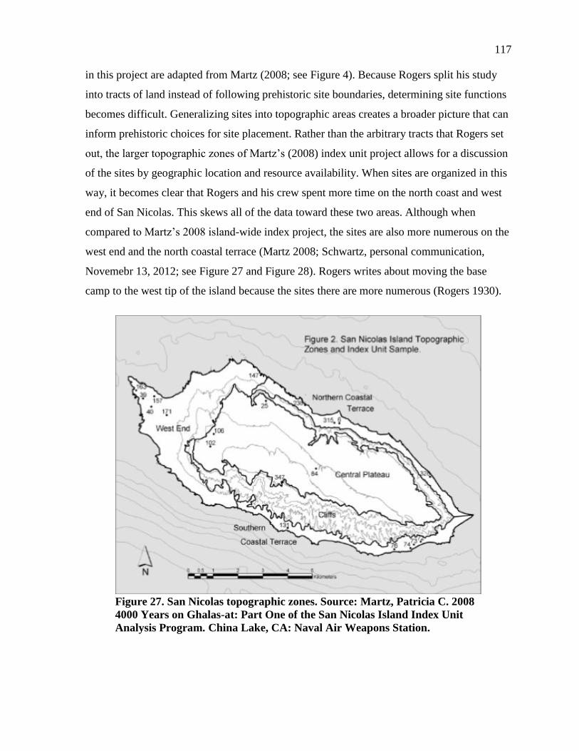
117
in this project are adapted from Martz (2008; see Figure 4). Because Rogers split his study
into tracts of land instead of following prehistoric site boundaries, determining site functions
becomes difficult. Generalizing sites into topographic areas creates a broader picture that can
inform prehistoric choices for site placement. Rather than the arbitrary tracts that Rogers set
out, the larger topographic zones of Martz’s (2008) index unit project allows for a discussion
of the sites by geographic location and resource availability. When sites are organized in this
way, it becomes clear that Rogers and his crew spent more time on the north coast and west
end of San Nicolas. This skews all of the data toward these two areas. Although when
compared to Martz’s 2008 island-wide index project, the sites are also more numerous on the
west end and the north coastal terrace (Martz 2008; Schwartz, personal communication,
Novemebr 13, 2012; see Figure 27 and Figure 28). Rogers writes about moving the base
camp to the west tip of the island because the sites there are more numerous (Rogers 1930).
Figure 27. San Nicolas topographic zones. Source: Martz, Patricia C. 2008
4000 Years on Ghalas-at: Part One of the San Nicolas Island Index Unit
Analysis Program. China Lake, CA: Naval Air Weapons Station.
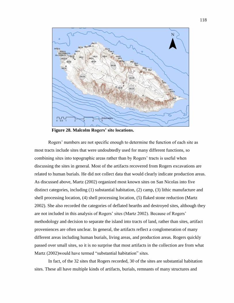
118
Figure 28. Malcolm Rogers’ site locations.
Rogers’ numbers are not specific enough to determine the function of each site as
most tracts include sites that were undoubtedly used for many different functions, so
combining sites into topographic areas rather than by Rogers’ tracts is useful when
discussing the sites in general. Most of the artifacts recovered from Rogers excavations are
related to human burials. He did not collect data that would clearly indicate production areas.
As discussed above, Martz (2002) organized most known sites on San Nicolas into five
distinct categories, including (1) substantial habitation, (2) camp, (3) lithic manufacture and
shell processing location, (4) shell processing location, (5) flaked stone reduction (Martz
2002). She also recorded the categories of deflated hearths and destroyed sites, although they
are not included in this analysis of Rogers’ sites (Martz 2002). Because of Rogers’
methodology and decision to separate the island into tracts of land, rather than sites, artifact
proveniences are often unclear. In general, the artifacts reflect a conglomeration of many
different areas including human burials, living areas, and production areas. Rogers quickly
passed over small sites, so it is no surprise that most artifacts in the collection are from what
Martz (2002)would have termed “substantial habitation” sites.
In fact, of the 32 sites that Rogers recorded, 30 of the sites are substantial habitation
sites. These all have multiple kinds of artifacts, burials, remnants of many structures and
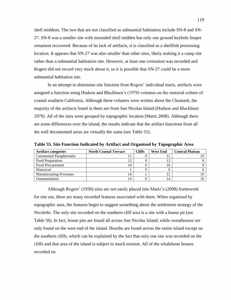
119
shell middens. The two that are not classified as substantial habitation include SN-8 and SN-
27. SN-8 was a smaller site with mounded shell midden but only one ground keyhole limpet
ornament recovered. Because of its lack of artifacts, it is classified as a shellfish processing
location. It appears that SN-27 was also smaller than other sites, likely making it a camp site
rather than a substantial habitation site. However, at least one cremation was recorded and
Rogers did not record very much about it, so it is possible that SN-27 could be a more
substantial habitation site.
In an attempt to determine site function from Rogers’ individual tracts, artifacts were
assigned a function using Hudson and Blackburn’s (1979) volumes on the material culture of
coastal southern California. Although these volumes were written about the Chumash, the
majority of the artifacts listed in them are from San Nicolas Island (Hudson and Blackburn
1979). All of the sites were grouped by topographic location (Martz 2008). Although there
are some differences over the island, the results indicate that the artifact functions from all
the well documented areas are virtually the same (see Table 55).
Table 55. Site Function Indicated by Artifact and Organized by Topographic Area
Artifact categories North Coastal Terrace Cliffs West End Central Plateau
Ceremonial Paraphernalia 11 0 11 10
Food Preparation 12 0 13 8
Food Procurement 14 0 16 9
Historical 1 0 0 0
Manufacturing Processes 14 1 12 10
Ornamentation 14 0 14 10
Although Rogers’ (1930) sites are not easily placed into Martz’s (2008) framework
for site use, there are many recorded features associated with them. When organized by
topographic area, the features begin to suggest something about the settlement strategy of the
Nicoleño. The only site recorded on the southern cliff area is a site with a house pit (see
Table 56). In fact, house pits are found all across San Nicolas Island, while sweathouses are
only found on the west end of the island. Hearths are found across the entire island except on
the southern cliffs, which can be explained by the fact that only one site was recorded on the
cliffs and that area of the island is subject to much erosion. All of the whalebone houses
recorded on
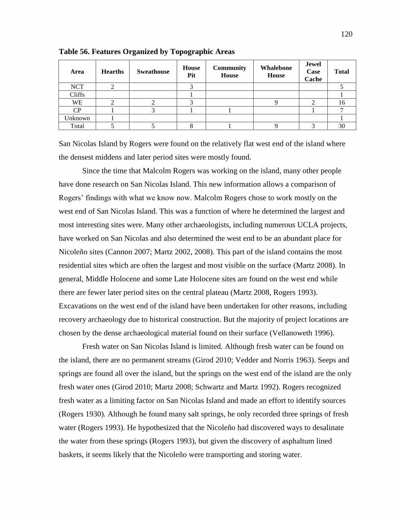
120
Table 56. Features Organized by Topographic Areas
Area Hearths Sweathouse House
Pit
Community
House
Whalebone
House
Jewel
Case
Cache
Total
NCT 2
3
5
Cliffs
1
1
WE 2 2 3
9 2 16
CP 1 3 1 1
1 7
Unknown 1
1
Total 5 5 8 1 9 3 30
San Nicolas Island by Rogers were found on the relatively flat west end of the island where
the densest middens and later period sites were mostly found.
Since the time that Malcolm Rogers was working on the island, many other people
have done research on San Nicolas Island. This new information allows a comparison of
Rogers’ findings with what we know now. Malcolm Rogers chose to work mostly on the
west end of San Nicolas Island. This was a function of where he determined the largest and
most interesting sites were. Many other archaeologists, including numerous UCLA projects,
have worked on San Nicolas and also determined the west end to be an abundant place for
Nicoleño sites (Cannon 2007; Martz 2002, 2008). This part of the island contains the most
residential sites which are often the largest and most visible on the surface (Martz 2008). In
general, Middle Holocene and some Late Holocene sites are found on the west end while
there are fewer later period sites on the central plateau (Martz 2008, Rogers 1993).
Excavations on the west end of the island have been undertaken for other reasons, including
recovery archaeology due to historical construction. But the majority of project locations are
chosen by the dense archaeological material found on their surface (Vellanoweth 1996).
Fresh water on San Nicolas Island is limited. Although fresh water can be found on
the island, there are no permanent streams (Girod 2010; Vedder and Norris 1963). Seeps and
springs are found all over the island, but the springs on the west end of the island are the only
fresh water ones (Girod 2010; Martz 2008; Schwartz and Martz 1992). Rogers recognized
fresh water as a limiting factor on San Nicolas Island and made an effort to identify sources
(Rogers 1930). Although he found many salt springs, he only recorded three springs of fresh
water (Rogers 1993). He hypothesized that the Nicoleño had discovered ways to desalinate
the water from these springs (Rogers 1993), but given the discovery of asphaltum lined
baskets, it seems likely that the Nicoleño were transporting and storing water.
121
Fishing resources also impact settlement. Rogers felt that most of the larger sites were
located on the west end of the island. This is corroborated by recent work done by Martz
(2002, 2008). Martz (2008) found most Middle Holocene sites located on the west end, with
settlement patterns expanding and diversifying during the Late Holocene. Martz (2008) also
concluded that the west end contained the largest number of residential sites. Martz (2008)
and Rogers (1930) agree that the west end of the island must have been one of the most
desirable locations on the island and both attribute this to the landscape. Martz (2008) notes
that the west end has the easiest access to both fresh water and fishing areas as well a less
steep and treacherous landscape than the rest of the island. In her study, Martz (2008) noted
that all west end sites included in her study were within 600feet of the shoreline and that
fishing was the most important subsistence resource in all but one site. This exemplifies the
importance that fishing had on the choice of settlement location.
Seasonal rotations may also have had an effect on the locations of these sites. In a
Middle Holocene site on the west end of the island, Vellanoweth (1996) took an in-depth
look at fish otoliths in order to determine if the site was used on a seasonal basis. By
examining these small fish bones, he was able to determine which season the fish died,
reflecting the seasons of site use (Vellanoweth 1996). He discovered that CA-SNI-161 was
used during the late winter and early summer as well as the late summer and early winter
(Vellanoweth 1996). A closer examination of other sites may reveal a pattern of seasonal
settlement.
Another possible explanation of a later shift of villages to the central plateau may be
an increase in interisland conflict. Kennett (2005) proposed settlement patterns on the
Northern Channel Islands based on viewshed and defendable positions. The Nicoleño,
however, were not utilizing the high cliffs of the southern coastal terrace as much as the
central plateau. In all likelihood the proximity to fishing waters kept them on the central
plateau, closer to the western and northern coast, rather than on the southern cliffs.
Settlement patterns were probably influenced by a complex combination of these
factors. The shift on San Nicolas to a more diverse settlement pattern coincided with the rise
in population levels and changes in diet as well as more interisland trade (see Chapter 3).
Like most cultural change, the cause and effect are multi faceted.
122
ROGERS’ COLLECTION METHODS
Rogers did not utilize the same methodology for every site that he recorded. He did,
however, surface collect from every site (see Table 57). It seems clear from his notes that if
the site was on a cliff or an eroded area, he would not excavate a trench and would document
the stratigraphy from the exposure. At large sites, if he could not determine the stratigraphy
from an exposed section, he would excavate a trench to determine the chronology. Rogers
did not excavate in levels, but rather excavated down to expose the stratigraphy and record it.
In most cases, Rogers excavated trenches to record stratigraphy, but at sites SN-6 and SN-7
Rogers excavated house pits by clearing them down to their original floor. Unlike the
archaeology of today, Rogers also often focused on excavating burials. He exposed the
burials and expanded the excavation until he felt that everything associated with the burials
had been found. He, therefore, spent more time at large late sites that contained cemeteries,
rather than at smaller early sites.
BURIAL AND CREMATION PRACTICES
Although internment practices are not often studied by modern subsurface
excavations due to respect for Native Americans and the limitations of federal and state laws,
much can be learned from the study of how people treat their dead (Gamble et al. 2001).
Internment practices are one of the ways that archaeologists separate the Chumash and
Gabrieliño cultures (Hardy 2000). Chumash were usually buried, while Gabrieliño were
often cremated before burial (Hardy 2000). It is clear that San Nicolas Island material culture
has pieces of both Chumash and Gabrieliño influence. This is also true for their burial
practices-both burials and cremations appear on San Nicolas Island. A comparison of the two
revealed that 21 out of 32 sites (66%) had burials and 13 out of 32 (41%) had cremations.
This sample, however, maybe skewed. Cremations can be more difficult to identify than
burials and Rogers was not doing a comprehensive study, only a quick survey.
When used in conjunction with other avenues of research, burial studies can provide
information about the social dynamics of a culture (Gamble et al. 2001). Although the
skeletal remains of this collection were not available for study, Rogers’ notes provide some
information about how the burials were discovered and what artifacts correspond to the
burials. Rogers’ interest in the artifacts associated with burials led him to take more notes on
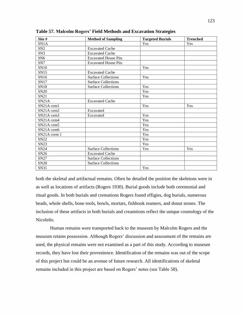
123
Table 57. Malcolm Rogers’ Field Methods and Excavation Strategies
Site # Method of Sampling Targeted Burials Trenched
SN1A Yes Yes
SN2 Excavated Cache
SN3 Excavated Cache
SN6 Excavated House Pits
SN7 Excavated House Pits
SN10 Yes
SN15 Excavated Cache
SN16 Surface Collections Yes
SN17 Surface Collections
SN18 Surface Collections Yes
SN20 Yes
SN21 Yes
SN21A Excavated Cache
SN21A cem1 Yes Yes
SN21A cem2 Excavated
SN21A cem3 Excavated Yes
SN21A cem4 Yes
SN21A cem5 Yes
SN21A cem6 Yes
SN21A crem 1 Yes
SN22 Yes
SN23 Yes
SN24 Surface Collections Yes Yes
SN26 Excavated Cache
SN27 Surface Collections
SN28 Surface Collections
SN31 Yes
both the skeletal and artifactual remains. Often he detailed the position the skeletons were in
as well as locations of artifacts (Rogers 1930). Burial goods include both ceremonial and
ritual goods. In both burials and cremations Rogers found effigies, dog burials, numerous
beads, whole shells, bone tools, bowls, mortars, fishhook reamers, and donut stones. The
inclusion of these artifacts in both burials and creamtions reflect the unique cosmology of the
Nicoleño.
Human remains were transported back to the museum by Malcolm Rogers and the
museum retains possession. Although Rogers’ discussion and assessment of the remains are
used, the physical remains were not examined as a part of this study. According to museum
records, they have lost their provenience. Identification of the remains was out of the scope
of this project but could be an avenue of future research. All identifications of skeletal
remains included in this project are based on Rogers’ notes (see Table 58).
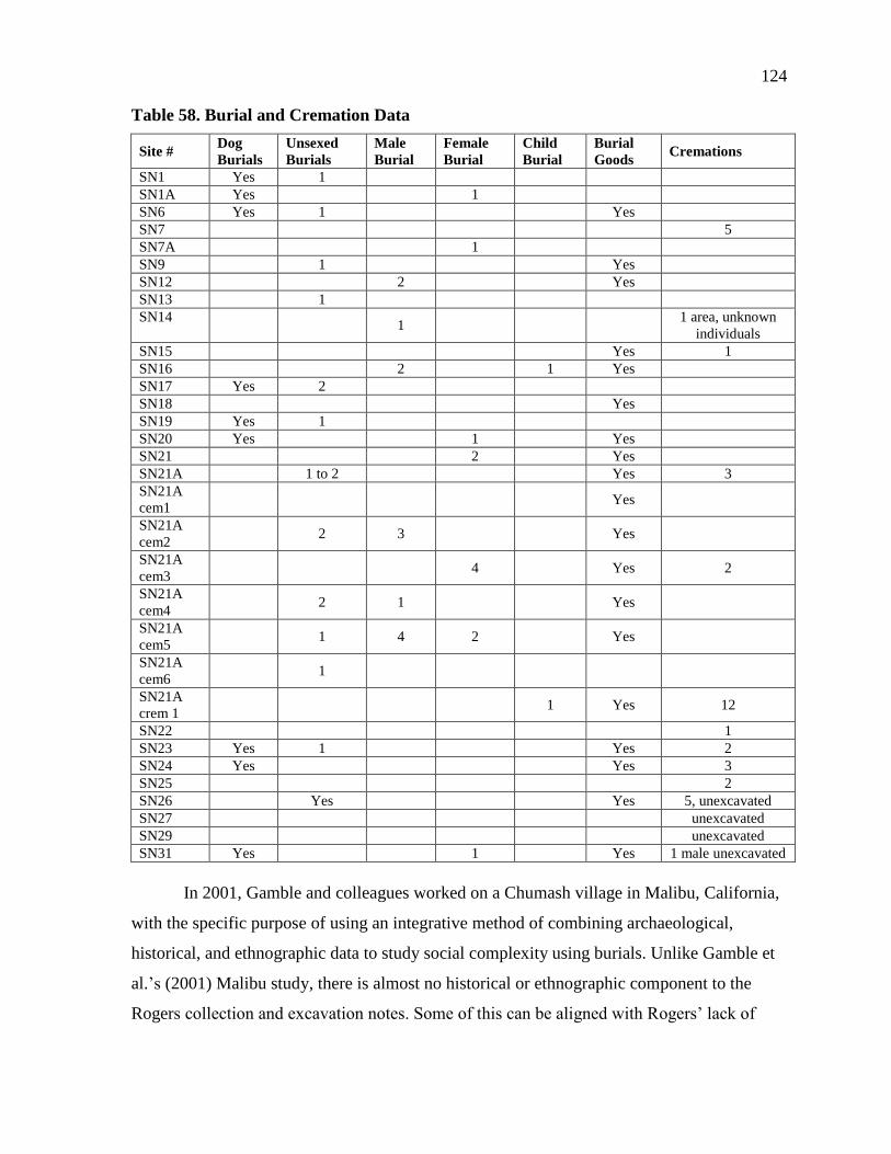
124
Table 58. Burial and Cremation Data
Site # Dog
Burials
Unsexed
Burials
Male
Burial
Female
Burial
Child
Burial
Burial
Goods Cremations
SN1 Yes 1
SN1A Yes
1
SN6 Yes 1
Yes
SN7
5
SN7A
1
SN9
1
Yes
SN12
2
Yes
SN13
1
SN14
1
1 area, unknown
individuals
SN15
Yes 1
SN16
2
1 Yes
SN17 Yes 2
SN18
Yes
SN19 Yes 1
SN20 Yes
1
Yes
SN21
2
Yes
SN21A
1 to 2
Yes 3
SN21A
cem1 Yes
SN21A
cem2 2 3
Yes
SN21A
cem3 4
Yes 2
SN21A
cem4 2 1
Yes
SN21A
cem5 1 4 2
Yes
SN21A
cem6 1
SN21A
crem 1 1 Yes 12
SN22
1
SN23 Yes 1
Yes 2
SN24 Yes
Yes 3
SN25
2
SN26
Yes
Yes 5, unexcavated
SN27
unexcavated
SN29
unexcavated
SN31 Yes
1
Yes 1 male unexcavated
In 2001, Gamble and colleagues worked on a Chumash village in Malibu, California,
with the specific purpose of using an integrative method of combining archaeological,
historical, and ethnographic data to study social complexity using burials. Unlike Gamble et
al.’s (2001) Malibu study, there is almost no historical or ethnographic component to the
Rogers collection and excavation notes. Some of this can be aligned with Rogers’ lack of

125
interest in historical archaeology, but much of it probably stems from the distance of San
Nicolas from the trading circles of historical Spanish contact and the disappearance of the
Nicoleño. However, comparing Rogers’ work to Gamble et al.’s comprehensive study allows
us a brief look into what may be possible with the burial information from Roger’s study.
Of the 84 burials and cremations that Rogers excavated, only 17 did not have artifacts
associated with them. The burials without associated goods are both male and female, but
there are no children found in this collection that were not associated with burial goods.
Gamble et al. (2001) argued that the Malibu Chumash village showed signs of ascribed social
hierarchy by the number and placement of burial goods. A small proportion of the burials in
the study held the majority of the burial goods (Gamble et al. 2001). This is consistent with
the Rogers’ collection burial information confirming the ascribed status among the Nicoleño.
Other consistencies with Gamble et al. (2001)’s findings in Malibu include that later
burials include more goods than earlier ones, indicating a shift towards social hierarchy.
Although the dates of the burials in this collection are unclear, in his notes, Rogers comments
that earlier burials have almost no burial goods in them making them less desirable for
excavation (Rogers 1930). Rogers also excavated groups of burials (cemeteries). Burying the
dead in a small area indicates a group consensus about using a ritualized space for the dead
(Gamble et al. 2001).
Gamble et al. (2001) also found that the position of the dead became more consistent
in the Middle and Late Prehistoric Period. Although this study is unable to discuss the
chronology of burials on San Nicolas Island, Rogers did discuss the flexed nature of many of
the burials as well as the directionality of the burial placement. Gamble discusses how
consistencies in burial practices indicate consistent religious beliefs across space and time. It
is possible that the San Nicolas burials share some of these consistent burial practices which
could indicate interesting correlations for religious consistency across the northern and
southern island groups.
According to the burial data from Rogers’ collection, the Nicoleño were a society of
ascribed status. In general, later burials included more burial goods than earlier ones
indicating an increase in social structure and hierarchy. The Nicoleño also had consistent
ritual burial practices, indicated by both burial location and body placement. These initial
126
findings could be expanded to allow for a more comprehensible understanding of changes in
social behavior of the Nicoleño through time.
EFFIGIES
Effigies are rare artifact types in the archaeological record. Often they are included
with burials, which are now protected from excavation by a number of state and federal laws.
The effigies used in this analysis include both formal effigies and hook stones, as well as any
artifact that was determined to be a possible effigy. An attempt was made to speciate the bird
effigies by the size and orientation of the beak in the manner of Hoover (1974). After
consulting with Philip Unitt, curator from the San Diego Natural History Museum and
specialist in California Birds, it was apparent that a clear speciation would be impossible.
Therefore, when effigies are referred to as “pelican effigies” in this study, it is in reference to
other projects which have used that title to refer to a specific shape of effigy, rather than the
actual bird.
Two of the sites with the most cemeteries in Rogers’ study, SN-21A and SN-14 were
predictably the sites with the most effigies collected (Table 59). As discussed above, a
scarcity of sites on the southern cliffs of the islands left the area with no effigies collected.
The other topographic areas were more similar in the number of effigies found. The north
coast terrace had four effigies, the west end had eight, and the central plateau had eight. This
is consistent with the number, size and age of sites in those areas. The north coast has
smaller, earlier sites with fewer formal cemeteries while the west end and the central plateau
both have larger, later sites with both formal cemeteries and cremation areas.
Like many other studies, Rogers recovered most of the effigies in this collection from
human burials. Their location in burials has made them an especially rare artifact, making
museum collections one of the only places to study an array of effigies (Figure 29). The
MoM Rogers collection is not only one of the rare collections to house many of these
effigies, but it has the added benefit of a relatively clear provenience and consistent curation.
In the early days of museum collection, some effigies were forged and sold as artifacts to
museums. The Rogers collection effigies have a clear enough provenience to be ruled out as
forgeries.

127
Table 59. Location and Description of Effigies from the Rogers’ Collection at MoM
Site # Site Location Description Material
SN-4 NCT Effigy Steatite
SN-7 NCT Effigy Serpentine
SN-10 NCT Pelican Effigy Sea Mammal Bone
SN-10 NCT Effigy Steatite
SN-13 WE Fish Effigy Soapstone
SN-14 CP Broken Pelican Effigy Unidentified Bone
SN-14 CP Pelican effigy Unidentified Stone
SN-14 CP Effigy Pendant Steatite
SN-16 WE Pelican Effigy Steatite
SN-20 WE Steatite Canoe Steatite
SN-20 WE Effigy Steatite
SN-21A WE Effigy Soapstone
SN-21A WE Effigy Unidentified Stone
SN-21A WE Canoe Effigy Steatite
SN-24 CP Sea Mammal Effigy Steatite
SN-26 CP Pelican Effigy Steatite
SN-26 CP Pelican Effigy Steatite
SN-27 WE Pelican Effigy Unidentified Stone
SN-28 CP Canoe Effigy Steatite
SN-29 CP Pelican Effigy Unidentified Stone
SN-Misc Unknown Whale Effigy Steatite
SN-Misc Unknown Pelican Effigy Whale Bone
SN-Misc Unknown Pelican Effigy Steatite
SN-Misc Unknown Pelican Effigy Serpentine
SN-Misc Unknown Porpoise Effigy Steatite
Figure 29. A selection of effigies.
128
Gamble et al. (2001) found fewer effigies in late prehistoric burials than those in the
Middle Period. She interpreted this as an indication of a decrease in religious power (Gamble
et al. 2001). When burials are dated, a comparison of the chronology of burials with and
without effigies as burials goods could indicate this shift on San Nicolas Island as well.
Although speciation was not possible with this collection of effigies, in conjunction with
other collections, it is possible that speciation of effigies could aid in an understanding of
prehistoric ecologies.
NATIVE AMERICAN GRAVES PROTECTION AND
REPATRIATION ACT (NAGPRA) IMPLICATIONS
Due to state and federal laws protecting ancient Native American human and
patrimonial remains, human burials are rarely excavated in North America, the Channel
Islands, or on San Nicolas Island today. The Rogers collection, excavated prior to the
implementation of NAGPRA laws, constitutes, therefore, an exceptionally rare set of
artifacts. These artifacts are not often found in current archaeological projects because of our
changing standards of excavation. While this project may be seen as a thesis in support of the
information that can be gained from burial goods, in fact it is a thesis on the need for more
legislation concerning culturally sensitive artifacts and remains. This collection is full of
interesting artifacts that may have many implications for our understanding of the prehistoric
populations of the California Channel Islands, but it has languished, in part because of
Rogers’ insistence on keeping data to himself and in part because of its lack of visibility.
This exceptionally rare set of artifacts and human remains, despite the lack of detailed
provenience information, is in desperate need of continued study. While NAGPRA laws have
changed the ways in which archaeologists design and implement archaeological field
research, museum collections are an important source of data- often otherwise inaccessible
with modern field techniques.
It is important to work with local Native American tribes to study these museum
collections as important sources of information on their cultural heritage. Rather than
allowing material like the Rogers collection to languish on museum shelves for decades, it is
time to dust these boxes off and glean what we can, in consultation with culturally affiliated
tribes. This might be more difficult than it first seems, however, as the repatriation of the San
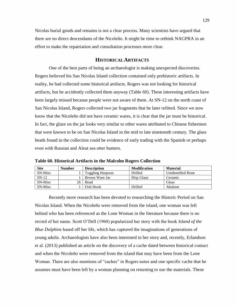
129
Nicolas burial goods and remains is not a clear process. Many scientists have argued that
there are no direct descendants of the Nicoleño. It might be time to rethink NAGPRA in an
effort to make the repatriation and consultation processes more clear.
HISTORICAL ARTIFACTS
One of the best parts of being an archaeologist is making unexpected discoveries.
Rogers believed his San Nicolas Island collection contained only prehistoric artifacts. In
reality, he had collected some historical artifacts. Rogers was not looking for historical
artifacts, but he accidently collected them anyway (Table 60). These interesting artifacts have
been largely missed because people were not aware of them. At SN-12 on the north coast of
San Nicolas Island, Rogers collected two jar fragments that he later refitted. Since we now
know that the Nicoleño did not have ceramic wares, it is clear that the jar must be historical.
In fact, the glaze on the jar looks very similar to other wares attributed to Chinese fishermen
that were known to be on San Nicolas Island in the mid to late nineteenth century. The glass
beads found in the collection could be evidence of early trading with the Spanish or perhaps
even with Russian and Aleut sea otter hunters.
Table 60. Historical Artifacts in the Malcolm Rogers Collection
Site Number Description Modification Material
SN-Misc 1 Toggling Harpoon Drilled Unidentified Bone
SN-12 1 Brown Ware Jar Drip Glaze Ceramic
SN-Misc 26 Bead Glass
SN-Misc 1 Fish Hook Drilled Abalone
Recently more research has been devoted to researching the Historic Period on San
Nicolas Island. When the Nicoleño were removed from the island, one woman was left
behind who has been referenced as the Lone Woman in the literature because there is no
record of her name. Scott O’Dell (1960) popularized her story with the book Island of the
Blue Dolphins based off her life, which has captured the imaginations of generations of
young adults. Archaeologists have also been interested in her story and, recently, Erlandson
et al. (2013) published an article on the discovery of a cache dated between historical contact
and when the Nicoleño were removed from the island that may have been from the Lone
Woman. There are also mentions of “caches” in Rogers notes and one specific cache that he
assumes must have been left by a woman planning on returning to use the materials. These

130
are reminiscent of the cache that was found by Erlandson et al. (2013) and could have been
left by the Lone Woman.
Susan Morris has also aided in the discussion of this particular time with the
translation of some Russian trading documents that outline a story of Aleut traders and their
interactions with the Nicoleño (Morris et al. in press). There is an Aleut bone harpoon as well
as an eccentric abalone fishhook that appears to have Aleut influence in its construction
(Figure 30). It is not clear whether the harpoon was made on the island or brought to the
island and lost. The eccentric fishhook, however, is made of local abalone shell and was
probably produced on the island. This could be the work cultural diffusion from Aleut
fishermen that were stranded on San Nicolas and lived with the Nicoleño. These Aleut
artifacts are archaeological evidence of the culture contact that we have recently learned
more about in the historical documentation (Morris et al. in press). The next step should be to
obtain permission from the MoM to date these artifacts and determine conclusively if they
date from the time that both the Nicoleño and the Aleut were on San Nicolas Island.
Figure 30. A bone toggling harpoon and eccentric shell fishhook with Aleut
characteristics.
CONCLUSIONS
Before research on San Nicolas Island can continue effectively, there has to be an
understanding of what has already been done. Returning to work with museum collections
can sometimes be tedious and often is without the glory of excavation, but sometimes you
can find things you did not know were there. The MoM’s Malcolm Rogers collection does
have some limitations including lost provenience and unclear maps, but it can still be useful
to many projects. Future research with this collection could take many avenues including:
131
Radiocarbon dating both prehistoric and historical artifacts for better chronologies
Skeletal analysis to determine health of populations
Complete site settlement analysis
Basket Weave Analysis for chronological and cultural purposes
Study of all effigies from San Nicolas Island
Mortuary artifact analysis through time
This study allows researchers to access unpublished archaeological information and provides
a complete photographic and descriptive catalog of the cultural materials excavated by
Malcolm Rogers currently located at the MoM. Publication of this study allows researchers
to better understand the research potential of collections housed at the MoM. This study
correlates the history of Malcolm Rogers’ expedition with the curated artifacts, provides an
analysis of artifacts, and creates a working data set from a previously unpublished collection.
Completing this study illuminates the need for publishing and analysis, as well as adds to the
understanding of past populations who lived on San Nicolas Island.
132
REFERENCES
Ambrose, R. F., J. M. Engle, J. A. Coyer, and B. V. Nelson
1993 Changes in Urchin and Kelp Densities at Anacapa Island, California. In The Third
California Islands Symposium: Recent Advances in Research on the California
Islands. F. G. Hochberg, ed. Pp. 199-209. Santa Barbara: Santa Barbara Museum of
Natural History.
Arnold, Jeanne E.
1987 Craft Specialization in the Prehistoric Channel Islands, California. Berkeley:
University of California Press.
1992 Hunter-Gatherer-Fishers of Prehistoric California: Chiefs, Specialists, and
Maritime Adaptations of the Channel Islands. American Antiquity 57(1):60-84.
2001 The Origins of a Pacific Coast Chiefdom: The Chumash of the Channel Islands.
Salt Lake City: University of Utah Press.
Arnold, Jeanne E., and A. P. Graesch
2001 The Evolution of Specialized Shellwork Among the Island Chumash. In The
Origins of a Pacific Coast Chiefdom: The Chumash of the Channel Islands. Jeanne
Arnold, ed. Pp. 71-112. Salt Lake City: University of Utah Press.
Bean, L. J., and C. R. Smith
1978 Gabrieliño. In Handbook of North American Indians. R. F. Heizer, ed. Pp. 538-
549. Washington, D.C.: Smithsonian Institution.
Bennyhoff, James A., and Richard E. Hughes
1987 Shell Bead and Ornament Exchange Networks between California and the
Western Great Basin. Anthropological Papers of the American Museum of Natural
History 64(2):82-164.
Bickel, Polly
1978 Changing Sea Levels Along the Califonia Coast: Anthropological Implications.
The Journal of California Anthropology 5(1):6-20.
Binford, Lewis R.
1962 Archaeology as Anthropology. American Antiquity 28:217-225.
Braje, Todd J.
2010 Modern Oceans, Ancient Sites: Archaeology and Marine Conservation on San
Miguel Island, California. Salt Lake City: The University of Utah Press.
Braje, Todd J., Jon M. Erlandson, and J. Timbrook
2005 An Asphaltum Coiled Basket Impression Tarring Pebbles, and Middle Holocene
Water Bottles from San Miguel Island, California. Journal of California and Great
Basin Anthropology 25(2):63-67.

133
Braje, Todd J., Jon M. Erlandson, Torben C. Rick, Paul K. Dayton, and Marco B. A. Hatch
2009 Fishing from Past to Present: Continuity and Resilience of Red Abalone Fisheries
on the Channel Islands, California. Ecological Applications 19:906-919.
Braje, Todd J., and T. C. Rick
2011 Perspectives from the Past: Archaeology, Historical Ecology, and Northeastern
Pacific Pinnipeds and Sea Otters. Los Angeles: University of California Press.
Buckley, Thomas
1989 Kroeber’s Theory of Culture Areas and the Ethnology of Northwestern California.
Anthropological Quarterly 62(1):15-26.
Cameron, Constance
2000 Animal Effigies from Coastal Southern California. Pacific Coast Archaeological
Society Quarterly 36(2):30-52.
Cannon, Amanda
2007 Passing Time Near Vizcaino Point: An Overview of Human Occupation and
Archaeological Investigations at CA-SNI-16, San Nicolas Island, California.
Technical Report 07-23. Los Angeles: U.S. Army Corps of Engineers, Los Angeles
District.
Cassidy, Jim, L., Mark Raab, and Nina A. Kononenko
2004 Boats, Bones, and Biface Bias: The Early Holocene Mariners of Eel Point, San
Clemente Island, California. American Antiquity 69(1):109-130.
Chartkoff, Joseph L., and Kerry Kona Chartkoff
1984 The Archaeology of California. Stanford: Stanford University Press.
Conlee, C.
2000 Intensified Middle Period Ground Stone Production on San Miguel Island.
Journal of California and Great Basin Anthropology 22:374-391.
Colton, R. H., and J. E. Arnold
1998 Prehistoric Marine Mammal Hunting on California’s Northern Channel Islands.
American Antiquity 63(4):679-701.
Cryne, Julia A.
2010 NAGPRA Revisited: A Twenty-Year Review of Repatriation Efforts. American
Indian Law Review 34(1):99-122.
Dartt-Newton, Deana, and Jon M. Erlandson
2006 Little Choice for the Chumash: Colonialism, Cattle, and Coercion in Mission
Period California. American Indian Quarterly 30(3-4):416-430.
Davis, Troy, Jon Erlandson, Gerrit Fenenga, and Keith Hamm
2011 Chipped Stone Crescents and the Antiquity of Maritime Settlement on San
Nicolas Island, Alta California. California Archaeology 2(2):185-202.

134
Eisen, Gustav
1904 An Account of the Indians of the Santa Barbara Islands in California. Paper
presented at the Meeting of the Royal Bohemian Society of Sciences, Prague, January
8.
Elsasser, Albert B., and Peter T. Rhode
1996 Further Notes on California Charmstones. Salinas: Coyote Press Archives of
California Prehistory.
Erlandson, J. M.
1988 Of Millingstones and Mollusks: The Cultural Ecology of Early Holocene Hunter-
Gatherers on the California Coast. Ph.D. dissertation, Department of Anthropology,
University of California Santa Barbara.
1994 Early Hunter-Gatherers of the California Coast. New York: Plenum Press.
Erlandson, J. M., and R. Colton, eds.
1991 Hunter-Gatherers of Early Holocene Coastal California. Los Angeles: Institute of
Archaeology, University of California Los Angeles.
Erlandson, J. M., Lisa Thomas-Barnett, René Vellanoweth, Steven J. Schwartz, and Daniel
R. Muhs
2013 From the Island of the Blue Dolphins: A Unique Nineteenth-Century Cache
Feature from San Nicolas Island, California. The Journal of Island and Coastal
Archaeology 8(1):66-78.
Ezell, Paul H.
1961 Malcolm Jennings Rogers, 1890-1960. American Antiquity 26(4):532-534.
Ezzo, Joseph
2001 The Ancient Mariners of San Nicolas Island: A Bioarchaeological Analysis of the
Burial Collections. Technical Report, 01-64. Tucson: University of Arizona,
Department of Anthropology.
Fagan, Brian, Donn R. Grenda, David Maxwell, Angela H. Keller, and Richard Ciolek-
Torrello
2006 Life on the Dunes: Fishing Ritual, and Daily Life at Two Late Period Sites on
Vizcaino Point, Archaeological Testing at CA-SNI-39 and CA-SNI-162, San Nicolas
Island, California. Technical Series, 88. Tucson: University of Arizona, Department
of Anthropology.
Garcia, Tracy
2010 Colonial Encounters with the Past: Paul Schumacher, the Smithsonian Institution
and the Origins of Pacific Coast Archaeology. Unpublished Masters thesis,
Department of Anthropology, University of Oregon.
Gamble, Lynn H.
2002 Archaeological Evidence for the Origin of the Plank Canoe in North America.
American Antiquity 67(2):301-315.
135
2005 Culture and Climate: Reconsidering the Effect of Paleoclimatic Variability
Among Southern California Hunter-Gather Societies. World Archaeology 37(1):92-
108.
Gamble, Lynn H., Phillip L. Walker, and Glenn S. Russell
2001 An Integrative Approach to Mortuary Analysis: Social and Symbolic Dimensions
of Chumash Burial Practices. American Antiquity 66(2):185-212.
Girod, Catherine
2010 A Preliminary Investigation of the Sociopolitical Organization of Prehistoric
Populations on San Nicolas Island. Unpublished Masters thesis, Department of
Anthropology, California State University Los Angeles.
Glassow, Michael
1996 Purisemeno Chumash Prehistory, Maritime Adaptations Along the Southern
California Coast. Case Studies in Archaeology. Fort Worth, TX: Harcourt Brace.
Glenn, Ryan J.
2012 Osteometric Comparisons of San Nicolas Island Dogs: Analysis of the Malcolm
Rogers’ Collection, San Diego Museum of Man, San Diego, California, U.S.A.
Unpublished Masters thesis, Department of Anthropology, California State University
Los Angeles.
Hanna, David
1982 Malcolm J. Rogers: The Biography of a Paradigm. Unpublished Masters thesis,
Department of Anthropology, San Diego State University.
Hardy, Ellen T.
2000 Religious Aspects of the Material Remains from San Clemente Island. Pacific
Coast Archaeological Society Quarterly 36(1):78-96.
Harris, Marvin
1979 Cultural Materialism: The Struggle for a Science of Culture. New York: Random
House.
Hayden, Julian
1961 Malcolm Jennings Rogers 1890-1960. American Anthropologist 63(6): 1323-
1324.
Heizer, Robert F.
1941 A Californian Messianic Movement of 1801 Among the Chumash. American
Anthropologist 43:127-128.
Heizer, Robert F., and Albert Elsasser
1966 Original Accounts of the Lone Woman of San Nicolas Island. In Aboriginal
California: Three Studies in Culture History. Robert Heizer, ed. Pp. 121-181.
Berkeley: University of California Archaeological Research Facility.
Hopkins, Nicolas A.
1965 Great Basin Prehistory and Uto-Aztecan. American Antiquity 31:48-60.
136
Hoover, Robert L.
1974 Some Observations on Chumash Prehistoric Stone Effigies. Journal of California
Anthropology 1:33-40.
Howard, William J., and L. Mark Raab
1993 Olivella Grooved Rectangle Beads as Evidence of an Early-Period Southern
Channel Islands Interaction Sphere. Pacific Coast Archaeological Society Quarterly
29(3):1-11.
Hudson, Travis
1981 Recently Discovered Accounts Concerning the “Lone Woman” of San Nicolas
Island. Journal of California and Great Basin Anthropology 3(2):187-199.
Hudson, Travis, and Thomas C. Blackburn
1979 The Material Culture of the Chumash Interaction Sphere. Banning: Ballena Press.
Johnston, Bernice Eastman
1962 California’s Gabrieliño Indians. Los Angeles: Southwest Museum.
Jones, T. L., B. J. Culleton, S. Larson, S. Mellinger, and J. F. Porcasi
2011 Toward a Prehistory of the Southern Sea Otter (Enhydra lutris nereis). In Human
Impacts on Seals, Sea Lions, and Sea Otters: Integrating Archaeology and Ecology in
the Northeast Pacific. T. J. Braje and T. C. Rick, eds. Pp. 243-271. Los Angeles:
University of California Press.
Jones, T. L., J. F. Porcasi, J. M. Erlandson, H. Dallas Jr., T. A. Wake, and R. Schwaderer
2008 The Protracted Holocene Extinction of California’s Flightless Sea Duck
(Chendytes lawi) and Its Implications for the Pleistocene Overkill Hypothesis.
Proceedings of the National Academy of Sciences 105(11):4105-4108.
Kennett, Douglas J.
2005 The Island Chumash: Behavioral Ecology of a Maritime Society. Los Angeles:
University of California Press.
Kennett, Douglas J., and James P. Kennett
2000 Competitive and Cooperative Responses to Climatic Instability in Coastal
Southern California. American Antiquity 65(2):379-395.
King, Chester D.
1990 Evolution of Chumash Society: A Comparative Study of Artifacts Used for Social
System Maintenance in the Santa Barbara Channel Region Before A.D. 1804. New
York: Garland Publishing.
Kinlan, B. P., M. H. Graham, and J. M. Erlandson
2005 Late Quarternary Changes in the Size and Shape of the California Channel
Islands: Implications for Marine Subsidies to Terrestrial Communities. In
Proceedings of the Sixth California Islands Symposium. D. K. Garcelon and C. A.
Schwemm, eds. Pp. 131-142. Arcata, CA: Institute for Wildlife Studies.
Kroeber, Alfred
1907 Shoshonean Dialects of California. Berkeley: University of California Press.

137
Lambert, Patricia M.
1993 Health in Prehistoric Populations of the Santa Barbara Channel Islands. American
Antiquity 58:509-522.
Lambert, Patricia M., and Philip L. Walker
1991 Physical Anthropological Evidence for the Evolution of Social Complexity in
Coastal Southern California. Antiquity 65:963-973.
Lauter, G. A.
1982 Defining an Intermediate Period in San Nicolas Island, California, Chronology:
Test Excavations at SNI-16. Unpublished Masters thesis, Department of
Anthropology, California State University Northridge.
Leonard, John William, ed.
1925 Who’s Who in Engineering, A Biographical Dictionary of Contemporaries. New
York: Who’s Who Publications.
Love, M. S.
1996 Probably More Than You Wanted to Know About the Fishes of the Pacific Coast.
Santa Barbara: Really Big Press.
Martz, Patricia C.
2002 San Nicolas Island Prehistoric Archaeological Sites Mapping and Recodation
Project. Unpublished MS, South Central Coastal Archaeological Information Center,
California State University Fullerton.
2005 Prehistoric Subsistence and Settlement on San Nicolas Island. In Proceedings of
the Sixth California Islands Symposium. D. Garcelon and C. Schwemm, eds. Pp. 65-
82. Arcata, CA: National Park Service Technical Publication CHIS-05-01, Institute
for Wildlife Studies.
2008 4000 Years on Ghalas-at: Part One of the San Nicolas Island Index Unit Analysis
Program. China Lake, CA: Naval Air Weapons Station.
Meighan, Clement W., and Hal Eberhart
1953 Archaeological Resources of San Nicolas Island, California. American Antiquity
19(2):109-125.
Morris, Susan L., Glenn J. Farris, Steven J. Schwartz, Irina Vladi L. Wender, and Boris
Dralyuk
In press Murder, Massacre, and Mayhem on the California Coast, 1814-1815: Newly
Translated Russian American Company Documents Reveal Company Concern Over
Violent Clashes. Journal of California and Great Basin Anthropology.
Munro, Pamela
1999 Takic Foundations of Nicoleño Vocabulary. In Proceedings of the Fifth California
Islands Symposium. D. Browne, K. Mitchell, and H. W. Chaney, eds. Pp. 659-668.
Washington, D.C.: U.S. Department of the Interior.
138
Noah, Anna C.
1987 A Meeting of Paradigms: A Late-Century Analysis of Mid-Century Excavations
of San Clemente Island. Unpublished Masters thesis, Department of Anthropology,
San Diego State University.
O’Dell, Scott
1960 The Island of the Blue Dolphins. New York: Houghton Mifflin Company.
Ogden, Adele
1933 Russian Sea-Otter and Seal Hunting on the California Coast, 1803-1841.
California Historical Society Quarterly 12(3):217-239.
Olivera, Elena Vega
2011 If Only She Could Speak for Herself: Representations of a California Channel
Islands Woman, 1840s-2000s. Unpublished Masters thesis, Department of
Anthropology, University of California Santa Barbara.
Olson, R.
1930 Chumash Prehistory. University of California Publications in American
Archaeology and Ethnology 28:1-21.
Orr, Phil C.
1968 Prehistory of Santa Rosa Island. Santa Barbara: Santa Barbara Museum of Natural
History.
Philbrick, R., and J. Haller
1977 The Southern Channel Islands. In Terrestrial Vegetation of California. M.
Barbour and J. Major, eds. Pp. 893-906. New York: John Wiley and Sons.
Pletka, S. M.
2001 Bifaces and the Institutionalization of Exchange Relationships in the Chumash
Sphere. In The Origins of a Pacific Coast Cheifdom: The Chumash of the Channel
Islands. J. Arnold, ed. Pp. 221-244. Salt Lake City: University of Utah Press.
Porcasi, J. F.
1999 Prehistoric Bird Remains from the Southern Channel Islands. Pacific Coast
Archaoelogical Society Quarterly 35(2-3):38-59.
Porcasi, J. F., and H. Fujita
2000 The Dolphin Hunters: A Specialized Prehistoric Maritime Adaptation in the
Southern California Chanel Islands and Baja California. American Antiquity 65:543-
566.
Raab, L. Mark, and D. O. Larson
1997 Medieval Climatic Anomaly and Punctuated Cultural Evolution in Coastal
Southern California. American Antiquity 62:319-336.
Raab, L. Mark, A. Yatsko,T. S. Garlinghouse, J. F. Porcasi, K. Bradford
2002 Late Holocene San Clemente Island: Notes on Comparative Social Complexity in
Coastal Southern California. In Catalysts to Complexity: Late Holocene Societies of
the California Coast. J. Erlandson and T. Jones, eds. Pp. 13-26. Los Angeles: Cotsen
Institute of Archaeology, University of California Los Angeles.
139
Reichlen, Henry, and Robert F. Heizer
1964 The Scientific Expedition of Leon de Cessac to California, 1877-1879. Reports of
the University of California Archaeological Survey 61:1-74.
Reinman, Fred M.
1962 New Sites on San Nicolas Island, California. Archaeological Survey Annual
Report 4:11-21.
1964 Maritime Adaptation on San Nicolas Island, California: A Preliminary and
Speculative Evaluation. Archaeological Survey Annual Report 6:51-75.
Reinman, Fred M., and Gloria Lauter
1984 San Nicolas Island Cultural Resource Survey Report. Point Mugu, CA: Naval Air
Weapons Station, Environmental Division.
Reinman, Fred M., and San-Joe Townsend
1960 Six Burial Sites on San Nicolas Island, California. Los Angeles: University of
California Los Angeles.
Rick, Torben, C.
2004 Social and Economic Dynamics on Late Holocene San Miguel Island, California.
In Foundations of Chumash Complexity. J. Arnold, ed. Pp. 97-112. Los Angeles:
Cotsen Institute of Archaeology, University of California.
2007 The Archaeology and Historical Ecology of Late Holocene San Miguel Island.
Los Angeles: Cotsen Institute of Archaeology, University of California.
Rick, Torben C., Jon M. Erlandson, Rene L. Vellanoweth, and Todd J. Braje
2005 From Pleistocene Mariners to Complex Hunter-Gatherers: The Archaeology of
the California Channel Islands. Journal of World Prehistoriy 19:169-228.
Rogers, Malcolm J.
1928 A Question of Scumming. Arizona Old New. The Arizona Museum Journal
1(2):5-21.
1929 The Stone Art of the San Dieguito Plateau. American Anthropologist 31(3):454-
467.
1930 Field Notes 1930 Expedition to San Nicolas Island. Unpublished MS, San Diego
Museum of Man, San Diego.
1993 Report of Archaeological Investigations on San Nicolas Island in 1930. Pacific
Coast Archaeological Society Quarterly 29(3):17-21.
Rogers, Malcolm J., H. M. Wormington, E. L. Davis, and Clark W. Brott
1966 Ancient Hunters of the Far West. San Diego: Union-Tribune Publishing
Company.
Rozaire, C.
1959 Archaeological Investigations at Two Sites on San Nicolas Island, California. The
Masterkey 33(4):129–152.
1967 Archaeological Considerations Regarding the Southern California Islands. Los
Angeles: Los Angeles County Museum.
140
Schoenherr, Allan A.
1992 A Natural History of California. Los Angeles: University of California Press, Ltd.
Schoenherr, Allan A., C. Roberrt Feldmeth, and Michael J. Emerson
1999 Natural History of the Islands of California. Los Angeles: University of California
Press.
Schwartz, Steven J.
1994 Ecological Ramifications of Historic Occupation of San Nicolas Island. In The
Fourth California Islands Symposium: Update on the Status of Resources. W. L.
Halvorson and G. J. Maender, eds. Pp. 171-180. Santa Barbara: Santa Barbara
Museum of Natural History.
Schwartz, Steven J., and Patricia Martz
1992 An Overview of the Archaeology of San Nicolas Island, Southern California.
Pacific Coast Archaeological Society Quarterly 28(4):46-75.
1995 An Overview of Recent Archaeological Research on San Nicolas Island. Pacific
Coast Archaeological Society Quarterly 31(4):4-22.
Schwartz, Steven J., and Kelly A. Rossbach
1993 A Preliminary Survey of Historic Sites on San Nicolas Island. Proceedings of the
Society for California Archaeology 6:189-198.
Trigger, Bruce G.
2006 A History of Archaeological Thought. New York: Cambridge University Press.
Van Bueren, Thad M., and Randy S. Wiberg
2011 Putting Central California Charmstones in Context: A View from CA-CCO-548.
California Archaeology 3(2):199-248.
VanPool, C. S., and T. L. Van Pool
2003 Essential Tensions in Archaeological Method and Theory. Salt Lake City:
University of Utah Press.
Vedder, J. G., and R. M. Norris
1963 Geology of San Nicolas Island California. Geological Survey Professional Paper,
369. Washington, D.C.: U.S. Department of the Interior.
Vellanoweth, Rene L.
1995 New Evidence From San Nicolas Island on the Distribution of Olivella Grooved
Rectangle Beads. Pacific Coast Archaeological Society Quarterly 31:13-22.
1996 Subsistence, Settlement, and Marine Resource Utilization at CA-SNI-161, San
Nicolas Island, California. Unpublished Masters thesis, Department of Anthropology,
California State University Los Angeles.
2001 Coastal Archaeology of Southern California: Accounts from the Holocene. Ph.D.
dissertation, Department of Anthropology, University of Oregon.
141
Vellanoweth, Rene L., and Jon M. Erlandson
1999 Middle Holocene Fishing and Maritime Adaptations at CA-SNI-161, San Nicolas
Island, California. Journal of California and Great Basin Anthropology 21(2):257-
274.
Vellanoweth, Rene L., Patricia Martz, and Steven J. Schwartz
2002 Complexity and the Late Holocene Archaeology of San Nicolas Island.
Perspectives in California Archaeology 6:82-100.
Wake, T. A.
2001 Bone Tool Technology on Santa Cruz Island and Implications for Exchange. In
The Origins of a Pacific Coast Chiefdom: The Chumash of the Channel Islands. J.
Arnold, ed. Pp. 183-197. Salt Lake City: University of Utah Press.
Wallace, William J.
1962 Prehistoric Cultural Development in the Southern Californian Deserts. American
Antiquity 28(2):172-180.
Warren, Claude N.
1966 The San Dieguito Type Site: M. J. Rogers’ 1938 Excavation on the San Dieguito
River. San Diego: Museum of Man.
Weaver, D. W.
1969 General Geology of the Region. In Geology of the Northern Channel Islands. D.
Weaver, D. Doerner, & B. Nolf, eds. Pp. 9-10. Tulsa: American Association of
Petroleum Geologists and Society of Economic Paleontologists and Mineralogists
Pacific Section.
York, Andrew L.
2012 Archaeological Evaluation and Site Documentation at Site CA-SNI-41 Naval
Base Ventura County, San Nicolas Island, California. Oxnard, CA: Ventura County
Naval Base.