e. executive summary e.1 introduction · 17 from km 475.040 to km 611.000 in the state of goa on...
TRANSCRIPT

Consultancy Services for the work of Four Laning of existing Maharashtra/Goa Border-Goa/Karnataka Border Section of NH-17 from Km 475.040 to Km 611.000 in the state of Goa on BOT (Toll) basis under NHDP-III (Patradevi to Pollem on NH-17)
DRAFT FEASIBILITY REPORT
EXECUTIVE SUMMARY
AA/HD/1824 1
E. EXECUTIVE SUMMARY
E.1 Introduction
The Government of India has envisaged to create a world-class infrastructure facility,
to boost the economic development in the country, for which National Highways
Authority of India (NHAI) plays a key role. NHAI has been entrusted to implement
the development of some of the stretches of National Highways under National
Highway Development Programme on EPC/BOT basis. As part of this endeavor, the
Public Works Department (PWD) of Government of Goa has decided for the
development of “Four Laning of Existing Maharashtra/Goa Border - Goa/Karnataka
Border of NH-17 from Km 475/040 to 611/000 in the state of Goa on BOT (Toll) basis
under NHDP-III (Patradevi to Pollem section)”.
Public Works Department (PWD) of Goa has appointed M/s Aarvee Associates
Architects Engineers & Consultants Pvt. Ltd., Hyderabad to provide consultancy
services for detailed engineering study for the above road section.
The project stretch excludes following reaches:
1. From Km 515.000 to Km 518.000 (Mandovi Bridge Reach)
2. From Km 523.000 to Km 535.000 (Zuari Bridge Reach)
3. From Km 545.000 to Km 554.000 (Margaon Bypass Reach)
4. From Km 586.000 to Km 603.000 (Canacona Bypass reach)
E.2 Project Description
The Project Highway is a section of NH-17 between Patradevi and Pollem, passing
through villages Torxem, Tamboxem, Uguem, Poroscodem, Casnem, Pernem,
Virnoda, Dargalim, Colvale, Acola, Mapusa, Bastora, Guirim, Porvorim, Panaji, Santa
Cruz Bambolim, Siridao, Palem, Cortalim, Nagoa, Verna, Nuvem, Fatorda, Margao,
Navelim, Sirlim, Chinchinim, Panzarconi, Cuncolim, Tiloi, Canacona, Macem, Kalmath,
Pollem. It connects Panvel (South of Mumbai city) to Kochi in Kerala, passing through
the states of Maharashtra, Goa, Karnataka, and Kerala. The Project stretch is an
important link connecting the states of Maharashtra, Goa and Karnataka starts at
Patradevi Maharashtra-Goa border to Pollem, Goa-Karnataka border with length of
135.96 km. It has a great potential of growth in the passenger as well as freight

Consultancy Services for the work of Four Laning of existing Maharashtra/Goa Border-Goa/Karnataka Border Section of NH-17 from Km 475.040 to Km 611.000 in the state of Goa on BOT (Toll) basis under NHDP-III (Patradevi to Pollem on NH-17)
DRAFT FEASIBILITY REPORT
EXECUTIVE SUMMARY
AA/HD/1824 2
movement in future due to tourism, agriculture and industrial growth in the project
influence area. From Km 475.040 to Km 545.000, the right of way ranges from 8 m
to 45m, from Km 555.000 to 585.000 the ROW ranges from 8m to 10m and Km
603.000 to Km 611.000 it is 10m to 30m. From Km 570.000 to Km 585.000 the
alignment passes through Ghat Section. The entire alignment passes through hilly
and rolling terrain except few reaches in plain terrain.
E.3 Alignment Option Study
Reconnaissance, map studies and detailed investigations of the influence area were
carried out for identifying the existing road network, land use pattern and industrial
activities along the project corridor. Different alignment options are considered,
evaluated and recommendations are presented in the subsequent sections. The
improvement scheme of the options are mentioned below.
The Project road has inconsistent terrain conditions with a mix of hilly, highly rolling
and plain topography. The following standards have been followed for improving the
horizontal geometry. For the purpose of horizontal design, the project road is divided
in to following sections
Section I: From Km 475.040 to Km 514.800 (Rolling/Plain terrain).
The Project Highway starts with a mix of rolling/plain terrain from Km 475+040 at
Goa/Maharashtra border. Existing alignment has substandard horizontal geometry.
The existing speed on the highway is about 50 to 60 kmph. Minor realignments
proposed to meet the minimum design speed of 80KMPH at following locations.
1. From Km 477.500 to Km 478.000
2. From Km 485.000 to Km 490.000
The existing alignment in Naibag location has substandard horizontal & vertical
curves in particularly from Km 486.500 to Km 490.500. For this stretch a realignment
with a 1.10 km length of tunnel proposed to improve the geometry. A comparative
study with existing alignment is presented below and alternatives plan is enclosed as
Appendix-A.

Consultancy Services for the work of Four Laning of existing Maharashtra/Goa Border-Goa/Karnataka Border Section of NH-17 from Km 475.040 to Km 611.000 in the state of Goa on BOT (Toll) basis under NHDP-III (Patradevi to Pollem on NH-17)
DRAFT FEASIBILITY REPORT
EXECUTIVE SUMMARY
AA/HD/1824 3
Description Alternative-I: Existing
Alignment
Alternative-II: Realignment
with Tunnel
Stability issues
It would not be possible to cut hill to the required slope since that would disturb the railway tunnel below the existing road at Km 488.200.
This realignment would involve insignificant disturbance to the railway tunnel as the highway tunnel is about 1.5 km away from that.
Structures involved
Breast Walls, Soil Nails etc. may be required for ensuring slope.
Earth retaining structures and Tunnel
Environmental issues
This option would involve disturbing of hill as the complete widening on hill side and the entire land will be occupied. In this option revegetation of green cover will not be possible as additional 2 lanes will land on hills.
This option would involve insignificant disturbance to environment and green cover.
Geometric alignment
Will follow the existing alignment; Substandard horizontal and vertical curves will remain.
Sub-standard horizontal and vertical curves will be improved.
Construction time
Less compared to other option Tunnel formation will be time consuming.
Construction cost
Less More
Design Speed 50 to 60 kmph 100 kmph
Recommendation Not Recommended Recommended
Apart from the above stretches the proposed alignment following the existing
alignment with minor curve improvements.
Section II: From Km 514.800 to Km 518.400 – Mandovi Bridge
Four Lane bridge construction is under progress on the River Mandovi from Km
514.800 to Km 518.400.
Section III: From Km 518.400 to Km 523.500 - Bambolim
The project highway passes through plain to rolling terrain in the urban area of
Panaji. Vehicular Overpass is proposed in this project stretch.

Consultancy Services for the work of Four Laning of existing Maharashtra/Goa Border-Goa/Karnataka Border Section of NH-17 from Km 475.040 to Km 611.000 in the state of Goa on BOT (Toll) basis under NHDP-III (Patradevi to Pollem on NH-17)
DRAFT FEASIBILITY REPORT
EXECUTIVE SUMMARY
AA/HD/1824 4
Section IV: From Km 523.500 to Km 535.500 – Zuari Bridge
The Project stretch constitutes a major bridge Zuari which is in the initial stage of
construction taken up by the Public works department.
Section V: From Km 535.500 to Km 545.000
The Project stretch passes through Verna Industrial area. The Proposed alignment
follows the existing alignment with minor curve improvements within the available
ROW. Elevated Corridor is proposed in this location to segregate the Airport traffic
and Verna Industrial Estate traffic plying on NH-17B.
Section VI: From Km 545.000 to Km 555.000
The Project stretch constitutes Margao bypass which is under construction taken up
by Public works department to bypass the heavily congested Margao City traffic.
Section VII: From Km 555.000 to Km 587.000
In this stretch the project highway passing through the congested villages namely
Chinchinim, Panzorconi, Cuncolim and Bali from Km 557.800 to Km 567.700.
Thereafter it passing through the dense forest area of Kharmal Ghat from Km
572.000 to Km 582.000.
The consultants have proposed 4 alternatives to bypass for the above 4 villages and
recommended Alternative-IV. The merits and demerits of the above 4 alternatives
are presented below and alternatives plan is enclosed as Appendix-B.
Description Alternative-
I
Alternative-
II
Alternative-
III
Alternative-
IV
Length 9.810 km 10.485 km 10.960 km 11.000 km
Alignment
Existing alignment passing through urban area
Passing through open lands except few locations where habitation exists.
Entire alignment passing through open lands
Entire alignment passing through open lands
Consultancy Services for the work of Four Laning of existing Maharashtra/Goa Border-Goa/Karnataka Border Section of NH-17 from Km 475.040 to Km 611.000 in the state of Goa on BOT (Toll) basis under NHDP-III (Patradevi to Pollem on NH-17)
DRAFT FEASIBILITY REPORT
EXECUTIVE SUMMARY
AA/HD/1824 5
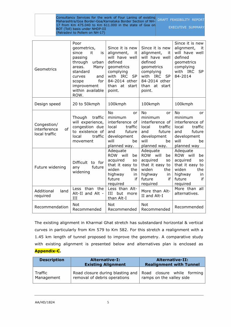
Geometrics
Poor geometrics, since it is passing through urban areas. Many standard curves and scope for improvement within available ROW.
Since it is new alignment, it will have well defined geometrics complying with IRC SP 84-2014 other than at start point.
Since it is new alignment, it will have well defined geometrics complying with IRC SP 84-2014 other than at start point.
Since it is new alignment, it will have well defined geometrics complying with IRC SP 84-2014
Design speed 20 to 50kmph 100kmph 100kmph 100kmph
Congestion/ interference of local traffic
Though traffic will experience, congestion due to existence of local traffic movement
No or minimum interference of local traffic and future development will be planned way.
No or minimum interference of local traffic and future development will be planned way.
No or minimum interference of local traffic and future development will be planned way
Future widening Difficult to for any future widening
Adequate ROW will be acquired so that it easy to widen the highway in future if required
Adequate ROW will be acquired so that it easy to widen the highway in future if required
Adequate ROW will be acquired so that it easy to widen the highway in future if required
Additional land required
Less than the Alt-II and Alt - III
Less than Alt-III but more than Alt-I
More than Alt-II and Alt-I
More than all alternatives.
Recommendation Not Recommended
Not Recommended
Not Recommended
Recommended
The existing alignment in Kharmal Ghat stretch has substandard horizontal & vertical
curves in particularly from Km 579 to Km 582. For this stretch a realignment with a
1.45 km length of tunnel proposed to improve the geometry. A comparative study
with existing alignment is presented below and alternatives plan is enclosed as
Appendix-C.
Description Alternative-I:
Existing Alignment
Alternative-II:
Realignment with Tunnel
Traffic Management
Road closure during blasting and removal of debris operations
Road closure while forming ramps on the valley side

Consultancy Services for the work of Four Laning of existing Maharashtra/Goa Border-Goa/Karnataka Border Section of NH-17 from Km 475.040 to Km 611.000 in the state of Goa on BOT (Toll) basis under NHDP-III (Patradevi to Pollem on NH-17)
DRAFT FEASIBILITY REPORT
EXECUTIVE SUMMARY
AA/HD/1824 6
Stability issues
It would not be possible to cut hill to the required slope since that would disturb road on the hill side. Thus, adequate slope stabilizing structures are to be provided to prevent landslides.
Construction of viaduct and Tunnel may not involve any stability related concerns.
Structures involved
Breast Walls, Soil Nails etc. may be required for ensuring slope.
Viaduct structure ; earth retaining structures and Tunnel
Environmental issues
This option would involve disturbing of hill slopes in the forest.
This option would involve insignificant disturbance to environment during construction time.
Extra Forest Land to be acquired
11.7 hectares. This option would involve disturbing of hill as the complete widening on hill side and the entire land will be occupied. In this option revegetation of forest cover will not be possible as additional 2 lanes will land on hills.
13.5 hectares. After the construction the vegetation of forest cover will be reinstated over the tunnel of length 1.45 km.
Geometric alignment
Will follow the existing alignment; Substandard curves will remain.
Sharp sub-standard curves will be improved.
Construction time
Less compared to other two options
Tunnel formation will be time consuming.
Design Speed 30 to 40 kmph 100 kmph
Recommendation Not Recommended Recommended
There are some minor realignments has been proposed to improve the geometry or
make use of existing 4 Lane RUBs at following locations.
1. From Km 569.200 to Km 570.600: existing 4 lane RUB in skew.
2. From Km 573.700 to Km 574.000: Substandard existing curves.
3. From Km 574.300 to Km 574.700: Substandard existing curve.
4. From Km 575.500 to Km 576.000: Substandard existing curves.
5. From Km 577.100 to Km 578.100: Substandard existing curves.
6. From Km 578.600 to Km 579.000: Substandard existing curves.
Consultancy Services for the work of Four Laning of existing Maharashtra/Goa Border-Goa/Karnataka Border Section of NH-17 from Km 475.040 to Km 611.000 in the state of Goa on BOT (Toll) basis under NHDP-III (Patradevi to Pollem on NH-17)
DRAFT FEASIBILITY REPORT
EXECUTIVE SUMMARY
AA/HD/1824 7
7. From Km 582.200 to Km 583.700: Substandard existing curves.
Section VIII: From Km 587.000 to Km 603.000
The Project Stretch from Km 587.000 to Km 603.000 is awarded and is under
construction.
Section IX: From Km 603.000 to Km 611.000
In this stretch the project highway passes through rolling terrain. The consultants
have proposed realignment from Km 606.100 to Km 607.000 to improve the existing
horizontal curves.
E.4 Surveys and Investigations
The studies and investigations carried out during the feasibility study comprised
mainly of the following:
• Detailed Inventory & Condition Surveys for Road
• Detailed Inventory & Condition Survey for Bridges
• Topographic Surveys along the existing alignment
• Traffic surveys viz., Classified Traffic Volume Count, Turning Movement Count,
Axle Load, Origin Destination and Commodity Movement, Willingness to Pay
etc., including collection of secondary data for traffic projections
• Investigations of the existing pavement and sub grade involving BBD test
• Collection and laboratory testing of soil samples from pits adjacent to the
existing road
• Identification of borrow areas for different types of pavement and bridge
construction material, collection of samples and their analysis
• Environmental baseline studies
• Public Consultations
E.5 Existing Condition of Road & Bridges
E.5.1 Inventory & Condition surveys for Existing Road
The existing NH-17 is having two lane and four lane configuration. Carriageway width
was measured at every 100m interval. Width of shoulders on either side was
measured separately along with carriageway measurements. The overall condition of
pavement is good and is of flexible type. The existing two lane carriageway width is
7.0m with earthen shoulders of about 0.3 to 2.0m width on either side and paved

Consultancy Services for the work of Four Laning of existing Maharashtra/Goa Border-Goa/Karnataka Border Section of NH-17 from Km 475.040 to Km 611.000 in the state of Goa on BOT (Toll) basis under NHDP-III (Patradevi to Pollem on NH-17)
DRAFT FEASIBILITY REPORT
EXECUTIVE SUMMARY
AA/HD/1824 8
shoulder exists of around 0.4 to 5.0m width on either side and at few parts of the
stretch are existing with 4 lane road also.
S. No. Existing Chainage (Km) Length
(m) Lane Configuration
Condition of
the Road From To
1 475.000 489.100 14100 2 lane carriageway Good
2 489.100 490.100 1000 4 lane carriageway Good
3 490.100 507.100 17000 2 lane carriageway Good
4 507.100 510.800 3700 4 lane carriageway Good
5 510.800 513.000 2100 2 lane carriageway Good
6 513.000 515.000 2000 4 lane carriageway Good
7 515.000 521.500 6500 2 lane carriageway Good
8 521.500 522.800 1300 4 lane carriageway Good
9 535.000 537.000 2000 2 lane carriageway Good
10 537.000 538.400 1400 4 lane carriageway Good
11 538.400 542.800 4400 2 lane carriageway Good
12 555.000 557.200 2200 2 lane carriageway Good
13 570.000 585.000 15000 2 lane carriageway Good
14 603.000 611.000 8000 2 lane carriageway Good
E.5.2 Inventory & Condition surveys for Bridges
The detailed inventory and condition survey of structures are discussed in Volume-II
Investigation Report. Total numbers of Structures on the Site are noted below:
a) Total number of Major Bridges - 1no
b) Total number of
ROBs - 1nos.
RUBs - 3nos.
c) Total number of Minor Bridges - 18nos.
d) Total number of Slab/Box Culverts - 88nos.
e) Total number of Pipe Culverts - 235nos.
f) Total number of Grade Separators - Nil
g) Total number of Vehicular and Non Vehicular Underpasses - 1 (2 Lane)
E.6 Traffic Studies
Based on reconnaissance studies, the locations for conducting various traffic surveys
were finalized. The traffic surveys viz., Classified Traffic Volume Count, Turning

Consultancy Services for the work of Four Laning of existing Maharashtra/Goa Border-Goa/Karnataka Border Section of NH-17 from Km 475.040 to Km 611.000 in the state of Goa on BOT (Toll) basis under NHDP-III (Patradevi to Pollem on NH-17)
DRAFT FEASIBILITY REPORT
EXECUTIVE SUMMARY
AA/HD/1824 9
Movement Count, Axle Load, Origin Destination and Commodity Movement,
Willingness to Pay, etc., including collection of secondary data for traffic projections
were carried out in the month of June in 2015. Secondary data was collected for the
purpose of determining the Seasonal Variation Factors and Growth Rates at various
count stations for different vehicle categories.
E.6.1 Average Annual Daily Traffic (AADT)
The Annual Average Daily Traffic (AADT in no of vehicles) at the survey locations is
obtained by multiplying the Average Daily Traffic (ADT) with the seasonal correction
factor. The AADT of vehicles for the year 2015 at eight survey locations of traffic
volume count survey along the Project corridor is presented below.
Table E.2: Average Annual Daily Traffic
Mode Km
493.0
Km
511.0
Km
522.0
Km
537.0
Km
544.0
Km
556.0
Km
588.0
Km
610.0
Two Wheelers 6132 17062 12232 9385 11411 10243 5777 3390
Three Wheelers 12 154 68 37 54 108 196 4
Car / Jeep / Van 5231 16337 14586 10892 13092 9386 4754 2166
Car Yellow board 176 2026 4647 2169 2026 527 808 148
Tata Magic 19 9 3 59 2 4 54 11
RTC Bus 155 474 767 461 595 189 257 91
Private Bus 237 655 330 406 455 487 402 45
School/College bus 3 15 8 9 7 14 25 9
Mini Bus 80 148 272 270 171 109 146 18
2 Axle 706 738 110 143 1660 310 255 146
3 Axle 149 293 29 21 488 171 179 82
M Axle 197 186 2 5 318 66 150 83
HEM 15 72 7 5 21 13 56 2
LCV/LGV 787 1539 711 931 1451 543 486 127
Mini LCV 466 1803 1605 1591 2069 750 621 140
Three Wheeler goods 2 42 39 18 23 46 64 7
Tractor 5 2 6 0 2 5 6 1
Tractor with trailer 2 12 5 5 0 1 1 0
Non-Motorized Vehicles 7 20 11 31 19 56 56 25
Govt. Exempted Vehicles 28 193 147 55 47 42 52 8
Tollable Traffic (vehicles) 8220 24294 23079 16960 22355 12567 8192 3069
Tollable Traffic (PCU's) 11894 30389 26091 19672 30761 15510 11463 4187
Total Vehicles
Motorized 14400 41758 35575 26459 33892 23012 14288 6479
Non-Motorized 7 20 11 31 19 56 56 25
Total Traffic 14407 41778 35586 26490 33911 23068 14344 6504
Total PCUs
Motorized 15024 39439 32573 24522 36615 20853 14687 5905
Non-Motorized 26 20 8 25 10 44 30 12
Total Traffic 15050 39459 32581 24547 36625 20897 14717 5917

Consultancy Services for the work of Four Laning of existing Maharashtra/Goa Border-Goa/Karnataka Border Section of NH-17 from Km 475.040 to Km 611.000 in the state of Goa on BOT (Toll) basis under NHDP-III (Patradevi to Pollem on NH-17)
DRAFT FEASIBILITY REPORT
EXECUTIVE SUMMARY
AA/HD/1824 10
E.6.2 Zuari Bridge Traffic (Heavy Vehicle Traffic)
Zuari Bridge, the main connecting link between North & South Goa is closed for
heavy vehicular traffic (above 12 tonnes) since 1997 as it was found structurally not
sound to cater to heavy traffic loads prevailing.
As per above context, the Consultants presumed that once Zuari bridge construction
gets completed and is thrown open to traffic, the truck traffic which is currently
plying on alternative routes is expected to use this bridge again. Considering this,
Consultants have collected traffic census data when Zuari Bridge was open to heavy
vehicular traffic and the same has been projected to 2015 the base year, with a
growth rate of 5% per annum.
Table E.3: Heavy Vehicle Traffic along Project Stretch when Zuari Bridge is
under Operation
S.
No. Vehicles
Traffic when Zuari
bridge is under
operation
Regular Traffic
(Actual)
Total
Traffic
Km 493, Malpem
1 Trucks (2 or 3 AT) 1282 857 2139
2 Multi Axle Trucks 314 212 526
3 Total 1596 1069 2665
Km 511, Porvorim
1 Trucks (2 or 3 AT) 1403 1042 2445
2 Multi Axle Trucks 371 258 629
3 Total 1774 1300 3074
Km 537, Cortalim
1 Trucks (2 or 3 AT) 1289 174 1463
2 Multi Axle Trucks 171 10 181
3 Total 1460 184 1644
Km 556, Navelim/Dharmapur
1 Trucks (2 or 3 AT) 554 482 1036
2 Multi Axle Trucks 611 79 690
3 Total 1164 561 1725

Consultancy Services for the work of Four Laning of existing Maharashtra/Goa Border-Goa/Karnataka Border Section of NH-17 from Km 475.040 to Km 611.000 in the state of Goa on BOT (Toll) basis under NHDP-III (Patradevi to Pollem on NH-17)
DRAFT FEASIBILITY REPORT
EXECUTIVE SUMMARY
AA/HD/1824 11
S.
No. Vehicles
Traffic when Zuari
bridge is under
operation
Regular Traffic
(Actual)
Total
Traffic
Km 588, Canacona
1 Trucks (2 or 3 AT) 560 437 997
2 Multi Axle Trucks 259 206 465
3 Total 818 643 1461
E.6.3 Vehicle Damage Factors (VDF)
The VDF calculated for different categories of commercial vehicles are shown below
and the detailed analysis is presented in Traffic Report.
Table E.4: Vehicle Damage Factor (VDF)
S.
No. Mode
Km 475.000 Km 610.000
To Panaji To
Patradevi Adopted
To
Karwar
To
Canacona Adopted
1 2 Axle 3.37 1.02 3.37 2.40 3.78 3.78
2 3 Axle 3.74 3.91 3.91 3.53 4.53 4.53
3 M axle 6.28 4.92 6.28 4.58 5.19 5.19
4 LCV 2.41 1.14 2.41 0.33 0.74 0.74
E.6.4 Traffic Growth Rates (%)
Traffic growth rates are an important parameter for projecting the traffic for the
design life of pavement. The projected traffic, in turn, will form the basis for capacity
assessment, pavement design, and financial viability analysis.
Table E.5: Traffic Growth Rates (%)
S.
No. Period
2
Wheeler
3
Wheeler
Cars/
Jeeps Buses
Trucks
2 Axle 3 Axle M Axle LCV and
Mini LCV
1 Up to 2016 7.0 5.0 10.0 8.0 5.0 5.0 5.0 5.0
2 2017 -2021 6.5 5.0 9.5 7.5 5.0 5.0 5.0 5.0
3 2022 – 2026 6.0 5.0 9.0 7.0 5.0 5.0 5.0 5.0
4 2027 – 2031 5.5 5.0 8.5 6.5 5.0 5.0 5.0 5.0
5 Beyond 2031 5.0 5.0 8.0 6.0 5.0 5.0 5.0 5.0
Consultancy Services for the work of Four Laning of existing Maharashtra/Goa Border-Goa/Karnataka Border Section of NH-17 from Km 475.040 to Km 611.000 in the state of Goa on BOT (Toll) basis under NHDP-III (Patradevi to Pollem on NH-17)
DRAFT FEASIBILITY REPORT
EXECUTIVE SUMMARY
AA/HD/1824 12
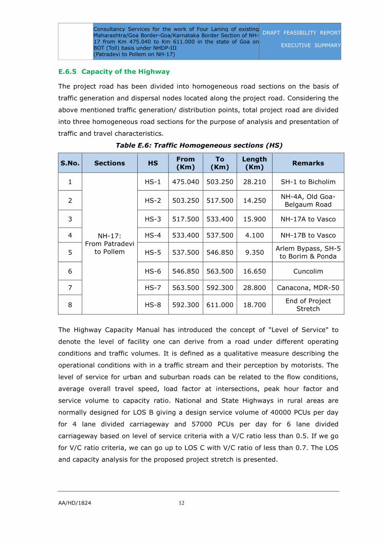
E.6.5 Capacity of the Highway
The project road has been divided into homogeneous road sections on the basis of
traffic generation and dispersal nodes located along the project road. Considering the
above mentioned traffic generation/ distribution points, total project road are divided
into three homogeneous road sections for the purpose of analysis and presentation of
traffic and travel characteristics.
Table E.6: Traffic Homogeneous sections (HS)
S.No. Sections HS From
(Km)
To
(Km)
Length
(Km) Remarks
1
NH-17: From Patradevi
to Pollem
HS-1 475.040 503.250 28.210 SH-1 to Bicholim
2 HS-2 503.250 517.500 14.250 NH-4A, Old Goa-Belgaum Road
3 HS-3 517.500 533.400 15.900 NH-17A to Vasco
4 HS-4 533.400 537.500 4.100 NH-17B to Vasco
5 HS-5 537.500 546.850 9.350 Arlem Bypass, SH-5 to Borim & Ponda
6 HS-6 546.850 563.500 16.650 Cuncolim
7 HS-7 563.500 592.300 28.800 Canacona, MDR-50
8 HS-8 592.300 611.000 18.700 End of Project
Stretch
The Highway Capacity Manual has introduced the concept of "Level of Service" to
denote the level of facility one can derive from a road under different operating
conditions and traffic volumes. It is defined as a qualitative measure describing the
operational conditions with in a traffic stream and their perception by motorists. The
level of service for urban and suburban roads can be related to the flow conditions,
average overall travel speed, load factor at intersections, peak hour factor and
service volume to capacity ratio. National and State Highways in rural areas are
normally designed for LOS B giving a design service volume of 40000 PCUs per day
for 4 lane divided carriageway and 57000 PCUs per day for 6 lane divided
carriageway based on level of service criteria with a V/C ratio less than 0.5. If we go
for V/C ratio criteria, we can go up to LOS C with V/C ratio of less than 0.7. The LOS
and capacity analysis for the proposed project stretch is presented.

Consultancy Services for the work of Four Laning of existing Maharashtra/Goa Border-Goa/Karnataka Border Section of NH-17 from Km 475.040 to Km 611.000 in the state of Goa on BOT (Toll) basis under NHDP-III (Patradevi to Pollem on NH-17)
DRAFT FEASIBILITY REPORT
EXECUTIVE SUMMARY
AA/HD/1824 13
Table E.7: Capacity analysis with Total Traffic
S.
No. HS
Chainage Present
Traffic
Year Attaining
15,000 PCU's
(Capacity of 2 lane
With LOS B)
Year Attaining
40,000 PCU's
(Capacity of 4 lane
With LOS B) From
Km To Km.
PCUs Year PCUs Year PCUs Year
1 HS-1 475.040 503.250 20316 2015 - - 38713 2025
2 HS-2 503.250 517.500 45298 2015 - - 45298 2015
3 HS-3 517.500 533.400 38817 2015 - - 38817 2015
4 HS-4 533.400 537.500 29169 2015 - - 39192 2019
5 HS-5 537.500 546.850 36522 2015 - - 39323 2016
6 HS-6 546.850 563.500 25263 2015 - - 38855 2021
7 HS-7 563.500 592.300 17501 2015 - - 39551 2027
8 HS-8 592.300 611.000 8754 2015 15669 2024 39379 2039
By considering 75% of cars, 2W, 3W, Tractors and Slow moving vehicles on service
roads from Km 503.250 to Km 546.850 (Urban portion from Karaswada Junction to
Arlem Bypass) where 4 lane with service roads are proposed and the 6 lane
requirement shall be after year 2030.
E.7 Pavement Design
E.7.1 Introduction
The Preliminary Pavement design is done for both flexible and rigid options. The
flexible pavement is designed as per IRC: 37-2012. The rigid pavement is designed
using IRC and CMA methods. The Sub grade CBR for the new carriage way is
considered 10%. Sub grade thickness of 500 mm is considered for both flexible and
rigid pavement options.
E.7.2 Million Standard Axles (MSA)
Design traffic in terms of Million Standard Axles has been determined at 8 locations
based on traffic homogeneous sections, where volume count and axle load surveys
were conducted.
Table E.8: Million Standard Axles (MSA)
S.N
o.
Homogeneous
Sections
From
(Km)
To
(Km)
Length
(Km)
5
Years
MSA
10
Years
MSA
15
Years
MSA
20
Years
MSA
1 HS-1 475.040 503.250 28.210 13 30 50 76

Consultancy Services for the work of Four Laning of existing Maharashtra/Goa Border-Goa/Karnataka Border Section of NH-17 from Km 475.040 to Km 611.000 in the state of Goa on BOT (Toll) basis under NHDP-III (Patradevi to Pollem on NH-17)
DRAFT FEASIBILITY REPORT
EXECUTIVE SUMMARY
AA/HD/1824 14
S.N
o.
Homogeneous
Sections
From
(Km)
To
(Km)
Length
(Km)
5
Years
MSA
10
Years
MSA
15
Years
MSA
20
Years
MSA
2 HS-2 503.250 517.500 14.250 18 40 70 105
3 HS-3 517.500 533.400 15.900 12 26 45 70
4 HS-4 533.400 537.500 4.100 10 23 40 60
5 HS-5 537.500 546.850 9.350 16 35 60 95
6 HS-6 546.850 563.500 16.650 10 20 35 55
7 HS-7 563.500 592.300 28.800 10 20 30 46
8 HS-8 592.300 611.000 18.700 6 12 20 31
E.7.3 Flexible Pavement
For the design traffic estimated for a life of 15 years and a sub grade CBR of 10%,
the pavement composition with granular base & sub-base option as follows:
Table E.9: Pavement Composition details for Main Carriageway
HS
Reach Eff.
CBR
(%)
Design
Life in
Years MSA
Bitume
n
Grade
Crust Composition in mm
From To BC DBM WM
M GSB Total
HS-1 475.04 503.25 10% 15 Y 50 VG-40 40 95 250 200 585
HS-2 503.25 517.50 10% 15 Y 70 VG-40 40 105 250 200 595
HS-3 517.50 537.50 10% 15 Y 45 VG-40 40 95 250 200 585
HS-4 537.50 546.85 10% 15 Y 60 VG-40 40 100 250 200 590
HS-5 546.85 592.30 10% 15 Y 35 VG-40 40 95 250 200 585
HS-6 592.30 611.00 10% 15 Y 20 VG-30 40 80 250 200 570
E.7.4 Rigid Pavement
For the design traffic estimated for a life of 30 years and a sub grade CBR of 10%,
the pavement composition with granular base & DLC is as follows:
Table E.10: Rigid Pavement Design with Tied Concrete Shoulders
S.No. Item Km 475 to Km 592.3 Km 592.3 to Km 611.0
1 PQC of M40 grade, mm 270 250
2 DLC of M10 grade, mm 150 150
3 GSB, mm 150 150
4 Dia. of Dowel bar, mm 36 32

Consultancy Services for the work of Four Laning of existing Maharashtra/Goa Border-Goa/Karnataka Border Section of NH-17 from Km 475.040 to Km 611.000 in the state of Goa on BOT (Toll) basis under NHDP-III (Patradevi to Pollem on NH-17)
DRAFT FEASIBILITY REPORT
EXECUTIVE SUMMARY
AA/HD/1824 15
S.No. Item Km 475 to Km 592.3 Km 592.3 to Km 611.0
5 Length of Dowel bar, mm 450 450
6 Spacing of Dowel bar, mm 300 300
7 Dia. of Tie bar, mm (Plain bars) 12 12
8 Length of tie bar, mm 580 580
9 Spacing of tie bar, mm 415 445
E.7.5 Recommended Pavement Option
Based on the life cycle cost analysis, Net Present Value (NPV) of rigid pavement is
less than the flexible pavement. The life cycle cost for 30 years’ period analysed for
flexible pavement comes to Rs. 746.84 crores. Whereas for rigid pavement the cost
comes to Rs. 718.64 crores.
As per MoRTH circular no. RW/NH-33044/53/2013-S&R(R) Pt. dated 20th November,
2013 (Appendix IIA) has advocated the use of environment friendly construction
practices for reduction of greenhouse gases and had also iner-alia specified the life
cycle cost analysis as an essential component of infrastructure design.
“Considering the issue related to longer service life, fuel consumption, resistance to
extreme weather condition, saving of natural resources and maintenance etc. the
obvious advantages of rigid pavement cannot be denied.”
MoRTH circular no. RW/NH-33044/31/2014-S&R(R) Pt. dated 04th August, 2014
states that “The price of cement vis-à-vis bitumen varies widely in different parts of
the country depending upon the lead from the production centers/refineries etc. This
variation would be required to be mapped out and unless there is price comparison
within an acceptable limit up to 20%, the use of flexible pavements may perhaps
require to be continued.” It means that rigid pavement could be considered when the
cost of construction with rigid pavement doesn't exceed that of flexible pavement by
more than 20%.
By considering the life cycle cost analysis, heavy load traffic and as mentioned in
Ministry circulars it is recommended to construct Rigid pavement for the entire
stretch.
E.7.6 Crust Composition for Service Roads
Design of pavement for service road has been carried out in accordance with clause
5.5.5 of IRC: SP:84-2014 for a design traffic 10 msa and CBR of 10%.

Consultancy Services for the work of Four Laning of existing Maharashtra/Goa Border-Goa/Karnataka Border Section of NH-17 from Km 475.040 to Km 611.000 in the state of Goa on BOT (Toll) basis under NHDP-III (Patradevi to Pollem on NH-17)
DRAFT FEASIBILITY REPORT
EXECUTIVE SUMMARY
AA/HD/1824 16
Table E.11: Pavement Composition for Service Roads
HS Eff.
CBR MSA
Bitumen
Grade
Crust Composition in mm
BC DBM WMM GSB Total
Service Roads 10% 10 VG-30 40 50 250 200 540
E.7.7 Design of Shoulders
Paved Shoulder: The shoulder would be useable during all seasons of the year and
hence as per Clause 5.10 of IRC:SP:84-2014, the crust composition and specification
of paved shoulder shall be same as of the main carriageway.
Earthen Shoulder: Earthen shoulder shall be covered with 150 mm thick layer of
granular material confirming to the requirements given in Clause 401 of MORTH
specifications.
E.7.8 Crust Composition for Bus bays
Bus bays have been designed for 10 MSA and shall be of a flexible pavement. The
crust composition for the bus bay is same as service road crust and given in table
above.
E.7.9 Crust Composition for Truck Lay Byes
Pavement Design for Truck Lay byes shall be same as that for main carriageway in
the relevant sections.
E.8 Highway Improvement Proposals
E.8.1 General
Primarily, the scope of the project is '4laning' of the existing 2-lane carriageway. The
project corridor is to be designed as a 'partially access controlled highway' by
providing service roads, grade separated intersections, acceleration and deceleration
lanes, vehicular and pedestrian underpasses / overpasses etc. with an objective to
segregate the local traffic from the through traffic.
The various upgrades required for enhancing the project road to 4 lane configuration
as per the guidelines given in the Four laning manual (IRC-SP:84-2014) are brought
out. In congested locations, various alternative upgrade options such as bypasses or
elevated highway have been considered before recommending the feasible option.
Consultancy Services for the work of Four Laning of existing Maharashtra/Goa Border-Goa/Karnataka Border Section of NH-17 from Km 475.040 to Km 611.000 in the state of Goa on BOT (Toll) basis under NHDP-III (Patradevi to Pollem on NH-17)
DRAFT FEASIBILITY REPORT
EXECUTIVE SUMMARY
AA/HD/1824 17
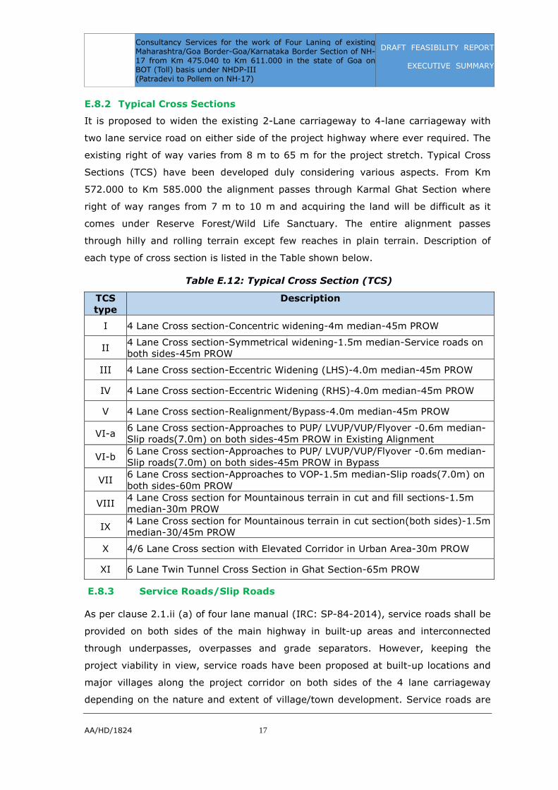
E.8.2 Typical Cross Sections
It is proposed to widen the existing 2-Lane carriageway to 4-lane carriageway with
two lane service road on either side of the project highway where ever required. The
existing right of way varies from 8 m to 65 m for the project stretch. Typical Cross
Sections (TCS) have been developed duly considering various aspects. From Km
572.000 to Km 585.000 the alignment passes through Karmal Ghat Section where
right of way ranges from 7 m to 10 m and acquiring the land will be difficult as it
comes under Reserve Forest/Wild Life Sanctuary. The entire alignment passes
through hilly and rolling terrain except few reaches in plain terrain. Description of
each type of cross section is listed in the Table shown below.
Table E.12: Typical Cross Section (TCS)
TCS
type
Description
I 4 Lane Cross section-Concentric widening-4m median-45m PROW
II 4 Lane Cross section-Symmetrical widening-1.5m median-Service roads on both sides-45m PROW
III 4 Lane Cross section-Eccentric Widening (LHS)-4.0m median-45m PROW
IV 4 Lane Cross section-Eccentric Widening (RHS)-4.0m median-45m PROW
V 4 Lane Cross section-Realignment/Bypass-4.0m median-45m PROW
VI-a 6 Lane Cross section-Approaches to PUP/ LVUP/VUP/Flyover -0.6m median-Slip roads(7.0m) on both sides-45m PROW in Existing Alignment
VI-b 6 Lane Cross section-Approaches to PUP/ LVUP/VUP/Flyover -0.6m median-Slip roads(7.0m) on both sides-45m PROW in Bypass
VII 6 Lane Cross section-Approaches to VOP-1.5m median-Slip roads(7.0m) on both sides-60m PROW
VIII 4 Lane Cross section for Mountainous terrain in cut and fill sections-1.5m median-30m PROW
IX 4 Lane Cross section for Mountainous terrain in cut section(both sides)-1.5m median-30/45m PROW
X 4/6 Lane Cross section with Elevated Corridor in Urban Area-30m PROW
XI 6 Lane Twin Tunnel Cross Section in Ghat Section-65m PROW
E.8.3 Service Roads/Slip Roads
As per clause 2.1.ii (a) of four lane manual (IRC: SP-84-2014), service roads shall be
provided on both sides of the main highway in built-up areas and interconnected
through underpasses, overpasses and grade separators. However, keeping the
project viability in view, service roads have been proposed at built-up locations and
major villages along the project corridor on both sides of the 4 lane carriageway
depending on the nature and extent of village/town development. Service roads are

Consultancy Services for the work of Four Laning of existing Maharashtra/Goa Border-Goa/Karnataka Border Section of NH-17 from Km 475.040 to Km 611.000 in the state of Goa on BOT (Toll) basis under NHDP-III (Patradevi to Pollem on NH-17)
DRAFT FEASIBILITY REPORT
EXECUTIVE SUMMARY
AA/HD/1824 18
designed to carry two-way traffic with turning areas where required and are linked to
the main carriageway by one-way deceleration and acceleration lanes with 'taper-
merge' arrangements. Service roads are generally kept at existing ground level to
serve the adjacent properties, whereas the main carriageway is constructed as per
the requirements of design vertical profile of highway. Service roads are proposed in
the following locations as shown in Table below.
Table E.13: Service Roads/Slip Roads
S.
No.
Ex. Chainage
(km) De. Chainage (km) Slip/
Service
Road
Remarks From To From To Length
1 475.000 475.800 475.000 475.800 0.800 Slip Road VUP (to Patradevi)
2 479.900 480.510 480.100 480.710 0.610 Slip Road VUP (to Mopa village and Tambosa village)
3 481.000 481.700 481.300 482.000 0.700 Slip Road LVUP (Uguem village & Temple)
4 483.850 484.910 484.200 485.260 1.060 Slip Road Road to MH border(Naibag junction)
5 489.824 490.494 487.190 487.860 0.670 Slip Road VUP Pernem
6 490.494 491.934 487.860 489.300 1.440 Slip Road LVUP – Govt. College
7 494.036 494.816 491.380 492.160 0.780 Slip Road Elevated Corridor(Road to Mopa New Airport)
8 495.420 495.950 492.720 493.250 0.530 Slip Road PUP (School)
9 495.950 496.900 493.250 494.200 0.950 Slip Road VUP (Road to Industrial Area, Tuem village)
10 498.535 499.085 495.790 496.340 0.550 Slip Road LVUP (Colvale-Chicali)
11 499.085 499.915 496.340 497.170 0.830 Slip Road 2 Lane PUP
12 499.915 500.585 497.170 497.840 0.670 Slip Road
FO/Viaduct (GOAIDC, Binani Fibre Glass Factory)
13 500.585 502.245 497.840 499.500 1.660 Slip &
Service Road
VUP (Road to Central Jail)
14 502.245 504.595 499.500 501.850 2.350 Slip Road EC(Karaswada Jn. (SH-1 to Bicholim Sports Complex)
15 504.595 506.315 501.850 503.570 1.720 Slip Road VUP (Bastora-Mapusa
16 506.315 509.465 503.570 506.720 3.150 Slip Road EC to Mapusa and Guirim
17 509.465 514.920 506.720 512.120 5.400 Service Road
EC (Urban Porvorim)
18 518.400 520.250 518.400 520.250 1.850 Service Road
VUP (Road to Merces)
19 520.250 520.970 520.250 520.970 0.720 Slip Road VUP (Road to Durgawadi)

Consultancy Services for the work of Four Laning of existing Maharashtra/Goa Border-Goa/Karnataka Border Section of NH-17 from Km 475.040 to Km 611.000 in the state of Goa on BOT (Toll) basis under NHDP-III (Patradevi to Pollem on NH-17)
DRAFT FEASIBILITY REPORT
EXECUTIVE SUMMARY
AA/HD/1824 19
S.
No.
Ex. Chainage
(km) De. Chainage (km) Slip/
Service
Road
Remarks From To From To Length
20 520.970 522.800 520.970 522.840 1.870 Slip Road VOP (Road to Donapaula on RHS)
21 535.600 538.660 535.600 538.660 3.060 Service Road
EC (NH-17B, Vasco Road & NH-17B Ponda missing link)
22 538.660 542.800 538.660 542.840 4.180 Service Road
EC (Cansaulim Junction, Verna Rly. Station road
23 554.801 555.131 554.900 555.230 0.330 Service Road
End of Margao Bypass
24 555.760 556.580 555.900 556.720 0.820 Slip Road VUP (Dramapur)
25 556.580 557.536 556.720 557.700 0.980 Slip Road Start of Cuncolim Bypass
26 558.736 559.686 558.900 559.850 0.950 Slip Road VUP (Chinchinim)
27 564.236 564.836 564.400 565.000 0.600 Slip Road VUP (Quepem)
28 567.446 567.806 567.610 568.200 0.590 Slip Road VUP (Bali)
29 567.284 567.834 568.200 568.750 0.550 Slip Road Cuncolim bypass end
30 603.640 604.490 603.600 604.450 0.850 Slip Road LVUP (Mashem)
31 607.350 608.100 606.950 607.700 0.750 Slip Road LVUP (Loliem)
E.8.4 Underpass/Overpass/Elevated Corridors
In order to avoid conflict of traffic on project road with the traffic on cross roads,
Vehicular underpasses (VUPs) or Vehicular Overpass (VOPs) or Elevated Corridors
are proposed at the intersections of major cross roads with the project highway. It is
proposed to provide 15 no's of VUPs, 5 no's of LVUPs, 3 no’s of PUP/CUPs, 1 no’s
VOPs, 1 Fly Over and 6 no’s Elevated Corridors along the project highway at the
following locations as given in below.
Table E.14: Vehicular Underpasses (VUP)
S.
No.
Existing
Chainage
(Km)
Design
Chainage
(Km)
Span /
Opening (m) Underpass Remarks
1 475.400 475.400 1 x 20.0 x 5.5 VUP To Patradevi
2 480.829 480.520 1 x 20.0 x 5.5 VUP To Mopa - Tamboxem
3 481.800 481.600 1 x 10.5 x 4.5 LVUP To Uguem
4 486.100 484.590 1 x 20.0 x 5.5 VUP To Shiroda
5 490.200 487.557 1 x 20.0 x 5.5 VUP To Pernem
Consultancy Services for the work of Four Laning of existing Maharashtra/Goa Border-Goa/Karnataka Border Section of NH-17 from Km 475.040 to Km 611.000 in the state of Goa on BOT (Toll) basis under NHDP-III (Patradevi to Pollem on NH-17)
DRAFT FEASIBILITY REPORT
EXECUTIVE SUMMARY
AA/HD/1824 20
S.
No.
Existing
Chainage
(Km)
Design
Chainage
(Km)
Span /
Opening (m) Underpass Remarks
6 491.600 488.952 1 x 10.5 x 4.5 LVUP To Govt. College
7 495.500 492.860 1 x 7.0 x 3.0 PUP To School
8 496.400 493.656 1 x 20.0 x 5.5 VUP To Industrial Area
9 497.800 495.083 1 x 7.0 x 3.0 CUP Access for Cultivation
10 498.850 496.115 1 x 10.5 x 4.5 LVUP To Colvale - Colvale
11 499.450 496.670 1 x 7.0 x 3.0 PUP Existing 2 Lane PUP
12 501.850 499.108 1 x 40.0 x 5.5 VUP To Central Jail
13 505.900 503.133 1 x 20.0 x 5.5 VUP To Bastora - Mapusa
14 519.800 519.813 1 x 20.0 x 5.5 VUP To Merces
15 520.600 520.610 1 x 20.0 x 5.5 VUP To Durgawadi
16 556.200 556.280 1 x 20.0 x 5.5 VUP To Dramapur
17 557.261 557.400 1 x 20.0 x 5.5 VUP Cuncolim Bypass Start
18 - 559.350 1 x 20.0 x 5.5 VUP To Chinchinim
19 - 564.660 1 x 20.0 x 5.5 VUP To Quepem
20 - 567.800 1 x 20.0 x 5.5 VUP To Bali
21 567.556 568.450 1 x 20.0 x 5.5 VUP Cuncolim Bypass End
22 604.000 603.980 1 x 10.50 x 4.5 LVUP Mashem
23 607.651 607.250 1 x 10.50 x 4.5 LVUP Pollem
Table E.15 (a): Vehicular Overpasses (VOP)
Sl.
No.
Existing
Chainage
(Km)
Design
Chainage
(Km)
Span / Opening
(m) Remarks
1 521.900 521.770 1 x 30.00 x 5.5 To Donapaula – MDR 3

Consultancy Services for the work of Four Laning of existing Maharashtra/Goa Border-Goa/Karnataka Border Section of NH-17 from Km 475.040 to Km 611.000 in the state of Goa on BOT (Toll) basis under NHDP-III (Patradevi to Pollem on NH-17)
DRAFT FEASIBILITY REPORT
EXECUTIVE SUMMARY
AA/HD/1824 21
Table E.15 (b): Fly Over
Sl.
No.
Existing
Chainage
(Km)
Design
Chainage
(Km)
Span / Opening
(m) Remarks
1 500.048 497.300 15 + 30 + 15 Binani – GOA IDC
Table E.16: Elevated Corridors
S.
No. Location
Elevated Corridors
(Design Chainages) (km) Proposed Span
Arrangement
Total
width of
Structure From To Length
1 Mopa Airport 491.610 491.915 305 30+50+40+65+40
+50+30 29
2 Karaswada Jn 500.140 501.595 1455 30+5x50+40+65+
40+20x50+30 29
3 Mapusa City 504.897 506.297 1400 30+2x50+40+65+40+15x50+40+65
+40+4x50+30 29
4 Porvorim 507.851 511.551 3700 30+47x50+40+65+40+13x50+40+6
5+40+7x50+30 29
5 Airport Link 537.540 538.390 850 30+50+40+65+40+8x50+40+65+40
+50+30 29
6 Verna 539.297 540.897 1600 30+12x50+40+65+40+12x50+40+6
5+40+50+30 29
E.8.5 Tunnel
The existing alignment in Kharmal ghat stretch has sub-standard horizontal &
vertical curves in particularly from Km 579 to Km 582. For this stretch a realignment
with a 1.45 km length of tunnel is proposed to improve the geometry.
Table E.17: Tunnel
S.
No. Location
Starts at
proposed
Chainage
Ends at
Proposed
Chainage
Length
(km) Single/Twin
1 Naibag Tunnel 485.630 486.450 0.820 3 lane Twin Tunnels
2 Karmal Ghat
Tunnel 579.950 581.490 1.540 3 lane Twin Tunnels

Consultancy Services for the work of Four Laning of existing Maharashtra/Goa Border-Goa/Karnataka Border Section of NH-17 from Km 475.040 to Km 611.000 in the state of Goa on BOT (Toll) basis under NHDP-III (Patradevi to Pollem on NH-17)
DRAFT FEASIBILITY REPORT
EXECUTIVE SUMMARY
AA/HD/1824 22
E.9 Structures Improvement Proposals
Recommendation of structure improvements, including widening, repair and
reconstruction / new construction of bridges, other cross drainage structures and the
proposals are given below. Where Minor bridges are proposed to be widened, it is
recommended that the existing railing to be replaced with RCC crash barrier by
chipping the edge of deck and exposing the reinforcement and then casting the RCC
crash barrier.
Widening of existing pipe culverts smaller than 900 mm shall be replaced with 1200
mm dia Pipe Culverts. Existing 900 mm dia pipe culverts can be widened using 900
mm dia pipes.
E.9.1 Rehabilitation scheme for Existing Structures
Rehabilitation measures for existing bridges & other structures are described briefly
below:
The basic measures to be taken into account are:
• Repair of existing scour protection/bed protection or slope protection
(wherever necessary).
• Replace existing wearing coat on all structures
• Replace expansion joints in all bridges.
• Replace bearings for bridges.
• Repair corroded reinforcement.
• Repair of cracks by epoxy injection – RCC elements.
• Repair of cracks by PMC mortar – Stone masonry elements.
E.9.2 Major Bridge
A) Construction of New Major Bridge
Sl.
No
Ex.
Chainag
e
Km
Design
chainag
e km
Proposed
structural
Configurati
on
Proposed
structure
type
Proposed
span
arrangement
Total Width of
the
structure(m)
LHS RHS
1 481+385 481+045 4 lane width PSC I-girder
3x25.0 12.5 12.5
Consultancy Services for the work of Four Laning of existing Maharashtra/Goa Border-Goa/Karnataka Border Section of NH-17 from Km 475.040 to Km 611.000 in the state of Goa on BOT (Toll) basis under NHDP-III (Patradevi to Pollem on NH-17)
DRAFT FEASIBILITY REPORT
EXECUTIVE SUMMARY
AA/HD/1824 23
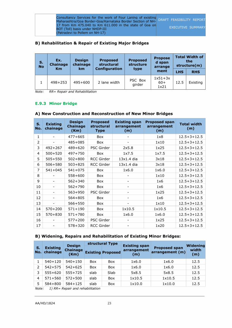
B) Rehabilitation & Repair of Existing Major Bridges
S.
No
Ex.
Chainage
Km
Design
chainage
km
Proposed
structural
Configuration
Proposed
structure
type
Propose
d span
arrange
ment
Total Width of
the
structure(m)
LHS RHS
1 498+253 495+600 2 lane width PSC Box
girder
1x51+3x60+ 1x21
12.5 Existing
Note: RR= Repair and Rehabilitation
E.9.3 Minor Bridge
A) New Construction and Reconstruction of New Minor Bridges
S.
No.
Existing
chainage
Design
Chainage
(Km)
Proposed
structural
Type
Existing span
arrangement
(m)
Proposed span
arrangement
(m)
Total width
(m)
1 - 477+665 Box - 1x8 12.5+3+12.5
2 - 485+085 Box - 1x10 12.5+3+12.5
3 492+267 489+620 PSC Girder 2x5.8 1x25 12.5+3+12.5
4 500+520 497+750 Box 1x7.5 1x7.5 12.5+3+12.5
5 505+550 502+800 RCC Girder 13x1.4 dia 3x18 12.5+3+12.5
6 506+580 503+825 RCC Girder 13x1.4 dia 3x18 12.5+3+12.5
7 541+045 541+075 Box 1x6.0 1x6.0 12.5+3+12.5
8 - 558+600 Box - 1x10 12.5+3+12.5
9 - 562+340 Box - 1x6 12.5+3+12.5
10 - 562+790 Box - 1x6 12.5+3+12.5
11 - 563+950 PSC Girder - 1x25 12.5+3+12.5
12 - 564+805 Box - 1x6 12.5+3+12.5
13 - 566+550 Box - 1x10 12.5+3+12.5
14 570+200 571+190 Box 1x10.5 1x10.5 12.5+3+12.5
15 570+830 571+780 Box 1x6.0 1x6.0 12.5+3+12.5
16 - 577+200 PSC Girder - 1x25 12.5+3+12.5
17 - 578+320 RCC Girder - 1x20 12.5+3+12.5
B) Widening, Repairs and Rehabilitation of Existing Minor Bridges:
S.
No.
Existing
chainage
Design
Chainage
(Km)
structural Type Existing span
arrangement
(m)
Proposed span
arrangement (m)
Widening
width
(m) Existing Proposed
1 540+120 540+150 Box Box 1x6.0 1x6.0 12.5
2 542+575 542+625 Box Box 1x6.0 1x6.0 12.5
3 555+620 555+725 slab Slab 5x8.5 5x8.5 12.5
4 571+560 572+500 slab Box 1x10.5 1x10.5 12.5
5 584+800 584+125 slab Box 1x10.0 1x10.0 12.5 Note: 1) RR= Repair and rehabilitation