dutch slough adaptive management plan - water.ca.gov · 1/10/2008 · the dsamp focuses on...
TRANSCRIPT
Dutch Slough Adaptive Management Plan
Version 1January 2008

Dutch Slough Adaptive Management Plan
Version 1 January 2008
Prepared by: John Cain Natural Heritage Institute 100 Pine Street, Suite 1550 San Francisco, CA 94111
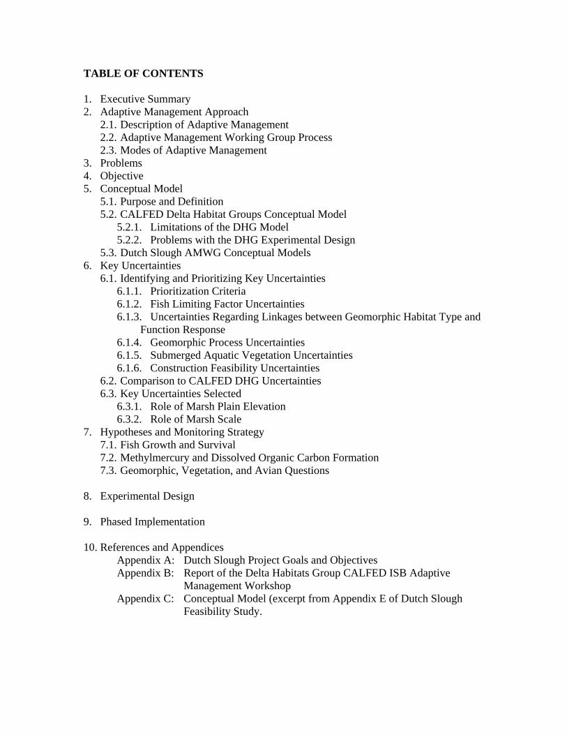
TABLE OF CONTENTS 1. Executive Summary 2. Adaptive Management Approach
2.1. Description of Adaptive Management 2.2. Adaptive Management Working Group Process 2.3. Modes of Adaptive Management
3. Problems 4. Objective 5. Conceptual Model
5.1. Purpose and Definition 5.2. CALFED Delta Habitat Groups Conceptual Model
5.2.1. Limitations of the DHG Model 5.2.2. Problems with the DHG Experimental Design
5.3. Dutch Slough AMWG Conceptual Models 6. Key Uncertainties
6.1. Identifying and Prioritizing Key Uncertainties 6.1.1. Prioritization Criteria 6.1.2. Fish Limiting Factor Uncertainties 6.1.3. Uncertainties Regarding Linkages between Geomorphic Habitat Type and
Function Response 6.1.4. Geomorphic Process Uncertainties 6.1.5. Submerged Aquatic Vegetation Uncertainties 6.1.6. Construction Feasibility Uncertainties
6.2. Comparison to CALFED DHG Uncertainties 6.3. Key Uncertainties Selected
6.3.1. Role of Marsh Plain Elevation 6.3.2. Role of Marsh Scale
7. Hypotheses and Monitoring Strategy 7.1. Fish Growth and Survival 7.2. Methylmercury and Dissolved Organic Carbon Formation 7.3. Geomorphic, Vegetation, and Avian Questions
8. Experimental Design 9. Phased Implementation 10. References and Appendices
Appendix A: Dutch Slough Project Goals and Objectives Appendix B: Report of the Delta Habitats Group CALFED ISB Adaptive
Management Workshop Appendix C: Conceptual Model (excerpt from Appendix E of Dutch Slough
Feasibility Study.
1
1.0 Executive Summary
Goal
The goal of the Dutch Slough Adaptive Management Plan (DSAMP) is to generate
scientific information that can be used to guide future tidal marsh restoration projects
elsewhere in the Delta. The DSAMP focuses on generating information regarding native
fish and water quality, but the DSAMP is only one component of the larger Dutch Slough
restoration project. The Dutch Slough project is also designed to provide numerous
ecological benefits as well as provide public access to the Delta shoreline.
Purpose of Plan
The purpose of this plan is to document the process used to design the Dutch Slough
Adaptive Management Restoration Project and to provide a framework for future
monitoring and design of the project. This plan should not be viewed as a rigid
prescription, but rather should be viewed as a framework for future monitoring and
design. The plan should evolve and grow in detail as information is generated or new
opportunities arise.
Strategic Focus
The DSAMP strategically focuses on the effects of various types of tidal marsh on water
quality parameters and native fish growth and survival. Specifically, the plan focuses on
the role of tidal marsh elevation and size in growth and survival of juvenile Chinook
salmon and Sacramento splittail as well as the production of methylmercury and
dissolved organic carbon. Despite this focus, the Dutch Slough project will be designed
and managed to facilitate research on other subjects such as subsidence reversal, marsh
plain evolution, and wildlife habitat relationships.
Approach
The Dutch Slough management team worked with a group of scientists to design large-
scale project features to test specific hypotheses regarding fish and water quality
responses to different tidal wetland types. The scientists also identified a number of
smaller scale features that could be incorporated into the project to evaluate
environmental factors that influence subsidence reversal, avian habitat, invasive species,
and production of methylmercury and dissolved organic carbon.
The DSAMP is primarily designed to generate information that can guide the design of
future restoration projects elsewhere in the Delta. The plan does not anticipate
reconstruction of the project to maximize fishery benefits or other ecological values if the
original project does not perform optimally. In many cases, adaptive management
implies that a management or restoration treatment will be iteratively revised based on
monitoring data to maximize benefits. Restoration at Dutch Slough, however, involves
millions of dollars of earthmoving to create tidal wetlands. This plan assumes that the
financial costs and permitting challenges associated with regrading or reconstructing a
restored tidal wetland would be prohibitive. The plan does, however, provide for smaller

2
changes in management practices to improve the ecological performance of the project
over time. For example, the plan anticipates testing and refining management techniques
for controlling invasive plant species.
The DSAMP will also generate information to determine the best long-term strategy for
managing Marsh Creek and the deeply subsided areas along the northern boundary of the
Dutch Slough project. Diverting Marsh Creek onto the Dutch Slough site could create
major benefits, but there is a risk that routing the creek onto the site would pollute the
restored wetland. Further studies, including water quality monitoring will help determine
whether it would be beneficial to route Marsh Creek onto the restoration site.
Additionally, a suite of pilot studies in the more subsided areas along the northern portion
of the site will guide the long-term management of those areas to either reverse
subsidence, maximize avian habitat, or minimize the adverse impacts of exotic
submerged aquatic vegetation.
Phased Implementation
Implementation of the project will be phased due to practical construction and financial
considerations.
• Phase 1: The first phase will extend 2-3 years and entail baseline monitoring,
borrowing material from the Ironhouse Sanitary District parcel, reinforcing the
levee toe berms, minor grading, tule cultivation on the lowest portions of the site,
and management of upland vegetation to minimize colonization of exotics.
• Phase 2: The second phase will extend 1-3 years and will include continued water
quality monitoring of Marsh Creek, major grading, widespread tule cultivation in
the future subtidal zones, and active riparian planting of the levees.
• Phase 3: The third phase would include construction of a new levee along Jersey
Island Road, breaching of the existing levees and possibly reconfiguration of
Marsh Creek. This phased approach will be easier to finance and will allow for
information gained in initial phases to shape subsequent phases. Financing the
project in these phases will be easier than raising all of the implementation funds
before commencing any construction.
The Dutch Slough Management Team and the Adaptive Management Working Group
(AMWG) considered restoring each of the parcels in sequence so that lessons learned
from restoration of the first parcel could be applied on the second and third parcels. They
rejected this approach because it would significantly prolong the implementation period
and would confound scientific comparison between different parcels. Since it would take
a minimum of 3-5 years of post project monitoring to obtain useful data from the first
parcel, design of the second parcel, let alone the third parcel, could not begin for several
years. Furthermore, chronological variations such as year type or an exotic species
invasion, would greatly confound potentially interesting comparison between restoration
treatments on different parcels that were implemented in different years. As a result, full
restoration will proceed simultaneously on all three parcels to yield information as soon
as possible that can guide future restoration efforts elsewhere in the Delta.

3
2.0 Adaptive Management
Adaptive management is a high-priority of the CALFED Ecosystem Restoration Program
(ERP) (ERP Strategic Plan), the primary funding source for the Dutch Slough Project.
Adaptive management is a strategy for reducing uncertainty by learning from restoration
and management actions. It is particularly important for tidal marsh restoration projects
like Dutch Slough since there is so much scientific uncertainty about how best to restore
tidal marsh to benefit endangered fish species – a key goal of the CALFED ERP.
The key to successful adaptive management is learning from restoration and management
actions. Subsequent restoration actions can then be revised or redesigned to be more
effective or instructive. Lessons learned at Dutch Slough can be used to change future
management actions at Dutch Slough or simply to inform the design of similar restoration
projects elsewhere in the Delta.
2.1 Description of Adaptive Management
Adaptive management employs the scientific method to maximize the information value
of restoration and management actions. Resource managers identify competing
hypotheses about ecosystem structure and function based upon the best available
information, and then they design restoration actions to test these competing hypotheses.
In this respect, adaptive management interventions are conducted as experiments. This
does not suggest that management interventions are conducted on a trial-and-error basis,
because management actions are guided by the best understanding of the ecosystem at the
time of implementation.
Adaptive management can be practiced both actively and passively. Passive adaptive
management entails monitoring the effectiveness of restoration actions and making
management changes based on the results of monitoring data. Active adaptive
management, however, requires specifically designing the restoration project to test
hypotheses regarding various management strategies. The Dutch Slough project pursues
an active adaptive management approach, but will also include passive adaptive
management elements.
A comprehensive and integrated adaptive management approach involves the following
steps:
1) Define the problem,
2) Articulate measurable goals and objectives,
3) Develop a conceptual model that synthesizes existing knowledge and theories,
and identifies and describes the key attributes of the system, the interrelations
among them, and the important environmental factors (including stressors) that
influence them,
4) Generate hypotheses about what management actions are necessary to achieve
objectives and incorporate these hypotheses into the conceptual model,
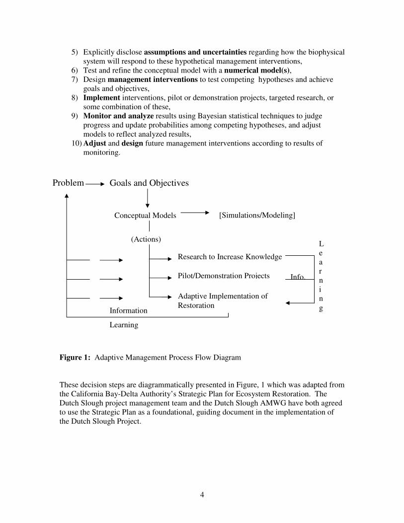
4
Research to Increase Knowledge
Problem Goals and Objectives
Conceptual Models
(Actions)
Pilot/Demonstration Projects
Adaptive Implementation of
Restoration
Learning
Information
L
e
a
r
n
i
n
g
[Simulations/Modeling]
Info.
5) Explicitly disclose assumptions and uncertainties regarding how the biophysical
system will respond to these hypothetical management interventions,
6) Test and refine the conceptual model with a numerical model(s),
7) Design management interventions to test competing hypotheses and achieve
goals and objectives,
8) Implement interventions, pilot or demonstration projects, targeted research, or
some combination of these,
9) Monitor and analyze results using Bayesian statistical techniques to judge
progress and update probabilities among competing hypotheses, and adjust
models to reflect analyzed results,
10) Adjust and design future management interventions according to results of
monitoring.
Figure 1: Adaptive Management Process Flow Diagram
These decision steps are diagrammatically presented in Figure, 1 which was adapted from
the California Bay-Delta Authority’s Strategic Plan for Ecosystem Restoration. The
Dutch Slough project management team and the Dutch Slough AMWG have both agreed
to use the Strategic Plan as a foundational, guiding document in the implementation of
the Dutch Slough Project.

5
2.2 Dutch Slough Adaptive Management Working Group Process
Process
The Dutch Slough restoration design and adaptive management plan grew out of the
AMWG process and coordination with the CALFED Bay-Delta Science Program. The
AMWG is a group of scientists convened by the Dutch Slough management team to
develop a restoration and adaptive management monitoring design for the project. The
project team and the chair of the AMWG solicited input from the CALFED Science
Board. The Science Board convened a sub-committee that consisted of Dr. Peter Moyle,
Dr. Denise Reid, and Dr. Robert Spies.
Scientists who regularly participated in the AMWG included:
Bruce Herbold, USEPA (chair)
Mark Stacey, UC Berkeley
Joan Florsheim, UC Davis
Peter Baye, Consultant
John Takekawa, USGS
David Sedlak, UC Berkeley
Lars Anderson, UC Davis
Stuart Siegel, Consultant
They were assisted by members of the Dutch Slough management and consultant team by
the following scientists, planners, and managers:
Sarah Beamish Puckett, NHI
John Cain, NHI
Nick Garrity, Philip Williams and Associates
Tom Hall, DWR
Lauren Hastings, CALFED Bay-Delta Program
Jeff Melby, State Coastal Conservancy
Michelle Orr, Philip Williams and Associates
Si Simenstadt, University of Washington
Mary Small, State Coastal Conservancy
Philip Williams, Philip Williams and Associates
2.3 Modes of Adaptive Management
The Dutch Slough project site is easily subdivided into three similar parcels that will
allow the project managers to treat each parcel differently to test restoration techniques
and hypotheses in the spirit of adaptive management.

6
The AMWG discussed three adaptive management restoration approaches that could be
employed at Dutch Slough: sequential implementation and learning, a compare and
contrast approach, and an iterative management approach. These three approaches are
not mutually exclusive and all of them could be applied at Dutch Slough. Sequential
implementation would allow lessons learned from restoration of the first parcel to be
applied on subsequent parcels. The comparative approach would test various restoration
strategies to determine the most effective strategies for application elsewhere in the
Delta. An iterative management approach would entail changing management actions or
reconstructing restoration treatments as the project management team monitored the
project and gained new information about ecosystem function and the efficacy of
different restoration treatments.
The main problem with the sequential approach is that it would require 10-20 years or
more to complete implementation and draw reliable conclusions, since planning,
implementation, and post project monitoring would require 5-10 years for each parcel. A
faster schedule for implementation and monitoring would more quickly yield results and
would inform design of restoration projects elsewhere in the Delta. Further complicating
the merits of a sequential approach is the probability that preliminary conclusions
regarding the success of the site will change as the different parcels evolve over time.
After 5 years of monitoring on the first site, we might develop the second parcel very
differently because we don’t like how the first parcel is proceeding. But after 10 years of
monitoring on the first site, we may conclude that the restoration of the first site was
actually performing effectively.
The iterative approach entails trying one approach and then modifying it based on the
monitoring data it if it does not perform as expected. This approach is well suited for
periodic management interventions such as ocean fishery harvest regulations, but it is less
useful for tidal marsh restoration actions that involve substantial earthwork. For
example, the report of the Delta Habitats Group prepared by the Adaptive Management
Subcommittee of the CALFED Independent Science Board (ISB) proposed restoring tidal
action on one parcel without grading tidal channels. If channels did not form naturally
after five years, the report suggested that the “marsh surfaces would be graded and
sculpted to initiate channel development.” The Dutch Slough management team
concluded that it was not realistic to assume that it would be possible to get funding and
permits to reconstruct a wetland that was created at considerable public expense only five
years previously. The iterative approach, however, may make sense for improving
periodic management interventions at Dutch Slough such as controlling exotic plant
species.
The Dutch Slough AMWG ultimately recommended focusing on a comparative approach
that involves comparing a range of treatments to determine the most effective treatment.
The AMWG warned, however, that the comparison would not be a statistically valid
scientific replication, because numerous factors would preclude establishment of true
replicates or control treatments. Nevertheless, the AMWG, along with input from the
CALFED ISB, concluded that such a comparison would still yield useful information.
Both the ISB and the AMWG recommended that all of the different treatments (the entire
7
project) be implemented at the same time, to facilitate comparison between the different
treatments. They cautioned that temporal and chronological factors such as age of
treatment, meteorological variations, and episodic events would make it difficult to
compare treatments started at different times.
3.0 Problem Statement
The Sacramento-San Joaquin Delta was historically composed of over 350,000 acres of
tidal marsh and adjoining seasonal wetlands (Atwater, 1982). Over 97 percent of the
Delta’s tidal marshes have been eliminated (The Bay Institute, 1998) and many of the
native fish species that once depended upon them are in danger of extinction.
The CALFED Ecosystem Restoration Program Plan (ERP, 2000) assumes that restoring
large tracts of tidal marsh will improve conditions for the Delta’s native fish assemblages.
Unfortunately, there is considerable uncertainty regarding how best to restore tidal marsh
and the extent to which restored marshes may benefit or impact native fish and water
quality in the Delta. Restoring some types of tidal habitat could simply provide habitat
for exotic species or could degrade water quality conditions in the Delta. And restoring
the Delta’s subsided lands to tidal marsh could be prohibitively expensive unless we
identify strategies for reducing costs.
The Dutch Slough restoration project is an opportunity to both restore tidal marsh and
learn more about the function of tidal marsh in the Bay-Delta ecosystem. The site is one
of the only locations in the Western Delta with suitable elevations for tidal marsh
restoration and is configured in three separate tracts which will allow scientists to
compare and contrast the efficacy of different approaches on the different parcels.
4.0 Goals and Objectives
Adaptive management is one of three broad goals for the Dutch Slough restoration
project:
1. Provide shoreline access, educational and recreational opportunities.
2. Benefit native species by re-establishing natural ecological processes and habitats.
3. Contribute to scientific understanding of ecological restoration by implementing
the project under an adaptive management framework.
Several objectives are associated with each goal and described in greater detail below as
well as in appendix A. As is the case with many projects, there is an unavoidable tension
between the three different goals. This section describes the distinct purposes of goals 2
and 3 and the tension between these two goals.

8
The restoration objectives of the Dutch Slough project are substantially broader and
distinctly different than the more focused adaptive management goal. The restoration
objectives are oriented to provide broad ecological benefits while the research objectives
are primarily focused on generating information about native fish and water quality.
While there is potential for conflict between the ecological objectives and the research
oriented, adaptive management objectives, the overall approach is to achieve the adaptive
management objectives within a larger effort aimed at achieving the restoration
objectives of the project. The restoration objectives are:
• Reestablish the hydrologic, geomorphic, and ecological processes necessary for
the long-term sustainability of native habitats and the plant and animal
communities that depend upon them. • Restore a mosaic of wetland and upland habitats.
• Contribute to the recovery of endangered and other at-risk species and native
biotic communities.
• Minimize establishment of and reduce impacts from non-native invasive species.
For comparison, the adaptive management objectives are:
• Generate information that will guide the design and effectiveness of future
wetland restoration projects in the Delta.
• Generate information regarding the ecological function of different types and
sizes of freshwater tidal marsh habitats and their value to native fish species,
particularly Sacramento splittail and juvenile salmon.
• Generate information regarding the processes that control the production and
dispersal of both methylmercury and dissolved organic carbon in different types
of wetlands.
• Provide the opportunity to establish field scale research projects at Dutch Slough
to measure ecological processes and test the efficacy of management interventions
for a variety of reasons including exotic species control, avian habitat
enhancement, wetland species restoration, control of mercury methylation and
subsidence reversal.
The measurable, ecological objectives or “performance measures” guiding design of the
Dutch Slough experimental adaptive management project are far narrower:
• Juvenile salmon rearing (growth and survival)
• Splittail spawning and rearing (reproduction, growth, and survival)
• Minimize mercury methylation and dissolved organic carbon formation
• Food production for pelagic organisms (phytoplankton and zooplankton
abundance)
The tension between restoration objectives and research objectives was a recurring theme
at the AMWG meetings. Some members felt strongly that the research objectives should
not in any way reduce the restoration benefits of the project. They worried that designing
the physical restoration as an experiment to generate information might limit the

9
ecological benefits of the project. Others argued, however, that the choice between
restoration and research was a false dichotomy. Equally important, they countered that
we did not know which type of treatment would have the greatest benefit for native fish
and would therefore never be able to design the project to maximize benefits for native
fish without the benefit of an adaptive management restoration experiment.
This debate was never fully resolved, but the ultimate restoration design for the Dutch
Slough project reflects a give and take between these two positions throughout the design
process. The project is designed to benefit a wide array of species, but is configured in
large part to generate information about how native fish respond to different types of tidal
wetland habitat. Existing upland areas are maintained within some of the restored marsh
treatments to provide for a diverse range of habitats and species, despite the fact that
these uplands might confound analysis of how different wetland types affect native fish.
Similarly, the opportunity to route Marsh Creek onto the Emerson Parcel is held open due
to its unique ecological value, even though that might preclude comparing treatments on
the Emerson Parcel with treatments on the other parcels. These potential benefits thus
outweighed the desire to create a more controlled experiment that could facilitate
comparison between treatments. The configuration of the overall project, however, is
based on an experimental strategy designed to generate information regarding the value
of a range of wetland types for a limited number of native fish species.
5.0 Conceptual Model
5.1 Purpose and Definition
The purpose of this section is to explain the underlying scientific assumptions that guided
the development of the Dutch Slough restoration and adaptive management design. It
should provide a benchmark from which to measure future evolution in our
understanding of the processes that shape structure and function of freshwater tidal
marshes and the species dependent upon them. The conceptual model and accompanying
text provided below are both a starting point and a history of how and why the Dutch
Slough AMWG arrived at this starting point. The conceptual model was developed prior
to the Delta Restoration Implementation Plan (CALFED, 2008) conceptual models and
should be revised to be consistent with them.
The CALFED Strategic Plan for Ecosystem Restoration (pg. 16-17) describes the
definition and purpose of conceptual models and guided the development of conceptual
models for the Dutch Slough project:
“Many resource managers, scientists, and stakeholders interested in the
restoration and management of the Bay-Delta ecosystem have implicit beliefs
about how the ecosystem functions, how it has been altered or degraded, and how
various actions might improve conditions in the system. That is, they have
simplified mental illustrations about the most critical cause-and-effect pathways.
10
Conceptual modeling is the process of articulating these implicit models to make
them explicit.”
The Plan also points out that “conceptual models are based on concepts that can and
should change as monitoring, research, and adaptive probing provide new knowledge
about the ecosystem.”
Future revisions or wholesale changes to the model will constitute progress in our
understanding of the Delta ecosystem. Given how difficult it was for the AMWG to
develop a conceptual model, it is entirely predictable that future managers and scientists
will avoid the difficult task of re-articulating the model as it evolves and changes. For
the DSAMP to succeed, however, future managers and scientists working at Dutch
Slough must make it a priority to routinely revisit, revise, and explicitly restate the
underlying scientific assumptions that will guide long term implementation of the Dutch
Slough Adaptive Management and Restoration Project.
In the difficult process of developing a conceptual model, the AMWG 1) articulated how
they believe the ecosystem functions, 2) evaluated competing models, 3) identified key
uncertainties that could be effectively addressed through experimental manipulations at
Dutch Slough, and 4) designed experimental manipulations for implementation at Dutch
Slough given the opportunities and constraints associated with the site.
5.2 Delta Habitat Groups Conceptual Model
The CALFED Bay-Delta program convened a group of scientists, the Delta Habitat
Group (DHG), to develop a conceptual model for tidal marsh restoration in the Bay-Delta
ecosystem (Figure 2). The Dutch Slough management team and restoration consultant,
PWA, presented the DHG’s model and experimental design as a starting point for the
Dutch Slough Conceptual Model. The AMWG, however, concluded that the conceptual
model and experimental design proposed by the CBDA DHG was not suited to the Dutch
Slough project in a few important respects regarding the following issues.
Limitations of the DHG Conceptual Model
• The model assumes that dendritic channels will increase tidal velocities and that
increased velocities will significantly reduce submerged aquatic vegetation
(SAV), which is not consistent with AMWG observations in the Delta. AMWG
members referenced high velocity environments such as Franks Tract or tidal
channels on Sherman Lake where SAV persists despite relatively high velocities.
• The model does not distinguish between different marsh plain and floodplain
elevations and their respective benefits for native fish or inhibition of exotic
species.
• The model does not encompass the unique opportunities to create other habitats
beneficial to fish at Dutch Slough, such as the Marsh Creek delta and riparian
habitat.
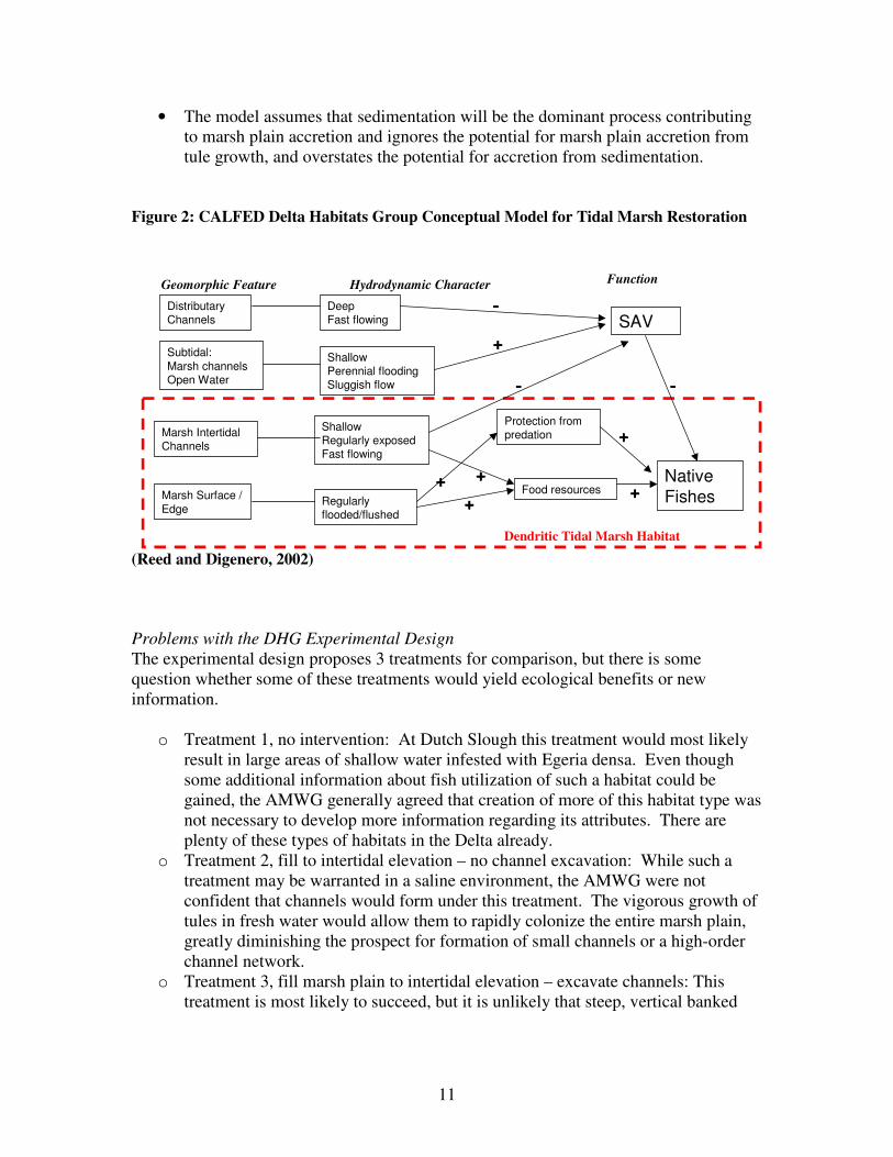
11
• The model assumes that sedimentation will be the dominant process contributing
to marsh plain accretion and ignores the potential for marsh plain accretion from
tule growth, and overstates the potential for accretion from sedimentation.
Figure 2: CALFED Delta Habitats Group Conceptual Model for Tidal Marsh Restoration
(Reed and Digenero, 2002)
Problems with the DHG Experimental Design
The experimental design proposes 3 treatments for comparison, but there is some
question whether some of these treatments would yield ecological benefits or new
information.
o Treatment 1, no intervention: At Dutch Slough this treatment would most likely
result in large areas of shallow water infested with Egeria densa. Even though
some additional information about fish utilization of such a habitat could be
gained, the AMWG generally agreed that creation of more of this habitat type was
not necessary to develop more information regarding its attributes. There are
plenty of these types of habitats in the Delta already.
o Treatment 2, fill to intertidal elevation – no channel excavation: While such a
treatment may be warranted in a saline environment, the AMWG were not
confident that channels would form under this treatment. The vigorous growth of
tules in fresh water would allow them to rapidly colonize the entire marsh plain,
greatly diminishing the prospect for formation of small channels or a high-order
channel network.
o Treatment 3, fill marsh plain to intertidal elevation – excavate channels: This
treatment is most likely to succeed, but it is unlikely that steep, vertical banked
Geomorphic Feature FunctionHydrodynamic Character
Distributary Channels
Regularly flooded/flushed
ShallowRegularly exposedFast flowing
ShallowPerennial floodingSluggish flow
SAVDeepFast flowing
Marsh IntertidalChannels
Marsh Surface /
Edge
Subtidal:
Marsh channelsOpen Water
Protection from predation
Food resourcesNative
Fishes
Dendritic Tidal Marsh Habitat
++++
++++
++++++++++++ ++++
----
--------
12
channels would form in soft fill sediments, increasing the likelihood that small
channels will be colonized by tules.
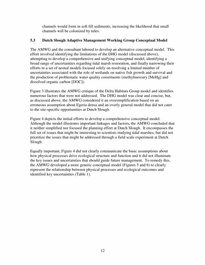
5.3 Dutch Slough Adaptive Management Working Group Conceptual Model
The AMWG and the consultant labored to develop an alternative conceptual model. This
effort involved identifying the limitations of the DHG model (discussed above),
attempting to develop a comprehensive and unifying conceptual model, identifying a
broad range of uncertainties regarding tidal marsh restoration, and finally narrowing their
efforts to a set of nested models focused solely on resolving a limited number of
uncertainties associated with the role of wetlands on native fish growth and survival and
the production of problematic water quality constituents (methylmercury [MeHg] and
dissolved organic carbon [DOC]).
Figure 3 illustrates the AMWG critique of the Delta Habitats Group model and identifies
numerous factors that were not addressed. The DHG model was clear and concise, but,
as discussed above, the AMWG considered it an oversimplification based on an
erroneous assumption about Egeria densa and an overly general model that did not cater
to the site-specific opportunities at Dutch Slough.
Figure 4 depicts the initial efforts to develop a comprehensive conceptual model.
Although the model illustrates important linkages and factors, the AMWG concluded that
it neither simplified nor focused the planning effort at Dutch Slough. It encompasses the
full set of issues that might be interesting to scientists studying tidal marshes, but did not
prioritize the issues that might be addressed through a field scale experiment at Dutch
Slough.
Equally important, Figure 4 did not clearly communicate the basic assumptions about
how physical processes drive ecological structure and function and it did not illuminate
the key issues and uncertainties that should guide future management. To remedy this,
the AMWG developed a more generic conceptual model (Figures 5 and 6) to clearly
represent the relationship between physical processes and ecological outcomes and
identified key uncertainties (Table 1).

13
Figure 3: Diagrammatic illustration of AMWG questions regarding the CALFED DHG Tidal Marsh Conceptual Model
? ? Distributary Channels
Open water/
Oversized channels
Deep, Fast flowing
Shallow Perennial
Flooding, Sluggish flow
SAV
Geomorphic Hydrodynamic Function
Marsh tidal channels
Marsh Surface/Edge
Fast flowing
Regularly flooded/flushed
Protection from predation
Food resources
Native Fishes
++++
++++
++++
++++
++++
++++
----
---- ---- ???? ????
Tidal Marsh with Dendritic Channels Habitat
Substrate Adjacent Habitats
Fluvial processes:
Marsh Creek
Predation by waterfowl
Types of Food
resources
Access
Landscape features Water
quality
Seasonal inundation
pattern
Temperature Spawning
Water depths
Factors not Considered in DHG Model

14
Figure 4: Initial Conceptual Model

15
Figure 5: Generalized conceptual model for Dutch Slough project.
Restoration
action
Physical
process
Physical
habitat
Biological
Habitat
Functional
Output
Mostly one way flow with linkages stronger on left
Restoration
action Physical
process
Physical
habitat
Biological
Habitat
Functional
Output
Linkages generally only across adjacent boxes except for the role of
biological habitat, generally vegetation to shape physical processes

16
Figure 6: Generalized conceptual model for Dutch Slough Project.
Sediment
trapping
erosion
Inundation
tidal
flood
gates
Temp.
Vegetation
Growth
Restoration
action
Physical
process
Physical
habitat
Biological
Habitat
Functional
Output
Dredge
channels
Breach
levees
Fill and
grade
Reroute
creek
Plant
Manage
Channel
shape
Topo
diversity
Soil
Profile and
chemistry
Water
chemistry
Vegetation
Slough
Marsh
high
low
Flood-
plain
Riparian
Upland
Transition
Salmon
growth
Salmon
survival
DS & ST
spawning
Mercury
mobilization
Avian
community
17
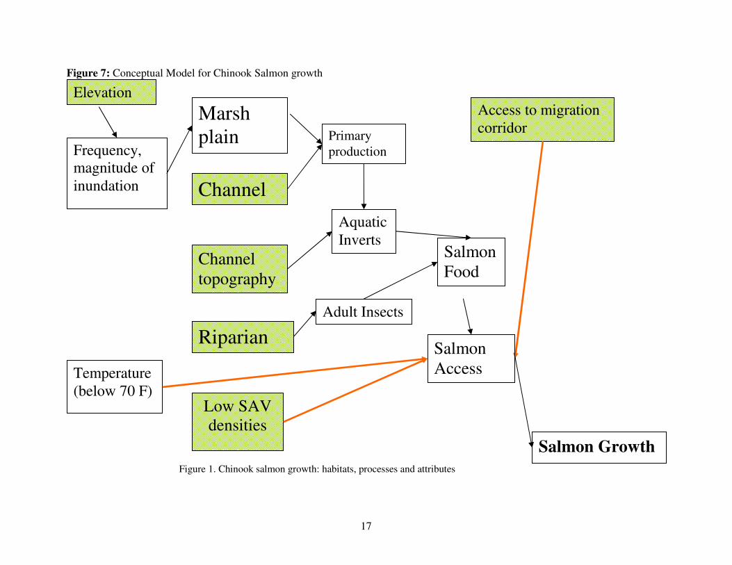
Figure 7: Conceptual Model for Chinook Salmon growth
Figure 1. Chinook salmon growth: habitats, processes and attributes
Adult Insects
Channel
Salmon
Food
Frequency,
magnitude of
inundation
Temperature
(below 70 F)
Salmon Growth
Riparian
Aquatic
Inverts
Marsh
plain
Elevation
Primary
production
Access to migration
corridor
Low SAV
densities
Channel
topography
Salmon
Access
18
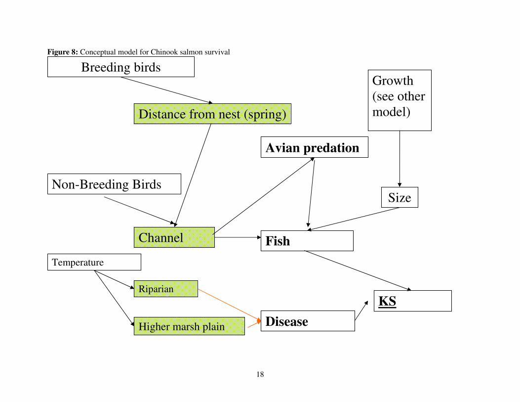
Figure 8: Conceptual model for Chinook salmon survival
Channel
Size
Higher marsh plain
KS
Survival
Distance from nest (spring)
Fish
predation
Avian predation
Temperature
Non-Breeding Birds
Breeding birds
Growth
(see other
model)
Riparian
Disease

19
Figure 9: Simplified conceptual model for mercury methylation showing outcomes (blue diamonds), processes (blue rectangles), and
restoration interventions (yellow circles).
MeHg in Fish
Marsh Plain Elevation
Channel Design
Tidal Range
MeHg in Water
MeHg in Bay
Food chain
MeHg in Sediments
Hg
Temperature
bioaccumulation
methylation
transport
transport
Labile Carbon
Plant Types*
Fe/AVS
Soil AmendmentsHg inputs
wetting/drying
sulfate
MeHg in Fish
Marsh Plain Elevation
Channel Design
Tidal Range
MeHg in Water
MeHg in Bay
Food chain
MeHg in Sediments
Hg
Temperature
bioaccumulation
methylation
transport
transport
Labile Carbon
Plant Types*
Fe/AVS
Soil AmendmentsHg inputs
wetting/drying
sulfate

20
6.0 Identifying and Prioritizing Key Uncertainties The conceptual models described in the previous section and further in this section are
approximations of how the ecosystem works and the relationship between restoration,
physical processes, habitats, and species. There are, however, large and important
uncertainties regarding how physical processes shape habitat and how various habitats
affect target species. Explicitly identifying these uncertainties and designing restoration
actions or management interventions to generate information that can reduce uncertainty
is the purpose of adaptive management. The purpose of this section is to list the
uncertainties identified by the AMWG and describe why the AMWG winnowed the large
and general list of uncertainties down to a limited number of key uncertainties for
focused research at Dutch Slough.
The AMWG quickly recognized that a field-scale experiment would only succeed if it
was focused on a very narrow set of variables. There are many important uncertainties,
but it is not possible to configure a large, field-scale experiment at Dutch Slough to
address them all. After reviewing the DHG model and discussing research priorities, the
AMWG recommended maintaining the experimental design focus on native fish and
revising the conceptual model with a series of nested sub-models (Figures 7, 8, 9) that
illustrate how we addressed the following measurable phenomena:
• Chinook salmon survival and growth
• Splittail spawning and rearing
• Delta smelt spawning (high uncertainty)
• Production and dispersal of dissolved organic carbon and methylmercury
The project management team and AMWG also wanted to address questions associated
with avian utilization and water quality impacts (DOC and MeHg production) of marsh
habitats. Avian and water quality experts on the AMWG, however, did not believe that
the overall spatial configuration of the project needed to be configured to test avian and
water quality hypotheses. Rather, they were confident that important water quality and
avian questions could be addressed as smaller scale projects within a larger experimental
configuration designed to address questions associated with native fish growth and
survival1. Other questions, such as how best to control exotic plant species or reverse
subsidence, could also be addressed on a smaller scale.
There are two distinct parts of the water quality problem: (a) formation of methylmercury
and dissolved organic carbon (DOC); and, (b) transport of methylmercury and dissolved
organic carbon from the wetland. Due to the highly toxic effects of methylmercury,
1 After the results of a CALFED research program on mercury identified the temporal and spatial patterns
of mercury methylation in the Delta and developed new methods for measuring methylmercury production,
the Dutch Slough management team realized that the large scale experimental design configuration for fish
was also well suited for testing water quality hypotheses. In short, key water quality questions could be
addressed both at micro and meso scales as originally envisioned as well as at a very large scale across
hundreds of acres.
21
transport of methylmercury from the wetlands is a very important issue for the Delta and
San Francisco Bay TMDLs. Formation of methylmercury in the wetland could be an
issue because it could pose risks to birds and fish that feed within the wetland, but it will
not be a significant problem for the larger Delta ecosystem unless methylmercury formed
in the marsh is transported out of the marsh. Similarly, DOC formation is not a problem
unless it is exported from the wetland in significant amounts, and then it is only a
problem if it becomes entrained into drinking water diversions.
The AMWG identified the key uncertainties that directly or indirectly influence outcomes
for fish and water quality. The uncertainties are grouped in the following five categories
and organized accordingly in table 1.
1. Fish Limiting Factor Uncertainties
2. Uncertainties Regarding Linkages between Geomorphic Habitat Type
Uncertainties and Functional Response (fish or bird density, MeHg, DOC)
3. Geomorphic Process Uncertainties
4. Submerged Aquatic Vegetation (SAV) Uncertainties
5. Construction Feasibility Uncertainties
6.1 Prioritization Criteria
All of the uncertainties identified in Table 1 are important, but it is not possible to
physically design the Dutch Slough restoration to address all of these uncertainties.
Many of these uncertainties cannot be effectively evaluated at Dutch Slough because they
are controlled by factors outside of the project boundaries. Other uncertainties could be
better or more cost effectively resolved through research at other sites. Other
uncertainties could be evaluated on a smaller scale at the site, but the entire site would
not be physically configured to specifically evaluate these other uncertainties.
The AMWG loosely applied the following criteria, in no order of priority, to identify
which uncertainties could be most effectively addressed through field-scale experimental
manipulations at Dutch Slough.
1. What variables/uncertainties have the greatest implications for the future cost and
feasibility of marsh restoration elsewhere in the Delta? 2. What variables can we test at Dutch Slough? What variables can be just as easily
tested elsewhere?
3. What design feature variables will maximize the chances of seeing a response?
4. What variables can be experimentally tested while still maximizing the restoration
value of the project?
5. What variables can be experimentally tested without significantly increasing the
restoration costs?
6. Which variables can we control?
7. Which variables need to be tested on a large scale vs. variables that can be
effectively tested on a smaller scale within the larger project.

22
Table 1: Categories of Uncertainties
1. Fish Uncertainties
a. Are target fish populations habitat limited?
b. Are target fish populations food limited?
c. Are target fish populations predation limited?
fish predators?
bird predators?
d. Are fish populations limited by contaminants?
e. Do Delta smelt spawn in marshes or channels?
2. Geomorphic-Habitat Type Uncertainties
a. What are important characteristics of open water vs. dendritic marsh for fish growth and reproduction, avian habitat, and MeHg and DOC production and dispersal?
b. Role and value of large channels vs. small channels for fish and birds?
c. Role and value of large order channel networks vs. small order for fish habitat and MeHg and DOC production and dispersal?
d. Relationship of channel density to fish utilization?
e. Value and role of high and low marsh for fish growth and reproduction, avian habitat, and MeHg and DOC production and dispersal?
f. What is the transport connection (fish, food, sediment, HG, DOC) between marshes and channels?
*g. How does shallow water habitat adjacent to tidal marsh affect the value of the marsh for fish?
3.Geomorphic Process Uncertainties
a. What factors influence slough channel development and sustainability?
b. What elevation of marsh plain will allow channel development or maintenance through scour?
c. Is Marsh plain elevation influenced by sediment supply, peat accumulation, tidal range, initial elevation, subsidence and compaction?
d. Will marsh plain accretion keep pace with sea level rise?
e. What is the lowest elevation tules will establish and persist?
f. How will system respond to extreme events?
4. Submerged Aquatic Vegetation Uncertainties
a. What is the relative stability of native SAV population?
b. Linkages of different SAV structure and fish habitat?
c. Role of SAV as habitat for invertebrates?
d. Fish and bird benefits of different aquatic plants?
e. Can we control SAV by managing submerged substrate?
5. Construction Feasibility Uncertainties
*a. Can we build steep banked channels presumably preferred by fish?
*b. Can we restore subsided lands with techniques other than placement of mineral soil fill material?
* Denotes uncertainties added by John Cain after the 5/28/04 AMWG meeting.

23
The following is a discussion of how the criteria applied to the five general categories of
uncertainties.
Category 1: Fish Limiting Factor Uncertainties
Are native fish limited by habitat or food or predation or contaminants? This question
did not fare well against criteria #2, since it cannot be answered at Dutch Slough alone.
Even if many fish use habitat at Dutch Slough and the total population goes up, it will be
nearly impossible to determine whether it was due to habitat or food created at Dutch
Slough or whether it was associated with some other factor elsewhere in the Delta.
Category 2: Uncertainties Regarding Linkages between Geomorphic Habitat Type
Uncertainties and Functional Response (fish or bird density, MeHg, DOC)
How do various configurations and types of habitat and channels influence the number of
native fish and birds or the production and dispersal of MeHg and DOC?
Questions in this category can be divided into meso-scale features and macro-scale
features, both of which can easily be cost effectively tested at Dutch Slough (criteria #2
and #5). Macro-scale features are larger scale, defining features such as marsh plain
elevation, channel density, and channel order that will control the flow of water,
nutrients, and chemicals onto and off the site. The elevation of the marsh plain will
influence wetting and drying cycles – key parameters affecting fish utilization, mercury
methylation, and DOC production. Both the density of channels and marsh plain
elevation will strongly influence the flow of water, nutrients, and fish in the restored site
and thus are likely to increase the likelihood of a clear and measurable response (criteria
#3). In short, these macro-scale features will determine biogeochemical cycles on the
restored site as well as the biogeochemical connectivity of the site to the waters of the
Bay-Delta system.
Marsh plain elevation is also a key factor in the cost and feasibility of future restoration
elsewhere in the Delta (criteria #1). Clean sources of fill to restore subsided lands to
marsh are extremely limited and the cost of transporting and placing fill is significant. If
lower marsh plains provide as much value for fish, we could restore fish habitat for
significantly less money. Constructing high-density channels may be more expensive
than low-density channels, but it is not nearly as significant a cost consideration as marsh
plain elevation. Many AMWG members concluded that higher density channels were
likely to provide more habitat and therefore any experimental design that called for lower
density channels would violate criteria #4.
Meso-scale features include channel shape, depth, size, and substrate, and localized
habitat types. These may affect local fish and bird density or localized rates of DOC and
MeHg production, but they don’t significantly affect the overall pattern and flow of
inundation, nutrients, and chemicals. Even where they might influence these factors, the
AMWG was not confident in our ability to control some factors such as channel shape
due to constructability uncertainties (criteria #6). Once we construct the project, we may
24
be able to collect some useful data regarding how species use deep channels vs. shallow
channels, but it is problematic to design the project around these difficult to control,
meso-scale features. Rather, as John Takekawa has suggested repeatedly, we can
overlay studies of bird (and fish) utilization of meso-scale habitat types on top of a
restoration design that focuses on macro-scale features such as channel density or marsh
plain elevation.
Scale and topology are important variables that should be considered in any experimental
design that evaluates the relative value of both meso and macro scale features. The scale
of the site will greatly influence the order, size, and diversity of channel features and
therefore is likely to produce a clear response (criteria #3). Without achieving some
threshold of size, it will be more difficult to measure differences between small channels
and large channels or low order and high order channels. Without differences in scale, it
will be impossible to compare the value of low order channel networks to high order
networks.
Topology, the spatial relationship between different geographic features, can determine
the value of those features. Brood ponds adjacent to nesting grasslands are far more
valuable to breeding waterfowl than ponds surrounded by water. An expanse of egeria-
infested shallow water habitat between the restored marsh and the existing sloughs would
reduce the value of the marsh for fish. Low marsh adjacent and hydrologically connected
to high marsh or uplands may be less or more valuable to fish than an expanse of low
marsh. To some degree, these issues could be tested on a smaller scale within a larger
scale project and therefore should not dictate overall design (criteria #7).
Category 3: Geomorphic Process Uncertainties
What factors influence channel and marsh plain structure, sustainability, and evolution?
Since these processes shape the marsh plain and channel habitat discussed in category 2
above, they are important to understand. Controlling some major geomorphic factors
such as tidal range, however, would involve major infrastructure such as gates and major
interventions over time (operations). These would be expensive and score poorly against
criteria #5. Some AMWG members were dubious about their potential environmental
impact (criteria #4). Restoring diverse channel types on marsh plains of varying
elevations as would occur when addressing uncertainty #2 above and measuring change
over time would largely test the questions in this category. In other words, it should be
possible to address questions in this category by designing a project to address
uncertainty #2. But a more detailed description of these uncertainties and the underlying
conceptual model may be needed to design a meso-scale experiment around them. For
example, more specific hypotheses about the processes that maintain channels and
prevent them from filling or being colonized by tules is necessary to design an
experiment around this question. Is channel depth the key factor that prevents vegetation
encroachment? If so, what prevents deposition and subsequent channel shallowing?
Perhaps tidal pannes are important for maintaining small, terminal channels? If so,
perhaps meso-scale features such as tidal pannes should be designed into the larger
experiment to test these meso-scale processes. These features could also be evaluated on
a smaller scale and therefore should dictate overall design (criteria #7).

25
Category 4: SAV Uncertainties
What are the fish and bird values of various SAV and can we manage to enhance SAV
that benefits target species?
In order to test these uncertainties, the project design would need to include shallow
water habitat areas suitable for SAV. We would then need to manage shallow open water
areas differently to obtain a diversity of SAV types. There is a relatively high level of
certainty, however, that non-native SAV will colonize these habitats without active
management and a high probability that such habitat would not be beneficial for target
native fish species. Thus, designing the project to specifically test the effects of SAV
appears to conflict with criteria # 4 since it would probably diminish the restoration value
of the project. Equally important, there are other sites with an abundance of non-native
SAV where the value of SAV for native species could be evaluated obviating the need to
spend millions of dollars to do it at Dutch Slough to the detriment of other research
priorities (criteria #2).
Conversely, it appears likely that cost and feasibility considerations may dictate the
inclusion of tidal or non-tidal open water areas on subsided portions of the site (criteria
#5). This may create an opportunity to study these issues at Dutch Slough, but the overall
project should not be designed to answer these questions (criteria #7)..
Category 5: Construction Feasibility Uncertainties
Can we cost effectively build the type of channels and the elevation of marsh plains we
think fish prefer?
These are important questions that will inform future restoration projects, but are best
addressed as small-scale pilot projects on the site rather than as the focus of the large-
scale site configuration and experimental design (criteria #7). For example, a novel
channel construction technique could be tested on 1,000 feet of channel. Thus, although
important, these questions should not drive the overall design of the project, because they
can easily be addressed on a smaller scale within a larger project design.
6.2 Key Uncertainties Selected
The Dutch Slough AMWG recommended focusing experimental design on the following
key attributes and questions:
Marsh Plain Elevation
What is the relationship between elevation of marsh plain:
� to salmon and splittail growth and survival?
� fish food production and access or transport to fish?
� splittail and Delta smelt spawning?
� methylmercury formation and dispersal?

26
� dissolved organic carbon formation and dispersal?
Channel Planform and Scale
What is the relationship between the density, length, order (scale of marsh plain),
width, depth, and shape of tidal channels to: � rearing and foraging habitat for salmon and splittail?
� avian predation?
� fish predation?
� access to marsh food supply?
� transport and dispersal of food, water, sediment, DOC, and MeHg into and
out of the Marsh?
6.2.1 Role of Marsh Plain Elevation
The AMWG recommended Marsh plain elevation for experimental design for the
following reasons:
• Marsh plain elevation controls the frequency of wetting and drying, which is a
key driver that determines all of the following factors: vegetation type and
character, access for native fish, habitat for fish and birds, residence time and
primary productivity, mercury methylation and dissolved organic carbon
formation.
• Marsh plain elevation is also a key cost factor, since it costs far more to
restore high marsh on subsided lands.
Several of the geomorphologists and ecologists participating on the AMWG struggled
with the distinction between high marsh and low marsh since low, emergent marsh was
naturally rare or non-existent in the Delta. Although there is not a clear natural
distinction between lower and higher marshes in the Delta, the intent is to compare
“lower” and “higher” marsh plains that differ enough in elevation to show different
ecological responses, while not making the “higher” marsh so high that it becomes fill-
limited or cost prohibitive.
The origins of higher and lower marshes vary substantially. High freshwater marsh in the
Delta was formed naturally over the last 6,000 years as sea level rose and formation of
organic soil from deposition of wetland vegetation kept pace (Atwater, 1982). The
persistence of tule marshes even as sea level rose is evidence that biological accretion of
the marsh plain was faster or equal to sea level rise and was apparently limited by the
upper extent of common high tides. As a result, the elevation of natural marsh plains in
freshwater environments generally corresponds with mean higher high tide.
Low emergent marsh, in contrast, is an artifact of human settlement in the Delta.
Vegetated marsh plain lower then mean high tide occurs in the Delta where subsided
islands have been intentionally or unintentionally restored to tidal inundation. Tules

27
persist below mean lower low water in some freshwater tidal environments, because they
can apparently tolerate frequent and persistent inundation. (Simenstad et al, 2000)
AMWG members also cautioned that constructed high marsh may perform very
differently then natural high freshwater marsh. Natural marsh plains in the Delta would
have been characterized by hummocky, organic soils built over centuries by decomposing
tules and rafted organic material including large woody debris. Constructing high marsh
plain with earth moving equipment and mineral soil would provide a far different and
presumably less diverse environment. Rather, they recommend that we not attempt to
construct high marsh, but rather let it grow to high marsh from a constructed mean tidal
elevation marsh plain. For this reason, and because constructing high marsh would cost
significantly more, the experimental design will compare low marsh plain environments
(-0.5 to 0.5 MLLW) to mid marsh (MTL) as described below. We believe that the
constructed marsh plains will gradually accrete biologically until they reach an elevation
approximating mean higher high water, provided that biological accretion of tules occurs
faster then sea level rise as it did during the last 6,000 years. A ten year pilot project by
DWR and USGS on Twitchel Island measured tule accretion rates of more than one inch
per year which far exceeds estimates for sea level rise.
6.2.2 Role of Marsh Plain Scale
Channel geometry and scale also influence potential fish access, residence time and
primary productivity, wetting and drying of channel edge, and fate and transport of water
quality constituents. The AMWG considered a range of channel geometry measures such
as channel density, cross sectional area, and channel order. Channel density was
eliminated from further consideration based on the assumption that higher density was
better for fish and more consistent with the overall ecological objectives.2 Although
channel cross section shape is important, the AMWG recognized that it was not a good
experimental variable both because it would be difficult to control on a large scale due to
constructability issues and because it is determined in part by marsh plain elevation, the
other independent variable they wanted to design the experiment around.
The AMWG decided to focus on the role of the size of the channel network (i.e., the size
of the marsh drainage), because it could be tested independent of marsh plain elevation
and because it influences a number of meso- and macro-scale factors including tidal
exchange, the diversity and size of channels in a given marsh drainage, the exchange of
nutrients and other water quality constituents between the marsh and neighboring
sloughs, wetting and drying of the marsh plain, and the extent of low water refugia for
target and predatory fish. As discussed in the hypothesis section below, small-scale
marsh areas are more likely to fully drain on low tide while large areas are less likely to
fully drain.
2 According to AMWG consultant, Si Simenstadt, target fish species such as juvenile salmon will only
occupy channels where they feed along the edge and will not utilize interior marsh plains. Thus, more
channels and channel edge would provide more habitat for juvenile salmon to feed and would provide more
restoration benefit than less channel.

28
6.3 Comparison of Dutch Slough Priorities to Delta Habitat Group Uncertainties
The CALFED Delta Habitats Group (DHG) previously identified several key
uncertainties that should be addressed through future tidal marsh restoration projects
(Reed and DiGenero, 2002). The purpose of this section is to explain why the Dutch
Slough project does not address many of the uncertainties identified by the DHG. The
annotated list below identifies the key uncertainties addressed by the CALFED Delta
Habitats Group, and provides the reasoning why some of these uncertainties are not
targeted by the Dutch Slough Adaptive Management Restoration Program.
1. Will SAV colonize and persist in and immediately adjacent to a dendritic channel
system adjoining an active distributary channel? The AMWG did not believe
that this was a key uncertainty. Although they recognized that SAV was probably
a major issue limiting native fish restoration, they were relatively certain that
SAV would colonize and persist in and adjacent to any freshwater dendritic
channel system in the Delta as evidenced by the persistence of SAV at Sherman
Lake wetlands. While it is possible that high velocity, dentritic channels may
limit SAV at Dutch Slough and thereby provide information on the factors
controlling SAV, the AMWG opted not to configure the multi-million dollar
restoration treatment around this question.
2. Can tidal action alone develop and maintain dendritic channels? At least two
members of the AMWG emphatically believed that dendritic channels would not
form on their own (i.e., without excavation). Rather, they believed that tule
vegetation would rapidly colonize tidal flats and preclude the development of
small tidal channels for the foreseeable future. Although naturally formed
channels would probably be superior to artificially excavated channels, the
AMWG recognized that artificial channels are far more beneficial to native target
fish species than no channels at all. The Delta Habitat Group had proposed that
channels could be excavated post restoration if they did not form on their own
accord within the first five years, but the AMWG and the Dutch Slough
Management Team did not believe that it was realistic to assume that a restored
wetland could be re-excavated due to regulatory and fiscal constraints.
3. What are fish responses to dendritic tidal marsh habitat in estuarine vs. tidal
riverine dominated systems? Although important, this question can only be
addressed by evaluating a variety of sites across a gradient extending from the
saline bay marshes to the river dominated freshwater tidal marshes.
4. What is the relationship between marsh channel pattern, hydrodynamics, and
marsh plain vegetation characteristics? This question will be informed by the
Dutch Slough experimental design, but is not the focus of that design.

29
5. What are the important characteristics of dendritic channels and adjacent marsh
that benefit native fishes? This question is the focus of the Dutch Slough
experimental design.
6. What are the process linkages that lead to these benefits? This question will also
be addressed in the Dutch Slough experimental design. The process linkages are
posited in the fish hypotheses listed in the following section.
7. Can we cost effectively design and construct tidal marsh plain channel systems
that are stable and sustainable in the long term (over decades)? This is an
engineering question that will undoubtedly be informed by the Dutch Slough
project. Since marsh elevation and fill material is the key cost factor, evaluation
of the value of varying marsh elevations is the fundamental factor that needs to be
addressed in order to limit restoration costs in the future.
7.0 HYPOTHESES AND MONITORING STRATEGY
The AMWG crafted several specific hypotheses to guide research to reduce the key
uncertainties identified in the previous section.
These hypotheses are identified below along with a general description of the monitoring
strategy for testing each hypotheses. More detailed monitoring methods must be
developed prior to implementation in order to effectively test these hypotheses. The
hypotheses are divided into three categories: fish, water quality, and miscellaneous bio-
geomorphic. Most of the fish and water quality hypothesis are targeted to address the key
uncertainties identified in the previous section. They are the highest priority for
monitoring and research, since the overall physical configuration of the restoration
project is intentionally designed to test them. Some of the water quality hypotheses and
all of the miscellaneous hypotheses are not targeted to the key uncertainties, but they can
be tested in smaller-scale experimental plots that will be integrated into the larger
restoration project to the extent that they are consistent with funding and scientific
priorities. As the project evolves, project managers should remain flexible and
accommodate meso-scale experiments to test additional hypotheses as scientific priorities
evolve.
7.1 Fish Hypotheses
1. Food resources for splittail and juvenile salmon will be greater in lower
marsh due to increased residence times and increased water column volume
in the photic zone. Water will remain on the marsh plain for longer periods
(increased residence time) and more water per area will be available for
photosynthetic activity which drives primary productivity. The relative
abundance of food resources will be measured by sampling phytoplankton and
zooplankton resources in both mid elevation marshes (MTL) and low marshes
(MLLW) at the project site.

30
2. Low marshes will export more food resources to adjacent Delta channels
than mid elevation marshes due to increased food production on low marshes
and greater tidal prism. Exported food resources can be measured by dissolved
organic carbon, phytoplankton, and zooplankton exiting and entering restored
tidal marsh zones during different seasons of the year.
3. Splittail and juvenile salmon growth will be greater in lower marsh and
channels that drain less often due to increased feeding opportunities. This
would largely be a function of greater food resources in lower marshes, but could
also stem from increased feeding opportunity since low marshes would drain less
frequently and thereby potentially provide longer duration wetted channel edge
for feeding. Caged and/or tagged fish experiments would probably be necessary
to measure relative growth rates in various types of marshes since fish might
travel between marsh plots.
4. Fish survival will be greatest within a intermediate-scale channel marsh
areas, because higher order networks will harbor predators and lower order
networks lack sufficient refuge during low tides. The amount of channel
inundated to a depth of over 0.5 meter at low tide is a function of marsh size.
This hypothesis is based on the assumption that most predator fish require depths
of greater then 0.5 meter3and would therefore be more abundant in the largest
marshes or at the mouth of small marshes that completely drain on each tide
cycle. Intermediate sized marshes would drain enough to limit predator habitat in
the marsh channel, but would not drain so completely as to force target juvenile
fish into the main sloughs where predators are known to be abundant. This
hypothesis could be tested directly by releasing tagged fish into varying marshes
and then measuring survival. The underlying physical and biological assumptions
could be tested by field surveys at low tides to measure the abundance of deep
water and predator fish in varying size marshes.
5. Fish growth will be greatest in intermediate- and large-scale channel marsh
areas, because higher order networks are more likely to maintain wetted
channel feeding opportunities during low tides. The mechanisms are similar to
hypothesis 4 above. Small marshes will drain completely at low tide, limiting
feeding opportunities. Large marshes will provide feeding opportunities at low
tide. This hypothesis assumes that smaller marshes will always drain completely,
but they may not drain completely during late winter and spring months when
Delta water levels are often higher than normal due to river inflow. To the extent
target fish (juvenile salmon and splittail) are most abundant in late winter and
spring, the actual extent and effect of marsh drainage may not significantly limit
feeding and growth during this life stage when it is most important.
3 This assumption was based on the professional opinion of AMWG members, but should be verified with
published literature before commencing with design of project.

31
7.2 Water Quality Hypotheses
Many of the water quality hypotheses discussed below involve measuring fluxes of
MeHg or DOC off of restored marshes. The accuracy of the flux measurements will
depend in large part on the ability to accurately quantify tidal inflow and outflow.
Therefore, a high priority of the monitoring program will be to develop a numerical
hydrodynamic model and a reliable method for measuring flow into and out of the
various marshes to calibrate the model. It may be efficient to do this through
establishment of a network of tidal gauges and optimal backscatter devices. Utilizing a
calibrated model is an important first step for cost effectively testing hypotheses one
through four below.
1. Methylmercury production will be greatest on mid elevation marshes
characterized by periodic wetting and drying and lowest on perennially
inundated emergent marsh. This hypothesis is based on the assumption that
flooding of vegetated wetlands or uplands or fluctuating water levels during tidal
cycles could stimulate microbial methylation of inorganic mercury, increasing
concentrations of methylmercury in water and biota. Measurements of
methylmercury in fish from the Bay-Delta reveal that fish have higher levels in
areas subject to periodic inundation such as high marshes and seasonal
floodplains (Ye, et al, 2006). In contrast, fish from perennially inundated areas
such as the Central Delta have relatively low levels of methylmercury suggesting
that the more frequent and continuous inundation that would occur on lower
marshes would result in lower methylmercury production (Slotton, 2007).
Methylmercury production could be measured with soil and water samples from
small plots, caged fish bioassays from various marshes, and on larger scales by
measuring import and export of methylmercury or its surrogate (DOC) on tidal
cycles. Monitoring techniques at Dutch Slough would be based on methods
recently developed by the USGS, Moss Landing Marine Laboratory, and the UC
Davis Mercury Group as part of the CALFED funded mercury monitoring
program.
2. Methylmercury and DOC flux from the marsh to Delta channels will be
greatest during extreme low tides during spring tide cycles. Data collected by
both USGS and the Moss Landing Marine Laboratory indicate that fluxes of
methylmercury and DOC from tidal marshes fluctuate greatly across the tidal
cycle and that exports from marshes are greatest during extreme low tide events
when tidal sloughs, banks, and associated pore water drain from the marsh.
Methylmercury levels may concentrate in the pore waters where residence time
and microbial activity are both high and then diffuse to adjacent channels and
sloughs when the pore water drains from the soil. This hypothesis could be tested
by measuring fluxes of DOC and methylmercury at the mouth of different
marshes across the tidal cycle or by collecting water samples from marsh channels
across the tidal cycle. These techniques were recently developed by the
CALFED-funded mercury monitoring program.

32
3. Total methylmercury and DOC flux from the restored marsh to the Delta
will be highest on small-scale, mid elevation marshes that drain frequently
and lowest on large-scale, low marshes that seldom drain completely. This
hypothesis is based on the assumption that methylmercury production will be
greatest on higher marshes (hypothesis 1 above) and that fluxes will be greatest
on smaller marshes since they are more likely to drain completely on low tides
(hypothesis 2). This assumes that DOC and methylmercury produced on the
marsh plain will be efficiently exported out of the marsh. On larger marshes, in
contrast, it would be cycled within the marsh. Pore water rich in DOC and
methylmercury would not have time to drain from the marsh before flood tides
would redisperse it across the marsh plain. However, to the extent that tidal prism
and total volume of water draining lower marshes is greater per unit area, it is
possible that total methylmercury and DOC flux from lower marshes could be
greater than mid elevation marshes even if hypothesis 1 and 2 are correct. This
hypothesis could be tested with monitoring approaches described for hypothesis 1
and 2 above.
4. For a given marshplain elevation, total methylmercury and DOC export
from the marsh to Delta channels will be greatest per unit area for small
drainage areas and least for large marsh drainage areas. This hypothesis is
very similar to hypothesis 3 above and could be tested with similar monitoring
methods. This hypothesis may be particularly policy relevant since it may be far
easier to implement many small restoration sites then it is to implement one large
restoration site. If this hypothesis is correct, however, many small sites may have
significantly greater water quality impacts then a equal area of large sites.
5. Photo-demethylation in open water areas significantly reduces net-
methylmercury production. Photo-demethylation may be the most important
factor limiting methylmercury levels in the central Delta and is one of the key
uncertainties in the Delta mercury mass balance. It may be possible to test this
hypothesis by discharging waters with relatively high methylmercury levels into
the freshwater ponds on the north side of each parcel. Water control structures on
the ponds could be operated to maximize diversion of methylymercury laden
waters into the ponds during the end of spring ebb tides when pore water drains
out of the soil. Changes in concentrations of methyl mercury could then be
measured in the ponds after the diversion event.
6. Soil substrate and vegetation characteristics influence methylmercury levels. Vegetation and soil type may influence the size of the reactive mercury pool, the
rate microbial activity and corresponding methylation, and the cycling of
methylmercury. This hypothesis could be tested by establishing numerous small
scale experimental plots with a range of soil and vegetation types. Measurements
would include reactive mercury pool as well as methylmercury levels in soil, pore
water, vegetation, and resident biota. Techniques developed by USGS and SFEI
as part of the CALFED mercury monitoring program would be used (CBDA,
2007). Vegetation type, which is closely correlated to elevation on the marsh
plain, will influence rates of mercury methylation and DOC formation. Certain

33
plants may alter the rhizosphere by production of organic acids or release of
dissolved oxygen, both of which are likely to affect mercury methylation rates.
The effects of plant species on water quality could be investigated in test plots on
a small scale.
7. Soil amendments such as iron will limit mercury methylation. Soil
amendments could be added to experimental plots to evaluate mitigative effects.
Data collected from the experimental plots could be compared with one another
and with data generated from sampling conducted from the general restoration
area to evaluate the respective impact on methylmercury production. This could
be tested with similar measurements as described for hypothesis 5 above.
8. The diversion of Marsh Creek onto the restoration site will not significantly
increase the methylmercury levels in restored marshes. Although there is an
abandoned mercury mine and elevated mercury levels in the upper Marsh Creek
watershed, fish from the mouth of Marsh Creek and nearby Big Break actually
have the lowest mercury levels of all fish measured in the Bay-Delta watershed
(Slotton, 2007). Even if inorganic mercury levels are high in Marsh Creek, they
will not necessarily increase mercurymethylation in restored marshes since levels
of methylmercury may be controlled by microbial activity in methylating
environments, not the total amount of mercury available. This hypothesis can be
tested by comparing methylmercury levels from marshes connected to Marsh
Creek with similar marshes not connected to Marsh Creek.
9. The diversion of Marsh Creek onto the restoration site will filter, trap,
and/or bio-remediate pollutants in Marsh Creek and thereby reduce
pollutant loads to the Delta. Water quality in Marsh Creek is poor. Creation of
a wetland at the mouth of Marsh Creek may improve Marsh Creek water quality
before it enters the Delta. Alternatively, wetlands at the mouth of Marsh Creek
may simply accumulate heavy metals such as copper or increase the levels of
methylmercury. Even if the hypothesis is correct, acute toxicity events
(pesticides, herbicides, chemical spill during low summer flows) in Marsh Creek
could significantly harm biota in the restored wetland at the mouth of Marsh
Creek. For this reason, it is not prudent to assume that a wetland at the mouth of
this urban creek can both provide stable habitat for biota and filter pollutants that
would otherwise flow into the Delta. This hypothesis could be tested by
measuring Marsh Creek water quality upstream, in, and downstream of the
restored Marsh, and before and after Marsh restoration.
10. Tidal marsh restoration will increase production of dissolved organic carbon,
result in net positive export of DOC out of the restored marsh, and thereby
increase the level of DOC at the Delta’s drinking water diversions. There are
three parts to this hypothesis: 1) increase production of DOC, 2) export out of the
marsh, and 3) entrainment in drinking water diversions. Even if restoration
increases both production and export, it will not create negative water quality
impacts unless DOC is transported from the restoration site to the drinking water
34
intakes when water is being diverted. Due to Dutch Slough’s westerly location in
the Delta, DOC produced at Dutch Slough will most often be transported
westward into Suisuin Marsh and San Francisco Bay and therefore is not likely to
increase DOC at drinking water intakes. Westward movement of DOC from
Dutch Slough will be most pronounced in periods when net westward flow is
greatest (presumably winter and spring). Conversely, the potential for eastward
flow and dispersion is greatest when net-flow is lowest (summer and fall).
Therefore, evaluation of the timing of net DOC production at Dutch Slough is
directly relevant to questions regarding the impact of Dutch Slough on DOC
concentrations at the Delta drinking water diversions. Furthermore, since some
type of DOC is more likely to form trihalomethanes (THM), monitoring efforts
should focus on the timing and potential transport of these more reactive species.
7.3 Miscellaneous Bio-geomorphic Hypotheses
1. Marsh plains will accrete at rates equal to or greater than sea level rise in a
variety of wetland environments. This is based on USGS measurements of non-
tidal tule ponds on Twitchell Island where organic material has accreted on the
marsh plain at 1-2 inches per year and has enormous implications for the long-
term restoration potential of tidal marsh in the Delta. This can be tested by
measuring marsh plain accretion in a variety of different wetland environments
across the Dutch Slough site. Feldspar markers could be deposited on the as-built
surface shortly after construction and periodic sediment cores could be used to
measure accretion from that surface over time.
2. Deposition of organic material is the dominant process driving marsh plain
accretion and greatly exceeds marsh plain accretion from deposition of
mineral soil. In freshwater environments with low sediment loads such as the
Delta, biological processes drive marsh plain accretion. This could be tested by
measuring the ratio of organic to inorganic material in sediment cores.
3. Subtidal emergent marshes (below MLLW) will accrete orders of magnitude
faster than open water (including vegetation) areas with the same elevation. This hypothesis is based on the assumption that the presence of emergent
vegetation is a catalyst for both physical and biological accretion processes that
enable accretion rates to cross a threshold from very slow (mm per year) to
relatively fast (cm per year). This could be tested by measuring accretion rates
and sediment cores in restored emergent marshes compared to open water areas at
Dutch Slough or in nearby Big Break and Franks Tract.
4. Tule vegetation established on subtidal elevations prior to tidal inundation
will persist at elevations 1 foot below MLLW, but will not survive at greater
depths. Confirmation of this hypothesis is critical to knowing the minimum
elevation for establishing tidal marsh and achieving the accretion threshold
addressed in hypothesis 3 above. If tule vegetation persists at greater depths, then
35
it may be possible to restore non-tidal subsidence reversal ponds to tidal marsh at
a lower elevation. This hypothesis can be tested by measuring the presence,
density, growth, and persistence of emergent marsh established at various subtidal
elevations. Tules will be cultivated on a variety of surface elevations above and
below MLLW prior to tidal inundation and then monitored after tidal inundation.
5. SAV will not colonize subtidal areas that are vegetated with emergent tule
marsh. Colonization of shallow water zones by invasive, exotic submerged
aquatic vegetation (SAV) is a major, pervasive problem. Pre-inundation
cultivation of tules at subtidal elevation as described in hypothesis 4 may preempt
establishment of undesirable SAV, even if the tule do not persist. Even dead,
submerged tules may prevent establishment of SAV.
6. Non-native SAV will colonize areas vegetated with native SAV at slower
rates than similar open water areas without native SAV. Establishment of
native SAV may preempt or otherwise limit establishment of non-native SAV.
This hypothesis may only be tested if the northern cells are managed for tidal or
non-tidal open water rather than subsidence reversal or managed marsh.
7. Geomorphic and habitat factors such as marsh plain elevation and channel
depth will affect utilization by avian species. This hypothesis is a general place
holder for more specific hypotheses that might be tested regarding habitat factors
that might influence avian species distribution and abundance. As more detailed
construction plans are developed, the Dutch Slough management team will work
with avian ecologists to design meso-scale experiments into the project design.
8. Wetlands (tidal and non-tidal) can be managed to optimize subsidence
reversal. The USGS has demonstrated that subsidence reversal wetlands on
Twitchell Island can accrete up to two inches of organic material each year. This
process sequesters atmospheric carbon and depending on methane emissions from
the wetlands, may substantially reduce greenhouse gases. This hypothesis can be
tested by measuring carbon accretion and methane fluxes in managed wetlands.
9. Rice straw bales can be used to build-up subsided surfaces and sequester
carbon without degrading water quality or marsh vegetation growth. Rice
straw bales could be used to build-up subsided lands, but there are concerns about
how rice straw bales could affect water quality or marsh vegetation. If rice straw
bales are buried under 1-3 feet of mineral soil, tules and other wetland vegetation
may be able to grow normally on the restored surfaces. Vegetation over
shallower soils may be limited by competition for nutrients with organisms
decomposing rice straw in the shallow soil. Decomposing rice straw could also
increase DOC or other undesirable water quality constituents. This hypothesis
could be tested through a pilot project using rice straw to rebuild subsided
surfaces as a substrate for restored marsh.

36
10. Deep non-tidal ponds could provide breeding ponds for the extirpated
Sacramento perch. Sacramento perch were once common in the Delta but were
extirpated in the last century due to loss of habitat and predation by exotic fish
such as bass. Non-tidal ponds managed to exclude predators could provide
excellent breeding habitat. Raised perch could be used to control mosquitoes and
potentially repatriate perch where habitat conditions are favorable.
8.0 EXPERIMENTAL DESIGN
The Dutch Slough project will be constructed and managed to test the hypotheses
described above and new hypotheses that may be generated as the project evolves. The
overall project will be configured to test a limited number of hypotheses regarding the
role of marsh plain elevation and scale (fish hypotheses 1-5 and water quality hypotheses
1, 3, and 4 above) but smaller experimental plots may be established within the larger
project to test hypotheses relating to a range of factors including but not limited to
subsidence reversal, exotic species management, dissolved organic carbon formation,
mercury methylation, and avian habitat (Table 2).
Figure 10 depicts the experimental design recommended by the AMWG and shows
several different marsh plots of varying sizes and elevation. Hypotheses regarding the
role of marsh plain elevation and scale will be tested by comparing how the different
parcels affect factors such as native fish growth and survival, primary productivity, and
methylmercury production and export. Hypotheses regarding subsidence reversal,
managed wetlands, or submerged aquatic vegetation can be tested in the areas labeled
open water on the north end of the three parcels. The role of creeks and fluvial processes
in tidal marshes could be tested by restoring a natural delta for Marsh Creek as depicted
in Figure 11.
8.1 Marsh Plain Elevation and scale
The marsh plain and channel configurations of the Gilbert and Burroughs parcels (Figure
10) will allow scientists to test the adaptive management hypotheses related to marsh
plain elevation and spatial scale. These experiments will compare low marsh and mid
marsh areas drained by large channel networks (approximately 80 to 90 acres), medium
sized channel networks (approximately 30 to 40 acres), and small networks
(approximately 10 to 15 acres). Paired sampling of low and mid marsh will allow for
comparison between low and mid marsh at different scales. A very large area of low
marsh on the Burroughs parcel (approximately 150 acres) will also be compared to the
smaller paired-sample marsh areas. The scale of each marsh area and channel network
may be refined in future design phases for the purpose of the adaptive management
experiments.
The configuration of channel networks draining to the same inlet channel (Little Dutch
Slough) is expected to aid in the comparison of results. Each marsh area and channel
network will be drained by one breach to Little Dutch Slough. As possible, the channels

37
draining paired sample areas will be located equidistant from the mouth of Little Dutch
Slough and designed to have similar hydraulic properties. For example, breach channels
will be aligned along Little Dutch Slough for the small marsh areas, medium marsh areas,
and large and very large low marsh areas. The marsh drainage area for each channel
network will be defined by high marsh drainage divides, which will minimize the
potential for new channel connections to form between and connect marsh areas.
Until such time as Marsh Creek is diverted onto the Emerson parcel, should this occur,
this parcel will provide an additional sample for the adaptive management experiments.
In the Emerson parcel, the large area of “mixed” marsh could be compared to the very
large area of low marsh on the Burroughs parcel to test the benefits of topographic
diversity. The fact that the marsh will drain to different sloughs may complicate
experimental comparison. If and when Marsh Creek is diverted onto the Emerson parcel,
the marshes in this parcel would no longer be comparable to the other marsh areas due to
the complicating factor of Marsh Creek.

38
Figure 10: Preferred experimental, conceptual design for the Dutch Slough Project.

39
Figure 11: Adaptive management options for restoration of Marsh Creek delta on Emerson Parcel

40
Figure 12: Option 4 Routes Marsh Creek to the
West and Restores delta on ISD land
west of Marsh Creek
Ironhouse Sanitary District
Contra Costa
Canal
Dutch Slough
Restoration
Site
Marsh Creek
Flood
Control Channel
LEGEND
Tidal marsh
Riparian woodland
Creek and tidal channel
10
Overflow
Zones
41
8.2 Subsided Land Management
The “open water” areas on the northern portion of each parcel in figure 10 are not proposed for
tidal marsh restoration at this time due to cost considerations associated with raising these
subsided lands to sea level in the short-term. These areas will not necessarily be managed as open
water, but rather may be managed to test a range of options for managing subsided lands including
subsidence reversal, carbon sequestration, open water habitat, managed waterfowl habitat, or
native submerged aquatic vegetation habitat.
8.3 Marsh Creek
Restoration of a natural delta on Marsh Creek would enable managers to evaluate the effects of
creek deltas on tidal marsh function. Creek deltas periodically deposit pulses of sediment on their
delta burying established marsh, triggering primary succession of new vegetation, and creating a
diverse mosaic of habitat and hydrologic patterns. Comparison of the tidal marsh parcels on the
Burroughs and Gilbert Parcels with the restored delta of Marsh Creek could generate important
information regarding the role of fluvial geomorphic disturbance events or habitat diversity on
water quality and species utilization.
Restoring a natural delta at the mouth of Marsh Creek, however, could result in water quality or
flood management impacts. In early phases of the project, water quality and sedimentation
patterns in Marsh Creek will be monitored to determine the best strategy for restoring a delta at the
mouth of Marsh Creek.
The AMWG identified four potential strategies for restoring a delta on Marsh Creek three of
which are illustrated in figure 11. They are:
• Diverting Marsh Creek onto the Ironhouse Sanitary District immediately
downstream of the railroad crossing (Figure 12).
• Diverting Marsh Creek on to the Emerson parcel immediately downstream of
the Contra Costa Canal.
• Diverting Marsh Creek on to the Emerson parcel immediately downstream of
the Contra Costa Canal.
• Diverting Marsh Creek on to the Emerson parcel near the northern boundary of
the Emerson parcel.
It may make sense to divert Marsh Creek onto the restored marshes at more than one of these
locations.
9.0 PHASED IMPLEMENTATION
The Dutch Slough project implementation will be phased to facilitate adaptive management and
construction. Large areas of tidal marsh will be restored to all three parcels simultaneously to
facilitate comparison of the different tidal marsh restoration treatments, but construction will be
phased leading up to full scale tidal marsh allowing managers to incorporate new information into
42
final tidal marsh restoration. Phased implementation will also allow managers to gather
information that will inform future decisions regarding restoration of Marsh Creek and the
subsidence management on the northern portion of each parcel.
The project phasing approach described below is not a rigid prescription for how the project will
be constructed, but rather as an illustration of how early phases of the project could inform later
phases of project development.
Phase I: West Marsh Creek Grading and Restoration and Dutch Slough Levee Improvements
Phase I could include the following elements:
1. Base-line monitoring program. The base-line monitoring program should include the
following elements:
a. Continue bi-annual bio-sentinel monitoring in Big Break, lower Marsh Creek, and
Emerson Slough to determine trends in mercury levels in fish (Slotton).
b. Periodic (semi-annual) wildlife monitoring programs on Dutch Slough parcels
following protocol used in first round of monitoring by DWR.
c. Establish new Interagency Ecological Program monitoring station at confluence of
Dutch Slough and Emerson Slough to measure trends in fish abundance and
distribution, hydrodynamics, and water quality.
d. Geomorphic monitoring of Marsh Creek to measure sedimentation and changes in
channel cross section or bed elevation.
e. Continue monitoring water quality in Marsh Creek to identify water quality
problems and trends to determine whether remedial actions are needed upstream to
protect Delta waters or whether it would be beneficial to divert Marsh Creek onto
the ISD or Dutch Slough restoration areas. Details of the water quality monitoring
plan including exact parameters to be measured will be informed by the existing
Marsh Creek monitoring program (appendix) as well as results of related programs
such as the mercury biosentinel monitoring program being conducted by the UC
Davis mercury group.
2. Upland vegetation management and monitoring to limit invasive weeds. The purpose of
this element is to assure that the site is not overwhelmed by exotic weeds in the transition
from grazing to tidal marsh restoration. The primary concern is establishment of invasive
species above the high tide level such as pepper grass. Invasives that become established
below the mean tide elevations prior to tidal inundation will most likely not survive tidal
inundation. Therefore, this activity should focus on management practices to limit
establishment of weedy vegetation on the upland portions of the site (>3 NGVD).
3. Grade 100-acre area west of Marsh Creek and deposit material on the Dutch Slough
parcel for marsh restoration and levee improvements. Borrowing fill material from
Ironhouse Sanitary District (ISD) land west of Marsh Creek is the least cost option, and
perhaps the only option for obtaining fill material to construct the preferred restoration
design. This material must be excavated and placed on the Dutch Slough site before tidal
restoration can occur and therefore must occur during an early phase of the project. Most
of the material excavated from ISD lands will probably be deposited on the central and

43
northwestern portions of the Emerson Parcel. Phase 2 grading efforts will probably entail
transporting material from the southwestern portion of the Emerson parcel to the Gilbert
and Burroughs properties.
4. Construct habitat levee section. Use borrow from ISD or from on-site to enlarge levee toe
berms and create a 5:1 or 10:1 interior levee slope that can eventually be vegetated to serve
as a habitat levee. To prevent destabilizing the levee, it will take twoto three annual
applications to build-up the toe berm.
5. Restore 100-acre area west of Marsh Creek to tidal marsh. Excavation of the ISD land
west of Marsh Creek would create the opportunity for restoring tidal marsh west of Marsh
Creek. Once the area is excavated to tidal elevations, the area could be tidally inundated in
phase 1 or phase 2 by breaching the levee on Marsh Creek near the East Bay Regional Park
District pedestrian bridge. Breaching the levee on the downstream portion of the site
would allow tidal inundation without diverting flood flows and sediment onto the ISD
parcel. Breaching the levee and restoring 100 acres of tidal marsh in phase 1 would
provide an opportunity to monitor the restored site and gain information that could inform
design and restoration of later phases of the project. During a later phase of the project, it
may be beneficial to breach the levee on the upstream portion of the site to divert creek
flows and sediment through the ISD parcel. Information on water quality and sediment
loads collected during phase 1 will be used to determine if it would be beneficial to breach
the upstream levee of Marsh Creek and route the creek through the restored site.
6. Cultivate tules in selected areas. Cultivate tules in areas that are already at elevations
suitable for tidal marsh or areas that will be managed for subsidence reversal over the long-
term provided that selection of tule cultivation areas does not interfere with large scale
grading contemplated in phase 2. Widespread tule cultivation before the large-scale
earthwork planned for phase 2 would be premature, but it would be advantageous to
cultivate tules on areas that will not be graded in phase 2. These include areas that are
already at design tidal marsh elevations or subsided areas that will not be elevated during
phase II grading. During phase I, it may be worthwhile to grade berms to facilitate tule
pond cultivation.
7. Limited upland and riparian planting: Plant areas and establish test plots in areas that will
not be graded or disturbed in subsequent phases. Test plots can help establish the most
effective planting strategies.
Phase II: Major Grading and Tule Cultivation
1. Continue Baseline Monitoring Program. Monitor water quality in Marsh Creek. Continue
water and sediment quality monitoring in Marsh Creek to determine whether it would be
beneficial to reroute Marsh Creek through restored tidal marsh on Dutch Slough or ISD.
2. Monitor tidal marsh restoration site on ISD lands west of Marsh Creek. Monitor site to
evaluate success of restoration strategies with focus on tule establishment on subtidal
elevations, persistence of small tidal channels, sedimentation patterns in Marsh Creek, and
construction techniques particularly for tidal sloughs.
3. Continue upland vegetation management and monitoring to limit invasive weeds.
4. Large-scale site grading: Grade the site to tidal restoration elevations. This is the single
most expensive implementation measure. It could occur in phase I if funds are available,
but does not have to occur until phase II. Under this schedule, phase II grading efforts will

44
probably entail transporting material from the southwestern portion of the Emerson parcel
to the Gilbert and Burroughs properties, while phase I grading will entail moving material
from ISD to the north and central Emerson parcel.
5. Widespread tule cultivation: Once large-scale grading is completed, the site will be ready
for wide-scale tule cultivation. At least one to two years of tule cultivation in sub-tidal
zones may be necessary before tidal inundation of the site under the assumption that pre-
cultivation of the tules will serve two critical functions: accelerating marsh plain accretion
and discouraging colonization of non-native, invasive SAV. Monitoring data from ISD
restoration site may help inform how long it takes for tules to become established.
6. Riparian and Upland Vegetation Planting
Phase III: Tidal Inundation
1. Construct east levee parallel to Jersey Island Road: This is one of the most expensive
elements of the restoration project, but is not needed until a final decision has been made to
restore tidal inundation on the Burroughs property.
2. Grade tidal channels: Grading tidal channels could either occur in phase II or in phase III.
Since it will be difficult to grade desired, steep banked channels in mineral soil during
phase II, it may be worth developing strategies for grading channels through non-tidal tule
marsh on the assumption that established tule vegetation will help maintain vertical banks.
This could be tested in phase I or II on the ISD parcel.
3. Grade and vegetate levee segments: Prior to tidal breaching, large portions of the levees
will be graded down during the low water season to allow for greater connectivity between
the restored tidal marsh and the existing tidal sloughs. To avoid uncontrolled flooding of
the site, this step probably cannot be done until the summer before tidal breaching occurs.
4. Breach Levees: Breach levees and allow tidal inundation.
Phase IV: Long-term monitoring and adaptive management
10.0 Long-Term Adaptive Management Program
10.1 Future Decision Points
As implementation and monitoring proceed over the next 10-20 years, managers may need to
make a half dozen key decisions including:
1. How best to treat subsided portions of the site: subsidence reversal or open water creation?
2. Where and whether to divert Marsh Creek onto restored tidal marsh?
3. Whether to manipulate tidal hydrology to minimize water quality impacts, if any?
4. Whether to aggregate smaller marsh areas into larger ones if larger ones are better?
5. Whether to raise the elevation of low marsh areas if mid elevation marsh areas perform
better?
Managers will need to make decisions on the first issue in the next 2-3 years, while decisions on
the subsequent issues could wait indefinitely.

45
Treatment of subsided lands: Should the subsided lands on the northern edge of the Dutch Slough
site be managed as open water or for subsidence reversal and eventual marsh restoration? This
decision should be made based on research priorities, capital costs, maintenance costs, ecological
benefits, potential risks, and long-term sustainability. If managed as open water, the areas could
provide opportunities for restoring native SAV habitat but could risk invasion by exotic species
such as Egeria densa. Management as open water probably forecloses any future opportunity to
restore these areas to tidal marsh. Management for subsidence reversal will not provide estuarine
fish habitat in the next 20 years, but promises to restore a sustainable habitat for estuarine fish.
Diversion of Marsh Creek: Diversion of Marsh Creek onto restored marshes on either Emerson or
ISD parcels would allow for the restoration of a natural delta at the mouth of Marsh Creek, but
could degrade habitat quality on the restored marsh with polluted water or increase flood risk on
lower Marsh Creek due to sediment deposition. These issues need to be monitored and analyzed
further before diverting Marsh Creek to create a natural delta.
Manipulate tidal hydrology to minimize water quality impacts: Several water quality hypotheses
identified above suggest that water quality impacts may be greatest at lowest tides when the marsh
fully drains. If these impacts materialize and are serious, it may be worthwhile to consider
installing water control structures to limit drainage of the marsh during extreme low tides.
Aggregate small marshes into larger marshes: If large marshes prove to be far more beneficial
for fish then small marshes, it may make sense to aggregate the marsh cells into one or more larger
marsh areas. This would require blocking the mouths of the small marshes and then connecting
them to larger marshes by excavating a new tidal channel between the small marsh and
neighboring larger marshes. During the detailed design phase, the tidal slough planform should be
designed to facilitate future connection of neighboring marshes.
Raise low marsh to mid elevation marsh: If mid elevation marshes prove to be far more beneficial
for fish then low marshes, it may make sense to raise the low marsh. The most plausible
technique for raising low marsh would be to slurry or spray clean dredged materials onto the
marsh surface. This could be done all at once or over a period of years. The regulatory issues
associated with altering wetlands with sediment may prohibit raising the marsh.

46
10.0 References Cited
Atwater, B.F. 1982 Geologic maps of the Sacramento-San Joaquin Delta, California. U.S.
Geological Survey MF-1401, Menlo Park, CA.
Bay Institute, The. 1998 The Sierra to the Sea. San Rafael, California.
CALFED Bay Delta Program, 2000. Strategic Plan for Ecosystem Restoration.
CALFED Bay Delta Program, 2000 a. Ecosystem Restoration Program Plan: Volume 1 –
Ecological Attributes of the San Francisco Bay-Delta Watershed.
CALFED Bay Delta Program Mercury Project Technical Review. Summary Evaluation CBDA
Project Workshop April 23-25, 2007.
CALFED Ecosystem Restoration Program, 2008. Delta Regional Ecosystem Restoration
Implementation Plan (DRERIP) Conceptual Models.
Reed, D. and DiGenero, B. Report of the Delta Habitats Group CALFED ISB Adaptive
Management Workshop 19-20 March 2002. Included as appendix B in this report.
Simenstad C, Toft J, Higgins H, Cordell J, Orr M, Williams P, Grimaldo L, Hymanson Z, Reed D.
2000. Sacramento-San Joaquin Delta breached levee wetland study (BREACH). Preliminary
report. Seattle (WA): Wetland Ecosystem Team, University of Washington, School of Fisheries.
Slotton, D.G., Ayres, S. M., Weyand, R. CBDA Biosentinel Mercury Monitoring Program. May 29, 2007.
Ye, Donald; Collins, J.; Grenier, Letitia. Mercury and Methylmercury Processes in North San
Francisco Bay Tidal Wetland Ecosystments – CALFED ERP02D-P62 Annual Project Report
2006.
Appendix A: Dutch Slough Tidal Marsh Restoration Project Goals and Objectives

Dutch Slough Tidal Marsh Restoration Project The following list of implementation commitments, goals, and objectives is a work in progress that reflects the comments of the management team, the restoration committee, and the Adaptive Management Working Group. The purpose of this draft document is to develop consensus regarding the specific objectives of the project and communicate those objectives to the project consultants. Future drafts may be necessary to explain these detailed objectives to the general public. Goals
1. Provide shoreline access, educational and recreational opportunities. 2. Benefit native species by re-establishing natural ecological processes and habitats
3. Contribute to scientific understanding of ecological restoration by implementing the
project under an adaptive management framework. Implementation Commitments
1. Avoid, measure and mitigate degradation of drinking water quality. 2. Minimize the potential for mercury methylation and other water quality impacts. 3. Minimize the establishment of nuisance species through design and management. 4. Design and manage project to minimize negative affects on public health, such as limiting
conditions that promote the production of mosquitoes and associated diseases. 5. Avoid and/or mitigate impacts to existing infrastructure and easements on the project site. 6. Maintain existing flood protection on neighboring properties.

Draft Objectives Goal 1: Provide shoreline access, educational and recreational opportunities
A. Provide and expand public access that is safe and consistent with the ecological goals of the project.
1. Open trail around Emerson levee 2. Create a 55-acre community park 3. Provide public access to the Delta shoreline
B. Create educational opportunities compatible with wildlife and habitat goals.
1. Create signage to educate public about restoration project 2. Build wildlife viewing platforms 3. Involve schools and community groups
C. Create recreational opportunities compatible with wildlife and habitat goals.
1. Build non-motorized boat launch 2. Create swimming opportunities for the public 3. Create opportunities to canoe and kayak
Goal 2: Benefit native species by re-establishing natural ecological processes and habitats
A. Reestablish hydrologic, geomorphic, and ecological processes to sustain native habitats and the species that depend upon them.
1. Reestablish tidal channels to the site for exchange of water, sediments, and nutrients. 2. Contribute to primary productivity of the Suisun Marsh and San Francisco Bay through
export of nutrients. 3. Create food supply for target species identified in table 1. 4. Seasonally inundate high marsh plain for spawning and rearing by Sacramento
Splittail. 5. Re-route Marsh Creek, if feasible, to reestablish a supply of natural freshwater flows
and fluvial sediments to the site.
B. Restore a mosaic of wetland and upland habitats. 1. Restore large areas of tidal emergent marsh and tidal channels. <invasives addressed
separately in objective 2C below> 2. Expand shaded riverine aquatic habitat along the sloughs and Marsh Creek. 3. Establish plant communities once common in the Delta but now rare such as the
willow-lady fern community, sandmound riparian woodland, Antioch dune scrub, and perennial grasslands.
4. Create natural gradients between uplands and wetlands for the restoration of biologically rich transitional habitats (ecotones).
5. Restore a dynamic, natural creek delta at the mouth of Marsh Creek, if feasible

C. Contribute to the recovery of endangered and other at-risk species and native biotic communities.
1. Focus restoration design to benefit tier 1 species, and adjust restoration to benefit tier 2 species. Maintain opportunities to benefit tier 3 species consistent with restoration of tier 1 species. Tier 1 species include juvenile Chinook salmon, Sacramento Splittail, Delta smelt, and Antioch Dune Scrub species. (see Table 1 for list of tier 1, 2, and 3 species)
D. Minimize establishment of and reduce impacts from non-native invasive species.
1. Design and manage the project to minimize the introduction of feral animals. 2. Design and manage the project to minimize potential for establishment of non-native
submerged aquatic vegetation (e.g. egeria densa). 3. Design and manage to prevent colonization and establishment of arundo donax, pepper
weed and Phragmites. 4. Minimize human impacts to wildlife particularly nesting avian species..
Goal 3: Contribute to scientific understanding of ecological restoration by implementing the
project under an adaptive management framework.
A. Establish technical review committees to review restoration design, management practices, and monitoring study design and results.
B. Articulate, test, refine, and grow understandings about natural and human systems.Conduct
hypothesis based research on the ecological processes that shape and maintain ecosystems.
C. Establish and improve communication pathways between science, management, and public communities that will result in the sharing of knowledge developed in the course of the Dutch Slough Restoration Project.
D. Conduct long-term project monitoring to evaluate the effect of the restoration project on
sensitive species, habitat value, and water quality.

Table 1: Target Species for the Dutch Slough Restoration Project
MSCS status
Fed. status
State status
CNPS status
Notes
Tier 1 Species Sacramento splittail Pogonichthys macrolipidotus
(R) T CSC Fish. Spawning and rearing
Chinook salmon Oncorhynchus tshawytscha
(R) varies varies Fish. Rearing habitat (all runs). Listing status varies by run.
Delta smelt Hypomesus transpacificus
(R) T CT Fish. Spawning (questionable, need more research)
Antioch Dune Scrub species Emphasis on community, not specific
species Tier 2 Species
California black rail Laterallus jamaicensis coturniculus
(r) CT/FP Bird. Nesting Habitat
Giant garter snake Thamnophis gigas
(r) T CT
Lange’s metalmark Apodemis mormo langei
(R) E Butterfly. Antioch dune species
Western pond turtle clemmys marmota
(m) CSC Observed at lower Marsh Creek
Tri-colored black bird Agelaius tricolor
(m) CSC Bird. Observed at lower Marsh Creek
Yellow-breasted chat Icteria virens
(m) CSC Bird. Observed at lower Marsh Creek.
Western burrowing owl Athene cunicularia hypugea
(m) CSC
Mason’s lilaeopsis Lilaeopsis masonii
(R) R Plant. Freshwater tidal marsh.
Delta tule pea Lathyrus jepsonii var. jepsonii
(r) 1B Plant. Freshwater tidal marsh.
Suisun marsh aster Aster lentus
(R) 1B Plant. Freshwater tidal marsh.
California hibiscus Hibiscus lasiocarpus
(m) 2 Plant. Freshwater tidal marsh.
Delta Mudwort Limosella subulata
(r) R 2 Plant. Freshwater tidal marsh.

Sanford’s Arrowhead Sagittaria sanfordii
(m) 1B Plant. Freshwater tidal marsh.
Marsh skullcap Scutellaria galericulata
(m) 2 Plant. Freshwater tidal marsh.
Waterfowl Shorebirds and wading birds
Tier 3 Species Long-billed curlew Numenius americanus
(m) CSC Bird. Observed on site.
White-tailed kite Elanus leucurus
(m) FP Bird. Observed on site.
White-faced ibis Plegadis chihi
(m) CSC
Northern harrier Circus cyaneus
(m) CSC Bird. Observed on site.
Shorebirds and wading birds
Other Potential Tier 2 or 3 Species (need more research on habitat preferences) Sacramento Perch Archoplites interruptus
(r)
Valley elderberry longhorn beetle Desmocerus californicus demorphus
(R) T
Curved-footed hygrotus diving beetle Hygrotus curvipes
Known from a single shallow muddy pool in Oakley area.
California red-legged frog Rana aurora draytonii
(m) T CSC
Western spadefoot toad Scaphiopus hammondii
(m) CSC
Silvery legless lizard Anniella pulchra pulchra
CSC
Coopers hawk Accipiter cooperi
(m) CSC
Swainson’s hawk Buteo swainsoni
(r) CT
Numerous Antioch dune insect species • R – recover species within ERP Ecological Management Zones. (r) – contribute to recovery of the species. (m) undertake action to maintain species. • F – federal endangered. T – federal threatened. CT – state threatened. CSC – state species of special concern. FB – state fully protected. R – rare under
California Native Plant Protection Act.

Appendix B: Report of the Delta Habitats Group CALFED ISB Adaptive
Management Workshop 19-20 March 2002

1
Report of the Delta Habitats GroupCALFED ISB Adaptive Management Workshop
19-20 March, 2002
Prepared by Denise Reed, ISB Adaptive Management Subcommittee
Bruce DiGennaro, Kleinschmidt
Introduction
The Delta Habitats Group was charged with developing an adaptive management experimental manipulation of delta habitat configurations. A large number of restoration actions are being taken or considered in the delta to restore or improve physical habitat, and many in the group had experience with design, construction or monitoring of these projects and the potential array of delta habitats.
The group began their deliberations with a brainstorming session on important types of delta habitats, their attributes and major uncertainties associated with their restoration.Suggestions for experimental habitat restoration were then put forward by individuals for discussion by the group. The three possible experiments considered were:
Concept 1. Provide floodplain habitat during dry season by opening all or part of Merritt, Sutter, or lower Grand Island, via gates or control structures, to allow inundation driven by tidal flow.
Concept 2. Create a large tidal marsh area by removing all or a significant portion of a delta island levee and grading the levee material onto the island. Material would be graded to create a gradual sloping land surface elevation from MLLW to something above EHHW at the opposite side of the island. The lower elevation (marsh) edge would front an active channel.
Concept 3. Provide dendritic tidal marsh habitat with attributes which will benefit native at-risk species, and discourage attributes (i.e., non-native SAV) that do not, while exploring the most effective ways to create such habitat across deltaic gradients
The group broke into 3 sub-groups to develop these ideas further and the results were presented back to the group for discussion. Concepts 1 and 2 were thought to provide promising ideas for further consideration and brief descriptions have been developed. The consensus of the group was that Concept 3 should be developed in more detail as an experiment. The approach to developing the experiment from the concept was to follow the adaptive management approach described in Chapter 3 of the ERP Strategic Plan (Final EIS/EIR Technical Appendix 2002).
This report includes a description the detailed experiment developed for concept 3 which has been reviewed and revised by the group. Short descriptions of Concepts 1 and 2 were developed from the breakout session notes and were reviewed and modified by the concept ‘champions’.

2
Delta Habitats Breakout Group
Bill Bennett, Bodega Marine LaboratoryMarina Brand, CA Department of Fish and GameJon Burau, U.S. Geological SurveyLarry Brown, U.S. Geological SurveyGonzalo Castillo, US Fish and Wildlife ServiceMike Chotkowski, U.S. Bureau of ReclamationSteve Culberson, CA Department of Water ResourcesMichael Dege, CA Department of Fish and GameBruce DiGennaro, KleinSchmidt (Recorder)Lenny Grimaldo, CA Department of Water ResourcesBruce Herbold, U.S. Environmental Protection AgencyLisa Lucas, U.S. Geological SurveyBill Martin, San Francisco State UniversityMike McGowan, San Francisco State UniversityDoug Morrison, US Fish and Wildlife ServiceAnke Mueller-Solger, CA Department of Water ResourcesMatt Nobriga, CA Department of Water ResourcesAnitra Pawley, The Bay InstituteDenise Reed, University of New Orleans (Facilitator)Curt Schmutte, CA Department of Water ResourcesCharles Simenstad, University of WashingtonMichelle Stevens, CA Department of Water ResourcesBob Spies, Applied Marine SystemsMarc Vayssieres, CA Department of Water ResourcesPhil Williams, Philip Williams and Associates
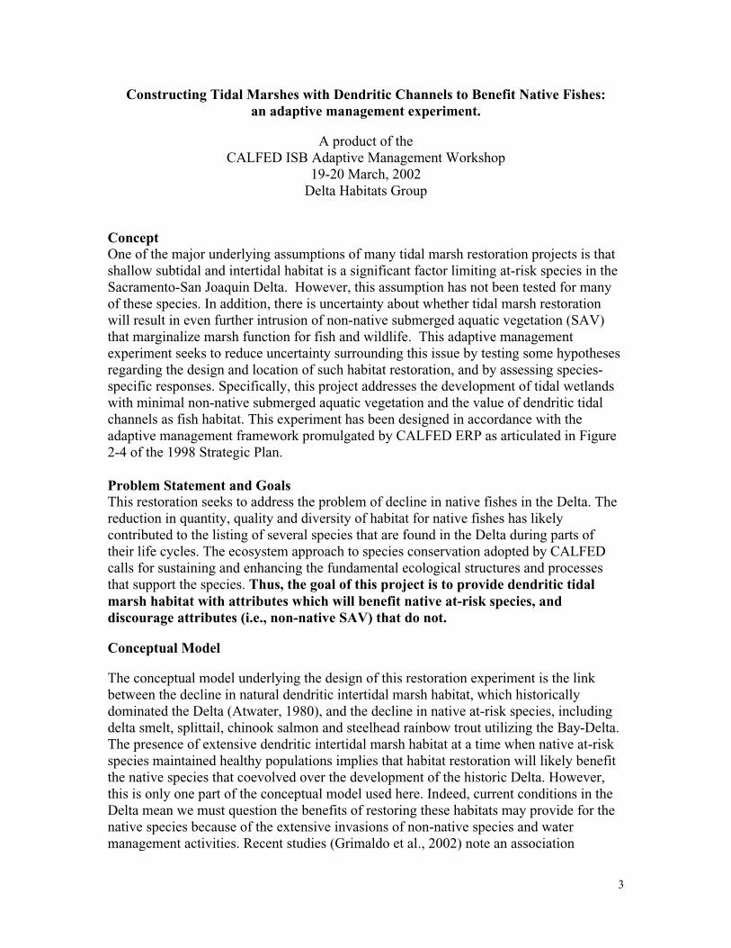
3
Constructing Tidal Marshes with Dendritic Channels to Benefit Native Fishes:an adaptive management experiment.
A product of theCALFED ISB Adaptive Management Workshop
19-20 March, 2002Delta Habitats Group
ConceptOne of the major underlying assumptions of many tidal marsh restoration projects is that shallow subtidal and intertidal habitat is a significant factor limiting at-risk species in the Sacramento-San Joaquin Delta. However, this assumption has not been tested for many of these species. In addition, there is uncertainty about whether tidal marsh restoration will result in even further intrusion of non-native submerged aquatic vegetation (SAV) that marginalize marsh function for fish and wildlife. This adaptive management experiment seeks to reduce uncertainty surrounding this issue by testing some hypotheses regarding the design and location of such habitat restoration, and by assessing species-specific responses. Specifically, this project addresses the development of tidal wetlands with minimal non-native submerged aquatic vegetation and the value of dendritic tidal channels as fish habitat. This experiment has been designed in accordance with the adaptive management framework promulgated by CALFED ERP as articulated in Figure 2-4 of the 1998 Strategic Plan.
Problem Statement and GoalsThis restoration seeks to address the problem of decline in native fishes in the Delta. The reduction in quantity, quality and diversity of habitat for native fishes has likely contributed to the listing of several species that are found in the Delta during parts of their life cycles. The ecosystem approach to species conservation adopted by CALFED calls for sustaining and enhancing the fundamental ecological structures and processes that support the species. Thus, the goal of this project is to provide dendritic tidal marsh habitat with attributes which will benefit native at-risk species, and discourage attributes (i.e., non-native SAV) that do not.
Conceptual Model
The conceptual model underlying the design of this restoration experiment is the link between the decline in natural dendritic intertidal marsh habitat, which historically dominated the Delta (Atwater, 1980), and the decline in native at-risk species, including delta smelt, splittail, chinook salmon and steelhead rainbow trout utilizing the Bay-Delta.The presence of extensive dendritic intertidal marsh habitat at a time when native at-riskspecies maintained healthy populations implies that habitat restoration will likely benefit the native species that coevolved over the development of the historic Delta. However, this is only one part of the conceptual model used here. Indeed, current conditions in the Delta mean we must question the benefits of restoring these habitats may provide for the native species because of the extensive invasions of non-native species and water management activities. Recent studies (Grimaldo et al., 2002) note an association

4
between subtidal areas, frequently dominated by SAV, and non-native fishes that consume native fishes, or may displace or out-compete them.
The conceptual basis for this project is outlined in Figure 1. The figure shows how thehydrodynamic characters and physiographic setting of various geomorphic features in the Delta provide appropriate conditions, or not, for extensive SAV development. As a consequence, it is also assumed that those features associated with dendritic tidal marsh habitat also provide important functions that benefit native fishes. Essentially, intertidal marshes with extensive dendritic channels drain regularly compared to subtidal areas and thus less likely to be dominated by SAV. However these habitats prove beneficial to native fishes only if it is directly accessible (i.e., access is direct and not via a dense SAV bed adjacent to the marsh and channel system). Thus an important landscape component of the conceptual model is that active distributary or slough channels also exhibit conditions that are unsuitable (too deep or too turbid) for SAV growth. The final element of the conceptual model to be tested and developed using this experiment is that we have the geomorphic understanding and engineering to establish conditions promoting the development of dendritic tidal marshes with the attributes just described.
UncertaintiesThe adaptive management experiment will be designed to address several key uncertainties contained in the conceptual model described above:
• Will SAV colonize and persist in and immediately adjacent to a dendritic channel system adjoining an active distributary channel?
• What are the important characteristics of dendritic channels and adjacent marsh that benefit native fishes?
• What are the process linkages that lead to these benefits?• Can tidal action alone develop and maintain dendritic channels?• Can we cost effectively design and construct tidal marsh plain channel systems
that are stable and sustainable in the long term (over decades)?• What are fish responses to dendritic tidal marsh habitat in estuarine vs tidal
riverine dominated systems?• What is the relationship between marsh channel pattern, hydrodynamics, and
marsh plain vegetation characteristics?
HypothesesThe above uncertainties will be addressed by testing the following hypotheses:
1. SAV coverage and density are lower or absent in tidal channels with stronger tidal flows and sandier substrate types.
2. Marsh with complex dendritic channel system will provide a greater quantity anddiversity of more food for fish, (e.g., benthic and pelagic, macroalgal and microalgal) compared to open subtidal habitats. This effect may be direct or indirect via the provision of food for prey (e.g., chironomids or copepods).
3. Fish reproduction, growth and survival depend on geomorphological characteristics of the marsh tidal channel system, specifically:

5
• Channel density (hypothesized positive relationship)• Channel shape in cross-section (hypothesized positive relationship with steep
side slopes)• Channel order
o Hypothesized negative relationship for growth; however, this may depend upon the strength of flow out of the dendritic channel system, e.g., higher order may actually provide better overall habitat because fish are not entirely forced out of the marsh at low tide, but SAV may occupy the higher order channel[s] if flow is not sufficient to suppress SAV growth.
o Hypothesized positive relationship for reproduction where dewatering at low tide may impact fish eggs.
• The ratio of marsh edge to marsh area (hypothesized positive relationship)4. Hydrogeomorphic setting and construction of tidal channel systems can be
optimized to minimize the impact of SAV• Grading can be used to design and construct functional tidal channels • Sedimentation from adjacent rivers will hasten the development of a dendritic
tidal channel system
Experimental DesignThe essential elements of the experimental design used to test these hypotheses will involve using different approaches to the creation of dendritic tidal marsh habitat, and testing these approaches in two areas:
• the eastern Delta (close to a riverine source of sediment). Possible location: McCormack-Williamson Tract
• the western Delta (remote from direct supply of sediments from riverine sources but close to sediments mobilized and transported by waves and tides). Possible location: Chipps Island
These sites have been selected for the suitability of their current elevations. Within each area land will be selected which is not greatly subsided (< 4 ft. below mean sea level - an elevation shallow enough for lateral colonization by tules.) and allocated into 3 parcels of 200 acres or greater in size. This size is considered a minimum to achieve the development of a mature (e.g., 4th order or greater) tidal channel network. Initialelevations must be sufficiently high that achieving tidal marsh elevations through natural sedimentation processes is likely, and higher elevation areas may be included in one of the treatments that require grading. If necessary, some material may be added to achieve the elevations necessary to complete the treatments. The parcels must exchange directly into a deep distributary channel that is unfavorable for SAV growth (too dynamic or too turbid).
Each of these parcels will receive a different experimental treatment:Treatment 1—No Intervention
At this site, tidal action will be introduced to the parcel via a very wide levee ‘breach’. No further action will occur and the site will be

6
monitored to assess performance relative to the measures described below.
Treatment 2—Fill to Appropriate ElevationsAt this site, the land will be graded or filled to achieve an elevation in the intertidal range and tidal action will be introduced to the site in a manner similar to Treatment #1.
Treatment 3—Fill and Excavate ChannelsAt this site, land will be graded or filled, as in Treatment #2, but in addition a proto-dendritic (i.e., “starter”) channel system will be excavated to ‘kick-start’ the channel development process.
Concept 4. The replication of these treatments in each area will allow the experimental evaluation of the role of riverine vs. tidal sediment sources to bring elevations to appropriate levels (Treatment 1 – hypothesis 5) as well as allowing the testing of hypotheses 1, 2 and 3 across a range of delta salinity, turbidity and hydrodynamic conditions. Hypothesis 4 is tested through the comparison of the physical performance of the treatments within an area.
Concept 5. Performance MeasurementsThe active adaptive management nature of this experiment means that in order to meet the stated goal the project must achieve specific performance measures or changes will be made accordingly. Thus, it is proposed that these treatments should be assessed relative to these measures 5 years after project implementation. This should be enough time for dendritic channel formation to at least begin in treatments 1 and 2, and for some natural adaptation of the channels in treatment 3. In addition, it is likely that within 5 years the area in the eastern Delta will be subjected to at least a moderate flood, supplying riverine sediments to the treatments.
The performance measures are linked to the development and function of the dendritic channel system – the goal is not just to achieve a channel network but one with functions and use patterns that allow our hypotheses to be tested. In some cases these performance measures can only be assessed by comparing the treatment sites with adjacent reference areas (e.g., sluggish subtidal areas as described in Figure 1). Where this is the case monitoring measures (see below) must encompass not just the restoration sites but also appropriate reference sites.
1. Composition and coverage of SAVThe coverage of SAV within the channel system must be less than coverage in sheltered subtidal areas close to the treatment. The composition of SAV that is present must include native species.
2. Development of channelsEach treatment in each area must develop a dendritic channel network of at least a third order level within five years.
3. Net vertical sedimentationTreatments which were implemented below mean marsh plain elevation must show vertical accretion (via accumulation of organic matter and/or sediments) towards marsh plain elevation. Treatments which were

7
implemented at marsh plain elevation must show elevation increase at a rate at least equal to relative sea-level rise.
4. Microalgal composition and productionThe benthic, epiphytic, and planktonic microalgal communities include high-quality food organisms for primary consumers (e.g., cryptophytes, certain diatoms, etc.). Such microalgal production in the restoration sites should be similar to (equal to or greater than) that found in adjacent sheltered subtidal channels and sufficient to support desirable consumer densities.
5. Reproduction, growth and survival of at risk native speciesMonitoring must show that reproduction, growth and survival of appropriate at-risk species within the treatment areas is equal to or greater than similar measures in adjacent sheltered subtidal channels.
Adaptive Management MeasuresWe recommend using the performance measures above to determine whether the project is progressing towards its stated goal within the five-year timeframe. If these measures are not met, contingency actions must be instituted to adjust the design/operation of thisproject, and to improve the design and operation of future tidal marsh restoration projects. Specifically, the key to this restoration action is the development of dendritic tidal channels without a significant presence of SAV. If Performance Measure #1 is not met five years after project implementation, the initial design specifications will be modified and the site reconfigured, e.g., marsh surfaces will be graded and sculptured to initiate channel development (similar to the approach proposed for Treatment #3). If channels are developing (e.g., measure #1 is being met) but Performance Measures #2-#5are not met then this implies that the dendritic tidal channel habitat is not functioning as anticipated in the conceptual model (Figure 1). The reasons for this will likely be clear from the monitoring data (see below) and the testing of the hypotheses. Information derived from this monitoring maybe used to modify the conceptual model and structurally alter the channel systems to improve function, but unless clearly justified structural improvements can be made, it is recommended that the project be redesigned, rather than adapted from its original concept.
Monitoring to Reduce UncertaintyThe role of the monitoring program is threefold:
1. to provide data on project performance relative to the measures described above; 2. to provide data to test the stated hypotheses and thus reduce uncertainties
surrounding the construction and use of dendritic tidal marsh habitat to benefit at-risk species; and,
3. provide direction for adaptive modifications to the experimental treatments that do not meet performance measures.
We recommend that the monitoring design for the project is both ‘process-oriented’ and examine the evolution of the sites and the resulting structure-process interactions. These

8
sites must be viewed as “open” systems, both influencing and influenced by processes in adjacent and remote environments. Specific measurements should include:
• evaluation of physical structure and processes (geomorphic character, hydrodynamics, sedimentation);
• emergent plants (composition over time and coverage);• submerged and floating plants (diversity, coverage, and change over time);• organic carbon (OC) fractions (forms of OC produced within and exported from
the sites);• invertebrate use and change over time;• benthic algae production• occurrence of juvenile and small pelagic fishes;• turbidity/light attenuation (i.e., because algal production is light limited);• inorganic nutrients;• spatial habitat complexity; and,• fish response to various habitat components of the marsh.
In particular monitoring must evaluate what the fish are eating; where the food came from (local or imported); and, the base of the food source (e.g., epiphytes vs. benthic microalgae vs. phytoplankton). Such measures will be essential to determine the causal mechanisms behind the functional performance of the habitat for fish and ultimately what attributes of the habitat should be replicated in other habitat designs.
The detailed design of the monitoring plan should be undertaken by a monitoring team, including (at a minimum) an ecologist, engineer, and agency resource manager. The team would provide advice on monitoring and help with “adaptive modifications” of the monitoring program, as well as the restoration project itself. The team would also ensure monitoring is coordinated with other monitoring programs (in terms of procedures and protocols, timing), would take advantage of existing monitoring programs and data, and would be responsible for integrated reporting, analysis, and interpretation of data, ensuring a long-term commitment to monitoring. The team would also be responsible for communicating the results and interpretations to the CALFED, other scientists, and other interested entities.
Given the limited existing monitoring of tidal marsh habitats in the Delta, it may be necessary for the team to design an extra-intensive (high frequency) preliminary study to determine the appropriate time and space scales for sampling. Similarly, it might plan for periodic revisiting of extra-intensive sampling to evaluate the “evolution” of the marsh system over time (such as prior to the 5-year post-implementation evaluation). The identification of appropriate reference sites or sampling stations (e.g., to document non-project related changes in fish and/or SAV) should also be considered by the team in the context of existing monitoring programs.
It is essential that the monitoring program be integrated to link landscape changes and biological response (recognizing that the physical evolution of the landscape and the biology of the marsh go hand in hand) and that data be collected to address Hypotheses 1, 2 and 3 which specifically address these linkages. New technologies should also be considered that allow identification of critical system responses, such as aerial

9
surveillance with multi-spectral sensing to detect biological responses (e.g., vegetation composition and landscape structure) to physical changes on a variety of scales, and “biomarkers” for determining carbon sources and pathways.
Results from the monitoring program should be reported annually and biennially a synthesis report should be produced, tracking project performance over time and testing the hypotheses posed here. In addition, presentations to the Bay-Delta restoration community and publication in peer-reviewed journals should be employed to inform restoration practitioners and managers. The ultimate goal should be to systematically reduce the uncertainties associated with the value of dendritic tidal marsh restoration in the Delta for at-risk native fishes.
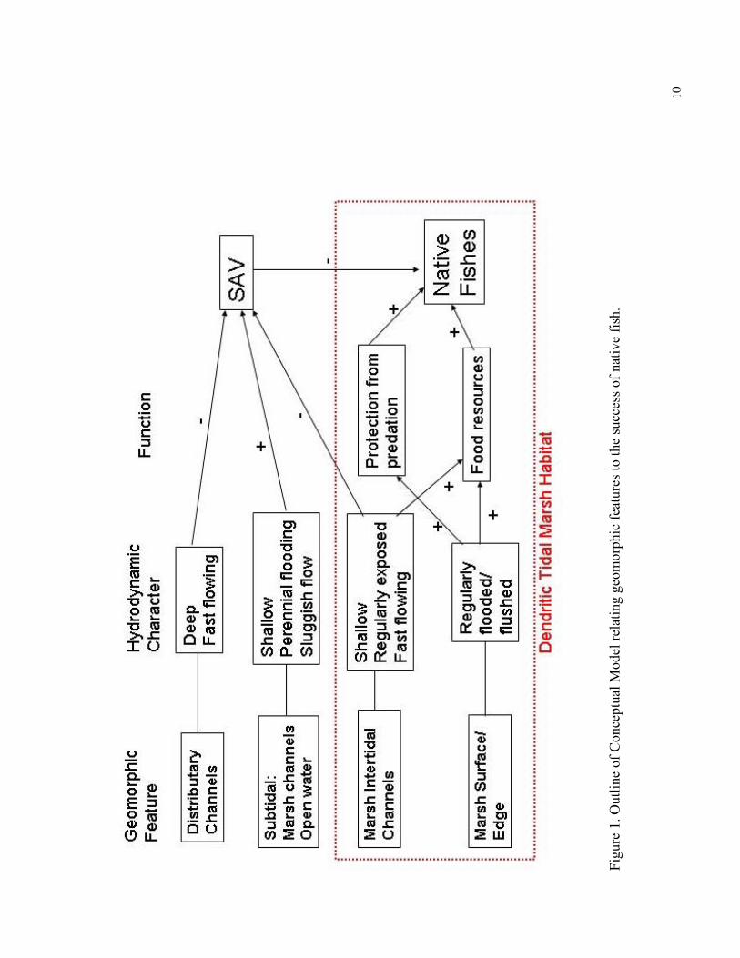
10
Figu
re 1
. Out
line
of C
once
ptua
l Mod
el r
elat
ing
geom
orph
ic f
eatu
res
to th
e su
cces
s of
nat
ive
fish
.

AM Workshop, 3/20/02 11
Additional Concepts for Delta Habitat Adaptive Management Experiments
A product of theCALFED ISB Adaptive Management Workshop
19-20 March, 2002
Concept 1. Tidal/Seasonal Floodplain
ConceptProvide floodplain habitat during dry season by opening all or part of Merritt, Sutter, or lower Grand Island, via gates or control structures, to allow inundation driven by tidal flow.
Conceptual ModelFloodplain benefits that are lost in dry years or during dry seasons can be reproduced by tidal inundation.
Target Species• Salmon, Steelhead, Splittail, Delta Smelt
Uncertainties• What is the benefit of the Sutter or Steamboat Sloughs to target species?• Can benefits of floodplain inundation be mimicked using tidal flows?• If full drainage were not possible would benefits outweigh potential stranding?
Possible Later Stages• Realign the opening of Sutter Slough to enhance movement into the opening • Add more acreage• Open Sacramento River into slough above Merritt Island.
Concept 2. In-Delta Levee Removal and Grading
ConceptCreate a large tidal marsh area by removing all or a significant portion of a delta island levee and grading the levee material onto the island. Material would be graded to create a gradual sloping land surface elevation from MLLW to something above EHHW at the opposite side of the island. The lower elevation (marsh) edge would front an active channel.
Conceptual ModelDevelopment of large tidal marsh area in the delta would provide important missinghabitat and ecological processes that would benefit at risk native species. Marsh edge facing active channel would not support significant Egeria habitat.

AM Workshop, 3/20/02 12
Target Species• Salmon, Steelhead, Splittail, Delta Smelt
Constraints• Subsidence• Sufficient levee material• Low fetch• Active channel with suspended bedload
Uncertainties• Active channel erosion (creating egeria habitat)• Extent and change in unvegetated and emergent vegetation in intertidal area• Non-native clam colonization• Fish use• Development of tidal channel system(s)• Wave fetch
Hypotheses• Egeria will not colonize intertidal and active channel edge.• Native at risk fish species will benefit from intertidal area (refuge, prey resources,
spawning).• Higher density of primary producers and benthic-pelagic coupling.• Alien clam colonization less than on “reflooded” islands.• Reducing residence time of water-borne contaminants (vs. flooded islands).
Performance Measures (relative to reference)• Egeria colonization• Short-term growth of fish• Empirical measures coupled to bioenergetic modeling• Predation on key fish species• predation rates• predator presence/abundance• Fish residence time (interrelated to growth measures)• Non-native clam colonization• Benthic primary production and water column (microalgal, macroalgal,
emergent/riparian)• Transfer of autochthonous primary production to upper trophic levels• Reproduction – Delta Smelt eggs• Splittail eggs and rearing• Erosion/sedimentation
Appendix C: Excerpts from the Dutch Slough Conceptual Plan and Feasibility Study
SAN FRANCISCO • BOISE • SACRAMENTO ENVIRONMENTAL HYDROLOGY ~ FLUVIAL GEOMORPHOLOGY ~ WETLAND, RIVER & WATERSHED MANAGEMENT ~ COASTAL & ESTUARINE PROCESSES ~ SEDIMENT
HYDRAULICS
M E M O R A N D U M
TO: Dutch Slough Restoration Project Management Team
FROM: Nick Garrity, Michelle Orr, and Philip Williams; PWA (Philip Williams & Associates)
With Bruce Herbold, EPA, and Charles Simenstad, University of Washington
DATE: May 4, 2006
RE: Dutch Slough Tidal Marsh Restoration Conceptual Model
1. SUMMARY This memorandum documents the Dutch Slough Tidal Marsh Restoration Conceptual Model and describes how the conceptual model informs large-scale adaptive management experiments in the Dutch Slough Tidal Wetland Restoration project. The memorandum describes the adaptive management context for the restoration project (Section 3), the conceptual model for freshwater tidal marsh restoration (Section 4), key uncertainties identified in the conceptual model (Section 5), hypotheses for the large-scale experiments for marshplain elevation and marsh scale (Section 6), and experimental design considerations for these large-scale experiments (Section 7). The large-scale adaptive management experiments for marshplain elevation and marsh scale are intended to test the response of special status native fish to different methods of wetland restoration and to inform restoration design, including cost-effectiveness, for future Delta restoration projects. The hypothesis for the marshplain elevation experiment is that lower elevation marshes produce greater prey resources for juvenile salmon and splittail than higher elevation marshes, and thus greater potential for feeding, growth, and survival. The hypothesis for marsh scale is that tidal channel networks in larger marshes provide greater refuge from predation than in smaller marshes, and thus greater survival opportunities for juvenile salmon and splittail. The Dutch Slough project includes small-scale and water quality adaptive management experiments, which are not described in this memorandum. These additional experiments are planned as part of the Dutch Slough project and will be described in the Dutch Slough Tidal Marsh Adaptive Management and Monitoring Plan (NHI, in progress) or developed in future phases of the project. 2. INTRODUCTION The Dutch Slough Tidal Marsh Restoration is being planned by the California Department of Water Resources (DWR), the State Coastal Conservancy (SCC), the City of Oakley, and the California Bay-Delta Authority (CBDA) (who collectively form the Dutch Slough Management Team). DWR is the land owner, having purchased the site in 2003 with funds from CBDA and the SCC. The SCC is leading the restoration planning with assistance from the Natural Heritage Institute (NHI) and the PWA (Philip

P:\PROJECTS\1714_DUTCH_SLOUGH\TASK6-FEASIBILITY REPORT\FINAL_REPORT\APPENDICES\E.PWA_DUTCH_CM_MEMO_FINAL.DOC 2
Williams & Associates) consultant team. The PWA consultant team developed the Dutch Slough Tidal Marsh Restoration Conceptual Plan and Feasibility Study (Conceptual Plan and Feasibility Study) (PWA and others, 2006). An Adaptive Management Work Group (AMWG) provided scientific input to the Dutch Slough conceptual restoration plan. AMWG members (listed in Section 8) include agency and university scientists and local restoration practitioners. One of the goals of the Dutch Slough restoration project is to contribute to scientific understanding of ecological restoration by implementing the project under an adaptive management framework. The AMWG, Dutch Slough Management Team, and PWA consultant team developed the Dutch Slough Tidal Marsh Restoration Conceptual Model (Dutch Slough Conceptual Model) to guide the adaptive management process. NHI is coordinating the AMWG and is developing the Dutch Slough Tidal Marsh Restoration Adaptive Management and Monitoring Plan (Adaptive Management and Monitoring Plan) (NHI, in progress). The Dutch Slough Conceptual Model is based on the CALFED (2000) adaptive management process and guidance on developing conceptual models. CALFED’s Strategic Plan for Ecosystem Restoration describes conceptual models as follows:
Many resource managers, scientists, and stakeholders interested in the restoration and management of the Bay-Delta ecosystem have implicit beliefs about how the ecosystem functions, how it has been altered or degraded, and how various actions might improve conditions in the system. That is, they have simplified mental illustrations about the most critical cause-and-effect pathways. Conceptual modeling is the process of articulating these implicit models to make them explicit. (CALFED, 2000)
This memorandum documents the Dutch Slough Conceptual Model in its current state of development. The conceptual model is expected to evolve with continued input from the AMWG and through the adaptive management process, and is therefore a working document. As described by CALFED (2000), “conceptual models are based on concepts that can and should change as monitoring, research, and adaptive probing provide new knowledge about the ecosystem.” The large-scale adaptive management experiments are designed to test hypotheses that predict the response of special status native fish to different methods of wetland restoration. Providing habitat for special status native fish species was the key objective of the adaptive management program that drove development of the large-scale adaptive management experiments. The conceptual model documented in this memorandum focuses on special status native fish species. Conceptual models for other elements of habitat restoration (in addition to habitat for special status native fish) and for other project elements (e.g., bioaccumulation of methylmercury) were developed and discussed as part of project planning. These conceptual models will guide the Dutch Slough restoration adaptive management program for elements of the restoration other than improving conditions for special status native fish. These conceptual models will be documented in the Adaptive Management and Monitoring Plan.

P:\PROJECTS\1714_DUTCH_SLOUGH\TASK6-FEASIBILITY REPORT\FINAL_REPORT\APPENDICES\E.PWA_DUTCH_CM_MEMO_FINAL.DOC 3
The conceptual model for special status native fish was developed during a series of meetings between the AMWG, the Dutch Slough Management Team, and the PWA consultant team. The CALFED Ecosystem Restoration Program Science Board provided feedback on a preliminary version of the conceptual model and adaptive management framework in a May 2004 meeting, and the Dutch Slough Sub-committee of the Science Board provided additional input in a May 2005 meeting. 3. ADAPTIVE MANAGEMENT CONTEXT Adaptive management is the process of learning from restoration and management actions, then using this knowledge to inform and adapt future actions. Typically, these actions modify parts of a restoration that have already been implemented. Figure 1 from CALFED (2000) illustrates the steps in the adaptive management process. Within the context of the Dutch Slough restoration, adaptive management also refers to informing actions for future restoration projects. This second type of adaptive management is sometimes referred to as “adaptive learning.” Lessons learned at Dutch Slough are primarily intended to inform future restoration projects anticipated in the Sacramento-San Joaquin River Delta, but may also influence management actions at Dutch Slough after tidal restoration is implemented. The project will test different methods of wetland restoration, monitor the physical and ecological responses, and make these results available. The process of adaptive management input to the design is as follows:
1. Define measurable ecological objectives. (These are discussed in Section 3 of the Conceptual Plan and Feasibility Study).
2. Articulate a conceptual model (or models) of the process linkages that explain how the restoration actions address the ecological objectives.
3. Identify key uncertainties in the conceptual model(s).
4. Articulate hypotheses for each of the key uncertainties.
5. Design experiments to test the hypotheses. (These are described in Section 7 of the Conceptual Plan and Feasibility Study and will be detailed in the Adaptive Management and Monitoring Plan.)
6. Implement a monitoring and adaptive management plan for the experiments and the restoration project. (This is in progress and will be documented in the Adaptive Management and Monitoring Plan.)
Adaptive management is an iterative process. Once monitoring results are available (from Step 6), the adaptive management process circles back to reassess the objectives (Step 1) and conceptual models (Step 2), etc. Steps 2 – 4 are described in this memorandum. Experimental design considerations (related to Step 5) for the large-scale experiments are also discussed. The Dutch Slough adaptive management process embedded within the overall restoration plan is more fully described in a draft memorandum to the AMWG (Cain, 2004) and will be documented in the Adaptive Management and Monitoring Plan.

P:\PROJECTS\1714_DUTCH_SLOUGH\TASK6-FEASIBILITY REPORT\FINAL_REPORT\APPENDICES\E.PWA_DUTCH_CM_MEMO_FINAL.DOC 4
4. CONCEPTUAL MODEL 4.1 Overview This memorandum documents the conceptual model for growth, survival, and spawning of three special status fish species identified as “tier 1” target species for the project: Sacramento splittail (Pogonichthys acrolipidotus), Chinook salmon (Oncorhynchus tshawytscha) and Delta smelt (Hypomesus transpacificus) (see Conceptual Plan and Feasibility Report Appendix A). The Dutch Slough Conceptual Model used a previous conceptual model by the Delta Habitats Group (Attachment B) as a starting point and the structure of Level 3 of the PSNERP (2006) conceptual model, developed for use in Puget Sound. In the Dutch Slough Conceptual Model, restoration actions are linked to ecological outcomes in cause-and-effect relationships. The conceptual model focuses on controllable actions at Dutch Slough. Other factors not directly related to the Dutch Slough restoration also affect outcomes, such as freshwater flows, Delta pump operations, water contaminants, fisheries management, or new introduced species. For clarity and simplicity, however, these factors are not included in the Dutch Slough Conceptual Model. The Dutch Slough Conceptual Model consists of an overarching general conceptual model and more detailed, operational conceptual models for the large-scale experiments. Elements of the general conceptual model are organized into the categories (Figure 2):
• Restoration Actions
• Physical and Vegetative Processes
• Habitat Structures
• Ecological Processes
• Functional Response
• External Factors The AMWG articulated detailed linkages among different elements of the conceptual model (see Attachment A1). Many of the linkages between processes and categories in the conceptual model are self-explanatory. This memorandum does not provide detailed descriptions of each linkage. Rather, this memorandum focuses on the key linkages between restoration actions with habitat structures that received the most discussion in developing the conceptual model. 4.2 Restoration Actions Restoration actions are required to recreate freshwater tidal marsh on leveed sites in the Delta that are presently subsided. These restoration actions allow physical and vegetative processes to occur and create habitat structures. Restoration actions are required because natural processes that formed ancient and
P:\PROJECTS\1714_DUTCH_SLOUGH\TASK6-FEASIBILITY REPORT\FINAL_REPORT\APPENDICES\E.PWA_DUTCH_CM_MEMO_FINAL.DOC 5
historic freshwater tidal marshes over the last 10,000 years in the Delta are not expected to restore marsh habitat structures on a restored (or restoring1) subsided site within the desired timeframe. Restoration actions at Dutch Slough include: filling and grading marsh areas, excavating channels, managing or planting vegetation to favor native plant establishment (re-vegetation), diverting Marsh Creek, and breaching levees. Natural physical and vegetative processes include: sediment deposition and biomass accumulation (accretion), erosion, tidal inundation, vegetation colonization, and heating/cooling. Restoration actions and physical and vegetative processes create and interact with the following habitat structures: vegetated marshplain, tidal channels, subtidal open water, floodplain, riparian, upland and transition, soil profile and chemistry, and water chemistry. Key processes and habitat structures are discussed below. 4.3 Physical and Vegetative Processes Generally, the physical processes part of the conceptual model predicts few significant geomorphic changes within several years to one or two decades after the site is constructed. Unlike its restoration counterparts in the more saline and sediment-rich parts of the estuary (San Francisco Bay) where sedimentation rates are higher, Dutch Slough is expected to experience slow rates of sedimentation in shallow subtidal and marshplain habitats, and likely limited formation of tidal channels through tidal scour. To achieve restoration and adaptive management goals within the planning horizon, it is therefore necessary to create restored marshes with features similar to equilibrium marshplain elevations and tidal channel networks, rather than relying on the evolution of equilibrium conditions through natural physical processes, in order to achieve the project goals within the planning horizons for restoration and adaptive management (50 years and from several years to one or two decades, respectively, as discussed in Section 7 of the Conceptual Plan and Feasibility Report). Constructed restoration features are expected to persist and evolve slowly over at least the next decade. Physical and vegetative processes for the San Francisco Bay Estuary are generally described in Orr et al. (2003), Reed (2002), Simenstad et al. (2000), Atwater and Belknap (1980), and Atwater et al. (1979), and Gilbert (1917). Much of the discussion that follows is based on Orr and others (2003) and Simenstad and others (2000). The extensive freshwater tidal marshes of the Sacramento-San Joaquin River Delta formed gradually over the last 10,000 years as rising sea levels flooded former inland valleys at the mouth of the Sacramento and San Joaquin rivers (Atwater and others, 1979). Marshplain elevations kept pace with rising sea level (Atwater and Belknap 1980), building up peat and peaty mud through sediment deposition and biomass accumulation (peat formation). Minerogenic sedimentation was primarily in response to flood flows of the Sacramento and San Joaquin rivers and confined to the margins of their distributary channels. Distal from these internal deltas, organic-rich marshes began to accumulate (Atwater, 1982). These ancient and historic Delta freshwater tidal marshes are drained by intricate systems of sinuous and branching tidal channels. The predominant marsh vegetation type is tule (Scirpus acutus, S. californicus, and S. americanus), with cattails (Typha sp.) and common reed (Phragmite sp.) (Atwater and Hedel 1976). 1 The term “restoring” is sometimes used to indicate that restored marshes continually evolve.

P:\PROJECTS\1714_DUTCH_SLOUGH\TASK6-FEASIBILITY REPORT\FINAL_REPORT\APPENDICES\E.PWA_DUTCH_CM_MEMO_FINAL.DOC 6
Reclamation of delta wetlands – levee-building, ditching, and draining of lands primarily for agriculture – has caused subsidence through direct dewatering of the substrate and aerobic decomposition of organic material in marsh soils. Sediment supply to the delta has been highly modified by upstream activities, which include hydraulic mining, grazing, deforestation, marsh and floodplain reclamation, dam construction, and channel incision (Gilbert, 1917; Beeman and Krone, 1992; Wright and Schoellhamer, 2003 in Orr and others, 2003). Accretion. Tidal marshplains sustain vertical growth (i.e., accretion) through sediment deposition and organic biomass accumulation. Marshes in the Delta are sustained primarily by the accumulation of low density organic rich soils (typically 50% organic content) derived from surface vegetation growth (Atwater and Belknap, 1980; Atwater and others, 1979), and also fluvial and estuarine mudflat sediments, depending on the location within the Delta. Peat formation occurs as organic material is buried and accumulates beneath the water table, where decomposition is slowed under anaerobic conditions. Mineral sediments are transferred fairly efficiently through the system to Suisun and San Pablo bays. Ancient and historic marshplain elevations kept pace with sea level rise at an equilibrium elevation of approximately MHHW through self-regulating accretionary processes (Atwater and others, 1979; Allen, 2000). Accretion above the MHHW elevation is limited by sea level rise and the decomposition of organic matter. Leveed former marshes such as the Dutch Slough site have subsided to elevations below mean sea level. When former leveed marshes are restored to tidal action by levee breaching, low elevation tidal areas are created where accretionary processes occur and are not limited by sea level rise. In subtidal areas below the vegetation colonization (see below), sediment deposition occurs; areas at intertidal elevations also accrete through biomass accumulation once vegetation is established. Available empirical data on accretion in Delta marshes indicate that rates of sedimentation and biomass accumulation are slow compared to restoration timelines (Orr and others, 2003). Historic rates of accretion for natural (high elevation) marshes are limited by the rate of sea level rise (as high as 3 to 4 mm/yr at Brown’s Island; Goman and Wells 2000). Limited data on long-term rates of accretion in restored (low elevation) marshes range from 9 – 18 mm/yr (at Sherman Lake, Lower Mandeville Tip, Mildred Island, and Frank’s Tract; data from Reed, pers. comm., Simenstad and others 2000, and PWA unpublished). An ongoing study by the USGS to measure accretion in permanently flooded (managed) wetlands has found initial biomass accumulation rates of 26 mm yr -1 (with a wide variation) over a three-year period (Drexler and others, 2003); however, these rates are not expected to be representative of tidal conditions in restored marshes. Accretion rates may be limited by the extent of wave and current energy in exposed subtidal restored sites (Simenstad and others, 2000). Vegetation colonization. Emergent vegetation colonization occurs in two ways: (1) pioneer colonization and (2) lateral expansion colonization. Pioneer colonization occurs by seed or deposition of vegetation fragments. Once vegetation becomes established, lateral expansion can extend lower in the tidal zone by extension of rhizomes. Higher elevation marshplains (“high marsh”) are typically vegetated by a mix of plant species including common tule (Scirpus acutus), California bulrush (Scirpus californicus), common reed (Phragmites communis), spikerush (Eleocharis spp.), and narrowleaf cattail (Typha angustifolia);
P:\PROJECTS\1714_DUTCH_SLOUGH\TASK6-FEASIBILITY REPORT\FINAL_REPORT\APPENDICES\E.PWA_DUTCH_CM_MEMO_FINAL.DOC 7
whereas lower elevation marshplains (“low marsh”) tend to be dominated by a monoculture of California bulrush (Simenstad et al, 2000; see Section 6.3 of the Conceptual Plan and Feasibility Report). Note that while the terms “high” and “low” marsh are used here, the transition from high marsh to low marsh is not well defined. Morphologically-similar freshwater emergent marsh vegetation occurs over a range of intertidal elevations. Low marsh and high marsh are not generally-recognized habitat categories in the Delta, unlike in the more saline San Francisco Bay. Vegetation colonization within the intertidal zone is expected to be rapid (Simenstad and others 2000, USFWS and USACE 1990). Areas below the vegetation colonization elevation are expected to remain as mudflats or to be colonized by non-native, invasive submerged aquatic vegetation (SAV). Limited data from Delta marshes show that tule vegetation becomes less dense in coverage with interspersed areas of mudflat and SAV within an elevation range between approximately +1 and -2 ft MLLW (Simenstad and others 2000; see Section 8.1.1 of the Conceptual Plan and Feasibility Study). In lower elevation zones near the bottom of this range, the extent of tule vegetation may be limited and SAV is expected to dominate plant communities (see Invasive SAV below). Subtidal areas below -12 ft mean tide level (MTL) are not expected to support SAV due to limited sunlight. At the marsh/channel edge, the lower limit of tules is expected to be similar in lower and higher elevation marshes. The quality of channel bank/marsh edge habitat is therefore also expected to be similar in different elevation marshes (see Figure 3 and Section 4.3). Under non-tidal conditions (i.e., managed water or leveed conditions), the natural recruitment of tules can occur in response to periodic flooding and draw-down water levels. The natural recruitment of tules has occurred inadvertently in low areas of the leveed Dutch Slough site and other sites in the Delta. The USGS demonstration project at Twitchell Island has used flood irrigation to encourage natural recruitment as a technique for re-vegetation and biomass accretion. Water management can be used to grow tules in subsided sites at elevations below the range of tule colonization observed for tidal conditions; however, it is uncertain whether tules pre-established below this range will survive under tidal conditions if the site is breached. Historically, natural channel levees formed along the banks of the fluvial distributary channels in some mature marshes (Atwater and Belknap, 1980; Simenstad and others, 2000; PWA, 2003). These natural levees were higher than the average elevation of the mature high marshplain and supported mature riparian vegetation, in contrast to the tule marshplain along tidal slough (non-distributary) channels. The natural channel levees decreased in elevation with both height and width with distance downstream in the Delta (Atwater and Belknap, 1980). They approached heights of 24 ft above MLLW near Sacramento and 14 ft above MLLW further downstream at the head of Grand and Sutter Islands (PWA, 2003). These levees were sustained by preferentially high sedimentation immediately adjacent to the distributary channels during flood flows. Vegetation-elevation transects surveyed by PWA at natural marshes along Lindsey Slough in the north Delta and Upper Mandeville Tip in the central Delta show that a subtle elevation difference of 0.5 ft between natural channel levees and the adjacent marshplain can support riparian vegetation along the levee (Simenstad and others, 2000; PWA, 2003).
P:\PROJECTS\1714_DUTCH_SLOUGH\TASK6-FEASIBILITY REPORT\FINAL_REPORT\APPENDICES\E.PWA_DUTCH_CM_MEMO_FINAL.DOC 8
In restored marshes, volunteer establishment of native woody and herbaceous riparian plants in higher elevation areas is expected to be limited to areas adjacent to existing native riparian plant communities, and would likely take decades to succeed beyond initial willow scrub phases to cottonwood-willow forests. Volunteer establishment is expected to be minimal in areas that lack adjacent existing native riparian plant communities to provide a source for colonization. Instead, there would be a high potential for establishment of invasive non-native species, including Himalayan blackberry, perennial pepperweed, Bermuda grass, milk thistle, Italian ryegrass, vetch, and curly dock. Tidal channel morphology. The formation of channels through tidal scouring of the compacted agricultural field surface in restored marshes is expected to be limited, and is an area of high uncertainty (see Section 5 below). Tidal velocities may be high enough in the large channels (the sloughs) and near the breaches to scour, as they have at Donlon Island; however, velocities in the small channels are hypothesized to be too low to scour channels into the marshplain. There may be a minimum restored marsh scale or tidal prism for tidal channels to form through tidal scour. Below this minimum, channels may not form and tules may colonize the potential channel footprint. The potential for tidal channel scour was identified as an area of uncertainty (see Section 5 below). In restored marshes, tidal channels that are constructed similar to natural channels (as possible) – both in cross-section (depth, width, side slope) and plan form (density, sinuosity, bifurcation) – are hypothesized to be sustainable habitat structures over the life of the restoration. In ancient and historic Delta marshes, tidal channel systems are sinuous and branching. In cross-section, tidal channels maintain unvegetated channel beds and steep-sloping channel banks with vegetated edges, which provide fish habitat (see Section 4.3 below). Tidal channel morphology is controlled both by marsh hydrology and vegetation. The volume of tidal flows (tidal prism) is related to the cross-sectional area, depth, and width of tidal channels, which can be correlated in hydraulic geometry relationships (PWA, 2003; Williams and others, 2002; Simenstad and others, 2000). The density of tidal channels in freshwater marshes is less than in more saline marshes (SFEI, 2004), presumably because freshwater vegetation assemblages grow lower within the tidal range. In freshwater marshes, smaller tidal channels with bed elevations in the intertidal zone are few in number because intertidal areas tend to be vegetated with tules. In some cases, these small first order channels are overgrown with tules to form subsurface drainage “pipes;” in other marsh areas, small intertidal channels are not present or are indistinguishable from the marshplain (PWA observations and unpublished data). The planform and cross-sectional geometry of tidal channels are expected to vary with marshplain elevation and marsh scale. Limited data suggest that channels in lower elevation restored marshes are wider than channels that drain the same area of higher elevation (MHHW) mature marsh, but that channel depths may not differ significantly (Simenstad and others, 2000). Tidal channel formation in restored marshes may also be controlled by antecedant conditions (e.g., agricultural field surface, ditches, etc) in addition to marshplain elevation. The number of channel bifurcations (channel order) in larger marsh areas will be greater than in smaller marsh areas. The main (higher order) channels in larger marsh areas will be larger and deeper than in smaller marsh areas. Larger marsh areas will have a greater range of channel sizes and depths. The range in channel depths is important for native juvenile fish habitat and refuge (see Section 4.3 below).
P:\PROJECTS\1714_DUTCH_SLOUGH\TASK6-FEASIBILITY REPORT\FINAL_REPORT\APPENDICES\E.PWA_DUTCH_CM_MEMO_FINAL.DOC 9
Heating and cooling. Temperature dynamics in tidal marshes are primary controlled by depths and frequency of inundation (i.e., wetting and drying or desiccation) and vegetation cover and shading. Generally, temperatures in deeper areas and shaded areas are less variable. Temperature variability is greatest during the day, especially when tide levels drop below the marshplain elevation and the marshplain is exposed to high temperatures. Temperatures in lower elevation marshplain environments are expected to be less variable, and therefore more benign, than higher elevation marshplains. The difference in heating the water column above vegetated marshplains with different elevations (high and low) is not expected to be significant (Garrity, 2004). Invasive SAV establishment. Conditions affecting the establishment and survival of non-native SAV (e.g., Egeria densa) were the focus in conceptual model development because of SAV’s perceived detriment to native fishes (see below). SAV can colonize tidal areas and grow at depths of up to 8 to 12 ft below MTL (-6.5 to -10.5 ft NGVD). Based on limited data, tt is not expected to be possible to control non-native SAV by designing for high velocities or selection of substrate (L. Anderson, USDA, pers. comm.). High velocities are expected to slow, but not prevent, the initial establishment of SAV. SAV is expected to establish in pockets in low velocity areas adjacent to high velocity areas. Once established, SAV is expected to eventually spread to higher velocity areas, forming a continuous coverage. Similarly, compacted soils or other unsuitable substrates are expected to slow, but not prevent, SAV colonization. 4.4 Habitat Structures, Ecological Processes, and Functional Response Juveniles of many of fishes, including several species of concern, will preferentially occupy shallow water habitats in the Delta through transitory periods in their early life history (Moyle, 1976; Wang, 1986). The AMWG developed several simple conceptual models that illustrate how an adaptive management strategy can be used to identify and test functional relationships between fish performance and restored wetland structure, where structure includes composition, structure, and arrangement of various fish habitat elements (Attachments A2 and A3). Performance measures for this strategy consist of juvenile Chinook salmon survival and growth, although similar mechanisms are expected to affect other fish using the restored wetlands, particularly Sacramento splittail. Performance measures can be tracked using both fish that are volitionally entering and using the sites and with manipulative release experiments using hatchery-produced juvenile salmon. These conceptual models show the expected responses of fish to marshplain elevation, channel characteristics and invasive SAV, and some of the fundamental assumptions behind these responses. Tidal marshplain habitat. A key feature of tidal marshes that influences juvenile salmon (and splittail) performance is the edge of vegetation along tidal channels. These fish feed predominantly at the marsh edge and are not expected to venture onto the vegetated marshplain. Therefore, the capacity of a marsh to support fish is more likely related to the complexity (e.g., channel length and density) of the tidal channels than it is related to total marshplain area. Access to prey. The opportunity for fish to access prey resources along the vegetated channel edge, and thus fish feeding rate and growth, is related most directly to the amount of time the fish have to access the

P:\PROJECTS\1714_DUTCH_SLOUGH\TASK6-FEASIBILITY REPORT\FINAL_REPORT\APPENDICES\E.PWA_DUTCH_CM_MEMO_FINAL.DOC 10
channel edge over the tide cycle. Thus, assuming full tidal drainage, the quality of lower marsh and higher marsh channel bank habitats provide approximately equivalent benefits to fish feeding and growth if the lower edges of vegetation are comparable (Figure 3). Prey productivity. Productivity, behavior and life history traits of juvenile salmon and splittail prey that occur along the marsh edge (i.e., dipteran fly larvae, pupae and adults; gammarid amphipods) may differ as a function of mean marshplain elevation (inversely related) because the duration of inundation will affect the amount of flooded habitat and the degree of elevation-associated stressors such as desiccation and elevated temperatures. It should be noted that other (generally less prominent) prey, such as planktonic cladocerans, do occur in the water column and in tidal channel mudflats and submerged and floating vegetation (e.g., gammarid amphipods). Tidal channel habitat and refuge from predation. We make the fundamental assumption that short-term survival of juvenile salmon and splittail is greater in shallow subtidal channels than in either deep subtidal channels or intertidal channels. At low tide, shallow subtidal channels will provide refuge from predation by piscivorous birds for juvenile salmon and splittail, but will be too shallow to allow access for large, piscivorous fish predators. Predator fish are unable to access and forage channels with water depths of less than approximately 0.5 m because they will be exposed near or above the water surface (i.e., “their backs stick out of the water”). These predators will not enter shallow subtidal channels at low tide when channel depths are less than approximately 0.5 m, but will be confined to deeper subtidal channels (Figure 4). Piscivorous fish predators will enter the same channels during higher tide stages, when water depths are greater than 0.5 m, but they will likely enter these channels after small, juvenile fishes have followed the rising tide into smaller channels farther into the marsh. Tidal channels that dewater at low tides force even juvenile fish out into deeper sloughs and distributary channels, where they are presumably more vulnerable to piscivorous predators. We also assume that juvenile fish that are feeding and growing well will be less susceptible to predation due to their increased vigor. Invasive SAV. In order for fish to take advantage of the feeding and refugia opportunities afforded by the Dutch Slough restoration effort, they must be able to find and enter the distributary channels. The greatest hindrance to access is expected to be growth of SAV in larger subtidal channels (Figure 5). Non-native SAV and also floating aquatic vegetation (e.g., water hyacinth) lower dissolved oxygen levels under some conditions and may affect other water quality parameters, as well as create conditions that attract predators of native fish species. However, the times when out-migrating salmon are present and splittial are expected to spawn is in winter and early spring, when accumulated plant material may be flushed out of the western delta and before temperature and insolation have allowed regrowth. 4.5 External Factors External factors – outside of the Dutch Slough site - have the potential to affect the ecological outcome of restoration actions. These factors cannot be controlled within the restoration design or adaptive management experiments. Examples of external factors include landscape factors such as regionally variable salinities and freshwater flows and other factors such as Delta pump operations, urban and agricultural pollutants, changes in fisheries management, and appearance of new invasive species. The
P:\PROJECTS\1714_DUTCH_SLOUGH\TASK6-FEASIBILITY REPORT\FINAL_REPORT\APPENDICES\E.PWA_DUTCH_CM_MEMO_FINAL.DOC 11
conceptual model does not describe the effects of external factors in detail. The affect of external factors within the adaptive management process and experimental design can be addressed with monitoring of baseline conditions and reference sites. 5. KEY UNCERTAINTIES The AMWG identified uncertainties related to: geomorphic and vegetative processes, linkages between habitat structures and functional response, water quality (mercury methylation and bioaccumulation, dissolved organic carbon (DOC) production), and construction feasibility. The AMWG considered which uncertainties were most uncertain and most important to test. In addition to the level of importance and uncertainty, the AMWG used the following criteria to select key uncertainties:
• What variables/uncertainties have the greatest implications for the future cost and feasibility of marsh restoration at Dutch Slough and elsewhere in the Delta?
• What variables can we test at Dutch Slough?
• What variables can be just as easily tested elsewhere?
• What design feature variables will maximize the chances of seeing a response?
• What variables can be experimentally tested while still maximizing the restoration value of the project?
• What variables can be experimentally tested without significantly increasing the restoration costs (e.g., the amount of fill required)?
• How many variables can be tested within the experimental design?
• To what degree should the Dutch Slough site be partitioned to test different variables?
• How does diverting Marsh Creek on to the site affect the ability to test variables? The uncertainties identified for testing at Dutch Slough are listed in Table 1. Key uncertainties are those that are considered most important (i.e., high potential to affect the outcome and cost-effectiveness of restoration) and most uncertain. The AMWG selected tidal marshplain elevation and marsh scale as the key uncertainties for large-scale large scale experimental testing (Table 2 and Section 6). Marshplain elevation is considered important to test because lower vegetated marshes require less fill, but the habitat value may differ from that of higher, natural marshes. Marsh scale (i.e., size of the marsh drainage area) is considered important to test to guide the selection of future restoration sites. Small sites are generally more available for restoration than large sites, but may not offer the same benefits on a per-acre basis (e.g., tidal channel complexity). Both parameters have implications for the cost-effectiveness and feasibility of restoration, as filling restored marshes to higher elevations and acquiring larger areas for restoration are typically more expensive. Other uncertainties were selected for testing at smaller spatial scales (one to two acres) (Table 2).
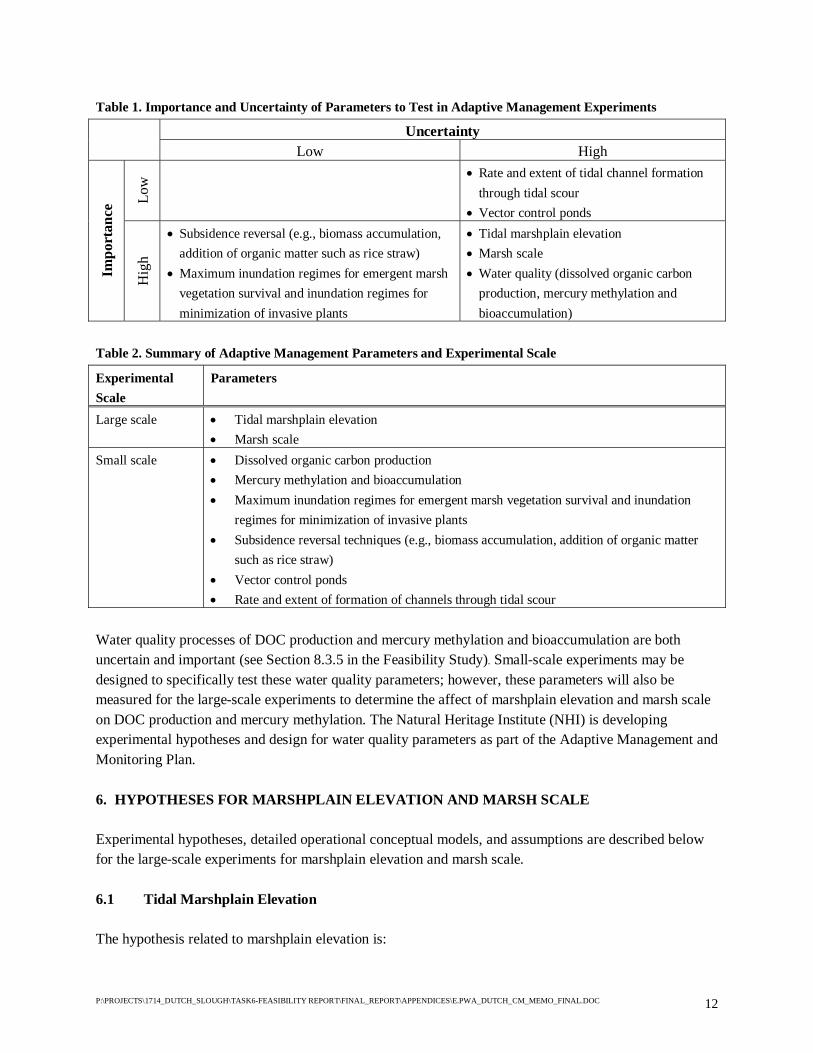
P:\PROJECTS\1714_DUTCH_SLOUGH\TASK6-FEASIBILITY REPORT\FINAL_REPORT\APPENDICES\E.PWA_DUTCH_CM_MEMO_FINAL.DOC 12
Table 1. Importance and Uncertainty of Parameters to Test in Adaptive Management Experiments
Uncertainty Low High
Low
• Rate and extent of tidal channel formation through tidal scour
• Vector control ponds
Impo
rtan
ce
Hig
h
• Subsidence reversal (e.g., biomass accumulation, addition of organic matter such as rice straw)
• Maximum inundation regimes for emergent marsh vegetation survival and inundation regimes for minimization of invasive plants
• Tidal marshplain elevation • Marsh scale • Water quality (dissolved organic carbon
production, mercury methylation and bioaccumulation)
Table 2. Summary of Adaptive Management Parameters and Experimental Scale
Experimental Scale
Parameters
Large scale • Tidal marshplain elevation • Marsh scale
Small scale • Dissolved organic carbon production • Mercury methylation and bioaccumulation • Maximum inundation regimes for emergent marsh vegetation survival and inundation
regimes for minimization of invasive plants • Subsidence reversal techniques (e.g., biomass accumulation, addition of organic matter
such as rice straw) • Vector control ponds • Rate and extent of formation of channels through tidal scour
Water quality processes of DOC production and mercury methylation and bioaccumulation are both uncertain and important (see Section 8.3.5 in the Feasibility Study). Small-scale experiments may be designed to specifically test these water quality parameters; however, these parameters will also be measured for the large-scale experiments to determine the affect of marshplain elevation and marsh scale on DOC production and mercury methylation. The Natural Heritage Institute (NHI) is developing experimental hypotheses and design for water quality parameters as part of the Adaptive Management and Monitoring Plan. 6. HYPOTHESES FOR MARSHPLAIN ELEVATION AND MARSH SCALE Experimental hypotheses, detailed operational conceptual models, and assumptions are described below for the large-scale experiments for marshplain elevation and marsh scale. 6.1 Tidal Marshplain Elevation The hypothesis related to marshplain elevation is:
P:\PROJECTS\1714_DUTCH_SLOUGH\TASK6-FEASIBILITY REPORT\FINAL_REPORT\APPENDICES\E.PWA_DUTCH_CM_MEMO_FINAL.DOC 13
There is greater production of prey resources for juvenile salmon and splittail in lower elevation marshes than in higher elevation marshes, and thus greater potential for feeding, growth, and survival
The rationale behind this hypothesis is that a lower marshplain is inundated for a longer part of each tide cycle. A longer marshplain inundation period is expected to provide a more productive environment for fish prey (i.e., dipteran fly larvae, pupae and adults; gammarid amphipods) because there is less stress (i.e., less desiccation and exposure to high temperatures). Greater fine sediment and detritus accumulation in lower marshplain environments may also provide increased productivity. Low and high marshplain habitat structures are hypothesized to have somewhat different linkages between physical/vegetative processes and ecological processes (Figure 5). Vegetation colonization of lower marshplains is expected to be more susceptible to the invasion of non-native SAV; however, the hypothesis assumes that revegetation techniques will be used to encourage equal extents of tule cover on restored low and high marshplains. The tidal inundation duration of lower marshplains will be significantly greater than higher marshplains, assuming that the difference between lower and higher marshplain elevations is large (i.e., at least half the tide range). The rise and fall of tide levels are not expected to differ significantly, assuming that tidal circulation is not limited by constricted conveyance from the tidal source through external sloughs, breaches, and/or the restored (constructed) channel systems (and that the restoration is designed to avoid this). Sedimentation rates in lower marshplain habitats is expected to be greater than for higher marshplain habitats due to the greater tidal inundation duration. 6.2 Marsh Scale The hypothesis related to marsh scale is:
Tidal channel networks in larger marshes provide shallow water refuge from predation throughout the tide cycle, whereas smaller channel networks in smaller marshes do not. Thus, larger marshes are expected to provide greater survival opportunities for juvenile salmon and splittail than smaller marshes.
The rationales behind this hypothesis are that: (1) the size of the tidal channel network is related to marsh scale and (2) channels with shallow water depths at low tide limit predator access and provide refuge for juvenile salmon and splittail. In larger marshes, some portion of the channel network is expected to always have water depths suitable for refuge during low tide. In smaller marshes, channel depth at low tide is not expected to be sufficient to provide refuge for juvenile salmon and splittail, which will be “flushed” into deep subtidal Delta slough channels (external sloughs) that likely harbor predators. In addition, larger marshes are hypothesized to provide greater structural heterogeneity and diversity (e.g., relief, vegetation assemblages and tidal channel sizes) and complexity (e.g., larger tidal channel systems, greater tidal energy, more refugia) than smaller marshes, and thus greater refuge and survival opportunities.

P:\PROJECTS\1714_DUTCH_SLOUGH\TASK6-FEASIBILITY REPORT\FINAL_REPORT\APPENDICES\E.PWA_DUTCH_CM_MEMO_FINAL.DOC 14
Marsh scale influences the linkages between restoration actions and functional response for habitat structures (Figure 6). Marsh scale directly relates to the following habitat structures: length of marsh/channel edge and the range of channel sizes. Larger-scale marshes are expected to have a greater length of marsh/channel edge and a larger range of channel sizes and depths. As with different elevation marshplains, the rise and fall of tide levels in different scale marshes are expected to be similar, assuming the tidal circulation is not limited by the restored (constructed) channel systems, breaches, or external sloughs. Because most of the fish forage along the vegetated edge of the tidal channels, increased access to prey is presumed to result from increased length of marsh/channel edge. Larger marshes therefore provide greater access to prey than smaller marshes; however, on a per-acre basis, the length of channel edge (i.e. linear channel density) is expected to be similar in larger and smaller marshes (SFEI, 2004; PWA, 1995). Prey access is therefore expected to also be similar in larger and smaller marshes on a per-acre basis. Protection from both fish and bird predation is linked to refugia such as shallow water, narrow channels and overhanging vegetation. Channel size is also assumed to influence foraging on benthic and epibenthic prey because larger channels have more surface area of low gradient, unconsolidated sediments (“mudflats”). The habitat value of a smaller marsh area and channel network is expected to be less than a marsh area of the same size within a larger marsh area. Due to the dendritic nature of tidal channel systems, smaller-scale channel and marsh systems are nested within large-scale marshes. The range of channel sizes in larger marshes is expected to provide more refugia (e.g., greater range of channel depths suitable for native fish refuge for varying tide levels, more ponded areas in dewatered channel bottoms). In smaller marsh systems, the range of channel sizes will be entirely limited to smaller channels. The larger external sloughs that are adjacent to both large and small tidal systems are typically armored and lack the refuge provided by the marsh edge. Thus, while juvenile fish may usually find refugia at some position within a larger channel system, varying as a function of tidal stage, they will be completely forced out of small channel systems during most low tides. 7. EXPERIMENTAL DESIGN CONSIDERATIONS The preferred restoration plan, including large-scale experiments to test the marshplain elevation and marsh scale hypotheses, are described in Sections 7 and 8 of the Conceptual Plan and Feasibility Report. The following considerations and assumptions are incorporated in the experimental design to allow testing of the adaptive management hypotheses. 7.1 Tidal Marshplain Elevation. Note that “lower elevation” and “higher elevation” marshes may be treated as distinct for adaptive management purposes, but are morphologically similar and not generally-recognized as distinct habitat categories in the Delta as discussed in Section 4.3. For adaptive management purposes, the intent is to compare “lower” and “higher” marshplains that differ enough in elevation to show different ecological responses, while not making the “higher” marsh so high that it becomes fill-limited or cost prohibitive. Selection of the exact elevations to compare requires an application of judgment. The preferred restoration plan includes low marsh areas (average marshplain elevation at mean lower low water) and

P:\PROJECTS\1714_DUTCH_SLOUGH\TASK6-FEASIBILITY REPORT\FINAL_REPORT\APPENDICES\E.PWA_DUTCH_CM_MEMO_FINAL.DOC 15
mid marsh areas (average marshplain elevation at mean tide level) that differ in elevation by approximately two feet and have significantly different tidal inundation frequencies. Revegetation methods (tule pre-establishment) will be used to encourage equal extents of vegetation cover on low and mid marshplains at the time of breaching, which is expected to aid the experimental comparison. Tule pre-establishment is expected to provide a somewhat greater probability of tule cover on low marshes than sites that undergo pioneer colonization under tidal conditions. Tule pre-establishment is also expected to aid in competition against invasive SAV. Tidal channel systems in restored marsh areas will be constructed to be as similar to natural systems as possible, both in cross-section (depth, width, side slope) and plan form (density, sinuosity, bifurcation). Tidal channels are anticipated to be wider in low marshes to accommodate the larger tidal prism; however, the density and depth of channels are not expected to differ greatly from mid marshes. It is assumed that tidal channel systems in low and mid marshes with equal areas will be designed with similar channel densities and depths. 7.2 Marsh Scale The large-scale experiment for marsh scale included in the Dutch Slough restoration plan will compare low marsh and mid marsh areas drained by large channel networks (approximately 80 – 90 acres), medium sized channel networks (approximately 30 – 40 acres), and small networks (approximately 10 – 15 acres). Paired sampling of low and mid marsh will allow for comparison between low and mid marsh at different scales. A very large area of low marsh on the Burroughs parcel (approximately 150 acres) will also be compared to the smaller paired-sample marsh areas. As discussed above, tidal channels will be excavated into the restored marshplain to ensure rapid tidal channel formation and provide fish habitat at the Dutch Slough restoration site. The intent of the marsh scale experiment is to test the value of structural heterogeneity and tidal channel complexity with increasing marsh scale to special status native fish survival. The scale of the small marsh area and channel network is expected to approximate the minimum scale that will provide low tide refuge for target fish species. Limited data on the relationship between channel depth and marsh area in Delta marshes (Simenstad and others 2000) suggest that marsh areas from approximately 10 – 15 acres may provide sufficient channel depths for low tide refuge (Figure 7). The channel networks in these small-scale marshes are expected to be 3rd order channel systems, based on data from historic freshwater and brachish marshes in other regions of the San Francisco Bay-Estuary (SFEI 2004). Medium-scale marsh and channel networks are expected to transition from 3rd to 4th order channel systems, with the largest channels allowing predator access at low tide, but a greater number of intermediate and small channel sizes that provide low tide refuge. The large and very large marsh areas and channel networks are expected to be 4th and 5th order channel systems and are hypothesized to have the greatest structural heterogeneity, diversity, and complexity. The scale of each marsh area and channel network may be refined in future design phases for the purpose of the adaptive management experiments. Additional data on tidal channel depth and plan form
P:\PROJECTS\1714_DUTCH_SLOUGH\TASK6-FEASIBILITY REPORT\FINAL_REPORT\APPENDICES\E.PWA_DUTCH_CM_MEMO_FINAL.DOC 16
relationships to marsh area would be required to reduce the uncertainty in designing and predicting fish response to tidal channel morphology. The marsh scale hypothesis is that juvenile native fish in smaller marshes will be more likely to be exposed to predators in the external slough channels while juvenile native fish in larger marshes are expected to remain in the restored marsh for refuge. The adjacency of small- and large-scale marshes may constitute a confounding factor for the marsh scale adaptive management experiments when using fish access and abundance as the performance measure. This is because fish offered the option of entering a large and a small marsh in close proximity may select the large marsh because the larger channel will allow them earlier access in the tidal cycle and may not dewater to the extent that they must leave. We assume that the opportunity to enter the small marsh will occur somewhat later in the tidal cycle and the fish will typically be forced out of the small marsh on the ebbing tide. Because smaller marshes are separated from nearby larger marshes by the external slough, this adjacency is not expected to be a significant factor. In addition, while the density of fish might be affected by adjacency, the performance of fish in manipulative experiments (with fish releases) within the marshes would not be as vulnerable to any artifact introduced by adjacent marshes. 8. AMWG MEMBERS The Dutch Slough Adaptive Management Work Group is:
Bruce Herbold, Ph.D., US EPA (Chair) Peter Baye, Ph.D., Private Consultant Joan Florsheim, Ph.D., UC Davis Roger Fujii, Ph.D., USGS David Sedlak , Ph.D., UC Berkeley Stuart Siegel, Ph.D., Private Consultant Mark Stacey, Ph.D., UC Berkeley John Takekawa, Ph.D., USGS Lars Anderson, Ph.D., USDA
9. REFERENCES Allen, JRL. 2000. Morphodynamics of Holocene salt marshes: a review sketch from the Atlantic and southern North Sea coasts of Europe. Quaternary Science Review 19(12):1155-1231. Anderson, Lars. U.S. Department of Agriculture. Personal communication. Atwater BF. 1982. Geologic maps of the Sacramento-San Joaquin Delta, California. Menlo Park (CA): U.S. Geological Survey MF-1401. Atwater BF, Belknap DF. 1980. Tidal-wetland deposits of the Sacramento-San Joaquin Delta, California. In: Field ME, Bouma AH, Colburn IP, Douglas RG and Ingle JC, editors. Quaternary depositional

P:\PROJECTS\1714_DUTCH_SLOUGH\TASK6-FEASIBILITY REPORT\FINAL_REPORT\APPENDICES\E.PWA_DUTCH_CM_MEMO_FINAL.DOC 17
environments of the Pacific Coast. Pacific Coast Paleogeography Symposium 4. Proceedings of the Society of Economic Paleontologists and Mineralogists. Los Angeles (CA): Society of Economic Paleontologists and Mineralogists. p 89-103. Atwater BF, Conard SG, Dowden JN, Hedel CW, MacDonald RL, Savage W. 1979. History, landforms, and vegetation of the estuary’s tidal marshes. In: Conomos TJ, Leviton AE, Berson M, editors. San Francisco Bay: the urbanized estuary. San Francisco (CA): Pacific Division, AAAS. p 347-385. Atwater BF, Hedel CW. 1976. Distribution of seed plants with respect to the tide levels and water salinity in the natural tidal marshes of the northern San Francisco Bay estuary, California. Preliminary report. U.S. Geological Survey Open File Report 76-389. Beeman and Krone. (Ogden Beeman & Associates, Inc., RB Krone & Associates, Inc.). 1992. Sediment budget study for San Francisco Bay. Final report. Prepared for the San Francisco District, U.S. Army Corps of Engineers. Located at: Ogden Beeman & Associates, Inc., Portland, OR. 25+ p. Cain, John. 2004. Memorandum to Dutch Slough Adaptive Management Working Group candidates. Subject: Draft Memo on Adaptive Management Working Group. Revised March 30. CALFED (CALFED Bay-Delta Program). 2000. Ecosystem restoration program plan final programmatic EIS/EIR. Sacramento (CA): CALFED Bay-Delta Program. Available from: http://calwater.ca.gov/CALFEDDocuments/Final_EIS_EIR.shtml. Delta Habitats Group, 2002. Report of the Delta Habitats Group, CALFED ISB Adaptive Management Workshop, March 19-20, 2002. Prepared by Denise Reed, ISB Adaptive Management Subcommittee and Bruce DiGennaro, Kleinschmidt. Drexler JZ, Fleck J, Wheeler G, Fujii R. 2003. Carbon storage and sediment accretion in restored wetlands on Twitchell Island in the Sacramento-San Joaquin Delta, California [abstract]. In: CALFED Science Conference 2003 Abstracts. CALFED Science Conference 14-16 Jan 2003, Sacramento Convention Center. Sacramento (CA): CALFED Bay-Delta Program. p 46. Garrity NJ. 2004. Solar Heating and Temperature Dynamics of Over-Marsh Tides in Restored Marshes. U.C. Berkeley CEE209A Hydrologic Mixing Processes class project for Professor Mark Stacey. May 17. Gilbert GK. 1917. Hydraulic mining in the Sierra Nevada. U.S. Geological Survey Professional Paper 105. Washington, DC: Government Printing Office. Goman M, Wells L. 2000. Trends in river flow affecting the northeastern reach of the San Francisco Bay Estuary over the past 7000 years. Quaternary Research 54:206-217. Moyle, PB. 1976. Inland fishes of California. University of California Press. NHI (Natural Heritage Institute). In progress. Dutch Slough Tidal Marsh Restoration Adaptive Management and Monitoring Plan.

P:\PROJECTS\1714_DUTCH_SLOUGH\TASK6-FEASIBILITY REPORT\FINAL_REPORT\APPENDICES\E.PWA_DUTCH_CM_MEMO_FINAL.DOC 18
Orr MK, Crooks S, Williams PB. (2003). Will Restored Tidal Marshes Be Sustainable? San Francisco Estuary and Watershed Science 1(1): Article 5. PSNERP (Puget Sound Nearshore Ecosystem Restoration Project, Nearshore Science Team). 2006. Conceptual model for assessing restoration of Puget Sound Nearshore Ecosystems. Prepared by the Nearshore Science Team, Conceptual Model Working Group – C. Simenstad lead author, K. Fresh, M. Logsdon, J. Newton and H. Shipman. Olympia, WA. (in press) PWA (Philip Williams & Associates, Ltd.). 2006. Dutch Slough Tidal Marsh Restoration Conceptual Plan and Feasibility Study. Prepared for The California State Coastal Conservancy; PWA Report 1714. PWA (Philip Williams & Associates, Ltd.). 2003. Decker Island Phase II Restoration Project – Concept Design. Prepared for MBK Engineers and DWR. May 8, 2003 Memorandum from Michelle Orr, Nick Garrity, and Phil Williams, PWA to Gilbert Cosio and Don Trieu, MBK Engineers. PWA report#1666. Located at: PWA, San Francisco, CA. 10+ p. PWA (Philip Williams & Associates, Ltd.), Pacific Estuarine Research Lab, and Louisiana Universities Marine Consortium. 1995. Design guidelines for tidal channels in coastal wetlands. Prepared for the U.S. Army Corps of Engineers Waterways Experiment Station. PWA report #934. Located at: PWA, San Francisco, CA. 46+ p. Reed DJ. 2002. Sea-level rise and coastal marsh sustainability: geological and ecological factor in the Mississippi delta plain. Geomorphology 48:233-243. SFEI (San Francisco Estuary Institute). 2004. Syntheses of Scientific Knowledge for Maintaining and Improving Functioning of the South Bay Ecosystem and Restoring Tidal Salt Marsh and Associated Habitats over the Next 50 Years at Pond and Pond-Complex Scales. Draft Final Report. Simenstad C, Toft J, Higgins H, Cordell J, Orr M, Williams P, Grimaldo L, Hymanson Z, Reed D. 2000. Sacramento-San Joaquin Delta breached levee wetland study (BREACH). Preliminary report. Seattle (WA): Wetland Ecosystem Team, University of Washington, School of Fisheries. 46 p. USFWS and USACE (U.S. Fish and Wildlife Service (Sacramento) and U.S. Army Corps of Engineers (Sacramento District)). 1990. Design and biological monitoring of wetland riparian habitats created with dredged materials. Final report. Deepwater Ship Channel monitoring program. Sacramento (CA): Sacramento District Corps of Engineers. 68 p. Wang JCS. 1986. Fishes of the Sacramento-San Joaquin Estuary and Adjacent Waters, California: A Guide to the Early Life Histories. Interagency Ecological Study Program for the Sacramento-San Joaquin Estuary. Williams PB, Orr M.K., Garrity NJ. 2002. Hydraulic geometry: a geomorphic design tool for tidal marsh channel evolution in wetland restoration projects. Restoration Ecology 10:577-590. Wright SA, Schoellhamer DH. 2003. Trends in the sediment yield of the Sacramento River, 1957-2001 [abstract]. In: CALFED Science Conference 2003 Abstracts; 14-16 Jan 2003, Sacramento. Sacramento (CA): CALFED Bay-Delta Program. p 177.

P:\PROJECTS\1714_DUTCH_SLOUGH\TASK6-FEASIBILITY REPORT\FINAL_REPORT\APPENDICES\E.PWA_DUTCH_CM_MEMO_FINAL.DOC 19
FIGURES Figure 1. Adaptive Management Plan Flow Diagram Figure 2. General Conceptual Model Figure 3. Tidal Marshplain Elevation Hypothesis Figure 4. Marsh Scale Hypothesis Figure 5. Tidal Marshplain Elevation Conceptual Model Figure 6. Marsh Scale Conceptual Model Figure 7. Channel Depth and Marsh Area Relationship ATTACHMENTS Attachment A. Initial Development of Dutch Slough Conceptual Model Attachment B. Conceptual Model by the Delta Habitats Group

Du
tch
Slo
ug
hC
on
cep
tua
lM
od
el
PWA#:1714Append_E.cdr
PW
AA
pp
end
ixE
fi
gu
re
fi
gu
re
1
Ad
ap
tive
Man
agem
ent
Pro
cess
Flo
wD
iagra
m

Du
tch
Slo
ug
hC
on
cep
tua
lM
od
el
PWA#:1714Append_E.cdr
PW
A
Gen
eral
Con
cep
tual
Mod
el
fi
gu
re
2
Ap
pen
dix
E

MH
HW
MLL
W
Hig
her
Ele
vati
on
Mar
shp
lain
Lo
wer
Ele
vati
on
Mar
shp
lain
Tid
al
Mars
hE
levati
on
Hyp
oth
esis
PWARef#1714AppendixEfig3elevHypoth.cdr
ig
ur
ef
3
Dutc
hSlo
ugh
Conce
ptu
al
Model
PW
A
Leg
end
Hyp
oth
esis
tule
veg
etat
ion
pre
y
del
iver
yo
fp
rey
toch
ann
elN
ote
s:M
HH
W=
mea
nh
igh
erh
igh
wat
erM
LL
W=
mea
nlo
wer
low
wat
erN
ot
tosc
ale
Ther
eis
gre
ater
pro
duct
ion
of
pre
yre
sourc
esfo
rju
ven
ile
salm
on
and
spli
ttai
lin
low
erel
evat
ion
mar
shes
than
inhig
her
elev
atio
nm
arsh
es,an
dth
us
gre
ater
pote
nti
alfo
rfe
edin
g,gro
wth
,an
dsu
rviv
al.
targ
etsp
ecia
lst
atus
nat
ive
fish
spec
ies
(juven
ile
salm
on
and
spli
ttai
l)
targ
etsp
ecie
sta
rget
spec
ies
Ap
pen
dix
E

MHHW
MHHW
MLLW
MLLW
tule vegetation
predator fish species
predator target species
LOW TIDE REFUGE NO LOW TIDE ACCESS
NO LOW TIDE ACCESS
LOW TIDE PREDATION
LOW TIDE PREDATION
Legend
predator target species
EL EVAT ION VIEW
target special status native fish species(juvenile salmon and splittail)
EX
TE
RN
AL
DE
LTA
SL
OU
GH
EX
TE
RN
AL
DE
LTA
SL
OU
GH
Hypothesis
SmallerMarsh
LargerMarsh
EL EVAT ION VIEW
Marsh Scale Hypothesis
i g u r ef 4
Dutch Slough Conceptual Model
PWA
PLAN VIEW
PLAN VIEW
Tidal channel networks in larger marshesprovide shallow water refuge frompredation throughout the tide cycle,whereas smaller channel networks insmaller marshes do not. Thus, largermarshes are expected to provide greatersurvival opportunities for juvenile salmonand splittail than smaller marshes.
Notes:MHHW = mean higher high waterMLLW = mean lower low waterNot to scale
1.6 ft(0.5m)
PW
AR
ef#
1714
App
endi
xEfig
4m
arsh
Sca
le.c
dr
Appendix E

Du
tch
Slo
ug
hC
on
cep
tua
lM
od
el
PWA#:1714Append_E.cdr
PW
A
Tid
al
Mars
hp
lain
Ele
vati
on
Con
cep
tual
Mod
el
fi
gu
re
5
Ap
pen
dix
E
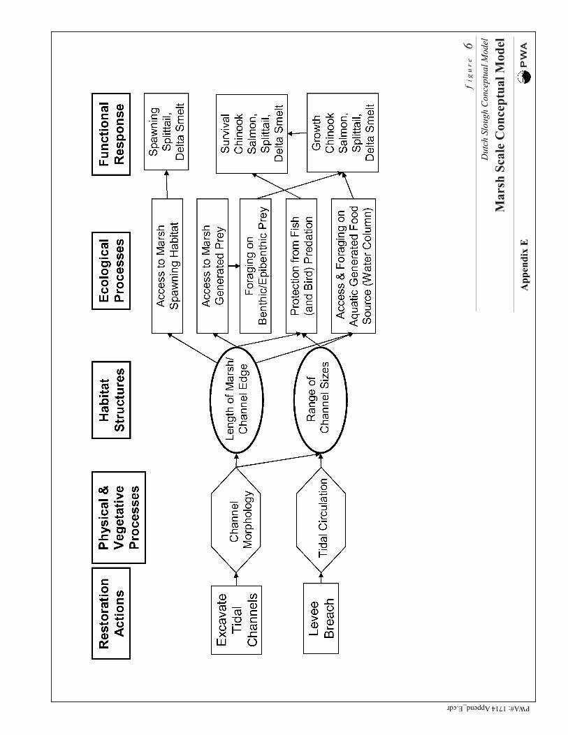
Du
tch
Slo
ug
hC
on
cep
tua
lM
od
el
PWA#:1714Append_E.cdr
PW
A
Mars
hS
cale
Con
cep
tual
Mod
el
fi
gu
re
6
Ap
pen
dix
E

P:\P
roje
cts\
1714
_Dut
ch_S
loug
h\Ta
sk6-
Feas
ibili
ty R
epor
t\Fin
al_R
epor
t\App
endi
ces\
E.F
ig7_
Cha
nnel
_Dep
th.x
ls F
ig7
5/5/
2006
051015
01
1010
01,
000
Mar
sh A
rea
(acr
es)
Thalweg Depth (ft below MLLW)
Low
er M
ande
ville
Tip
She
rman
Isla
ndB
row
ns Is
land
Dut
ch S
loug
h C
once
ptua
l Mod
elC
hann
el D
epth
and
Mar
sh A
rea
Rel
atio
nshi
p
f i g
u r
e
7
PWA
#171
4
Sou
rce:
Sim
enst
ad a
nd o
ther
s, 2
000
Small marsh
Medium marsh
Large marsh
Very large marsh
App
endi
x E

Du
tch
Slo
ug
hC
on
cep
tua
lM
od
el
PWA#:1714Append_E.cdr
PW
A
Init
ial
Det
ail
edC
on
cep
tual
Mod
el
Sep
t.2004
DR
AF
T
So
urc
e:A
MW
Gm
eeti
ng
dis
cuss
ion
,P
WA
,a
nd
Sim
enst
ad
posi
tive
neg
ativ
e
Att
ach
men
tA
1
Ap
pen
dix
E

Du
tch
Slo
ug
hC
on
cep
tua
lM
od
el
PWA#:1714Append_E.cdr
PW
A
Init
ial
Con
cep
tual
Mod
elfo
rC
hin
ook
Salm
on
Gro
wth
:H
ab
itats
,P
roce
sses
an
dA
ttri
bu
tes
No
te:
blu
ear
row
sre
pre
sen
tar
eas
of
hig
hu
nce
rtai
nty
,re
dar
row
rep
rese
nt
area
so
fh
igh
imp
ort
ance
.S
had
edb
ox
esre
pre
sen
tta
rget
so
fre
sto
rati
on
acti
vit
ies;
imp
lied
wit
hin
the
shad
edb
ox
esar
ev
ario
us
po
ssib
leco
nfi
gu
rati
on
sto
max
imiz
eo
rm
inim
ize
the
effe
cts
rep
rese
nte
db
yth
ear
row
s.
Sep
t.2004
DR
AF
T
So
urc
e:A
MW
Gm
eeti
ng
dis
cuss
ion
Att
ach
men
tA
2
Ap
pen
dix
E

Du
tch
Slo
ug
hC
on
cep
tua
lM
od
el
PWA#:1714Append_E.cdr
PW
A
Init
ial
Con
cep
tual
Mod
elfo
rC
hin
ook
Salm
on
Su
rviv
al:
Hab
itats
,P
roce
sses
an
dA
ttri
bu
tes
No
te:
blu
ear
row
sre
pre
sen
tar
eas
of
hig
hu
nce
rtai
nty
,re
dar
row
rep
rese
nt
area
so
fh
igh
imp
ort
ance
.S
had
edb
ox
esre
pre
sen
tta
rget
so
fre
sto
rati
on
acti
vit
ies;
imp
lied
wit
hin
the
shad
edb
ox
esar
ev
ario
us
po
ssib
leco
nfi
gu
rati
on
sto
max
imiz
eo
rm
inim
ize
the
effe
cts
rep
rese
nte
db
yth
ear
row
s.
Sep
t.2004
DR
AF
T
So
urc
e:A
MW
Gm
eeti
ng
dis
cuss
ion
Att
ach
men
tA
3
Ap
pen
dix
E